b r a t o n ab c a e s 2 0 e hxx s lake boca raton 900 10...
TRANSCRIPT

Environmentally Sensitive Areas Summer Protection PriorityXXX A - Protect First XX B - Protect after A AreasX C - Protect after B Areas
Acropora Priority Sites Priority of Protection
!!
! !!!
!! A - Protect First
!!
! !
!!!! B - Protect after A AreasResponse MethodsSkimmer
!h( Shallow Water Skimmer# Collection Point
General Booming Strategy(Length in Feet)
Incident Command Post
!S( Staging Areas
!R( Oil Spill Risk Sites
!E( Equipment Storage LocationsF Tidal Inlet Protection Strategy
Bio-Socioeconomic[\ Beach Access
!· Airport
[] American Crocodile
[y Aquaculture
k Aquatic Preserve/State Park
[m High Recreation Beach
!d Boat Ramp
[¥ Cape Sable Seaside Sparrow
[s Coast Guard
!̂ Coral Reef Monitoring Site
[b Everglades Snail Kite
Florida Panther
!Å Heliport
[¿ Historical Site
!(RSeagrass
!¤ Manatee
!] Marina
u Marine Sanctuary
[j National Park
[« Piping Plover
!d( Power Plant
!¶ Sea Turtle Nesting Area
[¡ Smalltooth Sawfish
!q Water Intake
[r Wildlife Refuge
MangrovesSea Turtle Nesting BeachFederal Managed AreasState Managed AreasState Waters/County LineUSCG Sector Boundary
!̂
!̂
Florida Atlantic
University Ecological
Sitek
! !
!!!
!
! ! !
!!!
! !
!
!!!
! !
!
!!!
XXX
XXX
XXX
XXXX
XXX
XX
XX
XX
X
XX
XXX
XX
XXX
X
XX
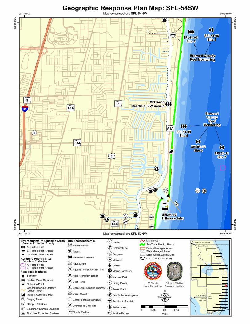
SFL54-07 Site 4
SFL54-03 Near Shore Reef (Near Boca Inlet)
SFL54-04 Boca Raton Inlet/Lake Boca Raton
SFL54-10Site 6
SFL54-11Site 7
Broward CountyReef Monitoring
SFL54-12 Hillsboro Inlet
SFL54-02 Broward County Reef Monitoring Site 1
SFL53-02Site 9
SFL54-06Site 3
SFL53-03PompanoBeachFishing Pier
SFL53-01Site 8
SFL54-09Site 5
SFL54-05Site 2
SFL54-08Deerfield ICW Canals
SFL54-01 Gumbo Limbo Nature Center(Water Intake)
EFL1-03 N.Boca RatonNearshore Reef
#
#
#
#
#
200
9001000
2150
!S(
!d
!S(
!d
[\
[\
[\
[\
[\
!]
!
!
!
!
!
!
!
!
!·
!·
!Å
[m
[m
!q
!¶
!¶
!]
!]
!]
!]
!]
!S(F
F
Broward CountyReef Monitoring
!]!d
!d
!d
!(R
1050
[\
#
#
!][s
LakeBocaRaton
BROWARDCOUNTY
PALM BEACHCOUNTY
!
!
!
!
!
!
!!
! x's 8 Deerfield/Hillsboro Beach
Boca Raton Beaches
PompanoBeachAirpark
AtlanticOcean
XXXSFL54-13 Coral Reefs fromMartin County throughMiami-Dade County
AB834
AB808
AB810
ABA1A
AB811
AB798
AB809AB5
£¤1
§̈¦95
AB9
80°0'0"W
80°0'0"W
80°7'30"W
80°7'30"W26
°22'30
"N
26°22
'30"N
26°15
'0"N
26°15
'0"N
Geographic Response Plan Map: SFL-54
0 0.5 1 1.5 2Miles
SectorKey West
SectorMiami
Sector Jacksonville
SectorSt. Petersburg
Sector Miami
µSE Florida
Area CommitteeFish and Wildlife
Research Institute
Map continued on: SFL-53
Map c
ontin
ued o
n: SF
L-55
!̂
!!! !!!
!!!
!!!
! ! !!
!!!!
!!
XXX
XXXX
XXX
XX
XX
XX
XXX
XX
XXX
SFL54-07 Site 4
SFL54-10Site 6 SFL54-11
Site 7
SFL54-12Hillsboro Inlet
SFL53-02Broward CountyReef Monitoring
Site 9
SFL54-06Site 3
SFL53-01Broward CountyReef Monitoring
Site 8
SFL54-09Site 5
SFL54-05Broward CountyReef MonitoringSite 2
SFL54-08Deerfield ICW Canals
#
#
2150
!S(
[\
!]
[\
[\[\
[\!·
!Å
[m
!¶
!]
!]
!] !S(
F
BrowardCounty
ReefMonitoring
!]!d
!d
#!] [s
!]
!] !̂
Broward CountyReef Monitoring
[\
[\ DeerfieldBeach
Deerfield IslandPark
[\
ABA1A
AB844
AB834
AB811 AB5
£¤1
§̈¦95AB9
80°3'45"W
80°3'45"W
80°7'30"W
80°7'30"W26
°18'45
"N
26°18
'45"N
26°15
'0"N
26°15
'0"N
Geographic Response Plan Map: SFL-54SW
0 0.25 0.5 0.75 1Miles
SectorKey West
SectorMiami
Environmentally Sensitive Areas Summer Protection PriorityXXX A - Protect First XX B - Protect after A AreasX C - Protect after B Areas
Acropora Priority Sites Priority of Protection
!!! !
!!
!! A - Protect First
!!
! !
!
!!! B - Protect after A AreasResponse Methods Skimmer!h( Shallow Water Skimmer# Collection Point
General Booming Strategy(Length in Feet)
Incident Command Post!S( Staging Areas!R( Oil Spill Risk Sites!E( Equipment Storage LocationsF Tidal Inlet Protection Strategy
Bio-Socioeconomic[\ Beach Access
!· Airport
[] American Crocodile
[y Aquaculture
k Aquatic Preserve/State Park
[m High Recreation Beach
!d Boat Ramp
[¥ Cape Sable Seaside Sparrow
[s Coast Guard
!̂ Coral Reef Monitoring Site
[b Everglades Snail Kite
Florida Panther
!Å Heliport
[¿ Historical Site
!(RSeagrass
!¤ Manatee!] Marina
u Marine Sanctuary
[j National Park
[« Piping Plover
!d( Power Plant
!¶ Sea Turtle Nesting Area
[¡ Smalltooth Sawfish
!q Water Intake
[r Wildlife Refuge
MangrovesSea Turtle Nesting BeachFederal Managed AreasState Managed AreasState Waters/County LineUSCG Sector Boundary
Sector Jacksonville
SectorSt. Petersburg
Sector Miami
µSE Florida
Area CommitteeFish and Wildlife
Research Institute
Map continued on: SFL-54NW
Map continued on: SFL-53NW

!̂
Florida Atlantic
University Ecological
Sitek
!! !!!!
!!
!!
XXX
XXX
XXX
XX
XXXX
X
XX
SFL54-07 Site 4
SFL54-03Near Shore Reef(Near Boca Inlet)
SFL54-04 BocaRaton Inlet/LakeBoca Raton
SFL54-02Broward CountyReef Monitoring
Site 1
SFL54-06Site 3
SFL54-05Broward CountyReef MonitoringSite 2
SFL54-01 Gumbo LimboNature Center(Water Intake)
#
#
200
9001000
!S(
!d
!S(
!d[\
[\
[\
[\
!]
!·
[m
[m
[m
[m
!q
!¶
!]
!]
F
!d
!d
!(R
1050
Lake BocaRaton
Broward CountyReef Monitoring
!] !]!]
PALM BEACH COUNTY
BROWARD COUNTY
[\
RedReef/SouthBeachPark
RutherfordPark
[\ DeerfieldBeach
Deerfield IslandPark
[\
AB808
AB811
AB810
ABA1A
AB798
AB809
AB5
£¤1
§̈¦95
AB9
80°3'45"W
80°3'45"W
80°7'30"W
80°7'30"W26
°22'30
"N
26°22
'30"N
26°18
'45"N
26°18
'45"N
Geographic Response Plan Map: SFL-54NW
0 0.25 0.5 0.75 1Miles
SectorKey West
SectorMiami
Environmentally Sensitive Areas Summer Protection PriorityXXX A - Protect First XX B - Protect after A AreasX C - Protect after B Areas
Acropora Priority Sites Priority of Protection
!!! !
!!
!! A - Protect First
!!
! !
!
!!! B - Protect after A AreasResponse Methods Skimmer!h( Shallow Water Skimmer# Collection Point
General Booming Strategy(Length in Feet)
Incident Command Post!S( Staging Areas!R( Oil Spill Risk Sites!E( Equipment Storage LocationsF Tidal Inlet Protection Strategy
Bio-Socioeconomic[\ Beach Access
!· Airport
[] American Crocodile
[y Aquaculture
k Aquatic Preserve/State Park
[m High Recreation Beach
!d Boat Ramp
[¥ Cape Sable Seaside Sparrow
[s Coast Guard
!̂ Coral Reef Monitoring Site
[b Everglades Snail Kite
Florida Panther
!Å Heliport
[¿ Historical Site
!(RSeagrass
!¤ Manatee!] Marina
u Marine Sanctuary
[j National Park
[« Piping Plover
!d( Power Plant
!¶ Sea Turtle Nesting Area
[¡ Smalltooth Sawfish
!q Water Intake
[r Wildlife Refuge
MangrovesSea Turtle Nesting BeachFederal Managed AreasState Managed AreasState Waters/County LineUSCG Sector Boundary
Sector Jacksonville
SectorSt. Petersburg
Sector Miami
µSE Florida
Area CommitteeFish and Wildlife
Research Institute
Map continued on: SFL-54SW

GRP - Oil Spill Sensitive Site Report for Sector : Miami GRP Map # SFL-54
Fall: CSpring: C Winter: C
Site ID: SFL54-01Name: Gumbo Limbo Nature Center (Water Intake)
Site Description:
Protection Priority (Season):
County: Palm Beach
General Location:
SCAT Division: Palm Beach County Division 1
Managed Area (if applicable):
Latitude (DMS): 26° 22' 1.478" N Longitude (DMS): 80° 4' 2.279" W
Latitude (DD): 26.367077 Longitude (DD): -80.067300
GEOSPATIAL INFORMATION
ESI Map: SFL-54 ESI Name: Boca Raton, Fla.
NOAA Chart 11466_3 CHART Name JUPITER INLET TO FOWEY ROCKS
USGS Quad: 26080-C1 QUAD Name: Boca Raton
CONTACT INFORMATION
Contacts: FL State Watch Office 800-320-0519; NRC 800-424-8802; Boca Raton Sea Turtle Protection Program (Marine Conservationist) 561-338-1587 NOAA-SSC (USCG District 7) 305-530-7925(o) 954-684-8486(c) 206-526-4911(24hr); DOI - Regional Environmental Officer 404-909-0537, 404-331-4524, 215-266-5155 (24hrs) or 617-223-8565; DEP-OER 561-393-5877
RESOURCES AT RISK INFORMATION
Shoreline Type: Fine-medium grained sand beaches
Habitat: Sandy beaches
Wildlife: Blue crab; Stone crab; Caribbean spiny lobster; Brown shrimp; Pink shrimp; Green sea turtle; Hawksbill sea turtle; Leatherback sea turtle; Loggerhead sea turtle
Threaten/Endangered Species: Green sea turtle; Hawksbill sea turtle; Leatherback sea turtle; Loggerhead sea turtle
Socio-Economic Resources: Water Intake
RESPONSE CONSIDERATIONS
Staging Area Silver Palm Park Boat Ramp, Port Everglades
Collection Points: Open water recovery with skimmers, collection point North of South Inlet Park
Area Access: boat/vehicle
Spill Risk:
Response Resources:
PROTECTION STRATEGY INFORMATION
Min. Boom Length (FT): Booming Method: Protection/ExclusionBoom Type:
Protection Strategy: Place exclusion boom around intake if visible at surface, use skimming vessels to keep oil away from intake.
Tidal Range (FT): Average Current (KTS): Ease of Protection:
Summer: C
Wednesday, March 06, 2013Report produced by Florida FWC - Fish and Wildlife Research Institue on:
For additional information, please contact FWC-FWRI Center for Spatial Analysis (727) 896-8626

GRP - Oil Spill Sensitive Site Report for Sector : Miami GRP Map # SFL-54
Fall: BSpring: B Winter: B
Site ID: SFL54-02Name: Broward County Reef Monitoring Site 1
Site Description:
Protection Priority (Season):
County: Palm Beach
General Location:
SCAT Division: Palm Beach County Division 1
Managed Area (if applicable): Broward County Environmental Protection & Growth Management Dept - Marine Resources Section
Latitude (DMS): 26° 20' 47.753" Longitude (DMS): 80° 3' 52.898" W
Latitude (DD): 26.346598 Longitude (DD): -80.064694
GEOSPATIAL INFORMATION
ESI Map: SFL-54 ESI Name: Boca Raton, Fla.
NOAA Chart 11466_3 CHART Name JUPITER INLET TO FOWEY ROCKS
USGS Quad: 26080-C1 QUAD Name: Boca Raton
CONTACT INFORMATION
Contacts: FL State Watch Office 800-320-0519; NRC 800-424-8802; FWC Wildlife Alert Hotline 888-404-3922; Broward Co. Envir. Protection & Growth Mgt Dept - Marine Resources Section (Beach Restoration) 954-519-1270 Broward County (Stakeholder Liaison for Port Everglades) 954-468-3520; NOAA-SSC (USCG District 7) 305-530-7925(o) 954-684-8486(c) 206-526-4911(24hr); DOI - Regional Environmental Officer 404-331-4524 or 617-223-8565; DEP-OER 561-393-5877
RESOURCES AT RISK INFORMATION
Shoreline Type: N/A
Habitat: Corals, Sea Turtles
Wildlife: Corals, Sea Turtles
Threaten/Endangered Species: Acropora Sp., Sea Turtles
Socio-Economic Resources:
RESPONSE CONSIDERATIONS
Staging Area Port Everglades, Silver Palm Park Boat Ramp
Collection Points: OSRV/VOSS Vessels Offshore, North of South Inlet Park
Area Access: boat
Spill Risk:
Response Resources:
PROTECTION STRATEGY INFORMATION
Min. Boom Length (FT): 1,200 Booming Method: Containment, DeflectionBoom Type:
Protection Strategy: Vessels in J configuration skimming mode
Tidal Range (FT): Average Current (KTS): Ease of Protection:
Summer: B
Wednesday, March 06, 2013Report produced by Florida FWC - Fish and Wildlife Research Institue on:
For additional information, please contact FWC-FWRI Center for Spatial Analysis (727) 896-8626

GRP - Oil Spill Sensitive Site Report for Sector : Miami GRP Map # SFL-54
Fall: ASpring: A Winter: A
Site ID: SFL54-03Name: Near Shore Reef (Near Boca Inlet)
Site Description: Nearshore fringing reef - shore to 12' water depth, water clarity excellent, quite productive, Worm rock, Red Reef Park: nearshore and artificial reefs, Boca patch reefs + artificial reefs south of Inlet, remnant 2nd reef, approx 20 ft depth
Protection Priority (Season):
County: Palm Beach
General Location:
SCAT Division: Palm Beach County Division 1
Managed Area (if applicable):
Latitude (DMS): 26° 20' 30.001" Longitude (DMS): 80° 3' 45.000" W
Latitude (DD): 26.341667 Longitude (DD): -80.062500
GEOSPATIAL INFORMATION
ESI Map: SFL-54 ESI Name: Boca Raton, Fla.
NOAA Chart 11466_3 CHART Name JUPITER INLET TO FOWEY ROCKS
USGS Quad: 26080-C1 QUAD Name: Boca Raton
CONTACT INFORMATION
Contacts: FL State Watch Office 800-320-0519; NRC 800-424-8802; PBC Environmental Resources Management (Director) 561-233-2400; USFWS (772) 562-3909; FWC Non-Game Biologist 561-625-5122; FDEP-CRCP 305-795-2167 or 786-385-3054(c) NOAA-SSC (USCG District 7) 305-530-7925(o) 954-684-8486(c) 206-526-4911(24hr); DOI - Regional Environmental Officer 404-909-0537, 404-331-4524, 215-266-5155 (24hrs) or 617-223-8565; DEP-OER 561-393-5877
RESOURCES AT RISK INFORMATION
Shoreline Type: N/A
Habitat: Offshore Corals > 3 m, hardbottom
Wildlife: Coral reefs, nearshore hard bottom
Threaten/Endangered Species: Sea turtles, Manatees
Socio-Economic Resources:
RESPONSE CONSIDERATIONS
Staging Area South Beach Park for shore collection @ Pompano Park Rd offshore vessels from Port Everglades and Port of Palm Beach. Smaller staging area at Silver Palm Park
Collection Points: Contain and collect offshore if possible. Collection possible North of South Inlet Park
Area Access: boat/vehicle
Spill Risk: MC 2-3
Response Resources: see inlet protection strategies
PROTECTION STRATEGY INFORMATION
Min. Boom Length (FT): 8,000 Booming Method: ContainmentBoom Type:
Protection Strategy: Utilize strategically placed mobile containment and skimming systems, such as USCG VOSS or standard "J" configuration with skimmer. Move turtles and eggs as necessary. Consider in-situ burning offshore.
Tidal Range (FT): 2 Average Current (KTS): Ease of Protection:
Summer: A
Wednesday, March 06, 2013Report produced by Florida FWC - Fish and Wildlife Research Institue on:
For additional information, please contact FWC-FWRI Center for Spatial Analysis (727) 896-8626

GRP - Oil Spill Sensitive Site Report for Sector : Miami GRP Map # SFL-54
Fall: ASpring: A Winter: A
Site ID: SFL54-04Name: Boca Raton Inlet/Lake Boca Raton
Site Description: Drinking water well fluid Zone
Protection Priority (Season):
County: Palm Beach
General Location:
SCAT Division: Palm Beach County Division 1
Managed Area (if applicable):
Latitude (DMS): 26° 20' 8.567" N Longitude (DMS): 80° 4' 10.826" W
Latitude (DD): 26.335713 Longitude (DD): -80.069674
GEOSPATIAL INFORMATION
ESI Map: SFL-54 ESI Name: Boca Raton, Fla.
NOAA Chart 11466_3 CHART Name JUPITER INLET TO FOWEY ROCKS
USGS Quad: 26080-C1 QUAD Name: Boca Raton
CONTACT INFORMATION
Contacts: FL State Watch Office 800-320-0519; NRC 800-424-8802; PBC Environmental Resources Management (Director) 561-233-2400; USFWS 772-562-3909; FWC Wildlife Alert Hotline 888-404-3922 NOAA-SSC (USCG District 7) 305-530-7925(o) 954-684-8486(c) 206-526-4911(24hr); DOI - Regional Environmental Officer 404-909-0537, 404-331-4524, 215-266-5155 (24hrs) or 617-223-8565; DEP-OER 561-393-5877
RESOURCES AT RISK INFORMATION
Shoreline Type: Fine- to medium- grained sand beaches; Riprap; Sheltered solid man-made structures
Habitat: Rocks associated with jetty, Water clarity excellent, Marine grasses inside inlet + Lake Boca Raton, Sea Grasses, Mangroves
Wildlife: Fish and invertebrates associated with rocks, Jetties, Scattered grasses, Algae, Birds
Threaten/Endangered Species: Manatees, Sea turtles, sea grasses
Socio-Economic Resources:
RESPONSE CONSIDERATIONS
Staging Area Silver Palm Park Boat Ramp West of Boca Raton Lake for staging area
Collection Points: Open water recovery with skimmers, North of South Inlet Park, North of Lake Boca Raton
Area Access: boat/helicopter/vehicle
Spill Risk: MC 3-
Response Resources: Fort Lauderdale. see inlet protection strategy
PROTECTION STRATEGY INFORMATION
Min. Boom Length (FT): 9,100 Booming Method: DeflectionBoom Type:
Protection Strategy: Utilize strategically placed mobile containment and skimming systems, such as shallow water boats and skimmers . Consider in-situ burning offshore. See Boca Raton Inlet TIPS. Bacon Raton Inlet TIPS requires a total of 9,150' of boom. Deflect oil from entering Inlet. Strategies will depend on wind and currents.
Tidal Range (FT): 2 Average Current (KTS): Ease of Protection:
Summer: A
Wednesday, March 06, 2013Report produced by Florida FWC - Fish and Wildlife Research Institue on:
For additional information, please contact FWC-FWRI Center for Spatial Analysis (727) 896-8626

GRP - Oil Spill Sensitive Site Report for Sector : Miami GRP Map # SFL-54
Fall: BSpring: B Winter: B
Site ID: SFL54-05Name: Broward County Reef Monitoring Site 2
Site Description:
Protection Priority (Season):
County: Broward
General Location:
SCAT Division: Broward County Division 1
Managed Area (if applicable): Broward County Environmental Protection & Growth Management Dept - Marine Resources Section
Latitude (DMS): 26° 18' 40.719" Longitude (DMS): 80° 3' 33.964" W
Latitude (DD): 26.311311 Longitude (DD): -80.059434
GEOSPATIAL INFORMATION
ESI Map: SFL-54 ESI Name: Boca Raton, Fla.
NOAA Chart 11466_3 CHART Name JUPITER INLET TO FOWEY ROCKS
USGS Quad: 26080-C1 QUAD Name: Boca Raton
CONTACT INFORMATION
Contacts: FL State Watch Office 800-320-0519; NRC 800-424-8802; FWC Wildlife Alert Hotline 888-404-3922; Broward Co. Envir. Protection & Growth Mgt Dept - Marine Resources Section (Beach Restoration) 954-519-1270 Broward County (Stakeholder Liaison for Port Everglades) 954-468-3520; NOAA-SSC (USCG District 7) 305-530-7925(o) 954-684-8486(c) 206-526-4911(24hr); DOI - Regional Environmental Officer 404-331-4524 or 617-223-8565; DEP-OER 561-393-5877
RESOURCES AT RISK INFORMATION
Shoreline Type: N/A
Habitat: Corals, Sea Turtles
Wildlife: Corals, Sea Turtles
Threaten/Endangered Species: Acropora Sp., Sea Turtles
Socio-Economic Resources:
RESPONSE CONSIDERATIONS
Staging Area Port Everglades, Silver Palm Park Boat Ramp
Collection Points: OSRV/VOSS Vessels Offshore, North of South Inlet Park
Area Access: boat
Spill Risk:
Response Resources:
PROTECTION STRATEGY INFORMATION
Min. Boom Length (FT): 1,200 Booming Method: Containment, DeflectionBoom Type:
Protection Strategy: Vessels in J configuration skimming mode
Tidal Range (FT): Average Current (KTS): Ease of Protection:
Summer: B
Wednesday, March 06, 2013Report produced by Florida FWC - Fish and Wildlife Research Institue on:
For additional information, please contact FWC-FWRI Center for Spatial Analysis (727) 896-8626

GRP - Oil Spill Sensitive Site Report for Sector : Miami GRP Map # SFL-54
Fall: BSpring: B Winter: B
Site ID: SFL54-06Name: Broward County Reef Monitoring Site 3
Site Description:
Protection Priority (Season):
County: Broward
General Location:
SCAT Division: Broward County Division 1
Managed Area (if applicable): Broward County Environmental Protection & Growth Management Dept - Marine Resources Section
Latitude (DMS): 26° 18' 37.105" Longitude (DMS): 80° 4' 1.075" W
Latitude (DD): 26.310307 Longitude (DD): -80.066965
GEOSPATIAL INFORMATION
ESI Map: SFL-54 ESI Name: Boca Raton, Fla.
NOAA Chart 11466_3 CHART Name JUPITER INLET TO FOWEY ROCKS
USGS Quad: 26080-C1 QUAD Name: Boca Raton
CONTACT INFORMATION
Contacts: FL State Watch Office 800-320-0519; NRC 800-424-8802; FWC Wildlife Alert Hotline 888-404-3922; Broward Co. Envir. Protection & Growth Mgt Dept - Marine Resources Section (Beach Restoration) 954-519-1270 Broward County (Stakeholder Liaison for Port Everglades) 954-468-3520; NOAA-SSC (USCG District 7) 305-530-7925(o) 954-684-8486(c) 206-526-4911(24hr); DOI Reg Officer 404-331-4524 or 617-223-8565; DEP-OER 561-393-5877
RESOURCES AT RISK INFORMATION
Shoreline Type: N/A
Habitat: Corals, Sea Turtles
Wildlife: Corals, Sea Turtles
Threaten/Endangered Species: Acropora Sp., Sea Turtles
Socio-Economic Resources:
RESPONSE CONSIDERATIONS
Staging Area Port Everglades, Silver Palm Park Boat Ramp
Collection Points: OSRV/VOSS Vessels Offshore, North of South Inlet Park
Area Access: boat
Spill Risk:
Response Resources: See physical description for other reef monitoring site locations on GRP Map S.FL-54.
PROTECTION STRATEGY INFORMATION
Min. Boom Length (FT): 1,200 Booming Method: Containment, DeflectionBoom Type:
Protection Strategy: Vessels in J configuration skimming mode
Tidal Range (FT): Average Current (KTS): Ease of Protection:
Summer: B
Wednesday, March 06, 2013Report produced by Florida FWC - Fish and Wildlife Research Institue on:
For additional information, please contact FWC-FWRI Center for Spatial Analysis (727) 896-8626

GRP - Oil Spill Sensitive Site Report for Sector : Miami GRP Map # SFL-54
Fall: ASpring: A Winter: A
Site ID: SFL54-07Name: Broward County Reef Monitoring Site 4
Site Description:
Protection Priority (Season):
County: Broward
General Location:
SCAT Division: Broward County Division 1
Managed Area (if applicable): Broward County Environmental Protection & Growth Management Dept - Marine Resources Section
Latitude (DMS): 26° 18' 35.039" Longitude (DMS): 80° 4' 24.054" W
Latitude (DD): 26.309733 Longitude (DD): -80.073348
GEOSPATIAL INFORMATION
ESI Map: SFL-54 ESI Name: Boca Raton, Fla.
NOAA Chart 11466_3 CHART Name JUPITER INLET TO FOWEY ROCKS
USGS Quad: 26080-C1 QUAD Name: Boca Raton
CONTACT INFORMATION
Contacts: FL State Watch Office 800-320-0519; NRC 800-424-8802; FWC Wildlife Alert Hotline 888-404-3922; Broward Co. Envir. Protection & Growth Mgt Dept - Marine Resources Section (Beach Restoration) 954-519-1270 Broward County (Stakeholder Liaison for Port Everglades) 954-468-3520; NOAA-SSC (USCG District 7) 305-530-7925(o) 954-684-8486(c) 206-526-4911(24hr); DOI - Regional Environmental Officer 404-331-4524 or 617-223-8565; DEP-OER 561-393-5877
RESOURCES AT RISK INFORMATION
Shoreline Type: N/A
Habitat: Corals, Sea Turtles
Wildlife: Corals, Sea Turtles
Threaten/Endangered Species: Acropora Sp., Sea Turtles
Socio-Economic Resources:
RESPONSE CONSIDERATIONS
Staging Area Port Everglades, Silver Palm Park Boat Ramp
Collection Points: OSRV/VOSS Vessels Offshore, North of South Inlet Park
Area Access: boat
Spill Risk:
Response Resources:
PROTECTION STRATEGY INFORMATION
Min. Boom Length (FT): 1,200 Booming Method: Containment, DeflectionBoom Type:
Protection Strategy: Vessels in J configuration skimming mode
Tidal Range (FT): Average Current (KTS): Ease of Protection:
Summer: A
Wednesday, March 06, 2013Report produced by Florida FWC - Fish and Wildlife Research Institue on:
For additional information, please contact FWC-FWRI Center for Spatial Analysis (727) 896-8626
GRP - Oil Spill Sensitive Site Report for Sector : Miami GRP Map # SFL-54
Fall: ASpring: A Winter: A
Site ID: SFL54-08Name: Deerfield ICW Canals
Site Description:
Protection Priority (Season):
County: Broward
General Location:
SCAT Division: Broward County Division 1
Managed Area (if applicable):
Latitude (DMS): 26° 17' 14.371" Longitude (DMS): 80° 4' 49.115" W
Latitude (DD): 26.287325 Longitude (DD): -80.080310
GEOSPATIAL INFORMATION
ESI Map: SFL-54 ESI Name: Boca Raton, Fla.
NOAA Chart 11466_3 CHART Name JUPITER INLET TO FOWEY ROCKS
USGS Quad: 26080-C1 QUAD Name: Boca Raton
CONTACT INFORMATION
Contacts: FL State Watch Office 800-320-0519; NRC 800-424-8802; City of Deerfield Beach (Main) 954-480-4200; City of Lighthouse Point (Main) 954-943-6500; City of Pompano Beach (Main) 954-786-4600; FWC Wildlife Alert Hotline 888-404-3922; FWC 888-404-3922 Broward County (Stakeholder Liaison for Port Everglades) 954-468-3520; NOAA-SSC (USCG District 7) 305-530-7925(o) 954-684-8486(c) 206-526-4911(24hr); DOI - Regional Environmental Officer 404-331-4524 or 617-223-8565; DEP-OER 561-393-5877
RESOURCES AT RISK INFORMATION
Shoreline Type: Fine-medium grained sand beaches; Sheltered, man-made structures; Sheltered riprap; Vegetated low banks
Habitat: Residential canals in Deerfield Beach off ICW Mangrove Island at Deerfield Island Park
Wildlife: Blue crab; Stone crab; Caribbean spiny lobster; Pink shrimp; West Indian manatee; Green sea turtle; Hawksbill sea turtle; Leatherback sea turtle; Loggerhead sea turtle
Threaten/Endangered Species: Manatees
Socio-Economic Resources:
RESPONSE CONSIDERATIONS
Staging Area Cove Marina for staging, Pioneer Park Boat Ramp, Port Everglades, Alsdorf Park
Collection Points: Either side of Hillsboro Inlet, On water recovery with shallow water skimmers
Area Access: boat/vehicle
Spill Risk:
Response Resources: Fort Lauderdale
PROTECTION STRATEGY INFORMATION
Min. Boom Length (FT): 1,000 Booming Method: Deflection, Protection/Exclusion
Boom Type: Harbor
Protection Strategy: Boom various canals as appropriate. Jon Boats + Skimmers + Boom
Tidal Range (FT): Average Current (KTS): Ease of Protection:
Summer: A
Wednesday, March 06, 2013Report produced by Florida FWC - Fish and Wildlife Research Institue on:
For additional information, please contact FWC-FWRI Center for Spatial Analysis (727) 896-8626
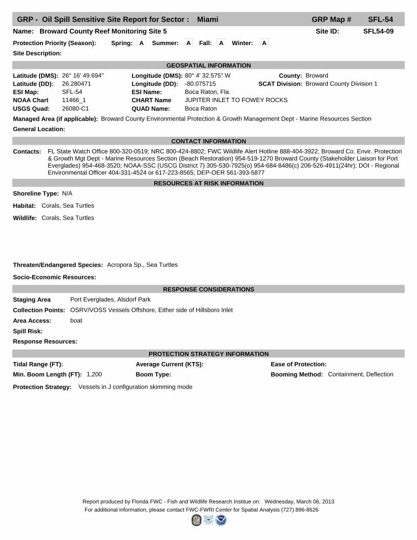
GRP - Oil Spill Sensitive Site Report for Sector : Miami GRP Map # SFL-54
Fall: ASpring: A Winter: A
Site ID: SFL54-09Name: Broward County Reef Monitoring Site 5
Site Description:
Protection Priority (Season):
County: Broward
General Location:
SCAT Division: Broward County Division 1
Managed Area (if applicable): Broward County Environmental Protection & Growth Management Dept - Marine Resources Section
Latitude (DMS): 26° 16' 49.694" Longitude (DMS): 80° 4' 32.575" W
Latitude (DD): 26.280471 Longitude (DD): -80.075715
GEOSPATIAL INFORMATION
ESI Map: SFL-54 ESI Name: Boca Raton, Fla.
NOAA Chart 11466_1 CHART Name JUPITER INLET TO FOWEY ROCKS
USGS Quad: 26080-C1 QUAD Name: Boca Raton
CONTACT INFORMATION
Contacts: FL State Watch Office 800-320-0519; NRC 800-424-8802; FWC Wildlife Alert Hotline 888-404-3922; Broward Co. Envir. Protection & Growth Mgt Dept - Marine Resources Section (Beach Restoration) 954-519-1270 Broward County (Stakeholder Liaison for Port Everglades) 954-468-3520; NOAA-SSC (USCG District 7) 305-530-7925(o) 954-684-8486(c) 206-526-4911(24hr); DOI - Regional Environmental Officer 404-331-4524 or 617-223-8565; DEP-OER 561-393-5877
RESOURCES AT RISK INFORMATION
Shoreline Type: N/A
Habitat: Corals, Sea Turtles
Wildlife: Corals, Sea Turtles
Threaten/Endangered Species: Acropora Sp., Sea Turtles
Socio-Economic Resources:
RESPONSE CONSIDERATIONS
Staging Area Port Everglades, Alsdorf Park
Collection Points: OSRV/VOSS Vessels Offshore, Either side of Hillsboro Inlet
Area Access: boat
Spill Risk:
Response Resources:
PROTECTION STRATEGY INFORMATION
Min. Boom Length (FT): 1,200 Booming Method: Containment, DeflectionBoom Type:
Protection Strategy: Vessels in J configuration skimming mode
Tidal Range (FT): Average Current (KTS): Ease of Protection:
Summer: A
Wednesday, March 06, 2013Report produced by Florida FWC - Fish and Wildlife Research Institue on:
For additional information, please contact FWC-FWRI Center for Spatial Analysis (727) 896-8626

GRP - Oil Spill Sensitive Site Report for Sector : Miami GRP Map # SFL-54
Fall: BSpring: B Winter: B
Site ID: SFL54-10Name: Broward County Reef Monitoring Site 6
Site Description:
Protection Priority (Season):
County: Broward
General Location:
SCAT Division: Broward County Division 1
Managed Area (if applicable): Broward County Environmental Protection & Growth Management Dept - Marine Resources Section
Latitude (DMS): 26° 16' 32.395" Longitude (DMS): 80° 4' 16.308" W
Latitude (DD): 26.275665 Longitude (DD): -80.071197
GEOSPATIAL INFORMATION
ESI Map: SFL-54 ESI Name: Boca Raton, Fla.
NOAA Chart 11466_1 CHART Name JUPITER INLET TO FOWEY ROCKS
USGS Quad: 26080-C1 QUAD Name: Boca Raton
CONTACT INFORMATION
Contacts: FL State Watch Office 800-320-0519; NRC 800-424-8802; FWC Wildlife Alert Hotline 888-404-3922; Broward Co. Envir. Protection & Growth Mgt Dept - Marine Resources Section (Beach Restoration) 954-519-1270 Broward County (Stakeholder Liaison for Port Everglades) 954-468-3520; NOAA-SSC (USCG District 7) 305-530-7925(o) 954-684-8486(c) 206-526-4911(24hr); DOI - Regional Environmental Officer 404-331-4524 or 617-223-8565; DEP-OER 561-393-5877
RESOURCES AT RISK INFORMATION
Shoreline Type: N/A
Habitat: Corals, Sea Turtles
Wildlife: Corals, Sea Turtles
Threaten/Endangered Species: Acropora Sp., Sea Turtles
Socio-Economic Resources:
RESPONSE CONSIDERATIONS
Staging Area Port Everglades, Alsdorf Park
Collection Points: OSRV/VOSS Vessels Offshore, Either side of Hillsboro Inlet
Area Access: boat
Spill Risk:
Response Resources:
PROTECTION STRATEGY INFORMATION
Min. Boom Length (FT): 1,200 Booming Method: Containment, DeflectionBoom Type:
Protection Strategy: Vessels in J configuration skimming mode
Tidal Range (FT): Average Current (KTS): Ease of Protection:
Summer: B
Wednesday, March 06, 2013Report produced by Florida FWC - Fish and Wildlife Research Institue on:
For additional information, please contact FWC-FWRI Center for Spatial Analysis (727) 896-8626

GRP - Oil Spill Sensitive Site Report for Sector : Miami GRP Map # SFL-54
Fall: BSpring: B Winter: B
Site ID: SFL54-11Name: Broward County Reef Monitoring Site 7
Site Description:
Protection Priority (Season):
County: Broward
General Location:
SCAT Division: Broward County Division 1
Managed Area (if applicable): Broward County Environmental Protection & Growth Management Dept - Marine Resources Section
Latitude (DMS): 26° 16' 25.940" Longitude (DMS): 80° 3' 49.198" W
Latitude (DD): 26.273872 Longitude (DD): -80.063666
GEOSPATIAL INFORMATION
ESI Map: SFL-54 ESI Name: Boca Raton, Fla.
NOAA Chart 11466_1 CHART Name JUPITER INLET TO FOWEY ROCKS
USGS Quad: 26080-C1 QUAD Name: Boca Raton
CONTACT INFORMATION
Contacts: FL State Watch Office 800-320-0519; NRC 800-424-8802; FWC Wildlife Alert Hotline 888-404-3922; Broward Co. Envir. Protection & Growth Mgt Dept - Marine Resources Section (Beach Restoration) 954-519-1270 Broward County (Stakeholder Liaison for Port Everglades) 954-468-3520; NOAA-SSC (USCG District 7) 305-530-7925(o) 954-684-8486(c) 206-526-4911(24hr); DOI - Regional Environmental Officer 404-331-4524 or 617-223-8565; DEP-OER 561-393-5877
RESOURCES AT RISK INFORMATION
Shoreline Type: N/A
Habitat: Corals, Sea Turtles
Wildlife: Corals, Sea Turtles
Threaten/Endangered Species: Acropora Sp., Sea Turtles
Socio-Economic Resources:
RESPONSE CONSIDERATIONS
Staging Area Port Everglades, Alsdorf Park
Collection Points: OSRV/VOSS Vessels Offshore, Either side of Hillsboro Inlet
Area Access: boat
Spill Risk:
Response Resources:
PROTECTION STRATEGY INFORMATION
Min. Boom Length (FT): 1,200 Booming Method: Containment, DeflectionBoom Type:
Protection Strategy: Vessels in J configuration skimming mode
Tidal Range (FT): Average Current (KTS): Ease of Protection:
Summer: B
Wednesday, March 06, 2013Report produced by Florida FWC - Fish and Wildlife Research Institue on:
For additional information, please contact FWC-FWRI Center for Spatial Analysis (727) 896-8626

GRP - Oil Spill Sensitive Site Report for Sector : Miami GRP Map # SFL-54
Fall: ASpring: A Winter: A
Site ID: SFL54-12Name: Hillsboro Inlet
Site Description:
Protection Priority (Season):
County: Broward
General Location:
SCAT Division: Broward County Division 1
Managed Area (if applicable):
Latitude (DMS): 26° 15' 24.516" Longitude (DMS): 80° 4' 52.243" W
Latitude (DD): 26.256810 Longitude (DD): -80.081179
GEOSPATIAL INFORMATION
ESI Map: SFL-54 ESI Name: Boca Raton, Fla.
NOAA Chart 11469_1 CHART Name FOWEY ROCKS; HILLSBORO INLET TO BIMINI ISLANDS
USGS Quad: 26080-C1 QUAD Name: Boca Raton
CONTACT INFORMATION
Contacts: FL State Watch Office 800-320-0519; NRC 800-424-8802; Broward County - Hillsborough Inlet Improvement and Maintenance District (Marine Resources) 954-519-1207; FWC Wildlife Alert Hotline 888-404-3922 Broward County (Stakeholder Liaison for Port Everglades) 954-468-3520; NOAA-SSC (USCG District 7) 305-530-7925(o) 954-684-8486(c) 206-526-4911(24hr); DOI - Regional Environmental Officer 404-331-4524 or 617-223-8565; DEP-OER 561-393-5877
RESOURCES AT RISK INFORMATION
Shoreline Type: Fine-medium grained sand beaches; Riprap; Sheltered, man-made structures
Habitat: Intracoastal waterway, Seawall habitat, ICW canals. Hard bottom/corals directly offshore of inlet Approx. center@ 26 degrees 15.287 N-80 degrees 4.846 W, Benthic Habitat, Mangroves
Wildlife: Manatee
Threaten/Endangered Species: Manatee, Sea turtles
Socio-Economic Resources:
RESPONSE CONSIDERATIONS
Staging Area 4WD vehicular access from both sides limited- Also stage at 14th St Boat ramp (Alsdorf Park)
Collection Points: Either side of Hillsboro Inlet
Area Access: boat/helicopter/vehicle
Spill Risk: MC 5-6
Response Resources: NE 16th St Beach access south inlet across @ to vehicles 26d 15.131 N 80d 5.097 W Boat ramp 14th St @ 26d 15.094N 80d 5.480 W
PROTECTION STRATEGY INFORMATION
Min. Boom Length (FT): 2,000 Booming Method: DeflectionBoom Type:
Protection Strategy: Place 2,000' of 48" deflection boom at inlet entrance, north or south depending on flow direction. See Hillsboro Inlet TIPS. Hillsboro Inlet requires a total of 8,100' of boom.
Tidal Range (FT): 2.5 Average Current (KTS): Ease of Protection:
Summer: A
Wednesday, March 06, 2013Report produced by Florida FWC - Fish and Wildlife Research Institue on:
For additional information, please contact FWC-FWRI Center for Spatial Analysis (727) 896-8626

GRP - Oil Spill Sensitive Site Report for Sector : Miami GRP Map # SFL-54
Fall: ASpring: A Winter: A
Site ID: SFL54-13Name: Coral Reefs from Martin County through Miami-Dade County
Site Description: Coral reef habitat
Protection Priority (Season):
County: Broward
General Location: Coral reefs up to 3nm offshore of Martin, Palm Beach, Broward, and Miami-Dade counties.
SCAT Division:
Managed Area (if applicable):
Latitude (DMS): 26° 17' 38.400" Longitude (DMS): 80° 3' 36.000" W
Latitude (DD): 26.294000 Longitude (DD): -80.060000
GEOSPATIAL INFORMATION
ESI Map: SFL-54 ESI Name: Boca Raton, Fla.
NOAA Chart 11469_1 CHART Name JUPITER INLET TO FOWEY ROCKS
USGS Quad: 26080-C1 QUAD Name: Boca Raton
CONTACT INFORMATION
Contacts: FL State Watch Office (800) 320-0519; FDEP Coral Reef Conservation Program (305) 795-2167 NOAA-SSC (USCG District 7) 305-530-7925(o) 954-684-8486(c) 206-526-4911(24hr); DOI Reg Officer 404-331-4524 or 617-223-8565; DEP-OER 561-393-5877
RESOURCES AT RISK INFORMATION
Shoreline Type: NA
Habitat: Coral reef
Wildlife: Corals, benthic resources, sea turtles
Threaten/Endangered Species: Sea turtles, Acroporids, Dendrogyra Cylindrus
Socio-Economic Resources:
RESPONSE CONSIDERATIONS
Staging Area
Collection Points:
Area Access:
Spill Risk:
Response Resources:
PROTECTION STRATEGY INFORMATION
Min. Boom Length (FT): Booming Method:Boom Type:
Protection Strategy: Any response activity affecting/impacting this area shall be reviewed and approved by the Environmental Unit within the Unified Command.
Tidal Range (FT): Average Current (KTS): Ease of Protection:
Summer: A
Wednesday, March 06, 2013Report produced by Florida FWC - Fish and Wildlife Research Institue on:
For additional information, please contact FWC-FWRI Center for Spatial Analysis (727) 896-8626

GRP - Oil Spill Staging Area Report for Sector : Miami GRP Map # SFL-54
Site ID: PB00479UAFacility Name: Silver Palm Park Boat Ramp
Site Type: Staging; Boat Ramp
Latitude (DMS): 26° 21' 0.263" N Longitude (DMS): 80° 4' 34.526" W
Latitude (DD): 26.35007307 Longitude (DD): -80.07625734
GEOSPATIAL INFORMATION
GENERAL INFORMATION AND COMMENTS
Access: Public
Operational Status:
Physical Address: 600 E. Palmetto Park Rd
County: Palm BeachCity: Boca Raton Zip Code 33432State: Florida
Water Type: Brackish Water Body Name:
SITE DESCRIPTION
Boat Ramp Surface Composition: Concrete
Parking Capacity for Cars: 11
Parking Surface: Paved AsphaltParking Lot Dimensions:
Access Constraints: None
Parking Capacity for Trailers: 0
Boat Launch Capability: Yes, 30'
Capable for Light or Heavy Equipment and Type:
Boom Available On-Site and Length:
Fuels Available: No
Number of Moorings: 0Number of Boat Slips: 0
Water Depth at End of Boat Ramp: 5'
Shoreline Type in Viewable Viscinity: Seawall
Crane Capabilities:
Collection Point Capabilities:
Wave Energy at Site:
ADDITIONAL AMMENITIES
Special/Pre-Planned Events and Dates:
Propane or Natural Gas Available
Water Available: Freshwater Fire Hydrant:
Pumpout Available: No Bathrooms Available: Yes
Electricity Amperage Available: No Camping Facilities:
Food Available: No Security Available and Hours On Duty:
Comments:
Survey Date:Survey Type: Data Collector (Agency):
Managing Agency: City of Boca Raton Department of Parks and Recreation
General Manager/Contact Person: Indy Ahern
Contact Phone #: 561-393-7810 or 561-416-3384 SCAT Description: Palm Beach County Division 1
Days of Operation:
Scale of Staging Area:
Hours of Operation: Sunrise to Sunset
Number of Boat Ramps: 1 Number of Boat Ramp Lanes: 2
Photo URL:
Wednesday, March 06, 2013Report produced by Florida FWC - Fish and Wildlife Research Institue on:
For additional information, please contact FWC-FWRI Center for Spatial Analysis (727) 896-8626

GRP - Oil Spill Staging Area Report for Sector : Miami GRP Map # SFL-54
Site ID: BW00009RFFacility Name: Alsdorf Park
Site Type: Boat Ramp
Latitude (DMS): 26° 15' 6.588" N Longitude (DMS): 80° 5' 29.580" W
Latitude (DD): 26.25183000 Longitude (DD): -80.09154999
GEOSPATIAL INFORMATION
GENERAL INFORMATION AND COMMENTS
Access: Municipal
Operational Status:
Physical Address: 2901 NE 14th St.
County: BrowardCity: Pompano Beach Zip Code 33062State: Florida
Water Type: Salt Water Body Name:
SITE DESCRIPTION
Boat Ramp Surface Composition: Asphalt
Parking Capacity for Cars: 81
Parking Surface: AsphaltParking Lot Dimensions:
Access Constraints:
Parking Capacity for Trailers: 70
Boat Launch Capability: 30'
Capable for Light or Heavy Equipment and Type: No
Boom Available On-Site and Length: No
Fuels Available: No
Number of Moorings: 0Number of Boat Slips: 0
Water Depth at End of Boat Ramp:
Shoreline Type in Viewable Viscinity: Concrete seawall with wooden docks
Crane Capabilities: Yes
Collection Point Capabilities:
Wave Energy at Site: Medium
ADDITIONAL AMMENITIES
Special/Pre-Planned Events and Dates:
Propane or Natural Gas Available No
Water Available: Saltwater Fire Hydrant: Yes
Pumpout Available: No Bathrooms Available: No
Electricity Amperage Available: No Camping Facilities: No Camping
Food Available: No Food Security Available and Hours On Duty: On site BSO marine patrol office
Comments:
Survey Date: 2010-07-31 00:00Survey Type: PlanningData Collector (Agency):
Managing Agency: City of Pompano Beach Parks & Recreation
General Manager/Contact Person:
Contact Phone #: 954-786-4111 SCAT Description: Broward County Division 1
Days of Operation: 24/7
Scale of Staging Area:
Hours of Operation: 24 Hours
Number of Boat Ramps: 3 Number of Boat Ramp Lanes: 6
Photo URL: http://ocean.floridamarine.org/waterphotos/ramp_photos/photo_id/3307/index.htm
Wednesday, March 06, 2013Report produced by Florida FWC - Fish and Wildlife Research Institue on:
For additional information, please contact FWC-FWRI Center for Spatial Analysis (727) 896-8626

GRP - Oil Spill Staging Area Report for Sector : Miami GRP Map # SFL-54
Site ID: BW00283ZPFacility Name: Pioneer Park
Site Type: Boat Ramp Only
Latitude (DMS): 26° 19' 19.240" N Longitude (DMS): 80° 5' 48.541" W
Latitude (DD): 26.32201100 Longitude (DD): -80.09681699
GEOSPATIAL INFORMATION
GENERAL INFORMATION AND COMMENTS
Access: Municipal
Operational Status:
Physical Address: 425 NE 3rd St.
County: BrowardCity: Deerfield Beach Zip Code 33441State: Florida
Water Type: Brackish Water Body Name:
SITE DESCRIPTION
Boat Ramp Surface Composition: Concrete
Parking Capacity for Cars: 14
Parking Surface: AsphaltParking Lot Dimensions:
Access Constraints:
Parking Capacity for Trailers: 23
Boat Launch Capability: 30'
Capable for Light or Heavy Equipment and Type: No
Boom Available On-Site and Length: No
Fuels Available: No
Number of Moorings: 0Number of Boat Slips: 0
Water Depth at End of Boat Ramp: G-8 Canal
Shoreline Type in Viewable Viscinity: Concrete
Crane Capabilities: Yes
Collection Point Capabilities:
Wave Energy at Site: Medium
ADDITIONAL AMMENITIES
Special/Pre-Planned Events and Dates:
Propane or Natural Gas Available No
Water Available: NA Fire Hydrant: Yes
Pumpout Available: No Bathrooms Available: Yes
Electricity Amperage Available: No Camping Facilities: No Camping
Food Available: On-Site Grocery/Restaurant Security Available and Hours On Duty: No, Broward Sheriff Office across
Comments:
Survey Date: 2010-07-30 00:00Survey Type: PlanningData Collector (Agency):
Managing Agency: City of Deerfield Beach Parks & Recreation
General Manager/Contact Person:
Contact Phone #: 954-480-4433 SCAT Description: Broward County Division 1
Days of Operation: 24/7
Scale of Staging Area:
Hours of Operation: 24 hours
Number of Boat Ramps: 1 Number of Boat Ramp Lanes: 3
Photo URL: http://ocean.floridamarine.org/waterphotos/ramp_photos/photo_id/3300/index.htm
Wednesday, March 06, 2013Report produced by Florida FWC - Fish and Wildlife Research Institue on:
For additional information, please contact FWC-FWRI Center for Spatial Analysis (727) 896-8626

104
INLET SUMMARY SHEET
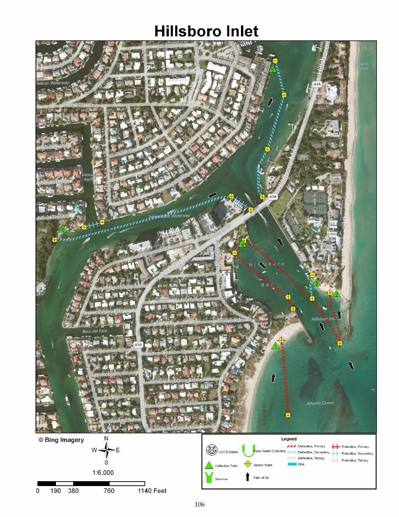
SITE: Hillsboro Inlet
DATE AND TIME OF ORIGINAL FIELD SURVEY [TIDE]: 27 June 1994; 1415
[High @ 1228 (+5.8); Hillsboro Inlet, entrance]
UPDATED:
In October 2011 using imagery collected in 2010 and 2011
RANKING (DEGREE OF DIFFICULTY): (see ranking scale)
A.
PRINCIPAL RESOURCES AT RISK:
Large number (+100) of Brown pelicans will roost on waterway. Manatees present. Atlantic green turtles and Atlantic loggerhead turtles nest on outer beaches. Patches of mangroves along waterway. Marina facilities, boats, and seawalls, revetments, docks, etc. on Hillsboro River and the network of canals along the river. For further information refer to the recent ESI map and data and the GRP.
PRELIMINARY PROTECTION STRATEGY:
Stretch a line of deflection boom across the southern marginal flood channel to deflect oil to the sand beach at CP1. Anchor another line of deflection boom to the south end of the remnant of the north jetty and extend it to the sand beach on the north side of the main entrance channel (CP2). Extend another line of deflection boom from the south end of the remnant of the north jetty to an anchor point further inside the inlet, which would serve as the head of a Christmas tree configuration of deflection boom. The short north limb of this Christmas tree will lead oil to a sand beach on the north side of the main inlet channel (CP3). The more southerly limb of the Christmas tree should lead to the seawall at the Hillsboro Inlet Park (Pompano Beach) (CP4). Extend another line of deflection boom from the landward end of the south jetty to the seawall at CP4. When the mid-90s field test was carried out, the land behind the seawall was a bare grassy lot. With the construction of the park, an overhanging walkway was built along the seawall. We recommend that a line of protection boom be placed in front of the walkway for the oil to accumulate on. Beyond the A1A Bridge, which is said to have 5-6 knots currents running under it, place a short line of protection boom from the south end of the bridge
105
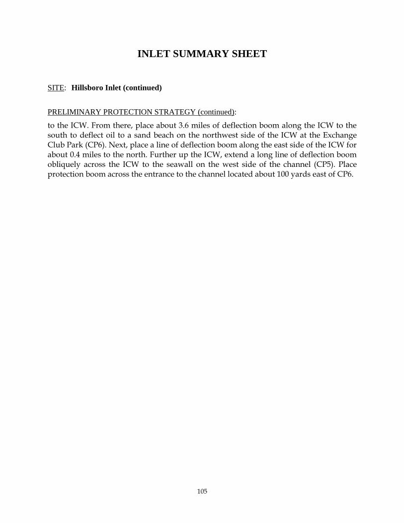
INLET SUMMARY SHEET
SITE: Hillsboro Inlet (continued)
PRELIMINARY PROTECTION STRATEGY (continued):
to the ICW. From there, place about 3.6 miles of deflection boom along the ICW to the south to deflect oil to a sand beach on the northwest side of the ICW at the Exchange Club Park (CP6). Next, place a line of deflection boom along the east side of the ICW for about 0.4 miles to the north. Further up the ICW, extend a long line of deflection boom obliquely across the ICW to the seawall on the west side of the channel (CP5). Place protection boom across the entrance to the channel located about 100 yards east of CP6.
106

107
Collection Point Description
Inlet: Hillsboro Inlet
Site Name: Collection Point #1
Relative Location: On the outer beach about 50-80 yards south of the south jetty.
Latitude: 26° 15' 26.965" N Longitude: 80° 4' 57.373" W
Currents: 1-3 knots along shore from the south during rising tides.
Shoreline Description: Sand beach.
Access: Possibly the easiest access would be from the bay side by watercraft (just south of the
south jetty) and walk across the beach. There are some large residences to the south of
the jetty. You may be able to drive along the beach, but access points are few and far
between.

108
Collection Point Description
Inlet: Hillsboro Inlet
Site Name: Collection Point #2
Relative Location: On the north side of the main inlet channel a few yards west of the west end
of the north jetty.
Latitude: 26° 15' 31.865" N Longitude: 80° 4' 50.385" W
Currents: Possibly up to 3-4 knots.
Shoreline Description: Sand beach.
Access: Beach is beside the grounds of the Hillsboro Lighthouse Station. You should be able to
drive to the beach across the grass lawn.

109
Collection Point Description
Inlet: Hillsboro Inlet
Site Name: Collection Point #3
Relative Location: On the north side of the main inlet channel about 80 yards west of the west
end of the north jetty.
Latitude: 26° 15' 33.298" N Longitude: 80° 4' 52.896" W
Currents: Possibly up to 3-4 knots.
Shoreline Description: Sand beach.
Access: Beach is beside the grounds of the Hillsboro Lighthouse Station. You should be able to
drive to the beach across the grass lawn.

110
Collection Point Description
Inlet: Hillsboro Inlet
Site Name: Collection Point #4
Relative Location: Shoreline of Hillsboro Inlet Park on west side of Hillsboro Bay.
Latitude: 26° 15' 37.423" N Longitude: 80° 5' 1.244" W
Currents: Possibly up to 3-4 knots.
Shoreline Description: Seawall with an overhanging platform. Place protection boom along the
seawall for the oil to accumulate on.
Access: You should be able to drive across the lawn to the seawall in Hillsboro Inlet Park.

111
Collection Point Description
Inlet: Hillsboro Inlet
Site Name: Collection Point #5
Relative Location: On the west side of the ICW about 450 yards north of the west end of the
main inlet channel.
Latitude: 26° 15' 55.699" N Longitude: 80° 4' 57.052" W
Currents: Possibly up to 3-4 knots.
Shoreline Description: Seawall.
Access: By watercraft.

112
Collection Point Description
Inlet: Hillsboro Inlet
Site Name: Collection Point #6
Relative Location: On the north side of the ICW about 645 yards west of the west end of the
main inlet channel, in the Exchange Club Park.
Latitude: 26° 15' 39.576" N Longitude: 80° 5' 22.163" W
Currents: Possibly up to 2-3 knots.
Shoreline Description: Sand beach.
Access: You can drive up close to the beach inside the Exchange Club Park. Then, if necessary,
you could drive across the grass lawn.
90
INLET SUMMARY SHEET
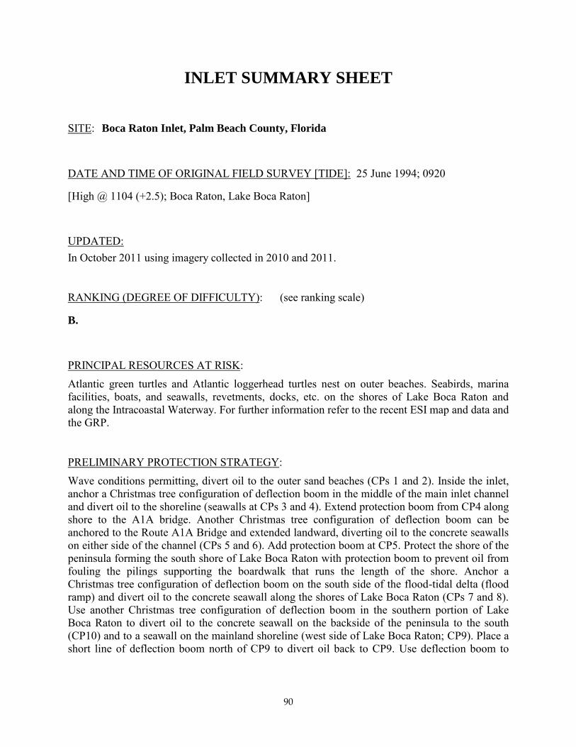
SITE: Boca Raton Inlet, Palm Beach County, Florida
DATE AND TIME OF ORIGINAL FIELD SURVEY [TIDE]: 25 June 1994; 0920
[High @ 1104 (+2.5); Boca Raton, Lake Boca Raton]
UPDATED: In October 2011 using imagery collected in 2010 and 2011.
RANKING (DEGREE OF DIFFICULTY): (see ranking scale)
B.
PRINCIPAL RESOURCES AT RISK: Atlantic green turtles and Atlantic loggerhead turtles nest on outer beaches. Seabirds, marina facilities, boats, and seawalls, revetments, docks, etc. on the shores of Lake Boca Raton and along the Intracoastal Waterway. For further information refer to the recent ESI map and data and the GRP.
PRELIMINARY PROTECTION STRATEGY: Wave conditions permitting, divert oil to the outer sand beaches (CPs 1 and 2). Inside the inlet, anchor a Christmas tree configuration of deflection boom in the middle of the main inlet channel and divert oil to the shoreline (seawalls at CPs 3 and 4). Extend protection boom from CP4 along shore to the A1A bridge. Another Christmas tree configuration of deflection boom can be anchored to the Route A1A Bridge and extended landward, diverting oil to the concrete seawalls on either side of the channel (CPs 5 and 6). Add protection boom at CP5. Protect the shore of the peninsula forming the south shore of Lake Boca Raton with protection boom to prevent oil from fouling the pilings supporting the boardwalk that runs the length of the shore. Anchor a Christmas tree configuration of deflection boom on the south side of the flood-tidal delta (flood ramp) and divert oil to the concrete seawall along the shores of Lake Boca Raton (CPs 7 and 8). Use another Christmas tree configuration of deflection boom in the southern portion of Lake Boca Raton to divert oil to the concrete seawall on the backside of the peninsula to the south (CP10) and to a seawall on the mainland shoreline (west side of Lake Boca Raton; CP9). Place a short line of deflection boom north of CP9 to divert oil back to CP9. Use deflection boom to

91
INLET SUMMARY SHEET
SITE: Boca Raton Inlet, Palm Beach County, Florida (continued)
PRELIMINARY PROTECTION STRATEGY (continued): divert oil entering the ICW from the north to a seawall on the mainland shore (CP11). NOTE: This area is entirely devoid of natural collection sites except on the outer beach. The rest of the collection points are close to or along seawalls, most of which are backed by closely spaced private residences. Access to the seawalls from the landward side may not be a good option, in which case, watercraft would have to be used for cleanup operations.
OTHER COMMENTS: The 1989 NOAA U.S. Coastal Pilot reported that tidal current velocities in Boca Raton Inlet may reach 7 knots.

92

93
Collection Point Description
Inlet: Boca Raton Inlet, Palm Beach County, Florida
Site Name: Collection Point #1
Relative Location: Just north of the north jetty.
Latitude: 26° 20' 11.673" N Longitude: 80° 4' 13.290" W
Currents: 1-3 knot flood currents along shore to the south during rising tide.
Shoreline Description: Sand beach.
Access: You can drive right up to (and onto) the beach.
94
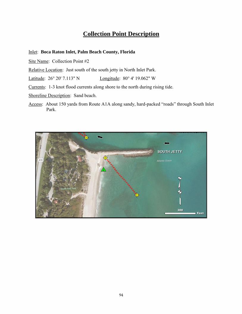
Collection Point Description
Inlet: Boca Raton Inlet, Palm Beach County, Florida
Site Name: Collection Point #2
Relative Location: Just south of the south jetty in North Inlet Park.
Latitude: 26° 20' 7.113" N Longitude: 80° 4' 19.062" W
Currents: 1-3 knot flood currents along shore to the north during rising tide.
Shoreline Description: Sand beach.
Access: About 150 yards from Route A1A along sandy, hard-packed “roads” through South Inlet Park.

95
Collection Point Description
Inlet: Boca Raton Inlet, Palm Beach County, Florida
Site Name: Collection Point #3
Relative Location: On east side of main inlet channel, 0.2 miles inland from jetties.
Latitude: 26° 20' 12.635" N Longitude: 80° 4' 20.285" W
Water Depth Description: On side of main inlet channel.
Currents: 3-6 knots in the channel.
Shoreline Description: Seawall.
Access: Beside highway; watercraft access may be best.

96
Collection Point Description
Inlet: Boca Raton Inlet, Palm Beach County, Florida
Site Name: Collection Point #4
Relative Location: West side of main inlet channel about 0.3 miles inland from the jetties.
Latitude: 26° 20' 10.484" N Longitude: 80° 4' 22.690" W
Currents: 3-6 knots in the channel.
Shoreline Description: seawall.
Access: Small parking area right by seawall.

97
Collection Point Description
Inlet: Boca Raton Inlet, Palm Beach County, Florida
Site Name: Collection Point #5
Relative Location: West side of main inlet channel about 150 yards landward of the Route A1A Bridge. Behind the Carlton Cove Condominium complex.
Latitude: 26° 20' 23.053" N Longitude: 80° 4' 24.068" W
Water Depth Description: On side of main inlet channel.
Currents: 4-5 knots in channel.
Shoreline Description: Seawall, wood dock pilings. Short CP on the seawall with covered walkway to the west.
Access: Paved to grass to 20 ft. to bulkhead; may be best to use watercraft.
98
Collection Point Description
Inlet: Boca Raton Inlet, Palm Beach County, Florida
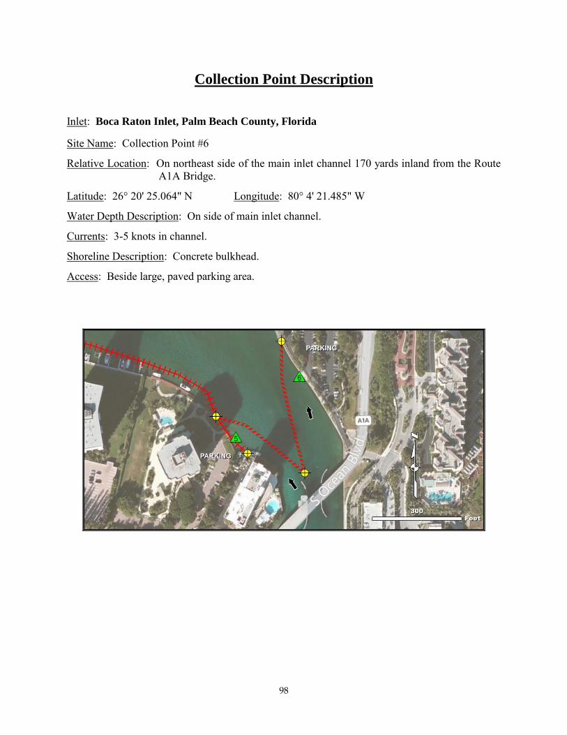
Site Name: Collection Point #6
Relative Location: On northeast side of the main inlet channel 170 yards inland from the Route A1A Bridge.
Latitude: 26° 20' 25.064" N Longitude: 80° 4' 21.485" W
Water Depth Description: On side of main inlet channel.
Currents: 3-5 knots in channel.
Shoreline Description: Concrete bulkhead.
Access: Beside large, paved parking area.

99
Collection Point Description
Inlet: Boca Raton Inlet, Palm Beach County, Florida
Site Name: Collection Point #7
Relative Location: Tennis court on east shore of Lake Boca Raton about 0.3 miles north of the A1A Bridge across the inlet.
Latitude: 26° 20' 38.298" N Longitude: 80° 4' 20.384" W
Currents: Probably up to 1.5 knots.
Shoreline Description: Concrete seawall.
Access: Side of large grassy lot with a tennis court in the middle of it. Recommend using watercraft.
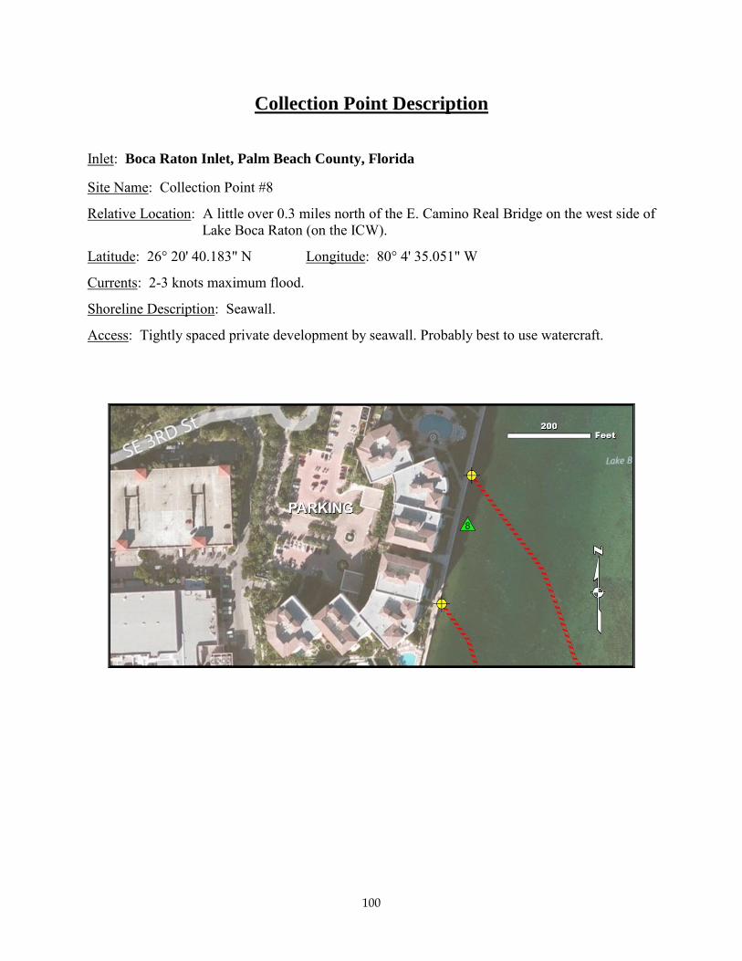
100
Collection Point Description
Inlet: Boca Raton Inlet, Palm Beach County, Florida
Site Name: Collection Point #8
Relative Location: A little over 0.3 miles north of the E. Camino Real Bridge on the west side of Lake Boca Raton (on the ICW).
Latitude: 26° 20' 40.183" N Longitude: 80° 4' 35.051" W
Currents: 2-3 knots maximum flood.
Shoreline Description: Seawall.
Access: Tightly spaced private development by seawall. Probably best to use watercraft.

101
Collection Point Description
Inlet: Boca Raton Inlet, Palm Beach County, Florida
Site Name: Collection Point #9
Relative Location: West shore of Lake Boca Raton (on ICW) about 0.3 miles north of the E. Camino Real Bridge.
Latitude: 26° 20' 37.249" N Longitude: 80° 4' 35.952" W
Currents: 1-3 knots maximum flood current.
Shoreline Description: Seawall.
Access: Dense private development landward of seawall. Probably best to use watercraft.

102
Collection Point Description
Inlet: Boca Raton Inlet, Palm Beach County, Florida
Site Name: Collection Point #10
Relative Location: 150 yards north of the East Camino Real Bridge, on east side of ICW.
Latitude: 26° 20' 25.084" N Longitude: 80° 4' 34.285" W
Water Depth Description: On the side of the ICW.
Currents: 1-3 knots maximum flood current.
Shoreline Description: Concrete bulkhead.
Access: Complex private area. Probably best to use watercraft.

103
Collection Point Description
Inlet: Boca Raton Inlet, Palm Beach County, Florida
Site Name: Collection Point #11
Relative Location: About 60 yards south of the East Camino Real Bridge, on west side of ICW.
Latitude: 26° 20' 20.843" N Longitude: 80° 4' 39.781"
Water Depth Description: On the side of the ICW.
Currents: 1-3 knots maximum flood currents.
Shoreline Description: Seawall.
Access: Closely spaced private houses landward of seawall. Probably best to use watercraft.

#*
#*
#*
#*
#*
#*
#*
#*
#*
#*
#*
!A
!A
!A
!A
!A
!A
!A
!A
!A
!A
!A
!A
!A
!A
!A
!A
!A
!A
!A
!A
!A
!A
!A
!A
!A
#
#
XXX
Boca Raton Inlet/Lake Boca Raton
80°4'30"W
80°4'30"W
26°20
'30"N
26°20
'30"N
26°20
'0"N
26°20
'0"N
LegendEnvironmentally Sensitive Areas Priority of Protection - SummerXXX A - Protect First - Highest Priority
XX B - Protect after A Areas - Medium Priority
X C - Protect after B Areas - Lower PriorityGRP Collection SitesCollection Type# Collection Point
!h( Shallow Water Skimmer
SkimmerGRP Booming Strategies
TIPS - Tactics#* Collection Point
Ñ
Skimmer
;; ØOpen Water Collection
!A Anchor Point
Path of Oil
TIPS Map Index
TIPS - BoomsType, Level
Deflection, Primary
Deflection, Secondary
Deflection, Tertiary
Dike
Protection, Primary
Protection, Secondary
Protection, Tertiary
µ0 700 1,400350Feet
Tidal Inlet: Boca Raton InletTIPS vs GRP Booming Strategies Deconfliction Map