“b1” category – minor mineral – cluster – non forest …
TRANSCRIPT
EXECUTIVE SUMMARY
Thiru.P. Selvam
MULTI-COLOUR GRANITE QUARRY
S.F. Nos: 72/2,72/3,72/5A– Extent: 3.58.0 ha
Karandapalli Village, Denkanikottai Taluk, Krishnagiri District,
Tamil Nadu State
“B1” CATEGORY – MINOR MINERAL – CLUSTER – NON FOREST
LAND
* CLUSTER EXTENT = 11.44.0 HA
Complied as per ToR Obtained vide
Lr.No.SEIAA-TN/F.No.7351/SEAC/TOR-716/2020 Dated: 17.06.2020
Project Proponent Thiru.P.Selvam,
S/o,Palani,
55, Lakshmi Narashima Nagar,
Thotagiri Main Road,
Hosur Town and Taluk,
Krishnagiri, District - 635 109.
Environmental Consultant
GEO EXPLORATION AND MINING SOLUTIONS
Old No. 260-B, New No. 17,
Advaitha Ashram Road, Alagapuram,
Salem – 636 004, Tamil Nadu, India
Accredited for sector 1, 28 & 38 Category ‘A’
Certificate No : NABET/EIA/1821/RA0123
Phone: 0427-2431989,
Email: [email protected], [email protected]
Web: www.gemssalem.com
* Calculated as per MoEF & CC Notification – S.O. 2269(E) Dated: 01.07.2016

Thiru.P.Selvam Executive Summary
Multi-Colour Granite Quarry Page 2
1. INTRODUCTION
Granite is the major requirements for construction and ornamental stone industries. This EIA
report is prepared for Thiru.P.Selvam, who has applied for Multicolour Granite quarry lease
in his own patta land (S.F.Nos.72/2,72/3,72/5A) over an extent of 3.58.0 Ha in Karandapalli
Village, Denkanikottai Taluk, Krishnagiri District, Tamil Nadu.
This EIA report is prepared by considering Cumulative load of proposed & existing multi-
colour Granite falling in the cluster situation (Two Proposed and Two Existing Quarries). The
total extent of Cluster quarries is 11.44.0 ha, calculated as per MoEF & CC Notification S.O.
2269(E) Dated 1st July 2016.
This EIA Report is prepared in compliance with ToR obtained vide letter No Lr.No.SEIAA-
TN/F.No. 7351/SEAC/TOR-716/2020, Dated: 17.06.2020. The Baseline Monitoring study
has been carried out during winter season (October 2020 - December 2020) considering the
provisions of MoEF & CC Office Memorandum Dated: 29.08.2017 and MoEF & CC
Notification S.O. 996 (E) Dated: 10.04.2015.
Now, as per Order Dated: 04.09.2018 & 13.09.2018 passed by Hon'ble National Green
Tribunal, New Delhi in O.A. No. 173 of 2018 & O.A. No, 186 of 2016 and MoEF & CC
Office Memorandum F. No. L-11011/175/2018-IA-II (M) Dated: 12.12.2018 clarified the
requirement for EIA, EMP and therefore, Public Consultation for all areas from 5 to 25 ha
falling in Category B- 1 and appraised by SEAC/ SEIAA as well as for cluster situation.
The proposed projects is categorized under category “B1” Activity 1(a) (mining lease
area in cluster situation) and will be considered at SEIAA – TN after conducting Public
Hearing and Submission of EIA/EMP Report for Grant of Environmental Clearance.
“Draft EIA report prepared on the basis of ToR Issued for carrying out public hearing
for the grant of Environmental Clearance from SEIAA, Tamil Nadu”
1.1 DETAILS OF PROJECT PROPONENT –
Name of the Project Proponent : Thiru.P.Selvam,
S/o,Palani,
Address : No.55,Lakshmi Narashima Nagar,
Thotagiri Main Road,
Hosur Town and taluk
Krishnagiri,
State : Tamil Nadu
Pin code 63109
Mobile No : +919597650008
Email id. : [email protected]
Status : Private Individual
Thiru.P.Selvam Executive Summary
Multi-Colour Granite Quarry Page 3
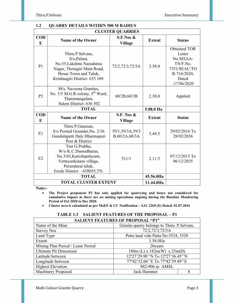
1.2 QUARRY DETAILS WITHIN 500 M RADIUS
CLUSTER QUARRIES
COD
E Name of the Owner
S.F.Nos &
Village Extent Status
P1
Thiru.P.Selvam,
S/o,Palani,
No.55,Lakshmi Narashima
Nagar, Thotagiri Main Road,
Hosur Town and Taluk,
Krishnagiri District- 635 109.
72/2,72/3,72/5A 3.58.0
Obtained TOR
Letter
No.SEIAA-
TN/F.No.
7351/SEAC/TO
R-716/2020,
Dated
:17/06/2020
P2
M/s. Naveena Granites,
No. 5/5 M.G.R colony, 5th
Ward,
Tharamangalam,
Salem District- 636 502
60/2B,60/3B 2.30.0 Applied
TOTAL 5.88.0 Ha
COD
E Name of the Owner
S.F. Nos &
Village Extent Status
E1
Thiru P.Ganesan,
S/o Permal Gounder,No. 2/36
Gundalapatti Hale Dharmapuri
Post & District
59/1,59/3A,59/3
B,60/2A,60/3A 3.44.5
29/02/2016 To
28/02/2036
E2
Tmt G.Prabha,
W/o K.C.Damodharan,
No.3/65,Karichipalayam,
Vettayankinaru village,
Perundurai taluk,
Erode District – 638055,TN.
511/1 2.11.5 07/12/2015 To
06/12/2035
TOTAL 45.56.0Ha
TOTAL CLUSTER EXTENT 11.44.0Ha
Note:- • The Project proponent P2 has only applied for quarrying and hence not considered for
cumulative impact as there are no mining operations ongoing during the Baseline Monitoring
Period of Oct 2020 to Dec 2020.
• Cluster area is calculated as per MoEF & CC Notification – S.O. 2269 (E) Dated: 01.07.2016
TABLE 1.3 SALIENT FEATURES OF THE PROPOSAL – P1
SALIENT FEATURES OF PROPOSAL “P1”
Name of the Mine Granite quarry belongs to Thiru. P.Selvam.
Survey Nos 72/2,72/3,72/5A
Land Type Patta land vide Patta.No:3524, 3520
Extent 3.58.0Ha
Mining Plan Period / Lease Period 20years
Ultimate Pit Dimension 180m (L) x 182m(W) x 25m(D)
Latitude between 12º27’29.90’’N To 12º27’36.45’’N
Longitude between 77º42’52.06’’E To 77º42’59.89’’E
Highest Elevation 882-906 m AMSL
Machinery Proposed Jack Hammer 8

Thiru.P.Selvam Executive Summary
Multi-Colour Granite Quarry Page 4
Compressor 2
Diamond Wire Saw 2
Diesel Generator 1
Crawler Crane 1
Excavator 2
Tipper 2
Proposed Blasting Method Controlled blasting
Manpower Proposed 35
Total Project Cost Rs. 2,88,26,100/-
1.4 STATUTORY DETAILS
• The project proponent had applied for Multi- Colour Granite quarry lease over an
extent of 3.58.0 ha of Patta Land in SF.No 72/2,72/3,72/5A Karandapalli Village,
Denkanikottai Taluk, Krishnagiri District. Tamil Nadu State – Dated:08.02.2019
• The Proponent had applied for ToR for Environmental Clearance vide online Proposal
No. No.SIA/TN/MIN/48919/2019 Dated: 24.12.2019
• The proponent applied for Granite Quarry Lease, Dated: 08.02.2019
• Precise Area Communication Letter was issued by the Industries (MME.2)
Department, Secretariat Chennai, vide Lr. No. 7898/MME.2/2019-1,dated 08.11.2019
• The Mining Plan was prepared and got approved by Director of Geology and Mining
Guindy, Chennai, vide Rc.No.1613/MM4/2019, Dated:13.12.2019
• Proponent applied for ToR to get Environmental Clearance vide online Proposal No.
SIA/TN/MIN/48919/2019, Dated: 24.12.2019
• The proposal was placed in 152nd
SEAC meeting held on 23.05.2020 and the
committee recommended for issue of ToR.
• The proposal was considered in 381st SEIAA meeting held on 17.06.2020 and issued
ToR vide Letter No SEIAA-TN/F.No.7351/SEAC/TOR-716/2020, Dated :17.06.2020
2. PROJECT DESCRIPTION
The proponent applied for Quarry lease dated 08.02.2019. The precise area
communication letter issued by Industries (MME.2)Department, Secretariat Chennai,
vide LetterNo.7898/MME.2/2019-1,dated 08.11.2019, the mining plan has been
prepared and got approved Director of Geology and Mining Guindy, Chennai, vide
Rc.No.1613/MM4/2019, Dated:13.12.2019.
The area is fresh land, no mining activities carried out before, Topography of the area is plain
terrain with gentle gradient towards North side. No major vegetation or trees within the
project area, the project is site specific and there is no additional area required for this project.
There is no effluent generation/discharge from the proposed quarry.
Multi-Colour Granite is proposed to quarry by opencast mechanized method involving Eco-
friendly Diamond Wire Saw Cutting. Heavy earth moving machineries like Excavators
Trucks will be deployed in this quarrying operation for Granite exploitation. Shot hole

Thiru.P.Selvam Executive Summary
Multi-Colour Granite Quarry Page 5
drilling with controlled blasting using slurry explosives for removal of overburden and
Weathered portions during initial stage of quarry operation.
1.3 SITE CONNECTIVITY TO THE PROJECT AREA
Nearest Roadway SH-17A – Denkanikottai – Hosur –11.5km - NE
NH-7 – Bangalore – Salem – NE 33.0Km - NE
Nearest Village Karandapalli-1Km-West
Nearest Town Denkanikottai- 11Km-NE
Nearest Railway Station &
Railway Line
Hosur-31Km-NE
Nearest Airport Bangalore Airport – 55Km-North
Seaport Chennai -275Km-NE
Interstate boundary Karnataka Interstate boundary – 9.5 km – West
Coastal line Bay of Bengal Sea – 241 km – Southeast
Forest The following Reserved Forest is located within
10km radius of the area.
1. Ponai R.F. – 1.2 South,
2. Ulibanda R.F. – 5 km SouthWest,
3. Noganoor R.F – 4.0Km NE
4. Jowlagiri R.F. – 6.3km Northwest
Wildlife sanctuary Cauvery (North)wildlife Sanctuary -1.2 km South
2.2 LAND USE PATTERN OF THE PROPOSED PROJECTS
Description Area To Be Required During
The Present Plan Period (Ha)
Area at The End of Life of
Quarry (Ha)
Quarry Pit/ Area under
Quarry 0.88.2 2.89.6
Infrastructure 0.02.0 0.02.0
Waste Dump 0.38.0 Backfilling
Roads 0.02.0 0.05.0
Green Belt 0.21.0 0.57.2
Stocking blocks 2.06.8 0.04.2
Grand Total 3.58.0 3.58.0
2.3 OPERATIONAL DETAILS OF LEASE APPLIED AREA
Description ROM
in m3
Granite
Recovery
@ 35 % in m3
Granite
Waste
@ 65 % in
m3
Weathered
in m3
Topsoil
in m3
Geological Resources 815653 285480 530173 53390 55678
Mineable Reserves 501318 175461 325857 41272 44942
Year-wise Production 103225 36130 67095 2250 4000
Number of Working Days 300 Days
Production per day 69 24 45 4 7
No of Lorry loads (6m3per
load) 12 4 8 1 1
Thiru.P.Selvam Executive Summary
Multi-Colour Granite Quarry Page 6
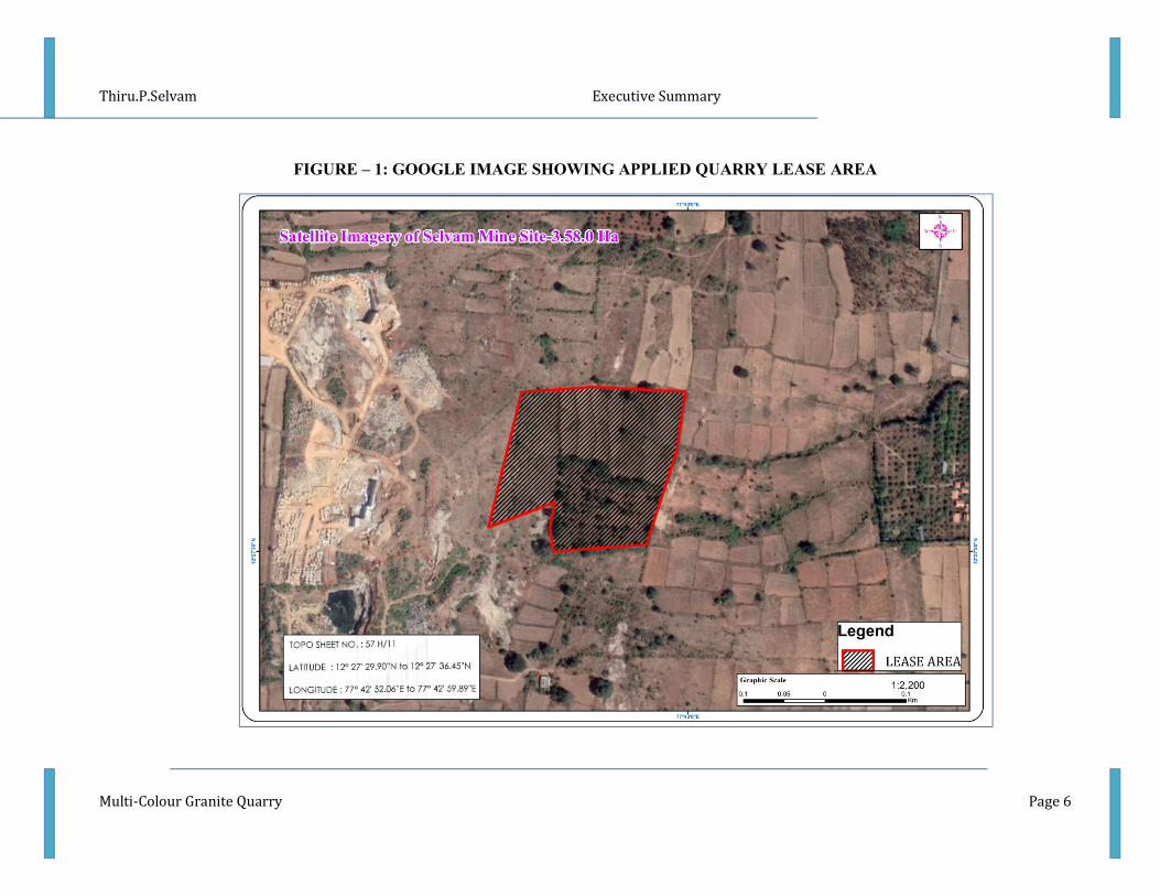
FIGURE – 1: GOOGLE IMAGE SHOWING APPLIED QUARRY LEASE AREA
Thiru.P.Selvam Executive Summary
Multi-Colour Granite Quarry Page 7
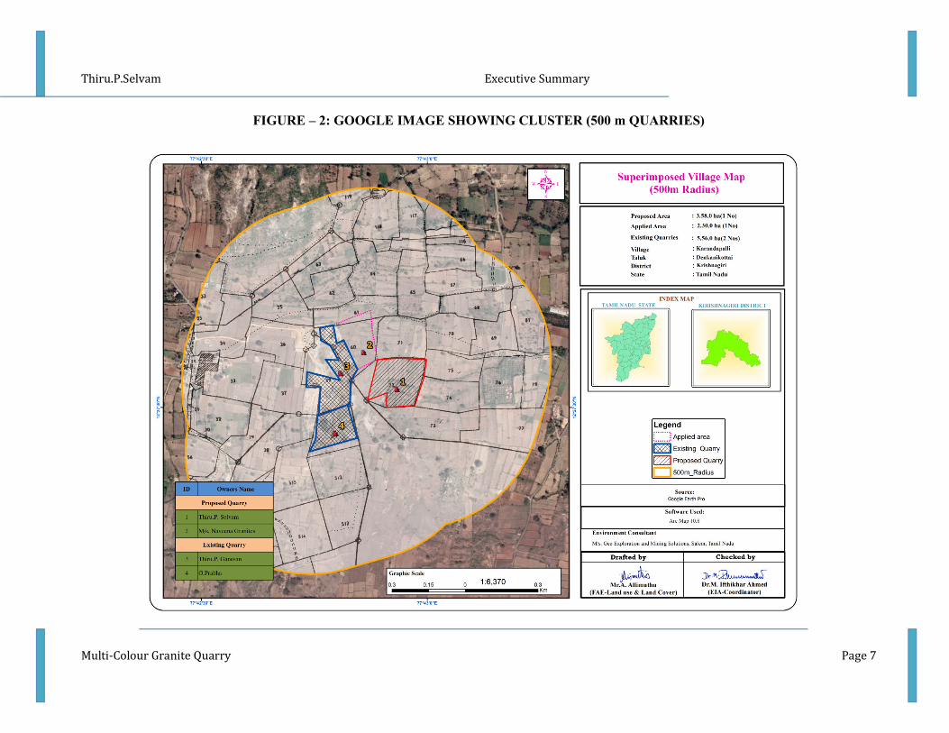
FIGURE – 2: GOOGLE IMAGE SHOWING CLUSTER (500 m QUARRIES)
Thiru.P.Selvam Executive Summary
Multi-Colour Granite Quarry Page 8
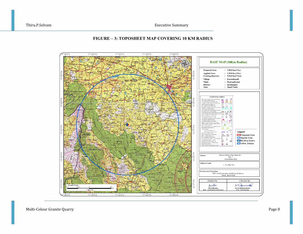
FIGURE – 3: TOPOSHEET MAP COVERING 10 KM RADIUS
Thiru.P.Selvam Executive Summary
Multi-Colour Granite Quarry Page 9
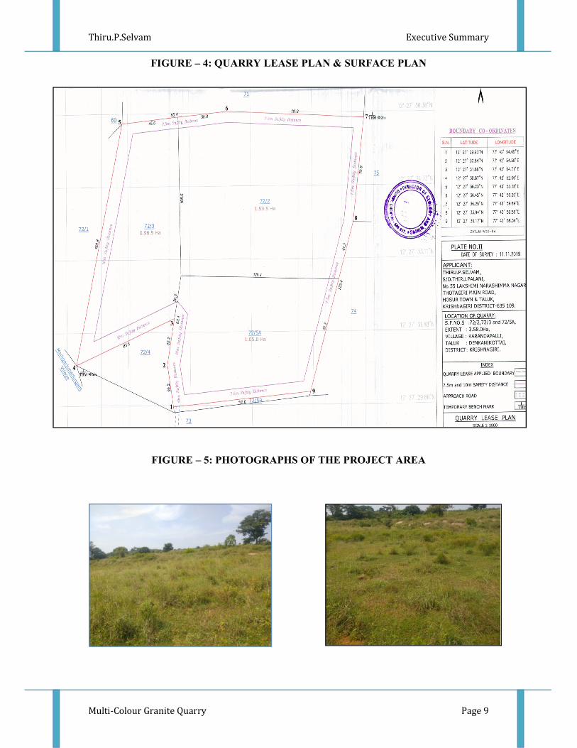
FIGURE – 4: QUARRY LEASE PLAN & SURFACE PLAN
FIGURE – 5: PHOTOGRAPHS OF THE PROJECT AREA

Thiru.P.Selvam Executive Summary
Multi-Colour Granite Quarry Page 10
2.4 METHOD OF MINING
The method of mining is Opencast mechanized method
• Eco-friendly dimensional wire saw cutting for liberation and splitting up of blocks
from parent sheet rocks
• Splitting of rock body of considerable volume from the parent rock formation by
carefully avoiding visibly seen defects such as patches veins, etc., is done by adopting
the method of “Diamond wire cutting” along the horizontal as well as two vertical
sides on the front face of the formation
• Jackhammer drilling with 32mm dia, this huge portion is further split into several
blocks of required dimensions, only slurry explosives are used for secondary
fragmentation and handling of waste.
• Hydraulic Excavator coupled with tippers is deployed for the formation of benches
and loading
• There is no mineral processing or ore beneficiation proposed
• Proposed bench height is 6m and 6m width with 900slope
• The waste material generated during quarrying activity includes rock fragments of
different sizes, and waste chips during dressing of the blocks. The waste materials
are taken in tippers and proposed to be dumped in the respective approved
places ear-marked for the purpose and the same will be utilized for backfilling in the
northern side of the lease area during conceptual stage.
2.5 PROPOSED MACHINERY DEPLOYMENT
S.NO. TYPE NOS SIZE/CAPACITY MOTIVE
POWER
1 Jack hammer 8 1.2m to 6m Compressed air
2 Compressor 2 140cfm/400psi Diesel Drive
3 Diamond wire saw 2 20m3/day
Diesel
Generator
4 Diesel Generator 1 125kva Diesel Drive
5 Crawler Crane 1 855 Generator
6 Excavator 2 300 Diesel Drive
7 Tipper 2 20 tonnes Diesel Drive
2.6 CONCEPTUAL MINING PLAN/ FINAL MINE CLOSURE PLAN
Conceptual mining plan is prepared with an object of long-term systematic development of
benches, lay outs, selection of permanent ultimate pit limit, depth of quarrying and ultimate
pit, selection of sites for construction of infrastructure etc. The ultimate pit size is designed

Thiru.P.Selvam Executive Summary
Multi-Colour Granite Quarry Page 11
based on certain practical parameters such as economical depth of quarrying, safety zones,
permissible area etc.
2.7 ULTIMATE PIT DIMENSION
Pit Length (Max) (m) Width (Max) (m) Depth (Max) (m)
I 180 182 25
3.0 DESCRIPTION OF THE ENVIRONMENT
Field monitoring studies to evaluate the base line status of the project site were carried
out covering October 2020, November 2020 & December 2020 as per CPCB guidelines.
Environmental Monitoring data has been collected with reference to proposed mine by
OMEGAA LABORATORIES ISO 9001: 2008, OHSAS 18001: 2007 Certified & MoEF
Notified Laboratory
3.1 ENVIRONMENT MONITORING ATTRIBUTES
Sl.No. Attributes Parameters Source and Frequency
1 Ambient Air Quality PM10, PM 2.5, SO2, NO2 Continuous 24 hourly samples
twice a week for three months
at 7 locations
(2 Core & 5 Buffer)
2 Meteorology Wind speed and direction,
temperature, relative humidity
and rainfall
Near project site continuous
for three months with hourly
recording and from secondary
sources of IMD station
3 Water quality Physical, Chemical and
Bacteriological parameters
Grab samples were collected
at 3 ground water and 2
surface water locations once
during study period.
4 Ecology Existing terrestrial and aquatic
flora and fauna within 10 km
radius circle.
Limited primary survey and
secondary data was
5 Noise levels Noise levels in dB(A) 7 locations (2 Core & 5
Buffer) – data monitored once
for 24 hours during EIA study
6 Soil Characteristics Physical and Chemical
Parameters
Once at 5 locations (1 Core &
4 Buffer) during study period
7 Land use Existing land use for different
categories
Based on Survey of India
topographical sheet and
satellite imagery and primary
survey.
8 Socio-Economic Aspects Socio-economic and
demographic characteristics,
worker characteristics
Based on primary survey and
secondary sources data like
census of India 2011.
9 Hydrology Drainage pattern of the area,
nature of streams, aquifer
characteristics, recharge and
discharge areas
Based on data collected from
secondary sources as well as
hydro-geology study report
prepared.
10 Risk assessment and Disaster
Management Plan
Identify areas where disaster
can occur by fires and
explosions and release of toxic
substances
Based on the findings of Risk
analysis done for the risk
associated with mining.

Thiru.P.Selvam Executive Summary
Multi-Colour Granite Quarry Page 12
3.2 LAND ENVIRONMENT
Land use pattern of the area was studied through LISS III imagery of Bhuvan (ISRO).
The 10 km radius map of study area was taken for analysis of Land use cover. The main
objective of this section is to provide a baseline status of the study area covering 10 km
radius around the mine site so that temporal changes due to the mining activities on the
surroundings can be assessed in future.
S.No Classification Area in Ha Area in %
1 Crop Land and Fallow Land 18606.37 56.04
2 Agriculture Plantation 1871.92 5.64
3 Barren Scrub 2056.27 6.19
4 BuiltUp Rural 83.71 0.25
5 BuiltUp Urban 51.47 0.16
6 Mining 57.70 0.17
7 Water Bodies 193.29 0.58
8 Forest Deciduos 7102.88 21.39
9 Forest Evergreen 1455.37 4.38
10 Scrub Forest 535.97 1.61
11 Water Bodies River Odai 1185.51 3.57
Total 33200.45 100.00
From the above table it is inferred that the majority of the land in the study area is Agriculture
and crop land 61.68 % followed by Forest land 27.39%, barren scrub 6.19% ,Water bodies
4.15%, Built up area 0.58%.
The total mining area within the study area is 57.70 ha i.e., 0.17%. The cluster area of
11.44.0 ha contributes about 19.82 % of the total mining area within the study area. This
percentage of Mining Activities shall not have any significant impact on the environment.
The project area is situated an elevated terrain, upto 24m Above the General Ground Level.
The gradient is 3 in 25 towards East and the altitude of the area is ranges from 882m to 906m
AMSL
3.3 SOIL ENVIRONMENT
Variation in pH of the soil in the study area was found to be moderately alkaline to
strongly alkaline in nature (7.19 - 8.36).
Mostly the soils collected from different location in the study area are Clay loam &
bulk density of the soil in range between 0.07 to 1.56 g/cc.
The available Nitrogen content range between 36.7 to 41.7 kg/ha
The available Phosphorus content range between 45.1 to 48.7 kg/ha
The available Potassium range between 4.8 to 8.9 mg/kg

Thiru.P.Selvam Executive Summary
Multi-Colour Granite Quarry Page 13
3.4 WATER ENVIRONMENT
The study area is studded with few tanks that serve as the source of drinking water and also
their surplus feeds adjoining tanks. The rainfall over the area is moderate, the rainwater
storage in open wells and trenches are in practice over the area and the stored water acts as
source of freshwater for couple of months after rainy season.
Surface Water
pH: The pH varied from 7.08 to 7.71 while turbidity found within the standards (Optimal
pH range for sustainable aquatic life is 6.5 to 8.5 pH).
Total Dissolved Solids: Total Dissolved Solids varied from 455 to 478 mg/l, the TDS mainly composed of
carbonates, bicarbonates, Chlorides, phosphates and nitrates of calcium, magnesium, sodium
and other organic matter.
Other parameters: Chloride varied between 157 mg/l and 172 mg/l. Nitrates varied from 4.2 to 5.6 mg/l,
while sulphates varied from 32.1 to 34.9 mg/l.
Ground Water
The pH of the water samples collected ranged from 7.01 to 7.55 and within the
acceptable limit of 6.5 to 8.5. pH, Sulphates and Chlorides of water samples from all the
sources are within the limits as per the Standard. On Turbidity, the water samples meet the
requirement. The Total Dissolved Solids were found in the range of 320 - 416 mg/l in all
samples. The Total hardness varied between 98.9 –145.2 mg/l. On Microbiological
parameters, the water samples from all the locations meet the requirement. The parameters
thus analysed were compared with IS 10500:2012 and are well within the prescribed limits.
3.5 AIR ENVIRONMENT
The baseline studies on air environment include identification of specific air pollution
parameters and their existing levels in ambient air. The ambient air quality with respect to the
study zone of 10 km radius around the proposed quarry forms the baseline information.

Thiru.P.Selvam Executive Summary
Multi-Colour Granite Quarry Page 14
FIGURE – 6: WIND ROSE DIAGRAM
3.6 SUMMARY OF AMBIENT AIR QUALITY
From the above data, the concentration of main criteria pollutants has been observed that
maximum concentration of PM10 is 43.5µg/m3
recorded at Andevanapalli and minimum is
34µg/m3recorded at Near Project Area. The concentration of PM2.5 varies from 17.2–
23.7µg/m3 Minimum concentration was recorded at Muluvanapalli and Maximum
concentration of PM2.5 recorded at Project Area- North East Corner. SO2 concentration level
ranged from 4 – 6.9µg/m3and NO
2concentration ranged from 14.7 – 20.7µg/m
3in the study
area.
0
5
10
15
20
25
30
35
40
45
AAQ1 AAQ2 AAQ3 AAQ4 AAQ5 AAQ6 AAQ7
PM10, µg/m3
PM2.5, µg/m3
SO2, µg/m3
NO2, µg/m3
Thiru.P.Selvam Executive Summary
Multi-Colour Granite Quarry Page 15
3.7 NOISE ENVIRONMENT
Ambient noise levels were measured at 7 (Seven) locations around the proposed
project area. Noise levels recorded in core zone during day time were from 46.8 – 48.2 dB
(A) Leq and during night time were from 36.3 – 38.1 dB (A) Leq. Noise levels recorded in
buffer zone during day time were from 43 - 48.7dB (A) Leq and during night time were
from 33.8 – 36.3 dB (A) Leq.
The values of noise observed in some of the areas are primarily owing to quarrying
activities due to cluster of quarries within 500m radius, movement of vehicles and other
anthropogenic activities. Noise monitoring results reveal that the maximum & minimum
noise levels at day time were recorded in the range of 48.7 dB(A) Leq in near Project area
and 43 dB(A) Leq in Medumuthukote village and 38.1 dB(A) in Project Area & 33.8 dB(A)
in Medumuthukote at night time. Thus, the noise level for Industrial and Residential area
meets the requirements of CPCB.
3.8 ECOLOGICAL ENVIRONMENT
There is no Forest land, National Parks, Eco sensitive areas, Wild life sanctuaries
within the radius of 10 km. An ecological survey of the study area was conducted
particularly with reference to the listing of species and assessment of the existing baseline
ecological (terrestrial) condition in the study area.
There is no schedule I species of animals observed within study area as per Wildlife
Protection Act 1972 as well as no species is in vulnerable, endangered or threatened category
as per IUCN. There is no endangered red list species found in the study area. Hence this
small operation over short period of time will not have any significant impact on the
surrounding flora and fauna.
3.9 SOCIO ECONOMIC ENVIRONMENT
It includes demographic structure of the area, provision of basic amenities viz.,
housing, education, health and medical services, occupation, water supply, sanitation,
communication, transportation, prevailing diseases pattern as well as feature like temples,
historical monuments etc., at the baseline level. This will help in visualizing and predicting
the possible impact depending upon the nature and magnitude of the project.
The socio economic study of surveyed villages gives a clear picture of its population,
average household size, literacy rate and sex ratio etc. It is also found that a part of
population is suffering from lack of permanent job to run their day to day life. Their
expectation is to earn some income for their sustainability on a long-term basis.
The proposed project will aim to provide preferential 35 persons to the local people
there by improving the indirect employment opportunity for 60 persons and in turn the social
standards will improve.

Thiru.P.Selvam Executive Summary
Multi-Colour Granite Quarry Page 16
4. ANTICIPATED ENVIRONMENTAL IMPACTS AND MITIGATION MEASURES
In order to maintain the environmental commensuration with the mining operation, it
is essential to undertake studies on the existing environmental scenario and assess the impact
on different environmental components. This would help in formulating suitable management
plans sustainable resource extraction.
4.1 LAND ENVIRONMENT:
ANTICIPATED IMPACT
The main anticipated impact on the Land Environment due to quarrying operation is change
in Landscape, change in Land – use Pattern. The total area applied for quarry lease is 3.58.0
Ha, the total extent of the cluster is 11.44.0 Ha including existing and proposed quarries. The
proposed project area is proponent own patta land, No forest land involved in this lease
applied area. The ultimate depth of the proposed project is quarrying is varies from 25m
below the ground level and will not intersect the ground water table. The project is site
specific.
MITIGATION MEASURES
Due to the quarrying activities, the land use pattern will be altered. In order to minimize the
adverse effects, the following control measures will be implemented:
• In the Opencast Method of Mining the degradation of land is insignificant, after
completion of the quarrying operation the land, the land will be partially backfilled
with dumped material and part of the area will be allowed to collect rainwater which
will act as temporary reservoir, this Granite waste, overburden not produce any toxic
effluents in the form of solid, liquid or gas
• Top Soil will be removed and utilized for greenbelt development in the safety barrier
• The periphery of the mining lease area will be converted to a greenbelt to prevent
Noise and sound propagation to the nearby lands
• Construction of garland drains all around the quarry pit and construction of check
dam at strategic location in lower elevations to prevent soil erosion due to surface
runoff during rainfall and also to collect the storm water for various uses within the
proposed area
• Barbed wire fencing will be re constructed at the conceptual stage, Security will be
posted round the clock, to prevent inherent entry of the public and cattle.
4.2 WATER ENVIRONMENT
ANTICIPATED IMPACT ON SURFACE AND GROUND WATER
The impact due to mining on the water quality is expected to be insignificant because of no
use of chemicals or hazardous substances during quarrying process. For the quarrying activity
water will be utilized for wire saw cutting (which will be recycled), water sprinkling on haul
roads and greenbelt development. The quarrying activity will not intersect ground water table
as ultimate depth of the quarry is 25m and water table is found at a depth of 58 to 62 m BGL.

Thiru.P.Selvam Executive Summary
Multi-Colour Granite Quarry Page 17
MITIGATION MEASURES
The following mitigation measures are suggested for water management.
The quarrying operation will be carried out well above the water table. There is no
intersection of surface water bodies (Streams, Canal, Odai etc.,) in the proposed project area.
During rainy season rain water will be collected in the quarry pit and later used for greenbelt
development and for the water sprinkling in the haul roads. There is no proposal for
discharging of quarry pit water outside the project area.
There is no proposal Granite processing or workshop within the project area thus
there is no effluent anticipated in the mine.
4.3 AIR ENVIRONMENT
The air borne particulate matter is the main air pollutant in this opencast mining. The mining
operation will be carried out by Diamond wire saw cutting, jackhammer drilling (35mm dia)
and Hydraulic Excavators will be utilized for handling of Granite waste.
ANTICIPATED IMPACT
The air borne particulate matter is generated by quarrying operation, and transportation. The
emissions of Sulphur dioxide (SO2), Oxides of Nitrogen (NOx) due to excavation/loading
equipment and vehicles plying on haul roads are marginal. Loading - unloading and
transportation of Granite and overburden, wind erosion of the exposed area and movement of
light vehicles will be the main polluting source in the mining activities releasing Particulate
Matter (PM10) affecting Ambient Air of the area. Prediction of impacts on air environment
has been carried out taking into consideration proposed production of 1,06,122 cbm (ROM)
on air environment and net increase in emissions by Open pit source modelling in AERMOD
Software.
MITIGATION MEASURES
Drilling – To control dust at source, wet drilling will be practiced. Where there is a scarcity
of water, suitably designed dust extractor will be provided for dry drilling along with dust
hood at the mouth of the drill-hole collar.
Advantages of Wet Drilling:-
• In this system dust gets suppressed close to its formation. Dust suppression become
very effective and the work environment will be improved from the point of
occupational comfort and health.
• Due to dust free atmosphere, the life of engine, compressor etc., will be increased.
• The life of drill bit will be increased.
• The rate of penetration of drill will be increased.
• Due to the dust free atmosphere visibility will be improved resulting in safer working
conditions.
Blasting –
• Establish time of blasting to suit the local conditions and water sprinkling on blasting
face

Thiru.P.Selvam Executive Summary
Multi-Colour Granite Quarry Page 18
• Avoid blasting i.e., when temperature inversion is likely to occur and strong wind
blows towards residential areas
• Controlled blasting include Adoption of suitable explosive charge and short delay
detonators, adequate stemming of holes at collar zone and restricting blasting to a
particular time of the day i.e. at the time lunch hours, controlled charge per hole as
well as charge per round of hole
• Before loading of material water will be sprayed on blasted material
• Dust mask will be provided to the workers and their use will be strictly monitored
Haul Road & Transportation –
• Water will be sprinkled on haul roads twice a day to avoid dust generation during
transportation
• Transportation of material will be carried out during day time and material will be
covered with taurpaulin
• The speed of tippers plying on the haul road will be limited below 20 km/hr to avoid
generation of dust.
• Water sprinkling on haul roads & loading points will be carried out twice a day
• Main source of gaseous pollution will be from vehicle used for transportation of
mineral; therefore weekly maintenance of machines improves combustion process &
makes reduction in the pollution.
• The un-metalled haul roads will be compacted weekly before being put into use.
• Over loading of tippers will be avoided to prevent spillage.
• It will be ensured that all transportation vehicles carry a valid PUC certificate
• Grading of haul roads and service roads to clear accumulation of loose materials
Green Belt –
• Planting of trees all along main mine haul roads and regular grading of haul roads will
be practiced to prevent the generation of dust due to movement of dumpers/trucks
• Green belt of adequate width will be developed around the project areas
Occupational Health –
• Dust mask will be provided to the workers and their use will be strictly monitored
• Annual medical check-ups, trainings and campaigns will be arranged to ensure
awareness about importance of wearing dust masks among all mine workers & tipper
drivers
• Ambient Air Quality Monitoring will be conducted six month once to assess
effectiveness of mitigation measures proposed
4.4 NOISE ENVIRONMENT
ANTICIPATED IMPACT
Noise pollution poses a major health risk to the mine workers. Following are the
sources of noise in the existing open cast mine project are being observed such as Drilling, &
Blasting, Loading and during movement of vehicles.
Thiru.P.Selvam Executive Summary
Multi-Colour Granite Quarry Page 19
MITIGATION MEASURES
• Usage of sharp drill bits while drilling which will help in reducing noise;
• Secondary blasting will be totally avoided and hydraulic rock breaker will be used for
breaking boulders;
• Controlled blasting with proper spacing, burden, stemming and optimum charge/delay
will be maintained;
• The blasting will be carried out during favourable atmospheric condition and less
human activity timings by using nonelectrical initiation system;
• Proper maintenance, oiling and greasing of machines will be done every week to
reduce generation of noise;
• Provision of sound insulated chambers for the workers working on machines
(HEMM) producing higher levels of noise;
• Silencers / mufflers will be installed in all machineries;
• Green Belt/Plantation will be developed around the project area and along the haul
roads. The plantation minimizes propagation of noise;
• Personal Protective Equipment (PPE) like ear muffs/ear plugs will be provided to the
operators of HEMM and persons working near HEMM and their use will be ensured
though training and awareness.
• Regular medical check–up and proper training to personnel to create awareness about
adverse noise level effects.
4.5 BIOLOGICAL ENVIRONMENT
ANTICIPATED IMPACT
There is no Forest land, National Parks, Eco sensitive areas, Wild life sanctuaries
within the radius of 10km.
There are no migratory corridors, migratory avian-fauna, and rare endemic and
endangered species. There are no wild animals in the area. No breeding and nesting site were
identified in project site. No National park and Wildlife Sanctuary found within 10km radius.
The dumps / bunds around the mine itself act as a good barrier for entry of stray animals. In
the post mining stage, barbed wire fencing is proposed all around the mined-out void to
prevent fall of animals in the mine pits.
MITIGATION MEASURES
To reduce the adverse effects on natural flora/fauna status of the area due to
deposition of dust generated from mining operations, water sprinkling and water spraying
systems will be ensured in all dust prone areas to arrest dust generation. Methodical and well-
planned plantation scheme will be carried out.

Thiru.P.Selvam Executive Summary
Multi-Colour Granite Quarry Page 20
GREENBELT DEVELOPMENT PLAN
Year
No.of trees
proposed to
be planted
Survial %
Area to be
covered
sq.m
Name of the
species
No. of trees
expected to
be grown
I 45 80% 420 Neem,
Pongamia
Pinnata,
Casuarina
etc.
36
II 45 80% 420 36
III 45 80% 420 36
IV 45 80% 420 36
V 45 80% 420 36
4.6 SOCIO ECONOMIC ENVIRONMENT
ANTICIPATED IMPACT
Employment generation due to the project will provide direct employment for about 35
persons and indirectly will get employment around 60 persons.
MITIGATION MEASURES
• Good maintenance practices will be adopted for plant machinery and equipment,
which will help to avert potential noise problems.
• Green belt will be developed in and around the project site as per Central Pollution
Control Board (CPCB) guidelines.
• Appropriate air pollution control measure will be taken to minimize the environmental
impact within the core zone.
• For the safety of workers, personal protective appliances like hand gloves, helmets,
safety shoes, goggles, aprons, nose masks and ear protecting devices will be provided
as per mines act and rules.
• Benefit to the State and the Central governments through financial revenues by way of
royalty, tax, DMF, NMET etc, from this project directly and indirectly.
3. ANALYSIS OF ALTERNATIVES (TECHNOLOGY AND SITE)
The site has been selected based on geological investigation and exploration as below:
• Occurrence of minerals at the specific site.
• Transportation facility for materials & manpower.
• Overall impact on environment and mitigation feasibility
• Socio – economic background.
The mineral deposits are site specific in nature; hence question of seeking alternate site does
not arise for this project.

Thiru.P.Selvam Executive Summary
Multi-Colour Granite Quarry Page 21
4. ENVIRONMENT MONITORING PROGRAM
Usually an impact assessment study is carried over short period of time and the data
cannot bring out all variations induced by natural or human activities. Hence regular
monitoring program of Environmental parameters is essential to take into account the
changes in the Environment.
The Objective of Monitoring -
To check or assess the efficiency of the controlling measures;
To establish a data base for future impact assessment studies.
6.1 ENVIRONMENTAL MONITORING CELL
Thiru.P.Selavm
Quarry Owner
HEAD OF
MINE MANAGEMENT
Mines Manager
Mine Foreman Mining Mate Site Supervisor
Empanelled Consultant /
External Laboratory
Approved by NABL /
MoEF
AREA LEVEL
Environment Officer
Assistant Gardner Water Sprinkler
Operator
Thiru.P.Selvam Executive Summary
Multi-Colour Granite Quarry Page 22
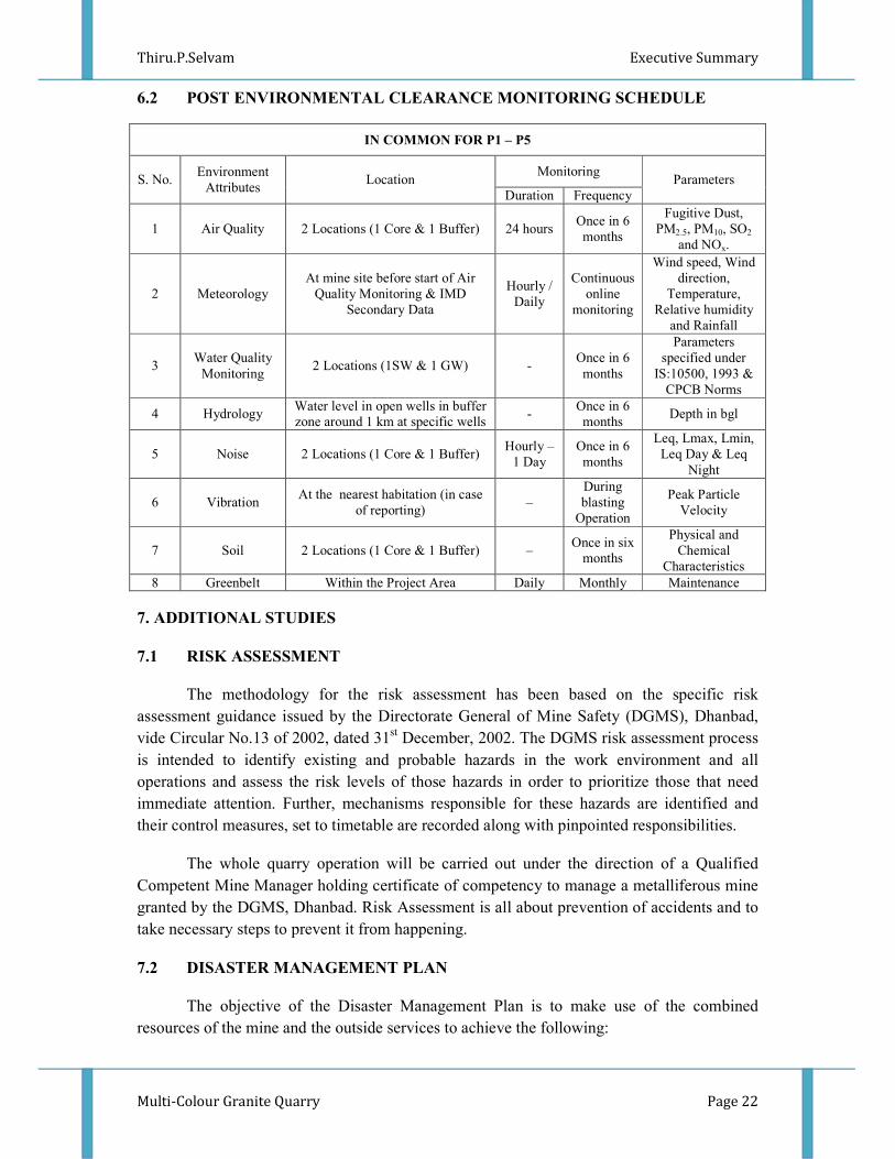
6.2 POST ENVIRONMENTAL CLEARANCE MONITORING SCHEDULE
IN COMMON FOR P1 – P5
S. No. Environment
Attributes Location
Monitoring Parameters
Duration Frequency
1 Air Quality 2 Locations (1 Core & 1 Buffer) 24 hours Once in 6
months
Fugitive Dust,
PM2.5, PM10, SO2
and NOx.
2 Meteorology
At mine site before start of Air
Quality Monitoring & IMD
Secondary Data
Hourly /
Daily
Continuous
online
monitoring
Wind speed, Wind
direction,
Temperature,
Relative humidity
and Rainfall
3 Water Quality
Monitoring 2 Locations (1SW & 1 GW) -
Once in 6
months
Parameters
specified under
IS:10500, 1993 &
CPCB Norms
4 Hydrology Water level in open wells in buffer
zone around 1 km at specific wells -
Once in 6
months Depth in bgl
5 Noise 2 Locations (1 Core & 1 Buffer) Hourly –
1 Day
Once in 6
months
Leq, Lmax, Lmin,
Leq Day & Leq
Night
6 Vibration At the nearest habitation (in case
of reporting) –
During
blasting
Operation
Peak Particle
Velocity
7 Soil 2 Locations (1 Core & 1 Buffer) – Once in six
months
Physical and
Chemical
Characteristics
8 Greenbelt Within the Project Area Daily Monthly Maintenance
7. ADDITIONAL STUDIES
7.1 RISK ASSESSMENT
The methodology for the risk assessment has been based on the specific risk
assessment guidance issued by the Directorate General of Mine Safety (DGMS), Dhanbad,
vide Circular No.13 of 2002, dated 31st December, 2002. The DGMS risk assessment process
is intended to identify existing and probable hazards in the work environment and all
operations and assess the risk levels of those hazards in order to prioritize those that need
immediate attention. Further, mechanisms responsible for these hazards are identified and
their control measures, set to timetable are recorded along with pinpointed responsibilities.
The whole quarry operation will be carried out under the direction of a Qualified
Competent Mine Manager holding certificate of competency to manage a metalliferous mine
granted by the DGMS, Dhanbad. Risk Assessment is all about prevention of accidents and to
take necessary steps to prevent it from happening.
7.2 DISASTER MANAGEMENT PLAN
The objective of the Disaster Management Plan is to make use of the combined
resources of the mine and the outside services to achieve the following:

Thiru.P.Selvam Executive Summary
Multi-Colour Granite Quarry Page 23
Rescue and medical treatment of casualties;
Safeguard other people;
Minimize damage to property and the environment;
Initially contain and ultimately bring the incident under control;
Secure the safe rehabilitation of affected area; and
Preserve relevant records and equipment for the subsequent inquiry into the cause and
circumstances of the emergency
7.3 CUMULATIVE IMPACT STUDY
CUMULATIVE PRODUCTION LOAD OF GRANITE
Quarry Mineable
Reserves ROM
in m3
Mineable
Reserves
of Granite
in m3
Proposed
production of
ROM for five
year period in
m3
Production
of ROM
Per Day in
m3
Production
of Granite
Per day in
m3
Number of
Lorry loads
of Granite
per day
P1 501318 175461 103225 69 24 4
E1 186202 37240 23052 15 3 1
E2 98120 19624 26362 18 4 1
Total 785640 232325 152639 102 31 6
PREDICTED NOISE INCREMENTAL VALUES FROM CLUSTER
Location ID Background
Value (Day)
dB(A)
Incremental
Value dB(A)
Total Predicted
dB(A)
Residential Area
Standards dB(A)
Habitation Near P1 43.5 44.5 47.1
55 Habitation Near E1 41.8 49.0 49.7
Habitation Near E2 12.5 48.5 49.5
SOCIO ECONOMIC BENEFITS FROM 2 MINES
Location code Employment Project Cost CER @ 2%
P1 35 Rs. 2,88,26,100/- Rs.5,76,522/-
E1 40 Rs.1,45,50,000/- Rs. 2,91,000
E2 40 Rs. 1,38,75,000/- Rs. 2,77,500
Total 115 Rs. 5,72,51,100 Rs.14,22,022
Thiru.P.Selvam Executive Summary
Multi-Colour Granite Quarry Page 24
8. PROJECT BENEFITS
Multi Colour Granite Quarry of Thiru.P.Selvam 1,75,461m3 of Granite @ 35% recovery
(ROM 5,01,318m3
for the entire period- Life of the mine) for Life of Mine of 20 Years. This
will enhance the socio-economic activities in the adjoining areas and will result in the
following benefits
Increase in Employment Potential
Improvement in Socio-Economic Welfare
Improvement in Physical Infrastructure
Improvement in Social infrastructure
To meet out the demand supply gap of Granite and enhance the foreign exports
9. ENVIRONMENT MANAGEMENT PLAN
The Environment Monitoring Cell discussed formed by the mine management will
ensure effective implementation of environment management plan and to ensure compliance
of environmental statutory guidelines through Mine Management Level.
The said team will be responsible for:
Monitoring of the water/ waste water quality, air quality and solid waste generated
Analysis of the water and air samples collected through external laboratory
Implementation and monitoring of the pollution control and protective measures/
devices which shall include financial estimation, ordering, installation of air pollution
control equipment, waste water treatment plant, etc.
Co-ordination of the environment related activities within the project as well as with
outside agencies
Collection of health statistics of the workers and population of the surrounding
villages
Green belt development
Monitoring the progress of implementation of the environmental monitoring
programme
Compliance to statutory provisions, norms of State Pollution Control Board, Ministry
of Environment and Forests and the conditions of the environmental clearance as well
as the consents to establish and consents to operate.
10. CONCLUSION
It can be concluded from overall assessment of the impacts, in terms of positive and
negative effects on various environmental components, that the mining activities will not
have any adverse effect on the surrounding environment.
To mitigate any impacts due to the mining activities, a well-planned EMP and a
detailed post project monitoring system is provided for regular monitoring and immediate
rectification at site. Due to the cluster quarrying activities, socio economic conditions in and
around the project site will be improved substantially. Hence, the Prior Environmental
Clearance shall be granted at the earliest.