baltrad dual polarization hydrometeor classifier
TRANSCRIPT

DMI: Rashpal S. Gill, Martin Sørensen,Thomas Bøvith
FMI: Jarmo Koistinen, Markus Peura
SMHI: Daniel Michelson
BALTRAD dual polarization hydrometeor classifier
SMHI: Daniel Michelson
ARPA: Roberto Cremonini
Version 0.1, 2010-09-01

� Advanced weather radar network for the Baltic Sea Region
� Financed by European Union in the framework of the
What is BALTRAD ?
Financed by European Union in the framework of the Baltic Sea Region programme 2007 – 2013
� BALTRAD project: 2009 – 2011� BALTRAD+ project: 2012 - 2013
� Real time weather radar data exchange in a decentralized network.
� Visit: http://www.baltrad.eu/
One of the activities: Dual Pol. classifier

Its components:
1. Ensure good quality and “stable” data:� Mitigate radome effects on Zdr, Фdp
Zdr offset correction (currently using Zdr scans at 90º + sun calibration)
DualPol Hydrometeor Classifier
special thanks to Beatrice Fradon, Meteo-France
� Zdr offset correction (currently using Zdr scans at 90º + sun calibration)� Monitor φdp0 offset� Monitor the quality of Zdr in light rain (20 dBZ – 22 dBZ) at close range� Monitor ρhv in rain (upper 75% quantile)
2. Computation of KDP
3. Correcting ZHH and ZDR for rain attenuation
4. Computation of the Melting layer (radar and NWP)4. Computation of the Melting layer (radar and NWP)
5. Fuzzy logics classification scheme:� Computation of the membership functions for each pre-specified radar echo class� Using fuzzy rules compute the “scores” by each parameter (expert) for each pixel � Weight the “scores” from each parameter� Compute the total score for each class from all the parameters� Final class is the one with e.g., the highest score
References: National Severe Storms Laboratory (NSSL), Colorado State Univ. (CSU), Meteo-France (M-F)

Stevns
Sindal
240 km
Rømø
Virring
Bornholm
240 km
DMI weather radar network:2 dualpol radars at Bornholm and Virring

<ZDR> variations with azimuth in stratiform rain
0.4
Sensitivity of Zdr to radar RADOME(DMI radomes: orange peel)
-0.8
-0.6
-0.4
-0.2
0
0.2
0 30 60 90 120 150 180 210 240 270 300 330 360
Azimuth (deg.)
<ZDR> (dB
)
April 3rd - 7th 2008
April 15th - 16th 2008
April 6th 2008
Blocking from other radars at the site
All elevations used: 0.5º, 0.7º, 1.0º, 1.5º, 2.4º, 4.5º, 8.5º, 10º, 13.0º, 15.0ºSNR>25 dB, ht<1200 m, range>5 km, ρhv>0.97
Bornholm radome with 8 panels

Z D R b ia s e s f r o m d a i ly S U N H IT S
Diurnal potential biases in the ZDR parameter for the Bornholm and Virring radars, computed using the radar scan at 90º elevation.
(Holleman et. al., 2010)
Bornholm radarVirring radar

� ΚDP parameter is not available from the radar processing software provided by the radar manufacturer.
Κ is computed as follows (Boumahmoud et. al, 2010):
Computation of specific differential phaseΚDP
� ΚDP is computed as follows (Boumahmoud et. al, 2010):
� The differential phase shift offset, ФDP(0), is computed dynamically for each ray from the first 5 gates containing precipitation (gate size = 0.5 km)
� ФDP(0) is then smoothed using a median filter with a window size of 6.5km,
Gematronik Workshop – Bringi (2005)
DPwindow size of 6.5km,
� ΚDP is then estimated by fitting a straight line on the above window.

The parameters ZHH and ZDR are corrected for attenuation
Rain attenuation correction
Many algorithms e.g., the simplest : path integrated attenuation (PIA):
The parameters ZHH and ZDR are corrected for attenuation due to rain using the following relations:
ZHH (new) (r) = ZHH (old) + α . [ФDP(r) - ФDP(0)]
ZDR (new) (r) = ZDR (old) + β . [ФDP(r) - ФDP(0)]
Gematronik Workshop – Bringi (2005)
where the α and β are constants and at C-band have the values 0.08 dB/deg. and 0.03 dB/deg. , respectively (Gourley et al., 2007a).
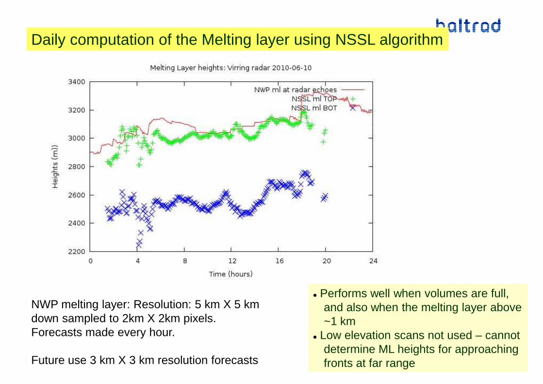
Daily computation of the Melting layer using NSSL algorithm
� Performs well when volumes are full,and also when the melting layer above~1 km
� Low elevation scans not used – cannotdetermine ML heights for approachingfronts at far range
NWP melting layer: Resolution: 5 km X 5 km down sampled to 2km X 2km pixels.Forecasts made every hour.
Future use 3 km X 3 km resolution forecasts

Hydrometeor Classifier ( using fuzzy logics)
Classify what the radar rays experience not what is observed on the groundClassify what the radar rays experience not what is observed on the ground

Pixel of hydrometeor class j has a score Sj given by the relation
Sj =
Pixel based fuzzy logics made simple:
∑
∑ ⋅
i
ii
i
w
Pw
where Pi and Wi are the value of the parameter i, and the associated weight, for the class j
The class that gets the highest score wins.
� Parameters used: � Zhh, Zdr, ρhv, Kdp, (+ texture parameters of Zhh, Zdr, Фdp),
HT NWP melting layer (only needed in level -2 classification – see later)
∑i
iw
� HT NWP melting layer (only needed in level -2 classification – see later)
Main challenge lies in having representative membership functions
� Need to compute the membership functions for ALL the different types of echoes observed by the radar. If a particular class is not accounted for then it will be mis-classified into one of the pre-determined classes.

Current hydrometeor classes
Current version has 11 hydrometeor classes (blue: internally in the system):� Ground clutter (2)� Sea clutter (2)� Electrical signals from external emitters that interfere with our radars + sun hits(10)� Clean air echoes (CAE) such as from birds, insects (3)Clean air echoes (CAE) such as from birds, insects (3)� Light rain (4: light drizzle, moderate drizzle, heavy drizzle, light rain)� Moderate rain � Heavy rain � Violent rain� light snow� Moderate to heavy snow� Hail/rain mixture
Subsequent versions of the algorithm will also include the following classes:Subsequent versions of the algorithm will also include the following classes:� wet snow–rain mixture, � hail, � Graupels.

Membership functions
Represented by beta-Functions (Bringi & Chandrasekar, 2001)
beta(x,m,a,b) = 1 / [1+{(x-c)/a]2}b
c =centre, a=width, b=slopec =centre, a=width, b=slope
ZHH ZDR
� ZDR depends on ZHH. No relationship established as many sub categories of rain used

3 beta-functions to represent 1 EE
Some strange membership functions !
ZDR 8 dBNo ZDR echo
No RHO echo

Level -1 classification
external emitters
score for e.g., external emitters: ( )8.00.05.08.00.10.1
8.00.05.08.00.10.1+++++
⋅+Φ⋅+⋅+⋅+⋅+⋅= HVDPtextDRtexDRHHtexHHj
ZZZZS
ρ
sea clutter precipitation

Level -2 classification
INPUT: precipitation from level 1 classification: need NWP melting layer heights
( )4.05.00.1
4.05.00.1++
Κ⋅+⋅+⋅⋅⋅= DPHVDRMLHHj
ZHZS
ρscore for e.g., drizzle

“Cleaned” Product
Most appreciated product by DMI users
BALTRAD hydrometeor classifier:
� publicly available according to the Lesser Gnu General Public License
� HDF5 file format
Finally
� Documentation: Doxygen
� Visit: http://www.baltrad.eu/
� Caution: membership functions are derived using the data from the 2 DMI dualPol radarsthey will need fine tuning when used with data from other radars
� Have realistic expectations : will not get it right 100 % everytime !
Thank you for your attention


�Advanced weather radar network for the Baltic Sea Region
�BALTRAD project: 2009 – 2011
What is BALTRAD ?
BALTRAD project: 2009 – 2011�BALTRAD+ project: 2012 - 2013
�Financed by European Union in the framework of the Baltic Sea Region programme 2007 – 2013
�Real time weather radar data exchange in a decentralized network.
�Visit: http://www.baltrad.eu/
One of the activities: Development of Dual Pol. classifier

Dual pol. parameters are difference between very small quantities
� Need to reduce noise in the data e.g., smooth – Zdr, ρhv, φdp, Kdp � Noise is a special problem for Kdp – critical parameter in attenuation correction and rain estimates. smoothed over several km – smooths out peaks
Need to correct for systematic errors e.g., radome contamination
NOTE:
�Need to correct for systematic errors e.g., radome contamination
�Accurate calibration a must.
� For reliable rain rate estimates and HMC need:
� Zdr within 0.1 – 0.2 dB (source Illingworth, 2004).
� Zhh within 1 dB for QPE
φdp within 1 deg. or better � φdp within 1 deg. or better
� ρhv => 0.98 in light to moderate rain. If this is not met then all polarimetricparameters will be affected by noise and the distinction between say rain and melting snow will be difficult. Measured values < theoretical values (OPERA report-WD-2009-1.4a).
� Contamination by wind mills of secondary lobes will affect the quality of measurements made in rain by the main lobes

1. Ensure good quality data
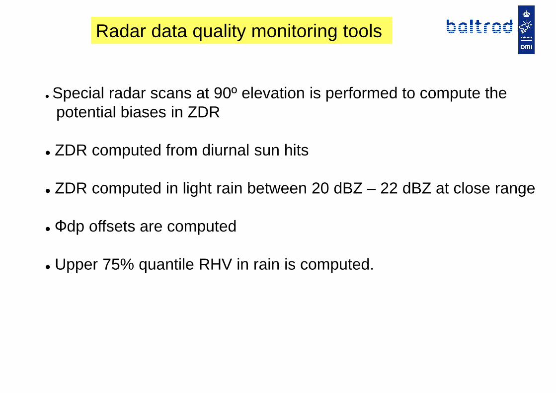
Radar data quality monitoring tools
� Special radar scans at 90º elevation is performed to compute the potential biases in ZDR
� ZDR computed from diurnal sun hits
� ZDR computed in light rain between 20 dBZ – 22 dBZ at close range
� Фdp offsets are computed
Upper 75% quantile RHV in rain is computed. � Upper 75% quantile RHV in rain is computed.

Diurnal variations of ρHV (colour red) in rain for Bornholm and Virring radars
BORNHOLM radar VIRRING radar

Its components:
1. Ensure good quality and “stable” data:� Mitigate radome effects on Zdr, Фdp
Zdr offset correction (currently using Zdr scans at 90º + sun calibration)
DualPol Hydrometeor Classifier
� Zdr offset correction (currently using Zdr scans at 90º + sun calibration)� Monitor φdp0 offset� Monitor the quality of Zdr in light rain (20 dBZ – 22 dBZ) at close range� Monitor ρhv in rain (upper 75% quantile)
2. Computation of KDP
3. Correcting ZHH and ZDR for rain attenuation
4. Computation of the Melting layer (radar and NWP)4. Computation of the Melting layer (radar and NWP)
5. Fuzzy logics classification scheme:� Computation of the membership functions for each pre-specified radar echo class� Using fuzzy rules compute the “scores” by each parameter (expert) for each pixel � Weight the “scores” from each parameter� Compute the total score for each class from all the parameters� Final class is the one with e.g., the highest score
References: National Severe Storms Laboratory (NSSL), Colorado State Univ. (CSU), Meteo-France (M-F)
The easy part
