bartele gallery newsletter edition 6

1
Bartele Gallery Indiae Orientalis, Insularumque Adiacentium Typus. Abraham Ortelius. 1598 A very attractive and much sought-after late 16th century coloured map of South-east Asia by Abraham Ortelius from the 1598 Dutch edition of the Theatrum Orbis Terrarum, published by Christophe Plantin in Antwerp. The Theatrum was the first uniformly-sized, systematic collection of maps every produced and hence is generally referred to as the first true atlas, although the term was not used until 25 years later by Gerard Mercator. This map of Southeast Asia represents a synthesis of the best readily available information on the region from Italian, Portuguese and Spanish sources. Overall condition very good with wide magins and measures 350 x 495 mm. Tartariae sive magni Chami regni typus. Abraham Ortelius. 1580 Very attractive and rare late 16th century map of Tartary and China from the 1580 German edition of Abraham Ortelius’ Theatrum Orbis Terrarum. Originally published in 1570 and engraved by Franz Hogenberg (c. 1538-1590). This striking map of Tartary and China is based on Gastaldi’s map of Asia published in 1561. Apart from showing the Anian Strait (Bering Strait) separating Asia from North America, the map contains no new information. The vignettes in the map are based upon Marco Polo’s travels and include over a dozen indigenous and mythical scenes, costumed locals and animals. Very good condition and measures 346 x 442 mm. The Father of the Atlas Abraham Ortelius (1527 - 1598) was born in Antwerp and studied Greek, Latin and mathematics in his early years. Following the death of his father, he set up a business with his sisters as a book dealer and ‘painter of maps’. From 1558 he began purchasing multiple copies of maps, building up a large personal collection. Ortelius is generally recognised as the creator of the first modern atlas, the Theatrum Orbis Terrarum (Theatre of the World) and is also believed to be the first person to imagine that the continents were joined together before drifting apart. The Theatrum, although the most expensive book ever printed, was an instant success and demand was enormous: at least 7,300 copies were produced in thirty- one editions between 1570 and 1612. Most of its maps were elegantly engraved by Frans Hogenberg (1535-1590) and this atlas inspired a six volume work entitled Civitates Orbis Terrarum which was edited by Georg Braun and also illustrated by Frans Hogenberg with the assistance of Ortelius himself. In 1573 Ortelius published seventeen supplementary maps under the title Additamentum Theatri Orbis Terrarum. Four more Additamenta were to follow, the last one appearing in 1597. Unlike many of his contemporaries, Ortelius acknowledged his sources of information and in the first edition of the Theatrum, credit was given to eighty-seven different cartographers. Abraham Ortelius’ maps are popular collector’s items and no map collection would be complete without one of his beautiful and very valuable maps. Abraham Ortelius Bartele Gallery Kantor Taman E3.3 Unit A1 4th Floor (entrance via Cazbar) Jl. Mega Kuningan Jakarta, Indonesia Tel: +62 21 5764575 Fax: +62 21 5764576 Email: [email protected]

Upload: angela-richardson

Post on 08-Mar-2016

212 views

Category:

Documents


0 download

DESCRIPTION

Bartele Gallery Newsletter Edition 6

TRANSCRIPT

Bartele Gallery

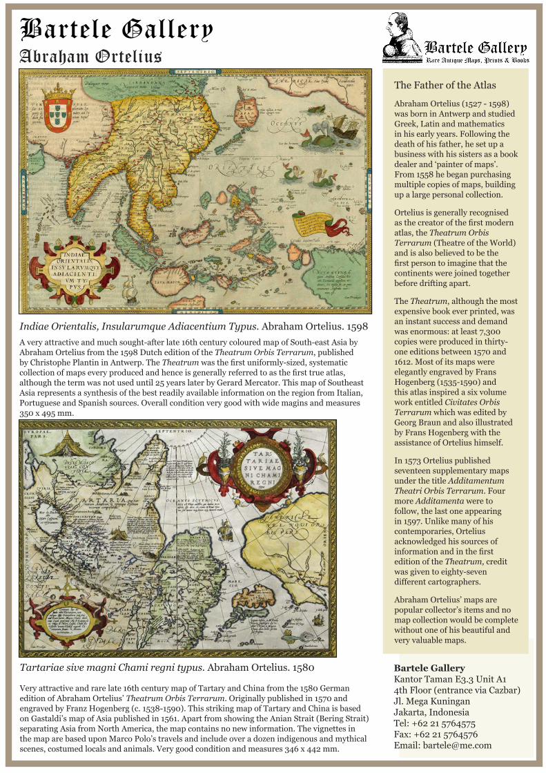
Indiae Orientalis, Insularumque Adiacentium Typus. Abraham Ortelius. 1598A very attractive and much sought-after late 16th century coloured map of South-east Asia by Abraham Ortelius from the 1598 Dutch edition of the Theatrum Orbis Terrarum, published by Christophe Plantin in Antwerp. The Theatrum was the first uniformly-sized, systematic collection of maps every produced and hence is generally referred to as the first true atlas, although the term was not used until 25 years later by Gerard Mercator. This map of Southeast Asia represents a synthesis of the best readily available information on the region from Italian, Portuguese and Spanish sources. Overall condition very good with wide magins and measures 350 x 495 mm.

Tartariae sive magni Chami regni typus. Abraham Ortelius. 1580

Very attractive and rare late 16th century map of Tartary and China from the 1580 German edition of Abraham Ortelius’ Theatrum Orbis Terrarum. Originally published in 1570 and engraved by Franz Hogenberg (c. 1538-1590). This striking map of Tartary and China is based on Gastaldi’s map of Asia published in 1561. Apart from showing the Anian Strait (Bering Strait) separating Asia from North America, the map contains no new information. The vignettes in the map are based upon Marco Polo’s travels and include over a dozen indigenous and mythical scenes, costumed locals and animals. Very good condition and measures 346 x 442 mm.

The Father of the Atlas

Abraham Ortelius (1527 - 1598) was born in Antwerp and studied Greek, Latin and mathematics in his early years. Following the death of his father, he set up a business with his sisters as a book dealer and ‘painter of maps’. From 1558 he began purchasing multiple copies of maps, building up a large personal collection.

Ortelius is generally recognised as the creator of the first modern atlas, the Theatrum Orbis Terrarum (Theatre of the World) and is also believed to be the first person to imagine that the continents were joined together before drifting apart.

The Theatrum, although the most expensive book ever printed, was an instant success and demand was enormous: at least 7,300 copies were produced in thirty-one editions between 1570 and 1612. Most of its maps were elegantly engraved by Frans Hogenberg (1535-1590) and this atlas inspired a six volume work entitled Civitates Orbis Terrarum which was edited by Georg Braun and also illustrated by Frans Hogenberg with the assistance of Ortelius himself.

In 1573 Ortelius published seventeen supplementary maps under the title Additamentum Theatri Orbis Terrarum. Four more Additamenta were to follow, the last one appearing in 1597. Unlike many of his contemporaries, Ortelius acknowledged his sources of information and in the first edition of the Theatrum, credit was given to eighty-seven different cartographers.

Abraham Ortelius’ maps are popular collector’s items and no map collection would be complete without one of his beautiful and very valuable maps.

Abraham Ortelius

Bartele GalleryKantor Taman E3.3 Unit A1 4th Floor (entrance via Cazbar)Jl. Mega KuninganJakarta, IndonesiaTel: +62 21 5764575Fax: +62 21 5764576Email: [email protected]