basic plan - st. johns county department of emergency .... johns county comprehensive emergency...
TRANSCRIPT
St. Johns County Comprehensive Emergency Management Plan 2016
Basic Plan - 1
ST. JOHNS COUNTY
COMPREHENSIVE EMERGENCY MANAGEMENT PLAN
2016
Basic Plan

St. Johns County Comprehensive Emergency Management Plan 2016
Basic Plan - 2
ST. JOHNS COUNTY, FLORIDA Including the City of St. Augustine, St. Augustine Beach and Town of Hastings
BASIC PLAN
I. INTRODUCTION St. Johns County is vulnerable to a variety of hazards that threaten our population, businesses and the environment. The Comprehensive Emergency Management Plan (CEMP) establishes the framework, as authorized by Chapter 252, Florida Statutes, to ensure that St. Johns County is prepared for these hazards. The CEMP emphasizes action within the four phases of the Emergency Management cycle: Preparedness, Response, Recovery and Mitigation. The CEMP defines the functional roles and responsibilities of each government entity that partners in St. Johns County’s disaster organization and their relationship to each other. In addition, the County’s CEMP provides a comprehensive approach to reducing the effects of disasters on its population and physical environment. The CEMP is divided into five sections: The Basic Plan, Recovery Annex, Mitigation Annex, NIMS/ESF Annex and Appendices. The following describes each section: A. The Basic Plan – outlines the general purpose, scope and methodology of the
plan; coordination, control and organizational structure; concept of operations, and identifies responsibilities of all agencies and resources mobilized by the county to assist in recovering from a disaster. The CEMP enables the St. Johns County Board of County Commissioners to discharge their responsibility for providing direction and control during any significant disaster.
B. Annex I – Recovery Functions. This annex outlines specific tasks or functions
that may be carried out before, during and after a disaster and details control, coordination, planning efforts, and policies within St. Johns County designed to facilitate both immediate and long-term recovery after a disaster has occurred. Providing for rapid and orderly start of rehabilitation and restoration of persons and property affected by a disaster anywhere in St. Johns County. Specific tasks may be described in Standard Operating Procedures (SOP’s) or other operational plans utilized within St. Johns County.
C. Annex II – Mitigation Functions. The mitigation annex includes the projects,
policies, and programs that reduce the county’s vulnerability to the impacts of disasters before they happen. The annex also details requirements and the programs incorporated in post-disaster recovery efforts to prevent recurring losses from future disasters. The St. Johns County Local Mitigation Strategy gives more detailed Mitigation information and is referred to within this Annex.
D. Annex III – National Incident Management System (NIMS)/Emergency
Support Functions (ESF’s). These annexes detail by name and organization
St. Johns County Comprehensive Emergency Management Plan 2016
Basic Plan - 3
the lead, support, and coordinating entities and their roles and responsibilities in the four phases of an emergency. Each annex outlines specific tasks or functions that may be carried out before, during and after a disaster and / or emergency event. These tasks utilize the Emergency Support Function (ESF) concept of federal and state plans and is also applied to specific functions within the Incident Command System (ICS). These specific tasks may be described in Standard Operating Procedures (SOP’s) or other operational plans utilized within St. Johns County by Emergency Management or other response and recovery agencies. Each ESF will respond to the EOC when activated by the County Emergency Management Director.
E. Annex IV – Appendices. Appendices are located at the end of the plan and
provide additional information and plans associated with the CEMP.
The CEMP is both a planning and an operations-based document that provides guidance for all aspects of emergency management including, disaster preparedness; evacuation and sheltering; warning and notification; public education and information; resource management; mutual aid; Special Needs Program; impact and damage assessment; debris management; training and exercises; and post-disaster recovery programs.
1. Purpose
The CEMP establishes a framework for an effective system of comprehensive emergency management, for the purpose of:
a) Reducing loss of life, injury, and property damage and loss resulting from natural or man-made emergencies;
b) Preparing for prompt and efficient response and recovery activities to protect lives and property impacted by emergencies;
c) Responding to emergencies with the effective use of all relevant plans and resources deemed appropriate;
d) Recovering from emergencies by providing for the rapid and systematic implementation of restoration and rehabilitation programs for persons and properties affected by emergencies; and
e) Assisting in awareness, recognition, education, prevention and mitigation of emergencies that may be caused or aggravated by inadequate planning for, and regulation of, public and private facilities and land use.

St. Johns County Comprehensive Emergency Management Plan 2016
Basic Plan - 4
2. Scope
a) The CEMP establishes the basic policies, assumptions and strategies for a comprehensive all-hazards countywide emergency management program.
b) The CEMP prioritizes protection of citizens and responders as a first priority, with the preservation and protection of property being the second priority.
c) The CEMP is applicable to minor, major or catastrophic disasters. It is flexible and expandable, depending on the emergency situation and needs. Any part or section of the plan may be utilized separately if required by the situation.
d) The CEMP establishes the procedures to coordinate with Local, Regional, State and Federal emergency management agencies, organizations and programs.
e) A unified direction and control structure is described. The CEMP identifies staff roles and resource allocation, as well as decision-making criteria. It delineates lines of authority, responsibilities and working relations of various entities.
f) The CEMP brings together County and municipal resources in a unified approach to manage the disaster. In addition, it identifies a cooperative process for coordination of private sector and volunteer resources.
g) The CEMP addresses management and prioritization of local resources and establishes the procedure to request immediate assistance for resources, if needed. State and / or Federal resources will be requested and drawn from when local resources have been exhausted.
h) The CEMP provides a format for the shift of focus of the EOC from Response to Recovery and Mitigation. Long-range recovery and mitigation is addressed by the ability of the EOC to continue operations in a modified form, after the response phase has been terminated.
i) The CEMP establishes an effective format for emergency management by:
a. Identifying the types of hazards that may occur within the County;
b. Determining the County’s vulnerability to various types of
St. Johns County Comprehensive Emergency Management Plan 2016
Basic Plan - 5
disasters, and identifying the most threatening so that appropriate preparedness, mitigation and planning steps can be taken.
c. Addressing each phase of the emergency management cycle:
i. Preparedness: Utilizes lessons learned from previous disasters, locally and elsewhere, to determine what is likely to occur during any particular type and intensity of disaster. Likely community needs can be identified and prioritized. Adequate planning pre-determines the best utilization of resources in responding to needs. Identification and training of personnel for roles and responsibilities during the disaster is included in this phase. It includes partnering with the private sector, residents and volunteer organizations to assist them in pre-disaster education and planning activities to lessen the impact of disasters.
ii. Response: The implementation of the CEMP.
Government responds to emergencies by activating its plan, incrementally increasing response as needed, giving direction and control to the emergency management effort, and looking ahead to recovery. Individuals respond by implementing their own disaster plans, whether it means evacuating the area or remaining in place. Private businesses and volunteer organizations implement their plans to secure and protect their assets, and if possible, make available resources to help the community.
iii. Recovery: Begins as soon as possible, sometimes
during the response phase. The emergency management organization initiates procedures to assess needs and resources, establish priorities, review state and federal aid criteria and coordinate with representatives from both levels of government. Once the extent of the recovery effort is determined, the appointed recovery team members determine how best to manage the specific activities, what resources and personnel will be required and what other actions are needed to return the impacted areas to normal operations as quickly as possible. Assessment of both short and long-term mitigation measures takes place during this phase and the “after action” evaluation process is conducted.
iv. Mitigation: This phase involves identifying
preventative and / or corrective measures and actions to

St. Johns County Comprehensive Emergency Management Plan 2016
Basic Plan - 6
prevent or limit bodily injury, loss of life or property damage from disasters. It includes policy issues as well as structural projects within government and the private sector. A separate Local Mitigation Strategy serves as the guidance document for both pre-disaster mitigation planning and post-disaster recovery.
3. Methodology
a) The CEMP is a dynamic document that adapts to changes in policy, priorities and needs. State and Federal statutes, regulations, and priorities guide development of the document. Public and private entities participating in the development of this plan include:
Florida Department of Health – St. Johns St. Johns County Agricultural Extension Agency St. Johns County Animal Control St. Johns County Board of County Commissioners St. Johns County Clerk of Court St. Johns County Code Enforcement and Zoning Department St. Johns County Emergency Management St. Johns County Fire / Rescue St. Johns County Growth Management Services St. Johns County Libraries St. Johns County Property Appraisers Office St. Johns County Public Works St. Johns County School District St. Johns County Sheriff’s Office St. Johns County Solid Waste Department St. Johns County Supervisor of Elections St. Johns County Tax Collectors Office St. Johns County Veteran’s Service Office
Other governmental entities furnishing input and information include:
City of St. Augustine
City of St. Augustine Beach Florida Division of Emergency Management Florida Forest Service National Weather Service Northeast Florida Regional Council St. Johns River Water Management District Town of Hastings U.S. Army Corps of Engineers

St. Johns County Comprehensive Emergency Management Plan 2016
Basic Plan - 7
Private Sector and volunteer organizations, which participated in creating this plan, include:
Amateur Radio Emergency Services (ARES) CERT (Community Emergency Response Team) Flagler Hospital Home Health Agencies Numerous local churches Northeast Florida Regional Airport Salvation Army St. Johns County Chamber of Commerce
St. Johns County Council on Aging St Johns County Volunteer Organizations Active in Disasters (VOAD)
b) Local planning involvement includes:
a. A promulgation letter from the County Administrator displayed at
the front of this document. b. Signed Concurrence acknowledging and accepting plan
responsibilities displayed at the front of this document. c. A distribution list of the Comprehensive Emergency
Management Plan, displayed at the front of this document. d. The Emergency Management Director (EMD) is responsible for
ensuring that all changes have been distributed to recipients of the CEMP. The distribution list, displayed at the front of this document is used to verify that all appropriate persons / offices are copied.
e. A Record of Changes Log, displayed at the front of this document is used to record all published changes as those holding copies of the CEMP receive them. The holder of the copy is responsible for making the appropriate changes and updating the Log.
f. A master copy of the CEMP, with a master Record of Changes Log, is maintained / kept on file by the Division of Emergency Management. A comparison of the master copy with any other will allow a determination to be made as to whether or not the copy in question has been posted to it with all appropriate changes.
II. SITUATION This section of the CEMP describes the potential hazard considerations, geographic characteristics, support facilities, land use patterns, economic profiles and demographics of St. Johns County. It also describes specific planning assumptions regarding preparedness, response, recovery and mitigation that were taken into consideration during the development of this plan. Information is also available in the

St. Johns County Comprehensive Emergency Management Plan 2016
Basic Plan - 8
Disasters and Hazards Expected Appendices.
A. Hazards Analysis
This section details the man-made and natural hazards to which St. Johns County is vulnerable. The first 7 hazards are analyzed in detail and can also be found in the Local Mitigation Strategy as each of these hazards has the greatest potential to affect St. Johns County and its citizens. Each additional hazard beginning at number 8 is not included in the Local Mitigation Strategy but is incorporated in the Comprehensive Emergency Management Plan in an effort to include every potential hazard no matter the probability of future occurrence. Additional hazard analysis, including an explanation of how each hazards vulnerability, probability of future occurrence, and risk is calculated, information can be found in the St. Johns County Local Mitigation Strategy. 1
1. Hurricane/ Tropical Storm
Vulnerability: High Probability of Future Occurrence: High Risk: High Hurricanes have the greatest potential for causing disaster than any other single natural threat to St. Johns County. The effects of an impacting hurricane will depend upon the strength, direction and, location of impact of the storm. Hurricanes are categorized on the Saffir-Simpson Hurricane Wind Scale from one through five depicted in the graph below. Categories one and two storms are considered “minor” hurricanes, although they can cause significant damage and potential loss of life. Categories 3, 4 and 5 hurricanes are “major” hurricanes and can cause massive destruction and loss of life.
TABLE 1: SAFFIR / SIMPSON HURRICANE WIND SCALE
Category Sustained
Winds Types of Damage Due to Hurricane Winds
1 74-95 mph
64-82 kt 119-153 km/h
Very dangerous winds will produce some damage: Well-constructed frame homes could have damage to roof, shingles, vinyl siding and gutters. Large branches of trees will snap and shallowly rooted trees may be toppled. Extensive damage to power lines and poles likely will result in power outages that could last a few to several days.
2 96-110 mph
83-95 kt 154-177 km/h
Extremely dangerous winds will cause extensive damage: Well-constructed frame homes could sustain major roof and siding damage. Many shallowly rooted trees will be snapped or uprooted and block numerous roads. Near-total power loss is expected with outages that could last from several days to weeks.
3 111-129 mph Devastating damage will occur: Well-built framed homes may incur
1 The St. Johns County Local Mitigation Strategy is a separate reference and planning document
that can be found on file at the St. Johns County Division of Emergency Management.

St. Johns County Comprehensive Emergency Management Plan 2016
Basic Plan - 9
(major) 96-112 kt 178-208 km/h
major damage or removal of roof decking and gable ends. Many trees will be snapped or uprooted, blocking numerous roads. Electricity and water will be unavailable for several days to weeks after the storm passes.
4 (major)
130-156 mph 113-136 kt
209-251 km/h
Catastrophic damage will occur: Well-built framed homes can sustain severe damage with loss of most of the roof structure and/or some exterior walls. Most trees will be snapped or uprooted and power poles downed. Fallen trees and power poles will isolate residential areas. Power outages will last weeks to possibly months. Most of the area will be uninhabitable for weeks or months.
5 (major)
157 mph or higher
137 kt or higher 252 km/h or
higher
Catastrophic damage will occur: A high percentage of framed homes will be destroyed, with total roof failure and wall collapse. Fallen trees and power poles will isolate residential areas. Power outages will last for weeks to possibly months. Most of the area will be uninhabitable for weeks to months.
SOURCE: National Oceanic and Atmospheric Administration The four major hazards produced by a hurricane are the storm surge, high winds, tornadoes and rainfall. The storm surge is the abnormal rise in ocean water levels caused by the wind and pressure forces of a hurricane or tropical storm. Storm surge produces most of the flood damage and drowning associated with storms that make landfall or that closely approach the coastline. Of the hurricane hazards, the storm surge is considered to be the most dangerous as ninety percent of hurricane-related deaths have been caused by drowning. St. Johns County is a coastal County and may have storm surge associated with hurricanes as well as surge effects associated with the St. Johns River which functions less as a river and more like a tidally influenced lagoon along its lower portions from Palatka to Jacksonville which make up the western boundary of the county. The St. Johns River is shallow and strongly influenced by tides from the Atlantic Ocean up to 50 miles downstream. As a result, within St. Johns County, areas adjacent to the St. Johns River and its tributaries are subject to storm surge. Areas of particular vulnerability include the entire shoreline of the St. Johns River, the southern portions of Julington Creek, shorelines adjacent to Cunningham Creek, Six Mile Creek and Deep Creek, which leads into and may cause the Town of Hastings to flood. A review of records from the National Weather Service between 1985 and 2015 shows that St. Johns County and Northeast Florida have had brushes with hurricanes but no direct impacts in this time. The last hurricane to directly impact Northeast Florida was hurricane Dora in 1964, which came ashore in northern St. Johns County. Since the last CEMP update Tropical Storms Beryl and Debby both passed through St. Johns County. Tropical Storm Beryl moved onshore on the northeast Florida coast the night of Sunday May 27th, 2012 and moved slowly inland across St. Johns County through the day on Monday the 28th. Tropical storm force winds caused tree and power line damage throughout the County.

St. Johns County Comprehensive Emergency Management Plan 2016
Basic Plan - 10
Instrumentation at the Northeast Florida Regional Airport in St. Augustine recorded the highest wind speed of 26 mph with gusts to 47 mph. Heavy rainfall of between 2-5 inches was reported across St. Johns County and its municipalities. Tropical Storm Debby moved across the State of Florida from the northeast Gulf of Mexico, St. Johns County began feeling the rain and some wind effects from Debby on Monday, June 25th, 2012. Debby moved across the State very slowly and finally exited into the Atlantic Ocean on Wednesday, June 27th. During this 3 day time frame Debby produced 12-15 inches of rain in the northern portion and 5-8 inches in the southern portion of St. Johns County. Some road flooding was reported throughout the County along with sporadic power outages and tree damage. The highest sustained wind speed of 31 mph and gust of 46 mph was recorded at the Northeast Florida Regional Airport in St. Augustine on June 25th, 2012. The following storms approached the closest to Northeast Florida and St. Johns County in the past thirty years: Hurricane Bob ………………….. July 24, 1985 Tropical Storm Chris ………………… August, 1988 Hurricane Dennis …………………….. August, 1989 Tropical Storm Josephine …………… October, 1996 Tropical Depression Georges ………. September/October, 1998 Hurricane Floyd……………………….. September 15, 1999 Tropical Storm Gabrielle……………... September, 2001 Hurricane Charley............................. August, 2004 Hurricane Frances............................. September, 2004 Hurricane Jeanne.............................. September, 2004 Tropical Storm Ophelia...................... September, 2005 Tropical Storm Alberto....................... June, 2006 Tropical Storm Ernesto...................... August, 2006 Tropical Storm Fay............................ August, 2008 Tropical Storm Beryl…………………... May 2012 Tropical Storm Debby…………………. June 2012 a) Storm Surge
Complete details regarding the storm surge threat are available from the SLOSH (Sea, Lake and Overland Surges from Hurricanes) model currently in use by the National Weather Service and National Hurricane Center. The SLOSH model has a long proven record and will be used in this analysis for storm surge vulnerability levels. The Northeast Florida Regional Council updated the Storm Surge Atlas for St. Johns County utilizing the SLOSH data in 2014. Storm surge will have the greatest impact to structures and infrastructure located in storm surge zones (a map of the storm surge zones can be found in
St. Johns County Comprehensive Emergency Management Plan 2016
Basic Plan - 11
Appendix P). Storm surge can completely wash structures off their foundations or undermine foundations to the point of structural collapse. Residents living in these structures will face dire consequences if they fail to follow an evacuation order and stay in these structures. Storm surge may also cause extensive erosion of beaches and dunes. The results can be catastrophic failure of structures and infrastructure in surge areas. The last known occurrence of storm surge in St. Johns County was in 1964 when Hurricane Dora came ashore in St. Johns County.
b) High Winds
If a hurricane were to occur in the County there are certain areas where winds would be higher due to topography (higher elevations), proximity to the ocean, and/or land use patterns such as large clear-cut within the forest. The following areas appear to be the most susceptible to high winds from a hurricane:
All shorelines
Areas adjacent to the Intracoastal Waterway;
Areas adjacent to the St. Johns River It should also be noted that as a coastal county, all of St. Johns County is susceptible to high winds, but the areas noted may suffer greater impacts due to their location. The high winds also can be devastating to persons outside, in motor vehicles, in mobile homes or substandard structures, or in structures with unprotected exposures. A 140-mile per hour wind can produce as much as 60 pounds of pressure per square foot. With this kind of pressure, a structure, once compromised during a windstorm, will experience increasing internal pressure to the roof and walls. This could cause the roof to blow off the structure, the structure to completely fail, or the inside to be devastated by a wind tunnel effect.
2. Severe Weather
Vulnerability: Low Probability of Future Occurrence: High Risk: Medium Forces associated with weather-generated events are grouped under Severe Weather. While each force has specific characteristics and effects, they often occur in conjunction with one another, thereby increasing and intensifying the effects. There has been damage in St.

St. Johns County Comprehensive Emergency Management Plan 2016
Basic Plan - 12
Johns County from tornadoes and storm wind events. Most strikes occur in the summer although lightning storms have occurred in other months with advancing cold fronts. The primary hazards included under this category are: lightning, heavy rains, hail, damaging winds, and tornadoes
a) Severe Thunderstorms and Lightning
A severe thunderstorm is defined as a thunderstorm containing one or more of the following phenomena: hail 1" or greater, winds gusting in excess of 57.5 mph, and/or a tornado. Severe weather can include lightning, tornadoes, damaging straight-line winds, and large hail. Most individual thunderstorms only last several minutes, however some can last several hours. Long-lived thunderstorms are called supercell thunderstorms. A supercell is a thunderstorm that has a persistent rotating updraft. This rotation maintains the energy release of the thunderstorm over a much longer time than typical, pulse-type thunderstorms, which occur in the summer months. Supercell thunderstorms are responsible for producing the majority of severe weather, such as large hail and tornadoes (NOAA). Downbursts are also occasionally associated with severe thunderstorms. A downburst is a strong downdraft resulting in an outward burst of damaging winds on or near the ground. Downburst winds can produce damage similar to a strong tornado. Although usually associated with thunderstorms, downbursts can even occur with showers too weak to produce thunder (NOAA). Strong squall lines can also produce widespread severe weather, primarily very strong winds and/or microbursts. When a severe thunderstorm approaches, the NWS may issue alerts. Two possible alerts are:
Severe Thunderstorm Watch - Conditions are favorable for the development of severe thunderstorms
Severe Thunderstorm Warning - Severe weather is imminent or occurring in the area
Thunderstorms are common in St. Johns County, and area residents are quite familiar with them and the severe weather they can bring. During the time period of 2000 – 2015, St. Johns County experienced 120 thunderstorm events with winds gust over 50 knots. The highest recorded wind gust of 70 knots occurred in the Elkton Area July 2014. This event caused a partial collapse of a pole barn, some downed trees, and bent power poles; the dollar figure for the damage is unknown. There are two recorded injuries from a thunderstorm wind event, they occurred in January 2010

St. Johns County Comprehensive Emergency Management Plan 2016
Basic Plan - 13
when two construction workers were blown off a highway overpass in the Durbin area and suffered minor injuries. Total property damage for all combined 120 events was estimated at $90,500 and crop damage at an estimated 1,500. Perhaps the most dangerous and costly effect of thunderstorms is lightning. As a thunderstorm grows, electrical charges build up within the cloud. Oppositely charged particles gather at the ground below. The attraction between positive and negative charges quickly grows strong enough to overcome the air's resistance to electrical flow. Racing toward each other, they connect and complete the electrical circuit. Charges from the ground then surge upward at nearly one-third the speed of light and produce a bright flash of lightning (Cappella, 1997). On average, more people are killed by lightning than any other weather event. Florida leads in the nation in lightning related deaths and injuries (National Lightning Safety Institute). Florida also has the most strikes, about 12 strikes per square kilometer per year in some places (National Lightning Safety Institute). As many as 1000 cloud-to-ground lightning strikes could occur within a 60-minute severe thunderstorm in St. Johns County. The peak months for lightning strikes are June, July, and August, but no month is safe from lightning danger. During the time period of January 2000 – December 2015, St. Johns County experienced 34 lightning events as defined by the NWS. There are five recorded injuries and two fatalities from lightning strikes during this time period. The following information describes the impacts from lightning in the identified timeframe. On September 16, 2000 a man was struck and killed on Anastasia Island; August 8, 2003 a man was stuck and injured in North Vilano Beach; August 11, 2003 a man was struck and injured in Vilano Beach; July 7, 2004 a man was struck and killed in the Flagler Estates area; March 28, 2009 a man was struck and injured in the Piccolata area; January 10, 2011 a golfer was struck by lightning on the 8th hole of the St. Johns Golf and Country Club golf course. He was transported to the hospital for treatment and later released. On October 1, 2012 a man was struck by lightning while flying a kite in a metal harness with his son near Vilano Beach. There was light rain at the time, and then the first observed lightning strike struck the man. CPR was administered at the scene; he was then transported to the hospital where he was in stable condition by that evening. Total property damage for all 34 events was estimated at $1.32 million. There was no recorded crop damage. All areas of St.
St. Johns County Comprehensive Emergency Management Plan 2016
Basic Plan - 14
Johns County are equally susceptible to thunderstorms and lightning.
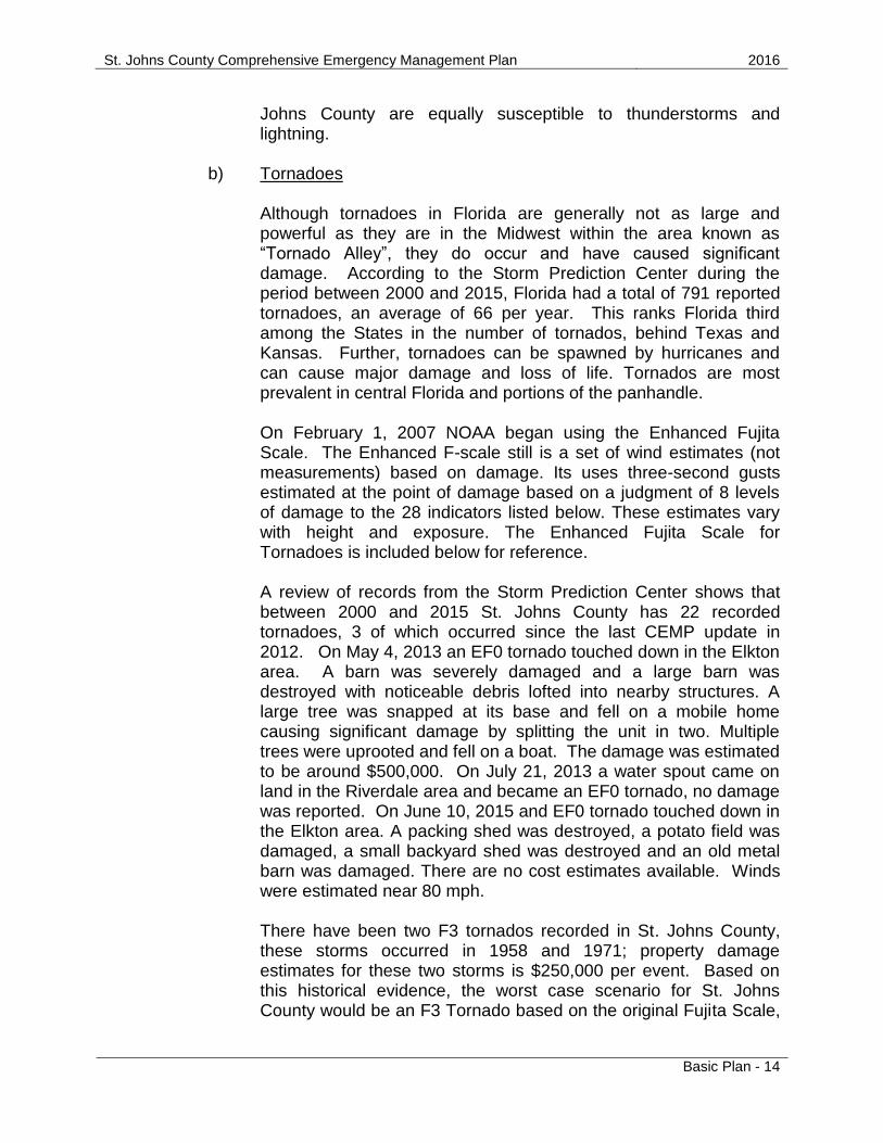
b) Tornadoes Although tornadoes in Florida are generally not as large and powerful as they are in the Midwest within the area known as “Tornado Alley”, they do occur and have caused significant damage. According to the Storm Prediction Center during the period between 2000 and 2015, Florida had a total of 791 reported tornadoes, an average of 66 per year. This ranks Florida third among the States in the number of tornados, behind Texas and Kansas. Further, tornadoes can be spawned by hurricanes and can cause major damage and loss of life. Tornados are most prevalent in central Florida and portions of the panhandle. On February 1, 2007 NOAA began using the Enhanced Fujita Scale. The Enhanced F-scale still is a set of wind estimates (not measurements) based on damage. Its uses three-second gusts estimated at the point of damage based on a judgment of 8 levels of damage to the 28 indicators listed below. These estimates vary with height and exposure. The Enhanced Fujita Scale for Tornadoes is included below for reference. A review of records from the Storm Prediction Center shows that between 2000 and 2015 St. Johns County has 22 recorded tornadoes, 3 of which occurred since the last CEMP update in 2012. On May 4, 2013 an EF0 tornado touched down in the Elkton area. A barn was severely damaged and a large barn was destroyed with noticeable debris lofted into nearby structures. A large tree was snapped at its base and fell on a mobile home causing significant damage by splitting the unit in two. Multiple trees were uprooted and fell on a boat. The damage was estimated to be around $500,000. On July 21, 2013 a water spout came on land in the Riverdale area and became an EF0 tornado, no damage was reported. On June 10, 2015 and EF0 tornado touched down in the Elkton area. A packing shed was destroyed, a potato field was damaged, a small backyard shed was destroyed and an old metal barn was damaged. There are no cost estimates available. Winds were estimated near 80 mph. There have been two F3 tornados recorded in St. Johns County, these storms occurred in 1958 and 1971; property damage estimates for these two storms is $250,000 per event. Based on this historical evidence, the worst case scenario for St. Johns County would be an F3 Tornado based on the original Fujita Scale,
St. Johns County Comprehensive Emergency Management Plan 2016
Basic Plan - 15
cost estimates would vary greatly as it would be dependent on the location of the tornado, housing development vs. farm land, as thus a cost estimate cannot be calculated. All areas of St. Johns County are equally susceptible to tornados.
ENHANCED FUJITA SCALE FOR TORNADOES
Fujita Scale Derived Enhanced
Fujita Scale
Operational EF Scale
F
Number
Fastest ¼
mile (mph)
3 Second
Gust (mph)
EF
Number
3 Second
Gust
(mph)
EF
Number
3 Second Gust
(mph)
0 40 - 72 45 - 78 0 65 - 85 0 65 - 85
1 73 – 112 79 – 117 1 86 - 109 1 86 – 110
2 113 – 157 118 – 161 2 110 – 137 2 111 – 135
3 158 – 207 162 – 209 3 138 – 167 3 136 – 165
4 208 – 260 210 – 261 4 168 – 199 4 166 – 200
5 261 - 318 262 - 317 5 200 – 234 5 Over 200 SOURCE: National Oceanic and Atmospheric Administration

St. Johns County Comprehensive Emergency Management Plan 2016
Basic Plan - 16
ENHANCED FUJITA SCALE DAMAGE INDICATORS
Number Damage Indicator Abbreviation
1 Small barns, farm outbuildings SBO
2 One- or two-family residences FR12
3 Single-wide mobile home (MHSW) MHSW
4 Double-wide mobile home MHDW
5 Apt, condo, townhouse (3 stories or less) ACT
6 Motel M
7 Masonry apt. or motel MAM
8 Small retail bldg. (fast food) SRB
9 Small professional (doctor office, branch bank) SPB
10 Strip mall SM
11 Large shopping mall LSM
12 Large, isolated ("big box") retail bldg. LIRB
13 Automobile showroom ASR
14 Automotive service building ASB
15 School - 1-story elementary (interior or exterior halls) ES
16 School - junior or senior high school JHSH
17 Low-rise (1-4 story) bldg. LRB
18 Mid-rise (5-20 story) bldg. MRB
19 High-rise (over 20 stories) HRB
20 Institutional bldg. (hospital, govt. or university) IB
21 Metal building system MBS
22 Service station canopy SSC
23 Warehouse (tilt-up walls or heavy timber) WHB
24 Transmission line tower TLT
25 Free-standing tower FST
26 Free standing pole (light, flag, luminary) FSP
27 Tree - hardwood TH
28 Tree - softwood TS SOURCE: National Oceanic and Atmospheric Administration
3. Flooding Vulnerability: Medium Probability of Future Occurrence: High Risk: Medium Freshwater flooding is generally associated with small natural streams or other drainage systems that are overwhelmed by large amounts of runoff generated by short episodes of extremely heavy rainfall. Coastal flooding can be associated with storms surge, abnormally high tides or nor’easter events. Flooding of evacuation routes just prior to evacuation orders or during the latter evacuations can trap evacuees. Detailed below are some of the roads and areas of concern within the county.

St. Johns County Comprehensive Emergency Management Plan 2016
Basic Plan - 17
Freshwater Flooding occurs in several areas in St. Johns County. The two largest areas of note are the downtown area in the city of St. Augustine and Flagler Estates with roads frequently flooded after rains. Other areas of the County that have experienced significant flooding are the neighborhood surrounding the St. Augustine Amphitheater, Neighborhood to the west of Surfside Beach Park, and West Augustine. Notable roadways include:
Sections of Ponte Vedra Blvd.
Several sections of Roscoe Road which runs along the Intracoastal Waterway
Greenbriar Road east of Roberts Road
International Golf Parkway just west of the World Golf Village and a large section just west of US-1
Portions of US-1
A1A Coastal Highway Coastal flooding may inundate potential evacuation routes and prevent persons evacuating late from vulnerable areas. Flooded roads can also contribute to fatal accidents. Freshwater flooding as well as coastal flooding is modeled by the Federal Emergency Management Agency (FEMA) as part of the National Flood Insurance Program (NFIP). Vulnerability to flooding is documented in the Flood Insurance Rate Maps delineating the 100-year flood (A and VE Zones) and the 500 year flood (X Zones). The FEMA Flood Zone Map for St. Johns County is included in Appendix P. For specific water depths in flooding events you can refer to the Flood Insurance Rate Maps. St. Johns County (unincorporated) can be found in Map(s) number 125147; City of St. Augustine (incorporated) in Map(s) number 125145; City of St. Augustine Beach (incorporated) in Map(s) number 125146; and Town of Hastings (incorporated) in Map(s) number 120282. This collection of maps is far too extensive to be included within this document and can be supplied upon request. The highest flood waters on record for St. Johns County occurred in Flagler Estates on September 14th – 15th, 2001 as a result of Tropical Storm Gabrielle. The water reached a depth of 3 feet on Flagler Estates Boulevard and surrounding areas. If conditions were right this extent of flooding, or possibly more, could be experienced in the future. National Weather Service records indicate that flooding events occurring since the last CEMP update include 2012, 2013 and several in 2015. Flooding in 2012 was from a stalled frontal boundary that caused scattered showers to linger in the area, standing water was noted in the downtown St. Augustine area, with an estimated $1000 in damage. In May 2013 heavy rainfall created flooding and deep hail drifts of penny size hail caused extensive damage to cropland near Elkton, with severe financial impact to

St. Johns County Comprehensive Emergency Management Plan 2016
Basic Plan - 18
farmers in the area. Crop damage was estimated around 38 million dollars. In 2015 there were 4 instances of flooding, all occurring in downtown St. Augustine. Roads were flooded with some cars stranded. No monetary damages were reported. a) Floodplains
The FEMA Flood Zone Map for St. Johns County, included in Appendix P identifies those areas of St. Johns County that are within the A and VE Zones (100 year) and X Zones (500 year) floodplain as delineated by the Federal Emergency Management Agency (FEMA) as part of the National Flood Insurance Program (NFIP). These are areas that could experience flooding associated with heavy rainfall events which cause localized flooding from overflowing streams or ponds in low lying areas. In St. Johns County floodplains are associated with the St. Johns River and Intracoastal Waterway and their tributaries; Flooding within these areas accounts for the principle flooding problems within the County. The largest portion of the county vulnerable to freshwater flooding is that area east of US 1 and areas along the St. Johns River. These are also the areas with the highest population concentrations within the County. As a result a significant portion of the County’s population is vulnerable to the effects of a 100 year flooding event. This could mean either that the dwelling units are directly impacted by being flooded, or that the property or accesses to the property are flooded resulting in health and safety hazards. Based on analysis completed for the Statewide Regional Evacuation Study in 2014, approximately 78,400 of the County’s 200,000 residents, or 39% of the population, are vulnerable to freshwater flooding in the 100 year floodplain.
b) Coastal Flooding Coastal flooding is a term that refers to weather events that have the possibility of flooding the immediate coastline or even further inland. NOAA describes several factors that contribute to coastal flooding:
Local severe weather events, such as tropical cyclones or extra- tropical storms, create meteorological conditions that drive up the water level, creating a storm surge.
Large waves, driven by local winds or swells from distant severe weather, can raise average coastal water levels and cause large and damaging waves to reach land.

St. Johns County Comprehensive Emergency Management Plan 2016
Basic Plan - 19
High tide levels caused by normal variations in the astronomical tide cycle.
The combination of storm surge and heavy rain events, whether locally or in the upland watershed.
Other larger scale regional and ocean scale variations, caused by seasonal heating and cooling and ocean dynamics, can contribute to high water levels.
Coastal flooding can be extremely dangerous, and any factor alone or in combination with another can cause severe damage. Coastal flooding has the potential to destroy structures and infrastructure, as well as having strong environmental effects and can have major impacts on the local economy. Though coastal flooding in St. Johns County is often the result of storm surge, there are instances of abnormally high astronomical tides with onshore winds and weather systems such as nor’easters that have produced coastal floods. Areas subject to coastal flooding include those along the Atlantic coast that are in the Coastal High Hazard Area- also known as the area of special flood hazard - that extends from offshore to the inland limit of a primary frontal dune along an open coast and any other area subject to high velocity wave action from storms or seismic sources. The coastal high hazard area is identified as Zone V on FEMA’s Flood Insurance Rate Maps (FIRMs). The location of coastal flooding is similar to that of storm surge; however, due to the nature of the events that cause coastal flooding, it is not expected to extend as far inland as storm surge. All coastal areas in St. Johns County are susceptible to coastal flooding with notable areas including South Ponte Vedra and Vilano Beach.
4. Wildfires
Vulnerability: Medium. High during drought conditions Probability of Future Occurrence: High Risk: Medium/High St. Johns County is subjected to some form of wildfire each year. In recent history 1998 - 1999, 2004, 2007, and 2011 the fires have been larger and have threatened urbanized areas more frequently. St. Johns County is transforming from a rural county, to one which is much more urban in nature, but a large percentage of its land area is still covered in forest. As a result many areas of the County are susceptible to wildfire. The most vulnerable areas are those generally located at the urban/wildland interface, primarily located in the western portions of the

St. Johns County Comprehensive Emergency Management Plan 2016
Basic Plan - 20
County. These are areas where subdivisions occur adjacent to large undeveloped areas of forestland. Much of this land is in large ownerships including lands owned by large timber companies and which is actively managed for silviculture. When subdivisions are developed without clearing the wooded areas surrounding them the interface becomes extremely hazardous. Florida has a history of naturally occurring wildfires. The hot, wet summers following long periods of uninterrupted growth cause the buildup of underbrush, which is prime fuel for wildfires. Large amounts of dry underbrush require only an ignition source; this can be from a home fireplace, trash burn, carelessly tossed away cigarette, or a natural source such as lightening. Once ignited, the underbrush can burn thousands of acres. Housing developments adjacent to areas with large amounts of underbrush are vulnerable to the fires. The Keetch-Byran drought index was designed specifically for fire potential assessment. It is a number representing the net effect of evapotranspiration and precipitation in producing cumulative moisture deficiency in deep duff and upper soil layers. It is a continuous index, relating to the flammability of organic material in the ground.
KBDI = 0 - 200: Soil moisture and large class fuel moistures are high and do not contribute much to fire intensity. Typical of spring dormant season following winter precipitation.
KBDI = 200 - 400: Typical of late spring, early growing season. Lower litter and duff layers are drying and beginning to contribute to fire intensity.
KBDI = 400 - 600: Typical of late summer, early fall. Lower litter and duff layers actively contribute to fire intensity and will burn actively.
KBDI = 600 - 800: Often associated with more severe drought with increased wildfire occurrence. Intense, deep burning fires with significant downwind spotting can be expected. Live fuels can also be expected to burn actively at these levels.
In 1998 St. Johns County experienced its most severe outbreak of wildfire. Approximately 12,842 acres burned. No homes were lost and one injury was reported. The cost to St. Johns County was $476,420; this does not include the cost for the timber that was lost during the fires. Other significant wildfire events ( >100 acres) have been recorded in St. Johns County in 1985, 1990, 1993, 1998 - 1999, 2004, 2007, and 2011. Wildfires in 2011 burned several hundred acres of timber and came dangerously close to the St. Johns County Animal Control Facility and Pet Center, ultimately no structures were burned. An additional wildfire in 2011 burned over a thousand acres and caused closures of Interstate 95 and US Highway 1 for approximately 12 hours. Some timber was lost but no structures were burned. This was the last occurrence of a major wildfire in the County. These wildfire events correlated with dry periods
St. Johns County Comprehensive Emergency Management Plan 2016
Basic Plan - 21
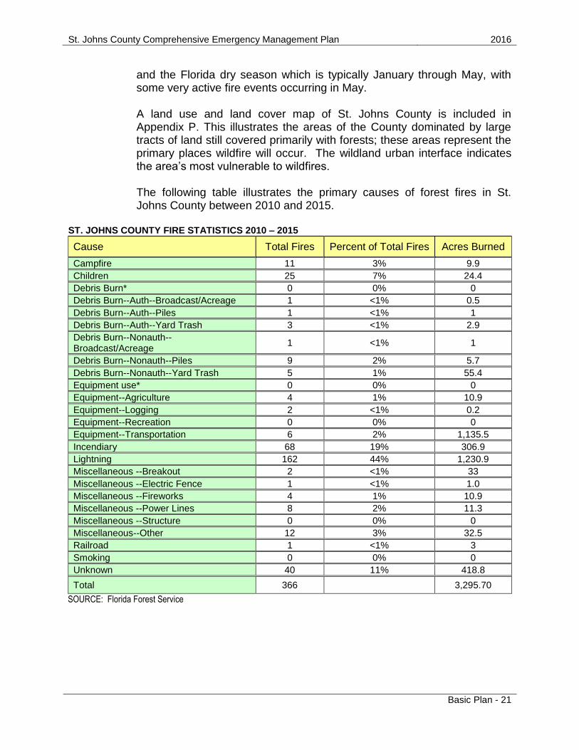
and the Florida dry season which is typically January through May, with some very active fire events occurring in May. A land use and land cover map of St. Johns County is included in Appendix P. This illustrates the areas of the County dominated by large tracts of land still covered primarily with forests; these areas represent the primary places wildfire will occur. The wildland urban interface indicates the area’s most vulnerable to wildfires. The following table illustrates the primary causes of forest fires in St. Johns County between 2010 and 2015.
ST. JOHNS COUNTY FIRE STATISTICS 2010 – 2015
Cause Total Fires Percent of Total Fires Acres Burned
Campfire 11 3% 9.9
Children 25 7% 24.4
Debris Burn* 0 0% 0
Debris Burn--Auth--Broadcast/Acreage 1 <1% 0.5
Debris Burn--Auth--Piles 1 <1% 1
Debris Burn--Auth--Yard Trash 3 <1% 2.9
Debris Burn--Nonauth--Broadcast/Acreage
1 <1% 1
Debris Burn--Nonauth--Piles 9 2% 5.7
Debris Burn--Nonauth--Yard Trash 5 1% 55.4
Equipment use* 0 0% 0
Equipment--Agriculture 4 1% 10.9
Equipment--Logging 2 <1% 0.2
Equipment--Recreation 0 0% 0
Equipment--Transportation 6 2% 1,135.5
Incendiary 68 19% 306.9
Lightning 162 44% 1,230.9
Miscellaneous --Breakout 2 <1% 33
Miscellaneous --Electric Fence 1 <1% 1.0
Miscellaneous --Fireworks 4 1% 10.9
Miscellaneous --Power Lines 8 2% 11.3
Miscellaneous --Structure 0 0% 0
Miscellaneous--Other 12 3% 32.5
Railroad 1 <1% 3
Smoking 0 0% 0
Unknown 40 11% 418.8
Total 366 3,295.70
SOURCE: Florida Forest Service

St. Johns County Comprehensive Emergency Management Plan 2016
Basic Plan - 22
5. Human Caused Hazards a) Hazardous Materials
Vulnerability: Medium Probability of Future Occurrence: Medium Risk: Medium Hazardous materials are used to maintain the modern lifestyles of both urban and rural communities; in fact, as many as 50,000 new chemicals are created annually. Agricultural uses for chemicals range from fertilizers, insecticides and disease control for crops to ammonia refrigeration units for dairy products. These chemicals increase crop yields and ensure the delivery of fresh products to markets. Similarly in urbanized areas of northeast Florida communities often use extremely hazardous chemicals, such as chlorine or sulfuric acid for treating drinking and waste water. Safe drinking water and reduced levels of pollution in surface waters are the result. Industrial chemicals such as potassium cyanide (used in manufacturing medicines) and fluorine (used in rocket fuels) are essential to maintain modern lifestyles in the northeast Florida area. New industrial chemicals improve product durability and create alternatives to high cost organic products, making products affordable to a wider range within the general population. However, these conveniences have increased vulnerability of the general population to exposure from an accidental release of hazardous materials. Each year the number of registered facilities using hazardous materials in Northeast Florida increases. Supplying these facilities requires routinely transporting hazardous materials into the County by rail, truck, air and/or, barge. The County is rapidly urbanizing; developing around the economic centers of St. Augustine, Ponte Vedra, and the World Golf Village. As the population and number of facilities that handle hazardous materials grow, greater numbers of people are vulnerable to an accidental release. This would include vulnerability from a release of hazardous materials during or following a major natural or man-made disaster. A railway, interstate and US highway all traverse the entire length of St. Johns County. Rail cars and Semi-trucks carrying hazardous materials pass through the County each day increasing the chances for a hazardous materials incident.
As part of the Comprehensive Emergency Management Plan, facilities subject to the 1986 Emergency Planning and Community

St. Johns County Comprehensive Emergency Management Plan 2016
Basic Plan - 23
Right-To-Know Act are identified and the following information is obtained:
The types of chemicals
The type and design of the container
Quantity of materials
The nature of the hazard (vapors, mists, fire explosion etc.)
In addition a Vulnerability Analysis was completed and includes the following information:
A vulnerability zone (radius) around the facility that could be affected by a release.
Population within this zone.
Property in the zone subject to damage.
Potential environmental impacts within the zone. And finally a Risk Analysis is completed which includes the following information:
Probability of occurrence
Estimates of injuries and deaths
Impacts to critical facilities
Impacts to property
Impacts to environment As of this writing St. Johns County has never experienced a large scale hazardous materials release, but one release of note happened August 2011. As fuel was being delivered to a gas station, vapors ignited as the fuel spilled and caused several explosions and a large fire. Foam was used to extinguish the fire but a great deal of fuel leaked into the surrounding tidal salt water marsh. There was one injury and the gas station was a total loss. Dollar figures for damage estimates are not available for this incident.
St. Johns County is also susceptible to non-commercial hazardous materials. Much of the County is residential or agricultural. Many of these properties have sheds, barns and storage buildings, which may contain a mixed group of chemicals including paints, insecticides, fertilizers, petroleum products, lubricants and other common household or agricultural products. While it can be assumed few people store and dispose of these items in full compliance with the law, many of these materials are in such small quantity the concern of a full “hazmat” incident is minimized.

St. Johns County Comprehensive Emergency Management Plan 2016
Basic Plan - 24
St. Johns County Fire Rescue maintains a Hazardous Materials Team which responds to hazardous materials incidents that occur regularly.
b) Terrorism
Vulnerability: Low Probability of Future Occurrence: Low Risk: Low Terrorism incidents can come in many forms including cyber-terrorism, biological weapons, chemical weapons, nuclear weapons, explosive weapons, and incendiary weapons. Biological, nuclear, incendiary, chemical, and explosive materials (B-NICE) are considered hazardous by nature. All counties in Florida are vulnerable to a terrorist attack, whether physical destruction from bombs or contamination from chemical, biological weapons, or radiological materials. There is also the risk of cyber-terrorism attacks that could disrupt or destroy vital computer networks. The county and local emergency service departments will be the first to respond to an actual or suspected terrorist attack. There are several potential targets that are most vulnerable to a terrorist attack in St. Johns County as identified in the Terrorism Annex:
Northrup Grumman
Flagler Hospital
Florida National Guard Headquarters
Florida National Guard Armory
Schools
Special Events
County and City Government Complex
Facilities and sites of historical significance A Terrorism Response Annex has been created as an appendix to the St. Johns County Comprehensive Emergency Management Plan (CEMP) to provide St. Johns County with a continuing assessment of the community’s vulnerability, and capability to respond to a terrorism incident. The annex provides an assessment of the County’s critical facilities and vulnerable populations, specialized response capabilities of emergency response personnel, definitions of operational aspects used in response management, and federal, state, and local command structure roles and responsibilities. The Terrorism Annex also provides information on each type of weapon of mass destruction that may be used in a terrorist attack. St. Johns County created a

St. Johns County Comprehensive Emergency Management Plan 2016
Basic Plan - 25
map that identifies the location of the facilities that have been deemed “Critical Facilities”. It is available upon request.
The following are descriptions of each type of potential hazardous threat by terrorist acts:
Biological weapons - microorganisms and/or toxins from living organisms that have infectious or non-infectious properties that produce lethal or serious effects in plants and animals, including small pox, anthrax, Ebola, and bubonic plague.
Nuclear weapons - high-energy particles or gamma rays that are emitted by an atom that represent a hazard to humans both internally and externally.
Incendiary weapons - intentional arson or explosions used to spread fire or chemical and biological weapons.
Chemical weapons - gas, liquid, or aerosol agents used to affect the transmission of nerve impulses in the human nervous system, including blister/mustard agents, choking agents and blood agents.
Explosive weapons; used to damage property and cause loss of human life by resulting secondary hazards such as unstable structures, debris and fire.
Cyber weapon - computer viruses and software that can be used to penetrate and disrupt networks.
St. Johns County has never experienced an act of terrorism.
6. Drought and Heat Wave
Vulnerability: Low Probability of Future Occurrence: Low/Medium Risk: Low Drought is a normal climatic occurrence that happens almost everywhere on the planet, although its characteristics vary throughout different regions. Drought is recognized as a deficiency of precipitation over an extended period of time, which could be an entire season or more. Drought not only has its physical effects on the environment, but also has social effects as well, and can often be exacerbated by human demand on water supply. There are different perspectives on drought, which include those from meteorological, agricultural, societal, and hydrologic perspectives. Periods of drought can affect crops, water supply, and can lead to increased hazard of wildfires. All of St. Johns County is susceptible to drought conditions and the hazards associated with them.

St. Johns County Comprehensive Emergency Management Plan 2016
Basic Plan - 26
The Palmer Drought Severity Index (PDSI) is an index of the relative dryness or wetness of an area. The PDSI indicates the prolonged and abnormal moisture deficiency or excess. The PDSI is an important climatological tool for evaluating the scope, severity, and frequency of prolonged periods of abnormally dry or wet weather.
-4.0 or less is considered an extreme drought
-3.0 to -3.9 is considered a severe drought
-2.0 to -2.9 is considered a moderate drought
-1.9 to +1.9 is considered near normal conditions
2.0 to 2.9 is considered an unusual moist period
3.0 to 3.9 is considered a very moist period
4.0 and above is considered an extremely moist period
In May 2007 drought conditions persisted as the area experienced a 15 – 18 inch rainfall deficit. Below average potato and hay crops were reported due to the drought but no loss estimates were compiled. A Heat Wave is when temperatures are abnormally and uncomfortably hot for an extended period of time. This event could continue from one day to several weeks. Heat waves are often accompanied by high humidity and can have a great impact on lives, including heat strokes, heat exhaustion, and even death. On July 20th, 1986 St. Augustine reached a record high temperature of 103* F; this temperature would represent the extreme heat extent. The heat index is the "apparent temperature" that describes the combined effect of high air temperature and high humidity. The higher this combination, the more difficult it is for the body to cool itself. All of St. Johns County is susceptible to the entire range of temperatures represented on the chart below describing heat index.
Temperature (*F)
Relative
Humidity
%
90 91 92 93 94 95 96 97 98 99 100 101 102 103 104 105
90 119 123 128 132 137 141 146 152 157 163 168 174 180 186 193 199
85 115 119 123 127 132 136 141 145 150 155 161 166 172 178 184 190
80 112 115 119 123 127 131 135 140 144 149 154 159 164 169 175 180
75 109 112 115 119 122 126 130 134 138 143 147 152 156 161 166 171
70 106 109 112 115 118 122 125 129 133 137 141 145 149 154 158 163
65 103 106 108 111 114 117 121 124 127 131 135 139 143 147 151 155
60 100 103 105 108 111 114 116 120 123 126 129 133 136 140 144 148
55 98 100 103 105 107 110 113 115 118 121 124 127 131 134 137 141
50 96 98 100 102 104 107 109 112 114 117 119 122 125 128 131 135
45 94 96 98 100 102 104 106 108 110 113 115 118 120 123 126 129
40 92 94 96 97 99 101 103 105 107 109 111 113 116 118 121 123
35 91 92 94 95 97 98 100 102 104 106 107 109 112 114 116 118

St. Johns County Comprehensive Emergency Management Plan 2016
Basic Plan - 27
30 89 90 92 93 95 96 98 99 101 102 104 106 108 110 112 114
People in urban areas are more susceptible to the effects of a heat wave due to the Urban Heat Island effect, which happens as a result of changes in their landscape. Buildings, roads, and other infrastructure replace open land and vegetation. Surfaces that were once permeable and moist become impermeable and dry. These changes cause urban regions to become warmer than their rural surroundings, forming an "island" of higher temperatures in the landscape. The environment, particularly agriculture interest including farms and ranches would likely suffer the greatest impacts from extended periods of drought and heat. Crops would fail and farm animals would suffer from a lack of vegetation to consume. Residents of St. Johns County could begin to see household water wells dry up or begin to have salt water intrusion. All of St. Johns County is susceptible to drought and heat wave conditions. Droughts occur slowly, over months to years and can continue on for many months and years. The drought noted in 2007 took many months to occur so it is very difficult to put an actual time on when it started or ended but it is safe to say that the extent of a drought could last a year or more with an extent of -4.0 extreme drought, on the Palmer Drought Severity Index. A heat wave is generally described as multiple days, up to weeks, of uncomfortable and abnormally hot temperatures, St. Johns Counties and its municipalities could expect a heat wave to meet these conditions.
7. Winter Storm and Freeze Vulnerability: Medium Probability of Future Occurrence: Medium Risk: Medium A winter storm is defined as a storm that can range from a few hours of moderate snow to blizzard like conditions with wind-driven snow that can last for days. Winter storms can impede visibility, affecting driving conditions, and can have an impact on communications, electricity or other services. Winter storms can range from several states to one county. St. Johns County is not generally susceptible to winter storms, because temperatures rarely reach snow-producing levels. The climactic conditions for winter storms are also not favorable. But temperatures can reach levels low enough to cause damage to crops and water lines. Freezing occurs when temperatures are below freezing, less than 32° F, over a wide-spread area for a significant period of time. Freezing temperatures can damage agricultural crops and burst water pipes in homes and buildings. In St. Johns County we have an average of 17 days

St. Johns County Comprehensive Emergency Management Plan 2016
Basic Plan - 28
a year at or below freezing. Frost, often associated with freezes can increase damaging effects. Frost is a layer of ice crystals that is produced by the deposition of water from the air onto a surface that is at or below freezing. Some of the coldest ever recorded temperatures in St. Johns County were in January 1985. On January 21st, 1985, St. Augustine recorded a temperature of 10* F and Hastings recorded a temperature of 12* F. St. Johns County experienced an ice storm Christmas 1989. As a result Interstate 95 along with many local roads were closed for 2 days and power outages were widespread. In March 1993 St. Johns County experienced the Storm of the Century. This storm produced ice and winds gusting over 70 mph, as a result roads were closed and power was out in many parts of the county for 3 days. As demonstrated in the above examples, snow, ice, gusting winds, and extremely cold temperatures could be expected in St. Johns County and its municipalities for multiple consecutive days. Wind Chill is the term used to describe the rate of heat loss on the human body resulting from the combined effect of low temperature and wind. As winds increase, heat is carried away from the body at a faster rate, driving down both the skin temperature and eventually the internal body temperature. Exposure to low wind chills can be life threatening to both humans and animals alike. In St. Johns County one could experience Wind Chills between 36* F and -11* F. If conditions were right Wind Chills could fall even lower. Below is the National Weather Service Wind Chill Chart.

St. Johns County Comprehensive Emergency Management Plan 2016
Basic Plan - 29
The following hazards do not appear in the St. Johns County Local Mitigation Strategy. While each of these hazards has the potential to occur the probability of occurrence is very low.
8. Environmental
a) Sea-level rise
Vulnerability: Low Probability of Future Occurrence: Low Risk: Low (Due to the long term nature of this hazard it has been rated as low) The two major causes of global sea-level rise are thermal expansion caused by the warming of the oceans and the loss of land-based ice due to increased melting. One of the primary impacts of sea-level rise will be the loss of land in coastal areas through erosion and submergence of the coastal landscape. Much of the shore along the ocean coast consists of landforms such as beaches, barrier islands, bluffs, and marshes that result from a dynamic interaction between the waves and tides and the geologic composition of a specific location. It has long been recognized that changes in sea level drive changes in the location of these coastal landforms over centuries to millennia. Many of the changes observed over days to years are caused by storms or changes in the amount of sediment available to sustain the shore.
Changes in sea level will also drive changes to the coastal groundwater system that will impact both human populations and coastal ecosystems. Increases in sea-level will raise the fresh water table in many coastal regions. Impacts to humans may include an increase in the potential for septic system failure and salt water intrusion in freshwater drinking wells, including those wells used for municipal water supplies. The intrusion of saltwater into groundwater systems will also impact coastal ecosystems such as marshes by changing the elevation of the freshwater-saltwater interface. (source – United State Geological Survey) Florida has 1,350 miles of coastline on both the Atlantic Ocean and Gulf of Mexico, St. Johns County lies on the northeast Florida coast with 42 miles of Atlantic coastline. Sea level rise would impact St. Johns County in a variety of ways including negative impacts on the tourist economy, structures and infrastructure located near the coast (including historic structures in the City of St. Augustine),

St. Johns County Comprehensive Emergency Management Plan 2016
Basic Plan - 30
coastal marsh environments and fresh drinking water. Predictions on levels of sea rise vary greatly and are difficult to estimate but as a coastal community at some point in the future we will almost certainly feel the effects of the rising seas.
b) Sinkholes
Vulnerability: Low Probability of Future Occurrence: Low Risk: Low Sinkholes are a common feature of Florida’s landscape due to the state’s karst topography. This karst topography can include caves, disappearing streams, springs, and underground drainage systems, all of which occur in Florida. A sinkhole is formed when carbonate layers that lie beneath the ground’s surface dissolve and the ground above the void collapses from its weight over the open space underneath. Sinkholes can cause significant damage to roads, homes, and other buildings that lie on the surface above the underground void. (Source - Florida Department of Environmental Protection) St. Johns County has not had any major sinkholes as the geology, a thick carbonate layer above the aquifer, of the County does not support the formation of sinkholes. Each year there are several reports of small sinkholes occurring. The majority of these reported sinkholes are not true karst depressions but a result of a failure of infrastructure such as a road bed, drainage pipes or old/abandoned septic tank and as such are classified as subsidence incidents. None of these reported subsidence incidents have resulted in a significant loss.
c) Tsunamis
Vulnerability: Low Probability of Future Occurrence: Low Risk: Low Tsunamis are sea waves that have the potential to be highly destructive. In the deep ocean the waves appear to be small but as they approach the shore they can become extremely large. They may be generated by earthquakes, volcanic explosions, meteorite impacts, or underwater landslides. The possibility of a tsunami impacting the Atlantic or Gulf Coasts of Florida is considered to be remote. This is because most tsunamis

St. Johns County Comprehensive Emergency Management Plan 2016
Basic Plan - 31
are associated with major earthquakes. The Atlantic Ocean basin is not ringed by large faults as is the Pacific, which is associated both with earthquakes and tsunamis. It is thought that rare underwater landslides would pose a greater risk in the Atlantic Ocean. The Caribbean region has a history of both earthquakes and tsunamis but they do not appear to have impacted Florida’s coastlines. The risk of a tsunami striking Florida is considered to be low. (Source - Florida Department of Environmental Protection)
d) Earthquakes
Vulnerability: Medium Probability of Future Occurrence: Low Risk: Low Earthquakes are rapid movements of the earth causing movement and shifting of rock beneath the surface. The event of an earthquake occurring in St. Johns County is rare although past events have been recorded in the State of Florida. The most recent earthquake was recorded in Daytona in 1975. Florida’s geology does not contain any fault lines or volcanoes, which are generally associated with earthquakes. Earthquakes were recorded in Florida in 1879, 1880, 1886, 1893, 1948, 1952 and 1975, but only one caused very minimal damage. Earthquakes can, however cause severe damage and loss of life. Earthquakes are not a major hazard concern in the State of Florida.
9. Mass Migration / Civil Disturbance
Vulnerability: Low Probability of Future Occurrence: Low Risk: Low St. Johns County has a minor history of civil disorder, occurring during the 1960’s. Neighboring Duval County has had past rioting. Areas most at risk in Duval County are not located near St. Johns County, as such businesses and law enforcement will have adequate time to initiate security measures. Law enforcement and security would be the lead planning concern of this scenario. Mass immigration is a low probability because of St. Johns County’s location on the northeast coast of Florida. Potential impacts of such an event would be an increase need for social services, law enforcement and detention facilities.

St. Johns County Comprehensive Emergency Management Plan 2016
Basic Plan - 32
10. Biological
Vulnerability: Medium Probability of Future Occurrence: Medium Risk: Medium Biological hazards are those associated with any insect, animal or pathogen that could pose an economic or health threat. They are a pervasive threat to the agricultural community. The possibility exists for the importation of pathogens that could have a widespread effect on the livestock industries. In addition, there is the possibility of an adverse effect to the general population through naturally occurring pathogens (i.e. influenza, emerging infectious diseases or by way of a terrorist action). Exotic Pest and Diseases – St. Johns County’s large agricultural areas are vulnerable to exotic pests and / or diseases. The St. Johns County Agricultural Extension Office, with assistance from the FDOH as necessary, would be the lead agency for addressing and managing this type of outbreak. St. Johns County has never experienced an exotic pest or disease outbreak of record.
Pandemic Outbreaks – The majority of St. Johns County’s population is located in the City of St. Augustine, the City of St. Augustine Beach and in the unincorporated areas of the Northwest and Northeast portions of the County. However, any part of St. Johns County may be vulnerable to disease outbreaks. The Florida Department of Health - St. Johns County, in conjunction with partner agencies will identify and manage any pandemic outbreak event. Potential impacts of a pandemic outbreak include economic losses, mass care, mass casualties, population quarantine and infectious disease control.
11. Technological/Critical Infrastructure Disruption
A technological hazard is one, which is a direct result of the failure of a manmade system or the exposure of the population to a hazardous material (hazardous materials are previously discussed as singular hazard and will not be addressed in this section) There is the potential for specific technological hazards to affect a large segment of the population and / or interfere with critical government, law enforcement, public works and public health / medical functions. There is an even greater problem when this technological failure results in a direct health and safety risk to the population. A number of things occur daily in St. Johns County, including hazardous material spills, or failure of the electrical power grid, which could constitute a threat to the population or produce widespread unmet needs. Each of these potential hazards would require a coordinated and

St. Johns County Comprehensive Emergency Management Plan 2016
Basic Plan - 33
speedy response, as well as attention to the short and long term effects. The primary hazards associated with this category are listed below. St. Johns County’s level of vulnerability to such an incident is further described below: a) Surface transportation spills
Vulnerability: Medium Probability of Future Occurrence: Medium Risk: Medium Because of the major surface road and rail transportation corridors in the County, the potential for hazardous materials spills is moderate to high. Florida East Coast Railway operates throughout St. Johns County, running parallel to U.S. Highway – 1 and Interstate 95, which both run north - south throughout the County and are highly traveled by commercial traffic. Other routes used by commercial vehicles include State Roads 16, 206, 207, and 312. Among the hazardous materials transported are gasoline, propane, chlorine, and ammonia.
b) Cyber-Attack
Vulnerability: Medium Probability of Future Occurrence: Medium Risk: Medium
A cyber-attack is deliberate exploitation of computer systems, technology-dependent enterprises and networks. Cyber-attacks use malicious code to alter computer code or data, resulting in disruptive consequences that can compromise data and lead to cybercrimes, such as information and identity theft. Cyberattacks may include the following consequences:
Identity theft, fraud, extortion
Malware, pharming, phishing, spamming, spoofing, spyware, Trojans and viruses
Stolen hardware, such as laptops or mobile devices
Denial-of-service and distributed denial-of-service attacks
Breach of access
Password sniffing
System infiltration
Website defacement
Private and public Web browser exploits
St. Johns County Comprehensive Emergency Management Plan 2016
Basic Plan - 34
Intellectual property theft or unauthorized access Both private and public entities in St. Johns County are vulnerable to cyber-attack. c) Natural gas
Vulnerability: Low Probability of Future Occurrence: Low Risk: Low St. Johns County has over 2,000 miles of natural gas lines throughout the County. Natural gas lines run along most major roadways in the County. The lines are marked by either a yellow pipe along the side of the road or with a yellow stripe marked on the road. The lines are all privately owned by TECO Peoples Gas and are routinely maintained. TECO Peoples Gas also employs a strict safety program with a vehicle that routinely monitors the lines with detection equipment that will detect gas levels of 1 part per million. The biggest hazard to gas lines is breach by contractors working in the area.
d) Nuclear Power Plants Vulnerability: Low Probability of Future Occurrence: Low Risk: Low There are no nuclear facilities within St. Johns County or within the 50 miles planning radius for a nuclear facility. A research reactor is located in Gainesville, Florida on the University of Florida campus. It is possible that the county could serve as a mass care site for evacuees from areas near a nuclear facility. In addition to shelter, planning concerns include medical and public health issues related to contamination and exposure of evacuees.
e) Air Crashes
Vulnerability: Low Probability of Future Occurrence: Low Risk: Low St. Johns County has one (1) public municipal airport: Northeast Florida Regional Airport | 4796 US-1 North | St. Augustine, FL 32095. Two commercial airlines operate flights in and out of the Northeast Florida Regional Airport. In the event of an airport mass casualty incident, it is likely that the resources of the responding

St. Johns County Comprehensive Emergency Management Plan 2016
Basic Plan - 35
agencies would be depleted and additional resources would be required from outside St. Johns County. Military aircraft also operate in and out of the Airport, as such; the potential for a military aircraft incident exists and could possibly require additional resources. Only a small segment of the population would normally be affected.
f) Coastal Oil Spills
Vulnerability: Medium Probability of Future Occurrence: Low Risk: Medium Coastal oil spills are moderate to major impact should one occur. There are no nearby offshore oilrigs. Shipping on the St. Johns River is relatively light. The greatest threat comes from the Port of Jacksonville and future drilling off the coast of Cuba. With the large volume of waterborne traffic at the Port of Jacksonville, a spill is possible. Time, distance and currents are favorable to St. Johns County’s planning effort. Warning residents and landowners of the spill’s approach, allows for some mitigating actions to take place to minimize damage. Most response capabilities are beyond the scope of St. Johns County and would come from federal authorities in accordance with the Area Contingency Plan. St. Johns County’s efforts would center on warning, recovery and mitigation.
g) Special Events
Vulnerability: Low Probability of Future Occurrence: Medium Risk: Low St. Johns County and the City of St. Augustine are tourist destinations and host many special events each year. St. Johns County is also a host County to special events that are in Jacksonville. Local events include the Fourth of July Fireworks, the Easter Festival and Parade, and the TPC Golf Tournament. Each activity requires community planning and is a major impact on Law Enforcement and Emergency Services. Potential effects on St. Johns County evacuation of large populations, mass care, mass casualty, sheltering, civil unrest and communications failures
B. Geographic Information
1. St. Johns County is located in the Northeast region of Florida, bordered on the East by the Atlantic Ocean and on the West by the St. Johns River.

St. Johns County Comprehensive Emergency Management Plan 2016
Basic Plan - 36
Duval County borders the North; Flagler County borders the South; and Clay County and Putnam County border West of the St. Johns River. See LMS for further information.
a) Area in square miles: 609
b) Topography: St. Johns County has the longest shoreline in
northeast Florida with approximately 42 miles of Atlantic Ocean shoreline on the east. The average elevation in St. Johns County is estimated at 15 feet. St. Augustine, the county seat, is the oldest permanent settlement in the United States, while the Town of Hastings is known as the potato capital of Florida.
c) Land use patterns are influenced by the waterways and road
systems. The primary open land uses are agricultural and forest, which are subject to weather phenomenon or wildfire type disasters, and consist of wildlife and water management areas which are ecologically sensitive.
d) Water area in square miles: 52
e) Drainage patterns: St. Johns County is part of the upper East
Coast Basin that begins south of Jacksonville at its northern end and flows south to New Smyrna Beach. The drainage is approximately 730 square miles. This basin is characterized by a strip of coastal ridges separating the Atlantic Ocean from a narrow lagoon system and the mainland. This lagoon system is connected by the Intracoastal Waterway (ICWW). The major lagoons in the northeast Florida region are the Tolomato River, which is between St. Augustine and Jacksonville, and the Matanzas River from St. Augustine to the Matanzas Inlet. The Guana River is a lagoon separate from the ICWW, which is situated roughly parallel and east of the Tolomato River.
f) Environmentally sensitive areas: St. Johns County is part of the
Atlantic Coastal Plain that is comprised of a diverse mixture of land cover that ranges from coastal marshes to upland oak hammocks and scrub areas. Included in the county are commercial and natural forest areas, rivers and associated wetlands. The large forested areas in the county such a Guana Tolomato Matanzas National Estuarine Research Reserve and Matanzas State Forest provide refuge for a wide variety of animal and plant species. The St. Johns River serves as the western boundary of the county with the Atlantic Ocean serving as the eastern boundary. St. Johns County has 42 miles of coastline along the Atlantic Ocean that provides habitats for plants and animals, protection from storms,

St. Johns County Comprehensive Emergency Management Plan 2016
Basic Plan - 37
recreational opportunities and economic income for the county. The sandy beach is generally backed by a dune system, which can reach heights of 40 feet, but is usually 10 to 20 feet high.
g) Flood Prone Areas: Are identified as those areas within the 100-
year and 500-year floodplain as delineated by the Federal Emergency Management Agency (FEMA) as part of the National Flood Insurance Program (NFIP). These are areas which experience flooding associated with heavy rainfall events which cause localized flooding from overflowing streams or ponds in low lying areas. In St. Johns County floodplains are associated with the St. Johns River and the Intracoastal Waterway and their tributaries. Flooding within these areas account for the principle flooding problems within the County. Additional Flood information can be found in the St. Johns County Local Mitigation Strategy.2
h) Coastal Barrier Resource System (CBRS): The Coastal
Construction Control Line in the County is the 30-year erosion control line.
Three areas in the County have been designated as Coastal Barriers within the Coastal Barrier Resource System (CBRS) by the Federal Government. These areas are:
a. The Guana River Area (Unit FL03P) located in the Guana River Marsh Aquatic Preserve and Guana River Wildlife Management Area, extending out seaward to the 20 to 30 foot bathymetric contour.
b. The Usina Beach area (Unit PO4A) located between Vilano and Usina Beaches, north of the St. Augustine Inlet. It extends from the Atlantic Ocean to the Tolomato River where it includes Saltwater Marsh. c. The Conch Island area (Unit P05 and P05P) which includes the Porpoise Point area on the southern tip of the northern barrier island to the north of the St. Augustine Inlet, the St. Augustine Inlet, Conch Island, an undeveloped island which is included in Anastasia State Park; and St. Augustine Beach.
d. The Matanzas River/Inlet area (Unit P05A and P05AP) which includes barrier island beginning approximately 1 mile north of the Inlet and extending south to the St. Johns County / Flagler
2 The St. Johns County Local Mitigation Strategy is a separate reference and planning document
that can be found on file at the Division of Emergency Management.

St. Johns County Comprehensive Emergency Management Plan 2016
Basic Plan - 38
County line, including an area that goes west into Pellicer Creek. It includes extensive saltwater and brackish marsh areas.
The Federal Barrier Resources Act (CBRA) was specifically designed to restrict federally subsidized development of undeveloped coastal barriers along the Atlantic and Gulf coasts in order to:
minimize the loss of human life
Reduce the wasteful expenditure of federal revenues
Reduce damage to fish and wildlife habitat and other valuable natural resources of coastal barriers.
This Act prohibits, within the undeveloped, unprotected coastal barrier of the Coastal Barrier Resource System (CBRS), expenditure of federal funds promoting development. The intent of the Act was to remove undeveloped coastal barriers from about 40 federal incentive programs for new development, such as National Flood Insurance, U.S. Army Corps of Engineers structural development projects, and federal assistance for construction of sewer and water systems, highways, bridges and jetties. The intent of the Act is to put the burden of financial risk associated with development on those who choose to live on coastal barriers.
2. Some geographic areas of St. Johns County are more vulnerable to
impact from specific hazards than others. The following describes these areas and the hazards to which they are vulnerable:
a) St. Johns River / Intracoastal Waterway
Areas along the County’s major waterways are particularly vulnerable to the effects of tropical cyclone, environmental and technological events including:
storm surge
wind damage from hurricane winds
winter storms
coastal flooding (non-tropical)
oil spills / hazardous materials
drought
b) Major Roadways / Rail Corridors
Federal Interstates: I-95 Federal Highways: US-1

St. Johns County Comprehensive Emergency Management Plan 2016
Basic Plan - 39
State Highways: SR-13; SR-16; SR-206; SR-207; SR-312; SR- A1A County Road: 204, 208, 210 Railroads: Florida East Coast Railroad All major transportation systems in the County are used by passenger and commercial traffic. These roadways pass through the County’s most densely populated areas as well as environmentally sensitive lands. In addition, the major roadways serve as primary hurricane evacuation routes away from coastal areas. Hazards impacting these areas could include:
hazardous materials spills
mass casualty / fatality incidents
hurricane evacuation traffic congestion
host sheltering / mass care C. Vulnerability Analysis (Demographics)
1. As one of the fastest growing counties in Florida, St. Johns County has experienced extraordinary growth during the past thirty years. St. Johns County grew from a population of 51,303 in 1980, to approximately 226,640 in 2015. Data, unless otherwise noted, is collected from the US Census Bureau. Additional information can be found in the extensive vulnerability analysis in the St. Johns County Local Mitigation Strategy.3
a) St. Johns County’s population based on U.S. Census Bureau,
Census 2010 (estimated 2015 numbers). City of St. Augustine 13,841 City of St. Augustine Beach 6,706 Town of Hastings 609 Unincorportated 205,484 Total 226,640
b) The population density in St. Johns County is 316.4 persons per
square mile. Approximately 7% of the County’s population resides in its county seat.
c) The age group distribution for the county is changing as a result of
St. Johns County’s continual growth and the longer average life span. The following table lists the population distribution by Age, and compares the current population to what it was in 2010. (Note- these estimates are based on the 2014 American Community
3 The St. Johns County Local Mitigation Strategy is a separate reference and planning document
that can be found on file at the Division of Emergency Management.

St. Johns County Comprehensive Emergency Management Plan 2016
Basic Plan - 40
Survey and as such, are slightly different that the 2015 total population estimate listed above)
POPULATION DISTRIBUTION BY AGE
Population
Age 2010 2014
0 – 14 35,684 37,021
15 – 24 22,815 24,788
25 – 44 44,304 46,458
45 – 64 57,443 60,660
65 – Over 29,793 34,475
Total 190,039 203,402
SOURCE: U.S. Census Bureau, Census 2010 and 2010-2014 American Community Survey 5-Year Estimates
d) Florida Statute 252.355 requires Emergency Management officials
to offer registration to any citizen requiring assistance during an emergency. It further mandates that officials plan for resource allocation to meet the needs of this population. St. Johns County has established a program to register, transport and shelter this population. 4
Population estimates suggest the number of residents over the age of 65 will continue to increase over the years. Special Needs Registration is coordinated and consolidated through St. Johns County Emergency Management. Special Needs Registration Forms are received from the St. Johns County Council on Aging, the Florida Department of Health - St. Johns, various Health Care and Home Health Agencies, individuals and other sources. The potential for Persons with Special Needs who may require assistance in a major disaster event is considerable. Approximately 600 (this number varies) citizens have been pre-registered with the County for assistance. This may be due to age, infirmity, illness, or vulnerability. These citizens require assistance with daily living, whether it is mobility assistance, medical assistance or simply transportation assistance. The typical special needs client in St. Johns County is over 65 years old, lives alone or with a spouse, suffers from chronic illness, lives in an evacuation area or mobile home, and is cared for in the home by a home health agency. The St. Johns County Special Needs Registration Program was created to pre-identify and preplan for the needs of persons
4 Also refer to the following reference documents on file at the Division of Emergency
Management: 1) St. Johns County Special Needs Procedures / Opening a Special Needs Shelter. 2) St. Johns County Guidance Document for Home Health Care Agencies for Special Needs Clients.

St. Johns County Comprehensive Emergency Management Plan 2016
Basic Plan - 41
requiring assistance through registration and prior triage based on information provided by the client and/or the home health agency. All Special Needs Client information is on file with St. Johns County Emergency Management.
Registration – Upon receiving Registration Forms, each applicant is carefully triaged, taking various health issues into consideration, to insure proper placement and categorized into one of three groups. Low: Citizens requiring transportation to Public Shelters; Medium: Citizens with special medical needs who are capable of transporting themselves to the Special Needs Shelter; and High: Citizens with special medical needs who require transportation to the Special Needs Shelter.
Each registrant is then input into the SJC Evacuation Assistance Database, which allows for easy reference of our Special Needs Registrants. Each client’s registration form is also labeled / input with their Evacuation Zone to insure accuracy when specified areas are called to evacuate. After registration is complete, each client is notified by mail of their registration, shelter placement and a list of supplies necessary when evacuating to a shelter.
Notification – When the threat of disaster in imminent, the Emergency Operations Center will activate the ESF-14 and ESF-8 individuals pre-identified as phone operators. Those individuals (county employees and Health Department employees) will call all of the pre-registered clients who reside in the expected impact areas. The clients will be informed about the emergency, and questioned concerning their need for assistance in the evacuation. Then if necessary or required, appropriate transportation will be made available. Transportation – Due to the large number of clients requiring assistance, transportation may start before an evacuation order / recommendation. The County will utilize buses and wheelchair lift vehicles from the St. Johns County School District, who will be organizing the transportation process, and the St. Johns County Council on Aging. Transportation is only available to a shelter within St. Johns County. During an emergency, clients will not be transported across County lines, to private homes or to hotels / motels.
e) Agriculture as an occupation makes up less than 1% of the St.
Johns County workforce. The majority of this population lives in and around the Town of Hastings.

St. Johns County Comprehensive Emergency Management Plan 2016
Basic Plan - 42
f) The annual tourist population in St. Johns County is approximately 3-million, with most tourists to the area visiting the City of St. Augustine and the County beaches. This population has a tremendous effect on the economy of the County.
g) St. Johns County has a 7.8% non-English speaking population. The hearing-impaired population for the County is less than 2%. St. Johns County is unique, as the Florida School for the Deaf and the Blind is located here. School statistics from January 2016 note that they service 829 students from 47 counties and one out-of-state student from Georgia; of those, 585 are served on campus, with 433 served as residential students and 152 as day students. Of these students; 64% are deaf, 34% are blind, and 2% have Dysfunction of Sensory Integration, and 60% have additional handicaps (in addition to being deaf or blind).
h) The transient (displaced) population in St. Johns County as of 2014
is 1,401. This information was provided by an official survey conducted by the St. Johns County Homeless Coalition.
i) According to the St. Johns County Property Appraisers Officer
there are 6,456 mobile homes throughout St. Johns County housing approximately 16,700 residents. There are a few large mobile home communities in the County including Flagler Estates, Coquina Crossing, Spanish Trails and Moultrie Oaks. The remaining mobile homes are scattered through the County including some on the barrier islands.
j) St. Johns County has two (2) juvenile detention centers; Hastings
Youth Academy located at 765 East St. Johns Avenue | Hastings, Florida and the St. Johns Juvenile Correctional Facility located at 4500 Avenue D | St. Augustine, Florida. St. Johns County has one Detention Center which is a 664-bed facility to house both male and female inmates for pre-trial and short-term sentences. The County also has a Community Release Center which houses male inmates who are sentenced to the county jail for 364 days or less. Inmates housed in this facility are allowed to participate in the work release program. Both of these facilities are located behind the St. Johns County Sheriff's Office on Lewis Speedway. When planning for correctional facilities St. Johns County assumes each facility will be at capacity, which is established by bed count.
Hastings Youth Academy – 98 Beds | Male only | Juvenile, High Risk
St. Johns County Juvenile Correctional Residential Facility – 48 Beds | Male | Juvenile, High Risk

St. Johns County Comprehensive Emergency Management Plan 2016
Basic Plan - 43
St. Johns County Detention Center – 664 Beds | Male & Female | Adult
St. Johns County Community Release Center - 100 Beds | Male only | Adult
2. Population in Vulnerable Areas: The greatest concentration of population
in St. Johns County exists in the areas most vulnerable to impact from specific hazards, such as hurricanes and transportation accidents/ hazardous material spills. This is addressed in the St. Johns County LMS, which identifies vulnerable areas and population, and recommends specific mitigation projects to avoid, minimize or reduce damage. Awareness of potential population in vulnerable areas assists in planning for adequate response and recovery.
D. Economic Profile The following is an economic profile of the County:
1. Employment by sector: The following table illustrates a breakdown of employment by sector with the data currently available. This information includes civilian employees only.
2014 - EMPLOYMENT BY SECTOR (Civilian Employed Population)
Industry Number of employees
Percent
Agriculture, forestry, fishing and hunting, and mining 444 0.5%
Construction 5,428 5.8%
Manufacturing 5,805 6.2%
Wholesale trade 3,210 3.4%
Retail trade 11,592 12.3%
Transportation and warehousing, and utilities 4,562 4.9%
Information 1,498 1.6%
Finance and insurance, and real estate and rental and leasing 11,279 12%
Professional, scientific, and management, and administrative and waste management services
12,220 13%
Educational services, and health care and social assistance 18,526 19.7%
Arts, entertainment, and recreation, and accommodation and food services
11,466 12.2%
Other services, except public administration 3,821 4.1%
Public administration 4,112 4.4%
TOTAL 93,963 100%
Source: US Census Bureau, American Community Survey
2. Employment Information: The following table illustrates labor force statistics for St. Johns County. (Population Age 16 and over)

St. Johns County Comprehensive Emergency Management Plan 2016
Basic Plan - 44
ST. JOHNS COUNTY LABOR STATISTICS
St. Johns County Labor Force Statistics 2014
Civilian Labor Force 101,244
Employed 93,963
Unemployed 7,281
Unemployment Rate 4.4%
Armed Forces 596
Not in Labor Force 62,039
Source: American Community Survey
3. Income: The most current information available lists median household income as $65,575 (2014), per capita income as $37,147 (2014) (Source - US Census Bureau)
4. Property Types and Values: The following table illustrates property types and values for St. Johns County as of 2016.
ST. JOHNS COUNTY PROPERTY TYPES AND VALUES – 2016
Total Parcels Just Value $ Average Value $
Residential
Single Family 68,404 18,375,146,841 268,627
Mobile Homes 5,630 338,153,475 60,063
Multi-Family (less than 10 units) 1675 479,823,920 286,462
Multi-Family (more than 10 units) 37 139,104,215 3,759,573
Condominiums 14,045 2,415,730,693 171,999
Commercial
Improved Commercial 2,868 1,674,244,619 583,767
Vacant Commercial 859 150,035,774 174,663
Improved Industrial 373 248,830,905 667,106
Vacant Industrial 117 12,151,833 103,862
Government / Institutional
Government 1,956 1,323,700,290 676,738
Institutional 478 492,705,007 1,030,764
Other
Agricultural 1,692 913,488,570 539,887
Non-Agricultural Acreage 242 126,798,599 523,961
Miscellaneous 2,407 99,383,143 41,289
SOURCE: St. Johns County Property Appraiser’s Office
E. Emergency Management Support Facilities The following facilities support emergency management operations and resources:

St. Johns County Comprehensive Emergency Management Plan 2016
Basic Plan - 45
1. Essential services and functions for survivors, continuation of public safety actions, and disaster recovery are performed or provided in St. Johns County. They also include infrastructure essential to the mission of critical facilities such as water, power and sewer. St. Johns County Division of Emergency Management maintains a Critical Facilities Inventory. Data is updated annually, included in the St. Johns County Local Mitigation Strategy and provided to the Florida Division of Emergency Management. A complete listing is available from St. Johns County Emergency Management.
2. Additional information in regards to logistics can be found in the St. Johns County Logistics Strategy5. The Logistical Staging Areas in St. Johns County are as follows:
a) St. Johns Greyhound Park 6322 Racetrack Rd. Jacksonville, FL 32259
b) Prime Outlets 500 Prime Outlets Blvd. St. Augustine, FL 32084
c) Old Tree of Life Building
1750 Dobbs Rd. St. Augustine, FL 32084
d) Vacant Warehouse on Commercial Dr. 3550 Commercial Dr. St. Augustine, FL 32092
3. Emergency Helicopter Landing Zones for Assessment Teams include:
Primary: Northeast Florida Regional Airport 4900 US 1 N St. Augustine, FL 32095 29° 57' 15.6672'' N 81° 20' 34.566'' W Secondary: St. Johns County Agricultural Center 3125 Agricultural Drive St. Augustine, FL 32092 29° 54' 17.64'' N 81° 24' 36.2376'' W
5 The St. Johns County Logistics and POD Strategy is located in Appendix M

St. Johns County Comprehensive Emergency Management Plan 2016
Basic Plan - 46
A complete list of pre-identified Emergency Helicopter Landing Zones is maintained by the St. Johns County Sheriff’s Office as they are responsible for establishing areas for the safe landing of emergency air units.
III. CONCEPT OF OPERATIONS
A. General
Emergency Operations span four separate but contiguous phases: emergency planning, response, recovery and mitigation of a disaster. For the purposes of this plan, this concept of operations will focus on emergency response and relief efforts and measures to be taken for a smooth transition into intermediate and long term recovery from a major or catastrophic disaster. Organizational charts and matrixes have been provided in the Appendices to show the county’s responsibility and the coordination between local agencies and the ESF’s. In addition, the scope of these operational concepts and response actions will include:
1. Provide emergency notification and warning to the public and media. 2. Protection of life and property. 3. Coordination of emergency mobilization procedures. 4. Gather and disseminate information to establish situational awareness and a common operating picture. 5. Initiate and track the implementation of emergency protective actions. 6. Establish priorities for each operational period. 7. Conduct rapid impact assessments of disaster impacts to the community and immediate emergency resource needs. 8. Ensure areas with the greatest impacts from the disaster are secured and communications are established. 9. Conduct emergency relief operations to ensure survivors, including pets, have been identified and that their needs are met including food, water, shelter and medical needs. 10. Conducting preliminary damage assessments to determine the need for federal assistance. 11. Relaxation of protective actions and coordination of reentry into evacuated areas. 12. Restoration of essential public facilities and services. 13. Preparing for federal disaster assistance (public and individual), including tracking of public fund expenditures. 14. Coordination and prioritization of resources (personnel, equipment, and any other supplies) including Mutual Aid requests. 15. Coordination of volunteer organizations and donated resources.

St. Johns County Comprehensive Emergency Management Plan 2016
Basic Plan - 47
16. Coordination and dissemination of information and instructions to the public. 17. Restoration of public infrastructure damaged by the disaster. 18. Coordinate transition from response phase to recovery phase.
The EOC serves as the central command and control point for emergency-related operations and activities and requests for deployment of resources. In the event the EOC is threatened, an Alternate EOC is activated. The locations of the primary and secondary EOC are listed below. Additional COOP / COG relocation information can be found in the St. Johns County Continuity of Operations / Continuity of Government Plan on file at the St. Johns County EOC.
Primary: St. Johns County EOC 100 EOC Dr. St. Augustine, FL 32092 Secondary: St. Johns County Agricultural Center
3125 Agricultural Drive St. Augustine, FL 32092
Alternate: Hastings Community Center 6195 South Main Street | Suite-A Hastings, FL 32145
The County must be able to respond quickly and effectively to developing events. When an event or potential event is first detected, the EOC initiates monitoring. Communications is maintained between the EOC and the State Emergency Operations Center (SEOC). While emergency response actions necessary to protect public health and safety are being implemented, the Policy Group will coordinate with the EMD, who will work with the ESF’s to make preparations to facilitate the rapid deployment of resources, activate the County's Emergency Operations Center if necessary and implement this plan. Operations Staff in the EOC and ESF representatives will contact the designated emergency coordinators in affected municipalities to begin to identify needed and anticipated resources and contact persons. Resource requests, which exceed the capability of the County, will be forwarded to the State ESF’s. The goal for each ESF is to have at least three individuals who are fully trained and capable of performing their duties and responsibilities in the EOC. It is essential that we are able to staff two shifts per day in the EOC for each activated ESF. Realizing of course, that each situation is

St. Johns County Comprehensive Emergency Management Plan 2016
Basic Plan - 48
different and depending on the scope of the disaster / emergency, not all ESF’s may be activated or require 24-hour staffing. The Emergency Management Director will determine staffing levels as required by the level of disaster.
Level of Disaster Primary Response Additional Responsibilities
Minor EMD * ESF-5, ESF-6, ESF-14
EMD in coordination with respective ESF-s will determine which ESF’s require 24-hour operation
ESF-2 ESF-16, ESF-13, ESF-17
ESF-3 ESF-1, ESF-7, ESF-12
ESF-4 ESF-10, ESF-15
ESF-9 ** ESF-8, EST-11
Minor to Major Chairperson and selected member of the Policy Group.
EMD * ESF-5, ESF-14
Operations Officer **
ESF-1 ESF-6, ESF-11
ESF-2 ESF-17
ESF-3 ESF-7, ESF-12
ESF-4 ESF-10, ESF-15
ESF-8 ESF-9
ESF-16 ESF-13
Major to Catastrophic
EMD in coordination with respective ESF will determine which ESF’s require 24-hour operation
Chairperson and members of the Policy Group. EMD * Shift 1 Operations Officer * Shift 2 Operations Officer ** All ESF’s with Supporting Agencies. NIMS would be employed fully at this level
* Primary team leader | ** Alternate team leader
B. Assignment of Responsibilities
A department, division or agency may be designated as the Primary Agency or Lead Agency for an ESF for a number of reasons. The agency may have a statutory responsibility to perform that function, or through the agency may have developed the necessary expertise to lead the ESF. In some agencies, a portion of the agency's mission is very similar to the mission of the ESF; therefore, the skills to respond in a disaster can be immediately translated from the daily business of that agency. As the Primary agency, that agency has the necessary contacts and expertise to coordinate the activities of that support function.
St. Johns County Comprehensive Emergency Management Plan 2016
Basic Plan - 49
St. Johns County is a medium sized county, there may be times when the NIMS and/or ESF system is used by the county, depending on the scope of the disaster, one agency may be responsible for several tasks, each represented by a different ESF in the State CEMP. This is a normal occurrence in growing counties with moderate resources.
Upon activation of the EOC, the lead agencies for the ESF’s will designate a representative in the EOC to coordinate that ESF. It is the primary agency's discretion as to how many, if any, support agencies they will require to assist them. However, due to space available in the EOC, the attendance of support agencies should be closely coordinated with the EMD in the development of standard operating guidelines. The Primary department or agency for the ESF will be responsible for obtaining all information relating to ESF activities and requirements caused by the emergency and disaster response. This information gathering will frequently require the primary agency to step outside traditional information gathering protocols. The County will respond to local requests for assistance through the ESF process. Within the EOC, requests for assistance will be tasked to the ESF’s for completion. The primary agency will be responsible for coordinating the delivery of that assistance.
The EOC Operations Coordinator will issue mission assignments to the primary departments for each ESF based on the identified resource shortfall. Resource tasking will be accomplished through the ESF’s on a mission assignment basis. The tasking on a mission assignment basis means that a local government’s resource shortfall will be addressed through assigning a mission to address the shortfall rather than tasking specific pieces of equipment or personnel.
The primary department or agency for that ESF will be responsible for identifying the particular resource or resources that will accomplish the mission and coordinate the delivery of that resource to the local government.
C. Plan Activation
In 1994, the St. Johns County Board of County Commissioners passed Ordinance 94-25, and then added some updated language in 2000 with Ordinance 2000-38, outlining the authority for declaring a Local State of Emergency. Section 6, 94-25, Power to Declare a Local Emergency:

St. Johns County Comprehensive Emergency Management Plan 2016
Basic Plan - 50
The Board is hereby designated and empowered to declare and/or extend a State of Local Emergency whenever it shall determine (I) that a natural, technological or manmade disaster or emergency has occurred that is affecting the County, either directly or because of an interlocal agreement to which the county is a party, (ii) that the occurrence or threat of such disaster or emergency is imminent and requires immediate and expeditious action, or (iii) that an extension of an existing State of Local Emergency is necessary and appropriate to enable the County to receive state or federal assistance and/or aid. When a quorum of the board is unable to meet, the Chair of the Board or the Vice-Chair in his or her absence, or the County Administrator, or his or her designee, in the absence of the Chair and Vice-Chair, is hereby designated and empowered to make such determination, declaration and/or extension.
D. Warning and Dissemination
1. General
The purpose of this section is to outline the systems available for warning the responsible government officials and the general public of the threat of an impending disaster or that an actual emergency situation is in progress in the County. Warnings of impending or potential emergencies such as a hurricane, tornado, or severe weather, or a notification of a sudden incident such as a tornado touchdown, an airplane crash, a major hazardous materials release or any other significant event that may impact multiple jurisdictions or large numbers of people must be disseminated to responsible officials, emergency response agencies, and to the public. The former notification is for the purpose of implementing emergency government and management procedures and reporting such actions to State emergency management agencies. The latter for instructions on appropriate protective actions and preparedness and response measures to take.
2. County Warning Point
The St. Johns County 911 Fire / Rescue Communications Center located at the St. Johns County Sheriff's Office Operations Center is designated as the official Warning Point for St. Johns County. The EMNet System and 911 System are housed in this facility. The Communication Supervisor is designated as the Warning Officer for St. Johns County. Back-up communications are available at St. Johns County Fire Rescue Administration Building and the Sherriff's Office Mobile Command.
St. Johns County Comprehensive Emergency Management Plan 2016
Basic Plan - 51
3. Significant Incidents
Notifications of watches, warnings, or the occurrence of significant events will be received at the Warning Point and the Emergency Operations Center through bulletins and advisories from the National Weather Service, EMNet, the NOAA Weather Radio, telephone, local media, and citizens. These significant incidents may include but are not limited to the following:
a) Any incident that may require a substantial evacuation and / or relocation of a given area b) Any event posing a potential threat for a mass casualty incident c) Any weather related warning advisory d) Any formation of tropical weather systems e) Any incident, which closes, or significantly blocks major roadways within the County f) Any large or multiple structure fires g) Any prolonged shutdown of public utilities h) Any incident where public resources within St. Johns County are being deployed out of the County i) Any event posing a major environmental threat
4. Alerting
Upon the receipt of notification of any such significant event the Communications Supervisor or on-duty Communications personnel shall implement the procedure appropriate to the event (weather, fire, hazardous materials, mass casualty incidents, etc.) The Communications Supervisor will alert the Emergency Management Director as needed. The Director or their designee may advise that one, or a combination of the following actions, be initiated by the Communications Supervisor as the County Warning Officer or some other designee:
a) Code Red Call-Out b) EMNet Activation of the IPAWS System c) Notify the State Warning Point, via EMNet or by telephone d) Notify one or more designated agencies of county government or political subdivision(s)
5. EOC Call Out Alert
The EOC call-out alert when initiated will be made to all EOC staff and administration utilizing the Code Red Database established and maintained by the Division of Emergency Management. It will
St. Johns County Comprehensive Emergency Management Plan 2016
Basic Plan - 52
be the responsibility of Primary Contacts maintained in the Code Red Database to notify their respective support agencies, division directors, and / or staff, under their span of control. In addition, the following actions will be initiated:
a) An alert will be sent to all local Public Safety Answering Points and they will in turn notify public safety agencies for which they are jurisdictionally responsible. b) St. Johns County political subdivisions, and other governmental and non-governmental agencies will be contacted, they will utilize their own internal procedures to notify their staff of the threat or emergency situation. c) Warning the public, whether via the Integrated Public Alert and Warning System (IPAWS), Code Red or other available means, will include instructions for any required actions, i.e., evacuation, keeping away from a disaster area, seeking cover from a threatened tornado.
E. Agency Notification when County / 911 Communications Center Procedures Are Not Implemented and EOC is Activated:
Upon notification of an emergency or disaster situation, Emergency Management Director is responsible for disseminating warnings to the following:
Selected County Administration personnel;
Mayors (or designee) of each municipality within the County
The primary agency contact for each Emergency Support Function.
The Emergency Management Director, will report to the EOC to supervise activation procedures for an actual or impending emergency. Key warning personnel will coordinate with adjacent jurisdictions using telephone, radio, email, or any other means necessary and available.
Each Mayor or their representative will alert the municipal services in his / her community and supervise the dissemination of warnings in their municipality. The primary agency contact for each ESF will contact all of the support agencies to the ESF. All agencies will notify their personnel to begin activation procedures as described in the ESF Annexes and implementing SOP’s. The County Emergency Operations Center will be activated under the following levels of activation:
1. Levels of Activation
a) Level III, Monitoring Activation - Monitoring will be implemented whenever Emergency Management receives

St. Johns County Comprehensive Emergency Management Plan 2016
Basic Plan - 53
notice of an incident, which may escalate to threaten public safety. During a monitoring activation, Emergency Management will disseminate information to the EOC team via telephone, e-mail and Code Red.
b) Level II - Hazard Specific or Partial Activation- Activation
may be implemented by the County Administrator, Emergency Management Director, or their Designee. Only those ESF’s impacted by the hazard or involved in the response will be represented at the EOC.
c) Level I - Full Activation– Full Activation may be
implemented for a major incident. All ESF’s, the Command Staff, Liaison Group, and Support Staff will be staffed 24 hours a day.
2. Levels of Disaster
St. Johns County Emergency Management has the responsibility to activate the EOC and carry out the policies of the CEMP as directed by the County Administrator under St. Johns County Ordinance 94-25 and later amended by 2000-38, whether it is a minor, major or catastrophic disaster of any kind.
The position that may change will be Incident Commander (IC) on the scene of the emergency. For example: Wildfire – Fire Chief would be the IC, Pandemic Influenza – Director of the Health Department would be the IC.
a) Minor Disaster – A disaster that can be handled with
municipal, county, private sector and volunteer resources. Sharing and realignment of assets, personnel and information would be common. There might be a need for some assistance from the state, where there is a shortfall locally of expertise, equipment or personnel. State assistance would be short term. The EOC monitors and could be partially activated.
b) Major Disaster – A disaster beyond the capabilities of local
governments. County, municipal, private and volunteer sectors have resource shortfalls. Some ESF’s might be entirely expended. State and most likely federal assistance are needed. The duration of assistance could be long term in some need areas. The EOC will be in a partial activation or full activation.

St. Johns County Comprehensive Emergency Management Plan 2016
Basic Plan - 54
c) Catastrophic Disaster – A disaster beyond the capabilities of state government. All county, municipal, state, private and volunteer sector resources are fully expended. Federal resources may become involved. The duration of assistance will be lengthy. Military personnel might be required. The EOC will be fully activated.
3. Warning to the General Public
St. Johns County must provide the general public with sufficient advance warning time for effective preparation and emergency plans to be implemented. Warning to the public is a concern as there are no local (St. Augustine) television stations. Notice must be coordinated with stations in Jacksonville for television broadcast of emergency messages. The local broadcast capability is through the local AM / FM radio stations and Comcast Cable using EMNet to access the Integrated Public Alert and Warning System (IPAWS). The following warning systems are available to disseminate warnings and warning information to the public:
Code Red Alert
EMNet – used to access the Integrated Public Alert and Warning System (IPAWS)
GTV (Local Government Television)
Local Cable – Comcast
NOAA Weather Radio
Public Address or Door to Door, if needed
Public Displays
Public Speaking Events
Social Media
Website at: www.sjcemergencymanagement.org
Volunteer Radio Groups
904-824-5550 St. Johns County Citizens Information Line
F. Emergency Decision Making Two key elements are essential for making sound emergency decisions, knowing the amount of time that is needed to respond to the emergency and the amount of resources that are needed and available. When making emergency action decisions the following general methodology will be used:
1. For hurricanes, emergency protective actions, such as evacuations, are based on information gathered from Hurrevac, a hurricane

St. Johns County Comprehensive Emergency Management Plan 2016
Basic Plan - 55
tracking program. This information is based on the actual characteristics of the storm (i.e., forward speed of the storm, the distance tropical storm conditions extend from the eye, wind speeds and expected storm surge). Hurrevac uses information input from the National Hurricane Center for a particular storm and then calculates evacuation times based on data from the Northeast Florida Regional Evacuation Study. St. Johns County is a subscriber to Hurrevac and EM Staff has received formal training to use the computer-modeling program. St. Johns County Evacuation times can be found in the Northeast Florida Regional Evacuation Study.6
2. The probabilities generated by the National Weather Service
(NWS) and National Hurricane Center (NHC), and input into Hurrevac, are based on complex computer weather models.
3. Pre-emergency hazard time is the amount of time between the
onset of the event and the actual arrival of hazardous conditions.
4. After determining the total pre-emergency time and the length of time before the arrival of hazardous conditions, a projection is made of when a decision must be reached. This is decision time.
5. Decision time is the amount of time available before the issuance of
protective actions to allow adequate response time for the threatened population.
6. Execution time is the time available that allows for the completion of
an emergency action before hazardous conditions are experienced. This would include a mobilization time.
7. During the process of decision making determination for the
issuance of protective actions; providing assistance will be based on the following priority:
a) Life-Threatening circumstances - A problem is directly linked
to life threatening circumstances; such requests will receive first priority.
b) Protection of Property - A threat exists for large-scale damage to property.
8. Operational responses to the above situations will be based upon the following:
6 Florida Statewide Regional Evacuation Study, Northeast Florida Region, 2010 - is a separate
reference and planning document that can be found on file at the Division of Emergency Management.

St. Johns County Comprehensive Emergency Management Plan 2016
Basic Plan - 56
a) Availability of Resources: ESF-7, and/or the Logistics Section, must assess the availability of resources, consider anticipated problems and identify the most effective method of meeting the request.
b) Location of Resources: ESF-7 and/or Logistics Section staff will identify the closest available resources.
c) Arrival Time: ESF-7 and/or Logistics Section staff will estimate the time of arrival of resources.
G. Protective Actions
1. Evacuations
Evacuation is described as a process to withdraw from a place in an organized way especially for protection.
St. Johns County is a coastal county with the Atlantic Ocean as the eastern boundary. The County prepares for the possibility of evacuation of the coastal areas, low-lying areas and the mobile homes each hurricane season. St. Johns County’s evacuation zones are based on the 2013 Northeast Florida Storm Surge Atlas, created from the data in the Northeast Florida Regional Hurricane Evacuation Study. The St. Johns County Hurricane Evacuation Zone map is available online at www.sjcemergencymanagement.com .
The St. Johns County Evacuation Plan7 is a separate planning document and includes more specific and technical information from the Florida Statewide Regional Evacuation Study - Northeast Florida Region – 2013, as listed below:
Evacuating People Statistics
Hurricane Hazards
Authorization
Warning
Evacuation Decision Making
Evacuation Time Requirements
Evacuation Zones
Clearance Times
Checklists
Maps
Shelter Data
7 St. Johns County Evacuation Plan is a separate planning document and can be found in
Appendix V

St. Johns County Comprehensive Emergency Management Plan 2016
Basic Plan - 57
Time Delineating Schedule St. Johns County instituted a Category 1 evacuation due to the threat from Hurricane Floyd in 1999. During the 2004 Hurricane Season, St. Johns County evacuated vulnerable populations for Charley, Frances and Jeanne to both, general population and special needs shelters.
Most evacuations will be local in scope and the EMD will initiate actions following a decision. In such cases, the actions will be coordinated and administered by emergency response officials using local resources in accordance with operational procedures. The County Administrator of St. Johns County has the authority to implement evacuations of all or part of St. Johns County. This authority would normally be used only in the absence of a quorum on the part of the commissioners. In the absence of the County Administrator, the EMD has the authority to implement a partial or total evacuation of St. Johns County. In this case, the EMD is acting on behalf of the commissioners, pending their approval of the action. The St. Johns County School Superintendent has the authority to order the evacuation of, or closing of schools.
During any county administered evacuation that does not require activation of the EOC; St. Johns County Emergency Management will provide assistance under various County agencies’ normal statutory authority through coordination and collaboration. However, in the event of a multi-jurisdictional operation, the Chairperson of the Board of County Commissioners may issue a declaration of a local state of emergency and evacuation order in support of a municipality. This decision will be made following consultation with the Emergency Management Director and representatives of the jurisdictions involved.
All County assistance and support of such actions will be coordinated from the EOC under the direction of the Emergency Management Director. Decisions on issues, such as deploying and pre-deploying personnel; determining evacuation zones and routes; directing people caught on evacuation routes to safe shelter; ensuring the sufficiency of fuel; and addressing any matters relative to the ordered protective actions will be made by the Executive Policy Group.
Evacuation Zone and Route Maps are located online at the St. Johns County and St. Johns County Emergency Management websites, Physical copies of the maps are available at libraries, community centers, and other public buildings throughout the County for public access. Regional Evacuation will be coordinated

St. Johns County Comprehensive Emergency Management Plan 2016
Basic Plan - 58
utilizing the current Northeast Florida Regional Evacuation Study Procedure.
2. Sheltering
The opening of shelters is the responsibility of St. Johns County Emergency Management and St. Johns County School District through ESF-6. Should a request for sheltering assistance be made to the EOC, it will support the sheltering plan as identified by that support function. The EOC will coordinate through ESF-6 any requests for assistance from other ESF’s that will be needed to support multi-jurisdictional shelter operations. The St. Johns County Shelter Coordination Plan8 includes detailed shelter information and operations and can be found in Appendix L. The Superintendent of Schools may close any or all schools should the need arise. The Superintendent, or his designee, will meet with the EMD to discuss the need for hurricane shelters, the impact of closure on the school year and possible reopening dates. Any school closures will be coordinated with input from the Superintendent as a matter of policy. All shelters are vulnerable to damage or destruction from Category 3 or higher hurricanes. The St. Johns County Hurricane Shelter List can be found within the St. Johns County Shelter Coordination Plan in Appendix L. Refuges of last resort will be used for temporary and minimal sheltering to evacuees who cannot be accommodated in public shelters. These shelters would not be expected to offer bedding, food/water, medical or other services. The evacuees should be self-supporting. Every attempt will be made to move these evacuees to public shelters as soon as possible. Sources of refuge would include church buildings, service club buildings, and community centers. Unoccupied office, warehouse or other types of commercial structures may also be utilized.
H. Relief Operations
After the emergency situation has passed, coordination of relief operations such as search and rescue operations, mass casualty activities, the provision of emergency supplies, preliminary damage assessment, emergency debris removal, and emergency restoration of utilities, will
8 St. Johns County Shelter Coordination Plan is a separate planning document and can be found in
Appendix L

St. Johns County Comprehensive Emergency Management Plan 2016
Basic Plan - 59
begin. The EOC will continue to direct management and coordination of all emergency response functions. Emergency relief agencies as well as all levels of government and the responding disaster relief organizations will be represented through various emergency support functions in the Emergency Operations Center.
The primary initial local coordinating agency for requesting resources and relief from State and Federal sources and allocating such supplies within the County will be the Emergency Operations Center. State and Federal Emergency Response Teams will be established and sent, if requested, as soon as possible after the emergency. Ideally, these Emergency Response Teams will be located in St. Johns County at or near the Emergency Operations Center and will carry out all State coordination and assistance functions until the Joint Field Office (JFO) is established.
The municipalities will make requests for immediate relief supplies and resources to the EOC. The EOC will consolidate all city requests into a County request for immediate relief resources. The County request for outside resources will be made to the State.
I. Activation of the National Response Framework
When it becomes apparent that the anticipated magnitude and extent of damages will be beyond the capabilities of the County and State and federal resources will be necessary to supplement local emergency response efforts, the Governor will contact the Director of the Federal Emergency Management Agency's (FEMA) Regional Office in Atlanta and request activation of the National Response Framework. Activation of this plan authorizes the mobilization of federal resources necessary to augment State and local emergency efforts. FEMA's Emergency Response Team The Federal Coordinating Officer (FCO) will head the Emergency Response Team (ERT). The ERT is composed of the FCO, FEMA program and support staff, and representatives from each of the 12 federal ESF’s. The responsibilities of the ERT include:
1. Coordinating overall federal response and emergency response activities to the County.
2. Working with the County to determine support requirements and to coordinate those requirements with the ESF’s.
3. Tasking the ESF’s or any other federal agency to perform missions in support of the County. Upon their arrival, the team leader and ESF’s will receive an operational briefing from the Emergency Management Director and be assigned space from which to

St. Johns County Comprehensive Emergency Management Plan 2016
Basic Plan - 60
conduct their activities. Once this is completed, federal ESF staff will establish contact with their counterparts on the County and State ESF’s to coordinate the provision of federal assistance to meet resource needs, which exceed the capability of the State and affected local governments.
IV. FINANCIAL MANAGEMENT
It is the intent of this policy to provide guidance for basic financial management to all departments and agencies responding under the provisions of the plan. Additionally, to ensure those funds are provided expeditiously and those financial operations are conducted in accordance with appropriate policies, regulations and standards.
A. Assumptions 1. Due to the nature of most emergency situations, finance operations will often be carried out with compressed time frames and other pressures, necessitating the use of non-routine procedures. This, in no way, lessens the requirements of sound financial management and accountability. 2. A Presidential Disaster or Emergency Declaration will permit funding from the Federal Disaster Relief Fund under the provisions of the Stafford Act in addition to the financial resources initiated at the local and state levels.
B. Expenditure of Funds
Timely financial support of response activity may be crucial to saving lives and property. While innovative and expeditious means of procurement are called for during times of emergencies, it is still mandatory that good accounting principles and practices be employed in order to safeguard the use of public funds from the potential of fraud, waste and abuse.
1. In concert with federal guidelines, officials of the primary and support agencies will give approval for expenditure of funds for response operations. Each agency is responsible for establishing effective administrative controls of funds and segregation of duties for proper internal controls, and to ensure that actions taken and costs incurred are consistent with the missions identified in this plan. 2. Extreme care and attention to detail must be taken throughout the emergency response period to maintain logs, formal records and file copies of all expenditures (including personnel time sheets, purchase orders (PO’s), credit cards, receipts, completed ICS Forms) in order to provide clear and reasonable accountability

St. Johns County Comprehensive Emergency Management Plan 2016
Basic Plan - 61
and justification for future reimbursement requests. Reimbursement is NOT guaranteed, as a result, as much deliberative prudence as time and circumstances allow should be used.
3. St. Johns County Emergency Management in conjunction the Finance Department and Office of Management and Budget will coordinate a training schedule for emergency event financial reporting and records maintenance requirements to coincide with Emergency Management's annual training and exercise schedule.
4. All records relating to the allocation and disbursement of funds pertaining to activities and elements covered in this plan must be maintained, as applicable, in compliance with:
a) The Code of Federal Regulations - Title 44 Emergency Management and Assistance (CFR 44); relevant Circulars and Federal Statutes, in a manner consistent with provisions of the Federal Stafford Act b) Chapter 252, Florida Statutes, relating specifically to emergency management powers and responsibilities of local government. c) The County and Municipal Finance Divisions. d) The Handbook for Disaster Assistance, Pocket Guide for Public Assistance and Pocket Guide for Individual Assistance, each created by the Florida Division of Emergency Management, has been prepared to provide basic information and instructions. This handbook can be obtained from St. Johns County Emergency Management. e) The Public Assistance Program and Policy Guide, Federal Emergency Management Agency, defining policies and procedures for the Public Assistance Program. This handbook can be obtained on the FEMA website.
5. The preservation of vital records for the continuation of County government will be the responsibility of Department Heads and Constitutional Officers. Records are stored in a variety of locations including County Warehouses, the EOC and digital storage of records is located in data centers in several states to insure the preservation of vital records pre and post disaster.
6. The Finance Director is responsible for implementing, maintaining and tracking all financial projects and matters during and after a disaster with assistance from Emergency Management staff as needed.

St. Johns County Comprehensive Emergency Management Plan 2016
Basic Plan - 62
7. All funding agreements will be presented to the St. Johns County Board of County Commissioners by resolution and will authorize the County Administrator to execute funding agreements with other legal entities on behalf of the County.
8. Funding sources are available and include the following:
Emergency Management Preparedness and Assistance (EMPA) Trust Fund
Emergency Management Performance Grant (EMPG)
St. Johns County General Fund and Reserves
Public Assistance
Individual Assistance
Small Business Administration Disaster Loan Program
Hazard Mitigation Grant Program
Each of these funding sources will be administered by the St. Johns County Board of County Commissioners through Resolution authorizing the County Administrator to use funds according to pre-established guidelines that will meet the funding requirements of local, state and federal funding.
9. Mutual Aid requests for St. Johns County are coordinated through St. Johns County Emergency Management as referenced in the State Wide Mutual Aid Agreement. Conversely, any request from outside St. Johns County will be coordinated through Emergency Management as referenced in the State Wide Mutual Aid Agreement. The Clerk of the Court will maintain original agreements with working copies at the department level. St. Johns County, the City of St. Augustine, the City of St. Augustine Beach and the Town of Hastings are signatories to the State Wide Mutual Aid Agreement. The EMD has responsibility for overseeing the mutual aid process in a disaster.
St. Johns County has responded to Mutual Aid requests from other counties including EMS units, fire apparatus, law enforcement assets and personnel. The documentation used to bill the receiving County included time sheets, travel logs, receipts and completed ICS Forms. This is the minimum documentation required by St. Johns County.
10. Each municipality in St. Johns County is responsible for their own financial management during a disaster. St. Johns County will offer guidance on policies, regulations and standards to the municipalities to ensure that expenditures are disaster related and can be included in the FEMA reimbursement process.

St. Johns County Comprehensive Emergency Management Plan 2016
Basic Plan - 63
The municipalities will be notified of each meeting on the PA process (if declared) and necessary steps to take in the reimbursement process.
V. TRAINING
A. General
This section will outline a training program that will ensure that emergency responders and the public fully understand the overall concept of Emergency Management and their responsibilities before, during and after an emergency / disaster. Training will follow the National Incident Management System and use FEMA’s Homeland Security Exercise and Evaluation Program to conduct all exercises.
B. Concept of Operations
1. General
a) St. Johns County Emergency Management has prepared a
training program to provide guidance for local governments to improve their capability for mitigation activities as well as respond effectively to, and recover from an emergency or disaster. See Training Program, Appendix E.
b) The training program shall have three dimensions: a. Programs and courses available through the Federal
Emergency Management Agency (ICS), the State and other governmental / volunteer agencies.
b. Local departmental emergency response training.
c. Community based awareness, self-help, population
protection procedures, and public awareness training for the general public.
2. Phases of Management
a) Mitigation / Preparedness Training
a. Division / Agency heads will designate Emergency
Coordinators within their organization.

St. Johns County Comprehensive Emergency Management Plan 2016
Basic Plan - 64
b. Division / Agency heads and Emergency Coordinators will participate in Emergency Management training to better prepare their organizations for responding to emergencies/disasters.
c. Divisions / Agencies will identify needed Emergency Management training and request it from St. Johns County Emergency Management.
d. All divisions / agencies are encouraged to budget for training and exercising.
b) Response Training
a. The Emergency Management Institute and the Florida Division of Emergency Management provide residence training for law enforcement, medical, fire services, utilities and emergency management personnel, as well as local appointed officials and their staffs.
b. Resident training at the Emergency Management
Institute is encouraged for response groups from the jurisdictions to better understand the Integrated Comprehensive Emergency Management concept and the local Plan.
c. The objectives of Emergency Management training are to
develop team skills for the St. Johns County Emergency Operations Center; field operations; information systems; technical information related to hazard mitigation, preparedness, response and recovery; and roles and responsibilities of all levels of government and the private sector in the event of emergencies or disasters.
d. Group training is encouraged for the St. Johns County
Emergency Operations Center staff, Executive Policy Group, individuals, information officers, all government division / department heads and their Emergency Coordinators, damage assessment teams, school district personnel, medical / health, institutional personnel, volunteers, communications / dispatchers, etc.
e. Internal training consists of the concepts of field
operations and key components of the St. Johns County

St. Johns County Comprehensive Emergency Management Plan 2016
Basic Plan - 65
Comprehensive Emergency Management Plan. An overview of the St. Johns County Comprehensive Emergency Management Plan and training is essential to departments / agencies in developing their department's emergency procedures.
f. Internal training should be done on-site and in-groups.
g. Community awareness programs are provided to train
citizens as to what actions are expected of them before, during and after an emergency / disaster.
h. Preparing citizens for protective action and self-help
practices immediately following a disaster is part of the Emergency Management training program.
i. The Emergency Management training program
encourages members of all groups to take advantage of available training.
j. Exercises
i. General
"Exercising" is the primary way to activate, test and evaluate the components of the St. Johns County Comprehensive Emergency Management Plan and to determine if the plan will work in an actual emergency / disaster situation.
ii. There are four principal reasons for conducting
exercises:
1). To detect deficiencies in a plan.
2). To detect deficiencies in the overall system.
3). To identify training needs.
4). To identify gaps relative to function and operation of equipment.
iii. Progressive Exercising
1) Tabletop exercises are designed to detect
potential gaps with coordination, to determine the

St. Johns County Comprehensive Emergency Management Plan 2016
Basic Plan - 66
appropriateness of assigned responsibilities and to achieve a certain level of familiarity of a plan.
2) Functional exercises are more complex and are
designed to test multiple functions, individual functions, such as direction and control, decision making, warning, public information or recovery.
3) Full-scale exercises are the highest level of
exercise. It is the culmination of the exercise program, designed to evaluate the operational capability of the emergency management system over a substantial period of time. It tests major components and sub-components of the plan.
iv. Exercise Requirements for Every Jurisdiction
Each of the municipalities in St. Johns County is responsible by law for the safety and welfare of its citizens. Training should therefore involve the utilization of all municipal as well as County capabilities in a coordinated effort in accordance with individual plans and Standard Operating Procedures (SOP’s).
1) St. Johns County Emergency Management will
conduct an annual exercise, which will incorporate the participation of all county agencies and municipalities, utilizing the St. Johns County CEMP as a guide.
2) A functional exercise is to be conducted once
every three years, in a four-year period.
3) A full-scale exercise is required every four years.
4) An evaluation of exercises in compliance with the Homeland Security Exercise and Evaluation Program will be completed for the purpose of plan revisions and improvements. Deficiencies will be noted and a corrective action plan will be created to address these deficiencies.
c) Recovery
a. Recovery exercises complete the process of

St. Johns County Comprehensive Emergency Management Plan 2016
Basic Plan - 67
exercising the St. Johns County Comprehensive Emergency Management Plan. Recovery exercises are designed to fit the format from tabletop to full-scale exercises.
b. Individual and departmental evaluations of exercise
performance are used to determine internal training requirements.
c. Group and individual training at the Emergency
Management Institute may be scheduled. These courses cover natural and technological hazards, as well as event specific courses.
C. Responsibilities
1. St. Johns County Emergency Management is responsible for
ensuring the St. Johns County Emergency Operations Center staff and operational responders fully understand their procedures and responsibilities, as outlined in the St. Johns County Comprehensive Emergency Management Plan.
2. Training and scheduling of training for Emergency Management
purposes will be coordinated through St. Johns County Emergency Management.
3. Department / Agency heads should budget for, and participate in,
training activities related to emergency management.
4. Municipalities: The Mayor (or designee) is responsible for the training of personnel under the jurisdiction of that office. Appropriate personnel should attend training courses offered by Federal, State and local organizations whenever possible.
5. St. Johns County Emergency Management will:
a) Coordinate all emergency management related training
within the County to ensure that all of the overall objectives of the CEMP are being met. To include:
NIMS Training
Evacuation
Shelter management
Recovery
Debris Management
Damage Assessment

St. Johns County Comprehensive Emergency Management Plan 2016
Basic Plan - 68
b) Assist County departments and agencies, municipalities, and
non-governmental disaster agencies as required, in attaining coordinated training and education objectives.
c) Utilize to the fullest extent all available means to reach the
maximum number of County residents to provide sufficient public information with which to develop individual plans:
Booklets, pamphlets, and brochures for public distribution;
Website and Social Media preparedness content;
Lectures and seminars relating to personal disaster preparation;
Local public information spots on radio and television.
d) Conduct exercises, in compliance with HSEEP, to evaluate components of the CEMP. Upon completion of exercises an evaluation will be conducted and an After Action Report will be developed. From this after action report a corrective action plan will be created to address identified gaps. Procedures, planning documents and training will be modified to correct the deficiencies as soon after the exercise as is possible
6. Those agencies or departments having primary and support
responsibilities for ESF’s will establish training programs covering their respective responsibilities, in accordance with approved ESF Annexes and SOP’s. Any personnel required to work in the EOC during activation periods will be required to have ICS 100 and ICS 700 training.
7. Further information is located in Appendix E, Training.
VI. REFERENCE AND AUTHORITIES Ultimate responsibility for the protection of life and property and the preservation of public peace, health and safety lies with local governments. The authority for local governments to respond to situations and take actions necessary to safeguard the life and property of its citizens is set forth in the following regulations.
A. St. Johns County
1. Chapter 252.38, Florida Statutes delineates the emergency management responsibilities of political subdivisions in safeguarding the life and property of citizens and other persons

St. Johns County Comprehensive Emergency Management Plan 2016
Basic Plan - 69
within the political subdivision. Key points within the statutes are listed below.
a) St. Johns County shall perform emergency management
functions within the territorial limits of St. Johns County and conduct those activities pursuant to 252.31 – 252.91, and in accordance with state and county emergency management plans and mutual aid agreements. St. Johns County has the authority to establish, as necessary, a primary and one or more secondary emergency operating centers (EOC’s) to provide continuity of government, and direction and control of emergency operations.
b) St. Johns County has the power to appropriate and expend
funds; make contracts; obtain and distribute equipment, materials and supplies for emergency management purposes; provide for the health and safety of persons and property, including assistance to survivors of any emergency; and direct and coordinate the development of emergency management plans and programs in accordance with the policies and plans set forth by federal and state emergency management agencies.
c) St. Johns County has the authority to request state
assistance or invoke emergency related mutual aid assistance by declaring a local state of emergency. The duration of the local state of emergency shall be limited to 7 days, and it may be extended as necessary in 7-day increments. St. Johns County participates in the Statewide mutual aid agreements in existence. The county also has the power and authority to waive the procedures and formalities otherwise required of St. Johns County by law, pertaining to:
Performance of public work and taking whatever prudent action is necessary to ensure the health, safety and welfare of the community.
Entering into contracts and incurring obligations.
Employment of permanent and temporary workers.
Utilization of volunteers.
Rental of equipment.
Acquisition and distribution, with or without compensation, of supplies, materials and facilities.
Appropriation and expenditure of public funds.

St. Johns County Comprehensive Emergency Management Plan 2016
Basic Plan - 70
d) St. Johns County recognizes the right of municipalities within the County to establish their own emergency management plans and programs. Those municipalities establishing emergency management programs will coordinate their activities and programs with St. Johns County Emergency Management in accordance with 252.38 (2) Florida Statutes.
2. St. Johns County Emergency Management serves the entire
county. It is the responsibility of St. Johns County to establish and maintain an emergency management agency, develop a comprehensive emergency management plan and program that is consistent with the state comprehensive emergency management plan and program.
3. St. Johns County Emergency Management will review emergency
management plans required of external agencies and institutions.
4. St. Johns County School District will, during a declared local state of emergency and upon the request of the Emergency Management Director participate by providing facilities and personnel to staff those facilities per St. Johns County Resolution No. 2006-364. St. Johns County School District will, when providing transportation assistance, coordinate the use of vehicles and personnel with Emergency Support Function 1, Transportation.
B. Ordinances and Administrative Rules
1. The following ordinances and administrative rules apply to St.
Johns County Emergency Management Activities: Chapter 1 - Definitions Chapter 7 - County Boundaries Chapter 14 - Title IV, Executive Branch, Governor Chapter 22 - Emergency Continuity of Government Chapter 23 - Florida Statutes, as amended by Chapter 93- 211, Laws of Florida Chapter 30 - Sheriffs Chapter 73 - Eminent Domain Chapter 74 - Proceedings Supplemental to Eminent Domain Chapter 125 - County Government Chapter 162 - County or Municipal Code Enforcement Chapter 165 - Title XII, Municipalities, Formation of Local Governments Chapter 166 - Municipalities Chapter 154 - Public Health Facilities

St. Johns County Comprehensive Emergency Management Plan 2016
Basic Plan - 71
Chapter 161 - Beach and Shore Preservation; Part III, Coastal Zone Preservation Chapter 163 - Intergovernmental Programs; Part I, Miscellaneous Programs Chapter 166 - Municipalities Chapter 187 - State Comprehensive Plan Chapter 252 - Emergency Management Chapter 321 - Highway Patrol Chapter 380 - Land and Water Development Chapter 381 - Title XXIX, Public Health Chapter 401 - Medical Communications and Transportation Chapter 403 - Environmental Control Chapter 404 - Radiation Chapter 406 - Medical Examiners Chapter 409 - Social Welfare Chapter 427 - Transportation Services Chapter 553 - Building Construction Standards Chapter 768 - Good Samaritan Act Chapter 870 - Affrays, Riots, Routs and unlawful assemblies
2. Federal Law
a) Public Law 106-390, as amended, Disaster Mitigation Act of
2000, which provides authority for response assistance under the Federal Response Framework, and which empowers the President to direct any federal agency to utilize its authorities and resources in support of state and local assistance efforts.
b) Public Law 100-707, Robert T. Stafford Disaster Relief and Emergency Assistance Act, as amended, constitutes the statutory authority for most Federal disaster response activities especially as they pertain to FEMA and FEMA programs.
c) Public Law 93-234, Flood Disaster Protection Act of 1973, as amended, provides insurance coverage for all types of buildings.
d) Public Law 81-290, the Federal Civil Defense Act of 1950, as amended, provides a system for joint capability building at the federal, state and local levels for all types of hazards.
e) Public Law 99-499, Superfund Amendments and Reauthorization Act of 1986, which governs hazardous materials planning and right-to-know.
f) Public Law 101-615, Hazardous Materials Transportation Uniform Safety Act (HMTUSA), which provides funding to improve capability to respond to hazardous materials incidents.

St. Johns County Comprehensive Emergency Management Plan 2016
Basic Plan - 72
g) Public Law 95-510, Comprehensive Environmental Response, Compensation and Liability Act of 1980 (CERCLA) as amended, which requires facilities to notify authorities of accidental releases of hazardous materials.
h) Public Law 101-549, Clean Air Amendments of 1990, which provides for reductions in pollutants.
i) Public Law 85-256, Price-Anderson Act, which provides for a system of compensating the public for harm caused by a nuclear accident.
j) Public Law 84-99 (33 USC 701n), Flood Emergencies, authorizing an emergency fund for flood emergency preparation, flood fighting and rescue operations, or repair and restoration of flood control works threatened or destroyed by flood.
k) Public Law 91-671, Food Stamp Act of 1964, in conjunction with section 412 of the Stafford Act, relating to food stamp distributions after a major disaster.
l) Public Law 89-665 (16 USC 470 et seq), National Historic Preservation Act, relating to the preservation of historic resources damaged as a result of disasters.
m) Public Law 110-325 (Title 42, chapter 126 and Title 47, chapter 5 of the USC) Americans with Disabilities Act of 1990, as amended, prohibits discrimination against people with disabilities.
n) Stewart B. McKinney Homeless Assistance Act, 42 USC 11331-11352, Federal Emergency Management and Shelter Program.
o) National Flood Insurance Act of 1968, (42 USC 4001 et seq.) and Flood Disaster Protection Act of 1973
p) Public Law 109-308 (Section 613 of the Robert T. Stafford Disaster Relief and Emergency Assistance Act [42 U.S.C 5196b] as amended) Pets Evacuation and Transportation Standards Act of 2006
q) Sandy Recovery Improvement Act of 2013 and Disaster Relief Appropriations Act. The law authorizes several significant changes to the way FEMA may deliver federal disaster assistance to survivors.
3. State of Florida
a) Florida Statute 252 - Florida Emergency Management Act b) Florida Administrative Code - Rules 27P 2, 6, 11, 14, 19, 20,
21, 22
4. Federal Programs and Directives

St. Johns County Comprehensive Emergency Management Plan 2016
Basic Plan - 73
a) CFR 44 Parts 59-76, National Flood Insurance Program and related programs.
b) CFR 44 Part 13 (The Common Rule), Uniform Administrative Requirements for Grants and Cooperative Agreements.
c) CFR 44 Part 206, Federal Disaster Assistance for Disasters Declared after November 23, 1988.
d) CFR 44 Part 10, Environmental Conditions. e) CFR 44 Part 14, Audits of State and Local Governments. f) HSPD – 5, Homeland Security Presidential Directive g) HSPD – 8, Homeland Security Presidential Directive h) National Incident Management System (NIMS) i) National Response Framework (NRF) j) National Incident Management Capability Assessment Tool
(NIMSCAST)
5. St. Johns County Ordinances and Resolutions
a) St. Johns County Comprehensive Plan, as amended. b) St. Johns County Resolution No. 94-25 as amended by
2000-38 c) St. Johns County Resolution No. 99-47 d) St. Johns County Resolution No. 2005-255 e) St. Johns County Resolution No. 2006-364 f) Declaration of a Local State of Emergency g) A sample copy of a local resolution for declaring a Local
State of Emergency is contained in Appendix N h) Local Mitigation Strategy – most recent FEMA approved
version 2015. i) 2016 (updated yearly) Statewide Mutual Aid Agreement
6. References that apply to the Comprehensive Emergency
Management Plan:
a) St. Johns County LMS b) St. Johns County COOP / COG c) St. Johns County Terrorism Annex d) St. Johns County Hazardous Materials Plan e) Northeast Florida Regional Evacuation Study 2013 f) United States Census 2010 g) St. Johns County Sheriff’s Office ETD Manuals h) St. Johns County Fire / Rescue policy Manuals i) St. Johns County Logistics Strategy j) St. Johns County Temporary Housing Plan k) St. Johns County Evacuation Plan l) St. Johns County Shelter Plan m) St. Johns County Debris Management Plan

St. Johns County Comprehensive Emergency Management Plan 2016
Basic Plan - 74
n) St. Johns County Damage Assessment Plan o) St. Johns County Fire / Rescue Communications SOP p) National Response Framework q) Duval County CEMP r) Clay County CEMP
VII. DIRECTION AND CONTROL
A. Governor
Under the provisions of Section 252.36, Florida Statutes, the Governor is responsible for meeting the dangers presented to the state and its people by emergencies. In the event of an emergency beyond the control or capability of local governments, the Governor may assume direct operational control over all or any part of the emergency management functions within the state. Pursuant to the authority vested in that position under Section 252.36, the Governor may:
1. Declare a State of Emergency to exist through the issuance of an
Executive Order or Proclamation.
2. Activate the response, recovery and mitigation components of existing state and local emergency plans.
3. Serve as Commander in Chief of the organized and voluntary militia
and of all other forces available for emergency duty.
4. Authorize the deployment and use of any forces, supplies, materials, equipment and facilities necessary to implement emergency plans.
5. Suspend the provisions of any regulation, statute, order or rule
prescribing the procedures for conducting government business if compliance would in any way hinder or delay necessary emergency actions.
6. Utilize all available resources of the state and local governments,
as reasonably necessary to cope with the emergency.
7. Transfer the direction, personnel and functions of state agencies to assist in emergency operations.
8. Commandeer or utilize any private property necessary to cope with
the emergency.

St. Johns County Comprehensive Emergency Management Plan 2016
Basic Plan - 75
9. Direct and compel the evacuation of all or part of the population from any threatened or stricken area.
10. Prescribe routes, modes of transportation, and destinations for evacuees.
11. Control ingress and egress to and from an emergency area, the
movement of persons within the area, and occupancy of premises therein.
12. Suspend or limit the sale, dispensing or transportation of alcoholic
beverages, firearms, explosives or combustibles.
13. Make provisions for the availability of temporary emergency housing.
B. Governor's Authorized Representative
Section 252.36, Florida Statutes, authorizes the Governor to delegate or otherwise assign his command authority and emergency powers as deemed prudent. The Governor has appointed the State Coordinating Officer (Florida Director of Emergency Management) as his authorized representative, to act on his behalf in carrying out the provisions of Chapter 252, Florida Statutes. While theses authorities are statutorily assigned to the governor and/or his designee.
C. Board of County Commissioners
Under the provisions of Section 252.38, Florida Statutes, the Board of County Commissioners is responsible for safeguarding the life and property of the citizens of St. Johns County, and to provide for the effective and orderly governmental control and coordination of emergency operations. For the purpose of effectively carrying out these emergency responsibilities the Board has delegated these authorities to the Emergency Management Director and / or his designee. On April 14, 1980, Governor Graham issued Executive Order No. 80-29.5. Section 4 of the order provides in part that: "Political subdivisions of the state (counties) shall, and municipalities may, by interlocal agreement or otherwise, take pre-emergency action as prescribed in Chapter 252. Thus a Board of County Commissioners, acting through the director of the county emergency management agency, is authorized by Chapter 252, Florida Statutes, and Executive Order No. 80-29, Office of the Governor, to order the evacuation of persons from areas of the county threatened by an imminent natural or manmade disaster in the absence of a directive from the Governor.

St. Johns County Comprehensive Emergency Management Plan 2016
Basic Plan - 76
D. Director of Emergency Management
Section 252.38, Florida Statutes, directs each county to establish an Emergency Management Agency and appoint a Director to carry out the provisions of section 252.31 - 252.60. St. Johns County Emergency Management Director is the designated Emergency Manager for the County. In this capacity, the Director is directly and solely responsible for:
1. Organization, administration and operation of the Emergency
Management Agency, the County Emergency Operations Center and other related operational facilities.
2. Serves in the capacity of advisor to the Board of County
Commissioners during emergency or disaster operations.
3. Coordinator of activities, services and programs for emergency planning and emergency response throughout St. Johns County.
4. Maintaining liaison with State, Federal and other local Emergency
Management Agencies.
5. Development and maintenance of operational planning for emergency responses.
6. Instituting training programs and public information programs.
7. Ascertaining the requirements of the County in order to implement
emergency response operations.
8. Taking all emergency preparedness actions necessary, including the partial or full emergency mobilization of agencies of county and municipal governments in advance.
9. Cooperating with the Florida Division of Emergency Management
and all other State, Federal and relief agencies in matters pertaining to emergency management.
10. Taking measures to carry out requests from municipalities,
agencies, the Florida Division of Emergency Management, or Federal agencies for any appropriate emergency management activity.
11. Implement actions deemed necessary by the Chairperson of the
Board of County Commissioners.

St. Johns County Comprehensive Emergency Management Plan 2016
Basic Plan - 77
E. Direction and Control of Daily Operations
St. Johns County Emergency Management, Emergency Management Director, during normal operations shall report directly to the County Administrator. The Emergency Management Director will oversee the normal day-to-day operations of Emergency Management. See the St. Johns County Emergency Management Organization Chart in Appendix A.
F. Additional Direction and Control Policies
1. The Chairperson of the St. Johns County Board of Commissioners
and the City Commissions of incorporated jurisdictions has the responsibility and authority to direct and control emergency / disaster operations in their jurisdictions.
2. Municipalities, pursuant to F.S. Chapter 252.38, legally constituted, may establish emergency management programs and develop emergency management plans in conformance with Federal, State and County plans. Public officials in these municipalities are responsible to provide policy guidance in the administration of emergency management programs in their respective jurisdictions. The municipalities’ command and control operations will be supported by the St. Johns County Emergency Operations Center.
3. The Emergency Management Director will serve as senior liaison
officer for St. Johns County when coordinating with the Florida Division of Emergency Management, the Florida National Guard and federal resources.
4. When the provisions of this are in effect, centralized direction and
control of all emergency / disaster operations will be coordinated through the St. Johns County Emergency Operations Center.
5. The Emergency Management Director, when required, to ensure
quick response to an actual or impending emergency / disaster, will activate appropriate portions of this plan.
6. The St. Johns County Board of County Commissioners (BOCC) is
responsible for making decisions regarding the governance of the County. Each county department reports to the County Administrator. Within this structure, St. Johns County Emergency Management is responsible for all aspects of emergency management including preparedness, response, recovery and mitigation. The day-to-day management structure is depicted in the St. Johns County Organization Chart Appendix A.

St. Johns County Comprehensive Emergency Management Plan 2016
Basic Plan - 78
7. A copy of the State Wide Mutual Aid Agreement is included in the Appendix Q.
G. St. Johns County Emergency Operations Center Team Organization
In order to facilitate the Emergency Support Function (ESF) concept, the organizational structure has been designed to correspond with the National Incident Management System (NIMS). The Chairperson of the Board of County Commissioners, through their designee, the Emergency Management Director, will be the Incident Commander in the EOC during emergency situations. See Organizational Charts, Appendix A.
1. The organizational structure depicted in the Organizational Charts
in Appendix A is established to ensure the effective coordination of resources and information during emergency response and recovery operations and collectively represents the St. Johns County Emergency Operations Center Team. The National Incident Management System contains functional responsibilities that can be matched with corresponding Emergency Support Functions in the Florida CEMP, and mirrored in the St. Johns County CEMP. In St. Johns County, depending on the scope of the disaster, one agency may be responsible for several tasks, each represented by a different ESF in the State and County CEMP. For example, the St. Johns County Sheriff’s Office supports ESF-9, Search and Rescue and is the lead agency for ESF-16, Law Enforcement. The St. Johns County Sheriff’s Office also provides support for several other agencies during emergency operations.
2. To ensure continuous leadership authority and responsibility during
emergency situations, a Line of Succession has been established by County Ordinance 94-25 and later amended by 2000-38. This line succession is illustrated in the St. Johns County Organizational Chart in Appendix A.