basin mastering – total’s approach to play-based …presentday coastline total acreage...
TRANSCRIPT

BASIN MASTERING – TOTAL’S APPROACH TO PLAY-BASED EXPLORATIONBenoit Ray – Marco Terrazas
SW Incised valley
NE Incised valley
Champion Entry point
BaramEntry point
North
20km
tlb-fan
mbc
mtc
sla
rff MTCs Mouth Bars Complex
Late Serravalian Plays:Reservoir GDE Map
Syndepositional structures
Reverse FaultNormalFaultFold axis
Shelf Edge
Non-deposition
Depositional limitson Distal Domain
on Proximal Domain
Deltaic PlainCoastal Plain
Continental Shallow marine Deep marine
Eolian
Lacustrine undiff.
Sh. Marine Clastic Dom
Carb. Lagoon
CarbonateRimmed Shelf
Clastic Slope
Clastic basin
Carbonate Slope
Carbonate Basin
Paleogeo Domains & Depositional Env.
Cultural limitsAcreage
Country borders
Present day coastline
Total acreage
Paleo-coastline
Depositional Systems
Turb. Lobe Dominated Fan
Lateral/distal facies
Sandy lobe
Carb. Sliope Apron
Petroleum results @ play
DryOil Gas O&G Oil, G, C shows Gas & CondBitumen
Hydrothermal
Notional Dep. System
Calibrated Dep. System
Data adequacy – quality map
!! Fictive example !! Inspired from NW Borneo Regional Synthesis 2011-2013
PPT version for Demo
Mature Explo Example
H500
H580
Reef
rff
tlb-fan
sla
Notional part of the Depositional Systems
Calibrated part of the Depositional Systems
North
20km
380m300m22%
800m300m22%
210m70m23%
180m5m13%
180m5m13%
210m70m23%
Gross (m)Net (m)Av Phi (%)
Frontier – Emerging Explo Example
Late Tortonian Plays:Reservoir presence & quality!! Fictive example !! Inspired from NW Borneo Regional Synthesis 2011-2013
H500
H580
PPT version for Demo
Post depositional structures impacting reservoir quality / alteration
Reverse Fault
InvertedNormal fault
Deep transverse lineament
Mouth Bars Complex
Cultural limitsAcreage
Country borders
Present day coastline
Total acreage
Paleo-coastline
Depositional SystemsLateral/distal
faciesSandy lobe
Carb. Sliope Apron
Petroleum results @ play
DryOil Gas O&G Oil, G, C shows Gas & Cond
Bitumen
Notional Sed. BodyCalibrated Sed. Body
Reef
Play absent (Erosion)
Reservoir prop’ degradation
Post-depositional effects & Res. CaractReservoir prop’ enhancement
Play partiallyeroded
OVP magnitudesIsoburial
curves
Shelf Edge
Continental Shallow marine
Eolian Sh. Marine Clastic Dom
Coastal
CarbonateRimmed Shelf
Paleogeo Domains & Depositional Env.
Reservoir
Charge
A
-
B
???
???
???
???
???
???
???
MMU
CA1 OAA3 A N BN OAA1 B Open
Acreage
5 km
10 km
15 km
20 km
Crocker Accretionary Prism Highly deformed Deep water Eocene-Oligocene sediment
?
???
??????
Vertical exaggeration X4 10 km
?
? ?
?
Play 4 (proven in CA2 ) Messinian Deep Marine
clastics
Play 2 (proven in Swk) Lwr. Miocene
Sh. Marine Carb. Play 1 (proven) Late Tortonian deep marine clastics
(sub-play: 4-way faulted folds)Play 3 (spec.): Lwr. Miocene
Deep Marine Carb.
Play 5 (spec.) Mid Tortonian deep
marine clastics
Play 6 (spec.) Lwr. Miocene deep
marine clastics Play 6 (proven in Sbh) Lwr. Miocene shallow
marine clasticsChampion
Field Brunei Bay-1MLJ Field
JGE-1JLE-1
Play X-sectionNorth
20km
Moderate to Poor seismic coverage
(2D only)
Good & recent 3D seismic coverage
Moderate to Poor seismic coverage
(2D only)
Data Adeq/Quality
Legend for Data Adequacy/Quality map
HighAverageLowStudy Area
Background map: bathymetry & topography
Petroleum results @ play
DryOil Gas O&G Oil, G, C shows Gas & Cond
Cultural limitsAcreage
Country borders
Present day coastline
Total acreage
Control pointsLate Tortonian sequence Outcrops
Wells
Calibration / confidence
Calibrated Inferred / notional
Reverse Fault
Normal Fault
Late Oligocene*
Typology (left) & chronology (right) of the main deformation markers
& impacting the Play
Anticline axis
Syncline axis
Tortonian
Messinian
Pliocene
Strike slipsUndifferentiated/ unknown
Key structural limits & domains(valid for all Plays)
Outboard limit of the Necking zone
Continent-Ocean Boundary (COB)
Sequence Depositional limitsDistal on Oceanic floorProximal on Slope or Shelf
Proximal on land
Luconia platform(Sunda plate)
RifttedContinental Crust
BaramTransfer Zone
Magpie-PetrelTransfer Zone
Present PPT version To be replaced asap by ArgGIS version
North20km
External Fold & thrust beltThick skin deformation domain
Langhian to Serravallian*
(* structures with impact on Tortonian Play sand entry points)
A
B
Transfer zones
Internal Fold & thrust beltCrocker Accretionary prism
External Fold & thrust beltThin skin deformation domain
Data adequacy – quality map
Pliocene gravity cells
Messinian gravity cells
Tortonian gravity cells
?
Hyper-stretched Cont. crust
Dangerous groundsNecking zone
Inferred Oceanic crust
Late Tortonian Plays:Structural play element map
!! Fictive example !! Inspired from NW Borneo Regional Synthesis 2011-2013
H500
H580 StructuralA regional geological
context for Prospect studies
Play Element Maps
& Play
X-sections
?
SW Incised valley
NE Incised valley
Syndepositional structures
Reverse FaultNormalFault
Shelf edge
Non-deposition
Sequence Depositional Onlap Distal on Oceanic floorProximal on Slope or ShelfProximal on land
Sedimentary bodies / Seismic AEs
Estuarine
Petroleum results @ play
DryOil Gas O&G Oil, G, C shows Gas & CondBitumen
Cultural limitsAcreage
Country borders
Present day coastline
Total acreage
Sequence Isopach contours
Control points & limits confidencecalibrated by wells
and/or SeismicNotionalOutcrops
Wells
North
20km
Braided
Continental Shallow marine Deep marine
Coastal
Deltaïc
Lagoon
Outer Shelf
Clastic Slope
Clastic basin
Slope carbonates
Basin carbonates
Paleo-environments and main lithologies
Data adequacy – quality map
Frontier Explo Example
Late Tortonian Plays:Seal GDE Map!! Fictive example !! Inspired from NW Borneo Regional Synthesis 2011-2013
H470
H500
PPT version for Demo
North
20km
Moderate to Poor seismic coverage
(2D only)
Good & recent 3D seismic coverage
Moderate to Poor seismic coverage
(2D only)
Pressure regime in reservoirSub-Hydrostatic
Possible OVP
Post depositional structuresPliocene
Reverse Fault
Pliocene Normal Fault
Pliocene Inverted Normal fault
L. MioceneReverse Fault
Messinianfaults
Petroleum results @ play
DryOil Gas O&G Oil, G, C shows Gas & Cond
BitumenOil / gas seeps
Cultural limitsAcreage
Country borders
Present day coastline
Total acreage
Control points & limits confidencecalibrated by wells
and/or SeismicNotionalOutcrops
Wells
Fuild escape featuresGas Cloud (extrado fault breaches ?)
North
20km 4
Data adequacy – quality map
Frontier Explo Example
Late Tortonian Plays:Seal presence & effectiveness!! Fictive example !! Inspired from NW Borneo Regional Synthesis 2011-2013
H470
H500
PPT version for Demo
Base Seal Burial Map(when regional seal present)
Shelf edge
Grey = Absence of
regional seal (requires local seal)
Seal Presence & efficiencyBackground map
MTCs
Green= Presence of regional seal
Seal
1. Play Element Maps
Play Fairway Maps Charge Synthesis maps
2. Play Summary Maps
3. Explo DecisionAnticipation, acreage capture, patrimonial optimization
Play Cross-Section
&

WHAT IS BASIN MASTERING AT TOTAL?
ESRI HOUSTON PUG 2019 2
● Geoscience knowledge capitalization● Spatialization and GIS integration● Play map generation (up to date)● Maturing plays and prospects● Risk and uncertainty of plays
● Adapted to TOTAL’s hub-based regional exploration organization
MENA-CSE: Middle East, North Africa, Caspian and Southern Europe
Africa
MENA-CSE
North Sea-Russia
Asia-PacificAmericas
Exploration Hub

WHY WORKING ON BASIN MASTERING?
ESRI HOUSTON PUG 2019 3
Total Exploration works worldwide in regional Hubs The need to share the same workflows and standards
People change position every 3 years Sharing data & knowledge is eased by Basin Mastering
Fully integrated in the validation process for acreage acquisition and drilling
Total is facing a massive retirement of experienced people A tool to gather and store their knowledge

BASIN MASTERING: HOW DO WE DO IT?
ESRI HOUSTON PUG 2019 4
● Create regional GIS projects in form of Play Element Maps
● Place prospects into their regional context
● Locate, identify, and mature new plays
● Provide key input to Yet-To-Find estimates
This is Total’s exploration knowledge base
Charge- SR Potential - Maturity- Migration trend
Reservoir- Paleogeography- Presence & Quality
Playmaps
Basins Fields
Prospects
Plays
Play Fairway MapsBasinsYTF
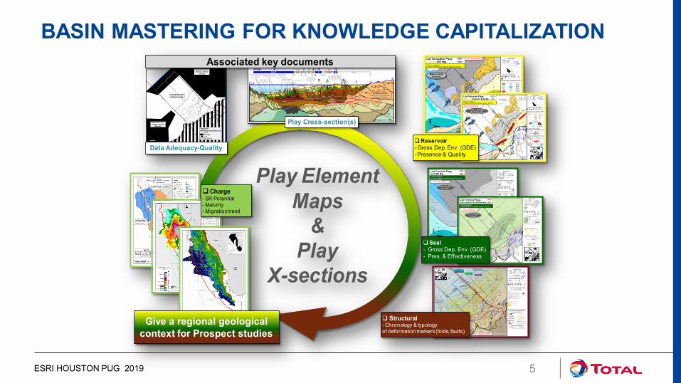
ESRI HOUSTON PUG 2019 5
A
-
B
???
???
???
???
??????
MMU
Accretionary Prism Highly deformed Deep water
Oligocene sediment
?
???
??????
?
? ?
?
???
GLH1 AAA3 AA N ZLM OAA9 K Open
Acreage
Play 4 (proven in CA2 ) Messinian Deep Marine
clastics
Play 2 (proven in Swk) Lwr. Miocene
Sh. Marine Carb.Play 1 (proven) Late Tortonian deep marine clastics (sub-play: 4-way faulted folds)
Play 3 (spec.): Lwr. Miocene
Deep Marine Carb.
Play 5 (spec.) Mid Tortonian deep
marine clastics
Play 6 (spec.) Lwr. Miocene
deep marine clastics Play 6 (proven in Sbh) Lwr. Miocene shallow
marine clasticsLisa-BField Sol-1
ILH Field
YB-1JLB-1
5 km
10 km
15 km
20 km Vertical exaggeration X4 10 km
SW Incised valley
NE Incised valley
Champion Entry point
BaramEntry point
North
20km
tlb-fan
mbc
mtc
sla
rff MTCs Mouth Bars Complex
Late Serravalian Plays:Reservoir GDE Map
Syndepositional structures
Reverse FaultNormalFaultFold axis
Shelf Edge
Non-deposition
Depositional limitson Distal Domain
on Proximal Domain
Deltaic PlainCoastal Plain
Continental Shallow marine Deep marine
Eolian
Lacustrine undiff.
Sh. Marine Clastic Dom
Carb. Lagoon
CarbonateRimmed Shelf
Clastic Slope
Clastic basin
Carbonate Slope
Carbonate Basin
Paleogeo Domains & Depositional Env.
Cultural limitsAcreage
Country borders
Present day coastline
Total acreage
Paleo-coastline
Depositional Systems
Turb. Lobe Dominated Fan
Lateral/distal facies
Sandy lobe
Carb. Sliope Apron
Petroleum results @ play
DryOil Gas O&G Oil, G, C shows Gas & CondBitumen
Hydrothermal
Notional Dep. System
Calibrated Dep. System
Data adequacy – quality map
!! Fictive example !! Inspired from NW Borneo Regional Synthesis 2011-2013
PPT version for Demo
Mature Explo Example
H500
H580
Reef
rff
tlb-fan
sla
Notional part of the Depositional Systems
Calibrated part of the Depositional Systems
North
20km
380m300m22%
800m300m22%
210m70m23%
180m5m13%
180m5m13%
210m70m23%
Gross (m)Net (m)Av Phi (%)
Frontier – Emerging Explo Example
Late Tortonian Plays:Reservoir presence & quality!! Fictive example !! Inspired from NW Borneo Regional Synthesis 2011-2013
H500
H580
PPT version for Demo
Post depositional structures impacting reservoir quality / alteration
Reverse Fault
InvertedNormal fault
Deep transverse lineament
Mouth Bars Complex
Cultural limitsAcreage
Country borders
Present day coastline
Total acreage
Paleo-coastline
Depositional SystemsLateral/distal
faciesSandy lobe
Carb. Sliope Apron
Petroleum results @ play
DryOil Gas O&G Oil, G, C shows Gas & Cond
Bitumen
Notional Sed. BodyCalibrated Sed. Body
Reef
Play absent (Erosion)
Reservoir prop’ degradation
Post-depositional effects & Res. CaractReservoir prop’ enhancement
Play partiallyeroded
OVP magnitudesIsoburial
curves
Shelf Edge
Continental Shallow marine
Eolian Sh. Marine Clastic Dom
Coastal
CarbonateRimmed Shelf
Paleogeo Domains & Depositional Env.
Reservoir- Gross Dep. Env. (GDE)- Presence & Quality
Charge- SR Potential - Maturity- Migration trend
Play Cross-section(s)North
20km
Moderate to Poor seismic coverage
(2D only)
Good & recent 3D seismic coverage
Moderate to Poor seismic coverage
(2D only)
Data Adequacy-Quality
Associated key documents
Legend for Data Adequacy/Quality map
HighAverageLowStudy Area
Background map: bathymetry & topography
Petroleum results @ play
DryOil Gas O&G Oil, G, C shows Gas & Cond
Cultural limitsAcreage
Country borders
Present day coastline
Total acreage
Control pointsLate Tortonian sequence Outcrops
Wells
Calibration / confidence
Calibrated Inferred / notional
Reverse Fault
Normal Fault
Late Oligocene*
Typology (left) & chronology (right) of the main deformation markers
& impacting the Play
Anticline axis
Syncline axis
Tortonian
Messinian
Pliocene
Strike slipsUndifferentiated/ unknown
Key structural limits & domains(valid for all Plays)
Outboard limit of the Necking zone
Continent-Ocean Boundary (COB)
Sequence Depositional limitsDistal on Oceanic floorProximal on Slope or Shelf
Proximal on land
Luconia platform(Sunda plate)
RifttedContinental Crust
BaramTransfer Zone
Magpie-PetrelTransfer Zone
Present PPT version To be replaced asap by ArgGIS version
North20km
External Fold & thrust beltThick skin deformation domain
Langhian to Serravallian*
(* structures with impact on Tortonian Play sand entry points)
A
B
Transfer zones
Internal Fold & thrust beltCrocker Accretionary prism
External Fold & thrust beltThin skin deformation domain
Data adequacy – quality map
Pliocene gravity cells
Messinian gravity cells
Tortonian gravity cells
?
Hyper-stretched Cont. crust
Dangerous groundsNecking zone
Inferred Oceanic crust
Late Tortonian Plays:Structural play element map
!! Fictive example !! Inspired from NW Borneo Regional Synthesis 2011-2013
H500
H580
Structural- Chronology & typology of deformation markers (folds, faults)
Give a regional geological context for Prospect studies
Play Element Maps
& Play
X-sections
?
SW Incised valley
NE Incised valley
Syndepositional structures
Reverse FaultNormalFault
Shelf edge
Non-deposition
Sequence Depositional Onlap Distal on Oceanic floorProximal on Slope or ShelfProximal on land
Sedimentary bodies / Seismic AEs
Estuarine
Petroleum results @ play
DryOil Gas O&G Oil, G, C shows Gas & CondBitumen
Cultural limitsAcreage
Country borders
Present day coastline
Total acreage
Sequence Isopach contours
Control points & limits confidencecalibrated by wells
and/or SeismicNotionalOutcrops
Wells
North
20km
Braided
Continental Shallow marine Deep marine
Coastal
Deltaïc
Lagoon
Outer Shelf
Clastic Slope
Clastic basin
Slope carbonates
Basin carbonates
Paleo-environments and main lithologies
Data adequacy – quality map
Frontier Explo Example
Late Tortonian Plays:Seal GDE Map!! Fictive example !! Inspired from NW Borneo Regional Synthesis 2011-2013
H470
H500
PPT version for Demo
North
20km
Moderate to Poor seismic coverage
(2D only)
Good & recent 3D seismic coverage
Moderate to Poor seismic coverage
(2D only)
Pressure regime in reservoirSub-Hydrostatic
Possible OVP
Post depositional structuresPliocene
Reverse Fault
Pliocene Normal Fault
Pliocene Inverted Normal fault
L. MioceneReverse Fault
Messinianfaults
Petroleum results @ play
DryOil Gas O&G Oil, G, C shows Gas & Cond
BitumenOil / gas seeps
Cultural limitsAcreage
Country borders
Present day coastline
Total acreage
Control points & limits confidencecalibrated by wells
and/or SeismicNotionalOutcrops
Wells
Fuild escape featuresGas Cloud (extrado fault breaches ?)
North
20km 4
Data adequacy – quality map
Frontier Explo Example
Late Tortonian Plays:Seal presence & effectiveness!! Fictive example !! Inspired from NW Borneo Regional Synthesis 2011-2013
H470
H500
PPT version for Demo
Base Seal Burial Map(when regional seal present)
Shelf edge
Grey = Absence of
regional seal (requires local seal)
Seal Presence & efficiencyBackground map
MTCs
Green= Presence of regional seal
Seal- Gross Dep. Env. (GDE)- Pres. & Effectiveness
BASIN MASTERING FOR KNOWLEDGE CAPITALIZATION

6
Dedicated DB
BASIN MASTERING PROJECT STANDARD GEODATABASE AND SYMBOLOGY
ENDOGENOUS (210-0-100) CONTINENTAL (230-200-170) SHALLOW MARINE UNDIFFERENTIATED (221-217-195)SHALLOW MARINE CARBONATE DOMINATED (219-238-243) SHALLOW MARINE CLATIC DOMINATED (255-255-204)DEEP MARINE UNDIFFERENTIATED (127-127-127)DEEP MARINE CARBONATE DOMINATED (102-204-255) DEEP MARINE CLATIC DOMINATED (165-165-165)
RGB code
Hydrothermal (205-0-95) Seward Deeping Reflectors (SDR) sdr (150-100-185) Volcanic (255-0-0) Volcanics / Volcano-Clastics vvc (230-70-55) Spring-Fed (255-150-85) Sub-Glacial Valley sgv (200-100-10) Glacial (245-125-25) Proglacial Front pgf (220-160-110) Alluvial (220-150-150) Alluvial Fan alf (102-0-51) Lacustrine Undifferentiated (140-240-210) Fan Delta fdt (210-0-100) Lacustrine Proximal (60-228-184) Playa ply (255-115-185) Lacustrine Distal (104-174-184) Fluvial Braided fbrd (255-130-85) Eolian (254-232-178) Erg erg (232-197-176) Fluvial Plain - Flood Plain (195-250-100) Fluvial Low Sinuosity To Meandering flsm (245-206-73) Deltaic Plain - Coastal Plain (0-160-0) Deltaic Distributary Channel Complex ddc (255-255-90) Coastal (223-218-0) Fluvio-Lacustrine Distributary Channel Complex fldc (255-235-0) Clastic Inner Shelf Undifferentiated (170-195-165) Fluvio-Lacustrine Mouth Bars Complex flmb (255-255-0) Clastic Outer Shelf Undifferentiated (80-165-150) Lacustrine Turbidite Lobe ltl (255-255-170) Wave Dominated Inner Shelf (225-225-135) Lacustrine Carbonate Slope Apron lcsa (55-100-145)Wave Dominated Outer Shelf (225-205-135) Bioclastic Bench bcb (168-168-246) Tide Dominated Inner Shelf - Estuarine (255-215-180) Tuffas tuf (220-190-245)Tide Dominated Outer Shelf (255-200-145) Travertines tvt (230-220-240)Delta Front (255-255-153) Stromatolitic Flat str-flt (255-170-140)Deltaic Shelf (155-110-80) Sebkha - Wadi Plain sb-wp (254-72-163) Pro-Delta (227-236-172) Salina sal (255-100-250) Clastic Slope (217-217-217) Tidal Flat tdf (106-217-23) Clastic Basin (168-168-168) Carbonate Lagoon crb-lgn (0-200-200) Clastic Submarine Fan (190-160-30) Carbonate Shoal cshl (204-255-0) Carbonate Shelf Undifferentiated (115-240-240) Reef rff (0-255-255) Carbonate Open Shelf (150-250-250) Clastic Lagoon - Bay cls-lgb (0-204-160) Carbonate Rimmed Shelf (180-250-250) Shoreface - Beach - Washover Fan sbw (236-249-61) Homoclinal Ramp Undifferentiated (90-170-205) Mouth Bars Complex mbc (250-240-60) Homoclinal Inner Ramp (170-210-230) Tidal bars Complex tbc (255-204-153) Homoclinal Middle Ramp (110-180-210) Tidal Delta tdt (245-200-150) Homoclinal Outer Ramp (50-130-155) Shelfal Lobe sfl (220-220-0) Distally Steepened Ramp Undifferentiated (150-180-215) Storm Lobe stl (215-210-0) Distally Steepened Inner Ramp (200-215-240) Offshore Bar ofb (250-250-0) Distally Steepened Middle Ramp (140-180-230) Canyon Complex cyc (191-191-191) Distally Steepened Outer Ramp (80-140-215) Mass Transport Complex mtc (204-204-255) Carbonate Slope (187-213-229) Mega Breccia mgb (204-192-218) Carbonate Basin (100-200-255) Mud Mound - Reef Mound mm-rm (0-153-153)
Carbonate Slope Apron csa (55-96-145) Name of the depositional environment RGB code Deep Water Evaporites dwe (255-102-255)
Contourite - Sediment Waves ct-sw (228-109-10) Turb, Channel Dominated Fan or Fairway tch-fn-fw (255-156-56) Turb, Lobe Dominated Fan tlb-fan (245-206-73)
Name of the depositional environment Abrev. RGB code
Deep
Mar
ine
Mar
ine
Carb
onat
es M
arin
e Cl
astic
sCo
ntin
ient
al
Shaz
llow
Mar
ine
Depositional sytems
Paleogeographical domains
Depositional environments
Cont
inen
tal
Undifferentiated depositional limit (thick black line 0-0-0) Depositional limit on proximal domain (thick brown 110-50-160)
Depositional limit on slope or shelf (thick blue 0-175-240) Depositional limit on distal domain (dark grey 89-89-89)Depositional limit on volcano (thick purple 110-50-160 )
Depositional limit on autochthonous salt (dark pink 204- 0-204)
Normalized color & symbols
Carbonate paleogeo Domains, Depositional Env. & Syst.
Clastic paleogeo Domains, Depositional Env. & Syst.
Specialties input:
standard interpretation & nomenclature
Background map: bathymetry & topography
Luconia platform(Sunda plate)
RifttedContinental Crust
BaramTransfer Zone
Magpie-PetrelTransfer Zone
North20km
A
B
North
20km
Moderate to Poor seismic coverage
(2D only)
Good & recent 3D seismic coverage
Moderate to Poor seismic coverage
(2D only)
Data adequacy – quality map
?
Hyper-stretched Cont. crust
Dangerous groundsNecking zone
Inferred Oceanic crust
Late Tortonian Plays:Structural play element map
!! Fictive example !! Inspired from NW Borneo Regional Synthesis 2011-2013
H500
H580
Present PPT version for map building demo only
Struct. geology
Arc-GIS Capitalized Play Map
Standard symbology in DB
Basin Modeling: EVAPET ESRI HOUSTON PUG 2019

ESRI HOUSTON PUG 2019 7
BASIN MASTERING WORKFLOW
Portal For Arcgis

PORTAL CATALOG FOR ARCGIS
ESRI HOUSTON PUG 2019 8
Basin MasteringDatabase(s)
Exploration Insight(Neftex)
IHS Markit
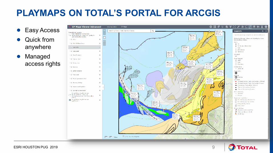
PLAYMAPS ON TOTAL’S PORTAL FOR ARCGIS
ESRI HOUSTON PUG 2019 9
● Easy Access● Quick from
anywhere● Managed
access rights

HOUSTON: MEXICO – PERDIDO BASIN – WILCOX PLAYSTRUCTURAL ELEMENTS
ESRI HOUSTON PUG 2019 10
Fictive Data
Play structural elements• Normal Faults (square)• Thrust Faults (teeth)• Folds (arrow ends)• Salt Bodies
Outlines regimes• Extensional Coast• Compressional Shelf
Data Adequacy Inlay• Provides a view of the
quality and resolution of the data
• Helps us understand how much trust we can have on the map’s data
• Often the data comes from multi million dollar 2D/3D Seismic datasets
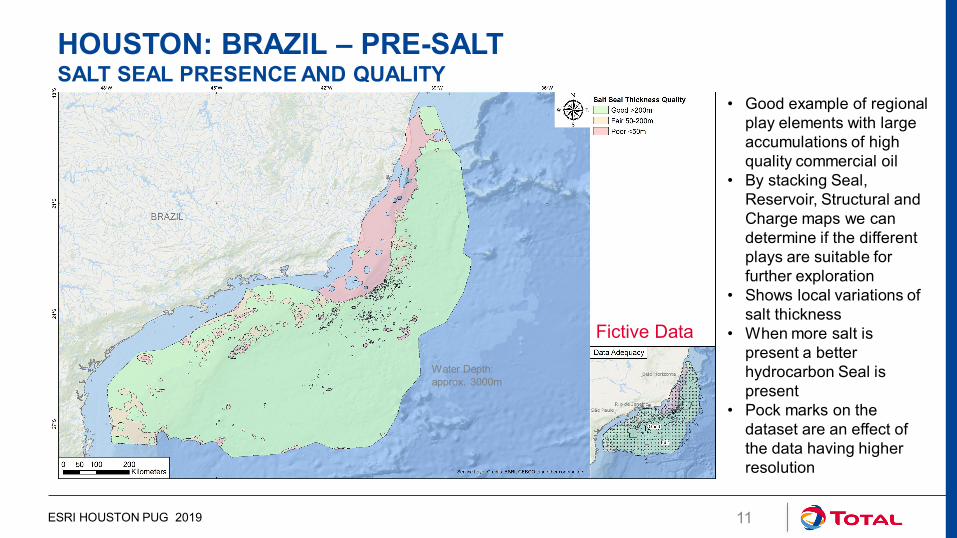
HOUSTON: BRAZIL – PRE-SALTSALT SEAL PRESENCE AND QUALITY
ESRI HOUSTON PUG 2019 11
Fictive Data
• Good example of regional play elements with large accumulations of high quality commercial oil
• By stacking Seal, Reservoir, Structural and Charge maps we can determine if the different plays are suitable for further exploration
• Shows local variations of salt thickness
• When more salt is present a better hydrocarbon Seal is present
• Pock marks on the dataset are an effect of the data having higher resolution
Water Depth:approx. 3000m

HOUSTON: US ALASKA - COLVILLE BASINRESERVOIR PALEOGRAPHY
ESRI HOUSTON PUG 2019 12
Fictive Data
• National Petroleum Reserve in Alaska
• Shows depositional systems and domain environments as when the reservoir was being deposited (past)
• First Domain environments are mapped: Basins, Shelf, etc. then we map the depositional environments: Deltas, Lobes, Fans, etc.
• The Delta Plain here is similar to a river that deposited and filled the basin from west to east
• Sources come mainly from public sources using our standards

ESRI HOUSTON PUG 2019 13
CONCLUSION AND OUTLOOKBasin Mastering has now been in place for 2 years
Used by all Explo teams using the same standards
Main Gains:
• Allows for data & knowledge transmission
• Knowledge is updated often with new data/insights
• Improves consistency in our evaluations
• Eases the decision making process
• Generates new ideas

THE TOTAL GROUP IS DEFINED AS TOTAL S.A. AND ITS AFFILIATES AND SHALL INCLUDETHE PARTY MAKING THE PRESENTATION
Disclaimer
This presentation may include forward-looking statements within the meaning of the Private Securities Litigation ReformAct of 1995 with respect to the financial condition, results of operations, business, strategy and plans of Total that aresubject to risk factors and uncertainties caused by changes in, without limitation, technological development andinnovation, supply sources, legal framework, market conditions, political or economic events.Total does not assume any obligation to update publicly any forward-looking statement, whether as a result of newinformation, future events or otherwise. Further information on factors which could affect the company’s financial resultsis provided in documents filed by the Group with the French Autorité des Marchés Financiers and the US Securities andExchange Commission.Accordingly, no reliance may be placed on the accuracy or correctness of any such statements.
Copyright
All rights are reserved and all material in this presentation may not be reproduced without the expresswritten permission of the Total Group.
14
DISCLAIMER AND COPYRIGHT RESERVATION
ESRI HOUSTON PUG 2019