baton rouge mtp - capital region planning
TRANSCRIPT
Developed For
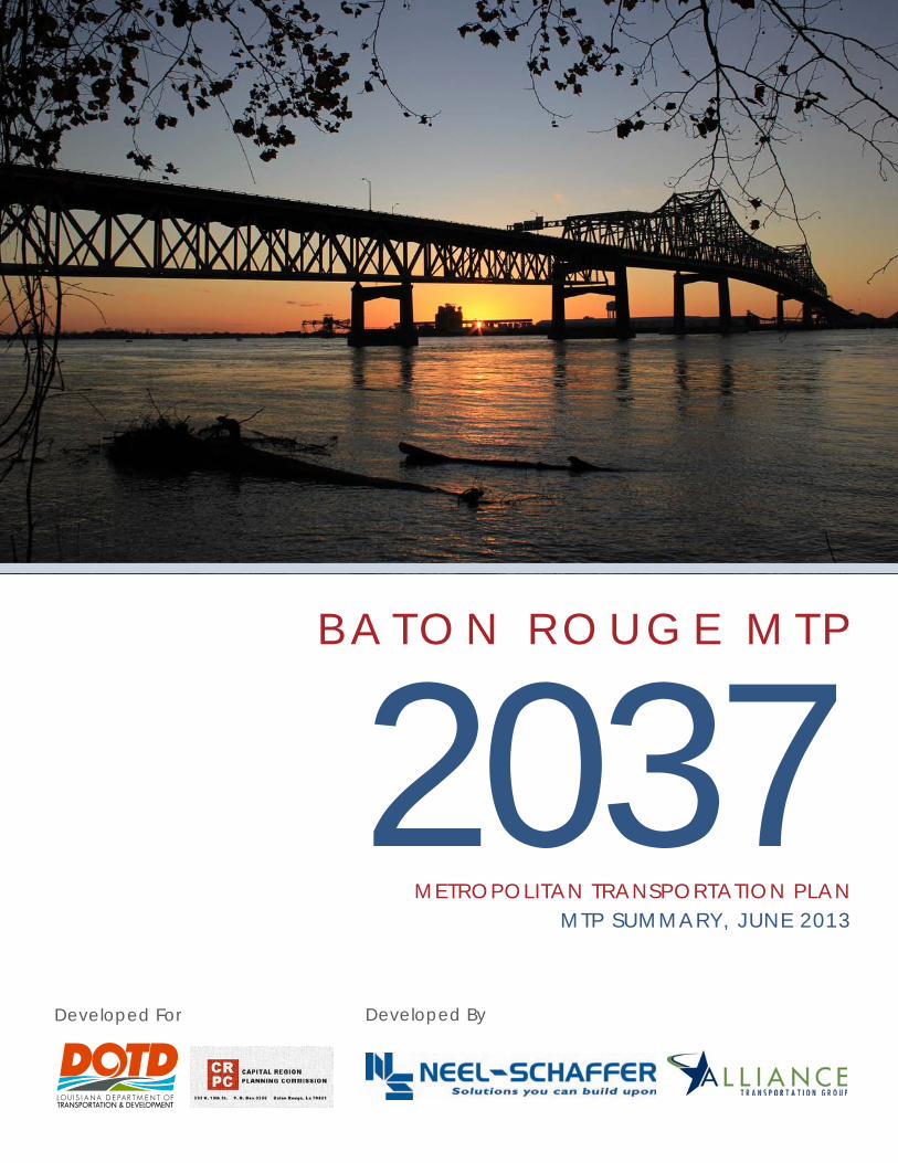
2037B A T O N R O U G E M T P
METROPOLITAN TRANSPORTATION PLANMTP SUMMARY, JUNE 2013
Developed By
2 | METROPOLITAN TRANSPORTATION PLAN 2037 | BATON ROUGE
INTRODUCTION
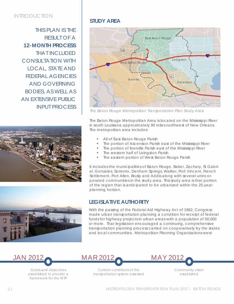
The Baton Rouge Metropolitan Area is located on the Mississippi River in south Louisiana approximately 90 miles northwest of New Orleans. The metropolitan area includes:
• All of East Baton Rouge Parish• The portion of Ascension Parish east of the Mississippi River• The portion of Iberville Parish east of the Mississippi River• The western half of Livingston Parish• The eastern portion of West Baton Rouge Parish
It includes the municipalities of Baton Rouge, Baker, Zachary, St Gabri-el, Gonzales, Sorrento, Denham Springs, Walker, Port Vincent, French Settlement, Port Allen, Brusly and Addis along with several unincor-porated communities in the study area. This study area is that portion of the region that is anticipated to be urbanized within the 25-year planning horizon.
The Baton Rouge Metropolitan Transportation Plan Study Area
THIS PLAN IS THE RESULT OF A
12-MONTH PROCESS THAT INCLUDED
CONSULTATION WITH LOCAL, STATE AND
FEDERAL AGENCIES AND GOVERNING
BODIES, AS WELL AS AN EXTENSIVE PUBLIC
INPUT PROCESS
STUDY AREA
LEGISLATIVE AUTHORITY
JAN 2012 MAR 2012 MAY 2012Goals and objectives
established to provide a framework for the MTP
Current conditions of the transportation system assessed
Community vision established
Iberville
Livingston
East Baton Rouge
West Baton Rouge
Ascension
With the passing of the Federal Aid Highway Act of 1962, Congress made urban transportation planning a condition for receipt of federal funds for highway projects in urban areas with a population of 50,000 or more. That legislation encouraged a continuing, comprehensive transportation planning process carried on cooperatively by the states and local communities. Metropolitan Planning Organizations were
THE MTP IS A LONG RANGE METROPOLITAN TRANSPORTATION PLAN, WHICH IS A BLUEPRINT TO GUIDE THE DEVELOPMENT OF PROGRAMS AND TRANSPORTATION PROJECTS WITHIN THE BATON ROUGE URBANIZED AREA
designated by the governor in each state to carry out this legislative requirement. Following that initial Federal legislation, there have been a series of acts by Congress that have continued to fund transporta-tion projects.
These acts have included the Intermodal Surface Transportation EfficiencyAct(ISTEA)in1991;theTransportationEquityActforthe21stCentury(TEA-21)in1998;theSafe,Accountable,FlexibleandEfficientTransportationEquityAct:ALegacyforUsers(SAFETEA-LU)in2005;andthe most recent act, Moving Ahead for Progress in the 21st Century (MAP-21) in 2012. MAP-21 serves as the current regulatory and fund-ing framework for transportation planning in the United States and has guided this update of the Baton Rouge Urbanized Area MTP 2037.
MAP-21 continues a provision of SAFETEA-LU which requires that a met-ropolitan planning area carry out a planning process that provides for consideration and implementation of projects, strategies and services that:
1. Support the economic vitality of the United States, the States, non-metropolitan areas, and metropolitan areas, especially by enabling global competitiveness, productivity, and efficiency;
2. Increase the safety of the transportation system for motorized and nonmotorized users;
3. Increase the security of the transportation system for motorized and nonmotorized users;
4. Increase the accessibility and mobility of people and for freight;
5. Protect and enhance the environment, promote energy conserva-tion, improve the quality of life, and promote consistency between transportation improvements and State and local planned growth and economic development patterns;
6. Enhance the integration and connectivity of the transportation sys-tem, across and between modes throughout the State, for people and freight;
7. Promote efficient system management and operation; and
8. Emphasize the preservation of the existing transportation system.
AUG 2012 OCT 2012 DEC 2012Transportation needs of
the community determined
Financial analysis of estimated costs and revenues performed
Staged Improvement Program developed
| 3

MAP-21 also establishes national performance goals for the Federal programs that occur on the highway system. These goals are:
MAP-21 ALSO ESTABLISHES NATIONAL PERFORMANCE GOALS
FOR THE FEDERAL PROGRAMS THAT
OCCUR ON THE HIGHWAY SYSTEM
FREIGHT MOVEMENT & ECONOMIC VITALITYTo improve the national freight network, strengthen the ability of rural communities to access national and international trade markets, and support regional economic development.
ENVIRONMENTAL SUSTAINABILITYTo enhance the performance of the transportation system while pro-tecting and enhancing the natural environment.
REDUCED PROJECT DELIVERY DELAYSTo reduce project costs, promote jobs and the economy, and expe-dite the movement of people and goods by accelerating project completion through eliminating delays in the project development and delivery process, including reducing regulatory burdens and improving agencies’ work practices.
4 | METROPOLITAN TRANSPORTATION PLAN 2037 | BATON ROUGE
SAFETY
ENVIRONMENTALSUSTAINABILITY
ECONOMICVITALITY
SAFETYToachieveasignificantreductionintrafficfatalitiesandseriousinju-ries on all public roads.
INFRASTRUCTURE CONDITIONTo maintain the highway infrastructure asset system in a state of good repair.
CONGESTION REDUCTIONToachieveasignificantreductionincongestionontheNHS.
SYSTEM RELIABILITYToimprovetheefficiencyofthesurfacetransportationsystem.
CONGESTIONREDUCTION
INFRASTRUCTURECONDITION
THE PLANNING PROCESS FOR CREATING THE MTP IS PRESCRIBED BY STATE AND FEDERAL REGULATIONS, BUT THE VISION THAT DRIVES THE PROCESS IS LOCALLY DEVELOPED
METROPOLITAN PLANNING ORGANIZATION (MPO)TheUSCensusBureauhasidentifiedover400regionsthroughouttheUnited States that they consider to be urbanized. Urbanized areas containapopulationgreaterthan50,000.Federallaw(23CFRPart450)mandatesthecreationofaMPOforeachcensusdefinedurban-ized area, with the purpose of involving local governments in transpor-tation decisions involving Federal highway and/or transit funds. Under theseregulations,theCapitalRegionPlanningCommission(CRPC)has been designated by the Governor of Louisiana as the MPO for the Baton Rouge Urbanized Area and is the responsible agency for trans-portation planning activities.
The MPO is composed of local government representatives, transpor-tationofficialsandotherstakeholders.Itfunctionswithtwocommit-tees.TheTechnicalAdvisoryCommittee(TAC)reviewsdocumentsand makes recommendations on the technical aspects of the MPO plansandtheTransportationPolicyCommittee(TPC)providespolicydirection to the MPO staff and authorizes adoption of the MPO plans.
METROPOLITAN PLANNING PROCESSThe planning process for creating the MTP is prescribed by state and federal regulations, but the vision that drives the process is locally de-veloped. The MTP is designed to implement this locally derived vision. In order to update the MTP for the Baton Rouge Urbanized Area, the following planning process was used by the study team, which was comprised of CRPC staff, technical representatives of member jurisdic-tions, the DOTD, and was supported by professional planning consul-tants. The planning process was conducted under the authority of the Baton Rouge Urbanized Area MPO.
EXISTINGCONDITIONS
PUBLIC INPUTVISION
NEEDSASSESSMENT
PUBLIC PARTICIPATION
Project Selection Criteria Ranking
1. Reduce Congestion2. PromoteEfficiency3. Improve Safety4. Improve Quality of Life5. Improve Access6. Support Economic Development Goals7. Connect Modes of Travel8. Improve Security9. Support Lane Use Goals10. Conserve Energy11. Protect the Environment12. Preserve Right-of-Way
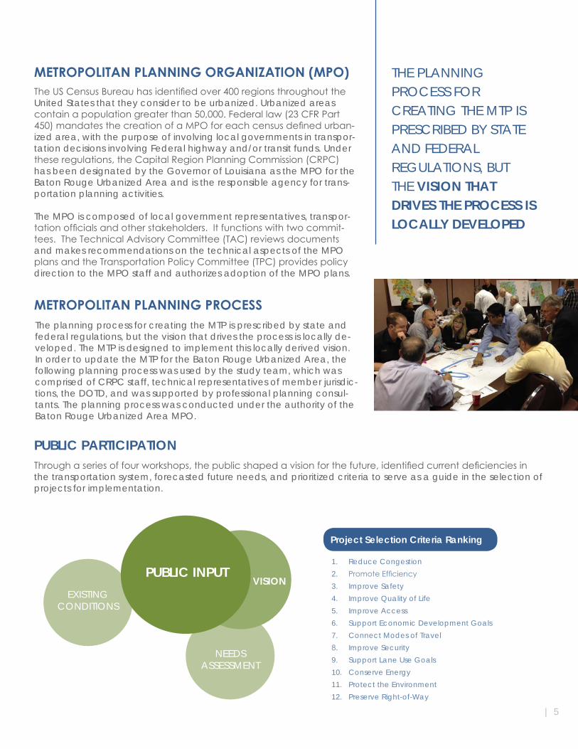
Throughaseriesoffourworkshops,thepublicshapedavisionforthefuture,identifiedcurrentdeficienciesinthe transportation system, forecasted future needs, and prioritized criteria to serve as a guide in the selection of projects for implementation.
| 5
METROPOLITAN TRANSPORTATION PLAN 2037 | BATON ROUGE6 |
CURRENT CONDITIONS
THE INITIAL STEP IN DEVELOPING A PLAN TO REACH A GOAL IS
THE ASSESSMENT OF THE CURRENT
CONDITIONS OF THE TRANSPORTATION
SYSTEM Wherever possible, all modes of the existing transportation system were inventoried. This inventory includes the urban and rural trans-portation system by functional class, the national highway system, the fixedroutetransitsystemandotherpublictransitsystemsandtheirservice areas. It also included information on ports, airports, passenger rail, intercity bus, intermodal terminals, bicycle facilities, pedestrian facilities and bridges.
SYSTEM INVENTORY
The initial step in developing a plan to reach a goal is the assessment of the current conditions of the transportation system. This assessment includes an inventory of the existing transportation system, a demographic analysis to determine a baseline demand, an evaluation of existing documents including information from local professionals, and crash data which may indicate locations where safety is a problem.
LAND USE AND ZONINGThe transportation system serves the trips generated by various land uses. Land use and the related demographic data is a direct input to the transportation model for an area. All documents related to land use are gathered to assess the current description of an area. These documents may be zoning documents, land use documents, or va-cant land inventories.
1
11%
1% 2% 1% 3
Means
82
%
s of Tran
2%
nsportation to W
Driv
Car
Pub
Wa
Tax
Wo
Work
ve Alone
pool
blic Transporta
lked
xi, Motorcycle,
orked at Home
tion
Bike, Other
Drive Alone
Carpool
Public Transportation
Walked
Taxi, Motorcycle, Bike, Other
Worked at Home
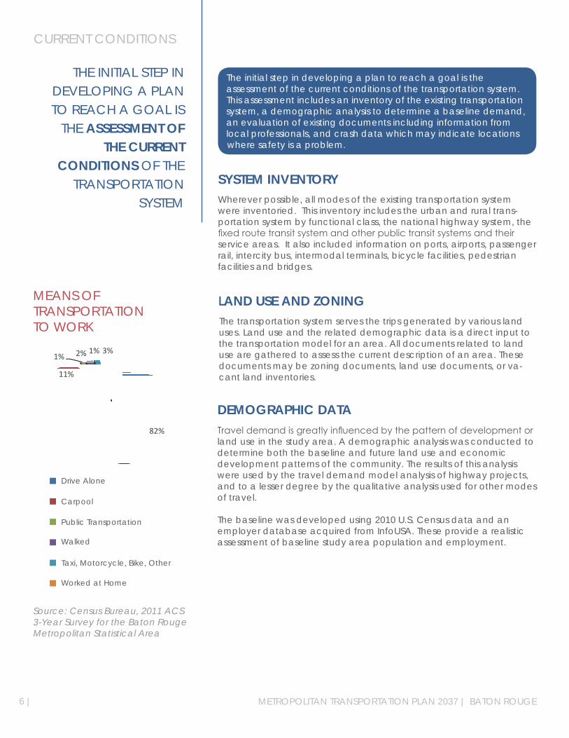
MEANS OF TRANSPORTATION TO WORK
Source: Census Bureau, 2011 ACS 3-Year Survey for the Baton Rouge Metropolitan Statistical Area
DEMOGRAPHIC DATATraveldemandisgreatlyinfluencedbythepatternofdevelopmentorland use in the study area. A demographic analysis was conducted to determine both the baseline and future land use and economic development patterns of the community. The results of this analysis were used by the travel demand model analysis of highway projects, and to a lesser degree by the qualitative analysis used for other modes of travel.
The baseline was developed using 2010 U.S. Census data and an employer database acquired from InfoUSA. These provide a realistic assessment of baseline study area population and employment.
1
11%
1% 2% 1% 3
Means
82
%
s of Tran
2%
nsportation to W
Driv
Car
Pub
Wa
Tax
Wo
Work
ve Alone
pool
blic Transporta
lked
xi, Motorcycle,
orked at Home
tion
Bike, Other
POPU
LATIO
N
VISION: THE QUALITY OF LIFE IN THE BATON ROUGE URBANIZED AREA IS ENHANCED BY A TRANSPORTATION SYSTEM THAT SUPPORTS THE LOCAL ECONOMY AND PROVIDES USERS WITH SAFE, CONVENIENT, AND AFFORDABLE TRANSPORTATION CHOICES TO DESIRED DESTINATIONS
VISIONINGThisprocessinvolvedtheidentificationofthevisionthatthecommu-nity wished to implement. In order to develop the elements of the plan, a variety of methodologies were employed in an effort to build a strong foundation for developing the long-range transportation plan that would best meet the needs of the community over the next 25 years. These activities included a review of local plans, the forecast of thedemographicdata,stakeholderconsultations,theidentificationof alternate growth scenarios and public participation workshops. The results of those activities were crafted into a recommended vision, set of goals and objectives, and a list of evaluation criteria to be used to evaluate potential projects.
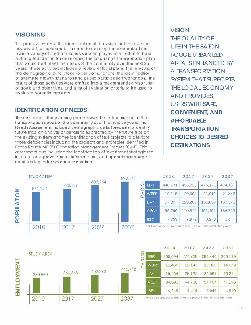
EBR 260,694 274,938 290,440 306,139
WBR* 11,460 12,143 13,029 14,079
LIV* 19,464 28,137 36,691 45,314
ASC* 34,693 44,736 57,467 71,298
IBR* 4,249 4,414 4,646 4,910
PA
RIS
H
2 0 1 0 2 0 1 7 2 0 2 7 2 0 3 7
2010 2017 2027 2037
330,560 364,368 402,273 441,740
*Includes only the portions of the parish in the MPO study area
2010 2017 2027 2037
EBR 440,171 456,729 476,171 494,181
WBR* 19,115 20,004 21,012 21,842
LIV* 97,807 123,209 151,659 180,572
ASC* 96,290 120,826 152,152 186,935
IBR* 7,759 7,972 8,270 8,611
PA
RIS
H
2 0 1 0 2 0 1 7 2 0 2 7 2 0 3 7
661,142728,739
809,264892,141
*Includes only the portions of the parish in the MPO study area
STUDY AREA
EMPL
OYM
ENT
STUDY AREA
| 7
The next step in the planning process was the determination of the transportation needs of the community over the next 25 years. The Needs Assessment included demographic data forecasts to identify futuretrips,ananalysisofdeficienciescreatedbythefuturetripsontheexistingsystemandtheidentificationoftestprojectstoalleviatethosedeficienciesincludingtheprojectsandstrategiesidentifiedinBatonRougeMPO’sCongestionManagementProcess(CMP).Thisassessmentalsoincludedtheidentificationofinvestmentstrategiestoincrease or improve current infrastructure, and operation/manage-ment strategies for system preservation.
IDENTIFICATION OF NEEDS
8|
FINANCIAL ANALYSISFiscalachievabilityisasignificantpriorityindeterminingthefinallistofimprovementstobeincludedintheMTPtoaddressidentifieddeficien-cies.MAP-21mandatesthattheMTPbefiscallyconstrained,thatis,only projects that can reasonably be expected to have adequate funding can be included in the implementation program. The process for establishing both estimated costs and revenues is critical for thecreation of a viable long-range transportation plan.
Street and Highway Funding Thefinancialanalysisincludedarevenueforecastthatidentifiedtheanticipated revenue for state and federal funds. Assuming future fund-ing for transportation improvements will be consistent with the level of expenditure indicated by recent historical data, an average of $42 million per year in 2010 dollars is forecast to be available in state and federal funds for transportation improvements within the study area. Byfactoringina2.5percentannualinflationrate,thetotalamountforecast to be available through 2037 is $2.03 billion.
Public Transit FundingSimilarly, historical public transit funding analysis indicated an average of $6.6 million per year in 2010 dollars is forecast to be available for public transit operations and capital im-provementswithinthestudyarea.Byfactoringina2.5percentannualinflationrate,thetotalamountforecastto be available for transit operations and capital improvements available through 2037 is $352.9 million.
Implementation CostsAn implementation cost was calculated for each project based on historical project cost by project type. Costisdefinedasthetotalprojectcost,whichincludes:planningelements,engineeringcosts,preconstructionactivities,construction,andcontingencies.Thesefiguresalsoincludeanannual2.5percentinflationfactortoestimate project implementation costs in year-of-expenditure dollars.
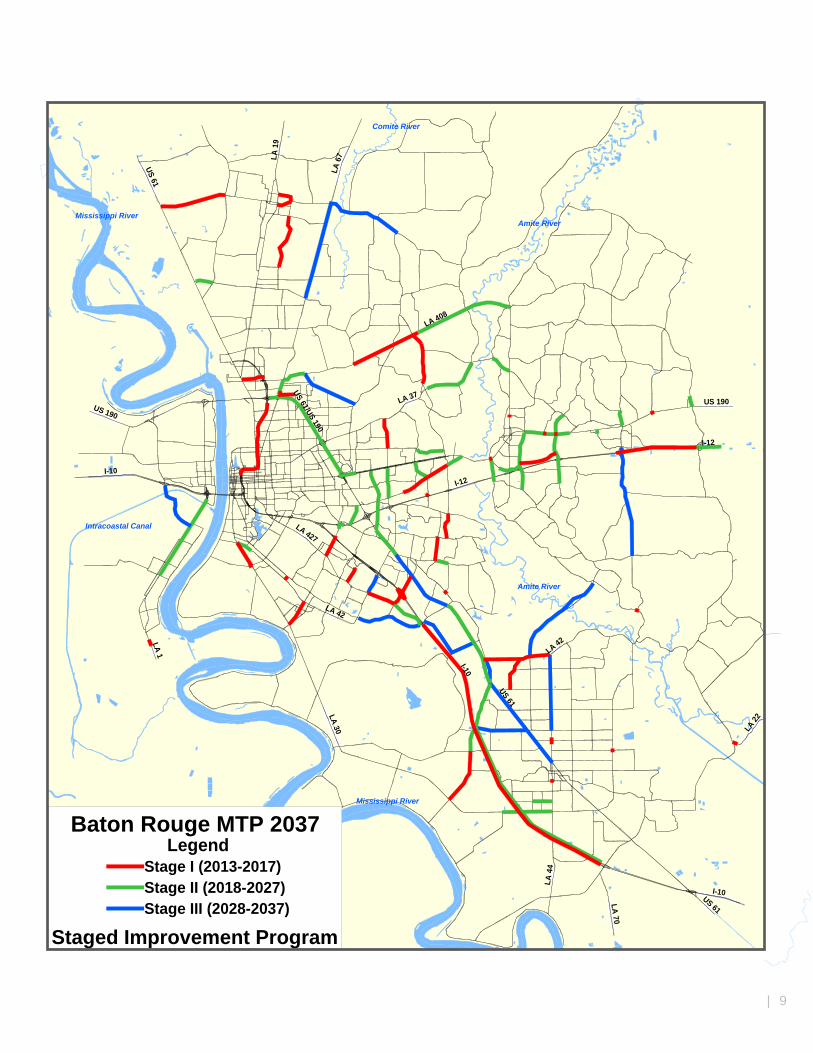
STAGED IMPROVEMENT PROGRAMAnnual transportation revenues in the urban areas of the state can vary widely. Therefore, revenue projections were calculated for three time periods, or stages. The revenue projections for state and federal recurring funds fortransportationprojectsidentifiedintheBatonRougeMTP2037Updateareshowninthefollowingtable.
These dollar amounts represent recurring revenues. In the case of projects with special dedications of non-re-curringfunds(suchasAmericanRecoveryandReinvestmentActfunds)theamountoffundingdedicatedtoindividual projects is added on top of the recurring revenue forecast on a case-by-case basis.
ProjectsidentifiedineachStageareshowninthemapandtablesonthefollowingpages.
TIME PERIOD STREET & HIGHWAY TRANSIT
STAGEI(2013to2017)
STAGEII(2018to2027)
STAGEIII(2028to2037)
TOTAL (2013 to 2037)
$423,260,000
$704,610,568
$901,961,098
$2,029,831,666
$59,737,297
$129,470,020
$163,679,390
$352,886,707
STAGED IMPROVEMENT PROGRAM
METROPOLITAN TRANSPORTATION PLAN 2037 | BATON ROUGE
Mississippi River
Mississippi RiverAmite River
Intracoastal Canal
Amite River
Comite River
LA 22
LA 30I-10
I-10
LA 6
7
US 61
LA 70
US 190
I-10
US 190
I-12
LA 408
US 61
LA 37
LA 427
LA 42
LA 4
4
LA 1
9
US 61
I-12
LA 1 LA 42
US 61/US 190
Baton Rouge MTP 2037
Staged Improvement Program
LegendStage I (2013-2017)Stage II (2018-2027)Stage III (2028-2037)
| 9
10 | METROPOLITAN TRANSPORTATION PLAN 2037 | BATON ROUGE
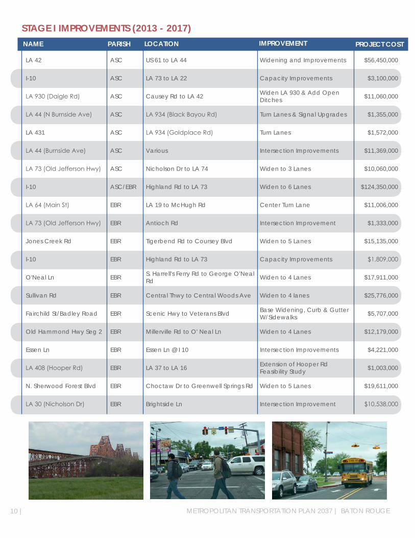
STAGE I IMPROVEMENTS (2013 - 2017)
LA 42 ASC US 61 to LA 44 Widening and Improvements $56,450,000
I-10 ASC LA 73 to LA 22 Capacity Improvements $3,100,000
LA930(DaigleRd) ASC Causey Rd to LA 42 Widen LA 930 & Add Open Ditches $11,060,000
LA44(NBurnsideAve) ASC LA934(BlackBayouRd) Turn Lanes & Signal Upgrades $1,355,000
LA 431 ASC LA934(GoldplaceRd) Turn Lanes $1,572,000
LA44(BurnsideAve) ASC Various Intersection Improvements $11,369,000
LA73(OldJeffersonHwy) ASC Nicholson Dr to LA 74 Widen to 3 Lanes $10,060,000
I-10 ASC/EBR Highland Rd to LA 73 Widen to 6 Lanes $124,350,000
LA64(MainSt) EBR LA 19 to McHugh Rd Center Turn Lane $11,006,000
LA73(OldJeffersonHwy) EBR Antioch Rd Intersection Improvement $1,333,000
Jones Creek Rd EBR Tigerbend Rd to Coursey Blvd Widen to 5 Lanes $15,135,000
I-10 EBR Highland Rd to LA 73 Capacity Improvements $1,809,000
O'Neal Ln EBR S. Harrell's Ferry Rd to George O'Neal Rd Widen to 4 Lanes $17,911,000
Sullivan Rd EBR Central Thwy to Central Woods Ave Widen to 4 lanes $25,776,000
Fairchild St/Badley Road EBR Scenic Hwy to Veterans Blvd Base Widening, Curb & Gutter W/Sidewalks $5,707,000
Old Hammond Hwy Seg 2 EBR Millerville Rd to O' Neal Ln Widen to 4 Lanes $12,179,000
Essen Ln EBR Essen Ln @ I 10 Intersection Improvements $4,221,000
LA408(HooperRd) EBR LA 37 to LA 16 Extension of Hooper Rd Feasibility Study $1,003,000
N. Sherwood Forest Blvd EBR Choctaw Dr to Greenwell Springs Rd Widen to 5 Lanes $19,611,000
LA30(NicholsonDr) EBR Brightside Ln Intersection Improvement $10,538,000
NAME PARISH IMPROVEMENT PROJECT COSTLOCATION

| 11
STAGE I IMPROVEMENTS (2013 - 2017)
LA408,LA73 EBR LA408&LA73 Turn Lanes $495,000
Sullivan Rd EBR Central Woods Ave to Hooper Rd Widen to 4 Lanes $33,138,000
LA3064(EssenLn) EBR Perkins Rd to I-10 Widen to 7 Lanes $10,350,000
Nicholson Dr Seg 1 EBR Brightside Ln to Gourrier Ave Widen to 4 Lanes $26,036,000
Hooper Rd EBR Blackwater Bayou to Joor Rd Widen to 4 Lanes $17,327,000
Hooper Rd EBR Joor Rd to Sullivan Rd Widen to 4 Lanes $29,363,000
Old Hammond Hwy Seg 1 EBR Blvd De Province to Millerville Rd Widen to 4 Lanes $14,000,000
Perkins Rd EBR Siegen Ln to Pecue Ln Widen to 4 Lanes $16,300,000
Staring Ln/Gardere Ln EBR Burbank Dr to Nicholson Dr New 4 Lane/Widen to 4 Lanes $15,795,000
LA 64 Bypass EBR MainSttoLA19(Zachary) New 2 Lane $4,524,000
I-110 EBR North St to US 61/190 Reconstruct JCP at grade $29,700,000
Glen Oaks Dr EBR Plank Rd to McClelland Dr Reconstruction $9,904,000
Highland-Burbank Connector EBR Highland Rd to Burbank Dr New 3 Lane $4,298,000
LA64(MtPleasant-ZacharyRd) EBR US 61 to LA 964 Widen to 4 Lanes $23,627,000
McHugh Rd EBR Wimbush Dr to Lower Zachary Rd Base Widening W/Shoulders $6,379,000
I 10 EBR Pecue Ln New Interchange W/Road Improvements $55,000,000
Picardy Perkins Connector EBR Picardy Ave to Perkins Rd New Road $32,192,000
I 12 EBR Millerville Rd InterchangeReconfiguration $2,300,000
US190(FloridaAve) LIV LA1026(Roundabout) Roundabout $1,570,000
US190(FloridaAve) LIV Eden Church Rd Construct 4-Legged Single Lane Roundabout $1,606,000
NAME PARISH IMPROVEMENT PROJECT COSTLOCATION

STAGE I IMPROVEMENTS (2013 - 2017)
LA 16 LIV LA 22 Install Roundabout $2,711,000
LA1032(SRiverRd) LIV US 190 Intersection Improvements $825,000
US190(FloridaAve) LIV LA 449 Left Turn Ln $385,000
LA 16 LIV LA 447 Roundabout $1,350,000
LA 1026 LIV Access Mgt. & Roundabouts Roundabout $4,838,000
LA16(NRangeAve) LIV Jackson St Turn Lanes $1,300,000
I-12 LIV Walker to Satsuma Widen to 6 Lanes $25,500,000
Cook Rd LIV Pete's Hwy to Juban Rd New 4 Lane $17,550,000
LA 1 WBR DOW Spur Xing Grade Separate Existing At-Grade Crossing $46,100,000
River Rd LIV Government St to Centerville St Widening and Overlay $483,000
LA939(WortheyRd) ASC LA 44 to Purpera St Overlay $965,000
LA940(OriceRothRd) ASC S Darla Ave to LA 44 Overlay $829,000
LA3038(CornerviewRd) ASC LA 44 to US 61 Overlay $543,000
LA 30 ASC Iberville Parish Line to I-10 Overlay $2,522,000
Acadian Thwy EBR Pavement Rehab $3,264,000
Various EBR Parishwide SignalModifications $1,672,000
Various EBR OLOL Medical Complex Roadway Rehab $1,160,000
LA986 WBR Sidewalks $879,000
LA 415 WBR I-10 north 0.41 mile Pavement Rehab $658,000
LA 1 WBR Various Lighting $549,000
NAME PARISH IMPROVEMENT PROJECT COSTLOCATION
12 | METROPOLITAN TRANSPORTATION PLAN 2037 | BATON ROUGE

| 13
STAGE I IMPROVEMENTS (2013 - 2017)
LA 1, LA 76 WBR Various Turn Lanes $595,000
Various ASC Parishwide Pavement Management $150,000
Line Item Study Area Various Enhancement $201,000
Line Item Study Area Various Safety $17,507,000
Line Item Study Area Various Bridge $101,304,000
Line Item Study Area Various Overlay $21,535,000
Line Item Study Area Various Maintenance $53,026,000
Line Item Study Area Various Operations $5,679,000
NAME PARISH IMPROVEMENT PROJECT COSTLOCATION
Total Stage I $993,529,000
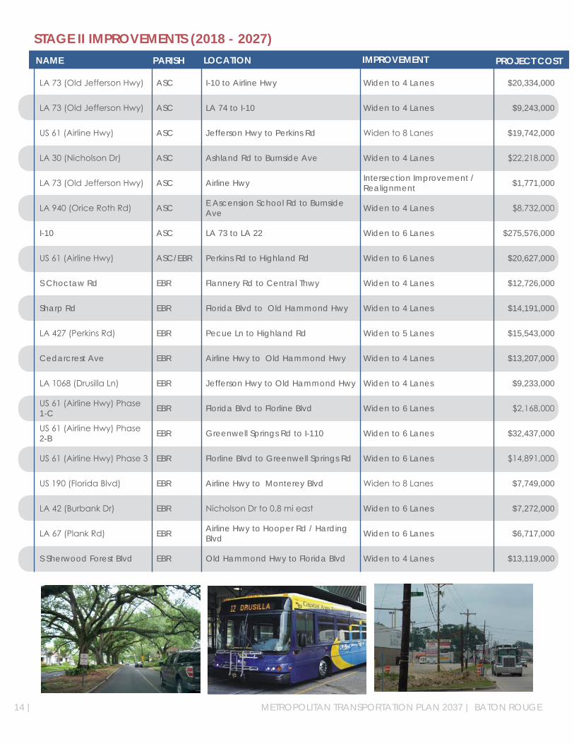
STAGE II IMPROVEMENTS (2018 - 2027)
LA73(OldJeffersonHwy) ASC I-10 to Airline Hwy Widen to 4 Lanes $20,334,000
LA73(OldJeffersonHwy) ASC LA 74 to I-10 Widen to 4 Lanes $9,243,000
US61(AirlineHwy) ASC Jefferson Hwy to Perkins Rd Widento8Lanes $19,742,000
LA30(NicholsonDr) ASC Ashland Rd to Burnside Ave Widen to 4 Lanes $22,218,000
LA73(OldJeffersonHwy) ASC Airline Hwy Intersection Improvement / Realignment $1,771,000
LA940(OriceRothRd) ASC E Ascension School Rd to Burnside Ave Widen to 4 Lanes $8,732,000
I-10 ASC LA 73 to LA 22 Widen to 6 Lanes $275,576,000
US61(AirlineHwy) ASC/EBR Perkins Rd to Highland Rd Widen to 6 Lanes $20,627,000
S Choctaw Rd EBR Flannery Rd to Central Thwy Widen to 4 Lanes $12,726,000
Sharp Rd EBR Florida Blvd to Old Hammond Hwy Widen to 4 Lanes $14,191,000
LA427(PerkinsRd) EBR Pecue Ln to Highland Rd Widen to 5 Lanes $15,543,000
Cedarcrest Ave EBR Airline Hwy to Old Hammond Hwy Widen to 4 Lanes $13,207,000
LA1068(DrusillaLn) EBR Jefferson Hwy to Old Hammond Hwy Widen to 4 Lanes $9,233,000
US61(AirlineHwy)Phase1-C EBR Florida Blvd to Florline Blvd Widen to 6 Lanes $2,168,000
US61(AirlineHwy)Phase2-B EBR Greenwell Springs Rd to I-110 Widen to 6 Lanes $32,437,000
US61(AirlineHwy)Phase3 EBR Florline Blvd to Greenwell Springs Rd Widen to 6 Lanes $14,891,000
US190(FloridaBlvd) EBR Airline Hwy to Monterey Blvd Widento8Lanes $7,749,000
LA42(BurbankDr) EBR NicholsonDrto0.8mieast Widen to 6 Lanes $7,272,000
LA67(PlankRd) EBR Airline Hwy to Hooper Rd / Harding Blvd Widen to 6 Lanes $6,717,000
S Sherwood Forest Blvd EBR Old Hammond Hwy to Florida Blvd Widen to 4 Lanes $13,119,000
NAME PARISH IMPROVEMENT PROJECT COSTLOCATION
14 | METROPOLITAN TRANSPORTATION PLAN 2037 | BATON ROUGE
| 15
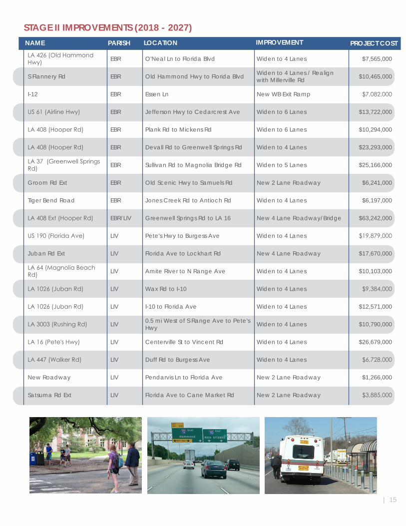
STAGE II IMPROVEMENTS (2018 - 2027)
LA426(OldHammondHwy) EBR O'Neal Ln to Florida Blvd Widen to 4 Lanes $7,565,000
S Flannery Rd EBR Old Hammond Hwy to Florida Blvd Widen to 4 Lanes / Realign with Millerville Rd $10,465,000
I-12 EBR Essen Ln New WB Exit Ramp $7,082,000
US61(AirlineHwy) EBR Jefferson Hwy to Cedarcrest Ave Widen to 6 Lanes $13,722,000
LA408(HooperRd) EBR Plank Rd to Mickens Rd Widen to 6 Lanes $10,294,000
LA408(HooperRd) EBR Devall Rd to Greenwell Springs Rd Widen to 4 Lanes $23,293,000
LA37(GreenwellSpringsRd) EBR Sullivan Rd to Magnolia Bridge Rd Widen to 5 Lanes $25,166,000
Groom Rd Ext EBR Old Scenic Hwy to Samuels Rd New 2 Lane Roadway $6,241,000
Tiger Bend Road EBR Jones Creek Rd to Antioch Rd Widen to 4 Lanes $6,197,000
LA408Ext(HooperRd) EBR/LIV Greenwell Springs Rd to LA 16 New 4 Lane Roadway/Bridge $63,242,000
US190(FloridaAve) LIV Pete's Hwy to Burgess Ave Widen to 4 Lanes $19,879,000
Juban Rd Ext LIV Florida Ave to Lockhart Rd New 4 Lane Roadway $17,670,000
LA64(MagnoliaBeachRd) LIV Amite River to N Range Ave Widen to 4 Lanes $10,103,000
LA1026(JubanRd) LIV Wax Rd to I-10 Widen to 4 Lanes $9,384,000
LA1026(JubanRd) LIV I-10 to Florida Ave Widen to 4 Lanes $12,571,000
LA3003(RushingRd) LIV 0.5 mi West of S Range Ave to Pete's Hwy Widen to 4 Lanes $10,790,000
LA16(Pete'sHwy) LIV Centerville St to Vincent Rd Widen to 4 Lanes $26,679,000
LA447(WalkerRd) LIV Duff Rd to Burgess Ave Widen to 4 Lanes $6,728,000
New Roadway LIV Pendarvis Ln to Florida Ave New 2 Lane Roadway $1,266,000
Satsuma Rd Ext LIV Florida Ave to Cane Market Rd New 2 Lane Roadway $3,885,000
NAME PARISH IMPROVEMENT PROJECT COSTLOCATION
16 |
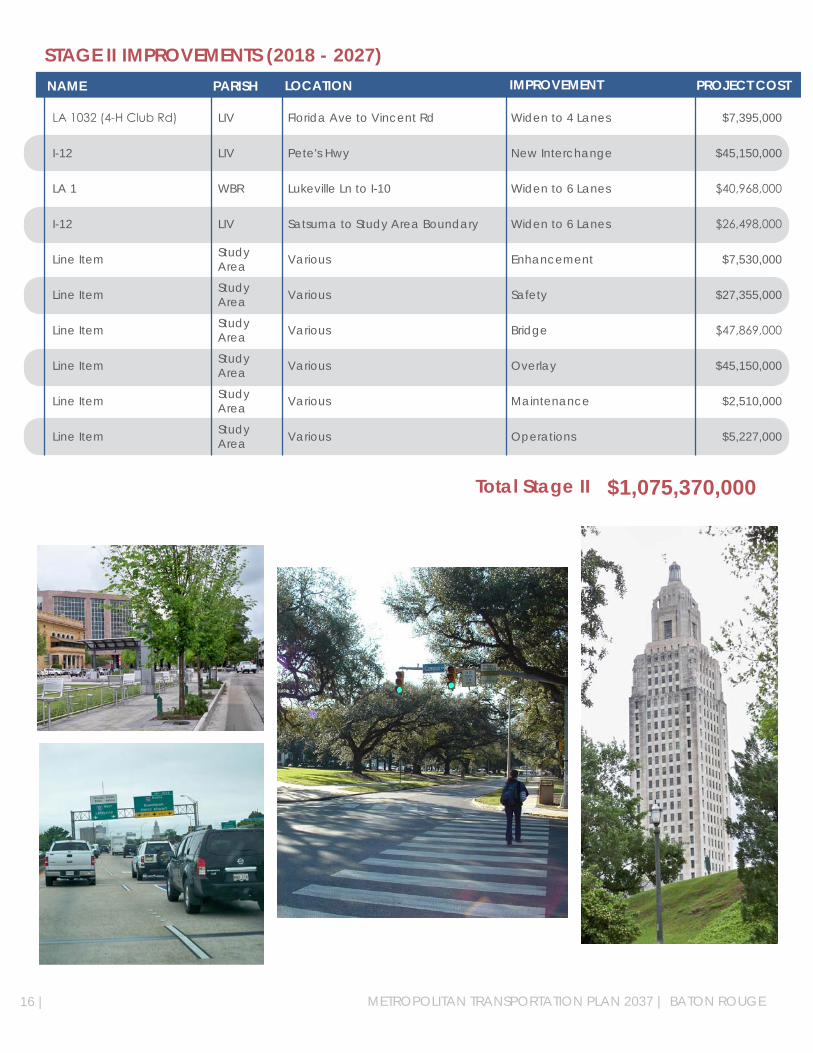
STAGE II IMPROVEMENTS (2018 - 2027)
LA1032(4-HClubRd) LIV Florida Ave to Vincent Rd Widen to 4 Lanes $7,395,000
I-12 LIV Pete's Hwy New Interchange $45,150,000
LA 1 WBR Lukeville Ln to I-10 Widen to 6 Lanes $40,968,000
I-12 LIV Satsuma to Study Area Boundary Widen to 6 Lanes $26,498,000
Line Item Study Area Various Enhancement $7,530,000
Line Item Study Area Various Safety $27,355,000
Line Item Study Area Various Bridge $47,869,000
Line Item Study Area Various Overlay $45,150,000
Line Item Study Area Various Maintenance $2,510,000
Line Item Study Area Various Operations $5,227,000
NAME PARISH IMPROVEMENT PROJECT COSTLOCATION
Total Stage II $1,075,370,000
METROPOLITAN TRANSPORTATION PLAN 2037 | BATON ROUGE
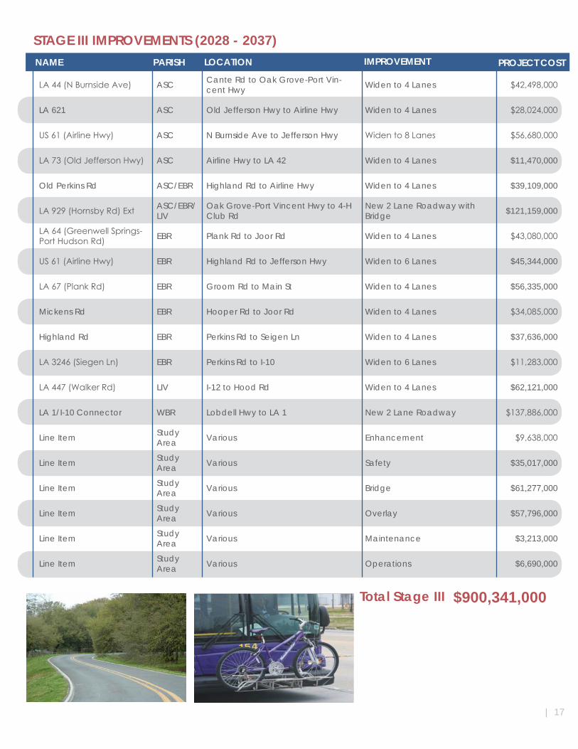
STAGE III IMPROVEMENTS (2028 - 2037)
LA44(NBurnsideAve) ASC Cante Rd to Oak Grove-Port Vin-cent Hwy Widen to 4 Lanes $42,498,000
LA 621 ASC Old Jefferson Hwy to Airline Hwy Widen to 4 Lanes $28,024,000
US61(AirlineHwy) ASC N Burnside Ave to Jefferson Hwy Widento8Lanes $56,680,000
LA73(OldJeffersonHwy) ASC Airline Hwy to LA 42 Widen to 4 Lanes $11,470,000
Old Perkins Rd ASC/EBR Highland Rd to Airline Hwy Widen to 4 Lanes $39,109,000
LA929(HornsbyRd)Ext ASC/EBR/LIV
Oak Grove-Port Vincent Hwy to 4-H Club Rd
New 2 Lane Roadway with Bridge $121,159,000
LA64(GreenwellSprings-PortHudsonRd) EBR Plank Rd to Joor Rd Widen to 4 Lanes $43,080,000
US61(AirlineHwy) EBR Highland Rd to Jefferson Hwy Widen to 6 Lanes $45,344,000
LA67(PlankRd) EBR Groom Rd to Main St Widen to 4 Lanes $56,335,000
Mickens Rd EBR Hooper Rd to Joor Rd Widen to 4 Lanes $34,085,000
Highland Rd EBR Perkins Rd to Seigen Ln Widen to 4 Lanes $37,636,000
LA3246(SiegenLn) EBR Perkins Rd to I-10 Widen to 6 Lanes $11,283,000
LA447(WalkerRd) LIV I-12 to Hood Rd Widen to 4 Lanes $62,121,000
LA 1/I-10 Connector WBR Lobdell Hwy to LA 1 New 2 Lane Roadway $137,886,000
Line Item Study Area Various Enhancement $9,638,000
Line Item Study Area Various Safety $35,017,000
Line Item Study Area Various Bridge $61,277,000
Line Item Study Area Various Overlay $57,796,000
Line Item Study Area Various Maintenance $3,213,000
Line Item Study Area Various Operations $6,690,000
NAME PARISH IMPROVEMENT PROJECT COSTLOCATION
Total Stage III $900,341,000
| 17
CONCLUSION
A continuing transportation planning process is an important part of overall planning. It is also an essential requirementtoensurethatthetransportationsystemisservingtraveldemandinanefficientandeffectivemanner. In addition, an annual evaluation of the MTP is required by the 3-C Planning Process. The CRPC, as the technical staff for the Baton Rouge MPO, is the agency responsible for conducting continuing transporta-tion planning. The process is coordinated with other local and State planning activities through the Technical Advisory Committee and the Policy Committee.
Implementation of the MTP should be continually monitored to determine any necessary revisions in the pro-gramresultingfromchangesinurbandevelopmentandtravelpatternsthatwerenotidentifiedwhentheMTPwas prepared. Maintenance of current information on land use planning data and travel demand – and how they interrelate – will permit a continuing evaluation of the transportation needs of the area. This continuing transportation planning process will protect the local, State and Federal governments’ investment in necessary improvements.
The continuing transportation planning process should contain at least the following three steps:
CONTINUING PLANNING
Collect, maintain and annually update key land use and planning data, system charac-teristicsandtraveldemandinformation.ThisMTPwaspreparedbasedonspecificlanduses, population and socio-economic data. An annual update of this data is essential to maintain an up-to-date transportation plan. Information should be maintained and col-lected in order to update travel demands as they pertain to the transportation system.
Information from the land use and planning data collection should be compared with forecasts from this study to determine the continued validity of the projections. Informa-tionconcerningtheuse,capacity,finances,andlevelofserviceofthetransportationsystem should be maintained and collected periodically in order to provide current knowledge of the total system operation for evaluation with respect to future need and possible change.
Evaluate the current MTP. Based on updated data, annual projections of future travel demands should be made. This data should be compared with projections estimated in the original MTP. It must then be determined if the MTP needs revision.
Revise and update the MTP as needed based on new projections of travel demand, the results of sample surveys, and current transportation system data.
The continuing transportation planning process should contain at least the following three steps:
1
2
3
The adopted MTP will provide a framework for rational implementation of a transportation system to satisfy trav-el demand as the Baton Rouge Urbanized Area continues to develop and grow into the future. The realization of the recommended improvements will require the continued coordination and cooperation of local, State andFederalofficialsinmakingdecisionsconcerningtheavailabilityanduseoftransportationimprovementfunds.TheultimateimprovementandfulfillingofthemobilityneedsofthetravelingpublicintheBatonRougeUrbanized Area will depend on the degree of compliance with the MTP.
CONCLUSION
18| METROPOLITAN TRANSPORTATION PLAN 2037 | BATON ROUGE
ACKNOWLEDGMENTS
TheMetropolitanPlanningOrganization(MPO)consistsoftwocommittees:theTransportationPolicyCommit-tee and the Technical Advisory Committee. These committees are comprised of elected and appointed de-cision-makersaswellastechnicallyqualifiedpersonsinterestedintransportationplanning.TheCRPCprovides
staffingfunctionsforbothcommittees.
TheTransportationPolicyCommittee(TPC)providesdecision-makingwithregardtotheapprovalandadoptionoftransportationplansandprograms.Itiscomposedoftheprincipalelectedofficialsinthemetropolitanarea
and State and Federal transportation representatives.
TheTechnicalAdvisoryCommittee(TAC)reviewsandevaluatesthetechnicalaspectsofplanningactivities.Itismadeupoflocal,StateandFederaltransportationplanners,engineersandothertechnicallyqualifiedper-sons with an interest in the existing and future transportation system. The membership of the TAC includes the
technical representatives from the following entities:
LOUISIANA DEPARTMENT OF TRANSPORTATION AND DEVELOPMENTFEDERAL HIGHWAY ADMINISTRATIONFEDERAL TRANSIT ADMINISTRATION
METROPOLITAN PLANNING ORGANIZATION
TRANSPORTATION POLICY COMMITTEE
TECHNICAL ADVISORY COMMITTEE
| 19
East Baton Rouge Parish - Mayor-PresidentCity of Baker - MayorCity of Central - MayorCity of Zachary - Mayor
Livingston Parish - PresidentCity of Denham Springs - MayorCity of Walker - Mayor
Ascension Parish - PresidentCity of Gonzales - MayorTown of Sorrento - Mayor
West Baton Rouge Parish - PresidentCity of Port Allen - MayorTown of Brusly - Mayor
Iberville Parish - President
• East Baton Rouge Parish Public Works• East Baton Rouge Parish Planning Commission• City of Baker• Town of Brusly• City of Central• City of Denham Springs• City of Gonzales• City of Port Allen• Town of Sorrento • Town of Walker• City of Zachary• Livingston Parish• Ascension Parish• West Baton Rouge Parish
• Capital Region Planning Commission• Baton Rouge Chamber of Commerce• Baton Rouge Metro Airport Staff• Capital Area Transit System• Paratransit Operator• Port of Greater Baton Rouge• American Automobile Association• LA Motor Transportation Association• Railway Association• LA Transportation Research Center• Baton Rouge Green• LA DOTD• Federal Highway Administration• LA Department of Environmental Quality• Private Sector

“The preparation of this report has been financed in part through grant(s) from the Federal Highway Administration and Federal Transit Administration, U.S. Department of Transportation, under the State Planning
and Research Program, Section 505 [or Metropolitan Planning Program, Section 104(f)] of Title 23, U.S. Code. The contents of this report do not necessarily reflect the official views or policy of the U.S. Department of
Transportation.”
STATE PROJECT NO. H.971844.1FEDERAL AID PROJECT NO. No. SPR-0010(035)
We especially acknowledge the contributions of the many people of the Baton Rouge Urbanized Area who took time to participate in the public meetings to give us insight into the needs of the traveling public.