bauhinia shire planning scheme
TRANSCRIPT
Planning Scheme for Bauhinia Shire (Amendment No. 1) 2011
BAUHINIA SHIRE
PLANNING SCHEME
Planning Scheme for Bauhinia Shire (Amendment No. 1) 2011 ii
Integrated Planning Act 1997 PLANNING SCHEME FOR BAUHINIA SHIRE Adoption The local government for Bauhinia Shire adopted this Amended Planning Scheme on 12 December 2011. Commencement The Amended Planning Scheme took effect on 23 December 2011. State Planning Policies The Minister has identified that the following state planning policy is appropriately reflected: 1. Temporary State Planning Policy 2/11 - Planning for stronger, more resilient floodplains Table of Amendments Date of adoption Planning Scheme
version number Amendment type Summary of
amendments 12 December 2011 Amendment No. 1 Minor Inclusion of a
Flood Hazard Overlay – Floodplain Assessment and Model Code as amended by Council
This is to certify that this is a true and correct copy to the Planning Scheme for Bauhinia Shire (Amendment no 1) 2011 adopted on 12 December 20011 and commenced on 23 December 2011.
Signed Bryan Ottone Chief Executive Officer Dated: 10 January 2012

Planning Scheme for Bauhinia Shire (Amendment No. 1) 2011 3
CONTENTS Page No
PART 1 – INTRODUCTION 6
Division 1 – Relationship to the Integrated Planning Act 6 1.1.1 Purpose of the Planning Scheme 6 1.1.2 Planning Scheme Functions as Part of IDAS 6
Division 2 –Structural Elements and Mechanisms of the Planning Scheme
7
1.2.1 Planning Schemes Seek to Achieve Outcomes 7 1.2.2 Snapshot of Bauhinia Shire Planning Scheme Structure 8 1.2.3 Shire Area is Divided into Zones and Precincts 9 1.2.4 Shire Area has Overlays 9 1.2.5 Codes Regulate Development 10 1.2.6 Applicability of Codes 10 1.2.7 Roads, Rail and Watercourses 10 1.2.8 Determining if Development is Assessable or Self
Assessable 11
1.2.9 Self Assessable and Code Assessable Development 12 1.2.10 Impact Assessable Development 12 1.2.11 Exempt Development 12
PART 2 – INTERPRETATION 14
Division 1 – Definitions 14 2.1.1 Definitions – the dictionary 14 2.1.2 Terms Defined in the IPA 14
Division 2 – Explanatory Notes 38 2.2.1 Explanatory Notes Assist Interpretation of Planning
Scheme 38
PART 3 – FOUNDATION OF THE PLANNING SCHEME 39
Division 1 – Desired Environmental Outcomes 39 3.1.1 Desired Environmental Outcomes 39
PART 4 – ZONES 41
Division 1 – Rural Zone 41 4.1.1 Assessment Tables for the Rural Zone 41 4.1.2 Assessment Criteria and Code for the Rural Zone 48
Division 2 – Open Space Zone 54 4.2.1 Assessment Tables for the Open Space Zone 54 4.2.2 Assessment Criteria and Code for the Open Space Zone 59
Division 3 – Town Zone 70 4.3.1 Assessment Tables for the Town Zone 70 4.3.2 Assessment Criteria and Code for the Town Zone 79
Planning Scheme for Bauhinia Shire (Amendment No. 1) 2011 4
PART 5 – OVERLAYS 89
Division 1 – Natural Features and Conservation Overlays 89 5.1.1 Assessment Tables for the Natural Features and
Conservation Overlays 89
5.1.2 Assessment Criteria and Code for the Natural Features and Conservation Overlays
96
Division 2 – Economic Resources Overlays 99 5.2.1 Assessment Tables for the Economic Resources Overlays 99 5.2.2 Assessment Criteria and Code for the Economic Resources
Overlays 103
Division 3 – Major Utilities Overlays 106 5.3.1 Assessment Tables for the Major Utilities Overlays 106 5.3.2 Assessment Criteria and Code for the Major Utilities
Overlays 109
Division 4 – Natural Disaster Overlays 112 5.4.1 Assessment Tables for the Natural Disaster Overlays 112 5.4.2 Assessment Criteria and Code for the Natural Disaster
Overlays 120
PART 6 – ASSESSMENT CRITERIA FOR DEVELOPMENT FOR A STATED PURPOSE OR A STATED TYPE
134
Division 1 – Preliminary 135
6.1.1 Codes for Development for a Stated Purpose or Stated Type
135
Division 2 – Accommodation Buildings Code 135 6.2.1 Assessment Criteria and Code for Accommodation
Buildings 135
Division 3 – Agricultural Use Code 140 6.3.1 Assessment Criteria and Code for Agricultural Uses 140
Division 4 – Animals Code 142 6.4.1 Assessment Criteria and Code for Animals 142
Division 5 – Caravan Park and Worker’s Accommodation Code 146 6.5.1 Assessment Criteria and Code for Caravan Parks and
Worker’s Accommodation 146
Division 6 – Commercial Code 149 6.6.1 Assessment Criteria and Code for Commercial
Development 149
Division 7 – Development Standards Code 154 6.7.1 Assessment Criteria and Code for Development Standards 154
Division 8 – Development Design Code 167 6.8.1 Assessment Criteria and Code for Development Designs 168
Division 9 – Extractive Industry Code 190 6.9.1 Assessment Criteria and Code for Extractive Industries 190
Division 10 – Home Based Business Code 194 6.10.1 Assessment Criteria and Code for Home Based Businesses 194
Division 11 – Home Host Accommodation Code 196 6.11.1 Assessment Criteria and Code for Home Host 196

Planning Scheme for Bauhinia Shire (Amendment No. 1) 2011 5
Accommodation
Division 12 – House Code 198 6.12.1 Assessment Criteria and Code for Houses 198
Division 13 – Reconfiguring a Lot Code 202 6.13.1 Assessment Criteria and Code for Reconfiguring a Lot 203
Division 14 – Residential Accommodation Code 216 6.14.1 Assessment Criteria and Code for Residential
Accommodation 216
Division 15 – Service Station Code 221 6.15.1 Assessment Criteria and Code for Service Stations 221
APPENDICES 224
Appendix 1 – Zoning Maps – Series of 4 maps Appendix 1A Zone – 1 Shire of Bauhinia Appendix 1B Zone – 2 Springsure Appendix 1C Zone – 3 Rolleston Appendix 1D Zone - 4 Carnarvon Gorge Tourism Area
Appendix 2 – Overlay Maps – Series of 6 maps Appendix 2A CONS - 1 Water Catchment Overlay Appendix 2B CONS – 2 Heritage Sites Overlay Appendix 2C RES – 1 Agricultural Land Class Overlay
Appendix 2D RES – 2 Mining Resources and Extractive Industries Overlay
Appendix 2E UTIL – 1 Major Utility Overlay Appendix 2F NDIS – 1 Bushfire Hazard Land Overlay
Appendix 2G NDIS - 2 Flood Hazard Overlay - Floodplain Assessment
Appendix 3 – Planning Scheme Maps – 1 map Appendix 3A Planning Scheme Map 1 Stock Routes in Bauhinia Shire
VOLUME 2 – PLANNING POLICIES
223
NO. 1 Legal Descriptions for Overlays in the Bauhinia Shire Planning Scheme
225
NO. 2 Water and Sewerage Headworks Contributions 289
NO. 3 Park Contributions
301
NO. 4 Car Parking Contributions
303

PART 1 INTRODUCTION Relationship of Planning Scheme to IPA
Planning Scheme for Bauhinia Shire (Amendment No. 1) 2011 6
PART 1—INTRODUCTION
Division 1—Relationship to Integrated Planning Act
1.1.1 Purpose of Planning Scheme
In accordance with the Integrated Planning Act 1997 (IPA), the local government for Bauhinia Shire has prepared this planning scheme as a framework for managing development in a way that advances the purpose of the IPA1 by — (a) identifying assessable and self-assessable development; and (b) identifying outcomes sought to be achieved in the local government area as
the context for assessing development.
1.1.2 Planning Scheme Functions as Part of IDAS
The planning scheme functions as part of IDAS2 and must be read together with the IPA,
together with the Integrated Planning Regulation 1998.
1 The purpose of the IPA is to seek to achieve ecological sustainability by (a) coordinating and integrating
planning at the local, regional and State levels; and (b) managing the process by which development occurs; and (c) managing the effects of development on the environment (including managing the use of premises).
2 IDAS—integrated development assessment system—is the system detailed in chapter 3 of the IPA for
integrating State and local government assessment processes for development.

PART 1 INTRODUCTION Structural Elements and Mechanisms
Planning Scheme for Bauhinia Shire (Amendment No. 1) 2011 7
Division 2—Structural Elements and Mechanisms of the Planning Scheme
1.2.1 The Planning Scheme Seeks to Achieve Outcomes
(1) The Planning Scheme seeks to achieve outcomes that are identified according to the following levels— (a) Desired Environmental Outcomes; (b) Overall Outcomes for Zones and Overlays, or for the purpose of a Code; (c) Specific outcomes for Zones, Overlays and Codes; and (d) Probable Solutions or Acceptable Solutions for a Specific Outcome.
(2) The relationship between the various levels, or elements of the Planning Scheme
structure, is demonstrated by Diagram 1.2.1 below:
Diagram 1.2.1 Key Elements and Structure of the Planning Scheme
Desired Environmental Outcomes
Eg. Section 3.1.1
� �
Assessment Tables Eg. Section 4.1.1 – Rural Zone
Table 4.1.1(1) and Table 4.1.1(2).
� �
Overall Outcomes or Code Purpose Eg Part 4.1.2 (3) – Rural Zone
� �
Specific Outcomes Eg. Part 4.1.2 (4) column 1 – Rural Zone
� �
Probable Solutions or Acceptable Solutions for a Specific Outcome
Eg. Part 4.1.2 (4) column 2 – Rural Zone
Me
asu
res
of
the
pla
nn
ing
sc
he
me
s 2
.1.3
(2
) o
f IP
A

PART 1 INTRODUCTION Structural Elements and Mechanisms
Planning Scheme for Bauhinia Shire (Amendment No. 1) 2011 8
1.2.2 Snapshot of Bauhinia Shire Planning Scheme Structure
(1) Diagram 1.2.2 below, depicts the key elements of the Bauhinia Shire Planning Scheme, and how they relate to one another.
(2) Sections 1.2.3 – 1.2.5 in this Division further explain the nature of the key elements.
Diagram 1.2.2 Snapshot of Bauhinia Shire Planning Scheme Structure
Rural Zone Open Space Zone Town Zone
There are Codes for each Zone
(see PART 4 for Zone
Codes and see Appendix 1 for maps)
Carnarvon Gorge Area Town Commercial Precinct;
Town Residential Precinct;
Town Industrial Precinct;
Town Community Precinct;
Town Utility Precinct;
Town Recreation Precinct;
Town Rural Residential Precinct; Town – Investigation Area
�
Natural Features and Conservation
Areas Overlays
Economic Resources Overlays
Major Utilities
Overlays
Natural Disaster Overlays
Balance of Shire
There are Codes for
each Overlay (see PART 5 for Overlay Codes and
see Appendix 2 for maps)
Heritage Places Overlay
Agricultural Land Class
Overlay
Major Utilities – Plant and Refuse Site
Overlay
Bushfire Prone Overlay
(Some parts of the Shire are not covered by any
Overlays) Water Catchment
Overlay Mining
Resources and Extractive
Industries Overlay
Landslide Prone Land
Overlay
Flood Hazard Overlay - Floodplain
Assessment
�
There are Codes for Development of a Stated Purpose or Stated Type (see PART 6 for Codes)

PART 1 INTRODUCTION Structural Elements and Mechanisms
Planning Scheme for Bauhinia Shire (Amendment No. 1) 2011 9
1.2.3. Shire Area is Divided into Zones, Areas and Precincts
(1) The Planning Scheme divides Bauhinia Shire into three zones that cover the entire Shire Area— (a) the Rural Zone, identified on Zoning Maps 1, 2, 3 & 4 (b) the Open Space Zone, identified on Zoning Maps 1,& 4; and (c) the Town Zone identified on Zoning Maps 2 & 3.
(2) The Zones incorporate sub-areas referred to as Precincts in the case of the Town
Zone, or Areas in other Zones, in order to distinguish different characteristics of the land within the Zone, and to better regulate the impacts of development on those characteristics. Land generally is included in a Precinct or Area within a Zone. However, in some instances not all land within a Zone is also included in a Precinct or Area.
1.2.4. Shire Area has Overlays
(1) The planning scheme has four types of Overlays —
A. Natural Features and Conservation Areas Overlays, comprising the: 1. Catchment Overlay which applies to:
i. The declared Water Catchment Area and as mapped on Map CONS-1 and as listed in Planning Policy No. 1: Legal Description of Land Affected by Overlays; and
ii. any watercourse within the mapped Overlay area referred to in i above.
2. Heritage Places Overlay which applies to: (i) The site of, or on land immediately adjacent to sites contained
on the Queensland Heritage Register, as shown by Map CONS 2, and as listed in Planning Policy No. 1: Legal Description of Land Affected by Overlays.
B. Economic Resources Overlays, comprising the:
1. Agricultural Land Class Overlay as mapped on Map RES 1 and as listed in Planning Policy No. 1: Legal Description of Land Affected by Overlays
2. The Mining Resources Overlay which applies to: (i.) land as shown by maps RES 2, and as listed in Planning Policy No.
1: Legal Description of Land Affected by Overlays; and (ii.) land within the 1000m radius of those areas referred to in (i) above. (iii.) land within the 1000m or 500m radius of those areas referred to in (i)
above.
C. Major Utilities Overlays, comprising the: 1. The Gas Pipeline Overlay, which applies to land as shown by Map UTIL
1, and as listed in Planning Policy No. 1: Legal Description of Land Affected by Overlays;
D. Natural Disaster Overlays, comprising the:
1. The Bushfire Hazard Land Overlay, which applies to land as shown by NDIS – 1, and as listed in Planning Policy No:1 Legal Descriptions of Land Affected by Overlays; and
2. The Landslide Prone Land Overlay applies to all land in the Shire, to the extent that it contains steep slopes, being those of 15% or greater.
3. The Flood Hazard Overlay - Floodplain Assessment applies to land, as shown by Map NDIS – 2.
(2) The Overlays refer to land which has specific land and development constraints, and
which may exist across the boundaries of Zones and Precincts. There are separate Assessment tables and Codes for each Overlay.

PART 1 INTRODUCTION Structural Elements and Mechanisms
Planning Scheme for Bauhinia Shire (Amendment No. 1) 2011 10
(3) To avoid any doubt, the Overlay Codes listed in the Tables of Assessment as being applicable criteria for assessment; apply in addition to any applicable Zone Codes as listed in the Tables of Assessment for that Zone.
1.2.5 Codes Regulate Development
(1) The Planning Scheme contains Codes for — (a) each Zone; (b) each type of Overlay; and (c) development for a stated purpose or development of a stated type.
(2) The Codes are contained in Parts 4 (Zones), 5 (Overlays) & 6 (Development of a
stated purpose or type) of the Planning Scheme.
1.2.6 Applicability of Codes
(1) The Codes that are applicable to development are indicated in Column 3 “Relevant Criteria” in the Assessment tables for each Zone, and the Assessment tables for each Overlay.
(2) When a Code is indicated as being applicable to development (as described in (1)
above) ALL of the listed Codes are “Relevant Criteria” for the development. (eg. the Zone Code AND the Overlay Code AND the Code for a stated purpose or development of a stated type).
(3) Zone Codes apply to development in the relevant Zone that is identified as Self assessable or Code assessable in the Assessment Tables for each Zone.
(4) The Town Zone contains a number of sub-areas known as Areas and Precincts which
delineate different land capabilities and constraints. Zone Codes contain specific provisions which are applicable to development in identified Precincts. The provisions specific to Areas and Precincts prevail over those applicable to development in the Zone.
(5) Overlay Codes apply to development on the relevant Overlay that is identified as Self
assessable and Code assessable in the Assessment Tables for each Overlay. (6) Codes for a stated purpose or development of a stated type apply to development for
that purpose or type, that is identified as Self assessable or Code assessable in the Assessment Tables for the Zone.
(7) Codes contain provisions applicable to Uses or Use Classes, and provisions
applicable to Works. All provisions may be considered in deciding Material Change of Use applications for developments that are specified in the relevant Table of Assessment as Code or Impact assessable development. Where a provision refers to a standard of provisions, such as an Australian Standard, the most recent edition of that Standard shall apply, unless otherwise stated.
(8) Codes are applicable at the time development is undertaken, and remain applicable:
(a) in the instance of a material change of use – for the ongoing use; (b) in the instance of building work – for the period that the building remains on
the site; (c) in the instance of reconfiguring a lot – for as long as the new lots exist; and (d) in the instance of operational works – for as long as the works are undertaken
and remain on the site.
1.2.7 Roads, Rail and Watercourses
(1) Where roads, railway land and watercourses in Bauhinia Shire are not shown as being covered by a Zone on the Zoning Maps, the following applies—
PART 1 INTRODUCTION Structural Elements and Mechanisms
Planning Scheme for Bauhinia Shire (Amendment No. 1) 2011 11
(a) if the road, railway land or watercourse is adjoined on both sides by land in the same Zone —the road, railway land or watercourse has the same zoning as the adjoining land;
(b) if the road, railway land or watercourse is adjoined on one side by land in a Zone and adjoined on the other side by land in another Zone —the road, railway land or watercourse has the same zoning as the adjoining land and the centreline of the road, railway land or watercourse is the boundary between the two Zones;
(c) if the road, railway land or watercourse is adjoined on one side only by land in a Zone —the entire road, railway land or watercourse has the same zoning as the adjoining zoned land.
(2) If a road, railway land or watercourse is adjoined by land covered by an Area or
Precinct on the Zoning Maps, subsection (1) applies as if the Precinct were a Zone. (3) The provisions of subsection (1) applies to the extent of the boundaries of Bauhinia
Shire only, and not to roads, railway land or watercourses which form the boundary with, or are in, adjoining Shires.
(4) To remove any doubt, it is declared that subsections (1) and (2) also apply to a
closed road if the road is closed after the commencement of the planning scheme. (5) Subsection (1) applies to all roads, except where the road adjoins land in the Town
Zone. The use of roads in these areas is governed by Council’s Local Laws.
1.2.8 Determining if Development is Assessable or Self-assessable Under the Planning Scheme
(1) Assessment tables for the Zones and Overlays identify development that is Assessable, Self-assessable or Exempt under the Planning Scheme as follows— (a) Tables 4.1.1(1) & 4.1.1(2)—Rural Zone; (b) Tables 4.2.1(1) & 4.2.1(2)—Open Space Zone; (c) Tables 4.3.1(1) & 4.3.1(2)—Town Zone (d) Tables 5.1.1(1) & 5.1.1(2)—Natural Features and Conservation Overlays; (e) Tables 5.2.1(1) & 5.2.1(2)—Economic Resources Overlays; (f) Tables 5.3.1(1) & 5.3.1(2)—Major Utilities Overlays; and (g) Tables 5.4.1(1) & 5.4.1(2)—Natural Disaster Overlays.
(2) The Assessment tables also identify Assessable development under the Planning
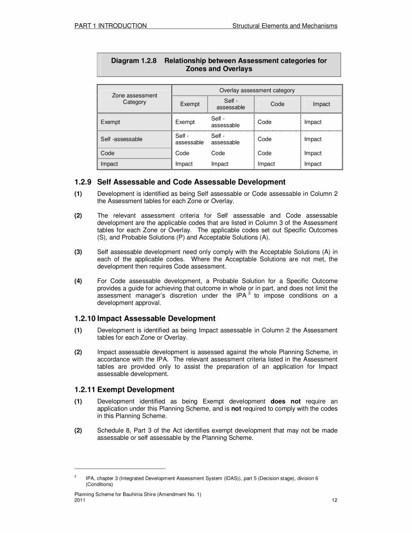
Scheme that requires Code assessment or Impact assessment. (3) If development is identified as having a different Assessment category under a Zone
than under an Overlay, the higher Assessment category applies as follows— (a) Self-assessable prevails over Exempt; (b) Code assessable prevails over Self-assessable or Exempt; (c) Impact assessable prevails over Self-assessable, Code assessable or
Exempt. (4) The relationship between Assessment categories for Zones and Overlays is shown in
Diagram 1.2.8 below:
PART 1 INTRODUCTION Structural Elements and Mechanisms
Planning Scheme for Bauhinia Shire (Amendment No. 1) 2011 12
Diagram 1.2.8 Relationship between Assessment categories for Zones and Overlays
Zone assessment Category
Overlay assessment category
Exempt Self -
assessable Code Impact
Exempt Exempt Self -assessable
Code Impact
Self -assessable Self - assessable
Self -assessable
Code Impact
Code Code Code Code Impact
Impact Impact Impact Impact Impact
1.2.9 Self Assessable and Code Assessable Development
(1) Development is identified as being Self assessable or Code assessable in Column 2 the Assessment tables for each Zone or Overlay.
(2) The relevant assessment criteria for Self assessable and Code assessable
development are the applicable codes that are listed in Column 3 of the Assessment tables for each Zone or Overlay. The applicable codes set out Specific Outcomes (S), and Probable Solutions (P) and Acceptable Solutions (A).
(3) Self assessable development need only comply with the Acceptable Solutions (A) in
each of the applicable codes. Where the Acceptable Solutions are not met, the development then requires Code assessment.
(4) For Code assessable development, a Probable Solution for a Specific Outcome
provides a guide for achieving that outcome in whole or in part, and does not limit the assessment manager’s discretion under the IPA 3 to impose conditions on a development approval.
1.2.10 Impact Assessable Development
(1) Development is identified as being Impact assessable in Column 2 the Assessment tables for each Zone or Overlay.
(2) Impact assessable development is assessed against the whole Planning Scheme, in
accordance with the IPA. The relevant assessment criteria listed in the Assessment tables are provided only to assist the preparation of an application for Impact assessable development.
1.2.11 Exempt Development
(1) Development identified as being Exempt development does not require an application under this Planning Scheme, and is not required to comply with the codes in this Planning Scheme.
(2) Schedule 8, Part 3 of the Act identifies exempt development that may not be made
assessable or self assessable by the Planning Scheme.
3 IPA, chapter 3 (Integrated Development Assessment System (IDAS)), part 5 (Decision stage), division 6
(Conditions)
PART 1 INTRODUCTION Structural Elements and Mechanisms
Planning Scheme for Bauhinia Shire (Amendment No. 1) 2011 13
(3) Development may also become exempt development if it is designated as Community Infrastructure under Chapter 2, Part 6 of the Act (to the extent that the development would otherwise be self assessable development or assessable development under this Planning Scheme).
(4) Despite anything to the contrary in this Planning Scheme, the following is also exempt
development: (a) plumbing and drainage work; (b) building work where requiring only code assessment against Standard
Building Regulations; (c) any development required to be carried out by a lawful order or instruction
issued under any Act; (d) temporary buildings associated with a material change of use, building works
or operational works; (e) building work for the restoration to its original condition of any building that
has been accidentally damaged or destroyed; (f) erecting no more than one satellite dish on a premises, where the satellite
dish has no dimension greater than (i) 1.2 metres in a residential area or residential consolidation Area; and (ii) 1.8 metres in any other area.
(g) Reconfiguration of a lot involving road widenings and truncations required as a condition of development approval;
(h) A Temporary Sign; and (i) Operational work associated with—
(A) management practices for the conduct of an agricultural use, other than— (i) the clearing of native vegetation under the Vegetation
Management Act 1999 (ii) operations of any kind and all things constructed or installed for
taking, or interfering with, water (other than using a water truck to pump water) if the operations are for taking, or interfering with, water under the Water Act 2000; and
(B) weed or pest control, unless it involves the clearing of native vegetation that is assessable development; and
(C) the use of fire under the Fire and Rescue Authority Act 1990; and (D) the conservation or restoration of natural areas; and (E) the use of premises for forest practices.
1.2.12 Existing Use
(1) Any existing development that was lawfully established may continue to operate in accordance with the provisions of the Integrated Planning Act 1997 and the provisions of the Planning Scheme.
(2) Council shall maintain a register of Existing Uses which is open to inspection by
request. Entries and deletion of lawful Existing uses shall be by resolution of the Local Government.
(3) For the purpose of this Planning Scheme, an existing use undergoes a Material
Change of Use where there is an intensification of activities or change in the scale of the use by more than 10% of the existing lawful activity (as may be measured by total use area, traffic movement, hours of operation or the like, considered in the context of the use).

PART 2 INTERPRETATION Definitions
Planning Scheme for Bauhinia Shire (Amendment No. 1) 2011 14
PART 2—INTERPRETATION
Division 1—Definitions
2.1.1 Definitions—the dictionary
The dictionary in PART 2: Division 1: Schedule A and PART 2: Division 1: Schedule B defines particular words used in this planning scheme as follows: (a) Defined uses and use classes; and (b) Administrative definitions.
2.1.2 Terms defined in the IPA
Where the planning scheme uses terms that are defined in the IPA, they are taken to have the same meaning as defined in the IPA.

PART 2 INTERPRETATION Definitions
Planning Scheme for Bauhinia Shire (Amendment No. 1) 2011 15
Division 1: Schedule A—Defined Uses and Use Classes4 (1) List of Definitions
The following table lists the defined uses under use classes.
USE & USE CLASS DEFINITIONS
Rural Use
Class Residential Use Class
Commercial Use Class
Industrial Use Class
Community Use Class
Agriculture Accommodation building
Caravan park Bulk store Community purposes
Animal Carcass Caretaker’s residence
Commercial premises
Extractive industry
Open space
Animal husbandry
Dual occupancy Food premises High impact industry
Public facility – operational
Fossicking Home based business
Hotel Landscape supplies
Public facility – other
Intensive agriculture
Home host accommodation
Indoor entertainment
Low impact industry
Intensive animal husbandry
House Mortuary Medium impact industry
Kennels and catteries
Multiple dwelling Motor sport facility
Transport terminal
Roadside stall Retirement village
Off street car park
Vehicle depot
Rural dwelling Worker’s accommodation
Outdoor entertainment
Warehouse
Stock saleyard Plant nursery Retail/
commercial complex
Service station Shop
Showroom Vehicle
showroom
4 See Bauhinia Shire Planning Scheme Explanatory Notes for references to environmentally relevant activities
that may be applicable to a particular use and require assessment against the Environment Protection Act 1994.

PART 2 INTERPRETATION Definitions
Planning Scheme for Bauhinia Shire (Amendment No. 1) 2011 16
(2) Use and Use Class Definitions The following section provides the meanings of Use definitions. These definitions are grouped into Use Classes of Rural Uses, Residential Uses, Commercial Uses, Industrial Uses and Community Uses.
RURAL USES collectively refers to agriculture, animal husbandry, fossicking, intensive agriculture, intensive animal husbandry, kennels and catteries, roadside stall, stock saleyard and other undefined uses generally identifiable as rural activities.
“agriculture” means premises used for the growing of plants under dryland practices including plantation forestry enterprises (refer to Plantation Forestry in Planning Schemes – DPI Guidelines for further information on plantation forestry enterprises) that use the following ‘accepted dryland forestry practices’:
• stress watering (drip irrigation up to 5 times/year) • fertilising (up to 3 applications – first 3 years
1)
• weed control – herbicide (1-21 times/year – first 4 years 1)
1 These provisions only need to be incorporated if the chemical application threshold is
retained in the agriculture definition. “animal carcass” means a premises used for handling, treating, processing, storage or packing of primary products, other than as an ancillary activity associated with another rural purpose on the same premises. The term also includes:
(a) servicing of plant and equipment used for rural purposes in the locality, (b) crop spray establishments; (c) selling of products resulting from the handling, treating, processing or packaging
of locally grown primary products in a roadside stall. (d) stock sales yards or holding yards
“animal husbandry” means the keeping, depasturing or stabling of any animal, bird, insect, reptile, fish or crustaceans including purposes in Column 1 of Table A.1, but not exceeding the numbers or density of that specified in Column3. The term does not include domestic pets, working dogs and breeding dogs associated with a house, intensive animal husbandry, or kennels and catteries. “fossicking” means the searching for and collection of fossicking materials from the surface or by digging with hand tools, for recreational, tourist or educational purposes, and as further defined by the Fossicking Act 1994. The term does not include camping, which is separately defined herein as Caravan Park or Open Space. “intensive agriculture” means premises used for the growing of plants involving the application of irrigation water. The term includes storage, packing and wholesale (not to the direct public) of product grown on the same site. “intensive animal husbandry” means the keeping, depasturing or stabling of any animal, bird, insect, reptile, fish or crustaceans including purposes in Column 1 of Table A.1, at a density greater than that specified for animal husbandry in Column 3, and with the numbers or density of that specified in Column 4, or as described in Column 4. The term includes associated processing of dairy products where produced on the farm. The term does not include animal husbandry, domestic pets, working dogs and breeding dogs associated with a house, or kennels and catteries. “kennels and catteries” means the keeping of cats or dogs whether for boarding, breeding, training or other purposes. The term does not include domestic pets associated with a house or animal husbandry. “roadside stall” means the display and sale of primary products grown and produced on the same site or road reserve adjacent to the site.

PART 2 INTERPRETATION Definitions
Planning Scheme for Bauhinia Shire (Amendment No. 1) 2011 17
“rural dwelling” means one or more additional dwellings on Rural zone land where the land size is at least 100 hectares and where the persons to be housed in the additional dwelling or dwellings is engaged in bona fide and viable rural pursuits on the subject land. “stock saleyard” means any premises used for the purpose of offering animals for sale and includes a public livestock market.
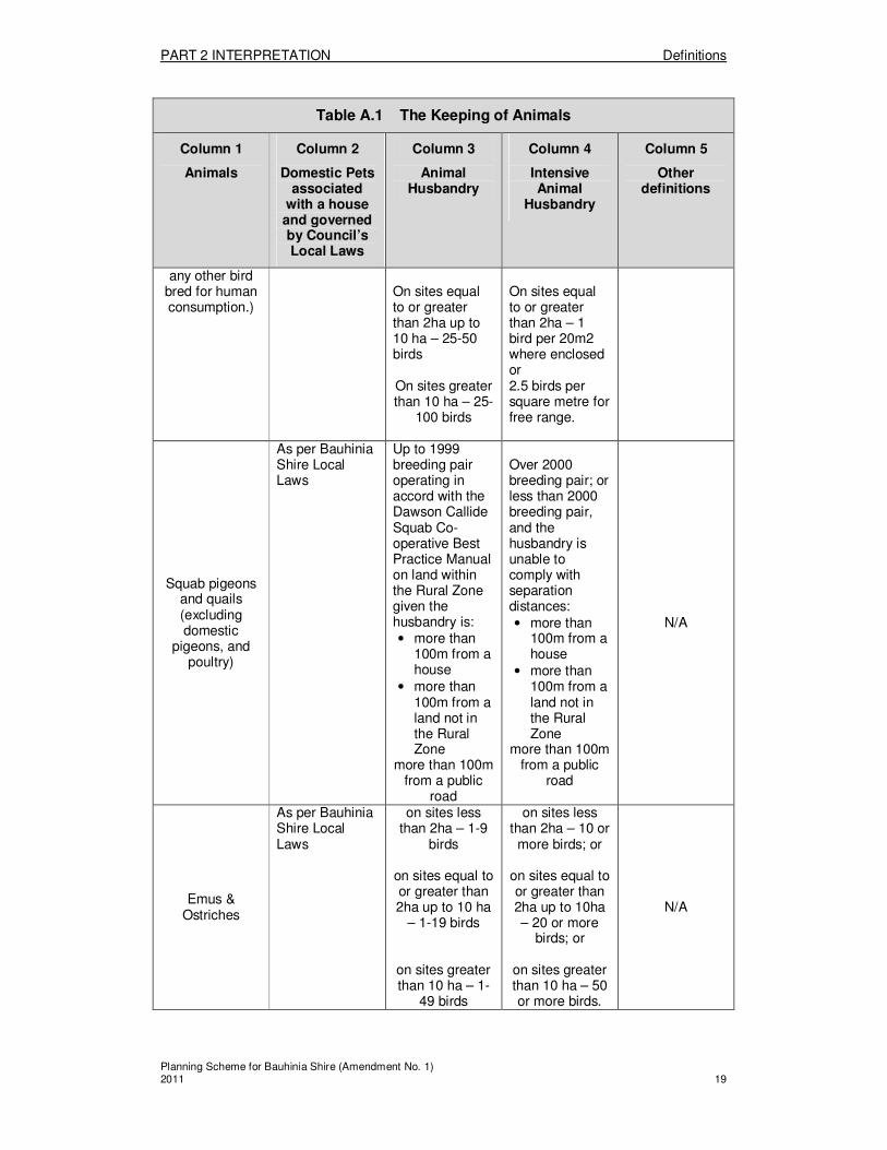
Table A.1 The Keeping of Animals
Column 1
Animals
Column 2
Domestic Pets associated
with a house and governed by Council’s Local Laws
Column 3
Animal Husbandry
Column 4
Intensive Animal
Husbandry
Column 5
Other definitions
Bees (hives) As per Bauhinia Shire Local Laws
3-20 hives More than 20
hives N/A
Caged birds (not including
poultry, emu or ostrich)
As per Bauhinia Shire Local Laws
21-40 birds More than 40
birds N/A
Cats As per Bauhinia Shire Local Laws
N/A N/A Kennels and
Catteries
Cattle
As per Bauhinia Shire Local Laws
on sites equal to or less than 2ha – 1 up to 9 cattle
on sites greater than 2ha up to 10 ha – 1 up to
19 cattle.
Feedlots and Dairies As per the requirements of the Environmental Protection Regulations 1998 and Reference Manual for the Establishment and Operation of Beef Cattle Feedlots in Queensland 2000
N/A
Dogs(not including working and breeding dogs on Rural Zoned land)
As per Bauhinia Shire Local Laws
N/A N/A Kennels and
Catteries
Fisheries (including fish, crustaceans as defined in the Fisheries Act)
As per Bauhinia Shire Local Laws
Ponds of 200m2 to 5ha in surface
area.
Aquaculture Ponds greater
than 5ha; or
any sized ponds
N/A

PART 2 INTERPRETATION Definitions
Planning Scheme for Bauhinia Shire (Amendment No. 1) 2011 18
Table A.1 The Keeping of Animals
Column 1
Animals
Column 2
Domestic Pets associated
with a house and governed by Council’s Local Laws
Column 3
Animal Husbandry
Column 4
Intensive Animal
Husbandry
Column 5
Other definitions
where wastes are released to
waters note: These activities are considered
ERAs and are required to be licensed under
the Environmental Protection Act
1994
Goats
As per Bauhinia Shire Local Laws
on sites equal to or less than 2ha
– 1-9 goats
on sites greater than 2ha up to 10 ha – 1-19
goats
on sites greater than 10 ha – 1-
49 goats
on sites equal to or less than 2ha
– 10 or more goats; or
on sites greater than 2ha up to 10ha – 20 or
more goats; or
on sites greater than 10 ha – 50 or more goats.
N/A
Horses As per Bauhinia Shire Local Laws
1-10 horses More than 10
horses N/A
Pigs
As per Bauhinia Shire Local Laws
On sites equal to or less than 2ha – 1-9 pigs
On sites greater than 2ha up to 10 ha – 1-19
pigs
On sites greater than 10 ha – 1-
49 pigs
Piggeries On sites less than 2ha – 10 or more pigs On sites equal to or greater than 2ha up to 10 ha – 20 or more pigs On sites greater than 10 ha – 50
or more pigs
N/A
Poultry (includes fowls, roosters, geese, ducks, (not domestic pigeons), and
As per Bauhinia Shire Local Laws
On sites less than 2ha – 1-25 birds (unless in the Town or Village Zone)
Poultry farms On sites less than 2ha – 1 bird per 1000m2;
N/A
PART 2 INTERPRETATION Definitions
Planning Scheme for Bauhinia Shire (Amendment No. 1) 2011 19
Table A.1 The Keeping of Animals
Column 1
Animals
Column 2
Domestic Pets associated
with a house and governed by Council’s Local Laws
Column 3
Animal Husbandry
Column 4
Intensive Animal
Husbandry
Column 5
Other definitions
any other bird bred for human consumption.)
On sites equal to or greater than 2ha up to 10 ha – 25-50 birds On sites greater than 10 ha – 25-
100 birds
On sites equal to or greater than 2ha – 1 bird per 20m2 where enclosed or 2.5 birds per square metre for free range.
Squab pigeons and quails (excluding domestic
pigeons, and poultry)
As per Bauhinia Shire Local Laws
Up to 1999 breeding pair operating in accord with the Dawson Callide Squab Co-operative Best Practice Manual on land within the Rural Zone given the husbandry is: • more than
100m from a house
• more than 100m from a land not in the Rural Zone
more than 100m from a public
road
Over 2000 breeding pair; or less than 2000 breeding pair, and the husbandry is unable to comply with separation distances: • more than
100m from a house
• more than 100m from a land not in the Rural Zone
more than 100m from a public
road
N/A
Emus & Ostriches
As per Bauhinia Shire Local Laws
on sites less than 2ha – 1-9
birds
on sites equal to or greater than 2ha up to 10 ha
– 1-19 birds
on sites greater than 10 ha – 1-
49 birds
on sites less than 2ha – 10 or
more birds; or
on sites equal to or greater than 2ha up to 10ha – 20 or more
birds; or
on sites greater than 10 ha – 50 or more birds.
N/A

PART 2 INTERPRETATION Definitions
Planning Scheme for Bauhinia Shire (Amendment No. 1) 2011 20
Table A.1 The Keeping of Animals
Column 1
Animals
Column 2
Domestic Pets associated
with a house and governed by Council’s Local Laws
Column 3
Animal Husbandry
Column 4
Intensive Animal
Husbandry
Column 5
Other definitions
Sheep
As per Bauhinia Shire Local Laws
on sites less than 2ha – 1-9
sheep
on sites equal to or greater than 2ha up to 10 ha
– 1-19 sheep
on sites greater than 10 ha – 1-
49 sheep
on sites less than 2ha – 10 or more sheep; or
on sites equal to or greater than 2ha up to 10ha – 20 or more
sheep; or
on sites greater than 10 ha – 50 or more sheep.
N/A
Others eg deer, alpaca
As per Bauhinia Shire Local Laws
on sites less than 2ha – 1-9
animals
on sites equal to or greater than 2ha up to 10 ha – 1-19 animals
on sites greater than 10 ha – 1-
49 animals
on sites less than 2ha – 10 or more animals;
or
on sites equal to or greater than 2ha up to 10ha – 20 or more animals; or
on sites greater than 10 ha – 50
or more animals.
N/A
RESIDENTIAL USE CLASS collectively refers to accommodation building, caretaker’s residence, dual occupancy, home based business, home host accommodation, house, multiple dwelling, retirement village uses, worker’s accommodation and other undefined uses that are ordinarily considered forms of residential accommodation or residential activities
“accommodation building” means premises used for accommodation units on a single lot and which provides common facilities and includes any restaurant, office and/or manager’s residence on the same site, shared kitchen, bathroom and laundries. The term includes uses commonly known as a motel, hostel, boarding house, apartment house, serviced apartments/rooms, and the accommodation component of hotels and community purpose uses. “caretaker’s residence” means a dwelling unit having a maximum floor area of 100m2 for accommodation of a caretaker or manager in connection with a particular purpose on the same site, except for rural purposes. “dual occupancy” means premises used for 2 dwelling units on a single lot. The term does not include home host accommodation, caravan park, or multiple dwelling.
PART 2 INTERPRETATION Definitions
Planning Scheme for Bauhinia Shire (Amendment No. 1) 2011 21
“home based business” means a commercial activity, occupation or profession carried out in, or on the same site as a house by any permanent resident of the house, where the total use area for the activity, occupation or profession does not exceed 50m
2 or constitute more
than 10% of the total use area of the house and has one or more of the following characteristics:
� maximum of 1 employee in addition to the resident/s of the house; � the total number of customers and visitors does not exceed 6 persons per day in an
average week; and � there may be ancillary yet minor sale or hire of goods from within the house.
The term does not include Low impact industry, Medium impact industry, High impact industry, Commercial premises, Roadside stall or Shop. “home host accommodation” means the provision of accommodation, as rural tourism, bed and breakfast or the like, on:
� land on the Rural zone and for a maximum of 10 visitors in any house or building on the subject site associated with the house, where the host resides on the premises on a full time basis, providing that the maximum number of persons on the premises at any one time does not exceed 12; or
� on land not contained in the Rural zone and for a maximum of 6 visitors in any house or building on the subject site associated with the house, where the host resides on the premises on a full time basis, providing that the maximum number of persons on the premises at any one time does not exceed 8.
“house” means using a detached building, comprising one dwelling unit, principally for residential purposes and includes as ancillary uses:
� the keeping of domestic pets, and includes working dogs for bone fide rural purposes; � outbuildings normally associated with this use; � the caring of children as defined as Family Day Care or Home Based Care as defined
in the Child Care Act, but not exceeding 6 children in care; � “home activity being a hobby, minor commercial activity, occupation or profession
carried out in, or on the same site as a house by any permanent resident of the house, where the total use area for the activity, occupation or profession does not exceed 50 m
2 or constitute more than 10% of the total use area of the house and has:
o no employees; o no public signage of the activity; o no customers or visitors to the site; and o no sale or hire of goods on site.
� an annexed unit where such unit: o has a maximum floor area of 50m
2;
o has only one bedroom; o is architecturally and structurally part of the house; and o is not self contained.
“multiple dwelling” means premises used for 3 or more dwelling units on a single lot. The term includes uses commonly known as a townhouse, unit, apartment and any manager residence. The term does not include accommodation building, home host accommodation, dual occupancy, retirement village, or caravan park. “retirement and care village” means premises used for 3 or more dwelling units or accommodation units for residential accommodation by elderly or retired persons in accordance with the Retirement Villages Act 1999 or disabled persons. The term includes ancillary nursing home accommodation and facilities, recreational and communal facilities provided on the same site. The term does not include stand alone community purposes (nursing home, aged care accommodation, institution), or multiple dwelling. “worker’s accommodation” means any premises used for the purpose of providing accommodation to workers associated with major developments. It includes ancillary uses such as kitchen, dining hall, amenity buildings, and recreation and parking facilities, which

PART 2 INTERPRETATION Definitions
Planning Scheme for Bauhinia Shire (Amendment No. 1) 2011 22
cater exclusively for the residents of the worker’s accommodation. The term does not include accommodation building, caravan park, community purposes, or multiple dwelling.
COMMERCIAL USE CLASS collectively refers to caravan park, commercial premises, food premises, hotel, indoor entertainment, motor sport facility, off street car park, outdoor entertainment, plant nursery, retail/commercial complex, service station, shop, showroom and vehicle showroom uses and other undefined business uses that are ordinarily centred around financial gain.
“caravan park” means any combination of the parking of caravans or relocatable homes, camping or the pitching of tents, or the use of cabins with a maximum total use area of 80m
2
for each cabin, whether for the travelling public or long-term residents. The term includes any manager’s office or residence, shop, amenity buildings and recreational and entertainment facilities which cater exclusively for the occupants of the caravan park. “commercial premises” means the provision of professional, business or commercial services in premises having a maximum total use area of 2000m
2, and is a use included in
one or more of the following categories: (a) The provision of administration, clerical, technical and/or professional services as a
business or commercial operation; (b) Premises used for the provision of health or medical service (with no overnight
accommodation) that may include a medical centre that would include such typical premises as medical and dental surgeries; clinics for specialists as well as physiotherapy, massage and naturopathy; a pathology laboratory; counselling rooms; nursing services; and the dispensing of pharmaceuticals associated and integrated with the medical centre (pharmacy otherwise defined as a shop);
(c) Offices for local, state or federal government administrative functions when not ancillary to the primary use of the premises and includes Council chambers, a court house and the like;
(d) Uses commonly referred to as veterinary clinic with the Health Care Facilityisation of animals, personal services such as a hairdressing/beauty salon, bank, post office, real estate office, or travel agency; or
(e) The sale of goods where ancillary to the primary commercial use. The term does not include uses defined as shop, food premises, showroom or vehicle showroom. “food premises” means the use of premises primarily for the preparation and serving of meals and beverages. The term includes restaurants, cafes, kiosks, takeaway shops, fast food outlets (including any drive-thru facility), function or reception centres, outdoor dining associated with any of these uses, and ancillary use of amplified music or speaker systems. “hotel” means premises which primarily sell liquor for consumption on-site, which may also sell liquor for consumption off-site, provide short-term accommodation or dining/entertainment facilities. The term does not include accommodation building, liquor store or shop. “indoor entertainment” means providing entertainment which, by its nature, is provided indoors, including amusement centres, cinemas, nightclubs, licensed and unlicensed clubs indoor sports centres, gymnasiums and the like and any commercial use (excluding food premises) with amplified music or speaker systems. “mortuary“ means the storage and preparation of bodies for burial or cremation, whether or not on the same premises as a funeral parlour. “motor sport facility“ means any motorised forms of recreation and sport, for purposes of recreation or conducting a motor race, and includes the provision of ancillary structures (eg. spectator stadium, mechanical workshop and amenities). “off street car park” means any premises used only for the temporary parking of motor vehicles.

PART 2 INTERPRETATION Definitions
Planning Scheme for Bauhinia Shire (Amendment No. 1) 2011 23
“outdoor entertainment” means any sporting or recreational activity, or other leisure pastime, which is conducted wholly or mainly outdoors. The term includes showgrounds (including provision for ancillary accommodation for travellers with livestock or show animals or those associated with a showgrounds event), outdoor public swimming pools, golf courses and driving ranges, outdoor courts and sportsgrounds, shooting or archery ranges and the like. It also includes the provision of a clubhouse, amenities, storage facilities and carparking associated with the use. The term also includes licensed or unlicensed facilities. The term does not include a motor sport facility. “plant nursery” means cultivating, storing or displaying seedlings, plants, flowers, shrubs and domestic trees for retail sale direct to the public. "retail/commercial complex” means the hire, retail sale of goods and/or provision of professional, business or commercial services:
� in premises having a total use area greater than 2000m2;
� in a single complex or separate buildings; and, � on one or more lots.
“service station” means the use of premises primarily for refuelling motor vehicles and including ancillary use of the premises for:
� retail sale of oils, greases and other motoring accessories and convenience items; � the servicing and minor repairs of vehicles; � a car washing facility; and, � a shop not exceeding a total use area of 100m
2.
“shop” means the display, hire and/or retail sale of goods on premises with a maximum total use area of 2000m
2. The term includes a, liquor store, video store, or the like.
“showroom” means any premises greater than 20m2 but not exceeding a total use area of 2000m
2 used for the display and sale of bulky goods or goods of a similar type. The term
includes the sale of electrical goods, camping equipment, produce stores and hardware stores, provided there is no outdoor storage of materials or equipment. The term does not include shop, commercial premises, vehicle showroom or low impact industry. “vehicle showroom” means the indoor and outdoor display, hire and sale of vehicles, including agricultural machinery, boats, caravans, cars, trucks or the like. The term includes selling of spare parts and ancillary repairs and servicing of those vehicles.
INDUSTRIAL USE CLASS collectively refers to bulk store, extractive industry, high impact industry, landscape supplies, low impact industry, medium impact industry, transport terminal, vehicle depot, warehouse and other undefined uses that are ordinarily considered industrial in nature. This Use Class includes ancillary business offices, retail areas and warehousing up to 25% of the total floor area.
“bulk store” means any premises used for the bulk storage of goods, where the goods stored or to be stored, are not required to be used for another use located on the same site and does not include a warehouse. The term includes storage sheds not ancillary to a primary use of any premises. “extractive industry” means the use of premises for the extraction and processing of extractive resources to produce extractive materials and includes ancillary activities such as storage, loading, transport, administration and maintenance facilities. The term includes the importation onto the premises of other materials to be used as additives for blending with the extractive materials to modify products to achieve material specifications or to bind, stabilise or correct products. The term does not include removal of quarry material from a watercourse or lake as defined under the Water Act 2000 if an allocation notice is required under that Act, does not include winning and processing of minerals authorised under the Mineral Resources Act 1989 and does not include a concrete batching plant or an asphalt manufacturing plant.

PART 2 INTERPRETATION Definitions
Planning Scheme for Bauhinia Shire (Amendment No. 1) 2011 24
“high impact industry” means use of any premises for the purpose of: (a) any of the industrial activities listed below that correspond to the group and class
listed within the Australian and New Zealand Standard Industrial Classification system and for Groups 217, 221, 222, 226, 262 and 274 only where the use is an Environmentally Relevant Activity under the Environmental Protection Act;
Group Class Description
211 Meat and Meat Product Manufacturing 214 Oil and Fat Manufacturing 217 Other Food Manufacturing 218 Beverage and Malt Manufacturing 219 Tobacco Product Manufacturing 221 Textile Fibre, Yarn and Woven Fabric Manufacturing 222 Textile Product Manufacturing 226 Leather and Leather Product Manufacturing 251 Petroleum Refining 252 Petroleum and Coal Product Manufacturing 253 Basic Chemical Manufacturing 254 Other Chemical Product Manufacturing 255 Rubber Product Manufacturing 262 Ceramic Product Manufacturing 263 Cement, Lime, Plaster and Concrete Product
Manufacturing 264 Non-Metallic Mineral Product Manufacturing 271 Iron and Steel Manufacturing 272 Basic Non-Ferrous Metal Manufacturing 273 Non-Ferrous Basic Metal Product Manufacturing 274 Structural Metal Product Manufacturing
2821 Shipbuilding
or; (b) using, storing, handling or disposing of any radioactive substance or material; or (c) storing chemicals, including ozone depleting substances, gases or dangerous goods under the
dangerous goods code, or (d) The following Environmentally Relevant Activities under the Environmental Protection Act;
Number 7 – Chemical Storage Number 53 – Soil Conditioner Manufacturing; Number 78 – Chemical or Oil recycling.
“landscape supplies” means premises used for the storage and/or sale of sand, soil, screenings and other such garden and landscaping materials where such material is stored on site for sale or distribution in quantities greater than one (1) cubic metre. The purpose includes the ancillary use of such premises for the sale, or displaying or offering for sale (in any quantity) of such items as: (a) seeds, plants or other propagative plant material; (b) goods associated with the cultivation of plants; (c) garden ornamentation, furniture or structures; (d) garden tools or equipment; that if not ancillary would otherwise be defined as a Plant nursery. “low impact industry” means the use of any premises for the purpose of; (a) any of the industrial activities listed below that correspond to the group or class listed
within the Australian and New Zealand Standard Industrial Classification system; and (i) for Groups 226, 231, 232, 233 and 274 only where the use is NOT an
Environmentally Relevant Activity under the Environmental Protection Act ; and (ii) for Groups 411, 412, 421, 422, 423, 424 and 425 only where the use of the
premises is for the purposes of a yard or depot; and (iii) for Groups 281, 285 and 286 only up to a maximum total use area of 100m2 ;
and

PART 2 INTERPRETATION Definitions
Planning Scheme for Bauhinia Shire (Amendment No. 1) 2011 25
(iv) the use operates only between the hours of 6am to 6pm, Monday to Saturday.
Group Class Description 213 Fruit and Vegetable Processing 216 Bakery Product Manufacturing 223 Knitting Mills 224 Clothing Manufacturing 225 Footwear Manufacturing 226 Leather and Leather Product Manufacturing 231 Log Sawmilling and Timber Dressing 232 Other Wood Product Manufacturing 233 Paper and Paper Product Manufacturing 241 Printing and Services to Printing 242 Publishing 243 Recorded Media Manufacturing and Publishing 274 Structural Metal Product Manufacturing 281 Motor Vehicle and Part Manufacturing 283 Photographic and Scientific Equipment Manufacturing 284 Electronic Equipment Manufacturing 285 Electrical Equipment and Appliance Manufacturing 286 Industrial Machinery and Equipment Manufacturing 292 Furniture Manufacturing 294 Other Manufacturing 411 Building Construction 412 Non-Building Construction
5
421 Site Preparation Services 422 Building Structure Services 423 Installation Trade Services 424 Building Completion Services 425 Other Construction Services 526 Household Equipment Repair Services
5322 Automotive Electrical Services
5329 Automotive Repair and Services
7865 Pest Control Services 7866 Cleaning Services
and unless stated elsewhere as being a different use, includes the servicing or repair of an item that would be produced, manufactured or created from the above list; or (c) dry cleaning that is a notifiable activity under the Environmental Protection
Act or a laundry not ancillary to the primary use of the premises; (d) machinery hire and associated repair business
The term includes any display area and/or office ancillary to the Low Impact Industry. “medium impact industry” means the use of any premises for the purpose of; (a) any of the industrial activities listed below that correspond to the group or class listed
within the Australian and New Zealand Standard Industrial Classification system and (i) for Groups 217, 221, 222 and 262 only where they are NOT an
Environmentally Relevant Activity under the Environmental Protection Act; and
(ii) for Groups 231, 232 and 233 only where they are an Environmentally Relevant Activity under the Environmental Protection Act; and
(iii) for Groups 281, 285 and 286 only where they have a total use area greater than 100m
2.
Group Class Description 212 Dairy Product Manufacturing 215 Flour Mill and Cereal Food Manufacturing
5 Excluding any use separately defined as a Public Facility - operational.

PART 2 INTERPRETATION Definitions
Planning Scheme for Bauhinia Shire (Amendment No. 1) 2011 26
217 Other Food Manufacturing 221 Textile Fibre, Yarn and Woven Fabric Manufacturing 222 Textile Product Manufacturing 231 Log Sawmilling and Timber Dressing 232 Other Wood Products Manufacturing 233 Paper and Paper Product Manufacturing 256 Plastic Product Manufacturing 261 Glass and Glass Product Manufacturing 262 Ceramic Pot Manufacturing 275 Sheet Metal Product Manufacturing 276 Fabricated Metal Product Manufacturing 281 Motor Vehicle and Part Manufacturing
2822 Boatbuilding 2823 Railway Equipment Manufacturing 2824 Aircraft Manufacturing 2829 Transport Equipment Manufacturing
285 Electrical Equipment and Appliance Manufacturing 286 Industrial Machinery and Equipment Manufacturing 291 Prefabricated Building Manufacturing
5323 Smash Repairing or
(b) a junk yard, wrecking yard or salvage yard; or (c) The following Environmentally Relevant Activities under the Environmental Protection
Act: (i) Number 23 – Abrasive blasting (ii) Number 27 – Metal Recovery (iii) Number 77 – Battery recycling (iv) Number 79 – Drum reconditioning (v) Number 80 – Tyre recycling; or
(d) Any Low Impact Industry operating outside of the specified hours for a Low Impact Industry.
(e) Any other Industry not separately defined. “transport terminal” means premises used for a road transport, rail transport or air transport (including heliport) passenger and/or goods terminal, a bus or coach station. The term does not include vehicle depots as separately defined. “vehicle depot” means premises for the overnight or longer storage (either in the open or covered) of any one or more buses, trucks, taxis, other motor vehicles, trailers, caravans and/or boats for commercial or public purposes and/or premises used as an operational base or depot for any such vehicles. The purpose includes the repair and maintenance of any such vehicles on the premises. The term does not include facilities ancillary to another purpose on the same site, a showroom, off-street car park or transport terminal as separately defined. “warehouse” means any premises used for the storage of goods, items, merchandise or materials in large quantities pending their; (a) distribution; or (b) sale to persons who in most instances (minimum of 90% of persons) purchase for the
purposes of resale only. The term includes any display area up to 20m2 and/or office ancillary to the warehouse.
COMMUNITY USE CLASS collectively refers to community purposes, open space, public facility – operational, public facility – other, and other undefined uses generally associated with community or non-profit organisations.
PART 2 INTERPRETATION Definitions
Planning Scheme for Bauhinia Shire (Amendment No. 1) 2011 27
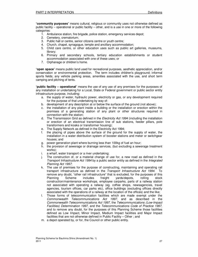
“community purposes” means cultural, religious or community uses not otherwise defined as public facility – operational or public facility – other, and is a use in one or more of the following categories:
1. Ambulance station, fire brigade, police station, emergency services depot; 2. Cemetery, crematorium; 3. Public hall or centre, senior citizens centre or youth centre; 4. Church, chapel, synagogue, temple and ancillary accommodation; 5. Child care centre, or other education uses such as public art galleries, museums,
library; 6. Primary and secondary schools, tertiary education establishments or student
accommodation associated with one of these uses; or 7. Orphanage or children’s home.
“open space” means public land used for recreational purposes, aesthetic appreciation, and/or conservation or environmental protection. The term includes children's playground; informal sports fields; any vehicle parking areas, amenities associated with the use, and short term camping and pitching of tents. “public facility – operational” means the use of any use of any premises for the purposes of any installation or undertaking for a Local, State or Federal government or public sector entity infrastructure purpose, including:
a. the supply of water, hydraulic power, electricity or gas, or any development required for the purpose of that undertaking by way of:
b. development of any description at or below the surface of the ground (not above); c. the installation of any plant inside a building or the installation or erection within the
premises of a generating station of any plant or other structures required in connection with the station;
d. The Transmission Grid as defined in the Electricity Act 1994 (including the installation or erection of an electrical transmission line of sub stations, feeder pillars, pole transformers and kiosks or transformer housing);
e. The Supply Network as defined in the Electricity Act 1994; f. the placing of pipes above the surface of the ground for the supply of water, the
installation in a water distribution system of booster stations and meter or switchgear houses; and
g. power generation plant where burning less than 100kg of fuel an hour; h. the provision of sewerage or drainage services, (but excluding a sewerage treatment
works); i. a wharf, water transport or a river undertaking; j. The construction of, or a material change of use for, a new road as defined in the
Transport Infrastructure Act 1994 by a public sector entity as defined in the Integrated Planning Act 1997;
k. The use of premises for the purpose of constructing, maintaining and operating rail transport infrastructure as defined in the Transport Infrastructure Act 1994. To remove any doubt, “other rail infrastructure” that is excluded, for the purposes of this Planning Scheme includes freight yards/depots, rolling stock construction/maintenance workshops, employee carparks, parts of a railway station not associated with operating a railway (eg. coffee shops, newsagencies, travel agencies, tourism offices, car parks etc), office buildings (excluding offices directly associated with the operations of a railway at the location of the offices) and the like;
l. Those forms of telecommunication facilities which are made exempt under the Commonwealth Telecommunications Act 1997, and as described in the Commonwealth Telecommunications Act 1997, the Telecommunications (Low-Impact Facilities) Determination 1997, and the Telecommunications Code of Practice 1997, and to remove any doubt, for the purposes of this Planning Scheme those facilities defined as Low Impact, Minor Impact, Medium Impact facilities and Major Impact facilities that are not otherwise defined in Public Facility – Other ; and
m. a depot operated by, or for, the Council or other public entity.
PART 2 INTERPRETATION Definitions
Planning Scheme for Bauhinia Shire (Amendment No. 1) 2011 28
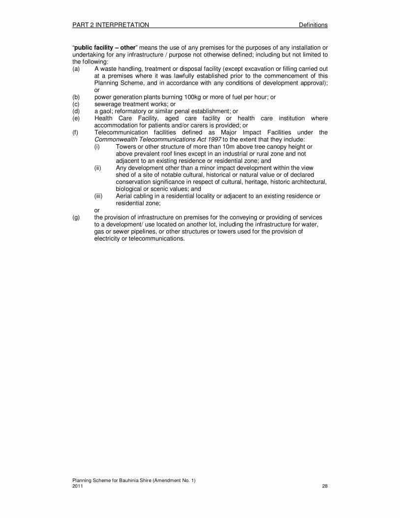
“public facility – other” means the use of any premises for the purposes of any installation or undertaking for any infrastructure / purpose not otherwise defined; including but not limited to the following: (a) A waste handling, treatment or disposal facility (except excavation or filling carried out
at a premises where it was lawfully established prior to the commencement of this Planning Scheme, and in accordance with any conditions of development approval); or
(b) power generation plants burning 100kg or more of fuel per hour; or (c) sewerage treatment works; or (d) a gaol; reformatory or similar penal establishment; or (e) Health Care Facility, aged care facility or health care institution where
accommodation for patients and/or carers is provided; or (f) Telecommunication facilities defined as Major Impact Facilities under the
Commonwealth Telecommunications Act 1997 to the extent that they include: (i) Towers or other structure of more than 10m above tree canopy height or
above prevalent roof lines except in an industrial or rural zone and not adjacent to an existing residence or residential zone; and
(ii) Any development other than a minor impact development within the view shed of a site of notable cultural, historical or natural value or of declared conservation significance in respect of cultural, heritage, historic architectural, biological or scenic values; and
(iii) Aerial cabling in a residential locality or adjacent to an existing residence or residential zone;
or (g) the provision of infrastructure on premises for the conveying or providing of services
to a development/ use located on another lot, including the infrastructure for water, gas or sewer pipelines, or other structures or towers used for the provision of electricity or telecommunications.
PART 2 INTERPRETATION Definitions
Planning Scheme for Bauhinia Shire (Amendment No. 1) 2011 29
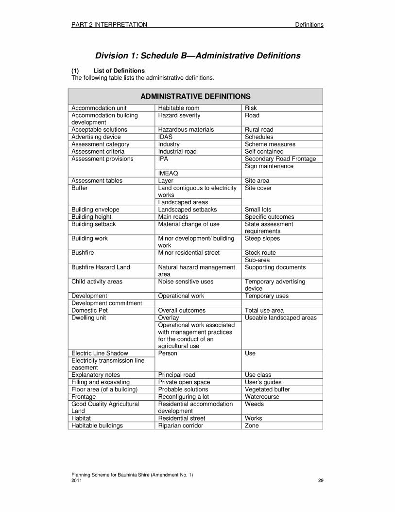
Division 1: Schedule B—Administrative Definitions (1) List of Definitions The following table lists the administrative definitions.
ADMINISTRATIVE DEFINITIONS
Accommodation unit Habitable room Risk Accommodation building development
Hazard severity Road
Acceptable solutions Hazardous materials Rural road Advertising device IDAS Schedules Assessment category Industry Scheme measures Assessment criteria Industrial road Self contained Assessment provisions IPA Secondary Road Frontage
Sign maintenance IMEAQ
Assessment tables Layer Site area Buffer Land contiguous to electricity
works Site cover
Landscaped areas Building envelope Landscaped setbacks Small lots Building height Main roads Specific outcomes Building setback Material change of use State assessment
requirements Building work Minor development/ building
work Steep slopes
Bushfire Minor residential street Stock route Sub-area
Bushfire Hazard Land Natural hazard management area
Supporting documents
Child activity areas Noise sensitive uses Temporary advertising device
Development Operational work Temporary uses Development commitment Domestic Pet Overall outcomes Total use area Dwelling unit Overlay Useable landscaped areas
Operational work associated with management practices for the conduct of an agricultural use
Electric Line Shadow Person Use Electricity transmission line easement Explanatory notes Principal road Use class Filling and excavating Private open space User’s guides Floor area (of a building) Probable solutions Vegetated buffer Frontage Reconfiguring a lot Watercourse Good Quality Agricultural Land
Residential accommodation development
Weeds
Habitat Residential street Works Habitable buildings Riparian corridor Zone

PART 2 INTERPRETATION Definitions
Planning Scheme for Bauhinia Shire (Amendment No. 1) 2011 30
(2) Administrative Definitions The following section provides the meanings of administrative definitions. “accommodation building development” means uses commonly referred to as a motel, hostel, boarding house, apartment house, serviced rooms and the accommodation component of hotels, collectively. “accommodation unit” means part of a building used as a dwelling place for the exclusive use of one household, but which is not a dwelling unit due to the absence of kitchen and laundry facilities. To avoid any doubt, kitchen facilities include those with the provision of oven and cooktop and not just provision of a microwave and other domestic appliances. “acceptable solutions” mean: (a) the criteria comprising a code that self-assessable development must comply with;
and (b) the precise criteria that do not require the exercise of discretion to assess whether
proposed development complies. “advertising device” means any words, letters, numerals, logos, messages, pictorial displays, inscription, notices, devices, representation or signs of any kind, which are visible from any public place or the air, having the effect of directing attention to a commodity, service, activity, product, trade, profession, place or person. The term includes, but is not limited to: (a) Any framework, board or other structure, which is used for the purpose of affixing or
supporting the advertising sign. Accordingly, the framework or structure includes the facade, walls, awning, roof, or canopy of a building and the columns, pylons, or poles of a freestanding device or fence;
(b) Any cloth, textile, plastic or flexible membrane material; (i) onto which the sign is affixed or painted (eg. flags, banners, balloons, blimps,
kites, cold air inflatables, blinds and canopies); or (ii) that is shaped or formed to attract attention (eg bunting / streamers, etc),
(c) Murals and three dimensional objects and shapes; (d) Any devices or objects which are illuminated or which have movement in any form.
This does not include lighting for the sole purpose of security or safety. To remove any doubt, an advertising device does not include: (a) a sign regulated by or through the Transport Operation (Road Use Management) Act
1995 or as amended; or (b) any sign required to be displayed to satisfy the obligations of any person, company or
contractor under the Workplace Health and Safety Act 1995 or as amended; or (c) a Temporary Advertising Device or Sign Maintenance as otherwise defined. “assessment category” means the type of assessment identified for development in accordance with the IPA, including one or other of the following— (a) exempt; (b) self-assessable; (c) assessable requiring code assessment, referred to as code assessable; (d) assessable requiring impact assessment, referred to as impact assessable. “assessment criteria” are those parts of the scheme measures, comprising applicable codes or otherwise, that establish the outcomes sought for self-assessable and assessable development, including overall and specific outcomes, acceptable solutions and probable solutions. “assessment provisions” means provisions that are assessment categories, assessment criteria, process considerations relevant to IDAS, and all parts of the planning scheme and associated planning scheme policies necessary for understanding and applying those provisions, including relevant maps and schedules.
PART 2 INTERPRETATION Definitions
Planning Scheme for Bauhinia Shire (Amendment No. 1) 2011 31
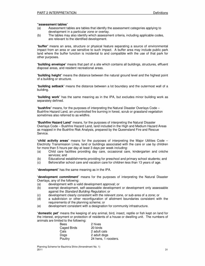
“assessment tables” (a) Assessment tables are tables that identify the assessment categories applying to
development in a particular zone or overlay. (b) The tables may also identify which assessment criteria, including applicable codes,
are relevant to the identified development. “buffer” means an area, structure or physical feature separating a source of environmental impact from an area or use sensitive to such impact. A buffer area may include public park land where the buffer function is incidental to and compatible with the use of that park for other purposes. “building envelope” means that part of a site which contains all buildings, structures, effluent disposal areas, and resident recreational areas. “building height” means the distance between the natural ground level and the highest point of a building or structure. “building setback” means the distance between a lot boundary and the outermost wall of a building. “building work” has the same meaning as in the IPA, but excludes minor building work as separately defined. “bushfire” means, for the purposes of interpreting the Natural Disaster Overlays Code – Bushfire Hazard Land, an uncontrolled fire burning in forest, scrub or grassland vegetation sometimes also referred to as wildfire. “Bushfire Hazard Land” means, for the purposes of interpreting the Natural Disaster Overlays Code – Bushfire Hazard Land, land included in the High and Medium Hazard Areas as mapped in the Bushfire Risk Analysis, prepared by the Queensland Fire and Rescue Service. “child activity areas” means for the purposes of interpreting the Major Utilities Code – Electricity Transmission Lines, land or buildings associated with the care or use by children for more than 5 hours per day at least 3 days per week including: (a) Child care facilities providing day care, occasional care, kindergarten and crèche
services; and (b) Educational establishments providing for preschool and primary school students; and (c) Before/after school care and vacation care for children less than 13 years of age. “development” has the same meaning as in the IPA. “development commitment” means for the purposes of interpreting the Natural Disaster Overlays, any of the following: (a) development with a valid development approval; or (b) exempt development, self-assessable development or development only assessable
against the Standard Building Regulation; or (c) development clearly consistent with the relevant zone, or sub-area of a zone; or (d) a subdivision or other reconfiguration of allotment boundaries consistent with the
requirements of the planning scheme; or (e) development consistent with a designation for community infrastructure. “domestic pet” means the keeping of any animal, bird, insect, reptile or fish kept on land for the interest, enjoyment or protection of residents of a house or dwelling unit. The numbers of animals are limited to the following:
Bees 2 hives Caged Birds 20 birds Cats 2 adult cats Dogs 2 adult dogs Poultry 24 hens, 1 roosters.

PART 2 INTERPRETATION Definitions
Planning Scheme for Bauhinia Shire (Amendment No. 1) 2011 32
The term does not include the keeping of animals as separately defined as animal husbandry or intensive animal husbandry. “dwelling unit” means a building or part of a building used as a self contained residence for one household. As examples: a House is a single dwelling unit; a Dual occupancy is two dwelling units; a relative’s apartment is either an annexed unit as part of the House (see the House definition); or is a second dwelling unit on the same site as the House, therefore falling in the definition of a Dual occupancy. “Electric Line Shadow” means the area directly below a group of electric lines when the lines are at rest. “electricity transmission line easement” mean an existing easement over land in favour of an entity responsible for the carriage or supply of electricity, which is intended to be used or used for the transmission of electricity over the Transmission Grid. “explanatory notes” means supporting documents declared by the planning scheme to be extrinsic material to assist interpretation of the scheme and include documents that: (a) provide a summary of the background to determining the desired environmental
outcomes and scheme measures; (b) explain the relationship between the desired environmental outcomes and scheme
measures; or (c) explain how the scheme provisions operate. “filling and excavating” means the deposition or removal of material that that materially alters the ground level. This deposition or removal of material is a form of operational works, whether associated with an assessable material change of use or not. The term does not include the use of premises for extractive industry separately defined. “floor area (of a building)” means the total floor area of all levels of a building measured from the outside of the external walls or the centre of a common wall. “frontage” means a boundary of a lot which abuts a road. “Good Quality Agricultural Land“ means that land which is mapped on Map RES 1 as Land Classes A, B, & C1, in accordance with the Planning Guidelines – The Identification of Good Quality Agricultural Land that accompany State Planning Policy 1/92. “habitat” means the terrestrial and/or aquatic environment where an organism or group of organisms live through time, including breeding, growing, feeding, nesting or roosting. “habitable buildings” means any building, part of a building or structure used for or able to be lawfully used as a residence. “habitable room” means any room used for normal domestic activities other than a bathroom, toilet, pantry, walk-in wardrobe, corridor, lobby, photographic darkroom, clothes or drying room, and other spaces of a specialised nature occupied neither frequently nor for extended periods. “hazard severity” means, for the purposes of interpreting the Natural Disaster Overlays Code – Bushfire Hazard Land, the severity of bushfire hazard that land has in accordance with a Bushfire Hazard Assessment based on:
1. the vegetation type across the land, 2. the slope of the land; and 3. the land’s aspect
As a result of a Bushfire Hazard Assessment, land is determined to have a Low, Medium or High bushfire hazard severity. “hazardous materials” for the purposes of interpreting the Natural Disaster Overlays Code, has the same meaning as in the Dangerous Goods Safety Management Act 2001.
PART 2 INTERPRETATION Definitions
Planning Scheme for Bauhinia Shire (Amendment No. 1) 2011 33
“IDAS“ has the same meaning as in the IPA. “industry” means any of the following operations:- (a) (i) any manufacturing process whether or not such process results in the
production of a finished article; or (ii) the breaking up or dismantling of any goods or any goods or any articles for
trade, sale or gain, as ancillary to any business; or (iii) repairing, servicing or storage of articles including vehicles, machinery,
buildings or other structures, laundering of articles but not including on-site work on buildings or other structures; or
(iv) any operation connected with the installation of equipment and services and the extermination of pests but not including on site work on buildings or other structures or land; or
(v) treating waste material; or (vi) the storage or sale of any solid, liquid or gaseous fuel where such storage is
not for a purpose separately defined herein; or (vii) any process of testing and analysis; and
(b) when conducted on the same land as any of the above operations - (i) the storage of goods used in connection with or resulting from any of the above
operations; or (ii) the provision of amenities for persons engaged in such operations; or (iii) the sale of goods, resulting from such operations where no more than a total of
20% of the site or floor area are used for sales and display of goods; or (iv) any work of administration or accounting in connection with such operations.
“industrial road” means a road which has the primary function of providing access to industrial properties. “IPA” means the Integrated Planning Act 1997. “IMEAQ” means Institute of Municipal Engineers, Australia (QLD) “Key Resources Area” a key resource area for extractive industry includes the maximum available resource, a suitable separation distance to reduce impacts to acceptable levels, and a transport corridor protected against encroachment of incompatible developments. “layer” means:
� a zone; and � a mapped or otherwise described area that affects assessment categories and has
relevant assessment criteria, or has relevant assessment criteria only, if those assessment categories and assessment criteria are organised separately from the zone provisions.
An overlay may be a layer. “land contiguous to electricity works” means land that: a) contains an easement for existing or proposed electricity works; or b) has or is planned to have electricity works over, on or under the land; or c) is within 20m of an existing or planned substation; or d) is closer to the centreline of an electric line than the distance identified as “A” in
Figure 2 for the nameplate voltage of the particular electric line; e) will contain buildings, structures or works (including landscaping, laying or pipes,
filling or excavating) that would intrude into the shaded space in Figures 2,3 or 4; f) will have vegetation that will at maturity exceed 4.0m in height, and is:
i. on, or within 5.0m of, an electric line shadow (see figure 1); ii. planted closer to the nearest edge of the electric line shadow than
the expected maximum height at maturity of the vegetation (see figure 5).
PART 2 INTERPRETATION Definitions
Planning Scheme for Bauhinia Shire (Amendment No. 1) 2011 34
“landscaped areas” means the area of any site, comprising usable landscaped areas, private open space areas, and landscaped setbacks. For the purposes of this definition: (a) usable landscaped areas refers to those areas of a site capable of providing
communal recreation facilities eg. Pools, BBQs, playgrounds, or for substantial (i) landscaping and gardens, and which: (ii) have no horizontal dimension less than 2.5m; and (iii) is kept clear of all obstacles such as clothes hoists, driveways, parking
spaces and receptacles; and (b) private open space areas refers to those areas of a site which provide recreation
areas exclusively for a dwelling unit and do not include balconies or decks that are not at ground level, and which for Dual occupancy uses may include clothes drying areas and bin storage; and
(c) landscaped setbacks refers to those areas of a site which provide landscaping in the building setback, for the provision of on-site gardens or specifically for buffering between land uses. These areas may include site facilities such as clothes lines, bin enclosures, storage areas, mail boxes and the like.
“landscaped setbacks” – refer to the “landscaped areas” definition. “main road” means a State Controlled Road under the Transport Infrastructure Act “material change of use” has the same meaning as in the IPA. “minor building work” means building work: (a) to which the provisions of the Building Code of Australia do apply; and (b) which in a single construction results in an increase in gross floor area of an existing
premises by no more than 10% of the existing gross floor area; and (c) which cumulatively in a number of constructions, over time, is not otherwise defined
in this Planning Scheme. Such work does not fall within a defined use class and is considered to be exempt development “minor residential street” means a minor road providing local residential access with shared traffic, pedestrian and recreation use, but with pedestrian priority or a road providing local residential access with shared traffic, pedestrian and recreation use with local traffic priority. “natural hazard management area” means for the purposes of interpreting the Natural Disaster Overlays Code, areas that are defined for the management of a hazard (flood, bushfire and landslide), but may not reflect the full extent of the area that may be affected by the hazard. These areas are defined by the Natural Disaster Overlays – Bushfire Hazard Land as mapped on Map NDIS 1, the Natural Disaster Overlays – Landslide Prone Land and the Natural Disaster Overlays – Flood Hazard Overlay – Floodplain Assessment as mapped on NDIS 2. The natural hazard management area for landslide, referred to as Landslide Prone Land, is defined as all land with a slope of 15% or greater. The natural hazard management area for flood is defined as land shown on the Flood Hazard Overlay – Floodplain Assessment as amended by Council. “noise sensitive uses” means those uses which fall within the definition of Noise Sensitive Places under the Environmental Protection Act - EP (Noise)P 1997; which for the purpose of this Planning Scheme include: (a) a dwelling (comprising houses, duplexes, multiple dwellings, accommodation units,
relatives apartments, retirement villages, motels, aged care accommodation and hostels);
(b) a library, childcare centre, kindergarten, school, college, university or other educational institution;
(c) a Health Care Facility, surgery or other medical institution; (d) a park or garden that is open to the public (whether or not on payment of money) for
use other than for sport or organized entertainment. “operational work“ has the same meaning as in the IPA.

PART 2 INTERPRETATION Definitions
Planning Scheme for Bauhinia Shire (Amendment No. 1) 2011 35
“overall outcomes”:
� are statements of desired outcomes that apply to the whole of a zone or overlay, and identify the purpose of a code under s 3.5.13(2) of the IPA,
� require the exercise of discretion to assess whether proposed development is consistent.
“overlay” means: (a) a secondary set of planning scheme provisions based on areas, places or sites
having special attributes that affect the outcomes sought, as the attributes may— (i) make those areas, places or sites sensitive to effects of development, or (ii) constrain development due to an environmental hazard or the value of a
resource. (b) do not cover the whole of a planning scheme area. (c) may be presented in the scheme as a layer. “Operational work associated with management practices for the conduct of an agricultural use” means those ‘long term cyclical activities’ associated with the agricultural use. Long term cyclical activity refers to the on-going activities that are commonly undertaken on a regular bases, eg daily or seasonal activities. Examples of such long term cyclical activities might include irrigation, ploughing, planting, spraying, harvesting, and maintaining existing built infrastructure such as drains. The term does not include significant, one-off works such as excavation and filling activities above thresholds identified in the planning scheme. “person“ has the same meaning as in the IPA. “principal road” means a road which carries through traffic but may also provide access to some abutting properties. “private open space”– refer to the “landscaped areas” definition. “probable solutions” means: (a) precise criteria that provide a guide for achieving a specific outcome in whole or part,
but do not necessarily establish compliance with a code; and (b) precise criteria in a code for code assessment. “reconfiguring a lot“ has the same meaning as in the IPA. “residential accommodation development” means Multiple dwellings, Retirement villages and Dual occupancy uses collectively. “residential street” means a road providing access to abutting residential properties and carrying local through traffic. “riparian corridor” means that part of the landscape adjacent to streams, that exerts a direct influence on the stream or lake margins, and on the water and aquatic ecosystems contained within them. Riparian zones include the stream bank and a variable sized belt of land alongside the banks. “risk” means for the purposes of interpreting the Natural Disaster Areas Overlays, a concept used to describe the likelihood of harmful consequences arising from the interaction of hazards, community and the environment. “road” means as defined in the Transport Infrastructure Act 1994. “rural road” means a road which has the primary function of providing access to rural and/or rural residential properties.

PART 2 INTERPRETATION Definitions
Planning Scheme for Bauhinia Shire (Amendment No. 1) 2011 36
“schedules”:
� provide details that support the assessment categories or assessment criteria, or provide other information for their interpretation, such as the meaning of defined uses or other terms used in the scheme.
� a planning scheme policy may also have supporting schedules. “scheme measures” means all provisions of a planning scheme and associated planning scheme provisions, including assessment provisions, introductory provisions and other provisions not used for development assessment. “secondary road frontage” means any road frontage to any lot or lots in addition to a road frontage used for primary vehicular access (eg. a corner lot has a road frontage and a secondary road frontage) and in no circumstance constitutes a State controlled road. “self contained” means for a single dwelling unit, that it contains kitchen, ablution and laundry facilities for the exclusive use of the household. “sign maintenance” means any maintenance carried out on an advertising device that existed and was being displayed on the commencement day of this planning scheme and still remains in the same location it did on the commencement day. Maintenance includes: (a) fixing or repairing an advertising device that has been damaged; in situ or taking the
advertising device away for a period of no more than 30 days for fixing or repair before it is redisplayed;
(b) changing the content of any advertising device; and (c) reducing the advertising device face area. “site area” means that part of a lot or lots which is proposed to be used, is currently used, or is the subject of a development application. “site cover” means the proportion of a site covered by a building, fixed structure, or outdoor storage area, excluding the area under eaves. “small lots” refers to any lot which has an area less than the specified minimum lot size in the relevant Zone. “specific outcomes” means: (a) statements of desired outcomes that contribute to the achievement of overall
outcomes and may relate to the use of land, the provision of infrastructure, or specified effects of use or development on aspects of the environment.
(b) require the exercise of discretion to assess whether proposed development complies with a code.
“state assessment requirements” means the various assessment categories, assessment criteria, information and referral requirements established by the State under the IPA and other related Acts, regulations and IDAS codes. “steep slopes“ means the purposes of interpreting the Natural Disaster Areas Overlays, land which has a slope of 15% or greater, as determined by a slope analysis. “stock route” means land used for purposes set out in the Stock Act, and includes using land for the moving, feeding, watering and holding of stock. These routes are mapped for the purposes of the planning scheme on Planning Scheme Map 2. “sub-area” means an identified area within a zone with special attributes to which certain zone provisions apply. These are referred to as Precincts, in the Town Zone. “supporting documents” means documents that are separate from the planning scheme that assist in its interpretation and use, including explanatory notes and user’s guides.

PART 2 INTERPRETATION Definitions
Planning Scheme for Bauhinia Shire (Amendment No. 1) 2011 37
“temporary advertising device” means any advertising device: (a) that does not require approval under the Building Code of Australia, and (b) displayed at a general location for a maximum period of 14 days (for part or the whole
of the day), consecutively or not, within a 3 month period. “temporary uses” means any use of land: (a) that occurs as a once only occasion; or (b) that occurs on an infrequent and irregular basis; or (c) that occur no more than twice in a 12 month period; or (d) that has a duration of less than 1 week. Examples of temporary uses, despite the criteria above, are circuses, weekend festivals, school fetes, bullaramas, and campdrafts. These uses do not fall within any of the defined Use Classes, and are exempt development. “total use area“ means total area in square metres used for a purpose and includes all storeys of buildings, display areas, storage, outdoor dining areas, and entrances, but excludes car parking areas, access driveways, and landscaped areas. “usable landscaped areas“ – refer to the “landscaped areas” definition. “use“ in relation to a use class, means a use for a single purpose that is part of that use class, such as “Animal husbandry” in a “Rural Uses” use class. “use class“ means a group of uses having different purposes but broad characteristics in common, such as a “Rural Uses” use class that includes uses for Agriculture, Animal husbandry, Intensive animal husbandry and the like. “user’s guides” means explanations of the development assessment system and how to use a planning scheme intended primarily for non-technical users of the scheme. “vegetated buffer” means a setback provided between a natural feature and the site area of a development, where existing vegetation is retained. The buffer excludes all buildings and structures, access driveways, car parking, effluent disposal areas and necessary excavation and filling. “watercourse” means a river, creek or stream in which water flows permanently or intermittently and includes the bed and banks and any other element of a river, creek or stream confining or containing water. ”weeds” mean those plant species recognised as pests, in the current Bauhinia Shire Council Pest Management Plan. “works” collectively refers to minor building work, building work, operational works – filling and excavating, work-roads, work-car parking and access, work – water and sewer, work – stormwater drainage, work – electricity, work – footpaths and cycleways, work- park provision, work- street trees, work – landscaping, clearing of vegetation, placing an advertising device, reconfiguring a lot, and operational works associated with reconfiguring a lot. “zone“ means:
� the primary layer for organising the provisions of the planning scheme based on land use allocations.
� all parts of the planning scheme area are included in one zone only. � a zone may incorporate distinct sub-areas; referred to as either Precincts. � any provisions applicable to those sub-areas are integrated with the zone provisions.
PART 2 INTERPRETATION Definitions
Planning Scheme for Bauhinia Shire (Amendment No. 1) 2011 38
Division 2—Explanatory Notes
2.2.1 Explanatory Notes Assist Interpretation of Planning Scheme
The Bauhinia Shire Planning Scheme Explanatory Notes are declared to be extrinsic material under the Statutory Instruments Act 1992, section 15, which assist interpretation of provisions of this planning scheme.

PART 3 FOUNDATION OF THE PLANNING SCHEME Desired Environmental Outcomes
Planning Scheme for Bauhinia Shire (Amendment No. 1) 2011 39
PART 3—FOUNDATION OF THE PLANNING SCHEME
Division 1—Desired Environmental Outcomes
3.1.1 Desired Environmental Outcomes
(1) The desired environmental outcomes are based on the achievement of ecological sustainability as outlined by the IPA and are the basis for the measures of the planning scheme.
(2) Each desired environmental outcome is sought to be achieved to the extent practicable having regard to each of the other desired environmental outcomes, noting that in many instances there is an overlap between each of the social, environmental and economic elements.
(3) The desired environmental outcomes are written from the perspective of reporting on Bauhinia Shire in 2012. This is the 8 year planning horizon adopted in the planning scheme.
(4) The desired environmental outcomes for Bauhinia Shire are as follows:
Social elements
(a) The Shire’s residential communities are preserved in character, well serviced, enjoy high levels of safety and amenity, able to accommodate growth and offer a range of housing options to meet the diverse needs of all members of the community.
(b) Springsure is the main business and economic centre, providing higher order services and a range of community and civic functions.
(c) Rolleston is a community that has access to facilities and services that meet local needs.
(d) The park and recreation opportunities for residents and visitors of the Shire are enhanced and expanded by providing a diversity of recreation settings.
(e) Rural residential areas are located and consolidated to provide suitably serviced, alternative rural living options that are close to Springsure.
(f) The risks to persons and property due to landslide, bushfire and flood are minimised.
Environmental elements
(g) The Shire’s water resources, including the waters of the Comet and Noga River and floodplains are managed sustainable and development is appropriately conditioned to ensure water quality, is maintained and enhanced wherever possible.
(h) The recognised values and integrity of significant natural features, conservation areas and open space networks eg. National Parks, are protected.
(i) Vegetation that supports important flora and fauna habitats, provides watercourse buffering or has associated scenic values, is protected from clearing and the spread of pest plants and animals.
(j) Development is located and managed where ever possible to ensure the long term protection and conservation of the significant cultural heritage values of the Shire.
(k) Public health and the environment are protected from environmental harm from waste and contaminated land. Efficient resource use and waste minimisation and management are promoted while allowing for ecologically sustainable development.
(l) Air quality is maintained or enhanced while allowing for ecologically sustainable development.
(m) The quality of the acoustic environment is maintained or enhanced while allowing for ecologically sustainable development.
PART 3 FOUNDATION OF THE PLANNING SCHEME Desired Environmental Outcomes
Planning Scheme for Bauhinia Shire (Amendment No. 1) 2011 40
(n) The spread or increase of weeds and pest animals is prevented through the appropriate conditioning of development to protect natural resources from degradation consistent with the objectives of the Shire’s Pest Management Plan.
Economic Elements
(o) The long term viability of agricultural industries within the Shire is enhanced through measures to protect productive agricultural land from excessive fragmentation and encroachment of incompatible uses.
(p) Natural resources and areas of economic value, such as Good Quality Agricultural Land, extractive materials, mineral resources and native forests are protected and utilised sustainably.
(q) Industrial development opportunities are available and are planned such as to balance economic values against the values of the natural environment, transport network and residential amenity.
(r) The efficiency of infrastructure, including telecommunication, gas, electricity and transport networks (including walkways and cycleways), is maintained and future extensions are well planned to meet the future development needs of the Shire.
(s) Water, sewer and stormwater infrastructure is planned and provided in a cost effective and timely manner to meet the needs of the Shire.
(t) Existing and future waste disposal facilities which are adequate for the Shire’s needs, are maintained and protected from the encroachment of inappropriate land uses.
(u) New development does not encroach upon industry or infrastructure so that the industry and infrastructure can operate efficiently and effectively.
PART 4 ZONES Rural Zone
Planning Scheme for Bauhinia Shire (Amendment No. 1) 2011 41
PART 4—ZONES
Division 1—Rural Zone
About the Rural Zone � The Rural Zone, as mapped on Maps Zone - 1, 2, 3, and 4 contains those areas of
the Shire predominantly used for agriculture and animal husbandry uses, and other rural uses.
� The Rural Zone also includes uses other than rural uses such as tourism activities such as the tourism accommodation and support services adjacent to Carnarvon National Park. Also this zone contains mining and extractive industries.
� The Rural Zone Code regulates new uses and works in relation to their impacts on the natural values of the environment, separation distances between incompatible land uses, their scale and location.
4.1.1 Assessment tables for the Rural Zone
(1) Assessment categories for the Rural Zone The assessment categories
6 are identified for development in the Rural Zone in
Column 2 of Tables 4.1.1(1) and 4.1.1(2) as follows— (a) Table 4.1.1(1)—making a material change of use
7 for a defined use, or
another use in a defined use class, listed in Column 1; or (b) Table 4.1.1(2)—other development
8 listed in Column 1, including—
(i) operational work, including but not limited to, filling and excavating, and the placing of advertising devices;
(ii) reconfiguring a lot; and (iii) carrying out operational work for reconfiguring a lot.
(2) Relevant assessment criteria for self assessable and assessable development
in the Rural Zone The relevant assessment criteria in the Rural Zone are referred to in Column 3 of Tables 4.1.1(1) and 4.1.1(2). For self-assessable development and development requiring code assessment, the relevant assessment criteria are applicable codes.
6 Information about assessment categories is provided in the Bauhinia Shire Planning Scheme Explanatory
Notes. 7 Works associated with an application for a material change of use may be assessed together with the material
change of use. Also, see Bauhinia Shire Planning Scheme Explanatory Notes giving examples that explain the type of development involved in different proposals.
8 See Bauhinia Shire Planning Scheme Explanatory Notes giving examples that explain the type of development
involved in different proposals.

PART 4 ZONES Rural Zone
Planning Scheme for Bauhinia Shire (Amendment No. 1) 2011 42
TABLE 4.1.1 (1)
ASSESSMENT CATEGORIES AND RELEVANT ASSESSMENT CRITERIA FOR THE RURAL ZONE – MAKING A MATERIAL CHANGE OF USE
Column 1
Defined use or use class
9 and
10
Column 2
Assessment category –(where Self assessable
development does not meet the Acceptable Solutions in
the applicable codes, it requires Code assessment.
Refer to Section 1.2.9),
Column 3
Relevant assessment criteria
11—are the applicable
codes for self assessable and code assessable
development
Rural Use Class
All development within 50m of the Springsure Health Care Facility Museum and Rainworth Fort as shown on Map No. CONS 2 shall be subject to the Heritage Places Overlay
Fossicking Exempt
Agriculture Self assessable Rural Zone Code;
Development Standards Code; and
Agricultural Use Code
Animal husbandry Exempt where conducted on a Stock Route.
Self assessable if not conducted on a Stock Route.
Rural Zone Code; and
Development Standards Code; and
Animals Code
Roadside stall Self assessable where use area does not exceed 50m
2 and is not
located in or within 5 metres of an electric line shadow.
Rural Zone Code; and
Development Standards Code
Code assessable where the circumstances for self assessable do not apply
Rural Zone Code; and
Development Standards Code
Rural Dwelling; and
Stock Saleyard
Self assessable Rural Zone Code;
Development Standards Code; and
Animals Code
All other uses in the Rural Use Class
Impact assessable
Residential Use Class
Accommodation Building
Code assessable Rural Zone Code; and Development Standards Code; and Accommodation Buildings Code
Home based business Code assessable Rural Zone Code; and
Development Standards Code;
Home Based Business Code; and
House Code
9 See schedule A (dictionary), Division 1 (defined uses and use classes).
10 Department of Main Roads should be contacted to consent to the access arrangements for any new use with
frontage to a State Controlled Road. 11
For impact assessable development the ‘relevant assessment criteria’ are provided for assistance and in no way affect the regard given to the planning scheme as a whole in accordance with section 3.5.5 of the IPA.

PART 4 ZONES Rural Zone
Planning Scheme for Bauhinia Shire (Amendment No. 1) 2011 43
TABLE 4.1.1 (1)
ASSESSMENT CATEGORIES AND RELEVANT ASSESSMENT CRITERIA FOR THE RURAL ZONE – MAKING A MATERIAL CHANGE OF USE
Column 1
Defined use or use class
9 and
10
Column 2
Assessment category –(where Self assessable
development does not meet the Acceptable Solutions in
the applicable codes, it requires Code assessment.
Refer to Section 1.2.9),
Column 3
Relevant assessment criteria
11—are the applicable
codes for self assessable and code assessable
development
Home host accommodation
Code assessable Rural Zone Code; and
Development Standards Code ;
Home Host Accommodation Code; and
House Code
House Self assessable Rural Zone Code; and
Development Standards Code; and
House Code
All other uses in the Residential Use Class
Impact assessable
Commercial Use Class
Off street car park;
Plant nursery ;
Outdoor entertainment
Code assessable Rural Zone Code; and
Development Standards Code; and
Commercial Development Code.
Caravan Park;
Hotel;
Food Premises
Code assessable where located in the Carnarvon Gorge Tourism Area – See Zone Map 4
Rural Zone Code; and Development Standards Code; and Commercial Development Code; and Caravan Park and Workers Accommodation Code
Impact assessable where not located in the Carnarvon Gorge Tourism Area.
All other uses in the Commercial Use Class
Impact assessable
Industrial Use Class
Low impact industry Code assessable if :
1. For the purposes of an animal carcass store; and
2. Located more than 1000m from land in the Town – Residential Precinct, or Town – Rural Residential Precinct.
Rural Zone Code; and
Development Standards Code
Impact assessable if the circumstances for Code assessable do not apply
All other uses in the Industrial Use Class
Impact assessable

PART 4 ZONES Rural Zone
Planning Scheme for Bauhinia Shire (Amendment No. 1) 2011 44
TABLE 4.1.1 (1)
ASSESSMENT CATEGORIES AND RELEVANT ASSESSMENT CRITERIA FOR THE RURAL ZONE – MAKING A MATERIAL CHANGE OF USE
Column 1
Defined use or use class
9 and
10
Column 2
Assessment category –(where Self assessable
development does not meet the Acceptable Solutions in
the applicable codes, it requires Code assessment.
Refer to Section 1.2.9),
Column 3
Relevant assessment criteria
11—are the applicable
codes for self assessable and code assessable
development
Community Use Class
Open space Exempt N/A
Public facility – operational
Exempt N/A
All other uses in the Community Use Class
Impact assessable

PART 4 ZONES Rural Zone
Planning Scheme for Bauhinia Shire (Amendment No. 1) 2011 45
TABLE 4.1.1 (2)
ASSESSMENT CATEGORIES AND RELEVANT ASSESSMENT CRITERIA FOR THE RURAL ZONE – OTHER DEVELOPMENT
Column 1
Type of development
Column 2
Assessment category –
(where Self assessable development does not meet the Acceptable Solutions in
the applicable codes, it requires Code assessment.
Refer to Section 1.2.9),
Column 3
Relevant assessment criteria
12—
are the applicable codes for self assessable and code assessable development
Operational work
Filling and excavating13 Code assessable if: 1. For other than operational
works associated with farm management practices; and
2. Greater than 2000m3 of
material is excavated or filled
Rural Zone Code;
Development Design Code
Work – Roads Code assessable Rural Zone Code;
Development Design Code
Work – Car Parking and Access
Code assessable Rural Zone Code;
Development Design Code
Work – Water and Sewer
Code assessable Rural Zone Code;
Development Design Code
Work – Stormwater Drainage
Code assessable Rural Zone Code;
Development Design Code
Work –Telecommunication Services
Code assessable Rural Zone Code;
Development Design Code
Work – Footpaths and Cycleways
Code assessable Rural Zone Code;
Development Design Code
Work – Park provision Code assessable Rural Zone Code;
Development Design Code
Work – Street lighting and Street signs
Code assessable Rural Zone Code;
Development Design Code
Work – Street trees Self assessable Rural Zone Code;
Development Design Code
Work – Landscaping Self assessable Rural Zone Code;
Development Design Code
12 For impact assessable development the ‘relevant assessment criteria’ are provided for assistance and in no way
affect the regard given to the planning scheme as a whole in accordance with section 3.5.5 of the IPA. 13
If works do not allow the taking of interfering with water from a watercourse, lake or spring, a Riverine Protection
Permit under the Water Act 2000 is required from the Department of Natural Resources and Water for any destruction of vegetation, excavation or placing fill in a watercourse.

PART 4 ZONES Rural Zone
Planning Scheme for Bauhinia Shire (Amendment No. 1) 2011 46
TABLE 4.1.1 (2)
ASSESSMENT CATEGORIES AND RELEVANT ASSESSMENT CRITERIA FOR THE RURAL ZONE – OTHER DEVELOPMENT
Column 1
Type of development
Column 2
Assessment category –
(where Self assessable development does not meet the Acceptable Solutions in
the applicable codes, it requires Code assessment.
Refer to Section 1.2.9),
Column 3
Relevant assessment criteria
12—
are the applicable codes for self assessable and code assessable development
Other Operational work associated with a Code or Impact assessable Material Change of Use (not including operational work associated with reconfiguring a lot)
14
Code assessable Rural Zone Code;
Development Design Code
Reconfiguring a lot15
All circumstances Code assessable:
1. where the size of any additional lots created is:
(a) not more than 5% below,
(b) equal to, or
(c) greater than,
the relevant specified minimum lot sizes in the Reconfiguring a Lot Code; OR
2. where no additional lots are created and the proposal is for the rearrangement of existing lot boundaries.
Rural Zone Code;
Reconfiguring a Lot Code;
Development Standards Code; and
House Code.
Impact assessable where circumstances for Code assessable do not apply
Carrying out operational work for reconfiguring a lot
All circumstances Code assessable Rural Zone Code;
Reconfiguring a Lot Code;
Development Design Code.
Other
14 If works do not allow the taking or interfering with water from a watercourse, like or spring, a Riverine Protection
Permit under the Water Act 2000 is required from the Department of Natural Recourses and Mines for any destruction of vegetation, excavation or placing fill in a watercourse.
15 Under IPA, schedule 8, part 3 the reconfiguring of a lot is exempt and cannot be made self-assessable or
assessable by a planning scheme if the proposal is for amalgamating 2 or more lots, for a building format plan that does not subdivide land, in relation to the Acquisition of Land Act 1967, or on Strategic Port Land.
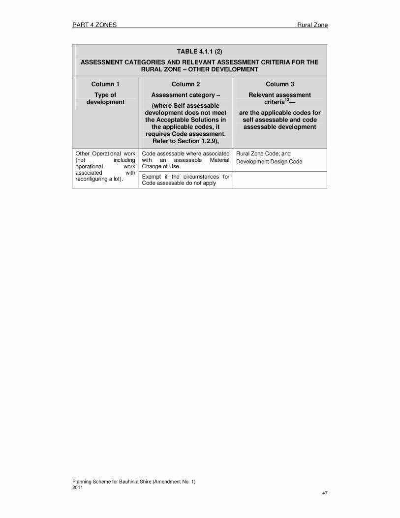
PART 4 ZONES Rural Zone
Planning Scheme for Bauhinia Shire (Amendment No. 1) 2011 47
TABLE 4.1.1 (2)
ASSESSMENT CATEGORIES AND RELEVANT ASSESSMENT CRITERIA FOR THE RURAL ZONE – OTHER DEVELOPMENT
Column 1
Type of development
Column 2
Assessment category –
(where Self assessable development does not meet the Acceptable Solutions in
the applicable codes, it requires Code assessment.
Refer to Section 1.2.9),
Column 3
Relevant assessment criteria
12—
are the applicable codes for self assessable and code assessable development
Other Operational work (not including operational work associated with reconfiguring a lot).
Code assessable where associated with an assessable Material Change of Use.
Rural Zone Code; and
Development Design Code
Exempt if the circumstances for Code assessable do not apply
PART 4 ZONES Rural Zone
Planning Scheme for Bauhinia Shire (Amendment No. 1) 2011 48
4.1.2 Assessment criteria for the Rural Zone
(1) Rural Zone Code The provisions in this division comprise the Rural Zone Code. They are— 1. The Purpose of the Rural Zone Code – Section (2); and 2. The Specific Outcomes, Probable Solutions and Acceptable Solutions for the Rural
Zone – Table 4.1.2. Rural Zone. (2) The Purpose of the Rural Zone Code
The purpose of the Rural Zone Code is to achieve the following overall outcomes, specific to identified Areas, and in the Rural Zone generally:
1. The overall outcomes sought for all Rural Zoned land are: a) Agriculture and animal husbandry uses, are the dominant land uses
within the Zone; b) Land is not provided with urban standard services; c) Rural character, including rural and agricultural landscapes, is protected; d) Overall water quality is maintained and enhanced where possible by the
protection of natural features such as watercourses, soil landscapes and vegetation and the spread or increase of weeds and pest animals is prevented;
e) Intensive agriculture and intensive animal husbandry uses locate in the Zone, provided that it is demonstrated through the application process that both on-site and off-site impacts of the development are managed so as not to pose a risk to the natural environment;
f) Those Rural Uses which have significant air emissions, noise or other impacts are located away from towns to protect the amenity of those towns;
g) Extractive industry and mining resources remain accessible within the Zone,
h) Some non-rural uses such as recreational based uses, home based businesses, home host accommodation, educational or tourism related uses of a low intensity and scale, occur within the Zone where the Specific Outcomes are met;
i) Development does not adversely affect the scenic values of the Carnarvon Gorge National Park and other National Parks as viewed from State controlled roads through the Shire.
j) Tourism accommodation and associated activities in relation to the Carnarvon Gorge National Park are to be located in the Carnarvon Gorge Tourism Area. Any expansion from that area needs to be well supported by a needs analysis and meet the specific outcomes of the zone.

PART 4 ZONES Rural Zone
Planning Scheme for Bauhinia Shire (Amendment No. 1) 2011 49
TABLE 4.1.2 RURAL ZONE
Specific outcomes (S) for Code and Impact assessable development
Probable Solutions (P) for Code and Impact assessable development;
and
Acceptable Solutions (A) for Self assessable development (where Self assessable development does not meet the Acceptable Solutions in the applicable codes, it requires Code assessment. Refer to Section 1.2.9).
All Uses and Works
Environmental Considerations S1 Land uses and works are located and designed so as not to have significant negative impacts on natural values of the environment including:
1. Natural fauna and flora habitats; 2. Water quality, watercourse
integrity and, ground water resources,
3. Soil and land resources.
P/A1.1 All uses and works are setback a minimum of 50m from any watercourse, as measured to the top of bank or as per DPIF Guidelines, whichever is the greater
16.
P/A1.2 Where the site and any newly created lots are not connected to the reticulated sewerage system, on-site disposal methods meet:
1. The Department of Natural Resources and Water On-site Sewerage Code (July 2002) or any subsequent update of that Code; and
2. AS/NZS 1547:2000 On-site Domestic Wastewater Management.
Note: Land is kept free of declared weeds and noxious plant infestations, as detailed in the Bauhinia Shire Council Pest Management Plan.
16 Clearing of any mapped native vegetation (as defined in Schedule 8 of the Integrated Planning Act 1997 and
Schedule 2 of the Integrated Planning Regulations 1998) will require application to the Department of Natural Resources and Water (on IDAS Form 1 Part J).

PART 4 ZONES Rural Zone
Planning Scheme for Bauhinia Shire (Amendment No. 1) 2011 50
Amenity S2 Land uses and works are integrated with the landform and landscape of the site and surrounding area.
P/A2.1 Buildings, roads, driveways and other works are sited and constructed without the need for cut and fill earthworks exceeding 2000m3 of material.
S3 Land uses and works have no significant impact on the amenity of adjoining premises or surrounding area:
1. By their design, orientation or construction materials;
2. Due to the operation of machinery or electrical equipment; or
3. Due to the emission of light, noise, vibration, odour, fumes, smoke, vapour, steam, soot, ash, grit, oil, dust, waste water, waste products, or electrical interference.
P3.1 No solutions specified.
S4 Land uses are located such that the potential impacts of noise from major roads and rail lines is reduced. Note: Are only located within 100m of any frontage to a Main Road where:
1. The Department of Main Roads has consented to the location without conditions; or
2. The Department of Main Roads has set conditions on the development to reduce the impacts of traffic noise and the development is undertaken in accordance with those conditions
P/A4.1 Noise sensitive uses
17 are located at least
100m from any frontage to a State Controlled Road; OR P/A4.2 Bedroom and living areas in residential uses and noise sensitive areas in non-residential uses are sited and designed to reduce the impact of rail noise by:
1. Siting noise affected areas as far away as practicable from the railway corridor noise source; or
2. Using roof and wall insulation, mechanical ventilation, thickened glass, double glazing of windows and doors; or
3. Orienting openings (for example, windows and doors) away from the rail corridor noise source; or
4. Incorporating noise attenuation barriers such as earth mounds, landscaping and fences or walls without gaps between the noise source and the use.
Separation Distances S5 Land uses and works are located, and include mitigation measures within the subject land that:
1. Are sufficient to protect the amenity of the area;
2. Are sufficient to protect the
P/A5.1 Uses in the Residential Use Class, except for houses, home host accommodation and home based businesses on lots with an area of 5ha or less, have separation distances between uses in the Residential Use Class and other uses, applicable to
17 See Administrative Definition of “Noise sensitive uses” contained in Section 2.1.1 Schedule B
PART 4 ZONES Rural Zone
Planning Scheme for Bauhinia Shire (Amendment No. 1) 2011 51
capacity for existing and approved uses to continue to operate; and
3. Are sufficient to protect the opportunities for existing and approved uses to expand in appropriately allocated /zoned land; and
4. For agricultural uses, are consistent with the Planning Guidelines: Separating Agricultural and Residential Land Uses DNR and DLGP, 1997;and
5. for the keeping of cattle, are outlined in Section 4 of the DPI Reference Manual for the Establishment and Operation of Beef Cattle Feedlots in Queensland, 2000; and
6. for the keeping of poultry, are outlined in the Guidelines for Poultry Farming in Queensland;
7. for the keeping of pigs, are outlined in the Separation Guidelines for Queensland Piggeries (2001); and
8. for development in proximity to watercourses and waterbodies, are consistent with the SEQWATER Development Assessment Guidelines (SEQWater, 2001), prepared as a collaboration with State Government Departments;
9. ensure the integrity of the Stock Routes as shown on Planning Scheme Map 1;
10. are consistent with the Guidelines to minimise mosquito and biting midge problems in new development areas; and
11. take into account the following variables: (a) The nature of the proposed
land use; and (b) The existing and future
amenity of the area; and (c) The existing and future
development in the area; and (d) The location of any existing
vegetation which would buffer the proposed use; and
(e) predominant wind directions; and
(f) The topography of the site.
both existing and approved uses, in accordance with Division 1: Schedule A – Separation Distances Between Uses in the Residential Use Class and Other Uses. P/A5.2 Development is not located on a Stock Route as shown on Planning Scheme Map 1 contained in Appendix 3.
Building Setbacks S6 Building setbacks reflect the character of existing development and land uses, and are provided having regard for the following:
1. The existing and proposed
P/A6.1 Buildings and other structures have boundary setbacks as follows:
1. On lots 1ha or less – 10m road frontage setback and 3m side

PART 4 ZONES Rural Zone
Planning Scheme for Bauhinia Shire (Amendment No. 1) 2011 52
amenity of the area; 2. The existing or proposed future
development in the area; 3. The distance between any
constructed road and the proposed building;
4. The distance between any existing buildings on other sites and the proposed building;
5. The location of any existing vegetation which would buffer the proposed building; and
6. Any constraints to development due to the topography of the site.
boundary setback; 2. On lots more than 1ha – 10m road
frontage setback and 10m to other boundaries.
Building Height S7 Building height reflects the character of existing development and land uses, and buildings are provided having regard for the following:
1. The existing and proposed amenity of the area;
2. The existing or proposed future development in the area;
3. The particular characteristics of the proposed building;
4. The distance of proposed buildings from roads and other public places from which the building could be viewed;
5. The topography, shape and location of the site; and
6. The location of any existing vegetation which would buffer the proposed building.
7. The proposed sport of recreational use.
P/A7.1 Buildings and other structures have maximum building heights as follows:
1. On lots 1ha or less – 10m; 2. On lots more than 1 ha – 15m.
Cultural Heritage S8 Development is managed in a fashion that ensures the long term protection and conservation of the significant cultural heritage values of the area.18
P8.1 No Solutions Specified
18 Under Section 23 of the Aboriginal Cultural Heritage Act 2003 and the Torres Strait Islander Cultural Heritage
Act 2003 a person who carries out an activity must take all reasonable and practicable measures to ensure the activity does not harm Aboriginal and Torres Strait Islander cultural heritage (the ‘cultural heritage duty of care’).
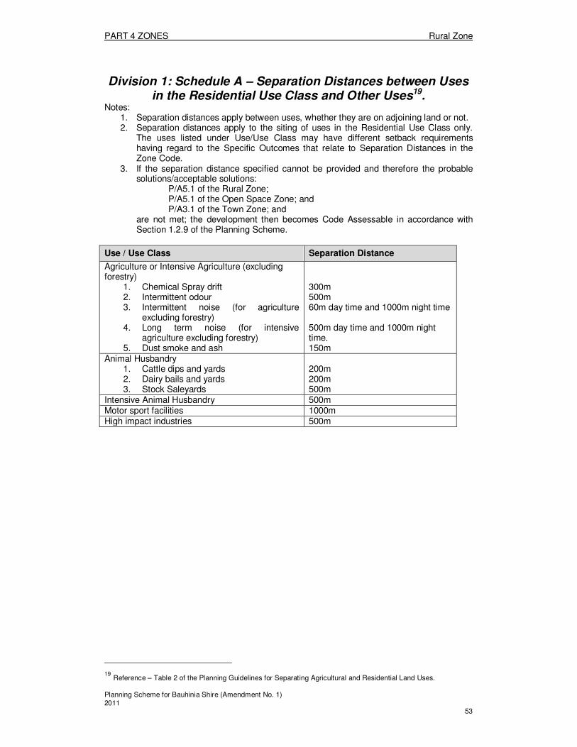
PART 4 ZONES Rural Zone
Planning Scheme for Bauhinia Shire (Amendment No. 1) 2011 53
Division 1: Schedule A – Separation Distances between Uses in the Residential Use Class and Other Uses19.
Notes: 1. Separation distances apply between uses, whether they are on adjoining land or not. 2. Separation distances apply to the siting of uses in the Residential Use Class only.
The uses listed under Use/Use Class may have different setback requirements having regard to the Specific Outcomes that relate to Separation Distances in the Zone Code.
3. If the separation distance specified cannot be provided and therefore the probable solutions/acceptable solutions:
P/A5.1 of the Rural Zone; P/A5.1 of the Open Space Zone; and P/A3.1 of the Town Zone; and
are not met; the development then becomes Code Assessable in accordance with Section 1.2.9 of the Planning Scheme.
Use / Use Class Separation Distance
Agriculture or Intensive Agriculture (excluding forestry)
1. Chemical Spray drift 2. Intermittent odour 3. Intermittent noise (for agriculture
excluding forestry) 4. Long term noise (for intensive
agriculture excluding forestry) 5. Dust smoke and ash
300m 500m 60m day time and 1000m night time 500m day time and 1000m night time. 150m
Animal Husbandry 1. Cattle dips and yards 2. Dairy bails and yards 3. Stock Saleyards
200m 200m 500m
Intensive Animal Husbandry 500m Motor sport facilities 1000m High impact industries 500m
19 Reference – Table 2 of the Planning Guidelines for Separating Agricultural and Residential Land Uses.
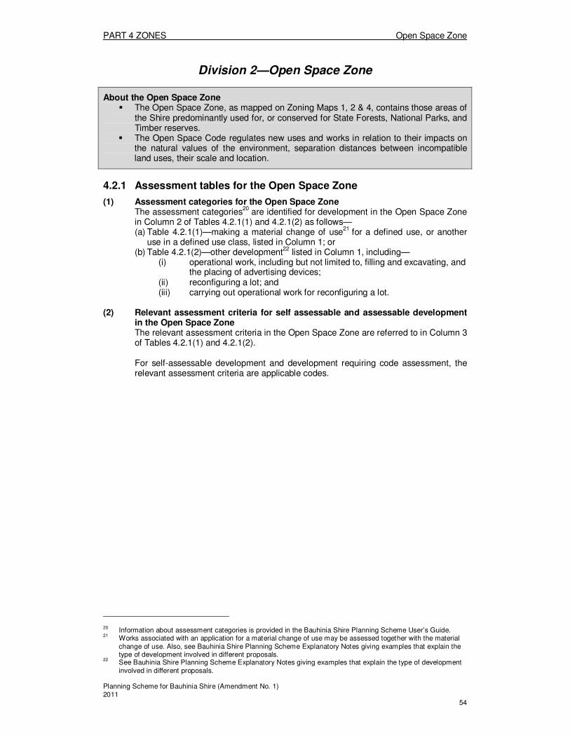
PART 4 ZONES Open Space Zone
Planning Scheme for Bauhinia Shire (Amendment No. 1) 2011 54
Division 2—Open Space Zone
About the Open Space Zone � The Open Space Zone, as mapped on Zoning Maps 1, 2 & 4, contains those areas of
the Shire predominantly used for, or conserved for State Forests, National Parks, and Timber reserves.
� The Open Space Code regulates new uses and works in relation to their impacts on the natural values of the environment, separation distances between incompatible land uses, their scale and location.
4.2.1 Assessment tables for the Open Space Zone
(1) Assessment categories for the Open Space Zone The assessment categories
20 are identified for development in the Open Space Zone
in Column 2 of Tables 4.2.1(1) and 4.2.1(2) as follows— (a) Table 4.2.1(1)—making a material change of use
21 for a defined use, or another
use in a defined use class, listed in Column 1; or (b) Table 4.2.1(2)—other development
22 listed in Column 1, including—
(i) operational work, including but not limited to, filling and excavating, and the placing of advertising devices;
(ii) reconfiguring a lot; and (iii) carrying out operational work for reconfiguring a lot.
(2) Relevant assessment criteria for self assessable and assessable development
in the Open Space Zone The relevant assessment criteria in the Open Space Zone are referred to in Column 3 of Tables 4.2.1(1) and 4.2.1(2). For self-assessable development and development requiring code assessment, the relevant assessment criteria are applicable codes.
20 Information about assessment categories is provided in the Bauhinia Shire Planning Scheme User’s Guide. 21
Works associated with an application for a material change of use may be assessed together with the material change of use. Also, see Bauhinia Shire Planning Scheme Explanatory Notes giving examples that explain the type of development involved in different proposals.
22 See Bauhinia Shire Planning Scheme Explanatory Notes giving examples that explain the type of development
involved in different proposals.
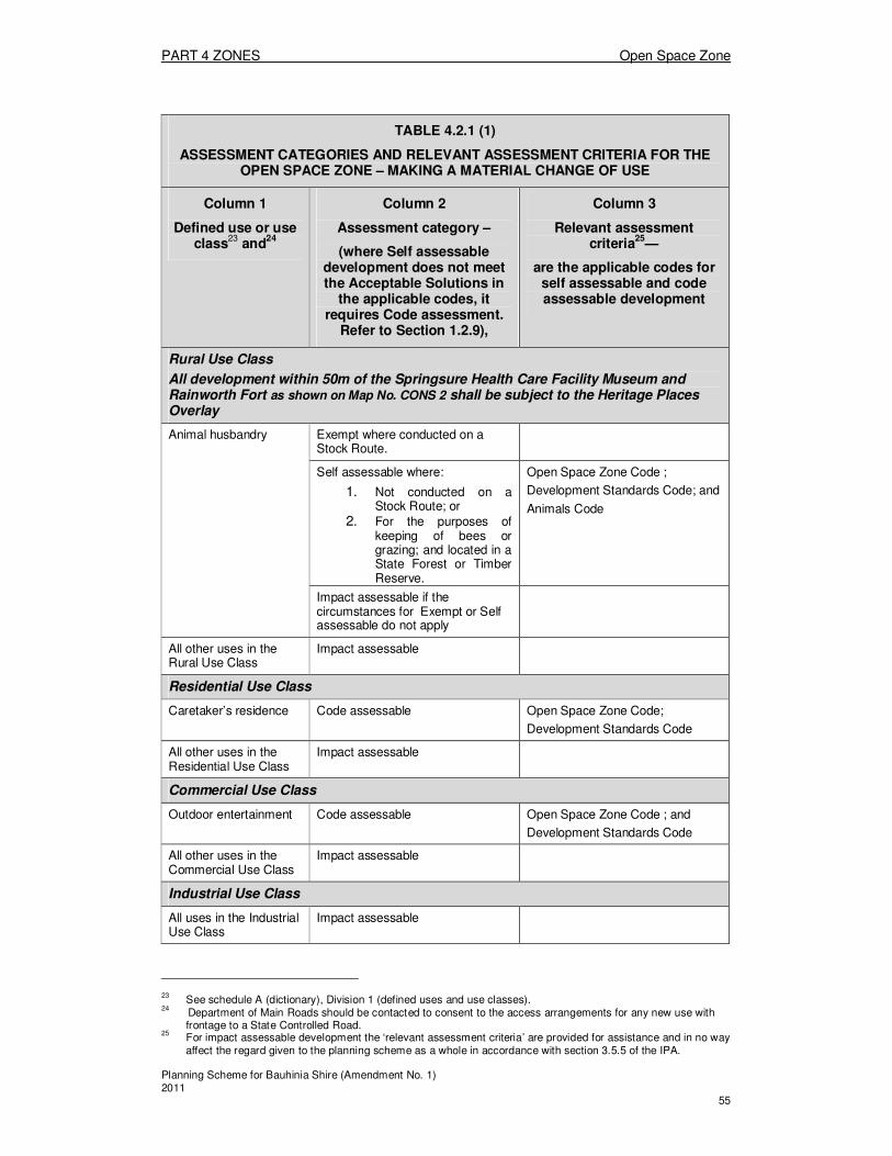
PART 4 ZONES Open Space Zone
Planning Scheme for Bauhinia Shire (Amendment No. 1) 2011 55
TABLE 4.2.1 (1)
ASSESSMENT CATEGORIES AND RELEVANT ASSESSMENT CRITERIA FOR THE OPEN SPACE ZONE – MAKING A MATERIAL CHANGE OF USE
Column 1
Defined use or use class
23 and
24
Column 2
Assessment category –
(where Self assessable development does not meet the Acceptable Solutions in
the applicable codes, it requires Code assessment.
Refer to Section 1.2.9),
Column 3
Relevant assessment criteria
25—
are the applicable codes for self assessable and code assessable development
Rural Use Class
All development within 50m of the Springsure Health Care Facility Museum and Rainworth Fort as shown on Map No. CONS 2 shall be subject to the Heritage Places Overlay
Animal husbandry Exempt where conducted on a Stock Route.
Self assessable where:
1. Not conducted on a Stock Route; or
2. For the purposes of keeping of bees or grazing; and located in a State Forest or Timber Reserve.
Open Space Zone Code ;
Development Standards Code; and
Animals Code
Impact assessable if the circumstances for Exempt or Self assessable do not apply
All other uses in the Rural Use Class
Impact assessable
Residential Use Class
Caretaker’s residence Code assessable Open Space Zone Code;
Development Standards Code
All other uses in the Residential Use Class
Impact assessable
Commercial Use Class
Outdoor entertainment Code assessable Open Space Zone Code ; and
Development Standards Code
All other uses in the Commercial Use Class
Impact assessable
Industrial Use Class
All uses in the Industrial Use Class
Impact assessable
23 See schedule A (dictionary), Division 1 (defined uses and use classes).
24 Department of Main Roads should be contacted to consent to the access arrangements for any new use with
frontage to a State Controlled Road. 25
For impact assessable development the ‘relevant assessment criteria’ are provided for assistance and in no way affect the regard given to the planning scheme as a whole in accordance with section 3.5.5 of the IPA.

PART 4 ZONES Open Space Zone
Planning Scheme for Bauhinia Shire (Amendment No. 1) 2011 56
TABLE 4.2.1 (1)
ASSESSMENT CATEGORIES AND RELEVANT ASSESSMENT CRITERIA FOR THE OPEN SPACE ZONE – MAKING A MATERIAL CHANGE OF USE
Column 1
Defined use or use class
23 and
24
Column 2
Assessment category –
(where Self assessable development does not meet the Acceptable Solutions in
the applicable codes, it requires Code assessment.
Refer to Section 1.2.9),
Column 3
Relevant assessment criteria
25—
are the applicable codes for self assessable and code assessable development
Community Use Class
Open space Exempt N/A
Public facility - operational
Exempt N/A
All other uses in the Community Use Class
Impact assessable
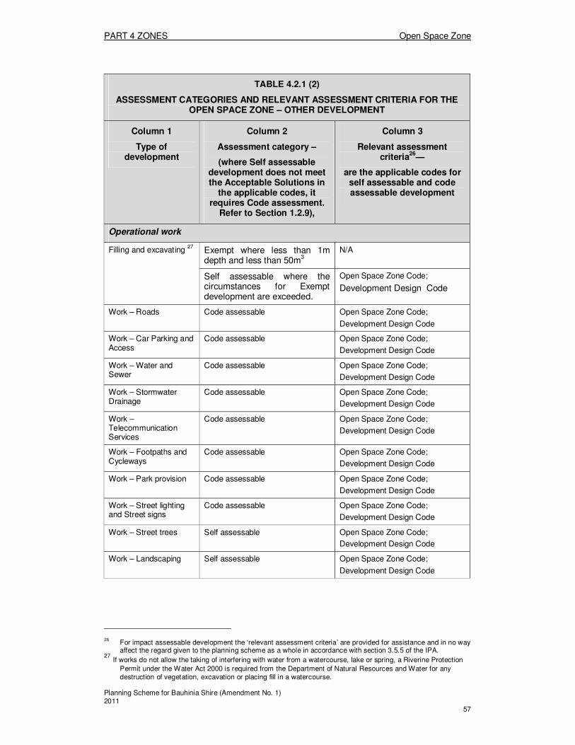
PART 4 ZONES Open Space Zone
Planning Scheme for Bauhinia Shire (Amendment No. 1) 2011 57
TABLE 4.2.1 (2)
ASSESSMENT CATEGORIES AND RELEVANT ASSESSMENT CRITERIA FOR THE OPEN SPACE ZONE – OTHER DEVELOPMENT
Column 1
Type of development
Column 2
Assessment category –
(where Self assessable development does not meet the Acceptable Solutions in
the applicable codes, it requires Code assessment.
Refer to Section 1.2.9),
Column 3
Relevant assessment criteria
26—
are the applicable codes for self assessable and code assessable development
Operational work
Filling and excavating 27
Exempt where less than 1m depth and less than 50m
3
N/A
Self assessable where the circumstances for Exempt development are exceeded.
Open Space Zone Code;
Development Design Code
Work – Roads Code assessable Open Space Zone Code;
Development Design Code
Work – Car Parking and Access
Code assessable Open Space Zone Code;
Development Design Code
Work – Water and Sewer
Code assessable Open Space Zone Code;
Development Design Code
Work – Stormwater Drainage
Code assessable Open Space Zone Code;
Development Design Code
Work –Telecommunication Services
Code assessable Open Space Zone Code;
Development Design Code
Work – Footpaths and Cycleways
Code assessable Open Space Zone Code;
Development Design Code
Work – Park provision Code assessable Open Space Zone Code;
Development Design Code
Work – Street lighting and Street signs
Code assessable Open Space Zone Code;
Development Design Code
Work – Street trees Self assessable Open Space Zone Code;
Development Design Code
Work – Landscaping Self assessable Open Space Zone Code;
Development Design Code
26 For impact assessable development the ‘relevant assessment criteria’ are provided for assistance and in no way
affect the regard given to the planning scheme as a whole in accordance with section 3.5.5 of the IPA. 27
If works do not allow the taking of interfering with water from a watercourse, lake or spring, a Riverine Protection
Permit under the Water Act 2000 is required from the Department of Natural Resources and Water for any destruction of vegetation, excavation or placing fill in a watercourse.

PART 4 ZONES Open Space Zone
Planning Scheme for Bauhinia Shire (Amendment No. 1) 2011 58
Reconfiguring a lot28
All circumstances Code assessable:
1. where the size of any additional lots created is:
a) not more than 5% below,
b) equal to, or
c ) greater than,
the relevant specified minimum lot sizes in the Reconfiguring a Lot Code; OR
2. where no additional lots are created and the proposal is for the rearrangement of existing lot boundaries.
Open Space Zone Code;
Reconfiguring a Lot Code;
Development Standards Code; and
House Code.
Impact assessable where circumstances for Code assessable do not apply
Carrying out operational work for reconfiguring a lot
All circumstances Code assessable Open Space Zone Code;
Reconfiguring a Lot Code;
Development Design Code.
Other
Other Operational work (not including operational work associated with reconfiguring a lot)
Code assessable where associated with a Code or Impact assessable Material Change of Use
Open Space Zone Code; and
Development Design Code
Exempt if the circumstances for Code assessable do not apply
N/A
28 Under IPA, schedule 8, part 3 the reconfiguring of a lot is exempt and cannot be made self-assessable or
assessable by a planning scheme if the proposal is for amalgamating 2 or more lots, for a building format plan that does not subdivide land, in relation to the Acquisition of Land Act 1967, or on Strategic Port Land.
PART 4 ZONES Open Space Zone
Planning Scheme for Bauhinia Shire (Amendment No. 1) 2011 59
4.2.2 Assessment criteria for the Open Space Zone
(1) Open Space Zone Code The provisions in this division comprise the Open Space Zone Code. They are—
1. The Purpose of the Open Space Zone Code – Section (2); and 2. The Specific Outcomes, Probable Solutions and Acceptable Solutions for the
Open Space Zone – Table 4.2.2 Open Space Zone.
(2) The Purpose of the Open Space Zone Code The purpose of the Open Space Zone Code is to achieve the following overall outcomes: 1. Environmentally significant habitats are protected from the encroachment of
incompatible uses; 2. Land within the Zone is used for, or conserved for one or more of the following:
a) State Forests; b) National Parks; c) Timber reserves; d) Forest reserves e) Riparian corridors; and f) Land providing buffers between incompatible land uses.
3. Impact assessable development makes provision for the protection and buffering of areas of cultural and historic significance;
4. A diverse range of public passive and active recreation and sporting activities occur without detrimental impacts on natural values;
5. Development for recreational or educational purposes including buildings and works for access, safety or basic amenities occurs where the Specific Outcomes are met;
6. The inclusion of formal sport and recreational facilities such as club houses, sports fields, and arenas, and tourism based development in the Zone only occurs where:
7. such development’s location is necessarily and directly associated with the natural features of the land;
8. they are grouped with similar uses in the locality; and 9. the potential impacts on the natural environment and amenity of the area are
mitigated; 10. Sites, items or places of indigenous and non-indigenous cultural heritage value
are protected. 11. Land capabilities and constraints are recognised by the delineation of different
Areas; the overall outcomes for each being specified below:

PART 4 ZONES Open Space Zone
Planning Scheme for Bauhinia Shire (Amendment No. 1) 2011 60
TABLE 4.2.2 OPEN SPACE ZONE
Specific outcomes (S) for Code and Impact assessable development
Probable Solutions (P) for Code and Impact assessable development;
and
Acceptable Solutions (A) for Self assessable development (where Self assessable development does not meet the Acceptable Solutions in the applicable codes, it requires Code assessment. Refer to Section 1.2.9).
All Uses and Works Environmental Considerations S1 Land uses and works are located and designed so as not to have significant negative impacts on natural values of the environment including:
1. Natural fauna and flora habitats; 2. Water quality, watercourse
integrity and, ground water resources,
3. Soil and land resources; and 4. Natural landscape features which:
(a) contribute to the diversity of recreation settings; and
(b) provide linkages between open space areas or corridors for path networks.
P/A1.1 All uses and works are setback a minimum of 50m from any watercourse, as measured to the top of bank29. P/A1.2 Where the site and any newly created lots are not connected to the reticulated sewerage system, on-site disposal methods meet:
1. The Department of Natural Resources and Water On-site Sewerage Code (July 2002) or any subsequent update of that Code; and
2. AS/NZS 1547:2000 On-site Domestic Wastewater Management.
P/A1.3 Any roads or driveways through the site have a maximum width of 9m, measured to include the road, kerb and channelling and any pedestrian footpath. P1.4 Development applications are to be accompanied by an Ecological Assessment Report and Environmental Management Plan, prepared in accordance with Division 3: Schedule A – Preparation of an Ecological Assessment Reports and Environmental Management Plans, which demonstrates that the proposal will not
29 Clearing of any mapped native vegetation (as defined in Schedule 8 of the Integrated Planning Act 1997 and
Schedule 2 of the Integrated Planning Regulations 1998) will require application to the Department of Natural Resources and Water (on IDAS Form 1 Part J).

PART 4 ZONES Open Space Zone
Planning Scheme for Bauhinia Shire (Amendment No. 1) 2011 61
detrimentally affect the natural values of the Open Space zoned land. Note: Land is kept free of declared weeds and noxious plant infestations, as detailed in the Bauhinia Shire Council Pest Management Plan.
Amenity S2 Land uses and works are integrated with the landform and landscape of the site and surrounding area, particularly in areas of scenic value.
P/A2.1 Buildings, roads, driveways and other works are sited and constructed without the need for cut and fill earthworks.
S3 Land uses and works have no significant impact on the amenity of adjoining premises or surrounding area:
1. By their design, orientation or construction materials;
2. Due to the operation of machinery or electrical equipment; or
3. Due to the emission of light, noise, vibration, odour, fumes, smoke, vapour, steam, soot, ash, grit, oil, dust, waste water, waste products, or electrical interference.
P3.1 No solutions specified.
Separation Distances S4 Land uses and works are located, and include mitigation measures within the subject land that:
1. Are sufficient to protect the amenity of the area;
2. Are sufficient to protect the capacity for existing and approved uses to continue to operate; and
3. Are sufficient to protect the opportunities for existing and approved uses to expand in appropriately allocated /zoned land; and
4. For agricultural uses, are consistent with the Planning Guidelines: Separating Agricultural and Residential Land Uses DNR and DLGP, 1997;and
5. for the keeping of cattle, are outlined in Section 4 of the DPI Reference Manual for the Establishment and Operation of Beef Cattle Feedlots in Queensland, 2000; and
6. for the keeping of poultry, are outlined in the Guidelines for Poultry Farming in Queensland;
7. for the keeping of pigs, are outlined in the Separation Guidelines for Queensland
P/A4.1 Uses in the Residential Use Class, except for houses, home host accommodation and home based businesses on lots with an area of 5ha or less, have separation distances between uses in the Residential Use Class and other uses, applicable to both existing and approved uses, in accordance with Division 3: Schedule A – Separation Distances Between Uses in the Residential Use Class and Other Uses. P/A4.2 Development is not located on a Stock Route as shown on Planning Scheme Map 1 contained in Appendix 3.
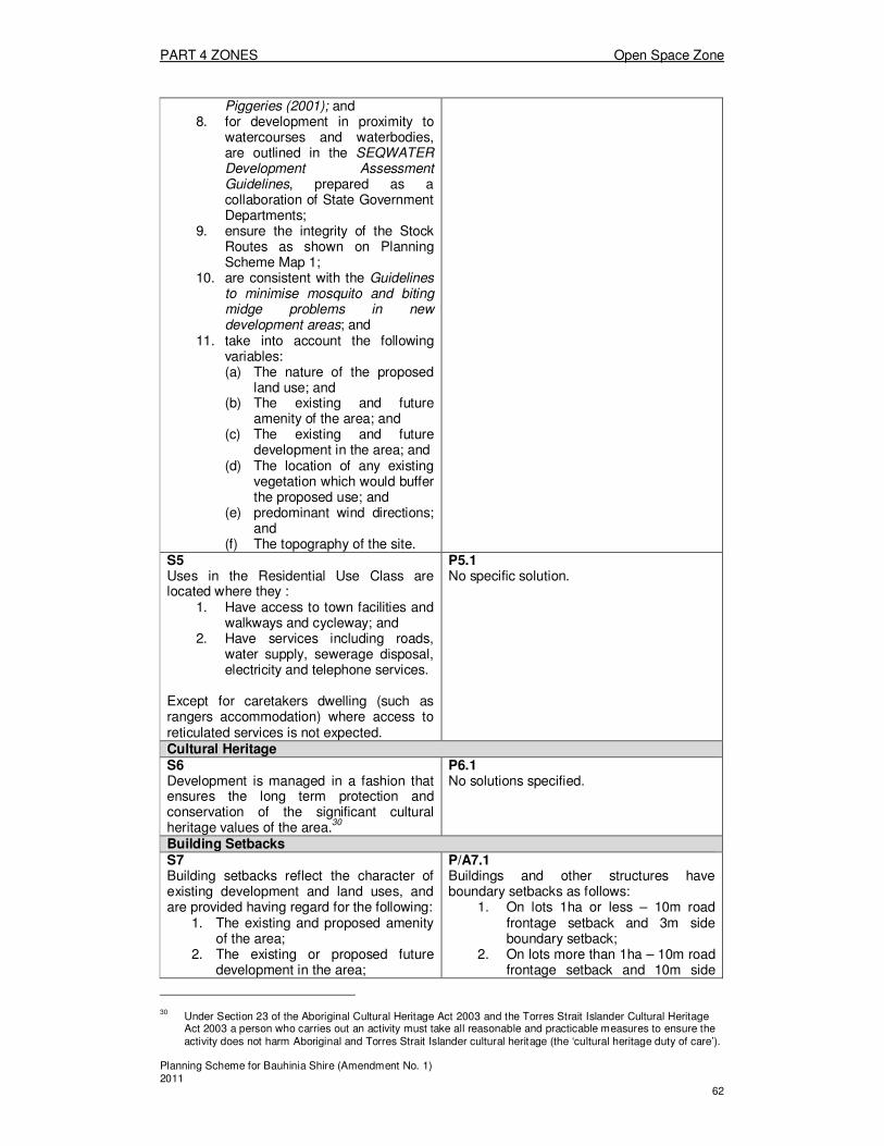
PART 4 ZONES Open Space Zone
Planning Scheme for Bauhinia Shire (Amendment No. 1) 2011 62
Piggeries (2001); and 8. for development in proximity to
watercourses and waterbodies, are outlined in the SEQWATER Development Assessment Guidelines, prepared as a collaboration of State Government Departments;
9. ensure the integrity of the Stock Routes as shown on Planning Scheme Map 1;
10. are consistent with the Guidelines to minimise mosquito and biting midge problems in new development areas; and
11. take into account the following variables: (a) The nature of the proposed
land use; and (b) The existing and future
amenity of the area; and (c) The existing and future
development in the area; and (d) The location of any existing
vegetation which would buffer the proposed use; and
(e) predominant wind directions; and
(f) The topography of the site. S5 Uses in the Residential Use Class are located where they :
1. Have access to town facilities and walkways and cycleway; and
2. Have services including roads, water supply, sewerage disposal, electricity and telephone services.
Except for caretakers dwelling (such as rangers accommodation) where access to reticulated services is not expected.
P5.1 No specific solution.
Cultural Heritage S6 Development is managed in a fashion that ensures the long term protection and conservation of the significant cultural heritage values of the area.
30
P6.1 No solutions specified.
Building Setbacks S7 Building setbacks reflect the character of existing development and land uses, and are provided having regard for the following:
1. The existing and proposed amenity of the area;
2. The existing or proposed future development in the area;
P/A7.1 Buildings and other structures have boundary setbacks as follows:
1. On lots 1ha or less – 10m road frontage setback and 3m side boundary setback;
2. On lots more than 1ha – 10m road frontage setback and 10m side
30 Under Section 23 of the Aboriginal Cultural Heritage Act 2003 and the Torres Strait Islander Cultural Heritage
Act 2003 a person who carries out an activity must take all reasonable and practicable measures to ensure the activity does not harm Aboriginal and Torres Strait Islander cultural heritage (the ‘cultural heritage duty of care’).

PART 4 ZONES Open Space Zone
Planning Scheme for Bauhinia Shire (Amendment No. 1) 2011 63
3. The distance between any constructed road and the proposed building;
4. The distance between any existing buildings on other sites and the proposed building;
5. The location of any existing vegetation which would buffer the proposed building; and
6. Any constraints to development due to the topography of the site.
boundary setbacks.
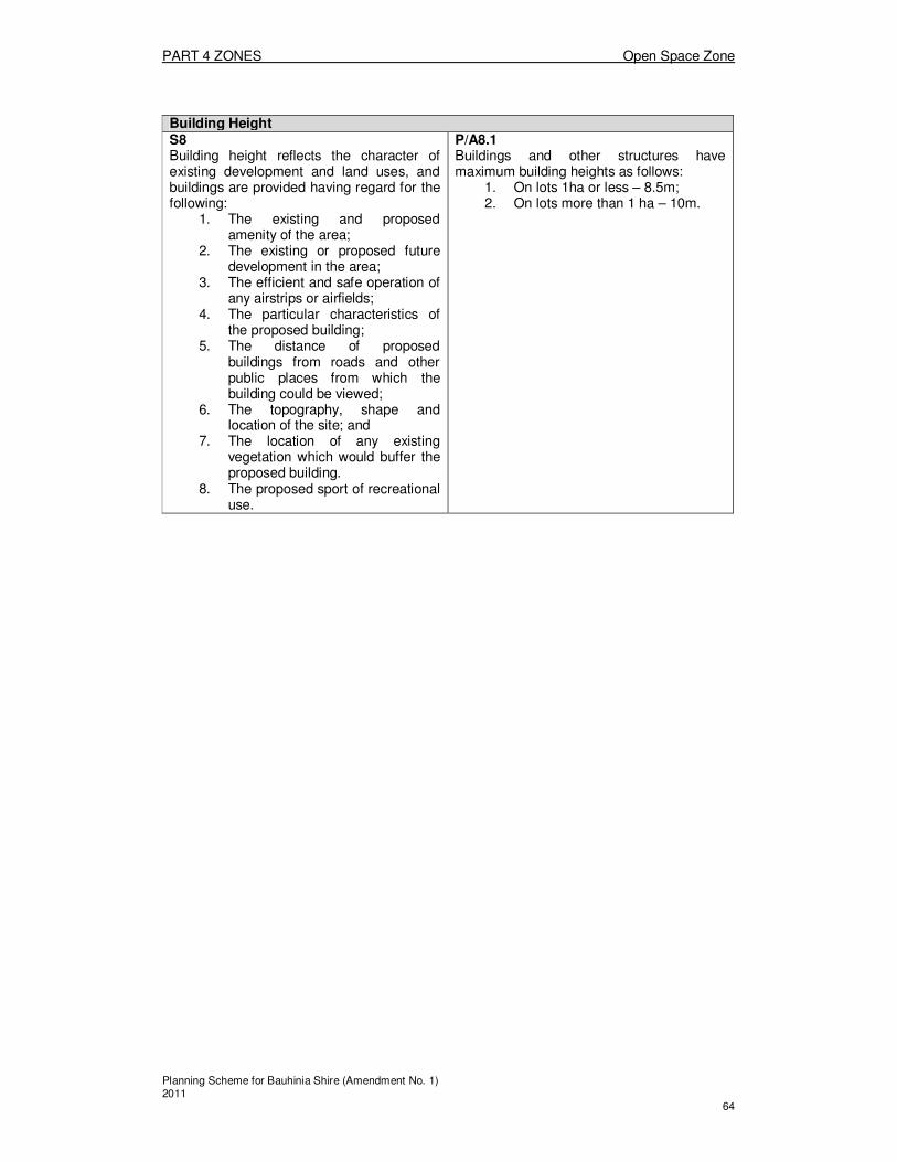
PART 4 ZONES Open Space Zone
Planning Scheme for Bauhinia Shire (Amendment No. 1) 2011 64
Building Height S8 Building height reflects the character of existing development and land uses, and buildings are provided having regard for the following:
1. The existing and proposed amenity of the area;
2. The existing or proposed future development in the area;
3. The efficient and safe operation of any airstrips or airfields;
4. The particular characteristics of the proposed building;
5. The distance of proposed buildings from roads and other public places from which the building could be viewed;
6. The topography, shape and location of the site; and
7. The location of any existing vegetation which would buffer the proposed building.
8. The proposed sport of recreational use.
P/A8.1 Buildings and other structures have maximum building heights as follows:
1. On lots 1ha or less – 8.5m; 2. On lots more than 1 ha – 10m.

PART 4 ZONES Open Space Zone
Planning Scheme for Bauhinia Shire (Amendment No. 1) 2011 65
Division 3: Schedule A – Preparation of Ecological Assessment Reports and Environmental Management Plans
Preparation of an Ecological Assessment Report
An Ecological Assessment Report is a tool used to provide detailed information about the proposal, the potential ecological impacts of the proposal and the measures proposed to avoid or minimise those potential adverse impacts. As a result each Ecological Assessment Report is specific to the individual proposal. Report format and content Where an Ecological Assessment Report is required to accompany the development application, the proponent is strongly encouraged to meet with Council Officers prior to lodgement of the application. This will assist in determining and clarifying the relevant items, identified below, to be addressed in the report. As a general guide the following format and contents description indicates the items required to be detailed: 1. Title and Address of Proposed Development 2. Qualifications of Author
The Ecological Assessment Report should be prepared by a suitably qualified person. References and experience of the author (such as other similar reports prepared by the consultant or consultants) should also be included.
3. State Interests
The report should include reference to any applicable State Planning Policies, and the report should address any rare, threatened or endangered species, areas of high nature conservation value or land vulnerable to land degradation.
4. Overview
The aim of the overview is to provide a clear and concise summary of what is discussed in the report, leaving the reader with a clear understanding of the reports detailed assessment of the proposals potential impacts and measures to minimise the potential adverse impacts. The following may assist in conveying this information. (a) Background and scope of proposal - summarise the proposed development
including the purpose and objectives, addressing the construction and operation of the project and associated infrastructure developments.
(b) Existing environment - summarise the features of the physical, biophysical and built environment relating to the proposed development and associated infrastructure.
(c) Potential impacts of the proposed development - summarise the main potential impacts of the project (direct, indirect and cumulative), both beneficial and detrimental, and any alternatives, on the existing environment.
(d) Impact monitoring, protection and management procedures - summarise the safeguards, standards and management procedures proposed to protect the environment, including environmental monitoring and the methods proposed to ameliorate or alleviate the potential impacts.
(e) Conclusions - summarise the key strategies and measures to the proposal to address any adverse environmental impacts.
5 Background and scope of proposal
(a) Outline in detail the purpose and objectives of the proposed development. (b) Discuss the following to illustrate the background of the proposal:
(i) The need for the proposed development or works (ii) The history of the proposal’s formulation (iii) Any alternatives considered and reasons for choosing the preferred option (iv) Action already taken to minimise potential adverse impacts
(c) Provide a description of the project, addressing: (i) The precise nature and scale of works (ii) The location and site requirements

PART 4 ZONES Open Space Zone
Planning Scheme for Bauhinia Shire (Amendment No. 1) 2011 66
(iii) The plant and/or building layout, size and design and the development staging program
(iv) The range and quantity of materials to be produced (v) The production process (vi) Possible waste discharges (vii) On-site works and operations (viii) Off-site works and operations (ix) Transport systems (x) Infrastructure requirements (water, sewerage, energy, waste disposal) (xi) The workforce (xii) Project life and time scale for completion (xiii) The possible future expansion of associated development/works
(d) Use of resources: - detail the implications of the proposal for the use of natural resources,
including the quantity and source of water, raw materials and energy to be used
6. Existing Environment
The existing environment of the site and surrounding areas should be described in sufficient detail to allow the ecological impacts of the proposal to be accurately and adequately assessed, and to provide a baseline against which predicted and future changes can be established. This section shall address features such as, the physical, biophysical and built environment relating to the proposed development and associated infrastructure. The following provides a comprehensive, but not exhaustive, list of elements, which may need to be discussed to enable an adequate assessment on potential ecological impacts. (a) Site and locality (b) Physical Features including:
(i) Landform, Geology and Geomorphology (ii) Hydrology (surface water and groundwater)
(c) Climate (d) Water Quality (e) Air quality (f) Noise environment (g) Ecological status/significance including:
(i) Types, structure and location of vegetation associations on the site and surrounding areas, including measures of foliage cover, health and natural regeneration;
(ii) Species of flora and fauna (aquatic and terrestrial, native and introduced), weed and pest species, including the location and abundance of each species, especially the presence of rare or endangered species;
(iii) Conservation significance – local, regional and national status; (iv) Special ecological values of the site such as refuge habitat, a breeding
habitat, a corridor for wildlife movement and use by migratory species (h) Social and Economic Characteristics, (i) Cultural heritage values of the site by undertaking the following:
(i) Aboriginal cultural heritage values of the site are protected by ensuring that development complies with cultural heritage duty of care guidelines gazetted under the Aboriginal Cultural Heritage Act 2003, or in accordance with an agreement with the Aboriginal party for the area or a cultural heritage management plan approved under Part 7 of the Aboriginal Cultural Heritage Act 2003; and
(ii) A cultural heritage survey, in consultation with relevant indigenous owners, by a cultural heritage practitioner under a permit issued by the Environmental Protection Agency.
(j) Landscape Character and Visual Amenity; (k) Infrastructure, addressing items such as:
(i) Transport; (ii) Water supply; (iii) Effluent Treatment and Disposal

PART 4 ZONES Open Space Zone
Planning Scheme for Bauhinia Shire (Amendment No. 1) 2011 67
(iv) Solid Waste (v) Power and Communications
7. Potential impacts of the development on the existing environment
Identify and detail the nature of any potential impacts of the development on the existing environment including joint resolution of conflicts between economic, social and environmental impacts. These may be adverse or beneficial, direct or indirect, short or long term or incremental and are to be considered for both the construction and operation phases of the development. Detail any irreversible commitment of resources that would be involved if the proposed development is implemented. Discussion on the potential impacts of the development on the existing environment should include potential impacts on: (a) Bio/Physical Features including:
(i) Geology and geomorphology (ii) Hydrology (surface and groundwater)
(b) Ecological status/significance (i) Air quality (ii) Water Quality (iii) Noise levels (iv) Infrastructure (v) Safety & Risk Assessment including: (vi) Potential events (vii) Safety program (viii) Native Vegetation
(c) Soil erosion and soil salinity (d) Fauna habitats and the introduction and spread of weeds.
8. Impact monitoring, protection, risk management and post development
management procedures An environmental management plan should be prepared for the development to outline measures to minimise impacts and monitor impacts of the proposal during construction, operation and decommissioning phases of the development. (refer to Section 3.0 of this policy for detail on an environmental management plan).
9. Consultation
The applicant/consultant should consult with relevant interest groups and parties likely to be affected by the proposal, and issues generated should be documented along with any proposed measures to address these issues.
10. References
(a) List other reference material and literature used (b) List authorities consulted and contributors to the report (c) Cross-reference the reference material in the text to allow easier access to
information 11. Appendices
(a) Include detailed technical information collected through the investigation, (b) Include relevant documents or correspondence from Government Authorities,
and (c) Monitoring programs.
Environmental Management Plans
An Environmental Management Plan (EMP) seeks to ensure that the potential impacts of development on the environment are adequately controlled. An EMP is a written description of what acceptable levels of environmental impact are intended to be achieved or maintained and how it is proposed to achieve or maintain them. This can include construction, operational and decommissioning stages of a development. EMP’s will vary for each site or location based on the different characteristics and issues for each proposal. The EMP allows
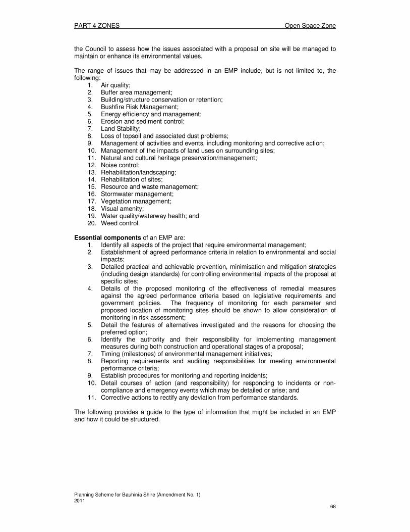
PART 4 ZONES Open Space Zone
Planning Scheme for Bauhinia Shire (Amendment No. 1) 2011 68
the Council to assess how the issues associated with a proposal on site will be managed to maintain or enhance its environmental values. The range of issues that may be addressed in an EMP include, but is not limited to, the following:
1. Air quality; 2. Buffer area management; 3. Building/structure conservation or retention; 4. Bushfire Risk Management; 5. Energy efficiency and management; 6. Erosion and sediment control; 7. Land Stability; 8. Loss of topsoil and associated dust problems; 9. Management of activities and events, including monitoring and corrective action; 10. Management of the impacts of land uses on surrounding sites; 11. Natural and cultural heritage preservation/management; 12. Noise control; 13. Rehabilitation/landscaping; 14. Rehabilitation of sites; 15. Resource and waste management; 16. Stormwater management; 17. Vegetation management; 18. Visual amenity; 19. Water quality/waterway health; and 20. Weed control.
Essential components of an EMP are:
1. Identify all aspects of the project that require environmental management; 2. Establishment of agreed performance criteria in relation to environmental and social
impacts; 3. Detailed practical and achievable prevention, minimisation and mitigation strategies
(including design standards) for controlling environmental impacts of the proposal at specific sites;
4. Details of the proposed monitoring of the effectiveness of remedial measures against the agreed performance criteria based on legislative requirements and government policies. The frequency of monitoring for each parameter and proposed location of monitoring sites should be shown to allow consideration of monitoring in risk assessment;
5. Detail the features of alternatives investigated and the reasons for choosing the preferred option;
6. Identify the authority and their responsibility for implementing management measures during both construction and operational stages of a proposal;
7. Timing (milestones) of environmental management initiatives; 8. Reporting requirements and auditing responsibilities for meeting environmental
performance criteria; 9. Establish procedures for monitoring and reporting incidents; 10. Detail courses of action (and responsibility) for responding to incidents or non-
compliance and emergency events which may be detailed or arise; and 11. Corrective actions to rectify any deviation from performance standards.
The following provides a guide to the type of information that might be included in an EMP and how it could be structured.

PART 4 ZONES Open Space Zone
Planning Scheme for Bauhinia Shire (Amendment No. 1) 2011 69
Suggested Environmental Management Plan Format
Introduction
� Description of the development proposal; � The need for the EMP in relation to the development; and � Structure and scope.
Aims of the EMP
� Provide a framework for practically addressing and monitoring the significant
environmental impacts of the proposal; � Compliance with legislative requirements and government policies; and � Evidence that the works and operations are being conducted in an environmentally
responsible manner.
Identification of Environmental Issues or Environmentally Impacting Activities and Associated Management Actions
For each issue or environmentally impacting activity outline the following: � Policy for addressing the issue/activity; � Performance criteria; � Implementation strategy; � Monitoring program; and � Details of how reporting will influence mitigation measures and how reporting is to take
place.
PART 4 ZONES Town Zone
Planning Scheme for Bauhinia Shire (Amendment No. 1) 2011 70
Division 3—Town Zone
About the Town Zone � The Town Zone, as mapped on Zoning Maps 2 & 3, reflects the towns of Springsure
and Rolleston, respectively. � The Town Zone contains a number of distinct sub areas, being the:
o Town – Commercial Precinct; o Town – Residential Precinct; o Town – Industrial Precinct; o Town – Light Industrial Precinct; o Town – Community Precinct; o Town – Utilities Precinct; o Town – Recreation Precinct; and o Town – Rural Residential Precinct o Town – Investigation Precinct Area
� Not all Precincts and Areas occur in each of the towns of Springsure and Rolleston. � The Town Zone Code regulates new uses and works in relation to their impacts on
the existing uses in the Precincts, their scale, design and location, and their compatibility with land in adjoining Precincts and Areas.
4.3.1 Assessment tables for the Town Zone
(1) Assessment categories for the Town Zone The assessment categories
31 are identified for development in the Town Zone in
Column 2 of Tables 4.3.1(1) and 4.3.1(2) as follows— (a) Table 4.3.1(1)—making a material change of use
32 for a defined use, or
another use in a defined use class, listed in Column 1; or (b) Table 4.3.1(2)—other development33 listed in Column 1, including—
(i) operational work, including but not limited to, filling and excavating, and the placing of advertising devices;
(ii) reconfiguring a lot; and (iii) carrying out operational work for reconfiguring a lot.
(2) Relevant assessment criteria for self assessable and assessable development in the Town Zone The relevant assessment criteria in the Town Zone are referred to in Column 3 of tables 4.3.1(1)and 4.3.1(2). For self-assessable development and development requiring code assessment, the relevant assessment criteria are applicable codes.
31 Information about assessment categories is provided in the Bauhinia Shire Planning Scheme User’s Guide 32
Works associated with an application for a material change of use may be assessed together with the material change of use. Also, see Bauhinia Shire Planning Scheme Explanatory Notes giving examples that explain the type of development involved in different proposals.
33 See Bauhinia Shire Planning Scheme Explanatory Notes giving examples that explain the type of development
involved in different proposals.

PART 4 ZONES Town Zone
Planning Scheme for Bauhinia Shire (Amendment No. 1) 2011 71
TABLE 4.3.1 (1)
ASSESSMENT CATEGORIES AND RELEVANT ASSESSMENT CRITERIA FOR THE TOWN ZONE – MAKING A MATERIAL CHANGE OF USE
Column 1
Defined use or use class
34 and 35
Column 2
Assessment category –
(where Self assessable development does not meet the Acceptable Solutions in
the applicable codes, it requires Code assessment.
Refer to Section 1.2.9),
Column 3
Relevant assessment criteria
36—
are the applicable codes for self assessable and code assessable development
Rural Use Class
All development within 50m of the Springsure Health Care Facility Museum and Rainworth Fort as shown on Map No. CONS 2 shall be subject to the Heritage Places Overlay
Agriculture Self assessable if in the Town – Rural Residential Precinct and in the Town - Investigation Area and on a lot over 2.5ha in area
Town Zone Code ;
Development Standards Code; and
Agricultural Use Code
Code assessable if in the Town –Rural Residential Precinct and the Town – Investigation Precinct Area.
Town Zone Code ;
Development Standards Code; and
Agricultural Use Code
Impact assessable if the circumstances for Self assessable do not apply
Animal Husbandry Exempt where conducted on a Stock Route.
Self assessable if in the Town – Rural Residential Precinct and in the Town – Investigation Area and on a lot over 2.5ha in area
Town Zone Code ;
Development Standards Code; and
Animals Code
Code assessable if in the Town –Rural Residential Precinct and the Town – Investigation Precinct Area.
Town Zone Code ;
Development Standards Code; and
Agricultural Use Code
Impact assessable if the circumstances for Exempt or Self assessable do not apply
Fossicking Exempt N/A
34 See schedule A (dictionary), Division 1 (defined uses and use classes).
35 Department of Main Roads should be contacted to consent to the access arrangements for any new use with a
frontage to a State Controlled Road. 36
For impact assessable development the ‘relevant assessment criteria’ are provided for assistance and in no way affect the regard given to the planning scheme as a whole in accordance with section 3.5.5 of the IPA.

PART 4 ZONES Town Zone
Planning Scheme for Bauhinia Shire (Amendment No. 1) 2011 72
TABLE 4.3.1 (1)
ASSESSMENT CATEGORIES AND RELEVANT ASSESSMENT CRITERIA FOR THE TOWN ZONE – MAKING A MATERIAL CHANGE OF USE
Column 1
Defined use or use class
34 and 35
Column 2
Assessment category –
(where Self assessable development does not meet the Acceptable Solutions in
the applicable codes, it requires Code assessment.
Refer to Section 1.2.9),
Column 3
Relevant assessment criteria
36—
are the applicable codes for self assessable and code assessable development
Roadside stall Self assessable where
1. the use area does not exceed 50m
2; and
2. In the Town – Rural Residential Precinct or Town – Investigation Area is located on a lot over 2.5ha in area; and
3. is not located in or within 5 metres of an electric line shadow.
Town Zone Code ; and
Development Standards Code
Impact assessable where the circumstances for Self assessable do not apply
All other uses in the Rural Use Class
Impact assessable
Residential Use Class
Caretaker’s residence Code assessable in the Town – Commercial Precinct, Town – Industrial Precinct or Town – Light Industrial Precinct.
Town Zone Code ; and
Development Standards Code
Impact assessable in all other Precincts
Dual occupancy Code assessable if located in Town – Residential Precinct and:
1. there is a maximum of 1 dual occupancy in every 4 lots on any street frontage; and
2. there are no more than half of the corner lots at any intersection being occupied by existing or approved dual occupancies; and
3. dual occupancies do not occur on consecutive lots; and
4. if the subject lot is over 1000m
2
Town Zone Code ;
Development Standards Code; and
Residential Accommodation Code.
Impact assessable where the circumstances for Code assessable do not apply

PART 4 ZONES Town Zone
Planning Scheme for Bauhinia Shire (Amendment No. 1) 2011 73
TABLE 4.3.1 (1)
ASSESSMENT CATEGORIES AND RELEVANT ASSESSMENT CRITERIA FOR THE TOWN ZONE – MAKING A MATERIAL CHANGE OF USE
Column 1
Defined use or use class
34 and 35
Column 2
Assessment category –
(where Self assessable development does not meet the Acceptable Solutions in
the applicable codes, it requires Code assessment.
Refer to Section 1.2.9),
Column 3
Relevant assessment criteria
36—
are the applicable codes for self assessable and code assessable development
House Self assessable if located in
1. The Town –Residential Precinct, or
2. Town – Rural Residential Precinct
3. Town – Investigation Precinct Area
Town Zone Code ;
Development Standards Code; and
House Code
Impact assessable in all other Precincts
All other uses in the Residential Use Class
Impact assessable
Commercial Use Class
Commercial premises;
Shop
Self assessable if:
1. Located in the Town – Commercial Precinct; and
2. Has a total use area less than 500m
2
Town Zone Code ;
Development Standards Code ; and
Commercial Development Code
Code assessable if:
1. Located in the Town – Commercial Precinct; and
2. Has a total use area of 500m
2 or more
Town Zone Code ; and
Development Standards Code; and
Commercial Development Code
Impact assessable if the circumstances for Self assessable or Code assessable do not apply
Food premises Self assessable if:
1. located in the Town – Commercial Precinct; and
2. the total use area does not exceed 200m2; and
3. there is no drive-through facility.
Town Zone Code ; and
Development Standards Code; and
Commercial Development Code

PART 4 ZONES Town Zone
Planning Scheme for Bauhinia Shire (Amendment No. 1) 2011 74
TABLE 4.3.1 (1)
ASSESSMENT CATEGORIES AND RELEVANT ASSESSMENT CRITERIA FOR THE TOWN ZONE – MAKING A MATERIAL CHANGE OF USE
Column 1
Defined use or use class
34 and 35
Column 2
Assessment category –
(where Self assessable development does not meet the Acceptable Solutions in
the applicable codes, it requires Code assessment.
Refer to Section 1.2.9),
Column 3
Relevant assessment criteria
36—
are the applicable codes for self assessable and code assessable development
Code assessable if:
1. Located in the Town – Light Industrial or Town – Industrial Precincts; and there is no drive-through facility;
OR
2. located in the Town – Commercial Precinct; and the total use area is 200m
2 or more; and
there is no drive-through facility.
Town Zone Code ;
Development Standards Code; and
Commercial Development Code
Impact assessable if the circumstances for Self assessable or Code assessable do not apply
Hotel Code assessable if located in the Town – Commercial Precinct.
Town Zone Code ;
Development Standards Code; and
Commercial Development Code
Impact assessable in all other Precincts
Indoor entertainment Code assessable if located in:
1. the Town – Commercial Precinct; or
2. the Town – Light Industrial Precinct
Town Zone Code ;
Development Standards Code; and
Commercial Development Code
Impact assessable in all other Precincts
Off street car park Code assessable if located in the:
1. Town – Commercial Precinct;
2. Town – Industrial Precinct;
3. Town – Light Industrial Precinct;
4. Town – Utilities Precinct; or
5. Town – Recreation Precinct
Town Zone Code ;
Development Standards Code; and
Commercial Development Code
Impact assessable in all other Precincts

PART 4 ZONES Town Zone
Planning Scheme for Bauhinia Shire (Amendment No. 1) 2011 75
TABLE 4.3.1 (1)
ASSESSMENT CATEGORIES AND RELEVANT ASSESSMENT CRITERIA FOR THE TOWN ZONE – MAKING A MATERIAL CHANGE OF USE
Column 1
Defined use or use class
34 and 35
Column 2
Assessment category –
(where Self assessable development does not meet the Acceptable Solutions in
the applicable codes, it requires Code assessment.
Refer to Section 1.2.9),
Column 3
Relevant assessment criteria
36—
are the applicable codes for self assessable and code assessable development
Outdoor entertainment Code assessable in the Town – Recreation Precinct
Town Zone Code ;
Development Standards Code; and
Commercial Development Code
Impact assessable in all other Precincts
Plant nursery Code assessable if located in the Town – Commercial Precinct and Town – Investigation Area
Town Zone Code ;
Development Standards Code; and
Commercial Development Code
Impact assessable in all other Precincts
Showroom;
Vehicle Showroom
Code assessable if located in the:
1. Town – Commercial Precinct; or
2. Town – Light Industrial Precinct
Town Zone Code ;
Development Standards Code; and
Commercial Development Code
Impact assessable if the criteria for Code assessable do not apply
All other uses in the Commercial Use Class
Impact assessable
Industrial Use Class
Bulk Store,
Landscape supplies;
Low impact industry
Vehicle depot; and
Warehouse
Self assessable in the Town – Light Industrial Precinct and Town – Industrial Precinct
Town Zone Code ; and
Development Standards Code
Impact assessable in all other Precincts
Medium impact industry Code assessable in the Town – Industrial Precinct
Town Zone Code ; and
Development Standards Code
Impact assessable in all other Precincts
All other uses in the Industrial Use Class
Impact assessable in all Precincts
Community Use Class
Community purposes
Self assessable
1. For Community purposes (Categories 1,3, 4, & 7) in the Town – Community Precinct;
Town Zone Code;
Development Standards Code

PART 4 ZONES Town Zone
Planning Scheme for Bauhinia Shire (Amendment No. 1) 2011 76
TABLE 4.3.1 (1)
ASSESSMENT CATEGORIES AND RELEVANT ASSESSMENT CRITERIA FOR THE TOWN ZONE – MAKING A MATERIAL CHANGE OF USE
Column 1
Defined use or use class
34 and 35
Column 2
Assessment category –
(where Self assessable development does not meet the Acceptable Solutions in
the applicable codes, it requires Code assessment.
Refer to Section 1.2.9),
Column 3
Relevant assessment criteria
36—
are the applicable codes for self assessable and code assessable development
Code assessable
1. For Community purposes (Categories 2 & 5) in the Town – Community Precinct; or
2. For Community purposes (Categories 1, 3, 4, and 5) in the Town – Commercial Precinct; or
3. For Community purposes (Category 3) in the Town – Recreation Precinct; or
4. For Community purposes (Category 1) in the Town – Light Industrial or Industrial Precinct.
Town Zone Code;
Development Standards Code
Impact assessable for all other Categories of the use in all other Precincts, not described for Self or Code assessable development
Open space Exempt N/A
Public facility - operational
Exempt N/A
All other uses in the Community Use Class
Impact assessable

PART 4 ZONES Town Zone
Planning Scheme for Bauhinia Shire (Amendment No. 1) 2011 77
TABLE 4.3.1 (2)
ASSESSMENT CATEGORIES AND RELEVANT ASSESSMENT CRITERIA FOR THE TOWN ZONE – OTHER DEVELOPMENT
Column 1
Type of development
Column 2
Assessment category –
(where Self assessable development does not meet the Acceptable Solutions in
the applicable codes, it requires Code assessment.
Refer to Section 1.2.9),
Column 3
Relevant assessment criteria
37—
are the applicable codes for self assessable and code assessable development
Operational work
Filling and excavating 38 Exempt where less than 1m depth and less than 50m
3
N/A
Self assessable where the circumstances for Exempt development are exceeded.
Town Zone Code;
Development Design Code
Work – Roads Code assessable Town Zone Code;
Development Design Code
Work – Car Parking and Access
Code assessable Town Zone Code;
Development Design Code
Work – Water and Sewer
Code assessable Town Zone Code;
Development Design Code
Work – Stormwater Drainage
Code assessable Town Zone Code;
Development Design Code
Work –Telecommunication Services
Code assessable Town Zone Code;
Development Design Code
Work – Footpaths and Cycleways
Code assessable Town Zone Code;
Development Design Code
Work – Park provision Code assessable Town Zone Code;
Development Design Code
Work – Street lighting and Street signs
Code assessable Town Zone Code;
Development Design Code
Work – Street trees Self assessable Town Zone Code;
Development Design Code
Work – Landscaping Self assessable Town Zone Code;
Development Design Code
Other Operational work associated with a Code or Impact assessable Material Change of Use (not including
Code assessable Town Zone Code;
Development Design Code
37 For impact assessable development the ‘relevant assessment criteria’ are provided for assistance and in no way
affect the regard given to the planning scheme as a whole in accordance with section 3.5.5 of the IPA. 38
If works do not allow the taking of interfering with water from a watercourse, lake or spring, a Riverine Protection
Permit under the Water Act 2000 is required from the Department of Natural Resources and Water for any destruction of vegetation, excavation or placing fill in a watercourse.
PART 4 ZONES Town Zone
Planning Scheme for Bauhinia Shire (Amendment No. 1) 2011 78
operational work associated with reconfiguring a lot)
Reconfiguring a lot39
All circumstances Code assessable:
1. where the size of any additional lots created is:
a) not more than 5% below,
b) equal to, or
c ) greater than,
the relevant specified minimum lot sizes in the Reconfiguring a Lot Code; OR
2. where no additional lots are created and the proposal is for the rearrangement of existing lot boundaries.
Town Zone Code;
Reconfiguring a Lot Code;
Development Standards Code; and
House Code.
Impact assessable where circumstances for Code assessable do not apply
Carrying out operational work for reconfiguring a lot
All circumstances Code assessable Town Zone Code;
Reconfiguring a Lot Code;
Development Design Code.
Other
Other Operational work (not including operational work associated with reconfiguring a lot)
Code assessable where associated with an assessable Material Change of Use
Town Zone Code; and
Development Standards Code
Exempt if the circumstances for Code assessable do not apply
39 Under IPA, schedule 8, part 3 the reconfiguring of a lot is exempt and cannot be made self-assessable or
assessable by a planning scheme if the proposal is for amalgamating 2 or more lots, for a building format plan that does not subdivide land, in relation to the Acquisition of Land Act 1967, or on Strategic Port Land.

PART 4 ZONES Town Zone
Planning Scheme for Bauhinia Shire (Amendment No. 1) 2011 79
4.3.2 Assessment criteria for the Town Zone
(1) Town Zone Code The provisions in this division comprise the Town Zone Code. They are— 1. The Purpose of the Town Zone Code – Section (2); and 2. The Specific Outcomes, Probable Solutions and Acceptable Solutions for the
Town Zone – Table 4.3.2. Town Zone. (2) The Purpose of the Town Zone Code
The purpose of the Town Zone Code is to achieve the following overall outcomes:
1. Springsure and Rolleston remain as the key service towns which serve the Shire; 2. Commercial, community and public uses are consolidated within, or immediately
adjoining Springsure and Rolleston, ensuring that they are easily identifiable and accessible community centres;
3. The Precincts each perform a different function within the Town Zone and represent distinct areas or groupings of compatible land uses;
4. The availability of land, the amenity, and the operational needs of different uses in each Precinct are not compromised by the inclusion or encroachment of inappropriate development;
5. Land on the boundaries of each of the Precincts is of a nature, design and appearance that respects the scale and nature of uses in the adjoining Precinct;
6. Land uses are located such that the potential impacts of noise from major roads is reduced;
7. The overall outcomes specific to each of the Precincts within the Town Zone listed below, are achieved; (a) The overall outcomes sought for the Town – Residential Precinct are:
(i) Land within the Precinct is predominantly used for uses in the Residential Use Class;
(ii) Land is generally provided with urban standard services; (iii) Development on land which is not intended to be provided with a
reticulated sewerage system, uses on-site effluent disposal systems which do not adversely impact on ground or surface water resources;
(iv) Uses that are not in the Residential Use Class such as churches, community facilities, and local recreation facilities are only located in the Precinct where such uses are of a scale, size, appearance and built form which is consistent with residential amenity of the area;
(v) Other uses not in the Residential Use Class are not generally located within the Precinct
(b) The overall outcomes sought for the Town – Rural Residential Precinct are: (i) Land is predominantly used for dwelling houses on small rural lots,
yet provided with all urban services; (ii) Low population densities in the Precinct mean that people enjoy a
rural lifestyle with accessibility to community facilities; (iii) The nature of the land within the Precinct is essentially residential
and therefore the size and scope of rural activities is limited; (iv) Uses such as animal husbandry, hobby farm cropping and
agriculture are of a scale that do not result in adverse impacts on residential amenity or the environment eg water quality;
(v) New rural residential development is located such that it represents an infill of existing available rural residential land, or is an extension of existing rural residential development;
(vi) The land in the Precinct is afforded an urban standard of road access and a reasonable level of flood immunity ;
(vii) Where reticulated water and sewerage is not available, new rural residential development has an adequate supply of potable water and water for emergency purposes, and sustainable means of
PART 4 ZONES Town Zone
Planning Scheme for Bauhinia Shire (Amendment No. 1) 2011 80
effluent disposal, which ensures that impacts on the ground and surface water resources are minimised;
(viii) The provision of parkland associated with new rural residential development coincides where possible with vegetation on the site to provide habitat corridors or linkages for recreational purposes;
(ix) Small scale commercial uses which provide otherwise unprovided essential day-to-day goods and services to the immediate rural residential community are located within the Precinct, where potential impacts on residential amenity due to traffic, noise, and the built environment are minimised;
(x) Commercial and industrial uses (except for those mentioned above) are not located on land within the Precinct.
(c) The overall outcomes sought for the Town – Commercial Precinct are:
(i) Land within the Precinct is predominantly used for commercial and business uses including shops, commercial premises, and hotels, concentrated within the major service towns of Springsure and Rolleston;
(ii) The uses within the Precinct afford the Shire a wide range of shopping, banking, office, medical and professional services;
(iii) Other commercial uses such as indoor entertainment and motels are located within the Precinct where they are compatible with other commercial uses in the locality;
(iv) The inclusion of industrial and land consumptive uses such as vehicle showrooms and low impact industries is minimised;
(v) New community facilities are consolidated around existing civic and community facilities;
(vi) Land is generally provided with urban standard services; (vii) Roads and parking areas are of an urban standard, allow for efficient
traffic movement and do not by their location or design compromise pedestrian movement in the Town.
(d) The overall outcomes sought for the Town – Industrial Precinct are:
(i) Land within the Precinct is predominantly used for medium and high impact industrial uses including manufacturing, processing, repairing, packing and storage, in locations where they can be effectively separated or buffered from incompatible land uses;
(ii) Uses defined as Low impact industrial uses, indoor and outdoor entertainment uses, showrooms and vehicle showrooms only locate in the Precinct where they cannot due to their size, scale or nature locate in the Town – Light Industrial Precinct.
(iii) New industrial development in the Shire locates in Springsure, or Rolleston, unless the industrial development requires larger sites out of the Town Zone.
(iv) Land is afforded good access to transport facilities, and is suited to building and vehicle requirements of preferred uses;
(v) Land is generally provided with urban standard services; (vi) Development provides for ample on site parking, and on site
manoeuvring and loading of heavy vehicles; and (vii) Other uses not in the Industrial Use Class such as service industries
and uses which directly serve employees of industrial uses eg food premises, are also located within the Precinct where such uses do not have significant impacts upon the operation or amenity of surrounding uses.
(e) The overall outcomes sought for the Town – Light Industrial Precinct are:
(i) Land within the Precinct is predominantly used for low and medium impact industrial uses including manufacturing, processing, repairing, packing and storage, in locations where they can be effectively separated or buffered from incompatible land uses;

PART 4 ZONES Town Zone
Planning Scheme for Bauhinia Shire (Amendment No. 1) 2011 81
(ii) Land is afforded good access to transport facilities, and is suited to building and vehicle requirements of preferred uses;
(iii) Land is generally provided with urban standard services; (iv) Development provides for ample on site parking, and on site
manoeuvring and loading of heavy vehicles; and (v) Other uses not in the Industrial Use Class such as service industries
and uses which directly serve employees of industrial uses eg food premises, showrooms and vehicle showrooms, indoor and outdoor entertainment uses are also located within the Precinct where such uses do not have significant impacts upon the operation or amenity of surrounding uses.
(f) The overall outcomes sought for the Town – Community Precinct are:
(i) Land within the Precinct is predominantly used for the provision of community purposes, including municipal services, education facilities, Health Care Facilities, meeting halls and places of worship;
(ii) Land tenure is predominantly, but not exclusively, crown land; (iii) The Community Uses found in the Precinct are protected from the
encroachment of incompatible uses and development that would restrict the potential expansion of the facilities;
(iv) Land is generally provided with urban standard services; (v) Development in the Precinct does not adversely impact on adjoining
residential areas; (vi) The inclusion of uses in the Commercial and Industrial Use Classes
is minimised; as they are generally not compatible with the uses in the Precinct.
(g) The overall outcomes sought for the Town – Utilities Precinct are:
(i) Land within the Precinct is predominantly used for the provision of utilities such as treatment plants, Council depots, telecommunication facilities, refuse sites and the like;
(ii) Land tenure is predominantly, but not exclusively, crown land; (iii) Land is generally provided with urban standard services; (iv) Development in the Precinct does not adversely impact on adjoining
residential areas; (v) The inclusion of uses in the Residential and Commercial Use
Classes is minimised; as they are generally not compatible with the uses in the Precinct.
(h) The overall outcomes sought for the Town – Recreation Precinct are:
(i) Land within the Precinct is predominantly used for the provision of public parks, open space, and outdoor entertainment uses including local sporting facilities and venues;
(ii) Land within the Precinct is located in close proximity to residential areas to ensure that the facilities are accessible to the residents they serve;
(iii) Areas of open space and natural habitats within the Precinct are provided such that they form linkages with other open space areas either in the Open Space Zone;
(iv) Land within the Precinct acts as a buffer between incompatible land uses where necessary;
(v) New development is located adjacent to other existing sporting facilities and open space areas to consolidate access points and to promote pedestrian and cycling linkages through the Precinct and between adjoining Precincts;
(vi) The inclusion of uses in the Commercial (other than food premises and outdoor entertainment) and Industrial Use Classes is minimised; as they are generally not compatible with the uses in the Precinct.

PART 4 ZONES Town Zone
Planning Scheme for Bauhinia Shire (Amendment No. 1) 2011 82
(i) The overall outcomes sought for the Town – Investigation Precinct Area are:
(i) Land is for the expansion of the Springsure township subject to
adequate proof of immediate need and commitment to early development as well as consideration of matters listed under Division 13 Schedule A – Reconfiguring a Lot.
(ii) Land is planned and assessed on the basis of a Master Plan as set out at Part 6, Division 13, Schedule A of this document. The Master Plan also addresses efficient lot layout, access, amenity, buffer, environmental and service issues.

PART 4 ZONES Town Zone
Planning Scheme for Bauhinia Shire (Amendment No. 1) 2011 83
TABLE 4.3.2 TOWN ZONE
Specific outcomes (S) for Code and Impact assessable development
Probable Solutions (P) for Code and Impact assessable development;
and
Acceptable Solutions (A) for Self assessable development (where Self assessable development does not meet the Acceptable Solutions in the applicable codes, it requires Code assessment. Refer to Section 1.2.9).
All Uses and Works
Environmental Considerations S1 Land uses and works are located and designed so as not to have significant negative impacts on natural values of the environment including:
1. Natural fauna and flora habitats; 2. Water quality, watercourse integrity
and, ground water resources, 3. Soil and land resources; and 4. Natural landscape features which:
(a) contribute to the diversity of recreation settings; and
(b) provide linkages between open space areas or corridors for path networks.
P/A1.1 All uses and works are setback a minimum of 50m from any watercourse, as measured to the top of bank
40.
P/A1.2 Where the site and any newly created lots are not connected to the reticulated sewerage system, on-site disposal methods meet:
1. The Department of Natural Resources and Water On-site Sewerage Code (July 2002) or any subsequent update of that Code; and
2. AS/NZS 1547:2000 On-site Domestic Wastewater Management.
P/A1.3 Land is kept free of declared weeds and noxious plant infestations, as detailed in the Bauhinia Shire Council Pest Management Plan.
Amenity S2 Land uses and works have no significant impact on the amenity of adjoining premises or surrounding area:
1. By their design, orientation or construction materials;
2. Due to the operation of machinery or electrical equipment; or
3. Due to the emission of light, noise, vibration, odour, fumes, smoke, vapour, steam, soot, ash, grit, oil, dust, waste water, waste products, or electrical interference.
P2.1 In partial solution of S2, specifically in relation to acoustic amenity near State controlled road, development of:
1. Residential (whether for temporary or permanent occupancy) habitable floors meets the following criteria:
a. 60dB(A) L10 (18 hour) or less, where existing levels measured at the deemed to comply building setback distance from the road are greater than 40dB(A) L90
40 Clearing of any mapped native vegetation (as defined in Schedule 8 of the Integrated Planning Act 1997 and
Schedule 2 of the Integrated Planning Regulations 1998) will require application to the Department of Natural Resources and Water (on IDAS Form 1 Part J).

PART 4 ZONES Town Zone
Planning Scheme for Bauhinia Shire (Amendment No. 1) 2011 84
and noise sensitive uses adjacent to a State controlled road must seek to achieve appropriate acoustic amenity, and noise sensitive development within 100 metres of the railway corridor is sited and designed to reduce the impact of rail noise Note: Trees are to be maintained and are not to cause a threat to the pubic safety. The line of sight is not to be impeded by vegetation whilst accessing or egression of the site.
(8 hour) between 10:00p.m. and 6:00a.m.; or
b. 57dB(A) L10 (18 hour) or less, where existing levels measured at the local government deemed to comply dwelling setback distance are less than or equal to 40dB(A) L90 (8hour) between 10:00p.m. and 6:00a.m.
NOTE: where criteria in 1a and 1b cannot be met, internal maximum design criterion levels specified in Table 1, AS2107-1987 are acceptable
2. Balconies and formal external open space meet the following criteria:
a. 60dB(A) L10 (18 hour) or less, where existing levels measured at the deemed to comply dwelling setback distance are greater than 45dB(A) L90 (18 hour); or
b. 57 dB(A) L10 (18 hour) or less, where existing levels measured at the deemed to comply dwelling setback distance are less than or equal to 45dB(A) L90 (18 hour).
3. Educational, community and health buildings, parks, outdoor educational and recreational areas and open space meet 63dB(A) 10 (12 hour) or less.
“Formal external open space is the private or communal recreational area of a development “required” by this planning scheme. P2.2 Bedroom and living areas in residential uses and noise sensitive areas in non-residential uses are sited and designed to reduce the impact of rail noise by:
1. Siting noise affected areas as far away as practible from the railway corridor noise source; or
2. Using roof and wall insulation, mechanical ventilation, thickened glass, double glazing of windows and doors; or
3. Orienting openings (for example, windows and doors) away from the rail corridor noise source; or

PART 4 ZONES Town Zone
Planning Scheme for Bauhinia Shire (Amendment No. 1) 2011 85
4. Incorporating noise attenuation barriers such as earth mounds, landscaping and fences or walls without gaps between the noise source and the use
Separation Distances S3 Land uses and works are located, and include mitigation measures within the subject land that:
1. Are sufficient to protect the amenity of the area;
2. Are sufficient to protect the capacity for existing and approved uses to continue to operate; and
3. Are sufficient to protect the opportunities for existing and approved uses to expand in appropriately allocated /zoned land; and
4. For agricultural uses, are consistent with the Planning Guidelines: Separating Agricultural and Residential Land Uses DNR and DLGP, 1997;and
5. for the keeping of cattle, are outlined in Section 4 of the DPI Reference Manual for the Establishment and Operation of Beef Cattle Feedlots in Queensland, 2000; and
6. for the keeping of poultry, are outlined in the Guidelines for Poultry Farming in Queensland;
7. for the keeping of pigs, are outlined in the Separation Guidelines for Queensland Piggeries (2001); and
8. for development in proximity to watercourses and waterbodies, are outlined in the SEQWATER Development Assessment Guidelines, prepared as a collaboration of State Government Departments;
9. ensure the integrity of the Stock Routes as shown on Planning Scheme Map 1;
10. are consistent with the Guidelines to minimise mosquito and biting midge problems in new development areas; and
11. take into account the following variables: (a) The nature of the proposed
land use; and (b) The existing and future amenity
of the area; and (c) The existing and future
development in the area; and
P/A3.1 Uses in the Residential Use Class, except for houses, home host accommodation and home based businesses on lots with an area of 5ha or less, have separation distances between uses in the Residential Use Class and other uses, applicable to both existing and approved uses, in accordance with Division 1: Schedule A – Separation Distances Between Uses in the Residential Use Class and Other Uses. P/A3.2 Development is not located on a Stock Route as shown on Planning Scheme Map 1 contained in Appendix 3. P/A3.3 Unless separation distances are otherwise provided in accordance with P/A3.1 above, the following is provided: Anywhere in the Town Zone
1. Uses in the Residential Use Class have minimum setbacks of 3m to any Non-Residential Use which exists on adjoining land.
2. Uses that are not in the Residential Use Class on sites adjoining the Town – Residential Precinct are setback a minimum of 3 m to any boundary shared with that adjoining land.
3. Uses that are not in the Residential Use Class on sites adjoining the Town – Residential Precinct or Open Space Zone have a minimum landscaped setback of 5m.
Town – Commercial Precinct
1. Uses in the Residential Use Class have minimum setbacks of: (a) 3m to adjoining land included
in the Town – Light Industrial Precinct;
(b) 5m to adjoining land included in the Town – Industrial Precinct.
2. Uses in the Commercial and Industrial Use Class and Community Purpose – other uses have:

PART 4 ZONES Town Zone
Planning Scheme for Bauhinia Shire (Amendment No. 1) 2011 86
(d) The location of any existing vegetation which would buffer the proposed use; and
(e) predominant wind directions; and
(f) The topography of the site.
(a) minimum setbacks of 2m to any use in the Residential Use Class which exists on adjoining land;
(b) a solid fence with a minimum height of 1.8m on the shared boundary with an adjoining use in the Residential Use Class, which screens any buildings, parking and access areas; and
(c) refuse bin enclosures or refuse storage areas setback at least 3m from the shared boundary with an adjoining use in the Residential Use Class.
Town – Residential Precinct A part solution is that uses that are not in the Residential Use Class have minimum setbacks of 6 m, or half the height of such building whichever is the greater, to any boundary of the site.
Non Residential uses in the Town – Residential Precinct S4 Development is of a scale and nature that does not compromise residential amenity.
P4.1 Food Premises, Community purposes uses for Educational establishments, Commercial premises including Health centres, and Accommodation Buildings occur only:
1. in a building or on land that was previously lawfully used for a use that is not in the Residential Use Class;
2. on land within or adjoining a business area;
3. on land having frontage to a main or principal road; and
4. in a location that would not adversely affect residential amenity.
Built Form, Layout and Streetscape S5 Development is designed and constructed such that it is in keeping with the existing character of the town, and having regard to the following:
1. The location, scale, height and bulk of buildings on adjoining premises and in the surrounding area;
2. The type of building materials used in the construction of buildings on adjoining premises and in the surrounding area;
3. The location of car parking on sites in the vicinity; and
4. The location of any vegetation or street trees that contribute to the streetscape.
Town – Commercial Precinct P/A5.1 Commercial uses are developed in accordance with the Commercial Code. P/A5.3 Buildings have a total site cover not exceeding 80%.

PART 4 ZONES Town Zone
Planning Scheme for Bauhinia Shire (Amendment No. 1) 2011 87
Building Setbacks S6 Building setbacks reflect the character of existing development and land uses, and are provided having regard for the following:
1. The existing and proposed amenity of the area;
2. The existing or proposed future development in the area;
3. The distance between any constructed road and the proposed building;
4. The distance between any existing buildings on other sites and the proposed building;
5. The location of any existing vegetation which would buffer the proposed building; and
6. Any constraints to development due to the topography of the site.
P/A6.1 Buildings and other structures have boundary setbacks as follows:
1. Town – Commercial Precinct (a) setbacks of between 0m and
6m to any road frontage, provided that for Uses in the Commercial Use Class the road frontage setback is within 2m of the road frontage setback of any commercial buildings on adjoining land; and
(b) Minimum building setbacks of 6m to the rear boundary.
2. Town – Residential Precinct (a) Minimum setbacks of 6m to
the road frontage; and (b) Minimum setbacks of 4.5m to
any secondary road frontage. 3. Town – Rural Residential Precinct
and the Town – Investigation Area (a) Minimum setbacks of 6m to
the road frontage; and (b) Minimum setbacks of 3m to
side boundaries. 4. Town – Industrial Precinct, Town –
Light Industrial Precinct, Town – Community Precinct, Town – Recreation Precinct and Town – Utilities Precinct (a) minimum setbacks of 6m to
the road frontage; (b) no specified setbacks for
other boundaries.
Building Height S9 Building height reflects the character of existing development and land uses, and buildings are provided having regard for the following:
1. The existing and proposed amenity of the area;
2. The existing or proposed future development in the area;
3. The efficient and safe operation of any airstrips or airfields;
4. The particular characteristics of the proposed building;
5. The distance of proposed buildings from roads and other public places from which the building could be viewed;
6. The topography, shape and location of the site; and
7. The location of any existing vegetation which would buffer the proposed building.
P/A9.1 Buildings and other structures have maximum building heights as follows:
1. Town – Commercial Precinct – 12m
2. Town – Residential Precinct - 8.5m
3. Town – Rural Residential Precinct – 8.5m
4. Town – Industrial Precinct – 15m 5. Town – Light Industrial Precinct –
8.5m 6. Town – Utilities Precinct – 12m 7. Town – Community Precinct –
12m 8. Town – Recreation Precinct –
12.5m 9. Town – Investigation Precinct
Area – 8.5m
PART 4 ZONES Town Zone
Planning Scheme for Bauhinia Shire (Amendment No. 1) 2011 88
8. The proposed sport of recreational use.
Cultural Heritage S10 Development is managed in a fashion that ensures the long term protection and conservation of the significant cultural heritage values of the area.41
P10.1 No Solutions Specified
41 Under Section 23 of the Aboriginal Cultural Heritage Act 2003 and the Torres Strait Islander Cultural Heritage
Act 2003 a person who carries out an activity must take all reasonable and practicable measures to ensure the activity does not harm Aboriginal and Torres Strait Islander cultural heritage (the ‘cultural heritage duty of care’).

PART 5 OVERLAYS Natural Features and Conservation Overlays
Planning Scheme for Bauhinia Shire (Amendment No. 1) 2011 89
PART 5—OVERLAYS
Division 1—Natural Features and Conservation Overlays
About the Natural Features and Conservation Overlays � The Natural Features and Conservation Overlays comprise the following:
o The Water Catchment Overlay o The Heritage Places Overlay;
� The Catchment Overlay regulates development which is in the declared Bauhinia Catchment Area, as defined by the Water Act 2000 and the Water Regulation 2002, as shown by CONS-1, and as listed in Planning Policy No:1 Legal Descriptions of Land Affected by Overlays. The Catchment Overlay also regulates development on land adjacent to the Comet River.
� The Heritage Places Overlay regulates development which occurs on the site of, or on land immediately adjacent to sites contained on the Queensland Heritage Register, as shown by CONS 2, and as and as listed in Planning Policy No. 1: Legal Description of Land Affected by Overlays
5.1.1 Assessment tables for the Natural Features and Conservation Overlays
(1) Assessment categories for the Natural Features and Conservation Overlays The assessment categories
42 are identified for development in the Natural Features
and Conservation Overlays in Column 2 of Tables 5.1.1(1) and 5.1.1(2) as follows— (a) Table 5.1.1(1)—making a material change of use
43 for a defined use, or
another use in a defined use class, listed in Column 1; or (b) Table 5.1.1(2)—other development
44 listed in Column 1, including—
(i) operational work, including but not limited to, filling and excavating, and the placing of advertising devices;
(ii) reconfiguring a lot; (iii) carrying out operational work for reconfiguring a lot.
(2) Relevant assessment criteria for self assessable and assessable development
in the Natural Features and Conservation Overlays The relevant assessment criteria in the Natural Features and Conservation Overlays are referred to in Column 3 of Tables 5.1.1(1) and 5.1.1(2). For self-assessable development and development requiring code assessment, the relevant assessment criteria are applicable codes.
42 Information about assessment categories is provided in the Bauhinia Shire Planning Scheme User’s Guide 43
Works associated with an application for a material change of use may be assessed together with the material change of use. Also, see Bauhinia Shire Planning Scheme Explanatory Notes giving examples that explain the type of development involved in different proposals.
44 See Bauhinia Shire Planning Scheme Explanatory Notes giving examples that explain the type of development
involved in different proposals.

PART 5 OVERLAYS Natural Features and Conservation Overlays
Planning Scheme for Bauhinia Shire (Amendment No. 1) 2011 90
TABLE 5.1.1 (1)
ASSESSMENT CATEGORIES AND RELEVANT ASSESSMENT CRITERIA FOR THE NATURAL FEATURES AND CONSERVATION OVERLAYS – MAKING A MATERIAL
CHANGE OF USE
Column 1
Defined use or use class
45
Column 2
Assessment category –
(where Self assessable development does not meet the Acceptable Solutions in
the applicable codes, it requires Code assessment.
Refer to Section 1.2.9),
Column 3
Relevant assessment criteria
46—
are the applicable codes for self assessable and code assessable development
Water Catchment Overlay - applying to the Fairbairn Dam Declared Catchment Area only.
Rural Use Class
Agriculture;
Animal Husbandry; and
Roadside stall
Fossicking
Exempt N/A
Stock saleyard
Code assessable Natural Features and Conservation Overlays Code – Catchment Overlay
All other uses in the Rural Use Class
Impact assessable
Residential Use Class
House
Home host accommodation;
Rural Dwelling
Code assessable where the use requires the establishment or expansion of an on-site waste disposal system within the Fairbairn Dam Declared Catchment Area
Natural Features and Conservation Overlays Code – Catchment Overlay
All other uses in the Residential Use Class
Impact assessable
Commercial Use Class
Off street car park; and
Outdoor entertainment
Plant Nursery
Caravan Park
Code assessable Natural Features and Conservation Overlays Code – Catchment Overlay
45 See schedule A (dictionary), Division 1 (defined uses and use classes).
46 For impact assessable development the ‘relevant assessment criteria’ are provided for assistance and in no way
affect the regard given to the planning scheme as a whole in accordance with section 3.5.5 of the IPA.

PART 5 OVERLAYS Natural Features and Conservation Overlays
Planning Scheme for Bauhinia Shire (Amendment No. 1) 2011 91
TABLE 5.1.1 (1)
ASSESSMENT CATEGORIES AND RELEVANT ASSESSMENT CRITERIA FOR THE NATURAL FEATURES AND CONSERVATION OVERLAYS – MAKING A MATERIAL
CHANGE OF USE
Column 1
Defined use or use class
45
Column 2
Assessment category –
(where Self assessable development does not meet the Acceptable Solutions in
the applicable codes, it requires Code assessment.
Refer to Section 1.2.9),
Column 3
Relevant assessment criteria
46—
are the applicable codes for self assessable and code assessable development
Food Premises
Shop
All other uses in the Commercial Use Class
Impact assessable
Industrial Use Class
Bulk store;
Landscape supplies;
Low impact industry;
Transport terminal;
Vehicle depot; and
Warehouse
Code assessable Natural Features and Conservation Overlays Code – Catchment Overlay
All other uses in the Industrial Use Class
Impact assessable
Community Use Class
Open space ;
Public facility – operational
Exempt except where the use does not requires the establishment or expansion of an on-site waste disposal system within the Fairbairn Dam Declared Catchment Area
N/A
Code assessable where the use requires the establishment or expansion of an on-site waste disposal system within the Fairbairn Dam Declared Catchment Area
Natural Features and Conservation Overlays Code – Catchment Overlay
All other uses in the Community Use Class
Code assessable Natural Features and Conservation Overlays Code – Catchment Overlay
Heritage Places Overlay
Rural Use Class
All uses in the Rural Use Class
Code assessable Natural Features and Conservation Overlays Code – Heritage Places Overlay
Residential Use Class
All uses in the Code assessable Natural Features and Conservation

PART 5 OVERLAYS Natural Features and Conservation Overlays
Planning Scheme for Bauhinia Shire (Amendment No. 1) 2011 92
TABLE 5.1.1 (1)
ASSESSMENT CATEGORIES AND RELEVANT ASSESSMENT CRITERIA FOR THE NATURAL FEATURES AND CONSERVATION OVERLAYS – MAKING A MATERIAL
CHANGE OF USE
Column 1
Defined use or use class
45
Column 2
Assessment category –
(where Self assessable development does not meet the Acceptable Solutions in
the applicable codes, it requires Code assessment.
Refer to Section 1.2.9),
Column 3
Relevant assessment criteria
46—
are the applicable codes for self assessable and code assessable development
Residential Use Class Overlays Code – Heritage Places Overlay
Commercial Use Class
All uses in the Commercial Use Class
Code assessable Natural Features and Conservation Overlays Code – Heritage Places Overlay
Industrial Use Class
All uses in the Industrial Use Class
Code assessable Natural Features and Conservation Overlays Code – Heritage Places Overlay
Community Use Class
Open space; and
Public facility -operational
Exempt N/A
All other uses in the Community Use Class
Code assessable Natural Features and Conservation Overlays Code – Heritage Places Overlay
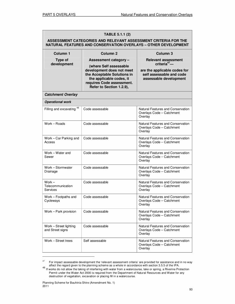
PART 5 OVERLAYS Natural Features and Conservation Overlays
Planning Scheme for Bauhinia Shire (Amendment No. 1) 2011 93
TABLE 5.1.1 (2)
ASSESSMENT CATEGORIES AND RELEVANT ASSESSMENT CRITERIA FOR THE NATURAL FEATURES AND CONSERVATION OVERLAYS – OTHER DEVELOPMENT
Column 1
Type of development
Column 2
Assessment category –
(where Self assessable development does not meet the Acceptable Solutions in
the applicable codes, it requires Code assessment.
Refer to Section 1.2.9),
Column 3
Relevant assessment criteria
47—
are the applicable codes for self assessable and code assessable development
Catchment Overlay
Operational work
Filling and excavating 48
Code assessable Natural Features and Conservation Overlays Code – Catchment Overlay
Work – Roads Code assessable Natural Features and Conservation Overlays Code – Catchment Overlay
Work – Car Parking and Access
Code assessable Natural Features and Conservation Overlays Code – Catchment Overlay
Work – Water and Sewer
Code assessable Natural Features and Conservation Overlays Code – Catchment Overlay
Work – Stormwater Drainage
Code assessable Natural Features and Conservation Overlays Code – Catchment Overlay
Work –Telecommunication Services
Code assessable Natural Features and Conservation Overlays Code – Catchment Overlay
Work – Footpaths and Cycleways
Code assessable Natural Features and Conservation Overlays Code – Catchment Overlay
Work – Park provision Code assessable Natural Features and Conservation Overlays Code – Catchment Overlay
Work – Street lighting and Street signs
Code assessable Natural Features and Conservation Overlays Code – Catchment Overlay
Work – Street trees Self assessable Natural Features and Conservation Overlays Code – Catchment Overlay
47 For impact assessable development the ‘relevant assessment criteria’ are provided for assistance and in no way
affect the regard given to the planning scheme as a whole in accordance with section 3.5.5 of the IPA. 48
If works do not allow the taking of interfering with water from a watercourse, lake or spring, a Riverine Protection
Permit under the Water Act 2000 is required from the Department of Natural Resources and Water for any destruction of vegetation, excavation or placing fill in a watercourse.
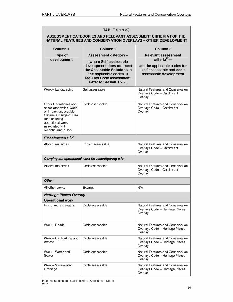
PART 5 OVERLAYS Natural Features and Conservation Overlays
Planning Scheme for Bauhinia Shire (Amendment No. 1) 2011 94
TABLE 5.1.1 (2)
ASSESSMENT CATEGORIES AND RELEVANT ASSESSMENT CRITERIA FOR THE NATURAL FEATURES AND CONSERVATION OVERLAYS – OTHER DEVELOPMENT
Column 1
Type of development
Column 2
Assessment category –
(where Self assessable development does not meet the Acceptable Solutions in
the applicable codes, it requires Code assessment.
Refer to Section 1.2.9),
Column 3
Relevant assessment criteria
47—
are the applicable codes for self assessable and code assessable development
Work – Landscaping Self assessable Natural Features and Conservation Overlays Code – Catchment Overlay
Other Operational work associated with a Code or Impact assessable Material Change of Use (not including operational work associated with reconfiguring a lot)
Code assessable Natural Features and Conservation Overlays Code – Catchment Overlay
Reconfiguring a lot
All circumstances Impact assessable Natural Features and Conservation Overlays Code – Catchment Overlay
Carrying out operational work for reconfiguring a lot
All circumstances Code assessable Natural Features and Conservation Overlays Code – Catchment Overlay
Other
All other works Exempt N/A
Heritage Places Overlay
Operational work
Filling and excavating Code assessable Natural Features and Conservation Overlays Code – Heritage Places Overlay
Work – Roads Code assessable Natural Features and Conservation Overlays Code – Heritage Places Overlay
Work – Car Parking and Access
Code assessable Natural Features and Conservation Overlays Code – Heritage Places Overlay
Work – Water and Sewer
Code assessable Natural Features and Conservation Overlays Code – Heritage Places Overlay
Work – Stormwater Drainage
Code assessable Natural Features and Conservation Overlays Code – Heritage Places Overlay
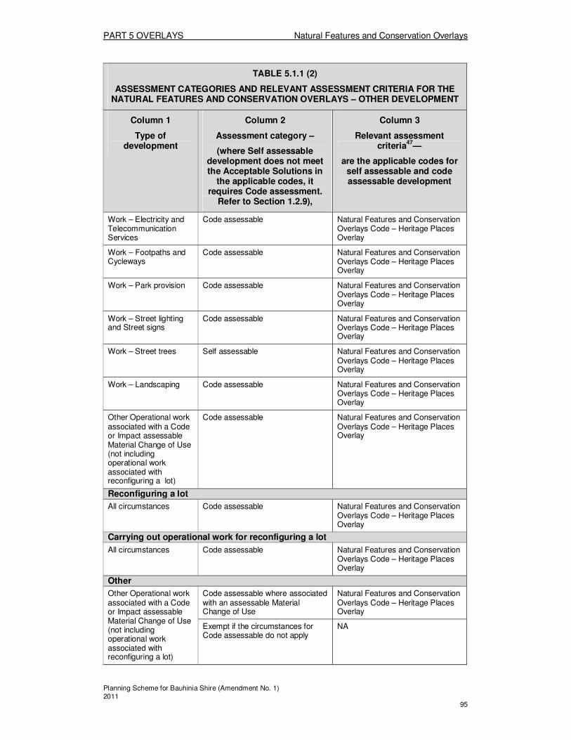
PART 5 OVERLAYS Natural Features and Conservation Overlays
Planning Scheme for Bauhinia Shire (Amendment No. 1) 2011 95
TABLE 5.1.1 (2)
ASSESSMENT CATEGORIES AND RELEVANT ASSESSMENT CRITERIA FOR THE NATURAL FEATURES AND CONSERVATION OVERLAYS – OTHER DEVELOPMENT
Column 1
Type of development
Column 2
Assessment category –
(where Self assessable development does not meet the Acceptable Solutions in
the applicable codes, it requires Code assessment.
Refer to Section 1.2.9),
Column 3
Relevant assessment criteria
47—
are the applicable codes for self assessable and code assessable development
Work – Electricity and Telecommunication Services
Code assessable Natural Features and Conservation Overlays Code – Heritage Places Overlay
Work – Footpaths and Cycleways
Code assessable Natural Features and Conservation Overlays Code – Heritage Places Overlay
Work – Park provision Code assessable Natural Features and Conservation Overlays Code – Heritage Places Overlay
Work – Street lighting and Street signs
Code assessable Natural Features and Conservation Overlays Code – Heritage Places Overlay
Work – Street trees Self assessable Natural Features and Conservation Overlays Code – Heritage Places Overlay
Work – Landscaping Code assessable Natural Features and Conservation Overlays Code – Heritage Places Overlay
Other Operational work associated with a Code or Impact assessable Material Change of Use (not including operational work associated with reconfiguring a lot)
Code assessable Natural Features and Conservation Overlays Code – Heritage Places Overlay
Reconfiguring a lot
All circumstances Code assessable Natural Features and Conservation Overlays Code – Heritage Places Overlay
Carrying out operational work for reconfiguring a lot
All circumstances Code assessable Natural Features and Conservation Overlays Code – Heritage Places Overlay
Other
Other Operational work associated with a Code or Impact assessable Material Change of Use (not including operational work associated with reconfiguring a lot)
Code assessable where associated with an assessable Material Change of Use
Natural Features and Conservation Overlays Code – Heritage Places Overlay
Exempt if the circumstances for Code assessable do not apply
NA
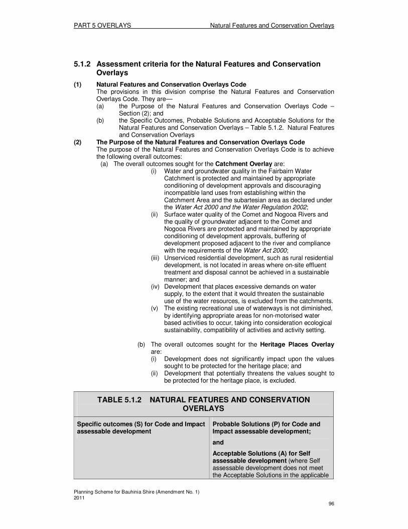
PART 5 OVERLAYS Natural Features and Conservation Overlays
Planning Scheme for Bauhinia Shire (Amendment No. 1) 2011 96
5.1.2 Assessment criteria for the Natural Features and Conservation Overlays
(1) Natural Features and Conservation Overlays Code The provisions in this division comprise the Natural Features and Conservation Overlays Code. They are— (a) the Purpose of the Natural Features and Conservation Overlays Code –
Section (2); and (b) the Specific Outcomes, Probable Solutions and Acceptable Solutions for the
Natural Features and Conservation Overlays – Table 5.1.2. Natural Features and Conservation Overlays
(2) The Purpose of the Natural Features and Conservation Overlays Code The purpose of the Natural Features and Conservation Overlays Code is to achieve the following overall outcomes:
(a) The overall outcomes sought for the Catchment Overlay are: (i) Water and groundwater quality in the Fairbairn Water
Catchment is protected and maintained by appropriate conditioning of development approvals and discouraging incompatible land uses from establishing within the Catchment Area and the subartesian area as declared under the Water Act 2000 and the Water Regulation 2002;
(ii) Surface water quality of the Comet and Nogooa Rivers and the quality of groundwater adjacent to the Comet and Nogooa Rivers are protected and maintained by appropriate conditioning of development approvals, buffering of development proposed adjacent to the river and compliance with the requirements of the Water Act 2000;
(iii) Unserviced residential development, such as rural residential development, is not located in areas where on-site effluent treatment and disposal cannot be achieved in a sustainable manner; and
(iv) Development that places excessive demands on water supply, to the extent that it would threaten the sustainable use of the water resources, is excluded from the catchments.
(v) The existing recreational use of waterways is not diminished, by identifying appropriate areas for non-motorised water based activities to occur, taking into consideration ecological sustainability, compatibility of activities and activity setting.
(b) The overall outcomes sought for the Heritage Places Overlay
are: (i) Development does not significantly impact upon the values
sought to be protected for the heritage place; and (ii) Development that potentially threatens the values sought to
be protected for the heritage place, is excluded.
TABLE 5.1.2 NATURAL FEATURES AND CONSERVATION OVERLAYS
Specific outcomes (S) for Code and Impact assessable development
Probable Solutions (P) for Code and Impact assessable development;
and
Acceptable Solutions (A) for Self assessable development (where Self assessable development does not meet the Acceptable Solutions in the applicable
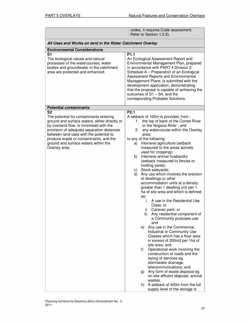
PART 5 OVERLAYS Natural Features and Conservation Overlays
Planning Scheme for Bauhinia Shire (Amendment No. 1) 2011 97
codes, it requires Code assessment. Refer to Section 1.2.9).
All Uses and Works on land in the Water Catchment Overlay
Environmental Considerations S1 The ecological values and natural processes of the watercourses, water bodies and groundwater in the catchment area are protected and enhanced.
P1.1 An Ecological Assessment Report and Environmental Management Plan, prepared in accordance with PART 4 Division 2: Schedule A – Preparation of an Ecological Assessment Reports and Environmental Management Plans, is submitted with the development application, demonstrating that the proposal is capable of achieving the outcomes of S1 – S4, and the corresponding Probable Solutions.
Potential contaminants S2 The potential for contaminants entering ground and surface waters, either directly or by overland flow, is minimised with the provision of adequate separation distances between land uses with the potential to produce waste or contaminants, and the ground and surface waters within the Overlay area.
P2.1 A setback of 100m is provided, from :
1. the top of bank of the Comet River or the Nogooa River ; and
2. any watercourse within the Overlay area;
to any of the following: a) Intensive agriculture (setback
measured to the areas actively used for cropping);
b) Intensive animal husbandry (setback measured to fences or holding yards);
c) Stock saleyards; d) Any use which involves the erection
of dwellings or other accommodation units at a density greater than 1 dwelling unit per 1 ha of site area and which is defined as:
i. A use in the Residential Use Class; or
ii. Caravan park; or iii. Any residential component of
a Community purposes use; and
e) Any use in the Commercial, Industrial or Community Use Classes which has a floor area in excess of 200m2 per 1ha of site area; and
f) Operational work involving the construction of roads and the laying of services eg. stormwater drainage, telecommunications; and
g) Any form of waste disposal eg. on-site effluent disposal, animal wastes.
h) A setback of 400m from the full supply level of the storage is
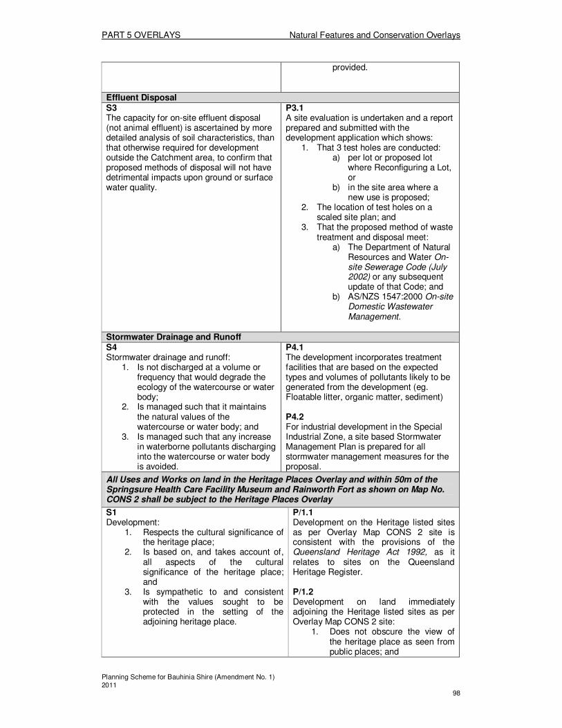
PART 5 OVERLAYS Natural Features and Conservation Overlays
Planning Scheme for Bauhinia Shire (Amendment No. 1) 2011 98
provided.
Effluent Disposal S3 The capacity for on-site effluent disposal (not animal effluent) is ascertained by more detailed analysis of soil characteristics, than that otherwise required for development outside the Catchment area, to confirm that proposed methods of disposal will not have detrimental impacts upon ground or surface water quality.
P3.1 A site evaluation is undertaken and a report prepared and submitted with the development application which shows:
1. That 3 test holes are conducted: a) per lot or proposed lot
where Reconfiguring a Lot, or
b) in the site area where a new use is proposed;
2. The location of test holes on a scaled site plan; and
3. That the proposed method of waste treatment and disposal meet:
a) The Department of Natural Resources and Water On-site Sewerage Code (July 2002) or any subsequent update of that Code; and
b) AS/NZS 1547:2000 On-site Domestic Wastewater Management.
Stormwater Drainage and Runoff S4 Stormwater drainage and runoff:
1. Is not discharged at a volume or frequency that would degrade the ecology of the watercourse or water body;
2. Is managed such that it maintains the natural values of the watercourse or water body; and
3. Is managed such that any increase in waterborne pollutants discharging into the watercourse or water body is avoided.
P4.1 The development incorporates treatment facilities that are based on the expected types and volumes of pollutants likely to be generated from the development (eg. Floatable litter, organic matter, sediment) P4.2 For industrial development in the Special Industrial Zone, a site based Stormwater Management Plan is prepared for all stormwater management measures for the proposal.
All Uses and Works on land in the Heritage Places Overlay and within 50m of the Springsure Health Care Facility Museum and Rainworth Fort as shown on Map No. CONS 2 shall be subject to the Heritage Places Overlay
S1 Development:
1. Respects the cultural significance of the heritage place;
2. Is based on, and takes account of, all aspects of the cultural significance of the heritage place; and
3. Is sympathetic to and consistent with the values sought to be protected in the setting of the adjoining heritage place.
P/1.1 Development on the Heritage listed sites as per Overlay Map CONS 2 site is consistent with the provisions of the Queensland Heritage Act 1992, as it relates to sites on the Queensland Heritage Register. P/1.2 Development on land immediately adjoining the Heritage listed sites as per Overlay Map CONS 2 site:
1. Does not obscure the view of the heritage place as seen from public places; and

PART 5 OVERLAYS Natural Features and Conservation Overlays
Planning Scheme for Bauhinia Shire (Amendment No. 1) 2011 99
2. Does not cast shadow over the heritage place.
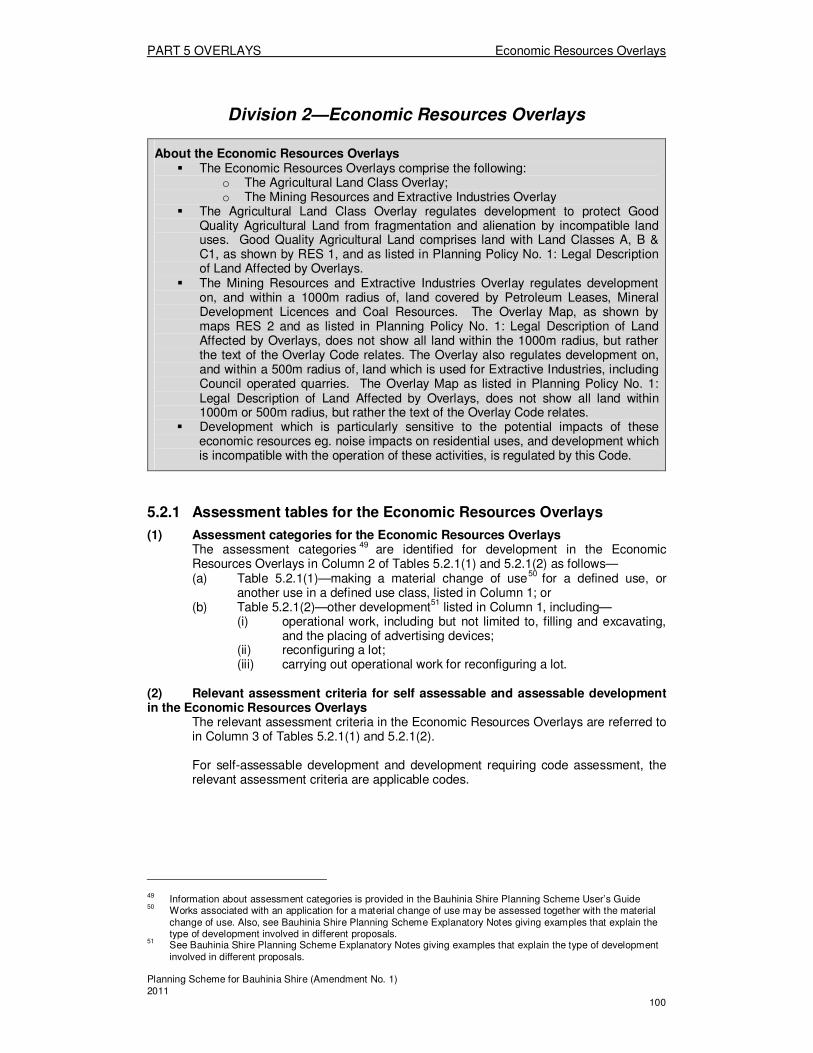
PART 5 OVERLAYS Economic Resources Overlays
Planning Scheme for Bauhinia Shire (Amendment No. 1) 2011 100
Division 2—Economic Resources Overlays
About the Economic Resources Overlays � The Economic Resources Overlays comprise the following:
o The Agricultural Land Class Overlay; o The Mining Resources and Extractive Industries Overlay
� The Agricultural Land Class Overlay regulates development to protect Good Quality Agricultural Land from fragmentation and alienation by incompatible land uses. Good Quality Agricultural Land comprises land with Land Classes A, B & C1, as shown by RES 1, and as listed in Planning Policy No. 1: Legal Description of Land Affected by Overlays.
� The Mining Resources and Extractive Industries Overlay regulates development on, and within a 1000m radius of, land covered by Petroleum Leases, Mineral Development Licences and Coal Resources. The Overlay Map, as shown by maps RES 2 and as listed in Planning Policy No. 1: Legal Description of Land Affected by Overlays, does not show all land within the 1000m radius, but rather the text of the Overlay Code relates. The Overlay also regulates development on, and within a 500m radius of, land which is used for Extractive Industries, including Council operated quarries. The Overlay Map as listed in Planning Policy No. 1: Legal Description of Land Affected by Overlays, does not show all land within 1000m or 500m radius, but rather the text of the Overlay Code relates.
� Development which is particularly sensitive to the potential impacts of these economic resources eg. noise impacts on residential uses, and development which is incompatible with the operation of these activities, is regulated by this Code.
5.2.1 Assessment tables for the Economic Resources Overlays
(1) Assessment categories for the Economic Resources Overlays The assessment categories 49 are identified for development in the Economic Resources Overlays in Column 2 of Tables 5.2.1(1) and 5.2.1(2) as follows— (a) Table 5.2.1(1)—making a material change of use
50 for a defined use, or
another use in a defined use class, listed in Column 1; or (b) Table 5.2.1(2)—other development
51 listed in Column 1, including—
(i) operational work, including but not limited to, filling and excavating, and the placing of advertising devices;
(ii) reconfiguring a lot; (iii) carrying out operational work for reconfiguring a lot.
(2) Relevant assessment criteria for self assessable and assessable development in the Economic Resources Overlays
The relevant assessment criteria in the Economic Resources Overlays are referred to in Column 3 of Tables 5.2.1(1) and 5.2.1(2). For self-assessable development and development requiring code assessment, the relevant assessment criteria are applicable codes.
49 Information about assessment categories is provided in the Bauhinia Shire Planning Scheme User’s Guide 50
Works associated with an application for a material change of use may be assessed together with the material change of use. Also, see Bauhinia Shire Planning Scheme Explanatory Notes giving examples that explain the type of development involved in different proposals.
51 See Bauhinia Shire Planning Scheme Explanatory Notes giving examples that explain the type of development
involved in different proposals.
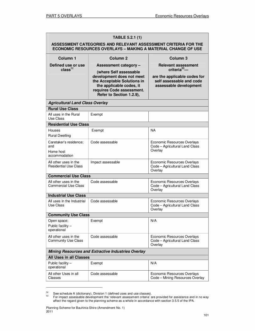
PART 5 OVERLAYS Economic Resources Overlays
Planning Scheme for Bauhinia Shire (Amendment No. 1) 2011 101
TABLE 5.2.1 (1)
ASSESSMENT CATEGORIES AND RELEVANT ASSESSMENT CRITERIA FOR THE ECONOMIC RESOURCES OVERLAYS – MAKING A MATERIAL CHANGE OF USE
Column 1
Defined use or use class
52
Column 2
Assessment category –
(where Self assessable development does not meet the Acceptable Solutions in
the applicable codes, it requires Code assessment.
Refer to Section 1.2.9),
Column 3
Relevant assessment criteria
53—
are the applicable codes for self assessable and code assessable development
Agricultural Land Class Overlay
Rural Use Class
All uses in the Rural Use Class
Exempt
Residential Use Class
Houses
Rural Dwelling
Exempt NA
Caretaker’s residence; and
Home host accommodation
Code assessable Economic Resources Overlays Code – Agricultural Land Class Overlay
All other uses in the Residential Use Class
Impact assessable Economic Resources Overlays Code – Agricultural Land Class Overlay
Commercial Use Class
All other uses in the Commercial Use Class
Code assessable Economic Resources Overlays Code – Agricultural Land Class Overlay
Industrial Use Class
All uses in the Industrial Use Class
Code assessable Economic Resources Overlays Code – Agricultural Land Class Overlay
Community Use Class
Open space;
Public facility – operational
Exempt N/A
All other uses in the Community Use Class
Code assessable Economic Resources Overlays Code – Agricultural Land Class Overlay
Mining Resources and Extractive Industries Overlay
All Uses in all Classes
Public facility – operational
Exempt N/A
All other Uses in all Classes
Code assessable Economic Resources Overlays Code – Mining Resources Overlay
52 See schedule A (dictionary), Division 1 (defined uses and use classes).
53 For impact assessable development the ‘relevant assessment criteria’ are provided for assistance and in no way
affect the regard given to the planning scheme as a whole in accordance with section 3.5.5 of the IPA.

PART 5 OVERLAYS Economic Resources Overlays
Planning Scheme for Bauhinia Shire (Amendment No. 1) 2011 102
.2.1 (2)
ASSESSMENT CATEGORIES AND RELEVANT ASSESSMENT CRITERIA FOR THE ECONOMIC RESOURCES OVERLAYS – OTHER DEVELOPMENT
Column 1
Type of development
Column 2
Assessment category –
(where Self assessable development does not meet the Acceptable Solutions in
the applicable codes, it requires Code assessment.
Refer to Section 1.2.9)
Column 3
Relevant assessment criteria
54—
are the applicable codes for self assessable and code assessable development
Agricultural Land Class Overlay
Operational work
All Operational work associated with a Code or Impact assessable Material Change of Use (not including operational work associated with reconfiguring a lot)
Exempt N/A
Reconfiguring a lot
All circumstances Code assessable Economic Resources Overlays Code – Agricultural Land Class Overlay
Carrying out operational work for reconfiguring a lot
All circumstances Exempt N/A
Other
All other development Exempt N/A
Mining Resources and Extractive Industries Overlay
Operational work
Other Operational work associated with a Code or Impact assessable Material Change of Use (not including operational work associated with reconfiguring a lot)
Exempt
N/A
Reconfiguring a lot
All circumstances Code assessable Economic Resources Overlays Code – Mining Resources Overlay
Carrying out operational work for reconfiguring a lot
All circumstances Exempt N/A
Other
All other development Exempt N/A
54 For impact assessable development the ‘relevant assessment criteria’ are provided for assistance and in no way
affect the regard given to the planning scheme as a whole in accordance with section 3.5.5 of the IPA.

PART 5 OVERLAYS Economic Resources Overlays
Planning Scheme for Bauhinia Shire (Amendment No. 1) 2011 103
5.2.2 Assessment criteria for the Economic Resources Overlays
(1) Economic Resources Overlays Code The provisions in this division comprise the Economic Resources Overlays Code. They are— 1. the Purpose of the Economic Resources Overlays Code – Section (2); and 2. the Specific Outcomes, Probable Solutions and Acceptable Solutions for the
Economic Resources Overlays – Table 5.2.2. Economic Resources Overlays (2) The Purpose of the Economic Resources Overlays Code
The purpose of the Economic Resources Overlays Code is to achieve the following overall outcomes: 1. The overall outcomes sought for the Agricultural Land Class Overlay are:
(a) Agriculture and intensive agriculture, and animal husbandry uses are the dominant uses in the Overlay area;
(b) All productive agricultural land is protected from the encroachment of incompatible uses and from excessive fragmentation into lot sizes that are not viable for agriculture;
(c) Incompatible non-rural uses are excluded from the Overlay area to protect their amenity, and particularly to protect against the effects of aerial spraying; and other impacts as a result of intensive cropping;
(d) Houses are the only exception to (c) above, provided that the houses are located such as to minimise potential conflicts with agricultural activities.
2. The overall outcomes sought for the Mining Resources and Extractive Industries Overlay are: (a) Mining tenements and designated Key Resource Areas in the Shire
continue to protect mineral resources of major economic significance to the Shire and State;
(b) Uses and Works in the vicinity of mining tenements and within designated Key Resource Areas are compatible with the mining operations associated with the mineral resource; and
(c) Uses and Works in the vicinity of haul routes for mining tenements do not compromise haul routes or direct access routes to the mineral resources.
(d) Extractive industries in the Shire continue to be resources of major economic significance to the Shire and State;
(e) Uses and Works in the vicinity of extractive industries are compatible with the extraction operations associated with the mineral resource; and
(f) Uses and Works in the vicinity of extractive industries do not compromise haul routes or direct access routes to the mineral resources.
PART 5 OVERLAYS Economic Resources Overlays
Planning Scheme for Bauhinia Shire (Amendment No. 1) 2011 104
TABLE 5.2.2 ECONOMIC RESOURCES OVERLAYS
Specific outcomes (S) for Code and Impact assessable development
Probable Solutions (P) for Code and Impact assessable development;
and
Acceptable Solutions (A) for Self assessable development (where Self assessable development does not meet the Acceptable Solutions in the applicable codes, it requires Code assessment. Refer to Section 1.2.9)
All Uses and Works on land in the Agricultural Land Class Overlay
All Development on land shown as Class A, B or C1 land in the Agricultural Land Class Overlay S1 Land uses and newly created lots are located and designed so as not to limit the productivity, viability or use of Good Quality Agricultural Land for agricultural purposes.
P1.1 No Solutions Specified Note: Land uses and newly created lots are located on Good Quality Agricultural Land:
1. where sufficient separation distances or buffering methods can be employed to overcome potential impacts on existing adjacent rural uses
AND 2. where it has been demonstrated
that there is an overriding need for the development in terms of public benefit and no other site is suitable and available for the purpose
OR 3. Where it has been demonstrated
through a detailed assessment of the agricultural quality of the subject land prepared in accordance with the Planning Guideline: “The Identification of Good Quality Agricultural Land” by a suitably qualified person that; the land is not Good Quality Agricultural Land.
All Development on land shown as Class C2 or C3 land in the Agricultural Land Class Overlay S2 Land uses and newly created lots are located and designed so as not to limit the productivity or viability of agricultural activities on Class C2 and C3 grazing land.
P2.1 No solutions specified
PART 5 OVERLAYS Economic Resources Overlays
Planning Scheme for Bauhinia Shire (Amendment No. 1) 2011 105
All Uses and Works on land in the Mining Resources and Extractive Industries Overlay
S3 Development in the vicinity of Mining Resources or designated Key Resource Areas does not compromise the utilisation of mineral resources and haul routes or access routes to the mineral resources, as it:
1. Does not adversely affect the safe and efficient operation of the mining related activities;
2. Is sited, designed or of a nature that ensures that the use is not sensitive to the potential impacts of mining related activities such as noise and dust emissions; and
3. A separation distance of 1000m is recommended where blasting will be used for extraction, and 200m where mechanical means eg ripping will be used; and
Makes provision for buffers between the mineral resources and new development.
P3.1 Houses, Home Host Accommodation, Home Based Businesses and any Community purposes – government or Community purposes – other, on lots which share a boundary with land identified as an extractive industry, are located at least:
1. 1,000m where the operation involves blasting;
2. 200m where blasting or intrusive processing is not involved;
3. 100m distance each side of a transport corridor associated with the extractive or mining resource.
Note: The above separation distances should be taken from the boundary of the mining lease or the mineral development licence or extractive industry approval area.

PART 5 OVERLAYS Economic Resources Overlays
Planning Scheme for Bauhinia Shire (Amendment No. 1) 2011 106
Division 3—Major Utilities Overlays
About the Major Utilities Overlay � The Major Utilities Overlay comprises the Shire’s Plant and Refuse Sites. � The Overlay regulates development which is in the vicinity of these forms of
infrastructure, as shown by maps UTIL 1, and as listed in Planning Policy No. 1: Legal Description of Land Affected by Overlays.
� Development which is particularly sensitive to the potential impacts of these types of infrastructure eg. safety risks to residents in proximity of powerlines, and development which is incompatible with the operation of these activities, is regulated by this Code.
5.3.1 Assessment tables for the Major Utilities Overlays
(1) Assessment categories for the Major Utilities Overlays The assessment categories
55 are identified for development in the Major Utilities
Overlays in Column 2 of Tables 5.3.1(1) and 5.3.1(2) as follows— (a) Table 5.3.1(1)—making a material change of use
56 for a defined use, or
another use in a defined use class, listed in Column 1; or (b) Table 5.3.1(2)—other development
57 listed in Column 1, including—
(i) operational work, including but not limited to, filling and excavating, and the placing of advertising devices;
(ii) reconfiguring a lot; (iii) carrying out operational work for reconfiguring a lot.
(2) Relevant assessment criteria for self assessable and assessable development
in the Major Utilities Overlays The relevant assessment criteria in the Major Utilities Overlays are referred to in Column 3 of Tables 5.3.1(1) and 5.3.1(2). For self-assessable development and development requiring code assessment, the relevant assessment criteria are applicable codes.
55 Information about assessment categories is provided in the Bauhinia Shire Planning Scheme User’s Guide 56
Works associated with an application for a material change of use may be assessed together with the material change of use. Also, see Bauhinia Shire Planning Scheme Explanatory Notes giving examples that explain the type of development involved in different proposals.
57 See Bauhinia Shire Planning Scheme Explanatory Notes giving examples that explain the type of development
involved in different proposals.

PART 5 OVERLAYS Economic Resources Overlays
Planning Scheme for Bauhinia Shire (Amendment No. 1) 2011 107
TABLE 5.3.1 (1)
ASSESSMENT CATEGORIES AND RELEVANT ASSESSMENT CRITERIA FOR THE MAJOR UTILITIES OVERLAYS – MAKING A MATERIAL CHANGE OF US
Column 1
Defined use or use class
58
Column 2
Assessment category –
(where Self assessable development does not meet the Acceptable Solutions in
the applicable codes, it requires Code assessment.
Refer to Section 1.2.9),
Column 3
Relevant assessment criteria
59—
are the applicable codes for self assessable and code assessable development
Major Utilities Overlay
Rural Use Class
All uses in the Rural Use Class
Exempt N/A
Residential Use Class
All uses in the Residential Use Class
Self assessable Major Utilities Overlays – Plant and Refuse Site Overlay
Commercial Use Class
Caravan Park; and
Hotel
Self assessable Major Utilities Overlays – Plant and Refuse Site Overlay
All other uses in the Commercial Use Class
Exempt N/A
Industrial Use Class
All uses in the Industrial Use Class
Exempt N/A
Community Use Class
Community purposes;
Public facility – other
Self assessable Major Utilities Overlays – Plant and Refuse Site Overlay
All other uses in the Community Use Class
Exempt N/A
58 See schedule A (dictionary), Division 1 (defined uses and use classes).
59 For impact assessable development the ‘relevant assessment criteria’ are provided for assistance and in no way
affect the regard given to the planning scheme as a whole in accordance with section 3.5.5 of the IPA.

PART 5 OVERLAYS Economic Resources Overlays
Planning Scheme for Bauhinia Shire (Amendment No. 1) 2011 108
TABLE 5.3.1 (2)
ASSESSMENT CATEGORIES AND RELEVANT ASSESSMENT CRITERIA FOR THE MAJOR UTILITIES OVERLAYS – OTHER DEVELOPMENT
Column 1
Type of development
Column 2
Assessment category –
(where Self assessable development does not meet the Acceptable Solutions in
the applicable codes, it requires Code assessment.
Refer to Section 1.2.9)
Column 3
Relevant assessment criteria
60—
are the applicable codes for self assessable and code assessable development
Major Utilities Overlay
Operational work
All Operational work associated with a Code or Impact assessable Material Change of Use (not including operational work associated with reconfiguring a lot)
Exempt N/A
Reconfiguring a lot
All circumstances Code assessable Major Utilities Overlays Code – Plant and Refuse Site Overlay
Carrying out operational work for reconfiguring a lot
All circumstances Exempt N/A
Other
All other development Exempt N/A
60 For impact assessable development the ‘relevant assessment criteria’ are provided for assistance and in no way
affect the regard given to the planning scheme as a whole in accordance with section 3.5.5 of the IPA.
PART 5 OVERLAYS Economic Resources Overlays
Planning Scheme for Bauhinia Shire (Amendment No. 1) 2011 109
5.3.2 Assessment criteria for the Major Utilities Overlay
(1) Major Utilities Overlays Code The provisions in this division comprise the Major Utilities Overlays Code. They are— 1. The Purpose of the Major Utilities Overlays Code – Section (2);and 2. The Specific Outcomes, Probable Solutions and Acceptable Solutions for the
Major Utilities Overlays – Table 5.3.2. Major Utilities Overlays (2) The Purpose of the Major Utilities Overlays Code
The purpose of the Major Utilities Overlays Code is to achieve the following overall outcomes: 1. Community infrastructure delivery, sewerage treatment plants and waste
disposal facilities, is facilitated by the provision of suitable and adequate land for the operation and maintenance of the infrastructure;
2. The co-location of other land uses and the undertaking of works within these areas, do not comprise the primary community infrastructure purpose of the land;
3. Minimum separation distances are established to provide buffers between incompatible land uses and works, and major utilities.
TABLE 5.3.2 MAJOR UTILITIES OVERLAYS
Specific outcomes (S) for Code and Impact assessable development
Probable Solutions (P) for Code and Impact assessable development;
and
Acceptable Solutions (A) for Self assessable development (where Self assessable development does not meet the Acceptable Solutions in the applicable codes, it requires Code assessment. Refer to Section 1.2.9)
All Major Utilities Overlay
All Development S1 Development in the vicinity of the sewerage and water treatment plants and refuse transfer stations:
1. Does not adversely affect the safe and efficient operation of the facility;
2. Is not a use which requires a high level of amenity; and
3. Makes provision for adequate buffers between the facility and new development.
P/A1.1 The site area for all uses in the Residential Use Class, Community Purpose uses, Caretaker’s residences, Caravan Parks, Hotels, and Accommodation Buildings have a minimum separation distance as shown in Division 3: Schedule A – Separation distances to Water and Sewerage Treatment Plants, and Refuse Sites.
Reconfiguring a Lot S2 Development in the vicinity of the sewerage and water treatment plants and refuse transfer stations:
1. Does not adversely affect the safe and efficient operation of the facility; and
2. Makes provision for adequate buffers between the facility and new development.
P2.1 Development applications for Reconfiguring a Lot have:
1. Lot sizes, shapes and configuration of lots that allow for building envelopes and any associated external activity areas for intended uses in the relevant Zone/Precinct; and
2. Lot configurations that enable the

PART 5 OVERLAYS Economic Resources Overlays
Planning Scheme for Bauhinia Shire (Amendment No. 1) 2011 110
requirements of P/A6.1 above to be met.
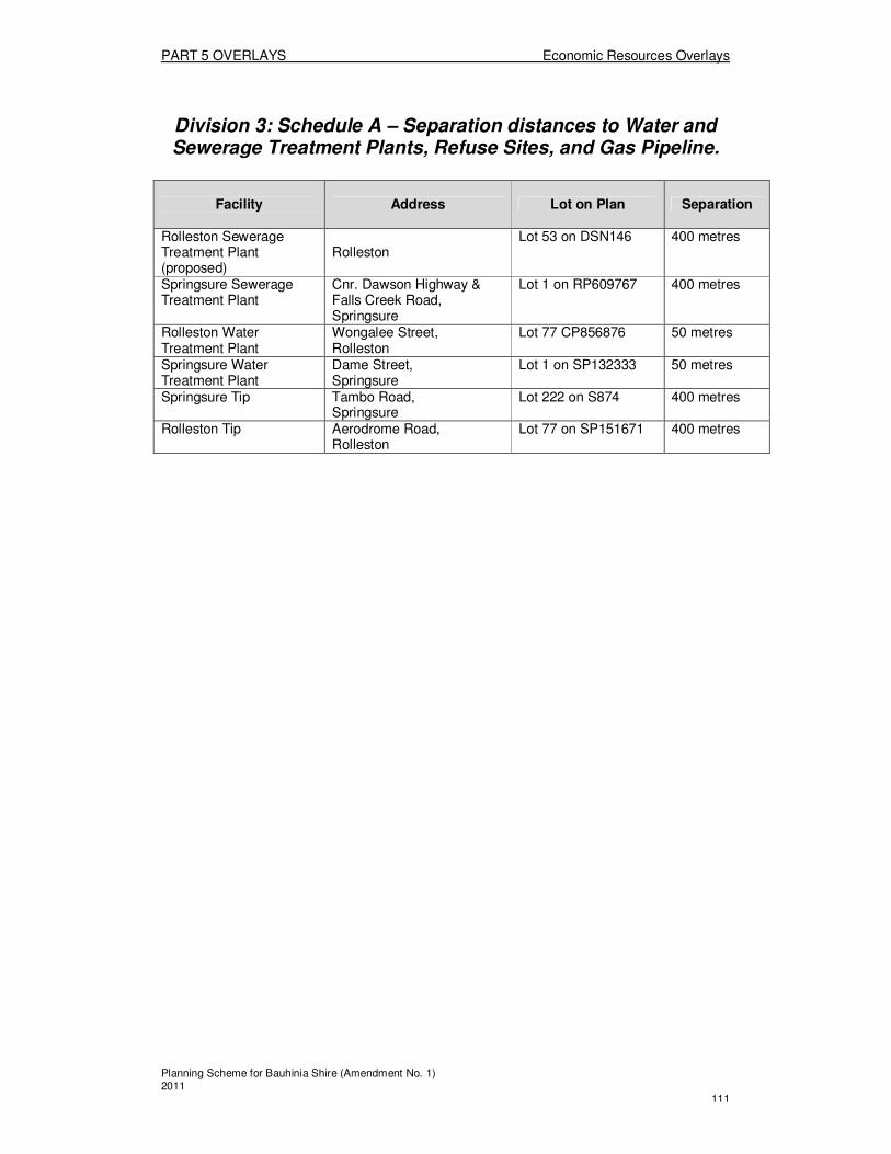
PART 5 OVERLAYS Economic Resources Overlays
Planning Scheme for Bauhinia Shire (Amendment No. 1) 2011 111
Division 3: Schedule A – Separation distances to Water and Sewerage Treatment Plants, Refuse Sites, and Gas Pipeline.
Facility
Address Lot on Plan Separation
Rolleston Sewerage Treatment Plant (proposed)
Rolleston
Lot 53 on DSN146 400 metres
Springsure Sewerage Treatment Plant
Cnr. Dawson Highway & Falls Creek Road, Springsure
Lot 1 on RP609767 400 metres
Rolleston Water Treatment Plant
Wongalee Street, Rolleston
Lot 77 CP856876 50 metres
Springsure Water Treatment Plant
Dame Street, Springsure
Lot 1 on SP132333 50 metres
Springsure Tip Tambo Road, Springsure
Lot 222 on S874 400 metres
Rolleston Tip Aerodrome Road, Rolleston
Lot 77 on SP151671 400 metres

PART 5 OVERLAYS Natural Disaster Overlays
Planning Scheme for Bauhinia Shire (Amendment No. 1) 2011 112
Division 4—Natural Disaster Overlays
About the Natural Disaster Overlays � The Natural Disaster Overlays comprise the following:
o The Bushfire Hazard Land Overlay; o The Landslide Prone Land Overlay; and o The Flood Hazard Overlay – Floodplain Assessment.
� The Bushfire Hazard Land Overlay regulates development on, and within 100m and 50m of High Hazard Severity areas and Medium Hazard Severity areas, respectively, as shown by Map NDIS - 1, and as listed in Planning Policy No:1 Legal Descriptions of Land Affected by Overlays.
� The Landslide Prone Land Overlay regulates development which is on steep slopes, being those of 15% or greater, anywhere in the Shire. There is no specific Overlay Map as contour information across the total Shire is not available.
� The Flood Hazard Overlay – Floodplain Assessment regulates development wholly or partially within the identified floodplain area on Map NDIS - 2
61
� Development which is particularly sensitive to the potential impacts of these hazards eg. safety risks to residential development, and development which is incompatible with the hazards, is regulated by this Code.
5.4.1 Assessment tables for the Natural Disaster Overlays
(1) Assessment categories for the Natural Disaster Overlays The assessment categories62 are identified for development in the Natural Disaster Overlays in Column 2 of Tables 5.4.1(1) and 5.4.1(2) as follows— (a) Table 5.4.1(1)—making a material change of use
63 for a defined use, or
another use in a defined use class, listed in Column 1; or (b) Table 5.4.1(2)—other development
64 listed in Column 1, including—
(i) operational work, including but not limited to, filling and excavating, and the placing of advertising devices;
(ii) reconfiguring a lot; (iii) carrying out operational work for reconfiguring a lot.
(2) Relevant assessment criteria for self assessable and assessable development
in the Natural Disaster Overlays The relevant assessment criteria in the Natural Disaster Overlays are referred to in Column 3 of Tables 5.4.1(1) and 5.4.1(2). For self-assessable development and development requiring code assessment, the relevant assessment criteria are applicable codes.
61 The Queensland Flood Commission of Inquiry (the Commission) is currently investigating the 2010/2011 flood
disaster that caused widespread devastation across Queensland. The Commission is likely to review the existing town planning provisions related to flooding and flood risk
mitigation. The final report of the Commission may recommend changes to State Planning Policy 1/03 and Temporary State Planning Policy 2/11: Planning for stronger more resilient floodplains which may have implications for the Bauhinia planning scheme.
Consequently, the provisions of the planning scheme with respect to the management of flooding and flood risk
mitigation may be subject to change at the direction of the Queensland Government or Central Highlands Regional Council in the near future. This should be taken into account by applicants and assessment managers when considering development in this area. Applicants are advised to make relevant enquiries regarding the status of the provisions relating to flooding.
62 Information about assessment categories is provided in the Bauhinia Shire Planning Scheme User’s Guide 63
Works associated with an application for a material change of use may be assessed together with the material change of use. Also, see Bauhinia Shire Planning Scheme Explanatory Notes giving examples that explain the type of development involved in different proposals.
64 See Bauhinia Shire Planning Scheme Explanatory Notes giving examples that explain the type of development
involved in different proposals.

PART 5 OVERLAYS Natural Disaster Overlays
Planning Scheme for Bauhinia Shire (Amendment No. 1) 2011 113
TABLE 5.4.1 (1)
ASSESSMENT CATEGORIES AND RELEVANT ASSESSMENT CRITERIA FOR THE NATURAL DISASTER OVERLAYS – MAKING A MATERIAL CHANGE OF USE
Column 1
Defined use or use class
65
Column 2
Assessment category –
(where Self assessable development does not meet the Acceptable
Solutions in the applicable codes, it
requires Code assessment. Refer to
Section 1.2.9)
Column 3
Relevant assessment criteria
66—
are the applicable codes for self assessable and code assessable development
Bushfire Hazard Land Overlay
All Uses (except Public facility – operational) in All Use Classes
All uses in all Use Classes which:
1. constitute a type of development to which the code applies, as referred to in Section 5.4.2 (A)(5); and
2. are located in a low bushfire hazard severity area, as shown on the Bushfire Hazard Land Overlay
Self assessable Natural Disaster Overlay Code – Bushfire Hazard Land Overlay
All uses in all Use Classes which:
1. constitute a type of development to which the code applies, as referred to in Section 5.4.2 (A)(5); and
2. are located on or within 50m of land with a medium bushfire hazard severity area as shown on the Bushfire Hazard Land Overlay or demonstrated by a bushfire hazard assessment
Self assessable Natural Disaster Overlay Code – Bushfire Hazard Land Overlay
All uses in all Use Classes which:
1. constitute a type of
Code assessable Natural Disaster Overlay Code – Bushfire Hazard Land Overlay
65 See schedule A (dictionary), Division 1 (defined uses and use classes).
66 For impact assessable development the ‘relevant assessment criteria’ are provided for assistance and in no way
affect the regard given to the planning scheme as a whole in accordance with section 3.5.5 of the IPA.

PART 5 OVERLAYS Natural Disaster Overlays
Planning Scheme for Bauhinia Shire (Amendment No. 1) 2011 114
TABLE 5.4.1 (1)
ASSESSMENT CATEGORIES AND RELEVANT ASSESSMENT CRITERIA FOR THE NATURAL DISASTER OVERLAYS – MAKING A MATERIAL CHANGE OF USE
Column 1
Defined use or use class
65
Column 2
Assessment category –
(where Self assessable development does not meet the Acceptable
Solutions in the applicable codes, it
requires Code assessment. Refer to
Section 1.2.9)
Column 3
Relevant assessment criteria
66—
are the applicable codes for self assessable and code assessable development
development to which the code applies, as referred to in Section 5.4.2 (A)(5); and
2. Are located on or within 100m of land with a High bushfire hazard severity area as shown on the Bushfire Hazard Land Overlay or demonstrated by a bushfire hazard assessment
All uses in all Use Classes which do not constitute a type of development to which the code applies, as referred to in Section 5.4.2 (A)(5); or
Public facility – operational uses .
Exempt N/A
Landslide Prone Land Overlay
All Uses (except Public facility – operational) in All Use Classes
All uses in all Use Classes which:
1. constitute a type of development to which the code applies, as referred to in Section 5.4.2 (A)(5); and
2. Are located on land within the Landslide Overlay
Self assessable Natural Disaster Overlay Code – Landslide Prone Land Overlay
All uses in all Use Classes which:
1. constitute a type of development to which the code applies, as referred to in Section 5.4.2 (A)(5); and
2. Are located on land with Steep slopes (15% or greater as determined by a Slope Analysis)
Code assessable Natural Disaster Overlay Code – Landslide Prone Land Overlay

PART 5 OVERLAYS Natural Disaster Overlays
Planning Scheme for Bauhinia Shire (Amendment No. 1) 2011 115
TABLE 5.4.1 (1)
ASSESSMENT CATEGORIES AND RELEVANT ASSESSMENT CRITERIA FOR THE NATURAL DISASTER OVERLAYS – MAKING A MATERIAL CHANGE OF USE
Column 1
Defined use or use class
65
Column 2
Assessment category –
(where Self assessable development does not meet the Acceptable
Solutions in the applicable codes, it
requires Code assessment. Refer to
Section 1.2.9)
Column 3
Relevant assessment criteria
66—
are the applicable codes for self assessable and code assessable development
All uses in all Use Classes which do not constitute a type of development to which the code applies, as referred to in Section 5.4.2 (A)(5);
OR
Public facility – operational uses.
Exempt N/A
Flood Hazard Overlay – Floodplain Assessment
All Uses (except Public facility – operational) in All Use Classes
All uses in all Use Classes which:
1. constitute a type of development to which the code applies, as referred to in Section 5.4.2 (2)1(e); and
2. are located wholly or partially within the area identified on the Flood Hazard Overlay – Floodplain Assessment
Self Assessable Natural Disaster Overlays Code – Flood Hazard Overlay – Floodplain Assessment
All uses in all Use Classes which do not constitute a type of development to which the code applies, as referred to in Section 5.4.2 (2)1(e);
OR
Public facility – operational uses.
Exempt N/A
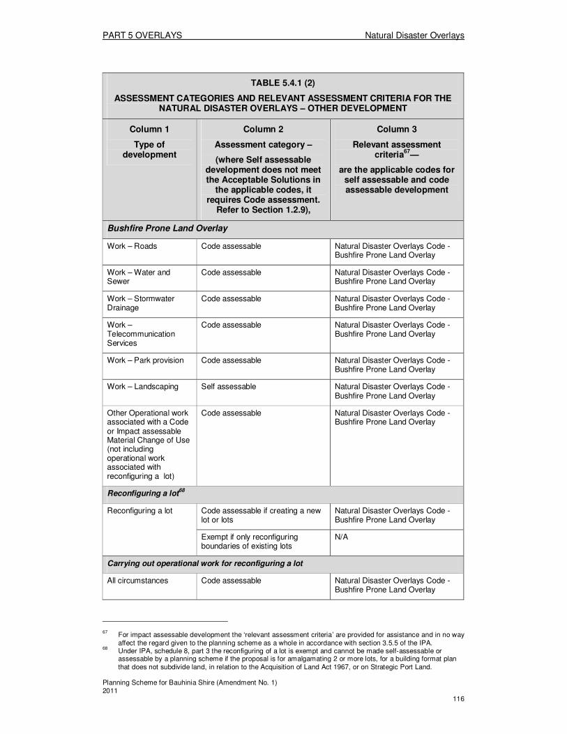
PART 5 OVERLAYS Natural Disaster Overlays
Planning Scheme for Bauhinia Shire (Amendment No. 1) 2011 116
TABLE 5.4.1 (2)
ASSESSMENT CATEGORIES AND RELEVANT ASSESSMENT CRITERIA FOR THE NATURAL DISASTER OVERLAYS – OTHER DEVELOPMENT
Column 1
Type of development
Column 2
Assessment category –
(where Self assessable development does not meet the Acceptable Solutions in
the applicable codes, it requires Code assessment.
Refer to Section 1.2.9),
Column 3
Relevant assessment criteria
67—
are the applicable codes for self assessable and code assessable development
Bushfire Prone Land Overlay
Work – Roads Code assessable Natural Disaster Overlays Code - Bushfire Prone Land Overlay
Work – Water and Sewer
Code assessable Natural Disaster Overlays Code - Bushfire Prone Land Overlay
Work – Stormwater Drainage
Code assessable Natural Disaster Overlays Code - Bushfire Prone Land Overlay
Work –Telecommunication Services
Code assessable Natural Disaster Overlays Code - Bushfire Prone Land Overlay
Work – Park provision Code assessable Natural Disaster Overlays Code - Bushfire Prone Land Overlay
Work – Landscaping Self assessable Natural Disaster Overlays Code - Bushfire Prone Land Overlay
Other Operational work associated with a Code or Impact assessable Material Change of Use (not including operational work associated with reconfiguring a lot)
Code assessable Natural Disaster Overlays Code - Bushfire Prone Land Overlay
Reconfiguring a lot68
Reconfiguring a lot Code assessable if creating a new lot or lots
Natural Disaster Overlays Code - Bushfire Prone Land Overlay
Exempt if only reconfiguring boundaries of existing lots
N/A
Carrying out operational work for reconfiguring a lot
All circumstances Code assessable Natural Disaster Overlays Code - Bushfire Prone Land Overlay
67 For impact assessable development the ‘relevant assessment criteria’ are provided for assistance and in no way
affect the regard given to the planning scheme as a whole in accordance with section 3.5.5 of the IPA. 68
Under IPA, schedule 8, part 3 the reconfiguring of a lot is exempt and cannot be made self-assessable or assessable by a planning scheme if the proposal is for amalgamating 2 or more lots, for a building format plan that does not subdivide land, in relation to the Acquisition of Land Act 1967, or on Strategic Port Land.

PART 5 OVERLAYS Natural Disaster Overlays
Planning Scheme for Bauhinia Shire (Amendment No. 1) 2011 117
TABLE 5.4.1 (2)
ASSESSMENT CATEGORIES AND RELEVANT ASSESSMENT CRITERIA FOR THE NATURAL DISASTER OVERLAYS – OTHER DEVELOPMENT
Column 1
Type of development
Column 2
Assessment category –
(where Self assessable development does not meet the Acceptable Solutions in
the applicable codes, it requires Code assessment.
Refer to Section 1.2.9),
Column 3
Relevant assessment criteria
67—
are the applicable codes for self assessable and code assessable development
Other
All other works Exempt N/A
Landslide Prone Land Overlay
Operational work
Excavating and filling Code assessable Natural Disaster Overlays Code – Landslide Prone Land Overlay
Work – Roads Code assessable Natural Disaster Overlays Code – Landslide Prone Land Overlay
Work – Water and Sewer
Code assessable Natural Disaster Overlays Code – Landslide Prone Land Overlay
Work – Stormwater Drainage
Code assessable Natural Disaster Overlays Code – Landslide Prone Land Overlay
Work – Electricity and Telecommunication Services
Code assessable Natural Disaster Overlays Code – Landslide Prone Land Overlay
Work – Park provision Code assessable Natural Disaster Overlays Code – Landslide Prone Land Overlay
Work – Landscaping Self assessable Natural Disaster Overlays Code – Landslide Prone Land Overlay
Other Operational work associated with a Code or Impact assessable Material Change of Use (not including operational work associated with reconfiguring a lot)
Code assessable Natural Disaster Overlays Code – Landslide Prone Land Overlay
Reconfiguring a lot69
Reconfiguring a lot Code assessable if creating a new lot or lots
Natural Disaster Overlays Code – Landslide Prone Land Overlay
Exempt if only reconfiguring boundaries of existing lots
N/A
Carrying out operational work for reconfiguring a lot
All circumstances Code assessable Natural Disaster Overlays Code – Landslide Prone Land Overlay
69 Under IPA, schedule 8, part 3 the reconfiguring of a lot is exempt and cannot be made self-assessable or
assessable by a planning scheme if the proposal is for amalgamating 2 or more lots, for a building format plan that does not subdivide land, in relation to the Acquisition of Land Act 1967, or on Strategic Port Land.

PART 5 OVERLAYS Natural Disaster Overlays
Planning Scheme for Bauhinia Shire (Amendment No. 1) 2011 118
TABLE 5.4.1 (2)
ASSESSMENT CATEGORIES AND RELEVANT ASSESSMENT CRITERIA FOR THE NATURAL DISASTER OVERLAYS – OTHER DEVELOPMENT
Column 1
Type of development
Column 2
Assessment category –
(where Self assessable development does not meet the Acceptable Solutions in
the applicable codes, it requires Code assessment.
Refer to Section 1.2.9),
Column 3
Relevant assessment criteria
67—
are the applicable codes for self assessable and code assessable development
Other
All other works Exempt N/A
Flood Hazard Overlay – Floodplain Assessment
Operational work
Excavating and filling Exempt where less than 1m depth and less than 50m
3 and not located
in the Flood Hazard Overlay – Floodplain Assessment.
N/A
Self assessable where more than 1m depth and more than 50m
3 and
not located in the Flood Hazard Overlay – Floodplain Assessment.
Natural Disaster Overlays Code – Flood Hazard Overlay – Floodplain Assessment
Self assessable where there is no net increase in fill and located in the Flood Hazard Overlay – Floodplain Assessment.
Natural Disaster Overlays Code – Flood Hazard Overlay – Floodplain Assessment
Code if the circumstances for Exempt or Self assessable do not apply.
Natural Disaster Overlays Code – Flood Hazard Overlay – Floodplain Assessment
Work – Roads Code assessable Natural Disaster Overlays Code – Flood Hazard Overlay – Floodplain Assessment
Work – Water and Sewer
Code assessable Natural Disaster Overlays Code – Flood Hazard Overlay – Floodplain Assessment
Work – Stormwater Drainage
Code assessable Natural Disaster Overlays Code – Flood Hazard Overlay – Floodplain Assessment
Work – Electricity and Telecommunication Services
Code assessable Natural Disaster Overlays Code – Flood Hazard Overlay – Floodplain Assessment
Work – Park provision Code assessable Natural Disaster Overlays Code – Flood Hazard Overlay – Floodplain Assessment
Work – Landscaping Self assessable Natural Disaster Overlays Code – Flood Hazard Overlay – Floodplain Assessment
Other Operational work associated with a Code or Impact assessable Material Change of Use
Code assessable Natural Disaster Overlays Code – Flood Hazard Overlay – Floodplain Assessment

PART 5 OVERLAYS Natural Disaster Overlays
Planning Scheme for Bauhinia Shire (Amendment No. 1) 2011 119
TABLE 5.4.1 (2)
ASSESSMENT CATEGORIES AND RELEVANT ASSESSMENT CRITERIA FOR THE NATURAL DISASTER OVERLAYS – OTHER DEVELOPMENT
Column 1
Type of development
Column 2
Assessment category –
(where Self assessable development does not meet the Acceptable Solutions in
the applicable codes, it requires Code assessment.
Refer to Section 1.2.9),
Column 3
Relevant assessment criteria
67—
are the applicable codes for self assessable and code assessable development
(not including operational work associated with reconfiguring a lot)
Reconfiguring a lot70
Reconfiguring a lot Code assessable if creating a new lot or lots
Exempt if only reconfiguring boundaries of existing lots
Natural Disaster Overlays Code – Flood Hazard Overlay – Floodplain Assessment
Carrying out operational work for reconfiguring a lot
All circumstances Code assessable Natural Disaster Overlay Code – Flood Hazard Overlay – Floodplain Assessment
Other
All other works Exempt N/A
70 Under IPA, schedule 8, part 3 the reconfiguring of a lot is exempt and cannot be made self-assessable or
assessable by a planning scheme if the proposal is for amalgamating 2 or more lots, for a building format plan that does not subdivide land, in relation to the Acquisition of Land Act 1967, or on Strategic Port Land.

PART 5 OVERLAYS Natural Disaster Overlays
Planning Scheme for Bauhinia Shire (Amendment No. 1) 2011 120
5.4.2 Assessment criteria for the Natural Disaster Overlays
(1) Natural Disaster Overlays Code The provisions in this division comprise the Natural Disaster Overlays Code. They are— 1. The Purpose of the Natural Disaster Overlays Code – Section (2);and 2. The Specific Outcomes, Probable Solutions and Acceptable Solutions for the
Natural Disaster Overlays – Table 5.4.2. Natural Disaster Overlays (2) The Purpose of the Natural Disaster Overlays Code
The purpose of the Natural Disaster Overlays Code is to achieve the following overall outcomes:
1. The overall outcome sought for all areas in the Natural Disaster Overlays is that: a) Development minimises the potential adverse impacts of bushfire,
landslide, or flood, on people, property, economic activity and the environment.
b) Wherever practicable, community infrastructure as listed below in point 5, is located and designed to function effectively during and immediately after natural hazard events commensurate with a specified level of risk.
c) Development is compatible with the nature of the natural hazard indicated by a natural hazard management area (eg. bushfire, flood or landslide), as it satisfies all of the relevant Specific Outcomes of this Code.
d) Development as listed below in point 5 is compatible with the nature of the natural hazard (eg. Bushfire Hazard Overlay, Landslide Prone Land Overlay, Flood Hazard Overlay – Floodplain Assessment Overlay), unless:
i. there is an overriding need (refer to State Planning Policy 1/03 Mitigating the Adverse impacts of Flood, Bushfire– demonstrating overriding need) for the development in the public interest and no other site is suitable and reasonably available for the proposal; or
ii. the development proposal is a development commitment and it would have a lower level of risk than generally applies to development in the vicinity, eg building floor levels proposed are higher than those which exist for other buildings in the vicinity.
e) Only certain types of development are regulated by the Natural Disaster Overlays, as follows:
Land uses: i. Development that increases in the number of people living,
working, or congregating in those areas eg. Residential development, shopping centres, tourist facilities, industrial or commercial uses involving large numbers of workers or customers;
ii. Development that involves institutional uses where evacuating people may be particularly difficult eg. Health Care Facilities, education establishments, child care centres, aged care, nursing homes, and high security correctional centres;
iii. Development that increases the amount of hazardous materials that are manufactured or stored in bulk; and
iv. Development that involves: • changing the existing ground level (other than the
removal or placement of topsoil, • removal of vegetation (other than that required to
clear a site for a single house or for routine management including bushfire protection measures), or
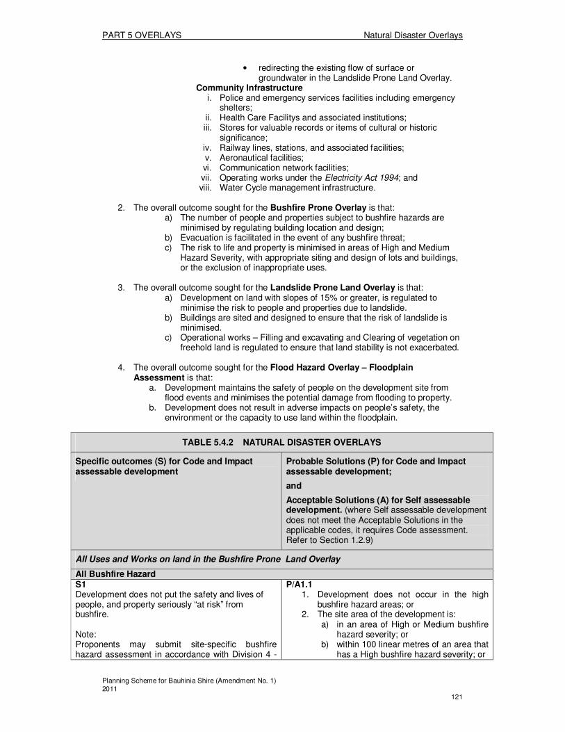
PART 5 OVERLAYS Natural Disaster Overlays
Planning Scheme for Bauhinia Shire (Amendment No. 1) 2011 121
• redirecting the existing flow of surface or groundwater in the Landslide Prone Land Overlay.
Community Infrastructure i. Police and emergency services facilities including emergency
shelters; ii. Health Care Facilitys and associated institutions; iii. Stores for valuable records or items of cultural or historic
significance; iv. Railway lines, stations, and associated facilities; v. Aeronautical facilities; vi. Communication network facilities; vii. Operating works under the Electricity Act 1994; and viii. Water Cycle management infrastructure.
2. The overall outcome sought for the Bushfire Prone Overlay is that:
a) The number of people and properties subject to bushfire hazards are minimised by regulating building location and design;
b) Evacuation is facilitated in the event of any bushfire threat; c) The risk to life and property is minimised in areas of High and Medium
Hazard Severity, with appropriate siting and design of lots and buildings, or the exclusion of inappropriate uses.
3. The overall outcome sought for the Landslide Prone Land Overlay is that:
a) Development on land with slopes of 15% or greater, is regulated to minimise the risk to people and properties due to landslide.
b) Buildings are sited and designed to ensure that the risk of landslide is minimised.
c) Operational works – Filling and excavating and Clearing of vegetation on freehold land is regulated to ensure that land stability is not exacerbated.
4. The overall outcome sought for the Flood Hazard Overlay – Floodplain
Assessment is that: a. Development maintains the safety of people on the development site from
flood events and minimises the potential damage from flooding to property. b. Development does not result in adverse impacts on people’s safety, the
environment or the capacity to use land within the floodplain.
TABLE 5.4.2 NATURAL DISASTER OVERLAYS
Specific outcomes (S) for Code and Impact assessable development
Probable Solutions (P) for Code and Impact assessable development;
and
Acceptable Solutions (A) for Self assessable development. (where Self assessable development does not meet the Acceptable Solutions in the applicable codes, it requires Code assessment. Refer to Section 1.2.9)
All Uses and Works on land in the Bushfire Prone Land Overlay
All Bushfire Hazard S1 Development does not put the safety and lives of people, and property seriously “at risk” from bushfire. Note: Proponents may submit site-specific bushfire hazard assessment in accordance with Division 4 -
P/A1.1 1. Development does not occur in the high
bushfire hazard areas; or 2. The site area of the development is:
a) in an area of High or Medium bushfire hazard severity; or
b) within 100 linear metres of an area that has a High bushfire hazard severity; or
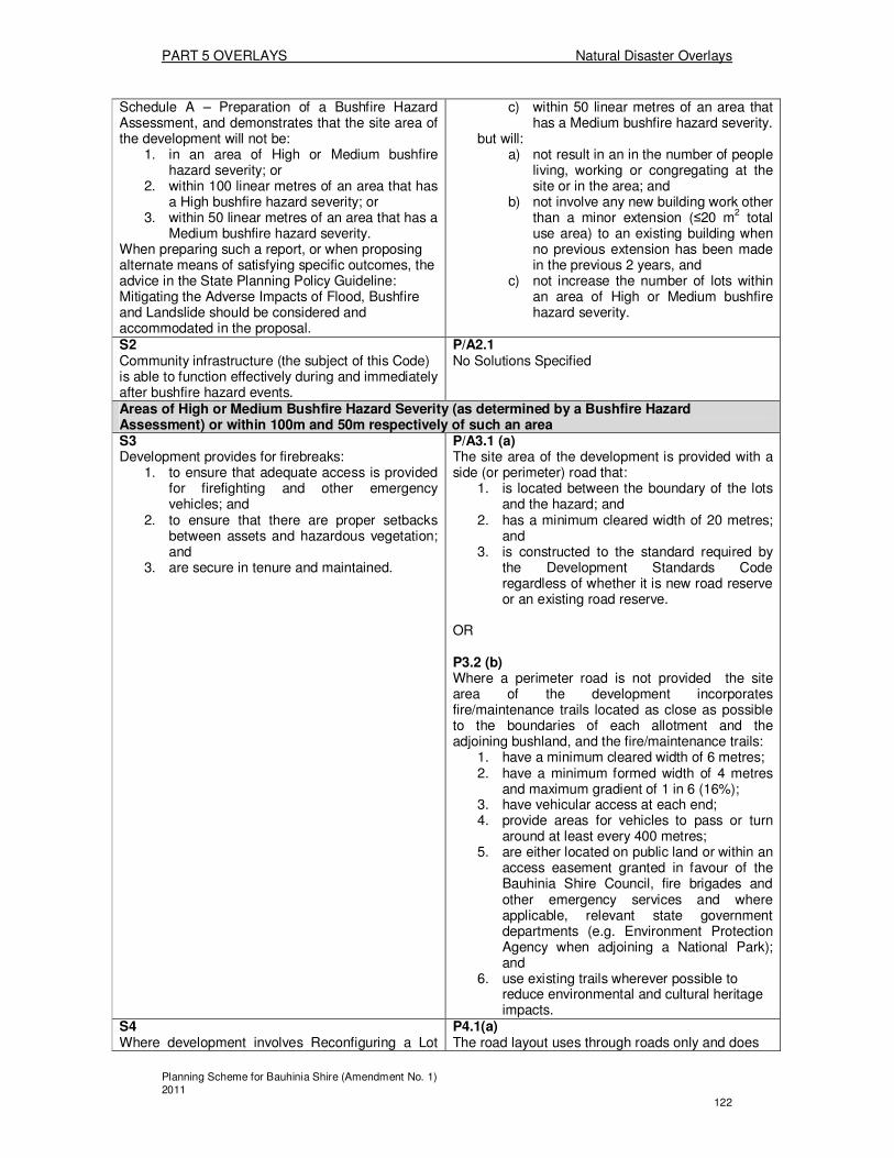
PART 5 OVERLAYS Natural Disaster Overlays
Planning Scheme for Bauhinia Shire (Amendment No. 1) 2011 122
Schedule A – Preparation of a Bushfire Hazard Assessment, and demonstrates that the site area of the development will not be:
1. in an area of High or Medium bushfire hazard severity; or
2. within 100 linear metres of an area that has a High bushfire hazard severity; or
3. within 50 linear metres of an area that has a Medium bushfire hazard severity.
When preparing such a report, or when proposing alternate means of satisfying specific outcomes, the advice in the State Planning Policy Guideline: Mitigating the Adverse Impacts of Flood, Bushfire and Landslide should be considered and accommodated in the proposal.
c) within 50 linear metres of an area that has a Medium bushfire hazard severity.
but will: a) not result in an in the number of people
living, working or congregating at the site or in the area; and
b) not involve any new building work other than a minor extension (≤20 m
2 total
use area) to an existing building when no previous extension has been made in the previous 2 years, and
c) not increase the number of lots within an area of High or Medium bushfire hazard severity.
S2 Community infrastructure (the subject of this Code) is able to function effectively during and immediately after bushfire hazard events.
P/A2.1 No Solutions Specified
Areas of High or Medium Bushfire Hazard Severity (as determined by a Bushfire Hazard Assessment) or within 100m and 50m respectively of such an area S3 Development provides for firebreaks:
1. to ensure that adequate access is provided for firefighting and other emergency vehicles; and
2. to ensure that there are proper setbacks between assets and hazardous vegetation; and
3. are secure in tenure and maintained.
P/A3.1 (a) The site area of the development is provided with a side (or perimeter) road that:
1. is located between the boundary of the lots and the hazard; and
2. has a minimum cleared width of 20 metres; and
3. is constructed to the standard required by the Development Standards Code regardless of whether it is new road reserve or an existing road reserve.
OR P3.2 (b) Where a perimeter road is not provided the site area of the development incorporates fire/maintenance trails located as close as possible to the boundaries of each allotment and the adjoining bushland, and the fire/maintenance trails:
1. have a minimum cleared width of 6 metres; 2. have a minimum formed width of 4 metres
and maximum gradient of 1 in 6 (16%); 3. have vehicular access at each end; 4. provide areas for vehicles to pass or turn
around at least every 400 metres; 5. are either located on public land or within an
access easement granted in favour of the Bauhinia Shire Council, fire brigades and other emergency services and where applicable, relevant state government departments (e.g. Environment Protection Agency when adjoining a National Park); and
6. use existing trails wherever possible to reduce environmental and cultural heritage impacts.
S4 Where development involves Reconfiguring a Lot
P4.1(a) The road layout uses through roads only and does

PART 5 OVERLAYS Natural Disaster Overlays
Planning Scheme for Bauhinia Shire (Amendment No. 1) 2011 123
and opening a new road, the road layout, location and design provides:
1. easy, effective and safe movement away from any encroaching fire for the evacuation of residents and/or emergency vehicles; and
2. an alternative safe access routes, should access in one location be blocked in the event of a bushfire; and
3. for the safe and effective operational use of firefighting vehicles.
not include cul-de-sac and “dead end” roads, except where a perimeter road extending around the development area isolates the development from the hazard, or, an alternative emergency access linking the cul-de-sac to other through roads is provided. OR P4.2 (b) Where the use of a single entry road is unavoidable because of topographical constraints, a properly established and maintained fire trail is incorporated into the layout to allow for safe emergency access. P4.3 Road gradients are not more than 12.5%.
S5 Newly created lots as a result of development for reconfiguration of a lot are designed to:
1. mitigate bushfire hazard; and 2. provide safe sites for houses; and 3. prevent the fragmentation of land with a
high bushfire hazard severity; and 4. The size and shape of lots facilitates
emergency access to buildings and fire fighting infrastructure, and the incorporation of suitable on-site bushfire mitigation measures.
P5.1 Newly created lots are located in parts of the site with the low bushfire hazard severity, in accordance with the principles of Protecting your Home Against Bushfire Attack, Department of Local Government and Planning (DLGP) 2000. P5.2 New lots (or parts of new lots) are not created;
1. in areas that have a high bushfire hazard severity; or
2. within 100 linear metres of an area that has a high bushfire hazard severity.
S6 Buildings are sited or able to be sited:
1. in areas where the environmental impacts are acceptable; and
2. on land which is the least prone to bushfire risk having regard to aspect, elevation, slope and vegetation type.
P/A6.1 Buildings and structures are sited:
1. in a location with the lowest level of hazard; and
2. not on the tops of ridgelines and not on north west to west facing vegetated slopes
P6.2 Buildings and structures:
1. have as a minimum setback from the closest hazardous vegetation, the greater of either of the following:
a) 1.5 times the predominant mature canopy tree height of the hazardous vegetation; or
b) 10m; AND 2. have a minimum setback of 10 metres from
any retained vegetation strips or small areas of vegetation; and
3. are sited so that less susceptible elements of the development are sited closest to the bushfire hazard.
Areas of High Bushfire Hazard Severity (as determined by a Bushfire Hazard Assessment) or within 100m of such an area S7 Development that materially intensifies the use of High bushfire hazard areas incorporates effective
P7.1 1. Development does not occur within areas of
high bushfire hazard, or

PART 5 OVERLAYS Natural Disaster Overlays
Planning Scheme for Bauhinia Shire (Amendment No. 1) 2011 124
siting, design and management measures to minimise bushfire hazard.
2. Within the High bushfire hazard area, development that increases the number of people living, working or congregating in the area or involves the storage or manufacture of flammable, explosive or noxious materials in bulk, complies with a prepared Bushfire Management Plan, which is prepared in accordance with Division 4 - Schedule B – Preparation of a Bushfire Management Plan.
S8 An adequate and accessible water supply is provided for bushfire fighting purposes.
P8.1 The development can reasonably connect to reticulated water supply that is reliable and has sufficient flow and pressure characteristics for bushfire fighting purposes at all times. P8.2 For any use in the Residential Use Class which cannot connect to a reticulated water supply, the development has:
1. an on-site, in-ground, swimming pool located within 25 metres of the outermost projection of the main residential building on the site; or
2. a dam that is easily accessible to a firefighting vehicle and located within 100 metres of the outermost projection of the main residential building on the site; or
3. a concrete tank with fire brigade fittings located within 25 metres of the outermost projection of the main residential building on the site, that is able to contain not less than 5000 litres per residential building.
All Uses and Works on land in the Landslide Prone Land Overlay
All Landslide Prone Land S9 Development does not put the safety and lives of people, and property seriously “at risk” from landslide, and wherever practicable determines land with steep slopes. Note: Proponents may submit a site-specific slope analysis in accordance with Division 4: Schedule C – Preparation of a Slope Analysis to accompany development applications for:
1. Filling and excavating for more than 50m3 of material;
2. Reconfiguring a Lot involving the creation of an additional number of lots; or
3. Material Change of Use for uses which are Impact assessable in the relevant Zone/Precinct/Area (as determined by the relevant Tables of Assessment);
and demonstrates that the site area of the development contains slopes less than 15% (approximately 1:6.67).
P/A9.1 Development on land with slopes exceeding 15%:
1. Does not result in any new building work other than an addition (less than 20m
2
Gross Floor Area) to an existing building; 2. Does not require the clearing of vegetation;
or 3. Does not alter ground levels or stormwater
conditions.

PART 5 OVERLAYS Natural Disaster Overlays
Planning Scheme for Bauhinia Shire (Amendment No. 1) 2011 125
S10 Community infrastructure (the subject of this Code) is able to function effectively during and immediately after landslide hazard event.
P/A10.1 No Solutions Specified
Areas of Steep Slopes (as determined by a Slope Analysis) S11 Development does not compromise the safety of people or property (both on site and on neighbouring lands) from landslide. Note: Proponents may submit a site-specific geotechnical analysis prepared by a registered professional engineer to address any potential stability problems and describes solutions that may be implemented to ensure:
1. The long-term stability of the site; 2. The long-term stability of the proposed
development; and 3. Access to the site will not be restricted
during a landslide event.
P11.1 No Solutions Specified
All Uses and Works on land in the Flood Hazard Overlay - Floodplain Assessment Overlay S12 Development siting and layout responds to flooding potential and maintains personal safety at all times. 71
For Material Change of Use P/A12.1 New buildings are:
• Located outside the overlay area; or • Located on the highest part of the site to
minimise entrance of floodwaters; or • Elevated; and • Provided with clear and direct pedestrian
and vehicle evacuation routes off the site. Note: If part of the site is outside of Map NDIS – 2, this is the preferred location for all buildings. For Reconfiguring a Lot P/A 12.2 New lots are:
• Located outside the overlay area; or • Where possible, located on the highest
part of the site to minimise entrance of floodwaters.
Note: If part of the site is outside of Map NDIS – 2, this is the preferred location for all lots (excluding park or other relevant open space and recreation lots). Note: Buildings subsequently developed on the lots created will need to comply with the relevant building assessment provisions under the Building Act 1975. P/A 12.3 Road and/or pathway layout provides a safe and
70
Council may choose to require the applicant submits a site-based flood study that investigates the impact of the development on the floodplain and demonstrates compliance with the relevant Performance Outcomes. The study should be in accordance with the Planning for stronger, more resilient floodplains Part 2 Guideline – Measures to support floodplain management in future planning schemes.
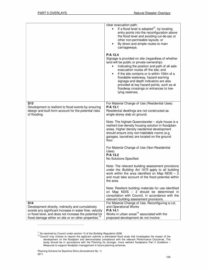
PART 5 OVERLAYS Natural Disaster Overlays
Planning Scheme for Bauhinia Shire (Amendment No. 1) 2011 126
clear evacuation path: • If a flood level is adopted
72, by locating
entry points into the reconfiguration above the flood level and avoiding cul-de-sac or other non-permeable layouts; or
• By direct and simple routes to main carriageways.
P/A 12.4 Signage is provided on site (regardless of whether land will be public or private ownership):
• Indicating the position and path of all safe evacuation routes off the site; and
• If the site contains or is within 100m of a floodable waterway, hazard warning signage and depth indicators are also provided at key hazard points, such as at floodway crossings or entrances to low-lying reserves.
S13 Development is resilient to flood events by ensuring design and built form account for the potential risks of flooding.
For Material Change of Use (Residential Uses) P/A 13.1 Residential dwellings are not constructed as single-storey slab on ground. Note: The highset Queenslander – style house is a resilient low-density housing solution in floodplain areas. Higher density residential development should ensure only non-habitable rooms (e.g. garages, laundries) are located on the ground floor. For Material Change of Use (Non-Residential Uses) P/A 13.2 No Solutions Specified Note: The relevant building assessment provisions under the Building Act 1975 apply to all building work within the area identified on Map NDIS – 2 and must take account of the flood potential within the area. Note: Resilient building materials for use identified on Map NDIS – 2 should be determined in consultation with Council, in accordance with the relevant building assessment provisions.
S14 Development directly, indirectly and cumulatively avoids any significant increase in water flow, velocity or flood level, and does not increase the potential for flood damage either on site or on other properties.73
For Material Change of Use, Reconfiguring a Lot, and Operational Works P/A 14.1 Works in urban areas
73 associated with the
proposed development do not involve:
71
As resolved by Council under section 13 of the Building Regulation 2006. 72
Council may choose to require the applicant submits a site-based flood study that investigates the impact of the development on the floodplain and demonstrates compliance with the relevant Performance Outcomes. The study should be in accordance with the Planning for stronger, more resilient floodplains Part 2 Guideline – Measures to support floodplain management in future planning schemes.

PART 5 OVERLAYS Natural Disaster Overlays
Planning Scheme for Bauhinia Shire (Amendment No. 1) 2011 127
• Any physical alteration to a watercourse or floodway including vegetation clearing; or
• A net increase in filling. P/A 14.2 Works in areas other than an urban area
73 either:
• Do not involve a net increase in filling greater than 50m
3; or
• Do not result in any reductions of on-site flood storage capacity and contain within the subject site any changes to depth/duration/velocity of flood waters; or
• Do not change flood characteristics outside the subject site in ways that result in:
o Loss of flood storage; o Loss of/changes to flow paths; o Acceleration or retardation of
flows; or o Any reduction in flood warning
times elsewhere on the floodplain.
S15 Development avoids the release of hazardous materials into floodwaters.
For Material Change of Use P/A15.1 Materials manufactured or stored on site are not hazardous in nature; or P/A15.2 If a flood level is adopted74, material manufacturing equipment and containers are located above this level; or P/A15.3 If a flood level is not adopted
74, material
manufacturing equipment and containers are located on the highest part of the site to enhance flood immunity. Note: Refer to the Dangerous Goods Safety Management Act 2001 and associated Regulation, the Environmental Protection Act 1994 and the relevant building assessment provisions under the manufacture and storage of hazardous substances.
S16 Community Infrastructure is able to function effectively during and immediately after flood events.
For Material Change of Use P/A 16.1 No Solutions Specified
73
As defined in the Sustainable Planning Regulation 2009.
74 As resolved by Council under section 13 of the Building Regulation 2006.
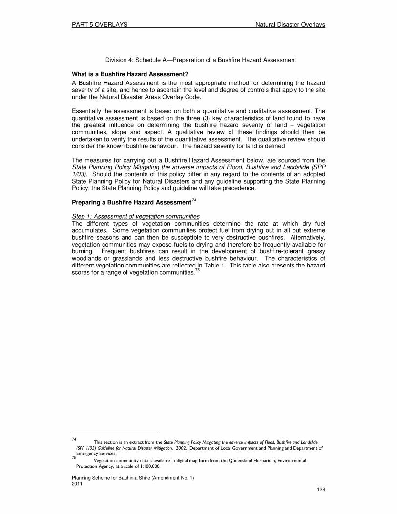
PART 5 OVERLAYS Natural Disaster Overlays
Planning Scheme for Bauhinia Shire (Amendment No. 1) 2011 128
Division 4: Schedule A—Preparation of a Bushfire Hazard Assessment
What is a Bushfire Hazard Assessment?
A Bushfire Hazard Assessment is the most appropriate method for determining the hazard severity of a site, and hence to ascertain the level and degree of controls that apply to the site under the Natural Disaster Areas Overlay Code. Essentially the assessment is based on both a quantitative and qualitative assessment. The quantitative assessment is based on the three (3) key characteristics of land found to have the greatest influence on determining the bushfire hazard severity of land – vegetation communities, slope and aspect. A qualitative review of these findings should then be undertaken to verify the results of the quantitative assessment. The qualitative review should consider the known bushfire behaviour. The hazard severity for land is defined The measures for carrying out a Bushfire Hazard Assessment below, are sourced from the State Planning Policy Mitigating the adverse impacts of Flood, Bushfire and Landslide (SPP 1/03). Should the contents of this policy differ in any regard to the contents of an adopted State Planning Policy for Natural Disasters and any guideline supporting the State Planning Policy; the State Planning Policy and guideline will take precedence.
Preparing a Bushfire Hazard Assessment74
Step 1: Assessment of vegetation communities The different types of vegetation communities determine the rate at which dry fuel accumulates. Some vegetation communities protect fuel from drying out in all but extreme bushfire seasons and can then be susceptible to very destructive bushfires. Alternatively, vegetation communities may expose fuels to drying and therefore be frequently available for burning. Frequent bushfires can result in the development of bushfire-tolerant grassy woodlands or grasslands and less destructive bushfire behaviour. The characteristics of different vegetation communities are reflected in Table 1. This table also presents the hazard scores for a range of vegetation communities.
75
74 This section is an extract from the State Planning Policy Mitigating the adverse impacts of Flood, Bushfire and Landslide (SPP 1/03) Guideline for Natural Disaster Mitigation. 2002. Department of Local Government and Planning and Department of Emergency Services.
75 Vegetation community data is available in digital map form from the Queensland Herbarium, Environmental Protection Agency, at a scale of 1:100,000.
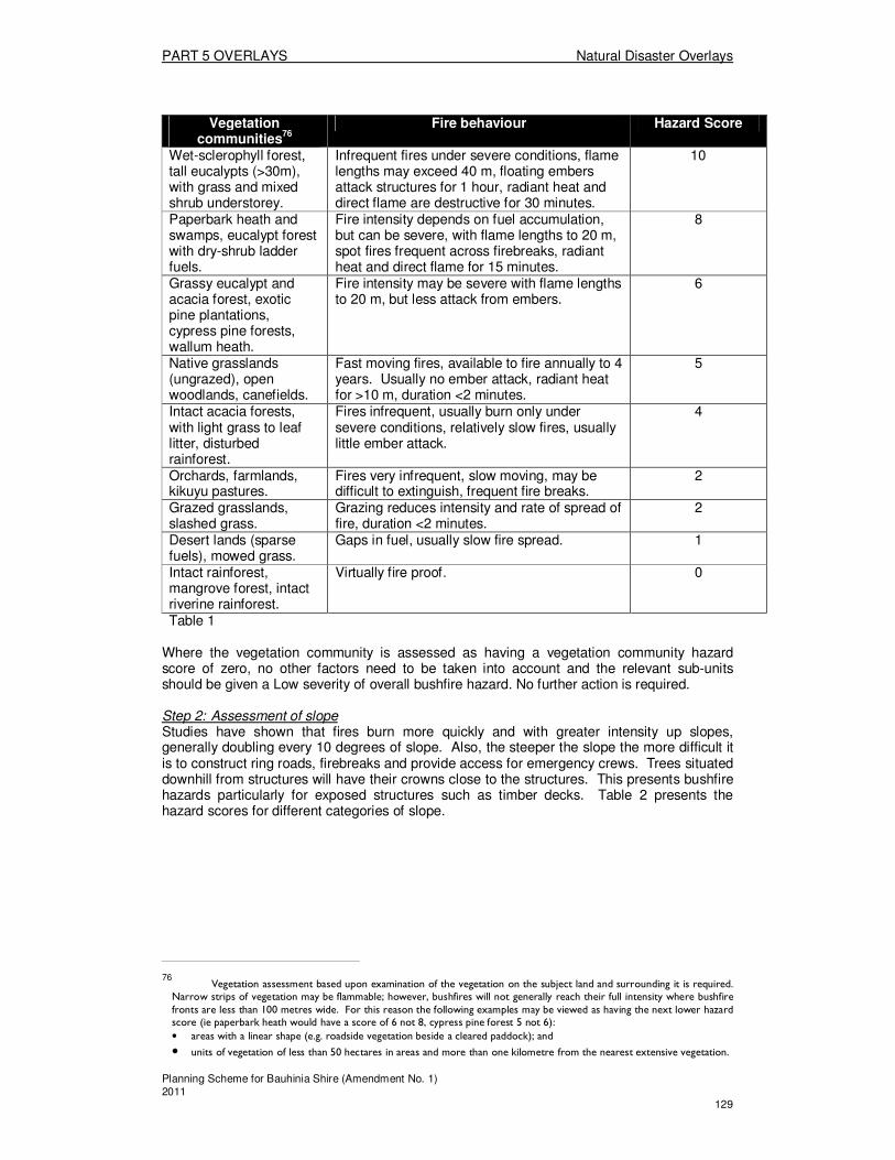
PART 5 OVERLAYS Natural Disaster Overlays
Planning Scheme for Bauhinia Shire (Amendment No. 1) 2011 129
Vegetation
communities76
Fire behaviour Hazard Score
Wet-sclerophyll forest, tall eucalypts (>30m), with grass and mixed shrub understorey.
Infrequent fires under severe conditions, flame lengths may exceed 40 m, floating embers attack structures for 1 hour, radiant heat and direct flame are destructive for 30 minutes.
10
Paperbark heath and swamps, eucalypt forest with dry-shrub ladder fuels.
Fire intensity depends on fuel accumulation, but can be severe, with flame lengths to 20 m, spot fires frequent across firebreaks, radiant heat and direct flame for 15 minutes.
8
Grassy eucalypt and acacia forest, exotic pine plantations, cypress pine forests, wallum heath.
Fire intensity may be severe with flame lengths to 20 m, but less attack from embers.
6
Native grasslands (ungrazed), open woodlands, canefields.
Fast moving fires, available to fire annually to 4 years. Usually no ember attack, radiant heat for >10 m, duration <2 minutes.
5
Intact acacia forests, with light grass to leaf litter, disturbed rainforest.
Fires infrequent, usually burn only under severe conditions, relatively slow fires, usually little ember attack.
4
Orchards, farmlands, kikuyu pastures.
Fires very infrequent, slow moving, may be difficult to extinguish, frequent fire breaks.
2
Grazed grasslands, slashed grass.
Grazing reduces intensity and rate of spread of fire, duration <2 minutes.
2
Desert lands (sparse fuels), mowed grass.
Gaps in fuel, usually slow fire spread. 1
Intact rainforest, mangrove forest, intact riverine rainforest.
Virtually fire proof. 0
Table 1
Where the vegetation community is assessed as having a vegetation community hazard score of zero, no other factors need to be taken into account and the relevant sub-units should be given a Low severity of overall bushfire hazard. No further action is required. Step 2: Assessment of slope Studies have shown that fires burn more quickly and with greater intensity up slopes, generally doubling every 10 degrees of slope. Also, the steeper the slope the more difficult it is to construct ring roads, firebreaks and provide access for emergency crews. Trees situated downhill from structures will have their crowns close to the structures. This presents bushfire hazards particularly for exposed structures such as timber decks. Table 2 presents the hazard scores for different categories of slope.
76 Vegetation assessment based upon examination of the vegetation on the subject land and surrounding it is required. Narrow strips of vegetation may be flammable; however, bushfires will not generally reach their full intensity where bushfire fronts are less than 100 metres wide. For this reason the following examples may be viewed as having the next lower hazard score (ie paperbark heath would have a score of 6 not 8, cypress pine forest 5 not 6):
• areas with a linear shape (e.g. roadside vegetation beside a cleared paddock); and
• units of vegetation of less than 50 hectares in areas and more than one kilometre from the nearest extensive vegetation.

PART 5 OVERLAYS Natural Disaster Overlays
Planning Scheme for Bauhinia Shire (Amendment No. 1) 2011 130
Slope Hazard Score
Gorges and mountains (>30%) 5 Steep Hills (>20% to 30%) 4 Rolling Hills (>10% to 20%) 3 Undulating (>3% to 10%) 2 Plain (0% to 3%) 1 Table 2
Note. Slope is to be calculated in accordance with Division 4 - Schedule C of this
Code – Preparation of a Slope Analysis
Step 3: Assessment of aspect Aspect affects bushfire hazard due to the effects that exposure to direct sunlight has on different vegetation communities, including the drying rates of fuels. Aspect also correlates closely with exposure to low humidity winds that increase bushfire intensity. In extremely broken country where there is a variety of aspects, the predominant aspect is used. As aspect has only a minor influence on flatter land, aspect is not significant on land with a slope less than 5%. Table 3 lists the hazard score for different aspects and Figure 1 illustrates the compass degree ranges for each aspect category.
Aspect Hazard Score
North to North-West 3.5 North-West to West 3 West to South 2 North to East 1 East to South and all land under 5% slope
0
Table 3
Figure 1
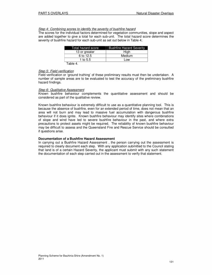
PART 5 OVERLAYS Natural Disaster Overlays
Planning Scheme for Bauhinia Shire (Amendment No. 1) 2011 131
Step 4: Combining scores to identify the severity of bushfire hazard The scores for the individual factors determined for vegetation communities, slope and aspect are added together to give a total for each sub-unit. The total hazard score determines the severity of bushfire hazard for each sub-unit as set out below in Table 4;
Total hazard score Bushfire Hazard Severity
13 or greater High 6 to 12.5 Medium 1 to 5.5 Low
Table 4.
Step 5: Field verification Field verification or ‘ground truthing’ of these preliminary results must then be undertaken. A number of sample areas are to be evaluated to test the accuracy of the preliminary bushfire hazard findings. Step 6: Qualitative Assessment Known bushfire behaviour complements the quantitative assessment and should be considered as part of the qualitative review. Known bushfire behaviour is extremely difficult to use as a quantitative planning tool. This is because the absence of bushfire, even for an extended period of time, does not mean that an area will not burn and may lead to massive fuel accumulation with dangerous bushfire behaviour if it does ignite. Known bushfire behaviour may identify sites where combinations of slope and wind have led to severe bushfire behaviour in the past, and where extra precautions to protect assets might be required. The reliability of known bushfire behaviour may be difficult to assess and the Queensland Fire and Rescue Service should be consulted if questions arise.
Documentation of a Bushfire Hazard Assessment In carrying out a Bushfire Hazard Assessment , the person carrying out the assessment is required to clearly document each step. With any application submitted to the Council stating that land is of a certain Hazard Severity, the applicant must submit with any such statement the documentation of each step carried out in the assessment to verify that statement.

PART 5 OVERLAYS Natural Disaster Overlays
Planning Scheme for Bauhinia Shire (Amendment No. 1) 2011 132
Division 4: Schedule B—Preparation of a Bushfire Management Plan
Preparation and Consultation A Bushfire Management Plan is to be prepared by a suitably qualified professional with appropriate technical expertise in the identification and mitigation of bushfire hazard. Suitable professionals may include those in the environmental management, landscape architecture, architecture, surveying, town planning and civil engineering fields. As a minimum, the author of the Bushfire Management Plan is to consult with the Council, responsible Rural and/or Urban Fire Brigade and managers of adjacent parks or reserves. It is also desirable to consult other agencies or individuals, such as the previous owners of the land or neighbours, who may have local knowledge of the severity and nature of the bushfire hazard. Contents of a Bushfire Management Plan A comprehensive Bushfire Management Plan is to include the following: (a) An assessment of the nature and severity of the bushfire hazard affecting the site.
This should comprise a detailed site-based assessment using the methodology set out in Division 4 - Schedule A – Preparation of a Bushfire Hazard Assessment. The assessment should also address other site specific factors that are important in devising suitable bushfire mitigation strategies. These factors could include matters such as; i. the likely direction of bushfire attack; ii. the environmental values that may limit mitigation options; and iii. the location of evacuation routes and/or safety zones.
(b) An assessment of the specific risk factors associated with the development proposal, including matters such as; i. the nature of activities and materials to be conducted / stored on the site; and ii. the numbers and types of persons likely to be present; and iii. particular warning and / or evacuation requirements.
(c) A plan for mitigating the bushfire risk identified in (a) and (b) above. The plan should address the relevant Specific outcomes, Probable Solutions and Acceptable Solutions of the Natural Disaster Area Code, applicable to Bushfire Hazard Land and recommend specific mitigation actions for the proposed development including: (1) road and lot layout and land use allocations; (2) firebreaks and buffers; (3) building locations or building envelopes; (4) landscaping treatments; (5) warning and evacuation procedures and routes; (6) firefighting requirements including infrastructure; (7) any other specific measures such as external sprinkler systems and alarms; (8) purchaser/resident education and awareness programs; and (9) ongoing maintenance and response awareness programs.
The level of detail required will vary with the nature of the development proposal and site, and with the type of development application. The level of detail required to accompany a particular application should be determined in consultation with the assessment manager. However, it is required, at a minimum, that items (a), (b) and (c) (1) – (3) outlined above be addressed in any Bushfire Management Plan.

PART 5 OVERLAYS Natural Disaster Overlays
Planning Scheme for Bauhinia Shire (Amendment No. 1) 2011 133
Division 4: Schedule C—Preparation of a Slope Analysis
What is a Slope Analysis?
A Slope Analysis is the most appropriate method for determining the slope of any land, and in doing so ascertaining if the land contains steep slopes. Steep slopes are defined as those of 15% or greater, and are those which are more susceptible to landslide.
Preparing a Slope Analysis
Step 1: Obtaining the necessary information Topographical information, namely contour information for the land, is required to be able to undertake a Slope Analysis. Given the size of the Shire, available mapping is limited, and in most cases it will be necessary for proponents to have the land surveyed by a qualified surveyor to acquire contour information. Step 2: Determining Slope Slope can be described in two different ways, a percent gradient or an angle of the slope. For the purposes of implementing this Code, a percent gradient is used. The methodology for calculating the percent of gradient of slope is as follows:
1. Determine the site area of the development, over which to calculate slope. Note, it should be an area where the slope direction does not change. Do not cross the top of a hill or the bottom of the valley.
2. When an area of interest is determined, draw a straight line perpendicular to the contours of the slope. For better accuracy, stare and end the line on, rather than between, contours on the map.
3. Measure the length of the of the line drawn and, using the scale of the map, convert that distance to metres.
4. Determine the total elevation change in metres along the line drawn (ie. Subtract the elevation of the lowest contour used form the elevation of the highest contour used). No conversions are necessary on this measurement, because it is a real-world elevation change.
5. To calculate a percent slope, divide the elevation change in metres by the distance of the line drawn (after convertin it to metres). Multiply the resulting number by 100 to get a percentage value equal to the percent slope of the hill. If the value you calculate is, for example 20, this means that for every 100 metres covered in a horizontal direction, 20 metres will be gained (or lost) in elevation.
EXAMPLE Length of measured line = 425m Elevation Change = 20m (read off contours) Percentage Slope = 20/425 x 100 = 4.7% slope
Additional reference should be made to Appendix 10 of SPP Guideline 1/03
PART 6 DEVELOPMENT OF A STATED PURPOSE OR OF A STATED TYPE Preliminary
Planning Scheme for Bauhinia Shire (Amendment No. 1) 2011 134
PART 6—ASSESSMENT CRITERIA FOR DEVELOPMENT FOR A STATED PURPOSE OR OF A
STATED TYPE
Division 1—Preliminary
6.1.1 Codes for development for a stated purpose or development of a stated type
The provisions in this part comprise the following codes— � Accommodation Buildings Code (Division 2); � Agricultural Use Code (Division 3); � Animals Code (Division 4); � Caravan Park and Worker’s Accommodation Code (Division 5); � Commercial Code (Division 6); � Development Standards Code (Division 7); � Development Design Code (Division 8); � Extractive Industry Code (Division 9); � Home Based Business Code (Division 10); � Home Host Accommodation Code (Division 11); � House Code (Division 12); � Reconfiguring of a Lot Code (Division 13); � Residential Accommodation Code (Division 14); and � Service Station Code (Division 15).
PART 6 DEVELOPMENT OF A STATED PURPOSE OR OF A STATED TYPE Accommodation Buildings Code
Planning Scheme for Bauhinia Shire (Amendment No. 1) 2011 135
Division 2—Accommodation Buildings Code
About the Accommodation Buildings Code � The Accommodation Buildings Code regulates different types of accommodation
buildings, including motels, hostels, serviced apartments, and the accommodation component of hotels and community purpose uses, whether they are Self assessable, Code assessable or Impact assessable.
� The Code regulates the scale, siting, density and design of development.
(1) Accommodation Buildings Code
The provisions in this division comprise the Accommodation Buildings Code. They are— 1. The Purpose of the Accommodation Buildings Code – Section (2); and 2. The Specific Outcomes, Probable Solutions and Acceptable Solutions for
Accommodation Building development – Table 6.2.1.
(2) The Purpose of the Accommodation Buildings Code The purpose of the Accommodation Buildings Code is to achieve the following overall outcomes: 1. Are located where they best serve the accommodation needs of users,
particularly visitors to the Shire; 2. Are located and designed to be compatible with the locality in which they are
situated and do not adversely impact upon surrounding residential premises; 3. Provide a reasonable level of privacy and amenity to users; and 4. Contribute positively to the streetscape and town character.
TABLE 6.2.1 ACCOMMODATION BUILDINGS
Column 1 Column 2
Specific outcomes (S) for Code and Impact assessable development
Probable Solutions (P) for Code and Impact assessable development;
and
Acceptable Solutions (A) for Self assessable development. (where Self assessable development does not meet the Acceptable Solutions in the applicable codes, it requires Code assessment. Refer to Section 1.2.9)
All Accommodation Buildings
Site and Location S1 Accommodation Buildings are located:
1. in those parts of the Shire that are normally frequented by visitors and tourists, or are adjacent to roads normally travelled by tourists to or through the Shire, including public transport; and
2. on land that is suitable for the use and of an area sufficient area to accommodate the requirements of this Code, whilst having regard to the following: (a) The existing development on
P1.1 Accommodation Buildings are located:
1. In the Town – Commercial Precinct, or
2. Not more than 500 m from the Town – Recreation Precinct.
P1.2 Accommodation Buildings are located on lots with a:
1. Minimum lot size of 1000m2; and
2. Minimum primary road frontage of 20m.

PART 6 DEVELOPMENT OF A STATED PURPOSE OR OF A STATED TYPE Accommodation Buildings Code
Planning Scheme for Bauhinia Shire (Amendment No. 1) 2011 136
the site; (b) The existing and proposed
amenity of the Zone Area/Precinct; and
(c) The topography of the site.
P1.3 Accommodation Buildings have a maximum site cover as follows:
1. 50% for all parts of a building or buildings one storey in height; and
2. 40% for all parts of a building or buildings two storeys in height; and
3. 35% for all parts of a building or buildings more than 2 storeys in height.
Development Density S2 The development density is consistent with the Overall Outcomes of the Zone and Area/Precinct in which the site is situated.
P2.1 For Accommodation Buildings the maximum number of accommodation units on a site is 1 accommodation unit per 200m2 of site area.
Landscaped Areas S3 Sufficient landscaped areas are provided on-site:
1. To compliment any street plantings;
2. To provide soft and hard landscaped areas on-site;
3. To screen unsightly buildings; 4. To accommodate the communal
and private open space needs of residents;
5. To provide shaded recreational areas;
6. To offer shelter to buildings with a western aspect; and
7. To accommodate communal refuge storage and other services.
8. To comply with Guidelines to minimise mosquito and biting midge problems in new development areas.
P3.1 Accommodation Buildings have landscaped areas which comprise at least 30% of the site, of which a minimum of 15% of the site as useable landscaped areas.
77
Carparking and Access S4 Vehicular access to the site is safe and allows for easy vehicle manoeuvring.
P4.1 Access driveways and any visitor car parking is:
1. Provided with an impervious seal; and
2. Located and designed so that vehicles can exit the site in a forward gear.
S5 The design and location of vehicle access and parking areas within the development:
1. Has minimal impacts upon the amenity of neighbouring residential properties; and
2. Contributes to the development of an attractive residential streetscape.
P5.1 No Solutions Specified
77 See also the provisions of P11.1 of this Code, which relate to landscaped areas.
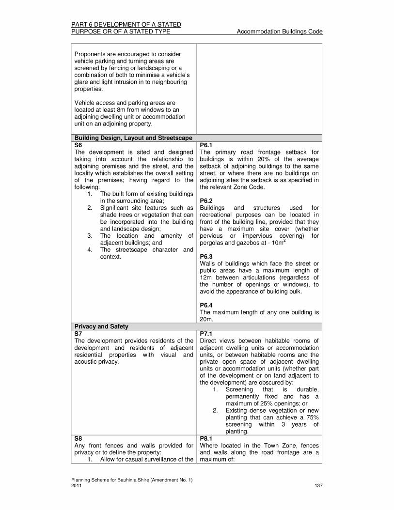
PART 6 DEVELOPMENT OF A STATED PURPOSE OR OF A STATED TYPE Accommodation Buildings Code
Planning Scheme for Bauhinia Shire (Amendment No. 1) 2011 137
Proponents are encouraged to consider vehicle parking and turning areas are screened by fencing or landscaping or a combination of both to minimise a vehicle’s glare and light intrusion in to neighbouring properties. Vehicle access and parking areas are located at least 8m from windows to an adjoining dwelling unit or accommodation unit on an adjoining property. Building Design, Layout and Streetscape S6 The development is sited and designed taking into account the relationship to adjoining premises and the street, and the locality which establishes the overall setting of the premises; having regard to the following:
1. The built form of existing buildings in the surrounding area;
2. Significant site features such as shade trees or vegetation that can be incorporated into the building and landscape design;
3. The location and amenity of adjacent buildings; and
4. The streetscape character and context.
P6.1 The primary road frontage setback for buildings is within 20% of the average setback of adjoining buildings to the same street, or where there are no buildings on adjoining sites the setback is as specified in the relevant Zone Code. P6.2 Buildings and structures used for recreational purposes can be located in front of the building line, provided that they have a maximum site cover (whether pervious or impervious covering) for pergolas and gazebos at - 10m
2
P6.3 Walls of buildings which face the street or public areas have a maximum length of 12m between articulations (regardless of the number of openings or windows), to avoid the appearance of building bulk. P6.4 The maximum length of any one building is 20m.
Privacy and Safety S7 The development provides residents of the development and residents of adjacent residential properties with visual and acoustic privacy.
P7.1 Direct views between habitable rooms of adjacent dwelling units or accommodation units, or between habitable rooms and the private open space of adjacent dwelling units or accommodation units (whether part of the development or on land adjacent to the development) are obscured by:
1. Screening that is durable, permanently fixed and has a maximum of 25% openings; or
2. Existing dense vegetation or new planting that can achieve a 75% screening within 3 years of planting.
S8 Any front fences and walls provided for privacy or to define the property:
1. Allow for casual surveillance of the
P8.1 Where located in the Town Zone, fences and walls along the road frontage are a maximum of:

PART 6 DEVELOPMENT OF A STATED PURPOSE OR OF A STATED TYPE Accommodation Buildings Code
Planning Scheme for Bauhinia Shire (Amendment No. 1) 2011 138
street; and 2. Are compatible with the building
and streetscape.
1. 1.2m high if solid; or 2. 1.5m high if the fence has
openings which make it at least 50% transparent.
P8.2 As an exception to P8.1 above, solid front fences and walls up to 1.8m high may be provided where:
1. The useable landscaped areas and private open space areas are in front of buildings and the fence length is limited to 75% of the frontage; or
2. The fence or wall fronts a main road and
3. the length of the fence or wall does not exceed 15m in length without some articulation or detailing to provide visual interest.
Development on sites with frontage to a Main Road S9 Development on sites with a frontage to a main road are designed such that the negative effects of traffic noise are minimised and resident privacy is protected, having regard to:
1. Building siting; 2. The use of front fences and walls; 3. Internal layout of buildings; 4. The location of communal and
private open space areas.
P9.1 Private open space areas are not located in the building setback to the road. P9.2 Usable landscaped areas and private open space areas are only located in the building setback to the road, where resident privacy can be maintained with the use of a solid fence or wall provided in accordance with P8.2 (1) above. P/A9.3 The room layout within a noise sensitive use is arranged to reduce the impact of noise on the rooms which are most sensitive to noise eg. locate bathrooms, hallways, stairways, storage rooms and car parking closest to the road frontage. Note: Mature landscaping is provided along walls referred to in P9.1 above, to avoid the appearance of blank walls from the road.
Amenity S10 Buildings and facilities are located and designed so as to minimise potential noise and light impacts beyond the property boundaries, particularly where adjoining residential premises. Air conditioning units and pool filters are located, enclosed, of a type, or otherwise installed such that they are least likely to cause an environmental nuisance to any adjoining premises.
P10.1 Vehicular access points are located at least 3 metres from any boundary shared with residential premises or land in the Town – Residential Precinct.
S11 Buildings and facilities are located and
P11.1 Building setbacks are sufficient to enable

PART 6 DEVELOPMENT OF A STATED PURPOSE OR OF A STATED TYPE Accommodation Buildings Code
Planning Scheme for Bauhinia Shire (Amendment No. 1) 2011 139
designed so as to enhance the streetscape appearance. Air conditioning units and other service equipment and areas eg. Bin storage, kitchen vents, pool filters, are located such that they do not present an unsightly view to the street or other public place.
the provision of at least a third of the landscaped area required in P3.1, across the primary road frontage of the site.
Motels
Site characteristics S12 Motel development is located on parcels of land of an area that is suitable for the siting of buildings, landscaped open space to screen living and recreation areas, and vehicle manoeuvring and parking, having regard to the following:
1. The existing development in the area;
2. The existing and proposed amenity of the area;
3. The topography of the site; and 4. The number of roads to which the
site has frontage.
P12.1 Motels have:
1. A minimum site area of 2000m2; 2. A landscaped area comprising at
least 30% of the site; and 3. Sufficient land available for the
provision of necessary bus manoeuvring and on-site parking where there are more than 30 units.
Amenity S13 Buildings and facilities are located and designed so as to minimise potential noise impacts beyond the property boundaries, particularly where adjoining residential premises. Air conditioning units and pool filters are located, enclosed, of a type, or otherwise installed such that they are least likely to cause an environmental nuisance to any adjoining premises.
P13.1 Vehicular access points are located at least 3 metres from any boundary shared with residential premises or land in the Town – Residential Precinct. P13.2 Restaurants associated with Motels are provided only where the premises are sited within or adjoining the Town – Commercial Precinct.

PART 6 DEVELOPMENT OF A STATED PURPOSE OR OF A STATED TYPE Agricultural Use Code
Planning Scheme for Bauhinia Shire (Amendment No. 1) 2011 140
Division 3—Agricultural Use Code
About the Agricultural Use Code � The Agricultural Use Code regulates Agriculture and Intensive Agriculture uses,
whether they are Self assessable, Code assessable or Impact assessable. � The Code would therefore apply to the general growing of plants or crops, as a new
use of land. � The Code regulates the location of new uses in terms of their potential impacts on the
amenity of nearby residential uses, and the road network. � Other potential impacts of the uses, such as on water resources and important
habitats, are regulated through the relevant Zone Code.
(1) Agricultural Use Code
The provisions in this division comprise the Agricultural Use Code. They are — 1. The Purpose of the Agricultural Use Code - Section (2); and 2. The Specific Outcomes, Probable Solutions and Acceptable Solutions for
Agricultural Uses – Table 6.3.1. (2) The Purpose of the Agricultural Use Code
The purpose of the Agricultural Use Code is to achieve the following overall outcomes: 1. Agriculture and Intensive Agriculture is:
(a) Located where the potential impacts upon the amenity of the area are minimised; and
(b) Located where there is adequate vehicular access to service the use, without detriment to the road network’s efficiency and safety.
TABLE 6.3.1 AGRICULTURAL USES
Column 1 Column 2
Specific outcomes (S) for Code and Impact assessable development
Probable Solutions (P) for Code and Impact assessable development;
and
Acceptable Solutions (A) for Self assessable development (where Self assessable development does not meet the Acceptable Solutions in the applicable codes, it requires Code assessment. Refer to Section 1.2.9)
All Agriculture and Intensive Agriculture
Separation Distances S1 Agriculture and Intensive Agriculture uses are located:
1. Away from urban areas and residential uses, to protect the amenity from the impacts of agricultural activities; and
2. In a manner which satisfies the provisions of the Planning Guidelines: Separating Agricultural and Residential Uses.
P/A1.1 Agriculture and Intensive Agriculture uses are setback from uses in the Residential Use Class, in accordance with PART 4: Division 1 – Schedule A (Rural Zone Code).
S2 Harvesting, packing and loading of produce is conducted in a manner that minimises impacts on the amenity of the locality.
P/A2.1 Where located within 1000m of any use in the Residential Use Class, whether on adjoining land or not, the operation of

PART 6 DEVELOPMENT OF A STATED PURPOSE OR OF A STATED TYPE Agricultural Use Code
Planning Scheme for Bauhinia Shire (Amendment No. 1) 2011 141
equipment and machinery, and the use of outdoor lighting is limited to the following:
1. Monday to Saturday - 7am to 7pm;and
2. Sunday and Public Holidays - 8am to 7pm.
All Intensive Agriculture
Road Network S3 Augmentation of the existing road network is provided to the extent necessary to service intensive agricultural uses.
P3.1 External road works, whether new road construction or the upgrade of existing roads, are undertaken to provide a road network designed to the standards specified in the Development Standards Code.

PART 6 DEVELOPMENT OF A STATED PURPOSE OR OF A STATED TYPE Animals Code
Planning Scheme for Bauhinia Shire (Amendment No. 1) 2011 142
Division 4—Animals Code
About the Animals Code � The Animals Code regulates the keeping of animals, whether they are Self
assessable, Code assessable or Impact assessable. � The Code is applicable to new uses whether the keeping of animals is for grazing,
breeding, training, or intensive animal husbandry (including aquaculture). � The Code does not apply to Domestic Pets, which are separately defined, and are
regulated by Council’s Local Laws. � The Code regulates the location of new uses in terms of their potential impacts on
the amenity of nearby sensitive uses, and the road network. � Other potential impacts of the uses, such as on water resources and important
habitats, are regulated through the relevant Zone Code and Overlays.
(1) Animals Code
The provisions in this division comprise the Animals Code. They are — 1. The Purpose of the Animals Code - Section (2); and 2. The Specific Outcomes, Probable Solutions and Acceptable Solutions for the
keeping of Animals – Table 6.4.1. (2) The Purpose of the Animals Code
The purpose of the Animals Code is to achieve the following overall outcomes: 1. Animal Husbandry and Intensive Animal Husbandry uses:
(a) Are located and designed in a manner that minimises potential impacts on the amenity of the area or nearby sensitive uses; and
(b) Located where there is adequate vehicular access to service the use, without detriment to the road network’s efficiency and safety; and
(c) Located where the risks of environmental harm are minimised.
TABLE 6.4.1 ANIMALS
Column 1 Column 2
Specific outcomes (S) for Code and Impact assessable development
Probable Solutions (P) for Code and Impact assessable development;
and
Acceptable Solutions (A) for Self assessable development (where Self assessable development does not meet the Acceptable Solutions in the applicable codes, it requires Code assessment. Refer to Section 1.2.9)
All Animal Husbandry uses
Site and Location S1 Animal Husbandry uses are located and designed to ensure that the amenity of the surrounding area, particularly residences, is maintained and having regard to:
1. The nature of existing and future uses on adjoining land and in the surrounding area;
2. The setbacks of animal enclosures or paddocks;
3. The natural features of the site including topography, soils, watercourses; and
P/A1.1 Animal enclosures eg. Stables, barns, holding yards, are separated a minimum of 100m from existing or approved uses in the Residential Use Class; or have separation distances provided in accordance with PART 4: Division 1 - Schedule A (Rural Zone Code), whichever is the greater separation distance.
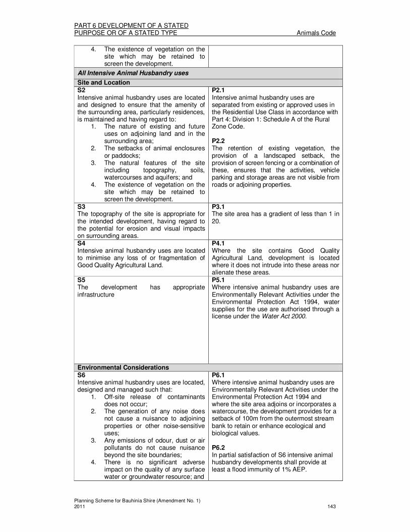
PART 6 DEVELOPMENT OF A STATED PURPOSE OR OF A STATED TYPE Animals Code
Planning Scheme for Bauhinia Shire (Amendment No. 1) 2011 143
4. The existence of vegetation on the site which may be retained to screen the development.
All Intensive Animal Husbandry uses
Site and Location S2 Intensive animal husbandry uses are located and designed to ensure that the amenity of the surrounding area, particularly residences, is maintained and having regard to:
1. The nature of existing and future uses on adjoining land and in the surrounding area;
2. The setbacks of animal enclosures or paddocks;
3. The natural features of the site including topography, soils, watercourses and aquifers; and
4. The existence of vegetation on the site which may be retained to screen the development.
P2.1 Intensive animal husbandry uses are separated from existing or approved uses in the Residential Use Class in accordance with Part 4: Division 1: Schedule A of the Rural Zone Code. P2.2 The retention of existing vegetation, the provision of a landscaped setback, the provision of screen fencing or a combination of these, ensures that the activities, vehicle parking and storage areas are not visible from roads or adjoining properties.
S3 The topography of the site is appropriate for the intended development, having regard to the potential for erosion and visual impacts on surrounding areas.
P3.1 The site area has a gradient of less than 1 in 20.
S4 Intensive animal husbandry uses are located to minimise any loss of or fragmentation of Good Quality Agricultural Land.
P4.1 Where the site contains Good Quality Agricultural Land, development is located where it does not intrude into these areas nor alienate these areas.
S5 The development has appropriate infrastructure
P5.1 Where intensive animal husbandry uses are Environmentally Relevant Activities under the Environmental Protection Act 1994, water supplies for the use are authorised through a license under the Water Act 2000.
Environmental Considerations S6 Intensive animal husbandry uses are located, designed and managed such that:
1. Off-site release of contaminants does not occur;
2. The generation of any noise does not cause a nuisance to adjoining properties or other noise-sensitive uses;
3. Any emissions of odour, dust or air pollutants do not cause nuisance beyond the site boundaries;
4. There is no significant adverse impact on the quality of any surface water or groundwater resource; and
P6.1 Where intensive animal husbandry uses are Environmentally Relevant Activities under the Environmental Protection Act 1994 and where the site area adjoins or incorporates a watercourse, the development provides for a setback of 100m from the outermost stream bank to retain or enhance ecological and biological values. P6.2 In partial satisfaction of S6 intensive animal husbandry developments shall provide at least a flood immunity of 1% AEP.

PART 6 DEVELOPMENT OF A STATED PURPOSE OR OF A STATED TYPE Animals Code
Planning Scheme for Bauhinia Shire (Amendment No. 1) 2011 144
5. The ecological and hydraulic processes of any watercourses are not adversely affected.
78
Road network S7 Augmentation of the existing road network is provided to the extent necessary to service agricultural uses.
P7.1 No Solutions Specified.
78 A hydrogeological investigation by a suitably qualified person will need to be prepared to identify any valuable
groundwater resources and their vulnerability to contamination.

PART 6 DEVELOPMENT OF A STATED PURPOSE OR OF A STATED TYPE Caravan Park and Worker’s Accommodation Code
Planning Scheme for Bauhinia Shire (Amendment No. 1) 2011 145
Division 5—Caravan Park and Worker’s Accommodation Code
About the Caravan Park and Worker’s Accommodation Code � The Caravan Park and Worker’s Accommodation Code regulates Caravan Park, and
Worker’s Accommodation uses, whether they are Self assessable, Code assessable or Impact assessable.
� The Code regulates the location, siting and scale of such uses, the facilities for occupants, as well as the potential impacts on the amenity of the surrounding area.
(1) Caravan Park and Worker’s Accommodation Code
The provisions in this division comprise the Caravan Park and Worker’s Accommodation Code. They are— 1. The Purpose of the Caravan Park and Worker’s Accommodation Code –
Section (2); and 2. The Specific Outcomes, Probable Solutions and Acceptable Solutions for
Caravan Park and Worker’s Accommodation development – Table 6.5.1.
(2) The Purpose of the Caravan Park and Worker’s Accommodation Code The purpose of the Caravan Park and Worker’s Accommodation Code is to achieve the following overall outcomes: 1. Caravan Parks:
(a) Are provided in a manner that is of a high standard of health, safety and amenity for visitors and residents;
(b) Are located where they best serve the accommodation needs of users, particularly visitors to the Shire;
(c) Are located and designed to be compatible with the locality in which they are situated and do not adversely impact upon surrounding residential premises; and
(d) Contribute positively to the streetscape and town character. 2. Worker’s Accommodation:
(a) Is provided in a manner that is of a high standard of health, safety and amenity for residents;
(b) Is located where they best serve the accommodation needs of residents;
(c) Is located and designed to be compatible with the locality in which they are situated: and
(d) Does not adversely impact on the amenity of the area due to residential densities, traffic generation, hours of operation, built form, or associated on-site facilities.
TABLE 6.5.1 CARAVAN PARKS & WORKER’S ACCOMMODATION
Column 1 Column 2
Specific outcomes (S) for Code and Impact assessable development
Probable Solutions (P) for Code and Impact assessable development
All Caravan Parks and Worker’s Accommodation
Site characteristics S1 Caravan Parks and Worker’s Accommodation are located on parcels of land of an area that are suitable for the siting of buildings, landscaped open space to screen living and recreation areas, and vehicle manoeuvring and parking, having regard to the following:
1. The existing development in the
P1.1 Caravan Parks have:
1. A minimum site area of 4000m2; and
2. A landscaped setback width of at least 5m along all road frontages.
P1.2 Worker’s Accommodation has:
1. A minimum site area of 5000m2; and
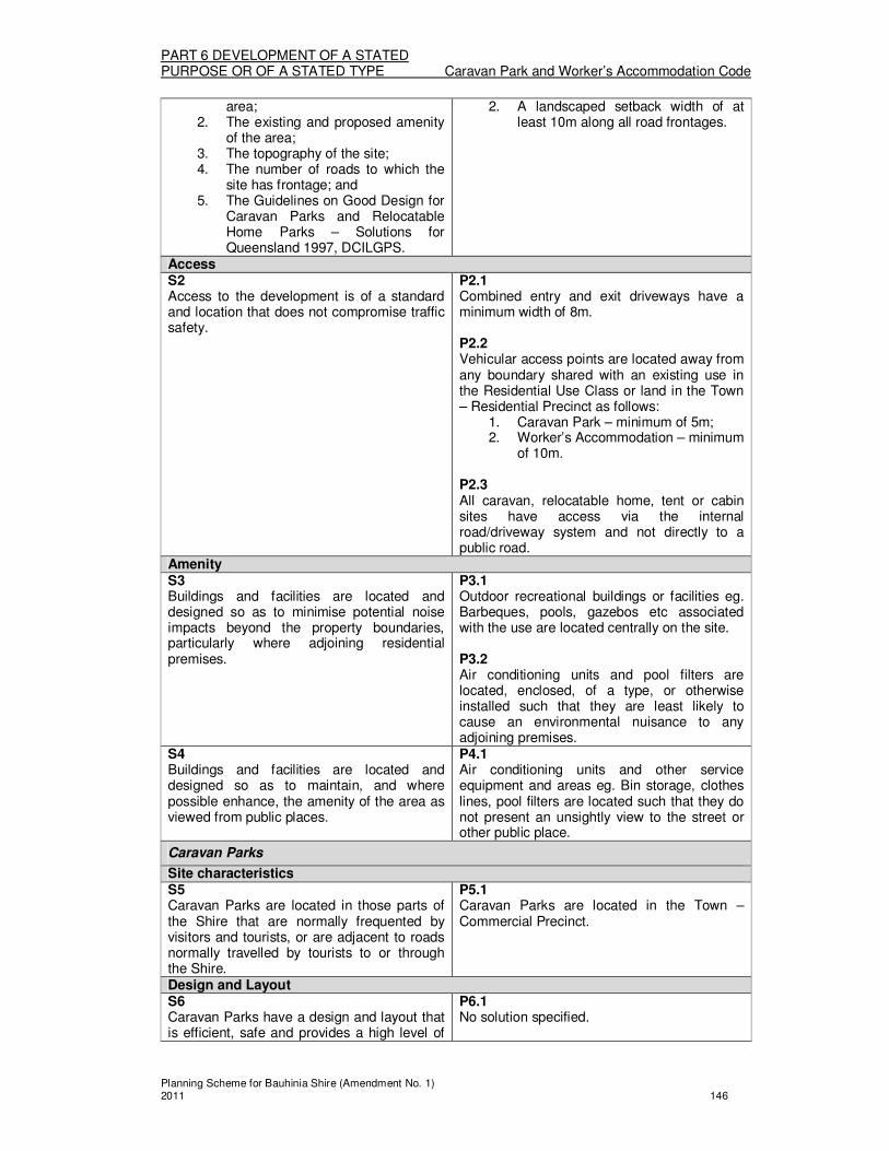
PART 6 DEVELOPMENT OF A STATED PURPOSE OR OF A STATED TYPE Caravan Park and Worker’s Accommodation Code
Planning Scheme for Bauhinia Shire (Amendment No. 1) 2011 146
area; 2. The existing and proposed amenity
of the area; 3. The topography of the site; 4. The number of roads to which the
site has frontage; and 5. The Guidelines on Good Design for
Caravan Parks and Relocatable Home Parks – Solutions for Queensland 1997, DCILGPS.
2. A landscaped setback width of at least 10m along all road frontages.
Access S2 Access to the development is of a standard and location that does not compromise traffic safety.
P2.1 Combined entry and exit driveways have a minimum width of 8m. P2.2 Vehicular access points are located away from any boundary shared with an existing use in the Residential Use Class or land in the Town – Residential Precinct as follows:
1. Caravan Park – minimum of 5m; 2. Worker’s Accommodation – minimum
of 10m. P2.3 All caravan, relocatable home, tent or cabin sites have access via the internal road/driveway system and not directly to a public road.
Amenity S3 Buildings and facilities are located and designed so as to minimise potential noise impacts beyond the property boundaries, particularly where adjoining residential premises.
P3.1 Outdoor recreational buildings or facilities eg. Barbeques, pools, gazebos etc associated with the use are located centrally on the site. P3.2 Air conditioning units and pool filters are located, enclosed, of a type, or otherwise installed such that they are least likely to cause an environmental nuisance to any adjoining premises.
S4 Buildings and facilities are located and designed so as to maintain, and where possible enhance, the amenity of the area as viewed from public places.
P4.1 Air conditioning units and other service equipment and areas eg. Bin storage, clothes lines, pool filters are located such that they do not present an unsightly view to the street or other public place.
Caravan Parks
Site characteristics S5 Caravan Parks are located in those parts of the Shire that are normally frequented by visitors and tourists, or are adjacent to roads normally travelled by tourists to or through the Shire.
P5.1 Caravan Parks are located in the Town – Commercial Precinct.
Design and Layout S6 Caravan Parks have a design and layout that is efficient, safe and provides a high level of
P6.1 No solution specified.

PART 6 DEVELOPMENT OF A STATED PURPOSE OR OF A STATED TYPE Caravan Park and Worker’s Accommodation Code
Planning Scheme for Bauhinia Shire (Amendment No. 1) 2011 147
amenity to park guests.
Worker’s Accommodation
Site characteristics S7 Worker’s Accommodation is:
1. located in close proximity to, or on, the site on which workers are employeed; or
2. located in the town closest to the site on which workers are employeed; and
3. are not visually obtrusive as viewed from public land or roads, due to the use of landscaping to screen the use.
P7.1 No solutions specified.
Amenity S8 On site facilities including:
1. bus pickup/setdown, parking or turning areas;
2. resident car parking areas; 3. dining halls; and 4. indoor recreation facilities;
are located and designed so as to: a) take account of their usage
in unusual hours; and b) minimise potential noise
impacts beyond the property boundaries, particularly where adjoining residential premises.
P8.1 Resident car parking areas are setback a minimum of 15m from any boundary shared with an existing use in the Residential Use Class or land in the Town – Residential Precinct. P8.2 Dining Halls and indoor recreation rooms are setback at least 20m to any boundary shared with an existing use in the Residential Use Class or land in the Town – Residential Precinct.

PART 6 DEVELOPMENT OF A STATED PURPOSE OR OF A STATED TYPE Commercial Code
Planning Scheme for Bauhinia Shire (Amendment No. 1) 2011 148
Division 6—Commercial Code
About the Commercial Code � The Commercial Code regulates most uses in the Commercial Use Class,
whether they are Self assessable, Code assessable or Impact assessable. (Note: the Tables of Assessment in the relevant Zone/Overlay stipulate when this Code is applicable)
� The Code regulates the scale and form of buildings, their siting and location, the provision of access and parking, and other design elements that are important in the Towns of the Shire.
(1) Commercial Code
The provisions in this division comprise the Commercial Code. They are— 1. The Purpose of the Commercial Code – Section (2); and 2. The Specific Outcomes, Probable Solutions and Acceptable Solutions for
Commercial development – Table 6.6.1.
(2) The Purpose of the Commercial Code The purpose of the Commercial Code is to achieve the following overall outcomes: 1. Commercial development is:
(a) Located on sites which are suitable for commercial uses having regard to size, location, and accessibility for vehicles and pedestrians;
(b) Consistent with the desired character and amenity of the locality; and (c) Designed to provide a safe and pleasant environment.
TABLE 6.6.1 COMMERCIAL DEVELOPMENT
Column 1 Column 2
Specific outcomes (S) for Code and Impact assessable development
Probable Solutions (P) for Code and Impact assessable development;
and
Acceptable Solutions (A) for Self assessable development (where Self assessable development does not meet the Acceptable Solutions in the applicable codes, it requires Code assessment. Refer to Section 1.2.9)
All Uses and Works outside the Town – Commercial Precinct
Building Scale and Form S1 Building scale and form:
1. is consistent with other buildings in the street;
2. is consistent with the purpose of the land, as indicated by its Zoning; and
3. does not negatively impact upon the amenity of adjoining land or streetscape.
P/A1.1 Buildings have a total site cover not exceeding 40%. P/A1.2 A landscaped area that is a minimum of 30% of the site area is provided in accordance with the Development Standard Code – Landscaping.
All Uses and Works in the Town – Commercial Precinct
Building Scale and Form S2 Development is designed and constructed such that it is in keeping with the existing character of the town, and having regard to the following:
1. The location, scale, height and bulk
P/A2.1 A suspended or cantilever awning, or post-supported verandah is provided across all road frontages of the site, and to the full width of the footpath, to offer shelter to pedestrians.

PART 6 DEVELOPMENT OF A STATED PURPOSE OR OF A STATED TYPE Commercial Code
Planning Scheme for Bauhinia Shire (Amendment No. 1) 2011 149
of buildings on adjoining premises and in the surrounding area;
2. The type of building materials used in the construction of buildings on adjoining premises and in the surrounding area;
3. The role of the commercial centre eg Town;
4. The provision of pedestrian pathways and shelter eg overhang or verandahs along the street; and
5. The location of car parking on sites in the vicinity.
P/A2.2 The outermost projection (towards the street) for any verandah provided in accordance with P/A2.1 above, is no closer than 0.5m to the kerb, to ensure that there is sufficient clearance between the structure and the on-street parking areas. P/A2.3 Car parking is provided at the rear of the building. P/A2.4 Buildings have a total site cover:
1. not exceeding 80% in the Town – Commercial Precinct; and
2. not exceeding 40% in other locations
Active Frontages S3 Active frontages are maintained along all road frontages.
P/A3.1 Where development is a mix of residential and non residential uses:
1. dwelling units are located behind non residential uses at ground level; and
2. any car parking or garages associated with the residential use are located at the rear of the premises.
P/A3.2 Buildings incorporate a minimum of 70% of the frontage as door openings, window glazing or transparent materials/display areas, as distinct from blank walls. P/A3.3 Active frontages are punctuated only where it is necessary to provide access driveways to on-site car parking, loading and service facilities.
Public safety S4 Commercial development promotes public safety.
P/A4.1 Entry points to buildings have direct access onto the street or other public space. P/A4.2 Illuminated pedestrian links are provided through landscaped areas to building entrances from car parking areas. P/A4.3 Landscaping on the site incorporates the use of tree or low shrub species, such that planting does not prevent the casual surveillance of public spaces and car parking areas, and is achieved by plantings:
1. Providing a tree canopy, with the

PART 6 DEVELOPMENT OF A STATED PURPOSE OR OF A STATED TYPE Commercial Code
Planning Scheme for Bauhinia Shire (Amendment No. 1) 2011 150
canopy height being greater than 1.8m; and
2. Providing hedges with a maximum height of 1m.
Impacts on surrounding residential uses S5 Residential amenity is maintained for residential uses which exist, or which are planned eg in the Town – Residential Precinct, on adjoining land to the new commercial development.
P/A5.1 Undesirable visual, noise and odour impacts are avoided or reduced by:
1. The siting of vehicle loading and refuse storage and collection areas furthest from land in the Town – Residential Precinct; or
2. Where 1 is not possible (in order to achieve other Probable Solutions of the Code) these areas are provided within enclosed service yards with a minimum screen fence height of 1.8m; and
3. limiting refuse collection times to daylight hours; and
4. locating and designing ventilation and mechanical plant so that they face away from residential areas.
P/A5.2 Where the site area shares a rear and/or side boundary with land in the Town – Residential Precinct, buildings incorporate the following design features:
1. A minimum building setback of 6m to the shared boundary;
2. A landscaped buffer with a minimum width of 3m, including mature trees (minimum 45ltr pot size), is provided along the whole rear boundary where residential uses exist on adjoining land;
3. A solid, timber or block fence with a minimum height of 1.8m is erected and maintained along the shared boundary; and
4. The building provides articulation and variations in setback of at least 1.5m depth, at least every 10m length of the building which faces residential uses on adjoining land.
P5.3 Residential amenity and privacy is maintained, as new commercial development has:
1. Windows and openings located and designed so they do not directly overlook or look into residential uses on adjoining land;
2. Buildings are sited and orientated to minimise the likelihood of overlooking occurring; and
3. The inclusion of screening across openings.

PART 6 DEVELOPMENT OF A STATED PURPOSE OR OF A STATED TYPE Commercial Code
Planning Scheme for Bauhinia Shire (Amendment No. 1) 2011 151
Car parking, Access and Service Vehicles S6 Carparking access driveways, loading and service facilities are efficient and safe in their location and design.
P/A6.1 Where the site area for development has a frontage to a main road, and also another road frontage, vehicular access is not from the main road. P/A6.2 Where development has a single road frontage, and involves the development of two or more lots, only one common access driveway is provided. P6.3 Car parking areas are illuminated.
Landscaping and Streetscape S7 Development is designed and constructed such that it is in keeping with the existing character of the town, having regard to the following:
1. The provision of landscaped areas; and
2. The location of any vegetation or street trees that contribute to the streetscape.
P/A7.1 A landscaped area that is a minimum of 10% of the site area is provided in accordance with the Development Standard Code – Landscaping. P/A7.2 All existing street trees are retained. P/A7.3 Where the development requires more than 20 car parking spaces to be provided on site, the majority of landscaping required by PA7.1 above, is provided in the car parking area; such that:
1. A 1m minimum landscaped setback from car parking to any road frontage is provided; and
2. Established (minimum 100ltr pot size) shade tree species are provided at a rate of 1 tree per 4 car parking spaces.
Retail/Commercial Complex development S8 Carparking access driveways, loading and service facilities are efficient and safe in their location and design.
P8.1 The siting and design of on-site facilities ensures that:
1. car parking, loading bays, truck turning areas and refuse storage and collection areas, are shared for a number of commercial uses/tenancies, and are in a central location to all uses/tenancies; and
2. public toilets, taxi ranks and bus stops are provided for in close proximity to the primary road frontage of the site.
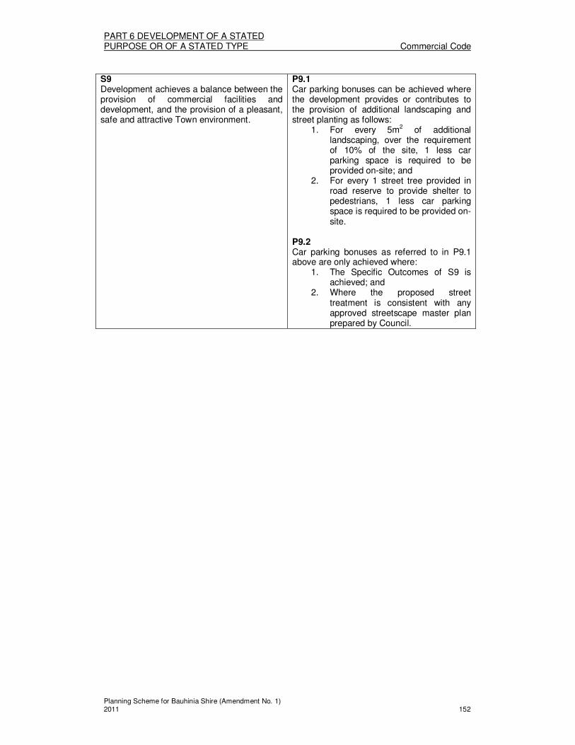
PART 6 DEVELOPMENT OF A STATED PURPOSE OR OF A STATED TYPE Commercial Code
Planning Scheme for Bauhinia Shire (Amendment No. 1) 2011 152
S9 Development achieves a balance between the provision of commercial facilities and development, and the provision of a pleasant, safe and attractive Town environment.
P9.1 Car parking bonuses can be achieved where the development provides or contributes to the provision of additional landscaping and street planting as follows:
1. For every 5m2 of additional landscaping, over the requirement of 10% of the site, 1 less car parking space is required to be provided on-site; and
2. For every 1 street tree provided in road reserve to provide shelter to pedestrians, 1 less car parking space is required to be provided on-site.
P9.2 Car parking bonuses as referred to in P9.1 above are only achieved where:
1. The Specific Outcomes of S9 is achieved; and
2. Where the proposed street treatment is consistent with any approved streetscape master plan prepared by Council.

PART 6 DEVELOPMENT OF A STATED PURPOSE OR OF A STATED TYPE Development Standards Code
Planning Scheme for Bauhinia Shire (Amendment No. 1) 2011 153
Division 7—Development Standards Code
About the Development Standards Code � The Development Standards Code regulates the design and siting aspects of
Material Change of Use and Reconfiguring a Lot development, as affected by associated Operational Work. This ensures that in considering how appropriate a particular use is for a site, or how appropriate a site is for subdivision, in the siting and provision of essential services, is undertaken when assessing the primary development application for Material Change of Use or Reconfiguring a Lot.
� How the Operational works are to be undertaken, is regulated separately by the Development Design Code. The Development Design Code is applicable to the carrying out of Operational Works.
� Example – Car parking associated with a change of use This Code, the Development Standards Code regulates how much car parking is to
be provided for a particular use, the dimensions of parking spaces, the location of driveways and other siting considerations. This is important for considering the Material Change of Use; as it may not be feasible to site all necessary car parking for the use on the site. Plans for the assessment of the Material Change of Use need only indicate these aspects of the associated Operational Works (car parking). The Development Design Code regulates the undertaking of Operational Works
including the manner in which the car park is constructed, sealed or marked. Plans submitted for assessment of the Operational Works will need to be detailed working drawings.
� Example – Provision of Roads associated with a new subdivision This Code, the Development Standards Code, regulates how wide new road
reserves and the pavement, is to be provided for new lots. These dimensions are important for considering the Reconfiguration of a Lot application, as it may not be feasible to site all the proposed lots and the necessary road reserves accessing those lots. Plans for the assessment of the Reconfiguration of a Lot application need only indicate these aspects of the associated Operational Works (roads). The Development Design Code regulates the undertaking of Operational Works
including the manner in which the road is constructed, sealed or marked. Plans submitted for assessment of the Operational Works will need to be detailed working drawings.
(1) Development Standards Code
The provisions in this division comprise the Development Standards Code. They are— 1. The Purpose of the Development Standards Code – Section (2); and 2. The Specific Outcomes, Probable Solutions and Acceptable Solutions for
Operational works – Table 6.7.1.
(2) The Purpose of the Development Standards Code
The purpose of the Development Standards Code is to achieve the following overall outcomes. New uses of sites and newly created lots are appropriately designed and sited to incorporate the associated Operational Works aspects of the development; including to ensure that:
a) There is an appropriate standard of road access to the use/new lots; b) Necessary upgrades to external infrastructure networks (eg transport, water,
sewerage) are identified; c) There is sufficient area provided to accommodate the necessary car parking
for the use; d) Connection to reticulated water and sewer systems is provided where
applicable; and e) Extension to existing, or provision of new pathways/cycleways is provided,
where applicable.

PART 6 DEVELOPMENT OF A STATED PURPOSE OR OF A STATED TYPE Development Standards Code
Planning Scheme for Bauhinia Shire (Amendment No. 1) 2011 154
f) There is appropriate provision of site storm water drainage and connection to suitable stormwater infrastructure;
g) Landscaping is provided to public and private land as appropriate for the development; and
h) Provision of other services to the site as appropriate.
TABLE 6.7.1 DEVELOPMENT STANDARDS
Column 1 Column 2
Specific outcomes (S) for Code and Impact assessable development
Probable Solutions (P) for Code and Impact assessable development
and
Acceptable Solutions (A) for Self assessable development (where Self assessable development does not meet the Acceptable Solutions in the applicable codes, it requires Code assessment. Refer to Section 1.2.9)
APPLICABLE TO MATERIAL CHANGE OF USE AND RECONFIGURING A LOT DEVELOPMENT
Roads
S1 The road network of the Shire provides:
1. Convenient and safe access to all allotments for pedestrians, vehicles and cyclists;
2. Safe, logical and hierarchical transport linkages;
3. Appropriate access for buses, emergency and service vehicles;
4. A convenient way for public utilities; 5. An opportunity for street
landscaping; and 6. An opportunity for on street car
parking.
P1.1 All roads which have frontage to the development site, and any new roads created, are of a width and are of a standard (with or without sealing and, kerb and channelling) as detailed in Division 7: Schedule A – Development Standards According to Zoning. P1.2 Where the road standard stated in P1.1 above does not exist for the development site the road is extended and/or upgraded to provide the required standard.
Car Parking and Access (only applicable to development applications for Material Change of Use)
Vehicular Access and Driveway Crossovers S2 Vehicular access arrangements:
1. are appropriate for: (a) The capacity of the parking
area, (b) The volume, frequency and
type of vehicle usage; and (c) The function and configuration
of the access road; 2. minimise any potentially adverse
impacts on: (a) The safety and efficiency of the
road; (b) The integrity of any
infrastructure within the road reserve; and
(c) The safety of access to adjacent properties; and
P/A2.1 For a House, Home Host Accommodation or Home Based Business uses, the driveway crossover is not:
1. A secondary property access; 2. Covering, crossing or located within 1m
of any street trees; fire hydrants; water meters; manholes; or stormwater gully pits;
3. Entering the carriageway at the location of an existing traffic island, speed control device, car parking bay, pedestrian crossing, bus stop or structure within the roadway;
4. Requiring the filling or excavation of more than 1000 m
3 of material in the
existing footpath/verge; and 5. Of a pervious standard of construction

PART 6 DEVELOPMENT OF A STATED PURPOSE OR OF A STATED TYPE Development Standards Code
Planning Scheme for Bauhinia Shire (Amendment No. 1) 2011 155
3. Are designed and located such that there are no significant adverse impacts on the amenity of premises in the vicinity.
eg. gravel, unless located in the Rural Zone.
Parking and Loading Provision S3 Sufficient vehicle parking and loading facilities are provided to meet the demand likely to be generated by the development taking into account any or all of the following:
1. The nature and intensity of the proposed use;
2. The parking demand generated by the existing use of the premises;
3. The feasibility of physically providing parking on-site;
4. The nature and intensity of existing and likely future development on adjoining premises;
5. The availability of public parking in the vicinity;
6. The hours of operation of the proposed use and the opportunity for sharing of parking spaces by multiple uses;
7. The impact of the parking on the amenity of nearby residents;
8. Existing and likely future traffic conditions and amenity of the area;
9. The recommendations of any Traffic and Parking Impact Report prepared for the proposed development.
10. Development is undertaken and maintained in accordance with a prepared Traffic and Parking Impact Report in accordance with Division 7: Schedule C – Traffic and Parking Impact Report Requirements , where :
(i) the specified parking and/or loading is proposed to be less than that specified in Division 7: Schedule B – Parking Provision for the particular uses or uses and no contribution-in-lieu is proposed; or
(ii) the use or uses proposed do not have a specified parking rate in Division 7: Schedule B – Parking Provision.
P/A3.1 Vehicle parking and loading facilities are provided in accordance with Division 7: Schedule B – Parking Provision. P/A3.2 Car parking areas have dimensions, and are of a standard as detailed in Division 7: Schedule A – Development Standards According to Zoning. P3.3 Where P/A3.1 above is not met for development in the Town Zone, the equivalent contribution-in-lieu is paid in accordance with Planning Policy No 4: Car Parking Contributions.
Transport Network S4 Provision is made to minimise any potentially adverse impacts on the safety, efficiency or effectiveness of the pedestrian, cycle and road network. Where the development
No Solutions Specified

PART 6 DEVELOPMENT OF A STATED PURPOSE OR OF A STATED TYPE Development Standards Code
Planning Scheme for Bauhinia Shire (Amendment No. 1) 2011 156
generates the need for more than 50 permanent parking spaces; the development is undertaken and managed in accordance with a prepared Traffic and Parking Impact Report covering the relevant matters detailed in Division 7: Schedule C – Traffic and Parking Impact Report Requirements. Car Park Design S5 Parking spaces and loading bays are:
1. Usable by the occupants of, and visitors to, the site;
2. Easily accessible from any buildings on the site;
3. Located to encourage off-street parking;
4. Located and designed to maintain or improve the character of the area.
P/A5.1 All development provides:
1. Parking spaces that are freely available for use by the development’s occupants and visitors during the business hours of the use;
2. Visitor or customer parking spaces that are located in the most accessible position to the main entrance of the buildings on the site;
3. Except for development in the Town – Commercial Precinct, at least 20% of the required car parking spaces are located so that they are clearly visible from the street (unless otherwise required by other use specific Codes);
4. Where car parking is provided at the rear of the site, clear signage is provided to indicate the location of parking areas;
5. Pedestrian pathways or clearances through the car parking area that allow unimpeded access to the buildings on the site;
6. Parking and pathways at a gradient no greater than 1:20 being suitable for vehicle access, and pedestrian access including access for persons with disabilities;
7. Landscaped buffers with a minimum width of 1m between the parking area and any boundary to the site; and
8. Parking areas that are designed to incorporate and retain existing street trees with a girth 50cm or greater which exist on the site.
P/A5.2 Parking associated with the development is located on the same site upon which the development is carried out. P5.3 Uses in the Commercial Use Class, which do not meet the requirements of P/A5.2 above, may locate parking on another site which is not more than 200m from the development to which it relates.
S6 The effects of dust, noise, glare or other potentially adverse impacts on the amenity, safety and aesthetics of the land in the vicinity are minimised.
P/A6.1 The car parking area is imperviously sealed to the standard stated in Division 7: Schedule A – Development Standards According to Zoning.

PART 6 DEVELOPMENT OF A STATED PURPOSE OR OF A STATED TYPE Development Standards Code
Planning Scheme for Bauhinia Shire (Amendment No. 1) 2011 157
P/A6.3 A solid fence with a minimum height of 1.8m is constructed between the parking area and any adjoining residential use or other noise sensitive use, provided that where the site is filled, the maximum height of the fence from natural ground level is 2.1m. P/A6.4 Where the parking area is open to the public at night, and for all parking areas in the Town Commercial Precinct, lighting is provided to ensure public safety, and is provided in accordance with Australian Standard AS 1158.3.1- Road Lighting – Pedestrian Area (Category P) Lighting – Performance and Installation Design Requirements.
Service Vehicle Provisions S7 Facilities for loading, unloading, manoeuvring and access for service vehicles are:
1. accommodated on-site; 2. of a design that allows safe and
efficient access to and from the site; and
3. of a design that does not unduly impede vehicular and pedestrian movement within the site.
P/A7.1 The design and provision of access driveways, manoeuvring areas, refuse collection areas and loading facilities for service vehicles is in accordance with Australian Standard AS 2890.2 – 1989- Off Street Parking – Commercial Vehicle Facilities. P/A7.2 Service vehicles are able to enter and exit the site in a forward gear.
Water Supply
S8 A reticulated water supply system is available to all development in the Council’s Water Supply Area that is of sufficient capacity to meet the demands imposed upon it by both consumers and emergency purposes.
P/A8.1 Water reticulation is available to the development site, in all circumstances stated in Division 7: Schedule A – Development Standards According to Zoning. P8.2 Where water reticulation is not connected to the development site, and therefore is not of a standard stated in P8.1 above, the infrastructure is extended and/or upgraded to provide the necessary connections and a monetary contribution is paid in accordance with Planning Policy No 2: Water and Sewer Headworks Contributions.
S9 Development outside the Council’s Water Supply Area, have a demonstrated water supply sufficient for domestic and emergency purposes.
P/A9.1 Domestic dwelling development outside Council’s Water Supply Area, has a water supply storage with water storage for domestic use (minimum 45 000 litre capacity).
Sewer System/Effluent Disposal
S10 A reticulated sewerage system is available to all development in Council’s Declared Sewered Area that is of sufficient capacity to meet the demands imposed upon it by consumers, emergency purposes and
P/A10.1 Sewer reticulation is available to the development site, in all circumstances stated in Division 7: Schedule A – Development Standards According to Zoning.

PART 6 DEVELOPMENT OF A STATED PURPOSE OR OF A STATED TYPE Development Standards Code
Planning Scheme for Bauhinia Shire (Amendment No. 1) 2011 158
environmental purposes. P10.2 Where sewer reticulation is not connected to the development site, and therefore is not of a standard stated in P10.1 above, the infrastructure is extended and/or upgraded to provide the necessary connections and a monetary contribution is paid in accordance with Planning Policy No 2: Water and Sewer Headworks Contributions.
S11 Development outside Council’s Declared Sewered Area, have a demonstrated on-site effluent disposal system, which meets the needs of the development without significant negative impacts upon ground water quality.
P/A11.1 Development outside Council’s Declared Sewered Area which is incapable of being connected to the reticulated sewerage system, has suitable lot size/s which contain land suitable for on-site treatment and disposal methods that meet:
1. the Department of Natural Resources and Water On-site Sewerage Code (July 2002) or any subsequent update of that Code; and
2. AS/NZS 1547:2000 On-site Domestic Wastewater Management.
Stormwater Drainage
S12 Stormwater drainage is designed and constructed to provide adequate capacity for existing and anticipated development and flows, and to protect against negative environmental impacts, particularly surface and ground water quality.
P12.1 Stormwater drainage is to meet the requirements of the Queensland Urban Drainage Manual.
S13 On-site and off-site erosion and sedimentation is minimised, whether drainage is via formed drainage systems or runoff from the site.
P13.1 Erosion and Sediment control measures are designed and constructed in accordance with the document Soil Erosion & Sediment Control – Engineering Guidelines for Queensland Construction Sites 1995.
Power
S14 Provision for power is made for all new uses and habitable buildings.
P/A14.1 All new uses and habitable buildings, and additional lots created, are provided with connection to the electricity supply. P14.2 The provision of underground electricity services is provided for new buildings and additional lots created in the Town areas.
Footpaths and Cycleways
S15 Footpaths and cycleways are designed to:
1. Adequately accommodate existing and anticipated traffic types and volumes;
2. Provide a safe, stable surface for intended users;
3. Be easily maintained; and 4. be of an appropriate width and
longitudinal gradient and provide
P/A15.1 Footpaths and cycleways are provided for the full length of all road frontages to the development site, in all circumstances stated in Division 7: Schedule A – Development Standards According to Zoning.

PART 6 DEVELOPMENT OF A STATED PURPOSE OR OF A STATED TYPE Development Standards Code
Planning Scheme for Bauhinia Shire (Amendment No. 1) 2011 159
kerb ramps and sight distances adequate to cater for the number of pedestrians, cyclists and user groups.
S16 Development for a Material Change in Use the subject of a Code assessable or Impact assessable application, make provision for footpaths and cycleways that are:
1. safe, accessible and of high quality; and
2. compatible and integrated with the surrounding environment; and
3. well connected to existing networks.
P16.1 The configuration of lots, and in particular the location of any land dedicated as park, accommodates the provision of footpaths/cycleways.
Street Trees
S17 Street trees which exist in the Town Zone, are retained, except where:
1. They pose a threat to the integrity of infrastructure or the safety of pedestrians;
2. They are of a size that unreasonably restricts the development expectations of land in the relevant Zone; or
3. They are a noxious weed.
P/A17.1 All existing street trees, in the Town Zone, with the following features are retained:
1. A trunk girth greater than 50cm (measured 1m from the ground); or
2. Are over 2m in height; or 3. Provide a shade canopy greater than 3m
in diameter when measured at midday on December 22.
Landscaping
S18 Development is landscaped in a manner which:
1. Enhances the appearance of the development internally as well as positively contributing to the streetscape;
2. Screens the view of unsightly buildings, structures, open space storage areas from public places, residences and other sensitive development;
3. Integrates existing vegetation and other natural features of the site into the development;
4. Contributes to a comfortable living environment by providing shade to reduce glare and heat absorption and re-radiation from buildings, car parking areas, and other hard surfaces;
5. Ensures private outdoor recreation spaces, which are also useable;
6. Provides for shade and the softening of hard landscaped or paved areas, particularly car parking areas;
7. Does not adversely affect vehicular sightlines and road safety; and
8. Does not create unsafe pedestrian environments due to inappropriate
P/A18.1 For any corner lot bounded by 2 or more road frontages which form an intersection, the area of the lot nearest that intersection has landscaping comprising trees, shrubs and other vegetation that have a maximum mature height of 1m, to ensure vehicle sight lines are not obscured. P/A18.2 Landscaping near electric lines should be designed and developed so that any vegetation at maturity or landscaping structures will not exceed 4.0m in height on land:
1. in an electric line shadow; or 2. within 5.0 metres of an electric line
shadow; or 3. within 5.0 metres of a substation
boundary. P18.3 Vegetation is planted in a position that is further from the nearest edge of an electric line shadow or substation boundary than the expected maximum height at maturity of the vegetation. P18.4 On land adjoining an electricity substation boundary, the vegetation foliage at maturity will not be within 3.0 metres of the substation boundary. However, where a substation has a solid wall along any part of its boundary, foliage may extent

PART 6 DEVELOPMENT OF A STATED PURPOSE OR OF A STATED TYPE Development Standards Code
Planning Scheme for Bauhinia Shire (Amendment No. 1) 2011 160
screening of public places. 9. Does not adversely impact on
electricity works. All electric lines are protected from encroachment by vegetation. Landscaping and other works and buffers do not generate a potential safety hazard and include provision for access and public utility infrastructure for maintenance and repair.
to, but not above or beyond, that solid wall. P18.5 Access for personnel and vehicular access is to be made available to electricity works in particular to substations, poles, stays and towers. P18.6 No interference with other utilities either immediately or when plantings are at full maturity.
Retaining Walls and Fences
S19 Retaining walls and fences do not affect traffic or pedestrian safety, and are not overbearing or unsightly in appearance.
P/A19.1 The combined height of any retaining wall and fence does not exceed 2.0m. P/A19.2 For any corner lot bounded by 2 or more road frontages which form an intersection, fence height is limited to a maximum of 1m for any fence along any road frontage boundary within 6m of the point of intersection, to ensure vehicle sight lines are not obscured.
Street Lighting and Street Signs
S20 Street lighting and street signs are designed and constructed to:
1. Comply with Australian best practice standards, methodology and design;
2. Provide adequate street lighting commensurate with the surrounding uses and public safety needs; and
3. Provide adequate identification of street names.
P20.1 Street signs are provided for all new roads in accordance with the Queensland Manual of Uniform Traffic Control Devices. P20.2 All street lighting in accordance with the AS1158 series.
Telecommunications
S21 Provision for telecommunications is made for all new users and habitable buildings and to a contemporary standard at the time of the development application.
P21.1 No solutions specified.
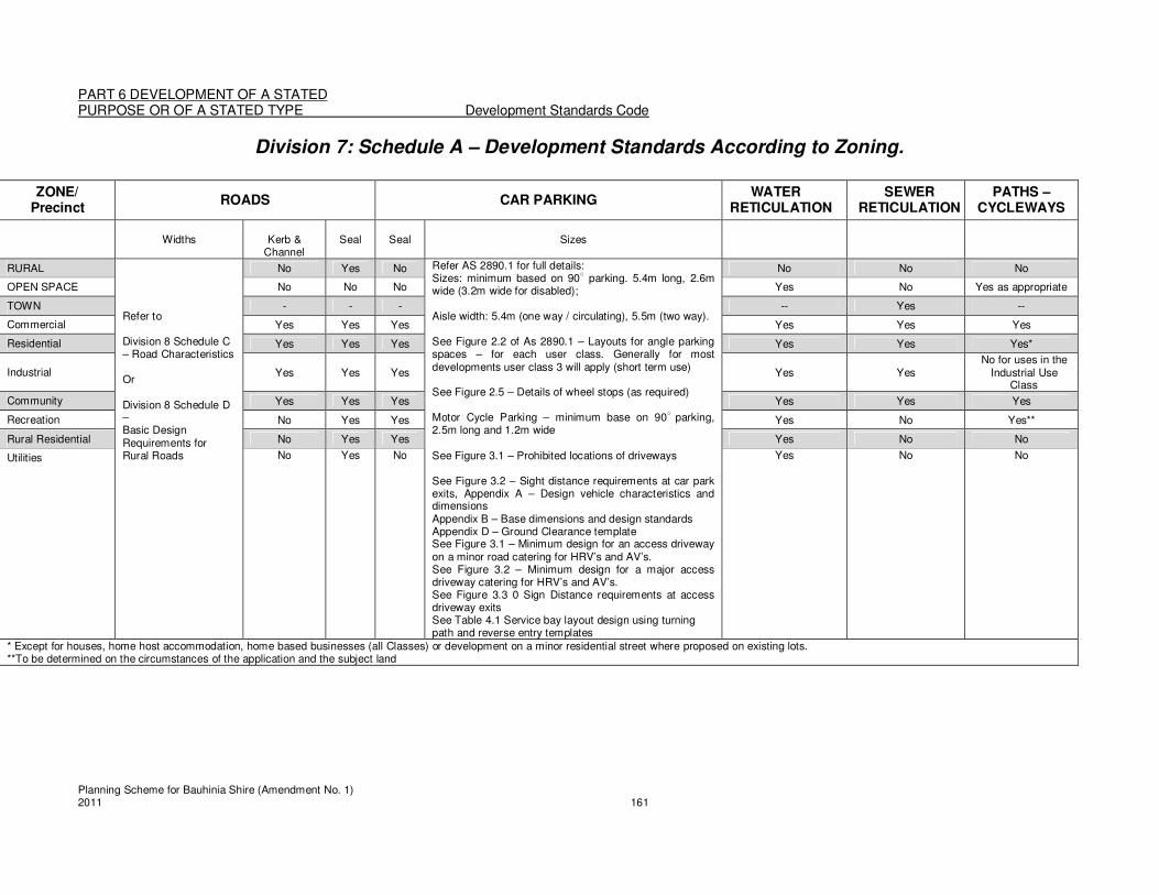
PART 6 DEVELOPMENT OF A STATED PURPOSE OR OF A STATED TYPE Development Standards Code
Planning Scheme for Bauhinia Shire (Amendment No. 1) 2011 161
Division 7: Schedule A – Development Standards According to Zoning.
ZONE/ Precinct
ROADS CAR PARKING WATER
RETICULATION SEWER
RETICULATION PATHS –
CYCLEWAYS
Widths
Kerb &
Channel Seal Seal Sizes
RURAL Refer to Division 8 Schedule C – Road Characteristics Or Division 8 Schedule D – Basic Design Requirements for Rural Roads
No Yes No Refer AS 2890.1 for full details: Sizes: minimum based on 90
○ parking. 5.4m long, 2.6m
wide (3.2m wide for disabled); Aisle width: 5.4m (one way / circulating), 5.5m (two way). See Figure 2.2 of As 2890.1 – Layouts for angle parking spaces – for each user class. Generally for most developments user class 3 will apply (short term use) See Figure 2.5 – Details of wheel stops (as required) Motor Cycle Parking – minimum base on 90
○ parking,
2.5m long and 1.2m wide See Figure 3.1 – Prohibited locations of driveways See Figure 3.2 – Sight distance requirements at car park exits, Appendix A – Design vehicle characteristics and dimensions Appendix B – Base dimensions and design standards Appendix D – Ground Clearance template See Figure 3.1 – Minimum design for an access driveway on a minor road catering for HRV’s and AV’s. See Figure 3.2 – Minimum design for a major access driveway catering for HRV’s and AV’s. See Figure 3.3 0 Sign Distance requirements at access driveway exits See Table 4.1 Service bay layout design using turning path and reverse entry templates
No No No
OPEN SPACE No No No Yes No Yes as appropriate
TOWN - - - -- Yes --
Commercial Yes Yes Yes Yes Yes Yes
Residential Yes Yes Yes Yes Yes Yes*
Industrial Yes Yes Yes Yes Yes No for uses in the
Industrial Use Class
Community Yes Yes Yes Yes Yes Yes
Recreation No Yes Yes Yes No Yes**
Rural Residential No Yes Yes Yes No No
Utilities No
Yes No Yes No No
* Except for houses, home host accommodation, home based businesses (all Classes) or development on a minor residential street where proposed on existing lots. **To be determined on the circumstances of the application and the subject land

PART 6 DEVELOPMENT OF A STATED PURPOSE OR OF A STATED TYPE Development Standards Code
Planning Scheme for Bauhinia Shire (Amendment No. 1) 2011 162
Division 7: Schedule B—Parking Provision For the purposes of interpreting this Schedule:
1. All car parking requirements specified are the minimum requirements, and do not preclude the provision of additional on-site parking.
2. Where the calculated car parking requirement results in a fraction, fractions are to be rounded up to the next whole number if they are equal to or more than 0.5 and rounded down if they are less than 0.5.
3. Car parking requirements specified on the basis of total use area are for each quantity specified and each part thereof. Eg. A car parking requirement rate of 1 space per 15m
2 for a total use area of 35m
2, would equate to 3 spaces.
4. “No specified rate” means the required number of parking spaces and facilities for service vehicles will be based upon the circumstances of the specific proposal and assessed against the Specific Outcomes, information provided with the application and any Traffic and Parking Impact Report.
5. “None” means that there are no requirements under the Planning Scheme to provide car parking.
Use Required Number of Parking Spaces and Facilities for Service Vehicles
Rural Use Class
Agriculture None Animal husbandry None Intensive animal husbandry
None
Kennels and catteries None
Roadside stall Where total use area is less than 50m2 – None; or Where total use area is 50m
2 or more – 1 space per 40m
2 of
total use area. Stock saleyard None All other uses in the Rural Use Class
No specified rate
Residential Use Class
Accommodation building
1. 1 space per accommodation unit:; and 2. For hostels or dormitory accommodation:
1 space per 4 beds with at least 50% of the required spaces, plus the provision of 1 bus bay and manoeuvring of buses for more than 30 rooms; or
3. For Motels: spaces per accommodation unit plus 1 space, plus provision for 1 bus bay and manoeuvring of buses for motels with more than 30 rooms; or
4. For other accommodation buildings: 1 space per 10 accommodation units.
Caretaker’s residence 1 space Dual Occupancy 1.5 space per dwelling unit Home based business As determined by Council upon nature and scale of business Home host accommodation
1 space per guest room (in addition to parking provided for the house)
House 2 spaces; may be provided in tandem Multiple dwelling 1.25 spaces per dwelling unit
Retirement village 1.1 spaces per dwelling unit, plus 0.5 spaces for each accommodation unit plus an ambulance pick-up/set-down area
Worker’s Accommodation No specified rate All other uses in the No specified rate
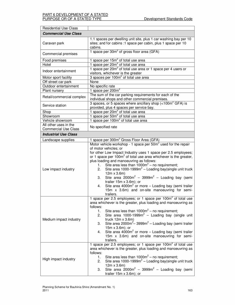
PART 6 DEVELOPMENT OF A STATED PURPOSE OR OF A STATED TYPE Development Standards Code
Planning Scheme for Bauhinia Shire (Amendment No. 1) 2011 163
Residential Use Class
Commercial Use Class
Caravan park 1.1 spaces per dwelling unit site, plus 1 car washing bay per 10 sites; and for cabins :1 space per cabin, plus 1 space per 10 cabins.
Commercial premises 1 space per 30m2 of gross floor area (GFA)
Food premises 1 space per 15m2 of total use area
Hotel 1 space per 20m2 of total use area
Indoor entertainment 1 space per 20m
2 of total use area or 1 space per 4 users or
visitors, whichever is the greater Motor sport facility 3 spaces per 100m
2 of total use area
Off street car park None Outdoor entertainment No specific rate Plant nursery 1 space per 200m
2
Retail/commercial complex The sum of the car parking requirements for each of the individual shops and other commercial premises.
Service station 3 spaces, or 5 spaces where ancillary shop (<100m
2 GFA) is
provided, plus 4 spaces per service bay. Shop 1 space per 20m
2 of total use area
Showroom 1 space per 50m2 of total use area
Vehicle showroom 1 space per 100m2 of total use area
All other uses in the Commercial Use Class
No specified rate
Industrial Use Class
Landscape supplies 1 space per 300m2 Gross Floor Area (GFA)
Low impact industry
Motor vehicle workshop - 1 space per 50m2 used for the repair
of motor vehicles; or for other Low Impact Industry uses 1 space per 2.5 employees; or 1 space per 100m
2 of total use area whichever is the greater,
plus loading and manoeuvring as follows: 1. Site area less than 1000m
2 – no requirement;
2. Site area 1000-1999m2 – Loading bay(single unit truck 12m x 3.6m)
3. Site area 2000m2 – 3999m
2 – Loading bay (semi
trailer 15m x 3.6m); or 4. Site area 4000m
2 or more – Loading bay (semi trailer
15m x 3.6m) and on-site manoeuvring for semi-trailers.
Medium impact industry
1 space per 2.5 employees; or 1 space per 100m2 of total use
area whichever is the greater, plus loading and manoeuvring as follows:
1. Site area less than 1000m2 – no requirement; 2. Site area 1000-1999m
2 – Loading bay (single unit
truck 12m x 3.6m) 3. Site area 2000m
2– 3999m
2 – Loading bay (semi trailer
15m x 3.6m); or 4. Site area 4000m
2 or more – Loading bay (semi trailer
15m x 3.6m) and on-site manoeuvring for semi-trailers.
High impact industry
1 space per 2.5 employees; or 1 space per 100m2 of total use area whichever is the greater, plus loading and manoeuvring as follows:
1. Site area less than 1000m2 – no requirement;
2. Site area 1000-1999m2 – Loading bay(single unit truck
12m x 3.6m) 3. Site area 2000m
2 – 3999m
2 – Loading bay (semi
trailer 15m x 3.6m); or

PART 6 DEVELOPMENT OF A STATED PURPOSE OR OF A STATED TYPE Development Standards Code
Planning Scheme for Bauhinia Shire (Amendment No. 1) 2011 164
4. Site area 4000m2 or more – Loading bay (semi trailer
15m x 3.6m) and on-site manoeuvring for semi-trailers.
Vehicle depot No specified rate Warehouse 1 space per 200m
2 of total use area
All other uses in the Industrial Use Class
No specified rate
Community Use Class
Community purposes
For Categories 1 and 2 uses – None For Category 4 uses - 1 space per 10 persons capable of being seated For Child care centres – 1 space per 2 employees, plus 3 spaces for every space required for employees which may be provided in tandem to allow for the setting down and picking up of children. For Category 6 uses – 1 space per employee, plus 1 space per 10 students of driving age, plus a paved setdown area for buses. Other Community Purposes uses – 1 space per 50m
2 of total
use area. Open space No specific rate Public facility – operational None
Public facility – other
For Hospitals – 1 space per 4 beds, plus 1 space per 2 employees (except where accommodation for employees with associated parking spaces are provided on the site), plus 1 space per staff doctor; plus an ambulance pick-up/set-down area For Nursing homes – 1 space per 2 employees based upon the maximum number of employees engaged at any one time, plus 1 space per 5 beds or occupants of the premises; plus an ambulance pick-up/set-down area For other Public facility – other uses - No specified rate.

PART 6 DEVELOPMENT OF A STATED PURPOSE OR OF A STATED TYPE Development Standards Code
Planning Scheme for Bauhinia Shire (Amendment No. 1) 2011 165
Division 7: Schedule C—Traffic and Parking Impact Report Requirements
A Traffic and Parking Impact Report is required to be prepared by suitably qualified persons, for the assessment of development applications for:
1. uses which generate the need for more than 50 permanent parking spaces; 2. uses where the proposed amount of car parking and facilities for service vehicles is
less than that specified in Division 7: Schedule B – Parking Provision; or 3. uses which have no specified parking rate in Division 7: Schedule B – Parking
Provision. A Traffic and Parking Impact Report is to address those of the following issues that are relevant to the proposed development:
1. A review of the existing and proposed on site car parking, and the existing and proposed road network and road operation conditions;
2. The amount of traffic likely to be generated by the development including: 3. the number of employees, 4. customer frequency and numbers; 5. hours of operation; and 6. any possibilities of shared parking in off peak hours. 7. The likely impact of the development on the movement of traffic on the road system.
This includes the impact of generated traffic on: (a) Nearby intersections; (b) Local roads in the neighbourhood of the development; (c) Existing nearby major traffic generating development; and (d) The major road network.
8. The likely impact of the traffic generated by the development on the road pavement, crossings, bridges and other surface and underground infrastructure;
9. Existing public parking supply and demand in the vicinity of the proposed development;
10. The level of provision for parking in the development based on land use and any alterative modes of transport available;
11. Measures provided to encourage and cater for alternative modes of transport including walking, cycling and public transport;
12. The means of providing safe, and appropriately designed and located access to and from the site;
13. The adequacy of provision for the loading, unloading, manoeuvring, standing and parking of vehicles on the site;
14. Any comments made by the Department of Main Roads and Queensland Transport; and
15. The existing and likely future amenity of the surrounding area.
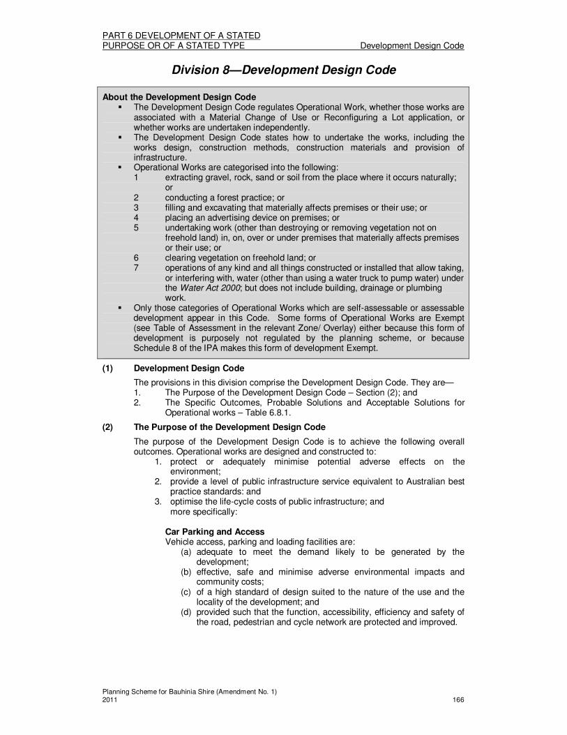
PART 6 DEVELOPMENT OF A STATED PURPOSE OR OF A STATED TYPE Development Design Code
Planning Scheme for Bauhinia Shire (Amendment No. 1) 2011 166
Division 8—Development Design Code
About the Development Design Code � The Development Design Code regulates Operational Work, whether those works are
associated with a Material Change of Use or Reconfiguring a Lot application, or whether works are undertaken independently.
� The Development Design Code states how to undertake the works, including the works design, construction methods, construction materials and provision of infrastructure.
� Operational Works are categorised into the following: 1 extracting gravel, rock, sand or soil from the place where it occurs naturally;
or 2 conducting a forest practice; or 3 filling and excavating that materially affects premises or their use; or 4 placing an advertising device on premises; or 5 undertaking work (other than destroying or removing vegetation not on
freehold land) in, on, over or under premises that materially affects premises or their use; or
6 clearing vegetation on freehold land; or 7 operations of any kind and all things constructed or installed that allow taking,
or interfering with, water (other than using a water truck to pump water) under the Water Act 2000; but does not include building, drainage or plumbing work.
� Only those categories of Operational Works which are self-assessable or assessable development appear in this Code. Some forms of Operational Works are Exempt (see Table of Assessment in the relevant Zone/ Overlay) either because this form of development is purposely not regulated by the planning scheme, or because Schedule 8 of the IPA makes this form of development Exempt.
(1) Development Design Code
The provisions in this division comprise the Development Design Code. They are— 1. The Purpose of the Development Design Code – Section (2); and 2. The Specific Outcomes, Probable Solutions and Acceptable Solutions for
Operational works – Table 6.8.1.
(2) The Purpose of the Development Design Code
The purpose of the Development Design Code is to achieve the following overall outcomes. Operational works are designed and constructed to:
1. protect or adequately minimise potential adverse effects on the environment;
2. provide a level of public infrastructure service equivalent to Australian best practice standards: and
3. optimise the life-cycle costs of public infrastructure; and more specifically:
Car Parking and Access Vehicle access, parking and loading facilities are:
(a) adequate to meet the demand likely to be generated by the development;
(b) effective, safe and minimise adverse environmental impacts and community costs;
(c) of a high standard of design suited to the nature of the use and the locality of the development; and
(d) provided such that the function, accessibility, efficiency and safety of the road, pedestrian and cycle network are protected and improved.

PART 6 DEVELOPMENT OF A STATED PURPOSE OR OF A STATED TYPE Development Design Code
Planning Scheme for Bauhinia Shire (Amendment No. 1) 2011 167
Landscaping Landscaping, fencing and planting in car parks:
(a) enhances the environmental amenity and quality of life, particularly in the townships of the Shire;
(b) incorporate hard and soft landscaping which is appropriate to the area’s function and site conditions; and
(c) enhances the streetscape, without compromising traffic or pedestrian safety.
2. Placing of Advertising Devices (signage)
Advertising devices are: (a) safely constructed and secured, and do not create a hazard; and (b) consistent with the visual quality of the Shire, and the amenity and
character of the immediate surrounding area in which they are located.
TABLE 6.8.1 DEVELOPMENT DESIGNS
Column 1 Column 2
Specific outcomes (S) for Code and Impact assessable development
Probable Solutions (P) for Code and Impact assessable development
and
Acceptable Solutions (A) for Self assessable development (where Self assessable development does not meet the Acceptable Solutions in the applicable codes, it requires Code assessment. Refer to Section 1.2.9)
All Operational Work S1
While undertaking development works, the site and adjoining road are maintained in a tidy, safe and hygienic manner and are not to cause unacceptable air emissions.
P/A1.1 Any waste generated whilst undertaking works on the site is removed off the site.
S2 While undertaking development works, the site and adjoining road are maintained free of obstacles to traffic, to maintain efficient traffic movements and safety.
P2.1 Operational road reserves are kept free of the storage, stock piling or loading of materials associated with the on-site works.
Filling and excavating S3
Filling and excavating is structurally stable for the intended purpose and does not adversely affect the amenity of adjoining or surrounding land. No ‘worsening’ of flood occurs as a result of the filling or excavation activity. Dust from excavation and filling is managed by the:
1. Covering of unearthed material in windy conditions;
2. Covering of vehicles hauling material to or from the site; and
3. The wetting of unearthed material or exposed earth in windy
P/A3.1 Excavation and filling activities are conducted between the hours of 7am and 6pm Monday to Saturday, excluding public holidays, and for a total duration not exceeding 4 weeks. P/A3.2 Excavation and filling activities are to be carried out in accordance with AS3798 Guidelines on Earthworks for Residential and Commercial Developments and any additional requirements referred to in S4 below.
P/A3.3 The excavation of filling does not

PART 6 DEVELOPMENT OF A STATED PURPOSE OR OF A STATED TYPE Development Design Code
Planning Scheme for Bauhinia Shire (Amendment No. 1) 2011 168
conditions. 4. is designed and located to ensure
public safety and the stability and safety of the electricity works.
5. maintains the minimum safety clearances specified in the Electricity Safety Regulations 2002
Areas of fill and excavation are graded, compacted and planted and/or mulched immediately after the dumping operation is complete. Where an area of more than 1000m3 of fill and excavation is involved, the filling and excavating is staged, with previous stages being progressively finished and rehabilitated (eg. graded, compacted and planted and/or mulched) to reduce visual impacts, dust generation, erosion and sedimentation.
concentrate or divert stormwater onto adjoining land to a degree which is worse than that which existed prior to the works.
P/A3.4 The excavation or filling does not cause or allow ponding or water on the site or adjoining land.
P/A3.5 The excavation, filling or laying of pipes other than as set out in P/A3.2, P/A3.3 and P/A3.4 above where the applicant/developer can demonstrate that the relevant Electricity Entity (eg. Ergon Energy Corporation Limited or Powerlink Queensland):
1. has advised in writing its agreement to the excavation, filling or laying of pipes;
OR 2. has entered into an agreement with
the applicant/developer to provide services that will achieve the purposes of the Electrical Safety Act 2002.
Note: Development involving filling, excavation or laying of metal pipes on Land Contiguous to Electricity Works should be referred to the relevant electricity entity for a safety advice on the proposed development, before any application is lodged with Council or before any Exempt or Self Assessable development is commenced. Note: Signage near electricity works will need to comply with the minimum safety clearances in the Electrical Safety Act 2002 and Electrical Safety Regulations 2002.
S4 On-site and off-site erosion and sedimentation is minimised, whether drainage is via formed drainage systems or runoff from the site.
P/A4.1 Sediment fences, earth berms and temporary drainage are provided and located to prevent sediment being transported to adjoining properties, roads and/or drainage systems. P/A4.2
Areas of fill and excavation are graded, compacted and planted and/or mulched immediately after the dumping operation is compete. P/A4.3
No ‘worsening’ of flood occurs as a result of the filling or excavation activity.

PART 6 DEVELOPMENT OF A STATED PURPOSE OR OF A STATED TYPE Development Design Code
Planning Scheme for Bauhinia Shire (Amendment No. 1) 2011 169
S5 Filling and excavating does not adversely affect existing infrastructure.
P/A5.1 Filling activities do not cover existing sewerage access chambers or other infrastructure access points. These infrastructure access points must be raised to the surface.
P/A5.2
Any excavation or filling does not occur within:
1. 10 metres of any tower, pole, foundation, ground anchorage or stay supporting electric lines or associated equipment; or
2. 5 metres of a substation site boundary; or
3. 2 metres of a padmount substation; or 4. 1 metre of a padmount transformer or
an underground cable. P/A5.3
The laying of metal pipes does not occur within:
1. 5 metres of any tower, pole, foundation, ground anchorage or stay supporting electric lines or associated equipment; or
2. 5 metres of a substation site boundary; or
3. 5 metres of, and parallel to, an electric line shadow.
P/A5.4 The excavation or filling does not result in the inundation of land containing electricity works. P/A5.5 The excavation, filling or laying of pipes other than as set out in P/A3.2, P/A3.3 and P/A5.6 above where the applicant/developer can demonstrate that the relevant Electricity Entity (eg. Ergon Energy Corporation Limited or Powerlink Queensland);
1. Has advised in writing its agreement to the excavation, filling or laying of pipes;
OR 2. Has entered into an agreement with
the applicant/developer to provide services that will achieve the purpose of the Electrical Safety Act 2002.
Note: Development involving filling, excavation or laying of pipes on Land Contiguous to Electricity Works should be referred to the relevant electricity entity for a safety advice on the proposed development, before any application is lodged with Council or before any Exempt or Self Assessable development is commenced.

PART 6 DEVELOPMENT OF A STATED PURPOSE OR OF A STATED TYPE Development Design Code
Planning Scheme for Bauhinia Shire (Amendment No. 1) 2011 170
Note: Signage near electricity works will need to comply with the minimum safety clearances in the Electrical Safety Act 2002 and Electrical Safety Regulations 2002.
S6 Retaining walls and batters are designed, constructed and landscaped to:
1. minimise the height of retaining walls and batter faces;
2. minimise the visual impact on any public place or adjoining land; and
3. ensure the stability and longevity of the retaining walls and batters and the safety of people and properties.
P/A6.1 Batters have a maximum slope of 25% and are terraced at every rise of 1.5m in height with each terrace having a minimum depth of 750mm.
P/A6.2
Retaining walls are to be of a commercially available design certified by the manufacturer or alternatively designed by a Registered Professional Engineer Queensland.
S7 Excavation and filling does not result in the disturbance of contaminated material or the contamination of land unless properly managed to avoid Environmental Harm or risk to people.
P/A7.1 Contaminated material is not excavated or used as fill.
Placing of Advertising Devices Location and Nature of Advertising Devices S8
Advertising devices are located such that they do not cause a traffic safety hazard.
P/A8.1 Advertising devices are not constructed or located such that the view of any traffic sign or street name is obscured.
P/A8.2 Advertising devices are located in private property or in accordance with Division 8: Schedule A – Types of Advertising Devices Consistent with the Code.
P/A8.3 Advertising devices are not located such that they present a hazard to pedestrians or cyclists.
P/A8.4 Advertising devices where located on the State Controlled road reserve must comply with the requirements of the Transport Infrastructure Act 1994 and in particular the Ancillary Works and Encroachment Notice requirements.
S9 Advertising devices installed to a size that:
1. Minimises impacts on the visual amenity of the surrounding area;
2. Ensures equitable access to limited advertising space;
3. Ensures the effects of any illumination are unobtrusive; and
4. Enhance the existing streetscape.
P/A9.1 Advertising devices have no flashing lights.
P/A9.2
Advertising devices which are illuminated are only located on land in the Town Zone (except for the Town-Recreation and Town – Residential Precincts).
P/A9.3
Advertising signage in road reserve or on

PART 6 DEVELOPMENT OF A STATED PURPOSE OR OF A STATED TYPE Development Design Code
Planning Scheme for Bauhinia Shire (Amendment No. 1) 2011 171
land visible from roads where the speed limit is over 80km/hr is not located:
1. Within 200m of an existing sign or the proposed location of any other approved advertisement facing the one direction of travel;
2. Within 200m of any intersection; and 3. Within 6m of the side boundary of
any parcel of land upon which it is to be erected.
P/A9.4 Advertising devices are defined and described as those in Division 8: Schedule A – Types of Advertising Devices Consistent with the Code.
Roads Road Hierarchy S10
The design and construction of roads which provide an optimum combination of safety, amenity, convenience and economy for residents, road users and the community generally.
P10.1 Roads in the Town Zone are provided to a standard consistent with their Classification as detailed in Division 8: Schedule C – Roadway Characteristics.
P10.2
Rural roads are provided to a standard consistent with their Classification as detailed in Division 8: Schedule C – Roadway Characteristics.
P10.3
Roads are designed and constructed in accordance with relevant parts of the Capricorn Municipal Development Manual adopted by Council by resolution.
Road Lighting S11
Road lighting is to provide an illuminated environment, which is conducive to the safe and comfortable movement of vehicular and pedestrian traffic at night and discourages illegal acts.
P11.1 The lighting provided to all roads is in accordance with relevant parts of the Australian Standard for Public Lighting AS1158.
Road Design S12
Road pavement and surfacing materials, types, layer thicknesses and configurations are appropriate to ensure that the pavement performs adequately and requires minimal maintenance under the anticipated traffic loading for the design like adopted.
P12.1 Pavements and surfacing materials are designed and constructed in accordance with relevant parts of the Capricorn Municipal Development Manual adopted by Council by resolution.
Car Parking and Access Vehicular Access and Driveway Crossovers S13 Vehicular access arrangements:
1. are appropriate for: (a) the capacity of the parking
area, (b) the volume, frequency and
type of vehicle usage; and
P/A13.1 Vehicular access to Council controlled Rural roads is provided to the site in accordance with DMR Road Planning & Design Manual, including Chapter 7 Cross Sections, APPENDIX 7A Template for Vehicle Clearance at Property Entrances.

PART 6 DEVELOPMENT OF A STATED PURPOSE OR OF A STATED TYPE Development Design Code
Planning Scheme for Bauhinia Shire (Amendment No. 1) 2011 172
(c) the function and configuration of the access road;
2. minimise any potentially adverse impacts on: (a) the safety and efficiency of the
road; (b) the integrity of any
infrastructure within the road reserve; and
(c) the safety of access to adjacent properties; and
3. are designed and located such that there are no significant adverse impacts on the amenity of premises in the vicinity.
P/A13.2
The design and construction of property accesses are to be in accordance with relevant standard drawings of the Capricorn Municipal Development Manual adopted by Council resolution.
P/A13.3
Only one access per lot will be allowed unless otherwise approved by Council. The location of the access is to be in accordance with the Capricorn Municipal Development Manual adopted by Council resolution.
Car Park Design S25 Parking spaces and loading bays are:
1. Usable by the occupants of, and visitors to, the site;
2. Easily accessible from any buildings on the site;
3. Located to encourage off-street parking;
4. Located and designed to maintain or improve the character of the area;
5. Of a standard similar to other parking and loading facilities in the surrounding area.
6. Located such that a clear, safe and effective circulation system is provided; and
7. Located such that sufficient queuing areas for vehicles entering or exiting the site are provided.
P/A14.1 Vehicle parking and loading facilities are of a dimension consistent with:
1. Australian Standard AS 2890.1 – 1993 Parking facilities – Part 1: Off Street Car Parking; and
2. Australian Standard AS 2890.2 – 2003 Parking facilities – Part 2: Off Street commercial vehicle facilities.
P/A14.2
Vehicle parking and loading facilities are designed and constructed in accordance with the requirements of Australian Standard AS 2890.1 – Parking Facilities – Off Street Car Parking
P/A14.3
Vehicle parking and loading facilities are line marked in accordance with DMR Manual of Uniform Traffic Control Devices QLD and landscaped in accordance with DMR standard specification 11.16 Landscape works.
P/A14.4
Where the parking area is open to the public at night, and for all parking areas in the Town Commercial Precinct, lighting is provided to ensure public safety, and is provided in accordance with Australian Standard AS 1158.3.1- Road Lighting – Pedestrian Area (Category P) Lighting – Performance and Installation Design Requirements.
P/A14.5
The design and provision of access driveways, manoeuvring areas and loading facilities for service vehicles is in accordance with Australian Standard AS 2890.5 – 1993 parking facilities – Part 5 - On Street Parking.
PART 6 DEVELOPMENT OF A STATED PURPOSE OR OF A STATED TYPE Development Design Code
Planning Scheme for Bauhinia Shire (Amendment No. 1) 2011 173
P/A14.6
Service vehicles enter and exit the site in a forward gear.
Water Supply S15
A reticulated water supply system managed by Council is provided to the Declared Water Area that is of sufficient capacity to meet the demands imposed upon it by both consumers and for emergency purposes.
Note: Council should be contacted to ascertain these external demands, point of connection to existing reticulation and operating parameters.
Note: Council offers a network analysis service that consulting engineers may utilise in the preparation of reticulation networks.
P15.1 The design and construction of the water distribution network and pumping stations shall be in accordance with relevant parts of the Capricorn Municipal Development Manual adopted by Council by resolution.
P15.2 The design of reservoirs or other infrastructure components not addressed by the Capricorn Municipal Development Manual are to be negotiated with Council. P15.3
The water reticulation takes into consideration all external demands that are presently acting on the system or are likely to do so in the future.
Sewerage System S16
The sewerage system in the Declared Sewered Area efficiently transports sewage from domestic, commercial and industrial properties using gravity flow pipes and, where this is uneconomic, by pumping to the treatment plant; and in planning for such a system the following elements of the system are taken into consideration:
1. Gravity sewers including junctions to property service drains;
2. Access chambers and other structures
3. Rising Mains; 4. Pumping Stations.
P16.1 The design of the sewerage system shall be in accordance with the relevant parts of the Capricorn Municipal Development Manual adopted by Council by resolution.
Stormwater Drainage S17
Stormwater drainage (including inter-allotment drainage) is designed and constructed to:
1. Provide adequate capacity for existing and anticipated development and flows; and (a) To ensure that inundation of
private and public buildings located in flood prone areas occurs only on rare occasions and that, in such events, surface flow routes convey floodwaters below the prescribed velocity/depth limits; and .
(b) To provide convenience and safety for pedestrians and traffic
P17.1 The design of stormwater drainage shall be in accordance with relevant parts of the Capricorn Municipal Development Manual adopted by Council by resolution and as modified by Division 8: Schedule E Stormwater Drainage Recurrence intervals.
P17.2 Water Sensitive Urban Design Principals will be considered by Council on their merits based on demonstrated best practice. P17.3 Stormwater quality issues need to be addressed utilising demonstrated best practice design.

PART 6 DEVELOPMENT OF A STATED PURPOSE OR OF A STATED TYPE Development Design Code
Planning Scheme for Bauhinia Shire (Amendment No. 1) 2011 174
in frequent stormwater flows by controlling those flows within prescribed limits; and
(c) To retain within each catchment as much incident rainfall and runoff as is possible and appropriate for the planned use and the characteristics of the catchment; and
2. Comply with Australian best practice standards, methodology and design; and
3. For new development, provide a stormwater drainage system in accordance with the “major/minor” system concept in accordance with Queensland Urban Design Manual (QUDM); that is, the “major” system shall provide safe, well-defined overland flow paths for rare and extreme storm runoff events while the “minor” system shall be capable of carrying and controlling flows from frequent runoff events; and
4. For redevelopment, –, ensure that the estimated peak flow rate from the site for the design average occurrence interval (ARI) of the receiving minor system is no greater than that which would be expected from the existing development and is not concentrated in such a way as to cause nuisance to downstream properties, where the proposed development replaces an existing development.
S18 Sub-surface drainage is provided to drain water from structures to ensure their satisfactory performance.
P18.1 The design of sub-surface drainage shall be in accordance with relevant parts of the Capricorn Municipal Development Manual adopted by Council by resolution.
S19
On-site and off-site erosion and sedimentation is minimised, whether drainage is via formed drainage systems or runoff from the site.
P/A19.1 Where development involves works, sediment fences, earth berms and temporary drainage are provided and located to prevent sediment being transported to adjoining properties, roads and/or drainage systems. P/A19.2
Erosion and Sediment control measures are designed and constructed in accordance with the document Soil Erosion & Sediment Control – Engineering Guidelines for Queensland Construction Sites 1995.
Power S20 P/A20.1

PART 6 DEVELOPMENT OF A STATED PURPOSE OR OF A STATED TYPE Development Design Code
Planning Scheme for Bauhinia Shire (Amendment No. 1) 2011 175
Provision for power is made for all new uses and habitable buildings.
All new users and habitable buildings, and additional lots created, are provided with connection to the electricity supply in accordance with the power authority requirements (currently Ergon Energy).
P/A20.2 The provision of underground electricity services is provided for new buildings and additional lots created in the Town Zone where practical.
Telecommunications S21
Provision for telecommunication is made for all new uses and habitable buildings and to a contemporary standard at the time of the development application.
P/A21.1 All new uses and habitable buildings, and additional lots created, shall have available provision for a permanent telephone connection.
P/A21.2 The Town of Springsure and Rolleston be provided with contemporary service connection such as high speed broadband.
Street Signs S22
Street signs are provided for all new roads.
P/22.1 Street signs are designed and constructed to:
1. Comply with Australian best practice standards, methodology and design.
2. Provide adequate identification of street names.
Footpaths and Cycleways S23
Footpaths and cycleways are designed and constructed in a manner which:
1. Provides convenient pedestrian and cycle useage;
2. Adequately accommodates existing and anticipated traffic types and volumes;
3. Provides a safe, stable surface for intended users;
4. Is easily maintained; 5. is of an appropriate width and
longitudinal gradient and provide kerb ramps and sight distances adequate to cater for the number of pedestrians, cyclists and user groups
P/A23.1 The design of footpaths and cycleways shall be in accordance with relevant parts of the Capricorn Municipal Development Manual adopted by Council by resolution.
Park Provision S24
The areas provided for park in new developments has a size, configuration, topography, surface treatment and provision of recreation facilities conducive to its intended use.
P24.1 New parks are designed and constructed in accordance with demonstrated best practice, appropriate Australian Standards and the Capricorn Municipal Development Manual adopted by Council resolution. P24.2 Where overland flow is designed for open space areas in the Town – Rural Residential

PART 6 DEVELOPMENT OF A STATED PURPOSE OR OF A STATED TYPE Development Design Code
Planning Scheme for Bauhinia Shire (Amendment No. 1) 2011 176
Precinct, the inundated area of land during a Q5 rainfall event is not included in parkland contributions where the inundation land cannot be maintained as active recreation parkland. P24.3 Where overland flow is designed for open space area is residential areas, the inundated area of land during a Q5 rainfall event is not included in parkland contributions where the inundation land cannot be maintained as active recreation parkland.
Street Trees S25
Street trees positively contribute to the streetscape in providing shade to pedestrians and to soften otherwise hard landscapes.
P/A25.1 All existing street trees, in the Village and Town Zones with the following features are retained:
1. a trunk girth greater than 50cm (measured 1m from the ground);
2. are over 2m in height; or 3. provide a shade canopy greater than
3m in diameter. Landscaping S26
Development is landscaped in a manner which:
1. Enhances the appearance of the development internally as well as positively contributing to the streetscape;
2. Screens the view of unsightly buildings, structures, open space storage areas from public places, residences and other sensitive development;
3. Integrates existing vegetation and other natural features of the site into the development;
4. Contributes to a comfortable living environment by providing shade to reduce glare and heat absorption and re-radiation from buildings, car parking areas, and other hard surfaces;
5. Ensures private outdoor recreation spaces, which are also useable;
6. Provides for shade and the softening of hard landscaped or paved areas, particularly car parking areas;
7. Does not adversely affect vehicular sightlines and road safety;
8. Does not create unsafe pedestrian environments due to inappropriate screening of public places; and
9. Does not introduce, spread or exacerbate the infestation of weeds.
P/A26.1 Landscaping incorporates the use of tree, shrub and groundcover plantings.
Note:
The suggested plant species are those listed in Division 8: Schedule G – Suitable Plant Species.
P/A26.2
For any corner lot bounded by 2 or more road frontages which form an intersection, the area of the lot nearest that intersection has landscaping comprising trees, shrubs and other vegetation that have a maximum mature height of 1m, to ensure vehicle sight lines are not obscured.
P26.3
Assessable development applications for landscaping:
1. are accompanied by a Landscaping Plan, prepared in accordance with Division 8: Schedule F – Landscaping Plans;
2. incorporate in the Landscaping Plan the use of plant species as listed in Division 8: Schedule G – Suitable Plant Species; and
3. demonstrate compliance with the Specific Outcomes in S1.
P26.4 Landscaping near electric lines should be designed and developed so that any

PART 6 DEVELOPMENT OF A STATED PURPOSE OR OF A STATED TYPE Development Design Code
Planning Scheme for Bauhinia Shire (Amendment No. 1) 2011 177
10. Does not adversely impact on electricity works. All electric lines are protected from encroachment by vegetation. Landscaping and other works and buffers do not generate a potential safety hazard and include provision for access and public utility infrastructure for maintenance and repair.
vegetation at maturity or landscaping structures will not exceed 4.0m in height on land:
• in an electric line shadow; or • within 5.0 metres of an electric line
shadow; or • within 5.0 metres of a substation
boundary. P26.4 Vegetation is planted in a position that is further from the nearest edge of an electric line shadow or substation boundary than the expected maximum height at maturity of the vegetation. P26.5 On land adjoining an electricity substation boundary, the vegetation foliage at maturity will not be within 3.0 metres of the substation boundary. However, where a substation has a solid wall along any part of its boundary, foliage may extent to, but not above or beyond, that solid wall. P26.6 Access for personnel and vehicular access is to be made available to electricity works in particular to substations, poles, stays and towers.
S27 Landscaping is provided in a manner that is sustainable in the local climate conditions.
P27 Landscaping incorporates the use of at least 60% of suitable species as specified in Division 8: Schedule G – Suitable Plant Species.
Retaining Walls and Fences S28
Retaining walls and fences do not affect traffic or pedestrian safety, and are not overbearing or unsightly in appearance.
P/A28.1 The combined height of any retaining wall and fence does not exceed 2.0m.
P/A28.2
For any corner lot bounded by 2 or more road frontages which form an intersection, fence height is limited to a maximum of 1m for any fence along any road frontage boundary within 6m of the point of intersection, to ensure vehicle sight lines are not obscured.

PART 6 DEVELOPMENT OF A STATED PURPOSE OR OF A STATED TYPE Development Design Code
Planning Scheme for Bauhinia Shire (Amendment No. 1) 2011 178
Division 8: Schedule A— Types of Advertising Devices Consistent with the Code
Type of Sign Acceptable dimensions/characteristics Above Awning Sign: means a sign attached to and supported above an awning.
Above Awning Sign (i) maximum depth of 0.5 m; and (ii) maximum width of 0.3 m; and (iii) no projection beyond the width of the awning or greater
than 2.4 m in length, whichever is the shorter; and (iv) minimum setback from the face of the awning fascia of
0.3 m; and (v) not closer than 0.4 m from any other above awning sign
or horizontal projecting wall sign; and (vi) attached to the side returns of the awning fascia; and (vii) no more than 1 sign per two tenancies.
Awning Fascia Sign: means a sign attached to the fascia of an awning.
Awning Fascia Sign (i) no projection above or below the fascia of the awning;
and (ii) no projection within 0.45 m of the vertical projection of
the kerb; and (iii) minimum ground clearance of 2.4 m; and (iv) no more than 1 sign per tenancy.
Below Awning Sign: means a sign attached to and supported below the awning.
Below Awning Sign (I) maximum depth of 0.5 m; (ii) maximum width of 0.3 m; (iii) no projection beyond the width of the awning or greater
than 2.5 m in length, whichever is the shorter; (iv) no projection within 0.45 m of the vertical projection of
the kerb; (v) not closer than 2.5 m to any other below awning sign; (vi) minimum ground clearance of 2.4 m; and (vii) nothing suspended from it; and (viii) no more than 1 sign per tenancy.
Hamper Sign: any advertising sign located above the door head or its equivalent height and below that awning level or verandah of a building. It may be painted or otherwise affixed upon the building
face.
Hamper Sign (i) no projection above or below the fascia of the building; (ii) not greater than two-thirds the depth of the fascia, or
0.95 m, whichever is the lesser; and (iii) no projection more than 0.2 m from the vertical face of
the fascia; and (iv) no more than 1 sign per tenancy.
Business Plate: means a sign identifying a business operating in premises, such as medical practitioners and professionals
Business Plate (i) maximum content is the name, business, qualifications,
and phone number; and (ii) no more than one sign per tenancy.

PART 6 DEVELOPMENT OF A STATED PURPOSE OR OF A STATED TYPE Development Design Code
Planning Scheme for Bauhinia Shire (Amendment No. 1) 2011 179
Home Based Business Sign: means a sign identifying a business which is operated as a Home Based Business (Classes 1 – 3)
Home Based Business Sign (i) only one sign per lot; (ii) this is the only sign on the lot; (iii) maximum content is the name, business, qualifications,
and phone number; and (iv) maximum area of 0.6m2.
Pole or Pylon Sign: means a sign erected on a single pole or pylon independent of any building or other structure.
Pole or Pylon Sign (i) maximum height of 6 m; (ii) minimum ground clearance of 2.7 m; (iii) maximum area of 6.0 m
2 for each face;
(iv) maximum length of 2.5 m; (v) maximum width of 0.3 m; and (vi) no movement or rotation; and (vii) no more than one sign per two tenancies.
Roof Sign: means a sign erected on a roof or parapet of a building.
Roof Sign (i) maximum length of 3 m; (ii) maximum depth of 0.9 m; (iii) maximum width of 0.3 m; (iv) maximum height above ground level of 6.3 m; and (v) no projection beyond the walls or highest point of the
roof; (vi) may be provided by painting advertising material onto
the roof inclination rather than a fixed structure; and (vi) no more than one sign per two tenancies.
Projecting Wall Sign: means a sign attached to and projecting from the street façade of a building with the greater dimension being the projecting vertical distance.
Projecting Wall Sign (i) maximum projection of 1.2 m; (ii) maximum depth of 2.4 m; (iii) minimum ground clearance of 3.6 m; (iv) no projection above the eaves or the parapet of the
façade; (v) maximum width of 0.3 m; (vi) minimum distance to side boundaries of 1.5 m; (vii) minimum 0.6 m above any awning roof measured from
the bottom of the awning; and (viii) no movement or rotation; and (ix) no more than one sign per two tenancies.
Wall Sign means a sign attached to, projected onto or painted on the wall of a building.
Wall Sign (i) no more than two signs on any wall; (ii) no projection beyond the walls; and (iii) total maximum area of 12 m
2 for all wall signs or 25% of

PART 6 DEVELOPMENT OF A STATED PURPOSE OR OF A STATED TYPE Development Design Code
Planning Scheme for Bauhinia Shire (Amendment No. 1) 2011 180
the area of the wall, whichever is the lesser.
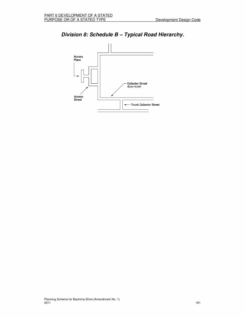
PART 6 DEVELOPMENT OF A STATED PURPOSE OR OF A STATED TYPE Development Design Code
Planning Scheme for Bauhinia Shire (Amendment No. 1) 2011 181
Division 8: Schedule B – Typical Road Hierarchy.
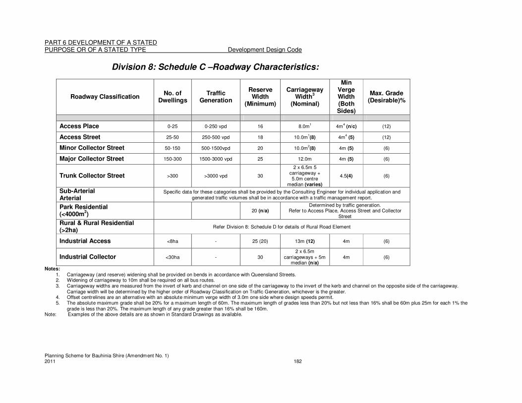
PART 6 DEVELOPMENT OF A STATED PURPOSE OR OF A STATED TYPE Development Design Code
Planning Scheme for Bauhinia Shire (Amendment No. 1) 2011 182
Division 8: Schedule C –Roadway Characteristics:
Roadway Classification No. of
Dwellings Traffic
Generation
Reserve Width
(Minimum)
Carriageway Width
3
(Nominal)
Min Verge Width (Both Sides)
Max. Grade (Desirable)%
Access Place 0-25 0-250 vpd 16 8.0m1 4m
4 (n/c) (12)
Access Street 25-50 250-500 vpd 18 10.0m1(8) 4m
4 (5) (12)
Minor Collector Street 50-150 500-1500vpd 20 10.0m2(8) 4m (5) (6)
Major Collector Street 150-300 1500-3000 vpd 25 12.0m 4m (5) (6)
Trunk Collector Street >300 >3000 vpd 30
2 x 6.5m 5 carriageway + 5.0m centre
median (varies)
4.5(4) (6)
Sub-Arterial Arterial
Specific data for these categories shall be provided by the Consulting Engineer for individual application and generated traffic volumes shall be in accordance with a traffic management report.
Park Residential (<4000m
2)
20 (n/a) Determined by traffic generation.
Refer to Access Place, Access Street and Collector Street
Rural & Rural Residential (>2ha)
Refer Division 8: Schedule D for details of Rural Road Element
Industrial Access <8ha - 25 (20) 13m (12) 4m (6)
Industrial Collector <30ha - 30 2 x 6.5m
carriageways + 5m median (n/a)
4m (6)
Notes: 1. Carriageway (and reserve) widening shall be provided on bends in accordance with Queensland Streets. 2. Widening of carriageway to 10m shall be required on all bus routes. 3. Carriageway widths are measured from the invert of kerb and channel on one side of the carriageway to the invert of the kerb and channel on the opposite side of the carriageway.
Carriage width will be determined by the higher order of Roadway Classification on Traffic Generation, whichever is the greater. 4. Offset centrelines are an alternative with an absolute minimum verge width of 3.0m one side where design speeds permit. 5. The absolute maximum grade shall be 20% for a maximum length of 60m. The maximum length of grades less than 20% but not less than 16% shall be 60m plus 25m for each 1% the
grade is less than 20%. The maximum length of any grade greater than 16% shall be 160m. Note: Examples of the above details are as shown in Standard Drawings as available.

PART 6 DEVELOPMENT OF A STATED PURPOSE OR OF A STATED TYPE Development Design Code
Planning Scheme for Bauhinia Shire (Amendment No. 1) 2011 183
Division 8: Schedule D – Basic Design Requirements for Rural Roads.
Traffic Volume or Road
Class <150VPD 150-500 500 - 3000 >3000
Road Reserve (flat terrain <5%)
20m 20m 25m
As per Division 8: Schedule C Sub-Arterial
Road Reserve (Undulating/Hilly >5%)
25m 25m 30m
Formation 8m 8m 10m
Pavement Width 8m 8m 10m
Seal Width * 7m 7m 8m
Shoulders
Incl. 0.25m
sealed on each side
Incl. 0.25m sealed on each side
Incl. 0.5m sealed on each side
Desirable Speed Environment
100kph 100kph 100kph
Design Speed for Individual Elements (Minimum)
80kph 80kph 80kph
• Widening on curves will be required.

PART 6 DEVELOPMENT OF A STATED PURPOSE OR OF A STATED TYPE Development Design Code
Planning Scheme for Bauhinia Shire (Amendment No. 1) 2011 184
Division 8: Schedule E—Stormwater Drainage Recurrence Intervals
Average Recurrence Intervals for Design
(i) Major System Design ARI (years) 100
(ii) Minor System Design ARI (years)
Development Category
Central Business and Commercial 10
Industrial 5
Urban Residential High Density -greater than 20 dwelling units/ha
5
Urban Residential Low Density -greater than 5 & up to 20 dwelling units/ha
5
Rural Residential – 2 to 5 dwelling units/ha 2
Open Space – Parks, etc 1
Major Roads (Minor Collector and above)
Kerb & Channel Flow
10*
Cross Drainage (Culverts)
50**
Minor Roads (Access Streets and Access Places)
Kerb & Channel Flow
Refer to relevant development
category Cross Drainage (Culverts)
10**
Notes: * The design ARI for the minor drainage system in a major road shall be that indicated for
the major road, not that for the Development Category of the adjacent area.
** Culverts under roads should be designed to accept the full flow for the minor system ARI shown. In addition the designer must ensure that the 100 year ARI backwater does not enter properties upstream. If upstream properties are at a relatively low elevation it may be necessary to install culverts of capacity greater than that for the minor system ARI design storm to ensure flooding of upstream properties does not occur. In addition the downstream face of the causeway embankment may need protection where overtopping is likely to occur.
*** The terms used in this table are described in the Glossary and/or Table 5.06.2 of QUDM September 1992.
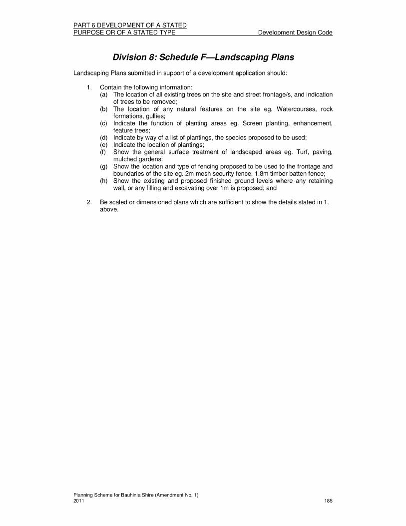
PART 6 DEVELOPMENT OF A STATED PURPOSE OR OF A STATED TYPE Development Design Code
Planning Scheme for Bauhinia Shire (Amendment No. 1) 2011 185
Division 8: Schedule F—Landscaping Plans
Landscaping Plans submitted in support of a development application should:
1. Contain the following information: (a) The location of all existing trees on the site and street frontage/s, and indication
of trees to be removed; (b) The location of any natural features on the site eg. Watercourses, rock
formations, gullies; (c) Indicate the function of planting areas eg. Screen planting, enhancement,
feature trees; (d) Indicate by way of a list of plantings, the species proposed to be used; (e) Indicate the location of plantings; (f) Show the general surface treatment of landscaped areas eg. Turf, paving,
mulched gardens; (g) Show the location and type of fencing proposed to be used to the frontage and
boundaries of the site eg. 2m mesh security fence, 1.8m timber batten fence; (h) Show the existing and proposed finished ground levels where any retaining
wall, or any filling and excavating over 1m is proposed; and
2. Be scaled or dimensioned plans which are sufficient to show the details stated in 1. above.

PART 6 DEVELOPMENT OF A STATED PURPOSE OR OF A STATED TYPE Development Design Code
Planning Scheme for Bauhinia Shire (Amendment No. 1) 2011 186
Division 8: Schedule G—Suitable Plant Species LEGEND: Drought resistance - V - very resistant R - resistant M - moderately resistant T - tender when young S - susceptible at all ages. Frost resistance V - very resistant R - resistant M - moderately resistant T - tender when young S - susceptible at all ages. Height in metres Moist soils * Areas suitable where soil moisture is
retained for short periods, after rain. In gullies, depressions, low land etc.
Clay heavy soils * Suitable Sandstone or rocky * Suitable subsoils Origin N - Australian Native E - Exotic It is recommended that proponents reference “Native Plants for the Fitzroy Basin 2003”

PART 6 DEVELOPMENT OF A STATED PURPOSE OR OF A STATED TYPE Development Design Code
Planning Scheme for Bauhinia Shire (Amendment No. 1) 2011 187
Common Name Botanical Name Drought
resistance
Frost
resistance Height
Moist soils
Clay - heavy soils Other
Hydrological Models
Sandstone rocky
subsoil Origin
Mount Morgan Wattle Qld Silver Wattle
Acacia Podalyriifolia M T 4 * * N
Crowded leaved Wattle Acacia Conferta R R 3 * N Brisbane Wattle Acacia Fimbriata M M 5 * * N
Lilly Pilly Acmena Smithii S S 18 * N Broad leaved Bottle Tree Brachychiton Australis V M 12 * * N
Red Bauhinia Bauhinia Galpinii M T 3 * * E Purple Orchid Tree Bauhinia Variegata M T 5 * * E
Leopard Tree Caesalpinea Ferrea M M 15 * * * E Fiery Bottlebrush Callistemon
Phoenicus R R 3 * * N
White Bottlebrush Callistemon Salignus R M 6 * * * N
Weeping Bottlebrush Callistemon Viminalis M T 6 * * * N
Dwarf Weeping Bottle Brush
Callistemon Viminalis Dwarf
R T 1.5 * * * N
Bribie Island Pine Callitris Columellaris R R 20 * N Laburnum Golden Shower Cassia Fistula M T 6 * * * E
Desert Cassia Cassis Eremophila Nemophila
V R 2.5 * * * N
River Sheoak Casuarina Cunninghamiana
R R 30 * * N
Swamp Bloodwood Eucalyptus Ptychocarpa
S M 10 * * * N
Red flowering Yellow Gum
Eucalyptus Leucoxlyon Macrocarpa
M R 7 * * * N
Ghost Gum Eucalyptus Papuana V M 10-20 * * N
Red Banks Grevillea Grevillea Banksii M T 2.5 * * N
Tulipwood Harpullia Pendula S T 15-20 * * N
Jacaranda Jacaranda Mimosaefolia
M T 12 * * E
Golden Rain Tree Koelreuteria Paniculata
R R 6 * * * E
Lemon Scented Tea Tree Leptospermum Petersonii
M T 3 * * * N
Bracelet Honey Myrtle Melaleuca Armillaris R M 6 * * * N
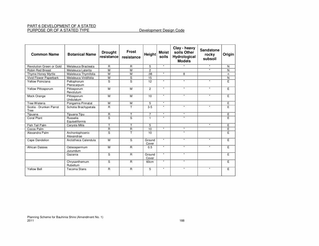
PART 6 DEVELOPMENT OF A STATED PURPOSE OR OF A STATED TYPE Development Design Code
Planning Scheme for Bauhinia Shire (Amendment No. 1) 2011 188
Common Name Botanical Name Drought
resistance
Frost
resistance Height
Moist soils
Clay - heavy soils Other
Hydrological Models
Sandstone rocky
subsoil Origin
Revolution Green or Gold Melaleuca Bracteata R R 5 * * * N
Robin Red Breast Melaleuca Laterita M M 2 * N Thyme Honey Myrtle Maleleuca Thymifolia M M .08 * 8 n
Vivid Flower Paperbark Melaleuca Viridifolia M S 15 N Yellow Poinciana Peltophorum
Pterocarpum S S 12 * * * E
Yellow Pittosporum Pittosporum Revolutum
M M 2 * * * E
Mock Orange Pittosporum Undulatum
M M 10 * * * E
Tree Wisteria Pongamia Pinnatat M M 5 * E
Scotia - Drunken Parrot Tree
Schotia Brachypetala R T 3-5 * * * E
Tipuana Tipuana Tipu R T 7 * * E Coral Plant Russelia
Equisetiformis S S 1 * * E
Fish Tail Palm Caryota Mitis T T 5 * E
Cocos Palm R R 10 * * E
Alexandra Palm Archontophoenix Alexandrae
S T 10 * E
Cape Dandelion Arctotheca Calendula M S Ground Cover
* * * E
African Daisies Osteospermum Jucundum
M R 0.5 * * * E
Gazania S R Ground Cover
* * E
Chrysanthemum Rubellum
S R 60cm * * E
Yellow Bell Tecoma Stans R R 5 * * * E

PART 6 DEVELOPMENT OF A STATED PURPOSE OR OF A STATED TYPE Extractive Industry Code
Planning Scheme for Bauhinia Shire (Amendment No. 1) 2011 189
Division 9 - Extractive Industry Code
About the Extractive Industry Code
� The Extractive Industry Code regulates Extractive Industry uses, whether they are Code assessable or Impact assessable.
� The Code regulates the location of such uses, and the potential impacts upon water quality, road infrastructure and use, and the amenity of adjoining land uses.
(1) Extractive Industry Code
The provisions in this division comprise the Extractive Industry Code. They are— 1. The Purpose of the Extractive Industry Code – Section (2); and 2. The Specific Outcomes, Probable Solutions and Acceptable Solutions for
Extractive Industry development – Table 6.9.1.
(2) The Purpose of the Extractive Industry Code The purpose of the Extractive Industry Code is to achieve the following overall outcomes: 1. Extractive resources and the access to extractive resources, are protected from
the encroachment of incompatible land uses; 2. Extractive resources are exploited in an efficient and responsible manner; 3. Haulage routes are adequate to accommodate the traffic demands of extractive
industries; and 4. The extraction of materials is undertaken without significant adverse
environmental impacts; and 5. Rehabilitation of sites after the extraction of material achieves a stable land form,
suitable to intended uses in the relevant Zone or Precinct.
TABLE 6.9.1 EXTRACTIVE INDUSTRIES
Column 1 Column 2
Specific outcomes (S) for Code and Impact assessable development
Probable Solutions (P) for Code and Impact assessable development;
and
Acceptable Solutions (A) for Self assessable development (where Self assessable development does not meet the Acceptable Solutions in the applicable codes, it requires Code assessment. Refer to Section 1.2.9)
All Extractive Industries
Operation S1 The development of the site:
1. Protects the natural environment; 2. Does not result in noise, dust and
vibration that causes nuisance or environmental harm at the nearest sensitive receptor or potential sensitive location (future residential,
P1.1 Houses, Home Host Accommodation, Home Based Businesses and any Community purposes – government or Community purposes – other, on lots which share a boundary with land identified as an extractive industry, are located at least:
1. 1,000m where the operation involves

PART 6 DEVELOPMENT OF A STATED PURPOSE OR OF A STATED TYPE Extractive Industry Code
Planning Scheme for Bauhinia Shire (Amendment No. 1) 2011 190
community use); and 3. Does not compromise public
safety79
.
blasting; 2. 200m where blasting or intrusive
processing is not involved; 3. 100m distance each side of a
transport corridor associated with the extractive or mining resource.
A report prepared in accordance with Division 9 Schedule A – Extractive Industry Assessment Reports will be required to be submitted with the application for assessment to demonstrate compliance with the specific outcomes and probable solutions. Note: The above separation distances should be taken from the boundary of the mining lease or the mineral development licence or extractive industry approval area. P1.2 Blasting is limited to Monday – Saturday 7am to 7pm. P1.3 Blasting does not result in materials escaping or being ejected from the site. P1.4 Operations do not occur on Sundays or public holidays. P1.5 Security fencing is provided for the full length of the perimeter of the site, enclosing all extraction sites and stockpiles. P1.6 A vegetation buffer of 10m is retained or provided around the perimeter of the site to screen the operations from adjoining properties and public land. P1.7 Weed control practices and plant and equipment cleaning and inspection protocols, as set out in the Queensland Guideline for Limiting Weed Seed Spread (DNR2000), are implemented to avoid the introduction and spread of weeds along haul routes and at delivery points.
Amenity S2 The development is designed and operated
P2.1 No solutions specified.
79 A report prepared in accordance with Division 9 - Schedule A – Extractive Industry Assessment Reports
will be required to be submitted with the application for assessment to demonstrate compliance with the specific outcomes and probable solutions.
.

PART 6 DEVELOPMENT OF A STATED PURPOSE OR OF A STATED TYPE Extractive Industry Code
Planning Scheme for Bauhinia Shire (Amendment No. 1) 2011 191
in a manner that does not result in noise, dust and vibration that causes nuisance or environmental harm at the nearest sensitive receptor or potential sensitive location (future residential, community use). Water Quality S3 Water from, around and within the area of operation is managed so that it does not adversely affect the quantity and quality of groundwater or receiving surface waters. Application is to comply with Division 9: Schedule B - Extractive Industry Assessment – Performance Criteria.
P3.1 Extraction of materials is managed to avoid any loss of hydraulic head in any aquifer intercepted by the extractive operations. P3.2 Erosion and stormwater control measures are designed and constructed in accordance with the Soil Erosion and Sediment Control – Engineering Guidelines for Queensland Construction Sites 1996.
Haulage S4 The transportation of materials from the site is with minimal impact upon the environment, the road system and premises along the haulage route.
P4.1 The development has road access that:
1. Is of a standard sufficient to carry traffic of the nature that the extractive industry use would be likely to generate;
2. Does not cause adverse impacts on premises along the haulage route, in particular due to the effects of dust and noise; and
3. Does not compromise traffic safety in the area.
Rehabilitation S5 The rehabilitation of development sites results in a stable land form after extraction is completed, that is suitable for uses intended for that Zone, or Precinct. Application is to comply with Division 9: Schedule B - Extractive Industry Assessment – Performance Criteria.
P5.1 Disused buildings and structures are removed from the site after extraction is completed.

PART 6 DEVELOPMENT OF A STATED PURPOSE OR OF A STATED TYPE Extractive Industry Code
Planning Scheme for Bauhinia Shire (Amendment No. 1) 2011 192
Division 9: Schedule A—Extractive Industry Assessment Report Requirements
An Extractive Industry Assessment Report is required to be prepared for the assessment of development applications for all Extractive Industry developments, and is to provide information on those of the following that are relevant to the proposed development: The site:
1. A scaled plan of the site indicating the location of: (a) Economic resources to be extracted and any proposed staging of extraction
and development; (b) Site access and any proposed roads within the site; (c) Proposed buildings, infrastructure and stockpiling areas; and (d) Other storage and servicing areas.
The proposal: 2. A description about the resource proposed to be extracted, and where necessary
due to the scale of the proposal, supported by geological and geo-technical information;
3. Details on the amount of material to be extracted; 4. Details of the proposed method of extraction eg. Blasting 5. Details of any proposed processing on site eg. Screening, crushing 6. Details of the proposed transportation methods of material including vehicular size,
frequency of trips and proposed haulage routes; 7. Proposed methods of removing material or refuse from the site.
Impacts on amenity: 8. Details of all noise sources; 9. Proposed noise attenuating measures, with consideration of surrounding land uses,
to minimise noise emissions from the site; 10. Details of the proposed hours of operation; 11. The extent of landscaping buffers (existing or proposed vegetation) to screen the
development; 12. Details of proposed lighting on site.
Impacts on environmental values: 13. Proposals for water management, including waste water management and
protection of water quality and overland flow paths; 14. Methods of controlling stormwater flows on the site and external to the site (which
depending on the scale of the proposal may require the preparation of an hydraulic study to ascertain the impacts on overland flows);
15. Projected impacts on groundwater; 16. The extent of required vegetation clearing, shown on a scaled site plan; 17. Proposals for the management of weeds and to minimise the risk of introduction and
spread of weeds; 18. Evaluation of impacts on the ecological values of the site and surrounding area; 19. Details of proposed monitoring of environmental impacts in all phases of the
development. Risks and Hazards:
20. Proposals for ensuring the safety of the public, both on the site and from any effects of the development external to the site.
Rehabilitation: 21. Proposals, including plans, for the progressive and final planting and site
rehabilitation. The required detail and complexity of the above information will vary between different sites and proposals, but is to be sufficient to demonstrate compliance with the Overall Outcomes, Specific Outcomes and Probable Solutions of the Extractive Industry Code.

PART 6 DEVELOPMENT OF A STATED PURPOSE OR OF A STATED TYPE Home Based Business Code
Planning Scheme for Bauhinia Shire (Amendment No. 1) 2011 193
Division 10—Home Based Business Code
About the Home Based Business Code � The Home Based Business Code regulates Home Based Business uses. � The Code regulates the operation of Home Based Businesses in terms of their size,
scale and nature, location and potential to impact on adjoining residential uses. � The House Code is also applicable (as indicated by the Tables of Assessment for the
relevant Zone) in the consideration of applications for Home Based Business uses.
(1) Home Based Business Code
The provisions in this division comprise the Home Based Business Code. They are — 1. The Purpose of the Home Based Business Code - Section (2); and 2. The Specific Outcomes, Probable Solutions and Acceptable Solutions for
Home Based Business development – Table 6.10.1. (2) The Purpose of the Home Based Business Code
The purpose of the Home Based Business code is to allow the provision of small scale businesses in association with the primary use of premises as a house, without compromising the safety of, and amenity enjoyed by, adjoining and nearby premises.
TABLE 6.10.1 HOME BASED BUSINESSES
Column 1 Column 2
Specific outcomes (S) for Code and Impact assessable development
Probable Solutions (P) for Code and Impact assessable development;
and
Acceptable Solutions (A) for Self assessable development (where Self assessable development does not meet the Acceptable Solutions in the applicable codes, it requires Code assessment. Refer to Section 1.2.9)
All Home Based Businesses
Scale of Use
S1 The use is of a scale and nature that is consistent with that of a house, in recognition of:
1. The predominantly residential nature of the use of the site and the surrounding area; and
2. The preference for uses of a scale greater than that allowed by this Code and the defined use, to be located in commercial areas.
P/A1.1 The use is conducted by the residents of the house. In addition, one employee or one student may be engaged in the use. P/A1.2 The use falls within the definition of a home based business in terms of floor area or area used. P/A1.3 Any separate building or structure associated with the use:
1. has a maximum height of 8.5m; 2. is not located in the road frontage
setback of the house; and 3. is setback a minimum of 2m from
any other boundary of the site. P/A1.4
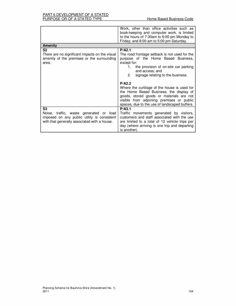
PART 6 DEVELOPMENT OF A STATED PURPOSE OR OF A STATED TYPE Home Based Business Code
Planning Scheme for Bauhinia Shire (Amendment No. 1) 2011 194
Work, other than office activities such as book-keeping and computer work, is limited to the hours of 7:30am to 6:00 pm Monday to Friday; and 8:00 am to 5:00 pm Saturday.
Amenity
S2 There are no significant impacts on the visual amenity of the premises or the surrounding area.
P/A2.1 The road frontage setback is not used for the purpose of the Home Based Business, except for:
1. the provision of on-site car parking and access; and
2. signage relating to the business. P/A2.2 Where the curtilage of the house is used for the Home Based Business, the display of goods, stored goods or materials are not visible from adjoining premises or public spaces, due to the use of landscaped buffers.
S3 Noise, traffic, waste generated or load imposed on any public utility is consistent with that generally associated with a house.
P/A3.1 Traffic movements generated by visitors, customers and staff associated with the use are limited to a total of 12 vehicle trips per day (where arriving is one trip and departing is another).

PART 6 DEVELOPMENT OF A STATED PURPOSE OR OF A STATED TYPE Home Host Accommodation Code
Planning Scheme for Bauhinia Shire (Amendment No. 1) 2011 195
Division 11—Home Host Accommodation Code
About the Home Host Accommodation Code � The Home Host Accommodation Code regulates Home Host Accommodation uses,
whether they are Self assessable, Code assessable or Impact assessable. � The Code regulates the operation of Home Host Accommodation uses in terms of
their size, scale and nature, location and potential to impact on adjoining residential uses.
� The House Code is also applicable (as indicated by the Tables of Assessment for the relevant Zone) in the consideration of applications for Home Host Accommodation uses.
(1) Home Host Accommodation Code
The provisions in this division comprise the Home Host Accommodation Code. They are — 1. The Purpose of the Home Host Accommodation Code - Section (2); and 2. The Specific Outcomes, Probable Solutions and Acceptable Solutions for
Home Host Accommodation development – Table 6.11.1. (2) The Purpose of the Home Host Accommodation Code
The purpose of the Home Host Accommodation Code is to achieve the following overall outcomes: 1. Home Host Accommodation development:
(a) Is a small scale and low key form of guest accommodation, established and operated in association with the primary use of the premise as a house;
(b) Does not have significant impacts on residential amenity or privacy; and (c) Provides facilities which are comfortable, safe and enjoyable for the touring
public. (d) Ensures adequate infrastructure will exist for the provision of a potable
water supply.
TABLE 6.11.1 HOME HOST ACCOMMODATION
Column 1 Column 2
Specific outcomes (S) for Code and Impact assessable development
Probable Solutions (P) for Code and Impact assessable development;
and
Acceptable Solutions (A) for Self assessable development (where Self assessable development does not meet the Acceptable Solutions in the applicable codes, it requires Code assessment. Refer to Section 1.2.9)
All Home Host Accommodation
Scale of Use
S1 The size, scale and design of the use is such that the accommodation of guests on the premises does not have significant impacts on the amenity of the adjoining premises or the surrounding area.
P/A1.1 The maximum number of visitors accommodated on the premises is as follows:
1. Town Zone– 6 visitors; and 2. All Other Zones – 10 visitors.
P/A1.2 The maximum number of bedrooms used to accommodate guests is as follows:
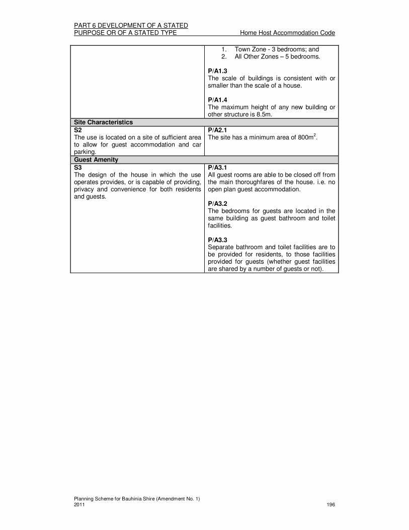
PART 6 DEVELOPMENT OF A STATED PURPOSE OR OF A STATED TYPE Home Host Accommodation Code
Planning Scheme for Bauhinia Shire (Amendment No. 1) 2011 196
1. Town Zone - 3 bedrooms; and 2. All Other Zones – 5 bedrooms.
P/A1.3 The scale of buildings is consistent with or smaller than the scale of a house. P/A1.4 The maximum height of any new building or other structure is 8.5m.
Site Characteristics
S2 The use is located on a site of sufficient area to allow for guest accommodation and car parking.
P/A2.1 The site has a minimum area of 800m
2.
Guest Amenity
S3 The design of the house in which the use operates provides, or is capable of providing, privacy and convenience for both residents and guests.
P/A3.1 All guest rooms are able to be closed off from the main thoroughfares of the house. i.e. no open plan guest accommodation. P/A3.2 The bedrooms for guests are located in the same building as guest bathroom and toilet facilities. P/A3.3 Separate bathroom and toilet facilities are to be provided for residents, to those facilities provided for guests (whether guest facilities are shared by a number of guests or not).

PART 6 DEVELOPMENT OF A STATED PURPOSE OR OF A STATED TYPE House Code
Planning Scheme for Bauhinia Shire (Amendment No. 1) 2011 197
Division 12—House Code
About the House Code � The House Code regulates all houses, whether they are Self assessable, Code
assessable or Impact assessable. � The Code is also applicable in the consideration of applications for Reconfiguring a
Lot where new lots are to be created. � The Code regulates house scale, construction materials, siting, associated activities
and special requirements for houses on small lots.
(1) House Code
The provisions in this division comprise the House Code. They are — 1. The Purpose of the House Code - Section (2); and 2. The Specific Outcomes, Probable Solutions and Acceptable Solutions for
Houses – Table 6.12.1. (2) The Purpose of the House Code
The purpose of the House Code is to achieve the following overall outcomes: 1. Houses are:
(a) Sited and designed in a manner that is consistent with the desired or existing residential character of the area;
(b) Afforded acceptable levels of privacy, daylight and amenity; and (c) Not subjected to unreasonable hazards or noise because of their
location.
TABLE 6.12.1 HOUSES
Column 1 Column 2
Specific outcomes (S) for Code and Impact assessable development
Probable Solutions (P) for Code and Impact assessable development;
and
Acceptable Solutions (A) for Self assessable development (where Self assessable development does not meet the Acceptable Solutions in the applicable codes, it requires Code assessment. Refer to Section 1.2.9)
All Houses
Siting and Design
S1 Houses are sited and designed so that they are compatible with the residential character of the surrounding area having regard to the following:
1. Building bulk, height and scale; 2. Construction materials; 3. Design features such as verandahs,
sun hoods, decks, and pitched roofs.
P/A1.1 Site coverage of a house and any associated buildings does not exceed 50%. P/A1.2 Dwelling units have a minimum area of 60m
2,
excluding garages.
S2 Houses are of a construction that is suited to the climate of the Shire and have regard to the following:
1. Construction materials and
P/A2.1 Houses are constructed predominantly of timber, brick or masonry.

PART 6 DEVELOPMENT OF A STATED PURPOSE OR OF A STATED TYPE House Code
Planning Scheme for Bauhinia Shire (Amendment No. 1) 2011 198
methods provide adequate insulation to protect against extremes in temperature; and
2. Provision of verandahs, sunhoods, eaves, shutters or blinds to offer shelter to the house.
S3 Houses are sited and designed having consideration of the impacts on residential amenity due to the existence of non-residential uses on adjoining properties, and having regard to the following:
1. Increased building setbacks to provide greater separation from non-residential uses;
2. The elimination of windows and openings adjacent to non-residential uses; and
3. The need for a landscaped buffer and/ or screen fencing to protect the privacy of the house.
P/A3.1 Houses are setback a minimum of 200m from the site area of any adjoining premises used for intensive animal husbandry uses, kennels and catteries, feedlots and dairies, piggeries, poultry farms, and stables, or, have setbacks provided in accordance with PART 4: Division 1 - Schedule A (Rural Zone Code), whichever is the greater setback. P/A3.2 Houses are setback a minimum of 3m to uses that are not in the Residential Use Class, other than as specified in P/A3.1 above.
Parking of Vehicles
S4 The parking or storage of heavy vehicles, as ancillary to the house use, does not adversely impact upon the amenity of the surrounding area, in particular uses in the Residential Use Class having regard to:
1. Potential noise impacts; 2. Visual intrusion into the streetscape
and adjoining premises; and 3. Potential impacts on traffic safety.
P/A4.1 The parking or storage of heavy vehicles per house, is limited to:
1. Town Zone (except Town – Industrial Precinct), Open Space Zone – 1 truck and 1 trailer;
2. Town – Industrial Precinct - 2 vehicles; and
3. All other Zones/Precincts – no specific rate.
P/A4.2 In the Town Zone, the parking or storage of heavy vehicles is not conducted within 3m of the side or rear boundaries. P/A4.3 In the Town - Rural Residential Precinct the parking or storage of heavy vehicles is not conducted within 15m of the side or rear boundaries. P/A4.4 The parking and storage of heavy vehicles does not include the maintenance or servicing of vehicles, which would be defined as an Environmentally Relevant Activity (Motor Vehicle Workshop).
Contaminated Land S5 Houses are not located on land which is contaminated land, to avoid potential hazards to human health or safety.
P/A5.1 Houses are not located on sites where, the existing use of the land is, or if the land is vacant land with no existing use the most recent use of the land was, for a notifiable activity under the Environmental Protection Act 1994.
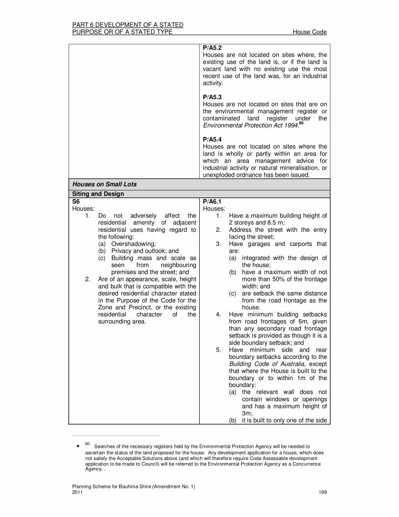
PART 6 DEVELOPMENT OF A STATED PURPOSE OR OF A STATED TYPE House Code
Planning Scheme for Bauhinia Shire (Amendment No. 1) 2011 199
P/A5.2 Houses are not located on sites where, the existing use of the land is, or if the land is vacant land with no existing use the most recent use of the land was, for an industrial activity. P/A5.3 Houses are not located on sites that are on the environmental management register or contaminated land register under the Environmental Protection Act 1994.
80
P/A5.4 Houses are not located on sites where the land is wholly or partly within an area for which an area management advice for industrial activity or natural mineralisation, or unexploded ordnance has been issued.
Houses on Small Lots
Siting and Design
S6 Houses:
1. Do not adversely affect the residential amenity of adjacent residential uses having regard to the following: (a) Overshadowing; (b) Privacy and outlook; and (c) Building mass and scale as
seen from neighbouring premises and the street; and
2. Are of an appearance, scale, height and bulk that is compatible with the desired residential character stated in the Purpose of the Code for the Zone and Precinct, or the existing residential character of the surrounding area.
P/A6.1 Houses:
1. Have a maximum building height of 2 storeys and 8.5 m;
2. Address the street with the entry facing the street;
3. Have garages and carports that are: (a) integrated with the design of
the house; (b) have a maximum width of not
more than 50% of the frontage width; and
(c) are setback the same distance from the road frontage as the house.
4. Have minimum building setbacks from road frontages of 6m, given than any secondary road frontage setback is provided as though it is a side boundary setback; and
5. Have minimum side and rear boundary setbacks according to the Building Code of Australia, except that where the House is built to the boundary or to within 1m of the boundary: (a) the relevant wall does not
contain windows or openings and has a maximum height of 3m;
(b) it is built to only one of the side
• 80 Searches of the necessary registers held by the Environmental Protection Agency will be needed to
ascertain the status of the land proposed for the house. Any development application for a house, which does not satisfy the Acceptable Solutions above (and which will therefore require Code Assessable development application to be made to Council) will be referred to the Environmental Protection Agency as a Concurrence Agency. .

PART 6 DEVELOPMENT OF A STATED PURPOSE OR OF A STATED TYPE House Code
Planning Scheme for Bauhinia Shire (Amendment No. 1) 2011 200
boundaries; and (c) the total length of wall on or
within 1m of the boundary does not exceed 12m.
Parking of Vehicles
S7 The parking or storage of heavy vehicles, as ancillary to the house use, does not adversely impact upon the amenity of the surrounding area, in particular uses in the Residential Use Class having regard to:
1. Potential noise impacts; 2. Visual intrusion into the streetscape
and adjoining premises; and 3. Potential impacts on traffic safety.
P/A7.1 Houses on small lots do not include the ancillary parking or storage of trucks or trailers or other heavy vehicles.

PART 6 DEVELOPMENT OF A STATED PURPOSE OR OF A STATED TYPE Reconfiguration of Lot Code
Planning Scheme for Bauhinia Shire (Amendment No. 1) 2011 201
Division 13- Reconfiguring a Lot Code
About the Reconfiguring a Lot Code � The Reconfiguring a Lot Code regulates development for Reconfiguring a Lot, which
is either Code assessable or Impact assessable. � The Code regulates the manner in which land is reconfigured or subdivided, including
minimum lot sizes and dimensions, means of access, open space provision and provision of essential services.
� Separately, the Development Standards Code regulates the design and siting aspects of the Reconfiguring of a Lot development, as affected by associated Operational Work. This ensures that in considering how appropriate a particular site is for the proposed subdivision, the aspects of servicing, provision of new roads and other facilities are also considered.
� The manner in which the operational works associated with the Reconfiguring a Lot is undertaken is regulated by the Development Design Code (as indicated by the Tables of Assessment for Operational Works relevant to the Zone/Overlay)
� The House Code is also applicable (as indicated by the Tables of Assessment for the relevant Zone/Overlay) in the consideration of applications for Reconfiguring a Lot.
(1) Reconfiguring a Lot Code
The provisions in this division comprise the Reconfiguring a Lot Code. They are— 1. The Purpose of the Reconfiguring a Lot Code – Section (2); and 2. The Specific Outcomes, Probable Solutions and Acceptable Solutions for
Reconfiguring a Lot development – Table 6.13.1.
(2) The Purpose of the Reconfiguring a Lot Code The purpose of the Reconfiguring a Lot Code is to achieve the following overall outcomes: 1. Lot design and size is suited to its intended and potential uses, and in the Rural
Zone the agricultural potential of the land; 2. A range of lot sizes are available, across the various Zones and Precincts, to
meet the needs of the community; 3. The rearranging of boundaries maintains or improves the usability of the land
and access to all lots; 4. The creation of access easements from constructed roads maintains or
improves access to all lots without compromising the functioning or efficiency of the existing road network;
5. The creation of additional lots provides lots that: (a) are of an area, dimension and nature that are consistent with the
outcomes sought for the zone in which it occurs, potential uses and any approved uses;
(b) reflect significant physical features and constraints of the land; (c) allow for the necessary boundary setbacks and buffer of uses; (d) have appropriate infrastructure and services supplied in an efficient and
cost effective manner; (e) are of a sufficient area to enable sustainable on-site sewerage treatment
and have demonstrated on-site domestic and emergency water supply in areas where reticulated services are not available; and
(f) are designed such that open spaces, and pedestrian, cycling and road access linkages are provided to existing areas or facilities on adjoining land.
6. In the Town Zone - Investigation Area, an Area Master Plan for the Area is to allow for the orderly and efficient rearrangement and intensification of subdivision layout with the timely delivery of services, whilst respecting the existing lawful rights enjoyed in the areas adjacent to the Investigation Area.
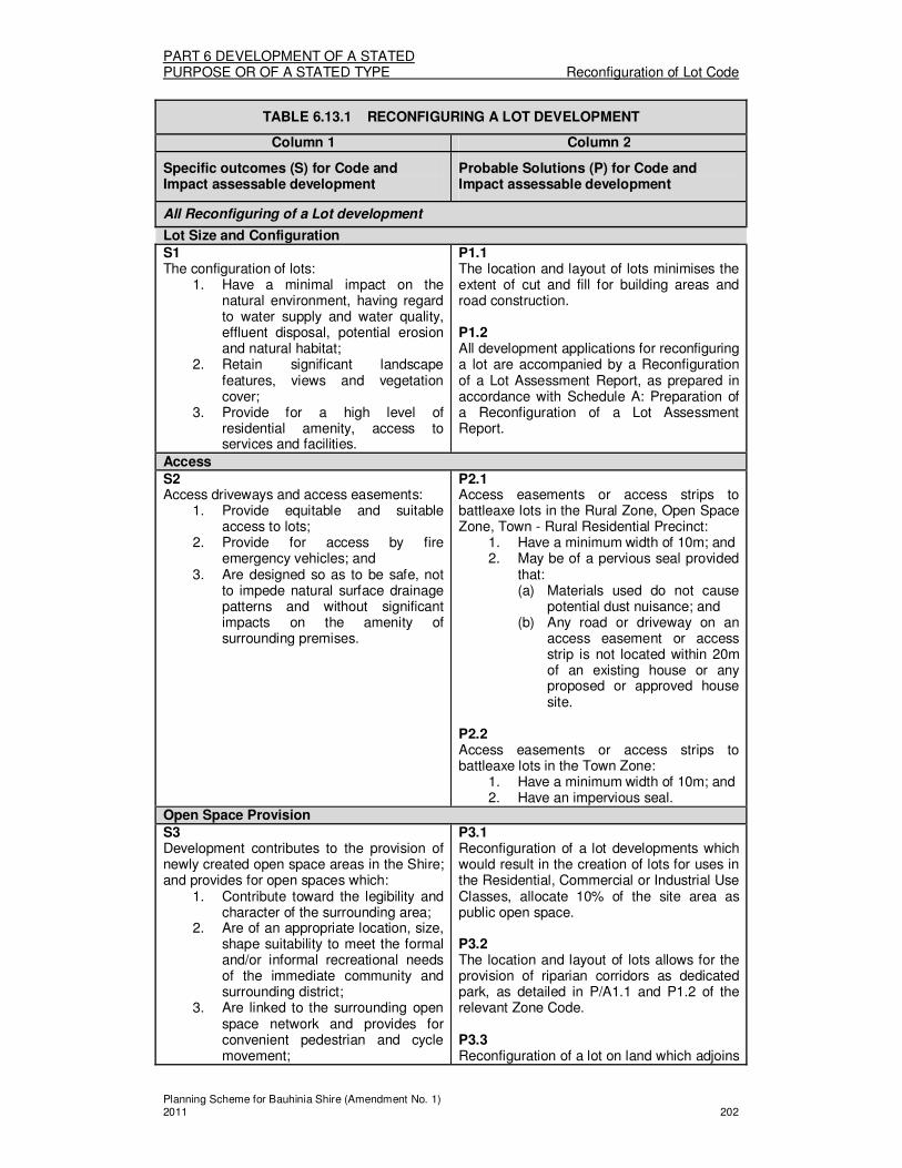
PART 6 DEVELOPMENT OF A STATED PURPOSE OR OF A STATED TYPE Reconfiguration of Lot Code
Planning Scheme for Bauhinia Shire (Amendment No. 1) 2011 202
TABLE 6.13.1 RECONFIGURING A LOT DEVELOPMENT
Column 1 Column 2
Specific outcomes (S) for Code and Impact assessable development
Probable Solutions (P) for Code and Impact assessable development
All Reconfiguring of a Lot development
Lot Size and Configuration
S1 The configuration of lots:
1. Have a minimal impact on the natural environment, having regard to water supply and water quality, effluent disposal, potential erosion and natural habitat;
2. Retain significant landscape features, views and vegetation cover;
3. Provide for a high level of residential amenity, access to services and facilities.
P1.1 The location and layout of lots minimises the extent of cut and fill for building areas and road construction. P1.2 All development applications for reconfiguring a lot are accompanied by a Reconfiguration of a Lot Assessment Report, as prepared in accordance with Schedule A: Preparation of a Reconfiguration of a Lot Assessment Report.
Access
S2 Access driveways and access easements:
1. Provide equitable and suitable access to lots;
2. Provide for access by fire emergency vehicles; and
3. Are designed so as to be safe, not to impede natural surface drainage patterns and without significant impacts on the amenity of surrounding premises.
P2.1 Access easements or access strips to battleaxe lots in the Rural Zone, Open Space Zone, Town - Rural Residential Precinct:
1. Have a minimum width of 10m; and 2. May be of a pervious seal provided
that: (a) Materials used do not cause
potential dust nuisance; and (b) Any road or driveway on an
access easement or access strip is not located within 20m of an existing house or any proposed or approved house site.
P2.2 Access easements or access strips to battleaxe lots in the Town Zone:
1. Have a minimum width of 10m; and 2. Have an impervious seal.
Open Space Provision
S3 Development contributes to the provision of newly created open space areas in the Shire; and provides for open spaces which:
1. Contribute toward the legibility and character of the surrounding area;
2. Are of an appropriate location, size, shape suitability to meet the formal and/or informal recreational needs of the immediate community and surrounding district;
3. Are linked to the surrounding open space network and provides for convenient pedestrian and cycle movement;
P3.1 Reconfiguration of a lot developments which would result in the creation of lots for uses in the Residential, Commercial or Industrial Use Classes, allocate 10% of the site area as public open space. P3.2 The location and layout of lots allows for the provision of riparian corridors as dedicated park, as detailed in P/A1.1 and P1.2 of the relevant Zone Code. P3.3 Reconfiguration of a lot on land which adjoins

PART 6 DEVELOPMENT OF A STATED PURPOSE OR OF A STATED TYPE Reconfiguration of Lot Code
Planning Scheme for Bauhinia Shire (Amendment No. 1) 2011 203
4. Have a multifunction role in providing for passive and active recreation, stormwater management and environmental care;
5. Are located to enable the retention of vegetation, watercourses, riparian corridors and other habitat areas, their associated buffers, linkages and any cultural heritage features;
6. Are located adjacent to compatible land uses, or buffered sufficiently to minimise any adverse impacts from recreational development in the open space; and
7. Are cost-effective to maintain.
existing open space areas with pedestrian and/or cycle paths; provide for the extension of those paths in the area of public open space allocated by the development. P3.4 A cash contribution in lieu of the allocation of public open space as specified in P3.1 may be accepted by Council, and is payable at the rate specified in the Planning Policy No:3 – Park Contributions. Note: Refer to Schedule B — Parks and Open Space Assessment Performance Criteria
Reconfiguring a Lot in the Rural Zone (Not land within the Carnarvon Gorge Area)
Lot Size and Configuration
S4 Lots are of an appropriate size and configuration to sustain the utility and productive capacity of the land for rural purposes; to ensure separation of uses; and to maintain rural character; whilst having regard for whether the proposed lot boundaries are derived from one or more of the following:
1. The configuration of the existing and proposed lots;
2. The nature of any existing use on the land or intended use of land in the Rural Zone;
3. The existence of any natural topographical features such as watercourses and gullies which traverse or constrain the land;
4. The location of existing road reserves and access to proposed and existing lots;
5. The opportunity to facilitate improved land management practices; or
6. A detailed assessment of the agricultural quality of the subject land prepared in accordance with the Planning Guideline: “The Identification of Good Quality Agricultural Land” by a suitably qualified person which demonstrates that the subject land has agricultural potential different to that as mapped on the Economic Resources Overlays Map RES 1 Agricultural Land Class Overlay; or
7. There is an overriding need for the development and alternative sites are not available.
P4.1 500ha is the minimum lot size for newly created lots, comprising Good Quality Agricultural Land Classes A & B as mapped in the Economic Resources Overlays Map RES1 Agricultural Land Class Overlay. P4.2 1000ha is the minimum lot size for newly created lots, comprising Good Quality Agricultural Land Class C1 as mapped in the Economic Resources Overlays Map RES1 Agricultural Land Class Overlay. P4.3 5000ha is the minimum lot size for newly created lots, comprising C2 & C3 Class lands as mapped in the Economic Resources Overlays Map RES1 Agricultural Land Class Overlay. P4.4 Lot sizes smaller than those specified in P4.1 – P4.3 above, only occur where the proposal is for the rearrangement of existing boundaries where no additional lots are being created. P4.5 The minimum road frontage for newly created lots is:
1. 200m for land comprising A, B & C1 Class land as mapped in the Economic Resources Overlays Map RES1 Agricultural Land Class Overlay ; and
2. 500m for C2 & C3 Class land as mapped in the Economic Resources Overlays Map RES1 Agricultural Land Class Overlay.
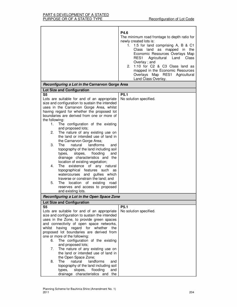
PART 6 DEVELOPMENT OF A STATED PURPOSE OR OF A STATED TYPE Reconfiguration of Lot Code
Planning Scheme for Bauhinia Shire (Amendment No. 1) 2011 204
P4.6 The minimum road frontage to depth ratio for newly created lots is:
1. 1:5 for land comprising A, B & C1 Class land as mapped in the Economic Resources Overlays Map RES1 Agricultural Land Class Overlay ; and
2. 1:10 for C2 & C3 Class land as mapped in the Economic Resources Overlays Map RES1 Agricultural Land Class Overlay.
Reconfiguring a Lot in the Carnarvon Gorge Area
Lot Size and Configuration
S5 Lots are suitable for and of an appropriate size and configuration to sustain the intended uses in the Carnarvon Gorge Area, whilst having regard for whether the proposed lot boundaries are derived from one or more of the following:
1. The configuration of the existing and proposed lots;
2. The nature of any existing use on the land or intended use of land in the Carnarvon Gorge Area;
3. The natural landforms and topography of the land including soil types, slopes, flooding and drainage characteristics and the location of existing vegetation;
4. The existence of any natural topographical features such as watercourses and gullies which traverse or constrain the land; and
5. The location of existing road reserves and access to proposed and existing lots.
P5.1 No solution specified.
Reconfiguring a Lot in the Open Space Zone
Lot Size and Configuration
S5 Lots are suitable for and of an appropriate size and configuration to sustain the intended uses in the Zone, to provide green spaces and connectivity of open space networks, whilst having regard for whether the proposed lot boundaries are derived from one or more of the following:
6. The configuration of the existing and proposed lots;
7. The nature of any existing use on the land or intended use of land in the Open Space Zone;
8. The natural landforms and topography of the land including soil types, slopes, flooding and drainage characteristics and the
P5.1 No solution specified.
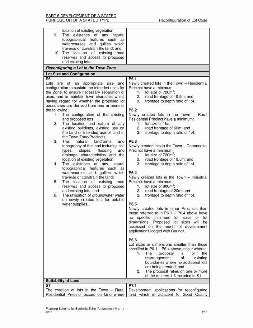
PART 6 DEVELOPMENT OF A STATED PURPOSE OR OF A STATED TYPE Reconfiguration of Lot Code
Planning Scheme for Bauhinia Shire (Amendment No. 1) 2011 205
location of existing vegetation; 9. The existence of any natural
topographical features such as watercourses and gullies which traverse or constrain the land; and
10. The location of existing road reserves and access to proposed and existing lots.
Reconfiguring a Lot in the Town Zone
Lot Size and Configuration
S6 Lots are of an appropriate size and configuration to sustain the intended uses for the Zone, to ensure necessary separation of uses, and to maintain town character; whilst having regard for whether the proposed lot boundaries are derived from one or more of the following:
1. The configuration of the existing and proposed lots;
2. The location and nature of any existing buildings, existing use on the land or intended use of land in the Town Zone/Precincts;
3. The natural landforms and topography of the land including soil types, slopes, flooding and drainage characteristics and the location of existing vegetation;
4. The existence of any natural topographical features such as watercourses and gullies which traverse or constrain the land;
5. The location of existing road reserves and access to proposed and existing lots; and
6. The utilisation of groundwater water on newly created lots for potable water supplies.
P6.1 Newly created lots in the Town – Residential Precinct have a minimum:
1. lot size of 720m2;
2. road frontage of 19.5m; and 3. frontage to depth ratio of 1:4.
P6.2 Newly created lots in the Town – Rural Residential Precinct have a minimum:
1. lot size of 1ha; 2. road frontage of 60m; and 3. frontage to depth ratio of 1:4.
P6.3 Newly created lots in the Town – Commercial Precinct have a minimum:
1. lot size of 720m2;
2. road frontage of 19.5m; and 3. frontage to depth ratio of 1:4.
P6.4 Newly created lots in the Town – Industrial Precinct have a minimum:
1. lot size of 800m2;
2. road frontage of 20m; and 3. frontage to depth ratio of 1:4.
P6.5 Newly created lots in other Precincts than those referred to in P6.1 – P6.4 above have no specific minimum lot sizes or lot dimensions. Proposed lot sizes will be assessed on the merits of development applications lodged with Council. P6.6 Lot sizes or dimensions smaller than those specified in P6.1 – P6.4 above, occur where:
1. The proposal is for the rearrangement of existing boundaries where no additional lots are being created; and
2. The proposal relies on one or more of the matters 1-3 included in S1.
Suitability of Land
S7 The creation of lots in the Town – Rural Residential Precinct occurs on land where
P7.1 Development applications for reconfiguring land which is adjacent to Good Quality

PART 6 DEVELOPMENT OF A STATED PURPOSE OR OF A STATED TYPE Reconfiguration of Lot Code
Planning Scheme for Bauhinia Shire (Amendment No. 1) 2011 206
the new lots: 1. Do not compromise the viable and
sustainable agricultural use (whether existing or potential use) of Good Quality Agricultural Land on adjoining land;
2. Are capable of being adequately serviced by on-site effluent disposal systems, where not able to be connected to reticulated sewer;
3. Are topographically suited to the intended use of the land in the Town – Rural Residential Precinct; and
4. Do not compromise the water quality values of any underground aquifer or surface water body.
Agricultural Land, provide for: 1. Building envelopes setbacks are
consistent with Division 1: Schedule A of the Rural Zone; and
2. The provision or retention of a vegetated buffer with a minimum width of 100m to adjoining Rural Zoned land, either as public open space or within proposed lots.
P7.2 Where the requirements of P7.1 above are not proposed or cannot be met, the proposal complies with the Planning Guidelines: Separating Agricultural and Residential Land Uses, August 1997 in achieving effective buffers between residential uses and agricultural uses. P7.3 Each separate lot proposed is of a size and has soil characteristics which are capable of sustaining the on-site disposal of effluent, where the lot or lots are not proposed to be connected to the reticulated sewer system.
Supply of Rural Residential Lots
S8 The creation of lots in the Town – Rural Residential Precinct is commensurate with the demand for new lots. In Springsure, this assessment is to include the potential for Rural Residential development in the Town Zone – Investigation Area.
P8.1 No solutions specified.

PART 6 DEVELOPMENT OF A STATED PURPOSE OR OF A STATED TYPE Reconfiguration of Lot Code
Planning Scheme for Bauhinia Shire (Amendment No. 1) 2011 207
Division 13: Schedule A—Reconfiguring a Lot: Assessment Report Requirements
A Reconfiguration of a Lot Assessment Report is required to be prepared for the assessment of development applications for all Reconfiguring a Lot development, and is to provide information on those of the following that are relevant to the proposed development: The site and proposal:
1. A scaled plan of the site indicating the location of: (a) Proposed lot boundaries and any proposed staging of lots; (b) Site access and any proposed roads within the site; (c) Proposed building envelopes; (d) Proposed open space provision for recreation and sport; and (e) Topographical and natural features such as watercourses, ridgelines, and
the extent of existing vegetation, and extent of known local flooding. 2. A description and location of land uses on adjoining land. 3. Where proposed lots are not to be connected to the reticulated sewerage system,
information is supplied that demonstrates that on-site sewerage disposal methods will meet the Department of Natural Resources and Water On-Site Sewerage Code (July 2002) or any subsequent update of that Code, and AS/NZS 1547:2000 On-site Domestic Wastewater Management;
4. A scaled plan with contour information over the site area; or an appraisal of the site’s topography to the extent necessary to demonstrate compliance with the Code;
5. A plan showing the location of any adjoining Rural Zoned land, existing buildings, and proposed buffers to achieve effective separation distances between residential and agricultural uses, and buffers to watercourses to maintain stream integrity;
6. Analysis of the opportunities provide linkages to surrounding open space networks, including linear corridors for cycling, walking and horse riding
7. Analysis of the opportunities to retain existing open space areas which are important for recreation or as natural habitats, in the allocation of land to satisfy the requirements for open space provision;
8. Potential environmental impacts and proposed measures to minimise impacts. 9. A review of flooding issues that may impact on the site. Applicants should
determine the applicability of the Flood Hazard Overlay – Floodplain Assessment and related provisions in this Planning Scheme. Where relevant, the applicant is to provide a site-based flood study in accordance with the Planning for stronger, more resilient floodplains Part 2 Guideline – Measures to support floodplain management in future planning schemes.
Town – Investigation Precinct Area: A Master Plan will be required as part of any Reconfiguration of Lot application in the Town – Investigation Precinct Area. The Master Plan is to address the above matters, as well as addressing the following potentially relevant matters:
1. The network of major roads including linkages with State controlled roads; 2. Locations of community centres including shopping centres, education and
recreation facilities; 3. Location, capacity and sequencing of infrastructure to service the development; 4. Likely development yields to be achieved; 5. The development program and staging likely to be followed in achieving the
development yield; 6. Natural resource management features, such as the location and conservation
status of remnant vegetation, wildlife corridors, watercourses and drainage paths and proposals for their protection;

PART 6 DEVELOPMENT OF A STATED PURPOSE OR OF A STATED TYPE Reconfiguration of Lot Code
Planning Scheme for Bauhinia Shire (Amendment No. 1) 2011 208
7. Open space and buffer areas including continuous corridors (50m in width minimum) joining areas of endangered and of concern vegetation, and
8. Areas subject to bushfire, landslip and inundation risk and proposed mitigation measures;
9. Agricultural land qualities, notably any potential conflicts with the conservation and development of Good Quality Agricultural Land;
10. A review of flooding issues that may impact on the site. Applicants should determine the applicability of the Flood Hazard Overlay – Floodplain Assessment and related provisions in this Planning Scheme. Where relevant, the applicant is to provide a site-based flood study in accordance with the Planning for stronger, more resilient floodplains Part 2 Guideline – Measures to support floodplain management in future planning schemes.
Division 13: Schedule B—Parks and Open Space Assessment Performance Criteria
Parks and Open Space Standards/Planning Performance Criteria
Open space standards were adopted in Australia by the National Capital Development Commission (NCDC) in 1972. However, sole dependence on these standards as the method of provision of land for recreation and sport is not recommended. The limitations of the application of these standards include:
� the standards were developed without regard to the recreation and sport needs of the community, or the fact that needs may change over time;
� lack of consideration to indoor and built facilities such as recreation and sport centres and swimming pools;
� lack of consideration of the need to optimise the diversity of recreation opportunities.
The standards are a useful starting point, but planners should also consider the:
� age and sex distribution of the population (to determine the required function of the open space);
� geographical distribution of the population (to indicate the appropriate location of the open space);
� socio-economic characteristics of the population (to indicate broad recreation and sport needs); � recreation and sport needs of the population (expressed as specific activities in specific
settings); � access to recreation and sport opportunities; � existing amount of open space (total area in ha and proportion of local government area); � number and location of alternative/competing/equivalent sites; � physical characteristics (eg terrain, soil type, climate, vegetation) of the local government
area and its impact on recreation and sport opportunities; � the diversity of opportunities in demand by the population; and � council’s plans for future expansion, renewal and development, which should allow for
sufficient quantity and quality of open space for recreation and sport. The standards need to be adapted to the area of available, suitable land (eg open space attributes such as water courses and riparian corridors, wildlife and pedestrian corridors, linkages with existing open space areas, flat areas for organised sport activities) and the population demographics as mentioned above. The application of a standard will not necessarily ensure useful land for recreation and sport. An approach that assesses the community, its needs, the physical characteristics of the area in question, the range of settings possible given the physical characteristics and considers the intended functions is supported. For example, settings and functions can include: lineal corridors for cyclepaths, walkways or horse trails; riparian land for water based recreation; and linkages between settings.

PART 6 DEVELOPMENT OF A STATED PURPOSE OR OF A STATED TYPE Reconfiguration of Lot Code
Planning Scheme for Bauhinia Shire (Amendment No. 1) 2011 209
Implementing Open Space Standards/Planning Performance Criteria
Discussion of Planning and Implementation Issues:
The Integrated Planning Act (1997)81
requires the development of “Standards of Service” for “public parks infrastructure” (this is the term used in the IPOLA Bill - it means land for open space, recreation and sport). If councils intend to fund the acquisition or development of public parks infrastructure through the Infrastructure Charges Schedule or Infrastructure Payments Schedule components of a Priority Infrastructure Plan, the open space requirements for future populations must be justified according to an agreed Standard of Service
82.
The standards of service help to ensure that public parks infrastructure is planned and funded equitably across a local government area. The recommended approach to developing “Standards of Service” involves a combination of spatial standards (quantitative standards) and performance criteria
83 (qualitative standards).
The use of a broad population-spatial standard such as 4 or 5 ha /1 000 population is useful to assess and plan for supply of public parks infrastructure at a broad (eg. district or catchment) level. However, spatial standards alone are not effective in meeting recreation needs as they do not reflect the critical quality issues which affect provision of public parks infrastructure land (such as access, size, distribution, diversity, land quality). The application of a range of additional performance criteria to guide the distribution of the bulk land supply, size of individual sites, diversity of settings, accessibility and general quality of land at local, district and shire/city wide levels, will ensure that each neighbourhood or local community has access to a range of diverse recreation opportunities. IPA recognises that provision of public parks infrastructure should be on the basis of potential demand. In other words, the desirable level of provision per person. The preparation of Standards of Service which combine spatial standards with performance criteria allows for a consistent approach to calculating a charge (such as $400 per dwelling unit, lot, equivalent person, or other unit of demand resulting from a development). Performance criteria operate to ensure parks (amongst other things): � Are within reasonable distances of residential areas � Are of suitable size and quality � Provide a diversity of open space settings � Provide sufficient land for active recreation (sport), and � Are of sufficient quality to cater for changing community characteristics and use demands. Standards of Service may be developed as part of an open space recreation and sport strategy or similar strategic planning document. They are also necessary if a local government wishes to plan and charge for public parks infrastructure in the Priority Infrastructure Plan. Standards of Service applied in a Priority Infrastructure Plan may have a narrower scope and focus than standards adopted for more general open space or recreation planning as they are specifically intended to facilitate planning for trunk level infrastructure (in this case parks recreation and sport) and charging for the planned infrastructure.
81 The Integrated Planning Act is currently under amendment with the Integrated Planning and Other Legislation Amendment Bill.
82
The infrastructure charging provisions are under review (see above) and this principle may be updated following final approval of changes
83
Performance criteria referred to here are meant in the general sense not the town planning sense as applied to an IPA scheme.
PART 6 DEVELOPMENT OF A STATED PURPOSE OR OF A STATED TYPE Reconfiguration of Lot Code
Planning Scheme for Bauhinia Shire (Amendment No. 1) 2011 210
The key benefits and impacts of preparing Standards Of Service for recreation and sport provision are: � Combining spatial standards with performance criteria ensures that sufficient quantity and
quality of public parkland is distributed equitably throughout a local government area and provides a framework for planning for and accommodating future demand.
� Councils are able to determine appropriate “Standards of Service” relevant to their circumstances, taking into account a range of factors including local community expectations, environmental outcomes and affordability (ie. Standards of Service must reflect an appropriate balancing of the three elements of ecological sustainability – community, environment and economy).
� Establishing qualitative standards (performance criteria) assists the development assessment process and localised planning by quantifying key assessment factors.
It is important to note that standards or performance criteria can be developed for a number of purposes, not just preparation of a Priority Infrastructure Plan, including: � Land acceptability/suitability criteria for land proposed as future park (such as in a
development proposal where need for parkland has been identified but a specific site has not been defined in the Priority Infrastructure Planning)
84. Example: when a local park is
to be provided as part of the development, acceptability criteria could ensure the land is suitable and has been protected or developed to an acceptable standard. Conversely the criteria can ensure the site has not been used as storage for machinery, fuels and contaminating materials or had all the vegetation, topsoils and other features removed and used in enhancing residential lots.
� Identifying minimum standard of development required for parks and sporting fields (ie. what facilities should be provided in different types and levels of park). Example: a council could adopt a set of criteria that ensure all local parks include a play event, water, shade, tables, a bin and have visibility from all boundaries. District parks could have as a minimum: toilets, a large shaded play space with associated tables and bbq area, a kick around area, off-street parking, lights, youth space and water.
The size and quality associated with land suitable for sporting use is a good example of the need for Standards of Service to guide provision of land for public recreation. If definitive criteria are not developed then public recreation land could end up comprised of highly constrained land types unsuitable for development with limited recreational value (the SLOAP85 approach). Example: linear open space less than 10m width, narrow open space corridors subject to regular flooding or containing drains, pocket parks less than 0.2 ha, wetlands and swamps, strips of land located behind residences with a narrow access and no street visibility. In addition the size, shape and quality of the land may not allow for sporting activity. Example: linear strips of waterways and drainage lines provided as public open space can not accommodate informal football games. The performance criteria/ Standards of Service are critical in achieving a sustainable outcome for development by ensuring sufficient public recreation infrastructure is in place to meet community needs
84 IPA has changed the way councils acquire land with a much greater expectation that
developers will pay a charge and council will acquire land when and where it has identified in infrastructure planning. However there is likely to be cases where a development site includes land proposed for a future park- in such cases a land contribution to the value of the monetary charge assessed can apply.
85 SLOAP – Space Left Over After Planning

PART 6 DEVELOPMENT OF A STATED PURPOSE OR OF A STATED TYPE Reconfiguration of Lot Code
Planning Scheme for Bauhinia Shire (Amendment No. 1) 2011 211
Planning Scheme Implementation:
The Standards of Service are an integral part of the Priority Infrastructure Plan for public parks infrastructure. They should be identified in the Priority Infrastructure Plan. However the supporting rationale and strategy or study that has led to them being adopted may be contained in a separate report. If desired key elements of the open space, sport and recreation study or other study (such as a recreation facilities demand study) that contribute to the determination of the Standards of Service could be incorporated as a Planning Scheme Policy to provide guidance on a number of related issues.
Other Implementation Measures:
1. Preparation of a recreation and sport strategy which determines Standard of Service and identifies hierarchy of provision (ie. what is needed at local, district and local government wide levels).
2. Guides for staff and developers to explain the Standards of Service / performance criteria and how to apply them.
3. Audit and monitoring processes to ensure that, Standards of Service are being complied with or are resulting in the desired level and quality of provision.
4. Preparation of Park Development Standards to guide the range and intensity of development and facilities for parks according to type (eg. informal, sporting, nature based, coastal, cultural) and hierarchy (eg. local, district, metropolitan).
1.3 Case Study - Park Planning Performance Criteria
Performance Criteria for recreation and sport land form the basis from which future demand for recreation, sport and open space will be calculated, acquired and developed. They relate to Standards of Service which are required by the Integrated Planning Act 1997 to be included in open space lands and in the preparation of Priority Infrastructure Plans. The performance criteria used in this case study are provided as a generic example based on those currently being applied by a number of local governments in Queensland. The criteria emphasise: � Holistic planning rather than strict adherence to a standards approach � The need to sometimes trade-off quantity of park for quality of park � Safety � Quality of land and facilities � The objective to maximise the range of opportunity where appropriate � The need to consider both capital and maintenance costs of public recreation land to both
the local government and to the community. It is recommended that officers from various discipline areas within council, including engineering, town planning, parks, recreation and community development, are involved in formulating Park Planning Performance Criteria for a specific council. The resulting performance criteria or standards of service for a specific local government area should be discussed and supported in an Open Space Strategy. This case study provides a guide only.
Performance measurement
Criteria Informal parks Sporting Parks Comment
Minimum level of supply 2 ha / 1 000 persons 2 ha / 1 000 persons Acts as a broad measure of supply across neighbourhoods and catchments.
Minimum size of parks
0.5 - 1 ha ( local) 3 - 5 ha (district)
1.2 – 2 ha (local) 5 ha (district)
Upper limit is the preferred minimum size, which allows more flexible use and cost efficient management.

PART 6 DEVELOPMENT OF A STATED PURPOSE OR OF A STATED TYPE Reconfiguration of Lot Code
Planning Scheme for Bauhinia Shire (Amendment No. 1) 2011 212
Performance measurement
Criteria Informal parks Sporting Parks Comment
Local sport park may be 1.2 if integrated with other open space.
Access and visibility: � Distance from any
residence to park � Park boundary � Constraints � Cycle and
pedestrian access � Accessibility � Visibility
Local – 500 m District – 3 km Min’ 50 % road frontage Local Parks shall not be separated from catchment by physical barriers (eg. main roads, creeks). Must provide for safe and convenient access. Location and park landscape should maximise access for people with mobility difficulties. Visibility from neighbouring residences should not be impeded by design, vegetation or buildings.
Local – 500 m District – 3 km Min 50 % road frontage. Local Parks shall not be completely separated from residences by physical barriers (eg. main roads, creeks). Must provide for safe and convenient access. Location and park landscape should maximise access for people with mobility challenges. Visibility of carparks, entry points and play areas is important. District sporting fields require buffering from residential areas to minimise impacts from noise and night lights
Substantial road frontage is crucial in local parks to ensure access and good community surveillance. Location and urban design must provide for multi- mode access to local and district parks. Park should be centrally located. Buffer design should complement the park area and enhance residential amenity.
� Shape � Should allow for a range of uses (eg. informal sport).
� Minimum access
corridor widths of 10 m.
� Regular shapes critical.
� Minimum radius for oval is 60-70 m (many LGA’s consult with the local field sport groups for consensus).
� Must consider multiple use of fields and ovals.
� Configuration should allow for passive uses of the perimeter and ancillary uses (eg. sheds and storage).
� Long narrow parks are generally unacceptable unless they are proposed as a linkage or as part of a corridor linking larger park areas. Preferred design is for park nodes, which may be linked by other open space components such as waterways.
� Integrating local sporting
parks with informal parkland and local community facilities is desirable and becoming more the model with many local governments.

PART 6 DEVELOPMENT OF A STATED PURPOSE OR OF A STATED TYPE Reconfiguration of Lot Code
Planning Scheme for Bauhinia Shire (Amendment No. 1) 2011 213
Performance measurement
Criteria Informal parks Sporting Parks Comment
� Land quality � Maximum slope is 1:4.
� Land can not be constrained by hazards (eg. power lines, conservation, contamination).
� Generally free of flood constraints.
� Suitable for intended purpose (eg. generally flat and useable).
� Must not require above average development costs.
� Max 30% of park constrained.
� Maximum slope is 1:200.
� Land can not be constrained by hazards (eg. power lines, conservation, contamination).
� Generally free of flood constraints.
� Suitable for intended purpose (eg. generally flat and clear).
� Must not require above average development costs.
� District parks must be able to provide for built development as well as multiple use fields.
� Special provisions apply to land quality. Land with certain constraints may be acceptable at a discounted rate.
� The purpose of quality criteria
is to minimise development and maintenance costs to the community and to ensure long term flexibility in use of park.
Diversity of settings A range of landforms should be used for informal parks. Linkage with natural areas, waterways and foreshores will provide diversity of settings. Provide opportunities for use of local and district viewscapes and landscape features.
Sporting parks can be integrated with other open space, community facility development and facility precincts.
Within local and district catchments a range of settings and opportunities should be provided. For example: Cycling and walking tracks within and linking parks Formal and informal sporting areas Shaded Playspaces Shaded Picnic areas Views, local features and scenic areas Recreation facilities Beachside/ creek side parks Natural vegetation Ornamental landscapes

PART 6 DEVELOPMENT OF A STATED PURPOSE OR OF A STATED TYPE Reconfiguration of Lot Code
Planning Scheme for Bauhinia Shire (Amendment No. 1) 2011 214
Performance measurement
Criteria Informal parks Sporting Parks Comment
� Minimising cost � Selection of preferred park sites should consider:
� Land which may be constrained for residential use and is cheaper to acquire.
� Land which will not require substantial improvement to be suitable for use.
� Shape, landform and access that minimises future maintenance costs.
� Co-location of facilities and integrating park and other open space will maximise savings from sharing of facilities and services.
� Selection of preferred park sites should consider (in addition to the previous column):
� Larger sizes to allow for greater shared use and co-location.
� Integrating district sporting areas with other community, retail, service and transport nodes.
� Suitability for construction of fields and facilities.
� The main purpose is to ensure the cost to the community is minimised without compromising on quality and functionality of parks.
� Potential costs associated
with park management should consider 3 areas :
� Acquisition � Development � Maintenance.

PART 6 DEVELOPMENT OF A STATED PURPOSE OR OF A STATED TYPE Reconfiguration of Lot Code
Planning Scheme for Bauhinia Shire (Amendment No. 1) 2011 215
Division 14—Residential Accommodation Code
About the Residential Accommodation Code � The Residential Accommodation Code regulates different types of Multiple dwelling,
including townhouses, units and apartments, Retirement village and Dual occupancy developments, whether they are Self assessable, Code assessable or Impact assessable.
� The Code regulates the scale, siting, density and design of development.
(1) Residential Accommodation Code
The provisions in this division comprise the Residential Accommodation Code. They are— 1. The Purpose of the Residential Accommodation Code – Section (2); and 2. The Specific Outcomes, Probable Solutions and Acceptable Solutions for
Residential Accommodation development – Table 6.14.1.
(2) The Purpose of the Residential Accommodation Code The purpose of the Residential Accommodation Code is to achieve the following overall outcomes: 1. Dual Occupancy, Multiple Dwelling and Retirement Village development:
(a) Is of a scale and design that compliments the residential areas in which they are located;
(b) Prevent unacceptable environmental and amenity impacts on surrounding premises;
(c) Utilise standards that result in safe, pleasant and practical living environments;
(d) Enhance the local streetscape and character of the areas in which they are located; and
2. Multiple Dwelling and Retirement Village development is located close to community, recreational, social and emergency services.
TABLE 6.14.1 RESIDENTIAL ACCOMMODATION
Column 1 Column 2
Specific outcomes (S) for Code and Impact assessable development
Probable Solutions (P) for Code and Impact assessable development;
and
Acceptable Solutions (A) for Self assessable development (where Self assessable development does not meet the Acceptable Solutions in the applicable codes, it requires Code assessment. Refer to Section 1.2.9)
All Residential Accommodation
Site and Location
S1 Multiple Dwelling and Retirement Village development is located on land that is suitable for the use and of an area sufficient area to accommodate the requirements of this Code, whilst having regard to the following:
1. The existing development on the site;
P1.1 Dual occupancy development is located on lots with a minimum lot size of 800m
2.
P1.2 Multiple Dwelling and Retirement Village development is located on lots with a minimum lot size of 1000m
2 and a minimum primary road
frontage of 20m.

PART 6 DEVELOPMENT OF A STATED PURPOSE OR OF A STATE TYPE Residential Accommodation Code
Planning Scheme for Bauhinia Shire (Amendment No. 1) 2011 216
2. The existing and proposed amenity of the Zone/Precinct; and
3. The topography of the site.
P1.3 Multiple dwellings and Retirement villages have a maximum site cover as follows:
1. 50% for all parts of a building or buildings one storey in height; and
2. 40% for all parts of a building or buildings two storeys in height; and
3. 35% for all parts of a building or buildings more than 2 storeys in height.
Development Density
S2 The development density is consistent with the Overall Outcomes of the Zone and Precinct in which the site is situated.
P2.1 For Dual occupancies the maximum number of dwelling units on a site is 1 dwelling unit per 400m
2 of site area.
P2.2 For Multiple dwellings and Retirement villages the maximum number of dwelling units on a site is 1 dwelling unit per 400m
2 of site area.
P2.3 Dwelling units have a minimum area of 60m
2,
excluding garages.
Landscaped Areas
S3 Sufficient landscaped areas are provided on-site:
1. To compliment any street plantings; 2. To provide soft and hard
landscaped areas on-site; 3. To screen unsightly buildings; 4. To accommodate the communal
and private open space needs of residents;
5. To provide shaded recreational areas;
6. To offer shelter to buildings with a western aspect; and
7. To accommodate communal refuge storage and other services.
P3.1 Dual occupancy development is provided with a minimum of 40m
2 of private open space with a
minimum dimension of 5m, for each dwelling unit. P3.2 Multiple dwellings and Retirement villages have landscaped areas which comprise at least 30% of the site, of which a minimum of 15% of the site as useable landscaped areas. P3.3 Each dwelling unit in Multiple dwelling and Retirement village developments, is provided with a private open space area at ground level which:
1. Is a minimum of 25m2 in area;
2. has a minimum dimension of 5m; 3. Is directly accessible from the dwelling
unit, ideally from living areas or non habitable rooms eg laundry;
4. contains clothes drying areas which are screened from view of adjoining roads to protect the amenity of the surrounding area; and
5. is fenced or otherwise screened for privacy and the exclusive use of the dwelling unit.
Carparking and Access
S4 Vehicular access to the site is safe and allows for easy vehicle manoeuvring.
P4.1 Access driveways and any visitor car parking is:
1. Provided with an impervious seal; and
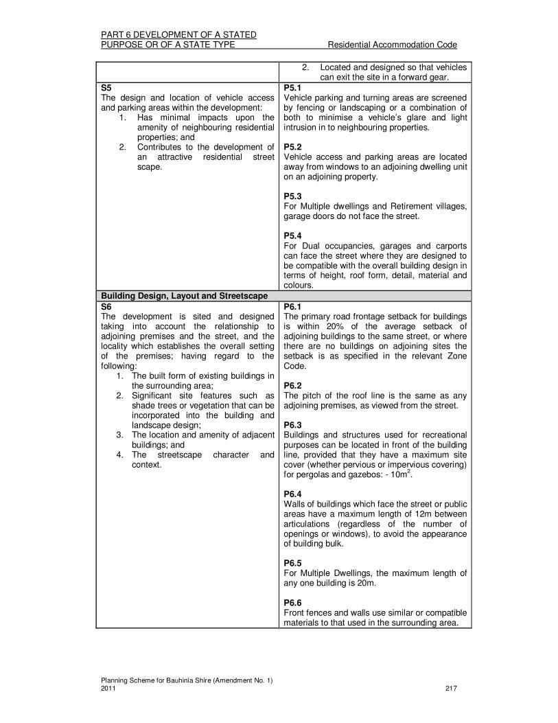
PART 6 DEVELOPMENT OF A STATED PURPOSE OR OF A STATE TYPE Residential Accommodation Code
Planning Scheme for Bauhinia Shire (Amendment No. 1) 2011 217
2. Located and designed so that vehicles can exit the site in a forward gear.
S5 The design and location of vehicle access and parking areas within the development:
1. Has minimal impacts upon the amenity of neighbouring residential properties; and
2. Contributes to the development of an attractive residential street scape.
P5.1 Vehicle parking and turning areas are screened by fencing or landscaping or a combination of both to minimise a vehicle’s glare and light intrusion in to neighbouring properties. P5.2 Vehicle access and parking areas are located away from windows to an adjoining dwelling unit on an adjoining property. P5.3 For Multiple dwellings and Retirement villages, garage doors do not face the street. P5.4 For Dual occupancies, garages and carports can face the street where they are designed to be compatible with the overall building design in terms of height, roof form, detail, material and colours.
Building Design, Layout and Streetscape
S6 The development is sited and designed taking into account the relationship to adjoining premises and the street, and the locality which establishes the overall setting of the premises; having regard to the following:
1. The built form of existing buildings in the surrounding area;
2. Significant site features such as shade trees or vegetation that can be incorporated into the building and landscape design;
3. The location and amenity of adjacent buildings; and
4. The streetscape character and context.
P6.1 The primary road frontage setback for buildings is within 20% of the average setback of adjoining buildings to the same street, or where there are no buildings on adjoining sites the setback is as specified in the relevant Zone Code. P6.2 The pitch of the roof line is the same as any adjoining premises, as viewed from the street. P6.3 Buildings and structures used for recreational purposes can be located in front of the building line, provided that they have a maximum site cover (whether pervious or impervious covering) for pergolas and gazebos: - 10m
2.
P6.4 Walls of buildings which face the street or public areas have a maximum length of 12m between articulations (regardless of the number of openings or windows), to avoid the appearance of building bulk. P6.5 For Multiple Dwellings, the maximum length of any one building is 20m. P6.6 Front fences and walls use similar or compatible materials to that used in the surrounding area.

PART 6 DEVELOPMENT OF A STATED PURPOSE OR OF A STATE TYPE Residential Accommodation Code
Planning Scheme for Bauhinia Shire (Amendment No. 1) 2011 218
Site Facilities
S7 Dwelling units are provided with necessary facilities which are practical and visually attractive.
P7.1 Mail boxes and garbage bin enclosures are:
1. Located where they are easily accessible by all residents and service vehicles;
2. Designed for efficient and convenient use; and
3. Designed so as not be visually intrusive.
P7.2 Each dwelling unit is provided with a separate water meter, to that of meters for communal areas.
Privacy and Safety
S8 The development provides residents of the development and residents of adjacent residential properties with visual and acoustic privacy.
P8.1 Direct views between habitable rooms of adjacent dwellings and dwelling units, or between habitable rooms and the private open space of adjacent dwellings and dwelling units (whether part of the development or on land adjacent to the development) are obscured by:
1. Screening that is durable, permanently fixed and has a maximum of 25% openings; or
2. Existing dense vegetation or new planting that can achieve a 75% screening within 3 years of planting.
S9 The development is readily accessible and easily identifiable by emergency service vehicles.
P9.1 Development makes provision on all street frontages, at the site entries, for signage which indicates street and unit numbers. P9.2 Where not all units face a road frontage, the signage required by P9.1 is accompanied by additional signage which acts as a directory/map.
S10 Any front fences and walls provided for privacy or to define the property:
1. Allow for casual surveillance of the street; and
2. Are compatible with the building and streetscape.
P10.1 Where located in the Town Zone, fences and walls along the road frontage are a maximum of:
1. 1.2m high if solid; or 2. 1.5m high if the fence has openings
which make it at least 50% transparent.
P10.2 As an exception to P10.1 above, solid front fences and walls up to 1.8m high may be provided where:
1. The useable landscaped areas and private open space areas for Multiple dwellings and Retirement villages, is in front of buildings and the fence length is limited to 75% of the frontage; or
2. The fence or wall fronts a main road and

PART 6 DEVELOPMENT OF A STATED PURPOSE OR OF A STATE TYPE Residential Accommodation Code
Planning Scheme for Bauhinia Shire (Amendment No. 1) 2011 219
3. the length of the fence or wall does not exceed 15m in length without some articulation or detailing to provide visual interest.
Development on sites with frontage to a Main Road
S11 Development on sites with a frontage to a main road are designed such that the negative effects of traffic noise are minimised and resident privacy is protected, having regard to:
1. Building siting; 2. The use of front fences and walls; 3. Internal layout of buildings; 4. The location of communal and
private open space areas.
P11.1 Walls of buildings that face the road frontage have very few or no openings. P11.2 Mature landscaping is provided along walls referred to in P11.1 above, to avoid the appearance of blank walls from the road. P11.3 The room layout with in dwellings is arranged to reduce the impact of noise on the rooms which are most sensitive to noise. Eg locate bathrooms, hallways, stairways, storage rooms and garages closest to the road frontage. P11.4 Private open space areas are not located in the building setback to the road. P11.5 For Multiple dwellings and Retirement villages, usable landscaped areas and private open space areas are only located in the building setback to the road, where resident privacy can be maintained with the use of a solid fence or wall provided in accordance with P10.2 (1) above. P11.6 Any walls or fences along the road frontage highlight site entrances and ensure that they are easily identifiable.
.

PART 6 DEVELOPMENT OF A STATED PURPOSE OR OF A STATE TYPE Service Station Code
Planning Scheme for Bauhinia Shire (Amendment No. 1) 2011 220
Division 15—Service Station Code
About the Service Station Code � The Service Station Code regulates Service station uses, whether they are Code
assessable or Impact assessable. � The Code regulates the scale, siting, and design of development with regards to their
safety and potential impacts on the amenity of adjoining uses.
(1) Service Station Code
The provisions in this division comprise the Service Station Code. They are— 1. The Purpose of the Service Station Code – Section (2); and 2. The Specific Outcomes, Probable Solutions and Acceptable Solutions for
Service Station development – Table 6.15.1.
(2) The Purpose of the Service Station Code The purpose of the Service Station Code is to achieve the following overall outcomes: 1. Service Stations:
(a) Are located and designed to provide efficient, safe and attractive working environments;
(b) Are located such that the streetscape appearance and amenity of adjoining uses is not adversely affected; and
(c) Make adequate and safe provision for vehicular access and movement.
TABLE 6.15.1 SERVICE STATIONS
Column 1 Column 2
Specific outcomes (S) for Code and Impact assessable development
Probable Solutions (P) for Code and Impact assessable development;
and
Acceptable Solutions (A) for Self assessable development (where Self assessable development does not meet the Acceptable Solutions in the applicable codes, it requires Code assessment. Refer to Section 1.2.9)
All Service Stations
Layout and Amenity
S1 The site has sufficient area and dimensions to accommodate the required:
1. Buildings and structures; 2. Vehicle accesses; 3. Vehicle manoeuvring and
loading/unloading areas; and 4. Landscaping and buffers.
P1.1 The site has:
1. A minimum area of 2000m2; and
2. A frontage width of at least 38 m, or where the site is a corner site, a frontage of 30m on one frontage and 32m on the other.
S2 The development is located and designed so as to minimise the visual impact of buildings and structures, and to provide adequate buffers to any adjoining residence or residential area.
P2.1 The minimum setbacks to Service Station facilities are as follows:
1. Buildings: (a) 14m to the road frontage/s; (b) 6 m to land in the Town –
Residential Precinct; and (c) 2m to other boundaries.
2. Fuel pumps:

PART 6 DEVELOPMENT OF A STATED PURPOSE OR OF A STATE TYPE Service Station Code
Planning Scheme for Bauhinia Shire (Amendment No. 1) 2011 221
(a) 8m to the road frontage/s; and (b) 10m to other boundaries.
3. Car washes (a) 15m to the road frontage; (b) 6m to land in the Town –
Residential Precinct; and (c) 2m to other boundaries.
P2.2 Landscaped setbacks with a minimum width of 2m are provided along all boundaries of the site. P2.3 A minimum 1.8 m high solid fence is provided along any side and rear boundaries of the site which adjoin uses in the Residential Use Class or other noise sensitive uses.
S3 The development operates without causing adverse impacts on surrounding uses due to the effects of noise.
P3.1 Car wash facilities are enclosed where in or adjoining the Town – Residential Precinct. P3.2 All plant, machinery and workshops are located, enclosed and otherwise attenuated to achieve the noise generation levels set out in the Environmental Protection (Noise) Policy 1997.
Safety
S4 The development achieves acceptable levels of risk and implements effective emergency measures.
P4.1 The design and layout of the Service Station complies with Australian Standard AS 1940 – 1993 – Storage and Handling of Flammable and Combustible Liquids. P4.2 The design and layout of the Service Station complies with Australian Standard AS 1596 – 1997 – Storage and Handling of LP Gas.
Access Servicing and Car parking
S5 Vehicular access to the premises:
1. Is adequate and safe for intended traffic;
2. Does not cause the intrusion of non-residential traffic onto local residential streets; and
3. Does not detrimentally impact upon the capacity or efficiency of the local road network.
P5.1 Driveway crossovers:
1. Have a maximum width of 9m; and 2. Are located more than 10m from a
road intersection or other crossover to the site.
P5.2 There are separate entrances to and exits from the site. P5.3 The storage tank inlets are positioned such that fuel tankers stand wholly within the site while discharging fuel. P5.4 On-site queuing space is provided for at least 3 vehicles to the first bowser in all bowser aisles, and to any car wash.

PART 6 DEVELOPMENT OF A STATED PURPOSE OR OF A STATE TYPE Service Station Code
Planning Scheme for Bauhinia Shire (Amendment No. 1) 2011 222
P5.5 Service stations are not located on corner lots if the intersection contains traffic islands or traffic signals. P5.6 As part of the development, a dedication of road free of cost to the Council is provided as follows:
1. For corner lots, a corner truncation being no more than that area of a right angled corner of 9m by 3 equal chords; and
2. a deceleration lane not more than 6m wide along the frontage of the site.
Service Station and Shop uses
S6 Service Stations accompanied by shop uses have no greater impacts upon the amenity of surrounding uses than a stand alone Service Station.
P6.1 Service Stations are accompanied by shop uses where such uses are ancillary to the Service Station use.

APPENDICES
Planning Scheme for Bauhinia Shire (Amendment No. 1) 2011
APPENDIX 1 Zoning Maps

Planning Scheme for Bauhinia Shire (Amendment No. 1) 2011
APPENDIX 2Overlay Maps

Planning Scheme for Bauhinia Shire (Amendment No. 1) 2011
APPENDIX 3Planning Scheme Maps