bayswater station redevelopment 2020
TRANSCRIPT
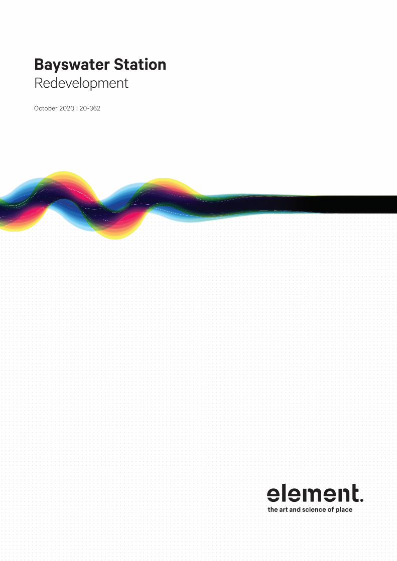
Bayswater StationRedevelopment
October 2020 | 20-362
Bayswater Station Redevelopment
ii
Document ID: /Volumes/Graphics/2020/20-362 Bayswater, FAL and MEL Stations DA/00 Draft Report/20-362 Bayswater FAL MEL Stations DA Folder/20-362 Bayswater FAL MEL Stations DA.indd
Issue Date Status Prepared by Approved by
1 07.10.20 Final Renee Young Murray Casselton
This report has been prepared for the exclusive use of the Client, in accordance with the agreement between the Client and Element Advisory Pty Ltd (element) (‘Agreement’).element accepts no liability or responsibility whatsoever in respect of any use of or reliance upon this report by any person who is not a party to the Agreement or an intended recipient.In particular, it should be noted that this report is a qualitative assessment only, based on the scope and timing of services defined by the Client and is based on information supplied by the Client and its agents.element cannot be held accountable for information supplied by others and relied upon by element. Copyright and any other Intellectual Property arising from the report and the provision of the services in accordance with the Agreement belongs exclusively to element unless otherwise agreed and may not be reproduced or disclosed to any person other than the Client without the express written authority of element.
We acknowledge the custodians of this land, the Whadjuk Noongar and their Elders past, present and emerging. We wish to acknowledge and respect their continuing culture and the contribution they make to the life of this city and this region.

iii
Contents
Executive Summary 1
1. Introduction 51.1 METRONET 5
1.2 Development Overview 5
1.3 Project Team 8
1.4 Relationship to Previous Approval 8
1.5 Project Delivery and Staging 9
1.6 Development Approval Requirements 14
1.7 Future Planning Framework 17
2. Stakeholder Engagement 192.1 Engagement Summary 19
2.2 Engagement with Local Businesses 19
2.3 Engagement with Community Groups 19
2.4 Engagement with the Community Advisory Group 20
2.5 Engagement with Cycling Groups 21
2.6 City of Bayswater 21
2.7 Engagement with the Metronet Noongar Reference Group 21
2.8 Engagement with the Access and Inclusion Reference Group 22
2.9 State Design Review Panel / Office of Government Architect 22
3.1 Other Authorities 27
4. Description of Development 294.1 Key Design Criteria /Principles 29
4.2 Station Design Response 31
4.3 Operation of Station 47
4.4 Place Making 57
5. Appendix A - Site Details 655.1 Site Location and Context 65
5.2 Property Description 65
5.3 Environmental Considerations 70
5.4 Heritage Considerations 70
6. Appendix B – Planning Framework and Assessment 71
6.1 Perth and Peel @ 3.5 million 71
6.2 Planning Control Area No. 135 71
6.3 Metropolitan Region Scheme 73
6.4 METRONET Act 75
6.5 Draft METRONET East Redevelopment Scheme 75
6.6 City of Bayswater Local Planning Framework 76
6.7 State Planning Policy 5.4 – Road and Rail Noise 76
6.8 State Planning Policy 7.0 – Design of the Built Environment 78
6.9 Development Control Policy 1.6 – Planning to Support Transit Use and Transit Oriented Development 81
6.10 Guidelines – Acid Sulfate Soils Planning Guidelines 81
6.11 Environmental Protection (Noise) Regulations 1997 82
7. Appendix C – Technical Considerations 83
7.1 Noise and Acoustic Attenuation 83
7.2 Vibration 84
7.3 Movement Network 84
7.4 Traffic Management 85
7.5 Services 87
7.6 Waste Management 87
7.7 Geotechnical Site Conditions 88
7.8 Drainage Management 88
7.9 Water Sensitive Urban Design 89
7.10 Construction Management 89
7.11 Construction Environmental Management 90
7.12 Property Condition Surveys 90
7.13 Demolition Management 92
7.14 Wind Amelioration 95

iv
Bayswater Station Redevelopment

1
Executive Summary
This report has been prepared by element, on behalf of Evolve Bayswater Alliance (Evolve Bayswater). The Evolve Bayswater team was selected to form an alliance with Public Transport Authority (PTA) to design and build METRONET’s new Bayswater Station project in May 2020.
METRONET is one of the largest ever single investments in public transport in Perth and Western Australia. The new Bayswater Station is part of METRONET Stage One. It is a key METRONET precinct and will incorporate the Perth-Midland Line, Forrestfield-Airport Link (FAL) and Morley-Ellenbrook Line (MEL) connections.
The Evolve Bayswater proposal for Bayswater builds on the development approval that was obtained by the PTA for the Bayswater Station works in 2019. It is an advancement of the design that was previously approved, responding to the matters raised in relation to the 2019 Development Approval and accommodating the additional scope of works that is required to accommodate the future MEL connection. The current proposal is considered to be a positive design evolution of the 2019 Development Approval and is the culmination of work by Hassell Architects accompanied by a team of specialist consultants including BG&E Civil Engineering, Jacobs, Lloyd George Acoustics Pty Ltd, JMG, Strada, WSP, Rail Services Australia (RSA), Golder Associates and element.
The Bayswater Station (the Station), is proposed to serve as a significant interchange station providing connections to the FAL and the MEL.
Western Australian Planning Commission (WAPC) approval is required for the works that are associated with the new station and associated car parks and bus interchange facilities and also for the associated means of pedestrian and vehicular access immediately surrounding these facilities. Approval is not required for all other railway related works that provide connections to the three urban rail lines that meet at the Bayswater Station. Accordingly, this application seeks development approval for:
• Two new station island platforms (150m long and 10m wide) to accommodate six (6) car train lengths.
• New rail bridges (Bridges 1 and 2) over King William Street, immediately south of the existing railway to support the new railway lines.
• New rail bridges (Bridges 3 and 4) over King William Street, located immediately north of the first new set of railway bridges to support expansion of the station to allow for the future MEL project.
• Western and eastern entry buildings complete with fare gates, passenger access to the platforms in the form of stairs, lifts and escalators, and retail tenancies.
• Relocation of the existing principal shared path on the southern side of the southern railway bridge (Bridge 1).
• Integrated pedestrian, cyclist, bus and vehicle access into the station.
• New bus bays and vehicle parking bays.
• Landscaping and urban design features within the station precinct.
• Modifications to the road network within the Planning Control Area (PCA) that has been placed over the Bayswater Town Centre.
• Noise mitigation measures incorporated into the bridge and track designs.
• Tenancy spaces in the eastern station entry building for a range of retail, commercial, culture and creative industry, community, dining and entertainment uses.

Bayswater Station Redevelopment
2
Planning approval is not required for rail related works each side of the new station infrastructure beyond the bridge abutments/platforms, which includes:
• Leake Street underpass reconstruction/widening.
• Turnback works (new turnback siding for the FAL project, shunters path and driver’s washroom) and an allowance for a future turnback for the MEL service.
• Railway infrastructure including signaling, overhead lines, communications and utility relocations.
• Railway tracks and associated infrastructure to the east and west of the eastern and western bridge abutments including retaining walls.
• Any noise mitigation works where these are associated with noise from the railway lines located east and west of the eastern and western bridge abutments.
The Station upgrade will play a key role in stimulating high quality residential, commercial and mixed-use development outcomes in and around the Bayswater Town Centre, increasing economic and social activity and providing for a range of new and enhanced living, recreational and employment options. The upgrades provide a fantastic opportunity to attract further broader investment and assist in delivering a vibrant precinct where people can choose to live, work and visit so as to continue to support the successful delivery of a Transit Oriented Development (TOD) precinct.
The following key public benefits will be delivered as part of the development:
• Replacement of the existing rail bridge with new rail bridges and elevated station platforms, achieving a minimum vertical clearance of at least 4.8 metres from the proposed finished road level of Coode Street/King William Street and to the extension of Beechboro Road South to the underside of the bridges;
• Provision of two station entrances to reduce the requirement for passengers to cross roads and to also allow for alternative emergency exit points;
• Creation of new bus interchange facilities (including a dedicated bus layover capacity and dedicated bus lanes) integrated with new bus stops that better connect bus services with the station to facilitate intermodal transfers and to foster improved public transport integration and patronage.
• A new 4.6 metre wide Principal Shared Path (PSP) located on Bridge 1 to the south of the new rail platform that ties into a realigned PSP.
• Dedicated and secure bicycle parking facilities within the new western station entry building as well as additional public (unsecured) bicycle parking facilities adjacent to the entries of the western and eastern entry station buildings being 5 No. U-Rail racks at each entry providing a total of 20 bicycle parking facilities.
• Designated pedestrian crossing locations within the surrounding road network to facilitate safe access to the new bus and train station facilities.
• Provision of new disabled parking facilities and an ambulance bay in close proximity to the western station entry building.
• New generous public plaza at ground level surrounding the eastern station entry building to facilitate access for large numbers of passengers into the station and to provide a flexible, open space that can cater for community events such as markets.
• New seating alcoves to create informal, publicly accessible gathering and meeting spaces.
• Opportunities for public art to assist in place making.
• Significant new tree planting and landscaping throughout the precinct to provide an enhanced green, lush and shaded environment.
• New accessible paths to provide access along Whatley Crescent between King William and Hamilton Streets.
• New retail opportunities within the eastern entry building to activate the station environment and surrounds.
• Staging of the works to allow the existing Perth-Midland line and Bayswater Station to remain operational during the construction process of Stage 1 until the first platform is operational and available to be used to accommodate associated rail services.

3
The development application is accompanied by a range of specialist information and technical reports including:
• Site Details prepared by element (Appendix A)
• Planning Framework and Assessment prepared by element (Appendix B)
• Summary of Technical Considerations prepared by element in conjunction with Evolve Bayswater (Appendix C)
• Architectural Plans and Design Report prepared by Hassell (Appendix D1)
• Landscape Concept Plans prepared by Hassell (Appendix D2)
• Drainage Plans prepared by Evolve Bayswater (Appendix D3)
• Lighting and Electrical Services Plans prepared by Evolve Bayswater (Appendix D4)
• Roadworks and Safety Barrier Plans prepared by Evolve Bayswater (Appendix D5)
• Sustainability Management Plan prepared by Evolve Bayswater (Appendix E)
• State Design Review Panel Reports (Appendix F)
• Certificates of Title (Appendix G)
• Urban Design and Landscape Concept Report prepared by Hassell (Appendix H1)
• Landscape Design Approach Report prepared by Evolve Bayswater in conjunction with Hassell (Appendix H2)
• Operational Noise Assessment prepared by Lloyd George Acoustics (Appendix I)
• Traffic and Transport Management Plan prepared by Evolve Bayswater (Appendix J)
• Movement Network Diagrams prepared by Hassell Architects (Appendix K)
• Geotechnical Factual Report prepared by Golder Associates (Appendix L)
• Construction Environmental Management Plan prepared by Evolve Bayswater (Appendix M)
• Green Star Rating Strategy prepared by Evolve Bayswater (Appendix N)
• Construction Plan prepared by Evolve Bayswater (Appendix O)
• Operational Waste Management Plan prepared by Evolve Bayswater (Appendix P)
• Tree Survey prepared by Paperbark Technologies (Appendix Q)
• Microsimulation Modelling (Transport Modelling) Report prepared by WSP (Appendix R)
• Water Management Plan prepared by Evolve Bayswater (Appendix S)
• Design Principles Plan prepared by element in conjunction with Hassell (Appendix T)

4
Bayswater Station Redevelopment

5
1. Introduction
1.1 METRONETMETRONET is one of the largest ever single investments in public transport in Perth and Western Australia. It will deliver approximately 72km of new passenger rail line and 18 new stations, and through this investment seeks to be a catalyst for the development of over 5,000ha of land around the new stations, delivering further investment, housing, jobs and services within Perth.
The new Bayswater Station is part of METRONET Stage One. It is a key METRONET precinct and will incorporate rail services associated with the Perth-Midland Line, FAL and MEL, giving people the option to travel to Perth Airport, the Swan Valley tourist region, the Perth CBD and beyond.
The METRONET vision for Bayswater is for a revitalised urban centre with the train station at its heart. Key project objectives include:
• Supporting economic growth in the area with better connected businesses and greater access to employment opportunities.
• Delivering infrastructure to the area that promotes easy and accessible travel and lifestyle options.
• Enhancing the sense of belonging in the local community, supporting Perth’s growth and prosperity.
While this complex project now marks the first part of the MEL, it also looks to balance priorities identified during stakeholder and community consultation (from March 2018), such as improving connections across the railway, allowing for increased bus services to the station, improving cycling and pedestrian movements and creating a rail bridge and station that fits within and complements the town centre.
After a robust procurement process the Evolve Bayswater team was selected to partner with the PTA to form the Evolve Bayswater Alliance (Evolve Bayswater). Evolve Bayswater is responsible for the design and construction of the new Bayswater Station. This development application is the culmination of the design work undertaken by Evolve Bayswater which, as set out in Section 1.3 below, is an evolution of the development that was subject to the 2019 development application prepared on behalf of the Public Transport Authority (PTA).
1.2 Development OverviewThe Bayswater Station upgrade was originally announced by the Western Australian Government in April 2018. The PTA subsequently worked collaboratively with the City of Bayswater (the City), community members and interested stakeholder groups on a design for Bayswater Station which was the subject of a development application lodged on 5 August 2019 and approved by the WAPC on 5 November 2019 (WAPC Reference: 14-50079-3) (referred to as the 2019 Approval).
The Evolve Bayswater team was subsequently selected to form an alliance with PTA to design and build METRONET’s new Bayswater Station project in May 2020. The PTA’s 2019 development approval has formed the basis of Evolve Bayswater’s further designs. The key elements of the proposed development requiring development approval include:
• Two new station island platforms (150m long and 10m wide) to accommodate six (6) car train lengths.
• New rail bridges (Bridges 1 and 2) over King William Street, immediately south of the existing railway to support the new railway lines.
• New rail bridges (Bridges 3 and 4) over King William Street, located immediately north of the first new set of railway bridges to support expansion of the station to allow for the future MEL project.
• Western and eastern entry buildings complete with fare gates, passenger access from ground level to the station platforms in the form of stairs, lifts and escalators and station services and facilities (including bicycle parking, public toilets and PTA facilities for staff). The eastern entry building also includes ground

Bayswater Station Redevelopment
6
level retail tenancies.
• The existing principal shared path (PSP) is realigned and supported across the station precinct on the southern side of the southern railway bridge (Bridge 1).
• Integrated pedestrian, cyclist, bus and vehicle access into the station.
• New bus bays and vehicle parking bays.
• Landscaping and urban design features within the station precinct.
• Modifications to the road network within the Planning Control Area (PCA) that has been placed over the Bayswater Town Centre.
• Noise mitigation measures incorporated into the bridge and track designs.
• The incorporation of proposed retail/commercial tenancies within the eastern entry building.
The above works are to be staged in a coordinated manner with the railway and associated infrastructure works, which as operational railway and infrastructure (public works) within a rail or road reserve are exempt from the requirement for development approval. The exemption from development approval applies to railway and infrastructure to the east and west of the eastern and western bridge abutments, proposed acoustic walls (associated with rail noise) to the east and west of the eastern and western bridge abutments, the train turnback facilities/siding, tracks, road and PSP works, retaining walls, signaling facilities, equipment rooms and overhead line works.
The objectives of the development are to:
• Allow for significantly increased train services and train patronage to the station.
• Provide a station that facilitates integration of the Perth-Midland, FAL and MEL urban rail services giving passengers opportunity to reach a wide range of destinations.
• Allow for increased and integrated bus services to the station and facilitate improved connectivity between rail and bus services.
• Provide for improvements to the existing cycling and pedestrian network to and through the Bayswater Town Centre area.
• Improve existing vehicle access through the site via realignments of Whatley Crescent/Beechboro Road South and Railway Parade.
• Provide for the reconfiguration of the Coode Street and Railway Parade signalized intersection to a left in only movement for public access and a left out only movement for buses.
• Provide new opportunities to activate the train station precinct through public art, urban design, landscaping and retail place making strategies.
The broad staging of the development requiring approval is as follows:
• Stage One – Construction of the new southern rail bridges (Bridges 1 and 2) between the eastern and western abutments, construction of the new southern station island platform, the new PSP on the southern side of the railway bridge, the first stage of the western and eastern entry buildings, and establishment of the southern portion of the public realm areas adjacent to the western and eastern entry buildings. The new station will become operational before any of the existing railway and Bayswater Station are disrupted to provide continuity of rail services as far as possible. This stage involves the closure of Whatley Crescent between King William Street and Hamilton Street to traffic, the construction of the new Whatley Crescent and Hamilton Street intersection and the provision of a temporary PSP on the southern side of Whatley Crescent. Whatley Crescent will be reconstructed as part of this stage but will not open to traffic until during Stage Two.
• Stage Two - Demolition of the existing Bayswater Station and associated rail infrastructure including the existing bridge over King William Street, construction of the new northern rail bridges (Bridges 3 and 4), construction of the northern station island platform, the second stage of the western and eastern entry buildings, the bus layover bays and bus stands on the eastern and northern sides of the station precinct and full completion of the station precinct including all landscape and public realm works. Stage 2 works also involve the car park upgrade works to the northern car park on Railway Parade and the opening of the Beechboro Road south extension to Whatley Crescent.
Early works for which development approval is not required have already begun on the project, including the relocation of Bayswater’s iconic Kurrajong tree to Bert Wright Park in January 2020.
Work has been completed to increase parking at Ashfield and Meltham Train Stations, ahead of the
7
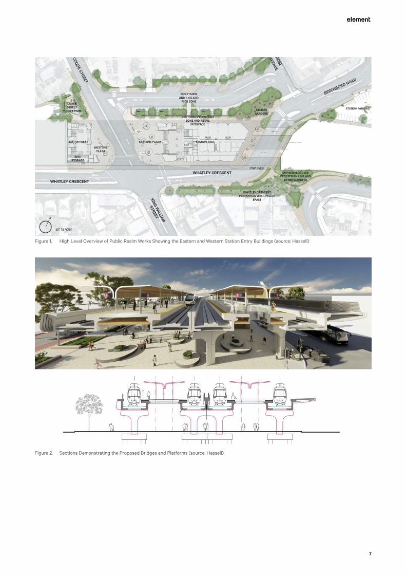
Figure 1. High Level Overview of Public Realm Works Showing the Eastern and Western Station Entry Buildings (source: Hassell)
Figure 2. Sections Demonstrating the Proposed Bridges and Platforms (source: Hassell)

Bayswater Station Redevelopment
8
Figure 3. High Level Overview of Staged Works (source: Evolve Bayswater)
Bayswater Station parking at Whatley Crescent closing later in 2020.
1.3 Project TeamEvolve Bayswater has engaged a team of specialist consultants to prepare the material to support this development application including:
• Hassell
• Jacobs in joint venture with BG&E Engineering
• RSA
• Golder Associates
• Lloyd George Acoustics Pty Ltd
• JMG
• Strada
• WSP
• Paperback Technologies
• element planning
1.4 Relationship to Previous ApprovalThis is the second development application that has been lodged to seek the necessary planning approvals for the Bayswater Station redevelopment. A development application for the development was originally lodged on behalf of the PTA on 5 August 2019. The application was subsequently approved by the Western Australian Planning Commission (‘WAPC’) on 5 November 2019 (WAPC Reference: 14-50079-3) (referred to as the ‘2019 Approval’).
The 2019 Approval provided for, in summary, two new rail bridges over King William Street to accommodate connection to the urban rail network of the FAL. At this stage the development consisted of:
• a new elevated station island platform located between the new rail bridges;
• a principal shared path on the southern side of the railway bridge;
• new track and station infrastructure;
• new bus stops and layover bays as well as a dedicated bus lane;
• reconfigured roads and intersections in the precinct;

9
• new car parking spaces and drop off bays; and
• new landscaping and urban design features.
Since the 2019 Approval was granted there have been a number of changes to the scope and design of the proposed development that have necessitated the lodgement of this new development application for approval. In summary these include:
• A second set of two additional rail bridges over King William Street, located to the immediate north of the first set of railway bridges to accommodate the future MEL connection.
• A second island platform complete with station infrastructure supported by the northern pair of railway bridges.
• Additional station infrastructure including commercial tenancies within the eastern station entry building.
Staging of the landscaping, urban design features and road works to suit the staged construction of the four rail bridges and two station platforms.
In addition, since the 2019 Approval, more detailed engineering, architectural and landscape concepts have been developed for the previously approved development. This additional work responds to detailed design requirements of the PTA and other matters raised in response to the 2019 Approval and encapsulate the positive design evolution of the proposed development.
Additional specialist review and assessment has also been carried out on these evolved designs which will enable the removal or amendment of a number of the conditions of approval previously imposed upon the 2019 Approval. This will ensure that the construction of the project can proceed in a staged manner in line with agreed project delivery timeframes to meet the wider METRONET project delivery dates.
1.5 Project Delivery and Staging
1.5.1 Overall Project ScopeEvolve Bayswater is required to deliver an integrated railway and station project consisting of three main components these being:
• Component 1 – Exempt Works This consists of railway works to the west of the station within the existing railway reserve together with associated infrastructure works required to accommodate the railway layout. Also exempt are railway works to the east of the station required to connect the Midland and FAL lines to the new station. All these works are exempt works under the METRONET Act.
• Component 2 – Stage 1 Works This consists of the southern station bridges and island platform as well as the southern half of the western and eastern entry buildings and the southern parts of the station precinct. The work will also include construction of railway tracks connecting the Midland and FAL lines to the new island platform. These works were all addressed in the 2019 Approval. The works beyond the bridge abutments are exempt works within the railway reserve (refer to Section 2.6).
• Component 3 – Stage 2 Works This consists of the northern station bridges and island platform as well as the northern half of the western and eastern entry buildings and full completion of the station precinct. Railway tracks for this platform will be installed as part of the MEL delivery project and these works will need to be completed before the northern part of the station becomes operational.
1.5.2 Station Project Works As described in Section 2.2 above, the parts of the overall project that are the subject of this development application are confined to the station facilities and the immediately surrounding station precinct.
The works that are the subject of this development application will be completed in two main stages, construction of the new southern rail bridges and station platform, including the precinct works on the southern side of the rail line, with the northern works to follow as a second stage.
Site works will be established in substages as works progress. Both temporary traffic management controls and perimeter fencing will be used as necessary to carry out construction works to the various parts of the development in the least disruptive manner possible.

Bayswater Station Redevelopment
10
The general order of development is proposed to be as follows:
Stage 11. In this stage, all work will be carried out to the south of the existing railway and station as these existing
assets will remain in service to maintain the Perth to Midland urban rail services.
2. Whatley Crescent reconfiguration works to divert the existing PSP to on-road lanes.
3. Services relocation and site preparation on Whatley Crescent leaving space initially for the PSP lanes on the northern side of the reduced road width and a single westbound lane on the southern side of the current road.
4. Southern bridges substructure construction.
5. Hamilton Street and Whatley Crescent intersection reconfiguration.
6. Southern bridges superstructure construction.
7. Station buildings, vertical transport and southern parts of the public realm construction and commissioning with rail access to allow opening of the new southern station facilities.
Whatley Crescent partial construction as far as is possible before the existing railway and station are closed.
Stage 2In this stage, all work will be carried out to the north of the new southern railway and station facilities and consist broadly of the following activities.
1. Demolition of existing station and railway along with site preparations.
2. Northern bridges substructure construction and deck construction at eastern end.
3. Final section of new Whatley Crescent alignment to be constructed to allow the opening of the new Link Road as well as the subsequent closure of Railway Parade from Beechboro Road South to Coode Street
4. Demolition of existing railway bridge over King William Street.
5. Balance of northern bridges superstructure construction.
6. Northern station buildings, vertical transport and associated station infrastructure construction.
7. Completion of station precinct and final landscaping.
Figure 4. High Level Overview of Staged Works (NB: the Turnback Works are Exempt Works) (source: Evolve Bayswater)

11
Figure 5. High Level Overview of Staged Works (NB: the Turnback Works are Exempt Works) (source: Evolve Bayswater)
Figure 6. High Level Overview of Staged Works (NB: the Turnback Works are Exempt Works) (source: Evolve Bayswater)

Bayswater Station Redevelopment
12
Figure 7. Stage 1.3 to January 2022 (estimated date) (source: Evolve Bayswater)
Figure 8. Stage 2.1 to March 2022 (estimated date) (source: Evolve Bayswater)
13
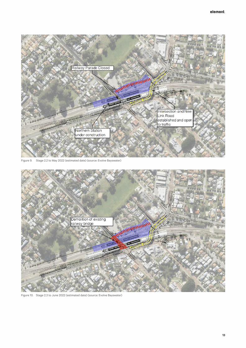
Figure 9. Stage 2.2 to May 2022 (estimated date) (source: Evolve Bayswater)
Figure 10. Stage 2.3 to June 2022 (estimated date) (source: Evolve Bayswater)
Bayswater Station Redevelopment
14
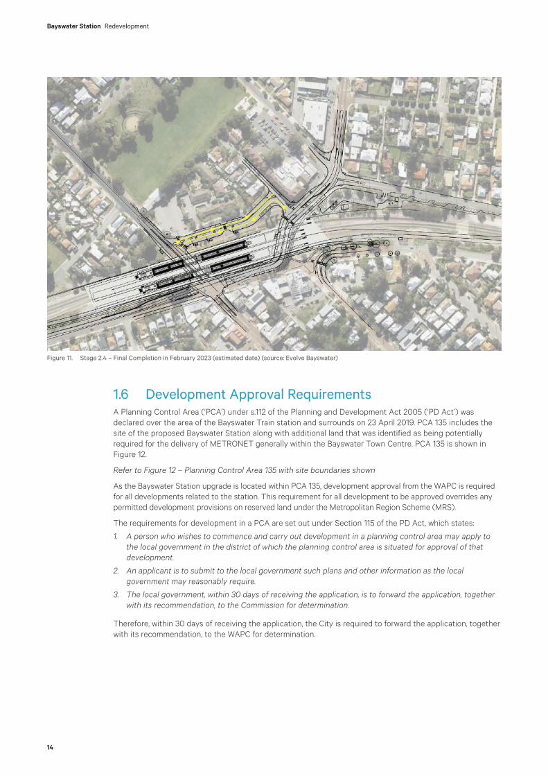
Figure 11. Stage 2.4 – Final Completion in February 2023 (estimated date) (source: Evolve Bayswater)
1.6 Development Approval RequirementsA Planning Control Area (‘PCA’) under s.112 of the Planning and Development Act 2005 (‘PD Act’) was declared over the area of the Bayswater Train station and surrounds on 23 April 2019. PCA 135 includes the site of the proposed Bayswater Station along with additional land that was identified as being potentially required for the delivery of METRONET generally within the Bayswater Town Centre. PCA 135 is shown in Figure 12.
Refer to Figure 12 – Planning Control Area 135 with site boundaries shown
As the Bayswater Station upgrade is located within PCA 135, development approval from the WAPC is required for all developments related to the station. This requirement for all development to be approved overrides any permitted development provisions on reserved land under the Metropolitan Region Scheme (MRS).
The requirements for development in a PCA are set out under Section 115 of the PD Act, which states:
1. A person who wishes to commence and carry out development in a planning control area may apply to the local government in the district of which the planning control area is situated for approval of that development.
2. An applicant is to submit to the local government such plans and other information as the local government may reasonably require.
3. The local government, within 30 days of receiving the application, is to forward the application, together with its recommendation, to the Commission for determination.
Therefore, within 30 days of receiving the application, the City is required to forward the application, together with its recommendation, to the WAPC for determination.

15
Figure 12. Planning Control Area 135 with site boundaries shown. (element, 2020).
Bayswater Station Redevelopment
16
Whilst development approval is typically required for all development from the WAPC for land within PCA 135, not all works require development approval as some work is still exempt under the Railway (METRONET) Act 2018 (‘METRONET Act’). The METRONET Act provides that “METRONET works” can be carried out within the PCA without the approval of the WAPC. METRONET works are defined as:
works for the purpose of, or in connection with, a METRONET railway but does not include the construction or alteration of a railway station, or any related car parks, public transport interchange facilities or associated means of pedestrian or vehicular access. (our emphasis added)
On this basis development approval is required for all works associated with:
• The proposed new stations/platforms.
• The bus interchange facilities.
• Car parking.
• Road realignments associated with the station development within the PCA.
• Pedestrian and vehicular access and paths associated with the above.
Development approval is not required for other railway infrastructure in either the existing railway reserve or on non-railway land that is outside of PCA 135 and which is still subject to the requirements of the MRS. This is because the METRONET Act also exempts these works from requiring development approval under the MRS. As such any railway works either side of the new station works beyond the bridge abutments/platforms are all works that are exempt from the requirement for development approval.
On this basis, Evolve Bayswater is seeking development approval from the WAPC under PCA 135 for all non-exempt development proposed as part of the Bayswater Station development. Whilst some works are exempt from the requirement for development approval, the plans and specialist material provided at Appendix D may illustrate and/or include detail of the exempt works as well as the works requiring WAPC approval. This is because this material has been prepared to inform and guide the project holistically given that the construction of exempt and non-exempt works are intrinsically interconnected as part of the delivery and ultimate operation of the rail infrastructure.
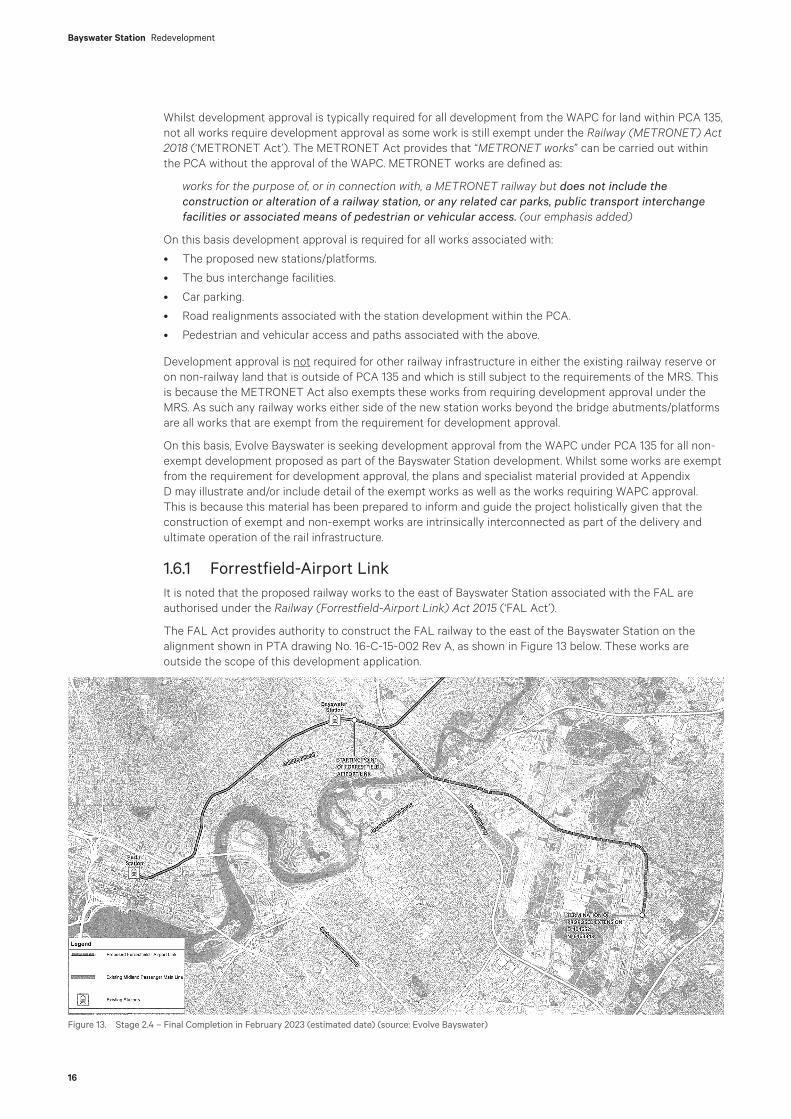
1.6.1 Forrestfield-Airport LinkIt is noted that the proposed railway works to the east of Bayswater Station associated with the FAL are authorised under the Railway (Forrestfield-Airport Link) Act 2015 (‘FAL Act’).
The FAL Act provides authority to construct the FAL railway to the east of the Bayswater Station on the alignment shown in PTA drawing No. 16-C-15-002 Rev A, as shown in Figure 13 below. These works are outside the scope of this development application.
Figure 13. Stage 2.4 – Final Completion in February 2023 (estimated date) (source: Evolve Bayswater)
17
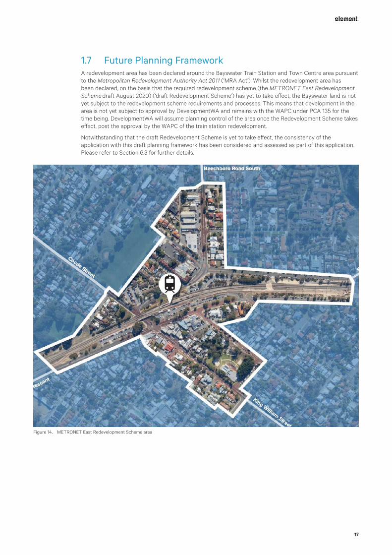
1.7 Future Planning FrameworkA redevelopment area has been declared around the Bayswater Train Station and Town Centre area pursuant to the Metropolitan Redevelopment Authority Act 2011 (‘MRA Act’). Whilst the redevelopment area has been declared, on the basis that the required redevelopment scheme (the METRONET East Redevelopment Scheme draft August 2020) (‘draft Redevelopment Scheme’) has yet to take effect, the Bayswater land is not yet subject to the redevelopment scheme requirements and processes. This means that development in the area is not yet subject to approval by DevelopmentWA and remains with the WAPC under PCA 135 for the time being. DevelopmentWA will assume planning control of the area once the Redevelopment Scheme takes effect, post the approval by the WAPC of the train station redevelopment.
Notwithstanding that the draft Redevelopment Scheme is yet to take effect, the consistency of the application with this draft planning framework has been considered and assessed as part of this application. Please refer to Section 6.3 for further details.
Figure 14. METRONET East Redevelopment Scheme area

18
Bayswater Station Redevelopment
19
2. Stakeholder Engagement
Throughout the development of the proposed concept design for the 2019 Approval, the PTA and the technical project team have liaised with the City on the proposed station upgrades as well as the State Design Review Panel (‘SDRP’).
Since this time and following the appointment of Evolve Bayswater to design and build METRONET’s new Bayswater Station project, the Evolve Bayswater team has continued to work closely with the City, the SDRP, the community and a range of other stakeholders as part of the detailed design process.
2.1 Engagement SummaryEvolve Bayswater adopted a Community-in-Design process, which is particularly useful in environments where there is a high level of stakeholder interest in design elements and management of construction impacts. Reflecting the incremental and organic nature of the engineering design process, the Community-in-Design process empowers all disciplines within Evolve Bayswater. The key characteristic of the Community-in-Design process is that all disciplines proactively identify, design and engineer solutions that avoid or minimise potential negative impacts (‘engineer out’) or support the realisation of opportunities (‘engineer in’).
In May 2020, the next evolution in the concept design was released to the community in the form of still images and a 1.50 minute animation video showing the road layout and engineering structures. The images generated extensive discussion and debate in the local community, with social media posts (relating to design) regularly generating over 50 community comments.
Between May and September 2020, Evolve Bayswater’s engagement with stakeholders has been driven by the detailed design schedule. Evolve Bayswater has carefully scheduled engagements to maximise the influence of external stakeholders in the decision-making process. Evolve Bayswater has also continued to engage with the community, with regular social media posts providing information on the progress of the design, an online townhall meeting attended by 80 participants and a newsletter distributed to the entire Bayswater suburb.
2.2 Engagement with Local BusinessesIn parallel with the engagement around design, Evolve Bayswater has engaged with local businesses in the Bayswater Town Centre to better understand how construction impacts can be mitigated. This engagement included several meetings with the Bayswater Retail Traders Association.
Local businesses have actively engaged in conversations around mitigations and assisted Evolve Bayswater to define the business engagement evaluation measures. Evolve Bayswater has engaged (through individual meetings) with 79% of local businesses. The key design issue for local businesses is the retention of car parking to support the continued operation of the town centre.
2.3 Engagement with Community GroupsIn June 2020 the Alliance met with the first of several active community groups to introduce Evolve Bayswater and discuss the design. Evolve Bayswater’s engagements have included Future Bayswater (June 2020) Bayswater Historical Society (June 2020), Baysie Rollers (July 2020) and Protect Bayswater’s Heritage Heart (August 2020). These meetings have been informal question and answer sessions, providing community groups with an opportunity to express their ideas and concerns relating to the station design. Feedback from the community groups has focused on the appearance of the bridge structures and how the new station integrates with the surrounding townsite.

Bayswater Station Redevelopment
20
2.4 Engagement with the Community Advisory GroupA Community Advisory Group (CAG) was established in 2019 to guide the ongoing development of the station. The CAG is made up of a number of local community representatives that act as a sounding board for the look and feel of the new station, public spaces, and impacts during construction. It has a total of 14 members, including one representative from each of the active community groups. The City also participates in the CAG.
Evolve Bayswater has met with the CAG on three separate occasions to discuss the project’s design elements. During these meetings the project’s Principal Architect, Design Integration Manager and Communications and Engagement Manager have all presented and explained the technical aspects of the design and engagement process to the CAG.
The CAG has specifically been asked to provide feedback on approaches to architectural treatments, the place activation zones and landscaping. The process has included the provision of information to the CAG members and the opportunity to answer their questions after which the CAG members have had the opportunity of engaging with neighbours and/or their local groups and to respond back to Evolve Bayswater via a web-based survey. To ensure transparency in the engagement process, summaries from this feedback have been shared with the CAG and the community. The feedback includes:
Architectural treatments • Looking for elegance in design.
• Opportunities to soften the bridge piers’ appearance and reduce the visual join between the piers and headstock.
• Use cladding to create an aesthetically pleasing skin or layer on the bridge structure.
• A preference for curved edges.
• A lighter coloured concrete (cream) to create more interest.
• Ease of maintenance should be considered in selecting materials and design to ensure the structure ages well.
• The platform shelters should be inspiring and functional.
Space activation • Requests for larger trees to enhance the shade canopy and provide visual relief from the concrete
structures.
• Consideration for the needs of local fauna and flora in design.
• Don’t duplicate existing spaces (e.g. playgrounds).
• Consider recreational activities for demographics that are not currently well serviced.
• Avoid large vertical faces to retaining structures and creating dead zones on the lowered Whatley Crescent.
• Consider alfresco opportunities for retail tenancies on the new terrace area where Whatley Crescent and Hamilton Street meet.
• Create easy pedestrian connections and prioritise foot traffic past existing shop fronts.
• Create functional spaces that attract people to the town centre.
Public spaces • Good mix of informal and flexible meeting spaces to support multiple activation options, including future
options for food vendors and markets.
• It is important to consider the interaction between pedestrians, future markets, cars and buses.
• Garden beds create a pleasant visual barrier between the pedestrian areas and buses, but they may also restrict future activation options.
• The design is safer and more accessible than the current station.
• Consider additional trees, less pavement, bike parking, enhanced opportunities for security and passive surveillance, interpretive art reflecting heritage and people, water features, urban orchard, larger alfresco areas for dining, more lighting, power and water amenities.
• Concerns about long term management of public spaces and how they may be affected by train noise.

21
Landscaping • Spaces that create a great place to sit and relax under the shade of trees.
• Good use of native, waterwise plants, trees and raised planters with bench seating using local materials.
• Consider using species that flower all year and shade tolerant plants under the bridges.
• Consider more greenery (particularly on the Whatley Crescent side of the station), larger species and interpretative gardens linked to story-telling and public art.
In addition to this feedback, several CAG members expressed a desire for an escalator to service each platform. The management of traffic, particularly with the closure of Whatley Crescent has also been discussed at length, with concerns that access to the surrounding road network will be limited for the pocket of residents north of Hamilton Street.
Records of the CAG meetings are available on the PTA website at the following link: https://www.metronet.wa.gov.au/projects/bayswater-station-upgrade#project-documents.
2.5 Engagement with Cycling GroupsThe project has met with Westcycle and the cycling branch in the Department of Transport to discuss the PSP design and planned detours. No objections were raised to the proposed design. Evolve Bayswater is currently working through the feedback to finalise the PSP detour arrangements, prior to seeking relevant approvals from the City.
2.6 City of BayswaterEvolve Bayswater has met on three occasions with the City’s elected members to provide project briefings and updates. Evolve Bayswater has also met with the City’s technical staff on a number of occasions. Evolve Bayswater continues to liaise with the City’s technical staff on a regular basis. Discussions have focused on topics including:
• Land management arrangements
• Street lighting
• Road layouts
• Traffic modelling
• Tree management and tree replacement
• Pedestrian access
• Car parking
The City will be a key participant in the redevelopment of Bayswater Station and hence Evolve Bayswater is focused on maintaining regular and effective consultation with the City at all levels to ensure alignment of expectations with outcomes.
2.7 Engagement with the Metronet Noongar Reference GroupThe Evolve Bayswater Aboriginal Engagement Team have attended two meetings with the MNRG.
The first meeting discussed the proposed Cultural Interpretation into Design. At this meeting the Aboriginal Engagement Manager and a member of the architectural design team presented proposed themes at first draft. Feedback received was very positive. Further meetings will be held once the final design concepts have been finalised for presentation to the MNRG.
The Aboriginal Engagement Lead and People & Culture Manager attended the second meeting, which was to present an overview of the Alliance – Cultural Awareness Training program outlines and content for both the Generic (bulk workforce) program and the program developed for the Alliance Management Team and the Alliance Leadership Team. Overall the MNRG were happy with the content and a couple of suggestions were made, which were taken on board and as a result some minor changes to the content have been made.
To date two Cultural Awareness workshops have been held with approximately 20 attendees from the overall Alliance team in attendance.
Bayswater Station Redevelopment
22
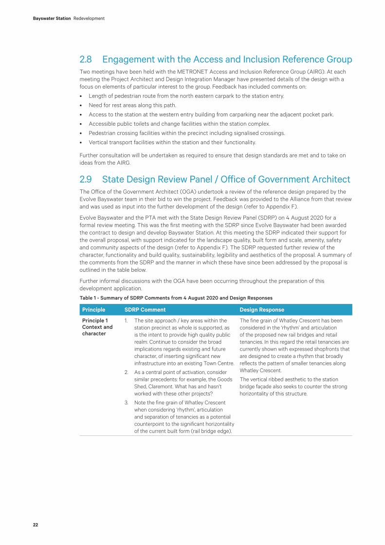
2.8 Engagement with the Access and Inclusion Reference GroupTwo meetings have been held with the METRONET Access and Inclusion Reference Group (AIRG). At each meeting the Project Architect and Design Integration Manager have presented details of the design with a focus on elements of particular interest to the group. Feedback has included comments on:
• Length of pedestrian route from the north eastern carpark to the station entry.
• Need for rest areas along this path.
• Access to the station at the western entry building from carparking near the adjacent pocket park.
• Accessible public toilets and change facilities within the station complex.
• Pedestrian crossing facilities within the precinct including signalised crossings.
• Vertical transport facilities within the station and their functionality.
Further consultation will be undertaken as required to ensure that design standards are met and to take on ideas from the AIRG.
2.9 State Design Review Panel / Office of Government ArchitectThe Office of the Government Architect (OGA) undertook a review of the reference design prepared by the Evolve Bayswater team in their bid to win the project. Feedback was provided to the Alliance from that review and was used as input into the further development of the design (refer to Appendix F).
Evolve Bayswater and the PTA met with the State Design Review Panel (SDRP) on 4 August 2020 for a formal review meeting. This was the first meeting with the SDRP since Evolve Bayswater had been awarded the contract to design and develop Bayswater Station. At this meeting the SDRP indicated their support for the overall proposal, with support indicated for the landscape quality, built form and scale, amenity, safety and community aspects of the design (refer to Appendix F). The SDRP requested further review of the character, functionality and build quality, sustainability, legibility and aesthetics of the proposal. A summary of the comments from the SDRP and the manner in which these have since been addressed by the proposal is outlined in the table below.
Further informal discussions with the OGA have been occurring throughout the preparation of this development application.
Table 1 - Summary of SDRP Comments from 4 August 2020 and Design Responses
Principle SDRP Comment Design Response
Principle 1 Context and character
1. The site approach / key areas within the station precinct as whole is supported, as is the intent to provide high quality public realm. Continue to consider the broad implications regards existing and future character, of inserting significant new infrastructure into an existing Town Centre.
2. As a central point of activation, consider similar precedents: for example, the Goods Shed, Claremont. What has and hasn’t worked with these other projects?
3. Note the fine grain of Whatley Crescent when considering ‘rhythm’, articulation and separation of tenancies as a potential counterpoint to the significant horizontality of the current built form (rail bridge edge).
The fine grain of Whatley Crescent has been considered in the ‘rhythm’ and articulation of the proposed new rail bridges and retail tenancies. In this regard the retail tenancies are currently shown with expressed shopfronts that are designed to create a rhythm that broadly reflects the pattern of smaller tenancies along Whatley Crescent.
The vertical ribbed aesthetic to the station bridge façade also seeks to counter the strong horizontality of this structure.
23
Principle SDRP Comment Design Response
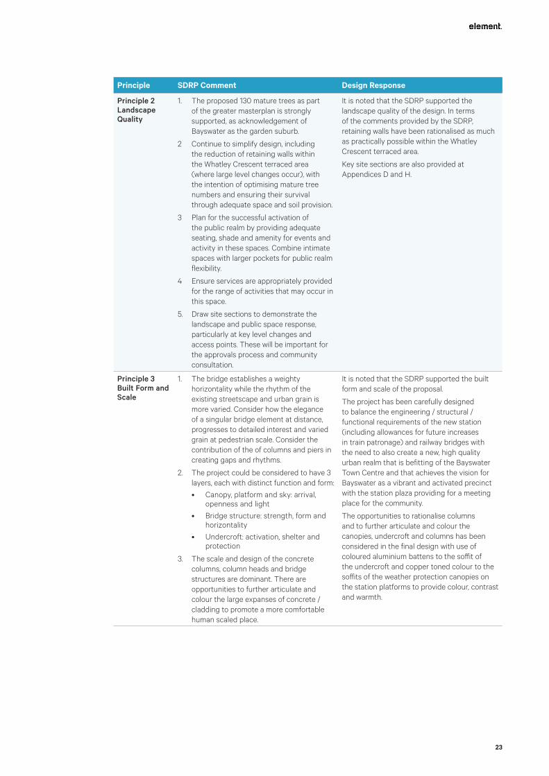
Principle 2 Landscape Quality
1. The proposed 130 mature trees as part of the greater masterplan is strongly supported, as acknowledgement of Bayswater as the garden suburb.
2 Continue to simplify design, including the reduction of retaining walls within the Whatley Crescent terraced area (where large level changes occur), with the intention of optimising mature tree numbers and ensuring their survival through adequate space and soil provision.
3 Plan for the successful activation of the public realm by providing adequate seating, shade and amenity for events and activity in these spaces. Combine intimate spaces with larger pockets for public realm flexibility.
4 Ensure services are appropriately provided for the range of activities that may occur in this space.
5. Draw site sections to demonstrate the landscape and public space response, particularly at key level changes and access points. These will be important for the approvals process and community consultation.
It is noted that the SDRP supported the landscape quality of the design. In terms of the comments provided by the SDRP, retaining walls have been rationalised as much as practically possible within the Whatley Crescent terraced area.
Key site sections are also provided at Appendices D and H.
Principle 3 Built Form and Scale
1. The bridge establishes a weighty horizontality while the rhythm of the existing streetscape and urban grain is more varied. Consider how the elegance of a singular bridge element at distance, progresses to detailed interest and varied grain at pedestrian scale. Consider the contribution of the of columns and piers in creating gaps and rhythms.
2. The project could be considered to have 3 layers, each with distinct function and form:
• Canopy, platform and sky: arrival, openness and light
• Bridge structure: strength, form and horizontality
• Undercroft: activation, shelter and protection
3. The scale and design of the concrete columns, column heads and bridge structures are dominant. There are opportunities to further articulate and colour the large expanses of concrete / cladding to promote a more comfortable human scaled place.
It is noted that the SDRP supported the built form and scale of the proposal.
The project has been carefully designed to balance the engineering / structural / functional requirements of the new station (including allowances for future increases in train patronage) and railway bridges with the need to also create a new, high quality urban realm that is befitting of the Bayswater Town Centre and that achieves the vision for Bayswater as a vibrant and activated precinct with the station plaza providing for a meeting place for the community.
The opportunities to rationalise columns and to further articulate and colour the canopies, undercroft and columns has been considered in the final design with use of coloured aluminium battens to the soffit of the undercroft and copper toned colour to the soffits of the weather protection canopies on the station platforms to provide colour, contrast and warmth.
Bayswater Station Redevelopment
24
Principle SDRP Comment Design Response
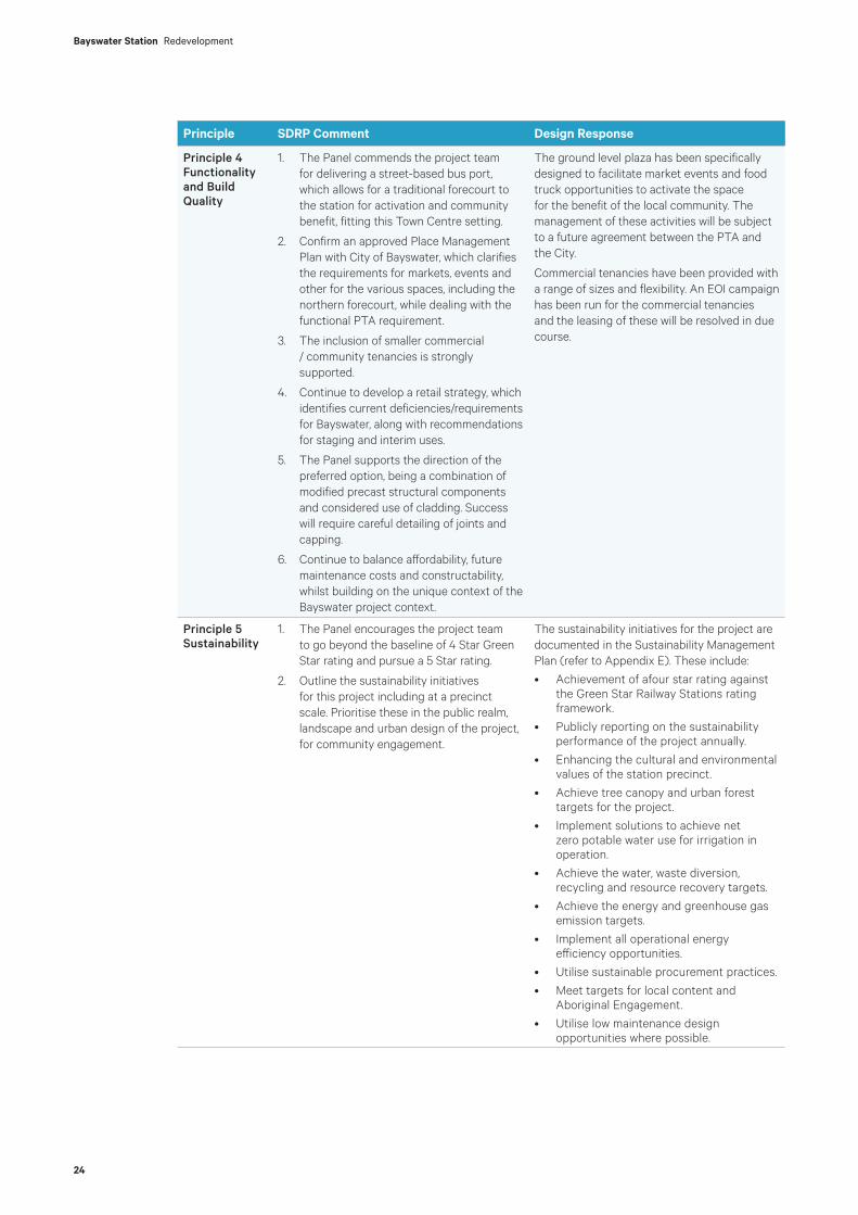
Principle 4 Functionality and Build Quality
1. The Panel commends the project team for delivering a street-based bus port, which allows for a traditional forecourt to the station for activation and community benefit, fitting this Town Centre setting.
2. Confirm an approved Place Management Plan with City of Bayswater, which clarifies the requirements for markets, events and other for the various spaces, including the northern forecourt, while dealing with the functional PTA requirement.
3. The inclusion of smaller commercial / community tenancies is strongly supported.
4. Continue to develop a retail strategy, which identifies current deficiencies/requirements for Bayswater, along with recommendations for staging and interim uses.
5. The Panel supports the direction of the preferred option, being a combination of modified precast structural components and considered use of cladding. Success will require careful detailing of joints and capping.
6. Continue to balance affordability, future maintenance costs and constructability, whilst building on the unique context of the Bayswater project context.
The ground level plaza has been specifically designed to facilitate market events and food truck opportunities to activate the space for the benefit of the local community. The management of these activities will be subject to a future agreement between the PTA and the City.
Commercial tenancies have been provided with a range of sizes and flexibility. An EOI campaign has been run for the commercial tenancies and the leasing of these will be resolved in due course.
Principle 5 Sustainability
1. The Panel encourages the project team to go beyond the baseline of 4 Star Green Star rating and pursue a 5 Star rating.
2. Outline the sustainability initiatives for this project including at a precinct scale. Prioritise these in the public realm, landscape and urban design of the project, for community engagement.
The sustainability initiatives for the project are documented in the Sustainability Management Plan (refer to Appendix E). These include:
• Achievement of afour star rating against the Green Star Railway Stations rating framework.
• Publicly reporting on the sustainability performance of the project annually.
• Enhancing the cultural and environmental values of the station precinct.
• Achieve tree canopy and urban forest targets for the project.
• Implement solutions to achieve net zero potable water use for irrigation in operation.
• Achieve the water, waste diversion, recycling and resource recovery targets.
• Achieve the energy and greenhouse gas emission targets.
• Implement all operational energy efficiency opportunities.
• Utilise sustainable procurement practices.
• Meet targets for local content and Aboriginal Engagement.
• Utilise low maintenance design opportunities where possible.

25
Principle SDRP Comment Design Response
Principle 6 Amenity
1. Consider the pedestrian experience and prioritise the entry plaza undercroft as a significant design opportunity to soften, add drama, interest, materiality, point of difference to the project to improve the arrival/departure experience.
2. The oculus (openings to the platform) are a key contributor to the amenity of what is otherwise a large and potentially oppressive undercroft area. Optimise their size and proactively design/detail the opening for interest and delight.
3. The entry plaza is well placed to provide good amenity under West Australian conditions with shade, shelter and activation. Continue to design these areas as key public realm, which considers the human scale.
The SDRP supported the level of amenity offered by the proposal.
The opportunities to further articulate and colour the undercroft has been considered in the final design with use of coloured aluminium battens to the soffit of the undercroft to provide colour, contrast and warmth to enhance the arrival / departure experience.
The opportunities for openings in the platform have been optimised as far as practical having regard to the need for stairs, lifts and escalators and platform capacity.
Principle 7 Legibility
1. The current design lacks adequate legibility for station users on a number of scales. The significance of this station to the rail network within the higher density future context provides a compelling argument to create a landmark.
2. Whilst supporting the simplified platform canopy design, there remains an opportunity to deliver a signifying element for the station – a ‘punctuation mark’ within the strong horizontality of the current design and would provide an identifying element visible within the greater Town Centre. Could such an approach announce the station entries more powerfully? The simplified platform approach and honest reflection of structure would contrast successfully with a distinctive marker in the station forecourt zone and achieve a variety of legibility objectives.
3. The marker referred to above could be achieved by integrating an artwork with the platform canopies. Colour and or pattern could be applied to the underside of the bridge and might wrap around the horizontal bridge beam. The legibility for pedestrians approaching the station undercroft would be improved.
4. Station signage should be further considered and depicted indicatively in future renders.
5. Continue consideration of longer distance views from the greater precinct in order to consider the contrast in scale for the canopies, the bridge structure and the station. Consider improved alignment of the platform canopies with King William Street to assist with long views and legibility.
6. Map existing and future key pedestrian and movement networks to optimise wayfinding and legibility.
As outlined above, the opportunities to further articulate and colour the canopies and undercroft has been considered in the final design with use of coloured aluminium battens to the soffit of the undercroft and copper toned colour to the soffits of the weather protection canopies on the station platforms to provide not only colour, contrast and warmth, but also provide identifying elements to the station. In addition, at ground level within the central plaza, informal seating has been provided in a landscaped setting to provide a visual marker for the station entry. Opportunities for lighting and/or artwork to this space are to be further resolved.
Existing and future key pedestrian and movement networks are shown in the Urban Design and Landscape Concept Report prepared by Hassell and included at Appendix H1. These demonstrate the legibility of the design.

Bayswater Station Redevelopment
26
Principle SDRP Comment Design Response
Principle 8 Safety
1. The simple design approach allows for a powerful lighting strategy which could form part of an integrated design approach as well as ensuring nighttime safety.
2. Progress sections to include areas of large level changes and public realm to identify potential areas of difficulty for passive surveillance and accessibility.
The SDRP supported the safety aspects of the proposed design.
A lighting strategy is to be prepared for the development as the design progresses to detailed design phase.
Principle 9 Community
1. The Panel supports an integrated approach to the landscape, built form and art strategies. Utilise public art and lighting as additional means of delivering fine grain and a sense of place and identity.
2. The intent for a broad tenancy EOI is supported as is the potential to incentivise interim innovative uses. Consider engagement with the Aboriginal reference group as part of tenancy EOI process/procurement as well as consideration of a community art initiative as a potential tenant.
3. Consult with the Aboriginal Reference Group as part of the METRONET Aboriginal Engagement Strategy Gnarla Biddi. This engagement should deliver more than just an “applied” public art.
The SDRP supported the community aspect of the proposed design.
Lighting and public art are proposed to deliver the fine grain design sought by the SDRP. These plans for these will be developed in conjunction with the preparation of the construction drawings.
Evolve Bayswater has been undertaking ongoing consultation with the Aboriginal Reference Group. Refer to Section 3.7 above.
Principle 10 Aesthetics
1. Continue to progress an integrated approach to the design of the station, both in relation to the formal outcome and the surrounding context. A holistic design response that considers architecture, engineering, urban design, landscape, lighting and public art together, and provides a contextually responsive outcome, is essential.
2. The Panel supports the simple and honest expression of structure as a design approach. A ‘streamlined’ aesthetic is considered suitable to transport uses: ‘engineered simplicity’. Consider contextual precedents for a stripped back Bayswater language, such as the local Post Office.
3. As an exercise in form making, the Panel is not overly concerned by the strong horizontality of the bridge component as the opportunity for finer grain exists with shopfront and handrail design below and above this component. Look to the tenancy design as a point of difference, as found in with the exemplar projects in the report appendix.
A holistic design approach has been employed by Evolve Bayswater.
Fine grain detailing is proposed through the shopfront / tenancy design and within the seating, landscaping, public art and overall landscape design.

27
3.1 Other AuthoritiesNumerous meetings have taken place with key National and State Authorities as well as private sector asset owners relating to their various assets that are impacted by the project. These Authorities include:
• Telstra
• NBN Co
• Optus
• Vocus
• TPG
• Main Roads Western Australia
• Western Power
• Water Corporation
• ATCO Gas
• Transperth Buses
Discussions with the communications service authorities have been primarily directed towards co-ordination of the removal of their buried services from the railway reserve and from areas where construction of the project will impact their existing infrastructure. All the communications authorities will be engaged by the PTA to realign their buried services to the north of the project site boundaries and also clear of the MEL siteworks to the east of the station. These enabling works are required to be completed prior to the end of 2020.
There are ongoing discussions with Western Power regarding the impacts of the project on the following elements of their plant and equipment:
• Overhead distribution power lines
• Overhead high voltage transmission lines
• Underground power lines and conduits
• Power supplies to Western Power and City street lighting
Work to remove conflicts with these services will be undertaken in the following months to match construction requirements.
Discussions with Water Corporation have been ongoing with a focus on:
• A 700mm diameter pressure sewer under Whatley Crescent that has to be realigned;
• Other water mains in the project area that require relocation; and
• Capacity and connections to the main stormwater drain that services the station precinct and its surrounds.
All these works will be carried out by Evolve Bayswater subject to approval of designs and construction methodologies by the Water Corporation.
Discussions with ATCO Gas have been held to co-ordinate adjustments to their pipeline assets in the vicinity of the project footprint. These works will be carried out in due course.
Discussions have been held with Main Roads regarding the changed road layouts and the impacts on traffic capacity and flows that arise. Refer to Section 4.2.6 for further details of these impacts. Discussions with Transperth Buses have resulted in the need to relocate two bus stops temporarily on to Railway Parade immediately north of the existing railway between Coode Street and Rose Avenue. One stop will be located on the north side of Railway Parade and one on the south side. The stops will service Bus Route No. 48 and also the emergency bus routes required if train services are disrupted on the Midland Line. These temporary stops will be removed when Stage 2 of the station works commence.

28
Bayswater Station Redevelopment
29
4. Description of Development
4.1 Key Design Criteria /PrinciplesTo facilitate good station design outcomes, the proposed concept for the station upgrade draws upon design principles outlined in the METRONET Station Precinct Design Guide and reflected in the 2019 Approval whilst also responding to State Planning Policy 7.0 – Design of the Built Environment (SPP 7) requirements as well as responding to the vision for Bayswater articulated in the draft METRONET East Redevelopment Scheme.
The design responds to the vision for Bayswater to become a vibrant and active town centre with the station at its heart, providing a meeting place for the community and drawing on high quality and innovative development solutions and leading sustainability practices. In particular, the design of the development is based on the following key design criteria / principles:
• Elevating the rail line to reduce the station footprint;
• Delivering new public plazas to facilitate safe and direct access between bus services and the station, for event spaces and to facilitate informal community use;
• Ensuring dual entries for improved pedestrian connections and integration with bus services;
• Provide integrated secure bicycle storage;
• Provide an elevated shared path to separate high volume commuter cyclists from the public realm and enhance safety for pedestrians;
• Improve cycling connections to the new station;
• Improving pedestrian connectivity through the town centre and facilitating accessible paths of travel;
• Create new road connections and reconfigure existing roads to simplify vehicle movements between the north and south and improve the integration of bus services in the town centre;
• Incorporate a new high quality public space at the Hamilton Street, Whatley Crescent intersection to promote pedestrian access and community use;
• Upgrade paving and landscaping to integrate treatments across the town centre promoting a consistent theme and connectivity on a precinct wide basis; and
• Focusing on opportunities for tree planting, shade and seating to support community use, tenancies, markets and food trucks for community events.
These principles are illustrated in the below Guiding Design Principles Plan (a copy of which is also contained at Appendix T).

30
Bayswater Station Redevelopment
Figure 15. Guiding Design Principles Plan
Level 18, 191 St Georges Terrace, Perth Western Australia 6000. PO Box 7375 Cloisters Square, Perth Western Australia 6850. T. +61 8 9289 8300 | E. [email protected] elementwa.com.au
Date: 05 Oct 2020 Scale: NTS @A3 Drawing No. 20-362 Staff: LS/TG/DW Checked: MC Bayswater StationGuiding Design Principles Plan (based on SPP7)
9
10
13
13 13
9
10
10
10
12
11
11 2
3
4
5
68
7
5
76
Potential Future Development Sites
Potential Future Development Site
2
1
11
2
1
10
Potential Future Development Sites
Whatley Cres
Coode St
Rose Ave
Beachboro Rd S
Drake St
King William
St
Shared Zone (10km/h)
Whatley Cres
1111
11
11
3
Guiding Principles
� Elevate rail line and reduce station footprint• Rail line elevated to 4.8m above road levels• Avoids dangerous vehicle collisions with bridge structure• Earth batters removed extended bridge structures to increase visual connections and
reconnect the two sides of the rail line through the site• Enhanced CPTED outcomes through light well structures providing openness,
natural light and clear view lines linking public spaces
2 Deliver new public plazas• Pedestrianised environment for informal activity and community events space. • Facilitates safe and direct access between bus services and the station. • Curated space offering multiple opportunities for active and passive use
3 Ensure dual station entries • Improved pedestrian connections to adjoining catchments and integration with bus
services
4 Provide integrated secure bicycle storage• Convenient accessible location providing direct access to the station
5 Provide elevated cycle path• Separated from vehicle and pedestrian movements for enhanced safety and
efficiency for users
6 Improve cycling connections• Convenient cycle path connections provided to both station entrances
7 Create new road connections in centre• Simplifies movement between northern and southern portions of the town centre• Enables integration of bus services • Improved intersection geometry and through traffic connections, slow vehicle speeds
and maintain essential through route
8 Hamilton Street level change
• New high quality public space incorporating terraces• Accessible pathway between the station precinct and Hamilton Street
9 Widened footpaths• Improve pedestrian amenity and create opportunities for street level activation
10 Include short term on-street car parking• High turnover to support local businesses and allows for pick up and drop off
11 Integrate bus services on street• Safe uninterrupted access to station
12 Retain open at-grade facilities
13 Protect development site opportunities• Project delivery to ensure opportunities for redevelopment are protected
• Existing rail line will be relocated toward Whatley Crescent to allow construction of four new rail lines. This will accommodate the Midland Line, Forrestfield Airport Link and Morley-Ellenbrook Line. Bayswater will evolve into one of Perth’s best connected stations.
• Bridge structures required to reduce station footprint and enable an open high quality design.
• King William Street and Coode Street are to be at same level to improve the public realm, disabled access and drainage. Intersections are to be designed for safe pedestrian use.
• Urban landscape and paving upgrades shall be required to integrate treatments across town centre promoting a consistent theme and connectivity on a precinct wide basis.
• Strong focus on tree planting, shade and seating is required to support micro tenancies, markets and food trucks for community events.
• Station and bridges are to be designed to reduce the visual scale of the infrastructure with strong consideration to emerging sense of place and scale of precinct development opportunities.
• Sustainable design considered for the station and integration with precinct wide initiatives.
• Public art and landscape opportunities to be used to further enhance Aboriginal and European heritage connections in Bayswater.
• Pedestrians shall be prioritised throughout town centre.
Perth (7km) Midland (9km)
Guiding Principles Plan provided to support explanation of the proposal and as a guide to detail design. The plan may be refined as part of the proposed Place Making Plan.

31
4.2 Station Design Response
4.2.1 Bridge StructuresA key component of the station upgrade is the replacement of the existing rail bridge that spans King William Street with a total of four new rail bridges spanning the entire station precinct (approximately 200 metres) that will support two new elevated island station platforms. Refer to Figures 16, 17 and 18 below.
The existing rail bridge has a low vertical clearance of approximately 3.8 metres from the road surface below, which does not meet current standards, with the existing bridge often being struck by moving vehicles that causes damage and creates a significant safety concern.
The proposed rail bridges will have a minimum vertical clearance of at least 4.8 metres from the proposed new road surface at King William Street to meet current safety standards. This clearance has been increased since the 2019 approval.
The new road connection between Whatley Crescent and Beechboro Road South (located towards the eastern end of the station) is also designed to achieve a minimum vertical clearance of 4.8 metres to the underside of the bridge, which is also greater than was achieved in the 2019 approval.
Figure 16. Architectural Plan Illustrating the Four Rail Bridges and PSP Bridge and the Alignment of these above the Eastern Entry Building (source: Hassell)
Figure 17. Architectural Section Through Structures and Platforms (source: Hassell)

Bayswater Station Redevelopment
32
Figure 18. Render Looking from Railway Parade under Structure to the South (source: Hassell)
Figure 19. Render of Station Platforms (source: Hassell)
4.2.2 PlatformsThe station platforms will be elevated and are designed to be directly supported by the new rail bridges.
The platform spanning between Bridges 1 and 2 for Stage 1 and the platform spanning between Bridges 3 and 4 for Stage 2 are to be constructed utilising transverse precast deck planks with an insitu-concrete slab topping as well as standard PTA surfacing common to their stations elsewhere on the network.
Importantly, the proposed new southern platform to be constructed in Stage 1 is located to the south west of the existing Bayswater Station, which means that the current Perth-Midland tracks and the existing Bayswater Station can generally remain operational during the construction process for the southern platform.

33
4.2.3 Structural ConstraintsThe track geometry required to accommodate the Midland, FAL and MEL tracks and turnbacks is heavily constrained by the space available within the rail reserve and, as such, there is only very limited opportunity to adjust the track geometry. The bridge designs are intimately linked to the track design therefore placing significant constraints on the physical location as well as the nature of the bridge components. These constraints include:
i) The height of the bridges and associated platforms are dictated by the line and level of the railway tracks that the bridges support. The tracks have been designed to ensure adequate vertical clearances between the road surfaces beneath the structures and the underside of the bridge decks.
ii) The overall extent of the bridges at the eastern abutment is dictated by the track geometry. There is a need to limit the extent of both horizontal and vertical curves in the track alignments on the structures to avoid problems with lateral clearances between the trains and the structures.
iii) At the western end of the bridges the abutment is located at the western extent of the western entry building. This positioning is dictated by the spatial requirements within the entry building footprint.
iv) The bridge spans have been designed to minimize the number of supporting piers and to position those piers clear of roads to ensure adequate sight distances. The piers have also been located to avoid conflicts within the entry building footprints as far as possible.
v) As a consequence of the above factors the pier sizes are dictated by the loads they are required to carry. These include for:
– Urban rail cars;
– The Indian Pacific train with a heavy diesel locomotive;
– The prospector diesel powered train;
– Work trains as required for track maintenance also pulled by diesel locomotives; and
– Platform and canopy loads.
vi) Similarly, the pier headstocks are sized to carry the superstructure loads from each of the bridges. However, they also need to be sized to accommodate the bridge bearings with sufficient space to allow the beams to be jacked off the bearings so that old bearings can be replaced with new units at the end of their useful life.
4.2.4 Entry Buildings and Other StructuresIn response to the unique setting and positioning of the elevated station platforms in relation to the alignment of King William Street, it was determined for the 2019 Approval that two station entry buildings represented the optimal access solution. This design approach has not changed. The new eastern and western station entry buildings will:
• Facilitate direct access between all proposed bus stands around the station precinct to a kerb side footpath with direct access to a station entry. Without the inclusion of the western station entry building bus patrons using the north bound Circle Route buses along King William Street would have to cross over King William Street to access the eastern station entry building.
• Enable multiple means of escape via the two separate stairs from each platform down to ground level (one in each building) or via the third emergency egress stair located at the western end of the platform. This also facilitates better access for emergency services to the station and platform in the event of an emergency.
• Enable a new pathway connection between the elevated PSP and the western entry building for cyclists to access a dedicated bicycle parking facility located within the new western entry building.
• Provide a higher degree of amenity and access for pedestrians from all areas around the station precinct and within the town centre generally.
• Improve distribution of passengers along and between the two platforms when future services come on-line at the northern platform with the commencement of the MEL service.
• Provide a key activation point at the western end of the precinct associated with the western entry building. This increases the opportunities for passive surveillance in this area.
The elevated station platforms will connect the western and eastern station building entrances, providing an increased platform length from that of the existing station that can support an increased number of railcar
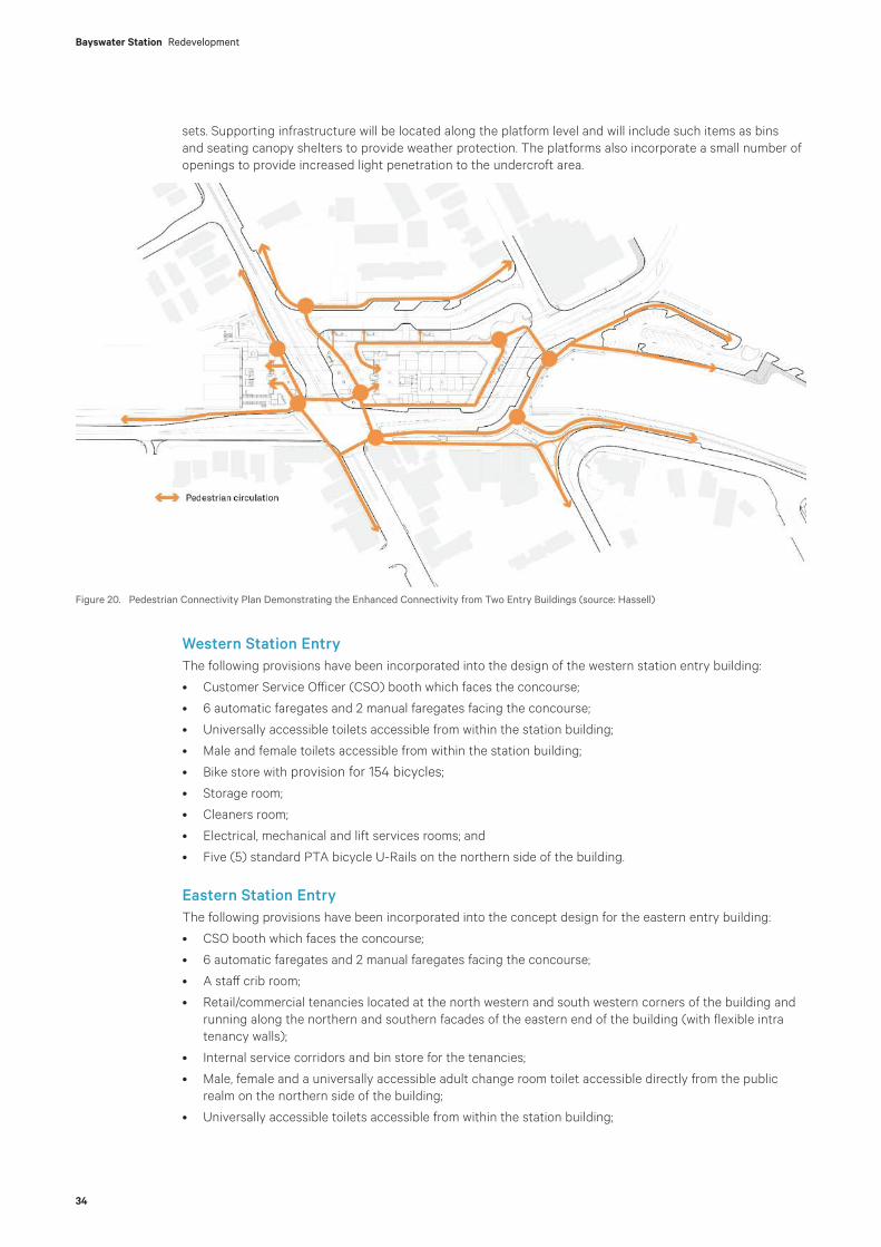
Bayswater Station Redevelopment
34
sets. Supporting infrastructure will be located along the platform level and will include such items as bins and seating canopy shelters to provide weather protection. The platforms also incorporate a small number of openings to provide increased light penetration to the undercroft area.
Western Station EntryThe following provisions have been incorporated into the design of the western station entry building:
• Customer Service Officer (CSO) booth which faces the concourse;
• 6 automatic faregates and 2 manual faregates facing the concourse;
• Universally accessible toilets accessible from within the station building;
• Male and female toilets accessible from within the station building;
• Bike store with provision for 154 bicycles;
• Storage room;
• Cleaners room;
• Electrical, mechanical and lift services rooms; and
• Five (5) standard PTA bicycle U-Rails on the northern side of the building.
Eastern Station EntryThe following provisions have been incorporated into the concept design for the eastern entry building:
• CSO booth which faces the concourse;
• 6 automatic faregates and 2 manual faregates facing the concourse;
• A staff crib room;
• Retail/commercial tenancies located at the north western and south western corners of the building and running along the northern and southern facades of the eastern end of the building (with flexible intra tenancy walls);
• Internal service corridors and bin store for the tenancies;
• Male, female and a universally accessible adult change room toilet accessible directly from the public realm on the northern side of the building;
• Universally accessible toilets accessible from within the station building;
Figure 20. Pedestrian Connectivity Plan Demonstrating the Enhanced Connectivity from Two Entry Buildings (source: Hassell)

35
• Male and female toilets accessible from within the station building;
• Storage rooms;
• Cleaners room;
• Electrical, mechanical and lift services rooms; and
• Five (5) standard PTA bicycle U-Rails on the northern side of the building.
The location of the retail tenancies that sleeve the building have been specifically designed to:
• Maximise opportunities for activation of the public realm;
• Ensure the public realm benefits from passive surveillance at both ends of the building and along both facades;
• Capitalise on the northern aspect in terms of opportunities for alfresco dining; and
• Accommodate the staged construction of the eastern entry building in two halves and the need to deliver key station infrastructure in this building in the first stage of construction that services the southern platform and rail lines.
Figure 21. Extract of Architectural Floor Plan of Eastern Entry Building (source: Hassell)
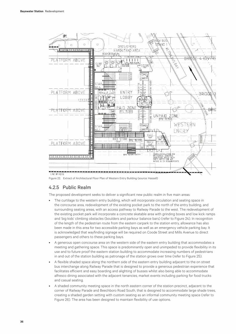
Bayswater Station Redevelopment
36
4.2.5 Public RealmThe proposed development seeks to deliver a significant new public realm in five main areas:
• The curtilage to the western entry building, which will incorporate circulation and seating space in the concourse area, redevelopment of the existing pocket park to the north of the entry building, and surrounding seating areas, with an access pathway to Railway Parade to the west. The redevelopment of the existing pocket park will incorporate a concrete skatable area with grinding boxes and low kick ramps and ‘big kids’ climbing obstacles (boulders and parkour balance bars) (refer to Figure 24). In recognition of the length of the pedestrian route from the eastern carpark to the station entry, allowance has also been made in this area for two accessible parking bays as well as an emergency vehicle parking bay. It is acknowledged that wayfinding signage will be required on Coode Street and Mills Avenue to direct passengers and others to these parking bays.
• A generous open concourse area on the western side of the eastern entry building that accommodates a meeting and gathering space. This space is predominantly open and unimpeded to provide flexibility in its use and to future proof the eastern station building to accommodate increasing numbers of pedestrians in and out of the station building as patronage of the station grows over time (refer to Figure 25).
• A flexible shaded space along the northern side of the eastern entry building adjacent to the on street bus interchange along Railway Parade that is designed to provide a generous pedestrian experience that facilitates efficient and easy boarding and alighting of busses whilst also being able to accommodate alfresco dining associated with the adjacent tenancies, market events including parking for food trucks and casual seating.
• A shaded community meeting space in the north eastern corner of the station precinct, adjacent to the corner of Railway Parade and Beechboro Road South, that is designed to accommodate large shade trees, creating a shaded garden setting with custom seating as an informal community meeting space (refer to Figure 26). The area has been designed to maintain flexibility of use options.
Figure 22. Extract of Architectural Floor Plan of Western Entry Building (source: Hassell)

37
• A green link that also facilitates an accessible path of travel in the area that is created by the change in alignment and level of Whatley Crescent where it connects with Beechboro Road South. The path allows movement from the lower road level up to the reconfigured intersection between Whatley Crescent to the east of the station precinct and Hamilton Street. This area offers the opportunity for a pleasant meeting space and will be landscaped to soften the structural elements required to sustain the level differences between the new road level and the existing footpath on Whatley Crescent that will continue to service the existing shops (refer to Figure 27).
In addition to the above, the development will deliver streetscape upgrades and improvements generally along the street network within the site. The above mentioned areas are shown generally in Figures 23 to 27 below.
Spatially, all of the above areas were accommodated in the 2019 Approval. However, the intent, design and functionality of the spaces had not been resolved at that time. This application proposes clear designs for these spaces that address the functional requirements of the new station and the town centre.
Figure 23. Key Areas of Public Realm and Primary Linkages (source: Hassell)

Bayswater Station Redevelopment
38
Figure 24. Pocket Park Design (source: Hassell)

39
Figure 25. Concourse Plaza Design (source: Hassell)
Figure 26. Northern Community Meeting Space (source: Hassell)

Bayswater Station Redevelopment
40
Figure 27. Render of Whatley Crescent Link and Landscaping (source: Hassell)
4.2.6 Road NetworkThe proposed development concept for the station has focused on improving the existing road geometry where practically possible and feasible within the spatial constraints of the site and the requirements of the rail infrastructure. The key design outcomes are to facilitate the overall permeability of the station precinct for vehicles whilst prioritising pedestrian and cyclist safety and accessibility to the station and bus interchange facilities.
The revised road network has also incorporated Transperth operational requirements for the bus interchange facilities, and routing to and from the station area.
The proposed road layout has been developed to suit appropriate road geometry whilst interfacing into the adjacent town centre/station precinct. The road network has been designed for an anticipated 40km/hr speed limit in the town centre precinct, in an area informed by City of Bayswater. The extent of the 40km/hr zones used reflect the expressed requirements of the City being:
• Beechboro Road South to Whatley Crescent – from Foyle Street north of the station precinct to just west of Roberts Road on Whatley Crescent; and
• Coode Street to King William Street – from Burnside Road in the north on Coode Street to Olfie Street in the south on King William Street.
In summary, the proposed concept and altered road layout will improve the existing station precinct by:
• Providing a new Whatley Crescent-Beechboro Road South connection under the eastern end of the new elevated rail bridges (which is consistent with the 2019 approval) to simplify the traffic flows for those vehicles wishing to travel through the town centre.
• Creating a new dedicated west bound bus lane on the northern side of the station (Railway Parade) where bus interchange facilities are provided (which is consistent with the 2019 approval).
• Creating a new intersection between the eastern part of Whatley Crescent and Hamilton Street (which is consistent with the 2019 approval).
• Providing eastbound access for light vehicles to Railway Parade connecting to Rose Avenue thus allowing access for drop-off to bus and rail transport services, property access and short-term parking.
• Providing for bus service access via Rose Avenue and limiting existing vehicle movements at the Rose Avenue and Railway Parade intersection to ensure the overall operation and movement of vehicles within

41
the precinct is not delayed by excessive queuing times. This is consistent with the PTA’s requirements for congestion free access to bus interchanges. The operational safety of the intersection has also considered the appropriateness of the intersection providing only for left turns into Rose Avenue from Whatley Crescent by buses and a left turn out of Rose Avenue onto Whatley Crescent by general vehicles. This is consistent with the 2019 approval.
• Providing for improved pedestrian connections with new dedicated crossings on Railway Parade at Coode Street, the new Whatley Crescent-Beechboro Road South connection for access to the town centre and the station from the north and east as well as the eastern carpark and at the Whatley Crescent and Hamilton Street intersection (which are consistent with the 2019 approval).
• Providing for improved bus-train connections by allowing passengers to connect between public transport modes without having to cross roads.
• Allowing for the integration of bus services within the local road network, facilitating bus stops for Circle Route busses (northbound and southbound) on Coode Street (consistent with the 2019 approval).
• Removing the existing Transperth parking located along Whatley Crescent east and west of King William Street, resulting in a reduction in traffic travelling to the station as a destination for Park ‘n’ Ride (consistent with the 2019 Approval). This loss of parking capacity has been offset by PTA constructing additional parking spaces at Meltham and Ashfield Stations.
The key change between the current application and the 2019 Approval in so far as the local road network is concerned is the removal of the right turn from Whatley Crescent (east) into Coode Street north. This movement is not available with the current intersection configurations and such movements are possible using the wider regional road network.
A summary of the traffic simulation modelling is contained at Section 7.3 of this report. A copy of the Traffic Modelling Report is included at Appendix R.
4.2.7 Principal Shared PathIt is proposed to remove a section of the existing PSP and to replace this with a 4.6 metre wide PSP located on a cantilevered extension to the new rail bridge on the southern side of the station. The elevated section of the PSP ties into realigned sections of the existing PSP on each side of the station precinct (as per the 2019 Approval). This is illustrated in Figure 28 below.
A new walkway will be connected to the PSP, running along the southern edge of the western entry building to provide access to the bicycle parking facilities in the western entry building. This arrangement will minimise the potential for cyclists to clash with pedestrians using the stations entries.
At the eastern end of the station there is also an accessible path from the PSP to the station precinct level. This path runs along the northern edge of the green space between the new Whatley Crescent road level and Hamilton Street.
Figure 28. Render of PSP sitting above Whatley Crescent (source: Hassell)
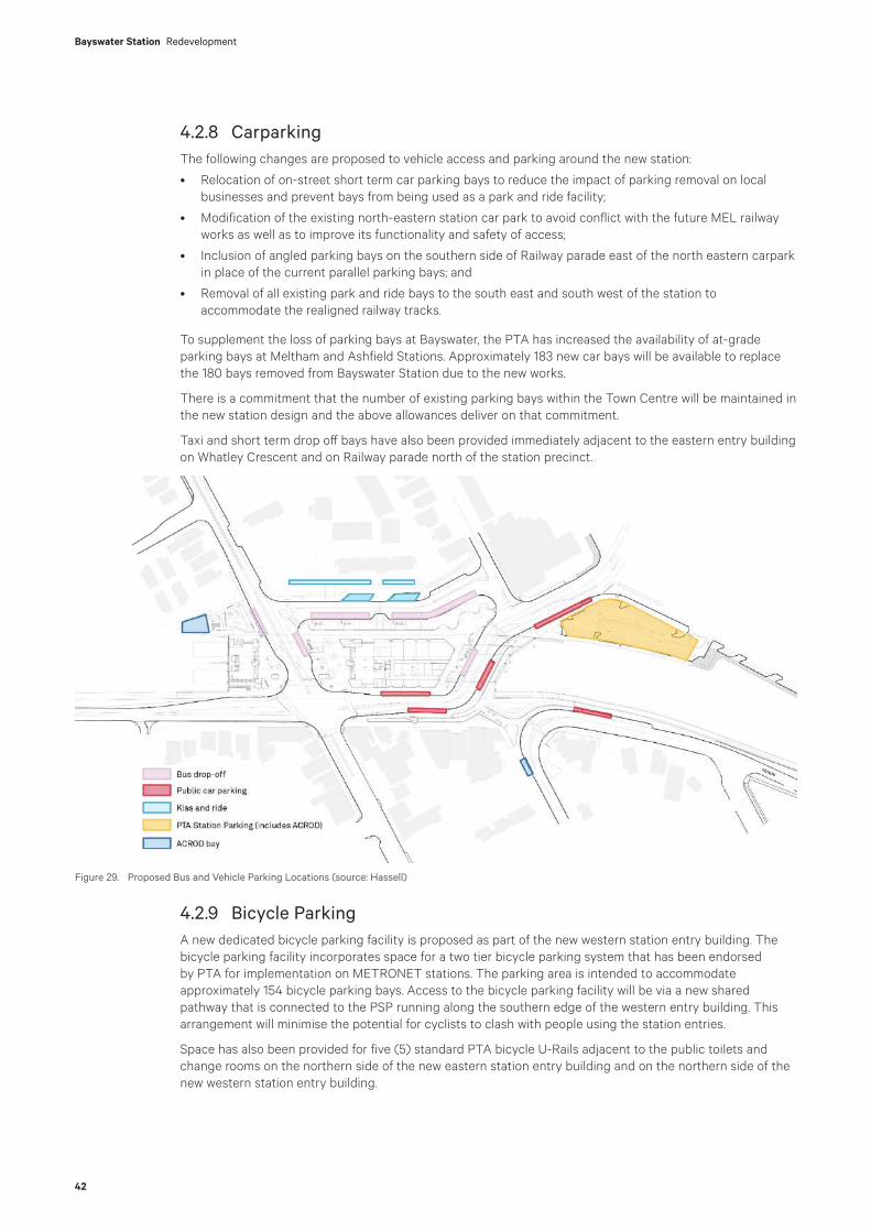
Bayswater Station Redevelopment
42
4.2.8 Carparking The following changes are proposed to vehicle access and parking around the new station:
• Relocation of on-street short term car parking bays to reduce the impact of parking removal on local businesses and prevent bays from being used as a park and ride facility;
• Modification of the existing north-eastern station car park to avoid conflict with the future MEL railway works as well as to improve its functionality and safety of access;
• Inclusion of angled parking bays on the southern side of Railway parade east of the north eastern carpark in place of the current parallel parking bays; and
• Removal of all existing park and ride bays to the south east and south west of the station to accommodate the realigned railway tracks.
To supplement the loss of parking bays at Bayswater, the PTA has increased the availability of at-grade parking bays at Meltham and Ashfield Stations. Approximately 183 new car bays will be available to replace the 180 bays removed from Bayswater Station due to the new works.
There is a commitment that the number of existing parking bays within the Town Centre will be maintained in the new station design and the above allowances deliver on that commitment.
Taxi and short term drop off bays have also been provided immediately adjacent to the eastern entry building on Whatley Crescent and on Railway parade north of the station precinct.
4.2.9 Bicycle ParkingA new dedicated bicycle parking facility is proposed as part of the new western station entry building. The bicycle parking facility incorporates space for a two tier bicycle parking system that has been endorsed by PTA for implementation on METRONET stations. The parking area is intended to accommodate approximately 154 bicycle parking bays. Access to the bicycle parking facility will be via a new shared pathway that is connected to the PSP running along the southern edge of the western entry building. This arrangement will minimise the potential for cyclists to clash with people using the station entries.
Space has also been provided for five (5) standard PTA bicycle U-Rails adjacent to the public toilets and change rooms on the northern side of the new eastern station entry building and on the northern side of the new western station entry building.
Figure 29. Proposed Bus and Vehicle Parking Locations (source: Hassell)
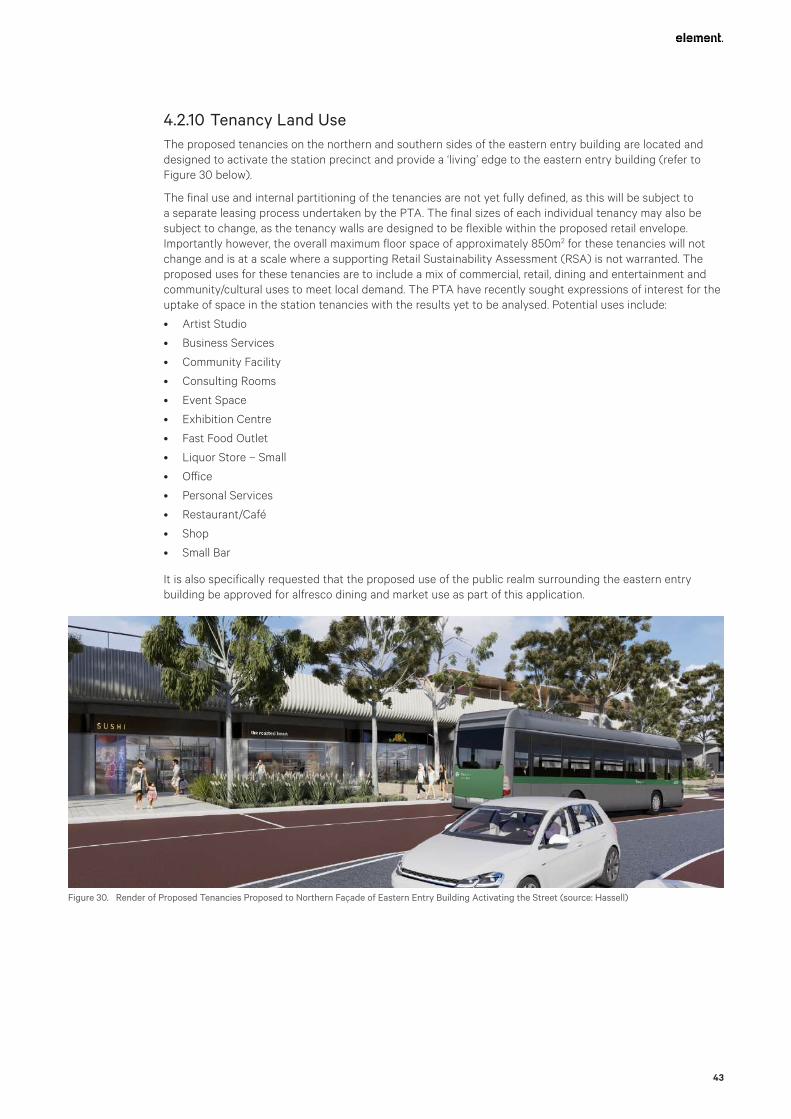
43
4.2.10 Tenancy Land UseThe proposed tenancies on the northern and southern sides of the eastern entry building are located and designed to activate the station precinct and provide a ‘living’ edge to the eastern entry building (refer to Figure 30 below).
The final use and internal partitioning of the tenancies are not yet fully defined, as this will be subject to a separate leasing process undertaken by the PTA. The final sizes of each individual tenancy may also be subject to change, as the tenancy walls are designed to be flexible within the proposed retail envelope. Importantly however, the overall maximum floor space of approximately 850m2 for these tenancies will not change and is at a scale where a supporting Retail Sustainability Assessment (RSA) is not warranted. The proposed uses for these tenancies are to include a mix of commercial, retail, dining and entertainment and community/cultural uses to meet local demand. The PTA have recently sought expressions of interest for the uptake of space in the station tenancies with the results yet to be analysed. Potential uses include:
• Artist Studio
• Business Services
• Community Facility
• Consulting Rooms
• Event Space
• Exhibition Centre
• Fast Food Outlet
• Liquor Store – Small
• Office
• Personal Services
• Restaurant/Café
• Shop
• Small Bar
It is also specifically requested that the proposed use of the public realm surrounding the eastern entry building be approved for alfresco dining and market use as part of this application.
Figure 30. Render of Proposed Tenancies Proposed to Northern Façade of Eastern Entry Building Activating the Street (source: Hassell)

Bayswater Station Redevelopment
44
4.2.11 Drainage ManagementA Water Management Plan that provides details as to how the development will capture and/or treat stormwater on site is provided at Appendix S. The principle of the plan and associated strategy is that stormwater will be retained on site such that there is no net increase in water leaving the site compared to the existing situation.
The concept for drainage design will ensure that there is no net increase from pre-development outflows into the Water Corporation King William Street Branch Drain (KWSBD), which starts at the intersection of King William Street and Whatley Crescent, and runs south until discharging into an open drain within the Riverside Gardens near Guildford Road (GHD, 2019).
For further details please refer to Section 7.8 of this report, the drainage plans at Appendix D3 and the Water Management Plan at Appendix S.
4.2.12 Existing Services ManagementThere are a number of critical major services to be managed as part of the construction process either by avoiding, protecting or relocating existing infrastructure. These include:
• ATCO and APA high pressures gas mains
• Water Coporation water and sewerage mains
• PTA Main Cable Route (MCR)
• Telstra and other communication lines
• Western Power for HV and LV transmission and distribution
Details of the co-ordination of services relocation works undertaken to date are provided in Section 3.10.
In addition, new and upgraded utility connections are required for the rail station and carpark, railway communications and to supply lighting for the PSP.
PTA will directly engage utility owners to relocate all services identified to require relocation prior to the commencement of the project with the exception of the Water Corporation assets and the PTA main conduit routes.
Evolve Bayswater will provide a dedicated Utilities and Services Team to:
• Ensure services that are remaining in place, both permanently and temporarily, are avoided and protected.
• Provide effective management of service and utility relocations by third parties and Evolve Bayswater.
• Construct the Water Corporation assets that require relocation or extension.
• Engage asset owners and, where required, design and/or construct all new and upgraded utility connections for stations, traction power and other assets.
• Design and construct any protection work for utilities and services not being relocated and any works required to protect railway infrastructure if services develop leaks in the future.
• Remove or make safe by grouting redundant buried services that have potential to impact on the works or existing assets.
• If required, engage asset owners and design and/or construct any additional services identified during the project that require relocation.
Details of the proposed services relocations are provided in the Construction Plan at Appendix O.
4.2.13 Station and Bus Services ManagementEvolve Bayswater plans on there being minimal disruptions to the normal operation of the metropolitan rail network at Bayswater Station as a consequence of the upgrading works. The Construction Plan is the principal document that outlines how this is to be achieved (refer to Appendix O). Essentially the southern rail bridges and station platform have been located and designed to facilitate construction whilst the existing Bayswater Station and the existing tracks remain operational therefore minimising the need for service disruptions. There will still be the need for short term disruptions to facilitate work on the rail tracks, signaling system and the overhead power system. Normal notification processes will be used to provide prior notice to passengers well before disruptions to services are required to facilitate construction activities. The duration of all such disruptions will be minimized.
45
Evolve Bayswater will also ensure that bus services continue to operate during construction as far as possible. The frequency, routing, and the functionality of existing public transport infrastructure affected by the project will be maintained or replicated during the delivery of the works unless otherwise agreed with Transperth. Normal notification processes will be used to provide prior notice to passengers well before disruptions to services are required to facilitate construction activities. The duration of all such disruptions will be minimised.
Evolve Bayswater understands the importance of routes 998 and 999 (Circle Route services) to the Transperth Network with all efforts made to maintain the current level of service and to ensure that the expectations of passengers are met.
Evolve Bayswater will coordinate with Transperth in relation to the arrangement of replacement services in the event that the works require planned route closures such as during the erection of new bridge beams over King William Street and the demolition of the existing rail bridge. Full closure of roads or detours during construction will be required for safety reasons but every effort will be made to minimize affecting scheduled bus services wherever possible.
Where road closures or detours are required, they will be minimised and localised to preserve route integrity and excessive variance to travel times. Any proposed road changes, route alterations and temporary bus stops will be agreed with Transperth and advised to passengers prior to the commencement of the relevant works.
Evolve Bayswater will ensure that bus stops impacted by the project such as those located on King William Street will be replicated to provide capacity, accessibility and functionality to support patronage levels and pedestrian movements forecast during the delivery of the works, and that any temporary bus infrastructure remains operable, maintainable and safe for passengers.
The existing PSP though the station construction site will need to be closed. However, alternative arrangements will be provided via on-road bicycle lanes for commuter cyclists. The existing footpath on the southern side of Whatley Crescent that services the existing properties will remain open for pedestrians during the course of the works. For a short period, the PSP will be diverted on to the footpath to maintain continuity of the PSP while the southern bridges are constructed.
4.2.14 Architectural Treatments, Materials and FinishesThe architecture draws upon the concept of Engineering Elegance with Human Scale, inspired by the best of WA’s infrastructure mediated by the form, texture and familiarity of its classic passenger trains and stations.
The proposed development incorporates a range of architectural treatments and cladding treatments to respond to the design cues of Bayswater and the rail environment. The architectural approach has been guided by the following themes:
• Garden - the ‘garden’ design principle addresses the activation of the Station Precinct through a mixture of hard and soft landscaping across a plaza that will be accessible to all ages and range of mobility providing a station setting that is familiar, welcoming and comfortable.
• Rhythm - addresses the scale of the surrounding streetscape. The rhythm of the station and precinct synchronise with the surrounding suburban grain creating a seamless experience that feels local.
• Infrastructure - the bridge plays a key role in the future of Bayswater. The bridge will be a key piece of the architectural identity within Bayswater and will allow the suburb to stitch together below it.
Fluid forms and fine grain texture are utilised to soften the scale of the significant structures comprising the bridges and platforms.
To achieve this cladding is to be applied to:
• the undersides of the station platform canopies to provide visual interest, colour and warmth;
• the external/ southern face of the elevated Principal Shared Path (PSP) and the northern façade of the bridge to provide visual interest and provide vertical elements into the design of the bridge structure; and
• the soffit of the bridge undercroft, station entry spaces and PSP to provide warmth and visual interest.
These treatments are proposed to balance the strong horizontality of the development with references to both the river and rail infrastructure (which the development serves) and to also provide colour and warmth to enhance the overall sense of place. The bridge superstructure treatments are linked to the substructure through the inclusion of fluting to some of the faces of the piers and headstocks.

Bayswater Station Redevelopment
46
In addition, it is proposed to utilise cream coloured concrete rather than typical grey concrete to provide added warmth and provide a highly durable and low maintenance finish.
A materials and finishes palette is included at Appendix D1, refer also to Figures 31 and 32 below.
Figure 31. Example of the Materials and Finishes Palette for the Bridge Structures (source: Hassell)
Figure 32. Example of the Materials and Finishes Palette for the Bridge Structures (source: Hassell)
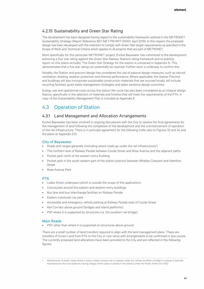
47
4.2.15 Sustainability and Green Star RatingThe development has been designed having regard to the sustainability framework outlined in the METRONET Sustainability Strategy (Report Reference: BST-MET-PM-RPT-00001, April 2019). In this respect the proposed design has been developed with the intention to comply with Green Star target requirements as specified in the Scope of Work and Technical Criteria which applies to all projects that are part of METRONET.
More specifically for this particular METRONET project, Evolve Bayswater has committed to the development achieving a four star rating against the Green Star Railway Stations rating framework and to publicly report on this status annually. The Green Star Strategy for the station is contained in Appendix N. This demonstrates that a five star rating can potentially be reached. Further work is underway to confirm this.
Notably, the Station and precinct design has considered the use of passive design measures, such as natural ventilation, shading, weather protection and thermal performance. Where applicable, the Station Precinct and buildings will also incorporate sustainable construction materials that are sourced locally, will include recycling facilities, good waste management strategies and water sensitive design outcomes.
Energy use and operational costs across the station life-cycle has also been considered as an integral design feature, specifically in the selection of materials and finishes that will meet the requirements of the PTA. A copy of the Sustainability Management Plan is included at Appendix E.
4.3 Operation of Station
4.3.1 Land Management and Allocation ArrangementsEvolve Bayswater has been involved in ongoing discussions with the City to resolve the final agreements for the management of land following the completion of the development and the commencement of operation of the rail infrastructure. There is in principle agreement for the following (refer also to Figures 33 and 34 and the plans at Appendix D1):
City of Bayswater• Roads and verges generally (including where roads go under the rail infrastructure1)
• The northern lane of Railway Parade between Coode Street and Rose Avenue and the adjacent paths
• Pocket park north of the western entry building
• Pocket park in the south eastern part of the station precinct between Whatley Crescent and Hamilton Street
• Rose Avenue Park
PTA• Leake Street underpass (which is outside the scope of this application)
• Concourses around the eastern and western entry buildings
• Bus lane and bus interchange facilities on Railway Parade
• Eastern commuter car park
• Accessible and emergency vehicle parking at Railway Parade west of Coode Street
• Rail Corridor above ground (bridges and island platforms)
• PSP where it is supported by structures (i.e. the southern rail bridge)
Main Roads• PSP, other than where it is supported on structures above ground.
There are a small number of land transfers required to align with the land management plans. These are transfers of Crown Land from PTA to the City or vice versa with arrangements to be confirmed in due course. The currently proposed land allocations have been provided to the City and are reflected in the following figures.
1 Maintenance of public roads where a road or street crosses over or passes under any railway by either a bridge or subway is typically maintained by the local authority having charge of the roads or streets in the district under the Public Works Act 1902.

Bayswater Station Redevelopment
48
Figure 33. Proposed Ground Level Land Management Arrangements (source: Evolve Bayswater)
Figure 34. Proposed Above Ground Level Land Management Arrangements (source: Evolve Bayswater)

49
It is also envisaged that the PTA will enter into an agreement with the City for the management of the event and market space around the eastern concourse building as well as for the ongoing management of the landscaping in and around the station facilities. A formal agreement will be put in place between the City and PTA to cover these requirements. Such management arrangements are in place elsewhere on the urban rail network.
The development will also require land to be transferred from the current vesting in the WA Police to the City of Bayswater to accommodate the revised connection from Whatley Crescent into Hamilton Street. Access to this land was identified within the 2019 Approval and is currently being negotiated.
4.3.2 Precinct Access ArrangementsThe public will be able to access the train station and bus interchange facilities as part of their public transport journey during station opening hours (5:15am to 1am Sunday to Thursday and 5:15am to 2:30am on Friday and Saturday). The station concourse areas around the station entry buildings will remain open and publicly accessible 24 hours a day, 7 days a week. These concourse areas have been designed to become part of the public realm under the control and management of the PTA except as otherwise agreed with the City.
The station precinct will generally be designed to accommodate light vehicle access for events, landscape maintenance, railway operations and maintenance and tenancy operations and maintenance. Such access will be controlled by the PTA as required in collaboration with the City.
Public access to the rail reserve (the tracks and the fenced-off areas of the station platforms) will not be permitted at any time. There are arrangements in place for escape during emergency events that will override this at the western end of the station platforms, however, access under these circumstances will be closely overseen and managed by the PTA.
As indicated at Section 4.3.1, it is also envisaged that the PTA will enter into an agreement with the City for the management of the event and market space around the eastern concourse building.
Public access to the tenancies will be provided through the shopfronts. Lessees of the larger tenancies on the northern side of the eastern entry building may be able to access their spaces via a separate internal, secured corridor. This will be separated from access to the rail operational rooms for security reasons. Tenants will be able to receive deliveries via parking facilities available on the precinct. There will also be access to the precinct for waste collection vehicles (refer to the Operational Waste Management Plan in Appendix P).
PTA operations and maintenance staff will have access to the precinct for parking and any operational requirements (e.g. structural inspections, services maintenance, etc.). There are a range of operational rooms within the entry buildings and these will be accessible to PTA personnel and authorized maintenance staff only, via secured doors and passageways.
Property access generally around the station development will be maintained with all crossovers retained on all roads impacted by the works with the exception of a double crossover on the modified section of Whatley Crescent (refer to Section 4.3.13 for details)
4.3.3 Train Services IntegrationProposed train operation patterns have been developed using the State Government’s Strategic Transport Evaluation Model (STEM) to model future station demand. To meet future expected patronage, the station will be serviced with 12, six-car trains per hour as of 2021 (opening day). Six (6) trains per hour will be running on the FAL line from Forrestfield to Claremont Stations, and a further six (6) trains per hour will be running from Midland to Fremantle Stations on the existing Perth-Midland line. These operation patterns are in line with PTA’s Concept Train Operating Plan: PTA Urban Network 2021- 2051 and can be made available to the WAPC on request.
The proposed development design also considers and provides for the integration of the future construction of the MEL by designing and constructing the second platform as part of this development. This will limit future construction impacts asso ciated with the MEL as the station will already be in place (just not fully operational until the MEL is delivered).

Bayswater Station Redevelopment
50
4.3.4 Vertical TransportDesigning the station with two separate entry buildings that each service the two station platforms maximises the flexibility and permeability of the station design. However, it also results in the duplication of vertical transport options between the eastern and western entry buildings. In this regard, each of the two station platforms is connected to the ground level entry buildings by both lifts and stairs, resulting in two sets of stairs and two lifts that access the southern platform (one from each entry building) and the same for the northern platform. The multiple lift and stair options provide for the movement of significant numbers of passengers on and off the platforms during peak periods. It also ensures that passengers leaving the platforms can make a deliberate choice to exit the station via either the eastern or western entry buildings, depending on which stair/lift is taken to ground level.
In addition to the stairs and lifts, and in response to community feedback, it was determined that a bidirectional escalator should be incorporated to provide access to each platform. Accordingly, there is one escalator per platform, accessed from the eastern entry building. Each escalator is bi-directional, which means that it can change direction to match peak directional travel demand (up or down).
4.3.5 Access and ConnectivityThe development is designed to promote and support direct, legible and comfortable access to and through the station and the precinct for pedestrians and cyclists. The proposed upgrades have been designed to comply with the PTA’s Accessibility Policy, which requires consultation with key stakeholders on access issues during the planning, funding, design and construction stages of a project.
The proposed concept has specifically considered the prioritisation of pedestrian and cyclist activities through and within the station and surrounds, in accordance with PTA’s operational requirements. A highly permeable station design solution with comprehensive pathways will prioritise pedestrian and cyclist movements through and within the station precinct, promoting a walkable and pleasant urban environment that appropriately limits and slows vehicles within the immediate surrounds of the station area.
Figure 35. Render of Stairs and Escalators from within the Entry Building (source: Hassell)

51
4.3.6 Movement Network SummaryThe key road connections through the project area are the King William / Coode Street connection and the proposed new Beechboro Road South / Whatley Crescent Connection. This provides a modified grid to facilitate efficient movement of buses, pedestrians and cyclists through the town centre. It also creates a station island that facilitates bus access to the stops on the perimeter of the precinct as well as stopping points for drop off and taxi access. It is diagrammatically illustrated in Figure 36 prepared by Hassell.
4.3.7 Bus Services IntegrationThe proposal will deliver an efficient bus-train transfer facility that will support public transport mode share growth into the future. The commencement of train services on the FAL and the future MEL reinforces Bayswater’s role as a major transfer point with buses needing to play a much greater role in achieving station accessibility in conjunction with a reduction in reliance on the use of private vehicles.
The proposed concept design provides for a hybrid on-street bus interchange. While there are some operational limitations and the need for clear wayfinding, locating bus stands on the street (in an embayment) adjacent to the public space forming part of the ground level station plaza will allow for the following to occur:
• Improved interchange facilities will allow the existing routes in the area to be realigned to Bayswater Station without the need to continue into the Perth Central Business District (CBD). This will provide passengers with faster travel times and restrict growth in bus services travelling into the CBD, assisting in alleviating congestion in and around the CBD;
• Safer and more convenient transfers between buses and trains;
• A greater number of people can connect into the Bayswater Town Centre, without requiring additional parking; and
• Opportunity to integrate the bus shelter designs into the public space forming part of the ground level station plaza to assist in activating the precinct around the Bayswater Station.
Currently bus routes 998 and 999 (Circle Route), and route 48 (Elizabeth Quay to Morley) provide bus access to Bayswater Station, culminating in 300 bus-train passenger transfers a day. The current station design, the established nature of the area and road geometry mean it is not currently possible to redirect services to Bayswater Station. Further, the Perth-Midland line currently only has two stations with bus interchanges at Midland and Bassendean which are both now at capacity.
Figure 36. Key Connections (source Hassell)

Bayswater Station Redevelopment
52
Once the station is upgraded, subject to funding being available, it is possible that additional bus routes will stop at the station to increase the catchment and patronage at Bayswater Station. Transperth will conduct community consultation regarding the bus service changes prior to operations taking effect to ensure routes are optimised and patrons are aware of any changes to existing routes.
The proposed bus interchange facilities will play a significant role in the overall function of the station upgrades. A number of additional on street bus stands are proposed to locate adjacent to the eastern and western station entry buildings on either side of Coode Street, in most instances being accessible via the ground level station plaza. The additional bus facilities proposed as part of the station upgrades are summarised as follows:
• Six on street active bus bays are provided in total as part of the upgrades, with three (3) bays provided within the area to the north of the new station infrastructure, one (1) bay provided under the new elevated rail bridge within the new road link and two (2) bays provided within King William Street;
• Two (2) new bus layover bays located within the area to be used as part of the overall bus interchange operations;
• Modified road layout, including the addition of a zone for buses and pedestrians to the north of the ground level station plaza to accommodate the turning paths of an 18 metre long articulated bus; and
• Bus stands are proposed to be 20 metres in length and four metres wide.
Pavement levels around the station precinct will be raised by 170mm above the adjacent road surface in accordance with PTA requirements for kerb heights to bus stands. The bus bays will also be drained away from the kerb line to protect passengers boarding or alighting from buses in periods of rain.
4.3.8 Pedestrian and Cyclist AccessAs outlined earlier in this report, one of the key design outcomes for the project is the improvement in the overall permeability of the station precinct for pedestrian and cyclist movements and improving the safety and accessibility of the station and bus interchange facilities to both cyclists and pedestrians. As indicated in Figures 20 and 37 the key pedestrian paths of travel in and around the eastern and western station buildings are separated from the key bicycle routes through the town centre (via the PSP) or into the station entry buildings.
Facilitating quick and direct access into each station entry building is an important design outcome and this is achieved through the wide openings and 6 automatic faregates and 2 manual faregates per entry building facing the concourse. Pedestrians are provided with safe paths of travel from Railway Parade, Coode Street, King William Street, Beechboro Road South and Whatley Crescent. This is reflected in the plan at Figure 20. An extract of the bike movements plan is shown below in Figure 37, demonstrating the permeability of the site for cyclists and the manner in which they are predominantly separated from pedestrians through the use of the PSP and use of the local road network.
Figure 37. Bike Movements (source: Hassell)

53
4.3.9 Road NetworkAs detailed at Section 4.2.6 of this report, the proposed development concept for the station has focused on improving the existing road geometry where practically possible and feasible within the spatial constraints of the site and the requirements of the rail infrastructure. The proposed operation of the road network by private vehicles is illustrated diagrammatically in the following plan prepared by Hassell.
4.3.10 Car ParkingThe existing commuter car parking areas to the south east and south west of the existing station adjacent to Whatley Crescent are being removed as part of this development, as the rail corridor needs to expand into this space. As highlighted earlier in this report, works are nearing completion at Ashfield and Meltham stations to increase available commuter carparking to compensate for the reduction at Bayswater.
However, the existing park and ride car park located to the north east of the existing station is to be retained and reconfigured as part of the development. It will be used variously for construction activities during the construction stages of the development but will be reconfigured and reopened as part of the Stage 2 works.
The reconfiguration works in this car park will result in a slight increase in commuter parking, increasing from a total of 64 bays to 68 bays.
Evolve Bayswater is committed to maintaining the total number of on-street parking bays in the town centre. The table below demonstrates how this will be achieved with the bays nominated shown on the design drawings.
Figure 38. Private Vehicle Movements (source: Hassell)

Bayswater Station Redevelopment
54
Table 2 – Summary of Parking Changes
Parking Use Bays Required
Bays Provided
Location
Long Term Motorcycle Bays
5 8 Station Car Park (NE corner of Beechboro Road South and Railway Parade)
Tenant Parking 7 7
Electric Car Charging
2 2
PTA Staff Parking
4 4
PTA Service Parking
2 2
Public Parking 43 45 Station Car Park (NE corner of Beechboro Road South and Railway Parade). Supplementary long term parking proposed on Railway Parade as noted below.
Accessible Parking
1 0 Accessible parking proposed near western station entrance as noted below.
TOTAL = 64 68
Supplementary Long Term
Public Parking 16 Angled parking bay on Railway Parade
Accessible Parking
2 Adjacent to western station entrance (Coode Street)
Short Term Taxi Drop Off Parking Bay
1 2 Bus Link Road (parallel parking bays)
Accessible Drop Off Parking Bay
1 2 Bus Link Road (parallel parking bays)
Town Centre / Retail (non- PTA)
Bus Link Road 8 10 Bus Link Road (angled bays)
General 4 5 Whatley Crescent EB
5 4 Whatley Crescent WB
3 3 New Link Road (Whatley-Beechboro)
5 5 Beechboro Road South
Emergency Vehicles 1 1 Adjacent to Western Station entrance (Coode Street)
Fire Brigade 1 2 DFES hardstand area – located adjacent to fire boosters in lieu of dedicated on street bay
4.3.11 Noise MitigationAn Operational Noise Assessment has been prepared by Lloyd George Acoustics to support the proposed development (document reference BST-EVO-NV-RPT-00042 Rev A). This document outlines the manner in which the noise impacts and acoustic attenuation requirements have been assessed for the operational phase on the project. It includes recommendations that deal with how noise is to be attenuated from the use of the rail lines and station platforms. The key findings of this report include:
• The project criteria have been determined by both existing noise levels and target noise levels.
• The noise levels of the interim and ultimate scenarios are reasonably similar.
• Increased train movements are offset by the increased use of 3 car sets rather than 4 car sets, with 3 cars being quieter.
• Noise walls are required in certain locations to attenuate noise from the railway line. Figure 37 below shows where these are to be located generally in PCA 135 noting that approval for noise mitigation is only required where this is associated with noise from the station and is located between the bridge abutments.
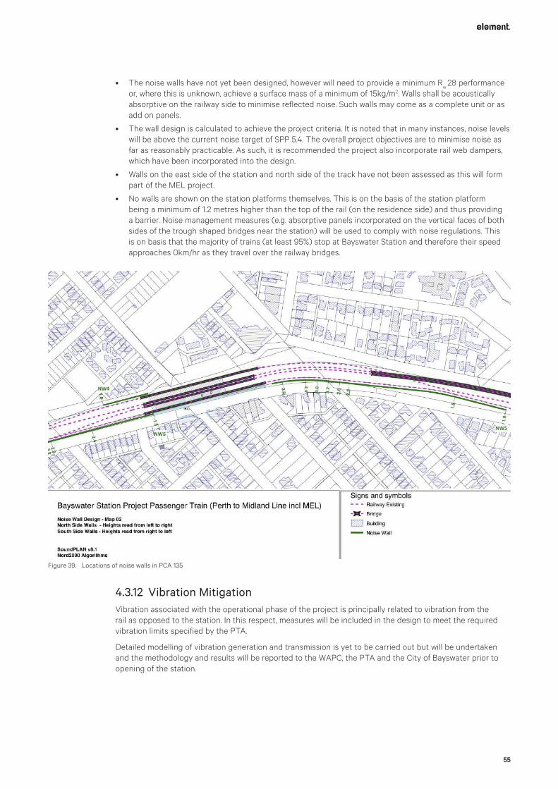
55
• The noise walls have not yet been designed, however will need to provide a minimum Rw
28 performance or, where this is unknown, achieve a surface mass of a minimum of 15kg/m2. Walls shall be acoustically absorptive on the railway side to minimise reflected noise. Such walls may come as a complete unit or as add on panels.
• The wall design is calculated to achieve the project criteria. It is noted that in many instances, noise levels will be above the current noise target of SPP 5.4. The overall project objectives are to minimise noise as far as reasonably practicable. As such, it is recommended the project also incorporate rail web dampers, which have been incorporated into the design.
• Walls on the east side of the station and north side of the track have not been assessed as this will form part of the MEL project.
• No walls are shown on the station platforms themselves. This is on the basis of the station platform being a minimum of 1.2 metres higher than the top of the rail (on the residence side) and thus providing a barrier. Noise management measures (e.g. absorptive panels incorporated on the vertical faces of both sides of the trough shaped bridges near the station) will be used to comply with noise regulations. This is on basis that the majority of trains (at least 95%) stop at Bayswater Station and therefore their speed approaches 0km/hr as they travel over the railway bridges.
4.3.12 Vibration MitigationVibration associated with the operational phase of the project is principally related to vibration from the rail as opposed to the station. In this respect, measures will be included in the design to meet the required vibration limits specified by the PTA.
Detailed modelling of vibration generation and transmission is yet to be carried out but will be undertaken and the methodology and results will be reported to the WAPC, the PTA and the City of Bayswater prior to opening of the station.
Figure 39. Locations of noise walls in PCA 135
Bayswater Station Redevelopment
56
4.3.13 Private Property AccessThe proposed design of Whatley Crescent connecting to the extension of Beechboro Road South as it crosses under the railway east of the station involves level changes of the road that vary from zero close to King William Street to approximately 4.5m at the Hamilton Street intersection. The footpath that services the existing retail and commercial properties on the impacted section of Whatley Crescent will remain unaffected by the level changes and continue to provide current accessibility to the subject properties. The design includes the installation of retaining walls to deal with the level differences between the footpath and the new road alignment.
It is recognised that this will impact on the existing vehicular access arrangements from Whatley Crescent to both No.1 Whatley Crescent and the adjacent privately-owned Right Of Way (ROW). That access is currently via a double crossover to the existing southern footpath on Whatley Crescent.
There are two other access points for the ROW, one to Hamilton Street and the other to King William Street. The constrained geometry of the ROW does not, however, provide ready access to properties east of King William Street on to that road.
The parties located on Lot 1 use the current double crossover on Whatley Crescent to access private, undercover carparking spaces on the strata titled Lot (3 strata titles). Other property owners and/or tenants also use the ROW for access to their properties for operational and parking purposes. In addition, the City’s waste collection Contractor is known to use the ROW during its operations. It is recognised that closure of access to the ROW at Whatley Crescent will constrain these current activities.
The current access will remain in place until March 2021, although from November 2020, such access will be constrained because Whatley Crescent will be reduced to a single lane with traffic having to move in the direction from Hamilton Street to King William Street. This is when Whatley Crescent will be reduced to a single, westbound traffic lane to make space for site preparation activities.
Temporary arrangements can then be made by Evolve Bayswater to provide ongoing access from the ROW and to Lot 1 by constructing a one-way access lane from the current double crossover on Whatley Crescent to connect to King William Street at the Whatley Crescent intersection. A preliminary layout for this temporary arrangement is shown in Figure 40 below.
In this arrangement vehicles accessing the current parking on Lot 1 can either drive directly into the west facing spaces or reverse into the south facing spaces. The geometry will be such that a waste collection truck will also be able to move from the ROW towards King William Street. The truck will not, however, be able to turn left into King William Street southbound due to the limited space available.
Figure 40. Proposed one-way access lane from the current double crossover on Whatley Crescent to connect to King William Street at the Whatley Crescent intersection

57
Discussions with the relevant parties concerning the closure of the access to the ROW at Whatley Crescent and the possible arrangements for parking on Lot 1 beyond June 2021 will be undertaken by Evolve Bayswater. This will include discussions with the City and its waste collections Contractor as well as all other potentially impacted landowners and occupiers.
Evolve Bayswater will continue to work with all the relevant landowners and occupiers as well as the City to seek agreement on the best way to deal with the change in current access arrangements from Whatley Crescent (before June 2021).
4.4 Place Making
4.4.1 Place ActivationThe design of the public realm has adhered to the design principles and requirements identified in the METRONET Station Precinct Design Guide, which establishes a list of specific Station Precinct Design Objectives. The manner in which the station and surrounds will be activated and will become a vital part of the town centre has been a key consideration in the design of the development. Key outcomes include:
• A development that addresses the scale of the surrounding streetscape, providing a rhythm that synchronises with the surrounding suburban grain creating a seamless experience that feels local.
• Using bridging structures to allow the suburb of Bayswater to stitch together below the station.
• Incorporating sufficient retail tenancy opportunities that maximise active frontages to create attractive and active edges to the eastern station entry building and ensuring the station becomes an integrated part of the town centre.
• Ensuring that the design of the centre embodies a strong sense of place in its architecture and landscape design.
• Providing for a human scaled environment which also reflects the fine grain of Bayswater.
• Designing to facilitate expansive open, inviting areas, welcoming station forecourts and legible entries. Pedestrian movements are logically located along key routes and sightlines and will contributing to a permeable and active precinct.
• Carefully co-locating the bus lane with the main entrance to the station, as well as connecting the existing principal-shared path with the station and bicycle parking facilities to drive activation.
• Refinement of the street alignment to support slower vehicle movements, enhancing the pedestrian experience and again, facilitating activation.
• Providing for a variety of open spaces to cater for a broad range of users including:
– The plaza, which will be a welcoming, lively and safe place that provides opportunities for hosting a variety of activation events such as market stalls, food trucks or temporary art installations;
– The pocket park for youth and younger members of the community;
– Spill-out and alfresco spaces for proposed retail tenancies on the northern side of the eastern entry building; and
– Spaces such as the Station Garden on the north eastern side of the eastern station building and adjacent to the new Whatley/Hamilton Street intersection for people to dwell, relax and come together amongst gardens that showcase local native wildflowers and plantings.
• The careful and considered inclusion of public art and lighting in the public realm, including the interpretation of the traditional owners’ culture, will assist in creating spaces that engage and activate people.

Bayswater Station Redevelopment
58
Figure 41. Place Activation Plan (source: Hassell)
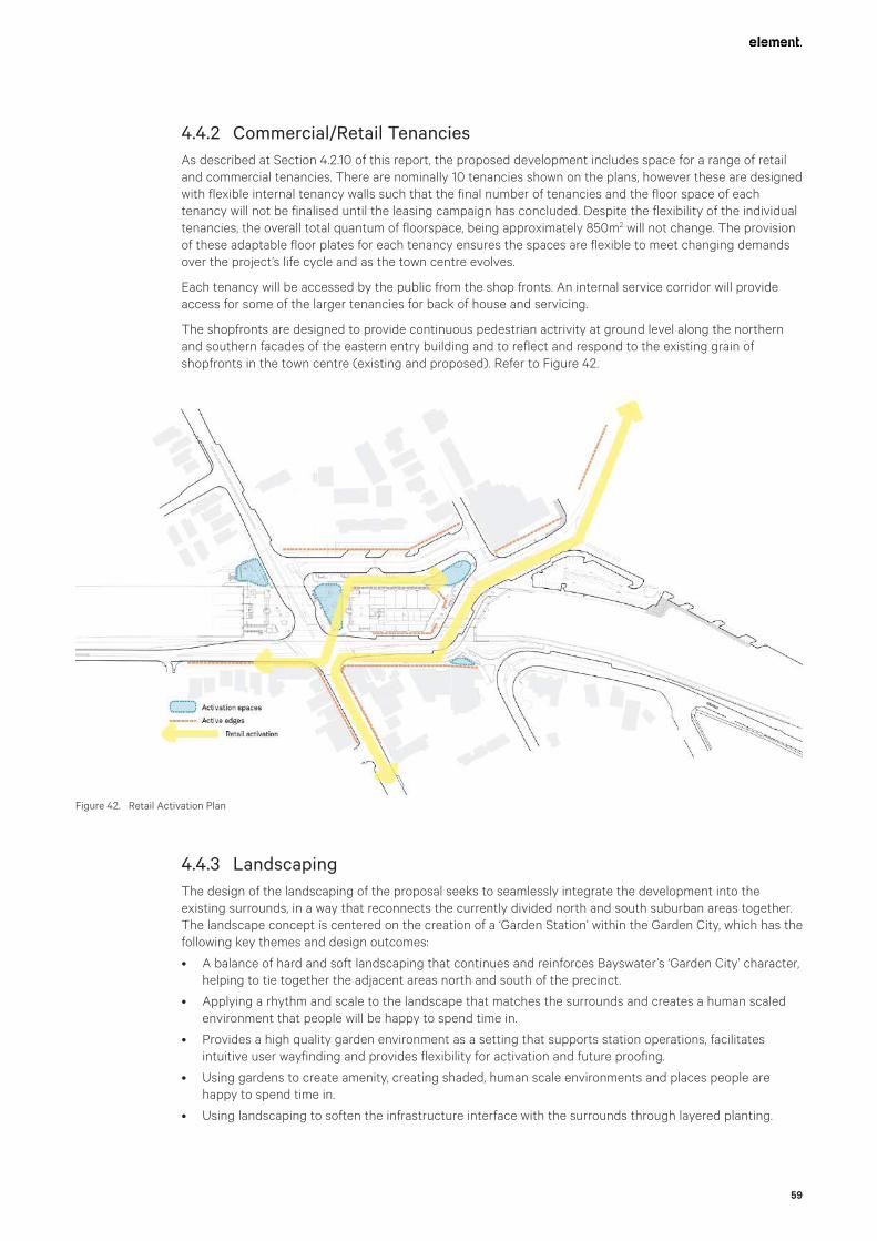
59
4.4.2 Commercial/Retail TenanciesAs described at Section 4.2.10 of this report, the proposed development includes space for a range of retail and commercial tenancies. There are nominally 10 tenancies shown on the plans, however these are designed with flexible internal tenancy walls such that the final number of tenancies and the floor space of each tenancy will not be finalised until the leasing campaign has concluded. Despite the flexibility of the individual tenancies, the overall total quantum of floorspace, being approximately 850m2 will not change. The provision of these adaptable floor plates for each tenancy ensures the spaces are flexible to meet changing demands over the project’s life cycle and as the town centre evolves.
Each tenancy will be accessed by the public from the shop fronts. An internal service corridor will provide access for some of the larger tenancies for back of house and servicing.
The shopfronts are designed to provide continuous pedestrian actrivity at ground level along the northern and southern facades of the eastern entry building and to reflect and respond to the existing grain of shopfronts in the town centre (existing and proposed). Refer to Figure 42.
4.4.3 LandscapingThe design of the landscaping of the proposal seeks to seamlessly integrate the development into the existing surrounds, in a way that reconnects the currently divided north and south suburban areas together. The landscape concept is centered on the creation of a ‘Garden Station’ within the Garden City, which has the following key themes and design outcomes:
• A balance of hard and soft landscaping that continues and reinforces Bayswater’s ‘Garden City’ character, helping to tie together the adjacent areas north and south of the precinct.
• Applying a rhythm and scale to the landscape that matches the surrounds and creates a human scaled environment that people will be happy to spend time in.
• Provides a high quality garden environment as a setting that supports station operations, facilitates intuitive user wayfinding and provides flexibility for activation and future proofing.
• Using gardens to create amenity, creating shaded, human scale environments and places people are happy to spend time in.
• Using landscaping to soften the infrastructure interface with the surrounds through layered planting.
Figure 42. Retail Activation Plan

Bayswater Station Redevelopment
60
• Expressing the gardens of the surrounding suburbs in scale and texture.
• Predominantly using low maintenance, endemic groundcovers and low shrubs particular to the region.
• Designing irrigation systems for the landscaped plaza, forecourt and carpark areas (to be designed by a specialist irrigation designer and/or subcontractor).
• Using large shade trees that create a dense canopy to sit beneath in a garden setting.
• Providing custom seating to provide multiple informal gathering spots.
• Designing well-lit and clear sight-lines to ensure safety whilst also maximising tree canopy and garden beds.
• Providing space to cater for activation strategies.
• Maximising greening to soften space in viable planting locations – careful consideration has been required to ensure viability of planting in low light conditions under the railway, with no access to rain.
• Feature trees with broad canopies are to provide shade in the summer months, and light throughout the winter.
• Arrival spaces and main activity nodes will incorporate the State’s wildflower initiative by using a selection of unique flora including a multitude of textures and forms whilst also ensuring year round flowering displays.
• Species shall be predominantly endemic to the area to ensure low water requirements and minimum pesticide use. A mix of Mature, 500L, 200L, 100L and 45L species are to be used.
• The selection of groundcovers and shrubs will be decorative, endemic where possible, characteristic of the area and suitable to the Swan Coastal Plain.
• All plantings within the rail corridor are to be lower than 500mm in height to ensure passive surveillance.
• Within the station forecourt, large format (nominally 600mm x 400mm) paving will create a cohesive ground plane.
An excerpt of the landscaping plan and a landscape section through the project are shown in Figures 43 and 44 below, demonstrating the above mentioned key themes and design outcomes.
Figure 43. Overall Landscape Plan (source: Hassell)

61
4.4.4 Tree Management and RetentionA tree survey of the entire site of the project works has been carried out and the results are contained in the report at Appendix O.
No discrimination has been made between trees within the railway reserve, that are under the control of PTA or within the public realm, that are under the control of the City of Bayswater.
A total of 172 trees were surveyed, of which 18 were not recommended for retention or were dead. A further 9 were found to need some form of remedial pruning.
The results of the survey will be used by Evolve Bayswater to determine where existing trees can be retained if at all possible. The scope of the project is, however, such that there are significant level changes and modifications to existing infrastructure so that such retention will be difficult to achieve in the majority of cases.
It is, however, noted that the current landscape plans call for planting of a total of 190 trees. An effort will be made to include species that reflect the existing trees that may need to be removed to make way for the project works, particularly within the station precinct.
Replacement trees will generally be selected based on the following qualities:
• Suitable to microclimate and adjacent landuse activity (Plaza, paved area corridor etc);
• A preference hierarchy of being Endemic to Bayswater -> Native (from southwest region of WA) -> Exotic; and
• In most instances, will be selected from the City’s preferred street tree list.
Evolve Bayswater will work collaboratively with the arborist and the City to protect remaining trees and will comply with the Australian and PTA Standards requirements to minimise the risks of construction activities on the health of those trees.
In discussions with the City to date it is recognised that any trees that are removed from within the current public realm will need to be replaced. It is also recognised that the City has expectations that there will be a tree replacement ratio for all of their trees that are removed. The exact tree replacement ratio will be a matter of negotiation with the City with agreement to be reached before the landscaping works within the precinct commence.
In this regard the City has indicated that replacement trees need not be planted within the project area but elsewhere within the City boundaries where rehabilitation works are underway or planned. In this regard, Evolve Bayswater will work with the City to agree the details of the tree replacement program.
4.4.5 Signage and WayfindingEfficient wayfinding ensures smooth passenger flow to and from the train station platforms and to and from the bus interchange facilities. It determines how easily people can navigate the station, navigate the bus interchange and navigate the surrounds, particularly during peak times.
Poor wayfinding can create barriers to the use of a station, it can create confusion, congestion and poor user experiences. Given the importance of signage and wayfinding to the design of the Bayswater Station, wayfinding has been a central pillar in the design approach to the development. Key design cues to assist with wayfinding include:
• Providing clear lines of sight to the station entrances;
• Providing expansive open concourses around the station entries;
Figure 44. Landscaping Section through Project Demonstrating the Three Landscape Typologies (source: Hassell)

Bayswater Station Redevelopment
62
• Continuing a modified grid street pattern with the Beechboro Road South extension to Whatley Crescent to assist with pedestrian orientation;
• Designating pedestrian crossings;
• Use of landscape markers and cues in the public realm surrounding the station; and
• Locating and designing the retail shop fronts to reflect a high street retail configuration which creates legibility and active edges.
At this stage of the design process a signage and wayfinding plan has not yet been developed, however the intention is that this will be prepared prior to the operation of the southern station platform. It is anticipated that this requirement will be conditioned as part of the approval of the development.
4.4.6 Public ArtEvolve Bayswater is committed to delivering public art as part of the development consistent with the METRONET Public Art Strategy. The thoughtful integration of art within the development is intended to provide opportunities for community connection, create safer more socially cohesive spaces, increasing dwell time and supporting businesses in the immediate area and around the station.
Public art is proposed to enrich the precinct by:
• reinforcing major gateway arrival points;
• strengthening wayfinding along key pedestrian corridors;
• creating must-see destination environments;
• activating the station and surrounds day and night; and
• revealing site histories and stories.
The public art proposed for Bayswater Station may take one of many forms including (for example):
• Interpretive elements (i.e. objects cast in bronze or aluminum, sand blasted text, image based plaques, decorative screens, sound elements and free flowing or indicative water elements);
• Functional elements (i.e. bus stops, seating or play elements);
• Projection artwork; or
• Light sculpture / night lighting.
A Public Art Coordinator is in the process of being appointed to coordinate artwork procurement and superintend the artwork project in consultation with the METRONET Public Art Program Coordinator.
The Public Art Coordinator’s key tasks will include:
• Collaboration with project team, design team and Noongar Working Group and community representatives where appropriate.
• Preparation of a public art strategy to confirm what opportunities will be developed into implemented projects; recommended themes for each project; associated recommended budget allocations; recommending a procurement methodology for each project; and recommending the level of design team and/or Noongar Working Group and community collaboration involved in each project.
• Preparation and implementation of a community engagement and communication plan (including the artist community) where appropriate.
• Preparation of procurement documentation (based on best-practice procurement methods) including the artist brief, commission agreement and associated documentation.
• Issue of briefs and promotion of the opportunity according to the agreed procurement methodology.
• Facilitation of the assessment and selection process.
• Facilitation of contract execution.
• Contract management.
• Superintending design development and documentation, fabrication and installation.
• Coordinating and submitting all close-out materials.
• Coordinating documentation throughout.

63
Ownership of public art is defined through the commissioning process, the contract and the land on which it is located. Through the contract with the artist, the artwork usually becomes the property of the commissioning body once the art is supplied and paid for. However, the contract may enable the commissioner and the artist to own joint copyright of the artwork.
Artwork located on public land is the responsibility of the managing authority. Where Evolve Bayswater has commissioned artwork for public land and that land is subsequently handed back to the control of the City, the artwork then comes under the ownership and maintenance of the City. For any METRONET public art commissioned for non-PTA land, agreements regarding handover to the City will be developed during public art planning phase and confirmed prior to the development of the commissioning contract.
4.4.7 Lighting
Station LightingLighting within the station will be designed to meet minimum PTA requirements as detailed in Table 3 below. Generally, all lighting will be of the LED style unless there are specific technical reasons for the selection of another form of lighting source.
Table 3 - Recommended Minimum Illumination Levels
Location Illumination Levels
Entrances, passageways and walkway 150 lux
Stairs & ramps 150 lux
Lifts See AS 1735.12 1999
Toilet & locker rooms 200 lux
Counter tops 250 lux
General displays 200-300 lux
Telephones 200 lux
Generally, lighting throughout the station will be designed in accordance with Australian Standards including for emergency lighting requirements. Allowance will also be made for consideration of Crime Prevention Through Environmental Design (CPTED) requirements to minimise security risks to the general public and PTA staff at the station. Lighting will be provided both within all the station buildings and on the platforms as well as to the external public areas and, in particular, for the various bus stops.
Details of the Luminaire Schedule and the proposed location of each type of luminaire are provided in the Electrical Drawings included in Appendix D.
Further detailed design is yet to be completed for feature lighting within the station and surrounding precinct. This nature and extent of feature lighting will be determined in conjunction with consideration of landscaping and public art installations. The details of feature lighting will also be discussed with the City and the community prior to finalisation.
Landscape LightingLighting within the public realm will be co-ordinated with the landscaping. The details of proposed lighting are contained in the electrical drawings in Appendix D. Consideration will also be given to incorporation of feature lighting within the landscaping that may also include public art installations. These details are yet to be designed but will be presented to the City prior to completion of the landscaping on the site.
Care will be taken to ensure all pathways are appropriately lit along their entire length and that garden areas are appropriately lit to minimise security and public safety risks.
Station Carpark LightingThe station carparking facility will be provided with lighting to meet PTA specifications and the relevant Australian Standards. Consideration will be given to the lighting required to meet accessibility requirements and also to ensure CPTED requirements for illumination are met.
Bayswater Station Redevelopment
64
Street LightingStreet lighting will be provided to all public roads and footpaths under the jurisdiction of the City to meet Western Power requirements. This includes lighting beneath the new bridge structures of the station on King William Street and Beechboro Road South.
Current lighting in the Town Centre is partly owned by the City and partly by Western Power. The future arrangements for street lighting have been discussed with the City but at this stage there has not been a definitive decision made as to the split of responsibility for street lighting within the project area. Nevertheless, the standard of street lighting to be provided will meet required illumination standards and will be installed and connected to the appropriate power supply by the Evolve Bayswater team in collaboration with Western Power and the City.
The PSP will also require lighting, and this will be designed to meet Main Roads’ requirements for such facilities and to match the current illumination levels along the path.
Emergency LightingEvolve Bayswater will design emergency lighting to meet PTA and other relevant Australian Standards. This will include design of electrical power supplies to the emergency lighting facilities that includes for up to 2 hours of battery supply in the case of a failure of the normal power supplies.

65
5. Appendix A - Site Details
5.1 Site Location and ContextBayswater Station is located within the centre of the Bayswater Town Centre area, which is situated both to the north and south of the railway reserve.
The existing station is currently located within the rail reserve and is separated from adjoining land parcels by Railway Parade and Whatley Crescent, which generally traverse in an east-west direction alongside the Perth-Midland line.
The station upgrade site generally slopes downwards from the periphery toward a low point at the intersection of King William Street/Whatley Crescent.
The proposed development will cover an area of approximately four hectares.
Refer to Figure 45 – Location Plan.
5.2 Property DescriptionA significant portion of the proposed station upgrade works will be located within the existing rail reserve. However, a number of surrounding landholdings and road reserves will be impacted by the proposed upgrades as identified in Table 4 on the following page.
The project area contains a number of existing landscaped areas that will be removed and replaced as part of the ongoing works. A small portion of works will occur within Lot 2 (No.92) Railway Parade, Bayswater where an existing Magnolia tree is located that is identified on the City’s Municipal Inventory. The proposed development will not have any impact on the tree, which will be appropriately protected and managed as part of any future works in this location through the implementation of a flora and vegetation monitoring and management plan.
Refer to Figure 46 – Site Plan and Figure 47 – Site Aerial.
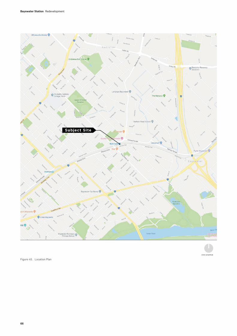
Bayswater Station Redevelopment
66
Figure 45. Location Plan
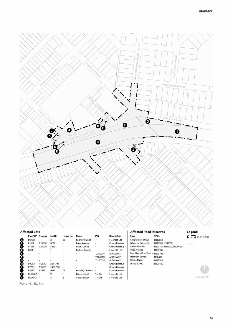
67
Figure 46. Site Plan

Bayswater Station Redevelopment
68
The following table identifies the relevant landholdings that will be directly impacted by the proposed development.
Table 4 – Site Details
Street Name Description Title Plan and Lot Owner
King William Street, Bayswater
Road N/A Pin 11819563 State of WA / City of Bayswater
Coode Street, Bayswater
Road N/A Pin 11819305 State of WA / City of Bayswater
Whatley Crescent, Bayswater
Road N/A Pin 11819565 & 11832533 State of WA / City of Bayswater
Railway Parade, Bayswater
Road N/A Pin 11820785 State of WA / City of Bayswater
Rose Avenue, Bayswater
Road N/A Pin 11820784 State of WA / City of Bayswater
Drake Street, Bayswater
Road N/A Pin 11820786 State of WA / City of Bayswater
Beechboro Road South, Bayswater
Road N/A Pin 11820792 State of WA / City of Bayswater
Hamilton Street, Bayswater
Road N/A Pin 1288884 State of WA / City of Bayswater
Rose Avenue, Bayswater
Crown Reserve 23080
LR3151/374 & LR3151/375
Lots 5269 & 5365 on Plan 1321
City of Bayswater
Railway Parade, Bayswater
Carpark 1658/634 Lot 2 on Diagram 8433 City of Bayswater
Railway Parade, Bayswater
Freehold 1049/324 Lot 1 on Diagram 471 City of Bayswater
1 Coode Street, Bayswater
Freehold 1049/324 Lot 2 on Diagram 471 City of Bayswater
3 Coode Street, Bayswater
Freehold 308/26 Lot 3 on Diagram 471 City of Bayswater
Railway Parade, Bayswater
Crown Reserve 12520
LR3156/229 & LR3024/45
Lots 504 & 2630 on Plan 2052
Public Transport Authority
Railway Parade, Bayswater
A Rail Way N/A Pins 12260397, 11658809 & 12260396
Public Transport Authority
Whatley Crescent, Bayswater
Crown Reserve 35891
LR3048/73 Lot 9915 on Plan 2285 Minister for Police & Emergency Services
Refer to Appendix E - Certificates of Title

69
Figure 47. Aerial Plan

Bayswater Station Redevelopment
70
5.3 Environmental ConsiderationsThe site is not located within a bushfire prone area.
A desktop search of the Department of Water and Environmental Regulation’s (DWER) Contaminated Sites Database confirms that the subject site is not identified as a contaminated site. Given the historical use of the land within the site, the following sources of contamination may be encountered during earthworks (cut to fill) required to be undertaken for the project:
• Historical fill materials, particularly within the rail reserve;
• Actual and Potential Acid Sulfate Soils (ASS);
• Organochloride pesticides (OCPs) in soils beneath building slabs;
• Hazardous materials within buildings or other infrastructure (pits and underground pipes); and
• Soakwells / sumps.
Accordingly, the Construction Environmental Management Plan (CEMP) included at Appendix M sets out a contaminated land management strategy to deal with any of the above if found during construction.
A desktop assessment for the potential to encounter ASS across the site was conducted using the ASS risk maps provided by the Department of Water and Environmental Regulation (DWER). The ASS risk maps indicate the site to be generally within an area mapped as ‘Moderate to low risk of ASS occurring within 3 m of natural soil surface’. Areas of ‘High to moderate risk of ASS occurring within 3 m of natural soil surface’ are shown to be present east of Coode Street, north of Railway Parade near Mills Avenue and to the east of the project area.
Golders (2018) and JBS&G (2019) have conducted ASS Investigations of the site to a maximum depth of 2 mbgl (Golders) and 5.5mbgl (JBS&G). A total of 58 samples have been analysed for Suspension Peroxide Oxidation Combined Acidity and Sulphur (SPOCAS).
The ASS area was found to encompass the entirety of the proposed ground disturbance area and the northern carpark area from 3.5 m bgl. It is likely excavation works below 3.5 m in this area could result in ASS impacts if not effectively managed. However, the current design is unlikely to require deep excavations except in respect of piled foundations. In this case soil removed for bored piles and secant piles will be collected and removed from site for proper disposal as it will be mixed with bentonite as part of the construction process.
Further investigation of ASS is not proposed but, subject to project specific dewatering requirements, a Dewatering Management Plan will be prepared as a subplan to the CEMP, in accordance with DWER guidelines. This is set out in the CEMP included at Appendix M.
The CEMP and the Construction Plan (CP) also include management plans for:
• Construction noise and vibration management;
• Flora and vegetation management;
• Aboriginal heritage and unexpected finds management; and
• Out of hours noise management plan (if out of hours works required).
5.4 Heritage ConsiderationsA desktop search of the Department of Planning, Lands and Heritage’s (DPLH) Aboriginal Heritage Inquiry System indicates that there are no places of Aboriginal heritage significance on the subject site.
Searches of the Heritage Council’s State Heritage Register and the City’s records indicate that the proposed development will not directly impact any identified European heritage sites. Nevertheless, the property condition survey will be undertaken as a basis for demonstrating no construction impacts on heritage buildings within the zone of influence of the project.
71
6. Appendix B – Planning Framework and Assessment
Due to the public infrastructure related nature of the proposed development, there are limited planning framework standards and requirements against which to assess this type of infrastructure. Notwithstanding, the following provides an overview and assessment against the most relevant planning framework requirements.
6.1 Perth and Peel @ 3.5 millionThe Perth and Peel @ 3.5 Million framework (the framework) is an overarching suite of documents, which builds on the vision established under Directions 2031. It aims to achieve a more consolidated urban form to meet long–term housing needs and strengthen key activity centres and employment nodes as the Perth and Peel population grows to 3.5 million. The framework guides infill development and advocates for greater use of activity centres, transport corridors and station precincts to support a diversity of higher-density accommodation.
The Bayswater Town Centre is identified within the framework as a station precinct and a major growth area. Station precincts are defined under the framework as areas surrounding train stations and major bus interchanges with the potential to accommodate transit-oriented developments and aim to:
• Promote and facilitate public transport use;
• Capitalise on the investment made in public transport infrastructure;
• Create transit stations as destinations; and
• Establish high levels of amenity, safety and permeability of the urban form.
The proposed upgrades to Bayswater Station are entirely consistent with guidance provided by the framework and TOD aims. The upgrades will improve the existing vehicle and pedestrian connections both in and around the station precinct, promote public transport use and provide an opportunity for further investment and growth in an around the station precinct and within the Bayswater Town Centre generally.
6.2 Planning Control Area No. 135A Planning Control Area (‘PCA’) under s.112 of the Planning and Development Act 2005 (‘PD Act’) was declared over the area of the Bayswater Train station and surrounds on 23 April 2019. PCA 135 includes the site of the proposed Bayswater Station along with additional land that was identifying as being required for the delivery of the METRONET project. PCA 135 is shown in Figure 48.
Refer to Figure 48 - Planning Control Area 135 with site boundaries shown

Bayswater Station Redevelopment
72
Figure 48. Planning Control Area 135 with site boundaries shown

73
As the Bayswater Station upgrade is located within PCA 135, development approval from the Western Australian Planning Commission (‘WAPC’) is required for any non-exempt works, as set out under Section 115 of the PD Act, which states:
1. A person who wishes to commence and carry out development in a planning control area may apply to the local government in the district of which the planning control area is situated for approval of that development.
2. An applicant is to submit to the local government such plans and other information as the local government may reasonably require.
3. The local government, within 30 days of receiving the application, is to forward the application, together with its recommendation, to the Commission for determination.
Therefore, within 30 days of receiving the application, the City is required to forward the application, together with its recommendation, to the WAPC for determination. It is expected that some flexibility will be applied to this timeframe to accommodate the internal referral and assessment process within the City and to allow the proposal to be presented to a Council meeting for consideration and comment.
6.3 Metropolitan Region SchemeGiven that a redevelopment area has been declared around the Bayswater Train Station and Town Centre pursuant to the MRA Act, the land has been excised from the MRS Scheme Maps.
Whilst the redevelopment area has been declared, at this stage the required redevelopment scheme is yet to take effect. On this basis the Bayswater land is not yet subject to the redevelopment scheme and the provisions of the MRS continue to apply, except to the extent that this is varied by the effect of the PCA.
Prior to the declaration of the redevelopment area, the site was located on land zoned ‘Urban’ and/or reserved for ‘Railways’ under the MRS. Refer to Figure 48 – Metropolitan Region Scheme Maps Extract (which is taken from the MRS prior to the METRONET East Redevelopment Area being declared).
Refer to Figure 49 – MRS extract
Clause 16 (1a) of the MRS provides that development on reserved land that is owned or vested in a public authority may be commenced or carried out without approval if the development is permitted development or is expressly authorised under an Act to be commenced or carried out without the approval of the WAPC. However, in this case, these provisions are overridden by the effect of the PCA which requires all development to be approved by the WAPC.

Bayswater Station Redevelopment
74
Figure 49. MRS extract (prior to the declaration of the Redevelopment Area) with site boundaries shown

75
6.4 METRONET Act The Railway (METRONET) Act 2018 (‘METRONET Act’) provides that “METRONET works” can be carried out without the approval of the WAPC despite any provisions in the MRS or the PCA.
METRONET works are defined as:
works for the purpose of, or in connection with, a METRONET railway but does not include the construction or alteration of a railway station, or any related car parks, public transport interchange facilities or associated means of pedestrian or vehicular access. (our emphasis added)
Accordingly, all the railway works other than works for the new stations, works in relation to car parks, bus interchange facilities and associated means of pedestrian and vehicle access are exempt works. On this basis development approval is required for all works associated with:
• The proposed new stations/platforms.
• The bus interchange facilities.
• Car parking.
• Road realignments associated with the station development within the PCA.
• Pedestrian and vehicular access and paths associated with the above.
Development approval is not required for other railway infrastructure in either the existing railway reserve or on non-railway land that is outside of PCA 135 and which is still subject to the requirements of the MRS. This is because the METRONET Act also exempts these works from requiring development approval under the MRS. As such any railway works either side of the new station works beyond the bridge abutments/platforms are all works that are exempt from the requirement for development approval.
On this basis, Evolve Bayswater is seeking development approval from the WAPC under PCA 135 for all non-exempt development proposed as part of the Bayswater Station development. Whilst some works are exempt from the requirement for development approval, the plans and specialist material provided at Appendices D to Q may illustrate and/or include detail of the exempt works as well as the works requiring WAPC approval. This is because this material has been prepared to inform and guide the project holistically given that the construction of exempt and non-exempt works are intrinsically interconnected as part of the delivery and ultimate operation of the rail infrastructure.
6.5 Draft METRONET East Redevelopment SchemeThe draft METRONET East Redevelopment Scheme was released for public comment in August 2020. This period closed on the 15 September 2020.
The Draft METRONET East Redevelopment Scheme is to be administered by DevelopmentWA, the scheme is designed to guide development around the Bayswater, Midland and High Wycombe Stations to maximise development opportunities and ensure that station upgrades and future development of the surrounding areas are well integrated.
The final scheme is expected to be in place by late 2020, at which point the planning authority for the site will transfer from the WAPC (under the PCA) to DevelopmentWA.
The Draft METRONET East Redevelopment Scheme includes the site in the ‘Core’ Precinct of the Bayswater Project Area. The proposed development is consistent with the preferred and contemplated land uses for the precinct and is consistent with the intention of the scheme to develop a strong sense of place, an activated and interesting public realm, diversity of activity, high quality and sustainable development.
Development policies and design guidelines for the METRONET East Redevelopment areas are expected to be released for the area in due course, however these are not presently available for review.

Bayswater Station Redevelopment
76
6.6 City of Bayswater Local Planning FrameworkAs indicated previously, due to the operation of the PCA development approval is not required from the City under the applicable local planning scheme2.
Notwithstanding, under the City’s Local Planning Scheme No. 24 (LPS24), the proposed upgrades will only impact on local roads that are either not zoned or are zoned ‘local distributor roads’ under the City’s LPS24 (refer to Figure 50 - LPS24 Extract). Upgrades within the local road reservations proposed through the development concept are entirely consistent with the purposes of a road and are required as part of the overall station upgrades.
Refer to Figure 50 – LPS24 extract.
Upgrades proposed to the pocket park within the Local Public Open Space Zone are also consistent with the purposes of the Local Public Open Space Zone.
The City’s draft Bayswater Town Centre Structure Plan (BTCSP) is intended to guide the future growth and activity within the town centre and covers an area within a 400 metre radius of the existing Bayswater Station. Although the draft BTCSP does not apply directly to the development of the Bayswater Station, the proposed upgrades are generally consistent with the BTCSP through providing improved connections for pedestrians, cyclists and improving the existing service offer and interchange facilities. It is noted that the WAPC recently signed off on the BTCSP subject to modifications which are currently being progressed and finalised.
6.7 State Planning Policy 5.4 – Road and Rail NoiseThe criteria relevant to managing the impacts of road and rail noise are outlined within the WAPC’s State Planning Policy 5.4 Road and Rail Noise (SPP 5.4). The objectives of SPP 5.4 are to:
• Protect the community from unreasonable levels of transport noise;
• Protect strategic and other significant freight transport corridors from incompatible urban encroachment;
• Ensure transport infrastructure and land-use can mutually exist within urban corridors;
• Ensure that noise impacts are addressed as early as possible in the planning process; and
• Encourage best practice noise mitigation design and construction standards.
SPP 5.4 sets out noise targets that are to be achieved by proposals to which the policy applies. The target is to achieve: These criteria address the following:
• Acceptable indoor noise levels in noise sensitive areas (e.g. bedrooms and living rooms of houses); and
• A ‘reasonable’ degree of acoustic amenity for outdoor living areas on each residential lot.
The policy recognises that in some instances, it may not be reasonable and/or practicable to meet the outdoor noise targets. Where transport noise is above the noise targets, measures are expected to be implemented that balance reasonable and practicable considerations with the need to achieve acceptable noise protection outcomes.
A detailed assessment of the proposed development has been undertaken in relation to noise impacts from train operations. A copy of the report is included at Appendix I. This report concludes that noise levels will be above the current noise target of SPP 5.4 however with acoustic walls and absorptive panels applied as recommended in the report, the development is expected to meet the project criteria established for this project, which seeks to minimize noise as far as reasonably practicable.
2 As public works, they would have been exempt from the requirement for local scheme approval irrespective of the PCA.
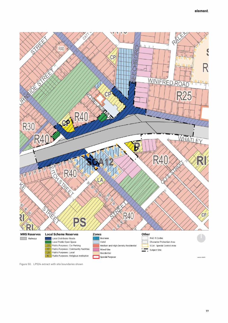
77
Figure 50. LPS24 extract with site boundaries shown

Bayswater Station Redevelopment
78
6.8 State Planning Policy 7.0 – Design of the Built EnvironmentState Planning Policy 7.0 – Design of the Built Environment (SPP 7.0) requires new development proposals and planning frameworks to address the criteria within the policy which has been created to promote good design outcomes. A Guiding Design Principles Plan prepared by element in conjunction with Hassell addressing how the development responds to the required design principles is included at Appendix R. An assessment against the SPP 7.0 requirements is included in the table below.
Table 5 – Assessment Against SPP 7.0
Principle Response
Context and Character
Good design responds to and enhances the distinctive characteristics of a local area, contributing to a sense of place.
The proposed development has been designed with careful consideration of the existing character of Bayswater, which includes the history of the place, the existing rhythm of built form, the garden characteristics of the area and the endemic species of the area.
The development has also been designed to respond carefully to the constraints and opportunities of the existing place, seeking to minimise the station footprint within the spatial constraints of the site and provide the opportunity to better connect the northern and southern parts of the town centre, which have traditionally been split by the rail corridor.
The architecture has been designed to ensure that the development melds with the existing place, contributing and continuing the streetscape with active tenancy frontages, responding to and reinforcing the main routes of travel, providing new community spaces and landscaping that stitch the town centre together and harmonise the place whilst providing for an array of different types of activities.
Landscape quality
Good design recognises that together landscape and buildings operate as an integrated and sustainable system, within a broader ecological context.
As detailed in the Urban Design and Landscape Concept Report prepared by Hassell at Appendix H1, the ‘Garden Station’ is the over-arching conceptual driver of the landscape design. The design seeks to:
Integrate the design principles of ‘Rhythm’ and ‘Infrastructure’;
• Utilise three garden typologies that each respond to specific site conditions: The Hillside Garden, The Water Garden and The Home Garden; and
• Use the garden typologies to express a different character that will be created through planting, interpretation and spatial structure.
It is clear in the Urban Design and Landscape Concept Report prepared by Hassell at Appendix H1 that the landscape design has carefully considered the opportunities and constraints of the site and has been designed in an integrated manner with the proposed structures and buildings. It is also clear that the landscape design responds to the need to be sustainable and ecologically responsive, utilising the principles of WSUD and the use of native and endemic species that will support local bird life.
Built form and scale
Good design ensures that the massing and height of development is appropriate to its setting and successfully negotiates between existing built form and the intended future character of the local area.
The architecture of the development draws upon the concept of Engineered Elegance with Human Scale.
It has been necessary to carefully balance the engineering / structural / functional requirements of the new station and railway bridges with the need to also create a new, high quality urban realm that is befitting of the Bayswater Town Centre and that achieves the vision for Bayswater as a vibrant and activated precinct with the station plaza providing for a meeting place for the community.
Hassell has sought to carefully break down the scale of the structures with the considered use of cream toned concrete, elegantly designed weather protection canopies, vertically ribbed cladding to the bridge facades, use of coloured aluminium battens to the soffit of the undercroft and use of copper toned colour to the soffits of the weather protection canopies on the station platforms. All of these design elements provide shape, colour, contrast and warmth and represents the negotiation of this design between the existing setting of the development and the engineering and structural requirements for the station.

79
Principle Response
Functionality and build quality
Good design meets the needs of users efficiently and effectively, balancing functional requirements to perform well and deliver optimum benefit over the full lifecycle.
The proposed design considers the future development and integration of the Morley-Ellenbrook line (MEL) at this location.
Pedestrian and cycling movements are maintained and improved throughout the precinct, consistent with the existing Bayswater Town Centre Structure Plan.
Bus services and associated infrastructure are seamlessly integrated within the public realm to improve patron experience, convenience and service efficiencies without detrimental impacting the aesthetic quality of the area.
Durable high quality materials are proposed that meet functional requirements and to meet life cycle expectations for key public infrastructure.
Sustainability
Good design optimises the sustainability of the built environment, delivering positive environmental, social and economic outcomes.
The proposed design incorporates GreenStar rating into the project requirements.
Active transport is also encouraged through the focus and investment on:
• Pedestrian amenity, which is fundamental to the overall design. Facilitating safe and direct pedestrian access to the station entries, bus interchange facilities and through the town centre is a fundamental part of the design. Finer grain details have also been considered such as the provision of lightwells within the elevated bridge structure to provide solar access and natural lighting at the ground level, enhancing pedestrian amenity.
• Planning and providing significant bicycle parking facilities, to support alternative transport modes accessing the station.
• Facilitating the improved use of public transport as a result of the station upgrade, in itself a key sustainability initiative, that will reduce demand on non-renewable resources.
Sustainability is also facilitated through the inclusion of WSUD in the landscape design and utilisation of waste reduction and diversion targets in the Operational Waste Management Plan.
Amenity
Good design provides successful places that offer a variety of uses and activities while optimising internal and external amenity for occupants, visitors and neighbours, providing environments that are comfortable, productive and healthy.
High quality design and use of materials will allow station entrances to be read as part of the wider town centre area and not standalone pieces of infrastructure.
Small scale retail/commercial land uses will locate within the station buildings. An expansive area of landscaped plaza will subsequently allow for more informal land uses and connections to occur, connecting the station infrastructure to the wider town centre area.
Both internal and external station amenity will consider the pedestrian environment and will ensure a DDA compliant design is achieved.
Legibility
Good design results in buildings and places that are legible, with clear connections and easily identifiable elements to help people find their way around.
Whatley Crescent is realigned to both improve the existing vehicle movements through the site and allow for the prioritisation of pedestrian movements.
The realignment of Whatley Crescent provides an additional visual and physical connection between the northern and southern extents of the town centre, further improved by station infrastructure being elevated.
The distinctive station structure, ground level entry points and a more clearly defined and sign posted ground level movement network will contribute to easy wayfinding and legibility across the town centre. Landscaping treatments will serve to reinforce desired movement patterns and direct people to safe street crossing points, bus services and station entry points.

Bayswater Station Redevelopment
80
Principle Response
Safety
Good design optimises safety and security, minimising the risk of personal harm and supporting safe behaviour and use.
Elevated rail bridges enable vehicles to safely traverse through the site while improving the pedestrian amenity below through allowing good solar access.
Key cycling movements through the site are separated from pedestrians, through the use of the PSP, for increased safety.
Safe pedestrian and cycle movements have been prioritised through the design, which allows good access to and from the public plaza and station in an environment that embraces casual surveillance opportunities.
The station will provide lighting and cctv coverage to PTA standards (this includes areas where pedestrians will congregate as well as bike storage and u rails.
Community
Good design responds to local community needs as well as the wider social context, providing environments that support a diverse range of people and facilitate social interaction.
The design responds to the existing site characteristics to provide enhanced connections between the surrounding town centre and the proposed station entrances.
A substantial area of landscaped plaza surrounding the station provides an opportunity for all users to integrate within the wider area safely and efficiently.
As a consequence of the station upgrade it is expected that a greater portion of the wider community will access the town centre. This is expected to not only be to access public transport but also the enhanced range of goods, services and entertainment opportunities that will follow as the precinct revitalises. Social interaction will be enhanced as the amenities on offer in the area improve over time.
This concept design balances the community’s priorities by:
• Creating new public spaces, both around the station and at the Whatley Crescent-Hamilton Street connection;
• Supporting pedestrian friendly streets with more open space under the rail bridge, better phasing at the traffic signals and reducing road crossings for bus-train transfers;
• Improving traffic conditions by reducing Whatley Crescent to one lane in each direction, removing one set of traffic signals and prioritising local traffic in the area;
• Creating station structure and design that integrates with the town centre; and
• Supporting long-term opportunities for future growth in the town centre.
Lighting and public art are also proposed to deliver a further layer to the design aesthetic which will enhance and build further connection with the local community.
Aesthetics
Good design is the product of a skilled, judicious design process that results in attractive and inviting buildings and places that engage the senses.
The Urban Design and Landscape Concept Report prepared by Hassell at Appendix H1 and the Landscape Design Approach Report prepared by Evolve Bayswater in conjunction with Hassell at Appendix H2 demonstrate the evolution of the design ideals for the public realm and landscaping. When read in conjunction with the architectural plans and renders, it is clear that a judicious process has been applied for the design approach and that it is the culmination of skilled design expertise, resulting in new station infrastructure and a new place that will set a benchmark for Western Australian train stations. The proposed design will be further layered with the lighting and public art proposals to provide a further fine grained element to the design and to enhance the manner in which this place will invite and engage the community.
It is considered that the design outcome is holistic and is very well considered, setting a positive precedent for the future development of the town centre.
81
6.9 Development Control Policy 1.6 – Planning to Support Transit Use and Transit Oriented Development
WAPC Development Control Policy 1.6 (DC1.6) seeks to maximise the benefits to the community of an effective and well used public transit system by promoting planning and development outcomes that will support and sustain public transport use.
The proposed station upgrades are considered to be consistent with the policy guidance in that the upgrades:
• Are of an appropriate scale provide for future growth in patronage (in terms of number of gates, vertical transport options and large concourse areas);
• Provides the second station platform for the future MEL;
• Will provide a high standard of amenity for all users;
• Will significantly improve existing pedestrian connection to and through the site by improving walkability;
• Will modify the existing street layout to enhance usability by both commuter and recreational cyclists, importantly separating high speed commuting and recreational cyclists (via the bridge) from the proposed station plaza;
• Considers ongoing safety and operational requirements to ensure the facility is appropriately serviced and maintained as a safe and inviting station for all users; and
• Will improve the existing service operations and bus interchange facilities, in turn promoting:
– Greater use of the public transport services; and
– The potential for higher density residential development and other appropriately located commercial land uses within the town centre in close proximity to the station.
6.10 Guidelines – Acid Sulfate Soils Planning GuidelinesThe WAPC’s planning guidelines for ASS outline a range of matters to be addressed at various stages of the planning process to ensure that the development of land containing ASS is planned and managed to avoid potential adverse effects on the natural and built environment.
There is the potential that ASS may occur within areas of the proposed development being undertaken. A large portion of the site is classified as having a ‘moderate to low’ risk of ASS including a small portion at the intersection of Rose Avenue and Railway Parade as well as a small area located toward the western extent of works being undertaken within the railway reserve.
The impacts associated with ASS can be associated with an increase in acidity and/or the release of heavy metals into the environment, resulting in a number of potentially detrimental impacts. The impacts of ASS can be avoided through a number of methods that deal with the issue, which, if identified as being necessary, would be addressed in an ASS management plan at the time of development.

Bayswater Station Redevelopment
82
6.11 Environmental Protection (Noise) Regulations 1997The Environmental Protection (Noise) Regulations 1997 (the Noise Regulations) operate as a prescribed standard under the Environmental Protection Act 1986 and set limits on noise emissions.
A detailed noise assessment has been completed for the proposed development to consider the operational stages of the development. The operational noise requirements of the railway have been defined by PTA in the Scope of Work and Technical Criteria for the project as per the following table.
Table 6 - Project Rail Operations Noise Criteria
Parameter Criterion1 Value Basis
Rail Operations – Noise Generally
Noise levels from rail operations will be managed as low as is reasonably practicable.
Demonstrated SPP5.4
Rail Operations – Airborne Noise Target Level
Noise mitigation must be considered where the noise level is at or above the prescribed rail operations – Airborne Noise Target Level at an external distance of 1 metre from a suitably representative building facade with a noise sensitive use located on noise sensitive premises and 1.5m above ground, with LAmax applicable to the 95th percentile train pass by event.
LAeq,day 60 dB
LAeq,night 55 dB
LAmax 75 dB
SPP5.4,
(LAmax - Industry best practice)
Rail Operations – Airborne Noise Design Level
Noise mitigation must be provided where the combined noise level resulting from the proposal and existing rail operations is both
• above the rail operations – Airborne Noise Target Level; and
• above the LAeq,day or LAeq,night noise level that would result from operation of existing Rail Infrastructure prior to the proposal.
At an external distance of 1 metre from a suitably representative building facade with a noise sensitive use located on noise sensitive premises and 1.5m above ground, with LAmax applicable to the 95th percentile train passby event.
Demonstrated Bayswater Station Upgrade, Reference Design, Noise and Vibration Assessment, SLR, 2019
1 Airborne noise criteria are referenced to 20 microPascals (dB re 20μPa). Vibration criteria are referenced to 1nm/s (dB re 1nm/s), use the subscript ‘v’ and are assessed on the basis of 1 second root mean square (RMS) values.
The noise assessment provides the results of detailed modelling with the basis of that modelling being the results of on-site monitoring of noise generated by train movements on the existing tracks at nearby residences. A copy of the assessment report is included at Appendix I.
Evolve Bayswater will also undertake operational compliance testing once the southern station is opened to demonstrate actual compliance with the nominated noise limits.
Further detailed modelling will be carried out as well as compliance testing but by others once the MEL project is completed.
The Construction Plan (CP) and Construction Environmental Management Plan (CEMP) both deal variously with construction noise management (refer to Appendices M and O).
The CP and CEMP consider the requirements of the Noise Regulations with respect to construction noise. Ongoing assessment and verification of these measures will occur during construction to ensure the railway construction complies with the prescribed standards of the Noise Regulations.

83
7. Appendix C – Technical Considerations
7.1 Noise and Acoustic AttenuationEvolve Bayswater has engaged Lloyd George Acoustics to prepare an Operational Noise Assessment to support the proposed development (refer Appendix I). This document outlines the manner in which the noise impacts and acoustic attenuation requirements have been assessed for the operational phases of the project. It includes recommendations that deal with how noise is to be attenuated from the use of the rail lines and station platforms. The key findings of this report include:
• The project criteria have been determined by both measurement of existing noise levels and the setting of target noise levels.
• The noise levels of the interim railway layout to be constructed by Evolve Bayswater and the ultimate rail layout to be in place when the MEL project is completed are reasonably similar.
• Increased train movements in the ultimate scenario are offset by the increased use of 3 car sets rather than 4 car sets, with 3 cars being quieter.
• Noise walls are required in certain locations to attenuate noise from the railway line. Figure 49 below shows where these are to be located generally in PCA 135 noting that approval for noise mitigation is only required where this is associated with noise from the station located between the bridge abutments.
The noise walls are to be installed sufficient to mitigate noise generated from both the interim railway layout to be constructed by Evolve Bayswater and also the ultimate railway layout when the MEL project is completed. This is to avoid, as far as is possible, the need to modify the noise walls after they are installed by Evolve Bayswater.
Refer to Figure 51 – Locations of noise walls in PCA 135
• The noise walls have not yet been designed, however will need to provide a minimum Rw
28 performance or, where this is unknown, achieve a surface mass of a minimum of 15kg/m2. Walls shall be acoustically absorptive on the railway side to minimise reflected noise. Such walls may come as a complete unit or as add on panels.
• The wall design is calculated to achieve the project criteria. It is noted that in many instances, noise levels will be above the current noise target of SPP 5.4. The overall project objectives are to minimize noise as far as reasonably practicable. As such, it is recommended the project also incorporate rail web dampers.
• Walls on the east side of the station and north side of the track have not been assessed as noise walls in this area will form part of the MEL project.
• No walls are shown on the station platforms themselves. This is on the basis of the station platform being a minimum of 1.2 metres higher than the top of the rail (on the residence side) and thus providing a barrier. Additional noise mitigation measures (eg absorptive panels incorporated on the vertical faces of both sides of the trough shaped bridges near the station) will be used to achieve the noise level targets stipulated. This is on the basis that the majority of trains (at least 95%) stop at Bayswater Station and therefore their speed approaches 0km/hr.

Bayswater Station Redevelopment
84
Figure 51. Locations of noise walls in PCA 135
The Operational Noise Assessment has also been designed to address the specific requirements of Advice Note 6 and Condition 8 as applied to the 2019 Approval with the view that these requirements can be modified in relation to the approval of this proposal. More specifically the following requirements have been addressed as follows:
• As indicated above, the acoustic assessment has concluded that no walls are needed on the station platforms due to the design of these platforms creating a barrier. Measures such as absorptive panels on the vertical facades of the trough shaped bridges near the station will be investigated and implemented as required.
• Adverse visual impacts are not expected from these noise mitigation measures within the station area.
• Noise and vibration from construction activities is addressed at Section 8.2 of the Construction Plan (CP). The CP also sets out the circumstances for noise monitoring during construction activities.
• The Operational Noise Assessment has had regard to the relevant reference documents.
7.2 VibrationDuring the operational phase of the project the proposed stations are not expected to have any ongoing vibration impacts. There will be some ongoing vibrations associated with trains on the rail line, however ballast mat will be used for the entire project with resilient rail fasteners on the concrete structures to minimize vibration.
Vibration from construction activities is being carefully assessed and monitored. For further details please refer to sections 7.12 of this report and the section 8.2 of the CP.
7.3 Movement NetworkA traffic simulation model has been developed to identify and assess the traffic impacts of these changes, which include the reconfiguration of the road network described above. The traffic modelling assessed the year of opening as the critical review (i.e. 2021), as well as 5 and 10-year planning horizons for a longer term overview (i.e. 2026 and 2031) over a wider area which extends to Guildford Road, Garratt Road, Coode Street, Beechboro Road South and Whatley Crescent. It is noted that the expected date for opening of the new intersection is approximately May 2022.
85
The modelling found that the PM peak is consistently more congested in all the analysis years. It was found that in 2021 (year of opening), the following intersections are significant constraints to the modelled networks performance:
• Whatley Crescent / King William Street: This intersection is overcapacity in the PM Peak with heavy demand from both Whatley Crescent and King William Street travelling towards Beechboro Road South. Queueing on King William Street northbound extends back, blocking Murray Street.
• King William Street / Guildford Road: This intersection suffers heavy delays (i.e. level of Service F) on the north and south approaches (i.e. King William Street) primarily in the PM peak period, as the signal timings naturally prioritise throughput along Guildford Road. The right-turn traffic from Guildford Road (east) to King William Street (north) also consistently queues back beyond the capacity provided in the turn pocket at the intersection, subsequently blocking the adjacent lane and reducing westbound throughput to a single lane.
• Roberts Street / Guildford Road: This is a three-leg priority-controlled intersection, with a considerable amount of traffic turning right from Guildford Road westbound onto Roberts Street. As these vehicles have to gap seek (limited opportunities available) they queue along Guildford Road and reduce its capacity to a single lane in the westbound direction.
In the opening year, impacts to average vehicle travel time along Whatley Crescent, King William Street and Guildford Road were also considered, as these are deemed to be the critical routes within the model. These impacts are recorded as a maximum of 30 seconds in the AM peak and one minute in the PM peak. There is a significant saving of over three and a half minutes in travel time for Beechboro Road South / Whatley Crescent westbound in the AM Peak, with marginal increases in the PM Peak.
Rat-running routes were identified as connections between either Whatley Crescent or Coode Street to Guildford Road, in order to bypass the signalised intersections on King William Street. These rat runs use the local roads of Slade Street, Murray Street, and Roberts Street. Note that some of these rat-running routes occur currently within the existing road network.
The overall network statistics show that as expected, as traffic volumes increase, delay on the network increases and average speed within the network decreases. The overall network statistics also highlight that by the year 2031, the network breaks down due to congestion with not all of the demand being able to enter the network within the modelled hours in either the AM or PM peaks.
The integration of the upgraded railway station into the Bayswater Town Centre restricts the space available for road and intersection expansion and therefore the ability to improve the capacity of the road network through the area. In addition, the expansion of the 40km/hr speed zoning through the Town Centre increases the occurrence of rat-running with drivers seeking alternate, faster routes away from the primary routes through the area.
As identified throughout the traffic modelling report (refer to Appendix R), in the future years there exists too much demand to be appropriately accommodated in the network as proposed (including the project and minor Main Roads WA road network changes). As a consequence, management of the traffic capacity of the modelled network will need to focus on improvements to traffic capacities within the wider network rather than changes to the project road designs.
It is proposed that the issues identified in the traffic modelling report are reviewed and addressed in the next stages of the Bayswater Station Upgrade project, with all key stakeholders including City of Bayswater, Public Transport Authority and Main Roads WA coming together to agree a satisfactory way forward and define what would be an acceptable outcome for the community. The detailed report on the traffic modelling with details of the impacts on the network is provided in Appendix R.
7.4 Traffic ManagementEvolve Bayswater has engaged Strada Consultants to prepare a Traffic and Transport Management Plan (‘TTMP’) to support the proposed development (document reference BST-EVO-TM-PLN-00002 Rev E). This document outlines the traffic control and traffic management procedures to be implemented to manage potential hazards associated with the traffic environment during the construction period of the project. The TTMP is the overarching document and is to guide the preparation of more detailed, individual, Traffic Control Plans (TCPs), which will be prepared on a site specific basis for discrete components of the work and will be subject to further approval requirements by either the City or Main Roads WA. This process is set out at section 2.3 of the TTMP.

Bayswater Station Redevelopment
86
The TTMP has also been designed to address the specific requirements of Advice Note 9 and Condition 11 as applied to the 2019 Approval with the view that these requirements can be modified in relation to the approval of this proposal. More specifically the following requirements have been addressed as follows:
• Existing traffic volumes on affected roads are identified at section 5.1 Traffic and Speed Data. Traffic volumes from construction activities will be addressed in individual TCPs as set out at section 5.2.4.3 of the TTMP.
• Construction activities are addressed at a general level in the TTMP. As set out below, detailed descriptions of the specific construction activities for each component of the work is outlined in the CP. Refer to the following sections of the CP for specific details of each of the construction activities proposed:
– Earthworks - 17.3.3
– Retaining Walls to Station Underpass - 17.4.6
– Leake Street Underpass - 17.4.4
– Track Formation - 17.7
– Track - 17.7
– PTA Main Conduit Routes - 16.1
– Signals Comms and Control Systems - 17.8
– Overhead Line Equipment - 17.7.3
– Bridges - 17.3.5, 17.3.6, 17.3.7 (i.e. comprising Substructure, Superstructure and Bearings)
– Demolition - 17.4
– Station Structure (i.e. comprising Substructure, Superstructure, Bearings, Platform and Ground Level Entry Buildings) - 17.3.5, 17.3.6, 17.3.7, 17.3.8 and 17.5.1
– Station Precinct Services - 17.6
– Track - 17.7
– Lighting to Precinct - 17.9
– Retaining Walls to Precinct - 17.10
– Roadworks - 17.11
– Principal Shared Path - 17.3.9 and 17.12
– Landscaping - 17.13
• Maintenance of access to adjacent private properties is addressed at section 5.4.6 of the TTMP, with additional detailed provided at section 15.2.2 of the CP.
• Arrangements for general traffic detours for cyclists, pedestrians, public transport and heavy and oversized vehicles are generally addressed in the TTMP, with detailed plans for these arrangements to be set out in subsequent TCPs. Arrangements for traffic detours for buses, vehicles, cyclists and pedestrians is also addressed in detail in the CP at sections:
– 15.2.1 Disruption to Perth’s Public Transport Network;
– 17.4 Demolition;
– 17.11 Roadworks; and
– 17.12 and 17.2.2.2 Principal Shared Path.
• The TTMP sets out the arrangements for heavy and oversized vehicles at sections 5.4.4 Heavy and Oversized Vehicles and 5.2.4.11 Main Roads Heavy Vehicle Services. At section 5.4.4. the TTMP suggests that heavy and oversized vehicles are expected to be able to pass through the proposed works with little or no disruption and that there is a procedure in place to enable vehicles to pass through the works. A procedure is also in place for notifying Main Roads Heavy Vehicle Services as required as set out at section 5.2.4.11.
• The TTMP addresses communication protocols with landowners, businesses and the general community at section 5.7 of the TTMP.
• Proposed routes for construction traffic to access various parts of the work site (at different stages) is set out in sections 17.2.2 and 17.2.3 of the CP.
As highlighted above, there is a close relationship between the TTMP and the CP and these documents are to be read in conjunction with one another as they have been prepared to avoid unnecessary duplication between the two documents. Accordingly, some items that Advice Note Item 9 (relating to the 2019

87
Approval) requires to be addressed in the TTMP for the 2019 Approval have been addressed in the CP for this application.
The TTMP is a ‘live’ document and will be periodically reviewed and updated as required or addendums prepared to address changes in practices or include additional optional works packages. The overall controls will remain the same but the sequencing and specific activities may vary to suit circumstances as they arise. Accordingly, any condition for the approval of the TTMP will need to facilitate the ongoing evolution of this document throughout the life of the project.
7.5 ServicesAs detailed at Section 4.2.12 of this report, there are a number of critical major services to be managed as part of the construction process either by avoiding, protecting or relocating existing infrastructure. These include:
• ATCO and APA high pressures gas mains
• High voltage transmission and distribution lines
• Water and sewerage mains
• PTA Main Cable Route (MCR)
• Telstra and other communication lines
• Western Power for HV and LV transmission and distribution
In addition, new and upgraded utility connections are required for the rail station and carpark, railway communications and to supply lighting for the PSP.
Evolve Bayswater will have a dedicated Utilities and Services Team to:
• Ensure services that are remaining in place, both permanently and temporarily, are avoided and protected.
• Provide effective management of service and utility relocations by third parties and Evolve Bayswater.
• Construct the Water Corporation assets that require relocation or extension.
The detailed Construction Plan (‘CP’) at Appendix O sets out the approach for all existing and proposed underground and overhead services, detailing relocation, modification and the proposed approach to obtaining necessary approvals. This addresses the requirements of Condition 17 of the 2019 Approval.
7.6 Waste ManagementAn Operational Waste Management Plan has been prepared for the development by Evolve Bayswater (refer to Appendix P). This document sets out the framework for waste management, identifies the waste categories and estimated quantities likely to be generated and provides guidance on the sizing and placement of bins as well as servicing requirements for collection vehicles.
The Operational Waste Management Plan addresses a number of requirements that were requested of the Applicant in Advice Note 17 and Condition 25, as applying to the 2019 Approval and specifically in relation to air quality, dust suppression, stormwater and sediment control. The Operational Waste Management Plan demonstrates that waste has been appropriately planned for and can be readily serviced without having a detrimental impact on the amenity of the public realm. Importantly the Operational Waste Management Plan also provides for annual waste audits, annual reporting and annual reviews of the Operational Waste Management Plan to ensure that it continues to meet the requirements of the operation of the site as operations evolve.
It is considered that the operational waste requirements of the development have been appropriately planned for to enable the development to proceed. Any condition relating to waste management is requested to provide for the commencement of the development in accordance with the recommendations of the Operational Waste Management Plan.

Bayswater Station Redevelopment
88
7.7 Geotechnical Site ConditionsA geotechnical investigation was commenced in July 2020. The works completed to date comprise:
• Completion of a site walkover.
• Completion of 24 No. Cone Penetrometer Tests (CPT) in the bridge and station precinct area, BWS-CPT116 to 122, 124 and 126 to 140, extending to depths between 6.2 and 38.0 m below ground level (bgl).
• Drilling of three hand auger boreholes, HA12 to HA15, extending to depths of 3.0 m bgl.
• Collection of soil samples for laboratory testing.
Test location details are provided in the Geotechnical Plan attached at Appendix L.
Further geotechnical investigations to be completed following the commencement of the development include:
• 8 CPTs at bridge pier locations (to be completed following demolition of the existing rail bridge and Bayswater station structures).
• 24 CPTs along retaining wall alignments west of the station area.
• 6 test pits along retaining wall alignments west of the station area.
• 4 hand auger boreholes along retaining wall alignments west of the station area.
• 10 pavement dippings along King William Street, Whatley Crescent and Drake Street.
The scope of the above investigation items will be dependent on the finalisation of station design and therefore the quantities may be subject to change. The results of further geotechnical investigations will be provided in a revision of this report and can be provided to the City as required.
Based on the results of the previous and current geotechnical investigations, it is considered that the bridge and station area is suitable for development from a geotechnical point of view, subject to the following:
• The design for the proposed bridge foundations is to consider the presence of the existing foundations for the current bridge and station structures.
• The design of the proposed bridge foundations is to consider movements of the foundations as a result of the bridge loads. At present bored piles are proposed to support the bridge structure and limit structural settlement/movement.
• Dewatering is likely to be required to allow construction of pile caps, lift pits and underground services in the station precinct area.
• The design of temporary and permanent retaining systems will need to consider ground movements as a result of installation and excavation of the retention systems, and these effects on adjacent structures and infrastructure.
It is considered that the geotechnical conditions of the site have been sufficiently investigated to enable the development to proceed in line with the recommendations for further testing and design. Any condition relating to geotechnical requirements is requested to provide for the commencement of the development in accordance with the recommendations of the Geotechnical Plan. Any condition for the approval of the Geotechnical Plan will need to facilitate the ongoing evolution of this document throughout the life of the project as these further investigations are completed.
7.8 Drainage ManagementAs outlined at Section 4.2.11, a Water Management Plan that provides details as to how the development will capture and/or treat stormwater on site is provided at Appendix S. The principle of the plan and associated strategy is that stormwater will be retained on site such that there is no net increase in water leaving the site compared to the existing situation.
The concept for drainage design will ensure that there is no net increase from pre-development outflows into the Water Corporation King William Street Branch Drain (KWSBD), which starts at the intersection of King William Street and Whatley Crescent, and runs south until discharging into an open drain within the Riverside Gardens near Guildford Road (GHD, 2019).
Based on recent reports carried out for PTA, it is known that the KWSBD is under capacity. Current Water Corporation modelling of the system for the minor (10yr ARI) design event shows hydraulic grade levels (HGLs) at or above the finished surface level in a number of locations along King William Street. These include:
89
• Within the current King William Street railway underpass.
• On King William Street, from immediately south of the Murray Street intersection through to Almondbury Street.
• From north of Guildford Road through to the south of Guildford Road.
It is noted that this is one of the reasons for raising the profile of King William Street at the current underpass by approximately 1.0m.
These significant capacity limitations for the KWSBD limit the ability for the system to receive additional flows along with existing flows from the proposed railway station and corridor. Discussions with Water Corporation indicate that a planned capacity review will occur in the near future examining options to improve the serviceability of the existing system. Outcomes will be designed to allow Water Corporation to meet its obligations under its service provider requirements. These improvements, however, are targeted at the minor (10 yr ARI) event situation only. A timeframe on when these works are to be undertaken has not been confirmed by the Water Corporation at this stage.
A two-dimensional flood study for the station precinct and KWSBM is underway and this will be utilised to confirm changes to peak discharge downstream of the station precinct between existing and post-development scenarios. Preliminary results of that study have been discussed with the Water Corporation.
Due to the shallow depth to groundwater across the catchment in and around the station there is limited opportunity for stormwater management via infiltration. The majority of drainage basins are for detention storage to reduce the peak discharge rates rather than for reducing discharge volumes (through infiltration). Every effort will be made to design drainage falls to flow into garden areas in line with Water Sensitive Urban Drainage (WSUD) principles.
The overall approach to drainage design has been discussed with Water Corporation and a detailed design report demonstrating the achievement of no net increase in drainage outflows is available for inspection if required.
Please refer to the Water Management Plan at Appendix S and the drainage design drawings in Appendix D3 for further details.
It is considered that the water management of the development have been appropriately planned for to enable the development to proceed. Any condition relating to water management is requested to provide for the commencement of the development in accordance with the recommendations of the Water Management Plan and Drainage Plans (refer to Appendices D3 and S).
Further detailed discussions are required with the City to finalise arrangements for the ongoing management and maintenance of the drainage network for the station, the surrounding precinct and roads.
7.9 Water Sensitive Urban DesignWater sensitive urban design (WSUD) principles are being employed with the intent to capture all runoff from hard paved areas within garden beds and tree pits. Local native species are also being utilised in the landscape design to reduce water needs consistent with the principles of WSUD. Refer to the Bayswater Station Urban Design and Landscape Concept Report prepared by Hassell at Appendix H1.
7.10 Construction ManagementA detailed Construction Plan (‘CP’) has been prepared to address the requirements of the Project Alliance Agreement, and the Scope of Works and Technical Criteria. It is in accordance with the technical specifications of the PTA and MRWA (unless specified).
The CP has also been prepared to address the requirements of Advice Note 13 and Condition 19 as applying to the 2019 Approval with the view that these requirements can be modified in relation to the approval of this proposal.
Specifically, in relation to Advice Note 13 and Condition 19, as applying to the 2019 Approval, the CP provides:
• A requirement to treat and monitor the quality of all groundwater seepage captured in the construction site (s. 8.1 of the CP);
• Detailed requirements for managing noise and vibration at section 8.2 of the CP;
• Tree protection measures at section 8.4 of the CP;
Bayswater Station Redevelopment
90
• Temporary lighting to paths at section 15.1.2 of the CP;
• Staging of works (refer to the specific staging for each part of the construction project set out variously in Section 17 of the CP);
• Hours of operation, timeframes and responsibilities (refer to sections 4.1, 8.2.3 and 12.1 of the CP)
• Public safety, amenity and site security (please refer to sections 4.7 and 17.0 of the CP);
• Delivery / storage of materials and equipment (refer to section 8.5 of the CP);
• Parking arrangements for contractors and subcontractors (refer to section 4.4 of the CP);
• Waste management (refer to section 4.10 of the CP), with additional details provided in the Sustainability Management Plan and CEMP;
• Details of the temporary shared path diversion (refer to section 17.12 of the CP);
• All proposed road, land and footpath obstructions and closures (refer to sections 17.0 of the CP); and
• Consultation and communication protocols including after hours contact details and the manner in which queries and complaints will be managed (refer to sections 8.2.3 and 15.1).
Notably, the management of air quality, dust suppression, stormwater and sediment control are addressed in the Construction Environmental Management Plan (CEMP), which is to be read in conjunction with the CP.
As highlighted above, the CP is a ‘live’ document and will be periodically reviewed and updated as required or addendums prepared to address changes in practices or include additional optional works packages. The overall controls will remain the same but the sequencing and specific activities may vary to suit circumstances as they arise. Accordingly, any condition for the approval of the CP will need to facilitate the ongoing evolution of this document throughout the life of the project.
7.11 Construction Environmental ManagementA CEMP has been prepared to outline Evolve Bayswater’s approach and procedures for environmental management during the delivery phase of the project (i.e. the design, construction and commissioning phases).
The CEMP is a ‘live’ document and will be periodically reviewed and updated as required or addendums prepared to address changes in practices or include additional optional works packages. The overall controls will remain the same but the sequencing and specific activities may vary to suit circumstances as they arise. Accordingly, any condition for the approval of the CEMP will need to facilitate the ongoing evolution of this document throughout the life of the project.
The CEMP addresses a number of requirements that were requested of the Applicant in Advice Note 13 and Condition 19, as applying to the 2019 Approval and specifically in relation to air quality, dust suppression, stormwater and sediment control as follows:
• Air quality – section 22.0 of the CEMP;
• Dust suppression – section 22.0 of the CEMP; and
• Stormwater and sediment control – section 19.0 of the CEMP.
7.12 Property Condition SurveysEvolve Bayswater will undertake condition surveys to establish the condition of adjoining properties, existing carpark and bridge structures, existing site, existing signage, pedestrian paths, roads, services, existing station structures and other built items on sites and properties within 100 metres of the works or temporary works before commencing any work on the site.
The survey will be carried out, where possible, in the presence of the owners or representatives of the owners of the items being surveyed and evidence of contact with owners must be retained and demonstrated.
To complete this work, Evolve Bayswater will engage a specialist group, Bradbury Sewell Loss Adjusters, to carry out each of the Property Condition Surveys. Bradbury Sewell will act independently of Evolve Bayswater and provide all services necessary to:
• Make initial contact with the relevant owners of the identified properties;
• Send up to three (3) letters to each owner informing them of the reasons for the surveys and asking for suitable times for a survey inspection to be completed.
• Undertake the survey in the presence, wherever possible, of the owner or the owner’s representative;

91
• Prepare a comprehensive report on the condition of the subject property including photographic evidence of the conditions found; and
• Provide the Alliance and the property owner with a copy of the Property Condition Report.
Evolve Bayswater will then provide PTA with a copy of each report for their records. Each report will be provided under a separate and unique document number to ensure traceability.
In the event of any reports received of suspected property damage, Evolve Bayswater will manage the further response to such reports through the services of Bradbury Sewell Loss Adjusters. In this respect the pre-condition surveys carried out and shared with the owners will be used as a basis for independently assessing any suspected damage arising from the works carried out by Evolve Bayswater.
In addition, completion of the Property Condition Surveys, Evolve Bayswater will also carry out a detailed vibration impact assessment based on the methods of construction, plant selected and prevailing site conditions. The results of these tests will dictate further construction management measures required to minimise the risks of property damage arising from site activities. They may also demonstrate that the area of influence of the works extends beyond the 100m distance used to identify the initial surveyed properties.
Based on the vibration impact assessment, Evolve Bayswater will implement vibration control measures and vibration monitoring where required. In addition, Evolve Bayswater will assess the adequacy of the extent of Property Condition Surveys carried out and may carry out additional Property Condition Surveys deemed necessary to ensure that all property that may be impacted by vibration from the works or temporary works has had a Property Condition Survey undertaken to establish the existing condition of such property.
The propagation of vibration caused by heavy machinery and more specifically plant and machinery designed to conduct vibratory activities can impact adjacent residences including occupants, buildings for residential, commercial and recreational purposes, heritage buildings / sites and public utilities and infrastructure. Vibration can not only cause aesthetic and structural damage if not monitored, it can generate community disruption, concern and complaints.
7.12.1 Vibration Targets Vibration emissions are to be monitored based on the Impact Assessment findings and relevant nearby receptors. Intervention and Actions targets will be established through the Impact Assessment and will either be constant over the project or be developed with allowable ranges at specific locations based on the nearby receivers, construction methods and distance separation. Vibration received at premises due to construction works should not exceed 5 mm/s peak particle velocity (ppv) to prevent structural damage to buildings. An early warning indicator of 3mm/s is to be used to assist in regulating vibration intensive works. Evolve Bayswater strive to complete works with no community complaints but in cases complaints are received each case will be reviewed and investigated.
Due to the importance of quantitative data provided by vibration monitoring equipment units must meet the requirements of BS 5228-2:2009+A1:2014 Code of Practice for Noise and Vibration Control on Construction and Open Sites—Vibration; BS 7385-2:1993 Evaluation and Measurement for Vibration in Buildings—to Damage Levels for Groundborne Vibration; and DIN 45669-1:2010 Measurement of Vibration Emission Part 1 Vibration Meters requirements and Tests, where applicable.
7.12.2 Vibration Controls Construction vibration management measures detailed below will be employed by Evolve Bayswater throughout the project to maintain vibration levels within the target criteria, especially with regards to sensitive receivers. The management measures are in accordance with Section 6 of AS 2436-2010 Guide to Noise and Vibration Control on Construction, Demolition and Maintenance Sites and have been derived with guidance from BS 5228-2:2009+A1:2014 Code of Practice for Noise and Vibration Control on Construction and Open Sites—Vibration but also with reference to AS 2670.2: Evaluation of Human Exposure to Whole Body Vibration:
• Selection, where practicable, of construction methodologies that minimise the generation of vibration.
• Selection, where practicable, of plant/machinery to minimise low frequency generation of vibration (e.g. selection of higher frequency generation of plant/machinery).
• During construction activities, ground vibration will be monitored at selected locations where there is the potential to impact local receptors.
• Where plant and machinery may exceed limits during start-up i.e. Vibratory Roller, these items will have
Bayswater Station Redevelopment
92
set designated areas and/or distances away from receptors where they can be turned on.
• Where plant and machinery may exceed limits during operation i.e. Vibratory Roller, these items will have set designated distance off-sets from relevant boundaries.
• All construction work will be carried out within the approved construction hours of 0700 to 1900 hours Monday to Saturday (except public holidays) unless approved in a separate Out of Hours CNVMP.
• Construction Teams are to comply with the requirements of the Community Engagement Plan.
• All public complaints will be recorded and investigated. Where complaints relating to construction vibration are received, vibration monitoring will be undertaken to verify compliance with the specified limits.
• Awareness training and information will be provided to project personnel in relation to the vibration limits on the project and the need to minimise vibration during the works.
• Environmental Toolboxes and pre-start briefings will be conducted, and work crews informed of the impacts of vibration generating plant/machinery.
• Where possible works are to be scheduled in order to reduce the impact of intensive vibration generating activities on sensitive receivers.
• Where structural vibration action targets are exceeded, the offending process will be reviewed, and alternative equipment or methodology will be evaluated.
• Plant and equipment will be located away from vibration sensitive areas where possible.
• Where practicable, on-site generators and auxiliary power sources used during construction will be positioned among/behind existing buildings to buffer vibration.
7.12.3 Vibration Monitoring Vibration trials of specific plant and machinery may be conducted prior to vibration-intensive activities that may have an impact on receptors to gauge potential setback distances or designated start-up locations.
7.12.4 Property Condition Surveys ProgressA total of 383 properties have been identified within the potential zone of influence of the construction works. At 25 September 2020 a total of 145 property condition surveys have been completed with a further 27 property inspections pending.
Progress is dependent on responses from the relevant property owners. As at 25 September 2020, a letter requesting an opportunity to conduct the inspections has been sent to all property owners. A second letter has then been sent to those property owners who had not responded to the initial letter.
There is provision to send a third letter to all property owners who have not responded but that letter has yet to be issued. No property owners have yet declined a condition survey.
Prior to construction activities, other than site preparation activities, commencing the Evolve Bayswater will identify those properties in closest proximity to the works and make face-to-face contact with the relevant property owners in an effort to get their acceptance of conducting a property condition assessment.
7.13 Demolition Management
7.13.1 Standards and General Evolve Bayswater will:
• on completion of demolition, provide a levelled site, free of depressions and undulations;
• disconnect all services at the property boundaries in accordance with the requirements of the relevant service owners and Government Agencies;
• cap all conduits and pipes at the disconnection points to prevent ingress of surface runoff and groundwater;
• remove all structures, facilities and debris above ground level;
• remove all ground slabs, foundations, strip footings, pile caps, tanks and other structures below ground level excluding piles below pile cap level;
• remove all demolished materials and debris from the site;

93
• backfill all excavations with fill free of deleterious materials and compact to a density consistent with the surrounding ground;
• for backfill operations consideration shall be given to the local ground, groundwater and drainage conditions to ensure no adverse drainage effects;
• recycle, to the maximum extent possible, all demolished materials to be removed from the Construction Site;
• comply with all regulations, planning and authority requirements; and
• conduct demolition under a demolition method that minimises noise, vibration and air quality impacts.
Demolition works will be carried out in accordance with the requirements of:
• AS 2601-2001 The Demolition of Structures;
• National Occupational Health and Safety Commission publication – “Asbestos: Code of Practice and Guidance Notes”;
• the Department of Occupational Health and Safety of WA Guidelines – “A Guide for the Safe Removal of Asbestos Cement Building Products”;
• the National Occupational Health and Safety Commission “Code of Practice or the Safe Removal of Asbestos”; and
• Alliance Safety Management Plan including AGH HSE-OMR-008 Demolition.
Evolve Bayswater will be responsible for the complete process of demolition works, including:
• execution of work in accordance with the relevant standards, OS&H Act, OS&H Regulations and the PTA’s requirements;
• design and Verification of temporary and permanent protection works;
• property condition surveys, including a complete photographic record of each property; and
• preparation of demolition methods.
Further to the requirements noted elsewhere in this section and AS 2601, prior to commencement of any demolition works, all preparatory works necessary to enable demolition to proceed shall be completed including:
• establishment of all protective hoardings and gantries to ensure public areas remain safe at all times;
• relocating, or securing and capping as required, all above and below ground services;
• removal of all artefacts and materials of salvage value to a safe storage place;
• pest and vermin treatments;
• establishment of alternative access and egress to adjoining properties that may be affected by demolition works;
• contacting all regulating and controlling Government Agencies on the proposed temporary Works methodology that will affect pedestrian and vehicle traffic; and
• obtaining approvals from all regulating and controlling Government Agencies for temporary Works and demolition.
Prior to any demolition, Evolve Bayswater will salvage and transport elements of value to locations nominated by the PTA. Evolve Bayswater will remove demolished materials from the Construction Site, unless identified for retention. Demolished materials will not be burnt or buried on the Construction Site.
Evolve Bayswater will take appropriate measures to control traffic on public roads and to protect the general public from injury or harm both during demolition works as well as when carting demolished materials.
Evolve Bayswater will notify the appropriate Government Agency immediately on encountering hazardous materials or conditions including the following:
• asbestos or material containing asbestos including asbestos cement products that have not already been identified;
• flammable or explosive liquids or gases;
• toxic, infective or contaminated materials;
• radiation or radio-active materials;
• noxious or explosive chemicals; and
• tanks or other containers which have been used for storage of explosive, toxic, infective or contaminated substances.

Bayswater Station Redevelopment
94
Evolve Bayswater will provide all warning signs, pedestrian deviation signs, temporary and security lighting required to manage the site of demolition activities.
Existing services, when encountered during the course of the demolition, will be treated in accordance with the relevant Third Party Utility Providers’ requirements and will be marked on the ground and recorded on drawings to be furnished to the PTA.
Any items that are not scheduled for demolition or are otherwise outside the required extent of demolition will be retained and protected from damage.
Evolve Bayswater will obtain agreement for relocation or disposal of flora and vegetation maintained by the City of Bayswater within the project as these may be impacted as a consequence of demolition activities.
Trees that are not identified for removal on drawings and that have not been authorised for removal by the PTA or the City of Bayswater will be protected from damage.
Evolve Bayswater will:
• prevent encroachment of demolished materials onto adjoining property, including public places;
• provide covers to protect existing plant and equipment and materials intended for re-use;
• minimise dust arising from demolition and control by watering or other approved means, and provide dust-proof screens, partition walls, bulkheads and covers to protect existing finishes and the immediate environment from dust and debris;
• if a wall or roof of a structure to be demolished or otherwise impacted by demolition activities is opened, provide security against unauthorised entry to the building;
• maintain safe existing pedestrian access or provide safe alternative access as required; and
• if demolition is to be staged, ensure structural integrity of all parts of the remaining structures is maintained during each stage.
Prior to decommissioning, salvaging or demolition works, the Alliance will undertake a HAZMAT survey of the Existing Bayswater Station and associated infrastructure within the limit of works. The findings of the HAZMAT survey will be used by Evolve Bayswater to develop a management process for any HAZMAT that is identified.
7.13.2 Plant used for Demolition Activities The following plant or similar is expected to be used in demolition activities:
• Mobile crane; • 22-ton excavator with attachments;
• Semi-tipper/bin truck; • Water cart; • Loader 924; and • Lighting towers.
Throughout all demolition activities, tipper trucks will be used to dispose of materials off site and to cart and spread water to suppress dust. Lighting towers will be used for night-time works while demolishing King William Street Rail Bridge and the existing adjacent PSP Bridge.
The major elements to be demolished within the project site include:
• Station Principle Shared Path Bridge;
• Leake Street Underpass;
• Bayswater Station Platform and Associated Structures;
• Bayswater Station Underpass, Retaining Walls and Wing Walls; and
• King William Street Rail Bridge.
Details of the demolition methodologies for each of these items are contained in the Construction plan.

95
7.14 Wind AmeliorationWind testing is typically only required to assess changes to the pedestrian wind environment associated with tall towers. The proposed development is not anticipated to result in significant changes to the pedestrian wind environment at ground level surrounding the new development on the basis that:
• The development does not incorporate tall and wide facades that are expected to generate downward wind pressure from prevailing winds;
• The station canopies, bridge design and awning structures are expected to combine to deflect any wind downdrafts from penetrating street level; and
• The dense network of landscaping and trees proposed in the public realm will provide significant ground level protection and will further mitigate any wind impacts.
On this basis it is not considered that further wind testing is necessitated for the development.

Level 18, 191 St Georges Tce, Perth WA 6000
T. (08) 9289 8300 – E. [email protected]
elementwa.com.au