beaman and turner properties specific plan -...
TRANSCRIPT
C a s e N o . 2 0 1 5 S P - 0 0 5 - 0 0 1 , a s a p p r o v e d b y M P C o n 0 2 / 2 6 / 2 0 1 5 Hawkins Partners, Inc.l a n d s c a p e a r c h i t e c t s
B e a m a n a n d T u r n e r P r o p e r t i e s S p e c i f i c P l a n
C a s e N o . 2 0 1 5 S P - 0 0 5 - 0 0 1 , a s a p p r o v e d b y M P C o n 0 2 / 2 6 / 2 0 1 5 Hawkins Partners, Inc.l a n d s c a p e a r c h i t e c t s
I n t r o d u c t I o n
P a g e 2
IntroductionNashville, Tennessee is on a significant growth trajectory. The Metropolitan Plan-ning Organization forecasts an additional one million people within the surround-ing 10-county Cumberland Region by the year 2035. According to the MPO’s projections, by the year 2035, there will be approximately 2.1 million people in the region, 1.5 million jobs, and 900,000 households. To efficiently house and employ this population in a way that provides a high-quality way of life, the region is look-ing for strategic locations for development.
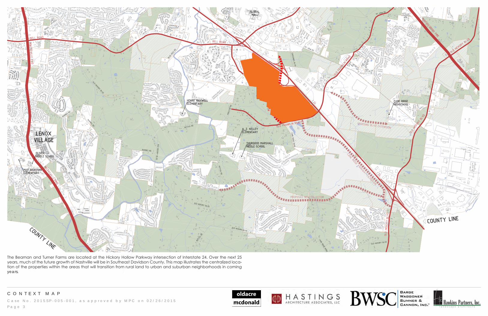
The site consists of nine lots for a total of 286 acres. The southern portion of the site is home to The Homeplace Farm, which is one of Tennessee’s one and a half century old family owned farms established in 1857 by William Snethis Turner and passed on to the family through the generations. In 1956, a portion of the land was sold to build the I-24 corridor and in the 1970s, this portion of I-24 was developed to serve the Hickory Hollow Mall with the addition of the Hickory Hollow Parkway on the North East side of the interstate. The northern portion of the site is owned by Lee Beaman and is mostly wooded. It lies between the Homeplace Farm and the old Target shopping center currently owned by Hickory Hollow, LLC.
The land at Exit 60 on I-24 is a rare opportunity for green field development within a developed community and a growing region. With easy access to I-24 and major thoroughfares, conveniently located near major employers, and nearby housing at a variety of price-points, the development possibilities are significant.
In order to make development of the site viable, the Exit 60 interchange will be completed to allow access to the property. New Parkways will be built to con-nect the interchange to existing streets. Existing streets will be improved to sup-port the new development. Continued conversations with Metro officials may show opportunities for connections to local and regional transportation systems.
ContentsI n t r o d u c t i o n 2G e n e r a l S t a n d a r d s 2C o n t e x t M a p 3C o n c e p t u a l M a s t e r P l a n 4M o b i l i t y N e t w o r k 5S t r e e t s P l a n 6C r o s s - S e c t i o n s 7 - 8P e d e s t r i a n , B i c y c l e , a n d P a r k s N e t w o r k 9C h a r a c t e r P h o t o s 1 0O p e n S p a c e C h a r a c t e r 1 1 - 1 2B u i l d i n g T y p e s 1 3 - 1 7U r b a n D e s i g n 1 8S u b d i s t r i c t P l a n 1 9S u b d i s t r i c t C h a r a c t e r 2 0S u b d i s t r i c t : R e s i d e n t i a l 2 1S u b d i s t r i c t : R e t a i l 2 2 - 2 3S u b d i s t r i c t : N e i g h b o r h o o d T r a n s i t i o n 2 4S u b d i s t r i c t : O f f i c e C o n c e n t r a t i o n 2 5S u b d i s t r i c t : M i x e d U s e 2 6
General StandardsThe regulations of this document are organized in several ways. First, the Sub-district Plan provides the areas that are regulated by different standards. Each Subdistrict regulates uses, bulk standards, and allowed building types.
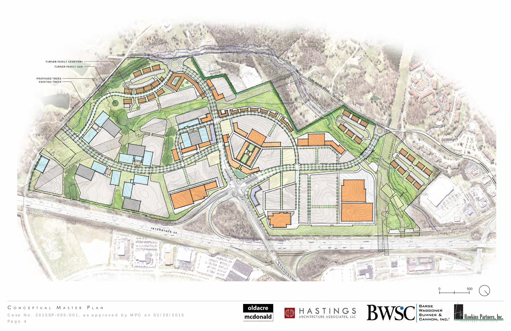
The guiding principles and regulatory standards of the Subdistricts are illustrated in a Conceptual Master Plan. This Master Plan envisions a mixed-use commu-nity center that provides services, retail, employment, housing, entertainment and recreation to the community and the region. The Conceptual Master Plan illustrates the vision for the overall development, and illustrates ideas for building placement, parking location, and open space configurations.
As the project continues to progress, the owner may make adjustments to con-ceptual plans for infrastructure, open space, and Subdistrict boundaries provided that such adjustments are done within the intent of the standards of this SP. The developer will coordinate such adjustments with Planning staff and other agen-cies as necessary.
Where silent on specific regulations, the zoning code shall dictate development standards. If adjustments to the SP are necessary to accommodate building code requirements and other regulations, the owner will coordinate such adjust-ments with Planning staff and other agencies as necessary.
Landscape buffer yard requirements between uses and zoning districts within the SP boundaries are not required. Buffers to adjacent properties outside the SP boundary are required.
All new trees within new public rights-of-way shall count toward the tree density requirements.
Boundaries of the Subdistricts are tied to infrastructure and natural features. The boundaries shown in this document are illustrative. Should the ultimate location of new streets, easements, and buffers be different than illustrated here, the ulti-mate locations will dictate the boundaries of the Subdistricts.
Rights-of-way improvements illustrated herein are conceptual and will require coordination with Metro Public Works and other agencies having jurisdiction over the project. Revisions to such, whether due to unforeseen conditions, existing conditions, or basic development of design intent, shall be reviewed by Planning staff to ensure consistency with the intent of the SP.
C a s e N o . 2 0 1 5 S P - 0 0 5 - 0 0 1 , a s a p p r o v e d b y M P C o n 0 2 / 2 6 / 2 0 1 5 Hawkins Partners, Inc.l a n d s c a p e a r c h i t e c t s
C O N T E X T M A P
I 24
I 24
I 24
OLD FRANKLIN ROA
D
MURFREESBORO PIKE
OLD HIC
KORY
BLV
D
NOLENSVILLE PIKE
BELL ROAD
NOLENSVILLE PIKE
OLD HI
CKORY
BLVDBELL ROAD
OLD FRAN
KLIN
ROAD
OLD
HICK
ORY
BLVD
CROSSING BLVD EXTENSION
PROPOSED NE W COLLECTOR
CANE RIDGE PARKWAY EXTENSION
PARKWAY
PARK
WAY
CANE RIDGE ROAD
CANE RIDGE ROAD
CROSSINGS BLVD
MT VIEW RD
MT VIEW RD
BLUE HOLE RD
PETTUS RD
PRES
TON
RD
OLD HICKORY BLVD
OLD HICKORY BLVD
OLD HICKORY BLVD
PETT
US RD
PETTUS RD
PETTUS RD
BARNES RD
BARNES RD
BARNE
S RD
OLD HICKORY BLVD
OLD HICKORY BLVD
OLD HICKORY BLVD
BURK
ITT
RD
CANE RIDGEHIGHSCHOOL
THURGOOD MARSHALLMIDDLE SCHOOL
A. Z. KELLEYELEMENTARY
GLOBAL MALL
COUNTY LINE
COUNTY LINE
HENRY MAXWELLELEMENTARY
LENOXVILLAGE
OLIVERMIDDLE SCHOOL
MAY WERTHANELEMENTARY
n
l
e 6
+/-2,100 ACRESUNDEVELOPED LAND IN VAR. ZONING
SERCA 006,7-/+GNINOZ A2RAZONING AND DEVELOPMENT KEY
P a g e 3
The Beaman and Turner Farms are located at the Hickory Hollow Parkway intersection of Interstate 24. Over the next 25 years, much of the future growth of Nashville will be in Southeast Davidson County. This map illustrates the centralized loca-tion of the properties within the areas that will transition from rural land to urban and suburban neighborhoods in coming years.
C a s e N o . 2 0 1 5 S P - 0 0 5 - 0 0 1 , a s a p p r o v e d b y M P C o n 0 2 / 2 6 / 2 0 1 5 Hawkins Partners, Inc.l a n d s c a p e a r c h i t e c t s
c o n c e p t u a l M a s t e r p l a n
P a g e 4
0 500
C a s e N o . 2 0 1 5 S P - 0 0 5 - 0 0 1 , a s a p p r o v e d b y M P C o n 0 2 / 2 6 / 2 0 1 5 Hawkins Partners, Inc.l a n d s c a p e a r c h i t e c t s
M o b I l I t y n e t w o r k
P a g e 5
Mobil i ty NetworkMobility is the backbone of the proposed development. In addition to moving cars throughout the site, each street design is intended to accommodate cyclists and pedestrians in a safe and attractive environment.
The Conceptual Master Plan, the Mobility Plan, and the Bicycle, Pedestrian, and Open Space Plan show a network of Parkways, streets, internal drives, and gre-enways. Priority has been given to balancing the needs of various forms of mobil-ity. The plans show limited vehicular access points, multi-use paths with planting strips, and aligned crossings that will function as intersections. These and other design standards will allow for easier flow of motorized traffic and safer pedes-trian crossings.
Exit 60 of Interstate 24 will be finished to allow access to the development site. The plans and design of the intersection are currently being reviewed by TDOT and the Federal Highway Administration. Included in this review are the intersection at the base of the completed interchange, and the bridge over the interstate.
The proposed public streets within the development meet and exceed the Major and Collector Street Plan’s requirements for new streets within the site. These new streets, called Parkways in this document, are 102 feet of right-of-way. The cross-section includes two travel lanes in both directions, a center median that accom-modates a turn lane where necessary, planting strips and 12-foot multi-use paths on both sides of the street.
The Parkways will move vehicles efficiently while providing mobility options on the
multi-use paths. The paths will connect to the parks and greenway system within the development.
A diagrammatic plan and cross-sections for improved existing streets and new streets are shown on the Mobility Network pages of this document. Similar cross-sections that balance various forms of mobility in a safe and attractive setting may be appropriate, and may be approved by the Planning Commission or its designee at the time of Final SP review. Additionally, the relationships of buildings to streets are shown on the Urban Design pages of this document.
A new design for the Hickory Hollow Parkway bridge over I-24 is currently being reviewed by transportation authorities. The current cross-section includes several travel lanes to accommodate mobility associated with the interstate. The cross-section also includes the continuation of the multi-use paths. This strategic con-nection to the Hickory Hollow and Crossings districts will provide mobility choice for the entire community.
Two existing roads frame the edges of the development. Cane Ridge Road and Old Franklin Road are generally rural in character. In order to accommodate anticipated traffic while preserving the current rural character of these roads, strategic improvements are proposed.
Cane Ridge Road - from Bell Road to the roundabout at the entrance of the development - will include two travel lanes in both directions, and sidewalks on both sides. The proposed cross-section of Cane Ridge Road is within the existing right-of-way. The design of this cross-section reflects comments from Metro Public Works.
Old Franklin Road will improved from the centerline of the street to include a wider travel lane and a sidewalk with grass strip.
Within the development, internal drives on private property will function as access to buildings and parking, and set up a framework for future development. These internal drives will include travel lanes, turn lanes where necessary, and sidewalks with planting strips.
The inclusion of parks and greenways within the development will also contribute to the overall mobility network. The multi-use paths throughout the development will connect to the proposed greenway system within the property to allow safe, attractive mobility choice to those who live, shop, work, and recreate in the new development.
The projected scale and intensity of this development will provide jobs, services, and homes to many within Middle Tennessee. As plans are studied further, input from the Metro Transit Authority (MTA) will be needed and welcomed. Connect-ing to existing bus lines and bus rapid transit lines will be an asset to the community and to the development. Considering this development’s role in regional growth, transit coordination will be an important point of providing mobility choice.
All open space, greenways, and landscaping within rights-of-way will be main-tained by the property owner(s) and will have public easements provided through the Final SP process.
Landscaping within rights-of-way may be used for stormwater management and will be maintained by the property owner(s).
Shared parking studies may be provided during the Final SP process for each development phase. Shared parking is allowed in all subdistricts and across sub-districts.
C a s e N o . 2 0 1 5 S P - 0 0 5 - 0 0 1 , a s a p p r o v e d b y M P C o n 0 2 / 2 6 / 2 0 1 5 Hawkins Partners, Inc.l a n d s c a p e a r c h i t e c t s
s t r e e t s p l a n
LEGEND:PARKWAYINTERNAL DRIVE
Pa
rk
wa
y 2
P a r k w a y 1P a r k w a y 3
P a g e 6
0 500
C a s e N o . 2 0 1 5 S P - 0 0 5 - 0 0 1 , a s a p p r o v e d b y M P C o n 0 2 / 2 6 / 2 0 1 5 Hawkins Partners, Inc.l a n d s c a p e a r c h i t e c t s
c r o s s - s e c t I o n s
BRIDGE SECTION
10’MULTI-USE
PATH
10’MULTI-USE
PATH 12’ TRAVEL LANE 12’ TURN LANE 12’ TURN LANE 12’ TURN LANE
4’ CONCRETE MEDIAN
12’ TRAVEL LANE 12’ TRAVEL LANE 12’ TRAVEL LANE12’ TRAVEL LANE12’ TRAVEL LANE
132’ RIGHT-OF-WAY
The Hickory Hollow Parkway bridge that crosses I-24 will be improved according to the recommendations of the Traffic Improvement Study. The improvements will extend to the bridge that crosses the railroad tracks on the east side of the interstate. These improvements include increased travel lanes and turn lanes, and 10-foot multi-use paths on both sides of the bridge. This cross-section is currently being reviewed by TDOT and the Federal Highway Administration.
PARKWAY SECTION
12’ MULTI-USE PATH
4’BIKEPATH
12’MULTI-USE PATH
4’PLANTING
STRIP
4’PLANTING
STRIP12’ TRAVEL LANE 12’ TRAVEL LANE 12’ TRAVEL LANE12’ TRAVEL LANE
2’-6” CURB AND GUTTER
16’ VEGETATED MEDIAN
102’ RIGHT-OF-WAY
4 RAIL FENCE
2’-6” CURB AND GUTTER4’
BIKEPATH
The Parkway cross-section is designed for all new collector streets within the development. These streets meet the policies of the Major and Collector Street Plan and set a framework for the Subdistricts of the SP. The Parkways will include two travel lanes in each direction separated by a median to accommodate turn lanes, planting strips with street trees, and multi-use paths for biking and walking.
Cane Ridge Road, from Bell Road to the roundabout at the entrance of the new development, will be improved to include two travel lanes in each direction, a 6-foot grass strip, and an 8-foot sidewalk on both sides of the street.
OLD FRANKLIN ROAD - SECTION
PLANTING AREA5’
SIDEWALK4’
GRASS STRIP+\- 10’ TRAVEL LANE
NEW ROADWAY FROM CENTERLINE OF ROAD
Old Franklin Road, along frontage associated with the SP, will be improved from the centerline of the right-of-way to include a 10-foot travel, a 4-foot grass strip, and a 5-foot sidewalk.
CANE RIDGE - SECTION
6’PLANTING
AREA
6’PLANTING
AREA8’ SIDEWALK 8’ SIDEWALK12’ TRAVEL LANE 12’ TRAVEL LANE12’ TRAVEL LANE12’ TRAVEL LANE
2’-6” CURB AND GUTTER
81’ RIGHT-OF-WAY
2’-6” CURB AND GUTTER
PA
RK
WA
YP
AR
KW
AY
B
RI
DG
E
CA
NE
R
ID
GE
R
OA
DO
LD
F
RA
NK
LI
N
RO
AD
P a g e 7
C a s e N o . 2 0 1 5 S P - 0 0 5 - 0 0 1 , a s a p p r o v e d b y M P C o n 0 2 / 2 6 / 2 0 1 5 Hawkins Partners, Inc.l a n d s c a p e a r c h i t e c t s
c r o s s - s e c t I o n s
This illustration shows one option for Internal Drives that includes one travel lane in both directions, and sidewalks on both sides of the internal drive.
INTERNAL DRIVE SECTION - A
PLANTINGSTRIP
PLANTINGSTRIP 15’ TRAVEL LANE15’ TRAVEL LANE 5’ SIDEWALK5’ SIDEWALK
4’LANDSCAPE
ORFRONTAGE
ZONE
4’LANDSCAPE
ORFRONTAGE
ZONE
SHADE TREES, ACCORDING TO THESTANDARDS OF THE SUBDISTRICT
This illustration shows a second option for Internal Drives that includes one travel lane in both directions, a turning lane, a sidewalk on one side of the internal drive, and a landscaping buffer on the other side.
INTERNAL DRIVE SECTION - B
10’ PLANTINGAREA
PLANTINGSTRIP 12’ TRAVEL LANE12’ TRAVEL LANE
2’6” CURBAND GUTTER
12’ TURN LANE5’ SIDEWALK
2’6” CURBAND GUTTER
4’LANDSCAPE
ORFRONTAGE
ZONE
SHADE TREES, ACCORDING TO THESTANDARDS OF THE SUBDISTRICT
This illustration shows a third option for Internal Drives that includes one travel lane in both directions, on-street parking, and sidewalks.
Buildings may front an internal drive with parking beyond. See Subdistrict standards for when, if, and how this is allowed.
Option 3 allows on-street parking on internal drives. Option 2 allows a sidewalk with landscaping on one side of the internal drive with landscape buffering on the side adjacent to parking.
INTERNAL DRIVE SECTION - C
PLANTINGSTRIP
PLANTINGSTRIP
12’ TRAVEL LANE
12’ TRAVEL LANE
ON-STREETPARKING
ON-STREETPARKING
5’ SIDEWALK
5’ SIDEWALK
4’LANDSCAPE
ORFRONTAGE
ZONE
4’LANDSCAPE
ORFRONTAGE
ZONE
SHADE TREES, ACCORDING TO THESTANDARDS OF THE SUBDISTRICT
Further standards on how the building relates to an internal drive are provided in the Building Types, Urban Design, and subdistrict standards.
IN
TE
RN
AL
D
RI
VE
1
IN
TE
RN
AL
D
RI
VE
2
IN
TE
RN
AL
D
RI
VE
3
PH
OT
O
EX
AM
PL
ES
The secondary street network of the development will be designed with Internal Drives. These drives will act as streets and will provide a framework for buildings and parking, and future development. Similar cross-sections that balance various forms of mobility in a safe and attractive setting may be appropriate, and may be approved by the Planning Commission or its designee at the time of Final SP review. The standards for the building’s relationship to the street are included on the Urban Design pages of this document.
P a g e 8
C a s e N o . 2 0 1 5 S P - 0 0 5 - 0 0 1 , a s a p p r o v e d b y M P C o n 0 2 / 2 6 / 2 0 1 5 Hawkins Partners, Inc.l a n d s c a p e a r c h i t e c t s
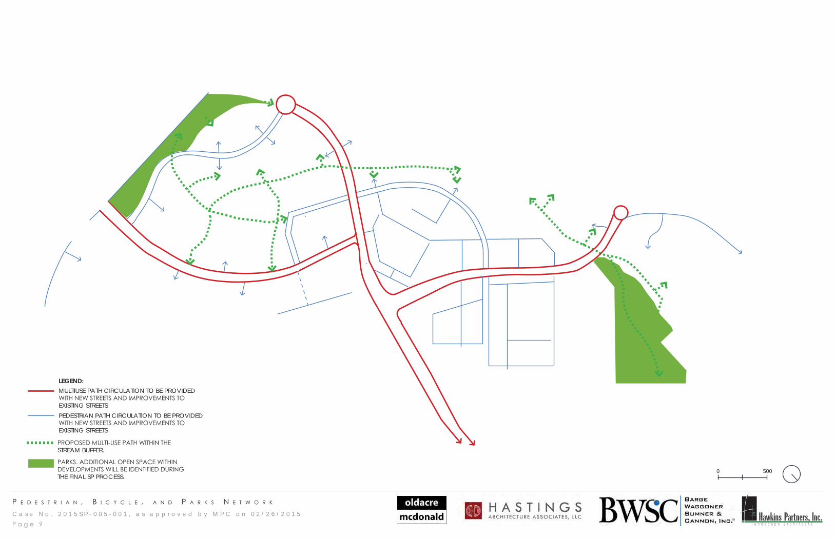
p e d e s t r I a n , b I c y c l e , a n d p a r k s n e t w o r k
LEGEND: MULTIUSE PATH CIRCULATION TO BE PROVIDED WITH NEW STREETS AND IMPROVEMENTS TO EXISTING STREETSPEDESTRIAN PATH CIRCULATION TO BE PROVIDED WITH NEW STREETS AND IMPROVEMENTS TO EXISTING STREETS
PROPOSED MULTI-USE PATH WITHIN THE STREAM BUFFER.
PARKS. ADDITIONAL OPEN SPACE WITHIN DEVELOPMENTS WILL BE IDENTIFIED DURING THE FINAL SP PROCESS.
P a g e 9
0 500
C a s e N o . 2 0 1 5 S P - 0 0 5 - 0 0 1 , a s a p p r o v e d b y M P C o n 0 2 / 2 6 / 2 0 1 5 Hawkins Partners, Inc.l a n d s c a p e a r c h i t e c t s
c h a r a c t e r p h o t o s
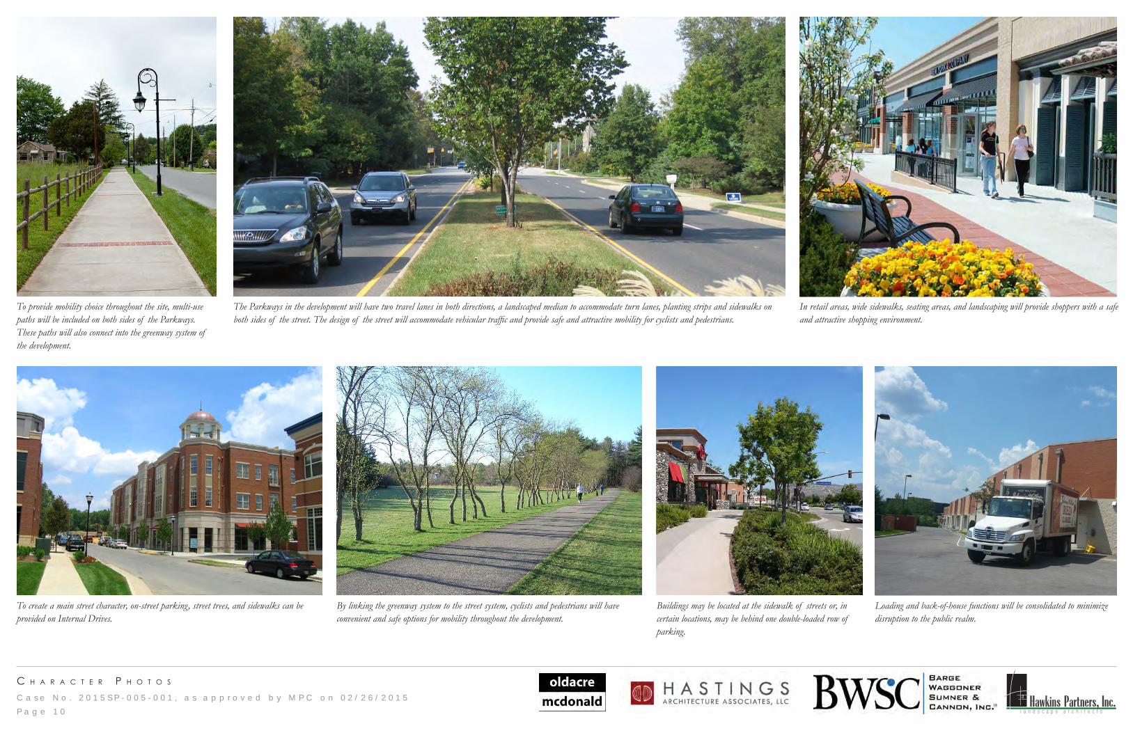
To provide mobility choice throughout the site, multi-use paths will be included on both sides of the Parkways. These paths will also connect into the greenway system of the development.
The Parkways in the development will have two travel lanes in both directions, a landscaped median to accommodate turn lanes, planting strips and sidewalks on both sides of the street. The design of the street will accommodate vehicular traffic and provide safe and attractive mobility for cyclists and pedestrians.
In retail areas, wide sidewalks, seating areas, and landscaping will provide shoppers with a safe and attractive shopping environment.
Loading and back-of-house functions will be consolidated to minimize disruption to the public realm.
To create a main street character, on-street parking, street trees, and sidewalks can be provided on Internal Drives.
By linking the greenway system to the street system, cyclists and pedestrians will have convenient and safe options for mobility throughout the development.
Buildings may be located at the sidewalk of streets or, in certain locations, may be behind one double-loaded row of parking.
P a g e 1 0
C a s e N o . 2 0 1 5 S P - 0 0 5 - 0 0 1 , a s a p p r o v e d b y M P C o n 0 2 / 2 6 / 2 0 1 5 Hawkins Partners, Inc.l a n d s c a p e a r c h i t e c t s
o p e n s p a c e c h a r a c t e r
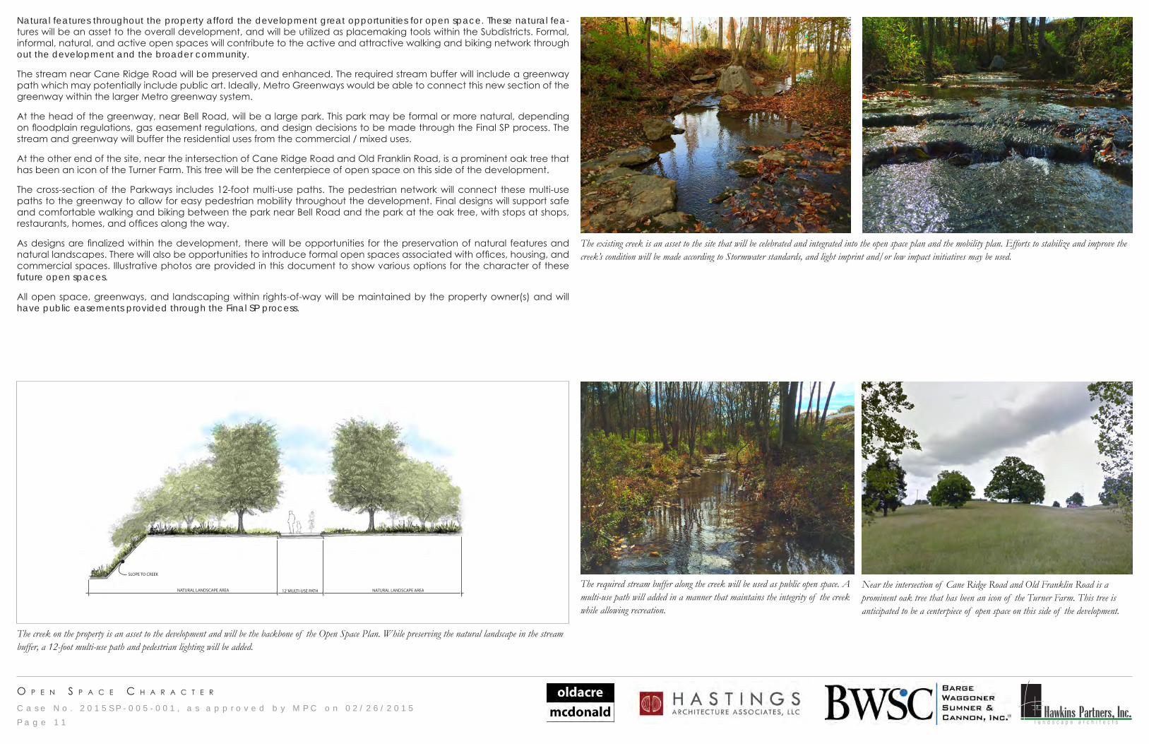
The creek on the property is an asset to the development and will be the backbone of the Open Space Plan. While preserving the natural landscape in the stream buffer, a 12-foot multi-use path and pedestrian lighting will be added.
GREENWAY/TRAIL - SECTION
NATURAL LANDSCAPE AREANATURAL LANDSCAPE AREA
SLOPE TO CREEK
12’ MULTI-USE PATHNear the intersection of Cane Ridge Road and Old Franklin Road is a prominent oak tree that has been an icon of the Turner Farm. This tree is anticipated to be a centerpiece of open space on this side of the development.
The existing creek is an asset to the site that will be celebrated and integrated into the open space plan and the mobility plan. Efforts to stabilize and improve the creek’s condition will be made according to Stormwater standards, and light imprint and/or low impact initiatives may be used.
The required stream buffer along the creek will be used as public open space. A multi-use path will added in a manner that maintains the integrity of the creek while allowing recreation.
P a g e 1 1
Natural features throughout the property afford the development great opportunities for open space. These natural fea-tures will be an asset to the overall development, and will be utilized as placemaking tools within the Subdistricts. Formal, informal, natural, and active open spaces will contribute to the active and attractive walking and biking network through out the development and the broader community.
The stream near Cane Ridge Road will be preserved and enhanced. The required stream buffer will include a greenway path which may potentially include public art. Ideally, Metro Greenways would be able to connect this new section of the greenway within the larger Metro greenway system.
At the head of the greenway, near Bell Road, will be a large park. This park may be formal or more natural, depending on floodplain regulations, gas easement regulations, and design decisions to be made through the Final SP process. The stream and greenway will buffer the residential uses from the commercial / mixed uses.
At the other end of the site, near the intersection of Cane Ridge Road and Old Franklin Road, is a prominent oak tree that has been an icon of the Turner Farm. This tree will be the centerpiece of open space on this side of the development.
The cross-section of the Parkways includes 12-foot multi-use paths. The pedestrian network will connect these multi-use paths to the greenway to allow for easy pedestrian mobility throughout the development. Final designs will support safe and comfortable walking and biking between the park near Bell Road and the park at the oak tree, with stops at shops, restaurants, homes, and offices along the way.
As designs are finalized within the development, there will be opportunities for the preservation of natural features and natural landscapes. There will also be opportunities to introduce formal open spaces associated with offices, housing, and commercial spaces. Illustrative photos are provided in this document to show various options for the character of these future open spaces.
All open space, greenways, and landscaping within rights-of-way will be maintained by the property owner(s) and will have public easements provided through the Final SP process.
C a s e N o . 2 0 1 5 S P - 0 0 5 - 0 0 1 , a s a p p r o v e d b y M P C o n 0 2 / 2 6 / 2 0 1 5 Hawkins Partners, Inc.l a n d s c a p e a r c h i t e c t s
o p e n s p a c e c h a r a c t e r
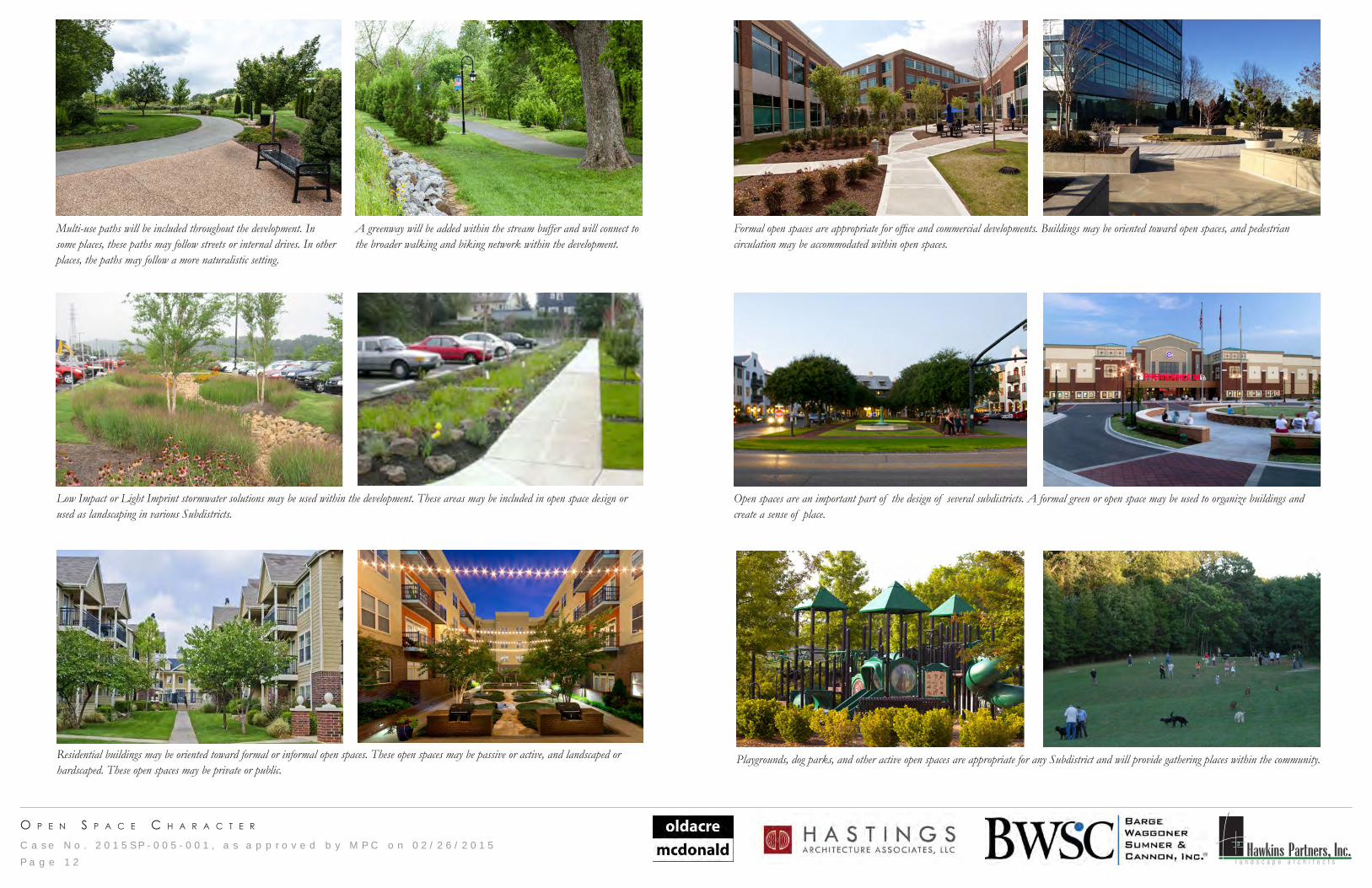
Formal open spaces are appropriate for office and commercial developments. Buildings may be oriented toward open spaces, and pedestrian circulation may be accommodated within open spaces.
Open spaces are an important part of the design of several subdistricts. A formal green or open space may be used to organize buildings and create a sense of place.
A greenway will be added within the stream buffer and will connect to the broader walking and biking network within the development.
Multi-use paths will be included throughout the development. In some places, these paths may follow streets or internal drives. In other places, the paths may follow a more naturalistic setting.
Playgrounds, dog parks, and other active open spaces are appropriate for any Subdistrict and will provide gathering places within the community.
Low Impact or Light Imprint stormwater solutions may be used within the development. These areas may be included in open space design or used as landscaping in various Subdistricts.
Residential buildings may be oriented toward formal or informal open spaces. These open spaces may be passive or active, and landscaped or hardscaped. These open spaces may be private or public.
P a g e 1 2
C a s e N o . 2 0 1 5 S P - 0 0 5 - 0 0 1 , a s a p p r o v e d b y M P C o n 0 2 / 2 6 / 2 0 1 5 Hawkins Partners, Inc.l a n d s c a p e a r c h i t e c t s
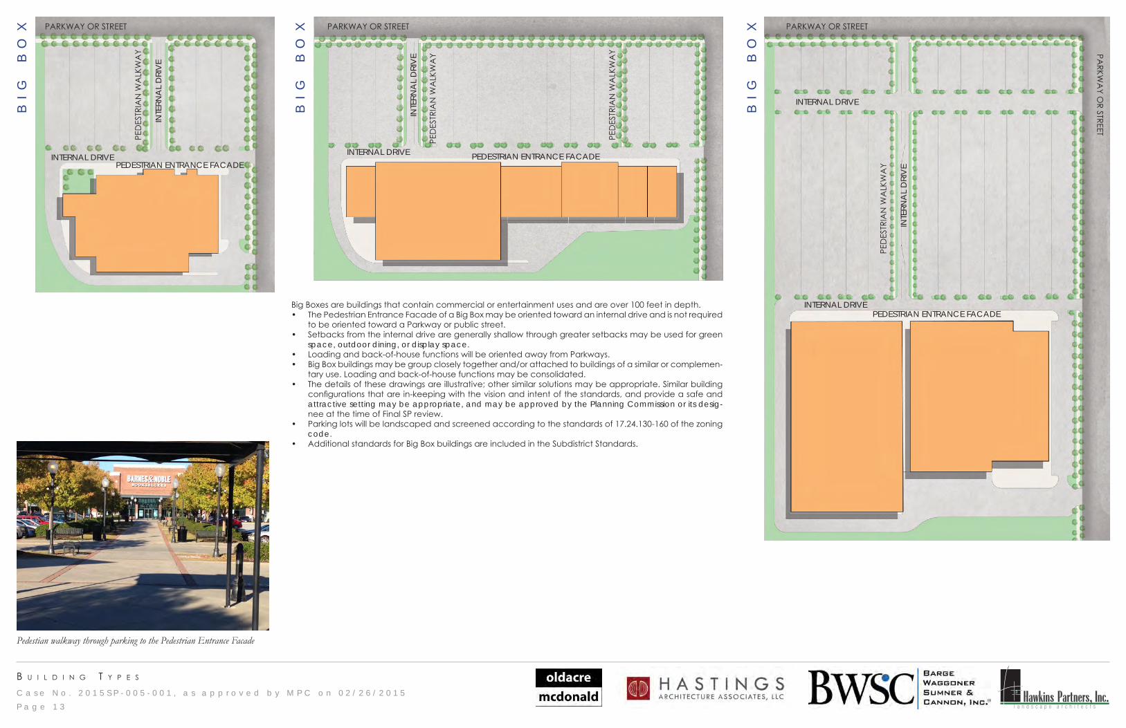
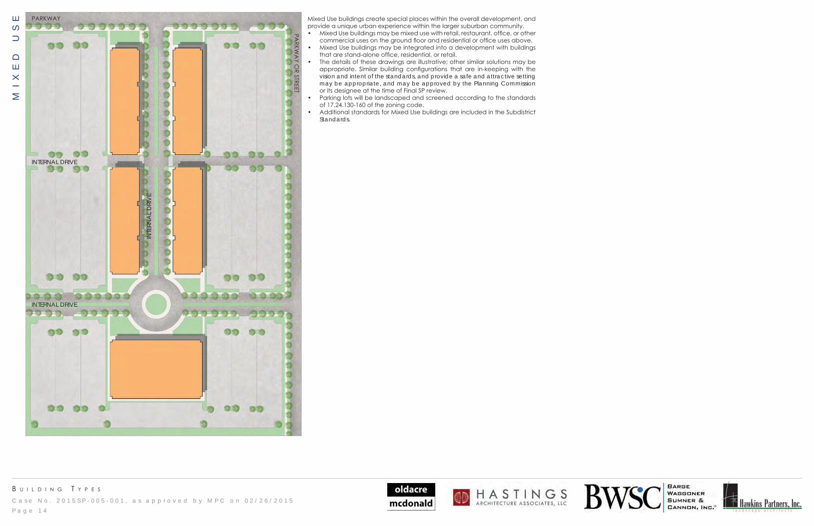
b u I l d I n g t y p e s
INTERNAL DRIVE
INTERNAL DRIVE
PARKWAY OR STREET
INTE
RNA
L D
RIV
E
PARKW
AY O
R STREET
PEDESTRIAN ENTRANCE FACADEBig Boxes are buildings that contain commercial or entertainment uses and are over 100 feet in depth. • The Pedestrian Entrance Facade of a Big Box may be oriented toward an internal drive and is not required
to be oriented toward a Parkway or public street.• Setbacks from the internal drive are generally shallow through greater setbacks may be used for green
space, outdoor dining, or display space. • Loading and back-of-house functions will be oriented away from Parkways. • Big Box buildings may be group closely together and/or attached to buildings of a similar or complemen-
tary use. Loading and back-of-house functions may be consolidated.• The details of these drawings are illustrative; other similar solutions may be appropriate. Similar building
configurations that are in-keeping with the vision and intent of the standards, and provide a safe and attractive setting may be appropriate, and may be approved by the Planning Commission or its desig-nee at the time of Final SP review.
• Parking lots will be landscaped and screened according to the standards of 17.24.130-160 of the zoning code.
• Additional standards for Big Box buildings are included in the Subdistrict Standards.
INTE
RNA
L D
RIV
E
INTE
RNA
L D
RIV
E
PARKWAY OR STREETPARKWAY OR STREET
PED
ESTR
IAN
WA
LKW
AY
PED
ESTR
IAN
WA
LKW
AY
PEDESTRIAN ENTRANCE FACADEPEDESTRIAN ENTRANCE FACADE
INTERNAL DRIVEINTERNAL DRIVE
PED
ESTR
IAN
WA
LKW
AY
PED
ESTR
IAN
WA
LKW
AY
BI
G
BO
X
BI
G
BO
X
BI
G
BO
X
P a g e 1 3
Pedestian walkway through parking to the Pedestrian Entrance Facade
C a s e N o . 2 0 1 5 S P - 0 0 5 - 0 0 1 , a s a p p r o v e d b y M P C o n 0 2 / 2 6 / 2 0 1 5 Hawkins Partners, Inc.l a n d s c a p e a r c h i t e c t s
b u I l d I n g t y p e s
PARKWAY
PARKW
AY O
R STREET
INTERNAL DRIVE
INTERNAL DRIVE
INTE
RNA
L D
RIV
E
Mixed Use buildings create special places within the overall development, and provide a unique urban experience within the larger suburban community. • Mixed Use buildings may be mixed use with retail, restaurant, office, or other
commercial uses on the ground floor and residential or office uses above. • Mixed Use buildings may be integrated into a development with buildings
that are stand-alone office, residential, or retail. • The details of these drawings are illustrative; other similar solutions may be
appropriate. Similar building configurations that are in-keeping with the vision and intent of the standards, and provide a safe and attractive setting may be appropriate, and may be approved by the Planning Commission or its designee at the time of Final SP review.
• Parking lots will be landscaped and screened according to the standards of 17.24.130-160 of the zoning code.
• Additional standards for Mixed Use buildings are included in the Subdistrict Standards.
MI
XE
D
US
E
P a g e 1 4
C a s e N o . 2 0 1 5 S P - 0 0 5 - 0 0 1 , a s a p p r o v e d b y M P C o n 0 2 / 2 6 / 2 0 1 5 Hawkins Partners, Inc.l a n d s c a p e a r c h i t e c t s
b u I l d I n g t y p e s
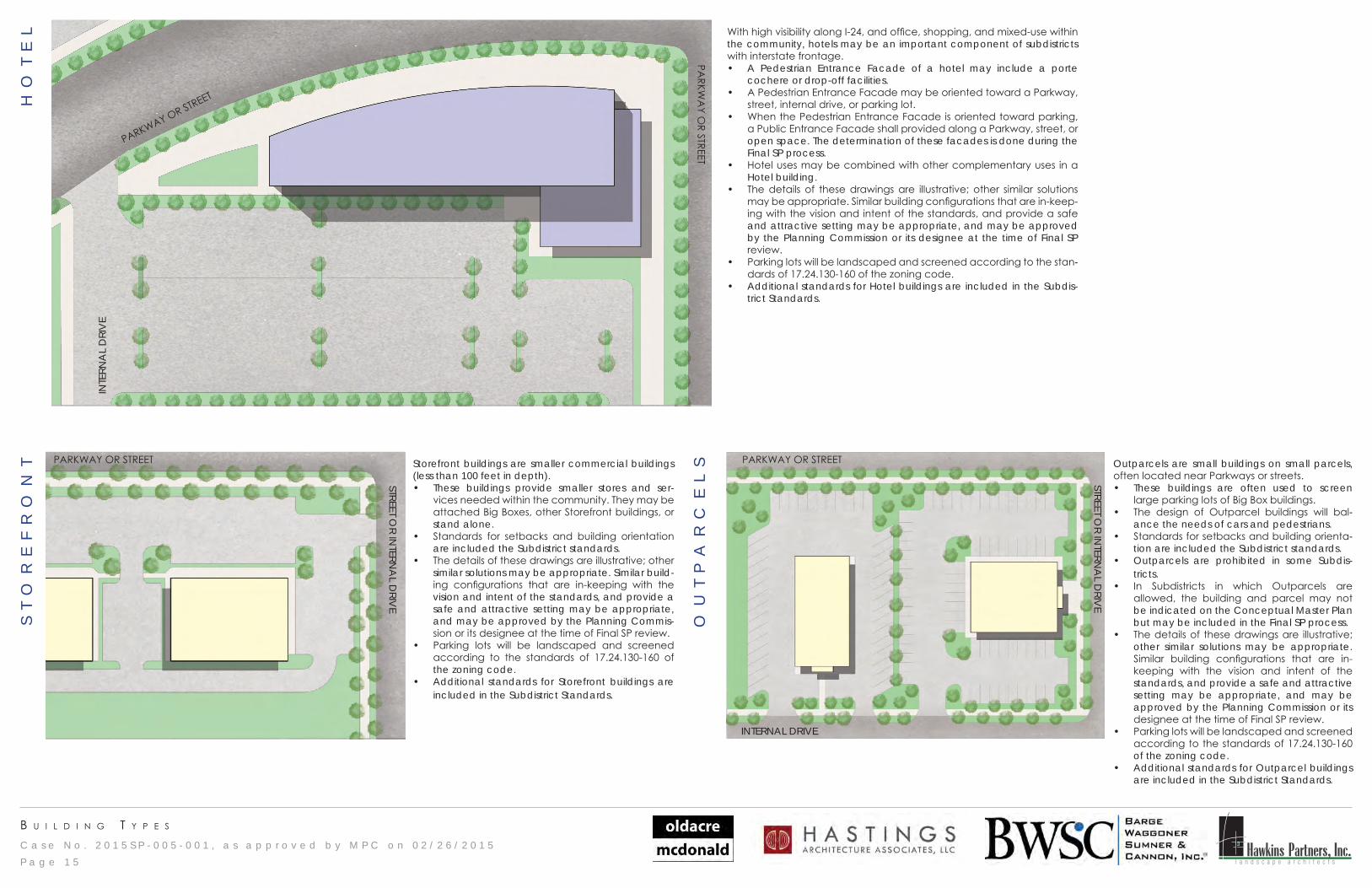
With high visibility along I-24, and office, shopping, and mixed-use within the community, hotels may be an important component of subdistricts with interstate frontage. • A Pedestrian Entrance Facade of a hotel may include a porte
cochere or drop-off facilities. • A Pedestrian Entrance Facade may be oriented toward a Parkway,
street, internal drive, or parking lot.• When the Pedestrian Entrance Facade is oriented toward parking,
a Public Entrance Facade shall provided along a Parkway, street, or open space. The determination of these facades is done during the Final SP process.
• Hotel uses may be combined with other complementary uses in a Hotel building.
• The details of these drawings are illustrative; other similar solutions may be appropriate. Similar building configurations that are in-keep-ing with the vision and intent of the standards, and provide a safe and attractive setting may be appropriate, and may be approved by the Planning Commission or its designee at the time of Final SP review.
• Parking lots will be landscaped and screened according to the stan-dards of 17.24.130-160 of the zoning code.
• Additional standards for Hotel buildings are included in the Subdis-trict Standards.
PARKWAY OR STREETPARKWAY OR STREET
INTERNAL DRIVE
STREET OR IN
TERNA
L DRIV
E
STREET OR IN
TERNA
L DRIV
E
Storefront buildings are smaller commercial buildings (less than 100 feet in depth). • These buildings provide smaller stores and ser-
vices needed within the community. They may be attached Big Boxes, other Storefront buildings, or stand alone.
• Standards for setbacks and building orientation are included the Subdistrict standards.
• The details of these drawings are illustrative; other similar solutions may be appropriate. Similar build-ing configurations that are in-keeping with the vision and intent of the standards, and provide a safe and attractive setting may be appropriate, and may be approved by the Planning Commis-sion or its designee at the time of Final SP review.
• Parking lots will be landscaped and screened according to the standards of 17.24.130-160 of the zoning code.
• Additional standards for Storefront buildings are included in the Subdistrict Standards.
Outparcels are small buildings on small parcels, often located near Parkways or streets. • These buildings are often used to screen
large parking lots of Big Box buildings. • The design of Outparcel buildings will bal-
ance the needs of cars and pedestrians.• Standards for setbacks and building orienta-
tion are included the Subdistrict standards. • Outparcels are prohibited in some Subdis-
tricts.• In Subdistricts in which Outparcels are
allowed, the building and parcel may not be indicated on the Conceptual Master Plan but may be included in the Final SP process.
• The details of these drawings are illustrative; other similar solutions may be appropriate. Similar building configurations that are in-keeping with the vision and intent of the standards, and provide a safe and attractive setting may be appropriate, and may be approved by the Planning Commission or its designee at the time of Final SP review.
• Parking lots will be landscaped and screened according to the standards of 17.24.130-160 of the zoning code.
• Additional standards for Outparcel buildings are included in the Subdistrict Standards.
PARKW
AY O
R STREET
PARKWAY OR STREETIN
TERN
AL
DRI
VE
ST
OR
EF
RO
NT
OU
TP
AR
CE
LS
HO
TE
L
P a g e 1 5
C a s e N o . 2 0 1 5 S P - 0 0 5 - 0 0 1 , a s a p p r o v e d b y M P C o n 0 2 / 2 6 / 2 0 1 5 Hawkins Partners, Inc.l a n d s c a p e a r c h i t e c t s
b u I l d I n g t y p e s
INTERNAL DRIVE
PARKWAY, STREET, OR INTERNAL DRIVE
INTERNAL DRIVE
OPEN SPACE INTERNAL DRIVE
PARKWAY, STREET, OR INTERNAL DRIVE
INTERNAL DRIVE
OPEN SPACE
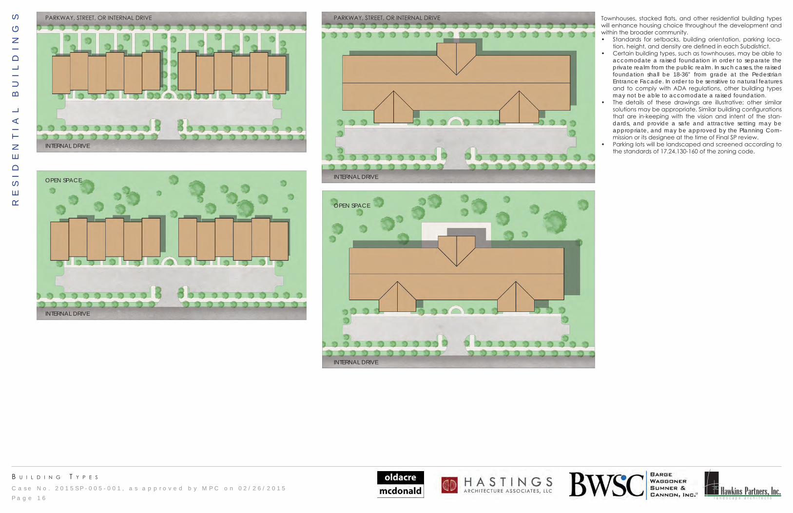
Townhouses, stacked flats, and other residential building types will enhance housing choice throughout the development and within the broader community.• Standards for setbacks, building orientation, parking loca-
tion, height, and density are defined in each Subdistrict.• Certain building types, such as townhouses, may be able to
accomodate a raised foundation in order to separate the private realm from the public realm. In such cases, the raised foundation shall be 18-36” from grade at the Pedestrian Entrance Facade. In order to be sensitive to natural features and to comply with ADA regulations, other building types may not be able to accomodate a raised foundation.
• The details of these drawings are illustrative; other similar solutions may be appropriate. Similar building configurations that are in-keeping with the vision and intent of the stan-dards, and provide a safe and attractive setting may be appropriate, and may be approved by the Planning Com-mission or its designee at the time of Final SP review.
• Parking lots will be landscaped and screened according to the standards of 17.24.130-160 of the zoning code.
RE
SI
DE
NT
IA
L
BU
IL
DI
NG
S
P a g e 1 6
C a s e N o . 2 0 1 5 S P - 0 0 5 - 0 0 1 , a s a p p r o v e d b y M P C o n 0 2 / 2 6 / 2 0 1 5 Hawkins Partners, Inc.l a n d s c a p e a r c h i t e c t s
b u I l d I n g t y p e s
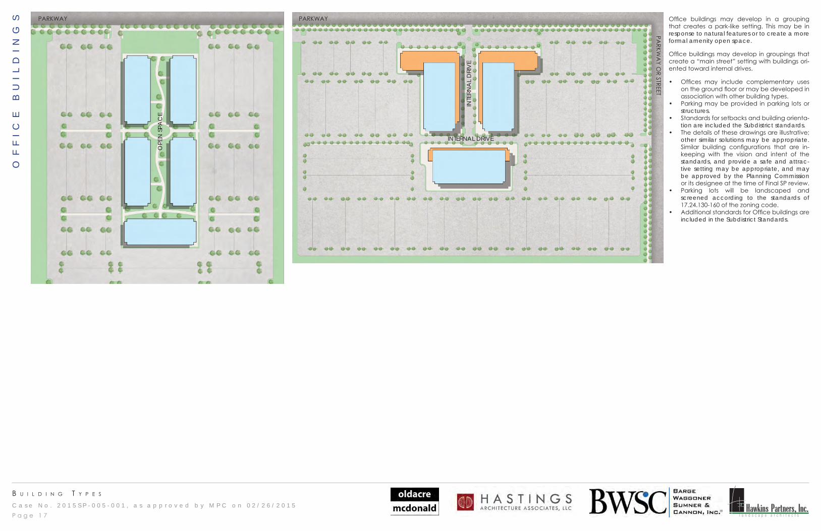
Office buildings may develop in a grouping that creates a park-like setting. This may be in response to natural features or to create a more formal amenity open space.
Office buildings may develop in groupings that create a “main street” setting with buildings ori-ented toward internal drives.
• Offices may include complementary uses on the ground floor or may be developed in association with other building types.
• Parking may be provided in parking lots or structures.
• Standards for setbacks and building orienta-tion are included the Subdistrict standards.
• The details of these drawings are illustrative; other similar solutions may be appropriate. Similar building configurations that are in-keeping with the vision and intent of the standards, and provide a safe and attrac-tive setting may be appropriate, and may be approved by the Planning Commission or its designee at the time of Final SP review.
• Parking lots will be landscaped and screened according to the standards of 17.24.130-160 of the zoning code.
• Additional standards for Office buildings are included in the Subdistrict Standards.
PARKWAY
OPE
N S
PAC
E
INTE
RNA
L D
RIV
E
PARKWAY
INTERNAL DRIVE
PARKW
AY O
R STREET
OF
FI
CE
B
UI
LD
IN
GS
P a g e 1 7
C a s e N o . 2 0 1 5 S P - 0 0 5 - 0 0 1 , a s a p p r o v e d b y M P C o n 0 2 / 2 6 / 2 0 1 5 Hawkins Partners, Inc.l a n d s c a p e a r c h i t e c t s
u r b a n d e s I g n
P a g e 1 8
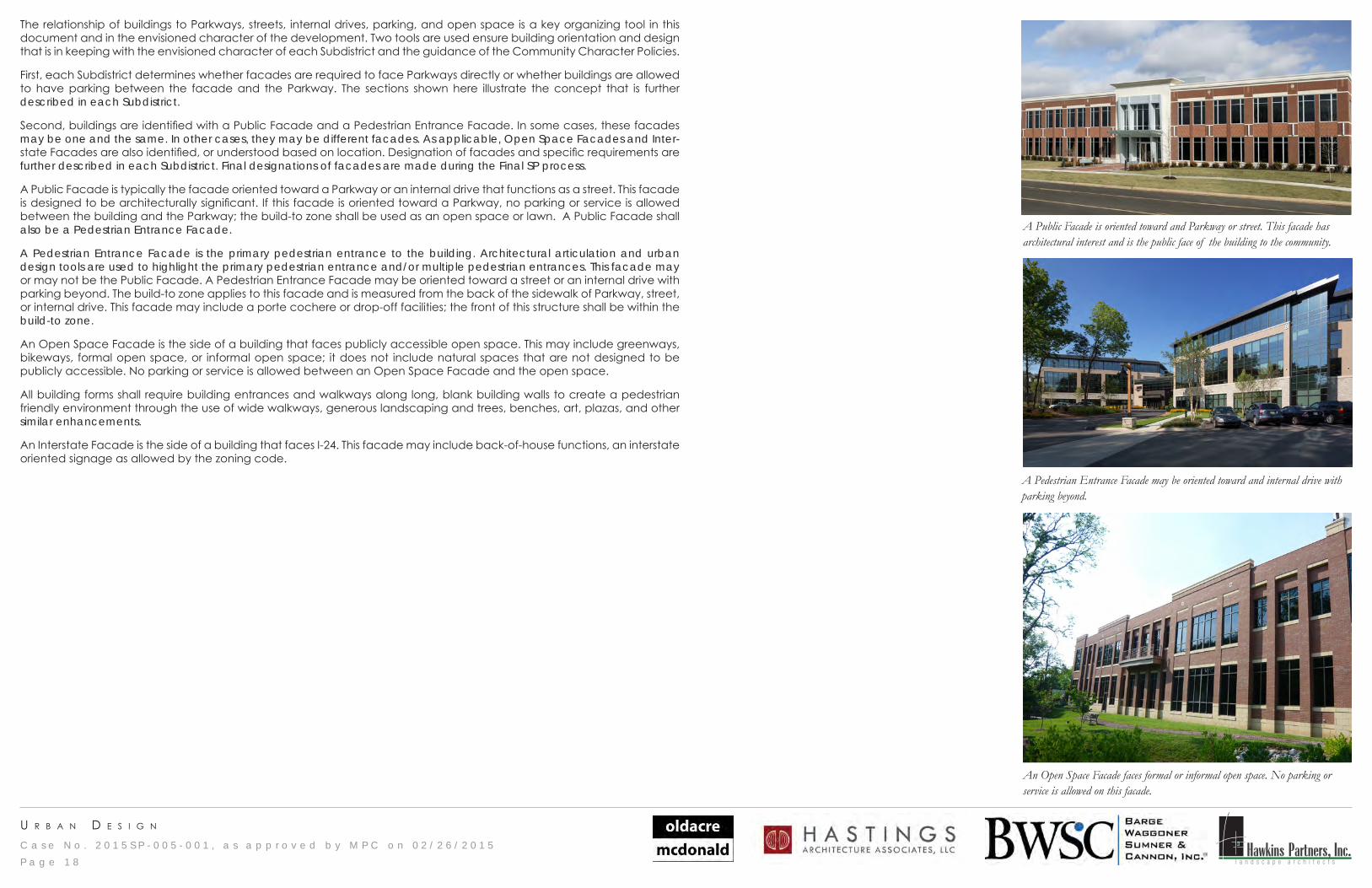
The relationship of buildings to Parkways, streets, internal drives, parking, and open space is a key organizing tool in this document and in the envisioned character of the development. Two tools are used ensure building orientation and design that is in keeping with the envisioned character of each Subdistrict and the guidance of the Community Character Policies.
First, each Subdistrict determines whether facades are required to face Parkways directly or whether buildings are allowed to have parking between the facade and the Parkway. The sections shown here illustrate the concept that is further described in each Subdistrict.
Second, buildings are identified with a Public Facade and a Pedestrian Entrance Facade. In some cases, these facades may be one and the same. In other cases, they may be different facades. As applicable, Open Space Facades and Inter-state Facades are also identified, or understood based on location. Designation of facades and specific requirements are further described in each Subdistrict. Final designations of facades are made during the Final SP process.
A Public Facade is typically the facade oriented toward a Parkway or an internal drive that functions as a street. This facade is designed to be architecturally significant. If this facade is oriented toward a Parkway, no parking or service is allowed between the building and the Parkway; the build-to zone shall be used as an open space or lawn. A Public Facade shall also be a Pedestrian Entrance Facade.
A Pedestrian Entrance Facade is the primary pedestrian entrance to the building. Architectural articulation and urban design tools are used to highlight the primary pedestrian entrance and/or multiple pedestrian entrances. This facade may or may not be the Public Facade. A Pedestrian Entrance Facade may be oriented toward a street or an internal drive with parking beyond. The build-to zone applies to this facade and is measured from the back of the sidewalk of Parkway, street, or internal drive. This facade may include a porte cochere or drop-off facilities; the front of this structure shall be within the build-to zone.
An Open Space Facade is the side of a building that faces publicly accessible open space. This may include greenways, bikeways, formal open space, or informal open space; it does not include natural spaces that are not designed to be publicly accessible. No parking or service is allowed between an Open Space Facade and the open space.
All building forms shall require building entrances and walkways along long, blank building walls to create a pedestrian friendly environment through the use of wide walkways, generous landscaping and trees, benches, art, plazas, and other similar enhancements.
An Interstate Facade is the side of a building that faces I-24. This facade may include back-of-house functions, an interstate oriented signage as allowed by the zoning code.
A Public Facade is oriented toward and Parkway or street. This facade has architectural interest and is the public face of the building to the community.
An Open Space Facade faces formal or informal open space. No parking or service is allowed on this facade.
A Pedestrian Entrance Facade may be oriented toward and internal drive with parking beyond.
p r o j e c t t I t l e
C a s e N o . 2 0 1 5 S P - 0 0 5 - 0 0 1 , a s a p p r o v e d b y M P C o n 0 2 / 2 6 / 2 0 1 5 Hawkins Partners, Inc.l a n d s c a p e a r c h i t e c t sP a g e 1 9
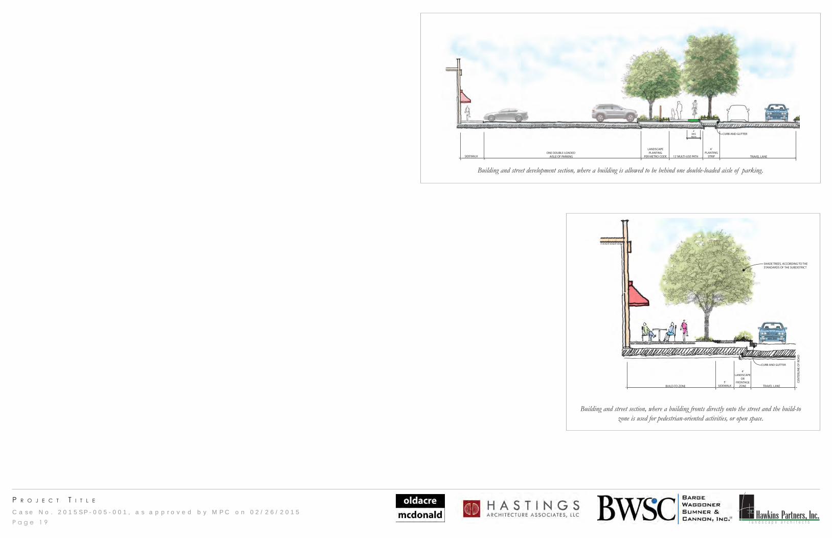
BUILDING/PARKWAY SECTION
SIDEWALK 12’ MULTI-USE PATH TRAVEL LANE
4’ PLANTING
STRIPONE DOUBLE-LOADED
AISLE OF PARKING
LANDSCAPEPLANTING
PER METRO CODE
CURB AND GUTTER4’
BIKEPATH
Building and street development section, where a building is allowed to be behind one double-loaded aisle of parking.
BUILDING/INTERNAL DRIVE SECTION
TRAVEL LANE
CEN
TERL
INE
OF
ROA
D
5’SIDEWALKBUILD-TO ZONE
4’LANDSCAPE
ORFRONTAGE
ZONE
CURB AND GUTTER
SHADE TREES, ACCORDING TO THESTANDARDS OF THE SUBDISTRICT
Building and street section, where a building fronts directly onto the street and the build-to zone is used for pedestrian-oriented activities, or open space.
C a s e N o . 2 0 1 5 S P - 0 0 5 - 0 0 1 , a s a p p r o v e d b y M P C o n 0 2 / 2 6 / 2 0 1 5 Hawkins Partners, Inc.l a n d s c a p e a r c h i t e c t s
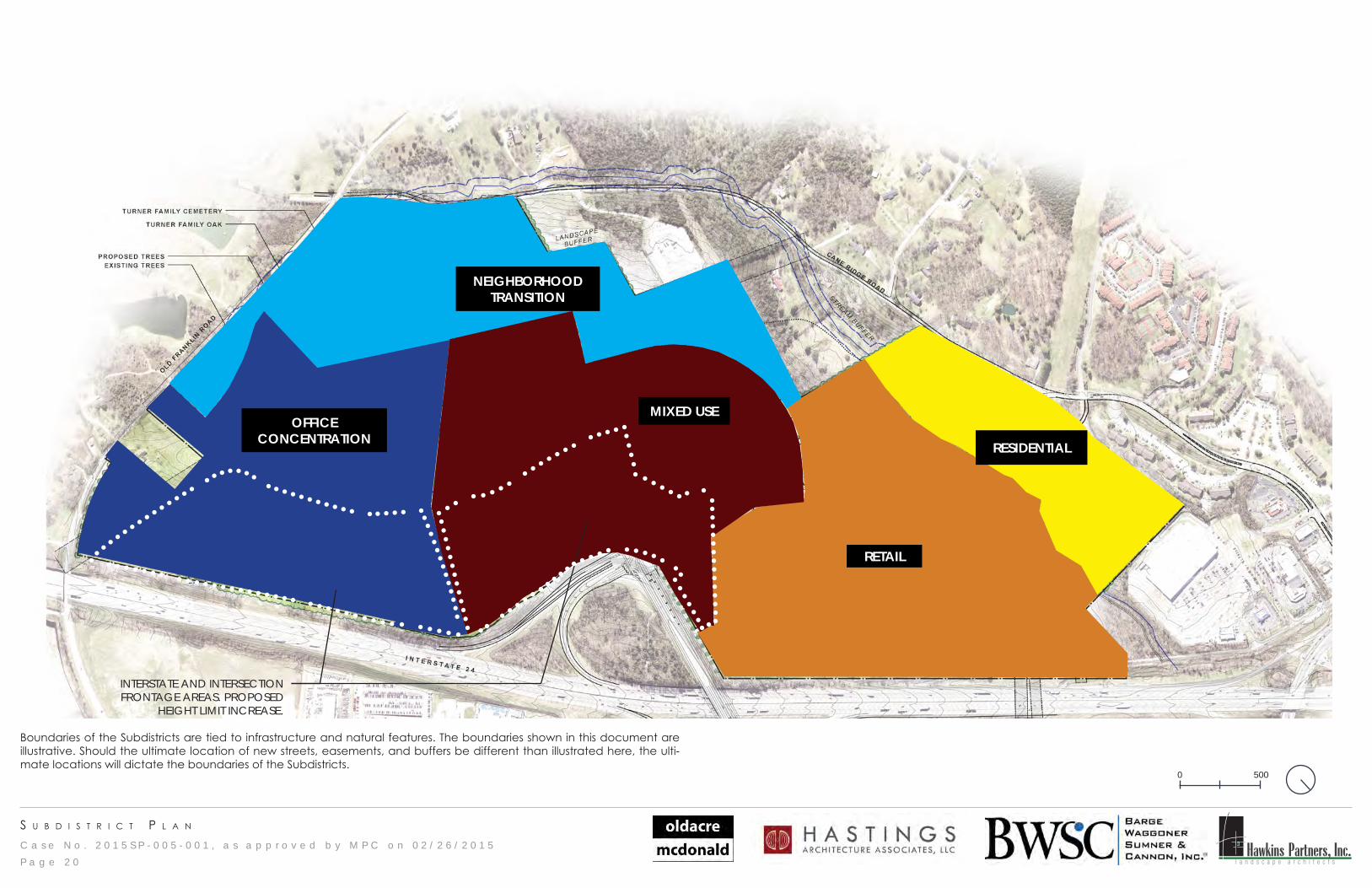
s u b d I s t r I c t p l a n
P a g e 2 0
0 500
Boundaries of the Subdistricts are tied to infrastructure and natural features. The boundaries shown in this document are illustrative. Should the ultimate location of new streets, easements, and buffers be different than illustrated here, the ulti-mate locations will dictate the boundaries of the Subdistricts.
MIXED USE
NEIGHBORHOOD TRANSITION
RESIDENTIAL
RETAIL
OFFICE CONCENTRATION
INTERSTATE AND INTERSECTION FRONTAGE AREAS. PROPOSED
HEIGHT LIMIT INCREASE.
C a s e N o . 2 0 1 5 S P - 0 0 5 - 0 0 1 , a s a p p r o v e d b y M P C o n 0 2 / 2 6 / 2 0 1 5 Hawkins Partners, Inc.l a n d s c a p e a r c h i t e c t s
s u b d I s t r I c t c h a r a c t e r
The Conceptual Master Plan is divided into five distinct subdistricts - Residential, Retail, Neighborhood Transition, Office Concentration, and Mixed Use. The character of each is supportive of the others, and contributes to a cohesive vision of a community center that provides housing, shopping, services, and jobs for the community and the region. The policies of the District: Destination Retail community character policy guide the standards and intent of each subdistrict.
The Residential Subdistrict provides a transition between the adjacent residential land uses and the proposed mixed-use development. This subdistrict responds to the natural features of the site, allowing buildings that step along the topography, preserve natural vegetation, and use the nearby creek as an amenity and an asset. Vehicular connections are balanced with pedestrian movements, and a priority is placed on pedestrian and bicycling connections, and open space orienta-tion. Landscaping is naturalistic, and lighting and signage are minimal.
The Retail Subdistrict is designed for regional retail and complementary uses. Large-footprint, single-use buildings are allowed within this subdistrict, and are designated for such uses. The standards of the subdistrict balance auto mobility with walking and cycling. The community-wide pedestrian and bicycle network is integrated into this subdistrict, allowing moblity options. Parking lots are organized in a manner that provides a block structure for future development. Regulations break down the scale of large parking lots and large buildings while balancing the needs of regional retail. Signage is allowed greater flexibility than other subdistricts.
The Neighborhood Transition Subdistrict provides services and uses that transition between the existing and emerging neigh-borhoods nearby, and the proposed mixed-use development. Natural features - including topography and a creek - are used as assets within the subdistrict. The buildings within this subdistrict are smaller footprint and parking lots are accordingly smaller. Buildings may be mixed-use or single-use commercial or residential. Site design is more formal, and buildings are oriented toward streets or open space.
The Office Concentration Subdistrict provides large-footprint office buildings for local and regional employment. Bulidings are oriented toward streets or open space, and parking is provided behind or beside buildings in lots or structures. This subidstrict takes advantage of the visibility and access provided by Interstate 24, and taller buildings are allowed nearer the interstate. Access is balanced between auto, pedestrian, and cyclist, and the subdistrict is connected to the overall mixed-use development through streets, open spaces, and greenways.
The Mixed Use Subdistrict allows a uniquely urban development type within a suburban location. Buildings are oriented toward internal streets or open space, and site design is more formal. Retail, commercial, entertainment, hotel, and mixed-use buildings are envisioned to complement the nearby retail and office uses. The Mixed Use Subdistrict is the physical center of the development, and combines the uses and intensity of the other subdistricts in a cohesive, pedestrian-oriented environment. The subdistrict is connected to all subdistricts with aligned streets, open spaces, and greenways.
The drawings, diagrams, plans, illustrative photos, guiding principles and regulations of this document are supported by and supportive of the Destination Retail community character policy, and create a unique destination retail, mixed-use com-munity center for Southeast Nashville. The development will integrate retail, commercial uses, office, hotel, and residential buildings into a 21st century mixed-use suburban community that can meet the needs of the current community while setting a framework for future development.
P a g e 2 1
C a s e N o . 2 0 1 5 S P - 0 0 5 - 0 0 1 , a s a p p r o v e d b y M P C o n 0 2 / 2 6 / 2 0 1 5 Hawkins Partners, Inc.l a n d s c a p e a r c h i t e c t s
s u b d I s t r I c t : r e s I d e n t I a l
P a g e 2 2
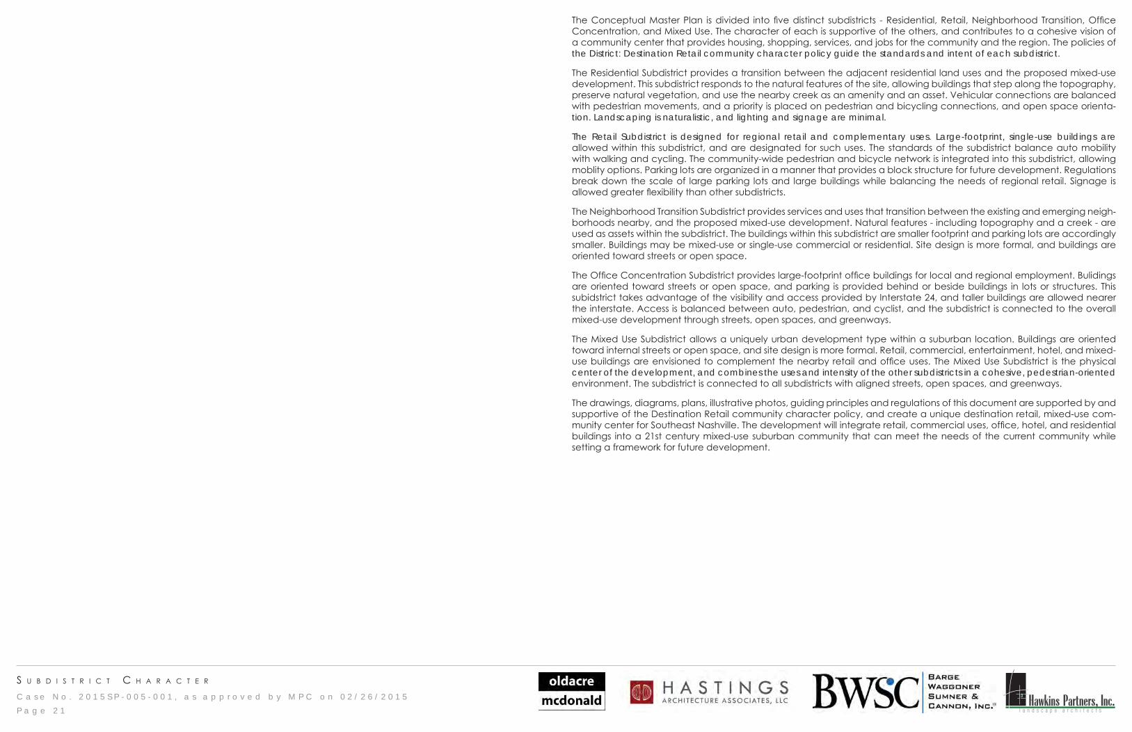
Acreage +/- 26 acres, up to 29 acres.Guiding Principles 1. This subdistrict is intended to develop as housing that responds and cel-
ebrates the natural resources of the site and provides a transition in use and scale from the existing residential buildings on Cane Ridge Road into the proposed mixed use development.
2. Cane Ridge Road will be improved to the entrance of the new develop-ment. Maintaining the rural character of the road beyond the entrance to the development was a request of the community and a commitment maintained by the applicant. To this end, design guidance in this Subdis-trict for the preservation of natural features such as topography, the creek, the creek buffer, and natural open space, building orientation and parking location are allowed flexibility not allowed in other subdistricts.
3. The creek will be prioritized as an amenity to the subdistrict, the larger devel-opment, and the entire community. Its associated flood plain and required stream buffers are intended to be active and passive open space for the community to enjoy nature and recreation.
4. The natural resources of the site will be a major organizing tool for site devel-opment, building orientation, and parking location. Buildings will be situated in park-like settings, and parking will be landscaped according to the zoning code standards.
Guiding Principles 5. Natural and formal open spaces will connect to the open space and pedes-trian network of the larger development.
6. Residential buildings - whether stacked flats or townhouses - will respond to the topography and natural features of the site.
7. In order to meet shifting demographics and a variety of price-points within the community, a variety of housing types are encouraged.
8. Pedestrian connections - including multi-use paths, greenways, and side-walks - will connect the residential buildings within this subdistrict to the resources of the mixed use development and the broader community.
9. To the extent allowed by external regulations, the gas easement will be uti-lized as an open space amenity.
Base Zoning The standards applied to this Subdistrict shall follow RM20 zoning except where standards in this document are more specific or change the standards of the base zoning district.
FAR Development intensity is determined by Dwelling Units only. Dwelling Units 20 units per acre, up to 300 units maximum. ISR According to RM20.Front Setback or Build-to Zone During the Final SP process, facades shall be identified in accordance with the
Urban Design pages of this document. • The build-to zone of Pedestrian Entrance Facades shall be 0-20’ from back
of the sidewalk of a Parkway, street, internal drive, or landscape bufferyard. Maximum Height at the Setback or Build-to Zone
5 stories
Height Control Plane or Stepback None.Maximum Overall Height 5 stories. Maximum height shall be measured from the lowest grade adjacent
to the building.Use Restrictions According to RM20.Parking According to RM20.Signage According to RM20. Ground signs are limited to monument signs. Pole signs are
prohibited. Billboards are prohibited. Digital signs, except when used for the dis-play of gas pricing, are prohibited. LED lighting is allowed for static signs.
Building and Development Types Stacked Flats, townhouses, and other residential building types are allowed. A mixture of housing types is required.
Additional Notes Land used for compliance with stream buffer regulations, public easements, and/open space - while not available for development - shall be available for calculation of overall density.
A landscape buffer yard, Standard B-1 or equivalent, shall be provided as shown on the plan.
Raised foundations of a minimum of 18” and a maximum of 36” are required for all residential buildings.
Parking is prohibited between a residential building and the parkway.
C a s e N o . 2 0 1 5 S P - 0 0 5 - 0 0 1 , a s a p p r o v e d b y M P C o n 0 2 / 2 6 / 2 0 1 5 Hawkins Partners, Inc.l a n d s c a p e a r c h i t e c t s
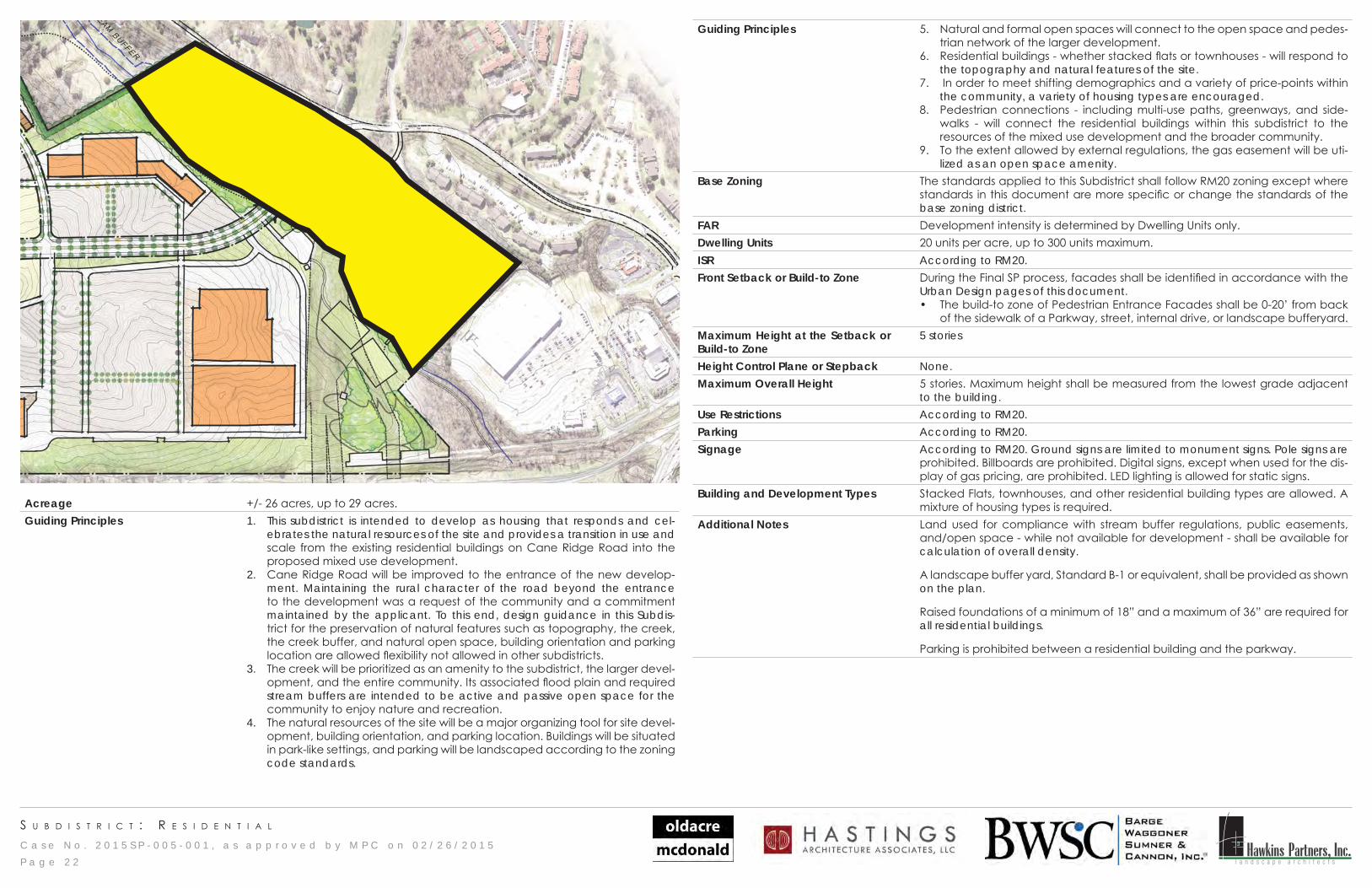
s u b d I s t r I c t : r e t a I l - p a g e 1
LEGEND:PEDESTRIAN ENTRANCE FACADE
P a g e 2 3
Acreage +/- 74 acres, to a maximum of 81 acres.Guiding Principles 1. This subdistrict will provide community and regional retail.
2. Safe and convenient vehicular access will be prioritized and balanced with the overall pedestrian network of the larger development.
3. The high visibility of the site from the interstate and the interchange provide opportunities for building types and signage that are unique to this subdistrict.
Base Zoning The standards applied to this Subdistrict shall follow SCR zoning district except where standards in this document are more specific or change the standards of the base zoning district.
FAR 1.0, according to SCR.Dwelling Units Development intensity is determined by FAR only.ISR 0.8, according to SCR.Front Setback or Build-to Zone During the Final SP process, facades shall be identified in accordance with the
Urban Design pages of this document. • The build-to zone of Pedestrian Entrance Facades shall be 0-20’ from back of
the sidewalk of a Parkway, street or internal drive. • Pedestrian Entrance Facades of Big Boxes shall be oriented toward an internal
drive with parking beyond.Maximum Height at the Setback 80 feetHeight Control Plane or Step-back
None.
Overall Maximum Height 80 feetUse Restrictions According to SCR with the following:
• Cash Advance is not permitted.• Check Cashing is not permitted.• Title Loan is not permitted.
Parking According to SCR with the following:• Parking for retail shall be 1 space per 250 SF.• Parking for accessory storage or warehousing within a retail building shall be
calculated separately from parking for retail. Such parking shall be provided at a ratio of 1 space per 1000 SF of storage or warehousing.
Signage According to SCR.Building Types Big Boxes, Storefronts, and Outparcel buildings are allowed.Additional Notes Vehicular access points to Outparcel buildings are restricted to internal drives and
minor streets and shall not be from Parkways.Outparcels may not be indicated on the Conceptual Master Plan but may be included in the Final SP process, and are subject to the standards of this Subdistrict and the Urban Design standards for Outparcels.On Pedestrian Entrance Facades, Big Boxes may comply with the facade articula-tion recommendations of the Community Character policies or, in areas that are unarticulated, a 10’ sidewalk may be provided adjacent to the building and inter-nal drive; the sidewalk shall include shade trees spaced at a minimum of 40’. All other facades are exempt from the articulation recommendation.For buildings larger than 200,000 SF, at least one designated pedestrian walkway will be provided through the parking lot to the Pedestrian Entrance Facade.
C a s e N o . 2 0 1 5 S P - 0 0 5 - 0 0 1 , a s a p p r o v e d b y M P C o n 0 2 / 2 6 / 2 0 1 5 Hawkins Partners, Inc.l a n d s c a p e a r c h i t e c t s
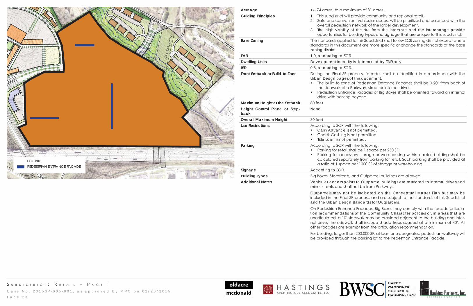
s u b d I s t r I c t : n e I g h b o r h o o d t r a n s I t I o n
P a g e 2 4
Acreage +/- 56 acres, to a maximum of 61 acres.Guiding Principles 1. This subdistrict will develop as housing or smaller scale commercial uses, or
smaller scale mixed use buildings that accommodate both types of uses. 2. Housing will respond to and celebrate the natural resources of the site and pro-
vides a transition in use and scale from the surrounding neighborhoods into the proposed mixed use development.
3. The creek will be prioritized as an amenity to the subdistrict, the larger develop-ment, and the entire community. Its associated flood plain and required stream buffers are intended to be active and passive open space for the community to enjoy nature and recreation.
4. The natural resources of the site will be a major organizing tool for site devel-opment, building orientation, and parking location. Buildings will be situated in park-like settings, and parking will be landscaped according to the zoning code standards.
5. Residential buildings - whether stacked flats or townhouses - will respond to the topography and natural features of the site.
6. In order to meet shifting demographics and a variety of price-points within the community, a variety of housing types are encouraged. These housing types may include stacked flats, townhouses, or units within mixed use buildings. A minimum of two housing types will be provided within this subdistrict.
7. Smaller footprint commercial buildings will provide services to the community within and beyond the mixed use development.
Base Zoning The standards applied to this Subdistrict shall follow MUL zoning district except where standards in this document are more specific or change the standards of the base zoning district.
FAR 1.0, according to MUL zoning.Dwelling Units A maximum of 700 dwelling units are allowed in this Subdistrict. ISR 0.9, according to MUL zoning.
Front Setback or Build-to Zone During the Final SP process, facades shall be identified in accordance with the Urban Design pages of this document. • The build-to zone of Public Facades facing Parkways have no restriction on
dimension, and shall follow the standards for Public Facades. • The build-to zone of Pedestrian Entrance Facades shall be 0-20’ from back of
the sidewalk of a Parkway, street or internal drive. • In relationship to Parkways, buildings may be located behind one double-
loaded aisle of parking. • Residential buildings are excluded from this provision; no parking is allowed
between a Parkway and a residential building. The constraints of topogra-phy and natural features, however, may require alternative solutions.
• Mixed Use buildings shall face a public street or internal drive that is visible to the public.
Maximum Height at the Set-back
3 stories for Mixed Use buildings. 5 stories for Residential buildings.
Height Control Plane or Step-back
None.
Maximum Overall Height 5 stories. Maximum height shall be measured from the lowest grade adjacent to the building.
Use Restrictions According to MUL zoning with the following:• Cash Advance is not permitted.• Check Cashing is not permitted.• Title Loan is not permitted.
Parking According to MUL zoning with the following:• Parking for retail shall be 1 space per 250 SF.
Signage According to MUL zoning. Ground signs are limited to monument signs. Pole signs are prohibited. Billboards are prohibited. Digital signs, except when used for the display of gas pricing, are prohibited. LED lighting is allowed for static signs.
Building and Development Types
Outparcels, Storefront, Mixed Use and Residential buildings are allowed.
Additional Notes Vehicular access points to Outparcel buildings are restricted to internal drives and minor streets and shall not be from Parkways.
Outparcels may not be indicated on the Conceptual Master Plan but may be included in the Final SP process, and are subject to the standards of this Subdistrict and the Urban Design standards for Outparcels.
A landscape buffer yard, Standard B-1 or equivalent, shall be provided as shown on the plan. Exceptions shall be made within utility easements.
Raised foundations of a minimum of 18” and a maximum of 36” are required for all residential buildings.
C a s e N o . 2 0 1 5 S P - 0 0 5 - 0 0 1 , a s a p p r o v e d b y M P C o n 0 2 / 2 6 / 2 0 1 5 Hawkins Partners, Inc.l a n d s c a p e a r c h i t e c t s
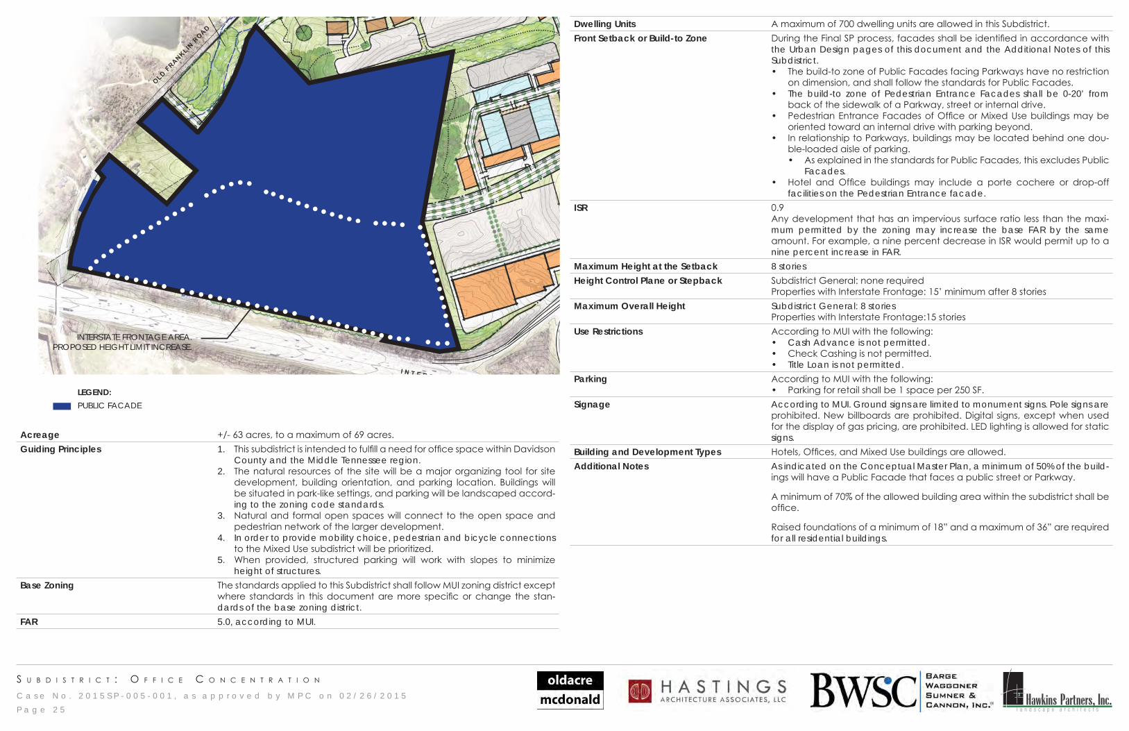
s u b d I s t r I c t : o f f I c e c o n c e n t r a t I o n
INTERSTATE FRONTAGE AREA. PROPOSED HEIGHT LIMIT INCREASE.
LEGEND:PUBLIC FACADE
P a g e 2 5
Acreage +/- 63 acres, to a maximum of 69 acres.Guiding Principles 1. This subdistrict is intended to fulfill a need for office space within Davidson
County and the Middle Tennessee region.2. The natural resources of the site will be a major organizing tool for site
development, building orientation, and parking location. Buildings will be situated in park-like settings, and parking will be landscaped accord-ing to the zoning code standards.
3. Natural and formal open spaces will connect to the open space and pedestrian network of the larger development.
4. In order to provide mobility choice, pedestrian and bicycle connections to the Mixed Use subdistrict will be prioritized.
5. When provided, structured parking will work with slopes to minimize height of structures.
Base Zoning The standards applied to this Subdistrict shall follow MUI zoning district except where standards in this document are more specific or change the stan-dards of the base zoning district.
FAR 5.0, according to MUI.
Dwelling Units A maximum of 700 dwelling units are allowed in this Subdistrict. Front Setback or Build-to Zone During the Final SP process, facades shall be identified in accordance with
the Urban Design pages of this document and the Additional Notes of this Subdistrict.• The build-to zone of Public Facades facing Parkways have no restriction
on dimension, and shall follow the standards for Public Facades. • The build-to zone of Pedestrian Entrance Facades shall be 0-20’ from
back of the sidewalk of a Parkway, street or internal drive. • Pedestrian Entrance Facades of Office or Mixed Use buildings may be
oriented toward an internal drive with parking beyond.• In relationship to Parkways, buildings may be located behind one dou-
ble-loaded aisle of parking. • As explained in the standards for Public Facades, this excludes Public
Facades. • Hotel and Office buildings may include a porte cochere or drop-off
facilities on the Pedestrian Entrance facade.ISR 0.9
Any development that has an impervious surface ratio less than the maxi-mum permitted by the zoning may increase the base FAR by the same amount. For example, a nine percent decrease in ISR would permit up to a nine percent increase in FAR.
Maximum Height at the Setback 8 storiesHeight Control Plane or Stepback Subdistrict General: none required
Properties with Interstate Frontage: 15’ minimum after 8 storiesMaximum Overall Height Subdistrict General: 8 stories
Properties with Interstate Frontage:15 storiesUse Restrictions According to MUI with the following:
• Cash Advance is not permitted.• Check Cashing is not permitted.• Title Loan is not permitted.
Parking According to MUI with the following:• Parking for retail shall be 1 space per 250 SF.
Signage According to MUI. Ground signs are limited to monument signs. Pole signs are prohibited. New billboards are prohibited. Digital signs, except when used for the display of gas pricing, are prohibited. LED lighting is allowed for static signs.
Building and Development Types Hotels, Offices, and Mixed Use buildings are allowed.Additional Notes As indicated on the Conceptual Master Plan, a minimum of 50% of the build-
ings will have a Public Facade that faces a public street or Parkway.
A minimum of 70% of the allowed building area within the subdistrict shall be office.
Raised foundations of a minimum of 18” and a maximum of 36” are required for all residential buildings.
C a s e N o . 2 0 1 5 S P - 0 0 5 - 0 0 1 , a s a p p r o v e d b y M P C o n 0 2 / 2 6 / 2 0 1 5 Hawkins Partners, Inc.l a n d s c a p e a r c h i t e c t s
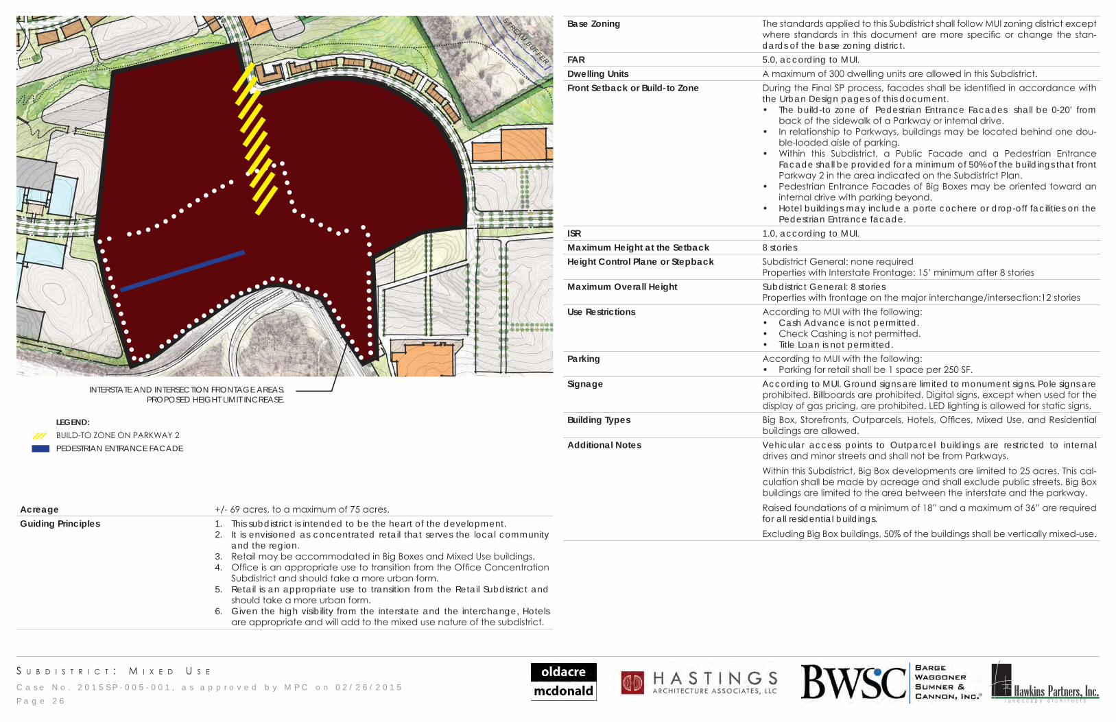
s u b d I s t r I c t : M I x e d u s e
INTERSTATE AND INTERSECTION FRONTAGE AREAS. PROPOSED HEIGHT LIMIT INCREASE.
LEGEND:BUILD-TO ZONE ON PARKWAY 2PEDESTRIAN ENTRANCE FACADE
P a g e 2 6
Acreage +/- 69 acres, to a maximum of 75 acres.Guiding Principles 1. This subdistrict is intended to be the heart of the development.
2. It is envisioned as concentrated retail that serves the local community and the region.
3. Retail may be accommodated in Big Boxes and Mixed Use buildings. 4. Office is an appropriate use to transition from the Office Concentration
Subdistrict and should take a more urban form. 5. Retail is an appropriate use to transition from the Retail Subdistrict and
should take a more urban form.6. Given the high visibility from the interstate and the interchange, Hotels
are appropriate and will add to the mixed use nature of the subdistrict.
Base Zoning The standards applied to this Subdistrict shall follow MUI zoning district except where standards in this document are more specific or change the stan-dards of the base zoning district.
FAR 5.0, according to MUI. Dwelling Units A maximum of 300 dwelling units are allowed in this Subdistrict. Front Setback or Build-to Zone During the Final SP process, facades shall be identified in accordance with
the Urban Design pages of this document. • The build-to zone of Pedestrian Entrance Facades shall be 0-20’ from
back of the sidewalk of a Parkway or internal drive. • In relationship to Parkways, buildings may be located behind one dou-
ble-loaded aisle of parking.• Within this Subdistrict, a Public Facade and a Pedestrian Entrance
Facade shall be provided for a minimum of 50% of the buildings that front Parkway 2 in the area indicated on the Subdistrict Plan.
• Pedestrian Entrance Facades of Big Boxes may be oriented toward an internal drive with parking beyond.
• Hotel buildings may include a porte cochere or drop-off facilities on the Pedestrian Entrance facade.
ISR 1.0, according to MUI.Maximum Height at the Setback 8 storiesHeight Control Plane or Stepback Subdistrict General: none required
Properties with Interstate Frontage: 15’ minimum after 8 storiesMaximum Overall Height Subdistrict General: 8 stories
Properties with frontage on the major interchange/intersection:12 storiesUse Restrictions According to MUI with the following:
• Cash Advance is not permitted.• Check Cashing is not permitted.• Title Loan is not permitted.
Parking According to MUI with the following:• Parking for retail shall be 1 space per 250 SF.
Signage According to MUI. Ground signs are limited to monument signs. Pole signs are prohibited. Billboards are prohibited. Digital signs, except when used for the display of gas pricing, are prohibited. LED lighting is allowed for static signs.
Building Types Big Box, Storefronts, Outparcels, Hotels, Offices, Mixed Use, and Residential buildings are allowed.
Additional Notes Vehicular access points to Outparcel buildings are restricted to internal drives and minor streets and shall not be from Parkways.Within this Subdistrict, Big Box developments are limited to 25 acres. This cal-culation shall be made by acreage and shall exclude public streets. Big Box buildings are limited to the area between the interstate and the parkway.Raised foundations of a minimum of 18” and a maximum of 36” are required for all residential buildings. Excluding Big Box buildings, 50% of the buildings shall be vertically mixed-use.