beetle infestat jons turpent~ne eval … · f/ / eval uation of black turpent~ne beetle infestat...
TRANSCRIPT
F/ /
EVAL UATION OF BlACK TURPENT~NE BEETLE INFESTAT JONS
ON
SAND HILLS STATE FOREST
BY
THE SOUTH CAROLINA
SlATE COMMISSiON OF FORESTRY

507-3B
EVALUATION OF BLACK TURPENTINE BEETLE INFESTATIONS ON SAND HILLS STATE FOREST IN SOUTH CAROLINA
By
Michael C. Remion l/
South Carolina State Commi ss ion of Forestry
ABSTRACT
January 1~71
Aerial ske tch map and ground surveys of Sand Hills State Forest located in nor t heas tern South Carolina indicate black turpent ine bee tle (Dendroctonus terebrans Oliv.) activity to be appr oaching epidemic levels. Survey data analysi s r evea l s that there are 12.2 spots and 63.5 infested trees perM acres of host type on the 92,000 acre f orest. Timber losses estimated from the aerial and ground phases of the survey are 10,537 board feet of sawt imber and 2.2 cords of pulpwood per M acres of hos t t ype. Prompt removal of infested material through commer cial sales is recommended throughout t he for es t .
1/ Forester-Entomologist, South Caro l ina State Commi ssion of Forestry .
S. C. STATE usn. RY

INTROnDCTION
The black turpentine beetle has always pre sented a slight prob l em on Sand Hills State Forest, but in June and July , 1970 Commission fo~ester s in the area recognized an apparent, above norma l incr ease i n the population. It was observed that the majority of the trees i n the spots they we r e encountering showed no signs of fading or reddening .
After delaying two months, hoping that a great er percentage of t he a t tacked trees would by then be displaying discolora tion symptoms, the aerial sketch map survey was performed on September 24 and 25, 1970. The subsequent ground survey was conducted from September 26 through Octobe r 23, 1970. Participants in the surveys included personnel of the s. C. State Commission of Forestry from Sand Hill s State Forest, Columbia and Camden District offices, and P. J. Barry, Entomologi s t with the Division of Forest Pest Control in Asheville, N. C. The purpose of this survey was to evaluate pine bark beetle i nfestat i ons , and primarily those of the black turpentine beetle, and estimate mortality caus ed by them.
SURVEY METHODS
A Cessna, Model 172 aircraft was cont r acted to complete t he aerial sketch map survey. The crew consisted of a pilot, a tracker, and two observers . Aircraft speed was maintained at approximately 90 m.p.h. t hroughout the survey at an altitude of 800 - 1,000 f eet above sea leve l . Twenty -six north-south flight lines spaced at one mile i ntervals gave 100 pe rcent survey coverage. Observers recorded the locat ion and estimat ed the number of red and fading pine trees for a distance of one-half mile on their r e spective sides of the aircraf t.
Approximately 19 percent of the total number of spots recorded during the aerial survey phase were examined during the ground surve:- to determine the causal agents involved, obtain mortality data, and evaluat e the bark beetle population.
RESULTS
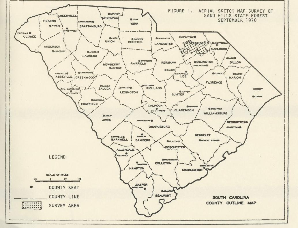
The survey encompassed 92,000 gross acre s (see Fig. 1), of whi ch 69,500 were considered host type.~/ A total of 436 spots containing an estimated 1045 trees were recorded during the aerial sur vey (see Table 1). Correct ing these figure s for observer errors accor ding t o Al drich et al., ~95~ and air to ground ratio factors,l/ the original aeri al survey data was expanded to an estimated 851 spots containing 8122 trees.
~/ Defined as any stand in which 25 percent or more of the stems are pine. 11 Air to ground ratio factor is defined as t he factor obtained from the
ratio of the total trees estimated in a giv en spot size category during the aerial survey phase to t he total trees recorded for that spot size category during the ground survey phase.
-2-

During the ground ~urve~-- , exand.nat~_ onP. were marle on 82 spots containing 1058 t1·ees, 575 of whi<:h we:-e cn::::::en :: ly ir_fested with bark beetles (see Table 2). Tt~e bl ack turpentine beet : e was the primary causal agent in 42 sp•Jta with 1.ps engraver beetles Gp_s_ . spp. ) being responsible for the remaining 40 spots.
Pine host speci~s attacked were pond (Pinus ser otina Michx.), longleaf (R_. palustris MUl.), slash (R_. elli t,ttii Enge lm.), and loblolly (R_. taeda L.).
Fifty-nine of the 82 spots ground checked contained infested trees and . 54 percent of the trees examined in the se spot s were infested. The survey results indicate that there are 12 .2 spots and 63.5 infested trees perM acres of host type on Sand Hi lls State Forest (see Table 3). Of the 1058 trees checked during the ground survey, 55 percent were green, 35 percent red, and 10 percent fadi ng .
From survey data analysis, total mortality due to pine bark beetles, and primarily the black turpentine beetle, is estimated at 732,349 board feet and 151.3 cords (see Table 4). These figures represent an estimated sttxmpage value of $26,691.35. The ground survey results indicated 72 percent of all trees examined fell into t he sawtimber class, 27 percent into the pulpwood class, and one percent i nto the non-merchantable class.
DISCUSSION
A mnnber of difficulties were encountered during the survey. As can be observed from the ground survey data summary (Table 2). , 55 percent of all trees examined displayed no crown symptoms of bark beetle attack and consequently could not be observed dur ing the ae-::ial su::.:-vey. The absence of ips engraver beetle association with most of the bl ack turpentine beetle spots was credited as being responsib l e f or the high percentage of attacken trees falling into the green category. This not only created high air to ground ratio factors, but made the l oca t ion of high inf estation areas containing large nun1bers of trees im~ossible without checking every recorded spot.
This initially was the case. However, during the first week of ground checking, the ground crews noticed an attack pattern of the black turpentine beetle. It was observed that the beetle was concentrating in stands primarily in and adjacent to drain areas and especially those which had been cut during the preYious year. Pond and longleaf pines were the primary host spec~es attacked since they comprised the majority of the type in these areas.
Intensive salvage operations conducted throughout the forest since and as a result of the February, 1969 ice storm, together with drought conditions which existed during the spring and summer months of 1970, are speculated as the agents responsibl e f or the epidemic population buildup of the black turpentine beetle on Sand Hil l s State Forest.
The survey results indicate ips engraver beetle populations to be endemic and timber losP.es attributable to them as acceptable. Lightning damage was found to be initially responsible for the maj ority of the spots where Ips spp. vmre considered to be the primary causal agents.
-3-

RECOMt-'i.::t:NDATIONS
1. It is reconnnended that black tv.rpentine beetle infested trees and other salvable timber be promptly salvaged through commercial sales when economically feasible . When suet methods are employed, it is imperative that stumps be kept as low as possible and damage to green, unattacked trees in the residual stand be held to a minimtnn .
It is further suggested that I•eriodic, monthly inspections be made of the salvaged stands beginning three weeks following the completion of a cutting operation and continuing to January, 1971. The purpose of these inspections being early detection of any reoccurrence of black turpentine beetle activity.
2. A 100 percent aerial sketch map survey of Sand Hills State Forest is scheduled for January 27, 1971. The primary objective of this survey will be to locate remaining black turpentine beetle spots for the purpose of suppression and re(luction of timber losses.
ACKNOWLEDGEMENTS
An expression of appreciation is made to Patr~ck J. Barry and William H. Clerke, both of the Asheville Offi ce, Division of Forest Pest Control, for their most helpful assistance in completing portions of this survey.
REFERENCES
Observation Limits for Aerial Sketchmapping Southern Pine Beetle in the Appalachians, 1958, by Aldrich, R. C., R. c. Heller, and W. F. Bailey. Jour. For. 56(3): 200-202.
Merchantable Rough Cord Voltnne Table published in the S. C. State Commission of Forestry Management Policy Manual.
Tables for Estimating Board-Foot Volume of Timber, by Clement Measvage and J. W. Girard . U. S. Forest Serv:ce, USDA, 94 pp., illus.
For extra copies of this report or further inf ormation on the survey, contact:
Management Assistant Forest Insect and Disease Control S. Co State Commission of Forestry P. 0. Box 287 Columbia, South Carolina 29202
-4-
OCONEE
20
' -i I • I I
I I
l I
L ~ --
. \ .__., I , • .
,CREENVIL.L£. I ~FFNEl' .-J FIGURE 1 . AERIAL SKETCH MAP SURVEY OF
SAND HILLS STATE FOREST SEPTEMBER 1970 ' \ I \CHER~ ~ PICKENS , • ,..__. ' ---, ero•
/ ·~tCKEN$ \ r;ARTA:BURG \..-""'- l 'I'ORK ·~ ' .~c .. ~c ... .,u.c L r· ~l- -<' I / l \ -------
' / • 1
.''\ i 0
I Y' l / ' ' fi/JMON\ ecNcs~• ) ~MCAsrut '\ CNESTEAFtag•
, • '-.. / UNION , CHESTER Al'IOERSON \ { ·........:..., L { LANCASTER •
... ,.{)I:,.SO#f '>:·" .L,MJHNS -"' • --------1 ,.-""\ ...... --- MARLBORO
,,,/ -'>.. LAURENS (' V""~ (". • '../) i . ,.\.... ' \....._ / \ ' / (. \ ,..,. \ ·lf"-SIIO/fO I \ .. · \.., I DILLON •
. /· l '-, 1
. NEWBERRY , FAIRFIELD i KERSHAW 5,~-'\ DAAUNCTON I, • DIU.ON ' " e.vc"'~): • • lW/ftt.oom~Ne LJ \ ' , --1 r ") .~ r-·-~· .UIICVUC. I ·~ , .__,.-· , ·~ • \ ,__. r • AS&VILL.£) •.r·_,..-, , ......., ... 1·.,s"""''LL£ (• ·"' _____ _; /
• GREENWOOD( "\.... / ( '· • L..£E .-'' ~. ..._ ' -~---\' I '--! ·-, '·~ _., . ......_ '-..<' ) MARION J • ' '\ · \. • •· ~oE • ) v''- - / es.owno I . -~ J \.. ~ r ... R NCE \
MC co;t.ciCK.-)......L·~ $AI...UDA • ~ \, RICHLAND ( '\,·""'· ,.> , ~ ...: •o-.clt ( \..., ( l.EXINCTON \ { eSUinTlf ,""'\._ \._ \
) '·- _,-"\,. (', • SUMTER / -,-_ • · ,
(
' ~EU y '--, J -._ ~ /• ../ ·- \.. ~ , EOGEFlELD ,/· l, V:J ·'-·--r' ;-'' ( .-. . ..___,-·?. .
/ -.....,, A" CAL.HOUN \ ~ -...- 1' • \,. '\ . ' ..,..., -\ • . . __.. I .. "' ,/ ,/ '"\..sr .... monos '"'( CL.ARENOON i ~ • \
• .._,.. / ............ -.). • WIL.UAMSBUAI:# j ~ . '\ J""'\ I , -
AIKEN .~ o-·~· •._1 • ~ / ,/ '\.... , __ _...5 ·\. 1
. C£0RCETOWN
/ ,- " ORANGEBURG ~ '-.. ,/• ~ ~"'-, .~ j \.-( QCW:T ....
•-ue I .__ ""' ./ ~- ~ ,, 8ARNWEL.L I 8AMSERG • / • .., ....... i.. ~. esr ccc.occ ( ~ ~ r-. ------.... ( \. . ,--'
AU.ENOAL.£ ., ,.,.·"'\J ~e:.sn:R"-, I I • ./': J "\..._ /
LEGEND AI.L-.z __,..· \ I \~ r
/ • e-L~~. ~ \ .~
SC-'U: OF WIL.£S
0 20 ~
COUNTY SEAT
COUNTY LINE
SURVEY AREA
) •~, COU..ETON f--~ \.f • HAMPTON \ I ~
A . • OtARL£STON
/" l A..,..__, \ ,. -v " • t... . . "\.. .
.JASPER l \. C.., -..... ) '- ....
{ ,...J'BEAUF'ORT
~ \,,
SOUTH CAROLINA
COUNTY OUTLINE MAP

TABLE 1. SUMMARY OF AERIAL SURVEY DATA
SPOT SIZE CATEGORY NUMBER OF SPOTS RECORDED NUMBER OF TREES RECORDED
Sing le 246 246
2 - 5 158 418
6 - 20 31 331
21 - 50 1 50
51+ 0 0
TOTAL 436 1 , 045
~'ABLE 3. LEVEL OF PINE BARK BEETLE INFESTATION, SAND HILLS STATE FOREST , SEPTEMBER 1970
- ··-------- ----------SURVEY AREA NUMBER OF SUCCESSFULLY
I ~/ NUMBER OF SPOTS NUMBER OF INFESTED TREES ATTACKED TREES Cr~ss_ftcres_~ost TyEe Acres PER M ACRES HOST TYPE PER M ACRES HOST TYPE PER M ACRES HOST TYPE
92,000 69,500 12.2 63.5 116.9
1/ Stands with 25 percent or greater of the stems comprised of pine were considered host type.

11 TABLE 2. SUMMARY OF GROUND SURVEY DATA
CAUSAL AGENTS NUMBER OF INFESTED TREES NUMBER OF EMERGED TREES SPECIES
Primary I Secondary Greens I Faders I Reds I Total Greens I Faders I Reds I Total
None Longleaf 161 11 7 179 16 8 25 49
BLACK ~ spp. Longleaf 5 0 0 5 0 0 5 5
TURPENTINE None Pond 244 4 8 256 54 49 177 280
BEETLE ~ spp. Pond 2 4 1 7 1 1 6 8
None Slash 55 1 1 57 1 1 6 8
None Loblolly 8 0 0 8 0 2 15 17
Sub Total 475 20 17 512 72 61 234 367 ----~-
None Longleaf 9 3 18 30 7 7 71 85 ;
n. I. B. Longlea.f 0 L. L 4 l 1 3 5
IPS spp. None Pond 8 1 10 19 2 3 12 17
B. T. B. Pond 1 0 1 2 0 0 0 0
None Slash 3 2 0 5 2 0 4 6
None Loblolly 0 2 1 3 0 0 3 3
§_~b __ ~ot.al _~-~~ __ -~---~----·--- ___ 21 10 32 63 12 11 93 116
TO':[~- ------------- -· ------~- ~~ ---~- -·---~96 ___ 3_0_ -~- --~--- __ 5_]] 84 72 327 483 -·"----
ll Data collected from 82 spots containing 1,058 trees.
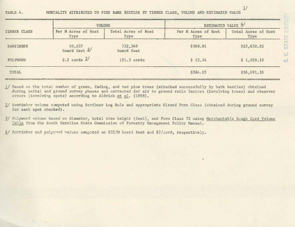
TABLE 4.
TIMBER CLASS
SAWTIMBER
PULPWOOD
TOTAL
ll MORTALITY ATTRIBUTED TO PINE BARK BEETLES BY TIMBER CLASS, VOLUME AND ESTIMATED VALUE
VOLUME
Per M Acres of Host I Type
10,537 board feet '1:.1
2.2 cords ]../
Total Acres of Host Type
732,349 board feet
151 .3 cords
ESTIMATED VALUE ~/ Per M Acres of Host
Type
$368.81
$ 15 .24
$384 .05
I Total Acres of Host Type
$25,632.25
$ 1,059.10
$26, 691.35
ll Based on the t utal number of green , f ading, and red pine trees (attacked successfully by bark beetle s) obtained during aerial anrl ground survey phases and cor rected .for air t o ground r ati o fact ors (invo l vi ng trees ) and observer P.rrors (involving spot s) according to Aldri ch e t a l. (1958).
~/ S awtimh~r volume c~puted us i ng Scribner Log Rule and appr opriate Girard Form Class (obtained during ground survey fo r each spot checked).
1./ "Pnlpwoorl volume b8 .. sed on diameter, tot al tree he i ght (feet) , and Form Class 72 using Merchantable Rcugh Curd Volume Tac•le f r om the Soath Caro lina State Cmumission of For estry Management Policy Manua l.
!J:./ S.:::~rt:imb ;; r e.nd pu 2.t:~ ;-v'l d val ues corr.p:t t ad on $35/M boarj feet aa d $7/-:ord, re spectively .
"
c: -·. LL. s en (.)
<ri