beni-darbang road sub-project - asian development bank · initial environmental examination (iee)...
TRANSCRIPT

Initial Environmental Examination (IEE)
of Beni-Darbang Road Sub-project
Beni-Darbang Road in Myagdi District
Submitted to:
Ministry of Local Development Government of Nepal
Submitted by:
District Development Committee Myagdi, Beni
July /2007

Beni-Darbang Road, Myagdi Initial Environmental Examination (IEE)
TABLE OF CONTENTS
ABBREVIATIONS ................................................................................................................................ I
EXECUTIVE SUMMARY (NEPALI)………………………………………………………………..II EXECUTIVE SUMMARY (ENGLISH) ........................................................................................... VI
SALIENT FEATURES ......................................................................................................................... X
Description Page 1.0 INTRODUCTION .................................................................................................................... 1
1.1 BACKGROUND ........................................................................................................................ 1 1.2 RELEVANCY OF THE PROPOSAL .............................................................................................. 1 1.3 NAME AND ADDRESS OF THE PROPONENT .............................................................................. 2 1.4 DESCRIPTION OF THE PROPOSAL ............................................................................................. 2 1.5 CONSTRUCTION APPROACH ................................................................................................... 5 1.6 OBJECTIVES ........................................................................................................................... 5 1.7 METHODOLOGY ADOPTED ...................................................................................................... 5
2.0 REVIEW OF RELEVANT ACTS, REGULATIONS AND GUIDELINES ....................... 9 3.0 EXISTING ENVIRONMENTAL CONDITION ................................................................. 13
3.1 PHYSICAL ENVIRONMENT .................................................................................................... 13 3.2 BIOLOGICAL ENVIRONMENT ................................................................................................ 14 3.3 SOCIO-ECONOMIC AND CULTURAL ENVIRONMENT .............................................................. 15
4.0 PROJECT ALTERNATIVES ............................................................................................... 20 4.1 NO ACTION OPTION .............................................................................................................. 20 4.2 PROPOSAL ALTERNATIVES ................................................................................................... 20 4.3 ALTERNATIVE DESIGN AND CONSTRUCTION APPROACH ..................................................... 20 4.4 ALTERNATIVE SCHEDULE AND PROCESS ............................................................................... 20 4.5 ALTERNATIVE RESOURCES .................................................................................................. 21
5.0 IDENTIFICATION AND ASSESSMENT OF IMPACTS ................................................. 22 5.1 BENEFICIAL IMPACTS ........................................................................................................... 22 5.2 ADVERSE IMPACTS ............................................................................................................... 24
6.0 MITIGATION MEASURES ................................................................................................. 28 6.1 MITIGATION MEASURES DURING PRE-CONSTRUCTION PHASE ............................................. 28 6.2 BENEFIT AUGMENTATION MEASURES .................................................................................. 28 6.3 ADVERSE IMPACTS MITIGATION MEASURES ........................................................................ 30
7.0 ENVIRONMENTAL MANAGEMENT PLAN ................................................................... 34 7.1 INSTITUTIONS AND THEIR ROLES .......................................................................................... 34 7.2 REPORTING AND DOCUMENTATION ...................................................................................... 35 7.3 ENVIRONMENTAL MANAGEMENT PLAN ............................................................................... 36 7.4 MITIGATION COST ................................................................................................................ 38 7.5 IMPLEMENTATION OF MITIGATION MEASURES .................................................................... 39 7.6 ENVIRONMENTAL MONITORING ........................................................................................... 40
8.0 CONCLUSION AND RECOMMENDATIONS ................................................................. 44 9.0 MISCELLANEOUS ............................................................................................................... 45

Beni-Darbang Road, Myagdi Initial Environmental Examination (IEE)
Tables Page
TABLE 1.1 PROJECT ACTIVITIES OF THE PROPOSED BENI-DARBANG ROAD SECTION ............................ 3 TABLE 3.1 TOPOGRAPHY, GEOLOGY AND SOIL TYPE ALONG THE ROAD ............................................. 13 TABLE 3.2 SUMMARY OF STREAMS ALONG THE ROAD ALIGNMENT .................................................... 14 TABLE 3.3 SUMMARY OF LAND USE PATTERN ALONG THE ROAD ALIGNMENT .................................... 14 TABLE 3.4 COMMUNITY FOREST ALONG THE ROAD ALIGNMENT ........................................................ 15 TABLE 3.5 SETTLEMENTS AND POPULATION WITHIN THE ZOI OF ROAD ALIGNMENT ........................... 15 TABLE 5.1. EVALUATION OF IDENTIFIED ENVIRONMENTAL IMPACTS ................................................. 27 TABLE 7.1 FRAMEWORK OF IMPLEMENTING ENVIRONMENTAL MANAGEMENT PLAN........................ 36 TABLE 7.2. COST ESTIMATE FOR ENVIRONMENTAL ENHANCEMENT AND MITIGATION MEASURES .... 39 TABLE 7.3 ENVIRONMENTAL MONITORING COST .............................................................................. 41 TABLE 7.4 FRAMEWORK FOR MONITORING ENVIRONMENTAL ISSUES ............................................... 42
Figures Page
FIGURE 1.1. MAP OF NEPAL SHOWING THE LOCATION OF BENI-DARBANG IN MYAGDI DISTRICT ......... 3 FIGURE 1.2. MAP SHOWING BENI-DARBANG ROAD IN MYAGDI DISTRICT .............................................. 4 FIGURE 1.3. MAP SHOWING BENI-DARBANG ROAD ALIGNMENT ............................................................ 4 FIGURE 7.1. ENVIRONMENTAL MANAGEMENT ORGANIZATION STRUCTURE ....................................... 36
ANNEXES Annex I Terms of Reference for IEE study
Annex II Abstract of cost
Annex III DRILP Environmental Checklist
Annex IV Public notice
Annex V Deed of enquiry (muchulka)
Annex VI Name of the organizations
Annex VII List of persons contacted
Annex VIII Recommendation letters from Municipality and VDCs
Annex IX a. Distribution of household by major occupation
b. Summary of public services and infrastructures according to settlement
c. Land holding pattern of settlements within ZoI
d. Number of households belonging to different food security category
Annex X List of tress
Annex XI Minimization of slope cutting and preservation of vegetation cover
Annex XII Photograph

Beni-Darbang Road, Myagdi Initial Environmental Examination (IEE) i
ABBREVIATIONS
ADB Asian Development Bank AP Affected Person BG Building Group Ch Chainage CBO Community Based Organization CDC Compensation Determination
Committee CEA Country Environmental Analysis CF Community Forest CFUG Community Forest Users Group CISC Central Implementation Support
Consultants CITES Convention on International Trade
in Endangered Species of Flora and Fauna
DADO District Agriculture Development Office
DDC District Development Committee DFO District Forest Office/Officer DG Director General DISC District Implementation Support
Consultants DIT District Implementation Team DoLIDAR Department of Local Infrastructure
Development and Agricultural Roads
DPO District Project Office DRCC District Road Coordination
Committee DSCO District Soil Conservation Office DTO District Technical Office DRILP Decentralized Rural Infrastructure
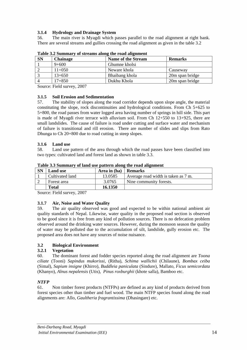
and Livelihood Project DTMP District Transport Master Plan EA Environmental Assistant/Assessment EAS Environmental Assessment
Specialist EIA Environmental Impact Assessment EMP Environmental Management Plan EMS Environmental Management
Section EPA Environmental Protection Act EPR Environmental Protection Rules ESD Environment Screening Document FGD Focus Group Discussion GoN Government of Nepal GIS Geographical Information System
Ha Hectare Hh Household IEE Initial Environmental Examination Km Kilometer LDO Local Development Officer LEP Labour based, environment friendly
and participatory LRMP Land Resource Management Project M meter MoPE Ministry of Population and
Environment MoEST Ministry of Environment, Science
and Technology Ml Milliliter MLD Ministry of Local Development NGO Non-Governmental Organization NRs Nepali Rupees NTFPs Non timber forest products OP Operational Plan PAM Project Administrative
Memorandum PCU Project Coordination Unit RES Rapid Environmental Screening RIDP Rural Infrastructure Development
Project RP Resettlement Plan RS Resettlement Survey SF Special Fund SA Social Appraisal SDC Swiss Agency for Development and
Cooperation SM Social Mobilizer SMC Social Mobilization Coordinator TA Technical Assistance ToR Terms of Reference TWS Technical Walkover Survey VDC Village Development Committee VWRCC Village Works and Road
Construction Committee ZoI Zone of Influence

a]gL–b/jfË ;8s–DofUbL k|f/lDes jftfj/0fLo k/LIf0f k|ltj]bg ii
a]gL–b/jf+u ;8s v08sf] k|f/lDes jftfj/0fLo k/LIf0f k|ltj]bg sfo{sf/L ;f/f+z
k[i7e"dLM ljs]Gb|Lt u|fdL0f k"jf{wf/ tyf hLljsf]kfh{g ;'wf/ sfo{s|d PlzofnL ljsf; a}+ssf] C0f ;xof]u, :jL; ljsf; ;xof]u lgof]usf] k|ljlws ;xof]u tyf g]kfn ;/sf/, ;xefuL lhNnfx? / nfeu|fxL ;d]tsf] nufgLdf z'? ePsf] xf] . of] sfo{s|dsf] nIo åGb af6 k|efjLt !* lk5fl8Psf lxdfnL tyf kxf8L lhNnfsf] u|fdL0f If]qsf] u/LaL Go"lgs/0f ug'{ /x]sf] 5 . u|fdL0f oftoft tyf k"jf{wf/ ljsf;sf] dfWod af6 u|fdL0f If]qsf ljkGg hgtfsf] ;fdflhs tyf cfly{s If]qx?sf] kx'“rdf clej[l4 u/L u/LaL 36fpg' o; sfo{s|dsf] p2]Zo /x]sf] 5 . o; sfo{s|dn] u|fdL0f e]usf] oftfoft ;+u ;DjlGwt pkcfof]hgfx? h:t} lhNnf tyf u|fdL0f ;8s, uf]/]6f] af6f], emf]n'Ë] k'n cflbsf] ;+hfn a9fpg] 5 . u|fdL0f k"jf{wf/sf] lgdf{0f tyf k'g{:yfkgf sf] lbuf]kg, ;fdflhs tyf cfly{s If]qx?df kx'“r tyf kF"lh clej[l4 >ddf cfwfl/t, jftfj/0fLo d}qL tyf ;xefuLtfd"ns cjwf/0ffsf] dfWodaf6 k"/f u/Lg] 5 . k|:tfjsM ljs]Gb|Lt u|fdL0f k"jf{wf/ tyf hLljsf]kfh{g ;'wf/ sfo{s|d cGt/ut lhNnfdf sfof{Gjog lgsfosf] lhDd]jf/L lhNnf ljsf; ;ldlt, DofUbLsf] ePsf]n] ;8s pk–cfof]hgfsf] k|f/lDes jftfj/0fLo k/LIf0fsf] k|:tfjs klg lhNnf ljsf; ;ldlt, DofUbL xf] . p2]ZoM k|f/lDes jftfj/0fLo k/LIf0f k|ltj]bg cWoogsf] d'Vo p2]Zo pk-cfof]hgf If]qsf] ef}lts, h}ljs, ;fdflhs, cfly{s tyf ;f+:s[lts jftfj/0fdf kg]{ k|efjx? kQf nufpg' xf] . cGo p2]Zox? lgDgfg';f/ 5g\ M
pkcfof]hgf If]qdf ul/g] ljleGg lgdf{0f sfo{x?n] ubf{ ef}lts, h}ljs, ;fdflhs, cfly{s tyf ;f+:s[lts jftfj/0fdf kg]{ d'Vo c;/x? kQf nufpg' .
jftfj/0fdf kg]{ gsf/fTds k|efjsf] Go"lgs/0fsf pkfox? / ;sf/fTds k|efj a9fpg] pkfox? af/] ;'emfj lbg'sf ;fy} jftfj/0fLo cg'udg of]hgf agfO{ sfof{Gjog u/fpg' .
k|:tfljt ;8s cfof]hgfsf] nflu k|f/lDes jftfj/0fLo kl/If0f u/] k'U5 eGg] s'/fsf] olsg ug{ .
k|:tfjsf] ;fGb{lestf tyf k|s[ofM of] k|f/lDes jftfj/0fLo k/LIf0f k|ltj]bg :yfgLo ljsf; dGqfnosf] ldlt @)^$.!.@! ;lrj :t/ lg0f{oaf6 l:js[t sfo{;"rL cg';f/ tof/ kfl/Psf] xf] . dO{÷h'g @))& df lkmN8 ;j]{If0fjf6 lnOPsf tYofÍ tyf cGo pknAw tYofÍx?sf] ;fy} ;fdflhs tyf k|fljlws 6f]nLjf6 k'gjf{; sfo{sf] ;e]{If0fsf] nflu ;+sng u/]sf tYofÍx? s]nfP/ k|f/lDes jftfj/0fLo k/LIf0f k|ltj]bg tof/ u/L lgisif{ tyf ;'emfjx? lbOPsf 5g\ . cfof]hgfsf] ljj/0fM k|:tfljt a]gL–b/jf+u ;8s klZrdf~rn ljsf; If]q cGtu{t DofUbL lhNnfdf kb{5 . of] ;8s @*) @)Ú #)ÚÚ b]lv @*) @$Ú @*ÚÚ -pQ/_ cfIff;+ / *#) #$Ú ))ÚÚ b]lv *#) @#Ú )^ÚÚ -k"j{_ b]zfGt/ df cjl:yt 5 . of] ;8s cy'{{u]+ uf=lj=;=sf] j]gL ahf/af6 z'? eO{ b/jf+udf uO{ 6'+luG5 / cy'{{u]+]+, k'nfrf}/, l;uf+, afaLofrf}/ / b/jf+u uf=lj=;= eP/ hfG5 . of] lhNnf :t/sf] ;8s xf] / ;8ssf] rf}8fO{ % dL= / hDdf nDafO{ b/jf+u ;Dd @#=)% ls=dL= kb{5 h'g *#* dL=b]lv !,)(( dL= prfO{ eP/ hfG5 . k|:tfljt ;8ssf] hDdf nfut g]? *@,((#,)##.%( / k|lt ls=dL=nfut g]? #,^)),%^%.$$ kb{5 .

a]gL–b/jfË ;8s–DofUbL k|f/lDes jftfj/0fLo k/LIf0f k|ltj]bg iii
DofUbL lhNnf b]zsf] cGo efu ;+u kj{t lhNnf eP/ dfn9'¨f–j]gL ;8s af6 / afun'¨ lhNnfdf afun'¨–j]gL ;8s af6 hf]8LPsf] 5 . lhNnfsf] clwsf+z efudf oftfoft d'Vo u/L uf]/]6f] af6f]jf6 ;+rfng ul/G5 . o;} sf/0f u|fdL0f If]qjf6 ahf/ If]qdf / ahf/ If]qjf6 u|fdL0f If]qdf ljleGg ;fdfgsf] cf];f/ k;f/ ug{ s7Lg x'g'sf] ;fy} dx+uf] kg{ hfG5 . k|:tfjLt ;8sn] lhNnfsf] klZrd If]qdf jfl;Gbfx?sf] ;b/ d'sfd ;Ddsf] kx'+rnfO{ ;lhnf] t'Nofpg] 5 . ;fy} o; ;8sn] ko{6sx?nfO{ 9f]/kf6g lzsf/ cf/If, cGgk'0f{ ;+/If0f If]q / wf}nflul/ cfwf/ lzlj/ ;Dd hfg cfpgnfO{ ;lhnf] jgfpg] 5 . of] ;8ssf] lgdf{0f tyf ;+rfngjf6 ;dosf] jrt x'g'sf ;fy} cfo cfh{gsf ;+efjgfx? a9\ghfg] tyf ahf/ ;Ddsf] kx'“r ;lhnf] eO{ Joj;fosf cj;/x? a9g]5g\ . ;fy} ;8s lgdf{0f x'“bf :yfgLo jfl;Gbfn] 5f]6f] cjlwsf] nflu /f]huf/Lsf cj;/ kfpg] 5g\ . o:tf k|ToIf kmfO{bf lbg] sfo{s|djf6 To; If]qsf] cfly{s ultljwL a9g'sf] ;fy} cGo /f]huf/Lsf cj;/x? >[hgf x'g] 5g\ . ljBdfg l:ytLM of] ;8s DofUbL gbL sf] b]j|] lsgf/f eP/ hfG5 . o; ;8s v08df ljleGg k|sf/sf r§fgx? h:t} Sjf6{hfO6, r"g9'+uf, s+unf]d/]6 cflb kfO{G5g\ . Pn'leon, sf]n'leon tyf /]hL8o"on k|sf/sf df6f]x? ;8s v08df kfOG5g\ . k|:tfljs ;8s If]qsf] jfo' tyf kfgL sf] :t/ ;kmfg} /x]sf] b]lvG5 ;fy} WjgL k|b'if0fsf] ;d:of 5}g\ . of] ;8s v]tL ul/Psf] hdLg, ag, v/jf/L / k|tL hUuf eP/ hfG5 . o; ;8s v08df kfOg] d"Vo ?vx?sf] k|hftLx?df 6'gL, lrnfpg], vGo', plQ;, vf]6] ;Nnf, l;Gb'/], l;dn, lv/f]{, l/¶f tyf u}¥x sfi7 jg k}bfjf/df cNnf], w;L+u]/], cflb kb{5g\\ . of] ;8s gf}j6f ;fd'bflos jg eP/ hfG5 . d[u, b'D;L, :ofn, h+unL lj/fnf] cflb jGo hGt'sf ;fy} sflnh, k/]jf cflb k+IfLx? o; ;8s v08 eP/ hfg] jgdf kfOG5g\ . of] ;8s v08 ;+/lIft If]q jf dWojtL{ If]qdf kb}{g . of] ;8s v08sf] k|efljt If]q leq cy'{{u]+]+, k'nfrf}/, l;uf+, afjLofrf}/ / b/jf+u uf=lj=;=sf #^ j6f j:tLx? kb{5g\ . hDdf 3/w'/L ;+Vof @,!)$ / hg;+Vof (,*^! /x]sf] 5 . oxf“ j;f]jf; ug]{ ljleGg hft hfltsf dflg;x?df d'Vo u/L a|fxd0f, If]qL, ysfnL, u'?Ë tyf blnt -bdfO{, sfdL / ;fsL{_ hfltx? kb{5g\ . blntx? ;j} j:tLx?df 5l/P/ a;]sf 5g\ . oxf“sf afl;Gbfx?sf] d'Vo k]zf s[lif / kz'kfng xf] . oftfoftsf] l;dLt ;'ljwf / kxf8L If]q ePsf]n] s[lif pAhgLn] dfq kof{Kt gx'g] x'“bf oxf“sf dflg;x?sf] cGo k]zfdf ;/sf/L tyf cGo ;+:yfdf sfd ug]{, Jofkf/ Joj;fo ug]{, cGo b]zdf uP/ sfd ug]{, s'NnLsf] ?kdf sfd ug]{ tyf 3/]n' pBf]u ;+rfng ug]{ kb{5g\ . clwsf+z k'?ifx? sfdsf] vf]hLdf ljb]zdf h:t}M stf/, ef/t, hfkfg / sf]l/of cflb b]zdf hfg] ub{5g\ h'g\ hLljsf]kfh{gsf] d'Vo cfwf/ xf] . ;sf/fTds k|efjM oftfoftsf] ;'ljwfn] :yflgo afl;Gbfx?sf] hLjgdf y'k}| ;sf/fTds k|efj kb{5g\ . ;8s lgdf{0f ubf{ :yfgLo jfl;Gbfx?n] >dLssf] ?kdf /f]huf/Lsf -@#,#^& bIf >dLs lbg / !$(,($% cbIf >dLs lbg_ cj;/x? k|fKt ug]{ / k|fljlws zLk tyf 1fg ;d]t k|fKt ug]{ 5g\ . ;8ssf] k'g{:yfkgf eO{ ;+rfngsf] cj:yfdf To; If]qdf vfBfgsf] cfk"lt{df ;'wf/ eO{ cfly{s tyf ;fdflhs :yfoLTj a9\g hfg]5 . ;fy} ;8s oftfoftn] ubf{ u|fdL0f e]ujf6 ahf/ If]q / ahf/ If]qjf6 u|fdL0f e]udf ;]jf tyf ;fdfgx?sf] cf];f/ k;f/ l56f], 5l/tf], ;'ne tyf ;:tf] x'g hfg]5 . ahf/df kx'“r ePsf] sf/0f s[lif pTkfbg a9fpg s[ifsx? pT;fxL x'g]5g\ . o:n] ubf{ pTkfbsTjdf j[l4 eO{ cGttf]uTjf u|fdL0f e]usf afl;Gbfsf] hLjg :t/df ;'wf/ x'g hfg] 5 .

a]gL–b/jfË ;8s–DofUbL k|f/lDes jftfj/0fLo k/LIf0f k|ltj]bg iv
;8s ;+rfng x'“bf Jofkf/ Joj;fodf j[l4 x'g hfg]5 . tftf]kfgL, jfaLofrf}/, d+unf3f6, /gjf+u tyf b/jf+udf Jofkf/ If]qsf] ljsf; eO{ oxf“sf afl;Gbfx?sf] hLjg :t/df ;'wf/ x'g hfg]5 . o;sf ;fy} ahf/ If]qsf] ljsf;n] ubf{ hUufsf] d"Nodf ;d]t j[l4 x'g hfg]5 . gsf/fTds k|efjM ;8s lgdf{0f ubf{ ef}lts jftfj/0fdf kg]{ gsf/fTds k|efjx?df e":jfdLTjsf] k|of]udf jbnfj, le/fnf] hUufdf klx/f] hfg], jfo' tyf kfgLdf k|b"if0f, vg]sf] df6f] kmflnbf kg]{ k|efjx? d'Vo 5g\ . o:t} k|sf/ h}ljs k|efj cGt/ut hDdf %*) ?vx?, !%* af“; !,$&% cld|; x6fOg]5g\ . k|:tfljt pkcfof]hgf jGo hGt' tyf r/fx?sf] nfuL pNn]v dxTjk"0f{ j;f]jf; If]q gkg]{ eP klg ;8ssf] k'g{:yfkgf ubf{ WjgLsf] dfqf j9\g uO{ jGo hGt' / k+IfLx?nfO{ c;/ kfg]{5 . cfly{s tyf ;fdflhs k|efj cGt/ut ;8s lgdf{0f ubf{ )=*%( x]S6/ v]tL ul/g] hdLg, )=)@* x]S6/ kfvf] hdLg tyf )=!@* x]S6/ v/jf/L gf]S;fgL kg'{sf ;fy} >dLs tyf cGo afl;Gbfx?sf] :jf:Yodf ;8s lgdf{0f x'“bf s]xL dfqfdf k|lts'n c;/ kg{ hfg]5 . ;8s ;+rfngsf] bf}/fg ef}lts jftfj/0fdf kg]{ gsf/fTds c;/x?df le/fnf]kgsf] :yfloTj / o;sf] Joj:yfkg, jfo' tyf WjgL k|b'if0f tyf ;8s ;'/Iffsf ;d:ofx? kb{5g\ . o;} k|sf/ h}ljs k|efjdf jGo >f]t 36g', jGo hGt'x?nfO{ cK7]/f] kg'{ x'g\ eg] ;fdflhs tyf cfly{s k|efjx?df gof“ j:tL / ahf/sf] cJojl:yt lj:tf/, ;fdflhs Jojxf/df kl/jt{g cflb kb{5g\ . ;sf/fTds k|efj a9fpg] tyf gsf/fTds k|efj Go"gLs/0fsf pkfoM o; ;8ssf] lgdf{0fjf6 ;sf/fTds tyf gsf/fTds b'j} k|sf/sf k|efjx? kg]{ b]lvG5g\ . ;sf/fTds k|efj a9fpg] pkfox? tyf gsf/fTds k|efj Go"gLs/0f ug]{ pkfox?sf] k|efjsf/L sfof{Gjogn] ubf{ ;sf/fTds k|efj j9g hfg'sf ;fy} gsf/fTds k|efj Go"g ug{ ;lsg] jf x6fpg ;lsg] 5g\ . k|efjx?sf] cf+sngsf] cfwf/df ;8s lgdf{0f tyf ;+rfng b'j} r/0fdf ;sf/fTds k|efj a9g] pkfo / gsf/fTds k|efj 36fpg] pkfox? pNn]v ul/Psf 5g\ . ;sf/fTds k|efj a9fpg] pkfoM sfdbf/ tyf lgdf{0f ;d"xsf ;b:ox?sf] hLljsf]kfh{g ;'wf/ ug{sf] nflu ljleGg lzkd"ns tflnd -cfocfh{g, OlGhlgol/Ë ;+/rgfsf] lgdf{0f tyf h}ljs k|ljlwsf sfdx?_ lbO{g] 5g\ . ;xsf/Lsf] ljsf; ug{ tyf ljlQo ;+:Yff tyf a}+s ;+u Joj;fo lj:tf/ ug{ sf] nflu ;dGjo u/fO{g] 5 . ;fd'bflos ljsf; sf sfo{x? h:t} lzIff, :jf:y tyf ;/;kmfO{ cflb nfO{ a9fjf lbO{g] 5 . ;fdflhs k"jf{wf/ sfo{s|d ;+u ;DaGw a9fO{g] 5 . v]tLaf6 ePsf] pAhgL j[l4sf] nfuL yk s[lif ljsf;sf sfo{s|d ug{ ;xof]u k'¥ofO{g] 5 / ahf/ ;+usf] ;DaGw lj:tf/ u/fO{g] 5 . ko{6gsf] ljsf;sf] nflu xf]6n, nh, tyf /]:6'/fx?sf] lj:tf/df ;xof]u k'¥ofO{g] 5 ;fy} ahf/ If]qdf 9n ljsf; tyf cGo cfwf/e"t ;'ljwf x?sf] lj:tf/sf] nflu ;xof]u ul/g] 5 . gsf/fTds pkfo Go"lgs/0f pkfoM >ddf cfwfl/t, aftfa/0fLo d}qL tyf ;xefuLtf d"ns cjwf/0ff sf] cjnDag ul/ jftfa/0fdf kg]{ k|efjx?sf] Go"lgs/0f ul/g] 5 . o; cg'?k vGg] / k'g{] cfotgsf] ;Gt'ng ldnfO{g] 5 . vgLPsf a:t'x?sf] k'gM k|of]u tyf h}ljs k|ljlw -jfof] OlGhlgol/Ë_ sf] k|of]u ul/g] 5 . le/fnf] hUufsf] Joj:yfkgsf] nflu k|of{Kt k|fjwfgx? cfof]hgfsf] l8hfO{gdf /flvg] 5 . vfgL ;+rfng cl:y/ -sdhf]/_ If]qx?, e"Ifo x'g] If]qx?, jg, a:tLx? tyf pj{/f hdLg df u/Lg] 5}g . :yfgLo jfl;Gbf x?nfO{ cfkm\gf] lghL hUufdf j[Iff/f]k0f u/fpg k|f]T;fxg u/fO{g] 5 . h;n] ubf{ ?vx?sf] IftL nfO{ kl/k"lt{ ug{ ;lsg] 5 . jGo hGt' / r/fx?nfO{ sd dfqfdf cj/f]w xf]; eGgfsf] nflu jgsf] 5]p5fpdf lgdf{0f sfo{ ubf{ Jojl:yt tl/sfn] ul/g] 5 . ;8sdf k/]sf] hUuf tyf cGo ;DktLsf] k|fKtL tyf Ifltk"lt{ ;DjlGw s'/fx?nfO{ ;d]6\g 5'§} k'g{jf; of]hgf agfO{g] 5 . sfdbf/x?nfO{ sfdsf] k|s[lt cg';f/ ;'/Iffsf ;fwgx? -x]Nd]6, df:s, dkmN;_ lbO{g] 5 / sfdbf/sf]

a]gL–b/jfË ;8s–DofUbL k|f/lDes jftfj/0fLo k/LIf0f k|ltj]bg v
nflu vfg]kfgL sf] cfk"lt{ tyf c:yfO{ vfN6] rkL{x? agfOg] 5g\ . ;fy} kfgLsf] >f]tdf vlgPsf] df6f] kmflng] 5}g . sfdbf/x?sf] nflu cf}ifwL tyf b'3{6gf jLdfsf] Joj:yf ul/g] 5 . jftfj/0fLo Aoa:yfkg of]hgfM ;sf/fTds c;/x?nfO{ a9fpg] / gsf/fTds c;/x?nfO{ 36fpg jftfj/0fLo Aoa:yfkg of]hgf Pp6f dxTjk"0f{ pkfo xf] . o;n] ubF{f cfjZosLo ;"rgfx? k|fKt eO{ k|efj Go"gLs/0fsf pkfox?sf] sfof{Gjogdf ;'wf/ ug{ ;lsG5 . o;sf] nflu lhNnf ljsf; ;ldlt -lh=lj=;=_ DofUbLn] cg'udg k|0ffnLsf] ljsf; u/L jftfj/0fLo ;'wf/df cfÎgf] k|ltj4tf b]vfpg] 5 . o; sfdsf] nflu lh=lj=;= nfO{ lhNnfdf /x]sf] of]hgf sfof{Gjog sfo{fno / lhNnf sfof{Gjog ;xof]u k/fdz{bftfx? / s]Gb|Lo sfof{Gjog ;xof]u k/fd{zbftfn] ;xof]u k'¥ofpg] 5g\ . lgisif{ tyf ;'emfjx?M j]gL–b/jf+u ;8s v08sf] k|f/lDes jftfj/0fLo k/LIf0f k|ltj]bgn] ;sf/fTds k|efjx? gsf/fTds k|efjsf] t'ngfdf j9L dxTjk"0f{ /x]sf] / nfdf] ;do;Dd /xg] / gsf/fTds k|efjx? Go"gLs/0f ug{ ;lsg] s'/f b]vfp“5, o; sf/0f of] ;8s pkcfof]hgfsf] :jLs[tLsf] nflu k|f/lDes jftfj/0fLo k/LIf0f k|of{Kt /x]sf] 5 . k|efjx?sf] Go"gLs/0f / ;+nUg jftfj/0fLo cg'udg of]hgf sfof{Gjog u/L k|:tfljt pkcfof]hgf sfof{Gjogsf] nflu l;kmfl/; ul/G5 . ;8s lgdf{0f ubf{ k|efljt JolQmx?sf] ;DklQsf] IftLk"tL{ ug{ k'gjf{; of]hgsf] cfjZostf kg]{5 .

Beni-Darbang Road, Myagdi Initial Environmental Examination (IEE) vi
_________________________________________________________________________
Executive Summary
Background The Decentralized Rural Infrastructure and Livelihood Project (DRILP) is a project being implemented with Loan 2092-NEP (SF) from Asian Development Bank (ADB), grant from Swiss Agency for Development and Cooperation (SDC), counterpart funding from Government of Nepal (GoN), participating districts and contributions from project beneficiaries. The project goal is to reduce rural poverty in 18 very poor remote hill and mountain districts affected by the conflict. The purpose is to achieve sustainable increased access to economic and social services, and enhanced social and financial capital for people in the project area, particularly poor and disadvantaged groups. The Project through specific rural transport subprojects will also extend the network of improved rural transport infrastructure, consisting of roads, trails and pedestrian bridges. Labor-based, environmentally friendly, and participatory (LEP) approaches will ensure that the investment in construction and rehabilitation of infrastructure results in sustainable, improved access to economic and social services, and enhanced social and financial capital. Project Proponent The District Development Committee (DDC), Myagdi is the executing agency at the district level under DRILP and the proponent of the Initial Environmental Examination (IEE) study for Beni-Darbang road sub-project. Objective The main objective of the IEE study is to identify the impacts of physical, biological, socio-economic and cultural environment of the sub-project area. The specific objectives of the proposed IEE study include to:
identify the major issues that may arise as a result of proposed works on bio-physical, socio-economic and cultural environment of the project area,
recommend practical and site specific environmental mitigation and enhancement measures, prepare and implement environmental monitoring plan for the sub-project, and
make sure that IEE is sufficient for the proposed road sub-project. Relevancy of the Proposal This IEE report of Beni-Darbang Road sub-project in Myagdi district is prepared based on the Terms of Reference (ToR) approved on 2064/1/21 by the secretary level decision of the Ministry of Local Development (MLD). The findings and conclusions of the report are based on the analysis of the information collected from the field during May/June 2007 by undertaking a walk-through environmental survey along the proposed route and secondary information supplemented by information collected by the social and technical teams working on the resettlement survey and detail survey. Project Description The proposed Beni-Darbang road lies in Myagdi district of Western Development region. The location of the road is at 28º 20' 30" to 28º 24' 28" north (latitude) and 83º 34' 00" to 83º 23' 06" east (longitude). The road starts from Beni bazar of Arthunge VDC and passes through Arthunge, Pulachaur, Singa, Babiachaur, Darbang VDCs and ends at Darbang. This is a district road and total length of the road is 23.05 km and the formation width is 5m which passes from

Beni-Darbang Road, Myagdi Initial Environmental Examination (IEE) vii
838 m to 1,099 m altitude. The total project cost is NRs. 82,993,033.59 and per km cost is NRs. 3,600,565.44. Myagdi district is connected with the other part of the country by Maldhunga-Beni road in Parbat district and Baglung-Beni road via Baglung district. The main means of transportation for the large area of the district is trail routes. Consequently, transportation of goods and services from the market centers to the rural areas and vice-versa has been difficult, insufficient and costly. The proposed road project provides easy connectivity to district headquarters of Myagdi for the people of western part of the district. Moreover, this road will provide better opportunities to the tourists for trekking expedition of Dhorpatan hunting reserve, Annapurna conservation area and Dhaulagiri base camp. This road will save considerable travel time and improve income generation potentials, enhance commercial opportunities and improve market accessibility. Moreover, this road will also provide short term employment opportunity by engaging the rural poor people in the construction of the road. Such people based development efforts will reinstall economic activities in the area by creating long term employment and other opportunities. Existing condition The road section passes along the left bank of Myagdi River. The road section comprises of different types of rocks like, quartzites, limestone, conglomerate and shales. In general soil type along the road can be classified as alluvial, colluvial and residual. Water quality in the proposed road section is observed to be good. The proposed area does not have any sources of noise nuisance. Land use pattern of the area through which the road passes have been classified into cultivated land, kharbari (grazing land), barren land and forest land. The dominant forest and fodder species reported along the road alignment are Toona ciliate (Tooni) Sapindus mukorissi, (Ritha), Schima wallichii (Chilaune), Bombax ceiba (Simal), Sapium insigne (Khirro), Buddleia paniculata (Sindure), Mallato, Ficus semicordata (Khanyo), Alnus nepalensis (Utis), Pinus roxburghii (khote salla), Bamboo etc. The main NTFP species found along the road alignments are: Allo, Gaultheria fragrantissima (Dhasingare) etc. There are 9 CFs along the road alignment. Muntiacus muntjak (Barking deer), Hystix indica (Porcupine), Canis aureus (Jackal), Macaca mulatta (Monkey), Felis chaus (Jungle Cat) are the wild animals reported in the proposed road area. Similarly birds are Lophura lencomelana (kalij pheasant), Columba livia (Pigion), etc. The road does not fall under any protected or buffer zone area. There are 36 settlements along the ZoI of the proposed road alignment in Arthunge, Pulachaur, Singa, Babiyachaur and Darbang VDCs. with total population of 9,861 persons (2,104 households). Diverse ethnic groups such as, Brahmin, Chhetri, Magar, Thakali, Gurung and occupational caste (Damai, Kami, Sarki) live along the ZoI of road alignment. Occupational caste households are distributed in almost all the settlements. The main occupation of the people residing within the ZoI of the proposed road alignment is agriculture and livestock. Due to limited transportation facilities and mountainous terrain, agriculture farming is not enough for subsistence level. Therefore, people are carrying out other economic activities like working in government and non government organizations, business, employment in foreign countries, labour and porters and cottage industries. Significant section of the economically active male population goes out for employment in foreign countries like, Qatar, India, Japan, and Korea which plays significant role in the livelihood of the people.

Beni-Darbang Road, Myagdi Initial Environmental Examination (IEE) viii
Beneficial Impacts The development efforts particularly the development of transportation network will have multifold beneficial impacts. The immediate beneficial impacts from road development are apparent in the construction phase like there will be various employment opportunities (23,367 skilled and 149,945 unskilled person days) for the local population, supports for the transfer of construction work skills and technical know-how to the local workers. During operation stage, an improved road access will bring an improvement of food security situation and overall economic and social stability. The road will also provide cheap, safe and fast transport of goods and services from rural areas to urban centers and vice versa. The farmers will be more interested to increase agricultural production due to market accessibility. This will contribute significantly to increase the productivity in rural areas and eventually improve the overall socio-economic condition of the people. Once this road is on operation, trade and business activities will be further promoted. There is a possibility of increased economic opportunities and significant growth and extension of the local markets along the road alignment like in Tatopani, Babiyachaur, Manglaghat, Ranabang, Darbang In addition, construction of road will lead to appreciation of land values particularly near the market and settlement areas. Adverse Impacts The physical adverse impacts during construction will be due to change in land use, slope instability and air, dust and water pollution, quarry sites and spoil disposal. Similarly, biological impacts during rehabilitation will be loss of total 580 numbers of timber, fodder and fruit trees, 158 bamboos and 1,475 broom grasses from the private land. The proposed area is not significant habitat for wildlife and bird species, however, the rehabilitation of road may disturb wildlife and bird species due to increased noise level. Socio-economic impacts during road construction and rehabilitation will be loss of 0.859 ha of agricultural land, 0.028 ha of barren land and 0.128 ha of Kharbari (grazing land), and exposure to health and safety problems during road construction. The adverse physical impacts during road operation are slope instability and management, air and noise pollution, road safety. Likewise, biological impacts are depletion of forest resources and disturbance to wildlife. Socioeconomic impacts are due to new settlement and market center development, change in social behavior. Benefit Augmentation and Mitigation Measures Impacts from the proposed road projects can be both beneficial as well as adverse. An effective implementation of benefit maximization measures and adverse impacts mitigation measures would optimize the benefits expected from the project and avoid/minimize the adverse impact from the project. Based on the impact assessment and identification, beneficial augmentation and adverse impact mitigation measures are presented in both constructions as well as in operation stage of the road. Benefit Augmentation Measures Life skill training like, income generation activities, construction of soft engineering structures and bioengineering works for workers and members of BGs will be conducted to improve their livelihood. Cooperatives will be promoted and linkage with bank and other financial institutions for setting up business enterprises will be provided. Promotion of community development activities such as education, health and sanitation services will be supported and linkage with social infrastructure services will be developed. Agricultural support services will be improved for the increased income from the farm products and market linkages will be developed. Development of lodges, restaurants and hotels for the tourists will be supported for the tourism development. Sewerage and other basic facilities will be supported in the market centers.

Beni-Darbang Road, Myagdi Initial Environmental Examination (IEE) ix
Mitigation Measures Spoils should be safely disposed and managed with minimum environmental damage using LEP approach which includes balanced cut and fill volume, re-use of excavated materials and minimum quantity of earth works and adoption of bio-engineering techniques. Adequate slope stabilization measures will be provisioned in design for the stabilization of slopes. Unstable sites, erosion prone area, dense forest area, settlements, fertile farm land will be avoided for quarrying operation. Loss of trees will be compensated by encouraging local people to plant trees in their private land. The construction activities near forest area will be appropriately managed so that there will be least disturbance to the wildlife and birds. A separate Resettlement Plan will be prepared to address land and property acquisition as well as compensation issues. The workers will be provided with helmets, masks, muffles depending on the nature of the construction work. Drinking water facility and temporary pit latrine will be established and disposal of excavated materials in the water bodies will be avoided. Workers will be provided with medicines and group accidental insurance facility. During operation stage, minor landslide and mass wasting will be immediately cleared and slope restored with appropriate technology. CFUGs will be supported to conserve and manage their CFs according to operational plans and installation of improved stoves will be promoted. Vehicle emission standard and speed limit of the vehicles will be maintained. Appropriate sign boards will be erected informing drivers about prohibition of blowing horns in the forest areas and potential areas for wildlife crossing. Appropriate road safety measures with the help of 3-Es i.e. engineering, enforcement and education will be applied.
Environmental Management Plan Environmental management plan is an important tool to ensure the implementation and monitoring of mitigation measures for minimizing adverse impacts and maximizing the beneficial impacts. Similarly, environmental monitoring generates useful information and improves the quality of implementation of mitigation measures. The proponent, DDC Myagdi will develop monitoring mechanism to show its additional commitment for environmental improvement and mitigate undesirable environmental changes, if any during construction and operational stage. DDC will be supported by DIT (DPO and DISC) team in the district and Environmental Assessment team from the CISC for environmental monitoring. Conclusion and Recommendation The IEE study of the proposed Beni-Darbang road project reveals that the benefits from the implementation of the proposed road project are more significant and long term in nature against the adverse impacts most of which could be mitigated or avoided. Therefore, this IEE is sufficient for approval of the proposed sub-project. This sub-project is recommended for implementation with incorporation of mitigation measures and environmental management plan. A Resettlement Plan will be required to ensure that the persons affected by the losses are properly compensated.

Beni-Darbang Road, Myagdi Initial Environmental Examination (IEE) x
SALIENT FEATURES 1. Name of the Project : Beni-Darbang Road 2. Location : Beni, Myagdi 2.1 Geographical Location 2.1.1 Start Point : Beni 2.1.2 End Point : Darbang
2.2 Geographical Features 2.2.1 Terrain : Hilly
2.2.2 Alignment : Valley 2.2.3 Altitude : 838 m to 1,099 m 2.2.4 Climate : Sub tropical 2.2.5 Soil : Boulder mixed soil, colluvial soil and alluvial soil
3. Classification of road : District A Road 4. Length of road : 23.05 km 5. Standard of Pavement : Earthen with spot gravelling 6. Construction Period : 400 days 7. Traffic Forecast : 58 vehicles per day 8. Major settlements
8.1 Major settlements :Beni, Chutreni, Singa, Tatopani, Simalchaur, Tarakhet, Babiyachaur, Ranabang, Ratodhunga, Darbang.
8.2 No. of households : 2,104 8.3 VDCs along the road : Arthunge, Pulachaur, Singa, Babiyachaur and Darbang
9. Cross-section 9.1 Right of Way : 10.0m on either side of the road 9.2 Formation Width : 5.0m having 5% outward slope 9.3 Carriage Way : 3.5m
10. Structures 10.1 RCC Causeway : 1 no. 10.2 RCC Bridges : 2 no. 10.3 Slab culvert : 1 no. 10.4 Retaining Structures
10.4.1. Dry Stone Wall : 2,467.377 cum 10.4.2. Gabion wall : 14,309 cum 11. Earthwork
11.1 Cutting : 42,139.43 cum 11.2 Filling : 15,246.03 cum
12. Project Cost 12.1 Net Cost (NRs.) : 82,993,033.59 12.2 Cost per km. (NRs.) : 3,600,565.44 13. Employment generation 13.1 Total person days 13.1.1 Skilled : 23,367 13.1.2 Unskilled : 149,945 13.2 Total employment generation (no. of labourer) for 90 working days 13.2.1 Skilled : 260 13.2.2 Unskilled : 1,666

Beni-Darbang Road, Myagdi Initial Environmental Examination (IEE) 1
_____________________________________________________________________
1.0 Introduction 1.1 Background 1. The Decentralized Rural Infrastructure and Livelihood Project (DRILP) is a project being implemented with Loan 2092-NEP (SF) from Asian Development Bank (ADB), grant from Swiss Agency for Development and Cooperation (SDC), counterpart funding from Government of Nepal (GoN), participating districts and contributions from project beneficiaries. The loan agreement was signed by GoN and ADB on December 23, 2004 (2061/09/08) and the loan has become effective from October 31, 2005 (2062/07/15). 2. The project goal is to reduce rural poverty in 18 very poor remote hill and mountain districts affected by the conflict. The purpose is to achieve sustainable increased access to economic and social services, and enhanced social and financial capital for people in the project area, particularly poor and disadvantaged groups. The Project will invest in small, community socio- economic infrastructure; and provide jobs, empower rural communities for development, increase institutional capacity and improve accountability and transparency. The Project through specific rural transport subprojects will also extend the network of improved rural transport infrastructure, consisting of roads, trails and pedestrian bridges. 3. Labor-based, environmentally friendly, and participatory (LEP) approaches will ensure that the investment in construction and rehabilitation of infrastructure results in sustainable, improved access to economic and social services, and enhanced social and financial capital. 4. Department of Local Infrastructure Development and Agricultural Roads (DoLIDAR) is the executing agency for DRILP supported sub-projects. The implementing arrangements are as following: DoLIDAR has established a Project Coordination Unit (PCU) in Kathmandu, headed by a project coordinator to coordinate all project activities. The PCU will be responsible for guiding and monitoring District Development Committees (DDCs) as they implement project components. At the district level, project implementation will be the responsibility of the District Project Office (DPO) within the District Technical Office (DTO) of each DDC. A local engineering consultant to cover technical issues, and a local Non-Government Organization (NGO) engaged for social mobilization and support for rural infrastructure building groups, will support the DPO as District Implementation Support Consultants (DISC). Overall back stopping support to the district will be provided by Central Implementation Support Consultants (CISC). 1.2 Relevancy of the proposal 5. An IEE of the proposed road is necessary in order to assess the environmental consequences of the proposed rural road rehabilitation and construction activities and suggest appropriate, practical and site specific mitigation and enhancement measures. It is a legal requirement by the Government of Nepal (GoN) according to article 3 of Environmental Protection Act (EPA) 1997 and article 3 of Environmental Protection Rules (EPR) 1997 (amended in 2007) as mentioned in schedule 1. Preparation of IEE report by concerned District Development Committee (DDC) and approval of IEE report by the Ministry of Local Development (MLD) according to Nepali legal provision is considered sufficient by the ADB according to Project Administrative Memorandum (PAM) subject to prior review of an agreed sample of sub-project IEEs by ADB. DRILP falls under category B project where IEE is mandatory according to Environmental Assessment Guidelines of ADB (2003). Nepali

Beni-Darbang Road, Myagdi Initial Environmental Examination (IEE) 2
legal provisions in essence satisfy ADB's requirements, however, ADB approval is also required if the project cost exceeds more than $ 30,000 per km according to Report and Recommendation of the President to the Board of Directors. 6. This IEE report of Beni-Darbang Road sub-project in Myagdi district is prepared based on the Terms of Reference (ToR) approved on 2064/1/21 by the secretary level decision of the Ministry of Local Development (MLD) which is given in Annex I. 7. The findings and conclusions of the report are based on the analysis of the information collected during May/June 2007 from the field by undertaking a walk-through environmental survey along the proposed route (for which a checklist was used) and secondary information, supplemented by information collected by the social and technical teams working on the resettlement survey and detail survey. 1.3 Name and Address of the Proponent 8. The District Development Committee (DDC), Myagdi is the executing agency at the district level under DRILP and the proponent of the Initial Environmental Examination (IEE) study for the rehabilitation and construction of Beni-Darbang road sub-project. Address: Beni, Arthunge VDC, Myagdi Phone number: 069-520530/144/127 Fax number : 069-520530 1.4 Description of the proposal 9. The proposed Beni-Darbang road lies in Myagdi district of Western Development region. The road starts from Beni bazar of Arthunge VDC and passes through Arthunge, Pulachaur, Singa, Babiyachaur and Darbang VDCs and ends at Darbang. The major settlements along the road are: Arthunge, Damara, Chutreni, Baguakhola, Singa, Tatopani, Simalchaur, Torakhet, Babiachaur, Ratdhunga, Derbang. This road is an earthen road having valley alignment passing along the left bank of Myagdi River. 10. This road was started in 2056/57 BS by Local Development Construction Programme (LDCP) with government funding up to Tarakhet. Last year, Tarakhet-Darbang section was constructed using dozer. Now, the vehicles are plying up to Darbang. 11. Small vehicle like Jeep and Mini bus are plying regularly up to Tarakhet. This section is fairly good with stone masonry side drain at certain stretches. Gabion retaining and breast wall, cross drainage structure in many location are constructed and gravelling in many stretches has been done. Average road width up to Tarakhet is 4.5 m. Lay byes (passing zones) are limited and regular and periodic maintenance has not been initiated.
12. From Tarakhet to Ratodhunga, road surface is earthen, retaining and cross drainage structures are limited without side drains. At Ch 11+830, about 300 m length of the road is almost at the same level as of the Myagdi river (high flood level). Average width of the road is 4.0 m with very limited passing places and vehicle operation is some what not easy.
13. Total length of the road is 23.05 km which passes from 838 m to 1,099 m altitude and the formation width is 5m. The description of the project works is given in the table 1.1 and the location of the road is illustrated by the figure 1.1, 1.2 and 1.3. The total project cost is NRs. 82,993,033.59 and per km cost is NRs. 3,600,565.44 (equivalent to US $ 56,258.84) as shown in Annex II.

Beni-Darbang Road, Myagdi Initial Environmental Examination (IEE) 3
Table 1.1 Project activities of the proposed Beni-Darbang road section SN Road section Chainage Length
(km) Descriptions Remarks
1 Beni-Tarakhet 0+00 to 13+500 13.50 Rehabilitation Regular vehicles operation
2 Tarakhet- Darbang
13+500 to 23+050
9.55 Rehabilitation 300 m new construction
Total 23.05 14. Myagdi district is connected with the other part of the country by Maldhunga-Beni road in Parbat district and Baglung-Beni road via Baglung district. The main means of transportation for the large area of the district is trail routes. Consequently, transportation of goods and services from the market centers to the rural areas and vice-versa has been difficult, insufficient and costly. The proposed road project provides connectivity to district headquarters of Myagdi for the people of western part of the district. Moreover, this road will provide better opportunities to the tourists for trekking expedition of Dhorpatan hunting reserve, Annapurna conservation area and Dhaulagiri base camp.
Figure 1.1. Map of Nepal showing the location of Beni-Darbang in Myagdi
District
15. This road will save considerable travel time and improve income generation potentials, enhance commercial opportunities and improve market accessibility. Moreover, this road will also provide short term employment opportunity by engaging the rural poor people in the construction and rehabilitation of the road. Such people based development efforts will reinstall economic activities in the area by creating long term employment and other opportunities.

Beni-Darbang Road, Myagdi Initial Environmental Examination (IEE) 4
Figure 1.2. Map showing Beni-Darbang road in Myagdi district
Figure 1.3. Map showing Beni-Darbang road alignment

Beni-Darbang Road, Myagdi Initial Environmental Examination (IEE) 5
1.5 Construction Approach 16. This road will be constructed using the labour-based, environment-friendly and participatory (LEP) approach, the important features of which are:
Use of local people as labour, hand tools and small equipment, rather than heavy machinery, for construction.
Balancing cut and fill and reuse of excavated materials as construction materials, and thus not generating excess spoils, as far as possible.
Use of bio-engineering techniques: integrated use of vegetation, simple civil engineering structures and proper water management systems for slope protection.
1.6 Objectives 17. The main objective of the IEE study is to identify the impacts of physical, biological, socio-economic and cultural environment of the sub-project area. The specific objectives of the proposed IEE study include to:
identify the major issues that may arise as a result of proposed works on bio-physical, socio-economic and cultural environment of the project area,
recommend practical and site specific environmental mitigation and enhancement measures, prepare and implement environmental monitoring plan for the sub-project, and
make sure that IEE is sufficient for the proposed road sub-project. 1.7 Methodology adopted 18. The IEE approach, methodology and procedure were generally followed according to the provisions of the EPA, 1997 and EPR, 1997. Two day IEE orientation training was given to the staff of District Development Committee (DDC), District Project Office (DPO), and District Implementation Support Consultants (DISC) team jointly to the staff of Baglung and Myagdi by the Environmental Assessment Specialist (EAS) and Environmental Assistant (EA) before going to the field for data collection. Data collection was done in May/June by the staff of DISC team (Engineer, Sub-Engineer, Social Mobilisation Coordinator (SMC), Social Mobiliser (SM), Enumerators) and Environmental Assessment team from CISC. 1.7.1 Desk review 19. The following steps were followed during the desk review: Collection and review of secondary information from various sources Initial interaction and consultation with the local community and district level
stakeholders Delineation of geographical boundary of the influence area on the topographical map Preparation of project specific checklist.
Collection and review of secondary sources of information from various sources 20. Secondary information was collected through published and unpublished reports and interpretation of maps and photographs. The sources of information were District Development Committee (DDC), District Forest Office (DFO), other line agencies, related NGOs and other project offices in the district. Initial interaction and consultation with the local community and district level stakeholders 21. During the IEE report preparation, EAS, EA and DISC team met, discussed and interacted with concerned staff of the Government of Nepal, DDC, VDCs in the district head quarter and teachers, community based organization member and knowledgeable key persons of surrounding areas within the Zone of Influence (ZoI).

Beni-Darbang Road, Myagdi Initial Environmental Examination (IEE) 6
Delineation of geographical boundary of the influence area on the topo-map 22. The geographical boundary of ZoI (one and half hours walk from the road or 5 km distance) was drawn on the topographical maps with the help of DISC Engineer, SMC and SM for collecting socioeconomic data for the IEE report. For the collection of environmental features related to biophysical environment, maximum 100 meter distance observable from the center of the road alignment was taken as an influence area. Preparation of project specific checklist 23. A checklist was prepared to collect physical, biological, socio-economic and cultural environment related information in the field as given in Annex III. This check list was based on APPROACH manual produced by DoLIDAR. In addition, ZoI household survey questionnaire was used to collect socio-economic information of the households. Similarly, household listing survey report was used for the listing of agricultural land, forest, trees, houses and other affected properties prepared during resettlement survey. 1.7.2 Field survey 24. Field survey comprised of walkthrough survey, consultation with community, site inspection and observation. The road alignment from the starting point at Beni to end point at Darbang was visited and observed. The following tools were used for the collection of primary data.
Focus group discussion (FGD) - To conduct consultation with the local communities at different settlements, FGD was organized with key informants and other knowledgeable persons. It was done to collect biological, socio-economic and cultural environment related information using a checklist as given in Annex III.
ZoI household survey - Questionnaire was used to collect socio-economic information of all the households within the ZoI.
Household listing survey - Total enumeration was done for the listing of agricultural land, forest, trees, houses and other affected properties.
Stripe map - It was used during walkthrough survey to document environmental features according to the chainage.
Topographical map - It was used to show environmental features on the map during walkthrough survey.
Photographs - Necessary photographs were taken to show different environmental features.
1.7.3 Compilation of existing information, impact identification and prediction 25. The information collected from different sources were processed and analyzed according to the physical, biological, socioeconomic and cultural environment within the zone of influence. The collected secondary data were the major sources for verification and crosschecking of primary data during the field survey. The generated information from primary source was analyzed, tabulated and prioritized. 26. Based on the identification of the impacts, their prediction was done to forecast the changes in local environment. The methods adopted in impact predictions were done by using various methods, such as trend analysis, cause and effect relationship, expert judgment etc. The assessment of environmental impact was derived exclusively in terms of magnitude, duration and extent. The significance of positive and negative impacts associated with construction and subsequent operation of the road were identified and predicted considering the ZoI. 1.7.4 Mitigation Measures and Management Plan 27. Based on the identified impacts their nature, extent and magnitude, the mitigation and monitoring prescriptions were developed. A realistic approach was applied for the application of the mitigation measures in the local context. Environmental monitoring and management

Beni-Darbang Road, Myagdi Initial Environmental Examination (IEE) 7
plan was developed to assess the effectiveness of the mitigation measures and implementation status. 1.7.5 Public consultation and disclosure 28. In order to ensure the public involvement, the following procedures were followed during IEE report preparation: Publication of notice- a 15 days public notice was published on 4th of Jestha 2064 in the
Gorkhapatra, a national daily newspaper (Annex IV) seeking written opinion from concerned VDCs, DDC, schools, health posts and related local organizations. A copy of the public notice was also affixed in the above mentioned organizations and deed of enquiry (muchulka) was collected (Annex V for deed of inquiry and Annex VI for the names of organizations)..
IEE team also carried out interaction with local communities and related stakeholders during field survey to collect the public concerns and suggestions (see Annex VII for the list of persons consulted). Moreover, focus group discussions (FGDs) were conducted to collect and solicit information regarding the bio-physical and socio-economic and cultural aspects of Beni-Darbang road. The FGDs were held at different 36 settlements along the ZoI of the road (refer table 3.5 for the names of settlements) and the results of FGD are mentioned under the chapter III, Existing Conditions and summary tables are given in Annex IX a,b,c,d.
Draft IEE report was sent to Arthunge, Pulachaur, Singa, Babiyachaur and Darbang VDCs for public disclosure and recommendation letters were also obtained as given in Annex VIII. Draft IEE was also kept in information center of DDC Myagdi for public disclosure.
The approved IEE report will be accessible to interested parties and general public through information center of DDC Myagdi and websites of ADB, DoLIDAR and DRILP.
1.7.6 The Final Report 29. The IEE report was prepared by Environmental Assessment Specialist and Environmental Assistant with DISC support and submitted to DDC for review through DTO. After reviewing the final IEE report according to ToR, it will be submitted to MLD and ADB for approval. 1.7.7 Organization of the IEE Report 30. The IEE report is organized as following: Table of Contents Abbreviations Executive Summary (Nepali) Executive Summary Salient Features of the Project Section 1.0: Introduction Section 2.0: Review of Relevant Acts, Regulations and Guidelines Section 3.0: Existing Conditions Section 4.0: Project Alternatives Section 5.0: Identification and Assessment of Impacts Section 6.0: Mitigation Measures Section 7.0: Environmental Management Plan Section 8.0: Conclusion and Recommendation Section 9.0: Miscellaneous Annexes Annex I Terms of Reference for IEE study Annex II Abstract of cost

Beni-Darbang Road, Myagdi Initial Environmental Examination (IEE) 8
Annex III DRILP Environmental Checklist Annex IV Public notice Annex V Deed of enquiry (muchulka) Annex VI Name of the organizations Annex VII List of persons contacted Annex VIII Recommendation letters from Municipality and VDCs Annex IX a. Distribution of household by major occupation
b. Summary of public services and infrastructures according to settlement c. Land holding pattern of settlements within ZoI
d. Number of households belonging to different food security category Annex X List of tress Annex XI Minimization of slope cutting and preservation of vegetation cover Annex XII Photographs

Beni-Darbang Road, Myagdi Initial Environmental Examination (IEE) 9
2.0 Review of Relevant Acts, Regulations and Guidelines 31. Government of Nepal has adopted various acts, regulations and guidelines to ensure the integration of development and conservation of environment. The IEE study was being guided by the requirements and provisions of the following acts, rules and guidelines as applicable. 2.1 Environmental Protection Act (EPA) 1997 32. Environmental Protection Act (EPA) 1997 and Environmental Protection Regulation (EPR) 1997 were enforced by the government which became effective with the enforcement of Environment Protection Regulations (EPR) in June 1997 and later its amendment in April 1999. The Act requires any development project, before implementation, to pass through environmental assessment, which may be either IEE or an EIA depending upon the location, type and size of the projects. The Act recognizes the interdependence between development and the environment and shows the concerns for minimizing the impacts of environmental degradation on people, animal, and plant species and their physical surroundings. 33. The Act obliges the proponent to undertake IEE and EIA of proposal, plans or projects which may cause changes in existing environmental condition and authorizes then (MoPE) now MoEST) to clear all EIA and line ministries for IEE study. 2.2 Environmental Protection Regulation (EPR) 1997 (amendment, 1999) 34. The EPR, 1997 obliges the proponent to inform the public on the contents of the proposal in order to ensure the participation of stakeholders. EPR contains the elaborative provisions on the process to be followed during the preparation and approval of projects requiring IEE and EIA including scoping document, terms of reference, information dissemination, public consultation and hearing and environmental monitoring and auditing. Article 12 of the EPR, requires the proponent to comply with the matters mentioned in the report and other conditions, if any, prescribed by the approving agency or concerned agency, while Rule 13 and 14 are related to environmental monitoring and environmental auditing. 2.3 Forest Act, 1993 35. The use of forestland for rural road project is subject to forest law and regulation. The road projects need to comply with the provisions of forest law when it requires the use of forestland for road construction. The Act requires decision makers to take account of all forest values, including environmental services and biodiversity, not just the production of timber and other commodities. 36. The Forest Act, 1993 (amendment, 1998) contains several provisions to ensure the development, conservation, management and sustainable use of forest resources, based on an approved work plan. It also recognizes the importance of forests in maintaining a healthy environment. Sections 68 of the Forest Act, 1993 empowers the government in case of no alternatives, to provide parts of any types of forests for the implementation of a national priority plan with assurance that it does not adversely affect the environment significantly. Section 49 of the Act prohibits reclaiming lands, setting fires, grazing, removing or damaging forest products, felling trees or plants, wildlife hunting and extracting boulders, sand and soil from the national forest without prior approval.

Beni-Darbang Road, Myagdi Initial Environmental Examination (IEE) 10
2.4 Forest Rules, 1995 37. The Forest Rules, 1995 further elaborate legal measures for the conservation of forests and wildlife. Rule 65 of the Forest Regulation stipulates that in case the execution of any project having national priority in any forest area causes any loss or harm to any local individual or community, the proponent of the project itself shall bear the amount of compensation to be paid. Similarly the entire expenses required for the cutting and transporting the forest products in a forest area to be used by the approved project shall be borne by the proponent of the project. 2.5 National Park and Wildlife Conservation Act, 1973 38. The National Parks and Wildlife Conservation Act, 1973 addresses for conservation of ecologically valuable areas and indigenous wildlife. The Act prohibits any movement of a person without written permission within the parks and the reserves. The Act further prohibits wildlife hunting, construction of houses and huts, damage to plants and animals etc. within the park and reserve, without the written permission of the authorized person. The Act has also listed 26 species of mammals, 9 species of birds and 3 species of reptiles as protected wildlife. 2.6 Local Self Governance Act (1999) and Rules (2000) 39. The Local Self Governance Act has been enacted to provide greater political, administrative and financial autonomy to local bodies and facilitate community participation at the local level. The Local Self Governance Act, 1999 empowers the local bodies for the conservation of soil, forest and other natural resources and implements environmental conservation activities. Sections 28 and 43 of the Act provide the Village Development Committee (VDC) a legal mandate to formulate and implement programs related to the protection of the environment during the formulation and implementation of the district level plan. 2.7 Land Acquisition Act, 1977 (amendment 1993) and Land Acquisition Rules, 1969 40. The Land Acquisition Act, 1977 and the Land Acquisition Rules, 1969 are the two main legal instruments that specify procedural matters of land acquisition and compensation. Government can acquire land at any place in any quantity by giving compensation pursuant to the Act for any public purposes or for operation of any development project initiated by government institutions. There is a provision of Compensation Determination Committee (CDC) chaired by Chief District Officer to determine compensation rates for affected properties. The Act also includes a provision for acquisition of land through negotiations. It states in clause 27 "not withstanding anything contained elsewhere in this Act, the Government may acquire any land for any purpose through negotiations with the concerned land owner. It shall not be necessary to comply with the procedure laid down in this act when acquiring land through negotiations." However, the Constitution of the Kingdom of Nepal, 1990 has provision for compensation to be paid to the individual if the state takes land for development purposes. 2.8 National Environmental Impact Assessment Guidelines, 1993 41. In order to integrate the environmental aspects in development projects and programs, the government has developed the National EIA Guidelines (1993). The guidelines provide guidance to project proponent on integrating environmental mitigation measures, particularly on the management of quarries, borrow pits, stockpiling of materials and spoil disposal, operation of the work camps, earthworks and slope stabilization, location of stone crushing plants, etc. 2.9 APPROACH for the Development of Agricultural and Rural Roads, 1999 42. With respect to agriculture sector, roads and irrigation sub-sectors play an important role since these are directly related to agriculture. The rural roads that are termed as

Beni-Darbang Road, Myagdi Initial Environmental Examination (IEE) 11
"Agricultural Road" link farms to market centers or to nearby strategic road. The existing rural road network, at present has a limited economic impact because of its low density. Therefore, among all the rural infrastructure development activities, rural road sub-sector is considered vital. The approach given in this manual is, therefore prepared in line with the poverty alleviation objectives and the decentralized participatory development concepts of the government. In addition of poverty alleviation objectives, this manual emphasizes labor based technology and environmental friendly, local resource oriented construction methods to be incorporated actively in rural infrastructure process. 2.10 Reference Manual for Environmental and Social Aspects of Integrated Road
Development, 2003 43. This Manual is designed to help integrate social and environmental considerations, including public involvement strategies, with technical road construction practices. It suggests stepwise process of addressing environmental and social issues alongside the technical, financial and others. The main objective of the Manual is to assist in the effective implementation of environmental and social plans and actions, to advice and suggest appropriate methodologies to achieve sustainable development. The Manual recommends various environmental and social approaches, actions and strategies to assist developers in following mandatory requirements of the law and improving public involvement. 2.11 Green Roads in Nepal, Best Practices Report: An Innovative Approach for
Rural Infrastructure Development in the Himalayas and Other Mountainous Regions, 1999
44. The green road concept is a new conservation oriented rural mountain road construction approach mainly focusing on participatory, labor based and environment friendly technology that has been gradually developing in Nepal since the mid 1970's. Proper alignment selection, mass balancing, proper water management, and bioengineering are the major features of the Green Road technology, yet some of them are sometimes difficult to apply. Green Roads are fair weather, low volume earth roads that are built in different phases using labor-based methods. Many of the environmental advantages of the technology are obviously not immediate. The Green Road Concept comprises a "phased construction" approach meaning construction of road in different phases. 2.12 Batabaraniya Nirdesika (Nepali), 2057 45. The directive is focused in the practical implementation of small rural infrastructures through the minimization of environmental impacts. This directive includes the simple methods of environmental management in the different phases of the project cycle. More emphasis is given to prevention rather than cure. So, the recommendations for the mitigation measures are provided only when it is necessary. 2.13 IEE Rural Access Programme (RAP) Guideline 46. The Rural Access Programme guidelines for IEE, 2003 clearly indicates the objectives and process of IEE in terms of project screening, preparation of terms of reference, desk review, field work, data analysis and interpretation (identification, prediction and analysis of impacts), mitigation measures, monitoring plan and reporting. 2.14 The GoN Tenth Five Year Plan, 2002-2007 47. The Tenth Plan has adopted following major policies and policy actions for the sector of environment management:
• Local institutions will be made capable and responsible for management of local natural resources on the basis of Local Self Governance Act, 2055, so as to increase the involvement of local institutions in environmental protection.
• Environmental aspects will be taken into account while building rural and agricultural roads, and appropriate technology or labor-oriented roads will be adopted in order to enhance employment opportunities.

Beni-Darbang Road, Myagdi Initial Environmental Examination (IEE) 12
2.15 Three Years Interim Plan, 2007/08-2009/10 48. The long term vision of environmental management is to create a clean and healthy environment through effective environmental management and to achieve sustainable development through the wise use of natural resources. By integrating environmental aspects in social and economic development programs through EIA system, improvements will be made in the quality of environment by means of environment friendly development. Road projects will be formulated and constructed based on methods that optimally utilize the local skill and resources and generate employment opportunities.

Beni-Darbang Road, Myagdi Initial Environmental Examination (IEE) 13
___________________________________________________________________________
3.0 Existing Environmental Condition
49. Baseline information on the existing physical, biological as well as socio-economic and cultural environment of the proposed sub-project are described here. 3.1 Physical Environment 50. This section describes the physical condition of the area that comes under the ZoI of the road section along its entire length and surrounding area. The data has been collected from both secondary and primary sources. 3.1.1 Topography 51. The proposed road lies in Middle mountain region. The elevation of the road ranges form 838 m at Arthunge to 1,099 m at Darbang. The location of the road is at 28º 20' 30" to 28º 24' 28" north (latitude) and 83º 34' 00" to 83º 23' 06" east (longitude). The topographical setting of the road section is characterized by river valley and the road passes along the left bank of Myagdi river. 52. The alignment passes along river valley through gentle to steep and rocky slope areas. The slope varies from 10° to 60°. The ZoI of this road lies within 36 settlements of Arthunge, Pulachaur, Singa, Babiyachaur and Darbang VDCs.
3.1.2 Geology and soil type 53. Beni-Darbang Road passes through the lower valley slope. The road section comprises of different types of rocks. The road corridor falls in the Tibetan Sediments zone that comprises quartzites, limestone, conglomerate and shales. The rocks are moderately to highly weathered and fractured. Soils are alluvial and colluvial and their thickness vary between 0.2-5m. The colluvial soil contains rock fragments and boulders of various sizes. 54. In general soil type along the alignment can be classified as alluvial, colluvial and residual. The detail topography, geology and soil type along the road alignment is presented in the table 3.1. Table 3.1 Topography, geology and soil type along the road SN Section Chainage Length Elevation (m) Aspect Geology Soil type 1 Beni-
Tarakhet 0+00 to 13+500
13.5 km 838 to 940 South Quartzites, limestone and shales
Boulder mixed soil
2 Tarakhet- Darbang
13+500 to 23+050
9.55 km
940 to 1,099 South Quartzites, limestone and shales
Boulder mixed soil
Source: Field survey, 2007 3.1.3 Climate 55. This section of the road lies in the sub-tropical climatic region and annual rainfall ranges from 407 mm to 2,960 mm. Generally, rainy season starts from June and ends in September. The general climatic condition is cold in winter and hot in summer with average minimum temperature of 3° C and average maximum temperature of 36° C.
Beni-Darbang Road, Myagdi Initial Environmental Examination (IEE) 14
3.1.4 Hydrology and Drainage System 56. The main river is Myagdi which passes parallel to the road alignment at right bank. There are several streams and gullies crossing the road alignment as given in the table 3.2 Table 3.2 Summary of streams along the road alignment SN Chainage Name of the Stream Remarks 1 9+600 Ghumne kholsi 2 11+050 Neware khola Causeway 3 13+650 Bhaibang khola 20m span bridge 4 17+850 Dukhu Khola 20m span bridge Source: Field survey, 2007 3.1.5 Soil Erosion and Sedimentation 57. The stability of slopes along the road corridor depends upon slope angle, the material constituting the slope, rock discontinuities and hydrological conditions. From Ch 5+625 to 5+800, the road passes from water logged area having number of springs in hill side. This part is made of Myagdi river terrace with alluvium soil. From Ch 12+550 to 13+925, there are small landslides. The cause of failure is road under cutting and surface water and mechanism of failure is transitional and rill erosion. There are number of slides and slips from Rato Dhunga to Ch 20+800 due to road cutting in steep slopes. 3.1.6 Land use 58. Land use pattern of the area through which the road passes have been classified into two types: cultivated land and forest land as shown in table 3.3. Table 3.3 Summary of land use pattern along the road alignment SN Land use Area in (ha) Remarks 1 Cultivated land 13.0585 Average road width is taken as 7 m. 2 Forest area 3.0765 Nine community forests. Total 16.1350 Source: Field survey, 2007 3.1.7 Air, Noise and Water Quality 59. The air quality observed was good and expected to be within national ambient air quality standards of Nepal. Likewise, water quality in the proposed road section is observed to be good since it is free from any kind of pollution sources. There is no defecation problem observed around the drinking water sources. However, during the monsoon season the quality of water may be polluted due to the accumulation of silt, landslide, gully erosion etc. The proposed area does not have any sources of noise nuisance. 3.2 Biological Environment 3.2.1 Vegetation 60. The dominant forest and fodder species reported along the road alignment are Toona ciliate (Tooni) Sapindus mukorissi, (Ritha), Schima wallichii (Chilaune), Bombax ceiba (Simal), Sapium insigne (Khirro), Buddleia paniculata (Sindure), Mallato, Ficus semicordata (Khanyo), Alnus nepalensis (Utis), Pinus roxburghii (khote salla), Bamboo etc. NTFP 61. Non timber forest products (NTFPs) are defined as any kind of products derived from forest species other than timber and fuel wood. The main NTFP species found along the road alignments are: Allo, Gaultheria fragrantissima (Dhasingare) etc.

Beni-Darbang Road, Myagdi Initial Environmental Examination (IEE) 15
Community Forest 62. Community forest (CF) is a national forest handed over to a community forest user group (CFUG) for its development, conservation and utilization for the collective interest of the user group according to the Forest Act, 1993 and the Forest Rules, 1995. In Myagdi district, there are 254 CFUGs having 19,471.29 ha of community forest benefiting 28,754 households. This is about 32% of total potential community forest area which is 62,151 ha (DFO, 2005). There are 9 CFs along the road alignment as shown in the table 3.4. Table 3.4 Community Forest along the road alignment SN Name of the Community
Forest Address Chainage Remarks
1 Barahpakho Arthunge Arthunge-2 0+005 to 0+200 2 Thakan Bhalukhola Arthunge-8 1+500 to 2+100 3 Sajyarni Pulachaur-9 4+000 to 4+2000 4 Andherikhola Rajikulo Singa VDC 5+800 to 5+900 5 Timilakharka Singa VDC 8+800 to 9+000 6 Simalchaur Babiyachaur VDC 9+200 to 9+500 7 Keshari Sammeni Babiyachaur VDC 15+000 to 16+000 8 Beture Darbang VDC 20+200 to 21+000 9 Gharpakha Darbang VDC 21+300 to 22+300 Source: Field survey, 2007 3.2.2 Wildlife 63. Muntiacus muntjak (Barking deer), Hystix indica (Porcupine), Canis aureus (Jackal), Macaca mulatta (Monkey), Felis chaus (Jungle Cat) are the wild animals reported in the proposed road corridor. Similarly birds are Lophura lencomelana (kalij pheasant), Columba livia (Pigion), etc. The road does not fall under any protected or buffer zone area. 3.2.3 Aquatic Animals 64. The road alignment passes along Myagdi River. Residents of nearby settlements like Chutreni, Babiyachaur, Ranabang, Darbang carry out fishing for their livelihood. The main species of fish found in Myagdi River is Schizotharax sps. (Asla). 3.3 Socio-economic and Cultural Environment 3.3.1 Population, Household and Ethnicity 65. There are 36 settlements along the ZoI of the proposed road alignment in Arthunge, Singa, Pulachaur, Babiyachaur and Darbang VDCs. with total population of 9,861 persons (2,104 households) and average family size of 4.68 as illustrated by table 3.5. Diverse ethnic groups such as, Brahmin, Chhetri, Magar, Thakali, Gurung and occupational caste (Damai, Kami, Sarki) live along the ZoI of road alignment. Occupational caste households are distributed in almost all the settlements. Table 3.5 Settlements and population within the ZoI of road alignment S.N. Major Settlements VDCs & ward
no. Total Households
Total Population
1 Dadhuwa Babiyachaur-1 60 281 2 Simalchaur Babiyachaur-2 98 459 3 Khumlia Babiyachaur-3 66 309 4 Ryalekhor Babiyachaur-4 52 244 5 Sima Babiyachaur-5 7 33 6 Tarakhet Babiyachaur-5 11 52 7 Lampata(Panabagar/Alkachaur) Babiyachaur-5 26 122 8 Babiyachaur Bazaar Babiyachaur-5 95 445 9 Kotrabang Babiyachaur-5 19 89

Beni-Darbang Road, Myagdi Initial Environmental Examination (IEE) 16
10 Salyan Babiyachaur-6 65 305 11 Lareni Babiyachaur-7 43 202 12 Ranabang Babiyachaur-8 83 389 13 Darung Babiyachaur-8 33 155 14 Tallo Hidi Babiyachaur-9 38 178 15 Syauli Bazaar Darbang-2 50 234 16 Darbang Bazaar Darbang-2 65 305 17 Gogan Pani Darbang-7 22 103 18 Tolbang Darbang-3 25 117 19 Lammela+Dharkharka Darbang-2 30 141 20 Ratdhunga Darbang-3 15 71 21 Dukhu+Alkachaur Darbang-3 100 468 22 Damara Arthung-8 50 234 23 Chutreni Arthunge-8 35 164 24 Baguwa Khola Pulachaur-9 95 445 25 Chhap Arthunge-9 92 431 26 Thakan Pokhari Arthunge-7 52 244 27 Mangala Ghat Arthunge-2 125 585 28 Danda Khet Singa-9 68 319 29 Danda Khet Singa-8 85 398 30 Upallo Singa Singa-6 65 305 31 Tallo Singa Singa-7 45 211 32 Surke Mella Singa-3 72 337 33 Rakkhe Singa-5 55 258 34 Tatopani Singa-4 146 684 35 Tham Danda Singa-2 64 300 36 Tham Danda Singa-1 52 244 Total 2,104 9,861 Source: Field survey, 2007 3.3.2 Main occupation 66. The main occupation of the people residing within the ZoI of the proposed road alignment is agriculture and livestock. Apart from this, people are carrying out other economic activities like employment as porter and labour (39%), working in foreign countries (21%) like, Qatar, Japan, Korea etc., business (18%) working in government and non government organizations (15%), and cottage industries (2%). Earnings of people going to foreign countries play significant role in the livelihood of the people. Details of occupations of the people according to the settlements are shown in Annex IX a. 3.3.3 Public Services and Infrastructures 67. There are various social sector facilities and infrastructure in different settlements. Details about public services and infrastructures according to the settlements are shown in Annex IX b. Education 68. The proposed project area consists of a total of 31 educational institutions ranging from primary level to college level education. There is a college in Babiyachaur bazaar and high schools in Babiyachaur, Darbang, Danda Khet, Upallo Singa and Mangalaghat. However, there are no educational institutions in one third of the settlements.

Beni-Darbang Road, Myagdi Initial Environmental Examination (IEE) 17
Health Facility 69. In health sector, there is a district hospital in Beni and a health center in Darbang. There are 4 health and sub-health posts in Ranabang, Syauli bazaar, Darbang and Tatopani. For serious health problem, people go to district hospital in Beni. Communication 70. Regarding communication, there are telephone facilities (CDMA, Mobile and land line) in majority of the settlements (22) covering total 342 households. Electricity 71. There is national grid for electricity supply in one fourth settlements (9). There is a micro hydro power supply in Upallo Singa settlement and mini hydro in Rakhhe, Tatopani and Thamdanda settlements. Most of the settlements have solar power for lighting purpose ranging from 1 to 46 numbers covering total 323 households. Business Facilities 72. There are grocery shops, tea stalls, restaurants and lodges available in almost all the settlements and number is more in potential market centers like Tatopani, Mangalaghat, Darbang and Babiyachaur. Number of grocery shops is highest followed by tea stalls. The number of business facilities varies from 1 to 86. There is a veterinary shop in Mangalaghat. Water Supply 73. Drinking water supply facility is available to all settlements. The water supply schemes generally use spring sources located at higher altitudes. The water is conveyed by pipes from the sources to the public taps. These taps are located in common places so that each serves a few households. No house has a private connection. The total number of taps is 499 distributed all over the settlements. Irrigation 74. Irrigation facility is available in total 336 ha of cultivated land covering half of the settlements. Mostly the irrigation facility is available through gravity fed canal except in some settlements where irrigation is possible during rainy season only. Other Infrastructures 75. Water and diesel mills (9 no) are found in Tarakhet, Kotrabang, Salyan, Ranabang, Syauli bazaar, Baguwakhola Pulachaur settlements mainly used for grinding purpose. There are 25 trail bridges (suspension, suspended and wooden) in various streams belonging to half of the settlements. Industries 76. There are 43 small scale industries mainly weaving, furniture, saw mill, bakery, rice and flour mills found in more than fifty percent settlements ranging from 1 to 7 numbers with highest number in Darbang. Financial Institutions 77. There are 9 cooperatives located in Ranabang, Darbang, Dukhu, Dandakhet settlements operating as financial institutions. Community Development Facilities 78. Community based organizations particularly, mothers' group, women saving and credit groups are found in two third of the settlements. Play grounds, ghat (cremation site) and community center (42 no.) are found in more than half (23) of the settlements.

Beni-Darbang Road, Myagdi Initial Environmental Examination (IEE) 18
3.3.4 Land holding pattern 79. Half of the households (50%) from these settlements belong to less than 5 ropani (approximately 1 ha = 20 ropani) land holding category. More than one fourth of the hhs (26%) belongs to 5-10 ropani land holding category. Where as a few hhs (7%) are landless while about one fifth (17%) hhs are having more than 10 ropani land. Details about land holding pattern are given in Annex IX c. 3.3.5 Food Security 80. Greater percentage of the households is food deficit for varied time period shown in the table given in Annex IX d. A higher percentage of households (55%) are reported as food sufficient for three to nine months and even one fourth hhs (21%) have food sufficiency for less than three months only which further demonstrates the poverty situation within the ZoI of the project area. Few households (7%) of the project area are reported as food surplus ones who are in the well off category of selling their surplus farm products. Where as about one fifth (17%) have food sufficiency for whole year. The main agricultural crops produced are maize, rice, wheat, millet, oilseed etc. Rice is grown mainly along the bank of Myagdi River where irrigation facility is available. 3.3.6 Migration pattern 81. Permanent migration takes place in limited scale towards Terai and other places like Kathmandu. However, people go to Qatar, Malaysia, Korea, Dubai and India in search of employment opportunity. From all the settlements, more than 25% households (512 persons) work in above mentioned countries for more than six months. It shows that at least two persons from each settlement are working in foreign countries. 82. Seasonal migration occurs during slack farming period in Baisakh and Magh as a labour, porter, carpenter mainly in various parts of Nepal like, Jomsom, Pokhara as well as local areas within Myagdi district. Similarly, people of some settlements also go to Bombay, Delhi and other parts of India in search of work. 3.3.7 Potential Development area 83. The proposed road passes through a potential area for vegetable production in Gaire Sera of Arthunge VDC and Lareni of Babiyachaur VDC. Similarly Damara of Arthunge VDC is also potential for the cultivation of banana and Lammela of Darbang VDC for medicinal herbs. Likewise, Chutreni of Arthunge VDC is potential area for cement concrete block production industry. Potential areas for furniture making are Daduwa, Simalchaur, Darung and Tallo Hidi. There is possibility of copper mine Torbang area. 84. Tatopani in Singa VDC is potential for rural tourism development for pilgrimage as this is the religious place and having hot water pond considered for curing diseases. More people will visit this area due to easy accessibility. Dukhu in Darbang VDC is popular site for the tourists as this area is famous for Bhale Basne Tal (lake). Kol danda Shikhari danda of Singa VDC is potential tourist area for sight seeing. Likewise, Tatopani, Dukhu, Chutreni, Syauli bazaar are potential areas for the hotel and lodges for the tourists. Similarly, this road will also open the easy accessibility for the tourists to visit Dhorpatan hunting reserve, Annapurna conservation area and Dhaulagiri base camp. 85. People will get direct benefit in education, agriculture, health and communication sector due to easy accessibility. 86. There will be noise pollution and dust pollution due to the plying of the vehicles which will cause health problems to the people residing nearby the road corridor. Agriculture production will also be affected due to the dust generated during road construction and operation of the road.

Beni-Darbang Road, Myagdi Initial Environmental Examination (IEE) 19
3.3.8 Religious, Cultural and Historical Sites 87. The following historical and religious sites are within ZoI of the proposed project area (outside road alignment and RoW):
Devi mandir (temple), Shiva temple, Mai temple, Kamal temple, Shivalaya, Ganesh temple, Malika temple, Bhumisthan temple, Bhagawati temple, Sarswati temple, Kul Deveta, Maharani Than, Jalmaya Bhagawati temple.
Tatopani in Singa VDC Bhale Basne Tal (lake) in Dukhu of Darbang VDC
88. These sites are visited, and used for worship, by the local residents. Tatopani is a religious place and visited by the people for bathing in the hot water pond for curing the various diseases. These sites are visited, and used for worship, by the local residents. However, they are not popular or famous outside the locality and these temples and religious sites don't fall in the proposed road alignment and there displacement is not needed.

Beni-Darbang Road, Myagdi Initial Environmental Examination (IEE) 20
___________________________________________________________________________
4.0 Project Alternatives 89. Alternative analysis has been considered as an integral part of IEE study, which involves an examination of alternative ways of achieving objectives of the proposed project. The aim of alternative analysis is to arrive at a development option, which maximizes the benefits while minimizing the adverse impacts. The various alternatives to achieve the project objectives with minimum environmental degradation are discussed as follows: 4.1 No action option 90. This alternative does not allow the implementation of the proposal. This alternative has both beneficial and adverse impacts on the environment. If the proposal is not implemented, the present poor condition of road will increase the transportation time and cost for the local people to the district headquarter and markets and vice versa resulting into low level of productivity and prevalence of poverty. The no action option will conserve some of the environmental adverse impacts at the cost of poverty and hardship of the people. 4.2 Proposal Alternatives 91. At ch 11+830, about 300 m length of the road is almost at the same level as of the Myagdi River (high flood level) which is environmentally at risk. However, repair and maintenance is cheaper than the alternative alignment in this stretch of the road. As this is the existing road and proposed for the rehabilitation, alternative alignment is not feasible and the proposed road project can be the best option. 4.3 Alternative Design and Construction Approach 92. There are two types of road design and construction methods. They are conventional and green road approach. In conventional method, heavy machineries and equipment, explosives, heavy concrete structures with the application of bituminous surfacing, side drains, bridges and culverts etc. are extensively involved. 93. Green road approach which is normally referred as a labour based, environmental friendly and participatory (LEP) focuses to conserve the delicate mountain ecology through the protection of vegetation cover as means of soil conservation. Under this approach, construction work is done manually from the local labour without using heavy machinery and explosives. Spoil disposal can be balanced with cutting and filling volume. Simple dry stone walls and stone causeways will be used at maximum possible extent. Preservation of vegetation cover is maintained. The proposed road has been designed considering the green road design concept and construction will be done accordingly, however, tractor trailers will be used for transportation of materials and compact roller will be used during gravelling. 4.4 Alternative schedule and process 94. During the rainy season, the construction work is stopped to allow the natural compaction of the road. Moreover, in this season, local workers are engaged in agricultural farming. Therefore, road rehabilitation and construction work will be carried out during the remaining months which are agricultural slack period. The construction period is more appropriate from October to June as the local people are more or less free from farming activities.

Beni-Darbang Road, Myagdi Initial Environmental Examination (IEE) 21
4.5 Alternative Resources 95. The physical resources consumed for the construction of the proposed road will mainly include boulders for gabions and stone for dry masonry wall and river bed materials for gravelling the proposed road surface. The proposed construction will optimally use the local labour force and local materials. However, cement and gabion wires will also be used where ever necessary.

Beni-Darbang Road, Myagdi Initial Environmental Examination (IEE) 22
___________________________________________________________________________
5.0 Identification and Assessment of Impacts
96. The identification and assessment of impacts has been carried out by considering the proposed proposal activities in terms of construction and operation stage. The impact of the activities will be on physical, biological. socio-economic and cultural resources within the ZoI. The impacts generated are both beneficial as well as adverse. The environmental impacts have been identified for a number of issues based on the analysis of the environmental baseline information and activities that are to be undertaken (during construction, rehabilitation and subsequent operation phase). Most of the identified impacts have been quantified to the extent possible. 97. The impacts have been predicted in terms of their magnitude if significance (minor, moderate and high), extent (site specific, local and regional) and duration (short, medium and long term) as illustrated in table 5.1. The possible impacts from the proposal during the construction and operation stages are presented as following: 5.1 Beneficial Impacts 98. The development efforts particularly the development of transportation network will have multifold beneficial impacts. Road projects are generally intended to improve the economic and social welfare of the people. The largest beneficial impacts will be on the physical and socioeconomic environment as given below: 5.1.1 Construction Stage Employment Generation and Increase in Income 99. One of the major direct beneficial impacts of the road during construction stage is the creation of employment opportunity to the local community. This road construction will create 149,945 of unskilled and 23,367 skilled person days work. Total 260 skilled and 1,666 unskilled persons will get employment for 90 days. Construction of this road will generate employment for the local people which will minimize seasonal migration to other parts of the country as well as in foreign countries. The amount of money that is earned by the wages will directly enhance the operation of various economic activities and enterprise development. Enterprise Development and Business Promotion 100. During construction period, different types of commercial activities will come into operation in order to meet the demand of workers. Since they will have good purchasing power, they will regularly demand for different types of food, beverage and other daily necessary items. To meet these demands, many local and outside people may operate a number of small shops and restaurants around the vicinity of the construction sites. Various farm based enterprises including wide range of agricultural and livestock products will also gain momentum as a result of increased demand by labors during construction period. This will increase local trade and business in the area. Enhancement of Community Development Service 101. Due to increase in employment opportunities, trade, business and agricultural income, considerable amount of money may be channeled into the local economy in the area. This will increase the income level of the individual household and the local community of the area. It is possible that some money may be spent by the individual for the community development activities such as education, school, health and sanitation services.
Beni-Darbang Road, Myagdi Initial Environmental Examination (IEE) 23
Skill Enhancement 102. The construction of the road will not only provide employment opportunities but also supports for the transfer of skills and technical know-how to the local labourers. Building group members will be given on the job training during road construction which will enhance their skills and capability in works like masonry, gabion wires, construction of dry and foundation walls, slope cutting and stabilization as well as bioengineering works. These skills will not only benefit the local workers by providing long-term employment opportunity but also contribute to local human resource development. Awareness on Resource Management 103. The project will adopt bioengineering treatments. This activity will enhance the local understanding on the importance of vegetation, particularly the trees and shrubs, including grasses for road slope stabilization. It is also likely that local people will have the opportunity to be aware about the importance of plants and its contribution to the stability of the road. 5.1.2 Operation Stage 104. Following beneficial impacts of the proposed road project are anticipated during the operational stage: Access to Inputs and Services due to Transportation Facility 105. Access to inputs and services is expensive and not regular at present. Once the road is in operation, people would have cheaper and improved access to many inputs such as seeds, chemical fertilizer and technology leading to increased agricultural production and diversification. The transportation cost is expected to come down heavily for many of the inputs that are used by farmers in the farm and other goods. Trade and Business 106. When completed, the road will bring more opportunities for the promotion of trade and business. This will also ensure regular and cheaper transportation facilities from the district headquarter of Myagdi to other rural areas in the western part of the district. This will ensure continuous flow of products and commodities to Tarakhet, Babiyachaur, Ratdhunga, Ranabang, Manglaghat, Tatopani and Darbang market centers along the road. Development of Market centers 107. There is a possibility of increased economic opportunities and significant growth and extension of the minor local markets along the road like in Tarakhet, Babiyachaur, Ratdhunga, Ranabang, Manglaghat, Tatopani and Darbang area. The farmers will be more interested to increase agricultural production due to market accessibility. Increased Crop Productivity and Sale of Farm Products 108. Due to easy and cheaper availability of agricultural inputs and technologies, productivity will be increased along the road. Sale of farm and livestock products will be increased in the settlements along the road corridor like, Simalchaur, Babiyachaur, Ranabang, Ratdhunga, Tatopani and Darbang. The major areas for vegetable production are Gaire Sera and Lareni. In addition, Damara is potential area for banana production. Appreciation of Land Value 109. The construction of road leads to appreciation of land values particularly near the market and settlement areas. The land price would increase due to the availability of reliable transportation facilities. There will be rapid increase in the commercial production of agricultural crops due to road accessibility which is also a major factor to raise the land value. This activity would likely uplift the economic condition of the local people.

Beni-Darbang Road, Myagdi Initial Environmental Examination (IEE) 24
Enhancement of Community Development Services 110. Local people may spend more on health and sanitary facilities, education facilities and other community services due to reduced transportation cost. The operation of road will also contribute to raise quality services in social sectors as more competent agencies and people will enter in the area to provide services. This will also encourage students to enroll in campuses for higher studies. People will get health services easily due to the regular and cheaper transportation facilities. Promotion of Tourism Activity 111. Tatopani in Singa VDC is potential for rural tourism development for pilgrimage as this is the religious place and having hot water pond considered for curing diseases. More people will visit this area due to easy accessibility. Dukhu in Darbang VDC is popular site for the tourists as this area is famous for Bhale Basne Tal (lake). Koldanda Shikhari danda of Singa VDC is potential tourist area for sight seeing. Similarly, this road will also open the easy accessibility for the tourists to visit Dhorpatan hunting reserve, Annapurna conservation area and Dhaulagiri base camp. Flow of tourists due to road upgrading will contribute in the enhancement of economic activities of the area which will increase the living condition of the local people. Women Empowerment 112. All the people will be benefited from the road construction and rehabilitation. However, women in particular may be benefited more from improved access to the market centers and various service providing agencies like health centers, banks, training institutions, women development office etc. Frequency of visit to such agencies will increase awareness level and empower the women. 5.2 Adverse Impacts 113. The proposed road project activities during construction and operation will create following adverse impacts on the local environment. 5.2.1 Construction Stage 114. The proposed road will be constructed and rehabilitated according to LEP approach. Therefore, there will not be severe damage to environment compared to conventional construction approach. However, it is likely to occur following impacts on physical, biological, socio-economic and cultural resources of the proposed road area. Physical Impacts Change in Land Use 115. The land acquired for the implementation of the project can undergo a long-term permanent change in the land use. Changes of land use due to the construction of road are mainly conversion of agricultural land, kharbari (grazing land) and barren land into built up area. Approximate 0.859 ha of cultivated land of the local people will be permanently lost during road construction. Similarly, 0.128 ha of kharbari (grazing land) and 0.028 ha of barren land will be lost due to road construction work. The changes in land use will have impact on loss of agricultural land, which directly reduce the agricultural production. Slope Instability 116. Removal of vegetation and open cuts with exposed soil to rain may cause soil erosion as well as landslide. This can become a major source of silt that the monsoon runoff carries away. The stability of slopes along the road corridor depends upon slope angle, the material constituting the slope, rock discontinuities and hydrological conditions. From Ch 12+550 to 13+925 and Rato Dhunga to Ch 20+800, there are small landslides and number of slips. The degree of sliding increases during the road excavation and it may cause regular sliding during operational phase. These slides are still active and will undoubtedly cause more problems during monsoon period.

Beni-Darbang Road, Myagdi Initial Environmental Examination (IEE) 25
Air Dust, Noise and Water Pollution 117. The ambient air quality data of the project area is not available at present. The road rehabilitation work will be carried out by the local labour. The road side dwellers and workers may be affected by the emission of dust during road rehabilitation works. This may affect the health of the laborers and people living nearby areas. The proposed project area does not experience significant noise pollution; however, the transportation of riverbed material by vehicles and use of rollers for compaction may cause noise pollution to some extent to the workers and people living in nearby areas. Water quality data of water sources within the project area is not available. However, the water quality of water bodies within the project area appears to be good and without pollution. During the road construction, these water bodies may be affected due to excavated materials. Quarrying and River Bed Material Extraction 118. The rehabilitation of road requires river bed materials, boulders and other type of construction materials. The extraction of materials from inappropriate places or in excessive amount can damage the local environment. The potential adverse impacts of quarrying and river bed material extraction are accelerated erosion, landslides, disturbance in natural drainage patterns, water logging and water pollution. Spoil Disposal 119. Fresh cuts whenever is required, invites landslides and erosion during the monsoon. The common likely problems from the inappropriate disposal of spoils are: gullying and erosion of spoil tips especially when combined with unmanaged surface water runoff, damage to farm lands, destruction of vegetation, crops and property at downhill through direct deposition or indirectly as result of mass flow. Decline in Aesthetic Value 120. Landscape degradation relates particularly to poorly designed or monitored activities resulting from quarrying operations, from extraction of river bed material, from landslides that could have been avoided, and from indiscriminate dumping of spoil material. Road induced activities may lead to the generation and mismanagement of wastes in the roadsides and create scars on the landscape. Biological Impacts 121. The following are possible identified impacts based on baseline information related with the construction of the proposed road. Loss of Vegetation 122. The proposed road passes through nine community forests (CFs). From these CFs, no trees will be felled, however, from private cultivated land, 580 numbers of trees (timber, fodder, fruit) and 158 bamboos and 1,475 broom grass will be removed (see annex IX for list of tress, cost and volume) during road construction. Details about the species wise data are included in the Resettlement Plan. Disturbance to Wildlife and Bird Habitat 123. The proposed area is not significant habitat for wildlife and bird species, however, the rehabilitation of road may disturb wildlife and bird species due to increased noise level. Socio-economic Impacts Loss of Agricultural land 124. There will be loss of 0.859 ha of cultivated land due to road construction. This will lead to loss of food grain production among the families losing lands to the project. Moreover, spoils on farm land will also affect the production of agricultural crops. Consequently, it will affect the livelihood of the households residing near the road alignment.

Beni-Darbang Road, Myagdi Initial Environmental Examination (IEE) 26
Health and Safety Matters 125. During construction, workers will be exposed to various risks and hazards. Potential impacts to health are respiration and eye diseases due to exposure to dust, risk of accident during work, stomach problems due to drinking water. 5.2.2 Operation stage 126. The following are possible identified impacts based on baseline information related with the operation of the road. Physical Environment Slope Instability and Management 127. The destabilization of slope may also be expedited due to human activities in the road neighborhood such as quarrying stones or soil, animal grazing, irrigated cultivation. This may cause damage to road section, disruption to transportation and other social impacts in the nearby areas. The inadequate maintenance of the road due to the blockage of drains damages the road surface that can lead to slides and slope failure. Air and Noise Pollution 128. The operation of vehicles can disturb silent ambience of the existing area. Similarly, in long-term operation period, air pollution will be increased by the emission from the vehicles as well as dust from the rehabilitated road. Road safety Measures 129. Movement of vehicles in the road will invite accidents. Inadequate provisions of road safety measures like no provisions of signals and lack of enforcement of traffic rules during operation period may invite accidents. Biological Environment Depletion of Forest Resources 130. The forest resources depletion may occur due to ineffective drainage works, inappropriate spoil disposal and construction practices. The development of market centers may exert pressure on forest and eventually deplete the forest resources. However, provision of forest products distribution in community forest operational plan will minimize the depletion of forest resources. Disturbance to the wildlife 131. Although the wildlife population is reported low, however, they may be disturbed due to the frequent movement of the vehicles. Vehicular flow, horn blowing in the forest area will have impact on the wildlife and bird species. Socioeconomic and Cultural Impacts New Settlement and Market Center Development 132. The existing trend is to settle along the road side for the economic activities. This is primarily attributed to increased opportunities for trade and commerce through the establishment of shops, restaurants, stalls and hotels. So, there is expansion of settlement area and development of market centers. This may trigger the practice of encroaching right of way (RoW). Consequently, this will reduce road capacity and increase road accidents. The increasing trend of roadside settlement is likely to increase household waste as well as wastewater on the road. Change in Social Behavior 133. Flow of tourists and other visitors may influence the changes in the social behavior. This may increase economic opportunities along the road corridor. People may leave their family in their villages to dwell near the new spots for economic incentives. This will

Beni-Darbang Road, Myagdi Initial Environmental Examination (IEE) 27
ultimately affect the traditional bonds, norms and functions of the family. This will also cause impact on social and cultural transition. Table 5.1. Evaluation of Identified Environmental Impacts Beneficial Environmental Impacts Phase Impact Magni
tude Extent Duration
Con
stru
cti
on S
tage
Employment Generation and Increase in income H Lc St Enterprise Development and Business Promotion M Lc Mt Enhancement of Community Development Service H Lc Lt Skill Enhancement M Lc Lt Awareness on Resource Management M Lc Lt
Ope
ratio
n St
age
Access to Inputs and Services due to Transportation Facility
M R Lt
Trade and Business M Lc Lt Development of Market centers M R Lt Increased Crop Productivity and Sale of Farm Products
M Lc Lt
Appreciation of Land value M Lc Lt Enhancement of Community Development Services M Lc Lt Promotion of Tourism Activity M Lc Lt Women Empowerment M Lc Mt
Adverse Environment Impacts Phase
Aspect Impact Magnitude
Extent Duration
Con
stru
ctio
n St
age
Phys
ical
Change in Land Use H Lc Lt Slope Instability H Ss Lt Air Dust, Noise and Water Pollution L Lc St Quarrying and River Bed Material Extraction M Ss St Spoil Disposal H Ss St Decline in Aesthetic Value M Ss Mt
Biological
Loss of Vegetation H Lc Lt Disturbance to Wildlife and Bird Habitat M Lc Mt
Socio-economic
Loss of Agricultural land H Lc Lt Health and Safety Matters H Lc St
Ope
ratio
n St
age
Phys
ical
Slope Instability and Management M Ss St Air and Noise Pollution M Lc Lt Road Safety Measures M Lc Lt
Biological
Depletion of Forest Resources M Lc Lt Disturbance to the Wildlife M Ss Mt
Socio-economic
New Settlement and Market Center Development
M Lc Mt
Change in Social behavior M Lc St Note: Magnitude: This can be low-L (minor), medium-M (moderate), and high-H (major),
depending on the scale or severity of change. Geographical extent: If the action is confined to the project area, it is referred as site-
specific (Ss), if it occurs outside area but close to project area, the extent of impact is local (Lc), if it occurs far away from the project, it is referred as regional (R).
Duration: It can be short term (St - i.e. less than 3 years), medium term (Mt - i.e. 3-20 years), and long term (Lt - i.e. more than 20 years).

Beni-Darbang Road, Myagdi Initial Environmental Examination (IEE) 28
___________________________________________________________________________
6.0 Mitigation Measures
134. Impacts from the proposed road projects can be both beneficial as well as adverse. An effective implementation of benefit maximization measures and adverse impacts mitigation measures would optimize the benefits expected from the project and avoid/minimize the adverse impact from the project. Based on the impact assessment and identification, beneficial augmentation and adverse impact mitigation measures are presented below. 6.1 Mitigation Measures During Pre-construction phase 135. The mitigation measures adopted during design or pre-construction phases are of preventive in nature with two basic objectives:
(i) Avoiding costly mitigation measures, and (ii) Increasing awareness among the stakeholders for environmental management
of road construction, rehabilitation and operation. 6.1.1 Route Selection 136. Since, this is an existing road and proposed for rehabilitation, there is no new route selection rather designing geometrical improvements (as required) and widening of the road formation to the specified width i.e. 5.0 m. Local conditions (structures, switchback, lay-byes, mass balancing and safe disposal site for the excess excavated material, community utilities, slopes, sensitive spots etc.) will be taken into due consideration as to which side widening will take place in order to minimize land acquisition from forest, cultivable lands, settlement and cultural properties. 6.1.2 Detailed Survey and Design 137. The road design will follow the rural road standards developed by DOLIDAR. The works will be executed through labor intensive construction method as far as possible and practical in this program. Bio-engineering technique will be applied for stabilization of slopes, which is sustainable, environment friendly and can be done by using local resources and manpower. 6.1.3 Land and Property Acquisition, Compensation and Resettlement 138. Being a governmental agency the proponent will assist to form Compensation Determination Committee (CDC) under the Chairmanship of Chief District Officer. The Chief of Land Revenue Office, DDC representative, DTO will be members in the CDC and other representatives from DFO, DADO, Survey Office, VDC and affected person will be invited if needed. The Committee will decide the rates applicable for compensating different types of houses, land, trees and crops in accordance to established market rates. A separate Resettlement Plan will be prepared to address land and property acquisition as well as compensation issues. 6.2 Benefit Augmentation Measures 6.2.1 Construction Stage Employment Generation and Increase in income 139. During the road construction and rehabilitation, large number of local people (149,945 unskilled person days and 23,367 skilled person days) will work as labourer giving more emphasis to women (at least 40%), ethnic minority and dalit (occupational caste). Total 260 skilled and 1,666 unskilled persons will get employment for 90 days. They will get direct

Beni-Darbang Road, Myagdi Initial Environmental Examination (IEE) 29
employment and it will contribute significantly in their livelihood. This will also increase their economy and keep them occupied in earning and skill learning job during agricultural lean season. To utilize their money earned from the project works, DRILP will implement life skill training for income generation activities to improve their livelihood. These programmes will generate multiplier effect in the local economy and support significantly to uplift the socioeconomic condition of the local people particularly poor, dalit, ethnic minority and women. Enhancement of Technical Skills 140. During the road construction and rehabilitation work, members of BGs will be given training in road construction, soft engineering structures and bioengineering works. They will also be given on-the-job training for beneficial augmentation measures. This will help them to find job as skilled worker in other future projects as an alternative occupation in addition to agriculture. 6.2.2 Operation Stage Promotion of Small Scale Industries 141. After the completion of the road, local people will have cheaper and easy access to sell their products to bigger markets at better price. This will encourage local people to establish small scale industries, cultivate coffee and other cash crops, timber and NTFPs. The benefit augmentation measures will be to promote cooperative and provide linkage with bank and other financial institutions for setting up business enterprises. Enhancement of community development services 142. Due to increase in employment opportunities, trade, business and agricultural income, considerable amount of money may be channeled into the local economy which will increase the income level of the individual household and the local community of the area. Promotion of community development activities such as education, school, health and sanitation services will be supported and linkage with social infrastructure services will be developed. Access to inputs and services 143. Once the road is in operation, people would have cheaper and improved access to many inputs such as seeds, chemical fertilizer and technology leading to increased agricultural production and diversification. The transportation cost is expected to come down heavily for many of the inputs that are used by farmers in the farm and other goods. Agricultural support services will be improved for the increased income from the farm products. Increased crop productivity and sale of farm products 144. Sale of farm and livestock products will be increased in the settlements along the road corridor. Farmers will be more interested to increase agricultural production due to market accessibility. For this, market linkages will be developed. Development of market centers 145. There is a possibility of growth and extension of the minor local markets along the road like in Tarakhet, Babiyachaur, Ratdhunga, Ranabang, Manglaghat, Tatopani and Darbang area. Sewerage and other basic facilities will be supported in the market centers. Appreciation of land value 146. The construction of road leads to appreciation of land values particularly near the market and settlement areas. There will be rapid increase in the commercial production of agricultural crops due to road accessibility which is also a major factor to raise the land value. This activity would likely uplift the economic condition of the local people. Benefit enhancement measures will be promotion of land development activities and control of encroachment within RoW.

Beni-Darbang Road, Myagdi Initial Environmental Examination (IEE) 30
Promotion of tourism activity 147. Flow of tourists due to road rehabilitation with spot gravelling will contribute in the enhancement of economic activities of the area which will increase the living condition of the local people. Development of lodges, restaurants and hotels for the tourists will be supported. Enhancement of Quality of Life 148. There will be improvement in quality of life of rural people due to increased productivity and subsequent increase in income level and gradual development of additional facilities and services in the area due to better access. 6.3 Adverse Impacts Mitigation Measures 6.3.1 Construction Stage Physical Environment Spoil Disposal 149. Spoils should be safely disposed and managed with minimum environmental damage using LEP approach which includes balanced cut and fill volume, re-use of excavated materials and minimum quantity of earth works. The following mitigation measures will be adopted:
Wherever possible, surplus spoil will be used to fill eroded gullies, quarries and borrow pits, depressed areas etc.
Excess spoils will be disposed in specified tipping sites in a controlled manner and the tipping sites should be covered by vegetation by bio-engineering techniques after surplus material is tipped.
Spoils should not be disposed on fragile slopes, farmland, marshy land, forest areas, natural drainage path, canals and other infrastructures.
After the disposal, the site will be provided with proper drainage, vegetation and adequate protection against erosion.
Provisions of toe walls and retaining walls would protect the disposal of soil. Slope Instability and Soil Erosion 150. Earth excavation, particularly in unstable zones, drainage work, quarrying and spoil disposal will aggravate slope instability and soil erosion. The proposed road adopts green road approach. Adequate slope stabilization measures will be provisioned in design. The following mitigation measures will be adopted during the construction and rehabilitation of the proposed road:
Ensuring minimum cut slope Selecting cut and fill slope at correct angle depending upon the soil type Re-vegetation of cut and fill slope or exposed areas as soon as possible by using
native plant species Adoption of bio-engineering techniques Protection of the stretch of road along the river bank through river training works Ensuring minimum damage of vegetation during construction No construction work during rainy season Environmental awareness programs for local community should be conducted to
avoid quarrying and grazing of cattle on unstable areas. Quarrying and Extraction of River Bed Materials 151. Stones and boulders needed for road construction will be extracted from the nearest relatively good quality natural deposits and river bed materials will be extracted from the bank of Myagdi River. Following mitigation measures will be adopted against the impacts of quarrying:
Unstable sites, erosion prone area, dense forest area, settlements, fertile farm land will be avoided for quarrying operation.

Beni-Darbang Road, Myagdi Initial Environmental Examination (IEE) 31
After the extraction is completed, the quarry site and river banks will be rehabilitated to suit the local landscape.
Drainage and Cross Drainage works 152. The concentrated water from the road outlet causes erosion and landslide eventually affecting the stability of the road itself. For this, following mitigation measures will be adopted as appropriate:
Adequate numbers of drainage structures will be provided in order to have minimum interference on natural drainage pattern of the area
Drain water discharge into farmland or risky locations will be avoided. No diversion of water away from natural water course unless it is absolutely
necessary Air, Noise and Water Pollution 153. The proposed project area does not experience significant noise pollution; however, the transportation of riverbed material by vehicles and use of rollers for compaction may cause noise pollution to some extent to the workers and people living in nearby areas. The road side dwellers and workers may be affected by emission of dust during road construction. During the road construction, water bodies may be affected due to excavated materials. The following mitigation measures will be adopted:
Use of face mask by the workers to minimize air pollution due to dust generation Plantation of local species along the roadside Use of ear muffles to lessen noise pollution during rock breaking, compaction of
road surface and quarrying Avoiding the disposal of excavated materials in the water bodies
Biological Environment Loss of Vegetation and Use of Forest Product 154. During the road construction, total 580 numbers of trees (timber, fodder, fruit) and 158 bamboos and 1,475 broom grasses will be removed from private land only as part of road construction and rehabilitation works. The loss of trees can not be minimized; however, it can be compensated by encouraging local people to plant trees in their private land. Disturbance to Wildlife and Illegal Hunting 155. Road construction may cause the loss of habitat and interruption in wildlife movement path. There may occur illegal hunting during construction period by building group members and project staff. The following mitigation measures will be adopted:
The construction activities near forest area will be appropriately managed so that there will be least disturbance to the wildlife and birds.
Restriction to work during night time Restriction to wildlife harassment by the workers Coordination with DFO and CFUGs to control the activities like illegal hunting and
poaching by enforcing acts and regulations strictly. The project will launch wildlife conservation awareness program for the construction
workers. Socio-economic and Cultural Environment Acquisition of Land and Property 156. Productive land and house acquisition for the road alignment will be minimized as far as possible. Compensation for the loss of property will be provided to the affected people. A separate Resettlement Plan will be prepared to address land and property acquisition as well as compensation issues.
Beni-Darbang Road, Myagdi Initial Environmental Examination (IEE) 32
Health and Safety 157. The workers will be provided with helmets, masks, muffles (earplugs) depending on the nature of the construction work. Drinking water facility and temporary pit latrine will be established at construction sites to control open defecation and pollution of water bodies by the workers. Workers will be provided with first aid and health facilities. There will be provision for group accidental insurance for the workers. First aid training will be provided to field staffs like sub-engineers, social mobilizers and supervisors. 6.3.2 Mitigation Measures During Operation Stage Physical Environment Slope Instability and Erosion 158. The impact of slope instability and erosion will be in terms of damage of agricultural land, other properties as well as reduction in agricultural production. The following mitigation measures will be adopted:
Correction of maintenance of the slope protection measures and drainage works Minor landslide and mass wasting will be immediately cleared and slope restored
with appropriate technology (bioengineering) Soil conservation will be promoted in the right of way and vulnerable areas beyond
the road alignment CFUG will be promoted to conserve and manage their CFs properly
Air, Noise and Water Pollution 159. The movement of vehicles on the road will cause air and noise pollution. Similarly, run-off from road surface may cause water pollution. Following mitigation measures will be adopted:
Vehicles conforming to acceptable emission standard will only be allowed Speed limit of the vehicles will be maintained near the settlements Use of horns should be restricted near dense forest, health posts, schools and
settlements Plantation will be done along the right of way (RoW) near the settlements.
Biological Environment Depletion of Forest Resources 160. The pressure on forest resources during road operation is likely to occur. The mitigation measures recommended are:
CFUGs will be supported to conserve and manage their CFs according to operational plans
Promote the installation of improved stoves to minimize the consumption of fire wood
Disturbance to Wildlife and Birds 161. Wildlife and birds will be disturbed due to the vehicle movement. Appropriate sign boards will be erected informing drivers about:
Prohibition of blowing horns in the dense forest areas Potential areas for wildlife crossing
Socio-economic and Cultural Environment Road Accidents 162. During road operation, there are likely chances of accidents. The mitigation measures adopted will be:
Applying appropriate road safety measures with the help of 3-Es i.e. Engineering, Enforcement and Education.
Enforcement is usually made through traffic laws, regulation and controls like restriction on vehicle speed.

Beni-Darbang Road, Myagdi Initial Environmental Examination (IEE) 33
Education is done by sufficient publicity and awareness raising programs. It aims at improving the human factor in traffic performance.
Engineering phase is the one which is constructive. It deals with improvement of road geometrics, providing additional road facilities and installation of suitably designed traffic control devices.
Ribbon Settlement Along the Road 163. There will be chances of growing ribbon settlements along the road during operation phase. This may cause congestion to road users and invite accidents. The following mitigation measures will be adopted:
Discouraging ribbon settlements along the road Awareness raising programme through local organizations to plan proper settlements Regulate settlement growth with proper panning along RoW Plantation of trees along the road.
Change in Social Behavior 164. People may leave their family in their villages to dwell near the new spots for economic incentives. This will ultimately affect the traditional bonds, norms and functions of the family. This will also cause impact on social and cultural transition. The mitigation measures recommended will be facilitating awareness raising programmes to the communities about negative social behavior like gambling, excess use of alcohol.

Beni-Darbang Road, Myagdi Initial Environmental Examination (IEE) 34
___________________________________________________________________________
7.0 Environmental Management Plan
165. The EMP is prepared to guide implementation of mitigation measures and monitoring requirements. It includes institution and their roles, environmental management activities, environmental management organizational structure and budget for mitigation measures. 7.1 Institutions and Their Roles 166. The Ministry of Environment, Science and Technology (MoEST) is the main institution mandated to formulate and implement environmental policies, plans and programmes at the national level. It is also charged with the responsibility for preparing and issuing environmental regulations and guidelines; development and enforcement of environmental standards; pollution control, commissioning environmental research and studies; and monitoring of programmes implemented by other agencies.
167. The main responsibility for IEE and environmental management plan (EMP) implementation is with DDC, Myagdi. During the implementation in the district, DISC team will assist DDC through DPO. The DDC will also receive necessary assistance from the CISC team for the implementation and monitoring of the EMP. 168. The Ministry of Local Development (MLD), District Development Committees (DDCs), and the Department of Local Infrastructure Development and Agricultural Roads (DoLIDAR) are the institutions directly involved in the IEEs of DRILP funded sub-projects. The environmental management organizational structure is illustrated by Figure 7.1. The roles of these institutions are as following: Ministry of Local Development (MoLD): 169. As the concerned line ministry, it is responsible for review and final approval of ToRs and study reports of IEEs, and for managing environmental monitoring. MLD has established an Environmental Management Section (EMS) which is mandated with the overall environmental responsibility of the Ministry. Department of Local Infrastructure Development and Agricultural Roads (DoLIDAR): 170. It is the executing department of the DRILP under MLD and responsible for various project implementation activities including environmental management. It is responsible for providing back-up support to DDC in carrying out its tasks and advising MLD as necessary. Decentralized Rural Infrastructure and Livelihood Project - Project Coordination Unit (DRILP- PCU): 171. It is the technical unit which is responsible to assist in project implementation in the districts. Central Implementation Support Consultant (CISC): 172. It is responsible for supporting the implementation of DRILP activities in the central and districts. It also provides additional human resources capacity, technical assistance and advisory support for project management and monitoring, institutional capacity strengthening and training, social mobilisation and development, planning, engineering design and supervision, maintenance, environmental management and impact evaluation.

Beni-Darbang Road, Myagdi Initial Environmental Examination (IEE) 35
District Development Committee, Myagdi: 173. DDC has overall responsibility for the Project implementation at district level. As project implementer at district level, DDC Myagdi is responsible for screening and ToR preparation, commissioning IEE studies, and carrying out mitigating works as well as environmental monitoring. District Technical Office (DTO): 174. The DTO is the office responsible for all infrastructure related works of DDC. It takes responsibility for the implementation of all technical and rural infrastructure development works on behalf of DDC. The DTO chief is the project manager in the district. District Project Office (DPO): 175. The DPO established within DTO has the responsibility of implementing the project activities in the district. District Implementation Support Consultant (DISC): 176. With technical and social staff, it supports in the implementation of the project activities in the district. District Road Coordination Committee (DRCC): 177. It is a sub-committee of the DDC for the implementation of the road construction and operation activities within the district.
Village Works and Road Construction Committee (VWRCC):
178. It coordinates road issues among beneficiaries and institutions at VDC level. Building Groups (BGs):
179. BGs are responsible for road construction activities. 7.2 Reporting and Documentation 180. As part of EMP, reports should be produced at regular time intervals depending upon type and size of project by the EMP team or unit. Since, the construction period is less than 2 years, three monthly reports will be prepared and submitted to the DDC and DDC will send to the PCU and DoLIDAR. 181. The Contract will need to state that the DDC must approve the building groups/contractor's arrangements for environmental protection, health and safety, waste management and other environmentally related actions identified during the detailed design phase and these must be written into the Contract Document. 182. The environmental consultant will inform the DDC/DTO in case of non-compliance and of any other environmental issues that require immediate attention. The contract will detail the remedies for non-compliance by the BG/Contractor. 183. The monthly reports will be based on recurrent site inspections and will report on the effectiveness of the mitigation measures; the Contractor's compliance with the environmental specifications; measures recommended in the events of non-compliance and recommendations for any other remedial actions, etc.

Beni-Darbang Road, Myagdi Initial Environmental Examination (IEE) 36
Figure 7.1 Environmental Management Organization Structure
7.3 Environmental Management Plan 184. The DDC with project support will be responsible for the implementation of mitigation measures and of the monitoring plan. Overall implementation of the EMP will become proponent’s responsibility. Framework for implementing environmental management plan is shown by Table 7.1. Table 7.1 Framework of Implementing Environmental Management Plan
Potential Impacts
Benefit Augmentation/Mitigation Measures
Concerned Agency
Period Verification Method
Benefit Augmentation Employment generation and increase in come
Involvement of women, dalit and ethnic minority poor people and providing life skill training for income generation activities and skill development
DPO/DISC Construction
Records, discussion
Enterprise development and business promotion
Support to local entrepreneurs and promotion of cooperative and linkage with bank and other financial institutions
DPO/DISC/Department of Cottage and Small
Construction and operation
Records and discussion
DoLIDAR
DRILP-PCU
DTO
DDC
DPO
DRCC
VWRCC
Building Group/Contractor
Ministry of Local Development (MLD)
DISC
CISC Environmental Assessment Specialist

Beni-Darbang Road, Myagdi Initial Environmental Examination (IEE) 37
Industries Enhancement of community development services
Support promotion of community development activities and development and linkage of social infrastructure services
DDC/DPO/DISC
Construction and operation
Records, discussion
Access to inputs and services
Improve agricultural support services for the farmers
DDC/DADO/local farmers
Operation Records and discussion
Increased crop productivity and sale of farm products
Promotion of market linkages and networking for better market price
DDC/DADO/NGO/local farmers
Operation Observation, records
Development of market centers
Support sewerage and other drainage facilities in the market centers
DDC/local club
Operation Observation, records
Appreciation of land value
Promotion of land development activities and check encroachment within RoW
DDC/VDC Operation Records, discussion
Promotion of tourism activity
Facilitate development of lodges, restaurants and hotels
DDC/VDC/local people
Operation Observation
Physical Environment Change in land use
Improving agricultural extension services. Applying additional protective measures that the remaining land will not be lost due to erosion
DDC/DISC Construction and operation
Records, observation
Slope instability
Bio engineering application should be used to stabilize the mountain slopes
DDC/DSCO/DISC/BG/Contractor
Construction
Observation
Effective, well designed drainage system should be utilized
DSCO/DDC/DISC
Construction & Operation
Observation
Efficient spoil management should be maintained
DDC/DPO Construction
Observation
Spoil disposal
Balance cut and fill volume within a reasonable haulage length. Where possible, use surplus spoil to fill eroded gullies and depressed areas. Spoil should not be disposed on fragile slopes, farmland, marshy land, forest areas and natural drainage path.
DDC/DPO/DISC
Construction
Observation
Air pollution Provide mask to construction workers and plantation of local species along the road side
DDC/DPO/DISC/DFO
Construction
Observation, records
Vehicle emission standard and speed limit will be maintained
DDC/DPO/DISC
Operation Observation
Noise Pollution
Uses of ear muffles should be maintained
DDC/DPO/DISC
Construction
Observation, records
Use of the unwanted horns at the public places and settlement area should be
DDC/DPO Construction and
Observation, records

Beni-Darbang Road, Myagdi Initial Environmental Examination (IEE) 38
prohibited operation Water pollution
Avoiding the disposal of excavated materials in the water bodies
DDC/DPO/DISC
Construction
Observation
Quarrying and river bed material extraction
Proper management and rehabilitation of quarry sites and river banks after extraction of the materials.
DDC/DPO/DISC
Construction
Observation
Decline in aesthetic value
Discouraging indiscriminate dumping of spoil material.
DDC/DPO/DISC
Construction
Observation
Road accidents
Appropriate spoil disposal sites should be identified and utilized
DDC/DPO?DISC
Construction
Observation
Enforcement of road safety measures like speed limit and erecting road sign
DDC/Traffic police
Operation Observation
Biological Loss of forest vegetation and forest degradation
Supporting CFUG to manage their community forests. Promote the installation of improved cooking stoves.
DDC/CFUG/DFO
Operation
Observation, records
Disturbance to wildlife and bird habitat
Construction activities near forest area will be properly managed and workers are restricted to disturb and harass wildlife
DDC/CFUG/DFO
Construction
Observation
Erecting appropriate sign boards for drivers near the forest area
DDC/CFUG/DFO
Operation
Observation
Socioeconomic Loss of agricultural land
Promotion of high value crops and commercial farming and increase the cropping pattern
DDC/DADO/NGO/local farmers
Construction
Observation, records
Health and safety matters
Workers will be provided with helmet, masks and muffles depending on the nature of work. Drinking water facility and temporary pit latrine will be established. Workers will be provided with first aid and health facilities. They will be insured for accidental insurance.
DDC/DPO/DISC/VWRCC
Construction
Observation, records
Ribbon settlement development
Regulate settlement growth with proper panning along RoW and discourage ribbon settlement
DDC/DPO Operation
Observation, records
Change in social behavior
Aware, educate and prohibit communities about negative social behavior like gambling, excess use of alcohol
DDC/DPO/VWRCC
Operation
Observation, records
7.4 Mitigation cost 185. The estimated cost for beneficial augmentation measures like awareness raising program, skill training, promotion of small scale industries, and income generation activities will be covered by the Community Development and Livelihood Restoration component of the DRILP. Costs for income generation and awareness programme activities for Affected Persons (APs) are included in Resettlement Plan. The design and cost estimate for most of the suggested mitigation measures such as slope stabilization, quarry site management, spoil disposal, supply of face masks, helmets, muffles, accidental insurance, bioengineering measures, plantation, land slide rehabilitation, supporting CFUGs shall be incorporated in the design and cost estimates. Therefore, most of the mitigation measures suggested would be a

Beni-Darbang Road, Myagdi Initial Environmental Examination (IEE) 39
part of road design and construction without additional cost. All proposed mitigation measures will be integrated in the project design so that these measures may automatically form part of the construction and operational phases of the project. The indicative cost for environmental enhancement and mitigation is presented in the Table 7.2. Table 7.2. Cost Estimate for Environmental Enhancement and Mitigation Measures SN Measures Estimated
cost (NRs.) Remarks
1 Benefit Augmentation Measures Included in Resettlement Plan for (APs) and for others will be included in Community Development and Livelihood Restoration component of the project
2 Adverse Impact Mitigation Measures
Included in project cost
3 Occupational health and safety Included in Particular conditions of contract
4 Landslide rehabilitation 501,618.63 Included in project cost 5 Bioengineering (3% of total
project cost) 1,752,918.58 Included in project cost
6 Land slide zone (erosion prone area) rehabilitation additional work
4,555,328.45 Included in project cost
7 Resettlement and rehabilitation cost
3,642,883.00 Included in Resettlement Plan
7.5 Implementation of Mitigation Measures 186. The mitigation measures should be integrated into project design and tender documents. Using this approach, the mitigation measures will automatically become part of the project construction and operation phase. By including mitigation measures in the contract or in specific items in the Bill of Quantities, monitoring and supervision of mitigation implementation could be covered under the normal engineering supervision provisions of the contract.
Project Design 187. The mitigation measures should be integrated in the design of the project itself. Such a step will enhance the mitigation measures in terms of specific mitigation design, cost estimation of the mitigation measure, and specific implementation criteria. The mitigation measure integration in the design phase will also help in strengthening the benefits and sustainability of the project.
Project Contract 188. The project contractor should be bound by the parameters identified in the environmental assessment pertaining to specific mitigation measures in the contract. The final acceptance of the completed works should not occur until the environmental clauses have been satisfactorily implemented.
Bill of Quantities 189. The tender instruction to bidders should explicitly mention the site-specific mitigation measures to be performed, the materials to be used, labor camp arrangements, and waste disposal areas, as well other site specific environmental requirements.

Beni-Darbang Road, Myagdi Initial Environmental Examination (IEE) 40
Supervision and Monitoring 190. The purpose of supervision is to make sure that specific mitigation parameters identified in the environmental assessment and as bound by the contract is satisfactorily implemented. Likewise, monitoring is necessary such that the mitigation measures are actually put into practice.
7.6 Environmental Monitoring 191. The IEE prescribes the mitigation measures in order to minimize adverse impacts and to enhance beneficial impacts. Environmental monitoring plan is an important tool to ensure the implementation of mitigation measures for minimizing adverse impacts and maximizing the beneficial impacts. Environmental monitoring generates useful information and improves the quality of implementation of mitigation measures. 7.6.1 Monitoring Responsibility 192. Monitoring is an integral part of the project proponent so as to know the unlikely impacts and implement corrective measures. The proponent, DDC Myagdi will develop in-built monitoring mechanism to show its additional commitment for environmental improvement and mitigate undesirable environmental changes, if any during construction and operational stage. DDC will be supported by DIT (DPO and DISC) team in the district and Environmental Assessment team from the CISC for environmental monitoring. There is a need to support these organizations to carry out environmental monitoring effectively. Therefore, environmental monitoring training will be conducted together with technical, social, resettlement and project performance monitoring and evaluation training. 193. According to EPR, 1997, the MLD/DoLIDAR is responsible for monitoring and evaluation of the impact of the implementation of the project. The MLD/DoLIDAR checks whether the DDC is carrying out monitoring activities as per the IEE, and if the prescribed mitigation measures are being implemented.
194. DDC with DRILP PCU support should make arrangements for sub-project level monitoring. It should constitute a monitoring team, which must be independent from the implementation team and should consist of relevant persons in the context of a sub-project being monitored, for example persons from the forest, agriculture, social and NGO sectors. The monitoring team will be constituted separately for each monitoring event. Project's district management team should be responsible for forming the monitoring team, financing the monitoring works, providing logistics and other necessary support. Thus, it is recommended that an external team hired by DDC takes responsibility for periodic monitoring of the environmental performance, in addition to the regular supervision and guidance provided by the DISC at the site. The sub-project specific monitoring plan as given in Table 7.3 should be followed. At least one monitoring in each construction season is necessary. The sub-project level monitoring team should submit its report to DRILP district management, which should forward a copy to the DRILP Project Coordination Unit. Total cost of environmental monitoring (field visits, observation, review of reports and report preparation) is estimated NRs. 450,000 as given in Table 7.3.

Beni-Darbang Road, Myagdi Initial Environmental Examination (IEE) 41
Table 7.3 Environmental Monitoring Cost Manpower requirement Duration (month) Rate (NRs) Amount (NRs) Team Leader 2 75,000 150,000 Engineer 1 60,000 60,000 Forester 1 60,000 60,000 Socio-economist 1 60,000 60,000 Support staff 1 25,000 25,000 Transportation cost LS 75,000 Report preparation LS 20,000 Total 450,000
7.6.2 Types of Monitoring and Monitoring Parameters 195. Monitoring is an on going component of the environmental assessment process and subsequent environmental management and mitigation activities. There are basically two types of environmental monitoring:
1. Compliance Monitoring - It verifies whether contract environmental clauses and the mitigation measures are properly implemented in the field.
2. Impact Monitoring - It confirms whether the environmental mitigation measures specified in the project design and contract are correctly formulated.
196. The nature and purpose of environmental monitoring will be different in the pre-construction, stage, construction stage and operation stage of the project. 7.6.3 Pre-construction Stage 197. Monitoring at this stage of project is to:
Confirm that plan, route selection and design of the road has considered the recommendation made by IEE
Judge the level of preparation for implementing the construction related mitigation, and
Prepare up-to-date environmental status of specific site where the impacts are assessed to be significant
7.6.4 Construction Stage 198. This stage of monitoring is to check compliance with the best practices, norms and standards and on implementation of the mitigation measures prescribed by IEE. The following parameters will mainly be focused on:
Disposal of spoil and construction wastes and its consequences Disruption of natural water courses, drainage work and its consequences Slope protection measures Loss, stratification or degradation of forest vegetation Care, sensitivity or disruption of community infrastructures Loss or degradation or threat to private properties Care, sensitivity or disruption to cultural sites Quarrying and borrow pits
7.6.5 Operation Stage 199. The monitoring in this stage is mainly related to road features, road induced activities and their impacts on receiving environment. The following parameters are mainly monitored during operation stage:
Drainage structures, their outfall and damage to private properties, community properties and natural resources
Effectiveness of the slope protection and soil erosion measures
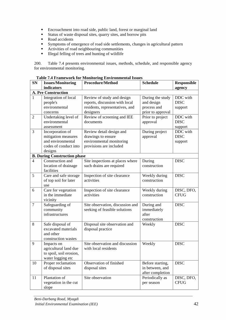
Beni-Darbang Road, Myagdi Initial Environmental Examination (IEE) 42
Encroachment into road side, public land, forest or marginal land Status of waste disposal sites, quarry sites, and borrow pits Road accidents Symptoms of emergence of road side settlements, changes in agricultural pattern Activities of road neighbouring communities Illegal felling of trees and hunting of wildlife
200. Table 7.4 presents environmental issues, methods, schedule, and responsible agency for environmental monitoring. Table 7.4 Framework for Monitoring Environmental Issues
SN Issues/Monitoring indicators
Procedure/Method Schedule Responsible agency
A. Pre Construction 1 Integration of local
people's environmental concerns
Review of study and design reports, discussion with local residents, representatives, and designers
During the study and design process and prior to approval
DDC with DISC support
2 Undertaking level of environmental assessment
Review of screening and IEE documents
Prior to project approval
DDC with DISC support
3 Incorporation of mitigation measures and environmental codes of conduct into designs
Review detail design and drawings to ensure environmental monitoring provisions are included
During project approval
DDC with DISC support
B. During Construction phase 4 Construction and
location of drainage facilities
Site inspections at places where such drains are required
During construction
DISC
5 Care and safe storage of top soil for later use
Inspection of site clearance activities
Weekly during construction
DISC
6 Care for vegetation in the immediate vicinity
Inspection of site clearance activities
Weekly during construction
DISC, DFO, CFUG
7 Safeguarding of community infrastructures
Site observation, discussion and seeking of feasible solutions
During and immediately after construction
DISC
8 Safe disposal of excavated materials and other construction wastes
Disposal site observation and disposal practice
Weekly DISC
9 Impacts on agricultural land due to spoil, soil erosion, water logging etc
Site observation and discussion with local residents
Weekly DISC
10 Proper reclamation of disposal sites
Observation of finished disposal sites
Before starting, in between, and after completion
DISC
11 Plantation of vegetation in the cut slope
Site observation Periodically as per season
DISC, DFO, CFUG

Beni-Darbang Road, Myagdi Initial Environmental Examination (IEE) 43
12 Timely construction of other slope protection measures
Community based planting/slope maintenance programme
Immediately after construction
DISC
13 Quality of surface water
Use field kit / visual observation
Weekly or during construction near water body
DISC
14 Air pollution near settlements
Observation of good construction practices and discussion with residents and workers
Monthly DISC
15 Protection of culturally sensitive spots
Site observation, discussion with local residents
Upon demand DISC
16 Operation and closure of quarries and burrow pits
Site inspection, discussion with local residents
During quarry operation or weekly
DISC
C. Operation Period 17 Encroachment/
degradation of forest Field visit to forest, discussion with local people, CFUG, local forest authority
Half yearly DDC, DTO, DFO
18 Inappropriate use of marginal lands
Discuss with local people, reference to prior mapping
Upon demand, Half yearly
DDC, DTO, DRCC
19 Surface flow Interruption and its consequences
Visit the area, mapping, discussion with local people.
Upon demand, Half yearly
DDC, DTO, DRCC
20 Air pollution, vehicular emission, noise, traffic volume
Travel along the road, discussion with local people, pedestrians, passengers, transport operators
Upon demand, Half yearly
DDC, DTO, DRCC
21 Maintenance of road Check maintenance record, inspection of road and road structures
Annually DDC, DTO, DRCC
22 Condition of environmental mitigation measures used in the road
Inspection and discussion with maintenance workers
Annually DDC, DTO, DRCC

Beni-Darbang Road, Myagdi Initial Environmental Examination (IEE) 44
___________________________________________________________________________
8.0 Conclusion and Recommendations
8.1 Conclusion 201. The IEE study of the proposed Beni-Darbang road sub-project does not pass through any environmentally sensitive area and have minimal detrimental effects associated with loss of forest and agricultural land. Most of the adverse impacts predicted are of low significance and short term as well as of reversible nature. The beneficial impacts with the facility of access to market centers and location of social services will enhance productivity in rural area and improve the quality of life of the people. In addition, local people will get direct employment as workers which will contribute significantly in improving their livelihood. These benefits from the implementation of the proposed road project are more significant and long term in nature against the adverse impacts most of which could be mitigated or avoided. 202. The IEE has shown that none of the anticipated environmental impacts of constructing the proposed road is significant enough to need a detailed follow-up EIA or special environmental study. Therefore, this IEE is sufficient for approval of the sub-project. 8.2 Recommendation 203. The proposed road project is recommended for implementation with incorporation of mitigation measures and environmental monitoring plan. 204. A key consideration in selecting the road alignment is to minimize the acquisition of valuable agricultural and forest land. However, some agricultural and forest land and possibly some built areas will have to be acquired for construction of the proposed road. A Resettlement Plan will be required to ensure that the persons affected by these losses are properly compensated.

Beni-Darbang Road, Myagdi Initial Environmental Examination (IEE) 45
9.0 Miscellaneous References ADB 2005 Aide Memoire for Loan No. 2092-NEP (SF): Decentralized Rural
Infrastructure and Livelihood Project, January 2005 ADB 2003 Environmental Assessment Guidelines. Asian Development Bank, Manila,
The Philippines DDC 2002 District Profile of Myagdi. District Development Committee Myagdi. DFO 2005. Annual Progress Report of District Forest Office, Myagdi. District
Forest Office, Myagdi DoLIDAR 1999 APPROACH for the Development of Agricultural and Rural Roads.
Department of Local Infrastructure Development and Agricultural Roads, 1999
DRILP 2006 Project Procedural Manual (Final Draft), Decentralized rural Infrastructure and Livelihood Project, GoN, DoLIDAR.
DRILP 2006 Environmental Guidelines (Draft), Decentralized rural Infrastructure and Livelihood Project, GoN, DoLIDAR.
GoN 2006 Environmental and Social Management Framework. Road maintenance and Development Project, Department of Roads, Ministry of Physical Planning and Works, November 2006.
GTZ, SDC, 1999Green Roads in Nepal, Best Practices Report – An Innovative Approach for Rural Infrastructure Development in the Himalayas and Other Mountainous Regions.
HMG/N 1998 Environmental Guide for Small Rural Infrastructure Projects. Government of Nepal, Ministry of Local Development in collaboration with IUCN, July 1998
HMG/N 1997 Environmental Protection Act, 1997. Ministry of Law and Justice, GoN, Kathmandu
HMG/N 1997 Environmental Protection Rules, 1997. Ministry of Law and Justice, GoN, Kathmandu
HMG/N 2003 REFERENCE MANUAL for Environmental and Social Aspects of Integrated Road Development. Ministry of Physical Planning and Works Department of Road, Kathmandu 2003
HMG/N 1993 Forest Act, 1993 HMG/N 1995 Forest Rules, 1995 HMG/N 1973 National Park and Wildlife Conservation Act, 1973 HMG/N 1999 Local Self Governance Act, 1999 Land Acquisition Act 1977 HMG/N 2000 Local Self Governance Rules, 2000 RAP 2001 Initial Environmental Examination Guidelines (Draft). Department for
International Development (UK) Rural Access Programme Nepal, March 2001
Uprety B K 2003 Safeguarding the Resources ENVIRONMENTAL IMPACT ASSESSMENT Process and Practice. December 2003

ANNEXES

ANNEX 1
Terms of Reference

Terms of Reference (ToR) for
Initial Environmental Examination (IEE) of
Beni-Darbang Road Sub-project
Submitted to: Ministry of Local Development,
Government of Nepal
Proponent: District Development Committee
Myagdi, Beni Telephone No. – 069-520382
Fax No. – 069-520285
March, 2007

TABLE OF CONTENT
DESCRIPTION PAGE
1.0 NAME AND ADDRESS OF THE PROPONENT ............................................................................. 1
2.0 INTRODUCTION ...................................................................................................................... 1
2.1 GENERAL INTRODUCTION .................................................................................................................. 1
2.2 BACKGROUND OF THE PROPOSAL ........................................................................................................ 1
2.3 OBJECTIVES .................................................................................................................................... 3
2.4 RELEVANCY OF THE PROPOSAL ........................................................................................................... 3
3.0 REVIEW OF RELEVANT LAWS, RULES AND GUIDELINES ............................................................ 4
4.0 PROCEDURES TO BE ADOPTED WHILE PRERPAEING THE REPORT ............................................ 4
4.1 DESK REVIEW ................................................................................................................................. 4
4.2 PUBLIC CONSULTATION ..................................................................................................................... 4
4.3 FIELD WORK ................................................................................................................................... 5
5.0 ALTERNATIVES FOR THE IMPLEMENTATION OF THE PROPOSAL ............................................... 5
6.0 REQUIREMENT OF THE IEE STUDY ........................................................................................... 5
6.1 TIME SCHEDULE .............................................................................................................................. 5
6.2 ESTIMATED BUDGET AND STUDY TEAM ................................................................................................ 5
7.0 ENVIRONMENTAL BASELINE ................................................................................................... 6
8.0 ANALYSIS AND INTERPRETATION ............................................................................................ 6
9.0 IDENTIFICATION, PREDICTION AND EVALUATION OF IMPACTS ................................................ 6
9.1 BENEFICIAL IMPACTS ........................................................................................................................ 6
9.2 ADVERSE IMPACTS ........................................................................................................................... 6
10.0 MITIGATION MEASURES..................................................................................................... 8
11.0 ENVIRONMENTAL MONITORING PLAN ............................................................................... 8
12.0 IEE REPORT FORMAT .......................................................................................................... 8

ABBREVIATIONS
ADB- Asian Development Bank CISC- Central Implementation Support Consultant DDC- District Development Committee DFID- Department for International Development DISC - District Implementation Support Consultant DIT- District Implementation Team DoLIDAR- Department of Local Infrastructure Development and Agricultural Roads DoR- Department of Road DTO- District Project Office DTO- District Technical Office/Officer DTMP- District Transportation Master Plan DRILP- Decentralized Rural Infrastructure and Livelihood Project DRCC- District Road Coordination Committee DTMP-District Transport Master Plan EA- Environmental Assessment EIA-Environmental Impact Assessment EPA- Environmental Protection Act EPR- Environmental Protection Rules ESD- Environment Screening Document EMP-Environmental Management Plan EMS- Environmental Management Section IEE- Initial Environmental Examination Km- Kilometer LDCP- Local Development Construction Programme LDO- Local Development Officer LRMP- Land Resource Management Project MLD- Ministry of Local Development NGO-Non-government Organization PCU- Project Coordination Unit RAP - Rural Access Programme RES- Rapid Environmental Screening SDC- Swiss Agency for Development and Cooperation TA- Technical Assistance ToR- Terms of Reference VDC-Village Development Committee

1
1.0 NAME AND ADDRESS OF THE PROPONENT The District Development Committee (DDC), Myagdi is the executing agency at the district level and the proponent of the Initial Environmental Examination (IEE) study for the construction of Beni-Darbang road sub-project. The Ministry of Local Development (MLD) is the concerned authority for the approval of IEE study report. Address of the Proponent District Development Committee, Myagdi, Beni Telephone No. – 069-520382 Fax No. – 069-520285 2.0 INTRODUCTION 2.1 General Introduction Government of Nepal has received a loan from ADB and grant assistance from Swiss Agency for Development and Cooperation (SDC) to finance the Decentralized Rural Infrastructure and Livelihood Project (DRILP). The project goal is to reduce rural poverty in 18 very poor remote hill and mountain districts affected by the conflict. The purpose is to achieve sustainable increased access to economic and social services, and enhanced social and financial capital for people in the project area, particularly poor and disadvantaged groups. Labor-based, environmentally friendly, and participatory approaches (LEP) will ensure that the investment in construction and rehabilitation of infrastructure results in sustainable, improved access to economic and social services, and enhanced social and financial capital. Department of Local Infrastructure Development and Agricultural Roads (DoLIDAR) is the executing agency. The implementing arrangements are as following: DoLIDAR has established a project coordination unit (PCU) in Kathmandu, headed by a project coordinator to coordinate all project activities. The PCU will be responsible for guiding and monitoring district development committees (DDCs) as they implement project components. At the district level, project implementation will be the responsibility of the district project office (DTO) within the district technical office of each DDC. A local engineering consultant to cover technical issues, and a local non-government organization (NGO) engaged for social mobilization and support for rural infrastructure building groups, will support the DTO. This Terms of Reference (ToR) is prepared to conduct an IEE of Beni-Darbang road sub-project in Myagdi District. This is a high priority road in Myagdi district and is proposed for construction under DRILP. 2.2 Background of the proposal The proposed Beni-Darbang road lies in Myagdi district of Western Development region. The road starts from Beni bazar of Arthunge VDC and passes through Arthunge, Pulachaur, Singa, Babiyachaur, Darbang VDCs and ends at Darbang. The major settlements along the road are: Arthunge, Damara, Chutreni, Baguakhola, Singa, Tatopani, Simalchaur, Torakhet, Babiyachaur, Ratdhunga, Derbang. Construction of this road was started through the fund of Local Development Construction Programme (LDCP) and people contribution using bulldozer and labour based techniques. The total length of this road is 19.7 km consisting of rehabilitation and new construction. The description of the project works is given in the Table 1 and the location and alignment of the road is given in the Figure 1 and 2.

2
Table. 1 Project activities of the proposed Beni-Darbang road section SN Road section Chainage Length Descriptions Remarks 1 Beni-Tarakhet 0+00 to 11+400 11.4 km Rehabilitation Regular vehicles
operation 2 Tarakhet-
Ratodhunga 11+400 to 15+700
4.3 km Rehabilitation Operation for vehicles is difficult
3 Ratodhunga-Dhairenipakha
15+700 to19+200
3.5 km Rehabilitation Not motorable
4 Dhairenipakha -Darbang
19+200 to 19+700
0.5 km New construction
Total 19.7 km
Figure 1. Map of Nepal showing the location of Beni-Darbang road in Myagdi District

3
Figure 2. Map of Myagdi showing Beni-Darbang road project
2.3 Objectives The objectives of the proposed IEE study includes to:
identify the major issues that may arise as a result of proposed works on bio-physical, socio-economic and cultural environment of the project area,
recommend practical and site specific environmental mitigation and enhancement measures, prepare and implement environmental monitoring plan for the sub-project, and
recommend whether the IEE is sufficient for the proposed road or whether EIA will be required as a result of the environmental issues that may arise due to the project implementation.
2.4 Relevancy of the proposal The Beni-Pakhapani road links north-western part of Myagdi district with Beni which is district headquarter. This road is considered as an important road for the people of north-western part of Myagdi district as it will provide physical and economical access to them with district headquarter and other part of Nepal. This road is also given top priority by the District Transport Master Plan (DTMP). An IEE of the proposed road is necessary in order to assess the environmental consequences of the proposed rural road construction activities and suggest appropriate, practical and site specific mitigation and enhancement measures. An IEE of a district road is a legal requirement according to Environmental Protection Act, 1996 (EPR, 1996) and Environmental Protection Rules, 1997 (EPR, 1997). Preparation of IEE report by concerned District Development Committee (DDC) and approval of IEE report by the Ministry of Local Development (MLD) according to Nepali legal provision is considered sufficient by the ADB.

4
3.0 REVIEW OF RELEVANT LAWS, RULES AND GUIDELINES Government of Nepal has adopted various acts, regulations and guidelines to ensure the integration of development and conservation of environment. The IEE study will be guided by the requirements and provisions of the following acts, rules and guidelines as applicable.
Environment Protection Act, 1996 and Environment Protection Rules, 1997 (amended 1999)
Batabaraniya Nirdesika (Nepal; MoLD), 2057 National Environmental Impact Assessment Guidelines, 1993 APPROACH for the Development of Agricultural and Rural Roads, 1999
(DoLIDAR) REFERENCE MANUAL for Environmental and Social Aspects of Integrated
Road Development, 2003 (Department of Road) Green Roads in Nepal, Best Practices Report – An Innovative Approach for Rural
Infrastructure Development in the Himalayas and Other Mountainous Regions. GTZ, SDC, 1999.
Forest Act, 1993 and Forest Rules, 1995 National Park and Wildlife Conservation Act, 1973 Local Self Governance Act, 1999 and Local Self Governance Rules, 2000 Land Acquisition Act 1977 DFID/RAP Initial Environmental Examination Guideline (Draft), 2001
4.0 PROCEDURES TO BE ADOPTED WHILE PRERPAEING THE REPORT The IEE approach, methodology and procedure should generally follow the provisions of the EPA, 1996 and EPR, 1997. Following approach and methodology will be adopted during the IEE report preparation. 4.1 Desk review The following steps will be followed during the desk review: Collection and review of secondary sources of information from various sources Initial interaction and consultation with the local community and district level
stakeholders Delineation of geographical boundary of the influence area on the topographical map Preparation of project specific checklist
4.2 Public consultation The role of public consultation and participation is to ensure the quality, comprehensiveness, effectiveness of IEE as well as to ensure that the public view's are adequately taken into consideration in the decision making process. It is done during the preparation of an IEE. In order to ensure the public involvement, the following procedures will be followed during IEE report preparation: Publication of notice- a 15 days public notice will be published in a national level daily
newspaper seeking written opinion from concerned VDCs, DDC, school, health posts and related local organizations. A copy of the public notice will be affixed in the above-mentioned organizations and deed of enquiry (muchulka) will be collected.
Recommendation letter from concerned VDCs and/or municipality will also be obtained. IEE team will also carryout interaction with local communities and related stakeholders
and will also collect the public concerns and suggestions.

5
4.3 Field work The IEE team will walk through along the road alignment visiting the significant environmental features in the probable influence corridor, and make necessary measurements, inspect/ observe and discuss it with the local stakeholders. The information collection will be made covering physical, biological, socio-economic and cultural aspects of the environment. 5.0 ALTERNATIVES FOR THE IMPLEMENTATION OF THE PROPOSAL Alternative analysis has been considered as an integral part of IEE study, which involves an alternative ways of achieving the objectives of a proposed sub-project. The aim of alternative analysis is to arrive at a development option, which maximizes the benefits while minimizing the unwanted impacts. The study team will conduct alternative analysis considering the following issues:
No action option Project alternatives Alternative alignment Alternative design and construction approach Alternative schedule and process Alternative resources, and Any other alternatives
6.0 REQUIREMENT OF THE IEE STUDY This includes time schedule, estimated budget and appropriate manpower (experts) for conducting IEE study. 6.1 Time Schedule IEE report will be completed within eight weeks after the approval of ToR. An indicative time frame for conducting IEE is given in the table 2 below: Table 2. Proposed work schedule for conducting IEE study SN Activities Week
1 2 3 4 5 6 7 8 1 Orientation training to the team 2 Desk study and review 3 Public notice publication 4 Field visit for survey and
consultation with community
5 Collection of suggestions and recommendations from stakeholders
6 Analysis and interpretation
7 Draft report preparation 8 Comments on draft report 9 Final Report preparation and
submission
10 Approval of the final report 6.2 Estimated budget and study team Most commonly an IEE of an infrastructure sub-project in the district need expert inputs from the following sectors:
Landslides, slope stability and erosion

6
Forestry and wildlife Geology Road engineering Social, economic and culture.
The IEE team will consists of DISC Engineer and Social Mobilization Coordinator and they will be trained to provide the above needed expertise for IEE preparation. IEE report preparation work will be supported by CISC environmental team under the supervision of DTO. Since, the IEE report will be prepared by the DISC team with the support of the CISC environmental team, no separate budget and manpower is required. 7.0 ENVIRONMENTAL BASELINE This will describe environmental setting of the project location and surrounding areas and will contain information on relevant bio-physical, socio-economic and cultural factors and features. The updated, processed and analyzed information and data on each of the relevant bio-physical, socio-economic and cultural aspects will be presented in the IEE study. As far as possible, other environmental features such as, sensitive area, population and settlements, forests, geological features will be shown in the map. 8.0 ANALYSIS AND INTERPRETATION Both secondary and primary information and data collected will be analyzed and interpreted. The bio-physical information will be tabulated to the extent possible. The socio-economic, cultural and religious information will be crosschecked and analyzed. 9.0 IDENTIFICATION, PREDICTION AND EVALUATION OF IMPACTS The identification and prediction of impacts shall be carried out by considering the proposed project actions/activities in terms of rehabilitation and construction of the road project. The impacts of the activities shall be on bio-physical, socio-economic and cultural resources in a defined immediate zone of influence (i.e.1.5 hours walking distance from the road alignment). The impacts shall be classified in terms of extent (site specific, local and regional), magnitude (low, medium and high) and duration (short term, medium term and long term) as well as reversible, irreversible, severe, moderate and significant. The likely impact shall be assessed covering both adverse and beneficial ones. The methodology adopted for impact identification and prediction will be checklists and matrix method. The likely impacts of the proposed road construction as well as operation are described in the following sections. 9.1 Beneficial Impacts Beneficial impacts due to the rehabilitation and construction of the road shall be assessed by the study team in terms of impacts on physical, biological, socioeconomic and cultural systems of the project area. The impacts shall also be assessed in the category of extent, duration and magnitude. Based on the identification and prediction of the impacts, the suitable enhance measures to maximize the project benefits shall be explored and designed. 9.2 Adverse Impacts The likely adverse impacts during construction and subsequent operation and maintenance in terms of physical, biological, socioeconomic, cultural and religious aspects due to project actions shall be identified, predicted and evaluated. Based on the identified impacts, appropriate mitigation measures shall be recommended. 9.2.1 Construction Stage - Though the sub-projects will apply LEP approach during the implementation, it may not be possible to avoid all likely impacts; the study shall take into account the following issues: 9.2.1.1 Physical environment - The issues and concerns generally related to physical environment typically include, but not necessarily limited to:

7
Slope instability and soil erosion due to various activities including slope cutting, spoil disposal, concentrated flows due to water diversions and inappropriate drain outfalls.
Quarry site operation. Impacts on water resources (irrigation, drinking water and other water bodies) and
drainage pattern. Degradation of air quality (particularly dust) and increase in vibration/noise and its
impact to the local people. Change in land use including development or expansion of roadside settlements. Impact of road safety
9.2.1.2 Biological environment - The issues and concerns generally related to biological environment typically include, but not necessarily limited to:
Loss or degradation of forests and vegetation. This includes all forest areas including state or community or leasehold or religious or private forest.
Impact on wildlife including birds due to loss or degradation of habitat, increased hunting and other form of human pressure.
Impacts on flora and fauna (as listed in CITES and IUCN Red data book). Impacts on the local ecology and ecological balance/functions.
9.2.1.3 Socio-economic and cultural environment - The issues and concerns generally related to socio-economic and cultural environment typically include, but not necessarily limited to:
Loss or degradation of farmland and productivity directly or indirectly (such as due to occupation of land, disposal of spoils, diversion of water/ drain waters, or disruption of hydrology, natural drainage, quarrying, burrow pits etc.).
Loss or degradation of private properties such as houses, farm sheds, and other structures, crops and fodder/ fruit trees.
Impact on community infrastructure such as irrigation, water supply, schools, health post, trail and trail bridges.
Impacts on cultural, religious and archeological sites. Impacts on social structures, employment opportunities, economy, cultural values. Impacts on health and sanitation.
9.2.2 Operation and maintenance stage - The following issues will be taken into account during operation and maintenance stage: 9.2.2.1 Physical environment
Road slope stability and management Impact on water resources Impact due to air pollution Impact due to noise pollution Road safety measures
9.2.2.2 Biological environment
Impact on forest resources Illegal poaching and impact on wild life Impact of natural habitat Increased access to and demands on forests due to road construction
9.2.2.3 Socio-economic and cultural environment
Population pressure and impact due to new settlement along the road alignment Impact on economic activities Impact on living condition Impact on farming practices

8
Changes in employment and income pattern of the local people Impact on cultural and religious activities Impact due to migration of the people
10.0 MITIGATION MEASURES The IEE study will propose site-specific mitigation measures to minimize/mitigate/avoid or control of proposal's adverse impacts. The mitigation measures will be selected based upon appropriateness and cost analysis and these will be suggested for pre-construction, construction and post construction phase of the project. Mitigation measures will be proposed for the impacts on physical, biological, socio-economic and cultural environment 11.0 ENVIRONMENTAL MONITORING PLAN The study will identify the key environmental monitoring indicators with respect to activities, methods and responsibilities in order to monitor the environmental condition and adoption of suitable mitigation measures. 12.0 IEE REPORT FORMAT This format will be in line with provision made in the Schedule 5 of EPR, 1997 and should be adapted to project specific situation. The IEE report will contain the following sections: i. Cover page with name of the proposal and proponent and address ii. Executive Summary that includes:
Objective of the sub-project Impacts on land use Adverse Impacts on environment, effects on people’s livelihood, and population
pressure Loss or degradation of local properties and assets Main mitigation measures Conclusions and recommendations
If the IEE report is prepared in English, executive summary will be given in Nepali also. iii. Table of content iv. List of Abbreviation (acronyms) v. Introduction: This section should describe the project in simple terms and concisely, without missing relevant points but avoiding unnecessary details. The project description should provide following information:
1. Background 2. Name of the proponent 3. Description of proposal 4. Objective of IEE 5. Methodology adopted for IEE study
vi. Review of related policy, legislations, standards, guidelines and institutions: During the study relevant policies, legislations and guidelines should be reviewed and their salient features should be mentioned in this section. Similarly related institutions should be consulted. vii. Existing Environmental condition. Baseline information on the existing physical, biological as well as socio-economic and cultural resources of the proposed sub-projects is described here. Environmental features such as sensitive areas, population and settlements, forests should be shown in a map viii. Project Alternatives: This section summarizes the alternatives by environmental comparison. This may include the following sub-headings.

9
a. Project alternative b. Alternative routes c. Alternative design and construction approach d. Alternative schedule and process e. Alternate resources f. Any other alternatives viii. Identification and Assessment of Impacts and Mitigation Measures- This section contains the process, findings and conclusions of analysis and interpretations. The criteria for significance assessment should be summarized with the results of assessment. This may be presented and discussed in the following: a) Physical and Chemical Impacts: such as land, air, water, noise, infrastructure impacts and other factors b) Biological Impacts: such as flora, and fauna, population, and natural habitats and ecosystems c) Socio-economic-cultural impacts: such as agricultural land, human health, social, cultural and religious values, implications of physical and biological impacts and other relevant socio-cultural-economic impacts. This section also summarizes the recommended mitigation measures including basis for selection and cost if possible. ix. Environmental Monitoring Plan- This section summarizes the recommended monitoring parameters/indicators, activities, methods and responsibilities. x. Conclusion and Recommendations - This section should clearly indicate whether IEE report is sufficient or further assessment is needed. Likewise, it should also be recommended that what aspects should be covered if further environmental assessment is needed. xi. Miscellaneous- Reference materials should be mentioned here if used during IEE report preparation in standard format. xii. Annex
ToR of IEE Summary of consultations and meetings Deed of inquiry (muchulka) Notices published and pasted Recommendations from the concerned VDCs or Municipality Photographs, Maps, Drawings, Checklists, Questionnaires List of persons and institutions consulted
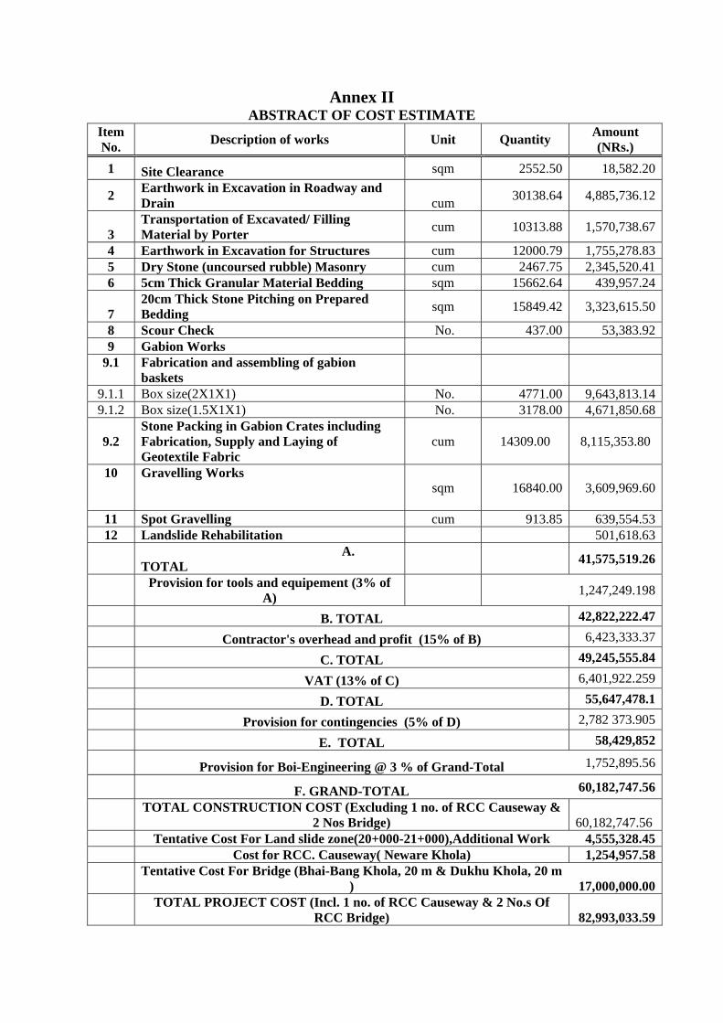
Annex II ABSTRACT OF COST ESTIMATE
Item No. Description of works Unit Quantity Amount
(NRs.) 1 Site Clearance sqm 2552.50 18,582.20
2 Earthwork in Excavation in Roadway and Drain cum 30138.64 4,885,736.12
3 Transportation of Excavated/ Filling Material by Porter cum 10313.88 1,570,738.67
4 Earthwork in Excavation for Structures cum 12000.79 1,755,278.835 Dry Stone (uncoursed rubble) Masonry cum 2467.75 2,345,520.416 5cm Thick Granular Material Bedding sqm 15662.64 439,957.24
7 20cm Thick Stone Pitching on Prepared Bedding sqm 15849.42 3,323,615.50
8 Scour Check No. 437.00 53,383.929 Gabion Works
9.1 Fabrication and assembling of gabion baskets
9.1.1 Box size(2X1X1) No. 4771.00 9,643,813.149.1.2 Box size(1.5X1X1) No. 3178.00 4,671,850.68
9.2 Stone Packing in Gabion Crates including Fabrication, Supply and Laying of Geotextile Fabric
cum 14309.00 8,115,353.80
10 Gravelling Works sqm 16840.00 3,609,969.60
11 Spot Gravelling cum 913.85 639,554.5312 Landslide Rehabilitation 501,618.63
A.
TOTAL 41,575,519.26
Provision for tools and equipement (3% of
A) 1,247,249.198
B. TOTAL 42,822,222.47
Contractor's overhead and profit (15% of B) 6,423,333.37
C. TOTAL 49,245,555.84
VAT (13% of C) 6,401,922.259
D. TOTAL 55,647,478.1
Provision for contingencies (5% of D) 2,782 373.905
E. TOTAL 58,429,852
Provision for Boi-Engineering @ 3 % of Grand-Total 1,752,895.56
F. GRAND-TOTAL 60,182,747.56
TOTAL CONSTRUCTION COST (Excluding 1 no. of RCC Causeway &
2 Nos Bridge) 60,182,747.56 Tentative Cost For Land slide zone(20+000-21+000),Additional Work 4,555,328.45 Cost for RCC. Causeway( Neware Khola) 1,254,957.58
Tentative Cost For Bridge (Bhai-Bang Khola, 20 m & Dukhu Khola, 20 m
) 17,000,000.00
TOTAL PROJECT COST (Incl. 1 no. of RCC Causeway & 2 No.s Of
RCC Bridge) 82,993,033.59

Annex III
DRILP Environmental Checklist
A. GENERAL SOCIO-ECONOMIC SITUATION OF THE INFLUENCE AREA1 1. Overview of settlements in the zone of influence (ZoI) area
Settlement
Code*
Name of Settlement and address Household and
Population
Caste/ethnic distribution
General Comment
A
B
C
D
E
F
G
H
I
J
* Use the same codes as in strip map and topographical map.
1 Will be collected through Focus Group Discussion (FGD) within ZoI

2. Economic activities/main occupation Settlement
Code
Number of HH and Percentage of Population engaged in Agriculture & Livestock
Labour & Porter
Business/ Commerce
Cottage Industry
GO/NGO Employees
Others (specify)
A
B
C
D
E
F
G
H
I
J
3. Existing services and infrastructures
S N Service/Infrastructure Settlement Code Category A B C D E F G H I J
1 EDUCATION 1.1
Campus (no.) Students (no.)
1.2
High School (no.) Students (no.)
1.3
Primary School (no.) Students (no.)
2 HEALTH 2.1 Hospital/health centre (no)
Capacity (beds)
2.2 Health Post (no.) Sub-Health Post (no.)
3 COMMUNICATION 3.1 Telephone/fax 3.2 Mobile/CDMA 3.3 Post Office 4 ELECTRICITY SUPPLY
4.1 from Micro-hydro 4.2 from Mini-hydro 4.3 from National Grid 4.4 from Solar System 4.5 from Diesel Generator

5 BUSINESS &
COMMERCE
5.1 Hotels & Lodges (no.) 5.2 Restaurant & Tea Stall(no) 5.3 Grocery Shops (no.) 5.4 Other Shops (no.)
(e.g. stationery, medicine, tailoring, etc.)
6 DRINKING WATER SUPPLY SCHEMES
6.1 Gravity-Flow Scheme (capacity)
6.2 Tube-wells (no.) 6.3 Spring/Dug-wells (no.) 7 IRRIGATION SCHEMES
7.1 Surface Irrigation (ha.) 7.2 Groundwater (ha.) 8 OTHER
INFRASTRUCTURES
8.1 Micro-hydro scheme (no. & capacity......kw)
8.2 Water Mill (no.) 8.3 Suspension Bridges (no.) 8.4 Wooden Bridges (no.) 8.5 Other Bridges (specify)
…................................
9 INDUSTRY 9.1 Weaving Industry (no.) 9.2 Rice & flour Mills (no.) 9.3 Other Industries (specify)
…................................
10 FINANCIAL INSTITUTIONS
10.1 Bank (no.) 10.2 Cooperative 11 COMMUNITY USE
11.1 Ghat (no.) 11.2 Hatia/Bazaar (no.) 11.3 Playground (no.) 11.4 Community Centre (no.) 11.5 Others (specify)
...................................

4. Land holding pattern Land holding Settlement (HH No.) Remarks
Pattern A B C D E F G H I J Landless less than 1 ropani)
1 to 5 ropani 5 to 10 ropani 10 to 20 ropani 20-50 ropani > 50 ropani
5. Food grain availability (HH no.)
Availability Status
Settlements (HH No.) Total
A B C D E F G H I J Surplus Sufficient for whole year
Sufficient for three to nine months
Sufficient for three months
Less than three months
6. Major existing agriculture production (denote the most dominant by 1, second dominant by 2 and so on).
S. No.
Type of Agriculture Production
Settlements
A B C D E F G H I J
1.0 CEREALS 1.1 Rice 1.2 Wheat 1.3 Maize 1.4 Millet 1.5 Junelo 1.6 Phaper 1.7 Others (list) 2.0 CASH CROPS 2.1 Oil Seeds 2.2 Beans/Dal 2.3 Tobacco 2.4 Potato 2.5 Vegetables 2.6 Fruits

2.7 Tea/Coffee 2.8 Amliso 2.9 Sericulture
2.10 Others (list) 3.0 LIVESTOCK & FISHERIES 3.1 Cattle (cows &
buffaloes)
3.2 Horses, Mules 3.3 Yak 3.4 Goat 3.5 Sheep 3.6 Rabbit 3.7 Pig 3.8 Fisheries 3.9 Poultry
3.10 Bee-keeping 3.11 Others
7. Migration for employment
(a) No. of HHs from where at least one person (may be HH head) is away from home for more than 6 months. Also mention the place.
Settlement (No. of HH) A B C D E F G H I J
Name of settlement:
(b) Seasonal migration in search of work.
Month No. of Total HH Destination Purpose Baisakh Jestha Ashad
Shrawan Bhadra Ashwin Kartik Marga Poush Magh Falgun Chaitra
8. Dominant off-farm occupation in the settlement in descending order ............................................................................…………………………….

B. DEVELOPMENT POTENTIAL ACCORDING TO SETTLEMENT B.1. Areas which have significant potential for development, for instance, high
agricultural production, tourism development, local mines, etc. (indicate these areas in map/sketch).
S. N. Name of Area Description of Development Potential
1
2
3
4
5
B.2. Scope of the proposed linkage in view of promoting socio-economic development
(communication, agricultural production, education and health).
S. No.
Sectors to get direct benefit Describe how it will benefit
1
2
3
4
5
C. HISTORIC AND CULTURAL RESOURCES WITHIN THE SETTLEMENT Type of Resource Name/specification Affecting
activities Location from project
Temples
Monuments
Others

Annex IV Public Notice


Annex V Deed of Enquiry (Muchulka)


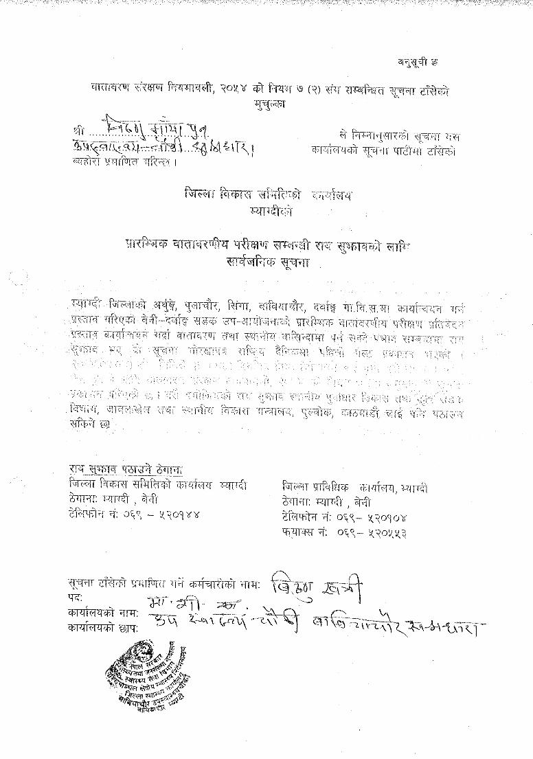


Annex-VI
Name of the Organizations (notice pasted and deed of inquiry obtained) SN. Name of organization Address Remarks
1 DDC Office Beni 2 District Technical Office Beni 3 District Forest Office Beni 4 District Administration Office Beni 5 District Soil Conservation Office Beni 6 District Livestock Development Office Beni 7 District Agriculture Development Office Beni 8 District Post Office Beni 9 District Health Office Beni
10 Land Revenue Office Beni 11 Milan, NGO Beni 12 Myagdi Multi Campus Beni 13 Sub Health Post Babiachaur 14 Shree Mangala Higher Secondary School Babiachaur 15 Babiachaur Range Post Babiachaur 16 Babiachaur Ilaka Post Office Babiachaur 17 Pulachaur VDC Pulachaur 18 Shree Malika Youth Club Sahatradhara 19 Arthunge VDC Office Arthunge 20 Singa VDC Office Singa 21 Tatopani Kunda Management Committee Singa-4 22 Singa Health Post Singa 23 Dhawalagiri Secondary School Singa 24 Village Level Forest Coordination Committee Singa 25 Pulachaur VDC Office Pulachaur 26 Pulachaur Additional Post Office Pulachaur 27 Shree Jagriti Women Development Multipurpose
Cooperative Ltd. Pulachaur
28 Pulachaur Sub Health Post Pulachaur 29 Shree Jamapriya Secondary School Darbang 30 Paschim Myagdi Darbang Youth Club Darbang 31 Darbang Ilaka Post Office Darbang 32 Darbang Primary Health Post Darbang 33 Darbang VDC Office Darbang

Annex VII List of person consulted
S.N. Name Designation Address1 Mr. Bhakti Bilas Subedi LDO DDC, Myagdi 2 Mr. Hari Bdr. Sunuwar DTO Chief Myagdi, DTO 3 Mr. Ram Prasad Regmi Engineer Myagdi, DPO 4 Mr. Hari Krishna Acharya Programme Officer Myagdi, DDC 5 Mr. Rakesh Kumar Jha DISC Engineer Myagdi, DISC 6 Ms. Manisha Sthapit DISC Engineer Myagdi, DISC 7 Mr. Mohan Kumar Shrestha DISC Overseer Myagdi, DISC 8 Mr. Dinesh Ghimire DISC Overseer Myagdi, DISC 9 Mr. Krishna Hari Pantha DTO Overseer Myagdi, DTO
10 Mr. Narayan Prasad Nepal Accountant Myagdi, DDC 11 Ms. Diva Pun SMC Myagdi, DISC 12 Ms. Tej Kumari Thapa DISC SM Myagdi, DISC 13 Ms. Juna Garbuya DISC SM Myagdi, DISC 14 Mr. Junga Bdr. Khatri User Damara, Arthunge-8
15 Ms. Usha Kishan TreasurerCommunity Forest Damara, Arthunge-8
16 Ms. Maya Kishan Under Secretary Damara, Arthunge-8 17 Mr. Bhakta Karki Principal Bal Jagriti Primary School,
Pulachaur18 Mr. Asuni Kumar Paudel Ex-Ward President Chutreni, Arthunge 19 Mr. Tej Bdr. Baniya Ex-Ward Chairperson Arthunge-920 Mr. Ranna Bdr. Baniya Retired Army Arthunge-921 Mr. Khag Raj Paudel Manager Amma Samuha, Simalchaur-222 Mr. Amar Shai Teacher Simalchaur-2 23 Ms. Shiri Kala Armaja President VDC, Dadhuwa-1 24 Mr. Tawal Giri President Lareni-725 Mr. Kul Prasad Pun Member Hidi-926 Mr. Padam Lal Sharma President VDC, Ryalkhor-4
27 Mr. Laxmi Acharya PresidentCommunity Organization, Ryalkhor-4
28 Mr. Dilip K.C. Leader Sima-529 Mr. Dal Bdr. Thapa Member Lampata-530 Mr. Bhim Bdr. Sunar Member Syauli Bazar 31 Ms. Suku Maya Kisan Member Amma Samuha, Dharaini-2
32 Mr. Shiva Narayan Fagami SecretaryForest Users Committee, Darbang-1
33 Mr. Santosh Subedi Ex-Secretary Tolbang-734 Mr. Buddhi Man Tulachan Member Ratdhunga-3 35 Mr. Narayan Bdr, Adhikari Member VWRCC, Babiyachaur-5 36 Ms. Jhuma Adhikari Teacher Tatopani-437 Mr. Ishwor Singa Khatri Principal Dandakhet-9 38 Mr. Bhim Bdr. Baniya Ex-Ward President Dandakhet-9
39 Ms. Pampha Bhandari MemberCommunity Forest, Singa-8, Dandakhet
40 Mr. Ishwor Singa Khatri Member Community Forest, Singa-5 41 Ms. Mekh Kumari K.C. Tatopani Kunda Staff Tatopani-442 Ms. Purna Kumari Baniya VWRCC Arthune-9
43 Mr. Dev Bdr. Ghale PresidentCommunity Forest, Singa-1,Thamdanda
44 Ms. Tirtha Kumari Shrestha Principal Beni Community Secondary School, Arthunge-2

Annex VIII Recommendation Letters from
VDCs


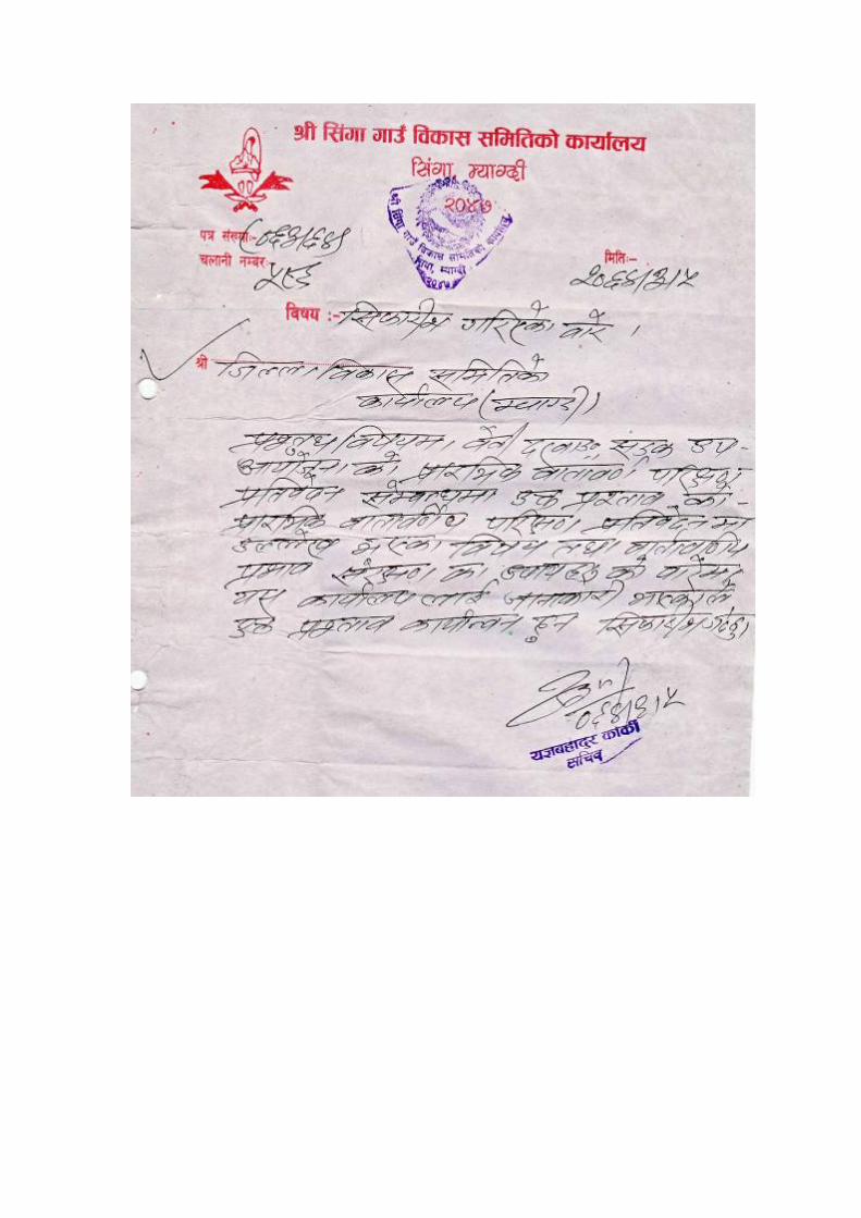


Annex IX a. Distribution of households by major occupation
Settlement Name
Number of HH in Agriculture & Livestock
Labour & Porter
Business/ Commerce
Cottage Industry
Employees Others (specify)
Dadhuwa 60 4 - - 6 16 Simalchaur 98 52 2 - 7 15 Khumlia 66 55 2 - 6 14 Ryalekhor 52 52 1 - 6 10 Sima 2 1 - - 1 3 Tarakhet 11 11 3 - 3 2 Lampata 26 12 2 - - 8 Babiyachaur Bazar 29 15 25 7 35 7 Kotrabang 19 4 - - 5 15 Salyan 64 6 1 - 16 14 Lareni 43 12 - - 1 15 Ranabang 55 25 7 2 20 18 Darung 33 10 - - 1 16 Tallo Hidi 37 30 2 - 8 5 Syauli Bazar 40 35 5 - 4 12 Darbang Bazar 39 13 13 - 13 6 Gogan Pani 22 5 1 - 5 8 Tolbang 25 8 1 - 3 18 Lammela and Dharkharka
30 20 - - 5 8
Ratdhunga 14 6 5 - 4 4 Dukhu and Alkachaur
100 60 6 - 18 90
Damara 25 30 10 1 3 5 Chutreni 21 21 4 - 3 4 Baguwa Khola 95 30 3 2 30 16 Chhap 88 10 4 - 7 - Thakan Pokhari 52 7 - - 15 - Mangala Ghat 10 100 100 10 15 50 Danda Khet 68 20 54 5 9 36 Danda Khet 85 30 3 - 16 32 Upallo Singa 62 3 10 - 6 - Tallo Singa 30 30 2 - 7 - Surke Mella 62 10 1 - 3 - Rakkhe 50 16 3 - 8 - Tatopani 50 50 100 6 12 - Tham Danda 50 16 - - 8 - Tham Danda 60 10 2 - 4 - Total 1673 819 372 39 313 447 Source: Field survey, 2007

Annex IX b. Summary of public services and infrastructures according to settlement Settlement Name/ Public services and Infrastructure
Scho
ol (n
o)
Hea
lth p
ost
Com
mun
icat
ion
(no)
Hyd
ro p
ower
(n
o. o
f hhs
)
Sola
r (n
o)
Shop
s/lo
dge
(no)
Wat
er su
pply
(n
o)
Irri
gatio
n
( are
a h
a)
Wat
er m
ill
Bri
dge
(no)
Com
mun
ity
orga
niza
tion
Fin.
Inst
. (no
)
Com
mun
ity
use
(no)
Indu
stry
(no)
Dadhuwa - - - - 3 3 11 1 - - 3 - - 1 Simalchaur 1 - 1 - 15 2 20 48 - 1 - - - 1 Khumlia 1 - 1 - 8 2 10 5 - - 2 - 1 - Ryalekhor 1 - 1 - 20 2 12 - - 2 2 - - 2 Sima - - - - 3 - 4 7 - - - - - - Tarakhet - - - - 5 4 1 4 1 2 1 - 1 1 Lampata 1 - - - 15 2 20 - - - 1 - - - Babiyachaur Bazar 3 - 4 - 46 30 14 8 - 1 2 - - 3 Kotrabang 1 - 1 - 8 - 4 20 2 1 2 - 1 2 Salyan 1 - - - 25 2 17 10 1 1 4 - 2 1 Lareni 1 - - - 2 - 2 5 - - 2 - 1 - Ranabang 2 1 - - 40 7 5 30 1 3 4 1 8 4 Darung 1 - - - 1 1 11 - - - 2 - - - Tallo Hidi 1 - - - 8 2 4 - - - 1 - 2 - Syauli Bazar - 1 5 - 5 19 9 - 1 - 1 - 2 1 Darbang Bazar 2 1 5 - 40 36 21 - - - 2 2 4 7 Gogan Pani 1 - - - 3 2 5 - - - 1 - - - Tolbang - - - - 3 1 2 - - - - - - - Lammela+Dharkharka
- - - - 3 3 10 - - - - - 1 -
Ratdhunga - - - - 7 9 2 - - 1 1 - 1 - Dukhu+Alkachaur 1 - - - 29 3 22 - - 1 2 3 1 - Damara - - 10 40 - 8 8 - - 1 1 - - 3 Chutreni - - 5 8 2 2 8 2 - 1 1 - - - Baguwa Khola 2 - 8 60 6 6 11 150 2 1 2 - 1 2 Chhap 1 - 8 - - 2 24 1 - - - - 1 1 Thakan Pokhari 1 - 5 - - 3 6 - - - - - 1 1 Mangala Ghat 2 - 250 125 2 66 100 - - 3 - - 3 3 Danda Khet 1 - 8 - - 3 14 20 - - 1 1 1 4 Danda Khet - - 8 - - 3 17 22 - - 1 2 3 - Upallo Singa 1 - 4 2 3 9 25 - - 1 1 - 1 2 Tallo Singa 1 - 1 - - 2 12 - - - - - - - Surke Mella 1 - 1 - 3 1 13 - - 2 1 - 1 1 Rakkhe - - 2 19 5 5 6 - - 1 - - 1 2 Tatopani 2 1 9 100 11 86 25 2 - 1 1 - 1 - Tham Danda 1 - 4 38 1 1 11 1 - 1 1 - 1 1 Tham Danda - - 1 30 1 2 13 1 - - - - - -
Total 31 4 342 422 323 329 499 336 9 25 43 9 42 43
Source: Field survey, 2007

Annex IX c. Land holding pattern of settlements within ZoI
Settlement Name
Number of HH Landless
<one ropani
1-5 ropani 5-10 ropani
10-20 ropani
20-50 ropani
>50 ropani
Dadhuwa 6 - 24 24 4 2 - Simalchaur 13 15 40 20 10 - - Khumlia 1 - 45 4 12 4 - Ryalekhor 26 7 7 - 10 2 - Sima 1 - - 1 1 4 - Tarakhet 1 1 - 4 5 - - Lampata 1 - 19 6 - - - Babiyachaur Bazar
15 14 35 30 1 - -
Kotrabang 3 1 5 10 - - - Salyan 1 10 10 29 15 - - Lareni 4 - 18 13 8 - - Ranabang 6 9 33 32 3 - - Darung 4 - 22 7 - - - Tallo Hidi 3 - 17 6 12 - - Syauli Bazar 2 - 45 3 - - - Darbang Bazar - 30 10 12 10 3 - Gogan Pani - 3 9 4 6 - - Tolbang - 2 5 15 3 - - Lammela+Dharkharka
5 5 20 - - - -
Ratdhunga 2 2 - - 11 - - Dukhu+Alkachaur
3 5 45 29 17 1 -
Damara 2 20 23 3 2 - - Chutreni 2 3 8 18 4 - - Baguwa Khola 7 20 40 20 5 3 - Chhap - - 5 10 72 5 - Thakan Pokhari - - 40 10 2 - - Mangala Ghat 25 90 - - 5 5 - Danda Khet - - 20 40 8 - - Danda Khet - 3 45 25 12 - - Upallo Singa - - 35 20 10 - - Tallo Singa 4 17 7 7 10 - - Surke Mella 3 22 14 21 10 2 - Rakkhe 1 2 20 32 - - - Tatopani 10 19 28 47 42 - - Tham Danda - 4 30 25 5 - - Tham Danda - 10 21 13 8 - - Total 151 314 745 540 323 31 - Source: Field survey, 2007

Annex IX d. Number of households belonging to different food security category
Settlement Name Surplus Sufficient for whole
year
Sufficient for 3-9 months
Sufficient for three months
Less than three months
Dadhuwa 5 9 6 36 4 Simalchaur 20 20 12 20 26 Khumlia 3 10 20 20 13 Ryalekhor 2 7 9 35 32 Sima - 4 2 3 - Tarakhet 1 5 - 3 2 Lampata 6 6 8 6 - Babiyachaur Bazaar 2 13 50 15 10 Kotrabang - 14 1 - 4 Salyan 3 6 12 27 17 Lareni - - 13 26 4 Ranabang 15 8 38 7 15 Darung - 4 16 1 12 2Tallo Hidi 6 7 - 16 9 Syauli Bazar - 2 15 33 - Darbang Bazar - 10 5 20 30 Gogan Pani 6 6 5 2 3 Tolbang - 5 5 11 4 Lammela+Dharkharka - 5 2 18 5 Ratdhunga - - 7 8 - Dukhu+Alkachaur 4 17 25 35 19 Damara - 2 3 23 22 Chutreni - 5 4 26 - Baguwa Khola 5 20 25 25 20 Chhap 4 8 60 15 5 Thakan Pokhari 2 - 40 10 - Mangala Ghat 2 3 - - 120 Danda Khet 8 20 20 15 5 Danda Khet 20 25 20 10 10 Upallo Singa 10 20 35 - - Tallo Singa 10 7 7 17 4 Surke Mella 5 10 21 14 22 Rakkhe 3 20 24 8 - Tatopani 5 42 44 30 25 Tham Danda 5 9 25 20 5 Tham Danda - 8 13 15 16 Total 152 356 597 553 446 Source: Field survey, 2007

Annex X List of trees
S.N. Common name Scientific name Total number Cost (NRs) Volume(cum)1 Amriso Thysanolaena maxima 1475 7375 NTFP 2 Amala Emblica officinalis 3 324 0.53 3 Bamboo Dendrocalmus strictus 158 3950 NTFP 4 Tuni Cedrela toona 145 44466.64 36.34 5 Gauva Pisidium guyava 20 12500 Fruit Tree 6 Banana Musa spp. 103 14300 Fruit Tree 7 Khanyu Ficus semicordata 53 9043.17 1.75 8 Sindure Buddleia paniculata 45 2496 1.71 9 Kutmiro Litsea monopetala 38 8115.35 1.45
10 Khapse Trewia nudiflora 3 340 0.02 11 Phusre Grewia subinaqualis 15 2069.5 0.30 12 Tote Ficus hispida 13 2264.35 0.54 13 Chilaune Schima wallichii 14 3130 5.43 14 Khirro Sapium insigne 11 2770 3.84 15 Dabdabe Garuga pinnata 11 1380.55 0.51 16 Koiralo Bahunia variegata 11 2067.75 0.44 17 Timilo Ficus roxburghii 9 1480.38 0.25 18 Simal Bombax ceiba 8 2596 3.99 19 Ipil-Ipil Leucaena leucocephela 8 687.5 0.07 20 Mauwa Bassia latifolia 5 464 0.49 21 Gayo Bridilia retusa 3 314.75 0.07 22 Masala Eucalyptus spp. 6 280 0.19 23 Ritha Sapindus mukorossi 3 150 0.08 24 Bedulo Ficus clavata 3 254.62 0.01 25 Khari Celtis australis 2 182 0.02 26 Sajh Terminalia tomentosa 2 71.5 0.00 27 Sisau Dalbergia sissoo 2 224 0.20 28 Suntala Citrus chyracarpa 1 1000 Fruit Tree 29 Utis Alnus nepalensis 1 28 0.01 30 Badahar Artocarpus lakoocha 1 168.88 0.02 31 Faledo Erythrina stricta 1 462 0.405 32 Kavro Ficus lacor 1 176 0.0225 33 Sajiwan Moringa oleifera 1 42 0.045 34 Shiris Albizia labbeck 1 374 0.45125 35 Chiuri Bassia butyracea 1 1000 Fruit Tree 36 Others 36 8925.38 10.27
Total 2213 135,473.32

Annex XI
Minimisation of Slope Cutting and Preservation of Vegetative Cover Construction of road on a natural mountain slope involves slope cutting that can be compared to an injury on human body. The bigger the injury, the greater are the treatment costs and the time necessary for healing. Therefore the Green Road Concept tries to inflict minimum injury to the natural mountain slope that can be cured fast by self-healing process. Vegetation cover acts as a "skin" to the slope body. Fast re-vegetation of exposed earth surface acts as an ointment to the injury. Utmost attention to the conservation of natural vegetation is paid in order to reduce future problems and this adopts preventive measures for causing minimum damage to the existing vegetative cover, such as:
• Bush clearing is done only within the formation width, not to the edge of the right-of-way.
• Uncontrolled disposal of excavated material downhill the road is prohibited, but instead, mass balancing and controlled tipping of excess excavated material is practised. Toe walls are constructed to withhold excess materials.
• Felling of trees (approval of which is required form District Forest Office) even in the middle of the road is done only in the last phase just before vehicles begin to ply.
• Suitable planting materials are extracted during the construction works and used for bioengineering purposes.
Mass Balancing Mass balancing is the most crucial – as well as the most fundamental -- principle in the Green Road Concept, yet, technically, it is the most difficult one to achieve properly. Mass balancing poses pragmatic problems in implementation if there is no sufficient technical supervision and improper labour management. In addition, non-availability of appropriate tools and materials, lack of funds and proper supervision, and improper technical know-how further influence mass balancing negatively.
Figure showing mass "cut and fill" balancing within a typical cross section The conventional road construction practice of developing the road width by full cutting and throwing the excavated material downhill, referred to as mass wasting, causes great damage to the vegetation cover. The barren soil creates excessive soil erosion and gully formation. In conventional construction practice for a hill slope of 3:4, where the cut volume is

approximately 9.6 cubic meter per meter of road length. This earth volume alone is more than enough to cause unaffordable environmental damage through inundation of large parts of mountain slope. In addition to the large cut volume, the cut height is also larger than the road width, which causes excessive risks of slope failure. The Green Road Concept on the other hand, attempts to balance the volume of cut and fill and prevent mass wasting. This technique is referred to as mass balancing as illustrated in figure the above figure. For controlling the wastage of fill volume, dry stone or gabion retaining structures are built on the valley side. In this way construction of road can be made possible without wasting even a single particle of soil. However, the fill material needs time for monsoon assisted self-compaction. For making self-compaction more effective, vehicles are not allowed to ply on the road at least one year after completion. In the cut-and-fill method, the cut slope height becomes half as smaller as compared to cut and throw approach, thereby making the cut slope much more stable and safe. In addition, the Green Road is developed in phases, which helps manage the excavated material easily without posing any environmental hazard. Mass balancing is not just a two-dimensional issue, but extends to three dimensions. It is therefore not always possible within the cross section alone to achieve mass balancing. Sometimes the excess soil has also to be used somewhere along the longitudinal alignment. Transportation of soil mass sometimes can be a major item for obtaining optimum mass balancing, which is best done by using pneumatic wheelbarrows. Excess excavated material can be properly disposed off at specified tipping sites and gullies. Necessary passing bays and switchbacks can be developed by using such excess materials. Re-use of Excavated Material as Construction Materials All excavated material is considered as potential construction material and is thus re-used. The idea is to produce minimum wastage and minimum damage to the environment. Excavated stone blocks, for instance, are stockpiled at the time of collection and re-used for constructing stone structures such as dry stone walls in the later phase. If these stones are rolled down the hill at the time of excavation, existing natural resources are wasted. Later, at the time of need, significant amount of financial resources is required to procure the same, which was once wasted.

Annex XII Photographs

Starting point at Beni bazaar of Beni-Darbang Road Road passes along the left bank of Myagdi river
Landslide area along the road Settlement along the road
Tatopani, a religious and tourist site below the road End point of the road at Darbang