big sandy enlargement project draft environmental assessment · big sandy enlargement project . ......
TRANSCRIPT
U.S. Department of the Interior Bureau of Reclamation Provo Area Office Provo, Utah September 2017
Big Sandy Enlargement Project Draft Environmental Assessment PRO-EA-16-012 Upper Colorado Region Provo Area Office Provo, Utah

Mission Statements The mission of the Department of the Interior is to protect and manage the Nation’s natural resources and cultural heritage; provide scientific and other information about those resources; and honor its trust responsibilities or special commitments to American Indians, Alaska Natives, and affiliated island communities. The mission of the Bureau of Reclamation is to manage, develop, and protect water and related resources in an environmentally and economically sound manner in the interest of the American public.

U.S. Department of the Interior Bureau of Reclamation Provo Area Office Provo, Utah September 2017
Big Sandy Enlargement Project Draft Environmental Assessment PRO-EA-16-012 Upper Colorado Region Provo Area Office Provo, Utah Interdisciplinary Team Lead: Jared Baxter 302 East 1860 South Provo, Utah 84606 801-379-1081 [email protected]

Contents
Page Chapter 1 Purpose of and Need for Proposed Action ...................................... 1
1.1 Introduction ................................................................................................ 1 1.2 Purpose of and Need for Proposed Action ................................................. 2 1.3 Scoping, Coordination, and Public Involvement ....................................... 2
1.3.1 Eden Valley Irrigation and Drainage District .................................... 3 1.3.2 Comment Period and Public Meeting on Draft EA ........................... 3 1.3.3 Wyoming Game and Fish Department .............................................. 3 1.3.4 U.S. Army Corps of Engineers (USACE) ......................................... 3 1.3.5 U.S. Fish and Wildlife Service (USFWS) ......................................... 3 1.3.6 Wyoming State Historic Preservation Office .................................... 3 1.3.7 Wyoming State Geological Survey .................................................... 3 1.3.8 Native American Consultation ........................................................... 4
1.4 Permits and Authorizations ........................................................................ 4 1.5 Related Projects and Documents ............................................................... 5
1.5.1 Rock Springs Resource Management Plan (RMP) Revision ............. 5 1.5.2 State of Wyoming Executive Order (EO) 2015-4, Greater Sage-Grouse Core Area Protection ...................................................................... 5 1.5.3 Colorado River Salinity Control Program Final EIS for Big Sandy River Unit Sublette and Sweetwater Counties, Wyoming .......................... 5 1.5.4 Eden Valley Irrigation and Drainage District (EVIDD) Piping Projects ........................................................................................................ 5
1.6 Scope of Analysis ...................................................................................... 6 Chapter 2 Alternatives ........................................................................................ 7
2.1 Introduction ................................................................................................ 7 2.2 No Action ................................................................................................... 7 2.3 Proposed Action ......................................................................................... 7
2.3.1 A Raise to the Existing Spillway Crest .............................................. 7 2.3.2 Toe Drain and Filter Trench at the Left Abutment ............................ 7 2.3.3 A Filter Diaphragm Around the Existing Outlet Works .................... 8 2.3.4 Cement-bentonite (CB) Cutoff Wall Through the Dike Embankment and Foundation............................................................................................ 8 2.3.5 Slope Protection Along the Upstream Dike ....................................... 8 2.3.6 Replace Big Sandy Feeder Canal Headworks and Drop Structures .. 8 2.3.7 Construction Procedures .................................................................... 9
2.3.7.1 Construction Sequence.............................................................. 9 2.3.7.2 Clear and Grade ........................................................................ 9 2.3.7.3 Develop Borrow Area ............................................................... 9 2.3.7.4 Excavation................................................................................. 9
2.3.7.5 Construct Spillway Crest .......................................................... 9 2.3.7.6 Construct Canal Headworks and Drop Structures .................. 10 2.3.7.7 Construct Left Abutment Toe Drain ....................................... 10 2.3.7.8 Construct Filter Diaphragm around Outlet Works.................. 10 2.3.7.9 Install CB Cutoff Wall ............................................................ 10 2.3.7.10 Cleanup and Restore Areas Disturbed by Construction ....... 10 2.3.7.11 Construction Materials Requirements................................... 11 2.3.7.12 Standard Operating Procedures............................................. 11
2.4 Alternatives Considered and Eliminated from Further Study.................. 11 2.4.1 Construct a Seepage Berm Downstream of the Dike....................... 11 2.4.2 Install a Geomembrane Liner on the Upstream Slope of the Dike .. 11 2.4.3 Install a Downstream Filter Trench at the Dike ............................... 12 2.4.4 Remove and Replace Big Sandy Feeder Canal ................................ 12
2.5 Minimization Measures Incorporated into the Proposed Action ............. 12 Chapter 3 Affected Environment and Environmental Consequences .......... 14
3.1 Introduction .............................................................................................. 14 3.2 Resources Considered and Eliminated from Further Analysis ................ 14 3.3 Affected Environment and Environmental Consequences ...................... 15
3.3.1 Geology and Soils Resources........................................................... 15 3.3.1.1 No Action ................................................................................ 15 3.3.1.2 Proposed Action ...................................................................... 15
3.3.2 Visual Resources .............................................................................. 15 3.3.2.1 No Action ................................................................................ 16 3.3.2.2 Proposed Action ...................................................................... 16
3.3.3 Cultural Resources ........................................................................... 16 3.3.3.1 No Action ................................................................................ 17 3.3.3.2 Proposed Action ...................................................................... 17
3.3.4 Paleontological Resources ............................................................... 18 3.3.4.1 No Action ................................................................................ 18 3.3.4.2 Proposed Action ...................................................................... 18
3.3.5 Hydrology ........................................................................................ 18 3.3.5.1 No Action ................................................................................ 19 3.3.5.2 Proposed Action ...................................................................... 19
3.3.6 Water Quality ................................................................................... 19 3.3.6.1 No Action ................................................................................ 21 3.3.6.2 Proposed Action ...................................................................... 21
3.3.7 System Operations ........................................................................... 22 3.3.7.1 No Action ................................................................................ 23 3.3.7.2 Proposed Action ...................................................................... 23
3.3.8 Health, Safety, Air Quality, and Noise ............................................ 23 3.3.8.1 No Action ................................................................................ 24 3.3.8.2 Proposed Action ...................................................................... 24
3.3.9 Flood Plains ..................................................................................... 24 3.3.9.1 No Action ................................................................................ 25 3.3.9.2 Proposed Action ...................................................................... 25 3.3.10 Wetlands and Riparian Resources ........................................... 25
3.3.10.1 No Action .............................................................................. 26 3.3.10.2 Proposed Action .................................................................... 26 3.3.11 Wildlife Resources ................................................................... 27 3.3.11.1 No Action .............................................................................. 27 3.3.11.2 Proposed Action .................................................................... 28 3.3.12 Threatened, Endangered, and Sensitive Species ...................... 28 3.3.12.1 No Action .............................................................................. 28 3.3.12.2 Proposed Action .................................................................... 28 3.3.12.2.1 Gray Wolf .......................................................................... 28
3.3.12.2.2 Ute-ladies’ Tresses ....................................................... 29 3.3.12.2.3 Yellow-billed Cuckoo .................................................. 29 3.3.12.2.4 Greater Sage-grouse ..................................................... 29 3.3.12.2.5 Burrowing Owl ............................................................ 31
3.3.13 Recreation ................................................................................ 33 3.3.13.1 No Action ........................................................................ 33 3.3.13.2 Proposed Action .............................................................. 33
3.3.14 Socioeconomics ....................................................................... 34 3.3.14.1 No Action ........................................................................ 35 3.3.14.2 Proposed Action .............................................................. 35
3.3.15 Access and Transportation ....................................................... 35 3.3.15.1 No Action ........................................................................ 36 3.3.15.2 Proposed Action .............................................................. 36
3.3.16 Water Rights ............................................................................ 36 3.3.16.1 No Action ........................................................................ 36 3.3.16.2 Proposed Action .............................................................. 36
3.4 Indian Trust Assets .................................................................................. 37 3.6 Cumulative Effects................................................................................... 39 3.7 Summary of Environmental Effects ......................................................... 39
Chapter 4 Environmental Commitments ........................................................ 41 4.1 Environmental Commitments .................................................................. 41
Chapter 5 Preparers .......................................................................................... 46 Chapter 6 Acronyms and Abbreviations ......................................................... 48 Chapter 7 References .......................................................................................... 50 Chapter 8 Appendices........................................................................................ 54 Appendix A - Figures Figure A-1 Project Area Figure A-2 - Big Sandy Reservoir Inundation Figure A-3 - Land Ownership Figure A-4 - Wildlife Habitat Appendix B - Official IPaC Species List Appendix C - WGFD Sage-grouse Letter Appendix D - Photographs
1
Chapter 1 Purpose of and Need for Proposed Action
1.1 Introduction This Environmental Assessment (EA) was prepared to examine the potential environmental impacts of the Big Sandy Enlargement Project, proposed by the Wyoming Water Development Commission (WWDC) in Sweetwater County, Wyoming. The reservoir extends north into Sublette County. If approved the Big Sandy spillway crest, outlet works, toe drain and filter trench, Big Sandy Dike, and feeder canal would be modified. Big Sandy Dam is a major storage facility of the Eden Project. Big Sandy Dam, Dike, and Reservoir are located on Big Sandy Creek approximately 45 miles northwest of Rock Springs and approximately 10 miles north of Farson, Wyoming (Figure A-1). The reservoir provides storage for irrigation, flood control, and recreation. The reservoir is typically operated to maintain as much storage as possible for irrigation use. No exclusive flood control capacity is provided at Big Sandy Dam; however, some flood control capacity can be provided if needed. Irrigation flows are released directly into the Means Canal for irrigation of Eden Project lands. The Means Canal has a capacity of approximately 600 cubic feet per second (cfs). An additional outlet from the reservoir diverts flows to Eden Reservoir. The Big Sandy Feeder Canal Headworks is a 42-inch-diameter gated turnout structure and conduit constructed through the left side of Big Sandy Dike, approximately 1.06 miles north of the dam. The purpose of this turnout is to control the delivery of up to 50 cfs of surplus water to Eden Reservoir from Big Sandy Reservoir via the Big Sandy Feeder Canal when Big Sandy Reservoir approaches the spillway crest elevation of 6,757.5 feet. The reservoir has a total storage capacity of 38,600 acre-feet (based on a 2010 bathymetric survey and 2015 LIDAR survey data) and a surface area of approximately 2,510 acres at water surface elevation 6,757.5 feet. The WWDC is evaluating the potential to increase the storage of Big Sandy Reservoir. WWDC would like to increase the storage by raising the spillway crest by 5 feet (Figure A-2). The Bureau of Reclamation completed Phase 1 of this study in 2014, which included a Risk Analysis, a Value Planning Study, and development of appraisal level design alternatives. Reclamation’s Dam Safety

2
Office has concluded that a reservoir enlargement would be approved if the dam safety risks remained risk neutral. Reclamation has prepared this EA to comply with procedural requirements of the National Environmental Policy Act of 1969 (NEPA) and regulations outlined by the Council on Environmental Quality and Department of the Interior. This EA analyzes the potential impacts of the Proposed Action in comparison with the No Action Alternative. Under the No Action, the reservoir would not be enlarged, and the Big Sandy Dike, Dam, and Feeder Canal would remain unchanged. As required by the NEPA implementing regulations, if significant impacts to the human environment are identified, an Environmental Impact Statement will be prepared. If no significant impacts are identified, Reclamation will issue a Finding of No Significant Impact (FONSI).
1.2 Purpose of and Need for Proposed Action The WWDC has requested authorization to enlarge the dam. The current storage capacity is 38,600 acre-feet. A 5 foot raise of the spillway crest would allow a total storage capacity of 52,300 acre-feet or an increase of 13,700 acre-feet. The additional water stored in the reservoir is needed to firm up the water supply for lands irrigated in the Farson/Eden area through the Eden Project. The additional storage would allow for more carryover water from wet years into future years so water deliveries can be made later in the summer. Normally, the reservoir is filling up to May 15, at which time irrigation releases begin. On approximately September 15, no more releases from the reservoir are made. At the beginning of the irrigation season, the emergency slide gate is opened and kept in the fully open position until about September 15. During this timeframe, only the regulating slide gate is adjusted. At the end of the irrigation season both the emergency and regulating gates are completely closed. The Federal Action being considered is whether or not Reclamation should authorize the WWDC to enlarge Big Sandy Reservoir by modifying the Big Sandy spillway crest and outlet works, Big Sandy Dike, the Big Sandy Feeder Canal.
1.3 Scoping, Coordination, and Public Involvement Scoping, as defined in 40 CFR §1501.7, is “an early and open process for determining the scope of issues to be addressed and for identifying the significant issues related to a proposed action.” Scoping includes all types of information-gathering activities and can occur throughout the NEPA process. The Proposed Action was presented to the public and interested agencies as outlined below.
3
1.3.1 Eden Valley Irrigation and Drainage District A shareholders meeting was held in November 2016. Approximately 20 people attended the meeting. The Proposed Action was presented to the shareholders. No formal vote was taken, but the majority supported the Project. One shareholder opposed it.
1.3.2 Comment Period and Public Meeting on Draft EA A comment period and public meeting will be conducted to solicit comments on the Draft EA. Notices of the comment period and public meeting will be sent to shareholders, landowners, and local, state, and Federal agencies.
1.3.3 Wyoming Game and Fish Department Reclamation contacted Wyoming Game and Fish Department (WGFD) to identify potential impacts to fish and wildlife resources at Big Sandy Reservoir. Biologists from the Rock Springs and Pinedale offices were contacted, as well as a habitat protection specialist with WGFD.
1.3.4 U.S. Army Corps of Engineers (USACE) Reclamation coordinated with Mr. Tom Johnson, Project Manager, Wyoming Regulatory Office. Mr. Johnson visited Big Sandy Reservoir on September 23, 2015, to determine the ordinary high water mark (OHWM) of Big Sandy Reservoir for regulatory purposes. An Approved Jurisdictional Determination was received on May 18, 2016, identifying the limits of USACE regulatory jurisdiction.
1.3.5 U.S. Fish and Wildlife Service (USFWS) A request was made to USFWS Information for Planning and Consultation (IPaC) program on March 9, 2017, and updated on September 8, 2017. This request was made to identify threatened and endangered species with potential to occur in the Project area.
1.3.6 Wyoming State Historic Preservation Office A copy of the Class III Cultural Resource Inventory Report and a determination of historic properties affected for the Proposed Action will be submitted to the Wyoming State Historic Preservation Office (SHPO). A Memorandum of Agreement (MOA) will be developed to detail the steps to mitigate the damage to eligible sites. The MOA will be signed by Reclamation, SHPO, and interested parties.
1.3.7 Wyoming State Geological Survey Reclamation will request a paleontological file search from the Wyoming State Geological Survey (WSGS) to determine the nature and extent of paleontological resources within the Area of Potential Effect (APE). Unless vertebrate fossils are discovered as a result of construction activities, this Project should have no impact on paleontological resources.
4
1.3.8 Native American Consultation Reclamation will conduct Native American consultation throughout the public involvement process. A consultation letter and copy of the Class III Cultural Resource Inventory Report will be sent to the Tribes with interests in the APE. This consultation will be conducted in compliance with 36 CFR 800.2(c)(2) on a government-to-government basis. Through this effort the tribe is given a reasonable opportunity to identify any concerns about historic properties; to advise on the identification and evaluation of historic properties, including those of traditional religious and cultural importance; to express their views on the effects of the Proposed Action on such properties; and to participate in the resolution of adverse effects.
1.4 Permits and Authorizations Implementation of the Proposed Action may require a number of authorizations or permits from state and Federal agencies. The WWDC would be responsible for obtaining all permits and authorizations required for the Project. Potential authorizations or permits may include those listed in Table 1-1.
Table 1-1
Permits and Authorizations
Agency/Department Purpose
Wyoming Division of Water Quality Wyoming Pollution Discharge Elimination System (WPDES) Permit for dewatering.
Wyoming Division of Water Quality Storm Water Discharge Permit under Section 402 of the Clean Water Act (CWA) if water is to be discharged as a point source into natural streams or creeks.
State of Wyoming Department of Natural Resources, Division of Water Rights
Stream Alteration Permit under Section 404 of the CWA and Wyoming statutory criteria of stream alteration described in the Wyoming Code. This would apply for impacts to natural streams or creeks during Project construction.
State of Wyoming Department of Natural Resources, Division of Water Rights
A new Reservoir Storage Permit would be required to obtain a water right for the additional storage. A secondary permit attaching the new storage irrigated grounds is not necessary but may be desired.

5
Agency/Department Purpose
Wyoming State Historic Preservation Office
Consultation pursuant to Section 106 of the National Historic Preservation Act (NHPA), 16 USC 470.
United States Army Corps of Engineers
A USACE permit in compliance with Section 404 of the CWA may be required if dredged or fill material is to be discharged into waters of the United States, including wetlands.
1.5 Related Projects and Documents 1.5.1 Rock Springs Resource Management Plan (RMP) Revision The Bureau of Land Management (BLM) Rock Springs Field Office has initiated a planning effort to revise the Green River RMP with an associated Environmental Impact Statement (EIS) and comprehensive travel and transportation management plan (CTTMP). The Rock Springs planning area includes 3.6 million acres of surface land and 3.5 million acres of mineral estate, administered by the BLM in portions of Lincoln, Sweetwater, Uinta, Sublette, and Fremont counties in southwestern Wyoming.
1.5.2 State of Wyoming Executive Order (EO) 2015-4, Greater Sage-Grouse Core Area Protection Governor Matt Mead issued EO 2015-4, which states that new development or land uses within Wyoming that were designated Core Population Areas should be authorized or conducted only when it can be demonstrated that the activity will not cause declines in greater sage-grouse populations. The entire Big Sandy Reservoir is located within a greater sage-grouse Core Population Area.
1.5.3 Colorado River Salinity Control Program Final EIS for Big Sandy River Unit Sublette and Sweetwater Counties, Wyoming An EIS was prepared by the Natural Resource Conservation Service (NRCS; formerly the Soil Conservation Service) in 1987 to assess the impacts of a voluntary salinity control program in the Eden-Farson area, including areas above and below Big Sandy Reservoir.
1.5.4 Eden Valley Irrigation and Drainage District (EVIDD) Piping Projects The EVIDD has piped several canals and laterals in the Eden Project, including the Eden Canal; E-5, E-6, E-7, E-8, E-13, M-1, and M-1B laterals. Piping laterals F-1, F-2, and F-5 are projects currently under environmental review.

6
1.6 Scope of Analysis The purpose of this EA is to determine whether or not Reclamation should authorize, provide funding, and enter into an agreement with the WWDC for the dam modifications to increase storage and, therefore, develop a more secure and reliable water supply. That determination includes consideration of whether there would be significant impacts to the environment, which includes the human environment, as a result of the No Action or Proposed Action Alternatives. In order to implement the Proposed Action, this EA must be completed and a FONSI issued. Analysis in the EA includes temporary impacts from construction activities and permanent impacts as a result of modifying the dam.
7
Chapter 2 Alternatives
2.1 Introduction This chapter describes the features of the No Action and Proposed Action Alternatives, and includes a description of each alternative considered. It presents the alternatives in comparative form, defining the differences between each alternative.
2.2 No Action Under the No Action, the reservoir would not be enlarged. It would continue to be operated at the existing storage capacity of 38,600 acre-feet.
2.3 Proposed Action The Proposed Action is the preferred alternative. It consists of the following modifications.
2.3.1 A Raise to the Existing Spillway Crest The existing spillway crest would be raised 5 feet using conventional concrete. A 25-foot-length of the existing crest would remain lower for the placement of stoplogs or flashboards. The spillway discharge capacity would be controlled by the new higher crest for passage of floods with estimated return periods greater than 1,000,000 years. The base of the concrete section would rest upon the native soils/rock upstream of the existing crest structure. The bottom elevation of the structure would be at elevation 6,754.5 feet. The USACE has determined that the ordinary high water mark is at elevation 6,755.5 feet. There is less than 25 yd3 of concrete below the ordinary high water mark.
2.3.2 Toe Drain and Filter Trench at the Left Abutment A toe drain and filter trench would be installed along the left abutment of the dam. The vertical filter trench would be backfilled with material that is filter compatible with the embankment and foundation soils. The vertical trench would extend 15 feet into bedrock to intercept the most open joints and would be 4-foot-wide. Above the vertical filter trench, a toe drain surrounded in gravel would be installed to collect seepage from the vertical filter trench along with any seepage that may daylight above the vertical filter trench.
8
2.3.3 A Filter Diaphragm Around the Existing Outlet Works A filter diaphragm would be installed around the outlet works. The filter diaphragm would extend a minimum of 8 feet beyond the cutoff collars. A gravel chimney drain would be installed downstream of the filter to provide drainage and release excess poor pressures. A 6-inch perforated HDPE pipe would be installed directly upstream of the existing stilling basin to collect seepage along the conduit and to discharge the seepage into the outlet canal.
2.3.4 Cement-bentonite (CB) Cutoff Wall Through the Dike Embankment and Foundation A CB seepage cutoff wall would be constructed through the crest of the dike to approximately elevation 6,735 feet. The excavation would penetrate at least 5 feet into lower permeability rock. The spoils from the trench would be graded into the upstream slope of the dike as slope protection to reestablish the slope to its original design slope of 8H:1V.
2.3.5 Slope Protection Along the Upstream Dike The reservoir raise would increase the height of water on the dikes. Currently, the dikes have experienced some erosion. The original design of the dikes resulted in the normal reservoir water surface being against an 8:1 slope. The reservoir raise would increase the reservoir water surface above the 8:1 slope. It has been determined that riprap is required or the 8:1 slope has to be carried to the top of the existing dike. The CB wall excavation would result in excess spoils containing cement, bentonite, and rock that can easily be used to grade the upstream slope to 8:1.
2.3.6 Replace Big Sandy Feeder Canal Headworks and Drop Structures The condition of the existing embankment adjacent to the canal headworks located on the left abutment of the dike is unknown. This proposal replaces the Big Sandy Feeder Canal Headworks in its existing location and replaces the six drop structures in the canal. This proposal consists of removal of the head gate, headwall, 42-inch-diameter concrete pipe, and downstream impact basin. The excavation to remove these features would be at a 4:1 slope. The headwall and head gate would be replaced and 42-inch-diameter concrete pressure pipe would be installed. The pipe would be bedded in Controlled Low Strength Material (CLSM) almost up to the spring line of the pipe. A filter diaphragm would be installed up to elevation 6762.5 feet and a gravel drain would be installed downstream of the filter. The existing concrete drop structures in the canal are in extremely poor condition and would be removed. New drop structures would be designed similar to existing drop structures in the existing locations.
9
2.3.7 Construction Procedures
2.3.7.1 Construction Sequence Construction would likely occur in the following sequence:
• Clear and Grade • Develop Borrow Area • Excavation • Construct Spillway Crest • Construct Canal Headwork and Drop Structures • Construct Left Abutment Toe Drain • Construct Filter Diaphragm around Outlet Works • Install CB Cutoff Wall • Cleanup and restore areas disturbed by construction
2.3.7.2 Clear and Grade The areas needed for construction would be cleared of vegetation as needed to allow access to the various locations. Haul roads to the Borrow Area would be graded to allow transport of fill materials to each area. It is anticipated much of the required hauling would be along the existing county road with a short spur to the borrow area.
2.3.7.3 Develop Borrow Area The borrow area would have the boundary staked and material screening equipment brought in to screen the material to the designed sizes. An articulated loader would be utilized to excavate and place the material into stockpiles as needed for the Project.
2.3.7.4 Excavation There would be minimal excavation needed for the raise of the spillway crest as the bottom of the concrete is only 1 foot below the existing grade. Excavation would take place to remove the canal headworks and around the existing feeder canal drop structures. Excavation around the existing outlet works and at the left abutment would take place concurrently to allow for placement of the required filter material. The excavation around the outlet works is anticipated to have the top of the cut slope extend to the top of the dam.
2.3.7.5 Construct Spillway Crest The crest would be a concrete ogee shaped crest overlaid on the existing crest. The base of the new concrete section would rest upon the native soils/rock upstream of the existing crest structure. The bottom elevation of the structure would be at elevation 6,754.5 feet.
10
2.3.7.6 Construct Canal Headworks and Drop Structures This proposal consists of removal of the head gate, headwall, 42-inch-diameter concrete pipe, and downstream impact basin. The excavation to remove these features would be at a 4:1 slope. The headwall and head gate would be replaced and 42-inch-diameter concrete pressure pipe would be installed. The pipe would be bedded in CLSM almost up to the spring line of the pipe. A filter diaphragm would be installed up to elevation 6,762.5 feet, and a gravel drain would be installed downstream of the filter. The existing concrete drop structures in the canal would be removed. New drop structures would be designed similar to existing drop structures in the existing locations.
2.3.7.7 Construct Left Abutment Toe Drain This proposal consists of the installation of a downstream vertical filter trench with a toe drain at the toe of the left abutment of the main dam. The vertical filter trench would be backfilled with material that is filter-compatible with the embankment and foundation soils. The vertical trench would be 4-feet-wide and extend 10 feet into bedrock to intercept the most open joints. Beyond this depth the seepage paths become long, the joints are tighter, and the seepage may no longer be in contact with the dam embankment. Above the vertical filter trench, a toe drain surrounded in gravel would be installed to collect seepage from the vertical filter trench along with any seepage that may daylight above the vertical filter trench. A small berm would be installed above the toe drain to protect it from freeze-thaw and contamination issues. The toe drain would contain a cleanout at the left side and would daylight into a single outfall locations. The outfall locations would contain a weir to collect and monitor the seepage.
2.3.7.8 Construct Filter Diaphragm around Outlet Works For the conceptual design the filter was assumed to be C-33 fine sand aggregate supplied from Rocksprings, Wyoming. The actual filter design will be fully developed during the next phase of final design.
2.3.7.9 Install CB Cutoff Wall The top of the dike would be excavated with a long-stick trackhoe. The trench would be supported by the replaced material of cement-bentonite slurry at the same time as the trench is excavated. Slurry placement and excavation would take place in a continuous operation to allow excavation to continue prior to the solidification of the slurry.
2.3.7.10 Cleanup and Restore Areas Disturbed by Construction All construction areas would be graded to uniform slopes. Haul routes that are no longer necessary would be rehabilitated in preparation for re-seeding. Roads that remain would be graded to remove any rutting that was caused by construction. Other disturbed areas would be planted and restored with native vegetation.
11
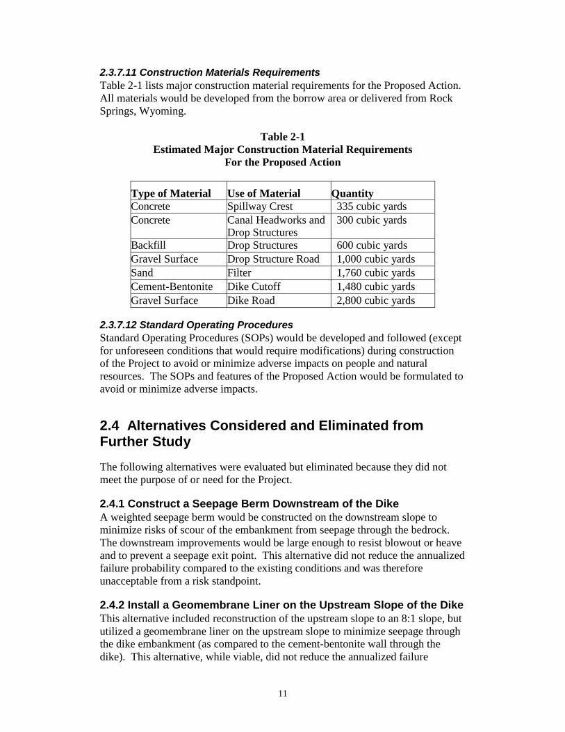
2.3.7.11 Construction Materials Requirements Table 2-1 lists major construction material requirements for the Proposed Action. All materials would be developed from the borrow area or delivered from Rock Springs, Wyoming.
Table 2-1 Estimated Major Construction Material Requirements
For the Proposed Action
Type of Material Use of Material
Quantity
Concrete Spillway Crest 335 cubic yards Concrete Canal Headworks and
Drop Structures 300 cubic yards
Backfill Drop Structures 600 cubic yards Gravel Surface Drop Structure Road 1,000 cubic yards Sand Filter 1,760 cubic yards Cement-Bentonite Dike Cutoff 1,480 cubic yards Gravel Surface Dike Road 2,800 cubic yards
2.3.7.12 Standard Operating Procedures Standard Operating Procedures (SOPs) would be developed and followed (except for unforeseen conditions that would require modifications) during construction of the Project to avoid or minimize adverse impacts on people and natural resources. The SOPs and features of the Proposed Action would be formulated to avoid or minimize adverse impacts.
2.4 Alternatives Considered and Eliminated from Further Study The following alternatives were evaluated but eliminated because they did not meet the purpose of or need for the Project.
2.4.1 Construct a Seepage Berm Downstream of the Dike A weighted seepage berm would be constructed on the downstream slope to minimize risks of scour of the embankment from seepage through the bedrock. The downstream improvements would be large enough to resist blowout or heave and to prevent a seepage exit point. This alternative did not reduce the annualized failure probability compared to the existing conditions and was therefore unacceptable from a risk standpoint.
2.4.2 Install a Geomembrane Liner on the Upstream Slope of the Dike This alternative included reconstruction of the upstream slope to an 8:1 slope, but utilized a geomembrane liner on the upstream slope to minimize seepage through the dike embankment (as compared to the cement-bentonite wall through the dike). This alternative, while viable, did not reduce the annualized failure

12
probably as well as the CB cutoff wall alternative. Additionally, it was estimated to be more expensive.
2.4.3 Install a Downstream Filter Trench at the Dike A chimney filter along with a vertical filter trench would be installed at the existing downstream toe of the dike. The chimney drain and vertical filter trench would be backfilled with material that is filter compatible with the embankment, foundation soils, and bedrock joints. This alternative, while viable, did not reduce the annualized failure probably as well as the CB cutoff wall alternative. Additionally, it was estimated to be more expensive.
2.4.4 Remove and Replace Big Sandy Feeder Canal Two alternatives were studied for replacement of the canal headworks which involved relocating the upper outlet works lower in the reservoir, diverting the water through a conduit, and connecting to the existing irrigation canal below existing drop structures to more efficiently deliver water to Eden Reservoir. The conduit would be 42-inch-diameter HDPE pressure pipe and 42-inch-diameter welded steel within the tunnel section. These design alternatives were not selected due to being significantly more costly than replacing the canal headworks in the existing location and replacing the concrete drop structures in the feeder canal.
2.5 Minimization Measures Incorporated into the Proposed Action The minimization measures, along with other measures listed under each resource in Chapter 3 and Chapter 4 have been incorporated into the Proposed Action to lessen the potential adverse effects.
• All land surface disturbances would be confined to areas previously disturbed, ditch right-of-way, existing roads, agricultural farmland, and small staging areas adjacent to the Project area, to the extent possible.
• Stockpiling of materials would be limited to those areas approved and
cleared in advance. • The Company would be responsible during construction for safety
measures, noise control, dust control, and air, and water pollution. • The Company would be responsible for the following improvements as
part of the Proposed Action. The boat ramp would be extended to match the proposed reservoir level; a total of 7 fire pits and picnic benches would be moved to higher ground or replaced and installed to match the proposed reservoir levels; the artesian well piping and valving would be extended to higher ground to maintain access to the well water for recreation and

13
irrigation purposes; the shade structure and vault restroom below the dam would be replaced; and the vault restrooms in the west camping loop and southeast camping areas would be replaced at a higher elevation following construction.
14
Chapter 3 Affected Environment and Environmental Consequences
3.1 Introduction This chapter describes the environment that could be affected by the Proposed Action. These impacts are discussed under the following resource issues: geology and soils resources; visual resources; cultural resources; paleontological resources; wild and scenic rivers; hydrology; water quality; system operations; health, safety, air quality, and noise; prime and unique farmlands; wetlands, riparian, noxious weeds and existing vegetation; wildlife resources; threatened, endangered, and sensitive species; recreation; socioeconomics; public safety, access, and transportation; water rights; Indian Trust Assets (ITAs); and environmental justice. The present condition or characteristics of each resource are discussed first, followed by a discussion of the predicted impacts caused by the Proposed Action. The environmental effects are summarized in Section 3-7.
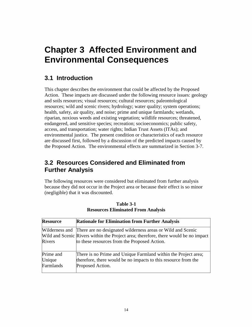
3.2 Resources Considered and Eliminated from Further Analysis The following resources were considered but eliminated from further analysis because they did not occur in the Project area or because their effect is so minor (negligible) that it was discounted.
Table 3-1 Resources Eliminated From Analysis
Resource Rationale for Elimination from Further Analysis
Wilderness and Wild and Scenic Rivers
There are no designated wilderness areas or Wild and Scenic Rivers within the Project area; therefore, there would be no impact to these resources from the Proposed Action.
Prime and Unique Farmlands
There is no Prime and Unique Farmland within the Project area; therefore, there would be no impacts to this resource from the Proposed Action.

15
3.3 Affected Environment and Environmental Consequences This chapter describes the affected environment (baseline conditions) and environmental consequences (impacts as a result of the Proposed Action) on the quality of the human environment that could be impacted by construction and operation of the Proposed Action, as described in Chapter 2.
3.3.1 Geology and Soils Resources The geology at Big Sandy Dam and Reservoir consists of the Laney Shale Member of the Tertiary Green River Formation. Bedrock comprising the dam and dike foundations are horizontally bedded (dipping 1 degree NE). The Laney Shale Member consists of sandstone, siltstone and shale with occasional thin, platy layers of limestone. The unit also consists of interbedded claystone and reworked tuff zones. The depositional environment transitions from lakebeds to shoreline to meandering streams. The Laney Shale Member is mostly fine to medium grained, poorly to moderately cemented, soft to moderately hard, slightly porous, friable sandstone below elevation 6,735 feet. Generally the Laney Shale Member is poorly cemented, slightly fissile, thinly bedded, friable siltstone that predominates above elevation 6,735 feet. Soils form a thin veneer over the weak bedrock materials described above, and potentially range in thickness from roughly 1 to 4-feet-thick over the bedrock. The soils consist of Silty and Sandy Clays, Clayey Sand, and Silty Sand with varying amounts of fine to medium gravel. Soils covering the bedrock material encompass the reservoir area.
3.3.1.1 No Action Under the No Action, the Project would not be built. There would have no effect on geology and soils.
3.3.1.2 Proposed Action Temporary surface soil impacts during construction are anticipated. Air borne particulate matter (dust) is anticipated while mining and processing neighboring surface soils for construction borrow materials. Potential soil erosion impacts after grubbing due to water and wind erosion are possible during construction. Construction erosion and sediment controls would serve to minimize these impacts.
3.3.2 Visual Resources The visual resource of the area would be of a natural wildland setting with very little development and dirt access roads from the highway to the reservoir. Most of the visual aspect of the reservoir consists of sagebrush with a few pockets of medium to large vegetation. Scarred beaches from wave action is also visible throughout times of the year.

16
3.3.2.1 No Action The No Action would have no effect on visual resources.
3.3.2.2 Proposed Action Visual resources would be minimally impacted due to the Proposed Action. Inundation by the expanded reservoir would be temporary in nature and based upon annual hydrology and continuous water pool fluctuations. The inundation is not anticipated to be of sufficient duration as to cause mortality of current vegetation. In the event that the cottonwoods (Populus spp.) along the eastern and western border of the reservoir are partially inundated for too long, the visual environment may change temporarily because the larger vegetation may die. However, the vegetation is likely to be replaced with similar habitat at the edges of the higher water level.
3.3.3 Cultural Resources Cultural resources are defined as physical or other expressions of human activity or occupation that are over 50 years in age. Such resources include culturally significant landscapes, prehistoric and historic archaeological sites, as well as isolated artifacts or features, traditional cultural properties, Native American and other sacred places, and artifacts and documents of cultural and historic significance. Section 106 of the National Historic Preservation Act of 1966, as amended NHPA, mandates that Reclamation take into account the potential effects of a proposed Federal undertaking on historic properties. Historic properties are defined as any prehistoric or historic district, site, building, structure, or object included in, or eligible for, inclusion in the National Register of Historic Places (NRHP). Potential effects of the described alternatives on historic properties are the primary focus of this analysis. In compliance with the regulations specified in Section 106 of the NHPA (36 CFR 800.16), the affected environment for cultural resources is identified as the APE. The APE is defined as the geographic area within which federal actions may directly or indirectly cause alterations in the character or use of historic properties. The APE for this Proposed Action includes the area that could be physically affected by any of the proposed Project alternatives (the maximum limit of disturbance). A Class I literature review and a Class III cultural resource inventory were completed for the APE, defined in the action alternative and analyzed for the Proposed Action, by Reclamation archaeologist Dr. Zachary Nelson. A total of 1,108.05 acres were inventoried during the Class III inventory to determine if the Proposed Action would affect cultural resources. The following previously identified sites were identified within the APE: 48SU1, 48SU2, 48SU4, 48SU5, 48SU6/48SU5327, 48SU7/48SU5214, 48SU101, 48SU102, 48SU103, 48SU104, 48SU105, 48SU106, 48SU1334, 48SU3546, 48SU5202, 48SU5323, 48SU5325, 48SU5328, 48SW1, 48SW2, 48SW3, 48SW4, 48SW6, 48SW103, 48SW104,
17
48SW1841, and 48SW17798. In addition, Reclamation discovered and recorded these cultural resources: Big Sandy Dam, Big Sandy Dike, Reclamation Camp, lithic scatter (zn4), and lithic scatter (zn6). Most of the sites are prehistoric open camps and lithic scatters associated with the Yellow Point Ridge Archaeological Landscape Area. Historic sites include the Oregon Trail and features of Reclamation’s Eden Project (such as the Big Sandy Dam and associated canals). In accordance with 36 CFR 800.4, these sites were evaluated for significance in terms of NRHP eligibility. The significance criteria for evaluating cultural resources is defined in 36 CFR 60.4 as follows: The quality of significance in American history, architecture, archeology, engineering, and culture is present in districts, sites, buildings, structures, and objects that possess integrity of location, design, setting, materials, workmanship, feeling, and association and
1. that are associated with events that have made a significant contribution to the broad patterns of our history; or
2. that are associated with the lives of persons significant in our past; or 3. that embody the distinctive characteristics of a type, period, or method
of construction, or that represent the work of a master, or that possess high artistic values, or that represent a significant and distinguishable entity whose components may lack individual distinction; or
4. that have yielded, or may be likely to yield, information important in
prehistory or history. Based upon these considerations, Reclamation recommends that sites 48SU3546, 48SU5328, 48SW17798, Big Sandy Dam, and Big Sandy Dike are historic resources eligible for inclusion on the NRHP while the other cultural resources are not considered eligible. Consultation with the SHPO is ongoing. As eligible resources, any changes made to these sites that are not in keeping with their historic integrity would result in an adverse effect to these historic resources.
3.3.3.1 No Action Under the No Action Alternative, there would be no adverse effects to cultural resources. There would be no need for ground disturbance associated with construction activities and no sites would be covered with additional water. Existing conditions would continue.
3.3.3.2 Proposed Action Eligible sites 48SU3546 (Eden Canal No. 1), Big Sandy Dam, and Big Sandy Dike would be adversely affected by the Proposed Action. Pursuant to 36 CFR 800.5, the criteria of adverse effect were applied to the sites. An adverse effect is
18
defined as an effect that could diminish the integrity of a historic property's location, design, setting, materials, workmanship, feeling, or association. Under the Proposed Action, the Eden Canal No. 1 would be severely eroded and its historic features replaced, the Big Sandy Dam would be visibly modified by the addition of several feet of new material, and the Big Sandy Dike would be reinforced and modified. Thus, the Proposed Action would cause an alteration to the sites’ characteristics which make them eligible for the NRHP and will, therefore, have an adverse effect on the historic properties according to 36 CFR 800.16(i). In compliance with 36 CFR 800.4(dX2) and 36 CFR 800.11(e), a copy of the cultural resource inventory report and a determination of historic properties affected will be submitted to the SHPO, the Advisory Council on Historic Preservation, and tribes which may attach religious or cultural significance to historic properties possibly affected by the Proposed Action for consultation. Pursuant to 36 CFR 800.6(c), a MOA will be developed to resolve the adverse effects to the sites. Signatories to the MOA will include Reclamation, SHPO, and other interested parties. The MOA must be executed prior to Project implementation.
3.3.4 Paleontological Resources A paleontological file search for the APE will be conducted by WSGS.
3.3.4.1 No Action Under the No Action, there would be no foreseeable impacts to paleontological resources. There would be no need for ground disturbance associated with pipeline installation or staging. The existing conditions would remain intact and would not be affected.
3.3.4.2 Proposed Action Until consultation with WSGS is complete, the impacts of the Proposed Action are unknown.
3.3.5 Hydrology The Big Sandy River (also called Big Sandy Creek) originates on the west side of the continental divide in the southern Wind River Range, in the Bridger Wilderness Area of the Bridger-Teton National Forest and flows roughly 140 river-miles (~60 miles as the crow flies) in a generally southwesterly direction before joining the Green River. Big Sandy Reservoir, a major storage facility of the Eden Project, is located on the Big Sandy River—approximately 45 miles north of Rock Springs and 10 miles north of Farson, Wyoming—near the river’s midpoint. The reservoir collects and stores water from the roughly 400 square-mile drainage area above Big Sandy Dam for irrigation use on Eden Project lands. While the Big Sandy River does have year-round base streamflows of roughly 5-15 cfs, inflows to the reservoir are primarily a result of spring snowmelt runoff when peak inflows regularly exceed 600 cfs. The normal runoff volume entering
19
Big Sandy Reservoir is 52,000 acre-feet (mean total April 1–July 31 runoff for years 1981-2010). The basin upstream of the dam is essentially in its unaltered, natural condition. Streamflows of the Big Sandy River downstream of the dam have been altered by the presence and operation of the dam for irrigation. Spring runoff flows in excess of the storage capacity of the reservoir are spilled to the river below the dam. Outside of spring runoff, releases to the river are not typically made as there is no minimum flow requirement.
3.3.5.1 No Action The No Action Alternative would have no effect on hydrology. The conditions in the basin above, and the river downstream of Big Sandy Dam would remain as they are.
3.3.5.2 Proposed Action Under the Proposed Action Alternative, the basin and hydrology upstream of the dam would remain in its essentially unaltered, natural condition. The Proposed Action has the potential to have a minor impact on the already–controlled hydrology immediately downstream of the dam. If dam and reservoir operations remain as they have historically, the hydrology of the river below the Big Sandy Dam would remain as is. If dam and reservoir operations are altered as planned—to provide additional carryover water from wet to dry years and provide additional irrigation water to extend the irrigation season—the Big Sandy River downstream of the dam would see fewer spring-time spillway flows as a result of the reservoir capturing more of the spring runoff and more summer-time irrigation return flows as a result of increased irrigation deliveries. It is anticipated that under the Proposed Action damaging flood flows downstream of the dam would be mitigated somewhat due to the increased storage capacity.
3.3.6 Water Quality A model-based analysis was performed to assess the potential effects of the Proposed Action on water quality. The analysis compared water quality before and after enlargement of the reservoir. Given that the data availability does not reach the level required by a detailed model, a simpler model approach was more appropriate. The model assumed the following:
1. The reservoir is well-mixed and stratification would not affect Total Suspended Solids (TSS) concentrations prior to settling,
2. Most of the TSS and Total Dissolved Solids (TDS) is carried into the reservoir by the upstream inflow from the Big Sandy River and tributary watershed sources,
3. TSS and TDS contributed by aeolian deposition and precipitation into the reservoir is negligible,
20
4. Evaporation will cause a minimal increase of TSS and TDS in-reservoir concentrations,
5. Outflow through controlled releases and emergency overflow will contain the same concentrations of TSS and TDS as those in the reservoir,
6. The reservoir provides a significant amount of residence time, which promotes internal settling of TSS,
7. Internal settling rate was 0.7 m/day average based on literature value (Thomann 1987),
8. Chemical flocculation of TSS is negligible, 9. The anion and cation constituents of TDS are unlikely to attach to
other charged particles. Thus, settling of TDS in this manner is negligible,
10. The TDS removal by biogeochemical processes in the reservoir is negligible,
11. Groundwater discharge and recharge was assumed to be negligible, 12. Overland runoff between upstream gaging station and the reservoir
was assumed to be minor, 13. No steady state assumption was made due to the change of water level
and reservoir storage, 14. The shape of the reservoir was assumed to be truncated cone for depth-
area calculations, 15. With adequate water conditions, the ideal irrigation season would
begin on April 1 and shut down on September 15.
A depth-storage and depth-area curve was established for the reservoir using daily U.S. Geological Survey (USGS) gaging station 09213700 storage and stage data from 2011 to 2016. The surface area of the reservoir was estimated under the assumption of truncated cone shaped reservoir. The surface area at the Normal High Water Level (NHWL) used by the existing model was 2,500 acres. The same surface area was used in the model prior to enlargement. The regression established between depth and area is y= -0.1012x^3+15.716x^2-715.67x+10579 with a goodness of fit r-squared of 0.996. Monthly average surface area calculated was used in the calculation of water budget components. Precipitation data was available year-round from Station USC00483170 in Farson, WY. The annual average rainfall at the station was 6.65 inches (2011 through 2016). This number is comparable to data from the University of Wyoming website (Wyoming Climate Atlas 2004). Only the precipitation that fell directly on the reservoir surface area was calculated. Precipitation falling onto the other parts of the watershed were assumed to be part of the upstream inflow. The enlargement of the reservoir would directly affect the precipitation amount received.
21
3.3.6.1 No Action The No Action would have no effect on water quality. The Reservoir would not be enlarged, nor would any ground disturbance occur under the No Action alternative.
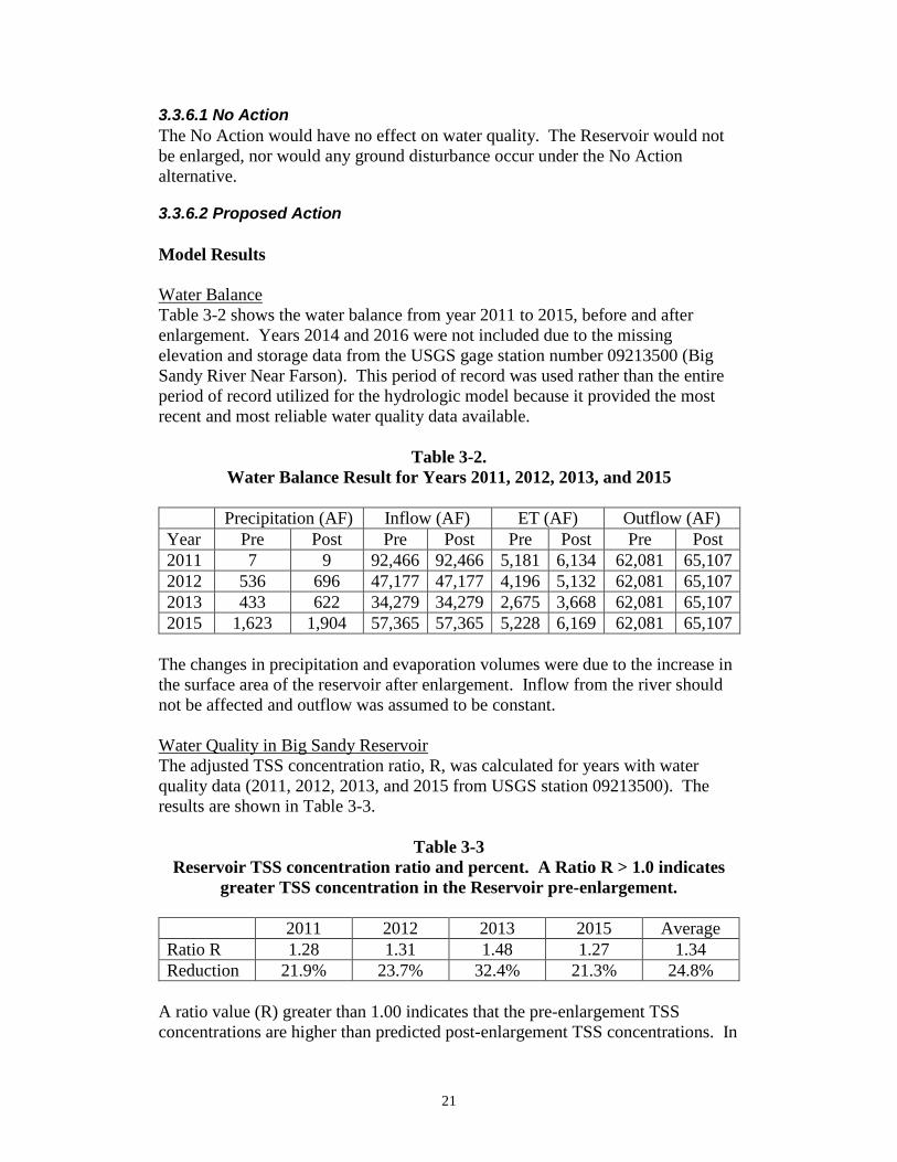
3.3.6.2 Proposed Action Model Results Water Balance Table 3-2 shows the water balance from year 2011 to 2015, before and after enlargement. Years 2014 and 2016 were not included due to the missing elevation and storage data from the USGS gage station number 09213500 (Big Sandy River Near Farson). This period of record was used rather than the entire period of record utilized for the hydrologic model because it provided the most recent and most reliable water quality data available.
Table 3-2. Water Balance Result for Years 2011, 2012, 2013, and 2015
Precipitation (AF) Inflow (AF) ET (AF) Outflow (AF) Year Pre Post Pre Post Pre Post Pre Post 2011 7 9 92,466 92,466 5,181 6,134 62,081 65,107 2012 536 696 47,177 47,177 4,196 5,132 62,081 65,107 2013 433 622 34,279 34,279 2,675 3,668 62,081 65,107 2015 1,623 1,904 57,365 57,365 5,228 6,169 62,081 65,107
The changes in precipitation and evaporation volumes were due to the increase in the surface area of the reservoir after enlargement. Inflow from the river should not be affected and outflow was assumed to be constant. Water Quality in Big Sandy Reservoir The adjusted TSS concentration ratio, R, was calculated for years with water quality data (2011, 2012, 2013, and 2015 from USGS station 09213500). The results are shown in Table 3-3.
Table 3-3 Reservoir TSS concentration ratio and percent. A Ratio R > 1.0 indicates
greater TSS concentration in the Reservoir pre-enlargement.
2011 2012 2013 2015 Average Ratio R 1.28 1.31 1.48 1.27 1.34 Reduction 21.9% 23.7% 32.4% 21.3% 24.8%
A ratio value (R) greater than 1.00 indicates that the pre-enlargement TSS concentrations are higher than predicted post-enlargement TSS concentrations. In
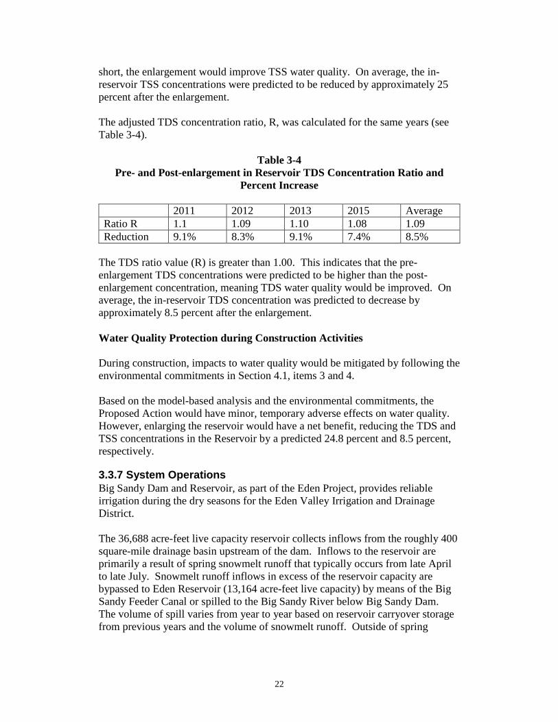
22
short, the enlargement would improve TSS water quality. On average, the in-reservoir TSS concentrations were predicted to be reduced by approximately 25 percent after the enlargement. The adjusted TDS concentration ratio, R, was calculated for the same years (see Table 3-4).
Table 3-4 Pre- and Post-enlargement in Reservoir TDS Concentration Ratio and
Percent Increase 2011 2012 2013 2015 Average Ratio R 1.1 1.09 1.10 1.08 1.09 Reduction 9.1% 8.3% 9.1% 7.4% 8.5%
The TDS ratio value (R) is greater than 1.00. This indicates that the pre-enlargement TDS concentrations were predicted to be higher than the post-enlargement concentration, meaning TDS water quality would be improved. On average, the in-reservoir TDS concentration was predicted to decrease by approximately 8.5 percent after the enlargement. Water Quality Protection during Construction Activities During construction, impacts to water quality would be mitigated by following the environmental commitments in Section 4.1, items 3 and 4. Based on the model-based analysis and the environmental commitments, the Proposed Action would have minor, temporary adverse effects on water quality. However, enlarging the reservoir would have a net benefit, reducing the TDS and TSS concentrations in the Reservoir by a predicted 24.8 percent and 8.5 percent, respectively.
3.3.7 System Operations Big Sandy Dam and Reservoir, as part of the Eden Project, provides reliable irrigation during the dry seasons for the Eden Valley Irrigation and Drainage District. The 36,688 acre-feet live capacity reservoir collects inflows from the roughly 400 square-mile drainage basin upstream of the dam. Inflows to the reservoir are primarily a result of spring snowmelt runoff that typically occurs from late April to late July. Snowmelt runoff inflows in excess of the reservoir capacity are bypassed to Eden Reservoir (13,164 acre-feet live capacity) by means of the Big Sandy Feeder Canal or spilled to the Big Sandy River below Big Sandy Dam. The volume of spill varies from year to year based on reservoir carryover storage from previous years and the volume of snowmelt runoff. Outside of spring
23
runoff, releases to the river are not typically made. The reservoir has spilled in 20 of last 46 years since 1970 (43 percent). Irrigation water deliveries are typically made from Big Sandy Reservoir from May to September. The Means Canal, with a capacity of 600 cfs, conveys water from Big Sandy Reservoir to the Westside Lateral, which serves lands on the west side of the Big Sandy River, and to the Eden Canal, which serves lands east of the River. Little Sandy Diversion Dam diverts water into the Little Sandy Canal which also supplies water to the Eden Canal. Water is diverted from Big Sandy Dam to the Eden Reservoir and from the Little Sandy Canal into the Eden Reservoir. Water is drawn from Eden Reservoir to serve the Eden Canal and Farson Lateral.
3.3.7.1 No Action The No Action Alternative would have no effect on system operations.
3.3.7.2 Proposed Action The Proposed Action Alternative has the potential to have a minor impact on the system operations. If dam and reservoir operations are altered as planned—to provide additional carryover water from wet to dry years and provide additional irrigation water to extend the irrigation season—the Big Sandy River downstream of the dam would see fewer spring-time spillway flows as a result of the reservoir capturing more of the spring runoff and more summer-time irrigation return flows as a result of increased irrigation deliveries. The water delivery systems could see higher flows and/or a longer duration of use should more irrigation water be delivered as a result of enlarging the reservoir. The additional capacity of the reservoir under the Proposed Action would provide improved carryover conditions resulting in a more reliable water supply during dry years. The modifications to the Big Sandy Feeder Canal and headworks under the Proposed Action would result in greater flexibility and efficiency in delivering and storing excess water from the Big Sandy River in Eden Reservoir.
3.3.8 Health, Safety, Air Quality, and Noise The Project area is located in Sweetwater County, Wyoming in a rural, primarily agricultural setting. There are no known public health concerns in the Project area. Safety concerns in the area are generally related to traffic along Wyoming State Highway 28 which is located in the Project area. Safety concerns include those related to vehicles traveling along the highway. Public safety resources in the general vicinity of the Project area include the Eden Farson Fire Control District Training Unit which is located on US Highway 191, approximately 11 miles south of the Project area. Current air quality in the Project area is good, typical of rural and agricultural areas. The ambient noise within the Project area includes a combination of natural sounds (wind, bird and insect calls) and mechanical sounds (cars, trucks, tractors, etc.). In general, noise levels are consistent with rural communities, likely averaging from 42 to 65 decibels based on their proximity to the state highway that runs through the Project area.
24
3.3.8.1 No Action Existing public health, air quality and noise conditions in the Project area would be maintained. Therefore, the No Action Alternative would have no effect on public health, air quality or noise.
3.3.8.2 Proposed Action The Proposed Action would have no impacts on public health and safety in the Project area. Emergency dispatch service including the local fire, police and ranger stations would not be impacted by the Proposed Action. Any temporary road or access closure would be coordinated with local law enforcement and emergency services. The Proposed Action is anticipated to have short-term noise and air quality impacts during active construction. Noise levels would be elevated during construction, but no new noise would be generated from the Proposed Action after construction. Air quality impacts from land disturbance activities such as excavation and compaction of soils along the Project alignment would be short term. Noise and air quality impacts would be mitigated through the implementation of the Best Management Practices (BMPs) throughout construction. The BMPs would include a dust mitigation plan and proper maintenance of construction equipment. Reclamation, or a designated contractor, would develop and implement a Spill Prevention Containment and Countermeasures Plan (SPCCP) prior to the onset of construction. The SPCCP would include measures to be implemented onsite that would keep construction and hazardous materials out of waterways and drainages. The SPCCP would include provisions for daily checks for leaks; hand-removal of external oil, grease, and mud; and the use of spill containment booms for refueling. In addition, construction equipment refueling and regular maintenance would be restricted to designated staging areas located away from streams and sensitive habitats. Reclamation expects that adherence to BMPs that dictate the use, containment, and cleanup of contaminants would minimize the risk of introducing such products to the waterway because the prevention and contingency measures would require frequent equipment checks to prevent leaks, would keep stockpiled materials away from the water, and would require that absorbent booms are kept on-site to prevent petroleum products from entering the river in the event of a spill or leak.
3.3.9 Flood Plains Executive Order 11988: Floodplain Management (EO 11988) (May 24, 1977) established federal policy for each agency to take action to reduce the risk of flood loss. Executive Order 11988 defines a floodplain as lowland and relatively flat areas adjoining inland and coastal waters including flood prone areas of offshore islands, including at a minimum, that area subject to a one percent or greater chance of flooding in any given year. Encroachment onto floodplains can reduce the flood-carrying capacity of the floodplain and extend the flooding hazard beyond the encroachment area.
25
According to the Flood Insurance Rate Map, the majority of the Project area is located in Flood Zone A. Flood Zone A corresponds to areas that are subject to inundation by the one percent annual chance-flood or 100-year flood event.
3.3.9.1 No Action Under the No Action Alternative, the Project would not be built and the existing conditions of the Project area would be maintained. There would be no impact to the floodplain or the potential for flooding.
3.3.9.2 Proposed Action The majority of the Proposed Action would take place inside of the active floodplain. The removal and replacement of the Big Sandy Feeder Canal conveyance pipeline would take place outside of the active floodplain. The proposed work on the existing spillway crest, toe drain, outlet works, and dike embankment would allow an additional 13,700 acre-feet of water, when available, to be stored in the reservoir. This storage capacity increase has the potential to expand the 100-year floodplain within the Project area. Currently, there are no structures that exist within the proposed expanded boundary of the 100-year floodplain.
3.3.10 Wetlands and Riparian Resources Wetlands Wetland areas were delineated by Western EcoSystems Technology Inc. in accordance with the 1987 Corps of Engineers Wetlands Delineation Manual (Environmental Laboratory 1987) and the Regional Supplement to the Corps of Engineers Wetland Delineation Manual: Arid West (Version 2.0) (USACE 2010). The 1987 manual outlines a three parameter approach for an area to be considered a wetland, in which all three parameters must be met. Hydrophytic plants must be the dominant vegetative cover; hydric soils must be present; and wetland hydrology must be present. In some locations, the survey area presented a problematic hydrology situation due to the reservoir influence and fluctuation. The Arid West Manual (USACE 2010) recommends additional monitoring for problematic situations and provides technical standards. The standard requires 14 or more consecutive days of flooding or ponding during the growing season at a minimum frequency of 5 out of 10 years (USACE 2010). Hydrology data and aerial imagery were reviewed to support this standard. In addition, discussions with the Cheyenne – USACE office occurred to guide these determinations. Based on conversations with the USACE (Personal Comm – Tom Johnson), sample locations that relied primarily on aerial imagery as the hydrologic indicator were determined to not meet the hydrology standards. Sample locations that used saturation, biotic crust, or other primary indicators were determined to appropriately meet the hydrology standards.
26
Field surveys concluded that 182 acres of wetlands occur along the reservoir margins, including broad meadows/depressions. Also, 154 acres of wetlands occur in the terrace/riparian corridors along the Big Sandy River, for a total of 336 acres. Fringe wetlands were primarily palustrine scrub-shrub (PSS) dominated by sandbar willow (Salix exigua) with limited herbaceous understory. Small palustrine emergent (PEM) fringes were also present. The large PEM meadow wetland areas were dominated by foxtail barley (Hordeum jubatum) and Douglas’ sedge (Carex douglasii), both of which are considered facultative wetland species. Some wetland areas had a high percentage of non-desirable annual species including tumbleweed (Salsola tragus) and halogeton (Halogeton glomeratus). In general, the meadow wetland areas were low quality, marginal wetlands. Based on a review of aerial photos using GoogleEarth, these wetland areas appeared to be inundated only when the reservoir was filled to maximum capacity. Wetland areas located along the Big Sandy River inflow were mixed community PEM/PSS wetlands. These wetlands had clear hydrology, hydric soil indicators, and hydric vegetative diversity. The river corridor was well defined and contained high quality wetland characteristics. Riparian Big Sandy Reservoir is located in an arid west landscape. The surrounding land cover is sagebrush steppe; however, riparian vegetation exists within the Project area along the banks of the Big Sandy River. This riparian community is primarily dominated by sandbar willow (Salix exiqua) and shining willow (Salix lucida). Other riparian species include: Northwest Territory sedge (Carex utriculata), Nebraska sedge (Carex nebrascensis), tufted hairgrass (Deschampsia caespitosa), Baltic rush (Juncus balticus), American licorice (Glycyrrhiza lepidota), water sedge (Carex aquatilus), and Kentucky bluegrass (Poa pratensis).
3.3.10.1 No Action The No Action would have no negative effect on wetlands and riparian vegetation. Hydrologic flow patterns in Big Sandy River and annual reservoir storage fluctuations would continue.
3.3.10.2 Proposed Action It is anticipated that implementation of the Proposed Action would cause temporary inundation of 336 acres of wetlands and riparian areas during periods when the reservoir would be at full water pool elevation. This inundation would be temporary in nature and based upon annual hydrology and continuous water pool fluctuations. The inundation is not anticipated to be of sufficient duration as to cause mortality of current wetland vegetation. The inundation may however be of sufficient duration to cause an expansion of fringe wetlands into areas that are currently classified as uplands. The USACE has determined that maintenance activities that do not result in expansion of the Big Sandy Dam embankment such as installation of the toe drain and filter, lower outlet works filter diaphragm, and cutoff wall in a portion of the dike are exempt as defined in Section 404(f)(B) and codified in regulations at 33
27
CFR 323.4(a)(2). Minor discharges associated with spillway modification or reinforcement of the dike embankment can be authorized by Nationwide Permit 18 as published in the Federal Register on February 21, 2012 (Volume 77, No. 34) (USACE, 2016).
3.3.11 Wildlife Resources Wildlife resources within the general area of the Project include mammals, birds, reptiles and amphibians, and fish. Mammals Mule deer (Odocoileus hemionus), Rocky Mountain elk (Cervus canadensis nelsoni), and pronghorn (Antilocapra americana) are found in the general surrounding area. Pronghorn and Rocky Mountain elk have crucial habitat within the Project area. Birds Migratory songbirds, upland gamebirds, raptors, and owls occur in the Project area. Two species of concern with records of observation within or near the Project area are the burrowing owl (Athene cunicularia) and greater sage-grouse (Centrocercus urophasianus). Reptiles and Amphibians A number of reptiles and amphibians occur in the general area including the western rattlesnake (Crotalus viridis), western chorus frog (Pseudacris triseriata), and tiger salamander (Ambystoma tigrinum). Fish The Reservoir supports four native fish species and two invasive species. Native fish occurring in the Reservoir and downstream include brown trout (Salmo trutta), catfish (Ictalurus punctatus), cutthroat trout (Oncorhynchus clarkii), and rainbow trout (Oncorhynchus mykiss). Most anglers visit the Reservoir to catch brown trout and rainbow trout, both of which have been stocked in recent years by Wyoming Game and Fish Department (WGFD) (John Walwrath, WGFD 2017, pers. comm.). In 2016, the WGFD stocked 11,000 3-inch brown trout and 22,000 catchable rainbow trout. Cutthroat trout were last stocked in 2004. Two invasive species are present in the reservoir, including burbot (Lota lota) and white sucker (Catostomus commersonii). Burbot were illegally introduced to the Reservoir in 2001 and have since invaded Fontenelle and Flaming Gorge Reservoirs. Both burbot and white sucker have reduced the quality of the fishery at Big Sandy Reservoir, making it a less desirable fishing destination (John Walwrath, WGFD 2017, pers. comm.).
3.3.11.1 No Action The No Action would have no negative effects on wildlife. Free water and habitat conditions would remain the same.
28
3.3.11.2 Proposed Action Under the Proposed Action there would be no long-term detrimental effects to wildlife. However, in the short term, especially during and immediately after construction, animals would have to find unfamiliar habitat wherein they are more susceptible to exposure to the elements and predation. Construction activity would cause stress to some wildlife species from noise, dust, displacement, and temporary loss of habitat. Trees and shrubs that used to be occupied by birds and other wildlife may die if they are inundated for extended periods of time. This may affect nesting habitat, and thermal cover for a variety of species. However, this is expected to be low impact due to the gradual habitat transition that would occur due to enlargement of the reservoir. Vegetation along the perimeter of the reservoir may increase with the enlargement of the reservoir. During construction, water availability is unlikely to change from typical conditions below the dam and on the north side of the reservoir. Some species may benefit from a larger water surface that would eventually create additional wet areas.
3.3.12 Threatened, Endangered, and Sensitive Species During the environmental review process for the Project area, several sources were reviewed to determine the impact of the proposed Project on the Threatened, Endangered, and Sensitive Species. By reviewing the U.S. Fish and Wildlife Service’s IPaC website, it was determined there was potential for eight listed species to occur in the Project area: yellow-billed cuckoo (Coccyzus americanus), bonytail chub (Gila elegans), Colorado pikeminnow (Ptychocheilus lucius), humpback chub (Gila cypha), razorback sucker (Xyrauchen texanus), Ute ladies’-tresses (Spiranthes diluvialis), and gray wolf (Canis lupus). Wyoming Game and Fish Department’s 2016 list of Species of Greatest Conservation Need and the Wyoming Natural Diversity Database were consulted to determine species distribution and occupancy for these and other Sensitive Species. On June 22, 2015, and April 12-13, 2017, Reclamation biologists surveyed the Project area for potential impacts to listed and sensitive species.
3.3.12.1 No Action The No Action would have no effect on Threatened, Endangered, and Sensitive Species.
3.3.12.2 Proposed Action The proposed Project would not adversely affect Threatened and Endangered Species, and would not significantly impact either Sensitive Species. Individual analyses for each of the species follows, and a full impact summary of all species can be viewed in Table 3-2 below.
3.3.12.2.1 Gray Wolf The gray wolf is listed as an endangered species under the Endangered Species Act of 1973. Gray wolves were reintroduced to Yellowstone National Park in 1995, and have since spread into northwest Wyoming, with packs also found in Washington, Oregon, Idaho, and Montana. Non-breeding individuals have exhibited exploratory behavior through Utah, Colorado, and Arizona. In

29
Wyoming, gray wolves are considered an experimental, non-essential population (ESA Section 10(j)). There is no designated critical habitat in Wyoming. The likelihood of a gray wolf occurring within the Project area is low, but possible. The greatest chance of an occurrence is through exploratory dispersal to the northern fringes of the Reservoir, away from areas they already avoid due to human activity such as campers, boaters, fishermen, vehicle traffic, etc. Therefore, no impacts on wolves would be expected as a result of the Proposed Action.
3.3.12.2.2 Ute-ladies’ Tresses Ute-ladies’ Tresses are a vascular plant species related to orchids. Ute-ladies’ Tresses flowers every 1-3 years in late summer, with a spiral-type white blossom. Ute-ladies’ Tresses were federally listed as a threatened species in 1992. The species was petitioned to be de-listed in 2004. Ute-ladies’ Tresses are not known to occur in western Wyoming, and there are no known populations within ~100 miles of the Project area. The species is unlikely to occur in the Project area. Therefore, the Proposed Action would not impact Ute-ladies’ Tresses.
3.3.12.2.3 Yellow-billed Cuckoo The Yellow-billed Cuckoo uses dense, wooded habitat where water is available nearby. The main prey of the Yellow-billed Cuckoo is caterpillars. Due to low numbers and the designation of a distinct population segment in the western portion of its range, the species was federally listed as threatened in 2014. There is no suitable habitat in the Project area. Therefore, the Proposed Action would have no impact on the Yellow-billed Cuckoo.
3.3.12.2.4 Greater Sage-grouse The proposed Big Sandy Reservoir enlargement would raise the existing normal high water mark from 6,757.5 feet to 6,762.5 feet, which would increase the surface area inundated from 2,420.25 to 2,919.32 acres. Of the new area inundated (499 acres), 266 acres are currently undisturbed uplands dominated primarily by big sagebrush (Artemisia tridentata). Greater sage-grouse are ground-nesting birds that rely on sagebrush (Artemisia spp.) in all phases of their life cycle. Sage-grouse nest in thick sagebrush cover, but utilize wetlands during much of the brood-rearing period. Wyoming supports the greatest number of sage-grouse of all the states or Canadian provinces in which they occur. The Wyoming Governor’s office developed a map of greater sage-grouse Core Population Areas. Governor Mead then issued Greater Sage-Grouse Executive Order (EO) 2011-5, which states that new development or land uses within Wyoming that were designated Core Population Areas should be authorized or conducted only when it can be demonstrated that the activity will not cause declines in greater sage-grouse populations. The entire Big Sandy Reservoir is located within a greater sage-grouse Core Population Area, which required that

30
impacts to greater sage-grouse caused by enlarging the reservoir be evaluated in accordance with the EO. The EO included a method for determining compliance with the EO for new projects, referred to as the Density and Disturbance Calculation Tool (DDCT). A DDCT analysis conducted for enlarging Big Sandy Reservoir showed that the Project would be in full compliance with the Governor’s EO, as the total proposed and existing disturbance of 2,541 acres would be 2.91 percent of the DDCT analysis area, well below the threshold of 5 percent disturbance. Of this disturbance, however, enlarging Big Sandy Reservoir would only account for 266 acres, or 0.3 percent of the DDCT analysis area. The DDCT analysis very conservatively assumed that the 266 acres of sagebrush-dominated uplands around the perimeter of the existing reservoir would be permanently lost once the reservoir is enlarged (i.e., this area would become devoid of all vegetation). Current operation of the Big Sandy Reservoir has not resulted in creation of large areas devoid of vegetation around the perimeter of the reservoir. Instead, wetlands occupy much of this area. It is assumed that inundated uplands along the perimeter of the expanded reservoir may also convert to wetlands (beneficial to sage-grouse during the brood-rearing period), rather than become devoid of vegetation. An analysis of how operation of the existing reservoir, which has allowed wetlands along the perimeter of the reservoir to persist, would relate to operation of the expanded reservoir. The length of inundation as well as the depth of water for existing wetlands under normal high water conditions for a period of record of 21 years (1990-2010) were used in the analysis. The maximum length of inundation of these wetlands in any given year was 211 days, while the average length of inundation was 53 days. However, if the seven years that wetlands were never inundated are removed, the mean length of inundation was 79 days during years that inundation occurred. The mean length of inundation varied among the 14 years from 16 to 211 days. The approximate depths of inundation also were examined. The average length of time that water was at or above the elevation of 6,754 feet was 53 days. The mean length of time that wetlands at the bottom elevation (6,754 feet) were inundated with 1, 2, 3 and 4 feet of water was 37, 28, 20 and 4 days, respectively. The maximum number of days the wetlands were inundated with 1, 2, 3 or 4 feet of water in any given year was 147, 128, 116 and 48 days, respectively. Scientific literature (see Chapter 7 References) indicates that dominant species in the wetlands along the margin of the reservoir would tolerate periodic flooding during times of normal high water levels. Existing wetlands at Big Sandy Reservoir between 6,754 and 6,758 feet have persisted despite an average of up to 79 days of inundation per year, including an average of 20 days per year under > 3 feet of water. Based on analysis of existing wetlands in relation to past high water levels and a review of the literature, all of the wetlands around the reservoir are likely to persist. No loss of PSS wetlands is expected. PEM wetlands also
31
would likely persist, although some changes in species composition would likely occur (e.g., change from grass-dominated to sedge-dominated species). Based on this literature review and analysis, it is likely that new wetlands would form both within and above the new normal high water line of the expanded reservoir, as they would likely be subjected to similar inundation regimes as existing wetlands. In addition to habitat disturbance described above, sage grouse may be temporarily displaced during construction activities, particularly along the Big Sandy Feeder Canal. Although work would occur using areas that were previously disturbed, noise from construction machinery may deter sage grouse from using the area adjacent to the Canal. However, it would not be expected that sage grouse would leave the area entirely as suitable habitat is found throughout the whole Project area.
3.3.12.2.5 Burrowing Owl The Burrowing Owl uses a wide variety of arid and semiarid environments, with well-drained, level to gently sloping areas characterized by sparse vegetation and bare ground. It prefers open prairie, grassland, desert, and shrub-steppe habitats, and may also inhabit agricultural areas. It depends on mammals that dig burrows, particularly prairie dogs and ground squirrels, which it uses for nesting, roosting, and escape. In Wyoming, the highest concentrations of Burrowing Owls are in the south and east, although it occurs and breeds throughout most of the State. The Burrowing Owl is considered an uncommon summer resident in Wyoming. Surveys by Reclamation biologists on April 12, 2017, indicated there was no suitable habitat in the Project area. Therefore, the Proposed Action would have no effect on Burrowing Owls.
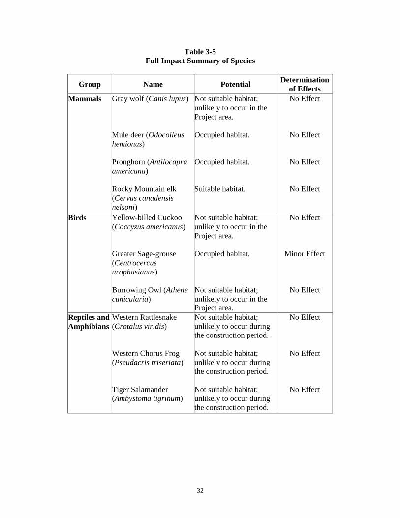
32
Table 3-5 Full Impact Summary of Species
Group Name Potential Determination of Effects
Mammals Gray wolf (Canis lupus) Mule deer (Odocoileus hemionus) Pronghorn (Antilocapra americana) Rocky Mountain elk (Cervus canadensis nelsoni)
Not suitable habitat; unlikely to occur in the Project area. Occupied habitat. Occupied habitat. Suitable habitat.
No Effect
No Effect
No Effect
No Effect
Birds Yellow-billed Cuckoo (Coccyzus americanus) Greater Sage-grouse (Centrocercus urophasianus) Burrowing Owl (Athene cunicularia)
Not suitable habitat; unlikely to occur in the Project area. Occupied habitat. Not suitable habitat; unlikely to occur in the Project area.
No Effect
Minor Effect
No Effect
Reptiles and Amphibians
Western Rattlesnake (Crotalus viridis) Western Chorus Frog (Pseudacris triseriata) Tiger Salamander (Ambystoma tigrinum)
Not suitable habitat; unlikely to occur during the construction period. Not suitable habitat; unlikely to occur during the construction period. Not suitable habitat; unlikely to occur during the construction period.
No Effect
No Effect
No Effect

33
Group Name Potential Determination of Effects
Fish Brown trout (Salmo trutta) Cutthroat trout (Oncorhynchus clarkii) Catfish (Ictalurus punctatus) Burbot (Lota lota) Bonytail chub (Gila elegans) Colorado pikeminnow (Ptychocheilus Lucius) Humpback chub (Gila cypha) Razorback Sucker (Xyrauchen texanus)
Minimal disturbance near construction on the Dam. Minimal disturbance near construction on the Dam. Minimal disturbance near construction on the Dam. Minimal disturbance near construction on the Dam. Does not occur in the Project area. Does not occur in the Project area. Does not occur in the Project area. Does not occur in the Project area.
Minor Effect
Minor Effect
Minor Effect
Minor Effect
No Effect
No Effect
No Effect
No Effect
Plants Ute ladies'-tresses (Spiranthes diluvialis)
No known populations occur within 100 miles of the Project area.
No Effect
3.3.13 Recreation The recreation around Big Sandy Reservoir consists of multiple campsites with picnic tables and fire pits along the edge of the reservoir with a few restroom facilities nearby. On the west side of the reservoir there is a boat ramp with a vault toilet, a camping loop area with an artesian well, vault restroom, a shade shelter, and multiple tables and fire pits. On the south side of the reservoir there is some dispersed campsites with fire pits. On the south east corner of the reservoir there are multiple campsites with tables, fire pits, and a vault restroom. Below the dam there is a camping area with a shade shelter and a restroom.
3.3.13.1 No Action The No Action alternative would have no effect on recreation.
3.3.13.2 Proposed Action The Proposed Action would have some impact on recreation facilities, as well as access to the reservoir for recreation. The boat ramp would need to be extended

34
to match the reservoir levels. Two vault toilets by the reservoir would be approximately 10 and 60 feet from the water with the reservoir at full capacity. Due to wave action and groundwater saturation, these two vault toilets would need to be replaced at a higher elevation. Moving or replacing the third vault toilet near the boat ramp would likely be unnecessary. The campsites along the southeast corner of the reservoir would need to be moved to higher ground, due to wave action eroding away the bank. Three tables and fire pits southwest of the main camping area near the boat ramp would need to be moved. If moving them is not possible, or if the current tables and fire pits are too deteriorated to move, then new equipment would need to be purchased and installed. The outlet of the artesian well would need to be extended to higher ground. The shade structure and existing vault restroom below the dam would need to be removed for construction, and replaced when done. During the construction period, access to the recreation area would be limited, which would reduce the number of visitors to the area. After construction, there may be a larger amount of visitors due to the larger reservoir and updated amenities that would exist.
3.3.14 Socioeconomics The estimated population of Sweetwater County in 2015 is 44,772 individuals, which is an increase of 19 percent from 37,613 people in 2000 (Figure 3-1) (U.S. Department of Commerce 2016). Median household income in 2014 was $69,022 with per capita income estimated to be $30,568, and 8.6 percent of individuals in poverty. The civilian labor force accounts for 72.6 percent of all individuals in Sweetwater County. Educational attainment is estimated to be 90.5 percent of people with a high school degree or higher (U.S. Census Bureau 2015).
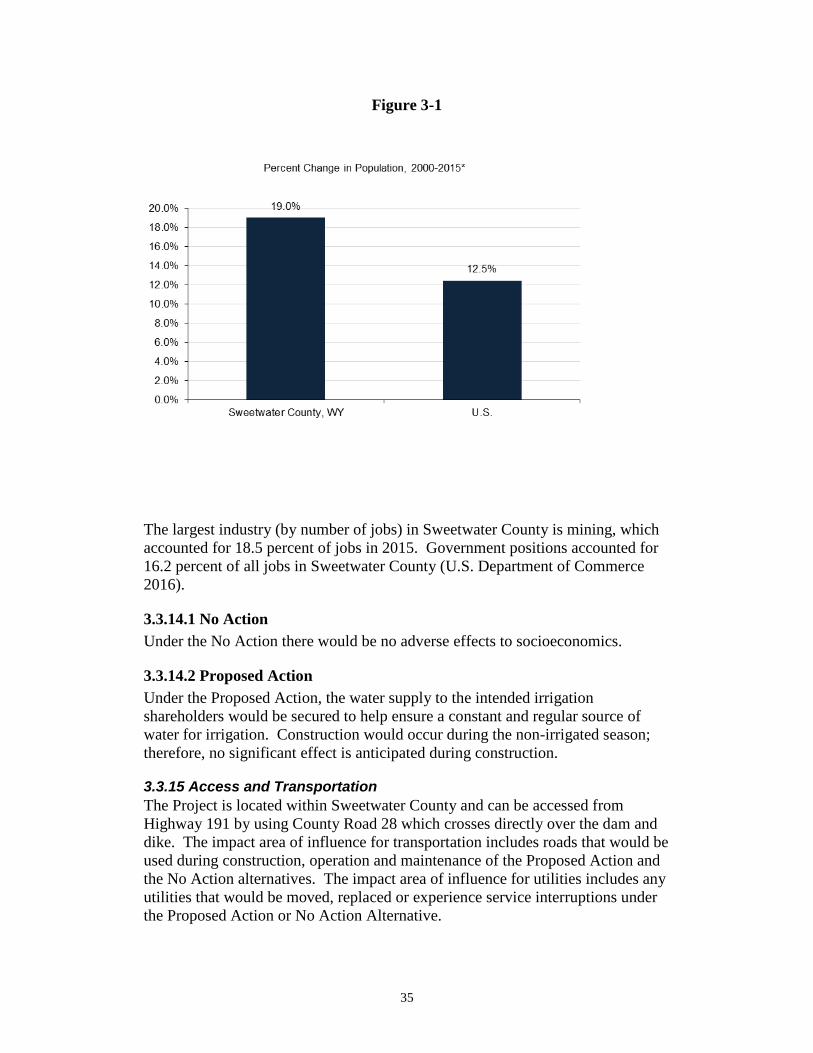
35
Figure 3-1
The largest industry (by number of jobs) in Sweetwater County is mining, which accounted for 18.5 percent of jobs in 2015. Government positions accounted for 16.2 percent of all jobs in Sweetwater County (U.S. Department of Commerce 2016).
3.3.14.1 No Action Under the No Action there would be no adverse effects to socioeconomics.
3.3.14.2 Proposed Action Under the Proposed Action, the water supply to the intended irrigation shareholders would be secured to help ensure a constant and regular source of water for irrigation. Construction would occur during the non-irrigated season; therefore, no significant effect is anticipated during construction.
3.3.15 Access and Transportation The Project is located within Sweetwater County and can be accessed from Highway 191 by using County Road 28 which crosses directly over the dam and dike. The impact area of influence for transportation includes roads that would be used during construction, operation and maintenance of the Proposed Action and the No Action alternatives. The impact area of influence for utilities includes any utilities that would be moved, replaced or experience service interruptions under the Proposed Action or No Action Alternative.
36
During construction, it is estimated that up to about fifteen construction vehicles per day would travel to the site depending on the features being worked on at the time. Within the site, continuous operation of heavy equipment is anticipated on a daily basis. The majority of the vehicle trips from off-site would be for transporting construction materials including concrete, cement-bentonite, excavation and backfill materials. The contractor would be transporting heavy construction equipment at the beginning and end of the Project. Upon completion of construction, vehicle trips are expected to be reduced to no more than three per day for Operation and Maintenance (O&M) purposes during irrigation season.
3.3.15.1 No Action The No Action would have no impact on access, and transportation.
3.3.15.2 Proposed Action The Proposed Action would have minor short-term effects during construction but no long-term effects on access, and transportation.
3.3.16 Water Rights The Eden Valley Project uses both direct flow and storage water rights to irrigate 17,009.44 acres of land in the Eden-Farson Area. The direct flow diversions are covered under the Wyoming State Water Right, Permit No. P5718, which has a priority date of November 24, 1903. The water storage in Big Sandy Reservoir is covered under the Wyoming State Water Right, Permit No. P947 Res, which has a priority date of November 9, 1906. Permit No. P947 Res. was originally filed to allow for 104,630 acre-feet of storage, but this water right was reduced when Notice of Completion of Construction was submitted in 1961 showing a reservoir capacity of 39,700 acre-feet. There is also a secondary Wyoming Water Right, P21403 that ties the water stored under P947 Res to the Eden Valley Project lands. This secondary permit is not required to store or use water in or use water from Big Sandy Reservoir, but instead makes this reservoir’s storage water and storage capacity appurtenant to the Eden Valley Project lands.
3.3.16.1 No Action Under the No Action, the Project would not be built. This would have no effect on water rights.
3.3.16.2 Proposed Action This proposed action would increase the storage capacity of Big Sandy Reservoir to 52,300 acre-feet which is 12,600 acre-feet above the allowable storage of 39,700 acre-feet under Water Right P947 Res. Therefore, a new application to store water would need to be filed with the Wyoming State Engineer to allow this additional storage volume.
37
This new water right would have a current day priority date which would make it junior to all existing water rights on the Big Sandy Creek. This subordination would provide legal protection to all neighboring non-project users from potential impairment from the additional storage in Big Sandy Reservoir may cause. If any interference between senior water rights and the additional storage is identified, the impaired water users can request the Wyoming State Engineer to put the river system in regulation. Once the Big Sandy Creek is in regulation, water rights would be regulated by priority date and junior storage rights would be curtailed as needed to fully satisfy the senior water rights.
3.4 Indian Trust Assets Indian Trust Assets (ITAs) are legal interests in property held in trust by the United States for Indian tribes or individuals. The Department of the Interior's policy is to recognize and fulfill its legal obligations to identify, protect, and conserve the trust resources of Federally recognized Indian tribes and tribal members, and to consult with tribes on a government-to-government basis whenever plans or actions affect tribal trust resources, trust assets, or tribal safety (see Departmental manual, 512 DM 2). Under this policy, as well as Reclamation's ITA policy, Reclamation is committed to carrying out its activities in a manner which avoids adverse impacts to ITAs when possible, and to mitigate or compensate for such impacts when it cannot. All impacts to ITAs, even those considered nonsignificant, must be discussed in the trust analyses in NEPA compliance documents and appropriate compensation or mitigation must be implemented. Trust assets may include lands, minerals, hunting and fishing rights, traditional gathering grounds, and water rights. Impacts to ITAs are evaluated by assessing how the action affects the use and quality of ITAs. Any action that adversely affects the use, value, quality or enjoyment of an ITA is considered to have an adverse impact to the resources. There are no known ITAs in the Project area vicinity, and no ITA concerns were identified by potentially affected tribes during the tribal consultation process. Because there are no ITAs within the Project vicinity, implementation of the Action Alternative would have no effect on ITAs. 3.5 Environmental Justice Executive Order 12898, established Environmental Justice as a Federal agency priority to ensure that minority and low-income groups are not disproportionately affected by Federal actions. The Reservoir is located in Sweetwater County. The estimated population in Sweetwater County for 2015 was 44,772 (U.S. Department of Commerce 2016). Those identifying as white accounted for 92.1 percent of the county’s populations. Those who identified as two or more races accounted for the next highest percentage (3.3 percent), followed by those identifying as some other race not listed Table 3-6.

38
Table 3-6 Population by Race
Population by Race, 2015*
Sweetwater County, WY U.S.
Total Population 44,772 316,515,021White alone 41,250 232,943,055Black or African American alone ˙388 39,908,095American Indian alone ¨269 2,569,170Asian alone ˙384 16,235,305Native Hawaiian & Other Pacific Is. alone ¨229 546,255Some other race alone ˙754 14,865,258Two or more races ˙1,498 9,447,883
Percent of TotalWhite alone 92.1% 73.6%Black or African American alone ˙0.9% 12.6%American Indian alone ¨0.6% 0.8%Asian alone ˙0.9% 5.1%Native Hawaiian & Other Pacific Is. alone ¨0.5% 0.2%Some other race alone ˙1.7% 4.7%Two or more races ˙3.3% 3.0%
* The data in this table are calculated by ACS using annual surveys conducted during 2009-2015 and are representative of average characteristics during this period.
In 2015, approximately 11.5percent of indi vi dua ls and 8.6 percen t of f amilie s were living below the Federal poverty level, both of which were lower than the U.S. averages of 15.5 percent (individuals) and 11.3 percent (families). Of those individuals below the poverty level in Sweetwater County, 12.1 percent self-identified as a minority race compared to 39.4 percent for the U.S. (U.S. Department of Commerce 2016) (Table 3-7).Consequences
Table 3-7 Poverty by Race and Ethnicity
Poverty by Race and Ethnicity^, 2015*
Sweetwater County, WY U.S.
Total Population (all races) in Poverty 5,058 47,749,043White alone 4,445 28,923,918Black or African American alone ¨108 10,321,254American Indian alone ¨185 702,127Asian alone ¨33 2,000,884Native Hawaiian & Oth.Pacific Is. alone ¨0 111,137Some other race ¨64 3,865,363Two or more races ˙223 1,824,360
All Ethnicities in PovertyHispanic or Latino (of any race) ˙1,678 12,915,617Not Hispanic or Latino (of any race) 3,107 20,750,471
Percent of Total**White alone 87.9% 60.6%Black or African American alone ¨2.1% 21.6%American Indian alone ¨3.7% 1.5%Asian alone ¨0.7% 4.2%Native Hawaiian & Oth.Pacific Is. alone ¨0.0% 0.2%Some other race ¨1.3% 8.1%Two or more races ˙4.4% 3.8%Hispanic or Latino (of any race) ˙33.2% 27.0%Not Hispanic or Latino (of any race) 61.4% 43.5%
Percent of total population in poverty by race and ethnicity is calculated by dividing the number of people in poverty in each racial or ethnic category by the total population.* The data in this table are calculated by ACS using annual surveys conducted during 2011-2015 and are representative of average characteristics during this period.** Total equals all individuals in poverty.
39
The proposed Project would not disproportionately (unequally) affect any low-income or minority communities within the Project area. Project funding would not target or disproportionately affect disadvantaged races, ethnicities, or communities of lower economic status. Implementation of the Proposed Action would not involve population relocation, health hazards, hazardous waste, property takings, or substantial negative impacts to the local economy. For the reasons described, this action would have no adverse human health or environmental effects on minority and low-income populations.
3.6 Cumulative Effects In addition to Project-specific impacts, Reclamation analyzed the potential for significant cumulative impacts to resources affected by the Project and by other past, present, and reasonably foreseeable activities within the watershed. According to the Council on Environmental Quality's regulations for implementing NEPA (50 CFR §1508.7), a “cumulative impact” is an impact on the environment which results from the incremental impact of the action when added to other past, present, and reasonably foreseeable future actions, regardless of what agency or person undertakes such other actions. Cumulative impacts can result from individually minor but collectively significant actions taking place over a period of time. It focuses on whether the Proposed Action, considered together with any known or reasonably foreseeable actions by Reclamation, other Federal or state agencies, or some other entity combined to cause an effect. There is no defined area for potential cumulative effects. Cumulative effects for this Project may include maintenance and repair work on the spillway, canal headworks, and canal drop structures, all of which are on previously disturbed areas. Grazing and agricultural practices would be expected to continue as they have for decades, with no cumulative impact from this Project. Any impacts from this work would be temporary in nature with no long-term impacts. Based on resource specialists’ review of the Proposed Action, Reclamation has determined that this action would not have a significant adverse cumulative effect on any resources.
3.7 Summary of Environmental Effects Table 3-8 summarizes environmental effects under the No Action and the Proposed Action Alternatives.
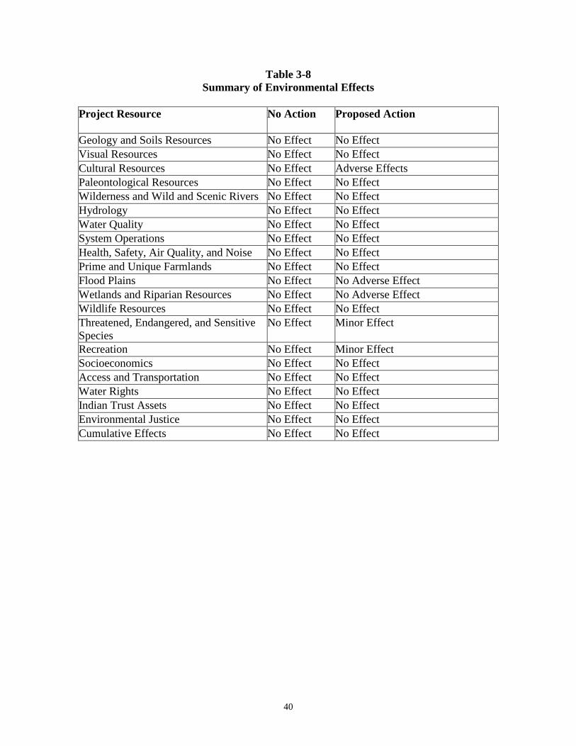
40
Table 3-8 Summary of Environmental Effects
Project Resource No Action
Proposed Action
Geology and Soils Resources No Effect No Effect Visual Resources No Effect No Effect Cultural Resources No Effect Adverse Effects Paleontological Resources No Effect No Effect Wilderness and Wild and Scenic Rivers No Effect No Effect Hydrology No Effect No Effect Water Quality No Effect No Effect System Operations No Effect No Effect Health, Safety, Air Quality, and Noise No Effect No Effect Prime and Unique Farmlands No Effect No Effect Flood Plains No Effect No Adverse Effect Wetlands and Riparian Resources No Effect No Adverse Effect Wildlife Resources No Effect No Effect Threatened, Endangered, and Sensitive Species
No Effect Minor Effect
Recreation No Effect Minor Effect Socioeconomics No Effect No Effect Access and Transportation No Effect No Effect Water Rights No Effect No Effect Indian Trust Assets No Effect No Effect Environmental Justice No Effect No Effect Cumulative Effects No Effect No Effect

41
Chapter 4 Environmental Commitments Environmental Commitments, along with Minimization Measures in Section 2.5 have been developed to lessen the potential adverse effects of the Proposed Action.
4.1 Environmental Commitments The following environmental commitments will be implemented as an integral part of the Proposed Action.
1. Additional Analyses - If the Proposed Action were to change significantly from that described in this EA because of additional or new information, or if other spoil, or work areas beyond those outlined in this analysis are required outside the defined Project construction area, additional environmental analyses may be necessary.
2. Standard Reclamation Best Management Practices - Standard
Reclamation Best Management Practices will be applied during construction activities, to minimize environmental effects and will be implemented by construction forces, or included in construction specifications. Such practices or specifications include sections in the EA on Geology and erosion control, visual resources, public safety, dust abatement, air pollution, noise abatement, water pollution abatement, waste material disposal, archaeological and historical resources, vegetation, wildlife, and flood control. Excavated material and construction debris may not be wasted in any stream or river channel in flowing waters. This includes material such as grease, oil, joint coating, or any other possible pollutant. Excess materials must be wasted at a Reclamation approved upland site well away from any channel. Construction materials, bedding material, excavation material, etc. may not be stockpiled in riparian or water channel areas. If necessary silt fencing will be appropriately installed and left in place until after revegetation becomes established, at which time the silt fence can then be carefully removed. Machinery must be fueled and properly cleaned of dirt, weeds, organisms, or any other possibly contaminating substances offsite prior to construction.

42
3. WYPDES Permit - A Wyoming Pollution Discharge Elimination System Permit will be required from the State of Wyoming before any discharges of water, if such water is to be discharged as a point source into a regulated water body. Appropriate measures will be taken to ensure that construction related sediments will not enter the stream either during or after construction. Settlement ponds and intercepting ditches for capturing sediments will be constructed, and the sediment and other contents collected will be hauled off the site for appropriate disposal upon completion of the Project. A Storm Water Pollution Prevention Plan (SWPPP) is required in order to obtain a WYPDES Permit. A SPCC Plan will also be prepared as part of the Permit application process.
4. Site Restoration - A site restoration and revegetation plan will be
developed to reclaim the areas disturbed by construction and prevent erosion and sedimentation in “Wyoming Surface Waters”.
5. Fugitive Dust Control Permit - The Division of Air Quality
regulates fugitive dust from construction sites, requiring compliance with rules for sites disturbing greater than one-quarter of an acre. Sensitive receptors include those individuals working at the site or motorists that could be affected by changes in air quality due to emissions from the construction activity. The BMP’s will be followed to mitigate for temporary impact on air quality due to construction related activities. These may include the application of dust suppressants and watering to control fugitive dust; minimizing the extent of disturbed surface; during times of high wind, restricting earthwork activities; and limiting the use of, and speeds on, unimproved road surfaces.
6. Cultural Resources - In the case that any cultural resources, either
on the surface or subsurface, are discovered during construction, Reclamation’s Provo Area Office archaeologist shall be notified and construction in the area of the inadvertent discovery will cease until an assessment of the resource and recommendations for further work can be made by a professional archaeologist.
a. Any person who knows or has reason to know that he/she has
inadvertently discovered possible human remains on Federal land, he/she must provide immediate telephone notification of the discovery to Reclamation’s Provo Area Office archaeologist. Work will stop until the proper authorities are able to assess the situation onsite. This action will promptly be followed by written confirmation to the responsible Federal agency official, with respect to Federal lands. The Utah SHPO and interested Native American Tribal representatives will be promptly
43
notified. Consultation will begin immediately. This requirement is prescribed under the Native American Graves Protection and Repatriation Act (43 CFR Part 10); and the Archaeological Resources Protection Act of 1979 (16 U.S.C. 470).
7. Paleontological Resources - Should fossils be encountered by the
proponent during ground disturbing actions, construction must be suspended until a qualified paleontologist can be contacted to assess the find.
8. Wildlife Resources
a. Migratory Bird Protection b. Perform any ground-disturbing activities or vegetation treatments
before migratory birds begin nesting or after all young have fledged.
c. If activities must be scheduled to start during the migratory bird
breeding season, take appropriate steps to prevent migratory birds from establishing nests in the potential impact area. These steps could include covering equipment and structures and use of various excluders (e.g., noise). Prior to nesting, birds can be harassed to prevent them from nesting on the site.
d. If activities must be scheduled during the migratory bird
breeding season, a site-specific survey for nesting birds should be performed starting at least 2 weeks prior to ground-breaking activities or vegetation treatments. Established nests with eggs or young cannot be moved, and the birds cannot be harassed (see b., above), until all young have fledged and are capable of leaving the nest site.
e. If nesting birds are found during the survey, appropriate spatial
buffers should be established around nests. Vegetation treatments or ground-disturbing activities within the buffer areas should be postponed until the birds have left the nest. Confirmation that all young have fledged should be made by a qualified biologist.
f. Raptor Protection g. Raptor protection measures will be implemented to provide full
compliance with environmental laws. Raptor surveys will be developed using the Utah Field Office Guidelines for Raptor Protection from Human and Land Use Disturbances (Romin and
44
Muck 2002), to ensure that the proposed Project will avoid adverse impacts to raptors, including bald and golden eagles. Locations of existing raptor nests and eagle roosting areas will be identified prior to the initiation of Project activities. Appropriate spatial buffer zones of inactivity will be established during breeding, nesting, and roosting periods. Arrival at nesting sites can occur as early as December for certain raptor species. Nesting and fledging can continue through August. Wintering bald eagles may roost from November through March.
9. Wetland Resources - Any and all wetlands will be avoided where
practical. In the event that impacts to wetlands are unavoidable a U.S. Army Corps of Engineers 404 Permit will be obtained prior to any dredged or fill material being discharged into jurisdictional wetlands. Surveys will be conducted to evaluate temporary and permanent impacts to wetlands.
10. Public Access - Construction sites will be closed to public access.
Temporary fencing, along with signs, will be installed to prevent public access.
11. Previously Disturbed Areas - Construction and staging activities
will be confined to previously disturbed areas where possible, for such activities as work, staging, and storage, waste areas and vehicle and equipment parking areas. Vegetation disturbance will be minimized as much as possible.
12. Disturbed Areas - All disturbed areas resulting from the Project will
be smoothed, shaped, contoured, and rehabilitated to as near the pre-Project construction condition as practicable. After completion of the construction and restoration activities, disturbed areas will be seeded at appropriate times with weed-free, native seed mixes having a variety of appropriate species (especially woody species where feasible) to help hold the soil around structures, prevent excessive erosion, and to help maintain other riverine and riparian functions. The composition of seed mixes will be coordinated with wildlife habitat specialists and Reclamation biologists. Weed control on all disturbed areas will be required. Successful revegetation efforts must be monitored and reported to Reclamation, along with photos of the completed Project.
13. Recreation Areas - The Company will be responsible for the
following improvements as part of the Proposed Action. The boat ramp will be extended to match the proposed reservoir level; a total of seven fire pits and picnic benches will be moved to higher ground or replaced and installed to match the proposed reservoir levels; the

45
artesian well piping and valving will be extended to higher ground to maintain access to the well water for recreation and irrigation purposes; the shade structure and vault restroom below the dam will be replaced; and the vault restrooms in the west camping loop and southeast camping areas will be replaced at a higher elevation following construction.
46
Chapter 5 Preparers The following is a list of preparers who participated in the development of the EA. They include environmental summary preparers, Reclamation team members, and Federal, State and District members.
Engineering and Environmental Preparers
Name Title Affiliation Mr. Mike Carnevale Senior Water Resources
Project Manager Wenck Associates
Ms. Pamela Massaro, PE Water Resources Engineer Wenck Associates
Mr. Greg Johnson Research Biologist WEST, Inc.
Reclamation Team, Environmental Preparers
Name Title Contribution Mr. Jared Baxter Fish and Wildlife Biologist Wildlife, Threatened,
Endangered, and Sensitive Species, ESA Compliance
Mr. Rick Baxter Manager, Water, Environmental, and Lands Division
Project oversight
Mr. Scott Blake Recreation Specialist Visual, Recreation Mr. Peter Crookston Chief, Environmental Group NEPA Compliance Mr. Gary Henrie Hydrologist Hydrology Mr. Rick Jones Wildlife Biologist Wildlife Resources, ESA
Compliance Mr. Ryan Luke Chief, Operations and
Emergency Management Group
System Operations
Ms. Linda Morrey Secretary Visual Identity, 508 Compliance, Editing
Mr. Shane Mower General Biologist Wildlife Resources Mr. David Nielsen Geologist Geology and Soils Mr. Zachary Nelson Archaeologist Cultural, Paleontological,
Indian Trust Assets Mr. Justin Record Civil Engineer Water Rights
47
Name Title Contribution Mr. Prashant Singh Economist Socioeconomics Mr. David Snyder Fish and Wildlife Biologist Wetlands and Riparian,
CWA Compliance, Floodplains
Mr. Scott Winterton Group Chief, Design and Contract Administration
Project Manager, Project Design
Federal, State, or Local Entity
Name Title Company
Mr. Jason Mead Deputy Director – Dams and Reservoirs
Wyoming Water Development Office
48
Chapter 6 Acronyms and Abbreviations
Acronyms Meaning/Description ACHP Advisory Council on Historic Preservation APE Area of Potential Effect BMP Best Management Practice CB Cement-Bentonite CFR Code of Federal Regulations CLSM Controlled Low Strength Material cfs Cubic Feet Per Second CWA Clean Water Act DDCT Density Disturbance Calculation Tool EA Environmental Assessment EO Executive Order EPA Environmental Protection Agency ESA Endangered Species Act FIRM Flood Insurance Rate Map FONSI Finding of No Significant Impact HDPE High-Density Polyethylene IPaC Information for Planning and Conservation ITA Indian Trust Asset MOA Memorandum of Agreement MSL Mean Sea Level NEPA National Environmental Policy Act NRCS Natural Resource Conservation Service NHPA National Historic Preservation Act NHWM Normal High Water Mark NRCS Natural Resource Conservation Service NRHP National Register of Historic Places NWI National Wetlands Inventory OHWM Ordinary High Water Mark O&M Operation and Maintenance PEM Palustrine Emergent PSS Palustrine Scrub-Shrub Reclamation U.S. Bureau of Reclamation SGIT Sage-Grouse Implementation Team SHPO Utah State Historic Preservation Office SOP Standard Operating Procedure
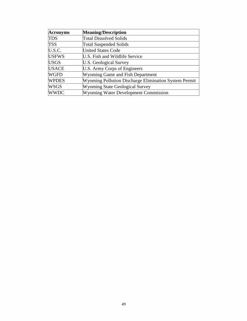
49
Acronyms Meaning/Description TDS Total Dissolved Solids TSS Total Suspended Solids U.S.C. United States Code USFWS U.S. Fish and Wildlife Service USGS U.S. Geological Survey USACE U.S. Army Corps of Engineers WGFD Wyoming Game and Fish Department WPDES Wyoming Pollution Discharge Elimination System Permit WSGS Wyoming State Geological Survey WWDC Wyoming Water Development Commission
50
Chapter 7 References Amlin, N. 2000. Influences of Drought and Flood Stresses on Riparian Cottonwoods and Willows. Masters of Science Thesis, University of Lethbridge. Lethbridge, Alberta. Anderson, M. D. 2008. Carex rostrata, C. utriculata. In: Fire Effects Information System, [Online]. U.S. Department of Agriculture, Forest Service, Rocky Mountain Research Station, Fire Sciences Laboratory (Producer). Available: http://www.fs.fed.us/database/feis/ [2012, June 15]. Brink, V.C. 1954. Survival of plants under flood in the Lower Frazer River valley, British Columbia. Ecology 35: 94-95. California Native Plant Society (CNPS). No date. Native perennial grasses, sedges, and rushes for Nevada and Placer County landscapes. Redbud Chapter. Connelly, J.W., M. A. Schroeder, A.R. Sands and C.E. Braun. 2000. Guidelines to manage sage grouse populations and their habitats. Wildlife Society Bulletin 28:967-985. Dionigi, C.P., I.A. Mendelssohn, and V.I. Sullivan. 1985. Effects of soil waterlogging on the energy status and distribution of Salix nigra and S. exigua (Salicaceae) in the Atchafalaya River basin of Louisiana. American Journal of Botany 72:109-119. Environmental Laboratory. 1987. Corps of Engineers Wetlands Delineation Manual. Technical Report Y-87-1. Department of the Army, Waterways Experiment Station, Corps of Engineers, Vicksburg, Mississippi. Hillman, C.N. and T.W. Clark. 1980. Mustela nigripes. In Mammalian Species No. 126. The American Society of Mammalogists. 3 pp. Hoag, J.C., D. Tilley, D. Ogle, and L. St. John. 2011. Description, propogation, and establishment of wetland – riparian grass and grass-like species in the Intermountain West. TN Plant Materials No. 38. U.S. Department of Agriculture Natural Resources Conservation Service. Boise, Idaho – Salt Lake City, Utah. Israelsen, K. R. 2009. Herbicide, Salinity, and Flooding Tolerance of Foxtail Barley (Hordeum jubatum L.) and Desirable Pasture Grasses. Utah State University. All Graduate Theses and Dissertations. Paper 519. http://digitalcommons.usu.edu/etd/519
51
Jeglum, J.K. 1971. Plant indicators of pH and water level in peatlands at Candle Lake, Saskatchewan. Canadian Journal of Botany 49: 1661-1676. Kuzovkina, Y.A., M. Knee, and M.F. Ouigley. Cadmium and copper uptake and translocation in five willow (Salix L.) species. International Journal of Phytoremediation 63:269-287. Meena, Jack. 1993. A Water Management Model for the Green River. M.S. Thesis, University of Wyoming, Laramie, WY. National Oceanic and Atmospheric Administration’s National Weather Service, State Precipitation Summary Web Site. [online] accessed February 17, 2017, Big Sandy River (WY) above Big Sandy Reservoir (BSRW4): https://water.weather.gov/afws/stprecipsummary.php?state=WY Natural Resources Conservation Service. Acres of Prime Farmland, 1997. Accessed 23 December 2016, at https://www.nrcs.usda.gov/Internet/FSE_DOCUMENTS/nrcs143_012232.pdf Rains, M.C., J.F. Mount, and E.W. Larsen. 2004. Simulated changes in shallow groundwater and vegetation distributions under different reservoir operations scenarios. Ecological Applications 14: 192-207. River Partners. 2008. Effects of Long Duration Flooding on Riparian Plant Species in Restoration Plantings. San Joaquin River National Wildlife Refuge, Stanislaus County, California. L. Singleton, S. Small, and T. Griggs. Modesto, California. Prepared for U.S. Fish and Wildlife Service. Romin, L.A. and J.A. Muck. 2002. Utah Field Office Guidelines for Raptor Protection from Human and Land Use Disturbances. U.S. Fish and Wildlife Service, Utah Field Office, Salt Lake City, Utah. St. John, L., D. G. Ogle, D. Darris, S. Parr. 2011 Plant Guide for Tufted Hairgrass (Deschampsia caespitosa). USDA-Natural Resources Conservation Service, Aberdeen, Idaho Plant Materials Center. 83210-0296. Thomann, R.V. and Mueller, J.A. (1987) Principles of Surface Water Quality Modeling and Control. Harper-Collins, New York. Tilley, D., Ogle, D., and L. St. John. 2011. Plant guide for water sedge (Carex aquatilis). USDA- Natural Resources Conservation Service, Idaho Plant Materials Center. Aberdeen, Idaho. U.S. Army Corps of Engineers. 2010. Regional Supplement to the Corps of Engineers Wetland Delineation Manual: Arid West Region (Version 2.0), ed. J.S.

52
Wakeley, R. W. Lichvar, and C.V. Noble. ERDC/EL TR-10-1. Vicksburg, MS: U.S. Army Engineer Research and Development Center. U.S. Army Corps of Engineers. 2016. Letter from Thomas Johnson dated May, 18, 2016 U.S. Census Bureau. 2015. Website accessed 4 April 2017 at https://factfinder.census.gov/bkmk/table/1.0/en/ACS/15_5YR/S1501/0500000US56037 U.S. Census Bureau. 2015. Website accessed 4 April 2017 at https://factfinder.census.gov/bkmk/table/1.0/en/ACS/15_5YR/DP03/0500000US56037 U.S. Department of Agriculture Natural Resource Conservation Service (USDA NRCS). 2000. Plant Guide: Coyote Willow (Salix exigua). Prepared by M. Stevens, G. Fenchel, C. Hoag, USDA NRCS, Plant Materials Centers, Los Lunas, NM and Aberdeen, Idaho. U.S. Department of Agriculture Natural Resource Conservation Service (USDA NRCS). 2004. Plant Guide: Kentucky Bluegrass (Poa pratensis). Prepared by S. Wennerberg, USDA NRCS, National Plant Data Center, Baton Rouge, Louisiana. U.S. Department of Agriculture Natural Resource Conservation Service (USDA NRCS). 2005a. Plant Guide: Nebraska Sedge (Carex nabascensis). Prepared by D. G. Ogle, USDA NRCS, Idaho State Office, Boise, Idaho. U.S. Department of Agriculture Natural Resource Conservation Service (USDA NRCS). 2005b. Plant Guide: Creeping Spikerush (Eleocharis palustris). Prepared by D. G. Ogle, USDA NRCS, Idaho State Office, Boise, Idaho. U.S. Department of Agriculture Natural Resource Conservation Service (USDA NRCS). 2005c. Plant Guide: Baltic Rush (Juncus balticus). Prepared by M. Stevens and C. Hoag, USDA NRCS, Plant Material Center, Aberdeen, Idaho. U.S. Department of Commerce. 2016. Census Bureau, American Community Survey Office, Washington, D.C., as reported in Headwaters Economics’ Economic Profile System (headwaterseconomics.org/eps). U.S. Department of Commerce. 2016. Census Bureau, American Community Survey Office, Washington, D.C.; U.S. Department of Commerce. 2000. Census Bureau, Systems Support Division, Washington, D.C., as reported in Headwaters Economics’ Economic Profile System (headwaterseconomics.org/eps). U.S. Department of the Interior, Bureau of Reclamation, Water Operations – Big Sandy Reservoir Web Site, Accessed April 17, 2017,
53
https://www.usbr.gov/rsvrWater/rsv40Day.html?siteid=936&reservoirtype=Reservoir U.S. EPA, Corvallis Environmental Research Laboratory. 1977. Report on Big Sandy Reservoir, Sublette and Sweetwater Counties, Wyoming, EPA Region VIII (Working Paper No. 881) U.S. Geological Survey, Surface-Water Daily Data for Wyoming, Web Site, Accessed February 17, 2017, 09213500: https://nwis.waterdata.usgs.gov/wy/nwis/qwdata/?site_no=09213500 and 09213700: https://waterdata.usgs.gov/nwis/dv?referred_module=sw&site_no=09213700 Western EcoSystems Technology (WEST), Inc., 2016. Aquatic Resources Inventory Report, Big Sandy Reservoir Expansion Project Sublette and Sweetwater Counties, Wyoming. Western EcoSystems Technology (WEST), Inc. 2017. Analysis of Big Sandy enlargement on greater sage-grouse. Wyoming Climate Atlas by Jan Curtis and Kate Grimes Web Site. 2004. Accessed April 17, 2017, http://www.wrds.uwyo.edu/sco/climateatlas/precipitation.html#41.

54
Chapter 8 Appendices Appendix A Figures Figure A-1 Project Area Figure A-2 Proposed Reservoir Inundation Figure A-3 Land Ownership Figure A-4 Wildlife Habitat
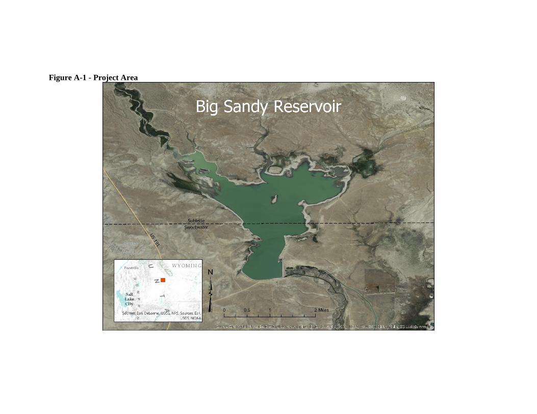
Figure A-1 - Project Area
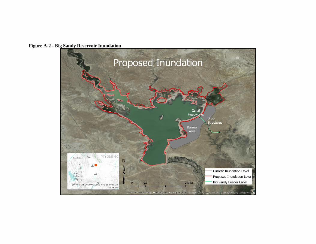
Figure A-2 - Big Sandy Reservoir Inundation
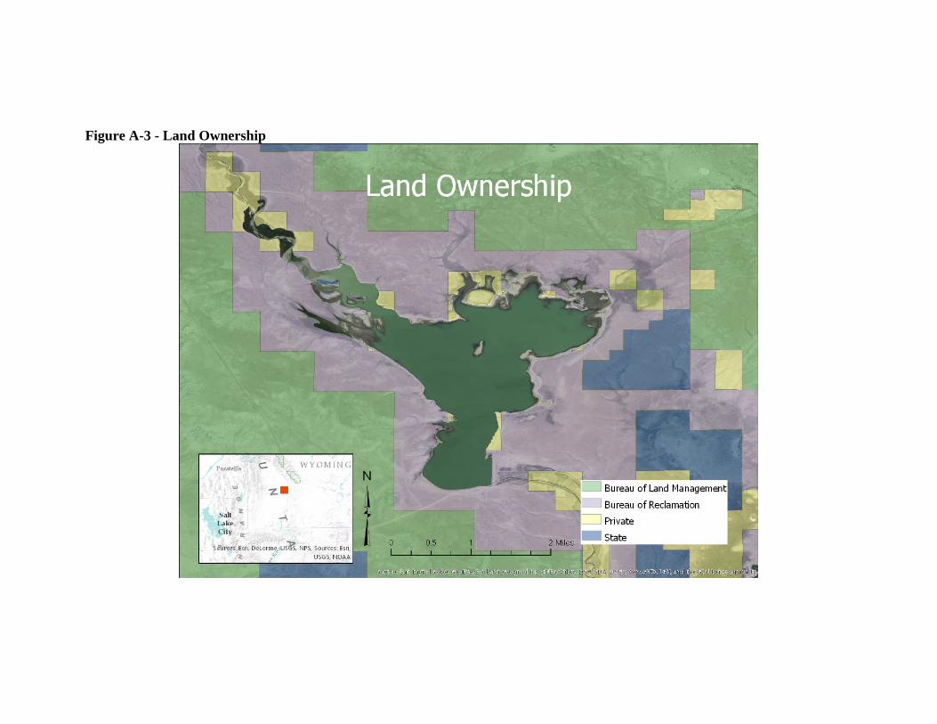
Figure A-3 - Land Ownership
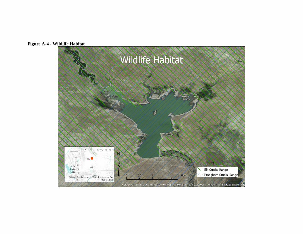
Figure A-4 - Wildlife Habitat

Appendix B - Official IPaC Species List

September 08, 2017
United States Department of the InteriorFISH AND WILDLIFE SERVICE
Wyoming Ecological Services Field Office5353 Yellowstone Road, Suite 308a
Cheyenne, WY 82009-4178Phone: (307) 772-2374 Fax: (307) 772-2358
http://www.fws.gov/wyominges/
In Reply Refer To:Consultation Code: 06E13000-2017-SLI-0247Event Code: 06E13000-2017-E-01715 Project Name: Big Sandy Reservoir Enlargement
Subject: Updated list of threatened and endangered species that may occur in your proposedproject location, and/or may be affected by your proposed project
To Whom It May Concern:
The enclosed species list identifies threatened, endangered, proposed and candidate species, aswell as proposed and final designated critical habitat, that may occur within the boundary of yourproposed project and/or may be affected by your proposed project. The species list fulfills therequirements of the U.S. Fish and Wildlife Service (Service) under section 7(c) of theEndangered Species Act (Act) of 1973, as amended (16 U.S.C. 1531 et seq.).
New information based on updated surveys, changes in the abundance and distribution ofspecies, changed habitat conditions, or other factors could change this list. Please note that under50 CFR 402.12(e) of the regulations implementing section 7 of the Act, the accuracy of thisspecies list should be verified after 90 days. This verification can be completed formally orinformally as desired. The Service recommends that verification be completed by visiting theEnvironmental Conservation Online System-Information, Planning, and Conservation System(ECOS-IPaC) website at regular intervals during project planning and implementation forupdates to species lists and information. An updated list may be requested through theECOS-IPaC system by completing the same process used to receive the enclosed list.
Please feel free to contact us if you need more information or assistance regarding the potentialimpacts to federally proposed, listed, and candidate species and federally designated andproposed critical habitat. We also encourage you to visit the Wyoming Ecological Serviceswebsite at for morehttp://www.fws.gov/wyominges/Pages/Species/Species_Endangered.htmlinformation about species occurrence and designated critical habitat.
The purpose of the Act is to provide a means whereby threatened and endangered species and theecosystems upon which they depend may be conserved. Under sections 7(a)(1) and 7(a)(2) of theAct and its implementing regulations (50 CFR 402 et seq.), Federal agencies are required to usetheir authorities to carry out programs for the conservation of threatened and endangered species
09/08/2017 Event Code: 06E13000-2017-E-01715 2
and to determine whether projects may affect threatened and endangered species and/ordesignated critical habitat.
A biological assessment is required for construction projects (or other undertakings havingsimilar physical impacts) that are major Federal actions significantly affecting the quality of thehuman environment as defined in the National Environmental Policy Act (42 U.S.C. 4332(2)(c)). For projects other than major construction activities, the Service suggests that a biologicalevaluation similar to a biological assessment be prepared to determine whether the project mayaffect listed or proposed species and/or designated or proposed critical habitat. Recommendedcontents of a biological assessment are described at 50 CFR 402.12.
If a Federal agency determines, based on the biological assessment or biological evaluation, thatlisted species and/or designated critical habitat may be affected by the proposed project, theagency is required to consult with the Service pursuant to 50 CFR 402. In addition, the Servicerecommends that candidate species, proposed species, and proposed critical habitat be addressedwithin the consultation. More information on the regulations and procedures for section 7consultation, including the role of permit or license applicants, can be found in the "EndangeredSpecies Consultation Handbook" at:http://www.fws.gov/endangered/esa-library/pdf/TOC-GLOS.PDF
We also recommend that you consider the following information when assessing impacts tofederally listed species, as well as migratory birds, and other trust resources:
: Consultation under section 7 of the Act is requiredColorado River and Platte River Systemsfor projects in Wyoming that may lead to water depletions or have the potential to impact waterquality in the Colorado River system or the Platte River system, because these actions may affectthreatened and endangered species inhabiting the downstream reaches of these river systems. Ingeneral, depletions include evaporative losses and/or consumptive use of surface or groundwaterwithin the affected basin, often characterized as diversions minus return flows. Project elementsthat could be associated with depletions include, but are not limited to: ponds, lakes, andreservoirs (e.g., for detention, recreation, irrigation, storage, stock watering, municipal storage,and power generation); hydrostatic testing of pipelines; wells; dust abatement; diversionstructures; and water treatment facilities.
Species that may be affected in the Colorado River system include the endangered bonytail (Gila), Colorado pikeminnow ( ), humpback chub ( ), andelegans Ptychocheilus lucius Gila cypha
razorback sucker ( ) and their designated critical habitats. Projects in the PlatteXyrauchen texanusRiver system may impact the endangered interior population of the least tern ( ),Sterna antillarumthe endangered pallid sturgeon ( ), the threatened piping plover (Scaphirhynchus albus Charadrius
), the threatened western prairie fringed orchid ( ), as well as themelodus Platanthera praeclaraendangered whooping crane ( ) and its designated critical habitat. For moreGrus americanainformation on consultation requirements for the Platte River species, please visithttp://www.fws.gov/platteriver.
: The Migratory Bird Treaty Act (16 U.S.C. 703-712), prohibits the taking ofMigratory Birdsany migratory birds, their parts, nests, or eggs except as permitted by regulations, and does not
09/08/2017 Event Code: 06E13000-2017-E-01715 3
require intent to be proven. Except for introduced species and some upland game birds, almostall birds occurring in the wild in the United States are protected (50 CFR 10.13). Guidance forminimizing impacts to migratory birds for projects that include communications towers (e.g.,cellular, digital television, radio, and emergency broadcast) can be found athttp://www.fws.gov/migratorybirds/CurrentBirdIssues/Hazards/towers/towers.htm.
The Bald and Golden Eagle Protection Act (16 U.S.C. 668-668d) prohibits knowingly taking, ortaking with wanton disregard for the consequences of an activity, any bald or golden eagles ortheir body parts, nests, or eggs, which includes collection, molestation, disturbance, or killing.Eagle nests are protected whether they are active or inactive. Removal or destruction of nests, orcausing abandonment of a nest could constitute a violation of one or both of the above statutes.Projects affecting eagles may require development of an eagle conservation plan(http://www.fws.gov/windenergy/eagle_guidance.html). Additionally, wind energy projectsshould follow the wind energy guidelines (http://www.fws.gov/windenergy/) for minimizingimpacts to migratory birds and bats.
If nesting migratory birds are present on or near the project area, timing of activities is animportant consideration and should be addressed in project planning. Activities that could lead tothe take of migratory birds or eagles, their young, eggs, or nests, should be coordinated with ouroffice prior to project implementation. If nest manipulation (including removal) is proposed forthe project, the project proponent should contact the Migratory Bird Office in Denver at303-236-8171 to see if a permit can be issued for the project. If a permit cannot be issued, theproject may need to be modified to protect migratory birds, eagles, their young, eggs, and nests.
We appreciate your concern for threatened and endangered species. The Service encouragesFederal agencies to include conservation of threatened and endangered species into their projectplanning to further the purposes of the Act. Please include the Consultation Tracking Number inthe header of this letter with any request for consultation or correspondence about your projectthat you submit to our office.
Attachment(s):
Official Species List
USFWS National Wildlife Refuges and Fish Hatcheries
Migratory Birds
Wetlands

09/08/2017 Event Code: 06E13000-2017-E-01715 1
Official Species ListThis list is provided pursuant to Section 7 of the Endangered Species Act, and fulfills therequirement for Federal agencies to "request of the Secretary of the Interior information whetherany species which is listed or proposed to be listed may be present in the area of a proposedaction".
This species list is provided by:
Wyoming Ecological Services Field Office5353 Yellowstone Road, Suite 308aCheyenne, WY 82009-4178(307) 772-2374
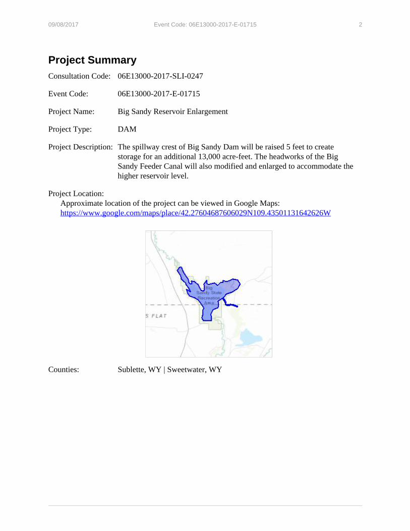
09/08/2017 Event Code: 06E13000-2017-E-01715 2
Project SummaryConsultation Code: 06E13000-2017-SLI-0247
Event Code: 06E13000-2017-E-01715
Project Name: Big Sandy Reservoir Enlargement
Project Type: DAM
Project Description: The spillway crest of Big Sandy Dam will be raised 5 feet to createstorage for an additional 13,000 acre-feet. The headworks of the BigSandy Feeder Canal will also modified and enlarged to accommodate thehigher reservoir level.
Project Location: Approximate location of the project can be viewed in Google Maps:
https://www.google.com/maps/place/42.27604687606029N109.43501131642626W
Counties: Sublette, WY | Sweetwater, WY

09/08/2017 Event Code: 06E13000-2017-E-01715 3
Endangered Species Act SpeciesThere is a total of 6 threatened, endangered, or candidate species on this species list. Species onthis list should be considered in an effects analysis for your project and could include speciesthat exist in another geographic area. For example, certain fish may appear on the species listbecause a project could affect downstream species. See the "Critical habitats" section below forthose critical habitats that lie wholly or partially within your project area under this office'sjurisdiction. Please contact the designated FWS office if you have questions.
Birds
NAME STATUS
Yellow-billed Cuckoo Coccyzus americanusPopulation: Western U.S. DPSThere is a for this species. Your location is outside the proposed criticalproposed critical habitathabitat.Species profile: https://ecos.fws.gov/ecp/species/3911
Threatened
Fishes
NAME STATUS
Bonytail Chub Gila elegansThere is a designated for this species. Your location is outside the designatedfinal critical habitatcritical habitat.Species profile: https://ecos.fws.gov/ecp/species/1377
Endangered
Colorado Pikeminnow (=squawfish) Ptychocheilus luciusPopulation: Wherever found, except where listed as an experimental populationThere is a designated for this species. Your location is outside the designatedfinal critical habitatcritical habitat.Species profile: https://ecos.fws.gov/ecp/species/3531
Endangered
Humpback Chub Gila cyphaThere is a designated for this species. Your location is outside the designatedfinal critical habitatcritical habitat.Species profile: https://ecos.fws.gov/ecp/species/3930
Endangered
Razorback Sucker Xyrauchen texanusThere is a designated for this species. Your location is outside the designatedfinal critical habitatcritical habitat.Species profile: https://ecos.fws.gov/ecp/species/530
Endangered

09/08/2017 Event Code: 06E13000-2017-E-01715 4
Flowering Plants
NAME STATUS
Ute Ladies'-tresses Spiranthes diluvialisNo critical habitat has been designated for this species.Species profile: https://ecos.fws.gov/ecp/species/2159
Threatened
Critical habitats
There are no critical habitats within your project area under this office's jurisdiction.
09/08/2017 Event Code: 06E13000-2017-E-01715 1
USFWS National Wildlife Refuges And FishHatcheriesAny activity proposed on lands must undergo a 'CompatibilityNational Wildlife RefugeDetermination' conducted by the Refuge. Please contact the individual Refuges to discuss anyquestions or concerns.
There are no refuges or fish hatcheries within your project area.
09/08/2017 Event Code: 06E13000-2017-E-01715 1
1.
2.
3.
Migratory BirdsCertain birds are protected under the Migratory Bird Treaty Act and the Bald and Golden EagleProtection Act .
Any activity that results in the of migratory birds or eagles is prohibited unless authorizedtakeby the U.S. Fish and Wildlife Service . There are no provisions for allowing the take ofmigratory birds that are unintentionally killed or injured.
Any person or organization who plans or conducts activities that may result in the take ofmigratory birds is responsible for complying with the appropriate regulations and implementingappropriate conservation measures.
The of 1918.Migratory Birds Treaty Act
The of 1940.Bald and Golden Eagle Protection Act
50 C.F.R. Sec. 10.12 and 16 U.S.C. Sec. 668(a)
The migratory birds species listed below are species of particular conservation concern (e.g. ) that may be potentially affected by activities in this location. ItBirds of Conservation Concern
is not a list of every bird species you may find in this location, nor a guarantee that all of the birdspecies on this list will be found on or near this location. Although it is important to try to avoidand minimize impacts to all birds, special attention should be made to avoid and minimizeimpacts to birds of priority concern. To view available data on other bird species that may occurin your project area, please visit the and . ToAKN Histogram Tools Other Bird Data Resourcesfully determine any potential effects to species, additional site-specific and project-specificinformation is often required.
NAME SEASON(S)
American Bittern Botaurus lentiginosushttps://ecos.fws.gov/ecp/species/6582
On Land: Breeding
Fox Sparrow Passerella iliaca On Land: Breeding
Golden Eagle Aquila chrysaetoshttps://ecos.fws.gov/ecp/species/1680
On Land: Year-round
Bald Eagle Haliaeetus leucocephalushttps://ecos.fws.gov/ecp/species/1626
On Land: Year-round
Black Rosy-finch Leucosticte atratahttps://ecos.fws.gov/ecp/species/9460
On Land: Year-round
Brewer's Sparrow Spizella brewerihttps://ecos.fws.gov/ecp/species/9291
On Land: Breeding
1
2
3

09/08/2017 Event Code: 06E13000-2017-E-01715 2
Burrowing Owl Athene cuniculariahttps://ecos.fws.gov/ecp/species/9737
On Land: Breeding
Cassin's Finch Carpodacus cassiniihttps://ecos.fws.gov/ecp/species/9462
On Land: Year-round
Ferruginous Hawk Buteo regalishttps://ecos.fws.gov/ecp/species/6038
On Land: Breeding
Greater Sage-grouse Centrocercus urophasianushttps://ecos.fws.gov/ecp/species/8159
On Land: Year-round
Loggerhead Shrike Lanius ludovicianushttps://ecos.fws.gov/ecp/species/8833
On Land: Breeding
Long-billed Curlew Numenius americanushttps://ecos.fws.gov/ecp/species/5511
On Land: Breeding
Mountain Plover Charadrius montanushttps://ecos.fws.gov/ecp/species/3638
On Land: Breeding
Olive-sided Flycatcher Contopus cooperihttps://ecos.fws.gov/ecp/species/3914
On Land: Breeding
Sage Thrasher Oreoscoptes montanushttps://ecos.fws.gov/ecp/species/9433
On Land: Breeding
Short-eared Owl Asio flammeushttps://ecos.fws.gov/ecp/species/9295
On Land: Year-round
Swainson's Hawk Buteo swainsonihttps://ecos.fws.gov/ecp/species/1098
On Land: Breeding
Western Grebe aechmophorus occidentalishttps://ecos.fws.gov/ecp/species/6743
On Land: Breeding
Willow Flycatcher Empidonax trailliihttps://ecos.fws.gov/ecp/species/3482
On Land: Breeding
Calliope Hummingbird Stellula calliopehttps://ecos.fws.gov/ecp/species/9526
On Land: Migrating
Rufous Hummingbird selasphorus rufushttps://ecos.fws.gov/ecp/species/8002
On Land: Migrating
Additional information can be found using the following links:Birds of Conservation Concern http://www.fws.gov/birds/management/managed-species/birds-of-conservation-concern.php
Conservation measures for birds

09/08/2017 Event Code: 06E13000-2017-E-01715 3
http://www.fws.gov/birds/management/project-assessment-tools-and-guidance/conservation-measures.php
Year-round bird occurrence data http://www.birdscanada.org/birdmon/default/datasummaries.jsp

09/08/2017 Event Code: 06E13000-2017-E-01715 1
WetlandsImpacts to and other aquatic habitats may be subject to regulation under SectionNWI wetlands404 of the Clean Water Act, or other State/Federal statutes.
For more information please contact the Regulatory Program of the local U.S. Army Corps of.Engineers District
FRESHWATER EMERGENT WETLAND
PEMAh
PEMCh
PEMC
PEMA
PEMCx
FRESHWATER POND
PABFh
LAKE
L2USAh
L1UBHh
L2UBFh
L2USCh
OTHER
PUSCh

Appendix C - WGFD Sage-grouse Letter


Appendix D - Photographs
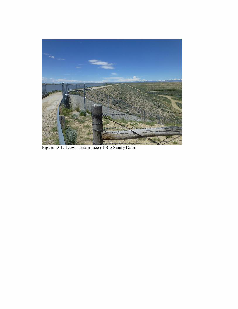
Figure D-1. Downstream face of Big Sandy Dam.
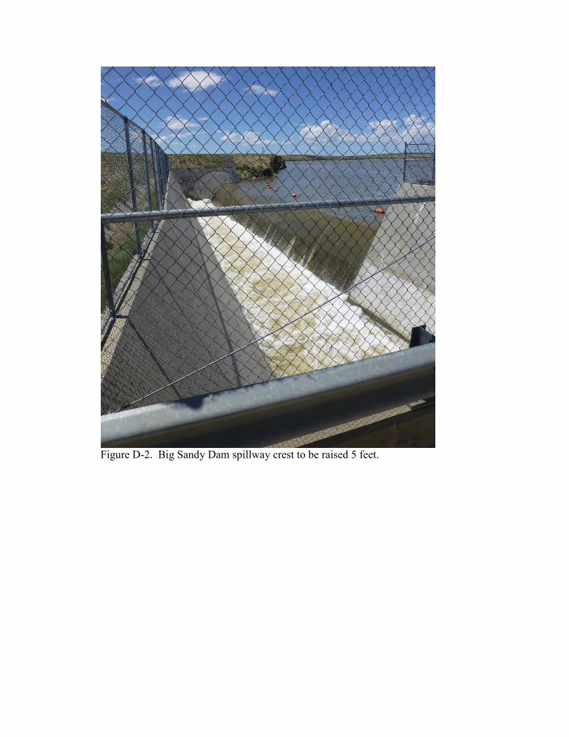
Figure D-2. Big Sandy Dam spillway crest to be raised 5 feet.
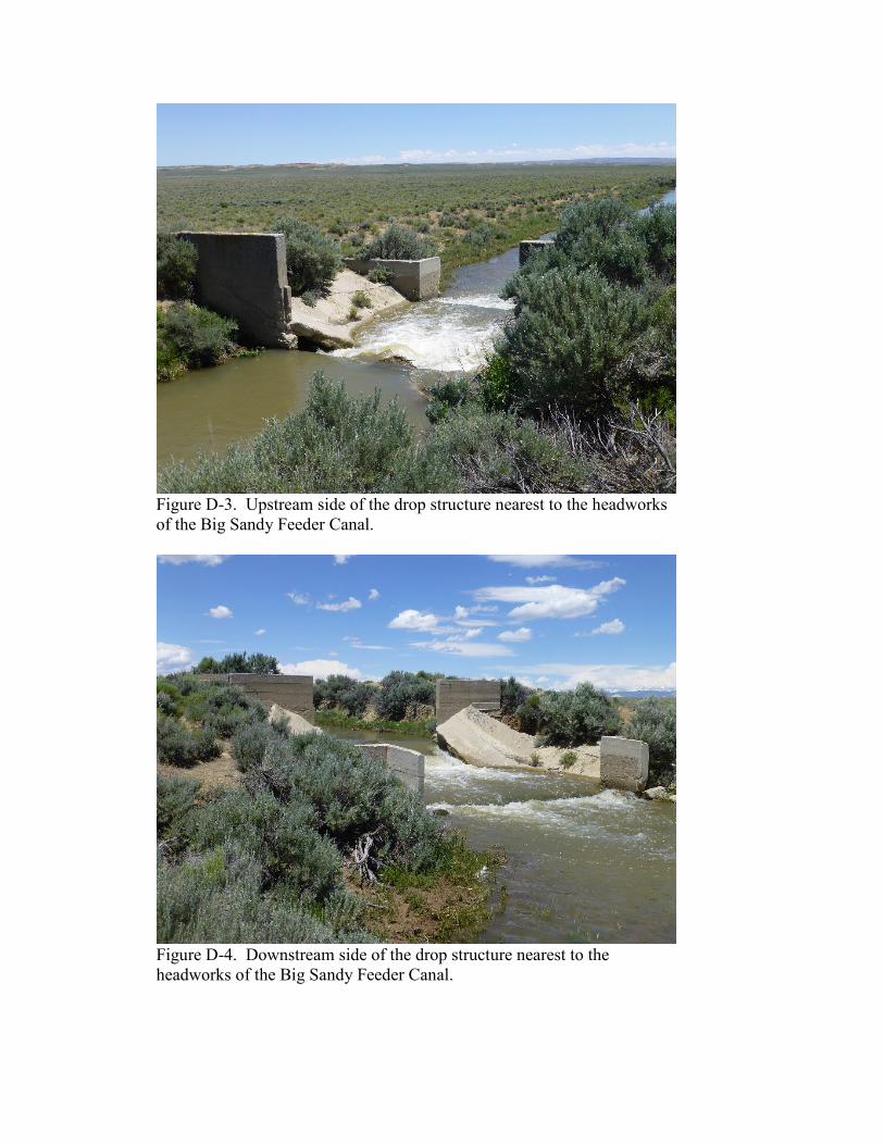
Figure D-3. Upstream side of the drop structure nearest to the headworks of the Big Sandy Feeder Canal.
Figure D-4. Downstream side of the drop structure nearest to the headworks of the Big Sandy Feeder Canal.
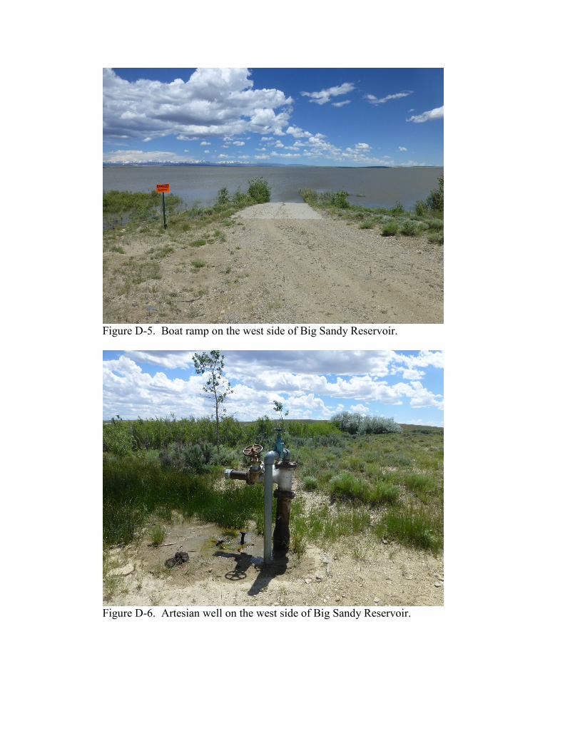
Figure D-5. Boat ramp on the west side of Big Sandy Reservoir.
Figure D-6. Artesian well on the west side of Big Sandy Reservoir.
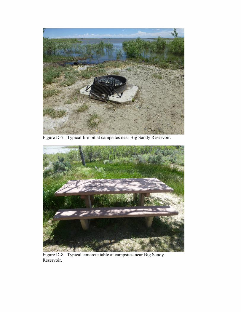
Figure D-7. Typical fire pit at campsites near Big Sandy Reservoir.
Figure D-8. Typical concrete table at campsites near Big Sandy Reservoir.