biodiversity strategy 2012 2022 - cairns regional council · 8 // biodiversity strategy 2012 - 2022...
TRANSCRIPT

Biodiversity Strategy 2012–2022

AcknowledgementsCairns Regional Council acknowledges the traditional Aboriginal language and clan groups of our region who are the custodians and first people of this country. We recognise and respect your cultural heritage, beliefs and continuing relationship and responsibility to your land and sea country. We honour and respect your elders past and present.
This document has been developed by Council staff with assistance from local professionals. We would like to thank Travis Sydes at the Far North Queensland Regional Organisation of Councils for his assistance with this project. We would also like to thank staff at the Wet Tropics Management Authority, CSIRO, the Department of Environment and Resource Management, Great Barrier Reef Marine Park Authority, Terrain Natural Resource Management and the Cairns and Far North Environment Centre for their valuable contributions to this document.
Disclaimer
Please note that while every effort has been made to ensure that the information contained within this report is correct and up to date, Cairns Regional Council (CRC) and all persons acting on their behalf preparing this report accept no liability for the accuracy or inferences from the material contained in this publication, or for any action as a result of any person’s or groups interpretations deductions or conclusions relying on this material. CRC accepts no liability for any loss, damage or injury (including consequential loss, damage or injury) from the use of this information.
This report has been produced by Cairns Regional Council who owns the copyright for this document.
Adopted by Council on 26 April 2012.
Document #3557213
EXECUTIVE SUMMARY ..........................................................5
1 INTRODUCTION .................................................................7
1.1 WHAT IS BIODIVERSITY? ........................................................7
1.2 WHY PROTECT BIODIVERSITY? ...........................................8
1.3 HOW CAN COUNCIL PROTECT BIODIVERSITY? .............9
2 THREATS TO BIODIVERSITY IN THE CAIRNS REGION ....11
2.1 POPULATION GROWTH AND URBAN EXPANSION.... 11
2.2 CLIMATE CHANGE ................................................................ 11
2.2.1 Climate change projections for the Cairns region ... 11
2.2.2 Climate change impacts on biodiversity ........... 12
2.2.3 How species are likely to respond to climate change ........................................................ 14
2.3 HABITAT FRAGMENTATION, DEGRADATION AND LOSS ................................................. 18
2.4 DECREASED WATER QUALITY, ALTERED FLOW REGIMES AND LOSS OF RIPARIAN AND COASTAL VEGETATION........................................................ 28
2.5 INVASIVE SPECIES AND BIOSECURITY RISKS ............... 28
2.6 ALTERED FIRE REGIMES ...................................................... 29
3 POLITICAL AND PLANNING CONTEXT ...........................31
3.1 FEDERAL .................................................................................. 32
3.2 STATE - QUEENSLAND ......................................................... 32
3.3 REGIONAL ............................................................................... 32
3.4 LOCAL ....................................................................................... 33
4 THE STRATEGY ................................................................35
4.1 VISION ...................................................................................... 35
4.2 SCOPE ....................................................................................... 35
4.3 INTENT ...................................................................................... 35
4.4 OBJECTIVES ............................................................................ 35
4.5 KEY STRATEGIES .................................................................... 35
4.6 STRATEGIC OUTCOMES ...................................................... 36
4.7 IMPLEMENTATION AND ACTION ..................................... 36
4.7.1 Financial requirements .......................................... 36
4.7.2 Review and accountability ................................... 36
4.7.3 Partnerships ............................................................. 36
4.7.4 Implementation plan ............................................. 36
5 A PROFILE OF BIODIVERSITY IN THE CAIRNS REGION ....45
5.1 OVERVIEW OF BIODIVERSITY ........................................... 45
5.2 ABOUT THE WET TROPICS BIOREGION ......................... 52
5.3 BIODIVERSITY CASE STUDIES ........................................... 54
5.3.1 Littoral Rainforest and coastal vine thicket ...... 54
5.3.2 Great Barrier Reef .................................................... 54
5.3.3 Daintree Rainforest ................................................. 55
5.3.4 Bartle Frere and Bellenden Ker ............................. 55
5.4 ICONIC FAUNA ....................................................................... 56
5.4.1 Cassowary ................................................................. 56
5.4.2 Bennett’s and Lumholtz’s tree kangaroos ......... 57
5.4.3 Spotted-tailed quoll and northern quoll ........... 57
5.4.4 Golden bower bird .................................................. 58
5.4.5 Beach stone-curlew ................................................ 58
5.4.6 Dugong ...................................................................... 59
5.4.7 Waterfall frog ........................................................... 59
5.4.8 Freshwater moray ................................................... 60
5.4.9 Opal cling goby........................................................ 60
5.4.10 Barramundi .............................................................. 60
5.5 ICONIC FLORA ........................................................................ 61
5.5.1 Fan palm ................................................................... 61
5.5.2 Daintree pine ............................................................ 61
5.5.3 Stockwellia ................................................................ 62
5.5.4 Noahdendron ........................................................... 62
5.5.5 Tropical Pitcher Plant ............................................. 62
5.5.6 Idiot Fruit ................................................................... 63
5.5.7 Seagrasses ................................................................ 63
6 CURRENT COUNCIL INITIATIVES TO RESTORE OR PROTECT BIODIVERSITY ...........................................65
6.1 WEED MANAGEMENT ......................................................... 65
6.2 TREE PLANTING AND SEED PROPAGATION ................. 65
6.3 FERAL ANIMAL CONTROL PROGRAM – FERAL PIGS ... 65
6.4 SPECIES MANAGEMENT PROGRAMS............................. 66
6.5 CATTANA WETLANDS ......................................................... 66
6.6 STRATEGIC BUY-BACK OF LAND...................................... 66
6.7 RATES INCENTIVES FOR CONSERVATION POLICY ........... 66
6.8 CLEANER SEAS PROJECT - WASTEWATER TREATMENT PLANT UPGRADES ...................................... 66
7 ADDITIONAL MAPPING ..................................................67
GLOSSARY ............................................................................73
REFERENCES .........................................................................75
PHOTO CREDITS ...................................................................79
Table of Contents

4 // Biodiversity Strategy 2012 - 2022

Biodiversity Strategy 2012 - 2022 // 5Biodiversity Strategy 2012 - 2022 // 5
The Cairns region is internationally recognised for its high biodiversity and stunning natural beauty. The region contains two World Heritage listed areas: the rainforests of the Wet Tropics and the reefs and waters of the Great Barrier Reef. The rainforests of the Wet Tropics contain some of the oldest continually surviving tracts of tropical rainforest in the world and contain many plant and animal species found nowhere else on the planet. The Great Barrier Reef is an international icon, known for its abundance and diversity of corals, fish and many others forms of other marine life. In addition to these areas, the region contains significant freshwater biodiversity and important wetlands, mangroves and coastal vegetation.
Maintaining and restoring the region’s biodiversity is important for many reasons. Not only does biodiversity provide crucial ecosystem services such as clean air and water, it also provides the basis for our economic prosperity and social wellbeing. The region is a popular destination for domestic and international tourists because of its distinct natural beauty and biodiversity values. Each year nearly two million domestic visitors and one million international visitors come to the region, directly supporting tourism businesses, and indirectly supporting a substantial part of the regional economy. There is a key link between biodiversity conservation and regional prosperity.
As in many other locations around the world, the integrity of ecosystems and the survival of species in the region are under threat from a number of processes. Major threats to biodiversity in the region include: population growth and urban expansion; climate change; habitat degradation, fragmentation and loss; decreased water quality, altered flow regimes and loss of riparian and coastal vegetation; invasive species and biosecurity risks, and altered fire regimes.
Council has the capacity to influence biodiversity conservation in a number of ways and is committed to protecting and restoring the region’s biodiversity. Council’s key strategies for protecting biodiversity in the region are:
• Protectandrestoreecological integrity and habitat connectivity;
• Protectandrestorewaterway health and aquatic biodiversity;
• Minimisetheimpactsofurban development on biodiversity;
• Minimisenegativedownstream impacts on the Great Barrier Reef; and
• EncourageCouncilstaffand community members to value, protect and restore biodiversity.
The strategy provides a clear plan for how Council can act strategically over the next ten years to protect the region’s unique biodiversity.
The rainforests of the Wet Tropics contain some of the oldest continually surviving tracts of tropical rainforest in the world and contain many plant and animal species found nowhere else on the planet.
Executive Summary
6 // Biodiversity Strategy 2012 - 2022
Biodiversity Strategy 2012 - 2022 // 7
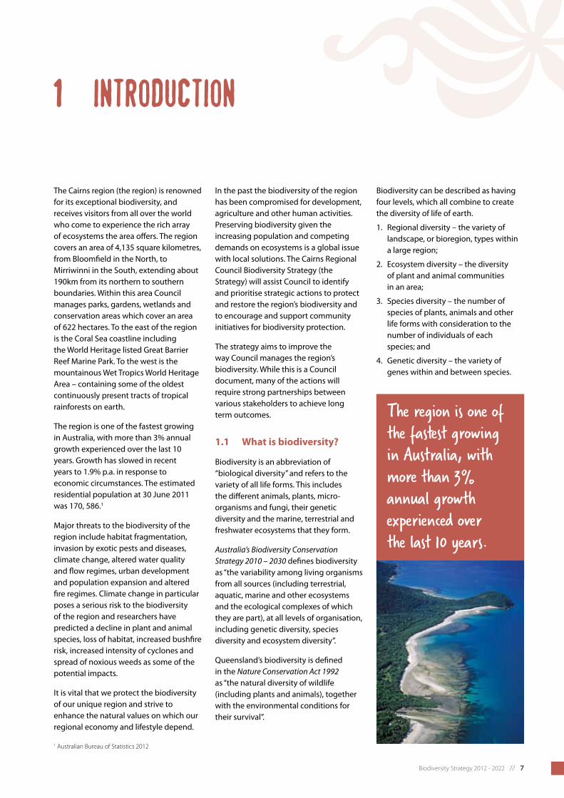
The Cairns region (the region) is renowned for its exceptional biodiversity, and receives visitors from all over the world who come to experience the rich array of ecosystems the area offers. The region covers an area of 4,135 square kilometres, from Bloomfield in the North, to Mirriwinni in the South, extending about 190km from its northern to southern boundaries. Within this area Council manages parks, gardens, wetlands and conservation areas which cover an area of 622 hectares. To the east of the region is the Coral Sea coastline including the World Heritage listed Great Barrier Reef Marine Park. To the west is the mountainous Wet Tropics World Heritage Area – containing some of the oldest continuously present tracts of tropical rainforests on earth.
The region is one of the fastest growing in Australia, with more than 3% annual growth experienced over the last 10 years. Growth has slowed in recent years to 1.9% p.a. in response to economic circumstances. The estimated residential population at 30 June 2011 was 170, 586.1
Major threats to the biodiversity of the region include habitat fragmentation, invasion by exotic pests and diseases, climate change, altered water quality and flow regimes, urban development and population expansion and altered fire regimes. Climate change in particular poses a serious risk to the biodiversity of the region and researchers have predicted a decline in plant and animal species, loss of habitat, increased bushfire risk, increased intensity of cyclones and spread of noxious weeds as some of the potential impacts.
It is vital that we protect the biodiversity of our unique region and strive to enhance the natural values on which our regional economy and lifestyle depend.
In the past the biodiversity of the region has been compromised for development, agriculture and other human activities. Preserving biodiversity given the increasing population and competing demands on ecosystems is a global issue with local solutions. The Cairns Regional Council Biodiversity Strategy (the Strategy) will assist Council to identify and prioritise strategic actions to protect and restore the region’s biodiversity and to encourage and support community initiatives for biodiversity protection.
The strategy aims to improve the way Council manages the region’s biodiversity. While this is a Council document, many of the actions will require strong partnerships between various stakeholders to achieve long term outcomes.
1.1 What is biodiversity?
Biodiversity is an abbreviation of “biological diversity” and refers to the variety of all life forms. This includes the different animals, plants, micro-organisms and fungi, their genetic diversity and the marine, terrestrial and freshwater ecosystems that they form.
Australia’s Biodiversity Conservation Strategy 2010 – 2030 defines biodiversity as “the variability among living organisms from all sources (including terrestrial, aquatic, marine and other ecosystems and the ecological complexes of which they are part), at all levels of organisation, including genetic diversity, species diversity and ecosystem diversity”.
Queensland’s biodiversity is defined in the Nature Conservation Act 1992 as “the natural diversity of wildlife (including plants and animals), together with the environmental conditions for their survival”.
Biodiversity can be described as having four levels, which all combine to create the diversity of life of earth.
1. Regional diversity – the variety of landscape, or bioregion, types within a large region;
2. Ecosystem diversity – the diversity of plant and animal communities in an area;
3. Species diversity – the number of species of plants, animals and other life forms with consideration to the number of individuals of each species; and
4. Genetic diversity – the variety of genes within and between species.
1 Introduction
The region is one of the fastest growing in Australia, with more than 3% annual growth experienced over the last 10 years.
1 Australian Bureau of Statistics 2012

8 // Biodiversity Strategy 2012 - 2022
1.2 Why protect biodiversity?
Biodiversity is essential to the maintenance of life on earth.
Maintaining and restoring biodiversity is important for many reasons. Biodiversity provides the basis for our economic prosperity and social wellbeing, as well as providing ecosystem services such as clean air and water. Biodiversity is critical to our survival, but also has value in its own right, and should be protected and maintained to allow the survival of species.
Ecosystem services and social wellbeing
Ecosystems provide ‘ecosystem services’ such as oxygen production, water purification, pollination, and soil formation, erosion control, and decomposition - without which our life on earth would not be possible. Maintaining healthy biodiversity means maintaining healthy functional ecosystems, which provide us with benefits beyond simple economic returns and healthy lifestyles.
Table 1 lists and categorises some examples of the range of benefits ecosystems provide for human wellbeing. Natural areas are also sanctuaries from urban pressures, places for exploration and provide the community with a sense of place, cultural identity and spiritual nourishment. Although placing a financial value on these services is complex and contentious, they are nevertheless of enormous value to the Cairns economy, to human health and wellbeing of residents and visitors to the region.
Table 1. Examples of ecosystem services provided by the natural environment (Wet Tropics Management Authority 2009)
Environmental values and processes
Environmental regulation Community services Community enrichment
•biodiversity
•habitatsandrefugia
•soilformationandfertility
•carbonsequestration
•biomassproduction
•pollination
•nutrientrecycling
•nitrogenfixing
•watercycles
•geneticresources
•fireregimes
•regulationofregional and micro climates
•floodmitigation
•waterpurification
•erosioncontrol
•pestcontrol
•groundwaterrecharge
•cleanwatersupply
•energy(hydroelectricity)
•shadeandshelter
•pharmaceuticalandbiological products
•horticulturalproducts
•artandcraftmaterials
•tourism
•recreationandleisureactivities
•spiritualvaluesandenjoyment
•scenicandaestheticvalues
•culturalandhistoricalvalues
•awarenessandeducation
•scientificdiscovery
•senseofplaceandidentity
Cultural heritage
For the traditional Aboriginal peoples in the Far North, the natural environment is inseparable from cultural, social and spiritual wellbeing. The term ‘Country’ means more than just the land, and can include the people, areas of the sea, animals, plants and culture that are all linked to a particular clan or language group. Over the past 40,000 years plus, ‘first peoples’ lives and spirituality, their custodial roles and responsibilities have been closely tied to Country. The greater Cairns region is home to the Eastern Kuku Yalanji people of the north, and the Djabugay, Yirrganydji and the Yidindji peoples from the central to the southern boundary of the local government area.
Resources and economy
Most human activities in one way or another depend on the region’s natural environment, whether it be the environmental values that attracts and supports a major ecotourism industry; or whether it is the climate that supports tropical agriculture. In the Cairns region, biodiversity is the basis of the tourism industry which is a major source of revenue for the region.2 Total visitor expenditure levels exceed $2 billion annually.3 Each year nearly two million domestic visitors and one million international visitors come to the region, directly supporting tourism businesses, and indirectly supporting a substantial part of the regional economy.
The region is a popular destination for domestic and international tourists because of its distinct natural beauty and biodiversity values. There is a key link between valuing and protecting our biodiversity and ensuring a strong economic future for the tourism industry.
2 Prideax and Falco-Mammone 20073 Gillespie Economics 2008

Biodiversity Strategy 2012 - 2022 // 9
1.3 How can Council protect biodiversity?
Council’s key strategies for protecting biodiversity in the region are:
• Protectandrestoreecologicalintegrityandhabitatconnectivity;
• Protectandrestorewaterwayhealthandaquaticbiodiversity;
• Minimisetheimpactsofurbandevelopmentonbiodiversity;
• MinimisenegativedownstreamimpactsontheGreatBarrierReef;and
• EncourageCouncilstaffandcommunitymemberstovalue,protectandrestorebiodiversity.
Council has the capacity to influence biodiversity conservation in the region in a number of ways. Council can directly influence biodiversity conservation by:
• ManagingCouncil’snaturalareastoprotectandrestorebiodiversity,restoreconnectivityandminimisetheimpactsof pest species;
• Encouragingurbanbiodiversitythroughuseofnativespeciesinstreetscapesandopenspaces;
• Promotingwaterwayhealthinurban,ruralandnaturalareasbyprotectingorrestoringriparianvegetation,managing stormwater and grey water, reducing sediment and chemical loads in run-off, and protecting coastal vegetation; and
• Usingplanningprovisionsorlocallawstominimiseecologicalimpactsofurbandevelopment.
Council can indirectly influence biodiversity conservation by:
• Influencinglandmanagementpracticesonprivatelandthroughratesincentives,educationandotherschemes;
• AdvocatingtoStateandFederalgovernmentforimprovedbiodiversityoutcomes;
• Encouragingandsupportingcommunityactionsthatprotectandenhancebiodiversity;and
• Raisingcommunityawarenessandencouragingappreciationoftheregion’sbiodiversityvalues.
10 // Biodiversity Strategy 2012 - 2022
Biodiversity Strategy 2012 - 2022 // 11
Biodiversity is vulnerable to habitat degradation, species population decline and potential extinction from threatening processes such as habitat fragmentation, changes in fire regimes and introduced species.4 The major threats to biodiversity in the Cairns region are:
• Populationgrowthand urban expansion;
• Climatechange;
• Habitatdegradation, fragmentation and loss;
• Decreasedwaterquality,altered flow regimes and loss of riparian and coastal vegetation;
• Invasivespecies;and
• Alteredfireregimes.
2.1 Population growth and urban expansion
Population growth and urban expansion have the potential to be a significant threat to the biodiversity of the region. In June 2010 the population was 168,2525 with the greatest concentration near the coast. The Cairns region has been experiencing continued growth, and over the next 20 years around 70,000 new residents are expected to arrive in the region.6
The impacts of population growth include:
• Increaseddemandforland,water, food, energy and other resources;
• Increaseddemandforcommunity infrastructure;
• Landclearing;
• Increasedairandwaterpollution;
• Increasedlikelihoodof introduction and movement of disease and invasive species;
• Increasednumbersofdomestic animals predating native wildlife; and
• Increasedtraffic.
The Far North Queensland Regional Plan 2009-2031 specifies the urban footprint for the region. Despite the low current growth rate of 1.9% p.a., growth will need to be carefully managed and planned fortomaximiseefficiencyoflanduseand infrastructure while protecting the natural environment.
Given the limited land areas available for further urban development in the Cairns region, future growth will need to be carefully managed to avoid further negative impacts on biodiversity. Accessing water for a growing population could also have negative impacts on the natural environment and the region’s biodiversity. Long and short term impacts on biodiversity must be considered throughout the planning stages to minimise the impacts of urban sprawl and reduce growth pressures in sensitive and high risk coastal areas.
2.2 Climate change
2.2.1 Climate change projections for the Cairns region
Climate change is recognised as a major threat to terrestrial and marine biodiversity and ecosystem function. The projected climate change impacts for the Cairns region are listed below:
• Anincreaseinannualaverage temperature of between 0.6 and 1.1°C by 2030 and between 0.9°C and 3.5°C by 2070 (compared to 1990 temperatures).7
• Anincreaseinthenumberof days above 35°C from the current annual average of three days to up to 41 days by 2070.8
• Achangeinannualaveragerainfall of between -8 to +6% by 2030 and between -26 to +18% by 2070.9
• Inter-annualrainfallvariabilityis expected to increase, and rainfall is expected to increase slightly in the wet season and to decrease markedly in the late dry season.
• Estimatesoftotalsea-levelrise remain uncertain due to unknown rates of polar ice cap melting. However, there is growing consensus among scientists that sea-level rise of 0.5 to 1.0 metres (compared to 1990 level) is plausible by 2100, and that a rise of 1.5 metres or more cannot be ruled out.10
As carbon dioxide dissolves into seawater, it increases the acidity of the ocean by formation of carbonic acid. This acidification of the oceans has adverse impacts on marine life, particularly corals, and presents a major threat to the health of the Great Barrier Reef. While projections of tropical cyclones in the Australian region are uncertain, available studies suggest that there may be an increase in the number of tropical cyclones in the more intense categories (categories 3–5), but a possible decrease in the total number of cyclones.11 A recent review of tropical cyclone characteristics simulated by models suggests an increase in globally averaged tropical cyclone intensity of 2-11% by the year 2100.12
In managing the natural environment we need to encourage ecosystem resilience to the impacts of climate change. Greenhouse gas mitigation and adaptation strategies are also an integral part of managing the effects of climate change upon biodiversity.
2 threats to biodiversity in the cairns region
7 Suppiah et al. 20108 Crimp et al. 20049 Suppiah et al. 2010
10 Suppiah et al. 201011 Short and Woodroffe 2009 12 Suppiah et al. 2010

12 // Biodiversity Strategy 2012 - 2022
2.2.2 Climate change impacts on biodiversity
Changing temperatures, rainfall patterns and cloud height are predicted to have negative impacts on plant and animal species in the Wet Tropics. Research shows that the biodiversity of the Wet Tropics is highly sensitive to climate change and high levels of species extinctions are predicted with warming beyond 2°C.13 The location and extent of rainforests, in particular, is largely determined by rainfall and its seasonality, while the type of rainforest and many of the organisms found within them depend upon narrow temperature ranges. Climate change impacts upon biodiversity at all its levels of organisation, ranging from biological, ecosystem and ecological impacts through to population level impacts.
These impacts result either directly from climate change or indirectly through interactions with other species that are affected by climate change which leads to changes in competition, food, habitat and predation patterns and processes. For some species these indirect impacts may be stronger than direct impacts. This cascade of climate change impacts also interacts with other human pressures on biodiversity such as habitat degradation and loss, water extraction, pollution and introduction and spread of pest species. Not only do climate change impacts add to these other pressures, they also interact, altering the way species and ecosystems would otherwise respond and adapt.
The golden bowerbird and the lemuroid ringtail possum are species that will be seriously affected by climate change due to their restricted habitat requirements at higher altitudes. For example, the lemuroid ringtail possum cannot survive above temperatures of 30°C for longer than 5 hours. Increasing temperatures will reduce already restricted habitat and affect their ability to maintain their ideal body temperature, placing even more pressure on this Wet Tropics species.
Biological impacts include the direct changes to organisms such as physiological and behavioural changes, including:
• Changesintimingofspecies’life-cycles(e.g.flowering,fruiting,breeding).
Changes will also occur to the composition, structure, function and services of ecosystems including:
• Changesinnutrientcyclingandnaturalresourcesupply(e.g.water);
• Changesinpredator-prey,parasite-host,plant-pollinatorandplant-disperserrelationships;and
• Changesinecosystemservicessuchaswatersupply,pestcontrolandpollination.
13 Still et al. 1999, Krockenberger et al. 2003, Hilbert et al. 2001, Williams et al. 2003
The golden bowerbird and the lemuroid ringtail possum are species that will be seriously affected by climate change due to their restricted habitat requirements at higher altitudes.
Biodiversity Strategy 2012 - 2022 // 13
Ecological impacts include those that result from changed interactions between organisms and their environment thereby affecting community composition, including:
• Changesinbreeding,establishment,growth,competitionandmortality;
• Changesinthelocationofspecies’habitatsresultinginrangeshiftsand/orlossesduetorangeexpansions,contractions and eliminations;
• Increasedopportunityforrangeexpansionofinvasivepestspeciesincludingweeds,feralanimals,pathogensandparasites;
• Increasedopportunityforrangeexpansionofnativespecieswithextensive,non-patchyranges,long-rangedispersal mechanisms;
• Changesinthestructureandcompositionofecologicalcommunities;and
• Formationofnovelcommunitiesbasedonnewspeciesassemblages.
Population impacts refer to changes in species abundance and distribution, including:
• Changesinpresence/absenceandrelative/absoluteabundances;
• Differentialindividualspecies’responsestochangingconditions;and
• Increasesintheriskofextinctionforspecieswithlimitedclimaticranges,limiteddispersalability,specialisedhabitat requirements,smallpopulationsand/orlowgeneticdiversity.
Interactions with other natural and artificial factors including:
• Changesintheintensity,frequencyandseasonalityofextremeeventssuchascyclones,floods,droughtsandfires;and
• Changesinhumanland-usepressures(synergieswithchangestolanduseandotherpopulationpressureson the environment).
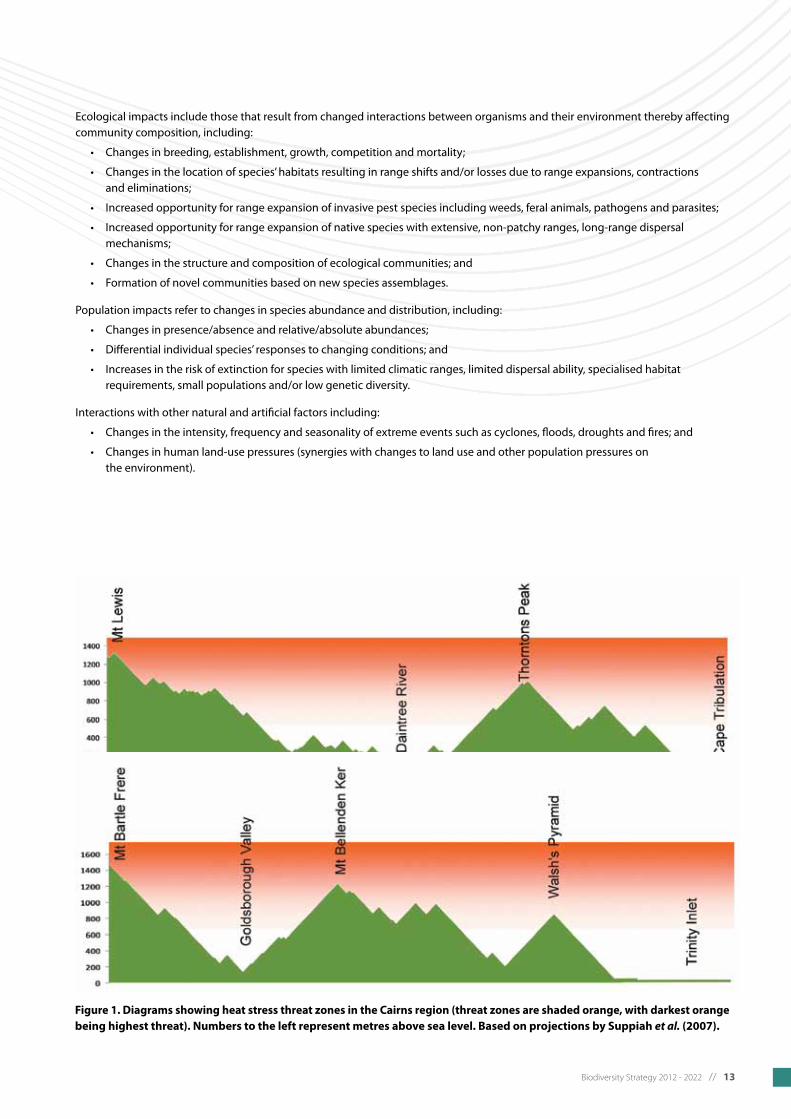
Figure 1. Diagrams showing heat stress threat zones in the Cairns region (threat zones are shaded orange, with darkest orange being highest threat). Numbers to the left represent metres above sea level. Based on projections by Suppiah et al. (2007).
14 // Biodiversity Strategy 2012 - 2022
2.2.3 How species are likely to respond to climate change
Individual species can exhibit two basic responses to climate change. They can adapt to new conditions within their existing range; or they can migrate to locations where suitable climatic conditions persist. The capacity of individual species to adopt either of these strategies will vary.
a. Species responses likely to be observed
• Shiftsinspecies’ranges(e.g.tohigher,cooleraltitudes);14
• Changesinspecies’abundances;15
• Changesinthelengthofaplantspecies’growingseason;
• Earlierfloweringinplants,earlieremergenceininsectsandearlieregglayinginbirds;16
• Changestothetimingandsequencingofflowering,fruitingandleafflushofplantscausingmanyflow-onimpactsto species dependent upon these plants.
b. Ecological responses likely to be observed
• AreductioninthenutritionalvalueandanincreaseinthetoughnessofmostfoliageduetoincreasedCO2levelsaffecting folivore abundance (e.g. endemic ringtail possums and many insects); 17
• Raisedcloudbaseswillaffectspeciesrequiringhighandconsistentmoisturelevels.18
c. Plant and animal invasions
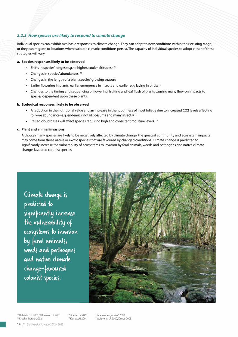
Although many species are likely to be negatively affected by climate change, the greatest community and ecosystem impacts may come from those native or exotic species that are favoured by changed conditions. Climate change is predicted to significantly increase the vulnerability of ecosystems to invasion by feral animals, weeds and pathogens and native climate change-favoured colonist species.
14 Hilbert et al. 2001, Williams et al. 200315 Krockenberger 2002
16 Root et al. 2003 17 Kanowski 2001
18 Krockenberger et al. 200319 Walther et al. 2002, Dukes 2003
Climate change is predicted to significantly increase the vulnerability of ecosystems to invasion by feral animals, weeds and pathogens and native climate change-favoured colonist species.

Biodiversity Strategy 2012 - 2022 // 15
d. Changes in fire regimes 20
Fire controls much of the boundary between rainforest and sclerophyll forests.21 Increases in the frequency of droughts associated with more El Niño events will increase the frequency and severity of unusual fire years and may lead to large changes in the distribution of rainforest and sclerophyll communities. The Cairns region can expect more fires, and more intense fires, for the following reasons:
• Hottertemperatures;
• Moredroughts;
• Lessrainfallinwinter/spring;
• Longerperiodsoflowhumidity;
• CO2-inducedincreasesinbiomass;
• Smallerwindowsofopportunityforprescribedburns.
Figure 2. The decline in species richness of regionally endemic rainforest vertebrates with increasing temperature (the darker the shade of red the greater the species richness) from Williams et al. 2003. Copyright S. Williams.
Summary
1. Climate change will have severe adverse impacts on wildlife and their habitats as well as on ecosystems and the services they provide the local community and visitors to the region.
2. In general, all native species will be more vulnerable, even those able to tolerate climatic changes per se, as they will all have to deal with a variety of new competitors, predators, diseases and introduced species for which they may have no natural defence.
3. It is predicted that existing ecosystems will undergo major changes; with some likely to disappear entirely; some totally new or novel ecosystems may appear, while others will experience dramatic changes in species composition and geographic extent.
20 Dukes 2003, Williams et al. 200121 Hopkins et al. 1993
16 // Biodiversity Strategy 2012 - 2022
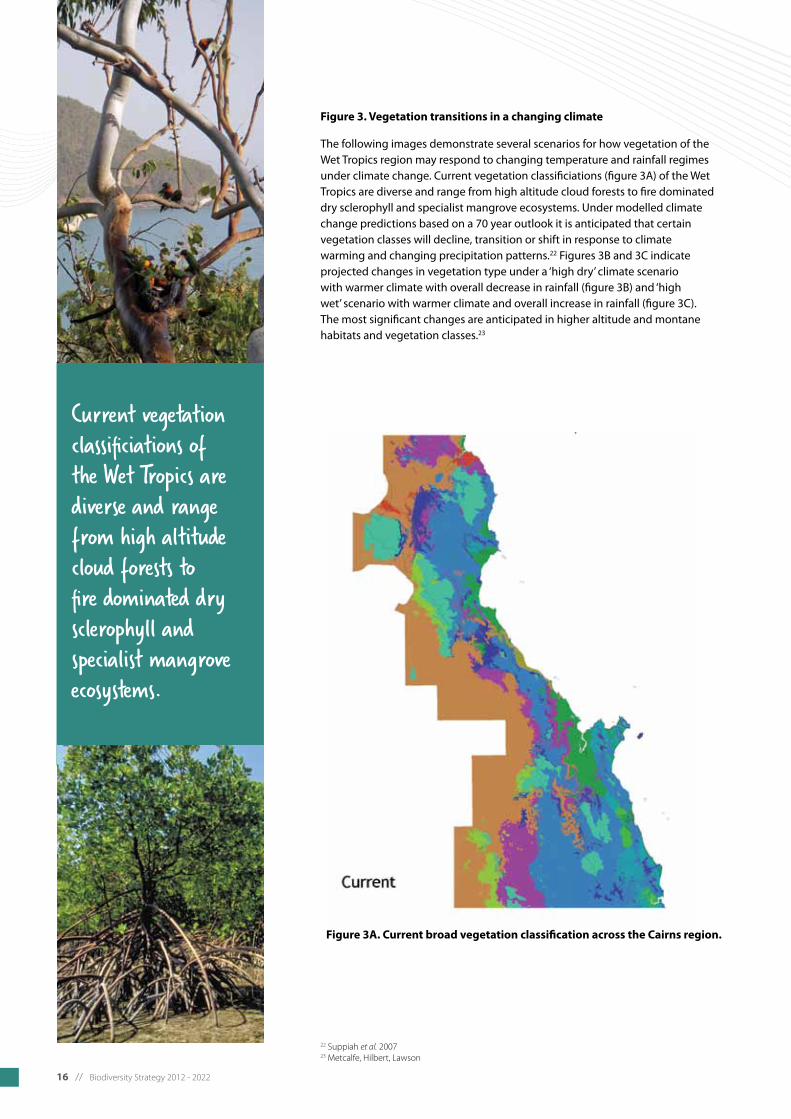
Figure 3. Vegetation transitions in a changing climate
The following images demonstrate several scenarios for how vegetation of the Wet Tropics region may respond to changing temperature and rainfall regimes under climate change. Current vegetation classificiations (figure 3A) of the Wet Tropics are diverse and range from high altitude cloud forests to fire dominated dry sclerophyll and specialist mangrove ecosystems. Under modelled climate change predictions based on a 70 year outlook it is anticipated that certain vegetation classes will decline, transition or shift in response to climate warming and changing precipitation patterns.22 Figures 3B and 3C indicate projected changes in vegetation type under a ‘high dry’ climate scenario with warmer climate with overall decrease in rainfall (figure 3B) and ‘high wet’ scenario with warmer climate and overall increase in rainfall (figure 3C). The most significant changes are anticipated in higher altitude and montane habitats and vegetation classes.23
22 Suppiah et al. 200723 Metcalfe, Hilbert, Lawson
Figure 3A. Current broad vegetation classification across the Cairns region.
Current vegetation classificiations of the Wet Tropics are diverse and range from high altitude cloud forests to fire dominated dry sclerophyll and specialist mangrove ecosystems.

Biodiversity Strategy 2012 - 2022 // 17
Figure 3B. ‘High dry’ climate scenario showing vegetation transitions in a warming climate with overall decrease in rainfall.
Figure 3C. ‘High wet’ climate scenario showing vegetation transitions in a warming climate with an overall increase in rainfall.
18 // Biodiversity Strategy 2012 - 2022
24 Goosem and Turton 200625 McFadyen 2000
2.3 Habitat fragmentation, degradation and loss
Habitat loss and fragmentation occurs when vegetation is cleared for urban development, farming or other infrastructure, or as a result of a cyclone or flood event. Fragmentation of habitat can occur when vegetation clearing causes habitat to be broken into smaller, disconnected areas. For example the clearing of long, linear strips for the construction of roads or powerlines results in smaller patches of habitat that are separated by cleared areas. These cleared areas create barriers to the movement of species, and increase the risk of invasion by exotic pest and weed species. In the Cairns region, historic land clearing has resulted in a heavily fragmented landscape, and continued pressures are leading to further fragmentation.
Fragmented habitat will cause a reduction in the mobility of species and their ability to forage. The increased isolation of small populations leads to decreased availability of breeding partners and can cause genetic isolation of populations. The long term survival of native species can be negatively affected, even if they can move between fragmented habitat, as they will still be at greater risk from predators, car strikes and dog attacks.
Research suggests that natural ecosystems can be seriously affected for some distance from the edge where linear clearings for infrastructure occur.24 Sunlight and wind can penetrate these edges, drying out the interior of the forest close to the edge and encouraging growth of opportunistic species which can displace native vegetation. 25
These edge effects further reduce the area of suitable habitat available for many native species.
In the Cairns region, lowland habitats are the most fragmented due to the concentration of towns and infrastructure in these areas. Protection of lowland habitats by minimising further clearing, fragmentation and degradation and increasing connectivity will improve the likelihood of the survival of lowland fauna species such as the cassowary.
The mapping in the following pages gives an indication of the level of habitat fragmentation in the region and the opportunities for restoring connectivity. Figure 5 illustrates the fragmentation corridors running through the region. Many of these follow major transport routes. Figure 6 shows the current habitat connectivity in the region, and Figure 7 indicates the potential connectivity value of land areas.
Landscape connectivity
“Connectivity” refers to the maintenance or restoration of key, large-scale ecological phenomena, flows, and processes critical to the long-term conservation of biodiversity. This may range from large-scale ecological processes such as water cycles and flow regimes to the transfer of genes from lowland areas to upland areas.
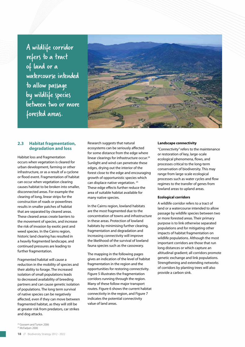
Ecological corridors
A wildlife corridor refers to a tract of land or a watercourse intended to allow passage by wildlife species between two or more forested areas. Their primary purpose is to link otherwise separated populations and for mitigating other impacts of habitat fragmentation on wildlife populations. Although the most important corridors are those that run long distances or which capture an altitudinal gradient; all corridors promote genetic exchange and link populations. Strengthening and extending networks of corridors by planting trees will also provide a carbon sink.
A wildlife corridor refers to a tract of land or a watercourse intended to allow passage by wildlife species between two or more forested areas.
Biodiversity Strategy 2012 - 2022 // 19
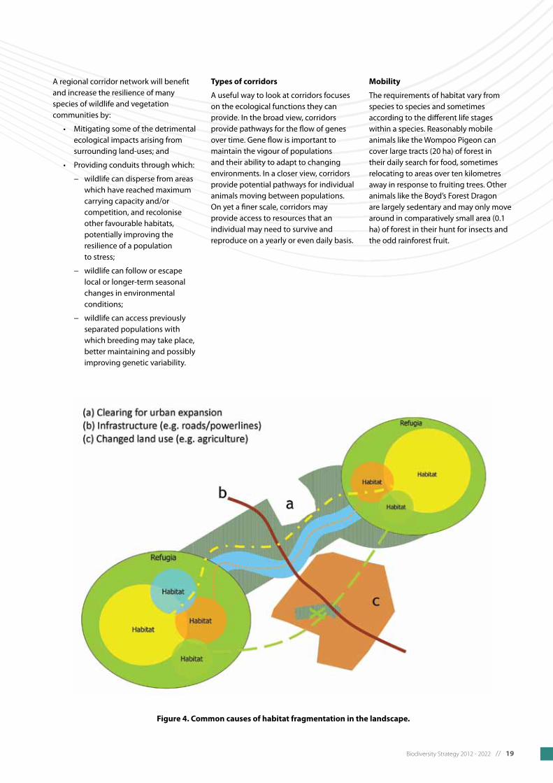
Figure 4. Common causes of habitat fragmentation in the landscape.
A regional corridor network will benefit and increase the resilience of many species of wildlife and vegetation communities by:
• Mitigatingsomeofthedetrimental ecological impacts arising from surrounding land-uses; and
• Providingconduitsthroughwhich:
− wildlife can disperse from areas which have reached maximum carryingcapacityand/or competition, and recolonise other favourable habitats, potentially improving the resilience of a population to stress;
− wildlife can follow or escape local or longer-term seasonal changes in environmental conditions;
− wildlife can access previously separated populations with which breeding may take place, better maintaining and possibly improving genetic variability.
Types of corridors
A useful way to look at corridors focuses on the ecological functions they can provide. In the broad view, corridors provide pathways for the flow of genes over time. Gene flow is important to maintain the vigour of populations and their ability to adapt to changing environments. In a closer view, corridors provide potential pathways for individual animals moving between populations. On yet a finer scale, corridors may provide access to resources that an individual may need to survive and reproduce on a yearly or even daily basis.
Mobility
The requirements of habitat vary from species to species and sometimes according to the different life stages within a species. Reasonably mobile animals like the Wompoo Pigeon can cover large tracts (20 ha) of forest in their daily search for food, sometimes relocating to areas over ten kilometres away in response to fruiting trees. Other animals like the Boyd’s Forest Dragon are largely sedentary and may only move around in comparatively small area (0.1 ha) of forest in their hunt for insects and the odd rainforest fruit.

20 // Biodiversity Strategy 2012 - 2022

Biodiversity Strategy 2012 - 2022 // 21
A brief history of vegetation clearing in the Wet Tropics (from Kemp et al. 2007)
From the 1840s Europeans were cutting timber from the Wet Tropics. From about 1870, small areas of land were taken up for sugarcane plantations and the area under sugarcane rapidly expanded during the 1880s. By this time, most of the useful red cedar timber (Toona ciliata) had been harvested from the lowland forests. With support of a South Sea Islander workforce, agricultural expansion accelerated again in the 1890s and early 1900s. A state land development policy in the first decade of the 20th century saw large areas surveyed for cattle farming, and between Tully and Cooktown, large areas were subdivided and cleared in the 1920s.
In the late 1980s and early 1990s large areas of lowlands vegetation were clear-felled on State lands for the establishment of pine plantations, particularly in the Cardwell area and the Herbert floodplain (Abergowrie, Broadwater and Lannercost State Forests). At about this time (1989) a rare marsupial, the mahogany glider (Petaurus gracilis) previously not recorded since its original description in 1883, was re-discovered, clinging to the remnants of habitat confined to the Herbert and Tully lowlands, and critically endangered by clearing). A subsequent development rush was triggered, amid fears of impending clearing restrictions, and a large proportion of the remaining arable land in the Herbert and Tully lowlands (within the range of the mahogany glider) was cleared of vegetation.
Shortly before the introduction of State tree clearing laws in 2000 (Vegetation Management Act 1999), another minor clearing surge was initiated, but by this time most of the available land had been cleared, with the remainder either within reserves, or too swampy or saline to clear. The remnant native vegetation on the floodplain of the wet tropics is today (except for estuarine areas) severely depleted, with many of the remnants existing in various stages of weed invasion and structural alteration due to cessation of burning, timber harvesting and other activities.

22 // Biodiversity Strategy 2012 - 2022
Figure 5. Fragmentation index - habitat fragmentation in the Cairns region.Interactive Biodiversity Assessment and Planning Framework (IBAPF), FNQROC, 2011.
Biodiversity Strategy 2012 - 2022 // 23
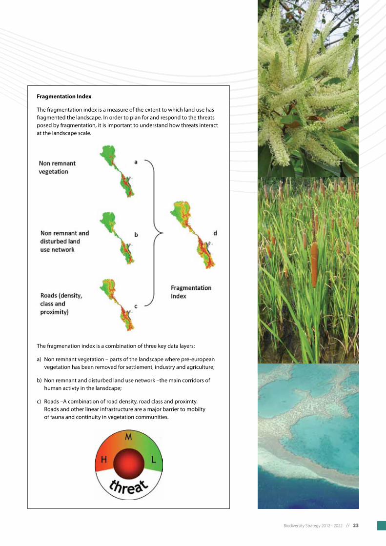
Fragmentation Index
The fragmentation index is a measure of the extent to which land use has fragmented the landscape. In order to plan for and respond to the threats posed by fragmentation, it is important to understand how threats interact at the landscape scale.
The fragmenation index is a combination of three key data layers:
a) Non remnant vegetation – parts of the landscape where pre-european vegetation has been removed for settlement, industry and agriculture;
b) Non remnant and disturbed land use network –the main corridors of human activty in the lansdcape;
c) Roads –A combination of road density, road class and proximty. Roads and other linear infrastructure are a major barrier to mobilty of fauna and continuity in vegetation communities.

24 // Biodiversity Strategy 2012 - 2022
Figure 6. Current habitat connectivity index - existing connectivity between habitat areas.Interactive Biodiversity Assessment and Planning Framework (IBAPF), FNQROC, 2011.

Biodiversity Strategy 2012 - 2022 // 25
Current habitat connectivity index
This index identifies the landscape scale connectivity between areas of high biodiversity value. The resulting network output can be used to guide where landscape scale linkages and values are most important.
The current habitat connectivity network index is the result of a network The current habitat connectivity network index is the result of a network analysis based on the biodiversity index (see figure 6 for a more detailed explanation). The analysis assigns a network score to each 20 hectare cell within the model based on its individual biodiversity index score (h) as well as its contribution to the connectivity of the entire network (i).

26 // Biodiversity Strategy 2012 - 2022
Figure 7. Potential connectivity index – potential habitat connectivity for mobility.Interactive Biodiversity Assessment and Planning Framework (IBAPF), FNQROC, 2011.

Biodiversity Strategy 2012 - 2022 // 27
Potential connectivity index
Potential for habitat connectivity on a local scale can be identified through two key mechanisms: habitat linkages and habitat expansion. Ideally planning for mobility for fauna delivers both. The connectivity index is a measure of the potential for areas to provide important links between existing remnant vegetation.
The connectivity index is derived from an analysis of remnant vegetation cover (a) and the distance and direction of the nearest possible link (b). The final output is essentially a conditional buffer identifying gaps between existing vegetation (c). This first step in identifying potential landscape linkages can be used alongside fragmentation and functional connectivity data to determine where activities like restoration and fauna crossings will be most effective.
28 // Biodiversity Strategy 2012 - 2022
2.4 Decreased water quality, altered flow regimes and loss of riparian and coastal vegetation
In addition to its renowned terrestrial biodiversity, the region is also home to many unique aquatic plant and animal species including freshwater species such as eel, frogs and fish as well as marine species including seagrass, dugong and crocodiles. These aquatic species depend on water quality for their survival and are affected by changes in water quality, riparian and coastal vegetation cover and water flow regimes.
In recent history, wetland, streams and other freshwater environments have been adversely affected by changes in land use and removal of riparian vegetation. These ecosystems have experienced increased sediment and nutrient loads, inflow of pesticides and rubbish. Marine biodiversity, in particular inshore reefs, is also suffering from pollution as sediments and nutrients wash into the sea from both urban and agricultural areas.
2.5 Invasive species and biosecurity risks
Invasive plant and animal species (pest species) often compete with, or directly prey on, native species. Pest plants and animals can significantly alter essential habitats and effect ecosystem processes to the detriment of native biodiversity. Pathogens such as Myrtle rust also present a real and direct threat to the survival of native flora and fauna.
Invasive plants out-compete and smother native flora leading to dominant monocultures that prevent the establishment and maintenance of diverse forests or interrupt aquatic flows. Invasive animals can out-compete native fauna and become the dominant predator preying on native species and competing for resources such as nesting hollows.
Established pest species require a large amount of resources for control and eradication. In the Cairns region there are many pests and weeds and their management and control is one of the most important areas for the protection of biodiversity in the region. Refer to Council’s draft Pest Management Plan for a full list of priority pest species.
Table 2. Significant pest species in the Cairns region.
Pest Animals Pest Plants Other biosecurity risks
Feral pigs (Sus scrofa)
Fire ants (Solenopsis invicta)
Electric ants (Wasmannia auropunctata)
Yellow crazy ants (Anoplolepis gracilipes)
Pond apple (Annona glabra)
Miconia (Miconia calvescens)
Hiptage (Hiptage benghalensis)
Cecropia (Cecropia peltata)
Siam weed (Chromolaena odorata)
Sicklepod (Senna obtusifolia)
Thunbergia (Thunbergia laurifolia)
Kudzu (Pueraria montana var. lobata)
Brillantasia (Brillantasia lamium)
Myrtle rust (Puccinia psidii s.l.)
Phytophthora (Phytophthora cinnamomi)
The impacts of vertebrate pests like feral pigs may increase over time with changes to the climate, particularly in upland rainforests. Feral pigs cause many problems, including degradation of upland microhylid frog habitat, a species already threatened by climate change. Feral pigs are also linked to the spreading of pathogens like phytophthora – causing rainforest dieback on Bartle Frere and Bellenden Ker. 26
26 Low 2011

Biodiversity Strategy 2012 - 2022 // 29
Figure 8 below illustrates hotspots in the region for occurrence of priority pest species only.
Figure 8. Frequency of occurrence of priority pest species in the Cairns region as identified in the Draft Cairns Regional Council Pest Management Plan.
Interactive Biodiversity Assessment and Planning Framework (IBAPF), FNQROC, 2011.
Note: this map displays occurrence of priority pest species only and is not an accurate representation of overall pest species occurrence. For further information on the distribution of other invasive species refer to Council’s Pest Management Plan and the Department of Primary Industries website: http://www.dpi.qld.gov.au
2.6 Altered fire regimes
Fire managed by humans has been part of the wet tropics landscape for tens of thousands of years and has played a significant role in shaping the forests we are familiar with today.
Depending on the vegetation type, fire may promote or adversely impact on biodiversity. Some vegetation types such as rainforests and wet sclerophyll forests are more fire sensitive than others (such as savannah woodlands) and for this reason the issue of fire regimes and impact on biodiversity needs to be considered for the breadth of vegetation types within the region. The open forests and woodlands of the Cairns region have been subjected to less frequent fires in recent European history due to rainforest expansion) while dry and wet sclerophyll forests occurring on the rain shadow side of the coastal ranges are naturally associated with rainforest boundaries. European disturbances in these areas (clearing, logging) have changed vegetation structure and increased fire susceptibility to rainforests which are sensitive to fire.
The projected climate change impacts for the region will influence the frequency and intensity of fires (see section 3.3.3). These projected impacts may also reduce the number of days suitable for hazard reduction burning. Managing fire regimes to reduce risk to property, people and biodiversity in the predicted changing climate change will be increasingly challenging.
Climate change may alter fire regimes, affecting species that are sensitive to fire frequency or intensity. Fire sensitive ecosystems (including rainforests and wet sclerophyll forests) and species will be at greater risk with increases in fire weather. Climate change will also have direct impacts on biodiversity by causing shifts in the distributions of species. Climate-induced changes to biodiversity will also drive fire regimes by changing the amount and composition of fuels. Hence climate change, fire regimes and biodiversity have complex feedback interactions (positive and negative) with different potential outcomes for different biomes. 27
Management actions will need to adapt to improve ecosystem resilience, reduce fire risk and mitigate species loss. 28 There is no easy solution to reducing the impact of changed fire regimes resultant from changes in climate. It will be important to develop and enhance monitoring strategies that track the impact of climate change on biodiversity, evolution of altered fire regimes and biodiversity response to interacting drivers of change at landscape scales. 29
Buffering fire sensitive vegetation types and species habitats from fire risk will be of increased importance.
27 Williams et al. 200928 Dunlop and Brown 200829 Williams et al. 2009

30 // Biodiversity Strategy 2012 - 2022
26 Low 2011

Biodiversity Strategy 2012 - 2022 // 31
There is a substantial legislative and policy framework for biodiversity conservation from the national to the local level. Figure 9 illustrates statutory (legally binding) and non-statutory frameworks for biodiversity conservation from the federal to the local level.
3 Political and Planning Context
Federal
StatutoryEnvironmental Protection Biodiversity Conservation Act 2000
Non-statutory Australia’s Biodiversity Strategy 2010-2030
State – Queensland
StatutoryNature Conservation Act 1992Vegetation Management Act 1999Land Protection (Pest and Stock Route) Management Act 2002Wet Tropics World Heritage Protection and Management Act 1993
Non-statutoryWet Tropics Management Plan 1998Building Nature’s Resilience: A Biodiversity Strategy for Queensland 2011Back on Track – Species Prioritisation Framework Wet Tropics Conservation Strategy: the conservation, rehabilitation and transmission to future generations of the Wet Tropics World Heritage Area
Regional
StatutoryFar North Queensland Regional Plan 2009 – 2031
Non-statutoryBack on Track – Actions for Biodiversity ‘Wet Tropics Region’Regional Pest Management Strategy
Local
StatutoryCairnsPlan 2009Douglas Shire Planning Scheme 2008Cairns Regional Council Community Plan 2011-2031
Non-statutoryCairns Regional Council Corporate Plan 2009-2014
Cairns Regional Council Biodiversity Strategy
Figure 9. Key legislation and documents influencing biodiversity.
32 // Biodiversity Strategy 2012 - 2022
3.1 Federal
Conventions
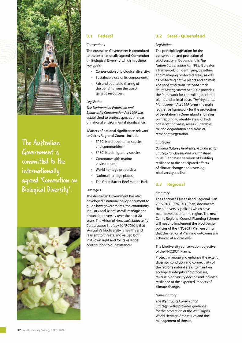
The Australian Government is committed to the internationally agreed ‘Convention on Biological Diversity’ which has three key goals:
- Conservation of biological diversity;
- Sustainable use of its components;
- Fair and equitable sharing of the benefits from the use of genetic resources.
Legislation
The Environment Protection and Biodiversity Conservation Act 1999 was established to protect species or areas of national environmental significance.
’Matters of national significance’ relevant to Cairns Regional Council include:
• EPBClistedthreatenedspecies and communities;
• EPBClistedmigratoryspecies;
• Commonwealthmarine environment;
• Worldheritageproperties;
• Nationalheritageplaces;
• TheGreatBarrierReefMarinePark.
Strategies
The Australian Government has also developed a national policy document to guide how governments, the community, industry and scientists will manage and protect biodiversity over the next 20 years. The vision of Australia’s Biodiversity Conservation Strategy 2010-2020 is that ‘Australia’s biodiversity is healthy and resilient to threats, and valued both in its own right and for its essential contribution to our existence.’
3.2 State - Queensland
Legislation
The principle legislation for the conservation and protection of biodiversity in Queensland is The Nature Conservation Act 1992. It creates a framework for identifying, gazetting and managing protected areas, as well as protecting native plants and animals. The Land Protection (Pest and Stock Route Management) Act 2002 provides the framework for controlling declared plants and animal pests. The Vegetation Management Act 1999 forms the main legislative framework for the protection of vegetation in Queensland and relies on mapping to identify areas of high conservation value, areas vulnerable to land degradation and areas of remanent vegetation.
Strategies
Building Nature’s Resilience: A Biodiversity Strategy for Queensland was finalised in 2011 and has the vision of ‘Building resilience to the anticipated effects of climate change and reversing biodiversity decline’.
3.3 Regional
Statutory
The Far North Queensland Regional Plan 2009-2031 (FNQ2031 Plan) documents the biodiversity policies which have been developed for the region. The new Cairns Regional Council Planning Scheme will need to implement the biodiversity policies of the FNQ2031 Plan ensuring that the Regional Planning outcomes are achieved at a local level.
The biodiversity conservation objective of the FNQ2031 Plan is:
Protect, manage and enhance the extent, diversity, condition and connectivity of the region’s natural areas to maintain ecological integrity and processes, reverse biodiversity decline and increase resilience to the expected impacts of climate change.
Non-statutory
The Wet Tropics Conservation Strategy (2004) provides guidance for the protection of the Wet Tropics World Heritage Area values and the management of threats.
The Australian Government is committed to the internationally agreed ‘Convention on Biological Diversity’.

Biodiversity Strategy 2012 - 2022 // 33
3.4 Local
Council policies, plans and strategies
Council’s Corporate Plan 2009-2014 identifies the vision for the region and informs Council’s annual Operational Plan. One of the four elements of the Council’s vision is to be Australia’s greenest region.
The Biodiversity Strategy is aligned with Council’s Protection of the Natural Environment Policy, Corporate Sustainability Policy and Carbon Emissions Reduction Policy.
Council has a number of other plans and strategies that will support the Biodiversity Strategy as follows:
- Cairns Regional Council Climate Change Strategy 2010-2015
- Cairns Regional Council Marine Plant Management Strategy 2010
- Cairns City Council Pest Management Plan 2005/Douglas Shire Council Pest Management Plan 2004
- Cairns Regional Council Fauna Management Plan
Planning Schemes
Douglas Shire Planning Scheme (2008)
The Douglas Shire Planning Scheme includes a Conservation Planning Area (CPA) which encompasses the majority of the areas of the Daintree lowlands that are not part of the Wet Tropics World Heritage Area. The CPA aims to protect the biodiversity values of the area. Land within this CPA is categorised as one of four precincts: Rainforest Conservation; Rainforest Residential; Rainforest Commercial/Community;orRainforestTourism Precinct.
All proposed land use changes within the CPA trigger assessment by Council, and in some precincts certain land uses are not permitted depending. Within the Conservation Precinct, the only use permitted is for a house, provided that a building pad had been legally cleared and that that it has been maintained.
In addition to the CPA, vegetation is protected through the Natural Areas and Scenic Amenity Code which applies when the Designated Development Area is within or partially within an area containing remnant vegetation or is within 50 metres of remnant vegetation or an identified waterway. This Code aims at maintaining and protecting biodiversity and scenic amenity by preventing the removal or damage of vegetation and riparian corridors.
CairnsPlan
CairnsPlan is the planning scheme for the area that was previously ‘Cairns City Council’. CairnsPlan includes Conservation Planning Areas in various Planning Districts in the region. In these Conservation Planning Areas, any kind of development requires an approval and most land uses are either Impact Assessable (requiring public notification) or Impact Inconsistent – unlikely to be approved and requiring Public Notification. The CairnsPlan also includes the Vegetation Conservation and Waterway Significance Overlay that aims to maintain and protect biodiversity by preventing the removal or damage of vegetation and riparian corridors.
Council’s Corporate Plan 2009-2014 identifies the vision for the region and informs Council’s annual Operational Plan. One of the four elements of the Council’s vision is to be Australia’s greenest region.
34 // Biodiversity Strategy 2012 - 2022

Biodiversity Strategy 2012 - 2022 // 35
4 the strategy
A large portion of land in the Cairns region is protected in national and marine parks, however there are also considerable areas of valuable biodiversity outside of these protected areas. It is in these areas where Council can most effectively act to protect biodiversity values from threats and impacts.
Historically the focus of biodiversity conservation has been on protected areas. Today there is general agreement that a whole of landscape approach for biodiversity conservation provides better outcomes and more resilient species, ecosystems and ecological processes. This whole of landscape approach aims to connect areas of important habitat through corridors, reduce threats, and focus on rehabilitation and restoration of landscapes. The importance of urban ‘green spaces’ for protecting biodiversity is also increasingly being acknowledged as important both for biodiversity conservation and community wellbeing.
Council is committed to protecting and restoring the significant biodiversity of this region. By adopting this strategy Council acknowledges the improvements it can make in its day to day activities to protect, restore and value biodiversity.
4.1 Vision
The vision of the strategy is that:
The biodiversity of the Cairns Region is protected and the resilience of species and ecosystems is enhanced through improved processes, planning and land management.
4.2 Scope
The strategy aims to produce outcomes that are within Council’s sphere of influence, including land and waterway management, urban planning, community engagement and staff education. The strategy includes an implementation plan to guide how Council achieves these outcomes in partnership with the community and key stakeholders over the next 10 years.
4.3 Intent
The strategy will guide Council’s planning and operational activities and the prioritisation of projects according to biodiversity outcomes. Mapping is provided to identify key areas of biodiversity value, threats and connectivity corridors.
4.4 Objectives
The objectives of the strategy are to:
• Provideaclearplanforhow Council can protect biodiversity;
• BuildthecapacityofCounciland the community to value and protect biodiversity;
• EnsureCouncilactsstrategically to protect the region’s unique biodiversity;
• Reducenegativeimpactsofhuman activities on terrestrial and aquatic biodiversity;
• EnsureCouncil’sapproachtoland management, urban planning and general operations is informed by the latest scientific research;
• Encouragegreaterawareness of the region’s unique biodiversity to encourage Council staff and community members to value and protect biodiversity.
4.5 Key strategies
Council’s key strategies for protecting biodiversity in the region are:
• Protectandrestoreecological integrity and habitat connectivity;
• Protectandrestorewaterway health and aquatic biodiversity;
• Minimisetheimpactsofurban development on biodiversity;
• Minimisenegativedownstream impacts on the Great Barrier Reef;
• EncourageCouncilstaffand community members to value, protect and restore biodiversity.
By adopting this strategy Council acknowledges the improvements it can make in its day to day activities to protect, restore and value biodiversity.

36 // Biodiversity Strategy 2012 - 2022
4.6 Strategic outcomes
The strategic outcomes of the strategy have been divided into seven categories and are listed below.
Valuing biodiversity and demonstrating leadership:
• Councilworksinpartnership with community, research organisations, traditional owners, industry stakeholders and other local organisations to protect biodiversity and demonstrate leadership to community and industry;
• Councilstaffandcommunity members are well informed about the biodiversity values of our region and how to minimise negative impacts on ecological values.
Managing invasive species and biosecurity risks:
• Theimpactsofpestsandweeds in the region are managed, reduced and minimised.
Protecting and restoring ecological integrity and habitat connectivity:
• Biodiversitylossandgeneral species decline are prevented or minimised;
• Habitatconnectivityandecological function of natural areas is restored and maintained, particularly in corridors of local and regional significance;
• Listedthreatenedspeciesare managed to reduce further stress on populations and efforts are made to reverse their decline.
Responding to climate change:
• Areasandspeciesconsidered at risk from climate change are identified and managed to promote species survival and minimise additional negative impacts.
Managing the impacts of development and population expansion:
• Urbanareasareplannedto minimise negative impacts on ecological values.
Reducing the risks of altered fire regimes:
• Council’sfiremanagement practices are informed by current research and consider the complex implications for local biodiversity.
Protecting and restoring riparian and coastal vegetation and improving water quality:
• Riparianvegetationisrestored and water quality in waterways is improved;
• Coastalbiodiversityisprotected and enhanced.
4.7 Implementation and action
An implementation plan has been developed to guide how Council achieves the strategy objectives in partnership with the community and key stakeholders over the next 10 years. It will guide Council’s planning and operational activities and the prioritisation of projects according to biodiversity outcomes.
4.7.1 Financial requirements
This strategy is to provide a high level direction for managing our biodiversity across Council. Departments will need to undertake further detailed analysis of the key strategies particularly for new initiatives. Council has an annual budget cycle in which implementation of new programs can be approved. External funding and grants will need to be sourced from Commonwealth and State programs.
4.7.2 Review and accountability
The strategy will need to be monitored and reviewed to determine its success and areas of improvement required. The strategy will be reviewed annually and implementation will be overseen by Council’s Environmental Sustainability Framework (Environmental Sustainability Committee and the Natural Environment Working Group).
4.7.3 Partnerships
Council will need to work with the Federal, State, other Local Governments, Natural Resource Management Groups, landholders, industry and the community to deliver the Strategy. Managing biodiversity crosses Local Government boundaries and jurisdictions, and effective working in partnerships are critical. Working to better engage, learn from and empower the local community is also a vital element of achieving the vision of the strategy.
Specific agencies that Council will continue to work with include; Commonwealth Department of Sustainability, Environment, Water, Population and Communities, The Commonwealth Scientific and Industrial Research Organisation (CSIRO), Queensland Department of Environment and Resource Management, Department of Planning and Infrastructure, Wet Tropics Management Authority, Biosecurity Queensland, Terrain Natural Resource Management, Far North Queensland Regional Organisation of Councils, James Cook University the Cairns and Far North Environment Centre and community groups.
4.7.4 Implementation plan
Strategy implementation will be guided by the strategic actions in the following implementation plans.

Biodiversity Strategy 2012 - 2022 // 37
VALUING BIODIVERSITY & DEMONSTRATING LEADERSHIP
Strategic outcomes:
•Councilworksinpartnershipwithcommunity,researchorganisations,traditionalowners,industrystakeholdersandotherlocalorganisations to protect biodiversity and demonstrate leadership to industry and the community;
•Councilstaffandcommunitymembersarewellinformedaboutthebiodiversityvaluesofourregionandhowtominimisenegative impacts on biodiversity values.
Impacts of biodiversity not being understood and valued:
•Councilnotleadingbyexampleinprotectingnaturalvalueswhichmaycausedamagetotheinternationallysignificantecosystems of the region;
•Councilstaffandcontractorsmaybeunawareofthesignificanceofspeciesandecosystemsthereforenotacttoprotectthem;
•Communitymembersmaybeunawareoflocalbiodiversityvaluesandthereforenotacttoprotectnativeplantsandanimalsfrom their own impacts (e.g. pets) or other factors.
Strategic outcome:
•Councilworksinpartnershipwithcommunity,researchorganisations,traditionalowners,industrystakeholdersandotherlocalorganisations to protect biodiversity and demonstrate leadership to industry and the community
ACTIONS: RESPONSIBILITY: FUNDING REQUIRED: TIMEFRAME:
1 Dedicate a staff position to guide Council’s strategic biodiversity decisions and practices
Executive team, Planning Strategies
$100,000/year(orembedded cost if existing position is redefined)
2013-onwards
2 Develop and implement a vegetation offset guideline for Council works and projects
Planning Strategies, Systems Support
Low or embedded cost 2013-2014
3 Explore the development and implementation of an environmental levy
Planning Strategies Low or embedded cost 2014-2016
4 Ensure landscape and land use planning encourage greater biodiversity in urban environments
Planning Strategies, Infrastructure Management, Technical Support Services, Natural Areas Management
Low or embedded cost Ongoing
5 Work with NRM bodies to assist in delivering NRM plans and encouraging community support of biodiversity conservation outcomes
Planning Strategies, Natural Areas Management, Terrain NRM
Low or embedded cost Ongoing
6 Review current policies, constraints and disincentives for private land conservation and develop tools to address these
Planning Strategies, Development Assessment
Low or embedded cost 2013
Strategic outcome:
•Councilstaffandcommunitymembersarewellinformedaboutthebiodiversityvaluesofourregionandhowtominimisenegative impacts on biodiversity values
7 Provide clear information to landholders to ensure better understanding of obligations to comply with clearing controls and planning scheme provisions
Development Assessment, Planning Strategies
Low or embedded cost 2015-onwards
8 Deliver a biodiversity education campaign providing information on local biodiversity values and how to encourage backyard biodiversity, and identify new opportunities for community engagement
Planning Strategies, Natural Areas Management, GBRMPA, DERM, Terrain NRM
Low or embedded cost 2013-onwards

38 // Biodiversity Strategy 2012 - 2022
MANAGING INVASIVE SPECIES & BIOSECURITY RISKS
Strategic outcome:
•Theimpactsofpestsandweedsintheregionaremanagedandminimised.
Impacts of invasive species:
•Nativespeciesfacecompetitionforresources;
•Invasivespeciespreyonnativespecies;
•Habitatisalteredbyinvasivespecies,resultinginchangestoecosystemtypeandfunction.
Strategic outcome:
•Theimpactsofpestsandweedsintheregionaremanagedandminimised.
ACTIONS: RESPONSIBILITY: FUNDING REQUIRED: TIMEFRAME:
9 Develop and implement a Myrtle rust response and adaptation plan
Systems Support, Natural Areas Management, Water & Waste
Low or embedded cost 2012-2013
10 Seek additional funding to expand Council’s pest management programs
Natural Areas Management
Low or embedded cost 2012-2015
11 Develop and implement a staff and contractor training program for early detection and management of pests, weeds and biosecurity risks
Natural Areas Management, Systems Support
Low or embedded cost 2012-onwards
12 Work with the nursery industry to promote awareness of weeds and encourage sale of local native species
Natural Areas Management, Planning Strategies
Low or embedded cost 2013-onwards
13 Provide information to the community about gardening with native species (including publishing a native plant list)
Planning Strategies Low or embedded cost 2012-onwards
14 Ensure at least 75% of plants used in landscape and streetscape plantings are local native species (excluding the northern and southern “city gateway” plantings)
Natural Areas Management, Technical Support Services
Low or embedded cost 2012-onwards
15 Update and implement Council’s Pest Management Plan and develop property pest management plans for Council assets
Natural Areas Management, FNQROC
Low or embedded cost 2012-2013
16 Implement Feral Pig Control program Natural Areas Management, QPWS, land owners
Refer to Pest Management Strategy
Ongoing
17 Provide clear information to landholders to ensure better understanding of obligations to comply with clearing controls and planning scheme provisions
Natural Areas Management, DERM, Terrain NRM, FNQROC, DEEDI, Biosecurity Qld
Low or embedded cost Ongoing
18 Develop a planning scheme policy which lists native plants that are recommended for use in landscape plans and those that are prohibited, invasive or undesirable
Planning Strategies, Natural Areas Management, Integrated Development Assessment, WTMA
Low or embedded cost 2013-2014

Biodiversity Strategy 2012 - 2022 // 39
PROTECTING AND RESTORING ECOLOGICAL INTEGRITY AND HABITAT CONNECTIVITY
Strategic outcomes:
•Biodiversitylossandgeneralspeciesdeclinearepreventedorminimised;
•Habitatconnectivityandecologicalfunctionofnaturalareasisrestoredandmaintained,particularlyincorridorsoflocalandregional significance;
•Listedthreatenedspeciesaremanagedtoreducefurtherstressesonpopulationsandeffortsaremadetoreversetheirdecline.
Impacts of habitat fragmentation and loss:
•Declineorlossofnativeplantandanimalspecies;
•Decreasedspeciesmobilityandgeneticdiversity;
•Increasedvulnerabilityofspeciestohumanimpactsandinvasivespecies.
Strategic outcome:
•Biodiversitylossandgeneralspeciesdeclinearepreventedorminimised.
ACTIONS: RESPONSIBILITY: FUNDING REQUIRED: TIMEFRAME:
19 Establish a biodiversity monitoring framework including appropriate indicators, and build a baseline dataset to measure biodiversity condition and trends
Natural Areas Management, FNQROC, Planning Strategies
Costs dependant on partnerships
2012-2014
20 Prepare a Natural Asset Management Plan for the region
FNQROC, Natural Areas Management
Low or embedded cost 2013
21 Ensure biodiversity impacts are considered and minimised for all Council works
Systems Support Low or embedded cost Ongoing
22 Work in partnership with the Department of Transport and Main Roads to encourage fauna-sensitive road design in high value areas
FNQROC, Systems Support, Natural Areas Management
Low or embedded cost Ongoing
Strategic outcome:
•Habitatconnectivityandecologicalfunctionofnaturalareasisrestoredandmaintained,particularlyincorridorsoflocalandregional significance.
23 Identify and map key biodiversity hotspots and rehabilitationcorridors/buffersatthelocalandregional level and develop a plan to restore these areas
Natural Areas Management, FNQROC, Planning Strategies
Low or embedded cost 2012
24 Assess roadside vegetation management and designaprocessforprotectingand/orrestoringsignificant roadside vegetation
Systems Support, Natural Areas Management
Low or embedded cost 2013
Strategic outcome:
•Threatenedspeciesaremanagedtoreducefurtherstressesonpopulationsandeffortsaremadetoreversetheirdecline.
25 Develop a Fauna and Flora Risk Management Matrix (including threatened species mapping)
Natural Areas Management, Systems Support
$20,000 2012-2014
26 Develop a community species mapping project Natural Areas Management, Systems Support
$20,000 2013-2016

40 // Biodiversity Strategy 2012 - 2022
RESPONDING TO CLIMATE CHANGE
Strategic outcome:
•Areasandspeciesconsideredatriskfromclimatechangeareidentifiedandmanagedtopromotespeciessurvivalandminimiseadditional negative impacts.
Impacts of climate change on biodiversity:
•Lossofsuitablehabitatforhigh-altitudespecies;
•Alteredrainfallpatternsresultinginchangesspeciescomposition;
•Increasedcyclonedisturbanceofforestsmayfavourinvasivespeciesandresultinchangestovegetationtype.
Strategic outcome:
•Areasandspeciesconsideredatriskfromclimatechangeareidentifiedandmanagedtopromotespeciessurvivalandminimiseadditional negative impacts.
ACTIONS: RESPONSIBILITY: FUNDING REQUIRED: TIMEFRAME:
27 Identify and map the distribution of species predicted to be at risk from climate change impacts
Natural Areas Management, Planning Strategies, FNQROC, JCU, CSIRO
Low or embedded cost 2013
28 Develop a plan for protecting critical habitat of ‘at risk’ species identified in action 18 and outline methods for avoiding or minimising additional negative impacts (as for action 57 in Council’s Climate Change Strategy)
Natural Areas Management, Planning Strategies, Systems Support
Low or embedded cost 2013
29 Protect high altitude habitat (e.g. by encouraging appropriate location of telecommunication towers)
Planning Strategies, Corporate Governance
Low or embedded cost Ongoing
30 Utilise biodiversity-rich solutions for mitigating climate change impacts on infrastructure where possible(i.e.wetland/beachrestorationformanaging erosion and inundation)
Technical Support Services, Natural Areas Management
Low or embedded cost Ongoing
A large portion of land in the Cairns region is protected in national and marine parks.
Biodiversity Strategy 2012 - 2022 // 41
MANAGING THE IMPACTS OF DEVELOPMENT & POPULATION EXPANSION
Strategic outcomes:
•Urbanareasareplannedtominimisenegativeimpactsonecologicalvalues;
•Councilstaffandcommunitymembersarewellinformedaboutthebiodiversityvaluesofourregionandhowtominimiseimpacts on local flora and fauna (see ‘Valuing biodiversity and demonstrating leadership’).
Impacts of development and population expansion:
•Habitatloss,fragmentationanddegradation;
•Increasedinfrastructuresuchasroadsandpowerlinescreatebarrierstospeciesmovement;
•Invasivespeciesintroducedtotheareafromgardensandsoilmovement;
•Increasedtrafficonroads;
•Increasednumbersofdogsandcatsintheareapreyingonnativeanimals;
•Increasedpressureonnaturalresourcessuchaswater,land,andfood;
•Increasedpollutionenterswaterways,airandlandfills(nutrients,emissions,airpollutantsandwaste).
Strategic outcome:
•Urbanareasareplannedtominimisenegativeimpactsonecologicalvalues.
ACTIONS: RESPONSIBILITY: FUNDING REQUIRED: TIMEFRAME:
31 Include comprehensive terrestrial biodiversity habitat mapping (showing areas of High and General ecological significance) in the new planning scheme
Planning Strategies, FNQROC
Low or embedded cost 2012
32 Develop covenants to protect significant plant species
Planning & Environment
Low or embedded cost 2013-2015
33 Investigate the development of covenants to limit ownership of domestic animals in areas of high ecological significance
Planning & Environment
Low or embedded cost 2014-2016
34 Integrate the Far North Queensland Regional Plan 2009-2031 Regional Plan Policies for the natural environment into the new planning scheme
Planning Strategies Low or embedded cost 2012-2014
35 Investigate the possibility of introducing local laws to restrict domestic animal ownership in conservation zones
Planning Strategies Low or embedded cost 2012-2013
36 Designcodes/assessmenttriggersforbiodiversityprotection
Planning Strategies Low or embedded cost 2013-2014

42 // Biodiversity Strategy 2012 - 2022
REDUCING THE RISK OF ALTERED FIRE REGIMES
Strategic outcome:
•Council’sfiremanagementpracticesareinformedbycurrentresearchandconsiderthecompleximplicationsfor local biodiversity.
Impacts of altered fire regimes:
•Changestofireregimesalterspeciescompositionandmayresultinlocallossofspeciesand/orvegetationtypes.
Strategic outcome:
•Council’sfiremanagementpracticesareinformedbycurrentresearchandconsiderthecompleximplicationsfor local biodiversity
ACTIONS: RESPONSIBILITY: FUNDING REQUIRED: TIMEFRAME:
37 Review current fire management practices and identify alternative management strategies taking into account projected climate changes
Natural Areas Management, Planning Strategies
Low or embedded cost 2013-2014
38 Ensure fire risk is included in education programs and pest management strategies
Natural Areas Management, Systems Support
Low or embedded cost Ongoing
39 Identify plant species at risk from altered fire regimes and propagate at Council nurseries
Environmental Assessment, Natural Areas Management
Low or embedded cost Ongoing
PROTECTING AND RESTORING WATERWAYS AND COASTAL AREAS AND IMPROVING WATER QUALITY
Strategic outcomes:
•Riparianvegetationisrestoredandwaterqualityinwaterwaysisimproved;
•Coastalbiodiversityisprotectedandenhanced.
Impacts of decreased water quality and loss of riparian and coastal vegetation:
•Increasedsedimentandnutrientloadsinwaterwaysleadstodecreasedbiodiversity,increasedabundanceofpestspeciesandcauses negative downstream effects on the marine environment;
•Increasedsoilerosion;
•Reducedhabitatavailableforaquatic,semi-aquaticandcoastalspecies;
•Vulnerabilityofcoastalareastoerosionandinundation.
Strategic outcome:
•Riparianvegetationisrestoredandwaterqualityinwaterwaysisimproved.
ACTIONS: RESPONSIBILITY: FUNDING REQUIRED: TIMEFRAME:
40 Establish water quality monitoring stations and undertake regular monitoring
Technical Support Services
$10,000 2013-onwards
41 Develop comprehensive freshwater biodiversity habitat mapping to inform the new planning scheme
Planning Strategies, FNQROC, Terrain Natural Areas Management, CSIRO
$10,000 2013-2014
42 Formulate a waterways and wetlands management plan to protect and restore freshwater biodiversity, seeking input from regional experts
Natural Areas Management, Planning Strategies, FNQROC, Terrain NRM, CSIRO
Low or embedded cost 2014-2015
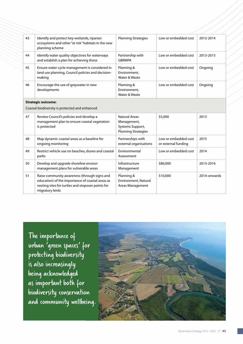
Biodiversity Strategy 2012 - 2022 // 43
43 Identify and protect key wetlands, riparian ecosystems and other “at risk” habitats in the new planning scheme
Planning Strategies Low or embedded cost 2012-2014
44 Identify water quality objectives for waterways and establish a plan for achieving these
Partnership with GBRMPA
Low or embedded cost 2013-2015
45 Ensure water cycle management is considered in land use planning, Council policies and decision-making
Planning & Environment, Water & Waste
Low or embedded cost Ongoing
46 Encourage the use of greywater in new developments
Planning & Environment, Water & Waste
Low or embedded cost Ongoing
Strategic outcome:
Coastal biodiversity is protected and enhanced
47 Review Council’s policies and develop a management plan to ensure coastal vegetation is protected
Natural Areas Management, Systems Support, Planning Strategies
$5,000 2013
48 Map dynamic coastal areas as a baseline for ongoing monitoring
Partnerships with external organisations
Low or embedded cost or external funding
2015
49 Restrict vehicle use on beaches, dunes and coastal parks
Environmental Assessment
Low or embedded cost 2014
50 Develop and upgrade shoreline erosion management plans for vulnerable areas
Infrastructure Management
$80,000 2013-2016
51 Raise community awareness (through signs and education) of the importance of coastal areas as nesting sites for turtles and stopover points for migratory birds
Planning & Environment, Natural Areas Management
$10,000 2014-onwards
The importance of urban ‘green spaces’ for protecting biodiversity is also increasingly being acknowledged as important both for biodiversity conservation and community wellbeing.

44 // Biodiversity Strategy 2012 - 2022

Biodiversity Strategy 2012 - 2022 // 45
5 A profile of biodiversity in the Cairns Region
5.1 Overview of biodiversity
The Cairns Regional Council area covers 4,135 square kilometres of land that is internationally recognised for its scenic beauty and high biodiversity. The region contains two World Heritage listed areas: the rainforests of the Wet Tropics and the reefs and waters of the Great Barrier Reef. The regional economy, local communities and local culture all rely on the internationally significant natural environment of the region.
A vast array of organisms, ranging from single celled organisms to the giant Stockwellia trees of the East Mulgrave River Valley, are supported by the various ecosystems, communities and habitats of the region. An abundance of migratory species depend on the wetlands, waterways, coastal waters and terrestrial habitats – from mangrove edges to mountain tops – for food and shelter during their stopover in the region.
The Cairns region contains 144 regional ecosystems in two bioregions: the Wet Tropics and the Einasleigh Uplands bioregions. The majority of the land area is within the Wet Tropics bioregion, with only a very small portion in the north-west classified as part of the Einasleigh Uplands bioregion (see figure 10). Under The Vegetation Management Act 1999 (VMA), 15 of the 144 regional ecosystems found in the Cairns Region have an Endangered status; 91 have an Of Concern status and 38 have an Of Least Concern status. 30
Approximately 252 plant species native to the Cairns Region are regarded as rare and threatened and 14 plant species are regarded as extinct in the wild. It is possible that populations of some of these extinct plants still exist as limited survey work has been undertaken in many areas of suitable habitat.
30 Cairns Regional Council 2010
A vast array of organisms, ranging from single celled organisms to the giant Stockwellia trees of the East Mulgrave River Valley, are supported by the various ecosystems, communities and habitats of the region.

46 // Biodiversity Strategy 2012 - 2022
Figure 10. Map of bioregions in northern Australia showing the Cairns Regional Council area.
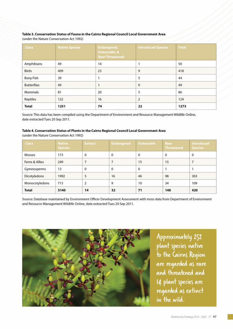
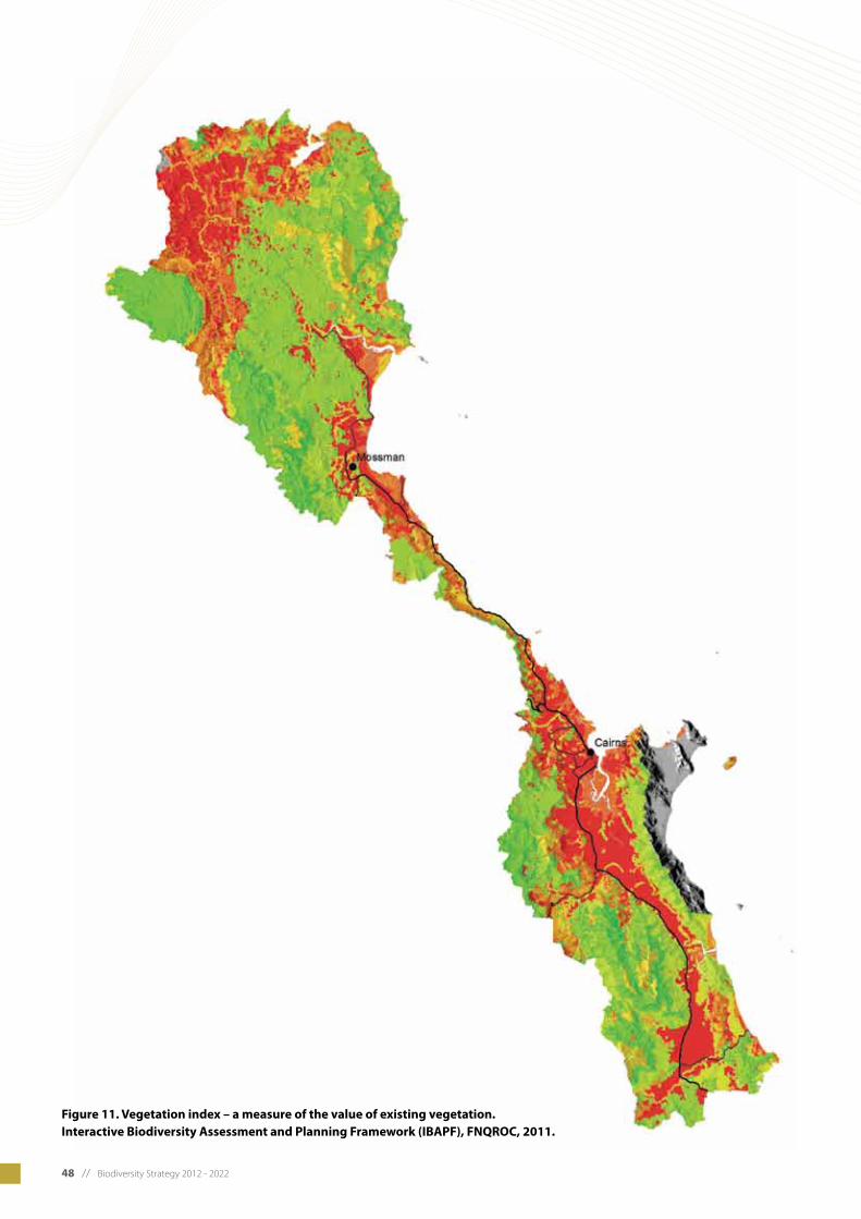
48 // Biodiversity Strategy 2012 - 2022
Figure 11. Vegetation index – a measure of the value of existing vegetation. Interactive Biodiversity Assessment and Planning Framework (IBAPF), FNQROC, 2011.
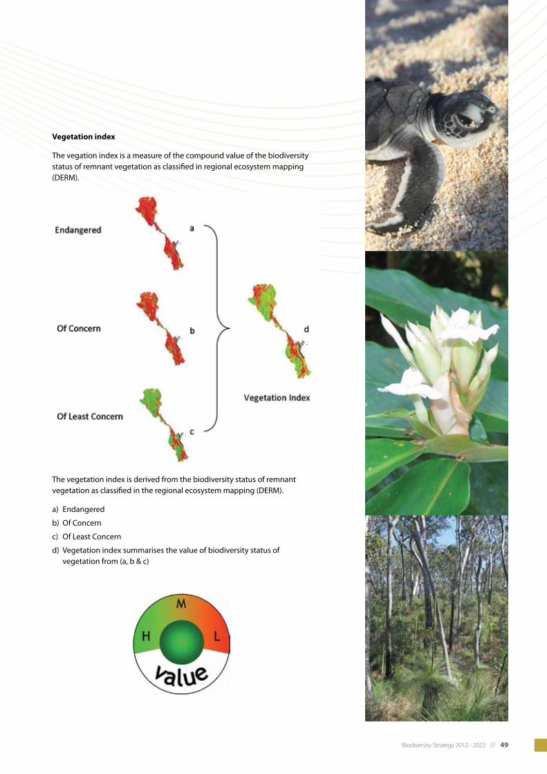
Biodiversity Strategy 2012 - 2022 // 49
Vegetation index
The vegation index is a measure of the compound value of the biodiversity status of remnant vegetation as classified in regional ecosystem mapping (DERM).
The vegetation index is derived from the biodiversity status of remnant vegetation as classified in the regional ecosystem mapping (DERM).
a) Endangered
b) Of Concern
c) Of Least Concern
d) Vegetation index summarises the value of biodiversity status of vegetation from (a, b & c)

50 // Biodiversity Strategy 2012 - 2022
Figure 12. Biodiversity index – a measure of biodiversity in the Cairns region. Interactive Biodiversity Assessment and Planning Framework (IBAPF), FNQROC, 2011.
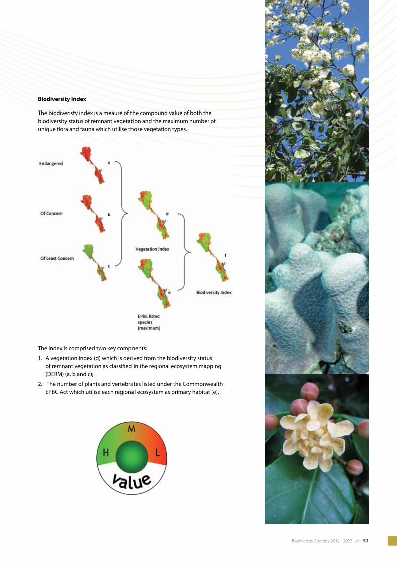
Biodiversity Strategy 2012 - 2022 // 51
Biodiversity Index
The biodiveristy index is a meaure of the compound value of both the biodiversity status of remnant vegetation and the maximum number of unique flora and fauna which utilise those vegetation types.
The index is comprised two key compnents:
1. A vegetation index (d) which is derived from the biodiversity status of remnant vegetation as classified in the regional ecosystem mapping (DERM) (a, b and c);
2. The number of plants and vertebrates listed under the Commonwealth EPBC Act which utilise each regional ecosystem as primary habitat (e).
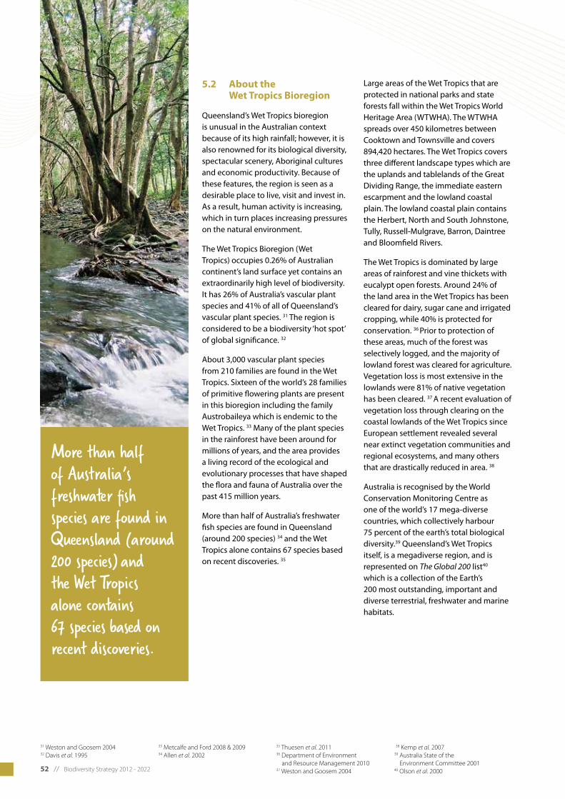
52 // Biodiversity Strategy 2012 - 2022
5.2 About the Wet Tropics Bioregion
Queensland’s Wet Tropics bioregion is unusual in the Australian context because of its high rainfall; however, it is also renowned for its biological diversity, spectacular scenery, Aboriginal cultures and economic productivity. Because of these features, the region is seen as a desirable place to live, visit and invest in. As a result, human activity is increasing, which in turn places increasing pressures on the natural environment.
The Wet Tropics Bioregion (Wet Tropics) occupies 0.26% of Australian continent’s land surface yet contains an extraordinarily high level of biodiversity. It has 26% of Australia’s vascular plant species and 41% of all of Queensland’s vascular plant species. 31 The region is considered to be a biodiversity ‘hot spot’ of global significance. 32
About 3,000 vascular plant species from 210 families are found in the Wet Tropics. Sixteen of the world’s 28 families of primitive flowering plants are present in this bioregion including the family Austrobaileya which is endemic to the Wet Tropics. 33 Many of the plant species in the rainforest have been around for millions of years, and the area provides a living record of the ecological and evolutionary processes that have shaped the flora and fauna of Australia over the past 415 million years.
More than half of Australia’s freshwater fish species are found in Queensland (around 200 species) 34 and the Wet Tropics alone contains 67 species based on recent discoveries. 35
Large areas of the Wet Tropics that are protected in national parks and state forests fall within the Wet Tropics World Heritage Area (WTWHA). The WTWHA spreads over 450 kilometres between Cooktown and Townsville and covers 894,420 hectares. The Wet Tropics covers three different landscape types which are the uplands and tablelands of the Great Dividing Range, the immediate eastern escarpment and the lowland coastal plain. The lowland coastal plain contains the Herbert, North and South Johnstone, Tully, Russell-Mulgrave, Barron, Daintree and Bloomfield Rivers.
The Wet Tropics is dominated by large areas of rainforest and vine thickets with eucalypt open forests. Around 24% of the land area in the Wet Tropics has been cleared for dairy, sugar cane and irrigated cropping, while 40% is protected for conservation. 36 Prior to protection of these areas, much of the forest was selectively logged, and the majority of lowland forest was cleared for agriculture. Vegetation loss is most extensive in the lowlands were 81% of native vegetation has been cleared. 37 A recent evaluation of vegetation loss through clearing on the coastal lowlands of the Wet Tropics since European settlement revealed several near extinct vegetation communities and regional ecosystems, and many others that are drastically reduced in area. 38
Australia is recognised by the World Conservation Monitoring Centre as one of the world’s 17 mega-diverse countries, which collectively harbour 75 percent of the earth’s total biological diversity.39 Queensland’s Wet Tropics itself, is a megadiverse region, and is represented on The Global 200 list40 which is a collection of the Earth’s 200 most outstanding, important and diverse terrestrial, freshwater and marine habitats.
31 Weston and Goosem 200432 Davis et al. 1995
33 Metcalfe and Ford 2008 & 200934 Allen et al. 2002
35 Thuesen et al. 201136 Department of Environment and Resource Management 201037 Weston and Goosem 2004
38 Kemp et al. 200739 Australia State of the Environment Committee 200140 Olson et al. 2000
More than half of Australia’s freshwater fish species are found in Queensland (around 200 species) and the Wet Tropics alone contains 67 species based on recent discoveries.
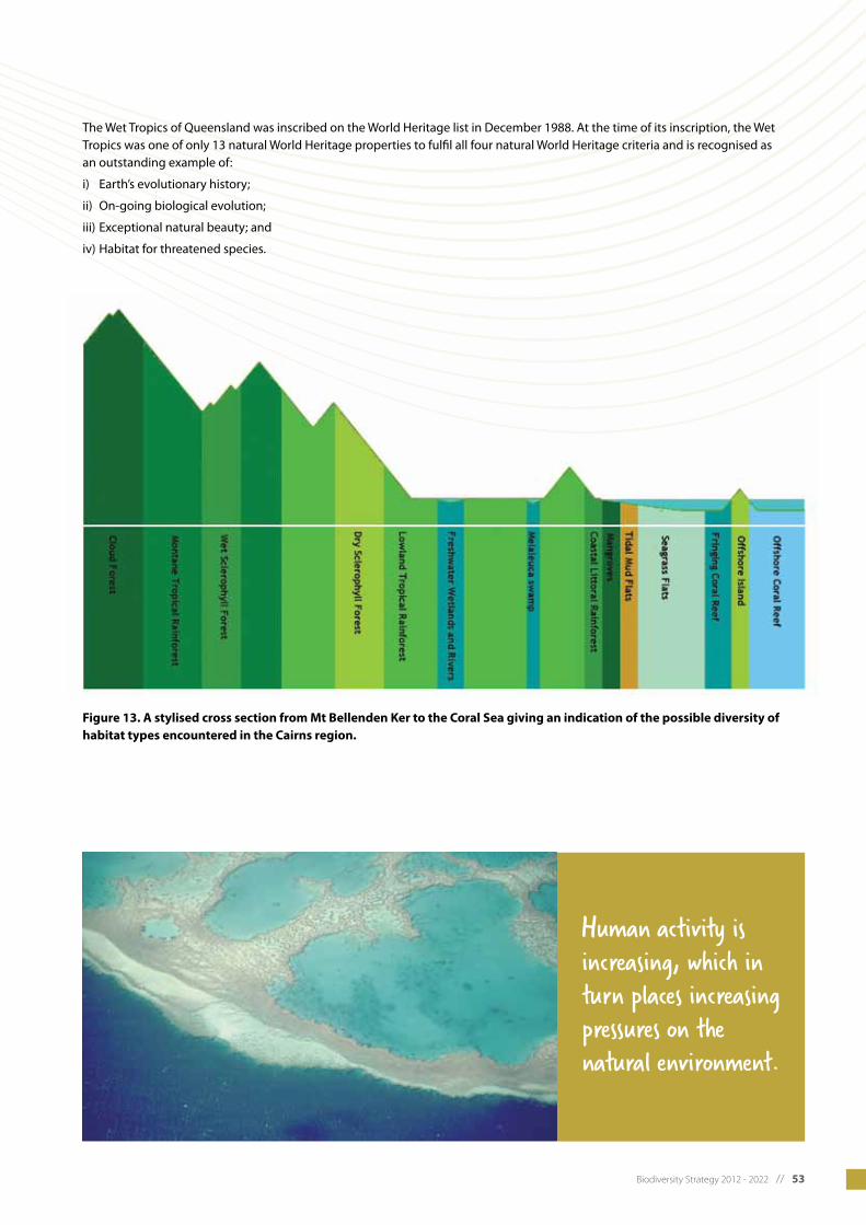
Biodiversity Strategy 2012 - 2022 // 53
The Wet Tropics of Queensland was inscribed on the World Heritage list in December 1988. At the time of its inscription, the Wet Tropics was one of only 13 natural World Heritage properties to fulfil all four natural World Heritage criteria and is recognised as an outstanding example of:
i) Earth’s evolutionary history;
ii) On-going biological evolution;
iii) Exceptional natural beauty; and
iv) Habitat for threatened species.
Figure 13. A stylised cross section from Mt Bellenden Ker to the Coral Sea giving an indication of the possible diversity of habitat types encountered in the Cairns region.
Human activity is increasing, which in turn places increasing pressures on the natural environment.

54 // Biodiversity Strategy 2012 - 2022
5.3 Biodiversity case studies
5.3.1 Littoral Rainforest and coastal vine thicket
The Littoral Rainforest and coastal vine thickets of eastern Australia (Littoral rainforest) is a highly fragmented and critically endangered ecological community listed under the Australian Government’s EPBC Act. The ecological community provides habitat for over 70 threatened plants and animals and provides an important buffer to coastal erosion and wind damage.
Littoral Rainforest occurs close to the coast in scattered patches all the way
from northern Queensland southwards to eastern Victoria and on offshore islands. It occurs on a range of landforms which have been influenced by coastal processes including dunes and flats, headlands and sea-cliffs.
This ecological community is a complex of rainforest and vine thickets. The vegetation generally is structurally diverse, with native trees, shrubs, vines and ground layers all usually being present. The vegetation typically has a closed canopy, and the structure includes a closed canopy of trees, although the canopy can be patchy when in exposed situations or after storm events. In the Cairns region this ecological community is present in coastal areas throughout the region, mainly on soils derived from Holocene beach ridge sand deposits that have accumulated over the past 6,000 years and on older beach ridge deposits which accumulated during the Pleistocene high sea level stand approximately 120,000 years ago. Regional ecosystems within the Cairns Region that support Littoral Rainforest and coastal vine thickets occur on old beach ridge deposits and coastal headlands. These are:
• Mesophyllvineforestonbeach ridges and sand plains of beach
origin, mainly in small patches in the lee of coastal beach ridges in very high rainfall areas (RE 7.2.1);
• Notophylltomicrophyllvineforest on beach ridges and sand Plains of beach origin (RE 7.2.2);
• Mesophyll/notophyllvineforests of Syzygium forte subsp. forte on beach ridges and sand plains of beach origin (RE 7.2.5a);
• Evergreennotophyllvinethickets with Acacia crassicarpa, Elaeodendrum melanocarpum, Aglaia elaeagnoidea and Drypetes deplanchei on aeolian dunes (RE 7.2.6b);
• Terminalia arenicola and Acacia polystachya low closed forest of coastal metamorphic headlands (RE 7.11.3b);
• Lownotophyllvinethicketson exposed rocky coastal headlands (RE 7.12.11d).
The larger areas that support Littoral rainforest and coastal vine thickets are mapped in the 1: 50,000 regional ecosystem mapping, numerous small areas of this critically endangered ecologically community are however not able to be mapped at this scale.
5.3.2 Great Barrier Reef
While located outside of Cairns Region, the Great Barrier Reef is a key feature of the surrounding natural landscape and is affected by policies and practices within the region.
The Great Barrier Reef is one of the richest, most complex and diverse ecosystems in the world. The Great Barrier Reef Marine Park begins at the tip of Cape York in Queensland and extends south almost to Bundaberg. The area is larger than Victoria and Tasmania combined and stretches more than 2,300 kilometres along the north-east coast of Australia. 41
The Great Barrier Reef is internationally renowned for its biodiversity. Its network of approximately 2,900 reefs is home to thousands of species. Extensive areas of
seagrass meadows, mangrove stands, saltmarshes, mud flats and beaches also provide a diverse range of habitats for many species. The diversity and size of the Great Barrier Reef makes it internationally significant, and it remains one of the world’s healthiest coral reef ecosystems. 42
Climate change, continued declining water quality from catchment runoff, loss of coastal habitats due to coastal development and impacts from fishing are identified as the priority threats reducing the resilience the Great Barrier Reef. Land management practices in the region have direct impacts on the reef by affecting water quality. Managing land for minimal sediment and nutrient runoff improves the water quality entering the reef lagoon and helps to protect the biodiversity of the Great Barrier Reef.
41 Great Barrier Reef Marine Park Authority 201042 Great Barrier Reef Marine Park Authority 2010

Biodiversity Strategy 2012 - 2022 // 55
5.3.4 Bartle Frere and Bellenden Ker
Located approximately 70 kilometres south of Cairns are the highest mountains in Queensland, Mount Bartle Frere (1,622 m) and Mount Bellenden Ker (1593 m). The meteorological station on Mt Bellenden Ker is the wettest in Australia, with an average annual rainfall of 8.3 metres and a record annual rainfall of 12.4 metres recorded in 2010. 44 Mount Bellenden Ker is located within sections of the Wooroonooran National Park.
The vegetation on the summits of Mt Bellenden Ker and Mt Bartle Frere is montane tropical rainforest. Both the species composition and the structure of the rainforest change with altitude. At mid to high altitudes species have smaller leaves and a lower canopy than lowland forest. On the mountain tops (above 1,500 m) the canopy is lower still, with a dense, wind-swept canopy cover as a result of frequent high winds. 45
A species of tea tree, Leptospermum wooroonooran, is endemic to the Wet Tropics and in only found on the Bellender Ker range, the summits north-west of Mossman, Mt Lewis and Mt Spurgeon. Bellenden Ker Range and the hills behind Mossman, meaning that is does not occur naturally anywhere else in the world. This species only occurs at altitudes of 1,100 -1,550 metres. It grows to around 13 metres and forms twisted, branching trees, with some individuals estimated to be up to 1,000 years old. 46
43 Goosem 200244 Bureau of Meterology 2001
45 Department of Environment and Resource Management 2011a
46 Department of Environment and Resource Management 2011a
5.3.3 Daintree Rainforest
The Daintree Rainforest (the Daintree) encompasses an area of approximately 1,200 square kilometres representing the single largest block of tropical rainforest in Australia. The Daintree is one of the most ecologically diverse ecosystems in the world and high a very high level of species endemism, containing many plant species that are found nowhere else on earth. The area extends from the Daintree River north to Cooktown and west to the Great Dividing Range. The majority of this area was protected in 1987 with the creation of Daintree National Park which is now part of the Wet Tropics World Heritage Area. However there are lowland areas of the Daintree that remain unprotected, and significant areas have been cleared for rural residential development following a subdivision in the 1980’s.
The Daintree is an area of exceptional biodiversity. It represents slightly over 1% of the State’s land area, yet contains 30% of Australia’s frog, marsupial and
reptile species, 65% of Australia’s bat and butterfly species and 20% of Australia’s bird species.
The vegetation of the area is the most diverse in Australia both floristically and structurally. There have been 13 different rainforest types identified, from the tall forests of the coastal plains with curling lianas and buttress roots, to the montane forests and areas of heath-like growth on the mountain tops.
As Australia became more arid, there were fewer and fewer places rainforests were able to survive. In the Daintree region, however, the climate and topography remained suitable, so the area became a last remaining refuge for rainforest species. Due to this, the region is home to many relict, or ancient, species, some dating back 110 million years. 43

56 // Biodiversity Strategy 2012 - 2022
5.4 Iconic Fauna
5.4.1 Cassowary
The southern cassowary (Casuarius casuarius johnsonii) is the second largest bird in Australia, and is an iconic symbol of the Wet Tropics. It is also of interest because unlike the majority of other bird species, it is the male cassowary that is the sole incubator and parental carer of the young. 47
The southern cassowary (cassowary) is considered a “keystone species”, meaning that it is critical to the functioning of the ecosystem due to its role in dispersing these rainforest plant seeds. 48 Fruits from over 230 native Wet Tropics plant species have been recorded in the cassowary diet. 49 Cassowaries are one of only a very few Wet Tropics frugivores that can disperse large rainforest seeds over long distances. Cassowaries are also a key disperser of over 150 species of plants which may be toxic to other species, and the sole disperser of dozens of endemic species. The combination of long distance seed dispersal ability and landscape-scale movement patterns means that cassowaries play a significant role in moving seeds (particularly of large seeded rainforest species) between populations that are spread across the landscapes of the Wet Tropics. This role assumes even greater importance as rainforest becomes more fragmented and isolated as a result of human land uses.
Before European settlement, the cassowary lived in rainforests stretching from Paluma near Townsville to the tip of Cape York Peninsula. The cassowary is now listed as endangered under both state and federal legislation and it is one of the most threatened vertebrate species in the country. It currently exists in two isolated populations in Cape York and in the Wet Topics. The population in the Wet Tropics area is approximately 1,500 birds. 50
The cassowary is important to the rainforest traditional owners who have customs, stories, songs and dances about the cassowary. 51 The species has become the iconic species for the Wet Tropics and cassowary conservation is an issue of strong public opinion. 52 Several local communities connect strongly with the cassowary and some commercial enterprises derive economic benefit from cassowaries through various tourism enterprises, promotion and advertising. Consequently, cassowary conservation and welfare is held in high public regard and is a focus of several community organisations.
Queensland’s Wet Tropics cassowary population is in decline. In particular, cassowaries are suffering from the impacts of urban development and habitat clearing. The greatest threats to their survival are the destruction and fragmentation of their habitat, car strikes, dog attacks and possibly disease. With population growth and its associated development poised to continue into the foreseeable future, the need for an integrated landscape strategy to maintain important cassowary habitat is vital, as is the need to provide for more compatible development where it does proceed.
Prime habitat for the cassowary is lowland tropical rainforest, generally below 100m altitude, 53 although cassowaries also inhabit upland rainforest, and can therefore make use of the national and state park network that is predominantly mountainous.
The vast majority of this lowland rainforest has been cleared over the past 200 years, leaving a vastly reduced and heavily fragmented habitat range for the species.
Another significant impact on cassowary habitat is storm and cyclone damage. Impacts from Cyclone Larry in 2006 and Cyclone Yasi in 2011 included reduced canopy cover resulting in higher temperatures and reduced shelter on the forest floor, and food shortages (as plants were not fruiting in areas worst hit by the cyclone). In the months following cyclone Yasi feeding stations were established to prevent cassowary deaths by starvation.
The larger remnant coastal cassowary habitat blocks are generally confined to steep slopes and poorly drained lowland sites where agriculture and settlement has been unsuitable. It is typically these areas that have been protected within either the national park estate or within the WTWHA. These secure protected areas are therefore generally ‘foothills-upland’ islands surrounded by cleared and fragmented coastal lowlands. The most important ‘lowland’ cassowary habitat types are, on the other hand, generally outside of the protected area estate, hugely reduced in areal extent by past clearing, extremely fragmented and subject to ongoing land use change and its associated range of development pressures.
Urbanisation and residential development continue to threaten the viability of cassowary populations as habitat continues to be incrementally cleared or severely modified. In areas where habitat is severely fragmented, small incremental losses over time may eventually lead to a landscape matrix not able to support a viable local cassowary population.
47 Pizzey and Knight 199748 Weston and Goosem 2004
49 Westcott et al. 200550 Garnett and Crowley 2000
51 Wet Tropics Management Authority 200452 Weston and Goosem 200453 Goosem 1992

Biodiversity Strategy 2012 - 2022 // 57
5.4.2 Bennett’s and Lumholtz’s tree kangaroos
There are two species of tree kangaroo’s found in the Wet Tropics Bioregion. These are the Bennett’s tree kangaroo (Dendrolagus bennettianus) and the Lumholtz’s tree kangaroo (Dendrolagus lumholtzi). Both species are listed as Near Threatened under the Nature Conservation Act 1992.
The Bennett’s tree kangaroo (Bennett’s) is found in rainforest between Cooktown and the Daintree. The Lumholtz’s tree kangaroo (Lumholtz’s) is found from the Daintree River to the Herbert River gorge. Lumholtz’s is now most commonly seen on the Atherton Tablelands between 750-1100 metres in altitude. Tree kangaroos have a long tail, strong claws and very strong forelimbs which enable them to balance and climb. 54
Threats to both species include habitat degradation, habitat loss, cars, dogs, and natural predation. Approximately 12% of the Lumholtz’s habitat is located within protected areas. The highest densities of Lumholtz’s occur on the Atherton Tablelands on private land. In these locations their habitat is prone to alteration, fragmentation or destruction for commercial purposes, such as agriculture, dairy farming and logging for timber. 55
5.4.3 Spotted-tailed quoll and northern quoll
North Queensland is the only place on the Australian mainland where two species of quolls occur. The largest of the quolls, the spotted-tailed quoll (Dasyurus maculatus gracilis), is found in large intact tracts of tropical rainforests mainly above 900 metres in altitude. The spotted-tailed quoll (northern subspecies) is listed as Endangered both under the Nature Conservation Act 1992 and the Environment Protection and Biodiversity Conservation Act 1999. It is ranked as a critical priority under the Department of Environment and Resource Management ‘Back on Track’ species prioritisation framework.
The spotted-tailed quoll is completely carnivorous and eats bandicoots, rats, mice, possums, carrion and takes down prey as large as wallabies. It requires large areas of intact rainforest and therefore has disappeared from settled areas and is now found only in larger protected areas. 56
The northern quoll (Dasyurus hallucatus) is the smallest of the quolls and is found across northern Australia; however it has declined severely in areas where cane toads have spread. Northern quolls are found in drier open savannah and woodland country and are common near Townsville, Atherton Tablelands, Mareeba, Lamb Range, Mt Molloy and Cooktown. Northern quolls are
omnivores and eat smaller prey including insects, reptiles and mice.
The northern quoll is listed as Endangered under the Environment Protection and Biodiversity Conservation Act 1999 and is ranked as a medium priority under the Queensland Government’s Back on Track species prioritisation framework.
The main threats to both quoll species in north Queensland include loss of habitat, competition with introduced animals including cats and foxes, ingestion of cane toads and road fatalities.
54 Tree Kangaroo Mammal Group 200455 Tree Kangaroo Mammal Group 2004
56 Department of Sustainability, Environment, Water, Population and Communities

58 // Biodiversity Strategy 2012 - 2022
5.4.5 Beach stone-curlew
The beach stone-curlew or bush thick-knee (Esacus magnirostris) is a large, thick-set wader which is usually found on open, undisturbed beaches, islands, reefs, and estuarine intertidal sand and mudflats, preferring beaches with estuaries or mangroves nearby but also frequents river mouths, offshore sandbars, reefs and coastal lagoons.
The beach stone-curlew is listed as Vulnerable under the Nature Conservation Act 1992 (Qld) and it is ranked as a high priority under the Department of Environment and Resource Management Back on Track species prioritisation framework. The stronghold for this species in Queensland is on the Great Barrier Reef, where threatening processes for these birds are very few (Milton 1998). On the mainland, threatening processes for beach stone-curlews include pollution due to residential and industrial development. Feral cats, dogs and pigs are also a threat due to predation of adults, chicks and eggs. Human disturbance from activities such as walking dogs off their leashes, boating, off-road vehicles and beach-combing can also severely impact on the natural behaviour of these birds.
Beach stone-curlews breed from September and February. Their nests can often be located on sandbanks, sandpits, or islands in estuaries, coral ridges, among mangroves or in the sand surrounded by short grass and scattered Casuarinas. Avoiding use of vehicles on beaches and mudflats and keeping dogs under control and well away from nesting and feeding sites is important for ensuring the survival of this species.
5.4.4 Golden bower bird
The golden bowerbird (Prionodura newtoniana) is the smallest of the seven species of Australian bowerbirds and also the smallest in the world. Endemic to the Wet Tropics, it is found only in high altitude rainforest over 900 metres above sea level. 57 Despite its size, it builds the largest bower of all the world’s bowerbirds – up to 2 metres tall - and the average period of occupancy for a bower is approximately seven years.
Due to the species’ narrow temperature range, it is under serious threat from climate change. Cited as being one of a group of indicator species that ranges from leopards to frogs, it will be one of the first species pushed toward extinction should the temperatures rise by as little as one degree Celsius. 58
57 Pizzey and Knight 199758 Williams 2007, Hilbert et al. 2004

Biodiversity Strategy 2012 - 2022 // 59
5.4.6 Dugong
Dugongs (Dugong dugon) are large marine mammals that occur in tropical and subtropical waters around the world. They can grow to three metres in length and weigh up to 400 kilograms. The dugong is a remarkable animal (elephants are considered to be their closest relatives), with an expanded, trunk-like upper lip, two nostrils and no dorsal fin. 59
In Australia, dugongs occur in the shallow and protected coastal waters from the Queensland/NewSouthWalesborderacross northern Australia to Shark Bay in Western Australia. The Great Barrier Reef is an important area of habitat for the species as this is one of the few marine protected areas in the world where they protected.
The main source of food for dugongs is seagrass, although they sometimes supplement their diet with sea squirts that also live on the seagrass beds. These seagrass beds grow in shallow, sandy areas and require good quality water, with low sediment and nutrient load, to survive.
Female dugongs give birth underwater to a single calf at three to seven year intervals. The calf stays with its mother, drinking milk from her teats and following close by until one or two years of age. Dugongs reach adult size between 4 and 17 years of age. These low breeding rates, long-term care of their calves, long time between calves, as well as their dependence on seagrass, make dugongs vulnerable to human threats.
Dugongs are subject to a range of human threats throughout their global distribution, including entanglement
in shark nets for bather protection, entanglement in fishing nets, entanglement in marine debris, loss and degradation of important habitat such as seagrass meadows, hunting and collisions with boats (also known as boat strikes).
In recent decades there has been a serious decline in dugong numbers in the Great Barrier Reef Marine Park between Cooktown and Hervey Bay. Between Dunk Island and Bundaberg numbers declined from around 3,500 in 1992 to around 1,700 by 1994. In Hervey Bay they declined from 2,200 in 1988 to 800 by 1994. 60
Worldwide, the dugong is listed under the IUCN - the World Conservation Union - Red List of Threatened Animals as being vulnerable to extinction. In Australia, dugong are listed as a marine and migratory species under the Commonwealth Environment Protection and Biodiversity Conservation Act 1999 and are listed as vulnerable under the Nature Conservation (Wildlife) Regulation 2006.
There have been some measures put in place to reverse the decline of this species. Set mesh nets have recently been banned in certain areas of critical dugong habitat in the southern Great Barrier Reef Marine Park. Many Aboriginal Community Councils south of Cooktown have decided to suspend dugong hunting. The Queensland Shark Protection Program has been reviewed to address the problem of dugongs being caught in shark nets, and catchment management is being improved in many areas in an effort to minimise inflows of silt and herbicides from water catchments.
5.4.7 Waterfall frog
The waterfall frog (Litoria nannotis) is one of seven endangered frog species in the Wet Tropics. Previously this species had a large range from Paluma to Cooktown at altitudes between 180 and 1300 metres, however the only currently known stable populations occur at lowland sites. 61
The waterfall frog has specialist habitat requirements: where most stream-breeding frogs live in adjacent forest and only use the stream to breed, the waterfall frog solely resides in the rocky streams, making the protection of these streams vital for its survival. 62 It is not found further than 15 metres from the stream that it lives in. The tadpoles are also well adapted physically to living in fast-flowing water with large suctorial mouthparts, muscular tail and a streamlined body shape. They breed all year around and are both diurnal and nocturnal.
Like most stream-dwelling rainforest frogs, the waterfall frog will be an important indicator species of climate change as it relies solely on the continued existence of fast-flowing, permanent streams.
59 Queensland Museum 201160 Queensland Museum 2011
61 North Queensland Threatened Frogs Recovery Team 200162 North Queensland Threatened Frogs Recovery Team 2001
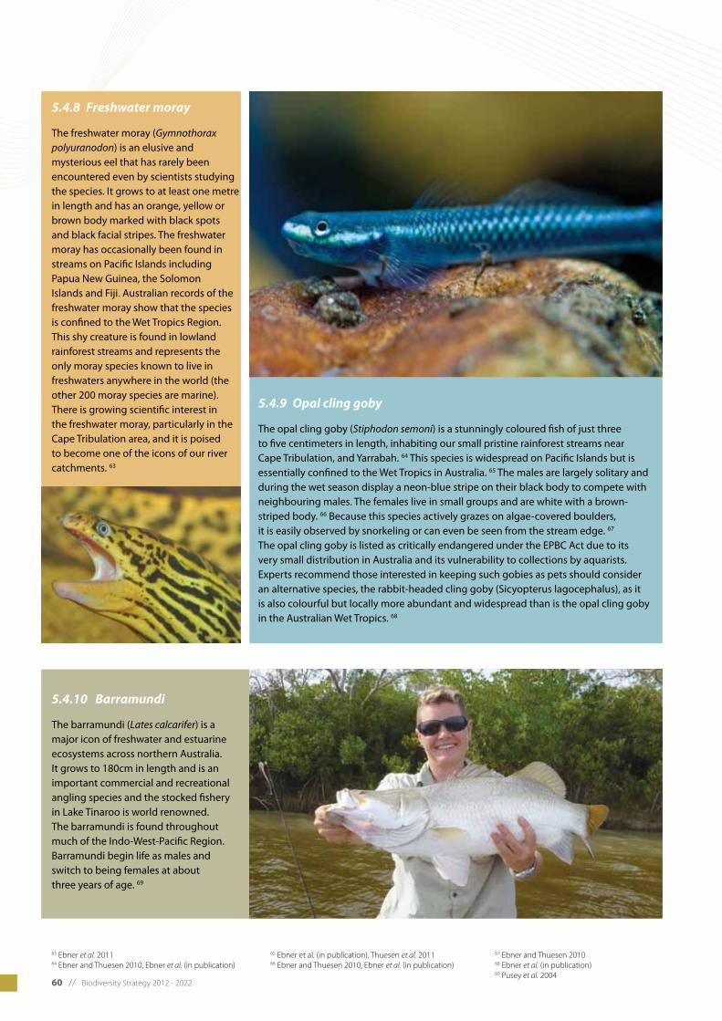
60 // Biodiversity Strategy 2012 - 2022
5.4.8 Freshwater moray
The freshwater moray (Gymnothorax polyuranodon) is an elusive and mysterious eel that has rarely been encountered even by scientists studying the species. It grows to at least one metre in length and has an orange, yellow or brown body marked with black spots and black facial stripes. The freshwater moray has occasionally been found in streams on Pacific Islands including Papua New Guinea, the Solomon Islands and Fiji. Australian records of the freshwater moray show that the species is confined to the Wet Tropics Region. This shy creature is found in lowland rainforest streams and represents the only moray species known to live in freshwaters anywhere in the world (the other 200 moray species are marine). There is growing scientific interest in the freshwater moray, particularly in the Cape Tribulation area, and it is poised to become one of the icons of our river catchments. 63
5.4.10 Barramundi
The barramundi (Lates calcarifer) is a major icon of freshwater and estuarine ecosystems across northern Australia. It grows to 180cm in length and is an important commercial and recreational angling species and the stocked fishery in Lake Tinaroo is world renowned. The barramundi is found throughout much of the Indo-West-Pacific Region. Barramundi begin life as males and switch to being females at about three years of age. 69
63 Ebner et al. 2011 64 Ebner and Thuesen 2010, Ebner et al. (in publication)
65 Ebner et al. (in publication), Thuesen et al. 201166 Ebner and Thuesen 2010, Ebner et al. (in publication)
67 Ebner and Thuesen 2010 68 Ebner et al. (in publication)69 Pusey et al. 2004
5.4.9 Opal cling goby
The opal cling goby (Stiphodon semoni) is a stunningly coloured fish of just three to five centimeters in length, inhabiting our small pristine rainforest streams near Cape Tribulation, and Yarrabah. 64 This species is widespread on Pacific Islands but is essentially confined to the Wet Tropics in Australia. 65 The males are largely solitary and during the wet season display a neon-blue stripe on their black body to compete with neighbouring males. The females live in small groups and are white with a brown-striped body. 66 Because this species actively grazes on algae-covered boulders, it is easily observed by snorkeling or can even be seen from the stream edge. 67 The opal cling goby is listed as critically endangered under the EPBC Act due to its very small distribution in Australia and its vulnerability to collections by aquarists. Experts recommend those interested in keeping such gobies as pets should consider an alternative species, the rabbit-headed cling goby (Sicyopterus lagocephalus), as it is also colourful but locally more abundant and widespread than is the opal cling goby in the Australian Wet Tropics. 68

Biodiversity Strategy 2012 - 2022 // 61
5.5 Iconic Flora
5.5.1 Fan palm
The iconic fan palm (Licuala ramsayi var. ramsayi) is a well-known feature of the tropical rainforests of our region, standing out because of its large, fan-like leaves. Fan palms grow to around 10 metres in height and occur between Cooktown and Ingham from sea level to 1100 metres in altitude.
5.5.2 Daintree pine
The primitive Daintree pine (Gymnostoma australianum) is a pine-like tree which is the only remaining Gymnostoma species in Australia. The genus was once widespread throughout Gondwana, and its relatives are still found in parts of the Pacific region and south-east Asia. Fossil records of this plant can be traced back 50 million years. 70
The Daintree pine is endemic to north east Queensland and is restricted to Thornton Peak and the surrounding area. It has an altitudinal range from near sea level to 1350 metres in altitude, and is so restricted initsdistributionthatcanbedifficult to find. 71
70 Department of Environment and Resource Management 2011b71 Beasley 2006
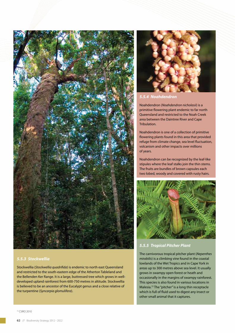
62 // Biodiversity Strategy 2012 - 2022
5.5.5 Tropical Pitcher Plant
The carnivorous tropical pitcher plant (Nepenthes mirabilis) is a climbing vine found in the coastal lowlands of the Wet Tropics and in Cape York in areas up to 300 metres above sea level. It usually grows in swampy open forest or heath and occasionally in the margins of swampy rainforest. This species is also found in various locations in Malesia.72 The “pitcher” is a long thin receptacle which is full of fluid used to digest any insect or other small animal that it captures.
5.5.4 Noahdendron
Noahdendron (Noahdendron nicholasii) is a primitive flowering plant endemic to far north Queensland and restricted to the Noah Creek area between the Daintree River and Cape Tribulation.
Noahdendron is one of a collection of primitive flowering plants found in this area that provided refuge from climate change, sea level fluctuation, volcanism and other impacts over millions of years.
Noahdendron can be recognized by the leaf-like stipules where the leaf stalks join the thin stems. The fruits are bundles of brown capsules each two lobed, woody and covered with rusty hairs.
72 CSIRO 2010
5.5.3 Stockwellia
Stockwellia (Stockwellia quadrifida) is endemic to north east Queensland and restricted to the south-eastern edge of the Atherton Tableland and the Bellenden Ker Range. It is a large, buttressed tree which grows in well-developed upland rainforest from 600-750 metres in altitude. Stockwellia is believed to be an ancestor of the Eucalypt genus and a close relative of the turpentine (Syncarpia glomulifera).
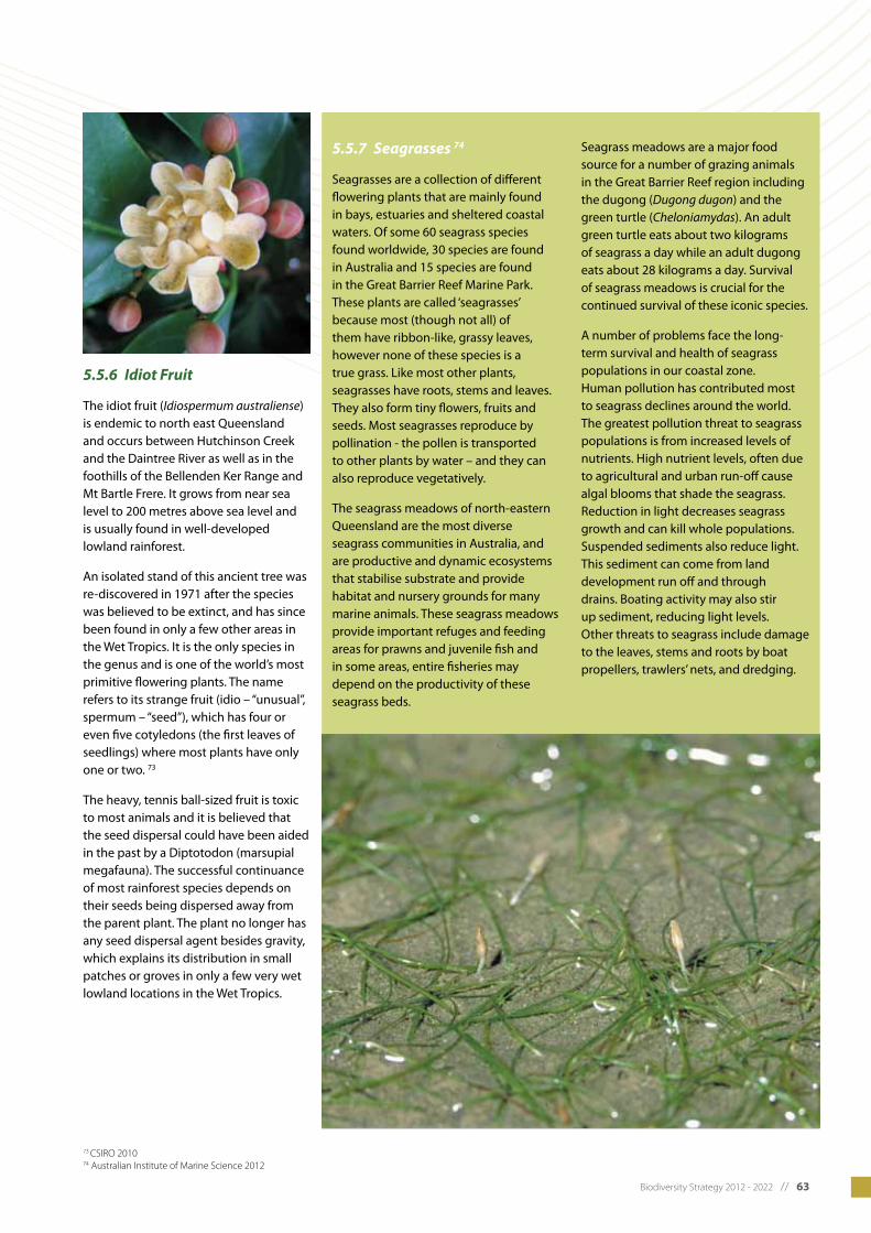
Biodiversity Strategy 2012 - 2022 // 63
5.5.6 Idiot Fruit
The idiot fruit (Idiospermum australiense) is endemic to north east Queensland and occurs between Hutchinson Creek and the Daintree River as well as in the foothills of the Bellenden Ker Range and Mt Bartle Frere. It grows from near sea level to 200 metres above sea level and is usually found in well-developed lowland rainforest.
An isolated stand of this ancient tree was re-discovered in 1971 after the species was believed to be extinct, and has since been found in only a few other areas in the Wet Tropics. It is the only species in the genus and is one of the world’s most primitive flowering plants. The name refers to its strange fruit (idio – “unusual”, spermum – “seed”), which has four or even five cotyledons (the first leaves of seedlings) where most plants have only one or two. 73
The heavy, tennis ball-sized fruit is toxic to most animals and it is believed that the seed dispersal could have been aided in the past by a Diptotodon (marsupial megafauna). The successful continuance of most rainforest species depends on their seeds being dispersed away from the parent plant. The plant no longer has any seed dispersal agent besides gravity, which explains its distribution in small patches or groves in only a few very wet lowland locations in the Wet Tropics.
5.5.7 Seagrasses 74
Seagrasses are a collection of different flowering plants that are mainly found in bays, estuaries and sheltered coastal waters. Of some 60 seagrass species found worldwide, 30 species are found in Australia and 15 species are found in the Great Barrier Reef Marine Park. These plants are called ‘seagrasses’ because most (though not all) of them have ribbon-like, grassy leaves, however none of these species is a true grass. Like most other plants, seagrasses have roots, stems and leaves. They also form tiny flowers, fruits and seeds. Most seagrasses reproduce by pollination - the pollen is transported to other plants by water – and they can also reproduce vegetatively.
The seagrass meadows of north-eastern Queensland are the most diverse seagrass communities in Australia, and are productive and dynamic ecosystems that stabilise substrate and provide habitat and nursery grounds for many marine animals. These seagrass meadows provide important refuges and feeding areas for prawns and juvenile fish and in some areas, entire fisheries may depend on the productivity of these seagrass beds.
Seagrass meadows are a major food source for a number of grazing animals in the Great Barrier Reef region including the dugong (Dugong dugon) and the green turtle (Cheloniamydas). An adult green turtle eats about two kilograms of seagrass a day while an adult dugong eats about 28 kilograms a day. Survival of seagrass meadows is crucial for the continued survival of these iconic species.
A number of problems face the long-term survival and health of seagrass populations in our coastal zone. Human pollution has contributed most to seagrass declines around the world. The greatest pollution threat to seagrass populations is from increased levels of nutrients. High nutrient levels, often due to agricultural and urban run-off cause algal blooms that shade the seagrass. Reduction in light decreases seagrass growth and can kill whole populations. Suspended sediments also reduce light. This sediment can come from land development run off and through drains. Boating activity may also stir up sediment, reducing light levels. Other threats to seagrass include damage to the leaves, stems and roots by boat propellers, trawlers’ nets, and dredging.
73 CSIRO 201074 Australian Institute of Marine Science 2012
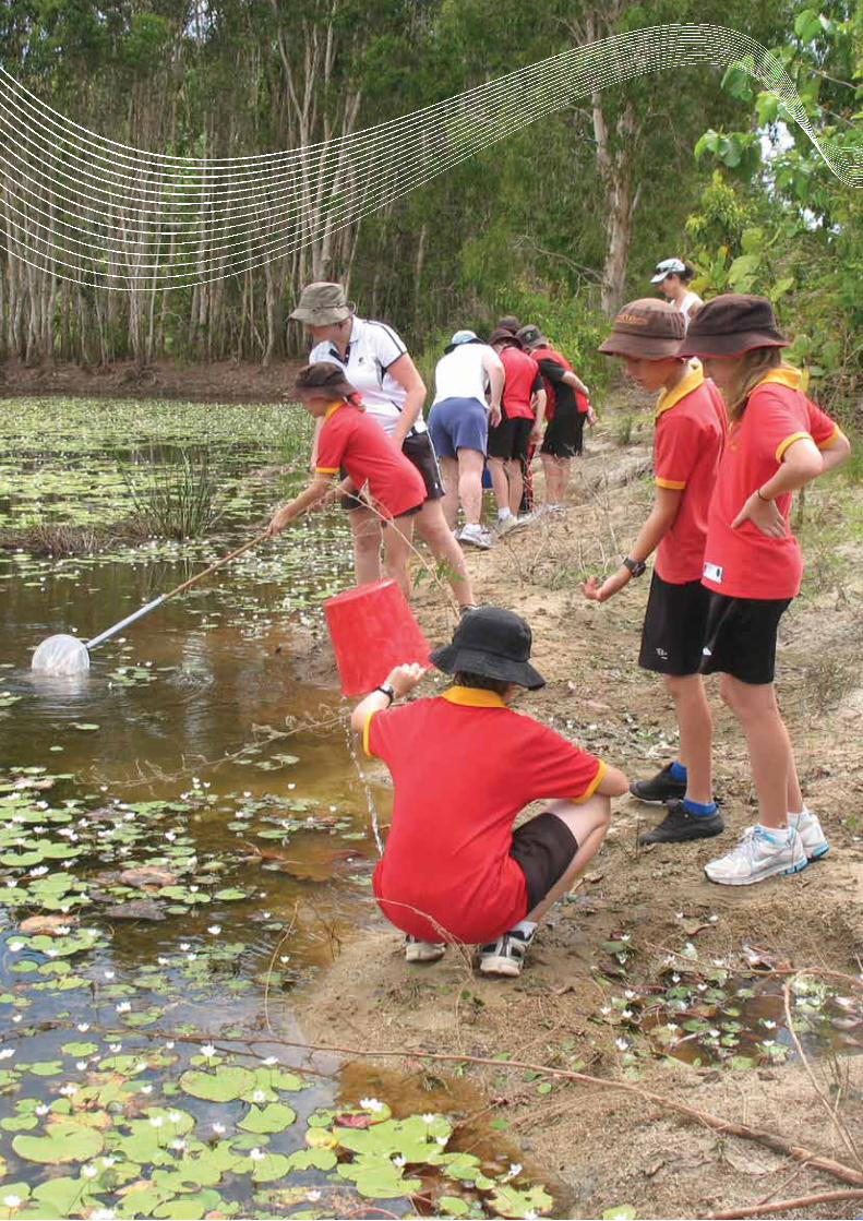
64 // Biodiversity Strategy 2012 - 2022
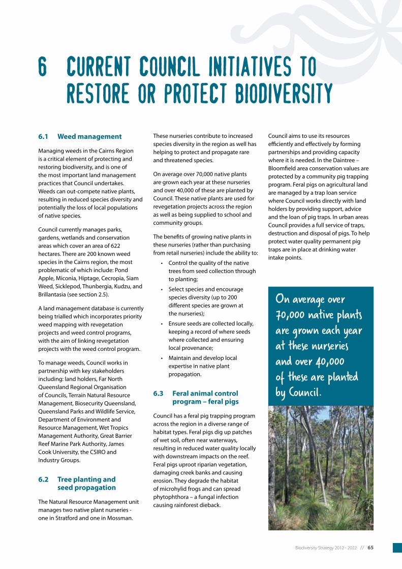
Biodiversity Strategy 2012 - 2022 // 65
6.1 Weed management
Managing weeds in the Cairns Region is a critical element of protecting and restoring biodiversity, and is one of the most important land management practices that Council undertakes. Weeds can out-compete native plants, resulting in reduced species diversity and potentially the loss of local populations of native species.
Council currently manages parks, gardens, wetlands and conservation areas which cover an area of 622 hectares. There are 200 known weed species in the Cairns region, the most problematic of which include: Pond Apple, Miconia, Hiptage, Cecropia, Siam Weed, Sicklepod, Thunbergia, Kudzu, and Brillantasia (see section 2.5).
A land management database is currently being trialled which incorporates priority weed mapping with revegetation projects and weed control programs, with the aim of linking revegetation projects with the weed control program.
To manage weeds, Council works in partnership with key stakeholders including: land holders, Far North Queensland Regional Organisation of Councils, Terrain Natural Resource Management, Biosecurity Queensland, Queensland Parks and Wildlife Service, Department of Environment and Resource Management, Wet Tropics Management Authority, Great Barrier Reef Marine Park Authority, James Cook University, the CSIRO and Industry Groups.
6.2 Tree planting and seed propagation
The Natural Resource Management unit manages two native plant nurseries - one in Stratford and one in Mossman.
These nurseries contribute to increased species diversity in the region as well has helping to protect and propagate rare and threatened species.
On average over 70,000 native plants are grown each year at these nurseries and over 40,000 of these are planted by Council. These native plants are used for revegetation projects across the region as well as being supplied to school and community groups.
The benefits of growing native plants in these nurseries (rather than purchasing from retail nurseries) include the ability to:
• Controlthequalityofthenative trees from seed collection through to planting;
• Selectspeciesandencourage species diversity (up to 200 different species are grown at the nurseries);
• Ensureseedsarecollectedlocally, keeping a record of where seeds where collected and ensuring local provenance;
• Maintainanddeveloplocal expertise in native plant propagation.
6.3 Feral animal control program – feral pigs
Council has a feral pig trapping program across the region in a diverse range of habitat types. Feral pigs dig up patches of wet soil, often near waterways, resulting in reduced water quality locally with downstream impacts on the reef. Feral pigs uproot riparian vegetation, damaging creek banks and causing erosion. They degrade the habitat of microhylid frogs and can spread phytophthora – a fungal infection causing rainforest dieback.
Council aims to use its resources efficientlyandeffectivelybyformingpartnerships and providing capacity where it is needed. In the Daintree – Bloomfield area conservation values are protected by a community pig trapping program. Feral pigs on agricultural land are managed by a trap loan service where Council works directly with land holders by providing support, advice and the loan of pig traps. In urban areas Council provides a full service of traps, destruction and disposal of pigs. To help protect water quality permanent pig traps are in place at drinking water intake points.
On average over 70,000 native plants are grown each year at these nurseries and over 40,000 of these are planted by Council.
6 Current Council Initiatives to restore or protect biodiversity
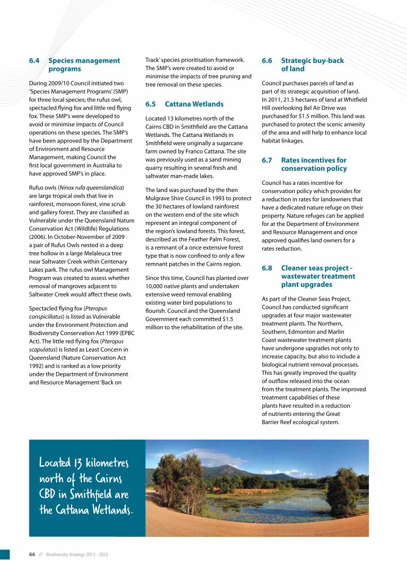
66 // Biodiversity Strategy 2012 - 2022
6.4 Species management programs
During2009/10Councilinitiatedtwo‘Species Management Programs’ (SMP) for three local species; the rufus owl, spectacled flying fox and little red flying fox. These SMP’s were developed to avoid or minimise impacts of Council operations on these species. The SMP’s have been approved by the Department of Environment and Resource Management, making Council the first local government in Australia to have approved SMP’s in place.
Rufus owls (Ninox rufa queenslandica) are large tropical owls that live in rainforest, monsoon forest, vine scrub and gallery forest. They are classified as Vulnerable under the Queensland Nature Conservation Act (Wildlife) Regulations (2006). In October-November of 2009 a pair of Rufus Owls nested in a deep tree hollow in a large Melaleuca tree near Saltwater Creek within Centenary Lakes park. The rufus owl Management Program was created to assess whether removal of mangroves adjacent to Saltwater Creek would affect these owls.
Spectacled flying fox (Pteropus conspicillatus) is listed as Vulnerable under the Environment Protection and Biodiversity Conservation Act 1999 (EPBC Act). The little red flying fox (Pteropus scapulatus) is listed as Least Concern in Queensland (Nature Conservation Act 1992) and is ranked as a low priority under the Department of Environment and Resource Management ‘Back on
Track’ species prioritisation framework. The SMP’s were created to avoid or minimise the impacts of tree pruning and tree removal on these species.
6.5 Cattana Wetlands
Located 13 kilometres north of the Cairns CBD in Smithfield are the Cattana Wetlands. The Cattana Wetlands in Smithfield were originally a sugarcane farm owned by Franco Cattana. The site was previously used as a sand mining quarry resulting in several fresh and saltwater man-made lakes.
The land was purchased by the then Mulgrave Shire Council in 1993 to protect the 30 hectares of lowland rainforest on the western end of the site which represent an integral component of the region’s lowland forests. This forest, described as the Feather Palm Forest, is a remnant of a once extensive forest type that is now confined to only a few remnant patches in the Cairns region.
Since this time, Council has planted over 10,000 native plants and undertaken extensive weed removal enabling existing water bird populations to flourish. Council and the Queensland Government each committed $1.5 million to the rehabilitation of the site.
6.6 Strategic buy-back of land
Council purchases parcels of land as part of its strategic acquisition of land. In 2011, 21.5 hectares of land at Whitfield Hill overlooking Bel Air Drive was purchased for $1.5 million. This land was purchased to protect the scenic amenity of the area and will help to enhance local habitat linkages.
6.7 Rates incentives for conservation policy
Council has a rates incentive for conservation policy which provides for a reduction in rates for landowners that have a dedicated nature refuge on their property. Nature refuges can be applied for at the Department of Environment and Resource Management and once approved qualifies land owners for a rates reduction.
6.8 Cleaner seas project - wastewater treatment plant upgrades
As part of the Cleaner Seas Project, Council has conducted significant upgrades at four major wastewater treatment plants. The Northern, Southern, Edmonton and Marlin Coast wastewater treatment plants have undergone upgrades not only to increase capacity, but also to include a biological nutrient removal processes. This has greatly improved the quality of outflow released into the ocean from the treatment plants. The improved treatment capabilities of these plants have resulted in a reduction of nutrients entering the Great Barrier Reef ecological system.
Located 13 kilometres north of the Cairns CBD in Smithfield are the Cattana Wetlands.
Biodiversity Strategy 2012 - 2022 // 67
7 Additional mapping
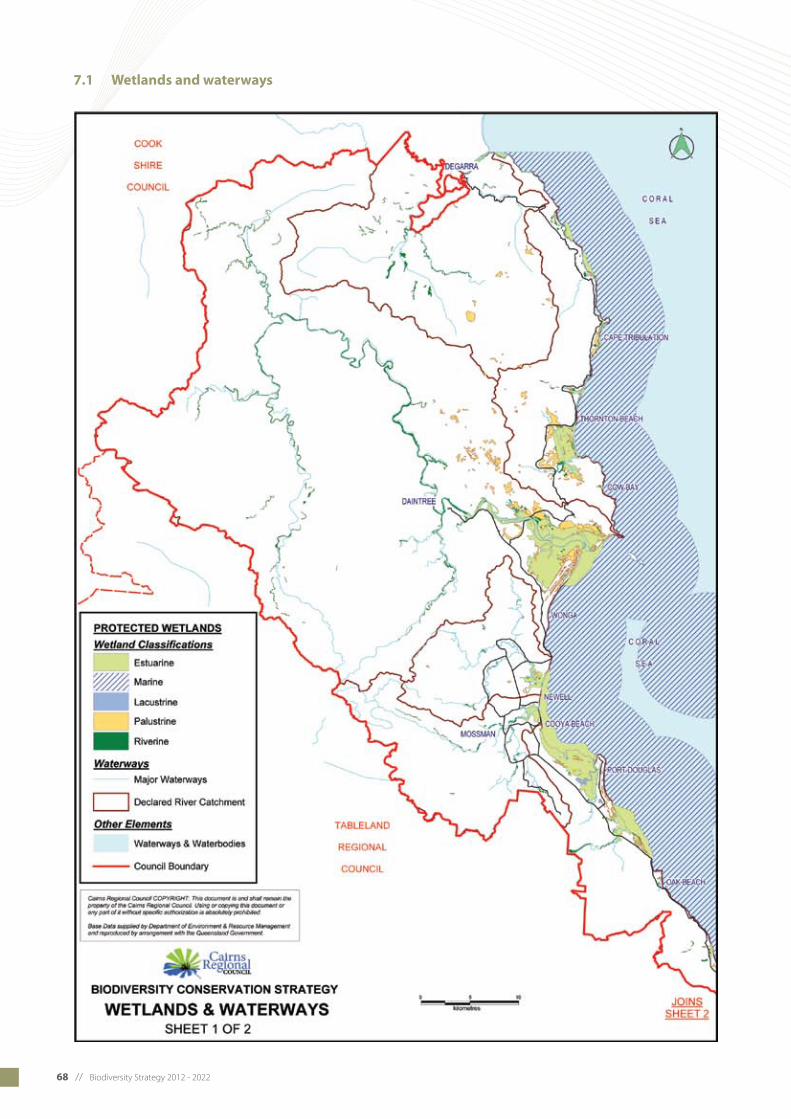
68 // Biodiversity Strategy 2012 - 2022
7.1 Wetlands and waterways

Biodiversity Strategy 2012 - 2022 // 69

70 // Biodiversity Strategy 2012 - 2022
7.2 Protected areas
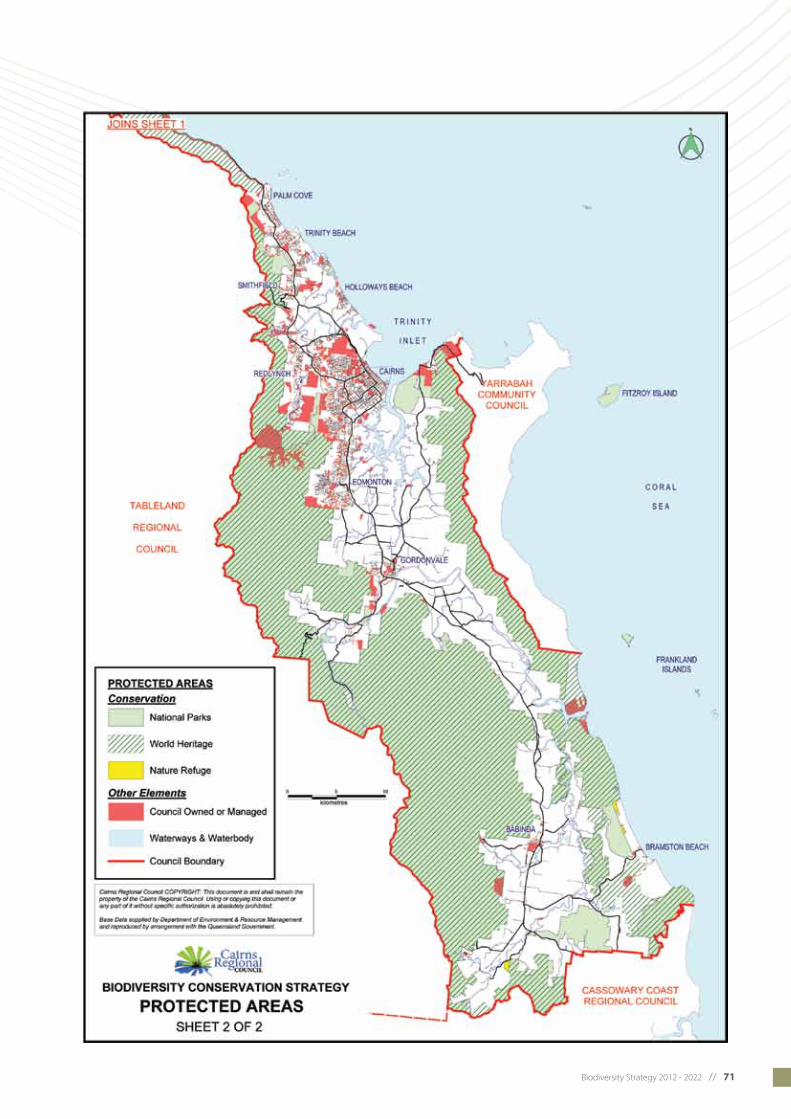
Biodiversity Strategy 2012 - 2022 // 71

72 // Biodiversity Strategy 2012 - 2022
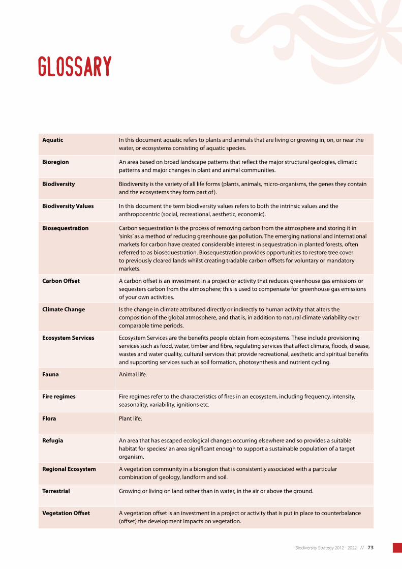
Biodiversity Strategy 2012 - 2022 // 73
Aquatic In this document aquatic refers to plants and animals that are living or growing in, on, or near the water, or ecosystems consisting of aquatic species.
Bioregion An area based on broad landscape patterns that reflect the major structural geologies, climatic patterns and major changes in plant and animal communities.
Biodiversity Biodiversity is the variety of all life forms (plants, animals, micro-organisms, the genes they contain and the ecosystems they form part of ).
Biodiversity Values In this document the term biodiversity values refers to both the intrinsic values and the anthropocentric (social, recreational, aesthetic, economic).
Biosequestration Carbon sequestration is the process of removing carbon from the atmosphere and storing it in ‘sinks’ as a method of reducing greenhouse gas pollution. The emerging national and international markets for carbon have created considerable interest in sequestration in planted forests, often referred to as biosequestration. Biosequestration provides opportunities to restore tree cover to previously cleared lands whilst creating tradable carbon offsets for voluntary or mandatory markets.
Carbon Offset A carbon offset is an investment in a project or activity that reduces greenhouse gas emissions or sequesters carbon from the atmosphere; this is used to compensate for greenhouse gas emissions of your own activities.
Climate Change Is the change in climate attributed directly or indirectly to human activity that alters the composition of the global atmosphere, and that is, in addition to natural climate variability over comparable time periods.
Ecosystem Services Ecosystem Services are the benefits people obtain from ecosystems. These include provisioning services such as food, water, timber and fibre, regulating services that affect climate, floods, disease, wastes and water quality, cultural services that provide recreational, aesthetic and spiritual benefits and supporting services such as soil formation, photosynthesis and nutrient cycling.
Fauna Animal life.
Fire regimes Fire regimes refer to the characteristics of fires in an ecosystem, including frequency, intensity, seasonality, variability, ignitions etc.
Flora Plant life.
Refugia An area that has escaped ecological changes occurring elsewhere and so provides a suitable habitatforspecies/anareasignificantenoughtosupportasustainablepopulationofatargetorganism.
Regional Ecosystem A vegetation community in a bioregion that is consistently associated with a particular combination of geology, landform and soil.
Terrestrial Growing or living on land rather than in water, in the air or above the ground.
Vegetation Offset A vegetation offset is an investment in a project or activity that is put in place to counterbalance (offset) the development impacts on vegetation.
glossary
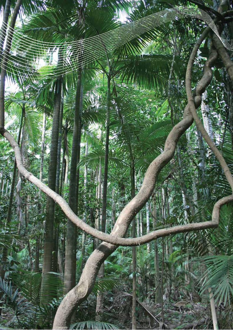
74 // Biodiversity Strategy 2012 - 2022
Biodiversity Strategy 2012 - 2022 // 75
References
Allen, G., Midgley, S. and Allen, M. (2002) Field Guide to the Freshwater Fishes of Australia. Perth: Western Australian Museum.
Australian Bureau of Statistics (2012) Regional Population Growth, Australia - Estimated Resident Population data for the Cairns Local Government Area. Released 30 March 2012.
Australian Government (2011) Threatened Species Ecosystems Unit Fact Sheet, The Southern cassowary, Queensland Parks and Wildlife Service, Brisbane.
Australian Institute of Marine Science (2012) Seagrasses. Retrieved 15 March 2012 from AIMS website: http://www.aims.gov.au/docs/projectnet/seagrasses.html.
Australian State of the Environment Committee (2001) Australia State of the Environment 2001.,Independent Report to the Commonwealth Minister for the Environment and Heritage, CSIROPublished on behalf of the Department of the Environment and Heritage, Canberra.
Crimp, S., Balston, J., Ash, A., Anderson-Berry, L., Done, T., Greiner, R.,Hilbert, D. Howden, M., Jones, R., Stokes, C., Stoeckl, N., Sutherst, B. and Whetton, P. (2004) Climate change in the Cairns and Great Barrier Reef region : scope and focus for an integrated assessment. TechnicalReport.AustralianGreenhouseOffice,Canberra.
Beasley, J. (2006) Plants of Tropical North Queensland – the Compact Guide. Footloose Productions.
Bureau of Meteorology (2001) Queensland site sets Australian rainfall record, Media Release (5 January 2001).
Cairns Regional Council (2010) State of the Environment Report 2009-2010.
CSIRO (2010) Australian Tropical Rainforest Plants Online Database Version 6.1
Davis, S., Heywood, V. and Hamilton, A. (Eds) (1995) Centres of Plant Diversity: A Guide and Strategy for their Conservation. Volume 2. Asia, Australasia and the Pacific. The World Wildlife Fund (WWF) and The World Conservation Union (IUCN). IUCN Publications Unit, Cambridge.
Department of Infrastructure and Planning (2009) Far North Queensland Regional Plan 2009-2031: planning for a stronger, more liveable and sustainable community. Department of Infrastructure and Planning, Brisbane.
Department of Environment and Resource Management (2010) Protected Areas for the Future: Cornerstones for Terrestrial Biodiversity Conservation.
Department of Environment and Resource Management (2011a) Wooroonooran National Park: Nature Culture and History. Retrieved 16 February 2012 from DERM website: http://www.derm.qld.gov.au/parks/bartle-frere/culture.html.
Department of Environment and Resource Management (2011b) Cape Tribulation, Daintree National Park: Nature Culture and History. Retrieved 23 February 2012 from DERM website: http://www.derm.qld.gov.au/parks/daintree-cape-tribulation/culture.html.
Department of Sustainability, Environment, Water, Population and Communities. Species Profile and Threats Database. Accessed 24 February 2012 http://www.environment.gov.au/sprat.
Dukes, J. (2003). Hotter and weedier? Effects of climate change on the success of invasive species. In Global Climate Change and Biodiversity, (Eds) Green, R., Harley, M., Miles, L., Scharlemann, J., Watkinson, A. and Watts, O. Tyndall Centre for Climate Change Research.

76 // Biodiversity Strategy 2012 - 2022
Dunlop, M. and Brown, P. (2008) Implications of climate change for Australia’s National Reserve System: a preliminary assessment. Department of Climate Change, Commonwealth of Australia, Canberra.
Ebner, B. and Thuesen, P. (2010) Discovery of stream-cling-goby assemblages (Stiphodon species) in the Australian Wet Tropics. Australian Journal of Zoology 58, 331–340.
Ebner, B., Kroll, B., Godfrey, P., Thuesen, P., Vallance, T., Pusey, B., Allen, G., Rayner, T. and Perna, C. (2011) Is the elusive Gymnothorax polyuranodon really a freshwater moray? Journal of Fish Biology 79: 70–79
Ebner, B., Thuesen, P., Larson, H. Keith, P. (Accepted) Partially known range and precautionary conservation requirements of sicydiine gobies in Australia. Cybium.
Garnett, S. and Crowley, G. (2000) The Action Plan for Australian Birds 2000. Environment Australia, Canberra.
Gillespie Economics (2008) Economic Activity of Australia’s World Heritage Areas. Report to the Department of the Environment, Water, Heritage and the Arts.
Goosem, S. (1992) cassowary Report, Mission Beach Area, North Queensland. Report to Queensland Department of Environment and Heritage, Cairns.
Goosem, S. (2002) Update of Original Wet Tropics of Queensland Nomination Dossier. Wet Tropics Management Authority, Cairns.
Goosem, M. and Turton, S. (2006) CRC Research Report, Weed Incursions along roads and powerlines in the Wet Tropics World Heritage Area. The Potential of remote sensing as an indicator of the weed infestations. Rainforest CRC, School of Tropical Environment Studies and Geography, James Cook University, Cairns.
Great Barrier Reef Marine Park Authority (2010) Biodiversity Strategy Information Sheet. Retrieved 22 March 2012 from http://www.gbrmpa.gov.au/about-the-reef/biodiversity.
Hilbert, D., Ostendorf, B. & Hopkins, M. (2001) Sensitivity of tropical forests to climate change in the humid tropics of north Queensland. Austral Ecology 26: 590-603.
Hilbert, D., Bradford M., Parker T. and Westcott D. (2004) Golden bowerbird (Prionodura newtonia) habitat in past, present and future climates: predicted extinction of a vertebrate in tropical highlands due to global warming. Biological Conservation 116(3): 367-377.
Hopkins, M., Ash, J., Graham, A., Head, J. and Hewett, R. (1993) Charcoal evidence of the spatial extent of the Eucalyptus woodland expansions and rainforest contractions in north Queensland during the late Pleistocene. Journal of Biogeography 20: 357-372.
Kanowski, J. (2001) Effects of elevated CO2 on the foliar chemistry of seedlings of two rainforest trees from north-east Australia: implications for folivorous marsupials. Austral Ecology 26: 165-172.
Kemp, J., Lovatt, R., Bahr, J., Kahler, C. and Appelman, C. (2007) An evaluation of vegetation loss through clearing on the coastal lowlands of the Wet Tropics revealed several near extinct vegetation communities and regional ecosystems, and many others that are drastically reduced in area. Cunninghamia 102: 285-329.
Krockenberger, A. (2002) A tropical rainforest possum that can’t take the heat. Paper presented to Ecology 2002: the 2nd joint meeting of the Ecological Society of Australia Inc. and the New Zealand Ecological Society Inc., 1-6 December 2002, Cairns.
Krockenberger, A., Kitching, R. and Turton, S. (2003) Environmental Crisis: Climate Change and Terrestrial Biodiversity in Queensland. Rainforest CRC, Cairns.
Low, T. (2011) Climate Change and Terrestrial Biodiversity in Queensland. Department of Environment and Resource Management, Queensland Government, Brisbane.
McFadyen, R. (2000) Impacts of exotic weeds on wildlife. Paper presented to the Royal Society of Queensland’s Landscape in Queensland Symposium, November 17 2000, Indooroopilly.
Metcalfe, D. and Ford, A. (2008) Floristic biodiversity in the Wet Tropics. Chapter 7 in Living in a Dynamic Tropical Forest Landscape, (Eds) N. Stork & S. Turton, Blackwell, Oxford, 123-132.
Metcalfe, D. and Ford, A. (2009) A re-evaluation of Queensland’s Wet Tropics based on primitive plants. Pacific Conservation Biology 15: 80-86.

Biodiversity Strategy 2012 - 2022 // 77
North Queensland Threatened Frogs Recovery Team (2001) Recovery plan for the stream-dwelling rainforest frogs of the Wet Tropics biogeographic region of north-east Queensland 2000-2004. Report to Environment Australia, Canberra. Queensland Parks and Wildlife Service, Brisbane.
Olson, D., Dinerstein, E., Abell, R., Allnutt, T., Carpenter, C., McClenachan, L., D’Amico, J., Hurley, P., Kassem, K., Strand, H., Taye, M. and Thieme, M. (2000) The Global 200: A Representation Approach to Conserving the Earth’s Distinctive Ecoregions. Conservation Science Program, World Wildlife Fund-US.
Pizzey, G. and Knight, F. (1997) Field Guide to the Birds of Australia. Harper Collins Publishers, Australia.
Prideax, B. and Falco-Mammone, F. (2007) Economic Values of Tourism in the Wet Tropics World Heritage Area. Cooperative Research Centre for Tropical Rainforest Ecology and Management, James Cook University, Cairns.
Pusey, B., Kennard, M. and Arthington, A. (2004) Freshwater Fishes of Northeastern Australia. CSIRO Publishing, Collingwood.
Queensland Museum (2011) Dugong (Sea Cow). Retrieved 22 March 2012 from the Queensland Museum website: http://www.qm.qld.gov.au/Find+out+about/Animals+of+Queensland/Mammals/Queenslands+vanishing+wildlife/Dugong+Sea+Cow.
Root, T., Price, J., Hall, K., Schneider, S., Rosenzeig, C. & Pounds, J. (2003) Fingerprints of global warming on wild animals and plants. Nature 421: 57-60.
Short, A. and Woodroffe, C. (2009) The Coast of Australia. Cambridge University Press, Melbourne, 288pp.
Still, C., Foster, N. and Schneider, S. (1999) Stimulating the effects of climate change on tropical montane cloud forests. Nature 398: 608-610.
Suppiah, R. Macadam, I. and Whetton, P. (2007) Climate Change Projections for the Tropical Rainforest Region of North Queensland. Unpublished report to the Marine and Tropical Sciences Research Facility. Reef and Rainforest Research Centre Limited, Cairns, 38pp.
Suppiah, R., Watterson, I.G., Macadam, I., Collier, M.A. and Bathols, J. (2010) Climate Change Projections for the Tropical Rainforest Region of North Queensland. Final Report on MTSRF Activities, 2006-2010. Report prepared for the Marine and Tropical Sciences Research Facility (MTSRF) Research Report Series, published by the Reef & Rainforest Research Centre Ltd, Cairns, 81pp.
Thuesen P., Ebner, B., Larson, H., Keith, P., Silcock, R., Prince, J. and Russell, D. (2011) Amphidromy underpins a newly discovered insular continental fish community in the West-Pacific. PLOS one Open access.
Tree Kangaroo Mammal Group (2004) Tree Kangaroo Info. Retrieved 15 April 2012 from the Tree Kangaroo Mammal Group website: http://www.tree-kangaroo.net/tkInfo.html.
Westcott, D., Bentrupperbäumer, J., Bradford, M. and McKeown, A. (2005) Incorporating patterns of disperser behaviour into models of seed dispersal and its effects on estimated dispersal curves. Oecologia 146: 57-67.
Weston, N. and Goosem, S. (2004) Sustaining the Wet Tropics: A Regional Plan for Natural Resources Management, Volume 2A Condition Report: Biodiversity Conservation. Rainforest CRC and FNQ NRM Ltd, Cairns, 211pp.
Wet Tropics Management Authority (2004) Wet Tropics Conservation Strategy: the conservation, rehabilitation and transmission to future generations of the Wet Tropics World Heritage Area. WTMA, Cairns, 108pp.
Wet Tropics Management Authority (2009) Annual Report and State of the Wet Tropics Report 2008-2009. Wet Tropics Management Authority, Cairns.
Williams, A., Karoly, D. and Tapper, N. (2001) The sensitivity of Australian fire danger to climate change. Climatic change 49: 171-91.
Williams, E., Bolitho, E., and Fox, S. (2003) Climate change in Australian tropical rainforests: an impending environmental catastrophe, Proceedings of the Royal Society B 270: 1887–1892.
Williams, S. (2007) Likely ecological impacts of global warming and climate change on the Wet Tropics World Heritage Area. Report prepared for an objections hearing in the Queensland Land and Resources Tribunal.
Williams, R., Bradstock, R., Cary, G., Enright, N., Gill, A., Liedloff, A., Lucas, C., Whelan, R., Anderson, A., Bowman, D., Clarke, P., Cook, G., Hennessy K. and York, A. (2009) Interactions between climate change, fire regimes and biodiversity in Australia – A Preliminary Assessment. Report to the Department of Climate Change and Department of Environment, Water Heritage and the Arts, Canberra, 196pp.

78 // Biodiversity Strategy 2012 - 2022
Biodiversity Strategy 2012 - 2022 // 79
PHOTO CREDITS
Front cover: Tropical rainforest, photographer Colyn Huber, Lovegreen Photography. Inset images on front cover: Lesser swamp-orchid (Phaius australis), photographer Bob Jago; Southern Cassowary, photographer Martin Cohen; Wild About Australia.; Feather star (Himerometra robustipinna) on coral, Commonwealth of Australia (GBRMPA).
Inside cover: Hawkesbill turtle, Commonwealth of Australia (GBRMPA).
Page 4: Mangrove, Commonwealth of Australia (GBRMPA).
Page 5: Above right - Vine palm forest on the Mulgrave River, photographer Campbell Clarke; Below right - White-lipped tree frog, Department of Environment and Resource Management (DERM).
Page 6: Feather star (Himerometra robustipinna) on coral, Commonwealth of Australia (GBRMPA).
Page 7: View towards Cape Tribulation showing the mouth of Myall Creek and fringing reef along the coast, Commonwealth of Australia (GBRMPA).
Page 9: Left - Noah Creek in the Daintree, Wet Tropics Management Authority (WTMA); Above right - Babinda Creek, photographer Campbell Clarke; Below right - Kauri pine (Agathis robusta), photographer Bob Jago.
Page 10: Great Barrier Reef, Commonwealth of Australia (GBRMPA).
Page 12: Golden bowerbird, photographer Mike Trenerry.
Page 14: Little Mulgrave River, photographer Campbell Clarke.
Page 16: Above left - Rainbow lorikeets; Below left - Mangroves on Woody Island at Low Isles, Commonwealth of Australia (GBRMPA).
Page 18: View from Smithfield looking towards the Redlynch Valley and the Barron River, photographer Daryl Jones.
Page 20: Kauri pine log, 1930’s, Cairns Historical Society.
Page 21: Above - Clearing land for farming, Bartle Frere from Babinda c 1915, Cairns Historical Society; Centre - Kuranda Railway timber train from Atherton c1913, Cairns Historical Society; Below - Logs being loaded at Cairns wharf from rail to ship 1930’s, Cairns Historical Society.
Page 23: Above - Abundant flowers of the white oak tree (Grevillea baileyana), photographer Bob Jago; Centre - Broad-leaved cumbungi (Typha orientalis), photographer Bob Jago; Below - Aerial view of offshore reefs, Commonwealth of Australia (GBRMPA).
Page 25: Above - A large Stockwellia tree (Stockwellia quadrifida), photographer Jeremy Little; Centre - Flowers of the Golden penda (Xanthostemon chrysanthus), photographer Bob Jago; Below - The vulnerable ant plant (Myrmecodia beccarii) is a tuberous epiphyte which houses a species of ant in its swollen stems in a symbiotic relationship, photographer Bob Jago.
Page 27: Above - Bennetts tree kangaroo, (Mungumby Lodge); Centre - Leichhardt tree (Nauclea orientalis), photographer Bob Jago; Below - Mistletoe (Amyema quaternifolia), photographer Bob Jago.
Page 30: White-lipped tree frog, Department of Environment and Resource Management (DERM).
Page 32: Above left - Hanging walkway over Mossman Gorge; Below left - Wax flower or common hoya (Hoya australis), photographer Bob Jago.
Page 33: Above right - View over Craiglie (south of Port Douglas) looking north, photographer Daryl Jones; Below right - View from Babinda Creek, photographer Craig Harriss.
Page 34: Babinda Creek, photographer Campbell Clarke.
Page 35: Palm Forest Swamp along the Mulgrave River, photographer Campbell Clarke.
Page 40: Nudibranch (Chromodoris magnifica), Commonwealth of Australia (GBRMPA).
Page 41: Mangrove roots provide shelter for many species, Commonwealth of Australia (GBRMPA).
Page 43: View over Craiglie (south of Port Douglas) looking north, photographer Daryl Jones.
Page 44: View over Port Douglas, photographer Daryl Jones.
Page 45: Above - Tropical pitcher plant (Nepenthes mirabilis), photographer Bob Jago; Below - Butress roots of a Stockwellia tree (Stockwellia quadrifida), photographer Jeremy Little.
Page 46: Above - Green turtle hatchling, Commonwealth of Australia (GBRMPA); Centre - Booroogum or pleated ginger (Alpinia arctiflora), photographer Bob Jago; Below - Woodland with grass trees, photographer Campbell Clarke.
Page 51: Above - Cadaga tree (Corymbia torelliana) in flower, photographer Bob Jago; Centre - Corals; Below - Flowers of Idiospermum australiense, photographer Bob Jago.
Page 52: Little Mulgrave River, photographer Campbell Clarke.
Page 53: Aerial view of offshore reefs, Commonwealth of Australia (GBRMPA).
Page 54: Above - Littoral rainforest at Emmagen Creek, Daintree; Below - Great Barrier Reef, Commonwealth of Australia (GBRMPA).
Page 55: Left - Noah Creek in the Daintree, Wet Tropics Management Authority (WTMA); Right - Branches of Leptospermum wooroonooran, photographer Maree Grenfell.
Page 56: Southern cassowary with two chicks, photographer David Cook.
Page 57: Above - Lumholtz’s tree-kangaroo, photographer Martin Cohen, Wild About Australia; Below - Spotted-tailed quoll, DERM.
Page 58: Above - Golden bowerbird, photographer Mike Trenerry; Below - Beach stone-curlew, Commonwealth of Australia (GBRMPA).
Page 59: Below left - Dugong (Dugong dugon), Commonwealth of Australia (GBRMPA); Above right - Waterfall Frog (Litoria nannotis), photographer Martin Cohen, Wild About Australia.
Page 60: Above - Opal cling goby, photographer Brendan Ebner, CSIRO and TropWATER; Centre - Freshwater Moray, photographer Brendan Ebner, CSIRO and TropWATER; Below: Angler Tina Lawson with a freshly caught barramundi, photographer Michael Coob.
Page 61: Above - Fan palm (Licuala ramsayi var. ramsayi); Below - Flower of the Gymnostoma, photographer Bob Jago.
Page 62: Left - A large Stockwellia tree (Stockwellia quadrifida), photographer Jeremy Little; Above right - Flower of the Noahdendron, photographer Bob Jago; Below right - Tropical pitcher plant, photographer Bob Jago.
Page 63: Above left - Flowers of Idiospermum australiense, photographer Bob Jago; Below - Seagrass (Halodule uninervis - narrow leaf morph) with male flowers, Commonwealth of Australia (GBRMPA).
Page 64: School students help at Cattana wetlands.
Page 65: Woodland with grass trees, photographer Campbell Clarke.
Page 66: Cattana wetlands, Cairns Regional Council.
Page 67: Fruit of the small-leaved lilly pilly (Syzygium luehmannii), photographer Bob Jago.
Page 72: Gorgonian coral, Commonwealth of Australia (GBRMPA).
Page 74: Vine palm forest on the Mulgrave River, photographer Campbell Clarke.
Page 79: Southern Cassowary, photographer Martin Cohen, Wild About Australia.
Back cover: Main image - Great Barrier Reef, Commonwealth of Australia (GBRMPA); Inset images left to right - Woodland with grass trees, photographer Campbell Clarke; Golden bowerbird, photographer MikeTrenerry; Little Mulgrave River, photographer Campbell Clarke; Goat’s-foot Convolvulus (Ipomoea pes-caprae subsp. brasiliensis) Commonwealth of Australia (GBRMPA).

Phone: 4044 3044 (Cairns) | 4099 9444 (Mossman) 1800 070 444 (STD Callers) | www.cairns.qld.gov.au