biological environment - · pdf filebiological environment ... the bsa comprises the...
TRANSCRIPT

Chapter 2 Affected Environment, Environmental Consequences, and Avoidance, Minimization, and/or Mitigation Measures
State Route 74 Lower Ortega Highway Widening 221
BIOLOGICAL ENVIRONMENT
The analysis of potential impacts of the proposed Lower SR-74 Widening project on biological resources is based on the Natural Environment Study (NES) (EA 086900) (June 2007) and the NES Supplement (August 2008) (EA 086920). The NES and NES Supplement are on file and available for review at the Department District 12 offices. The NES was prepared with input from resource agencies including the ACOE, CDFG, the National Marine Fisheries Service (NMFS), and USFWS. Additional information was obtained from the: Joint Programmatic Environmental Impact Report/Environmental Impact Statement (EIR/EIS) and Draft Implementation Agreement (IA) for the Southern Subregion Natural Community Conservation Plan/Master Streambed Alteration Agreement/Habitat Conservation Plan (Southern Subregion NCCP/MSAA/HCP) (County of Orange, July 2006), the Final EIS, San Juan Creek and Western San Mateo Creek Watershed Special Area Management Plan (SAMP) (ACOE, January 2007), Addendum No. 1 (PA06-0023) for Final EIR No. 589 The Ranch Plan Planning Area 1 (BonTerra Consulting, May 2006), and the Final EIR No. 589 General Plan Amendment/Zone Change (PA 01-114) for The Ranch Plan (Certified Draft EIR Orders and Approvals, Technical Appendices, Comments and Responses [SCH No. 2003021141]) (County of Orange, November 2004).
Project Coordination
From January 2001 to May 2006, the Department coordinated with the resource agencies. A history of coordination, events, and survey findings is contained within Appendix F to the NES. During coordination, it was determined that the Department will apply for and obtain resource agency permits for the proposed project. The Department will review these resource agency permits for impacts and conditions associated with SR-74 itself. The Department will assume responsibility for mitigation and monitoring commitments for any impacts to biological resources associated with the proposed project, including mitigation required pursuant to CEQA as well as any additional measures required by the resource agencies during the permitting process. Mitigation for impacts to biological resources will be implemented by the Department. No mitigation will be planted within the state right-of-way to account for impacts to biological resources.

Chapter 2 Affected Environment, Environmental Consequences, and Avoidance, Minimization, and/or Mitigation Measures
State Route 74 Lower Ortega Highway Widening 222
Biological Study Area and Context
The City portion of the project is referred to as the “proposed project,” the “project area,” or the “Biological Study Area” (BSA). The BSA contains the disturbance limits for the proposed project, including such activities as cut, fill, and grading. For purposes of this environmental document, only the areas within the Project Limits from Calle Entradero to the City/County limits are analyzed. The BSA is located in the City of San Juan Capistrano, United States Geological Survey (USGS) San Juan Capistrano, California quadrangle, Sections 6 & 32, Township 7-8 south, and Range 7 west.
The BSA is located just west of the approximately 22,815 ac Ranch Plan project located in unincorporated Orange County. Ladera Ranch is located to the north of the BSA; the Donna O’Neill Land Conservancy is located to the southeast of the BSA; and Caspers Wilderness Park is located to the northeast of the BSA. The topography of the BSA generally slopes down from the north to the south and ranges in elevation from 656 to 1,640 ft. (200 to 500 m). “The Oaks” property (28650 Ortega Highway), a regionally important large equestrian farm owned by Joan Irvine Smith, founder of the Capistrano Valley Conservancy, is located on the southern side of the BSA at the eastern end of the project limits. The Ranch Plan’s Planning Area (PA) 1 is located immediately east of the BSA.
The BSA comprises the disturbance limits and a 25–35 ft buffer. During the April and May 2008 surveys, private properties within the buffer area were assessed visually from within the public right-of-way where feasible, but they were not surveyed on foot. Areas beyond solid walls, fences, or dense vegetation were not assessed.
The BSA includes the existing SR-74 (Department and City right-of-way), low-density residential areas, landscaped areas, and disturbed roadway shoulders. The BSA is surrounded by rural and residential development. Small undeveloped areas occur along the shoulder of the north side of the road where landscaping is not regularly maintained. These areas are highly disturbed and comprised primarily of nonnative and invasive species, including scattered ornamental species, with occasional native species.
The following sections describe applicable regulatory settings, existing environments, impacts, and avoidance, minimization and mitigation measures for these categories of biological resources.

Chapter 2 Affected Environment, Environmental Consequences, and Avoidance, Minimization, and/or Mitigation Measures
State Route 74 Lower Ortega Highway Widening 223
2.3.1 Natural Communities
This section of the document discusses natural communities of concern. This section focuses on biological communities, not on individual plant or animal species. This section also includes information on wildlife corridors and habitat fragmentation. Wildlife corridors are areas of habitat used by wildlife for seasonal or daily migration. Habitat fragmentation involves the potential for dividing sensitive habitat, thereby lessening its biological value.
Habitat areas designated as critical habitat under the Federal Endangered Species Act (FESA) are discussed below under the Threatened and Endangered (T/E) Species section heading. Wetlands and other waters are discussed under the corresponding section heading. Specific plant species and animal species are discussed under the corresponding section headings.
2.3.1.1 Regulatory Setting Laws that are applicable for the protection of natural communities include those listed under Section 2.3.2, Wetlands and Other Waters, and Section 2.3.3, Plant Species.
Natural Communities of Concern This section discusses natural communities and habitat not listed as critical habitat under the FESA and not discussed later in the Wetlands and Other Waters section. Vegetation communities are considered natural communities of concern based on (1) federal, State, or local laws regulating their development; (2) limited distribution; and/or (3) the habitat requirements of special status plants or animals occurring on the site. The CDFG has designated natural communities of concern within California.
Natural Communities Conservation Plans In addition, in an effort to respond to growing concern over the conservation of coastal sage scrub and other biological communities, federal, state, and local agencies have developed a multispecies approach to habitat conservation planning known as the Natural Communities Conservation Planning process. This was made possible by Assembly Bill 2172 (AB 2172), which authorized the CDFG to enter into agreements for the preparation and implementation of Natural Communities Conservation Plans (NCCPs). The USFWS joined in this effort, utilizing both the Section 4(d) Special Rule and the Habitat Conservation Plan (HCP) processes. The NCCP program aims primarily to conserve natural communities at the ecosystem scale while accommodating compatible land use. By focusing on the long-term stability of wildlife and plant communities, and by including key interests in the process, the

Chapter 2 Affected Environment, Environmental Consequences, and Avoidance, Minimization, and/or Mitigation Measures
State Route 74 Lower Ortega Highway Widening 224
program seeks to anticipate and prevent the controversies and gridlock caused by species’ listings.
The County Board of Supervisors certified the FEIR for the MSAA/HCP and approved the HCP in October 2006. This final document sets forth a proposed Conservation Strategy to be implemented by the Department in cooperation with state and federal agencies and participating landowners in southern Orange County. The proposed Conservation Strategy focuses on long-term protection and management of multiple natural communities that provide habitat essential to the survival of a broad array of wildlife and plant species. The plan encompasses 91,000 ac, with 57,000 ac of natural habitat including coastal sage scrub, chaparral, grassland, riparian, and oak woodlands. State-listed species covered by the plan include least Bell’s vireo (Vireo bellii pusillus), southwestern willow flycatcher (Empidonax traillii extimus), and thread-leaved brodiaea (Brodiaea filifolia). The USFWS distributed the Final EIS for public review on November 13, 2006. The IA was signed by the Participating Landowners (the County, RMV, and Santa Margarita Water District) in December 2006. The USFWS signed the IA, approved the HCP, and issued Incidental Take Permits (ITP) to each of the participating landowners on January 10, 2007. The Southern HCP assumes the Ranch Plan development. Coordination with CDFG on the NCCP/MSAA is ongoing.
2.3.1.2 Affected Environment The BSA is highly disturbed and contains primarily landscaped areas of the City (south side) and low-density residential areas (north side). As of January 2007, silt fence is present along areas to the north of SR-74. These improvements to private property appear to have changed the topography and hydrological conditions of the BSA. Differences observed on site during surveys conducted for the 2007 NES and the 2008 NES Supplement include changes in topography (private property yard improvements) and changes to Department mowing practices.
Vegetation in the BSA includes no native plant communities. The BSA is comprised of developed areas (8.29 ac), ornamental vegetation (8.33 ac), ruderal vegetation (2.68 ac), and disturbed wetlands (0.04 ac). The disturbed wetlands (associated with Drainage System [DS] 7) contain some native plant species that may provide habitat value for native wildlife; Section 2.3.2 (Wetlands and Other Waters), below, discusses this further. The ornamental trees and shrubs within the study area may serve as roosting and nesting habitat for raptors and other migratory bird species.

Chapter 2 Affected Environment, Environmental Consequences, and Avoidance, Minimization, and/or Mitigation Measures
State Route 74 Lower Ortega Highway Widening 225
Refer to Section 2.3.4 (Animal Species) for discussion of potential project impacts on migratory bird species.
The NES identified the disturbed wetlands and eight coast live oak (Quercus agrifolia) trees that would be affected by the proposed project; the document states these areas “have limited function and value and occur in very small areas next to the roadway shoulder.” These oaks, located at “The Oaks” property (28650 Ortega Highway), are not considered an oak woodland given that there are less than a dozen trees that may be impacted. The eight oak trees do not occur within CDFG jurisdictional areas; however, the City’s Tree Removal Permit process will be applicable for the removal of any of these trees. A total of 70 trees of various species will be impacted along the north side of the road and 41 trees along the south side of SR-74. Refer to Section 2.3.3 (Plant Species) for a discussion of potential project impacts related to tree removal.
Wildlife currently travels along San Juan Creek, south and east of the BSA, searching for food, water, shelter, and mates. There are no major existing wildlife corridors within the project limits. The NES acknowledges that wildlife may use the small box culverts and corrugated metal pipe culverts that occur within the BSA to cross below SR-74; however, none of these is of sufficient size or suitable configuration (with suitable habitat on either side) to serve as a noteworthy wildlife corridor. San Juan Creek, near the BSA, provides a regional wildlife movement corridor.
2.3.1.3 Environmental Consequences Temporary Impacts No Build Alternative The No Build Alternative does not propose any construction or other disturbance in the project area. Therefore, the No Build Alternative will result in no impacts related to natural communities.
Build Alternatives 1 and 2 The Build Alternatives would not result in the removal of sensitive plant communities because none are found within or immediately adjacent to the project disturbance limits. Impacts to wetlands are discussed in Section 2.3.2 (Wetlands and Other Waters), and impacts to mature trees are discussed in Section 2.3.3 (Plant Species).There would be no temporary impacts to sensitive communities.

Chapter 2 Affected Environment, Environmental Consequences, and Avoidance, Minimization, and/or Mitigation Measures
State Route 74 Lower Ortega Highway Widening 226
Permanent Impacts No Build Alternative The No Build Alternative proposes no construction or other disturbance in the project area. Therefore, the No Build Alternative would not result in impacts related to natural communities.
Build Alternatives 1 and 2 Impacts to wetlands are discussed in Section 2.3.2 and impacts to oak trees are discussed in Section 2.3.3, respectively. Impacts related to invasive species are addressed in Section 2.3.6.
The Build Alternatives would not result in the removal of sensitive plant communities because none are found within or immediately adjacent to the project disturbance limits. Therefore, there would be no permanent impacts to natural communities.
The Build Alternatives would improve an existing transportation facility and would not result in fragmentation of habitat or impacts to wildlife corridors. Culverts that are present in the BSA allow passage of mobile species and may provide marginal habitat. Habitat within the BSA would not be further fragmented by the proposed project since SR-74 is an existing roadway.
This project is consistent with the Orange County Southern Subregion NCCP/MSAA/HCP as discussed above. The NCCP/MSAA/HCP acknowledges the proposed widening of SR-74 within the City; however, covered status is only extended to the portion of SR-74 within the RMV planning area, east of the BSA. The potentially applicable requirements of the NCCP/MSAA/HCP include the policies for New Infrastructure Projects (Section 11.2.5(a) of the NCCP/MSAA/HCP), the New Infrastructure Operation and Maintenance Policies (Section 11.2.5(b) of the NCCP/MSAA/HCP), and, if necessary, the Infrastructure Emergency Procedures and Policies (Section 11.2.5(c) of the NCCP/MSAA/HCP).
Given that Build Alternatives 1 and 2 would not affect natural or sensitive communities and would not affect wildlife corridors, there are no impacts to natural communities.
2.3.1.4 Avoidance, Minimization, and/or Mitigation Measures The Lower SR-74 Widening project will not result in significant impacts related to natural communities. No avoidance, minimization, or mitigation measures are required.

Chapter 2 Affected Environment, Environmental Consequences, and Avoidance, Minimization, and/or Mitigation Measures
State Route 74 Lower Ortega Highway Widening 227
2.3.1.5 Level of Significance The No Build and Build Alternatives would have no temporary, permanent, direct or indirect impacts to natural communities.

Chapter 2 Affected Environment, Environmental Consequences, and Avoidance, Minimization, and/or Mitigation Measures
State Route 74 Lower Ortega Highway Widening 228
2.3.2 Wetlands and Other Waters
This section of the document discusses wetlands and other waters and summarizes the Supplemental Wetlands Delineation and Assessment of Jurisdictional Waters Report (July 2008) (EA 086920), the NES (June 2007), and the NES Supplement (August 2008).
2.3.2.1 Regulatory Setting Wetlands and other waters are protected under a number of laws and regulations. At the federal level, the Clean Water Act (CWA) (33 U.S.C. 1344) is the primary law regulating wetlands and waters. The CWA regulates the discharge of dredged or fill material into waters of the United States (waters of the U.S.), including wetlands. Waters of the U.S. include navigable waters, interstate waters, territorial seas and other waters that may be used in interstate or foreign commerce. To classify wetlands for the purposes of the CWA, a three-parameter approach is used that includes the presence of hydrophytic (i.e., plants that require saturated soils) vegetation, wetland hydrology, and hydric soils (soils subject to saturation/inundation). All three parameters must be present, under normal circumstances, for an area to be designated as a jurisdictional wetland under the CWA.
Section 404 of the Clean Water Act establishes a regulatory program that provides that no discharge of dredged or fill material can be permitted if a practicable alternative exists that is less damaging to the aquatic environment or if the nation’s waters would be significantly degraded. The Section 404 permit program is run by the ACOE with oversight by the Environmental Protection Agency (EPA).
At the state level, lakes, rivers and streambeds and waters of the U.S. are regulated primarily by the CDFG and the Regional Water Quality Control Boards (RWQCB), respectively. In certain circumstances, the RWQCB can assert jurisdiction over “waters of the State” pursuant to the Porter-Cologne Water Quality Control Act (Porter-Cologne). Waters of the State under Porter-Cologne are defined as “…any surface water or groundwater, including saline waters, within the boundary of the state.” In certain circumstances, the California Coastal Commission (or Bay Conservation and Development Commission) may also be involved. Sections 1600–1607 of the California Fish and Game Code require any agency that proposes a project that will substantially divert or obstruct the natural flow of or substantially change the bed or bank of a river, stream, or lake to notify the CDFG before beginning construction. If CDFG determines that the project may substantially and

Chapter 2 Affected Environment, Environmental Consequences, and Avoidance, Minimization, and/or Mitigation Measures
State Route 74 Lower Ortega Highway Widening 229
adversely affect fish or wildlife resources, a Lake or Streambed Alteration Agreement will be required. CDFG jurisdictional limits are usually defined by the tops of the stream or lake banks, or the outer edge of riparian vegetation, whichever is wider. Wetlands under jurisdiction of the ACOE may or may not be included in the area covered by a Streambed Alteration Agreement obtained from the CDFG.
The Regional Water Quality Control Boards were established under Porter-Cologne to oversee water quality. The RWQCB also issues water quality certifications in compliance with Section 401 of the Clean Water Act. Please see the Water Quality section for additional details.
The ACOE has prepared a SAMP for the San Juan Creek and Western San Mateo Creek Watershed, which covers permits for drainage activities within the BSA for this project. The SAMP process is applicable to the BSA. According to the SAMP EIS, the purpose of the SAMP is to provide for reasonable economic development and the protection long-term management of sensitive aquatic resources. As applicable to the proposed project, the SAMP includes Long-Term Individual Permits/Letters of Permission (LOP) procedures for long-term activities proposed for properties within the SAMP study area, which includes the project site. The City, as a SAMP Participant, would be required to adhere to SAMP LOP procedures and applicable conditions of the NCCP/MSAA/HCP. A Streambed Alteration Agreement from CDFG and 401 Water Quality Certification from the San Diego Regional Water Quality Control Board will be required for the proposed project.
2.3.2.2 Affected Environment
The northern side of the BSA contains disturbed conditions typical of roadside shoulders, and the southern side of the BSA contains landscaped areas within City right-of-way. The surrounding areas are primarily low-density residential and rural. The entire BSA is highly disturbed, and vegetated areas are comprised primarily of nonnative and invasive species, with scattered ornamental and occasional native species.
The BSA contains culverts and ditches that eventually discharge into San Juan Creek, located south and east of the Project Limits. All existing drainages would be modified and extended to intercept at the proposed edge of pavement. An additional seven drainage systems to collect and convey runoff would be added in the BSA on the north side of SR-74. Three existing drainages are potentially jurisdictional waters/streambed based on ACOE and CDFG guidelines. These drainage areas will be filled

Chapter 2 Affected Environment, Environmental Consequences, and Avoidance, Minimization, and/or Mitigation Measures
State Route 74 Lower Ortega Highway Widening 230
during north side roadway widening. These drainages eventually discharge into the main channel of San Juan Creek, located less than one mile east of the BSA. The three drainages were evaluated as discussed below; however, it should be noted that the Department regularly mows the area, and site conditions (particularly relative to vegetative cover) are subject to change as a result of current mowing practices.
The NES identified three of the existing drainage systems, DS 7, 8, and 10 (discussed in further detail below), as considered jurisdictional “atypical wetlands” (as defined in the 1987 ACOE Wetland Delineation Manual, Section F, Atypical Situation). Previously, the ACOE and CDFG verified jurisdictional waters during a site visit. A subsequent wetland delineation was conducted in May 2008, which found that some areas previously verified as jurisdictional do not meet the criteria for wetland waters of the U.S. or CDFG jurisdiction, particularly in light of recent regulatory changes. The ACOE and CDFG staff were consulted regarding the difference in conclusions; both agencies agreed that a formal jurisdictional delineation report documenting site conditions observed in 2008 would be sufficient to justify the difference in conclusions. The 2008 NES Supplement concluded that DS 7, 8, and 10 are potentially jurisdictional waters of the U.S., but only DS 7 contains potential wetland waters of the U.S. This conclusion is based on additional field work conducted in accordance with the 1987 ACOE Wetland Delineation Manual as well as the 2006 Interim Regional Supplement to the Corps of Engineers Wetlands Delineation Manual: Arid West Region.
The three potential jurisdictional features (DS 7, DS 8 and DS 10, also referred to as Features A, B, and C) are illustrated in Figure 2.3.2-1. Within the BSA, potential jurisdictional nonwetland waters of the U.S. subject to ACOE jurisdiction total 0.058 ac. Of this area, 0.036 ac is potential wetland waters of the U.S., and 0.022 ac is potential nonwetland waters of the U.S. The three features are discussed in further detail below.
DS 7 (Feature A) is parallel to the north side of SR-74 approximately 100 ft west of the intersection with Via Errecarte. This unnamed feature is the result of an unidentified seep from the adjacent hillside to the north or an unidentified existing culvert. This feature appears to have a permanent or near-permanent water source and supports hydrophytic vegetation. All three wetland criteria (hydrophytic vegetation, hydric soils, and wetland hydrology) were determined to be present. Therefore,

ORTEGA HWY
TOY
ON
DR
VIA
ERR
ECA
RTE
AVD
SIE
GA
FEATURE A (DS 7)FEATURE B (DS 8)
FIGURE 2.3.2-1
I:\CDT0802\GIS\JD_forEIR.mxd ( 8/5/2008 )
SOURCE:Air Photo USA (2007), Thomas Bros (2007).
0 25 50 FeetPotential CDFG and Corps Jurisdiction
Lower SR-74 Widening Project
12-ORA-74 PM 1.0/1.9EA# 086920
Sheet 1 of 2Map Index
12
LEGENDBiological Study AreaWetland Waters of the U.S.Nonwetland Waters of the U.S.CDFG JurisdictionSheetflow (Nonjurisdictional)
18’’ Culvert
City BoundaryProposed Project Features
Permanent Impact AreaTemporary Impact Area

Chapter 2 Affected Environment, Environmental Consequences, and Avoidance, Minimization, and/or Mitigation Measures
State Route 74 Lower Ortega Highway Widening 232
This page intentionally left blank

Unin
corp
ora
ted O
range C
ounty
City
of S
an J
uan C
apistra
no
ORTEGA HWY
FEATURE C (DS 10)
FIGURE 2.3.2-1
I:\CDT0802\GIS\JD_forEIR.mxd ( 8/5/2008 )
SOURCE:Air Photo USA (2007), Thomas Bros (2007).
0 25 50 FeetPotential CDFG and Corps Jurisdiction
Lower SR-74 Widening Project
12-ORA-74 PM 1.0/1.9EA# 086920
Sheet 2 of 2Map Index
12
LEGENDBiological Study AreaWetland Waters of the U.S.Nonwetland Waters of the U.S.CDFG JurisdictionSheetflow (Nonjurisdictional)
18’’ Culvert
City BoundaryProposed Project Features
Permanent Impact AreaTemporary Impact Area

Chapter 2 Affected Environment, Environmental Consequences, and Avoidance, Minimization, and/or Mitigation Measures
State Route 74 Lower Ortega Highway Widening 234
This page intentionally left blank

Chapter 2 Affected Environment, Environmental Consequences, and Avoidance, Minimization, and/or Mitigation Measures
State Route 74 Lower Ortega Highway Widening 235
approximately 0.036 ac of DS 7 is potentially jurisdictional wetland waters of the U.S. This 0.036 ac area would also be subject to CDFG jurisdiction as streambed.
DS 8 (Feature B) consists of a concrete-lined channel that varies from approximately 3 ft in width on the eastern end to approximately 8 ft in width for the remaining portion of the feature.
This feature was determined to be potential jurisdictional nonwetland waters of the U.S. subject to ACOE jurisdiction and was determined to be nonriparian streambed (bed, bank and channel) that may potentially be considered subject to CDFG jurisdiction. The total area in Feature B potentially subject to ACOE jurisdiction is 0.005 ac of nonwetland waters of the U.S., and the area potentially subject to CDFG jurisdiction is 0.045 ac.
DS 10 (Feature C) conveys storm water and runoff flows from east to west originating from an 18-inch storm drain culvert. The feature is an approximately 400 ft long shallow depression that occurs on the SR-74 westbound shoulder. Since all three criteria were not satisfied, the feature is potentially a jurisdictional nonwetland waters of the U.S. and subject to CDFG jurisdiction due to the presence of a defined bed, bank, and channel. The total area potentially subject to ACOE jurisdiction is 0.017 ac, and the area potentially subject to CDFG jurisdiction is 0.017 ac.
The project is within the jurisdiction of the Santa Ana (Region 8) RWQCB, which is responsible for the administration of Section 401 of the CWA. Water quality certification under Section 401 of the CWA is required as part of an application process for federal licenses or permits, such as the Section 404 permit/LOP from ACOE this project will require.
The project area contains a total of 0.098 ac of streambed potentially subject to CDFG jurisdiction. It is anticipated that the CDFG would authorize the alteration of these features for project construction under a Section 1602 Lake or Streambed Alteration Agreement.
Initial consultation with resource agencies was conducted on March 15, September 21, and October 5, 2006. Follow up conversations were held with Stephanie Hall of ACOE (May 28, 2008) and Naeem Siddiqui of CDFG (May 29, 2008) to address the difference in the areas identified as potentially jurisdictional during the May 2008 delineation (as compared to preliminary determination made during a site visit in

Chapter 2 Affected Environment, Environmental Consequences, and Avoidance, Minimization, and/or Mitigation Measures
State Route 74 Lower Ortega Highway Widening 236
2006). Both agreed that the routine jurisdictional delineation would provide adequate documentation of jurisdictional areas, and were in general agreement with the permitting approach. Consultation with resource agencies is discussed in detail in Section 5.5 of the NES and Chapter 5 of the NES Supplement.
The project is required by law to comply with all environmental permit conditions, such as those which will likely be issued by the CDFG, RWQCB, and ACOE. The permit conditions will likely require measures that would offset project impacts. However, because the environmental permit conditions are not known at this time, for purposes of providing suitable mitigation in compliance with CEQA, specific mitigation measures are proposed in Section 2.3.2.4 below. These measures are intended to be complementary to the anticipated environmental permit conditions, and to provide minimum requirements to ensure adequate mitigation in accordance with the requirements of CEQA.
2.3.2.3 Environmental Consequences
Build Alternatives 1 and 2 would have the same impact footprint to waters of the U.S. and streambed, and both would result in the same impacts to wetlands and nonwetland waters of the U.S. The Build Alternatives are designed to maintain pre-project downstream flow conditions by replacing the drainage functions with drainage pipes that will tie into the existing storm drain system.
Within the BSA, the drainage function of all drainages would be replaced by new pipes under Build Alternatives 1 and 2. With the completion of the project, these drainage systems will be modified and will have increased capacity. Existing conditions provide minimal habitat value, and the jurisdictional features do not provide high quality habitat for plants, wildlife, or special interest species. Additionally, due to the lack of native vegetation and the disturbed conditions typical of a roadside shoulder, the functions and values (as discussed in the Supplemental Wetlands Delineation and Assessment of Jurisdictional Waters Report, July 2008) of the jurisdictional features are minimal. It is anticipated that a Section 404 LOP pursuant to the SAMP will be required from the ACOE.
Temporary Impacts No Build Alternative The No Build Alternative does not propose any construction or other disturbance in the project area. Therefore, the No Build Alternative will result in no impacts related to wetlands or other waters of the U.S.

Chapter 2 Affected Environment, Environmental Consequences, and Avoidance, Minimization, and/or Mitigation Measures
State Route 74 Lower Ortega Highway Widening 237
Build Alternatives 1 and 2 The Build Alternatives would result in 0.001 ac of temporary impacts to nonwetland waters of the U.S within Feature C (DS 10). This 0.001 ac of temporary impacts is also potentially subject to CDFG jurisdiction. An additional 0.001 ac of streambed habitat potentially subject to CDFG jurisdiction within Feature B (DS 8) will be temporarily impacted. Temporary impacts to CDFG potentially jurisdictional streambed total 0.002 ac. All other impacts will be permanent and are addressed below. Build Alternatives 1 and 2 would both require issuance of a 404 Permit from the ACOE and a 1602 Agreement from the CDFG to address temporary impacts as outlined in Section 2.3.2.4. Therefore, temporary impacts are considered less than significant.
Permanent Impacts No Build Alternative The No Build Alternative proposes no construction or other disturbance in the project area. Therefore, the No Build Alternative will result in no impacts related to wetlands or other waters of the U.S.
Build Alternatives 1 and 2 Both Build Alternatives have the same impact footprint to wetlands and other waters, and would permanently affect 0.056 ac of potential jurisdictional waters subject to ACOE jurisdiction. Approximately 0.021 ac of nonwetland waters of the U.S. will be permanently impacted by the proposed project. Approximately 0.035 ac of wetland waters of the U.S. will be permanently impacted by the proposed project. A Section 404 LOP or NWP for linear transportation projects (e.g. NWP 14) will be required from the ACOE.
Build Alternatives 1 and 2 will directly and permanently affect 0.085 ac of streambed potentially subject to CDFG jurisdiction. It is anticipated that the CDFG would authorize the alteration of these features for construction under a Section 1602 Lake or Streambed Alteration Agreement.
Table 2.3.2-1 identifies the permanent impacts to waters associated with Build Alternatives 1 and 2. Impacts to wetlands and other waters involve the loss of vegetation from filling of DS 7, 8, and 10 for SR-74 widening, and direct removal of vegetation due to site preparation such as vegetation clearing, tree removal, grubbing, and grading. As noted above, the area is subject to periodic mowing by the

Chapter 2 Affected Environment, Environmental Consequences, and Avoidance, Minimization, and/or Mitigation Measures
State Route 74 Lower Ortega Highway Widening 238
Table 2.3.2-1 Impacts to Potential ACOE and CDFG Jurisdictional Areas
Feature
Permanent Impacts to
Potential ACOE Wetland Waters
(ac)
Permanent Impacts to Potential
ACOE Nonwetland Waters (ac)
Temporary Impacts to Potential
ACOE Nonwetland Waters (ac)*
Permanent Impacts to
Potential CDFG Jurisdictional
Streambed (ac)
Temporary Impacts to
Potential CDFG Jurisdictional
Streambed (ac)
DS 7 0.035 0 0 0.035 0 DS 8 0 0.005 0 0.034 0.001 DS 10 0 0.016 0.001 0.016 0.001 Total 0.035 0.021 0.001 0.085 0.002
ac = acre ACOE = United States Army Corps of Engineers CDFG = California Department of Fish and Game
Department, which may result in changes to the conditions of these drainages depending on current mowing practices. Build Alternatives 1 and 2 will have a less than significant impact on wetlands and other waters. Since most of the widening will occur on the north side of SR-74, all existing drainages would be modified and extended to intercept at the proposed edge of pavement. The drainage features shall be replaced by drainage pipes that tie into the existing storm drain system. An additional seven drainages would be added on the north side of SR-74 throughout the BSA.
Indirect effects to wetlands and other waters may include: (1) changes in hydrology from increased sediment entering drainage areas after vegetation clearing and/or (2) invasive, non-native plants transported into areas along the roadway with the movement of soil and/or placement of fill material that is present on construction equipment brought on-site or taken off-site and is inadvertently included in seed mixes. These indirect effects would only last during construction. Implementation of BMPs in the SWPPP and the measures outlined in Section 2.3.6, Invasive Species, would minimize these effects during construction.
Based on the above considerations, it is determined that Build Alternatives 1 and 2 include all practicable measures to minimize harm to wetlands that may result from such use. The drainage areas are highly disturbed, primarily concrete-lined, and are located in the roadway shoulder. Therefore, impacts to wetlands are considered less than significant under Build Alternatives 1 and 2.

Chapter 2 Affected Environment, Environmental Consequences, and Avoidance, Minimization, and/or Mitigation Measures
State Route 74 Lower Ortega Highway Widening 239
2.3.2.4 Avoidance, Minimization, and/or Mitigation Measures
As discussed in previous sections, the Department has assumed responsibility for mitigation of impacts to biological resources. The project will comply with all permit requirements and applicable conditions of approval from relevant resource agencies, in addition to implementing mitigation measures identified in this environmental document to ensure adequate mitigation under CEQA. The CDFG and other resource agencies are likely to issue environmental permit conditions that require compensatory measures commensurate with project impacts (e.g., purchasing credits in an off-site mitigation bank or in-lieu fee program, or planning and funding off-site restoration efforts) to offset the permanent loss of jurisdictional streambed. Impacts to wetland waters of the U.S. are required to be offset through wetland creation at a minimum 1:1 ratio under the federal no-net-loss of wetlands policy.
In accordance with the agency coordination conducted to date, the Department shall be responsible for negotiating the terms of the environmental permits and funding implementation of permit conditions, subject to review by the Department. The Department will negotiate appropriate environmental permit conditions with the resource agencies during the permit application process. The Department will serve as the Applicant for the resource agency permits (e.g., Section 404 NWP or LOP, Section 401 Water Quality Certification, and Section 1602 Lake or Streambed Alteration Agreement). The Department will be responsible for implementing applicable conditions of the SAMP and the MSAA/HCP.
If the Department is required to plan and fund off-site mitigation as part of the environmental permit conditions, it is anticipated that they would be required to retain a qualified habitat restoration biologist to create a compensatory mitigation plan and technical specifications, which would be implemented by a qualified native habitat landscape contractor. The resource agencies and the habitat restoration biologist would determine success criteria for the compensatory mitigation and monitoring plan. The plan would include five-year monitoring and reporting requirements that would document when the mitigation site becomes self-sustaining habitat without further human intervention. The mitigation would not be considered successful until the resource agencies issue final approval in the form of release from further maintenance and monitoring obligations.
The project is required by law to comply with all environmental permit conditions, such as those that will likely be issued by the CDFG, RWQCB, and ACOE. The permit conditions will likely require measures that would offset project impacts.

Chapter 2 Affected Environment, Environmental Consequences, and Avoidance, Minimization, and/or Mitigation Measures
State Route 74 Lower Ortega Highway Widening 240
However, because the environmental permit conditions are not known at this time, for purposes of providing suitable mitigation in compliance with CEQA, specific mitigation measures are proposed below. These measures are intended to be complementary to the anticipated environmental permit conditions, and to provide minimum requirements to ensure adequate mitigation in accordance with the requirements of CEQA.
Minimization measures described in Section 2.2.2, Water Quality, will minimize impacts to wetlands as a result of Build Alternatives 1 and 2..
In addition to the measures identified above, the following measures will minimize, avoid, and compensate for potential project impacts.
The project would result in permanent impacts to Waters of the United States (waters of the U.S.) requiring a Letter of Permission (LOP) from the ACOE to authorize the discharge of dredged and/or fill materials into waters of the U.S., pursuant to Section 404 of the Clean Water Act (CWA). A Compensatory Mitigation Plan addressing unavoidable impacts to waters of the U.S. and the program goal of no net loss of wetlands shall be prepared and approved by the ACOE prior to the issuance of the first grading permit. Mitigation ratios shall be determined by the ACOE, but shall be no less than 1:1 to offset loss of wetland waters of the U.S. The measures, which are anticipated conditions of the LOP, are described in the NES.
Best Management Practices (BMPs) will be implemented during construction. Please refer to Section 2.2.2, Water Quality, for a description of these BMPs.
No fueling, lubrication, storage, or maintenance of construction equipment within CDFG or ACOE jurisdictional areas is permitted. Spoil sites shall not be located within the CDFG or ACOE jurisdictional areas, or in areas where it could be washed into a drainage channel that outlets at San Juan Creek.
A qualified biologist shall be designated responsible for overseeing biological monitoring, regulatory compliance, and restoration activities associated with the proposed project in accordance with the adopted mitigation measures, applicable regulations and laws, and environmental permit conditions. The biologist will provide periodic reports to the Department, the County, ACOE, CDFG, and RWQCB to document monitoring efforts and project compliance with the adopted mitigation measures, applicable regulations and laws, and environmental permit conditions.

Chapter 2 Affected Environment, Environmental Consequences, and Avoidance, Minimization, and/or Mitigation Measures
State Route 74 Lower Ortega Highway Widening 241
Biological resources shall be protected during construction. To ensure this protection, a Biological Resources Construction Plan that provides for the protection of the resource and establishes the monitoring requirements will be completed to be reviewed and approved by the resource agencies prior to ground disturbance.
2.3.2.5 Level of Significance
The No Build Alternative will have no impact on wetlands and other waters.
The Build Alternatives will have a less than significant temporary, permanent, or direct impact with incorporation of compensation for wetlands and other waters. The Build Alternatives will not result in temporary, permanent, or indirect impacts to wetlands.

Chapter 2 Affected Environment, Environmental Consequences, and Avoidance, Minimization, and/or Mitigation Measures
State Route 74 Lower Ortega Highway Widening 242
2.3.3 Plant Species
This section of the document discusses plant species with the potential to occur within the BSA, and it summarizes the results of research and field work conducted to date, the NES (June 2007), and the NES Supplement (August 2008).
2.3.3.1 Regulatory Setting
The USFWS and the CDFG share regulatory responsibility for the protection of special-status plant species. These species are selected for protection because they are rare and/or subject to population and habitat declines. Special status is a general term for species that are afforded varying levels of regulatory protection. The highest level of protection is given to Threatened and Endangered species; these species are formally listed or proposed for listing as endangered or threatened under the FESA and/or the California Endangered Species Act (CESA). Species listed or proposed for listing as threatened or endangered are discussed in detail in Section 2.3.5 (Threatened and Endangered Species).
This section discusses other special-status plant species, including CDFG fully protected species and species of special concern, USFWS candidate species, and nonlisted California Native Plant Society (CNPS) rare and endangered plants.
The regulatory requirements for FESA can be found at United States Code (USC) 16, Section 1531 et seq. See also 50 CFR Part 402. The regulatory requirements for CESA can be found at California Fish and Game Code, Section 2050 et seq. Department projects also are subject to the Native Plant Protection Act, found at Fish and Game Code Sections 1900–1913, and CEQA Public Resources Code Sections 2100–21177.
2.3.3.2 Affected Environment
Special status plant species are considered absent from the BSA. This conclusion is based on the following: (1) the lack of observations of such species during the field surveys, including focused plant surveys conducted during the spring of 2008; (2) the lack of reports of such species from within the greater study area; and (3) the absence of suitable habitat for such species (i.e., the disturbed conditions and associated absence of natural plant communities in the BSA).
Though not considered a special-status plant species, oak trees are protected by the CDFG when they occur in CDFG jurisdictional areas. A linear swath of 8 coast live

Chapter 2 Affected Environment, Environmental Consequences, and Avoidance, Minimization, and/or Mitigation Measures
State Route 74 Lower Ortega Highway Widening 243
oak (Quercus agrifolia) trees is found along the property fence at the southeastern portion of the BSA in upland areas. These oaks are not within CDFG jurisdictional areas, but will be subject to the City’s Tree Preservation Ordinance. The understory of these oak trees is composed of non-native grasses and trees in containers on “The Oaks” property (28650 Ortega Highway).
Tatsumi and Partners, Inc. (Tatsumi) conducted an inventory of the trees within the project area in 2007, concurrently with the City and the Department, to survey trees that would require removal as a result of project activities. It was determined that 111 trees were located within the BSA, including two oak trees, are anticipated to require removal. Temporary impacts may also occur within the dripline of an additional six oak trees.
2.3.3.3 Environmental Consequences
Tatsumi conducted an inventory of the trees within the project area in 2007, concurrently with the City and the Department, and it was estimated that 111 trees in the BSA would require removal as a result of project activities associated with Build Alternatives 1 and 2. This determination was based on the location of the trees relative to the project footprint, as well as the nature of activities to be conducted. For trees where only minimal grading (e.g., fill of less than 3 ft) is proposed, if the tree was otherwise in good health, it was assumed that removal would not be required. With the exception of western sycamore (Platanus racemosa) and coast live oak trees, the species to be removed are not native. None of the nonnative tree species are on the City’s list of “recommended” species for landscaping, and two species, eucalyptus (Eucalyptus sp.) and Peruvian pepper (Schinus molle) are on the City’s “not recommended” list.
Temporary Impacts No Build Alternative The No Build Alternative proposes no construction or other disturbance in the project area. Therefore, the No Build Alternative will not result in temporary impacts related to special-status plant species or oak trees.
Build Alternatives 1 and 2 There are no special-status plant species on the project site. Therefore, the Build Alternatives would not result in temporary impacts on special-status plant species. However, temporary effects may occur as ground disturbance activities occur within or near the drip line of the oak trees at “The Oaks” property; however, with

Chapter 2 Affected Environment, Environmental Consequences, and Avoidance, Minimization, and/or Mitigation Measures
State Route 74 Lower Ortega Highway Widening 244
application of the avoidance measures outlined in Section 2.3.3.5, temporary oak impacts are considered less than significant.
Permanent Impacts No Build Alternative The No Build Alternative proposes no construction or other disturbance in the project area. Therefore, the No Build Alternative will not result in impacts related to special-status plant species or oak trees.
Build Alternatives 1 and 2 Eight coast live oak trees may be impacted by ground disturbance activities within the dripline of the trees, associated with roadway widening. Two of these coast live oak trees are anticipated to require removal. Direct effects may also occur as ground disturbance activities occur within the drip line of the other six coast live oak trees at “The Oaks” property; however, with implementation of the compensation measures outlined in Section 2.3.3.5 permanent oak tree impacts are considered less than significant.
There are no special-status plant species on the project site. Therefore, the Build Alternatives would not result in permanent impacts on special-status plant species.
Build Alternatives 1 and 2 would result in impacts to 111 trees. Most of these trees are part of maintained ornamental landscaping along the public right-of-way and on private property; some occur in unmaintained areas along the highway. Table 2.3.3-1 lists the number of trees that will be removed by species. It is anticipated that impacts will include the direct removal of the 111 trees from within the permanent impact area. It was determined that there are no species with any listing status (CNPS, USFWS, or CDFG) within the BSA. Additionally, there are many oak trees within and adjacent to the BSA that would not be impacted by the proposed project. A Tree Removal Permit will be obtained from the City prior to tree removal. Removal of these trees is considered less than significant impact for both the Build Alternatives.
With the exception of two coast live oaks and six western sycamores, trees to be removed consist of nonnative species that are not on the City’s list of “recommended” species for landscaping. Of the trees to be removed, 44 trees are eucalyptus or Peruvian pepper trees, which are on the City’s list of “not recommended” species for landscaping. Removal of these trees may be considered beneficial in preventing the spread of these species in the area. Impacts to all trees will be replaced in accordance with the City’s Tree Preservation Ordinance.

Chapter 2 Affected Environment, Environmental Consequences, and Avoidance, Minimization, and/or Mitigation Measures
State Route 74 Lower Ortega Highway Widening 245
Table 2.3.3-1 Trees to be Removed
Scientific Name Common Name Number of Trees to be Removed1
Phoenix canariensis Canary Island date palm 5 Ulmus parvifolia Chinese elm 11 Quercus agrifolia Coast live oak 2 Eucalyptus spp. Eucalyptus 14 Olea europaea European olive 1 Schinus molle Peruvian pepper tree 30 Schinus terebinthefolius Brazilian pepper tree 4 Platanus racemosa Western sycamore 6 Platanus x acerfolia London plane 10 Phoenix roebelenii Pygmy date palm 1 Syagrus romanzoffianum Queen palm 5 Yucca gloriosa Spanish dagger yucca 2 Liquidambar styraciflua Sweetgum 9 Myoporum insulare Myoporum 3 Washingtonia robusta Mexican fan palm 8 TOTAL 111
Source: Tatsumi (2007) 1 Number of trees to be removed as determined in the field during a site visit
conducted by Tatsumi, the City, and the Department In addition to the removal of trees, ground-disturbing activities within and along the edge of the impact area may adversely affect trees through impacts to canopy and roots. For trees in proximity to or within the project impact limits, these impacts may result in the loss of tree viability and may require eventual removal of trees and will be potentially significant.
2.3.3.4 Avoidance, Minimization, and/or Mitigation Measures
Impacts to coast live oak trees will be compensated at a minimum 1:1 ratio. Impacts to trees will be minimized through the implementation of the following minimization and compensation measures.
Protective fencing shall be placed around the dripline of oaks not identified for removal to prevent compaction of the root zone and designated as an environmentally sensitive area (ESA). In addition, trees that occur in containers will be relocated prior to the start of construction.
Any impacts to coast live oak trees will be mitigated in proximity to the BSA, consistent with the City Tree Removal Permit process. In accordance with the City Tree Removal Permit process, the Department will provide replacement trees at a

Chapter 2 Affected Environment, Environmental Consequences, and Avoidance, Minimization, and/or Mitigation Measures
State Route 74 Lower Ortega Highway Widening 246
City-approved ratio for removed trees. Coast live oak trees shall be replaced at a minimum 1:1 ratio;
If any special status plants are observed within the BSA during pre-construction surveys, the locations of the populations and an estimation of the population size shall be mapped and shown on construction drawings. This information shall be used for appropriate avoidance during construction. If a species is to be avoided during construction, it shall be shown as an environmentally sensitive area (ESA) on the construction plans. If the population cannot be avoided during construction, this information shall be used for appropriate seed collection and salvage measures.
2.3.3.5 Level of Significance
The No Build Alternative will not have an impact on plant species.
The Build Alternatives would have a less than significant temporary, permanent, or direct impact to plant species with the incorporation of compensation and avoidance measures, and no temporary, permanent, or indirect impacts to plant species.

Chapter 2 Affected Environment, Environmental Consequences, and Avoidance, Minimization, and/or Mitigation Measures
State Route 74 Lower Ortega Highway Widening 247
2.3.4 Animal Species
This section of the document discusses animal species with the potential to occur within the BSA and summarizes the results of research and field work conducted to date, the NES (June 2007), and the NES Supplement (July 2008).
2.3.4.1 Regulatory Setting
Many state and federal laws regulate impacts to wildlife. The USFWS, NMFS and CDFG are responsible for implementing these laws. This section discusses potential impacts and permit requirements associated with wildlife not listed or proposed for listing under the FESA or the CESA. Species listed or proposed for listing as threatened or endangered are discussed in detail in 2.3.5 (Threatened and Endangered Species). All other special-status animal species are discussed here, including CDFG fully protected species and species of special concern, and USFWS or NMFS candidate species.
Federal laws and regulations pertaining to wildlife include the following:
• FESA. • Migratory Bird Treaty Act (MBTA). • Fish and Wildlife Coordination Act.
State laws and regulations pertaining to wildlife include the following:
• CESA. • CEQA. • Sections 1600 to 1603 of the Fish and Game Code. • Sections 4150 and 4152 of the Fish and Game Code.
Raptors and many other native bird species are protected during nesting by State law and/or by the federal MBTA. While loss of trees on site is considered minimal given the extensive stands of woodland, grassland, and coastal sage scrub in the region, destruction of active nests for most avian species is legally prohibited.
Refer to Section 2.3.1, Natural Communities, for a discussion of the Southern Orange County Subregional NCCP/MSAA/HCP.

Chapter 2 Affected Environment, Environmental Consequences, and Avoidance, Minimization, and/or Mitigation Measures
State Route 74 Lower Ortega Highway Widening 248
2.3.4.2 Affected Environment
Special-status animal species are endangered or rare as defined by CEQA and its Guidelines, or are of current local, regional, or state concern. Animal species are deemed to be of special-status based on (1) federal, state, or local laws regulating their survival, (2) limited distribution, and/or (3) habitat requirements.
According to the NES and the NES Supplement, no special-status animal species are considered present within the BSA based on lack of suitable habitat within the BSA for these species and lack of direct observation of these species during field surveys. However, raptors and other birds protected by the MBTA and the California Fish and Game Code may use the ornamental trees and shrubs in the BSA for nesting habitat.
Department Biologists and Environmental Staff visited the project site on several occasions in the summer and fall of 2006. Animal and plant species typical of urban areas were present such as the cabbage white butterfly (Pieris rapae), swallowtail (Papilio rutulus rutulus), house finch (Carpodacus mexicanus), common raven (Corvus corax), American crow (Corvus brachyrhynchos), black phoebe (Sayornis nigricans), western fence lizard (Sceloporus occidentalis), and red-winged blackbird (Agelaius phoeniceus). Additional surveys were conducted in the spring and summer of 2008 in support of the NES Supplement (August 2008). Species observed included American crow, mourning dove (Zenaida macroura), Anna’s hummingbird (Calypte anna), Nuttall’s woodpecker (Picoides nuttallii), black phoebe, bushtit (Psaltriparus minimus), house finch, lesser goldfinch (Carduelis psaltria), and western fence lizard, as well as other species commonly found in urban and developed areas. Raptors, including red-tailed hawk (Buteo jamaicensis), red-shouldered hawk (Buteo lineatus), and Cooper’s hawk (Accipiter cooperii), were also observed during the 2008 surveys. Other locally common species may also occur and nest within the BSA; however, no special-status bird species are expected to nest within the BSA.
Raptors may utilize the BSA; however, the BSA contains marginal habitat for nesting, and more suitable habitat (tall trees further from the highway and upslope) occurs in the vicinity. Raptors were not found to be nesting in the BSA. Raptors observed in the BSA are identified on Table 2.3.4-1.
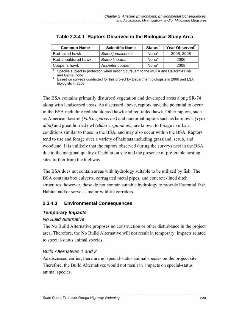
Chapter 2 Affected Environment, Environmental Consequences, and Avoidance, Minimization, and/or Mitigation Measures
State Route 74 Lower Ortega Highway Widening 249
Table 2.3.4-1 Raptors Observed in the Biological Study Area
Common Name Scientific Name Status1 Year Observed2 Red-tailed hawk Buteo jamaicensis None* 2006, 2008 Red-shouldered hawk Buteo lineatus None* 2006 Cooper’s hawk Accipiter cooperii None* 2008 1 Species subject to protection when nesting pursuant to the MBTA and California Fish
and Game Code 2 Based on surveys conducted for this project by Department biologists in 2006 and LSA
biologists in 2008 The BSA contains primarily disturbed vegetation and developed areas along SR-74 along with landscaped areas. As discussed above, raptors have the potential to occur in the BSA including red-shouldered hawk and red-tailed hawk. Other raptors, such as American kestrel (Falco sparverius) and nocturnal raptors such as barn owls (Tyto alba) and great horned owl (Bubo virginianus), are known to forage in urban conditions similar to those in the BSA, and may also occur within the BSA. Raptors tend to use and forage over a variety of habitats including grassland, scrub, and woodland. It is unlikely that the raptors observed during the surveys nest in the BSA due to the marginal quality of habitat on site and the presence of preferable nesting sites further from the highway.
The BSA does not contain areas with hydrology suitable to be utilized by fish. The BSA contains box culverts, corrugated metal pipes, and concrete-lined ditch structures; however, these do not contain suitable hydrology to provide Essential Fish Habitat and/or serve as major wildlife corridors.
2.3.4.3 Environmental Consequences
Temporary Impacts No Build Alternative The No Build Alternative proposes no construction or other disturbance in the project area. Therefore, the No Build Alternative will not result in temporary impacts related to special-status animal species.
Build Alternatives 1 and 2 As discussed earlier, there are no special-status animal species on the project site. Therefore, the Build Alternatives would not result in impacts on special-status animal species.

Chapter 2 Affected Environment, Environmental Consequences, and Avoidance, Minimization, and/or Mitigation Measures
State Route 74 Lower Ortega Highway Widening 250
Raptors and other birds protected by the MBTA may nest in existing trees and shrubs within and adjacent to the BSA. Impacts to these species can occur as a result of direct removal of nests (e.g., during vegetation clearing) or nest failure caused by excessive disturbance of the nesting birds (e.g., from excessive noise and disruption from increased human activities). Within the BSA, construction noise may affect nesting birds in the following ways: (1) reduce communication distance; (2) distort sounds; and/or (3) cause an avoidance pattern due to annoyance. Construction activities may result in a temporary noise impact to nesting birds. Temporary impacts to birds nesting within or adjacent to the BSA may occur if construction, particularly vegetation clearing, occurs during the nesting season. The measures outlined in Section 2.3.4.4 will ensure that the Build Alternatives avoid impacts to nesting raptors and other birds protected by the MBTA during construction activities, and temporary impacts are considered less than significant.
Small mammals, reptiles, and amphibians and other animals of slower mobility that live in the BSA may be temporarily affected as habitat is altered or removed. More mobile wildlife species may be able to vacate the areas and move into adjacent areas of open space. Any displacement of wildlife into adjacent areas of open space is anticipated to occur only during construction. Lighting may be installed during night work that may temporarily disrupt animal behavior (including foraging and nesting); however, lighting will be shielded away from natural areas. Any displacement of wildlife into adjacent areas of open space (primarily at RMV) is anticipated to be temporary and less than significant.
During construction, there may be indirect effects to riparian-dependent species downstream of the BSA, including minimal increases to sediment levels in tributary drainages to San Juan Creek, minimal changes in water temperature, flow velocity, chemistry, or associated terrestrial/aquatic vegetation that would reduce the habitat quality for riparian-dependent species. Any of these indirect effects would be limited to the construction time period and considered less than significant. Although project work will occur in tributaries to San Juan Creek, fish do not use these areas due to lack of suitable hydrology. Implementation of the BMPs in the SWPPP and measures included in Section 2.3.2, Wetlands and Other Waters, would avoid and minimize these effects during construction.

Chapter 2 Affected Environment, Environmental Consequences, and Avoidance, Minimization, and/or Mitigation Measures
State Route 74 Lower Ortega Highway Widening 251
Permanent Impacts No Build Alternative The No Build Alternative proposes no construction or other disturbance in the project area. Therefore, the No Build Alternative will not result in permanent impacts related to special-status animal species.
Build Alternatives 1 and 2 As discussed earlier, there are no special-status animal species on the project site. Therefore, the Lower SR-74 Widening project will not result in impacts on special-status animal species.
Direct effects involve the physical loss of habitat, possibly used by wildlife, due to site clearing, tree removal, grubbing, culvert improvements, and road widening. Construction of the Build Alternatives would result in the removal of habitat that may provide nesting and foraging opportunities for a variety of species. It is estimated that 111 trees, including two coast live oaks will be removed during construction. Six additional coast live oak trees may be impacted by work proposed within the dripline of the trees. Trees within the BSA provide nesting and foraging habitat. However, these resources are less suitable for nesting than other resources throughout the region, due to their proximity to the roadway and the resulting noise and human disturbance. Potential impacts from tree removal will be minimized and avoided through the planting of replacement trees. Therefore, impacts to nesting and foraging habitat are considered less than significant.
The proposed project does not include the construction of median barriers and is not anticipated to affect long-term wildlife movement. SR-74 is an existing roadway, and no increase in raptor-vehicle collisions is anticipated once construction is complete.
With implementation of the project noise barriers, noise levels pre- and post- construction would remain similar to existing conditions. There will be no long-term, permanent impacts from noise.
2.3.4.4 Avoidance, Minimization, and/or Mitigation Measures
The following measures would be implemented in addition to those listed in Section 2.2.2, Water Quality; 2.3.1, Natural Communities; 2.3.2, Wetlands and Other Waters; and 2.3.3, Plant Species.
If feasible, vegetation removal would be avoided during the primary nesting season for local birds (February 15 through September 1) and most raptors, which are

Chapter 2 Affected Environment, Environmental Consequences, and Avoidance, Minimization, and/or Mitigation Measures
State Route 74 Lower Ortega Highway Widening 252
protected by the Migratory Bird Treaty Act and Section 3503.5 of the California Fish and Game Code. If vegetation removal must occur during this period, then pre-construction surveys shall be conducted surveyed by a qualified biologist in the appropriate habitats no more than 7 days prior to clearing within and up to approximately 50 ft (15.2 meters [m]) from the project boundary or an area coordinated with the resource agencies, in order to identify nesting birds and/or raptors within or adjacent to the proposed project. In the event of discovery of active nests in the areas to be cleared, protective measures as outlined by the qualified Biologist shall be taken, as coordinated with the resource agencies. Clearing and grubbing limits may be established up to approximately 500 ft (150 m) in any direction of nests, or other buffer distance coordinated with the resource agencies as directed by the project engineer.
Lighting may be installed during night work that may temporarily disrupt animal behavior (including foraging and nesting); however, lighting will be shielded away from natural areas. Any displacement of wildlife into adjacent areas of open space (primarily at RMV) is anticipated to be temporary and less than significant.
To reduce impacts to wildlife, all construction-related activities shall be confined to the proposed impact boundaries by installing fencing along the boundary in locations where the impact area abuts vegetated areas to prevent any construction activities from encroaching into adjacent habitat areas. In addition, construction access points shall be limited in proximity to the potential habitat for wildlife to the maximum extent feasible as directed by the project engineer.
2.3.4.5 Level of Significance
The No Build Alternative will have no impact to animal species.
With implementation of minimization measures, temporary permanent, direct, or indirect impacts to animal species are considered less than significant.

Chapter 2 Affected Environment, Environmental Consequences, and Avoidance, Minimization, and/or Mitigation Measures
State Route 74 Lower Ortega Highway Widening 253
2.3.5 Threatened and Endangered Species
This section of the document discusses T/E species as well as designated critical habitat with the potential to occur within the BSA, and it summarizes agency consultation conducted to date, the NES (June 2007), and the NES Supplement (August 2008).
2.3.5.1 Regulatory Setting
The primary federal law protecting threatened and endangered species is the FESA (United States Code [USC], Section 1531, et seq. and 50 Code of CFR Part 402). FESA and subsequent amendments provide for the conservation of endangered and threatened species and the ecosystems on which they depend. Under Section 7 of the FESA, federal agencies are required to consult with the USFWS and the NMFS to ensure that they are not undertaking, funding, permitting, or authorizing actions likely to jeopardize the continued existence of listed species or destroy or adversely modify designated critical habitat. Critical habitat is defined as geographic locations critical to the existence of a T/E species. For projects where no federal action is involved, project proponents are required to consult with the USFWS and NMFS pursuant to Section 10 of the FESA. The outcome of consultation under Sections 7 or 10 is a Biological Opinion or an incidental take permit. Section 3 of FESA defines take as to “harass, harm, pursue, hunt, shoot, wound, kill, trap, capture or collect or any attempt at such conduct.”
California has enacted a similar law at the State level, the CESA (California Fish and Game Code, Section 2050, et seq.). The CESA emphasizes early consultation to avoid potential impacts to rare, endangered, and threatened species, and to develop appropriate planning to offset project-caused losses of listed species populations and their essential habitats. The CDFG is the agency responsible for implementing CESA. Section 2081 of the Fish and Game Code prohibits take of any species determined to be an endangered species or a threatened species. Take is defined in Section 86 of the Fish and Game Code as to “hunt, pursue, catch, capture, or kill, or attempt to hunt, pursue, catch, capture, or kill.” CESA allows for take incidental to otherwise lawful development projects; for these actions, an incidental take permit is issued by CDFG. For projects requiring a Biological Opinion under Section 7 of FESA, CDFG also may authorize impacts to CESA species by issuing a Consistency Determination under Section 2080.1 of the Fish and Game Code.

Chapter 2 Affected Environment, Environmental Consequences, and Avoidance, Minimization, and/or Mitigation Measures
State Route 74 Lower Ortega Highway Widening 254
2.3.5.2 Affected Environment
During preparation of the NES, the USFWS was contacted to provide a species list for the proposed project, which was provided on August 7, 2006. During the subsequent preparation of the 2008 NES Supplement, the USFWS was contacted to determine whether an update to the species list was required. On April 8, 2008, the USFWS indicated that coastal California gnatcatcher (Polioptila californica californica) critical habitat no longer is designated within the BSA, and no other revisions to the list are necessary.
Of the 11 possible federal or State T/E species that may occur in the BSA according to the USFWS list, none were observed during surveys of the BSA, and no suitable habitat was observed. USFWS protocol surveys were not conducted based on the lack of suitable habitat in the BSA and based on the Rancho Mission Viejo (RMV) T/E species survey results indicating absence in areas abutting the BSA. Due to the urbanized nature of the project area, federally and/or State-listed T/E species are not anticipated to occur in the BSA. Special status species with the potential to occur in the vicinity of the biological resources project study area are identified on Table 2.3.5-1.
As confirmed in the NES and the NES Supplement, no federal- or State-listed T/E species are present in the BSA for the SR-74 Widening project. This conclusion is based on (1) the lack of observation of such species during the field surveys, (2) the lack of reports of such species near the BSA from within the greater study area, and (3) the absence of suitable habitat for such species (i.e., the disturbed conditions and associated absence of natural plant communities in the BSA).
2.3.5.3 Environmental Consequences
Temporary Impacts No Build Alternative The No Build Alternative proposes no construction or other disturbance in the project area. Therefore, the No Build Alternative will not result in impacts related to T/E species.
Build Alternatives 1 and 2 There are no State or federal T/E-listed species in the BSA; therefore, no temporary impacts to T/E species are anticipated as a result of the Lower SR-74 Widening project. There is no critical habitat in the BSA.

Chapter 2 Affected Environment, Environmental Consequences, and Avoidance, Minimization, and/or Mitigation Measures
State Route 74 Lower Ortega Highway Widening 255
Table 2.3.5-1 Project Study Area T/E Species
Common Name Scientific Name Status
General Habitat
Description
Habitat Present/Absent
Rationale
Amphibians
Arroyo toad Bufo californicus FE Flood terraces, sandy pools A Lack of suitable
habitat Birds Southwestern willow flycatcher
Empidonax traillii extimus FE
Low-elevation riparian habitats
A Lack of suitable habitat
Bald eagle Haliaeetus leucocephalus FT Lakes,
reservoirs A Lack of suitable habitat
Coastal California gnatcatcher
Polioptila californica californica
FT Coastal sage scrub A Lack of suitable
habitat
Least Bell’s vireo
Vireo bellii pusillus FE Riparian A Lack of suitable
habitat Crustaceans San Diego fairy shrimp
Branchinecta sandiegonensis FE Vernal Pools A Lack of suitable
habitat Riverside fairy shrimp
Streptocephalus woottoni FE Vernal Pools A Lack of suitable
habitat Fish
Southern steelhead
Oncorhynchus mykiss FE
Freshwater streams, coastal lagoons, drainages
A Lack of suitable habitat
Plants Thread-leaved brodiaea
Brodiaea filifolia FT, SE Chaparral, woodlands, coastal scrub
A Lack of suitable habitat
Laguna Beach live-forever
Dudleya stolonifera FT, ST
Chaparral, woodlands, coastal scrub
A Lack of suitable habitat
Big-leaved crownbeard Verbesina dissita FT, ST
Chaparral, woodlands, coastal scrub
A Lack of suitable habitat
Source: USFWS Species List for the State Route 74 Widening Project in the City of San Juan Capistrano, Orange County, California (August 7, 2006) Notes: Status: Federal Endangered (FE); Federal Threatened (FT); Federal Proposed (FP, FPE, FPT); Federal Candidate (FC), Federal Species of Concern (FSC); State Endangered (SE); State Threatened (ST); Fully Protected (FP); State Rare (SR); California Species of Special Concern (SSC); California Native Plant Society (CNPS). Habitat Present/Absent: Absent [A] means no further work needed. Present [P] means general habitat present and species may be present.

Chapter 2 Affected Environment, Environmental Consequences, and Avoidance, Minimization, and/or Mitigation Measures
State Route 74 Lower Ortega Highway Widening 256
Permanent Impacts No Build Alternative The No Build Alternative does not propose any construction or other disturbance in the project area. Therefore, the No Build Alternative will not result in impacts related to T/E species.
Build Alternatives 1 and 2 There are no State or federal T/E-listed species in the BSA; therefore, no long-term or permanent impacts to T/E species are anticipated as a result of the Lower SR-74 Widening project. There is no critical habitat in the BSA.
2.3.5.4 Avoidance, Minimization, and/or Mitigation Measures
There are no federal or State T/E species within the BSA. The project is not anticipated to permanently, temporarily, directly or indirectly affect T/E species; therefore, no avoidance, minimization, and/or mitigation measures are proposed.
2.3.5.5 Level of Significance
The No Build and Build Alternatives would have no temporary permanent direct or indirect impacts to T/E species.

Chapter 2 Affected Environment, Environmental Consequences, and Avoidance, Minimization, and/or Mitigation Measures
State Route 74 Lower Ortega Highway Widening 257
2.3.6 Invasive Species
This section of the document discusses invasive species with the potential to occur within the BSA and summarizes the results of field work conducted to date, the NES (June 2007), and the NES Supplement (August 2008).
2.3.6.1 Regulatory Setting On February 3, 1999, President Clinton signed Executive Order (EO) 13112, requiring federal agencies to combat the introduction or spread of invasive species in the United States. This EO defines invasive species as “. . . any species, including its seeds, eggs, spores, or other biological material capable of propagating that species, that is not native to that ecosystem whose introduction does or is likely to cause economic or environmental harm or harm to human health.”
The California Invasive Plant Inventory updates the 1999 Exotic Pest Plants of Greatest Ecological Concern in California. Each plant on the list received an overall rating of High, Moderate or Limited based on a distinct criteria system of evaluation. The meaning of these overall ratings is described below. In addition to the overall ratings, specific combinations of section scores that indicate significant potential for invading new ecosystems trigger an Alert designation so that land managers may watch for range expansions. Some plants were categorized as Evaluated but Not Listed because either we lack sufficient information to assign a rating, or the available information indicates that the species does not have significant impacts at present (Cal-IPC 2008).
• High: These species have severe ecological impacts on physical processes, plant and animal communities, and vegetation structure. Their reproductive biology and other attributes are conducive to moderate to high rates of dispersal and establishment. Most are widely distributed ecologically.
• Moderate: These species have substantial and apparent—but generally not severe—ecological impacts on physical processes, plant and animal communities, and vegetation structure. Their reproductive biology and other attributes are conducive to moderate to high rates of dispersal, though establishment is generally dependent upon ecological disturbance. Ecological amplitude and distribution may range from limited to widespread.
• Limited: These species are invasive but their ecological impacts are minor on a statewide level, or there was not enough information to justify a higher score. Their reproductive biology and other attributes result in low to moderate rates of

Chapter 2 Affected Environment, Environmental Consequences, and Avoidance, Minimization, and/or Mitigation Measures
State Route 74 Lower Ortega Highway Widening 258
invasiveness. Ecological amplitude and distribution are generally limited, but these species may be locally persistent and problematic.
2.3.6.2 Affected Environment
According to the NES and the NES Supplement, the Lower SR-74 Widening project is located in an area that predominantly supports nonnative species, which are found in the ornamental and ruderal vegetation along the alignment.
Observed plants within the BSA included in the CalEPPC 1999 Exotic Pest Plants of Greatest Ecological Concern in California A-1 list include iceplant (Carpobrotus edulis, also known as Hottentot fig), pampas grass (Cortaderia sp.), eucalyptus (Eucalyptus sp., also known as gum tree or Tasmanian blue gum), wild fennel (Foeniculum vulgare), and African fountain grass (Pennisetum setaceum). The area of ice plant is approximately 30 ft. by 30 ft.; is located on the north side of SR-74, next to the roadway. The following observed plants are CalEPPC A-2: Australian saltbush (Atriplex semibaccata), mustard (Brassica sp.),1 and myoporum (Myoporum laetum). The following observed plants are included in CalEPPC list B: black mustard (Brassica nigra),2 olive (Olea europaea), castor bean (Ricinus communis), Peruvian pepper tree (Schinus molle), and Brazilian pepper tree (Schinus terebinthifolius). No plants observed in the project area are included on the Red Alert list. Observed annual grasses listed by CalEPPC included oat (Avena sp.). Observed plants considered but not listed by CalEPPC included bristly ox-tongue (Picris echioides).
A species of sowthistle (Sonchus sp.) observed on site may be an A-list CDFA noxious species. The listed species is perennial sowthistle (Sonchus arvensis). One species found on site is listed in the CDFA noxious species list as “B”: knotweed (Polygonum sp.). Two species found on the site are listed in the CDFA noxious species list as “C”: Russian thistle (Salsola tragus) and Bermuda grass (Cynodon dactylon).
As mentioned above, the California Invasive Plant Inventory updates the 1999 Exotic Pest Plants of Greatest Ecological Concern in California. Observed plants with a “High” status include iceplant, pampas grass, and wild fennel. Observed plants with a
1 Brassica tournefortii is included on list A-2.
2 Brassica (mustard) includes several species that are listed as “High,” “Moderate,” and “Limited.” See footnote 1.

Chapter 2 Affected Environment, Environmental Consequences, and Avoidance, Minimization, and/or Mitigation Measures
State Route 74 Lower Ortega Highway Widening 259
“Moderate” status include Australian saltbush, eucalyptus,1 black mustard, garland chrysanthemum (Chrysanthemum coronarium), Bermuda grass, redstem stork’s bill (Erodium cicutarium), wild barley (Hordeum sp.), and African fountain grass. Observed plants with a “Limited” status include eucalyptus, olive, Canary Island date palm (Phoenix canariensis), bristly ox-tongue, English plantain (Plantago lanceolata), wild radish (Raphanus sativus), castor bean, Peruvian pepper tree, and Brazilian pepper tree. The common dandelion (Taraxacum officinale) was evaluated but not listed by CalEPPC.
No substantial populations of invasive wildlife have been documented in the BSA. House sparrows (Passer domesticus), rock pigeons (Columba livia), and European starlings (Sturnus vulgaris), as well as Virginia opossums (Didelphis virginiana) and feral dogs (Canis lupus familiaris) and cats (Felis catus) are known to occur in urban areas, and they occur throughout Southern California.
2.3.6.3 Environmental Consequences
Temporary Impacts No Build Alternative The No Build Alternative proposes no construction or other disturbance in the project area. Therefore, the No Build Alternative would result in no temporary impacts related to invasive species.
Build Alternatives 1 and 2 The implementation of the Build Alternatives has the potential to spread invasive species by the entering and exiting of construction equipment contaminated by invasives, the inclusion of invasive species in seed mixtures and mulch, and the improper removal and disposal of invasive species so that seed is spread along the highway. In accordance with the measures listed in Section 2.3.6.4, invasive species and noxious weeds listed by CalEPPC and CDFA will not be used in landscaping or erosion control efforts. With implementation of the measures described below, potential temporary invasive species impacts are considered less than significant.
1 Eucalyptus globulus has a “Moderate” status and E. camadulensis has “Limited”
status.

Chapter 2 Affected Environment, Environmental Consequences, and Avoidance, Minimization, and/or Mitigation Measures
State Route 74 Lower Ortega Highway Widening 260
Permanent Impacts No Build Alternative The No Build Alternative proposes no construction or other disturbance in the project area. Therefore, the No Build Alternative would result in no permanent impacts related to invasive species.
Build Alternatives 1 and 2 Invasive species, including ice plant and pampas grass, would be removed by the proposed project. Invasive species have the potential to be imported to the project area by contaminated construction equipment or imported materials such as soils. The dispersal of invasive species propagules in the BSA may be furthered by roadway vehicles, with inadvertent mixing of invasive species in seed mixes applied adjacent to the highway and the spread of invasive species during weed-control programs such as mowing. The increased risk of introduction or spread of invasive species would occur only during construction. The risks would be avoided or minimized with the application of the measures discussed in Section 2.3.6.4 below. In addition, areas of plant species that are non-native to the area will be removed by the proposed project and not re-planted in the BSA once construction is complete.
Eradication of these species from the BSA is expected to have little or no effect on their distribution locally or in the region. With implementation of the measures outlined below, permanent impacts to invasive species from the Build Alternatives are considered less than significant.
2.3.6.4 Avoidance, Minimization, and/or Mitigation Measures
The following measures would be implemented in addition to those listed in Section 2.3.1 Natural Communities, 2.3.2 Wetlands and Other Waters, and 2.3.3 Plant Species. The following measures will avoid and minimize the potential spread of invasive species from spreading from or into the project area:
Bare soil will be landscaped with California Department of Transportation-recommended seed mix from locally adopted species to preclude the invasion of noxious weeds. In compliance with the Executive Order on Invasive Species, EO 13112, and subsequent guidance from FHWA, the landscaping and erosion control included in the project will not use species listed as noxious weeds, and no invasive species will be planted within the state right-of-way or in areas where the species may enter a drainage area.

Chapter 2 Affected Environment, Environmental Consequences, and Avoidance, Minimization, and/or Mitigation Measures
State Route 74 Lower Ortega Highway Widening 261
In areas of particular sensitivity, extra precautions will be taken if invasive species are found in or adjacent to the construction areas. These include the inspection and cleaning of construction equipment, and eradication strategies to be implemented should an invasion occur. Before mobilizing to arrive at the site and before leaving the site, construction equipment will be cleaned of mud or debris that may contain invasive plants and/or seeds, and inspected to reduce the potential of spreading noxious weeds. To ensure implementation of these measures, the project contractor shall provide a weed abatement program to be approved by the Department engineer prior to the start of ground disturbance.
The Department will use site-specific plant materials (e.g., propagules and seed) adapted to local conditions in order to increase the likelihood that revegetation will be successful, and to maintain the genetic integrity of the local ecosystem.
Seed purity will be certified by planting seed labeled under the California Food and Agricultural Code or seed tested within a year by a seed laboratory certified by the Association of Official Seed Analysts or by a seed technologist certified by the Society of Commercial Seed Technologists.
Trucks with loads carrying vegetation will be covered, and vegetative materials removed from the site will be disposed of, in accordance with all applicable laws and regulations.
2.3.6.5 Level of Significance
The No Build Alternative will have no impacts from invasive species.
With implementation of minimization measures, temporary, permanent, direct, or indirect impacts from invasive species are considered less than significant.

Chapter 2 Affected Environment, Environmental Consequences, and Avoidance, Minimization, and/or Mitigation Measures
State Route 74 Lower Ortega Highway Widening 262
This page intentionally left blank