biscayne bay aquatic preserves tuttle basin...
TRANSCRIPT

June 21 2017
Eric Buck, Manager
Biscayne Bay Aquatic
Preserves
Tuttle Basin Seagrass

• Serves the most populous county in Florida – 2.6 million residents
• Thirty-five miles (56km) long
• Area = 428.6 sq. miles / 70k acres
• Fourteen municipalities along border
• More than 40 islands (mostly spoil)
• Protected by both an Aquatic Preserve and a National Park
• Part of the Kissimmee-Okeechobee-Everglades Watershed
• High diversity, species unique to area
About Biscayne Bay
Nearly 70,000 acres

Florida Department of EnvironmentalProtection
• DEP protects our air, water, and land
• Three program areas:• Regulatory Programs
• Land and Recreation
• Water Policy and Ecosystem Restoration
• Florida Coastal Office: 4 Millionacres• Forty-one Aquatic Preserves
• National Estuarine Research Reserves
• Outer Continental Shelf
• FL Keys National Marine Sanctuary
• Coral Reef Conservation Program
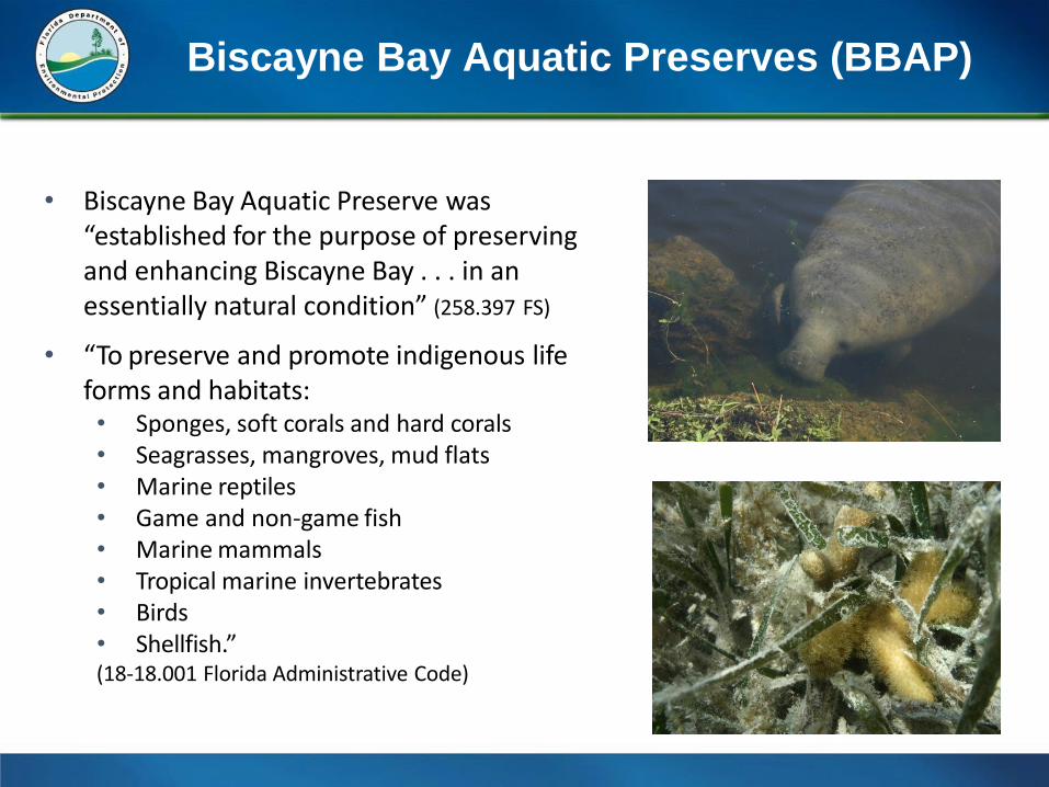
• Biscayne Bay Aquatic Preserve was“established for the purpose of preserving and enhancing Biscayne Bay . . . in an essentially natural condition” (258.397 FS)
• “To preserve and promote indigenous lifeforms and habitats:• Sponges, soft corals and hard corals• Seagrasses, mangroves, mud flats• Marine reptiles• Game and non-game fish• Marine mammals• Tropical marine invertebrates• Birds• Shellfish.”(18-18.001 Florida Administrative Code)
Biscayne Bay Aquatic Preserves (BBAP)

Julia Tuttle Basin Seagrass

Julia Tuttle Basin Seagrass
2011 2017

Julia Tuttle Basin Seagrass
2016 2017

Julia Tuttle Basin Seagrass
Nov 2016

Julia Tuttle Basin Seagrass
The die-off has accelerated with an overall loss of fish habitat and increase in turbidity from loose sediments
May 2017

Julia Tuttle Basin Seagrass

Timeline
• Ligia Collado-Vides (FIU) and John Watts (FDEP)
report linking macroalgae bloom in Bay and canals
near Coral Gables to anthropogenic nutrients
• Miami-Herald article, “Dying seagrass and ‘yellow
fog’ signal trouble for Florida Bay”
• BBAP observations of dense growth and
cyanobacteria-epiphytic complex development in
south central part of basin
• Brie Cokos (Ocean Consulting) observation noting
seagrass decline and cyanobacteria at site in
eastern basin February 2015-February 2016
August 2014
October 2015
February 2016

Timeline
• BBAP and Miami-Dade DERM staff planning meeting on macroalgae and nutrient sources to Bay.
• Robert Carroll observations of loss of seagrass coverage in Tuttle basin, north of Rickenbacker, and near Matheson Hammock park.
• BBAP observations of seagrass loss at previouslydense sites in south central basin.
• Penny Hall (FWRI) facilitated a site visit by FWC biologists and Bradley Furman (UVA) to investigate basin seagrass loss.
• Biscayne Times article, “Follow the Fish.”
2016 April
2016 July
2016 Dec
2017 March
2017 April

Timeline
• Miami-Herald article, “Seagrass keeps dying in Biscayne Bay. Is it getting too sick to recover?”
• FWRI-UVA Site Visitation draft report suggests connection of previously dense seagrass growth to low canal freshwater input; die-off to higher flows starting in 2012 - salinity change stress also exacerbated by a 15cm sea level rise beginning in 2010
April 2017

Dec 2014
Construction Events

Jan 2016
Construction Events

Construction Events
Feb 2016

Other Risks?

FLORIDA'S
AQUATICPRESERVES
W A T E R S THAT W O R K , P L A Y , A N D LIVE

Documents
• Sargent, F.J., T.J. Leary, D.W. Crewz, and C.R. Kruer. 1995. Scarring of Florida’s seagrasses: assessment and management options. FMRI Tech. Rep. TR-1. Florida Marine Research Institute, St. Petersburg, Florida. 37 p. plus appendices.
• FWRI-UVA Site Visitation draft report
• Miami-Herald – “Seagrass keeps dying in Biscayne Bay. Is it getting too sick to recover?”
• Biscayne Times article, “Follow the Fish.”
• DERM draft report – “Evaluation of apparent seagrass die-off condition inJulia Tuttle Basin, North Biscayne Bay.”
• Ligia Collado-Vides (FIU) and John Watts (FDEP) BBAP funded reports –
• “A search of links between water indicators and the persistence of the Anadyomene complex bloom in Biscayne Bay”
• “A rapid assessment of the impact of the winter 2015-2016 El Niño rain anomaly on the prevalent Anadyomene species bloom inBiscayne Bay.”

• Miami-Dade County DERM report to EPA - “Surface Water Quality Monitoring: Results and Discussion For the Reporting Period June 21, 2015 to June 20, 2016. As per Part V.B. of the NPDES MS4 Permit No. FLS000003-003 Issued to Miami-Dade County and Specified Co-Permittees.”
• FWC SIMMS Report - Yarbro, L. A., and P. R. Carlson, Jr., eds. 2016. Seagrass Integrated Mapping and Monitoring Program: Mapping and Monitoring Report No. 2. Fish and Wildlife Research Institute Technical Report TR-17 version 2. vi + 281 p.
• Miami-Herald - “Dying seagrass and ‘yellow fog’ signal trouble forFlorida Bay.”
• Robert Carroll observations of loss of seagrass coverage in Tuttle basin, north of Rickenbacker, and near Matheson Hammock park.
• http://robbiecarroll.com/rob/Seagrass-Matheson.gif
• http://robbiecarroll.com/rob/Seagrass-Rickenbacker-Causeway.gif
• http://robbiecarroll.com/rob/Seagrass-Julie-Tuttle-Causeway.gif
Documents