black hole - en - petzl
TRANSCRIPT

© Petzl 2017
By Jean-Paul Sounier Photos by Robbie Shone
BLACKHOLENakanai Mountains New Britain, Papua New Guinea

- 1 -
In January 2016, an international caving expedition traveled to the island of New Britain in Papua New Guinea. The goal? To find and explore a cave identified during aerial observations. Jean-Paul Sounier, expedition leader and the brains behind the project, takes us into the heart of the Papuan rainforest on a truly incredible adventure.

- 2 -
Expedition members:
• Jean-Paul Sounier, France; expedition leader • Robbie Shone, United Kingdom; expedition photographer • Jérôme Jouret, France • Clément Flouret, France • Guillaume Delorme, France • Jérémie Faurax, France; team doctor • José Gambino Loureiro, Spain • Jabier Garcia, Spain • Al Warild, Australia

- 3 -

- 4 -
Prologue
Black hole "A celestial object that has a gravitational field so strong that light cannot escape it." - Webster's Dictionary.

- 5 -
Naming a caving expedition "Black Hole," seems appropriate, since caving involves
the exploration of natural underground cavities where nary a photon exists; an entire world without light. These two words conjure up images of the celestial phenomenon whose gravitational field is so strong that not a particle of matter or wave of light can escape its grasp. Since deep caves ap-pear to exert an equally strong attraction for ca-vers, why shouldn't a caving expedition bear this name? The explanation is actually rather simple. To find out what it is, let's back up a few years.
In 1980 and 1985, on the island of New Britain – the second-largest island in the archipelago that forms Papua New Guinea – the first two French caving expeditions ventured into the Nakanai Mountains, a limestone mountain range with an area covering approximately 4,000 square kilo-meters. At the time, cavers relied on aerial pho-tos to look for deep caverns to explore. In these images, the large surface sinkholes, characteris-
tic of the rainforest-covered karst landscape, look like enormous black holes of varying sizes. Once identified, cavers ventured into the depths of such giant caves as Nare, Kururu, Poipun, and Bikbik Vuvu. In 1988, I made a helicopter reconnaissance flight over the area between Galowe to the east, and the huge Wunung Gorge to the west. With Alan Rohl at the controls, we flew over the enor-mous doline located between the two gorges. It turned out to be huge "bowl" without a river at the bottom, so of little interest to our expedition. Alan then told me about previously flying over ano-ther huge sinkhole in the vicinity, but unfortunately we were unable to locate it this time around. We then flew up Wunung Gorge, and to my surprise, unlike Galowe Gorge, no rivers poured into this 1000-meter-deep canyon. This begged the ques-tion: where was the water flowing into the mouth of the coastal Wunung River coming from? We finally located Wunung's resurgence along one of the last meanders before the river enters the sea. The fol-lowing years were spent exploring other objectives

- 6 -
that this vast karst landscape contains, Muruk, Ora, Mageni, and Wowo, letting Wunung and its mysterious ghost river slowly fade from memory.
During the summer of 2014, after an expedition to another karst area in New Britain, I started looking for a worthy objective to take me back the Nakanai Mountains. Looking at aerial photos kept safely in storage since the 1980s, I noticed, on a plateau along the left bank of Wunung Gorge, a black and white mark indicating a surface sinkhole. Could this be the very chasm that Alan Rohl spotted so long ago? Since Google Earth does not have high-de-finition satellite images of the area, I switched to another website with satellite photos, Bing. I viewed with glee the high-definition photos of the area. Eagerly moving the cursor over the correspon-ding area in my aerial photos, I discovered a black hole almost 100 meters wide! Even at max zoom I could not see the bottom. What would this mys-terious unexplored black hole reveal? Venturing to a plateau that has never been explored and map-
ping its underground passageways, what an en-ticing proposition! One other important piece of information in the satellite images: the presence of a village on the right bank of Wunung Gorge, the ideal starting point towards the plateau where this mysterious sinkhole was located and that we of course named... Black Hole!

- 7 -

- 8 -
Chapter 1
January 22, the dock in Palmalmal…

- 9 -
A few team members arrived in advance. Jérôme and Clément volunteered to land
in Kokopo, New Britain's capital, on January 13, to buy base camp supplies. José and Jabier also volunteered to arrive in advance. I tasked them with a reconnaissance mission in the field: learn more about the village in the satellite photos, its name, the approach, and then to go there to speak with local Papuans to learn any information about the caves they know of and our plateau of interest.
While unloading our cargo, José, his bronzed face smiling brightly, confirms the information that he sent me. The unknown village's name is Tolel; the vast palm tree plantation visible on the satellite photos had expanded, making it possible to cross the plantation on a dirt road by truck, reducing the approach hike to the village to around two hours.
To handle local logistics, the best middleman on the island is Iggie Madapia, owner of the Delawin Guesthouse. This is where we stay and meet up
with Jennifer Gabriel and Michael Wood, both Australian. I only know Jennifer through email and phone calls, and am happy to finally meet her in person. Our discussions focused on the possibility of classifying the Nakanai Mountains as a World Heritage Site for its incredible caves and rich bio-diversity. She and Michael are conducting an an-thropological study that could help the area beco-me a classified landmark before the quarry, palm tree plantation, and deforestation projects in the works destroy the karst landscape.
Joe Tally, born and raised in the village of Tolel, pays us a visit. He is a councilman on the Palmalmal administrative council and offers to travel with us to Tolel to assist in our future encounters with the local population. We happily accept, understan-ding full well the difficulty in convincing the natives in remote villages in the region that our passion for caving is in no way commercial in nature.

- 10 -

- 11 -
Chapter 2
Welcome to Tolel

- 12 -
The trail crosses a stream that serves as the inhabitants' only water source and winds
along the mountainside. When the slope levels off, the first rooftops come into view. We enter a wide open field lined with a few wood structures. The first is the school, and since the children are on vacation, the Papuans set down our packs and offer to let us use it during our stay. The rudimen-tary school building contains three small class-rooms with rows of wood benches in each. We
barely have the time to take of our packs, rehy-drate, and eat a little before the Papuans invite us to join them for a welcome ceremony. At the top of a small slope, the entire village finally comes in-to view. Huts of different shapes and sizes extend over a broad expanse of partly grassy and partly muddy terrain. I recognize one of the longer struc-tures as the Haus Boi, or men's lodge. To the nor-th, the primary forest-covered plateau stretching to the horizon contains the legendary Black Hole.

- 13 -

- 14 -
For the welcome ceremony, a group of Papuans join us. The women and children wear dresses made from leaves. Most of the men wear stalks, and three of them set the rhythm of the procession by playing the kundu, a small local drum. The re-petitive melody accompanies our parade through the village. All of a sudden, two Tumbuans appear. While this is not the first time I have participated in a ceremony that includes Tumbuans, these cos-tumed men never cease to amaze me. Their bo-dies are covered in long coconut leaves; only their arms and hands poke through. One hand holds a staff. Leaves cover their heads, topped off by a beanie decorated with different-colored bands: green, yellow, purple, red, white, and black. As the Tumbuans start to spin around in both direc-tions, the leaves from their costumes whirl in the air. They walk with us to the Haus Boi and continue to dance for a while, accompanied by singing and the steady drumbeat. Then, the music suddenly stops; time for the welcome speech to begin. Joe explains the reason for our trip. Paul, the village's
"Bigman," makes a long speech in Mengen that Joe translates for us. Then, everyone on the team introduces themselves. As the team leader, I re-ceive a traditional Kina necklace as a gift. The ce-remony ends and we walk back to the school to settle in. I am as pleasantly surprised by the warm welcome from the villagers as by the beauty and cleanliness of Tolel.
We meet with John Lole, who speaks English well and will be our guide during our stay in the forest. We enjoy the last rays of sunlight to admire our current location. José talks about his reconnais-sance mission, showing me the different locations he identified. From where we are, we can see the plateau where Black Hole is located, as well as the confluence of Wunung Gorge with another gorge. The Papuans call this gorge, also dry, Lolotu.

- 15 -
José explains that the walls of Wunung Gorge are extremely steep further upstream, and that clim-bing them is out of the question. He estimates that we can reach Black Hole by first ascending the bottom of the gorge, then walking up the left bank of what the Papuans refer to as Lola Gorge. From past experience, I know that this is a bad choice. Steep headwalls could potentially block the way, in addition to the fact that we would be exposing ourselves to flash floods that could sweep us away like a measly piece of driftwood. However, at the junction of Wunung and Lolotu gorges, the terrain
climbs gradually and on paper appears to be the best option for our approach. John confirms my assumption the next day.
We decide to split into two teams. Clément, Guillaume, Al, and Jabier will stay in Tolel to ex-plore the caves familiar to the Papuans and lo-cated in the vicinity of the village. Jérôme, Robbie, José, and I will hike up to the plateau to look for a good site for our future base camp and to find Black Hole.

- 16 -
Chapter 3
En route to base camp

- 17 -
On Tuesday morning, January 26, we leave the village at 08:15. John recommends
that we take four Papuans with us to break trail. He brings Bruno, Ismael, and Herman, the lat-ter one of John's uncles who, while much older than the rest of us, proves extremely deft with a machete. Five porters join the team. The trail we take leads to the coastal village of Irina. The last 100 meters of vertical prove very steep; one slip could send us careening down the slope. We then reach the Wunung riverbed. On either side, the steep, forested slopes rise towards the cloud cei-ling. Without the noise of water running or churning, the daunting gorge is eerily silent for a country that gets close to twelve meters of rain per year! I ex-perience the same lost feeling from 28 years ago on the helicopter flyover looking for Wunung's re-surgence. We head downstream towards a beau-tiful waterfall formed by the stream, where Tolel's inhabitants get their water. A small lake has formed at the base of the falls. Incredibly, the water flows not downstream, which would have been logical,
but rather upstream into a stone-filled basin. The mystery of Wunung's ghost river just deepened!
We fill our canteens, and then, just as we get ready to show him a potential path we found on our map, John shows us an already existing trail. So we follow it. The first 200 meters are also ve-ry steep, with few trees and bushes to grab onto while ascending the muddy, somewhat unstable terrain. It is hot, our packs heavy, our feet slipping everywhere; what a pleasure it is to return to the Papuan rainforest! The slope finally levels off. I join John and his team near stakes that have been planted to build a makeshift shelter. To my sur-prise, John mentions that they hunt wild boar in the area from time to time. That explains the trail.
We continue walking along the faint trail. This makes for quick forward progress. Around 500 meters elevation, we exit the Papuan’s hunting grounds and start hiking along the broad rib that separates the two gorges.

- 18 -
The terrain is moderately steep at this point. A beautiful forest occupies these particular slopes and the thin undergrowth presents relatively few obstacles. Then, the slope steepens. The Papuans use their machetes from time to time to make the climb easier. At 13:30 we step onto the pla-teau at an altitude of 700 meters. "Plateau" in the Nakanai Mountains does not translate to a flat sur-face. The terrain is typical tropical karst, and even though the limestone bedrock covered in mud and thick vegetation is practically invisible, erosion has created a classic karst topography with joint do-lines. Crossing this type of terrain is like walking along roller coaster tracks. Suddenly, the machete swings intensify and our pace slows. At 14:30, at 770 meters elevation, we decide to stop for seve-ral reasons. The Papuans need to build a shelter, and we have to find two properly spaced trees to attach our hammocks. After suspending our tarps between two trees, we are ready to collect rainwa-ter for drinking. Rain always falls at some point during the day, and today it starts at 16:00. With
nothing left to do, we slip into our sleeping bags just past sunset and I enjoy my first good night's sleep since my arrival.

- 19 -
The next morning, we start walking at 8:00. We set a general course heading northwest, but I let the Papuans pick the path to guide us around the countless dolines, downed trees, and bamboo thickets. We move at a steady clip thanks to John and Herman's efficient machete work as well as their navigational skills that keep the up and down to a minimum.
After hiking for two hours, we start looking for a place to set up base camp. There are several fac-tors to consider: the site has to be close enough to Tolel to allow our porters to make the trip on foot in
less than 7 hours, but not too far from Black Hole. The site has to be large enough to set up our big tent, nine hammocks, and several small huts to house almost three dozen porters. The ideal spot would be in the middle of the plateau surrounded by Wunung Gorge to the south, Lolutu Gorge to the east, Lola Gorge to the west, and a streambed to the north. As we advance further towards the middle of the plateau, the terrain becomes increa-singly rugged and uneven; the ridgelines separa-ting the dolines and streambeds are too narrow. Just before noon, we find a spot that could work, but that is still a bit too far from Black Hole. We decide to continue walking for another hour, plan-ning to come back if we can't find a better loca-tion. Less than an hour later, we discover a much better spot at approximately 940 meters elevation; our GPS indicates a distance of 1.78km straight to Black Hole, and I ask John if we are close enough to Tolel to transfer our gear. He confirms. We then spend a second night between two trees.

- 20 -
Chapter 4
Around the abyss

- 21 -
On Thursday, January 28, with food sup-plies running low, I send six Papuans back
to Tolel. Only John, Herman, and Nelson remain. After sharpening their machetes, they set off at a determined pace with us in tow. We choose a bearing of 270 degrees, but like the day before, we let them pick their way through the forest to make cutting and the overall effort easier. José and I, with a GPS and compass in hand, adjust our course from time to time. The plateau rises gradually, with the occasional streambed to cross. Since the Papuans like to walk straight up, we enjoy more than a slide or two on these muddy slopes. The inordinate amount of bamboo on this section requires a herculean path-clearing effort. I remem-ber my first expeditions to the Nakanai Mountains during which forward progress through the high canopy was easy; but in 1997 an incredibly violent cyclone devastated the forest, with the worst of the damage located above 1200 meters eleva-tion. Lower down, the winds were less violent, but as I turn my gaze towards the treetops, I see few
branches and a lack of canopy coverage. With the increased sunlight, several types of plants have taken over the undergrowth, including bamboo. Nevertheless, the cyclone blew through 19 years ago, and as the canopy foliage has increased, the bamboo thickets have started to diminish.
- How far away are we, Jérôme asks. I look at the GPS. - 543 meters.
- 22 -
Finally, we are closing in on our objective. 300 me-ters, 250… In spite of the Papuans' efforts to main-tain a consistent heading, our approach is far from a straight line. Only 80 meters to go; I look ahead but fail to distinguish anything between the tree trunks. The terrain should indicate such a massive chasm from a distance. Do we have the wrong coordinates? Fifty meters remain as we climb over the top of a mound; there it is! Between tree trunks we can see a huge depression.
We sprint forward like thirsty desert wanderers to a life-saving waterhole, stopping just before the void of the gigantic sinkhole. John, who is in front of us, turns around and we see the genuine asto-nishment on his face.
- So big, he says.
I concur with a nod. We are on the southeast edge of the void, and this is neither the high nor the low point. Black Hole's highest wall is to the north; its
shortest, to the south. We estimate the sinkhole to be 100 to 150 meters deep, depending on which edge one stands. We can see the bottom filled with steep scree, covered with wild banana plants and other bushes; Black Hole does not really de-serve its name, and I am a little disappointed that the hole is not deeper. However, from our vantage point we hear what sounds like a stream, and can clearly see a black archway further down. Could this be the access point to the unexplored depths of the abyss? Does an underground stream run through the bottom of the sinkhole? As if reading my mind, Herman turns towards me.
- Wara, wara, he repeats, surprised that on this li-mestone plateau, where running water is almost nonexistent except for the rare water hole, he hears the murmur of a running stream.
We move towards the lowest point, that we refer to as the spillway, to evaluate the potential obstacles for rigging our descent. Having seen enough, we

- 23 -
walk at a steady clip and are back at camp an hour later. Tomorrow we will return to Tolel to organize the trip to base camp for the rest of the team.
During the night, a long howl, similar to that of a wolf, disrupts the usual concert of nocturnal noises. The howl ends with yelping. When we wake up, I ask John what animal could have made such a ruckus.
- Wild dog, he answers. He explains that there are large wild dogs that live in the forest. It was the first time I had heard such a howl in the Nakanai Mountains. John assures me that we run no risk of being attacked.

- 24 -
Chapter 5
Organizational skills

- 25 -
We are finally ready and operational! The Papuans successfully transfer our gear
to base camp despite there being too few helping hands to do it in a single trip. Al and José remain in the village to organize the second group two days later. At camp, we organize ourselves to ensure maximum efficiency during the upcoming weeks.
Our first order of business: arranging our explo-ration equipment and managing logistics. Setting up and placing the headlamp and drill batteries in their chargers takes most of the day. Dinner pro-vides us the opportunity to gather the entire team and discuss the following day's program. Anyone unaccustomed to caving expeditions may think that the expedition leader allocates tasks like an army officer. Nothing could be further from the truth...
First, cavers compose a group of individuals who resist any form of "vertical" hierarchy. While not anarchists, they are individualists as far as their personal affairs go, while recognizing that their fa-vorite activity requires some form of collective or-ganization and teamwork. Second, participants in a caving expedition are not there for the money but to quench their thirst for exploration. There is no authority that comes with one's role, as there would be with a paid position. Finally, it is not how I work. I assumed the role of expedition leader be-

- 26 -
cause I initiated the project and because of my ca-ving experience in Papua New Guinea. However, the first issue I want to clarify is that "We're all on vacation!" My role is to propose exploration ob-jectives, but freedom still reigns supreme in the group. I always make a considerable effort to en-sure everything works well, and honestly abhor the term "expedition leader," which sounds way too army-like and connotes an archaic form of com-pany management.
I propose concurrent explorations of Black Hole and another cave, Wild Dog, which we discove-red during a quick excursion further north. The first important question we have to ask: who want to go caving and for what cave to explore? The teams are formed along different criteria. Personal affinities play a role, but I insist on the fact that the groups not always be made up of the same people. I know that this is not easy, given the in-ternational makeup of the team. Some members speak neither English nor Spanish. However, the
choice to venture into one cave over the other de-pends on the objective itself. Wild Dog cave looks promising; we stopped at the top of a ten-meter deep pitch the day we discovered it. Black Hole represents a much more prestigious objective. Al and the Spaniards choose Black Hole. A team of Frenchmen decide to brave Wild Dog.

- 27 -
With the teams formed, the next step is to prepare the equipment. Since this is just the beginning of the exploration, we have our choice of gear. Every rope and anchor is free for the taking beneath our designated "equipment tent." We have approxi-mately 800 meters of rope, a wide range of an-chors, Dyneema® accessory cord, carabiners, bolt hangers, and expansion bolts. However, we know that if the exploration proves lengthy, we will need to tightly manage the dwindling amount of equipment available and organize a roundtrip to Tolel to retrieve the extra stash of gear.
In addition, exploring a deep cave that requires a lot of equipment will force us to remove gear from less important cavities.

- 28 -
Chapter 6
The big photo shoot

- 29 -
The next day, in the company of Jérôme, Jérémie, and Guillaume, I conduct a lengthy
exploration of Wild Dog cave. The Black Hole team returns less than enthusiastic. As I initially feared, Black Hole turns out to be a blind giant pitch, wi-thout any access to an extensive underground network. Al equipped a vertical section starting from the low point on the edge of the shaft, and 60 meters down, set foot on the sloping talus field. When he reached the archway, it turned out to be only an alcove.
A few days later, I am standing at the lip of the giant sinkhole. Except for Jabier, who remained at the camp, the entire team is standing around Black Hole for a big photo shoot. José, who rig-ged the longest vertical line two days earlier, des-cends with Al and Jérémie. I stay with Robbie, who takes photos of their descent from the shorter ver-tical line located on the opposite side of the shaft. Jérôme, Clément, and Guillaume are tasked with mapping the cavity. During the photo shoot, I have the time to admire our incredibly majestic location. All around us, the forest surrenders to the verti-cal walls. Ferns cling desperately to the limestone where, from time to time, evidence of rock fall bears witness to erosion's continuous handiwork. Here and there, a small shrub grows, drawing life-gi-ving nutrients from who knows where. Facing us, the orange rope is clearly visible and we are able to follow its course from the forest at the edge of the shaft to the thick blanket of plants growing in the talus field.

- 30 -
José, Al, and Jérémie have started their descent and are clearly visible in their bright red oversuits. The further they descend, the smaller they seem, demonstrating the true immensity of Black Hole.
Our photographer asks me to stand at the start of the rope to frame the foreground. Once the pho-tos are taken, I start my descent to the base of the steep wall. The unstable cliffside rock is less than reassuring, but I make it safe and sound to the talus field, which consists of large boulders that make it awkward to walk. Shrubs and wild banana plants have colonized the unstable sloping jumble
of rocks. I follow my predecessors' tracks to join them at the very bottom. We are 120 meters be-low the rim, with no stream to be found, contrary to what we had assumed on the day we discove-red the shaft. Instead, millions of water droplets fall from the doline's walls, splashing down onto huge leaves. The noise is so loud that from above it sounds like a river flowing. I walk into the alcove that had given us hope; it just turns out to be a deep recess at the bottom of the shaft. Robbie joins us. We wait until sunset so he can take pho-tos from the bottom, looking up towards the hu-ge opening, which frames the brilliantly colored sky, with José's silhouette on the rope that hangs straight down the vertical wall. The camera flash lights up the talus slope and the walls on the other side of the shaft. We all hope that it does not start raining. Today, luck is on our side and Robbie can take the shot from several different angles. As night falls, we remove our gear on the way up and walk back to camp.

- 31 -
Chapter 7
Major discovery ahead

- 32 -
While exploring Black Hole, we found se-veral other cavities during our forays in-
to the surrounding area. Christian Rigaldie Cave, discovered by Jérôme, Guillaume, and Clément, will mobilize our efforts in the days to come. In this sinkhole we first named "Dooble," the team reached 245 meters below the surface, stopping at the top of a vertical pitch approximately thirty meters deep. Had the expedition found the mas-sive cave it was looking for? That is my hope as I venture to the cavity on Wednesday, February 10.
By sheer luck, the entrance is only a seventeen-mi-nute walk from camp. In addition to myself, to-day's group includes Jérôme, who never tires, Jérémie, Guillaume, and Robbie who comes with us to take a photographer's look at the cave en-trance. The vertical cave's entrance is located at the bottom of a plant-choked doline. Because it's relatively narrow, I make to carefully pick my way through unstable walls. The section that follows is relatively spacious; a meander that requires us
move in opposition between the walls. The mean-der is fun and forward progress relatively easy. "Not bad, not bad," I think. "In any case, no keyholes or squeezes for the moment." As if reading my mind, Jérôme says:
- There's a squeeze at the start of the next vertical shaft.
After descending a pleasant 23-meter pitch, the cave continues along a series of yet more vertical pitches, including one that is very narrow.

- 33 -
We rub and scrape along the walls a little. We qui-ckly arrive at a much bigger drop-off, a 47-meter deep pitch. This descent is split with several rebe-lays. Clément, who rigged the descent, set several bolts into flows of orange calcite. At the bottom, a less-enthralling meander leads to a two-meter-wide by four-five-meter-high gallery.
I continue with Robbie. The conduit we follow is incredible, the ceiling decorated with white stalac-tites. Further down, a small stream appears, with pools of crystalline water lining our path. As we advance, the gallery becomes even more beauti-
ful. Robbie is enthralled. After a few short vertical sections, we reach the pitch where the previous team stopped. I place an anchor, offset relative to the flowing water. The pitch is stunning. I take ad-vantage of my powerful headlamp to light up the bottom, more than 30 meters down. A small pool of water sits at the bottom. My first thought is that if I bolt a line to the bottom, I should offset the se-ries of anchors to avoid any potentially powerful waterfall triggered by increased water flow. With the top anchors set, I move towards the right-hand wall. Before drilling a hole, I test the rock with my

- 34 -
hammer. It rings hollow; poor rock quality is typi-cal when caving in the Nakanai Mountains. The range is made up of coral limestone, not nearly as solid and hard as the karst topography in France. When I hear a higher-pitch sound, I drill a hole for the bolt.
After descending fifteen meters from the top of pit-ch, I peek at the bottom again and see a small ope-ning. It is slightly off my line of descent, but I should have no problem reaching it. I install an interme-diate anchor to make access easier. Luck strikes once again: the small opening leads downstream, so no need for us to go to the bottom of the pitch, and therefore eliminating any potential risks from increased water flow. I install a two-bolts rebelay before setting foot on unstable ground. After a few meters, I encounter another vertical drop. A small stream flows at its base. I weave between a hu-ge boulder and the cave wall to follow the moving water as it dives into a small rift. The rift leads to a round-shaped gallery. Water gushes from a point
in the ceiling and I move quickly to avoid getting too wet. For the moment, I am alone while my three teammates map our progress thus far. The cave gradually increases in size, and I am soon walking through a high and wide meander. A small lake blocks the way and I set an anchor and han-dline to avoid taking a big plunge. My three collea-gues join me, and Jérémie and I forge ahead as the lead team. The meander remains spacious, four to five meters wide and 20 meters high, on average. Forward progress requires maneuvering around often deep pools of water. To avoid taking a swim, we climb along the cave walls; I always enjoy this type of underground adventure. Several hundred meters further on, the shape of the cave changes. The gallery becomes tubular. A tributary enters from the left and doubles the flow rate of the underground stream. I proceed. To the left I can see a dry gallery. I continue following the moving water to a deep lake. The ceiling here is almost at water level. I turn around and follow the dry gallery identified earlier.

- 35 -

- 36 -
Just over a hundred meters further on, I see the river again. Further down, the gallery decreases in size, but on the right bank, a calcite flow appears to lead to another chamber. We decide to wait and explore the chamber on our way out, and continue following the stream that disappears into a jumble of boulders a short distance later. After climbing up a bit of talus, we enter a room with an opening in the ceiling to a vertical shaft. When Jérôme and Guillaume arrive, we stop to eat.
After a frugal meal consisting of a can of tuna for two, a box of crackers, and a few pieces of dried fruit, Jérôme takes over rigging duties. As the large meander continues onward, as spectacular and spacious as before, the slope steepens. We rig anchors for several short pitches. At the base of the last drop, approximately 300 meters be-low the surface, the cave's morphology changes completely. We leave the stream to enter a round-shaped gallery with formations all over the ceiling. At another junction, we follow the most obvious
passage. Several smaller conduits lead right and left; we are in a veritable maze. We then rig a short vertical section. Another junction and another ver-tical pitch follow. At the fourth pitch since we last left the stream, we come across another small flow of water. It dives into a mid-size gallery with a low ceiling. It is relatively flat; a small pond blocks the way. I continue forward and to my surprise find myself thigh-deep in mud. After fifteen more me-ters of mud, the water once again flows over so-lid ground. A right turn follows, then a left. Further down in the unknown, I hear a waterfall. My team-mates also hear the distinctive roar, and we qui-ckly cover the last few meters to an incredible pit. The small stream we were following flows into the abyss, and on the other side of the opening, a lar-ger stream does the same. The pitch appears to spiral and the presence of both streams will clear-ly make rigging the descent more complicated. At this point it matters little, since we are out of rope; the next team will take over from here. We estimate the bottom of the pitch to be 500 meters

- 37 -
below the surface, in fact - 450 meters according to the survey, and we think the stream flowing from the others side of the opening is the one we lost track of at -300 meters. We verify our theory on the trip back to the surface. Just after the junc-tion where we lost sight of the stream, a gallery leads to a rift. On the floor of the gallery, the water dives into an impenetrable crack, and given both the distance and direction, we conclude that it is indeed the stream flowing into the pitch we plan to explore.
On the way out, we take a look at the chamber we identified on the descent. A pleasant surprise awaits us. In general, the ceiling throughout the cave has been made up of some form of flowstone or speleothem. However, this particular chamber offers the type of underground landscape that ex-plains the passion for our often-misunderstood activity. Access to the chamber requires climbing over a wide calcite flow. Beyond it, the ground is covered in orange-colored rimstone that captures

- 38 -
crystalline water. The walls are decorated with bizar-rely shaped stalactites. Further up is the highlight: an entire rock wall where the white calcite forms a powerful eruption of petrified stalactites with bi-zarre growths that refuse to obey the law of gra-vity. We stay for a while, staring at these awe-ins-piring wonders, then head back to the surface. In spite of our fatigue, we are ecstatic; the cave is magnificent and there remains much more to ex-plore! When we exit the underground labyrinth after 12 hours of exploration, night has already fallen.
At breakfast, I suggest renaming Dooble Cave. The discoverers initially chose the name because they play a lot of Tarot. Having already named an 80-meter deep cave after the latter, they decided once again to name their following discovery af-ter a card game. This time it was Dooble. I sug-gest that we pay homage to Christian Rigaldie by naming the cave after him. I first met Christian in 1980, during the first French national expedition to New Britain and the Nakanai Mountains. We
explored the now-world famous mega-dolines; it was also the first time we had encountered under-ground rivers with such incredibly high flow rates. We reunited in 1985 for the second national ex-pedition to the same mountain range. After ex-ploring the gigantic Minye doline, we discovered Muruk Cave and descended to what was then a record depth for Papua New Guinea, -637 meters. Christian never returned to Papua New Guinea; his professional obligations increasingly limited his free time, but through Bourses Expés grants, he contributed to funding several caving and moun-taineering expeditions. He often expressed inte-rest in returning to Papua New Guinea someday, but disease got the best of him in 2015. He was 64 years old. What could be better than honoring an incredible caver by renaming an amazing cave located in the mountains of an island that had so captivated his imagination? The entire team whole-heartedly agrees with my proposal.

- 39 -
Chapter 8
Into the deep

- 40 -
S ince Christian Rigaldie Cave appears to be THE cave for the expedition to explore, we
return three days later. This time the team consists of Jabier, Guillaume, Al, and me. We task Jabier with rigging, assisted by Guillaume. Al and I have some catching up to do with the cave mapping, so we decide to start our task at -300 meters. We finally arrive at the pitch where we turned around before. Just as I thought, rigging must have pro-ven a serious challenge for Jabier. The shaft spi-rals upon itself, and to keep from getting too wet, Jabier had to pendulum several times. I reach the bottom of the pitch in a fine rain. It leads to a small chamber where Guillaume awaits.
- So? - It goes on, but narrows considerably. Two openings lay ahead, and I choose the left one, which meets up with the flow of water just a bit further down. The stream flows into a small gal-lery that averages three meters in diameter. The
conduit is devoid of all formations. During the rai-ny season, it must be completely filled with wa-ter, which explains the total absence of deposit formations. "It would not be good to be here in a flash flood," I think to myself, and as if to prove me right, a passage further down requires crawling on all fours. The moderately inclined section ends at a pitch where the waterfall will complicate our si-tuation if we should ever decide to pass this way. Fortunately, a parallel dry pitch allows us to avoid the waterfall altogether. Jabier rigged this route. We meet up with him two dozen or so meters be-low. To continue descending further, it looks like we will be forced into the pitch with the active wa-ter flow. I attempt a horizontal dry passage that narrows to a squeeze at a wedged boulder. Past this section, the conduit widens and there is a hole in the floor downstream, but the squeeze is too difficult to navigate, so we decide to follow Jabier, who has already committed to the wet pitch. Once at the bottom, we follow a downward-sloping dry passage. I am in the lead while the others take a

- 41 -
break. The passage opens up considerably, but the steep slope forces me to downclimb, so I pay extra close attention to avoid falling. At the bottom of the downclimb, I reach a large ledge covered with rocks, and can happily see that the cave widens at this point. However, the next vertical section re-quires a rope. Thirty minutes later, it is rigged. The chamber at the bottom of the vertical drop opens into a smaller gallery. Once again, the cave gra-dually slopes downwards. Jabier and Guillaume move further ahead while Al and I map this sec-tion. The stream follows its underground course via a series of small waterfalls and pools. We join Guillaume, who is waiting for us on a ledge. Jabier is lower down, busy rigging a pitch, and from where we stand the job looks difficult. I join Jabier at the bottom of a short pitch. Apparently, he continued down the next vertical drop and then climbed back up. His face clearly shows signs of capitulation. Through a mix of Spanish and English, I unders-tand that the section after the bottom of the pitch is problematic. The passage narrows and water
flows through it, making any exploration an ex-tremely dangerous proposition. Jabier re-rigs our last rope, and I descend to take a look, stopping where he stopped. Water sprays everywhere and I am soaking wet in no time. I lean over to peer at the next section. The pitch is a little less than 10 meters deep, and at the bottom, water indeed flows into a fairly narrow passage. However, I can-not see the next section since the passage comes back towards our position. In these conditions, the wise choice is to stop all exploration; a fair amount of water flows down the series of short pitches that we just descended, making them dangerous if the water rises, not to mention the very narrow section downstream.
We climb back up. Guillaume, who did not follow us, continued through a small downward sloping dry gallery and explains to us that he stopped at the top of pitch. I decide to take a look: the drop measures at least twenty meters and is fairly wide. What a cave, I think. All of these dry conduits

- 42 -
showing up just at the right moment, allowing us to continue into the deep. When I join the others, I explain that the next section passes through a dry gallery and that we'll have to come back. A quick estimate, using our altimeter-watches and the to-pographic data that Al provides us with, indicates a depth of 600 to 650 meters! We are ecstatic. Christian Rigaldie cave is living up to its promise and turning out to be one of the deepest caves in the Nakanai Mountains!
We start retracing our steps back to the surface. I arrive at the wet pitch. The section to the first in-termediate anchor is 10 meters high. I clip my hand jammer onto the rope and then my chest jammer. I take up slack, and start climbing when a jolt makes me carefully look up. In horror, I watch the rope dislodge a huge flake that breaks away from the wall and comes hurtling towards me. At the same time, I swing towards the wall, right into the path of the sharp-edged rock. Certain of the inevi-table impact, and reacting instinctively to protect
myself, I pull my head in and wait. By pure luck, the flake bounces off the wall and barely misses me. The shaft is dangerous; I should have taken the passage with the narrow squeeze. The rest of the climb out continues without incident or acci-dent. We all know that an accident underground is the worst thing that can happen. Self-rescue is the only option, and our team is small. At around -150 meters, I see a piece of paper lying on a boul-der. Jérôme left a message to inform us of a new cave that meets up with Christian Rigaldie cave; there are now two entrances.

- 43 -
Chapter 9
-714 meters

- 44 -
The next day, Robbie, along with Clément, Jérémie, and José spend most of their time
taking photos in Christian Rigaldie cave. It is already February 14. Robbie is to leave in two days and we have plans to move base camp on February 23. Christian Rigaldie Cave continues ever dee-per, but the lower conduits are increasingly nar-row and choked with water. We are almost out of rope, so choices need to be made. Robbie will be in charge of bringing up extra gear stored in Tolel. One cave has already been stripped of equipment to recover the much-needed ropes. We decide to descend into Christian Rigaldie cave, and if we do not find the a large active gallery, we will remove all of our gear from the cave. And then focus our efforts on Wild Frank cave and the newly discove-red cavities.
Monday, February 15: Jérôme and José take the lead. Al and I map. Since I have a rope in my back-pack, I continue into the dry gallery, leaving Al to finish mapping. I descend the pitch that we obser-
ved two days prior, then downclimb several short steep sections. The walls are somewhat unstable and several holds break off in my hands. I join Jérôme at the top of a wet pitch at the very same time José pops out of it. He starts pulling up the rope.
- Does the cave end? - Not really. I went down several short, very wet pitches. They're connected by small galleries. I stopped at the top of a ten-meter-high verti-cal drop. At the bottom, the water dives into a one-meter-by-one-meter conduit. All in all, I des-cended 70 meters. Like we said at camp, given the conditions, we're better off stopping the ex-ploration here.
Al joins us. Together we estimate the depth reached. We are certain to have surpassed the 650-meter deep mark, and are probably closer to 700 meters below the surface, but there is still a large section of the cave that we need to map. We do this on

- 45 -
our way back out, each of us carrying a pack loaded with the gear we remove. The topographic calcu-lations are made the next day: Christian Rigaldie cave measures 714 meters deep. It now ranks as the second-deepest cave in Papua New Guinea, after the Casoar (Muruk) cave network.
While we were exploring Wild Frank cave, Jérôme, Guillaume, and Clément found a new cave that they named Surprise, since they were looking for another cave to explore. The same team, along with José, return and link up with Christian Rigaldie
cave, which now has three entrances. As the expe-dition enters its final days, we try to explore as much new terrain as possible. I return with Clément and Guillaume to a cave Clément discovered. Jacob names it Tontonpalona. It also links to Christian Rigaldie cave, adding a fourth entrance.

- 46 -
- 47 -
Chapter 10
Back home

- 48 -
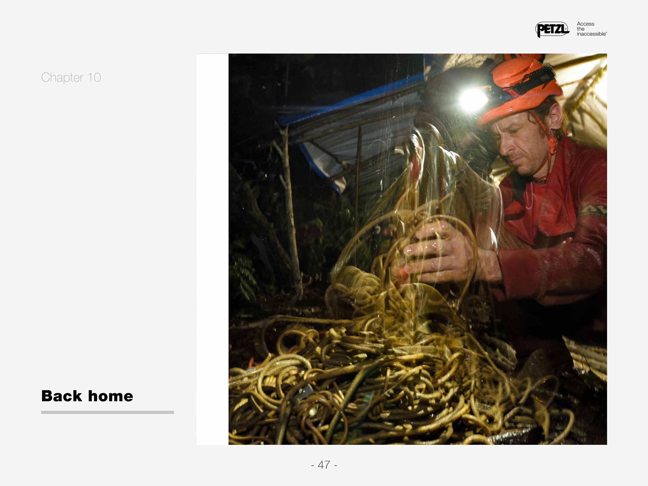
Today, Tuesday, February 23, the porters be-gin arriving in the early afternoon. We pack
all of the equipment that needs to be carried out, and give the rest to our Papuan friends. The next day, we reluctantly leave camp. Everything moves quickly from that point. We plan a one-day stop in Tolel to pick up the gear we stored there, and the Papuans take the opportunity to organize a farewell party. All of the locals who spent time with our team express their desire for us to come back. We then return to Palmalmal, and spend a full day washing, drying, and packing our gear. The boats from Kabaira Dive Center arrive on the evening of February 27.
The return trip, which should have been a leisu-rely seven- to eight-hour cruise, does not go as planned. In Wide Bay, waves start to hit our boat, and the situation takes a turn for the worse when we head up the coastline that forms the eastern shore of the narrow section of sea between New Britain and New Ireland. Strong winds cause rough
seas, forcing us to stop for a few hours before Lloyd decides to continue. This turns out to be a poor choice, as the sea never calms down, for-cing another stop at the end of the afternoon in the village of Kambubu. We continue our journey, this time on land. Finally, at 00:40, we arrive at our destination, 20 hours after leaving Palmalmal.
The return to Kokopo marks the end of the Black Hole expedition, and provides us the chance to look back at our trip. During the four weeks spent in the Nakanai Mountains, we explored almost nine kilometers of galleries, surveying and mapping 6.565 of those. The highlight discovery was clearly the Christian Rigaldie cave network; the 714-me-ter deep cave ranks second among the deepest caves in Papua New Guinea. Our exploration pro-vided a partial explanation as to where the water flows underground in this part of the karst lands-cape. The Christian Rigaldie cave network extends south by southwest, towards Wunung Gorge. We descended to an altitude of roughly 246 meters

- 49 -
above sea level at the bottom of the cave. There is no way in which the water flowing through this cave could exit at the Wara Kalap resurgence, lo-cated almost 12 kilometers away to the east. The stream running through the Christian Rigaldie cave network flows beneath Wunung Gorge and feeds into the resurgence of the same name. The disco-very in the Wunung riverbed of a small cavity that descends a dozen meters to a sump corroborates this hypothesis. A section of the cave at the lower end of Wunung Gorge is completely underwater.
In general, Wild Frank Cave heads south but, at the bottom, the cave gradually meanders to the west. The same goes for Arche cave. These two cavities are located near Black Hole. It is difficult to determine the direction of the underground drai-nage system, but it is highly likely that the wa-ter exits at the Wunung resurgence. However, for Wild Dog cave, it is possible that water drains to the west, towards Wara Kalap. This is likely the case for the yet-to-be-discovered cavities to the
north. Finding proof, however, will require another expedition. Several team members would love to come back. How about in 2018?
Jean-Paul Sounier

- 50 -

- 51 -
Jérôme Jouret spends his time exploring even the smallest cavities near his resi-dence in Ardèche, France. He is an underground digger and rescue specialist. He was a member of the 2014 expedition to New Britain, and greatly enjoys caving in Papua New Guinea, so he enthusiastically agreed to participate in the Black Hole expedition.
Robbie Shone is an underground photographer and reporter who loves taking pic-tures on expeditions. His first underground photos featured caves in England, those explored by a British expedition to Papua New Guinea in 2006. Since then, his reco-gnition has only grown as he continues taking photos for expeditions and in famous caves all over the globe.
Jean-Paul Sounier was the instigator and leader of the Black Hole expedition. He is THE specialist for caving in Papua New Guinea, with 13 expeditions to the islands under his belt, including those that led to the exploration of the first 1000-meter-deep cave in the Southern Hemisphere. His explorations have taken him to the four cor-ners the planet.
The Black Hole expedition team

- 52 -
Jérémie Faurax is a doctor, a highly sought-after profession for both alpine and ca-ving expeditions. Working in New Caledonia, he decided that participating in a pro-ject in Papua New Guinea, a country close to his workplace, was a dream to come true. He first applied for another project, but the dates did not fit, so he was able to serve as doctor for the Black Hole expedition.
Guillaume Delorme discovered underground exploration not too long before he par-ticipated in the Black Hole expedition. During a caving outing, Jérôme told him about the Papua New Guinea project. Tragically, Guillaume passed away in 2016.
Clément Flouret is a high-mountain guide and started caving only recently. Being able to participate in his first caving expedition in a legendary mountain range on the other side of the planet is what motivated him, along with the voyage and discove-ring other cultures, since traveling is an important part of his profession.

- 53 -
Al Warild is a legend in the caving community. His list of underground successes is mind-boggling. He has participated in several expeditions to Papua New Guinea, including three to New Britain. Enticed by the Black Hole expedition's objectives, he took little time in agreeing to participate.
Jabier Garcia is José's "underground rope partner." He was also a member of the 2010 Vuvu expedition team. A new underground adventure in Papua New Guinea was also a high-priority foreign expedition for him.
José Gambino Loureiro enjoys his passion for caving primarily in the karstic moun-tains of Spain, especially in the Basque Country. Cold and deep caves are his spe-cialty. He participated in the 2010 Vuvu expedition, the fourth cave diving expedition in the Nakanai Mountains, and returning there was a must for him.

- 54 -
The expedition received support from Petzl and this ebook was published by the brand's graphics studio.