black sea commission/permanent secretariat · pdf fileenvironment of the black sea resulting...
TRANSCRIPT

13-14 December 2011, Chisinau
Black Sea Commission/Permanent Secretariat www.blacksea-commission.org

Oil Pollution Sources in the Black Sea
• Rivers discharges
• Rivers discharge • Municipal Sector • Shipping • Offshore installations • Natural seepage
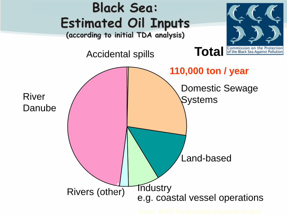
Black Sea: Estimated Oil Inputs (according to initial TDA analysis)
Industry e.g. coastal vessel operations Rivers (other)
Source: BSEP Transboundary Diagnostic Analysis
River Danube
Domestic Sewage Systems
Land-based
Accidental spills Total 110,000 ton / year
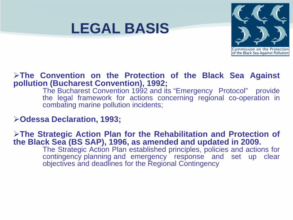
The Convention on the Protection of the Black Sea Against pollution (Bucharest Convention), 1992; The Bucharest Convention 1992 and its “Emergency Protocol” provide the legal framework for actions concerning regional co-operation in combating marine pollution incidents;
Odessa Declaration, 1993;
The Strategic Action Plan for the Rehabilitation and Protection of the Black Sea (BS SAP), 1996, as amended and updated in 2009. The Strategic Action Plan established principles, policies and actions for contingency planning and emergency response and set up clear objectives and deadlines for the Regional Contingency Plan.
LEGAL BASIS

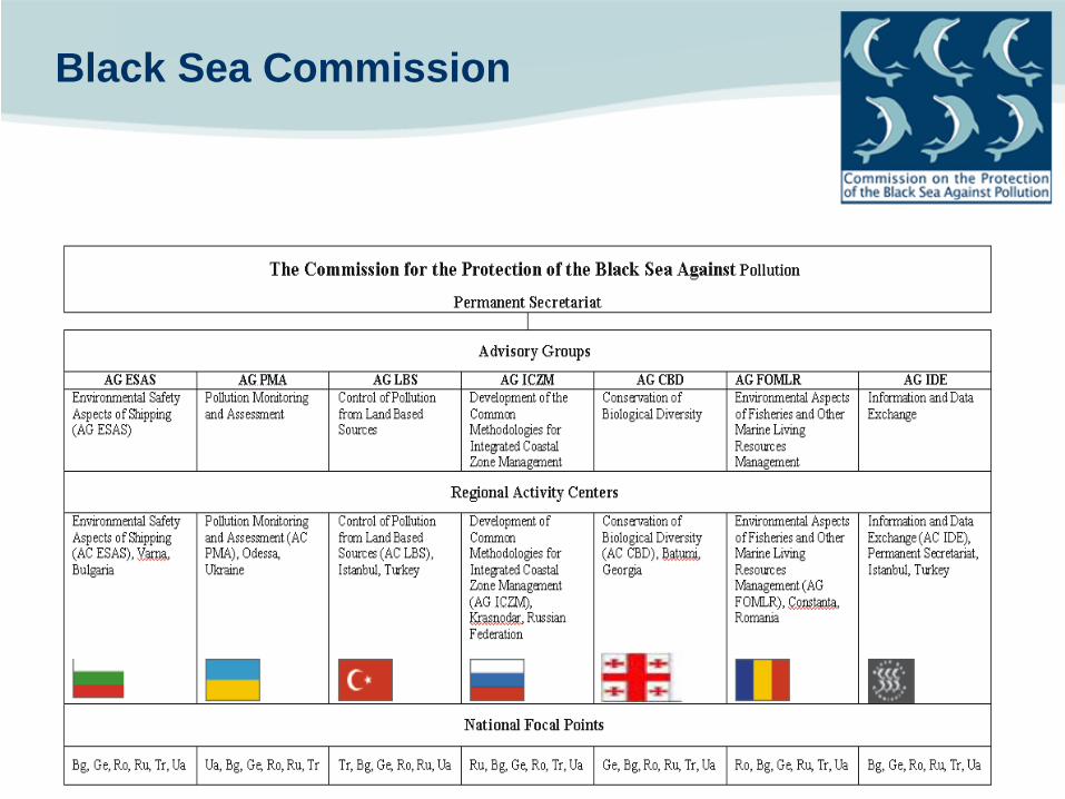
Black Sea Commission
Bucharest Convention In April 1992 six Black Sea countries (Bulgaria, Georgia, Romania, Russian Federation, Turkey and Ukraine) signed and shortly thereafter ratified the Convention on the Protection of the Black Sea Against Pollution (Bucharest Convention) with its (three) integrated protocols. Pollution related
– Land based sources – Cooperation in emergency situations – Dumping
and – Black Sea Biodiversity and Landscape Conservation Protocol (not ratified yet)
•Intergovernmental body for promoting the implementation of the provisions of Bucharest Convention, its protocols and Strategic Action Plan •The regional focal point for any environmental aspects of the coastal and marine environment of the Black Sea •Made up of 6 Commissioners (one for each coastal country) and a chairman •The Permanent Secretariat is located in Istanbul, Turkey
Bulgaria Georgia Romania Russian Federation
Turkey Ukraine

The Strategic Action Plan for the Rehabilitation and Protection of the Black Sea
• Signed on October 31, 1996
(commemorated as the Black Sea Day)
• Adopted by all Black Sea countries
• Updated in 2009
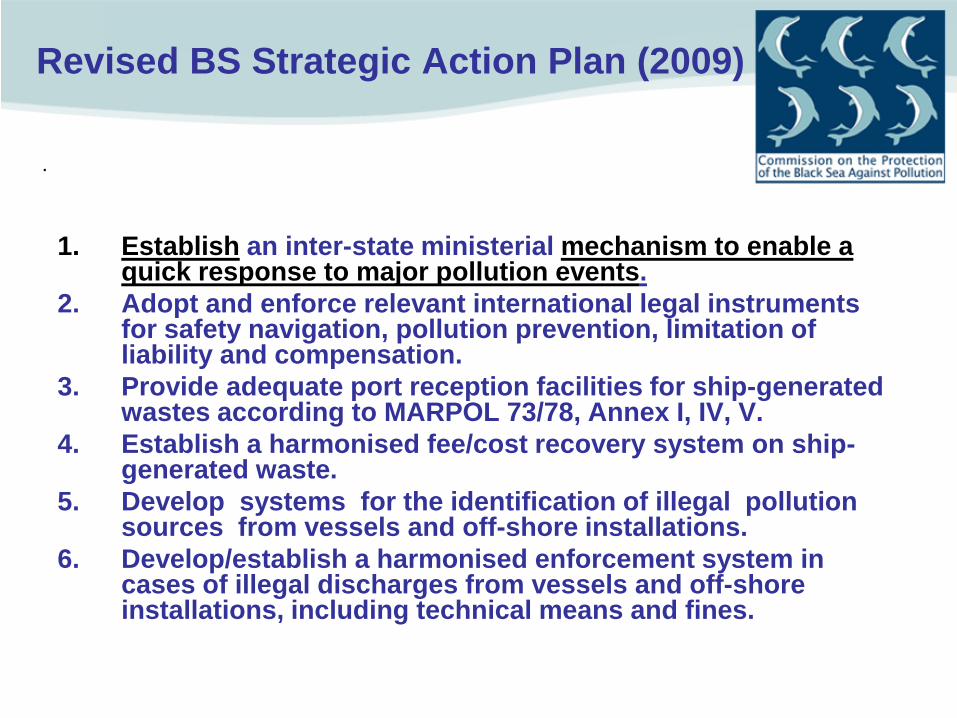
Revised BS Strategic Action Plan (2009)
1. Establish an inter-state ministerial mechanism to enable a quick response to major pollution events.
2. Adopt and enforce relevant international legal instruments for safety navigation, pollution prevention, limitation of liability and compensation.
3. Provide adequate port reception facilities for ship-generated wastes according to MARPOL 73/78, Annex I, IV, V.
4. Establish a harmonised fee/cost recovery system on ship-generated waste.
5. Develop systems for the identification of illegal pollution sources from vessels and off-shore installations.
6. Develop/establish a harmonised enforcement system in cases of illegal discharges from vessels and off-shore installations, including technical means and fines.
.
Black Sea Commission

Regional Legal Framework
• The Bucharest Convention (1992) • Article IX: Cooperation in combating pollution in
emergency situations • The Contracting Parties shall cooperate in order to
prevent, reduce and combat pollution of the marine environment of the Black Sea resulting from emergency situations in accordance with the Protocol on Cooperation in Combating Pollution of the Black Sea by Oil and Other Harmful Substances in Emergency Situations…
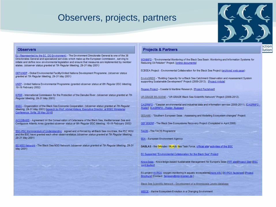
Observers, projects, partners

AG Environmental Safety Aspects of Shipping (AG ESAS)
Provides operational assistance for combating pollution from oil or chemical spills
• Capacity building : -training, exercises
• Data collection as: Number of ships calling at ports, passing the Istanbul Strait, PRF, Oil Spills,
Dumping (volume of dredged material, cub m), Ballast Waters.
• Legal documents. Regular maintenance and update of the operational information (Annexes 1-4) for the implementation of the RCP
1. Directory of competent national authorities, contact points, emergency response centres, national on-scene commanders and other relevant addresses;
2. Maps showing possible sources of pollution, environmental sensitive areas, environmental sensitive indices, priorities for protection;
3. Operational procedures: Alarming, notification, communication System; 4. Directory of response personnel and inventory of response equipment, products
and other means which each party might offer as assistance in case of the activation of the Plan.
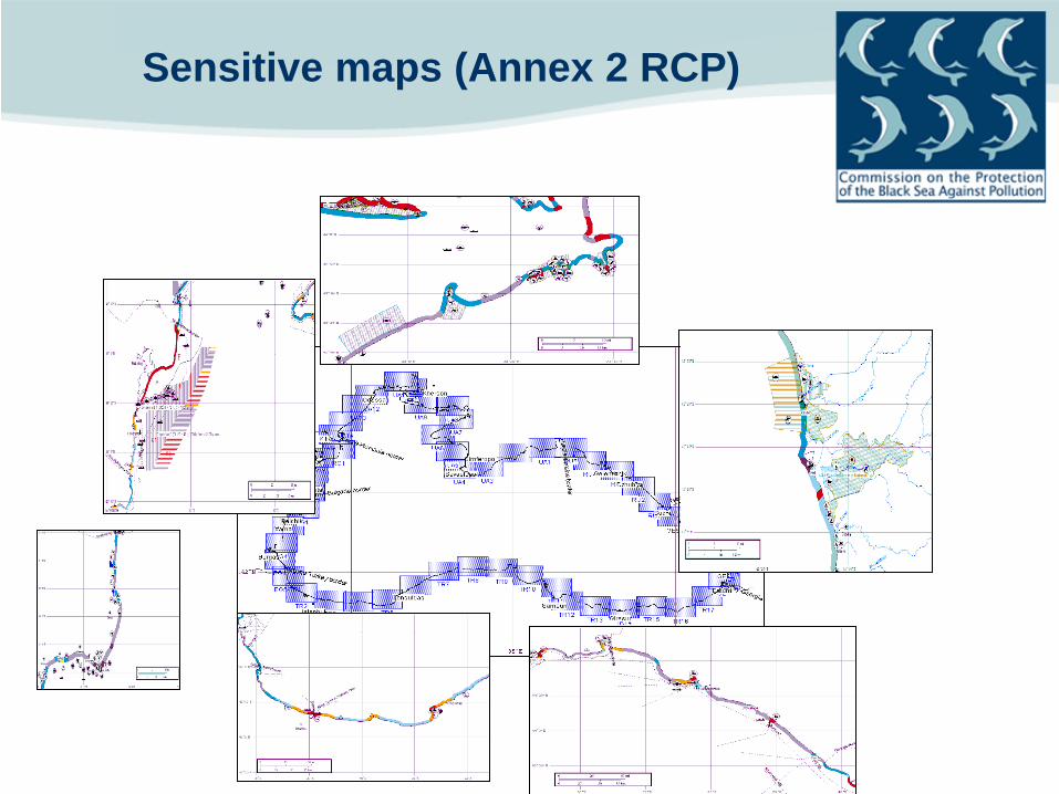
Sensitive maps (Annex 2 RCP)

AG ESAS International, regional and/or national
at-sea response exercises
Exercises are a major milestone and investment in the region’s preparedness for oil spill accidents: • Black SEA ALPHA: Synthetic or Table-top Exercise;
• Quarterly BLACK SEA BRAVO: Alarm or Communication Exercise;
• BLACK SEA DELTA (at-sea exercises) :
• SULH 2007, hosted by Turkey. • RO-DELTA August 2009, hosted by Romania • GEODELTA Sept. 2011, hosted by Georgia
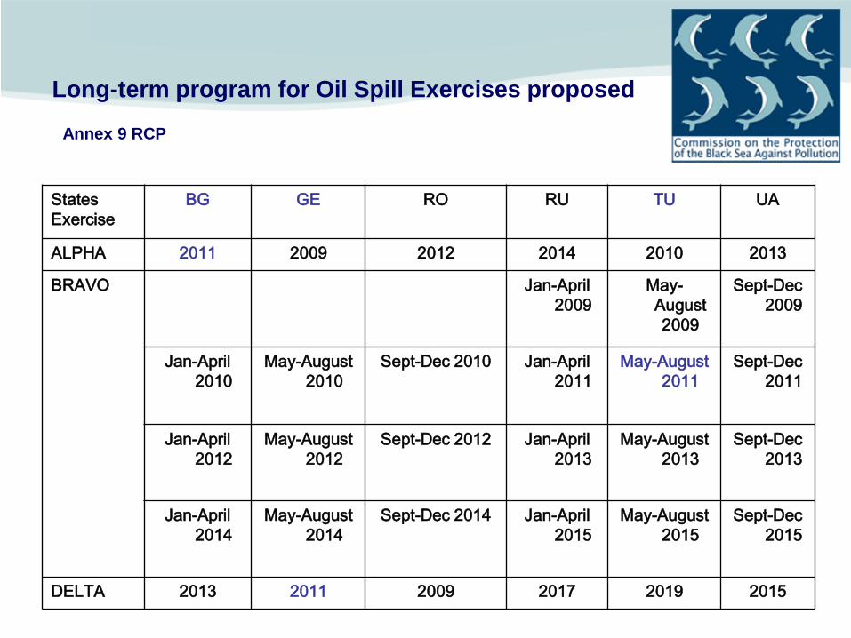
Long-term program for Oil Spill Exercises proposed
Annex 9 RCP
States Exercise
BG GE RO RU TU UA
ALPHA 2011 2009 2012 2014 2010 2013
BRAVO Jan-April 2009
May- August 2009
Sept-Dec 2009
Jan-April 2010
May-August 2010
Sept-Dec 2010 Jan-April 2011
May-August 2011
Sept-Dec 2011
Jan-April 2012
May-August 2012
Sept-Dec 2012 Jan-April 2013
May-August 2013
Sept-Dec 2013
Jan-April 2014
May-August 2014
Sept-Dec 2014 Jan-April 2015
May-August 2015
Sept-Dec 2015
DELTA 2013 2011 2009 2017 2019 2015

DELTA Exercise, September 2007, hosted by TURKEY – SULH 2007
http://www4.ibackup.com/qmanager/servlet/share?key=jdowx61003 http://www.cam-story.com/download/SULH.zip )

RO-DELTA– Midia- Constanta August 2009
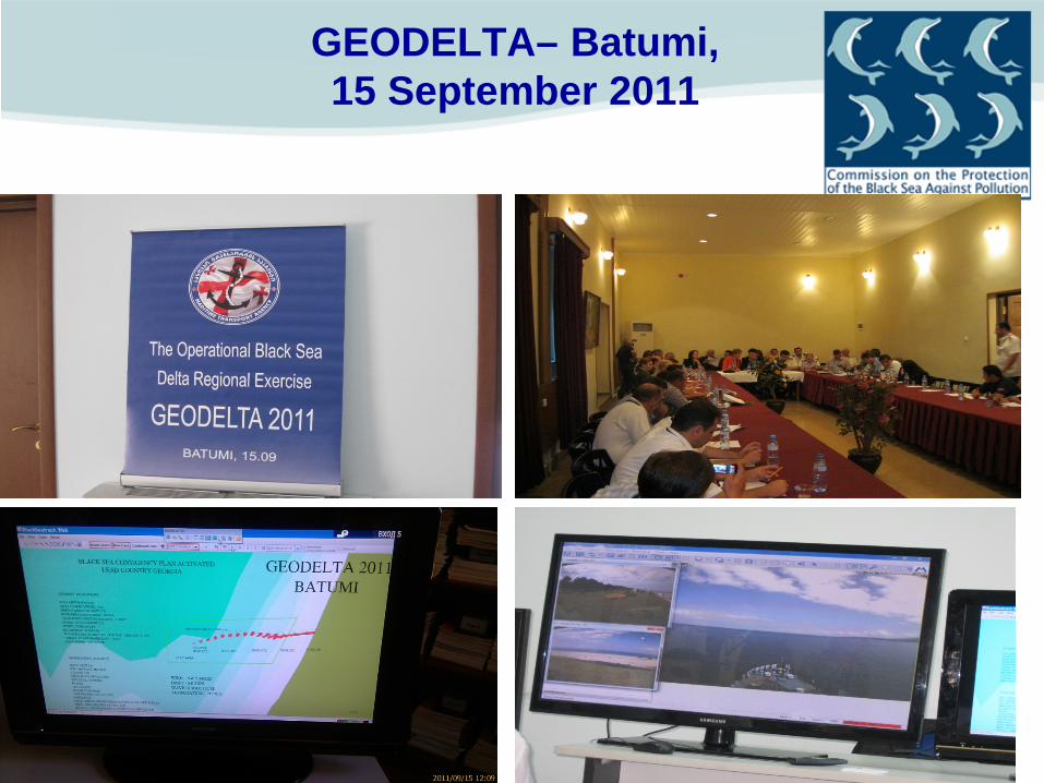
GEODELTA– Batumi, 15 September 2011
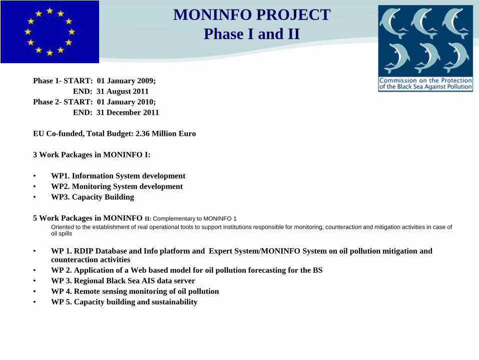
MONINFO PROJECT Phase I and II
Phase 1- START: 01 January 2009; END: 31 August 2011 Phase 2- START: 01 January 2010; END: 31 December 2011 EU Co-funded, Total Budget: 2.36 Million Euro 3 Work Packages in MONINFO I: • WP1. Information System development • WP2. Monitoring System development • WP3. Capacity Building
5 Work Packages in MONINFO II: Complementary to MONINFO 1 Oriented to the establishment of real operational tools to support institutions responsible for monitoring, counteraction and mitigation activities in case of
oil spills
• WP 1. RDIP Database and Info platform and Expert System/MONINFO System on oil pollution mitigation and counteraction activities
• WP 2. Application of a Web based model for oil pollution forecasting for the BS • WP 3. Regional Black Sea AIS data server • WP 4. Remote sensing monitoring of oil pollution • WP 5. Capacity building and sustainability

MONINFO Project General objectives
MONINFO project finally should enable the coastal states to better prevent and respond to
operational/accidental/illegal oil pollution, aiming to achieve the following main objectives:
• Development/Improvement of information and monitoring systems for operational, illegal and accidental oil pollution, by collecting, storing, processing and distributing different type of data related to oil pollution prevention and response activities within the area;
• Setting up a Black Sea Regional AIS server; • Setting up a regional monitoring service on oil pollution detection;
• Setting up an oil modeling to understand distribution/forecast following a spill
• Enhancement of response capabilities, including a common risk management proposal and emergency planning update.

MONINFO Project Scope
Long term:
– Contribue to improve the quality of the environment at regional level by using common tools and methodologies focusing on an expert system for oil pollution mitigation and counteraction activities.
– Stronger institutional partnership at national level, sustaining and further building of capacity in the region.
– Improved regional cooperation and partnership with regional and international bodies.
Short term: - Implementing a satellite monitoring pilot study in detecting oil pollution
(illegal, operational, accidental) that will include Automatic Identification System (AIS) and backtracking.
– Trained experts and users in all MONINFO layers (from reporting data to assessments and decisional support, based on an Internet oil spill transport model and effective response).
– Clear baseline of existing situation as basis for improved national and regional monitoring information and communication

Main deliverable of 1st phase
is Concept Paper
Dedicated to support the Regional Contingency Plan through:
• Building a single access point system for Black Sea related data • Supporting decision makers (national authorities, MRCCs) using: >Several Components
-Oilspill Modeling -Satellite Image Monitoring -Document Repository -GIS data, Geoportal -AIS Regional server -Risk Management Capabilities

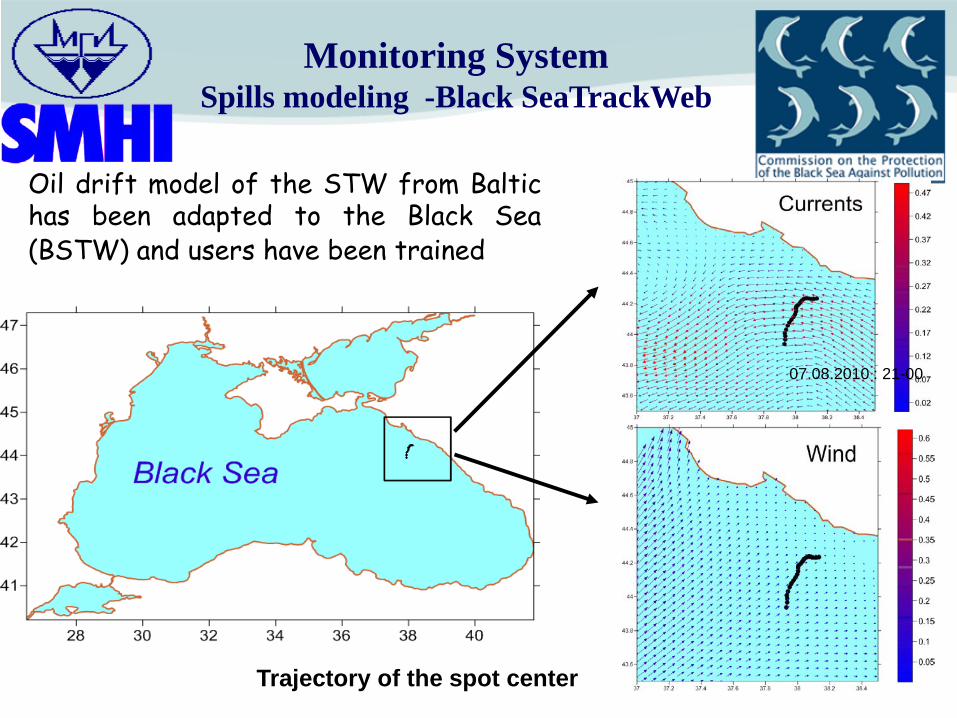
Oil drift model of the STW from Baltic has been adapted to the Black Sea (BSTW) and users have been trained
07.08.2010 : 21-00
Trajectory of the spot center
Monitoring System Spills modeling -Black SeaTrackWeb

MyO Thematic Assembling Center
(TAC)
NOAA, ERS, EnviSat, Jason
MyO Production Unit BS SEVASTOPOL-UA Atmosphere
forcing (ALADIN/SKIRON)
MyO Dissemination
Unit (DU)
MyO Center Service Desk (CRD)
MyOcean Black Sea MFC
Server BSC
STW Black Sea
Internet
Internet
User
User

BlackSeaTrackWeb

Oilspill Monitoring (Satellite based)
• CleanSeaNet (CSN) from EMSA – CSN was successfully launched in the Black Sea area since
August 2010, providing service to Bulgaria-Georgia-Romania-Turkey;
– The service is open to Russia and Ukraine as well;
• BlackSeaSatNet (ITU+ScanEX) – Tested February-March 2011

CLEAN SEA NET 2010

Case Humboldt: Image from 18/08/2010 at 20:45:00 UTC Evidence of pollution found, after inspection in Turkey
Correlation with AIS data for a detection in Italy
Example of Identification of potential polluters by combining CSN and AIS Information

Geoportal
“Космоснимки-Черное море”
The Russian capacity under SCANEX- and the Turkish capacity by Istanbul Technical University, Center for Satellite Communications and Remote Sensing (ITU CSCRS) are available. Both institutions are involved in the Project by their capacity and expertise in satellite surveillance, in build a composite map of areas of heavy oil pollution (based on archive data) and to provide a similar service as CSN (complementing it in the BS region).
•Geoportal
“Cosmophotos – Black Sea
Demonstration site http://new.test.kosmosnimki.ru/Default.aspx
Log in – scanex, password – scanex
SCANEX & ITU CSCRS
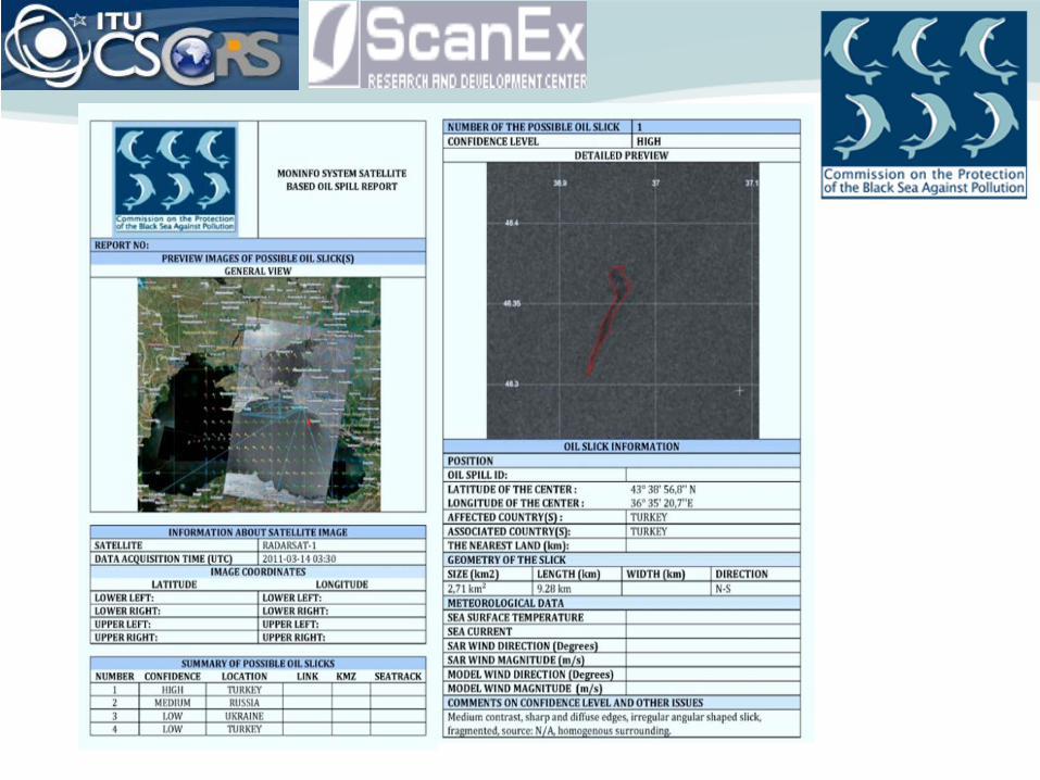

Oilspill Report

HELCOM AIS server North Sea
AIS server
Mediterranean AIS server
STIRES server
Black Sea Server
Northern N.Atlantic server Groenland
Feroe. Island Canada
Regional Black Sea AIS

REGIONAL BLACK SEA AIS
• Ad-hoc AG on AIS data exchange (or Expert Working Group on AIS) established by BSC. Three AIS EWG meetings were held
• Technical specifications has been finalized
• Draft MoU on Regional Black Sea AIS has been prepared and finalized

MONINFO (Main Page)
AIS
National Contacts
Environmental Information
Satellite Monitoring
BS SatNet
Clean Sea Net
News and Forum
Incident Reporting
User Accounts
Help System
Decision Support
Legal Framework
Document Reposıtor
y
Useful Links
Possible Oil Spill Maps
AIS Maps Oil Drift
Moodeling Results
Incident Records
Bathymetry maps
Port maps Nautical
Charts Areas of
risk
User Interface Decision
Support & RA
Oil Spill Drift Modelling
BS
SeaTrack Web

OIL SPILL RECORDS • Historical records of oil spills in the
Black Sea has been prepared and are stored in the MONINFO system
• A comprehensive report on the Kerch accident (11th November 2007) is prepared by a team of experts from Russia and Ukraine and is in course of being published.
• It contains scientific, unpublished data, many photos taken during and after the accident, figures and tables which provide valuable information in different aspects including conclusions and lessons learned.

The catastrophic disaster 11 November 2007 from the «Volgoneft-139» tanker accident in the Kerch Strait which was estimated to disperse to 117.6 km2.
16.07.2008
The tanker "Volgoneft-139" had 4.77 thousands tons of fuel oil on board. It literally split in two. Then, within the span of two hours, one after the other, three ships loaded with sulfur sank: "Volnogorsk", which had more than 2.6 tons of sulfur on board; "Nakhichevan", with two thousands tons of sulfur; and "Kovel", with 2.1 thousands tons of sulfur.
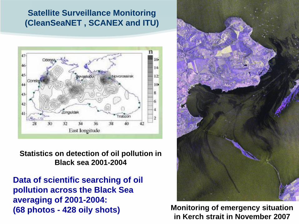
Data of scientific searching of oil pollution across the Black Sea averaging of 2001-2004: (68 photos - 428 oily shots)
Satellite Surveillance Monitoring (CleanSeaNET , SCANEX and ITU)
Monitoring of emergency situation in Kerch strait in November 2007
Statistics on detection of oil pollution in Black sea 2001-2004

Document repository

Geoportal
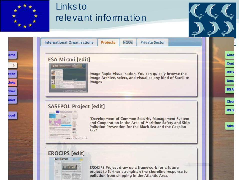
Links to relevant information

Capacity Building
Support on regional level: 1. Emergency preparedness/contingency planning (update of the operational information RCP (Annexes 1-4) , guidelines on exercise
and dispersants have been developed )
2. Exercises and training in oil spill response (such as support of RODELTA-2009 and GEODELTA -Sept 2011)

MONINFO System web page
Thank you
Bulgaria Georgia Romania Russian Federation
Turkey Ukraine
www.blacksea-commission.org