blackstone river watershed - u.s. army corps of engineers ... · main report august 1981 blackstone...
TRANSCRIPT

••
Main Report
August 1981
Blackstone River Watershed
TC423 .N43B621 1981 v.1 c.3

'IC423 • N43B6 21 1981
v.1 c. 1 c.2 c.3 c.4
v.2 .:.1 c.2 t;3 c.4
Blac~stone ~iver ~atershed. -- ~al~ham, Mass_ : U.S. Army Corps o~ Engineers, New England Division, 1981. 2 v. : 111., maps; 28 em_ -
(Pawcatuck ~iver and Narragansett Bay drainage basins.) (Water and related land resources study.)
"AuDust 1981" ~ 1 M i rt -- v.2. Contents: v. • a n repa
Appendices.
09 AUG 86 14070315 AEEMsl SEE NEXT CRD
TC423 • N43B621 1981
Elackstone River wa~ershed. ••• 1981 • <Card 2)
1. Water resources development-Blackstone River wa~ershed, Mass. and R.I. 2. Watershed manaeement-Blackstone River watershed, Mass. and R.I. 3. Flood control--Blackstone River watershed, Mass. and &.1. 4. Blackstone River watershed (Nass. and R.I.)--Water resources development. 5. Pawcatuck River watersbed (MaSSe and R.I.)--Water resources developmeD~. 6. Narra@anse~t Bay drainage basin (Mass. and R.I. )--Wa~er resources develo~ment. I. Uni~ed States. Army. Corps of Engineers. New England Division. II • Series III. Series: Wa~er and rel ated land resources study.
09 AUG 86 14070315 AEENsl

PAWCATUCK RIVER AND NARRAGANSETT BAY DRAINAGE BASINS
WATER AND RELATED LAND RESOURCES STUDY
BLACKSTONE RIVER WATERSHED
MAIN REPORT
DEPARTMENT OF THE ARMY NEW ENGLAND DIVISION, CORP OF ENGINEERS
WALTHAM, MASSACHUSETTS 02254
AUGUST 1981

FOREWORD
THE PAWCATUCK RIVER AND NARRAGANSETT BAY STUDY
The Pawcatuck River and Narragansett Bay Drainage Basins (PNB), authorized for study under Congressional resolutions in 1968, include southeastern Massachusetts, nearly all of Rhode Island, and the southeastern corner of Connecticut. The investigation of the water resource needs of the PNB study area is being published in several documents with a final summary report scheduled to be completed in December 1982.
This document addresses, primarily, the solutions investigated to meet flood control needs in the Blackstone River Watershed, a MassachusettsRhode Island drainage basin at the head of Narragansett Bay. An executive summary follows on page ii.
The following reports were prepared for various drainage basins or resource needs by the PNB study:
Report Title
PNB Water Supply Study Assessment of the Flood Problems
of the Taunton River BaSin, MA Pawtuxet River Flood Control Report Big River Reservoir Project Blackstone River Watershed Pawcatuck and Woonasquatucket River
Basins and Narragansett Bay Local Drainage Areas
PNB Summary Report
i
Report Completion !late
January 1979 August 1979
August 1980 July 1'181 August 1981 October 19!11
December 1982

EKECUTIVE SuMMARY
The investigation of the Pawcatuck Kiver and Narragansett Bay Drainage Basins (PNB), which includes the Blackstone Kiver was authorized under Congressional resolutions in 1968. The Blackstone River watershed lies within southeastern Massachusetts and northern Rhode Island. The watershed study reviewed about 40 potential projects in 1974 to meet flood control, water supply and recreation needs in the study area. By 1976, six projects remained for further study following the initial screening, including Nipmuc Dam and Keservoir, modifications of Old Slater Hill Dam and Sayles Finishing Company Dam, and local protection projects at Uxbridge, Massachusetts, and at Ashton and Herkeley in Cumberland, Khode Island. By 1978 only the Berkeley Local Protection Project was economically justified and warranted detailed study. The Berkeley Industrial Park, which employs 900 people and wholesales groceries, clothes, and wire regiomdde, would experience about $2~ million in damages with a recurrence of the August 1955 record flood. 'lwo plans were found economically and environmentally feasible; however, only one plan is implementable.
The purpose of this report is to document the investigation conducted under the Blackstone River Study. The main report highlights the study findings. Greater detail, particularly concerning plan formulation and reiteration, is contained in the eight appendices which accompany the main report.
A flood control plan for Cumberland was presented at a December 19/8 public meeting to determine public support. With the support demonstrated for protecting the Berkeley Industrial Park, two plans were prepared in more detail for final consideration and selection: a structural and a nonstructural plan. The Berkeley Local Protection Plans A and B were both found to be economically, environmentally, technically and socially feasible and more acceptable than future conditions without a plan of improvement. Both plans would include flood warning and evacuation for three floodprone areas in Cumberland; Ashton, Berkeley and Lonsdale. In addition, the plans would provide a high degree of flood protection to the town's pumping station and to three Berkeley industries shown on the front cover, consisting of ~oger Williams Foods, Health-Tex Incorporated and The Okonite Company. The most significant differences between the two plans are level of flood protection, first costs, impact on flood stages, and implementation.
Plan A would provide flood warning for the town and a structural solution for Berkeley with protection against a Standard Project Flood (SPF). An SPF is the flood discharge that may be expected from a rare event which would be caused by the most severe combination of meteorological and hydrologic conditions that are considered reasonably characteristic of the region~ excluding extremely rare combinations. An ~PF would exceed the 1955 flood level by about 3 feet. The Berkeley Protection includes 5,100 feet of concrete wall and earth dikes with a pumping station and access gates, at a first cost of ~6.l million. As a result of the dike restricting the channel, river stages would increase upstream and adversely affect one private residence and the Owens-Corning Fiberglas Corporation plant in Ashton (see Figure 1). In addition, river velocities would increase
ii

downstream of the bridge tsee cover photo) and possibly increase erosion along the historic Blackstone Can~l. The plan would require Congressional authorization and funding, as well as State and local assurances and cost sharing to be implemented over a 7 to 10 year period.
Plan B would provide flood warning for the town and a nonstructural solution for Berkeley with partial protection against a recurrence of the 1955 flood. The Berkeley protection includes waterproofing of walls, flood shields for doors and windows, and ringwalls for unloading areas to protect the three Berkeley industrial buildings and the town pumping station at an estimated first cost of $1.2 million. The nlost significant adverse impact associated with the plan is the continued flooding of areas around the buildings thus necessitating evacuation of the buildings. The plan could be implemented in 3 to 4 years under the Corps' Continuing Authority for small flood control projects, provided local assurances and cost sharing requirements are met following completion and approval of a Detailed Project Report.
In June and July lY81, the Corps met with the Mayor of Cumberland, the town council, and industry representatives to determine the preferred plan. The town supported Plan A provided it was authorized under traditional cost sharing with non-Federal interests paying only for lands, damages and relocations. However, all indications are that the current administration's policy will be similar to the former administration's policy for cost sharing, which requires a Z5 percent non-Federal contribution, or ~l,536,OOO for Plan A with a Federal cost of ~4,b06,OOO. Since this amount is beyond their financial resources, local interests decided to support Plan B. Plan B's estimated non-Federal cost is $243,000 with a Federal cost of ~973,OOO.
The Division Engineer, therefore, recommends no further action by the Corps of Engineers under the PNB authorization for the Blackstone River Watershed Study and that the Berkeley Local Protection Plan B continue detailed planning under the Corps' authority for small flood control projects, as requested by letter dated 31 July 1981 from the town of Cumberland (see Correspondence Section).
iii
•


PAWCATUCK RIVER AND NARRAGANSETT BAY DRAINAGE BASINS
WATER AND RELATED LAND RESOURCES STUDY
FEASIBILITY STUDY BLACKSTONE RIVER WATERSHED
RHODE ISLAND AND MASSACHUSETTS
MAIN REPORT
TABLE OF CONTENTS
Item FOREWORD EXECUTIVE SUMMARY
INTRODUCTION
Study Authority Scope of the Study Study Participants and Coordination Other Studies The Report and Study Process
PROBLEM IDENTIFICATION
National Objectives Existing Conditions The WLthout Condit Lon Problems, Needs and Opportunities Planning Constraints Statements of Problems and Opportunities
FORMULATION OF PRELIMINARY PLANS
Plan Formulation Rationale Plans of Others Analysis of Plans Considered in Preliminary
Planning Conclusions
ASSESSMENT AND EVALUATION OF DETAILED PLANS
Plan A - Berkeley Local Protection Structural Project Plan B - Nonstructural Plan
iv
Page No. i ii
1
1 1 1 3 4
5
5 5
14 14 17 17
18
21 23 23
26
28
28 36

TABLE OF CONTENTS
Item
COMPARISON OF DETAILED PLANS
Rationale for Designation of NED Plan Rationale for Designation of EQ Plan Rationale for Selected Plan
CONCLUSIONS
ENVIRONMENTAL ASSESSMENT
Summary Need for and Objectives of Action Alternatives Affected Environment Environmental Effects Public Involvement Fish and Wildlife Coordination Correspondence
APPENDICES*
Number Title
1 PROBLEM IDENTIFICATION
2 PLAN FORMULATION
(Cont-d)
3 PUBLIC VIEWS AND RESPONSES
4 DESIGN AND COST ESTIMATES
5 RECREATION AND NATURAL RESOURCES
6 SOCIAL AND CULTURAL RESOURCES
7 ECONOMICS
8 HYDROLOGIC ANALYSIS
*Appendices are bound in a separate volume.
v
Page No.
44
46 46 46
47
I 3 5
10 14 16
Page No.
1-1
2-1
3-1
4-1
5-1
6-1
7-1
8-1
TABLE OF CONTENTS (Cont-d)
PHOTOS
1955 FLOOD PHOTOS
PROJECT SITE PHOTOS
v:L
Follows Page
14
EA12
Number
lA IB 2
3
4
5
6
7
8
9
Number
1
2
3
Number
1
2
3
4
5
TABLES
Titles
PERTINENT PROJECT INFORMATION FLOOD CONTROL PROJECTS STUDIED PLAN A - FIRST COST AND ANNUAL CHARGES
PLAN A - ECONOMIC ANALYSIS
PLAN A - COST APPORTIONMENT
PLAN B - FIRST COSTS AND ANNUAL CHARGES
PLAN B - ECONOMIC ANALYSIS
PLAN B - COST APPORTIONMENT
SUMMARY COMPARISON OF FINAL ALTERNATIVE PLANS
COMPARATIVE IMPACTS
FIGURES
Title
BERKELEY LOCAL PROTECTION
TRACKS OF SELECTED HURRICANES
FLOODWAY SCHEMATIC
PLATES
Title
PNB STUDY AREA
BLACKSTONE RIVER GROUP
BERKELEY LOCAL PROTECTION PROJECT, PROJECT PLAN A
BERKELEY LOCAL PROTECTION PROJECT, DETAILS
BERKELEY LOCAL PROTECTION PROJECT, PROJECT PLAN B
vii
Page No.
12 24 29
30
34
37
39
41
45
Follows Page
i
6
18
Follows Page
1
11
28
2tl
36

INTRODUCTION
The Blackstone River Basin lies within southeastern Massachusetts and northern Rhode Island. Due to the area's history of floods, this study investiRated the flooding and associated water resource problems in the watershed and developed plans, acceptable to local interests that would solve these problems.
STUDY AUTHORITY
This report is submitted in partial compliance with seven Congressional resolutions, combined under one resolve adopted by the Committee on Public Works of the United States Senate, which authorize the Pawcatuck River and Narragansett Bay Drainage Basins (PNB) Study, including the Blackstone River Basin. Two resolutions, one adopted 29 March 1968 and the other 10 July 1968, requested review of the 1955 report on The Resources of the New England - New York Region. A third resolution, adopted 8 May 1967, requested a review of the 1965 report of the Chief of Engineers on the Blackstone River in Massachusetts and Rhode Island and of other pertinent reports to determine the advisability of modifying his recommendations.
SCOPE OF THE STUDY
The PNB study area, as shown on Plate I, is hydrologically divided into five major watersheds, namely the Pawcatuck River (PK); the Providence River Group (PD), which comprises subwatersheds known as the Blackstone, Ten Mile, Seekonk, and the tri-river complex involving the Woonasquatucket-Moshassuck-Providence Rivers; the Taunton River (TN); the Pawtuxet River (PX); and the Narragansett Bay local drainage area (LD).
The Blackstone River Basin study explored alternative solutions to flood control and related water resource problems in the area. The most feasible plan was selected only after consideration of all factors, including cost and benefit estimates and comments expressed by concerned agencies, the State of Rhode Island and local parties.
An architect-engineer firm under contract to and under the direction of the Corps of Engineers performed a major portion of the screening process of the study. During the study factual information on past and potential floods was collected and developed. By using the basic data and by appling judgment as to degree of protection needed, as well as the probability of engineering, economic, social, and environmental feasibility, individual alternatives were either recommended for further analysis or found to be unwarranted and were eliminated.
STUDY PARTICIPANTS AND COORDINATION
The Corps of Engineers had the principal responsibility for conducting and coordinating the study and the plan formulation, consolidating information from studies of other agencies and preparing the report.
1

These studies and investigations were performed with the assistsnce of the following participating agencies:
u.s. Department of Interior (Fish and Wildlife Service) U.S. Department of Agriculture (Soil Conservation Service) u.s. Department of Commerce (National Weather Service) U.S. Department of Housing and Urban Development U.S. Department of Interior (Geological Survey)
Effects of the study alternatives concerning fish and wildlife were analyzed by the U.S. Fish and Wildlife Service.
All studies were coordinated with the appropriate agencies including but not limited to the following:
Federal Level
U.S. Environmental Protection Agency U.S. Department of Health, Education and Welfare (Public Health
Service) U.S. Department of Commerce (National Marine Fisheries Service) U.S. Department of the Interior (Heritage, Conservation and
Recreation Service)
State and Regional Level - Rhode Island
Statewide Planning Office Historical Preservation Commission Water Resources Board Department of Health Department of Natural Resources (Division of Fish and Wildlife) Blackstone Valley Sewer District Commission
State and Regional Level - Massachusetts
Central Massachusetts Regional Planning Commission Department of Environmental Quality Engineering (Division of
Waterways) Department of Environmental Management (Division of Water Resources)
Local Level
City of Woonsocket, Rhode Island City of Central Falls, Rhode Island City of Pawtucket, Rhode Island Town of Cumberland, Rhode Island Town of Lincoln, Rhode Island Cumberland, Rhode Island Conservation Commission Lincoln, Rhode Island Conservation Commission
2

N
BLACKSTONE RIVER SUB·BASIN
PD
SC ~ L! I ~ MI LES
o ..... ;;oj
,-' _/
" " " " eo
eo ,
LOCATION MAP ,<0" ~ .'C<' . ~ ,. " .. ..
L EGEND
COMMUNITY BOUNDAR Y
COUNTY BOUNDARY
STATE LI NE
RESPECTIVE BAS IN LIM ITS
P/lWTUXET RIVER BASIN
TAUNTON RIVER BASIN PAWCATUCK RIVER BASIN
LOCA L DRA INAGE
PROVIDENCE RIVER GROUP WATERSHED
WOONASOUA TUCKET - MOSHASSUCK
PROVIDENCE RIVERS SUB - BAS I N
BLACKSTO NE RIVER SUB - BAS I N
TEN'" I LE · SEEKONK RIVERS sua - BASIN
W"TE~ USOURCES MANAGUI!NT HPORT
PAWCATUCK RIVER AND
NARRAG ANSE TT BAY STUDY
BASIN MAP .".IT.,., Of tHE II.'
1,1 I'~U" m'\IO •. (om or ,"""", IIllH'., 10\'.
PLATE

Private Groups
Audubon Society Cumberland Preservation Society Blackstone River Watershed Association Sierra Club Pawtucket - Blackstone Valley Chamber of Commerce Canal, Inc.
Coordination procedures included informal meetings to discuss alternative plans considered or to be considered, review of and comments on a preliminary draft environmental assessment and participation in formal public meetings.
Initial public meetings were held in Providence, Rhode Island and in Uxbridge, Massachusetts to solicit people's views prior to the start of the PNB Study. Numerous meetings were later held with appropriate Federal and State agencies and with local officials and citizens of the basin's towns and cities to coordinste plans and proposals with the plans and goals of these interests. A late stage public meeting was held on 7 December 1978 in Cumberland, Rhode Island specifically for the Blackstone River Basin study to discuss the proposed basin flood management plans. Since that time additional meetings have been held with community and industrial representatives.
OTHER STUDIES
This study follows a number of earlier studies, described in Appendix 1 including:
The New England-New York Interagency Committee Report, March 1955
New England Flood Studies Report, June 1963
Report of Study, Blackstone River, November 1965
Master Manual of Reservoir Regulations, June 1966
Flood of March 1968 in Eastern Massachusetts and Rhode Island
Flood Plain Information Reports for Cumberland, Lincoln, Central Falls and Pawtucket, Rhode Island, June 1971; Auburn, Massachusetts, October 1972; and Lincoln, Rhode Island, August 1973
Reconnaissance Report of the Providence River Group, October 1972
Planning Aid Report on Climatology and Hydrology, September 1973
Site Preservation for Water Resources Project, January 1973
3

Flood Insurance Studies
Southeastern New England (SENE) Report, March 1976
Water Resources Development Study, May & October 1974
Environmental Report, March 1975
Water Quality Management Plans (Rhode Island, August 1976; Massachusetts, April 1975)
THE REPORT AND STUDY PROCESS
This report consists of two volumes. The Main Report describes the area under study and its problems, needs and opportunities with regard to flooding and related water resources. It sets out feasible solutions with their economic costs, benefits and justificstions as well as recommendations for implementation, including division of responsibility between Federal snd non-Federal interests. The "Formulation of Preliminary Plans" section explains the various measures that were screened and eliminated. The eight technical appendices contain technical detail augmenting the main report.
Planning consists of executing the four functional planning tasks during three stages of plan development. Iteration of these tasks during any of the planning stages may be necessary and even desirable in order to reflect an increasing level of effort, detail and refinement. Iteration also provides for the incorporation of additional information to the study as it progresses. The product of Stage 1 of the study effort is the reconnaissance report which describes the advisability of continuing with more detailed study. Effort at this stage provides a clear indication of the scope of needs, the study area's planning objectives and the scheduling and management of subsequent planning activities. Development of Intermediate Plsns in Stage 2 entails a more detailed analysis of the problems as well as the development of a preliminary range of solutions at a general level of detail, assessment and evaluation. Development of Final Plans in Stage 3 concentrates on developing a select number of more detailed alternative plans. Extensive public involvement and professional evaluation are required to determine which plans warrant detailed evaluation. Several iterations of the four basic tasks may be needed in order to achieve adequate detailed planning. This report is a Stage 3 document.
The report follows the study process, which basically involves four tasks: problem identification, formulation of alternatives, impact assessment and evaluation of flood control measures. The report then summarizes the formulation of alternatives considered in implementing programs of flood control and describes a recommended plan.
4

PROBLEM IDENTIFICATION
The following section defines the physical area and the exact nature of the flooding problems of the Blackstone River Basin study area. Planning objectives addressing those concerns and resource management problems are considered in light of the present conditions and of future conditions if no Federal action is taken. As noted in the "Scope of the Study" section, the Blackstone River Basin is part of the Pawcatuck River and Narragansett Bay Drainage Basins study and therefore the two national objectives are similar for each of the basins.
NATIONAL OBJECTIVES
National objectives for water resources plsnning have been defined in the U.S. Water Resources Council's Principles & Standards as achievement of national economic development (NED) and environmental quality (EQ). NED is to be achieved by increasing the value of the Nation's output of goods and services and by increasing the national economic efficiency. EQ is to be achieved by the management, preservation, creation, restoration, or improvement of the quality of certain natural and cultural resources and ecological systems.
The NED objective can be achieved here with flood control measures that can improve the area economy by reducing flood damages and the resulting costs to businesses in the area's flood plains.
The EQ objective can be achieved here with the same measures, if properly applied. Flood control measures that include or allow preservation of ecologically valuable wetlands could be adopted. Watershed management measures can increase ecological diversity and productivity of fish and wildlife in the area.
EXISTING CONDITIONS
The Blackstone River Basin study area occupies most of northern Rhode Island and extends northerly into southeastern Massachusetts. It is generally a region of wooded hills and rolling countryside covering 540 square miles: 382 square miles in southeastern Massachusetts and 158 square miles in northern Rhode Island. High floodflows are experienced on the Blackstone main stem, which result from the tendency of its tributaries to synchronize their flows with the crest on the main river. Since 84 percent of the Blackstone's length lies within metropolitan townships, thus affecting and affected by the works of man, s general understanding of the area's resources, development, and economy are essential to identifying flood-related problems and needs.
The Blackstone River originates at the junction of the Middle River and Mill Brook in the southern part of Worcester, Massachusetts, and flows in a southeasterly direction 44 miles to the Main Street Dam in Pawtucket,
5

Rhode Island. There it becomes the Seekonk River, a tidal estuary, which in turn flows south 7 miles into the Providence River in Providence, a northern arm of Narragansett Bay. Total fall over its entire length is approximately 440 feet.
Although the Blackstone is the largest river, it is not the only contributor of riverine benefits and problems to the watershed. Nine tributaries-Mill Brook, snd the Middle, Quinsigsmond, Mumford, West, Branch, Mill, and Peters Rivera and Abbot Run -all running through heavily urbanized areas, also have important influences upon the population and industry of the basin.
Climate
Variable in nature, the srea's climate is dominated by prevailing westerly winds. Precipitation averages between 40 and 47 inches annually, and mean temperature range a from 240 F to 720 F, with occasional higher and lower extremes. Snowfall ranges from 38 inches in the south to 75 inches in the north. Snowmelt seldom results in major flooding unless combined with heavy rainfall.
The area experiences continental storms that move in from the west, nor'eaaters which produce substantial precipitation, thunderstorms and tropical coastal storms originating in the Caribbean which sometimes become hurricanes (see Figure 2).
Serious droughts have occasionally affected both water supply snd riverflow.
Topography
The area is generally hilly, extending from 1,395 feet above National Geodetic Vertical Datum (NGVD) in Paxton, Massachusetts to sea level in Pawtucket, Rhode Island. The soil is glacial and the exposed rock is mostly granite, with many natural falls along the river which provided favorable power sites for manufacturing in the past.
Geology
The underlying bedrock of the region is generslly reflected by the nature of the topography--moderately hilly to the north, low hills and plains to the south. The bedrock formstions trend northeast-southwest and, being relatively resistant to erosion, control the drainage over much of the region except in the subdued topography of the Narragansett Bay Basin. Other than moderate erosion and filling of the surface topography, the area remains essentially the same as in the late postglacisl period of 12,000 years ago.
6

/
"'''' ~
') ./
~
)
I \
'" H
1 • T ~ •
I I \
I--! I I
\
~ 'l
'" 0
>-
;0
"' Z
~~
, .
",
'" C A N
V T
M •
C
,,'
10' ,,' A 0 A
23 SEPr. IBI5-~CAROLN
31 AUG. 1954
j'\/" "DONNA"
12 -13 SEPT. 1960
X / NEW
'\ BRUNSW I C
.I
i i
i i
.1" A I N E
.I
/\ Auq,ut1a 0
" I ~
i ~ v
0
\ \ v ~
" ~
v
"-
" '" ·OIANE"
17- 20 AUG. 1955
1 I
".
TRACKS OF SELECTED HURRICANES
u .. IofI;,.y £_££11. \)N\&OM. MEW [~~"1If) COli'" Of (NO/NE[IIS
.Jl.LT"olll, .......
..,,, .. [ (0' .'Ll!. r~ 0 l~ '0
"""*'!'l
FIGUlili l
"
,,'
\ 66·

Mineral Resources
Sand and gravel are the only minerals currently being mined in the Blackstone River Basin, where they are processed for use in ready-mix concrete and hot-mix asphalt. Although these deposits are abundant, alternative land uses will increasingly preclude their development, causing more sand and gravel to be brought in from outside the area to meet future needs.
Groundwater
Several billion gallons of high quality groundwater are stored in the area. The water is soft to moderately hard, with high manganese concentrations constituting the principal water quality problem. Wells typically yield between 2 and 15 gallons per minute (gpm), with yields of 200 gpm and more near the Blackstone River.
Water Supply
The water supply systems located in the basin are generally small in capacity. Only 4 of the 26 systems can produce more than 2.0 million gallons per day (mgd). Of the 26 systems, 6 operate in Rhode Island while the remainder serve Massachusetts. Five of the systems are privately owned and operated, while 21 are publicly owned.
Both ground and surface sources are used by Rhode Island municipalities for water suppy. The city of Pawtucket has the largest system, with an available safe yield of 20.7 mgd. The only town lacking a public water supply system is Glocester, which obtains all of its water from individual private wells.
Groundwater is the primary source of supply outside of the Worcester area in the Massachusetts portion of the basin. The largest surface water supply serves the city of Worcester and has a total safe yield of 32.5 mgd. It consists of a series of reservoirs in the Quinapoxet River Basin in Princeton and Holden and two wells adjacent to Lake Quinsigamond. The town of Millville is the only municipality in the basin in Massachusetts not served by a public water supply system, relying instead on individual wells for supply.
In 1970, approximately 57 mgd, from both ground and surface sources, were supplied to users in the Blackstone River Basin, with 23 mgd going to Rhode Island and 34 mgd serving Massachusetts.
A summary of the sources of water supply and existing water supply systems of the Blackstone Basin in Rhode Island and Massachusetts is provided in Appendix 1. The water supply needs in the basin and solutions will be addressed in the final urban study report for the PNB, scheduled for completion in December 1982.
7

Water Quality
The existing surface water quality in the Blackstone River Basin ranges from Class A (suitable for all uses including water supply) in Abbott Run, to Class E (nuisance condition) in the upper, more heavily developed reaches.
The Blackstone River is the recipient of large amounts of treated and raw domestic and industrial sewage. The riverwater in many reaches is characterized by offensive tastes and odors, high turbidity, high concentrations of suspended and organic mat rial and high bacterial counts as well as low dissolved oxygen (DO) levels. With this large initial load of pollutants, and with many municipal and industrial waste loads added by towns along its course, the Blackstone River is considered less than "c" quality in many reaches.
Some wastewater treatment plants were built in the Blackstone River Basin when the area was experiencing rapid industrial growth during the 1920's. However, many of these facilities lack sufficient capacity to handle today's higher waste flows snd, in some cases, improvements are needed.
With the advent of Public Law 92-500, a number of new or improved treatment facilities have been constructed on the major sources of waste discharges and water quality in many reaches has significantly improved.
Quality of water in the Blackstone Basin should improve as more advanced and efficient wastewater treatment processes are constructed. The dissolved-solids content, however, will probably increase as the flow increases since municipal and industrial wastewater treatment plants remove little, if any, of the dissolved solids.
Vegetative Cover
Rural upland areas of the basin are dominated by oak-hickory forest with scattered agricultural fields and meadows. Lowland areas are predominantly red maple swamp or shrub-covered wetland. Extensive sreas of nstural vegetation, mostly secondary growth after agriculture abandonment in the 19th century, now provide habitat for wildlife, retard runoff and reduce soil erosion. Increasing reSidential, commercial and industrial development in the basin is reSUlting in a significant reduction in natural vegetative cover.
Fish and Wildlife
Many species of fish and wildlife in the Blackstone River Basin are seriously threatened by the destruction of their habitat. Poor water quality in the streams has reduced the number of species; however, considerable stocking of ponds exists. Dams along major rivers are obstacles to those saltwater fish species which need to spawn in
8

freshwater. Seven species of birds are listed as endangered or possibly endangered (see Appendix 5). Diligent land use planning or public purchase of lands is needed to halt uncontrolled reduction of wildlife habitat.
Historical and Archaeological Resources
Prehistoric occupation of the Blackstone Valley appears to have been primarily on terrace areas above the flood plain. Locations near major river falls were of particular importance as stations for catching anadromous fish. Most of these falls were utilized for industrial development and hydropower during the 19th century. The Corps completed a report in 1979 for the New England River Basins Commission on the "Hydroelectric Potential at Existing Dams in New England'; which addresses sites in the Blackstone River Basin.
Historic settlement in the Blackstone River Basin consisted initially of agricultural communities. but the region's economic base shifted to a primarily industrial character in the 19th century. Although some 17th and 18th century farmsteads and public buildings still stand within the region. most of the historic period structures remaining near the river consist of 19th century factories or millworkers' housing.
Structures or districts in the valley which are currently on the National Register of Historic Places include the valley Falls Mill in Central Falls. the Berkeley Mill village in Cumberland. the Old Slater Mill in Pawtucket. and part of the Blackstone Canal in Lincoln.
Population
Twenty-nine communities in Massachusetts and nine in Rhode Island lie wholly or partially within the Blackstone watershed. Two major metropolitan areas. Worcester and Providence. influence the population trends in the watershed. While these large central cities have been showing decreases in population. their suburban counterparts have shown increases.
The 11 communities that lie along the main stem of the Blackstone and have suffered substantial flood damage losses had a total 1980 population of approximately 190.000. a decrease of about 2.6 percent from the 1970 population of approximately 195.000. Population densities in these communities range from 179 in Sutton. Massachusetts to 14.163 in Central Falls. Rhode Island.
Economic Development
During the valley's 300-year history. its economy has shifted from farming to manufacturing. first with local materials and then using imported materials. This shift has been accompanied by increasing labor intensification and reduction in the use of materials to minimize shipping costs and thus decrease the cost of the region's products. The result has been increasing specialization in the manufacture of such products as machinery and electronic equipment.
9

The Blackstone Valley economy has remained heavily based on manufacturing, accounting for about 90 percent of its economy (compared to 58 percent for southern New England and 31 percent for Boston).
Manufacturing jobs,which accounted for more than one-third of total employment in 1970, are declining as manufacturing employers move away. However, the valley still contains a sizable skilled labor force. About one-third of its blue collar workers are craftsmen and foremen. The availability of these skills is credited with leading the rise of electronics and jewelry making in the region, balancing the decline in textiles.
Land Use Characteristics
The Blackstone River Basin lies largely within two Standard Metropolitan Statistical Areas (SMSA)--Worcester and Providence-PawtucketWarwick--and close to a third, Boston. While the upper and lower reaches of the basin are extensively urbanized, the small towns in between are mostly in the process of being absorbed into the regional metropolitan economy. Scattered suburban housing and land subdivisions are encroaching on wetlands along the area's streams.
Only three cities or towns within the flood plain of the Blackstone River Basin--Pawtucket, Central Falls and Woonsocket--are fully developed. Beyond these are several stretches of intensive development in land that is otherwise rural in character. This varying pattern of development is clearly illustrated by the number of persons per square mile, ranging from only 179 to more than 14,000.
Most of the flood plain development in the Blackstone River Basin lies in its lower reaches. In Pawtucket and Central Falls, nearly all of the Blackstone's available flood plain has been fully developed by industrial and commercial users. In the Lonsdale section of Cumberlsnd, most of the flood plain has been covered by a variety of commercial, industrisl, residential and transportation facilities. From Pratt Dam in Lonsdale to Woonsocket, most of the available flood plain is vacant; but there are three important industrial complexes along this stretch: The Berkeley Industrial Park at Martin Street with 80 acres in the flood plain, the Owens-Corning Fiberglas Company at Ashton, and the BerkshireHathaway Mill complex at Albion.
The significant concentration of development in the upper reaches of the flood plain is in Millville, Massachusetts. Elsewhere, the flood plain is either fairly narrow or vacant with considerable amounts of marshland unsuitable for development. In Woonsocket, previous channel improvements and local protection projects have protected nearly all the natural flood plain against the flood threat. Along the tributaries, existing flood plains are narrow or largely vacant, with a few exceptions.
10

Transportation Facilities
The Blackstone Valley 1s served by Conrail bulk freight rail service and Amtrak passenger service, as well as the Providence and Worcester Railroad. A number of major highways run through the northern and southern parts of the basin, including 1-90. 1-296. 1-95. 1-495 and U.S. 6. Air transportation is provided at Worcester. Warwick. and Smithfield. Most waterborne commerce needs are served through the Port of Providence. with its 40-foot-deep main ship channel.
Recreation
Seven percent of the basin's land area--21,179 acres--is public recreation land. Very little of this acreage is along the Blackstone River; but initial steps have been taken by the States of Rhode Island and Massachusetts to develop a linear park along the entire reach of the Blackstone River (see Appendices I and 5). A principsl focus for this park will be the old Blackstone Canal. whose waterways and towpath can be used for many forms of recreation.
Streamflow Characteristics
The US Geological Survey measures streamflow at nine gaging stations on the Blackstone River and its tributaries. This published information was used to establish streamflow characteristics and prepare flood frequency curves for three points on the river. Relationships between flood stage. frequency of return and resulting flood damages were then established for use in flood analysis. More information can be found in Appendix R. A number of hydrologic studies of rainfall and runoff data associated with every flood on the Blackstone River since 1936 were used to determine flooding conditions along the river.
Status of Existing Improvements
After the record flood of August 1955 funds were provided that resulted in the following flood control projects. consisting of reservoirs. local protection projects. and other Federal projects (shown on Plate 2 and summarized on Table I).
The Corps of Engineers constructed the West Hill Reservoir. which provides floodwater storage that controls about 80 percent of the West River wstershed. This project provides flood stage reductions on the Blackstone at downstream communities as far south as Pawtucket. Limited recreational opportunities are available. and an intensive management program for fish and game resources on the reserved lands and waters is being developed by the Massschusetts Division of Fisheries and Wildlife. There are no other Federal flood control reservoirs. either completed. under construction. or operational within the study area.
11

Project
West Hill
Dam & Reservoir
Worcester
Diversion Project
Woonsocket
Local Protection
Lower Woonsocket
Local protection
TABLE 1
PERTINENT PROJECT INFORMATION
Date of Construction
1959-1961
1957-1960
1956-1960
1963-1966
Project Cost
$2,300,000
6,102,500
4,809,100
8,791,200
Damage Prevented in a Recurring Aug. 1955 Flood (June
1979 Price Levels) (Millions)
$43,200,000
91,400,000
31,000,000
24,500,000
The Woonsocket Local Protection Project was completed by the Corps of Engineers in 1959 at a Federal cost of $4,040,100 and a local cost of $769,000. Major components include channel improvements, four dikes, a f100dwall and pumping station, and the replacement of an industrial dam. The project completely protects about half of the industrial property in the city as well as many homes, commercial establishments, extensive transportation fsci1ities snd public utilities against floodflows equal to those experienced in the August 1955 flood. It has also reduced flood stages in the upstream communities of North Smithfield, Rhode Island and Blackstone, Massachusetts.
The Lower Woonsocket Local Protection Project was completed by the Corps of Engineers in 1960 at a Federal cost of $8,356,200 and a local cost of $435,000. This project supplements the Woonsocket local protection project upstream and completely protects industrisl and commercial establishments and closely pscked residential developments along the Blackstone and its tributaries: the Mill and the Peters Rivers in the city of Woonsocket. The project consists of channel improvements that increase the capacity of the channels, and dikes and floodwa1ls with two pumping stations that protect sections of Woonsocket. It WaS designed for flows equal to those of a Standard Project Flood (SPF)--defined as the flood discharge that may be expected from the moat severe combination of meteorological and hydrologic conditions that are considered reasonably characteristic of the region, excluding extremely rare combinations.
12

(COMPLETED 1960 I
CONN.
COMPLETED WEST HILL
1 --+..:.I;:-'i, RESERVOIR
,~~~~~~~~;,,:,~~"'t (COMPLE~I) 19611
~~ 1It<-\----
I '\
I ( y!",,,.,~::,
-...... \
;/ ~ Say'"
" .. V'." I
J~
. "'l"- -I
COMPLETEO LOWER WOONSOCKET LOCAL PROTECTION PROJECT
(COMPLETED 1966)
rE:N MH..E NIVER BASIN NOT PART OF' THIS STlJor
! I' ... ~INE , VERIIIO!'IT ) '0.... \.
! j NEW HAMPSHIRE
~~---~ , MASSACHUSETTS
LOCATION "AP
50 "Xl
- _ BlacirsloM cui S .... ...",. R/...,- 8<n1l1$
SuIJ-""sm~
~ £zlsling ~SMYIOn,,,,,,,,,* alAlM
CD No<> !1r¥:DnIing PncIpthfflDn Smt;o"
• R«vding Incipiftttim Stat"",
S St_ FI". fil.l9itw $mhan
o ~ hHIu Statian
o .s-~ Stv,i<>n
@ Ccmpmr. "fffl>/Q(/Ical 0aIr1 StollOf'
____ Ulst;ng Dams
Sltt"'~s
~ R.HnfOir SII .. ~
• '.,.o, .. ",s Pr""W$ly I_sfl#tlf .. d
• Flood IMoff lMwsion '".,..II;gttIH
... Dtft~1 ~
• I+oJ"'rs Pr .. ufll/y Und .. r C,,,,sithrtlf,on
BLACKSTONE RIVER FLOO 0 CONTROL'
BLACKSTONE RIVER GROUP BASIN MAP
BLACKSTONE RIVER, MASS.a R.1.
TO l(;I;OIllP~ln 11[1'0111
OATEO
!!UL' ~s ~"N .".""'---'"€I' 01
PLATE 2

The Worcester Diversion Project was completed by the Corps of Engineers in 1960 at a Federal and non-Federal cost of $5,O~l,500 and $1,021,000, respectively. Located in Auburn and Millburn on the south side of Worcester, Massachusetts the project provides a bypass for floodwaters originating upstream. This diversion protects industrial, commercial, residential, and public property in Worcester that has been heavily damaged by floods in the past.
Other Programs
The National Flood Insurance Program (NFIP) provides Federally subsidized insurance protection to property owners in flood-prone areas of communities that have enacted community wide land use controls. Almost all of the communities in the Blackstone River Basin have received or applied for the insurance protection, and most of the communities have enacted flood plain zoning measures.
Emergency flood control funds were provided ($137,000 Federal and $9,000 non-Federal) following the March 1968 flood for the restoration of a flood control wall in Blackstone, Massachusetts, which protects the town hall, courthouse building, homes and the town's recreational and athletic field against floodflows equal to those experienced in the August 1955 flood.
Disaster relief operations following the August 1955 Hurricane Diane were conducted by the Corps of Engineers to rehabilitate the deteriorated main channel of the Blackstone River in Rhode Island. Emergency funds were spent for the removal of obstructions and sediment deposits in Cumberland, Lincoln, Pawtucket and Central Falls. Temporary protective dikes were built with much of the excavated material. Recommendations were also made to towns for permanent flood protection works.
The Seekonk River Navigation Project, completed in 1927, provides a l6-foot channel from Wilkes Barre Pier in East Providence to the Division Street Bridge in Pawtucket, a distance of 3.4 miles.
Non-Federal projects have also been constructed. The Commonwealth of Massachusetts, following the August 1955 flood, completed the modification and restoration of numerous flood control, channel improvement, bridge replacement and other projects in Worcester, Millbury, Grafton, Blackstone, Milford, Auburn, Shrewsbury, North Attleboro, Northbridge and Uxbridge, all within the Massachusetts portion of the Blackstone River Basin. The State of Rhode Island completed bridge reconstruction in conjunction with the two Woonsocket local protection projects.
The Blackstone River Watershed Association organized "Project Zap" in September 1972 to clean up the Blackstone's riverbanks, and mobilized 10,000 volunteers to remove more than 10,000 tons of debris from a 14-mile stretch from Pawtucket to Woonsocket Falls Dam. "Zap II," held in the fall of 1977, removed about 1,700 tons of debris from the Blackstone River in the Massachusetts communities of Blackstone, Millville, Uxbridge and Northbridge. Also included in an ongoing cleanup operation will be an effort to create a series of mini-strip or linear parks along the flood plain of the river.
13

THE WITHOUT CONDITION
The condition most likely to occur in the basin without any Federal action will be continued growth. With the ad~ent of the National Flood Insurance Program (NFIP) the trend of unwise de~elopment of the intermediate flood plain should be reduced, but not eliminated. Development will continue to occur in the land ares between the lOo-year flood and the SPF. Losses can therefore be expected to increase although not in the same proportion as prior to the initiation of the NFIP and flood plain zoning.
With increased development the runoff rate will increase causing higher flood peaks than previously experienced. Development that is now flood free at a 100-year flood event could get damaged due to increased runoff from urbanization. If the zoning is not adhered to and the flood plain is filled along with upstream holding areas, the situation would worsen and greater increases in flood stages can be anticipated. Even with wise development, the lower Blackstone's flood problems would worsen. More frequent flooding can be expected with a larger area subject to inundation.
PROBLEMS, NEEDS AND OPPORTUNITIES
The Blackstone River Basin has experienced destructive flooding in the past. Increasing urbanization, resulting in expanded use of flood plains, can be expected to magnify these problems in the future. This section of the report will discuss these flood problems and existing flood control messures by outlining the past and present conditions of towns and cities located throughout the basin. Present plans and improvements desired by local interests will also be presented.
Flood Problems
Significant floods in the Blackstone River Basin have occurred in sll seasons of the year. Since 1926, 17 floods of serious magnitude have occurred, but records of destructive floods are incomplete prior to 1936. Major floods have occurred in March 1936, July 1938, August 1955, and March 1968. The August 1955 flood is the greatest ever recorded on the Blackstone River. While rainfall associated with hurricanes and tropical coastal storms in the Summer and fall is generally much greater than that of winter/spring storms, the ground conditions in winter and early spring are such that rainfall equal to only 50 to 60 percent of a
summer or fall storm rainfall produces an equivalent flood runoff. Thus, of the 17 serious floods since 1926, nine have occurred in winter or early spring, while eight are summer/fall floods.
14

Berkeley Airport, Martin Street, CUlTIberland, RI 8/22/55

Blackstone River, Ashton, RI 8/22/55 Owens Corning Fiberglas Plant lower right.

/
/ I
/
I
/
/ I
Lonsdale Area, CUTI1berland, RI 8/22/55

Old Slater Mill, Cumberland, RI 3/22/55

present flood problems in the study area are concentrated in the more densely populated urban communities and generally decrease in magnitude in suburban communities. Communities with flooding problems are:
Millbury, Massachusetts--Industrial and railroad property damage occurs in industrial areas along River, West and Water Streets and between the railroad bridge and South Main Street. Scattered urban residential, commercial and highway damage also occurred.
Sutton, Massachusetts--Major damage occurs at a chemical plant on Follett Street.
Grafton, Massachusetts--Most damage is incurred from the Fisher Dam downstream to Depot Street.
Northhridge, Massachusetts--This community total losses of any town on the Blackstone between socket in the 1955 flood. The area between Kupfer Paul Whitin Dam sustained over $200,000 in damages. although not in operation, sustained heavy damages. Chemical Company, which now occupies that building, in the recurrence of such a flood.
incurred the largest Worcester and WoonMill and the former
The Whitin Mill, Losses to the Coz
would be much higher
Uxbridge, Massachusetts--Industrial damage occurs at the Stanley Woolen Mill just above Mendon Street, with small amounts of damage along Main Street and at the intersection of River and South Streets. Overflowing of the Mumford River due to backwater from the Blackstone is another major flood problem for the other industrial area of Uxbridge.
Millville, Massachusetts--Total cost of damages from the 1955 flood exceeded $1 million, with large amounts of industrial damage in the area just south of Central Street.
Blackstone, Massachusetts--Damage was limited to rail and highway facilities.
Cumberland-Lincoln, Rhode Island--Damage was largely industrial and urban commercial-residential, with the Lonsdale section hardest hit. From the Ashton Fiberglas Dam to south of Martin Street, new industrial activity in the flood plain since 1955 could result in damages of $28 million from a 1955 event (see the following photos). Damage to a 42-inch trunkline sewer and to the Providence and Worcester Railroad line in a repetition of the 1955 flood is of major local concern, as is potential damage to the Blackstone Canal (a recently declared National Historic Site) and potential pollution of municipal water supply wells.
15

Cumherland, Rhode Island--Some urban damage on the left bank of the river occurred in 1955.
Central Falls, Rhode Island--1955 damage to the right bank was mostly urban and industrial, amounting to $350,000.
Pawtucket, Rhode Island--Greatest losses were concentrsted on the right bank in the commercial area around Roosevelt and Main Streets, amounting to $340,000.
Some of the flood problems of the Blackstone River Basin have been amplified with the loss of natural valley storage as a result of encroachment on flood plains by industrial, commercial and residential development. Because these flood plains are easily accessible through an improved highway system and are the most economics 1 areas to develop, this urbanization continues. Thus increased flood problems with losses exceeding earlier flooding events can be expected~
Flood Damages
Flood damages incurred from the August 1955 flood, considered to be the record storm in the Blackstone River Basin, were analyzed. Total losses in the basin were estimated to be $42.7 million under present development conditions at the 1955 flood elevation. Losses for specific problem areas were projected for a development condition that existed in 1979 in the event of a recurrence of the 1955 event. Losses in the Berkeley Park area could be ~28 million for a lY55 flood recurrence and ~50 million for a Standard Project Flood. In the Ashton area, the Owens-Corning Fiberglas Corporation industrial concern may be SUbject to damages. The industry aas implemented nonstructural floodproofing measures. The Pantex Dam section in Pawtucket would incur ~5.L million. In the area of the Slater Mill Dam modification proposal, ~3.~ million in damages could be suffered. 1n the Saylesville modification area, ~5.j million of losses could be sustained; and in the Branch River area, ~2.9 million of losses could be anticipated.
Local Support and Improvements Desired
At the beginning of the PNB study, four public meetings were held. Two of these meetings, one in Providence and the other in Uxbridge provided information for the Blackstone River study. Individual citizens anrl local, State and Federal officials were provided with the opportunity to express their views concerning the need for and extent of flood reduction measures which should be taken in the Blackstone River Basin. Written statements were also submitted for the record.
Most of those attending the meetings supported this study, although some expressed displeasure with the lack of prior action to correct flood problems. Specific recommendations for flood damage reduction were also submitted, inclurling the rlredging of silted-up sections of the river and the removal of some dams. The recreational anrl environmental attributes of the has in were also emphasized.
16

Numerous informal meetings with local interests were then initiated to expand on the problem and needs presented at the public meetings. As the study progressed and people became more aware of the flood problems in the basin, additional requests for Federal assistance were received from areas described in the section "Flood Problems."
On 19 March 1971 a brief supporting an application for a Blsckstone River flood control project was submitted by a number of local and State officials with the support of Congressional representatives. Numerous other requests for various projects in connection with flood control on the Blackstone River have also been received during the course of the study.
As a result of the preceding outline of the basin's flood problems, existing flood control measures and meetings, the needs of the towns and cities of the Blackstone River Basin have become evident.
PLANNING CONSTRAINTS
Planning constraints are those conditions imposed upon the planning process that limit the range of feasible alternatives available to the planner. These constraints may be legal, public policy, economic, social or environmental factors of such importance that to violate them would compromise the planning effort. Specific constraints for the Blackstone River Basin include:
Preservation of Valley Falls Pond for wildlife habitat and scenic values.
No construction of structures within the flood plain unless they are either elevated above the lOO-year flood stage or are floodproofed to this elevation.
The Blackstone Canal and Old Slater Mil~ both recorded in the National Register of Historic Places, are regarded as sensitive areas when flood control alternatives are being considered.
STATEMENTS OF PROBLEMS AND OPPORTUNITIES
The Corps of Engineers seeks plans thst provide solutions for existing flood problems and also offer the potentisl for reducing future flood damage within the study area. Based upon an assessment of the flood problems, needs and opportunities in the study area the following problem statements and opportunities have been developed.
Reduction of potential flood damage in the Blackstone River Basin from 1985 to 2085.
Development of flood damage reduction plans which are compatible with or enhance environmental, recreational and cultural values.
17

FORMULATION OF PRELIMINARY PLANS
Flood management measures sre needed to respond to the principal water resource problems withln the basin. Alternative solutions for satisfying flood control needs are evaluated in this section. Greater detail is contained in Appendix 2, Plan Formulation. MANAGEMENT MEASURES
All potential regulatory and corrective measures for meeting the flood protection needs of the basin were initially identified and appraised. The without condition (one entailing no Corps of Engineers participation) was considered throughout the plan formulation process. It assumes that all communities would control growth within their flood plains, at least to meet the minimum requirements of the ongoing NFIP. The NFIP provides a Federal subsidy to private insurers so that flood prone properties may be eligible for flood insurance ($245,000 limit for single family residence and contents, $550,000 for small business structures and contents, and $400,000 limit for other nonresidential property and contents).
All basin communities have initiated participation in the NFIP, which should lead to local programs for controlling growth within the flood plains.
Regulatory Measures
Regulatory measures discourage the use and development of the flood plains, thus lessening the threat of flood damage and possible loss of life.
Flood plain regulations help avoid repetition of past building errors by preventing or minimizing damage to land and buildings subject to flooding. Communities may adopt more stringent regultions than those required by the NFIP. Such restrictions require the enactment of ordinances to implement and enforce land use planning programs involving the delineation of flood hazard areas.
Encroachment lines drawn on the map on each side of a watercourse show the lateral limits within which development must be restricted in order to preserve the flood carrying capacity of the stream and prevent further growth in the flood plain. Figure 3 is a schematic drawing of this concept. The central portion, or floodway, consists of the stream channel and that portion of the adjoining flood plain required to pass a IOO-year flood. No construction or filling should be allowed there, although parking lots, recreation, agriculture, and other nonstructural uses may be permitted, provided that the free flowing state of the floodway is not impaired.
lR

'''''''~---------100 YEAR FLOOD PLAIN-----------!.,
FLOODWAY _+-______ FLOODWAY ______ -+ FLOODWAY FRINGE FRINGE
FLOOD ELEVATION WHEN CONFINED WITHIN FLOODWAY
ENCROACHMENT
AReA (If "lOOD PLAIN THAT COULD Bf USI D FOfl DEVELOPMENT BY RAISING GROUND
STREAM CHANNEL
ENCROACHMENT
FLOOD ELEVATION BEFORE ENCROACHMENT ON FLOOD PLAIN
LINE AB IS THE FLOOD ELEVI>TION BEFORE ENCROACHMENT
LINE CD IS THE FLOOD ELEVATION AFTER ENCROACHMENT
NOT TO SCAL[
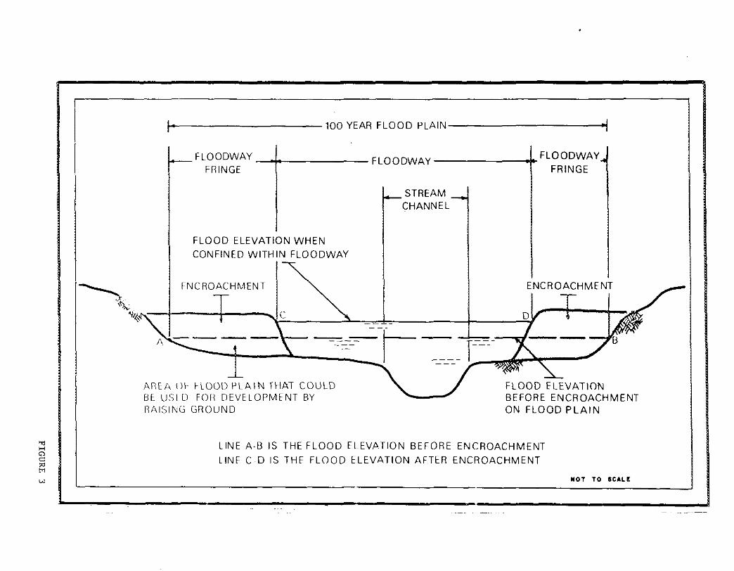
The floodway fringe is the remainder of the lOO-year flood plain. Limited encroachement or filling may be allowed here, providing it does not cause the water level of the IOO-year flood to rise more than one foot (or less if so established by State or local regulations). Any construction here must be floodproofed to the lOo-year flood level.
Zoning is the legal measure used to enforce land use and development restrictions in the flood plain by governmental agencies. It can insure the safekeeping of this property for the health, welfare, and safety of the public.
Subdivision regulations are used by local governments to control construction in undeveloped flood plains by specifying minimum elevations, drainage, location restrictions, and other conditions to prohibit encroachment in flood hazard areas.
Land use programs for conservation, scenic, and flood control purposes may include land use restrictions, purchase of land use rights, lowering of tax assessments, and other measures to meet public objectives-such as preventing development in flood plains--while allowing continued private ownership of the land.
The following regulatory measures also lessen the threat of flood losses.
Building codes specify minimum standards of design, construction, snd quality of materials to reduce potential flood damages in structures whose location in flood hazard areas cannot be prevented. Such restrictions could prevent buildings from floating off their foundations, establish minimum basement and first floor elevations consistent with potential flood occurrences, prohibit basements that would be subject to shallow flooding, require reinforcement to withstand water pressure or high velocity flow, restrict the use of materials which deteriorate rapidly in water, and prohibit equipment that might be hazardous to life when submerged.
Urban redevelopment presents opportunities to remove developments from the flood plain and make sure that new construction in the flood plain is designed to withstand flooding.
Tax adjustments on land dedicated to open space uses, such as agriculture, recreation, and conservation, helps to preserve undeveloped flood plains.
Warning signs of previous high water levels warn prospective buyers that a flood hazard exists. Required certification by sellers that the property is reasonably flood free is even more effective.
19

Health and fire regulations should include contingency plans for temporary evacuation of people, property, and livestock from low-lying areas; for prevention of disease should water supplies become polluted or sanitation facilities inoperative; for accessibility to fire fighting equipment; and for emergency fire reporting systems.
Cleanup campaigns to remove material dumped in flood-prone arees and prevent future dumping may be instituted.
Flood forecasting can reduce property losses significantly and save lives. Information from the Federal Government's extensive weather forecasting system should be effectively disseminated at the local level.
Corrective Measures
Structural - Structural components are often the most practical way to control floods and reduce damage in heavily urbanized, flood-prone areas where regulatory measures may be environmentally or socially undesirable.
Land treatment measures reduce erosion and runoff and lessen the damaging movement of sediments to streams and flood plains. Vegetative and mechanical measures developed for conservstion practices--contour farming, cover cropping, terracing, critical area planting, and the like-are also effective on rural lands undergoing development.
Reservoirs for impounding uncontrolled floodwaters provide protection to downstream communities, while satisfying other needs, such as water supply and public recreation.
Walls and dikes confine floodflows to the channel or floodway and provide protection to local high-risk areas.
Reservoir management programs provide for the addition of flood control storage in existing reservoirs, with controlled release after the flood danger passes.
Stream improvements can increase the flood-carrying capacity of floodways by elimating abrupt turns, widening and deepening channels, improving areas at bridges and culverts, alleviating erosion problems, and removing shoals, sandbars, islsnds, overhanging and uprooted trees, and accumulated debris. Diversion of floodflows to bypass heavily congested flood-prone areas offer great protection while minimizing environmental and social impacts.
20

Nonstructural - Nonstructural measures that render buildings and contents less vulnerable to flood damage include:
1. Permanent measures such as waterproofing, installation of drain systems and pumps, anchoring and reinforcing walls and floors, use of water resistant materials, raising the elevation of structures, protecting immovable equipment, bricking windows, relocating entrances, and drawing up plans for emergency protection measures.
2. Contingency measures such as manually closed sewer valves and removable bulkheads or flood shields for windows, doors and vents.
3. EmergeI1cy measures such as sandbagging, pumping and removal of contents to high elevations.
4. Permanent evacuation of developed areas by removing structures and relocating people, so that flood-prone lands could be returned to natural habitat or used for agriculture, parks and recreation. Temporary evacuation is also effective when used in conjunction with a reliable flood warning system.
PLAN FORMULATION RATIONALE
In evaluating alternative solutions for the basin's flood management needs, technical, economic, and social criteria, including consideration of all beneficial and detrimental effects on the area's environment, were followed. Supplemental planning criteria for alternatives involved acceptability, completeness, effectiveness, equity, irreversibility, and ease of maintenance and operation. Alternatives that were obviously not feasible or acceptable were removed from further consideration during the planning process. Socioeconomic data used in evaluating costs and benefits were derived from Corps investigations and other published data of State and Federal agencies. Hydrologic and hydraulic data were obtained from Corps studies. Environmental impact information was obtained from Corps studies and water quality sampling by the Federal Environmental Protection Agency. In addition s"System of Accounts"Table was developed to compare the beneficial and adverse effects of alternative plans. See Appendix 2, "Plan Formulation" for detailed information discussed in this section
Economic Criteria
1. Combined NED and EQ Benefits must exceed combined NED and EQ Costs.
2. Intangible benefits, such as protection of lives and property, may cause the scope of development to be greater than would otherwise be required to provide maximum net tangible benefits.
21

3. The recommended plan must not physically displace or economically preclude from development any more economical means for accomplishing the same purpose.
Technical Criteria
Technical criteria adopted from engineering manuals, regulations and other sources require that the plan be feasible to implement, complete with no additional future improvements, and insure against significsnt worsening of any flood conditions. Alternative measures were formulated in accordance with regulations stipulating that the SPF is an appropriate level of protection for high dikes and floodwalls in urban areas.
Environmental and Social Considerations
Requirements of the National Environmental Policy Act of 1969 include:
1. Analysis of the environmental impact of any proposed action.
2. Identification of adverse environmental effects which could be avoided in project implementation.
3. Evaluation of alternatives to the proposed action.
4. Determination of the relationship between local short term uses of man's environment and the maintenance and enhancement of long term productivity.
5. Accounting of any irreversible and irretrievable commitments of natural resources and biological systems which would be involved in the project.
Requirements of the Principles and Standards of the Water Resources Council include:
1. Management, protection, enhancement, or creation of areas of natural beauty and human enjoyment.
2. Management, preservation, or enhancement of especially valuable or outstanding archeological, historical, biological, and geological resources and ecological systems.
3. Enhancement of quality sspects of water, land, and sir, while recognizing and planning for the need to harmonize conservation of the resources with the land use objectives of productivity for economic use and development.
4. Development and use of objectives which minimize or preclude the possibility of undesirable and irreversible changes in the natural environment.
22

Considerations mandated by Section 122 of the 1970 River and Harbor Act include:
t. Effects of air quality, noise levels, and water pollution.
2. Destruction or disruption of manmade and natural resources, aesthetic values, community cohesion, and the availability of public facilities and services.
3. Adverse employment effects and tax and property value losses.
4. Injurious displacement of people and businesses.
5. Disruption of desirable community and regional growth.
6. Public acceptance of proposed improvements and their ability snd willingness to meet local cooperation requirements.
PLANS OF OTHERS
Although no major structural flood control management plans in the Blackstone River Basin have been developed by agencies other than the Corps of Engineers, various firms and local concerns have developed plans to prevent or to alleviate local damages and losses. Such a measure 1s floodproofing of individual buildings, which ranges from permanent measures (see Appendix 4) such as closure of openings to emergency measures such as removal of contents to higher elevations.
Other current plans include the development of a park system along the entire length of the Blackstone River. This plan is being financed and administered by the Rhode Island and Massachusetts Departments of Environmental Management and by the Rhode Island Historic Preservation Commission and Massachusetts Historical Commission. The Valley Marshes surrounding Valley Falls Pond, located upstream of Central Falls Dam, were acquired in 1979, the first major step towards development of this park system.
ANALYSIS OF PLANS CONSIDERED IN PRELIMINARY PLANNING
Description of Plans
On the basis of studies done by the Corps of Engineers, a number of flood management measures were evaluated and either eliminated from or retained for further consideration. All regulatory measures were retsined for further consideration. Each of the following measures was judged on its own merits. Those not considered adequate, realistic, practical engineering solutions, or measures not socially or environmentally acceptable or economically justified, were eliminated. Appendix 2 and Table IB include complete lists of reservoirs and local protection sites inves-tigated during Stage 2.

TABLE lB
FLOOD CONTROL PROJECTS STUDIED BUT FOUND INFEASIBLE OR INADEQUATE
RESERVOIRS LOCAL PROTECTION PROJECTS
Project
Millville Fisherville Grafton Emerson Brook Pondville Brandy Brook Keech Pond Carpenter Rsvr. Round Top Brook Clear River Old Common Rsvr. w. Millbury Rsvr. Cedar Swamp Rsvr. Pond "626" Purgatory Brook Aldrich Brook Tarkiln Brook Lazy Hill Rsvr. Chocalog Res. Douglas State
Forest Upper Carpenter Lower Stockwell Lackey Nipmuc Mapleville
Location
Millville, Mass. Grafton, Mass. Grafton, Mass. Uxbridge, Mass. Worcester, Mass. Glocester, R.I. Chepachet, R.1. Northbridge, Mass. Douglas, Mass. Burrillville, R.I. Blackstone, Mass. Blackstone, Mass. Blackstone, Mass. Blackstone, Mass. Sutton, Mass. Blackstone, Mass. Burrillville, R.I. Saundersville, Mass. Burrillville, R.I. Douglas, Mass.
Northbridge, Mass. Sutton, Mass. Douglas, Mass. Burrillville, R.I. Burrillville/ Glocester, R.1.
DIVERSIONS
Site
Mill River Valley Falls Pond
Location
Hopedale, Mass. Central Falls/
Pawtucket, R. I.
Site
Uxbridge Ashton Millville Northbridge (South) Northbridge (North) Grafton Riverdale Pawtucket
Location
Uxbridge, Mass. Cumberland, R.1. Millville, Mass. Northbridge, Mass. Northbridge, Mass. Grafton, Mass. Riverdale, Mass. Pawtucket, R.I.
DAM REMOVAL OR MODIFICATION
Site
Old Slater Mill Dam Pantex Dam Sayles Finishing Dam Pratt Dam
Location
Pawtucket, R.I. Pawtucket, R.1. Pawtucket, R.I. Cumberland/ Lincoln, R.1.
CHANNEL MODIFICATION
Site
Ashton Dam to Pratt Dam
Old Slater Mill Dam
23A
Location
Cumberland/ Lincoln, R.1-
Pawtucket, R.I.

More than two dozen reservoir sites were originally investigated. }Iost of them were eliminated from further consideration because of the limited amount of flood protection they could provide, the engineering, social and environmental drawbacks, or their poor benefit-cost ratios.
On the three remaining, strategically located reservoir sites -Lackey Reservoir in Douglas, Massachusetts, and Nipmuc and Mapleville Reservoirs in Burrillville, Rhode Island - only the Nipmuc site was retained for further investigation in Stage 2 (see Plate 2 presented earlier in report).
Walls and dikes were considered for a number of communities along the Blackstone River to provide protection against floods equal to the record 1955 event. Of the nine sites originally investigated, only three Berkeley and Ashton in Cumberland, Rhode Island, and Uxbridge, Massachusetts were initially found to demonstrate potential economic feasibility and were retained for further study.
Reservoir management programs consisted of investigating many existing dams to analyze their potential for controlling floodflows through storage and release of floodwaters. However, none Was found to be suitable or justifiable without major modification.
Since flooding along the msin stem of the Blackstone River is not influenced by tides, due to the Main Street Dam at Pawtucket, no further tidal flood protection analysis was required for the riverine reaches.
Channel conditions along the Blackstone River have seriously deteriorated, causing higher river stages and subsequent flooding. Four stream improvement possibilities were analyzed.
a. Due to open dumping in the past along the banks of the Blackstone River, both states have laws to protect the riverbanks. There is considerable environmental interest in riverbank cleanup, but local communities need ordinances and active cleanup and maintenance campaigns.
b. The section of the Blackstone between Ashton Dam and Pratt Dam in Cumberland/Lincoln, Rhode Island because of its long history of high flood damage was studied for widening and deepening as an alternative to local protection projects (walls and dikes). It was found, however, that local structural protection would still be necessary and this channel alternative was not considered further.
c. Four dams--old Slater Mill Dam and the Pantex Dam in Pawtucket, Sayles Finishing Dam in Central Falls, and Pratt Dam in Cumberland/ Lincoln--were analyzed. None of the removals was found to be justified, either due to an insignificant effect on floodwater levels or because of subsequent problems caused by its removal. However, the study concluded that in any future detailed analyses, consideration should be given to modification of Old Slater Mill Dam, and Sayles Finishing Dam as a system , of improvements.
24

d. Two floodwater diversions were also considered:
Upper Mill River diversion to the upper Charles River Basin in Massachusetts could not be justified on a benefit-cost ratio basis and might also adversely affect water supply for the city of Woonsocket, Rhode Island.
Valley Falls Pond diversion was considered for the Central FallsPawtucket area as an alternative to a local protection project for a high damage area, but the benefits were found to be insufficient to justify the cost.
Those measures which passed the initial screening were further analyzed to see if they could provide an adequate degree of protection in major damage areas, while meeting the established criteria. Considering each of the previously outlined measures, over 50 potential project areas were initially investigated, six of which, considered as the most relevsnt and most feasible, were retained for further assessment and evaluation. Again, all applicable regulatory measures were retained for further consideration.
Plans Considered Further
Following are the six surviving plans (see Plate 2).
Nipmuc River Dam and Reservoir - This project would be located about one mile northwest of the village of Harrisville, just north of where the Nipmuc River joins the Clear River. It basically consists of a rolled earth dam, a chute-type spillway and an outlet works, all of which would provide a degree of flood control along the Branch River and in the Blackstone River as well as water supply for the northern area of Rhode Island. The henefit-cost ratio of this flood control project was found to be only 0.80 to 1.
Modification of Old Slater Mill Dam - Two alternatives of the Pawtucket structure were considered. First, the replacement of the historic dam with a gate structure would preserve the existing pool, as requested by local interests, and at the same time allow floodwaters of the magnitude of the 1955 flood to be passed, thus preventing backwater flooding of commercial and industrial properties. Channel improvement would also be required. The benefit-cost ratio for this project was found to be 0.7 to I, thus making it infeasible. The second alternative considered involves channel slope protection, raising of floodwalls and floodproofing of adjacent buildings--without dam modification. This project was found to have a benefit-cost ratio of 0.8 to 1.
Modification of Sayles Finishing r,ompany Dam - This channel improvement project would involve replacing the existing dam in Central Falls with a gate structure that would maintain present upstream water levels for a proposed conservation-recreation site and still allow the
25

passage of floodwaters. Slope protection and retaining walls would also be required. A benefit-cost ratio of only 0.5 to 1 eliminated the project from further consideration.
Uxbridge Local Protection Project - Dikes and walls to be built along the east bank of the Mumford River in Uxbridge, Massachusetts would protect the firm of Emile Bernat & Son from flooding. However, the company has indicated that it cannot afford to put any money toward this project, and with a benefit-cost ratio of 0.66 to I, it was eliminated from further consideration.
Ashton Local Protection Project - Dikes and walls would provide Standard Project Flood (SPF) protection to a lO-acre area on the east bank of the Blackstone River in Cumberland, between Valley Falls Pond and the Ashton Fiberglas Dam. The benefit-cost ratio was found to be only 0.48 to 1, thus eliminating it from further consideration. An alternative protection plan to divert floodflows through the existing channel of Scott Brook was found to require excessive channel width to carry the flow, so was not considered further.
Berkeley Local Protection Project - Dikes and walls extending for 5,100 feet along the east bank of the Blackstone River in Cumberland. would protect 70 acres of industrially developed land against the SPF. An analysis of costs and benefits indicated a benefit-cost of 1.4 to 1, which meets the established economic criteria. The area 1s near Martin Street Bridge.
Another alternative was also considered for the Berkeley site. This alternative basically would consist of floodproofing each of the individual structures and buildings. By definition this is a nonstructural measure, since it provides protection on a structure by structure basis.
Additional nonstructural elements were also considered as possible flood control alternatives, such 8S relocation, urban redevelopment, floodproofing, flood plain regulations, National Flood Insurance Program and others. These nonstructural approaches can be used effectively to prevent or minimize future damages, and in some areas to alleviate existing losses.
CONCLUSIONS
In summary, many different communities were investigated for damages occurring during floods and the means of protection which could be offered to prevent such damages in the event of future floods. Due to the nature of a basin study, different management measures were analyzed for each problem area as possible solutions. Initially over 50 potential project areas were investigated, and after many iterations, assessments and evaluations (see Technical Appendices) of the structural measures associated with each problem area, only one plan in the Blackstone River Basin, namely the Berkeley plan, was found to satisfy the establishd criteria and to be worthy of more detailed analysis.
26

All other projects were eliminated due to unfavorable benefit-cost ratios, inadequate levels of flood control provided, substantial opposition by local interests, or adverse economic, social, or environmental impacts.
The resultant plan, the Berkeley plan consisting of two alternatives was then analyzed and screened so that the most feasible alternative for this local problem area would surface.
27

ASSESSMENT AND EVALUATION OF DETAILED PLANS
This section describes and evaluates two flood control plans for the Berkeley Industrial Park, a structural plan selected for detailed study and a nonstructural plan. The significant beneficial and adverse impacts on the economy, environment and social well-being of the area are presented, as well as the degree to which they fulfill planning objectives. Trade-off analyses are performed to analyze the comparative contributions within each plan. Mitigation requirements, implementation responsibilities, and public views are also provided to demonstrate each plan's completeness, certainty of implementation, and acceptability to the public. The evaluation establishes the basis for comparing plans in the next section. (See Appendix 2 for additional information.)
PLAN A - BERKELEY LOCAL PROTECTION STRUCTURAL PROJECT
Plan Description
The structural alternative for the Berkeley area is a 5,lOo-foot-long levee consisting of 3,590 feet of earthfill dikes up to 20-foot high, 1,450 feet of concrete floodwall, two 10-foot-wide railroad gates and a 40-foot-wide vehicular gate to protect the industrial area in the vicinity of Martin Street, Cumberland, Rhode Island against damage from the SPF. The east bank of the river would be straightened to align the dike embankment, but no channel excavation is planned. Two railroad gates would be required at the intersection of the project alignment with the Providence and Worcester Railroad trackage to permit the passage of freight trains through the flood protected area during normal periods. A pumping station for discharging interior drainage and seepage would be located at the downstream side of the Martin Street Bridge. Normal runoff from about 270 acres of high ground and industrial wastewater would be conducted to the Blackstone River through a 48-inch diameter pipe. This would be a gravity discharge pipe, but during floods water would be pumped over the earth dike to the river. A vehicular floodgate closure would be required at the south end of the levee. Some relocation of street lighting and overhead wires would be required along Martin Street. Interior drainage would be disrupted by the project, requiring construction of interceptor drains to the pumping station. Two sewer gates would be provided at the intersections of the sewerline and the dike to prevent interior floorlin8. A flood warning system would be included to warn industries of impending floods so that gate closures can be made. Flooding normally starts 12 hours after intense rain with flood stages peaking after 24 hours. The plan would also include warning and evacuation for the rest of Cumberlands flood plain, including the Ashton and Lonsdale areas. Plates 3 and 4 show the essential features of the structural alternative. (Table 2 summarizes the project first cost and annual charges.)
28

. "'
':-=-~ ~"'''C_
---------------------- - .----------
TORQUE "IoATE
TLNi mlls-~ve: GUIDES \IlII'£RE R£Q.lIRED
STn. ""SrrON INo""'T'"
GATE .o.ccESS
"
E DETAIL SLUICE -,G",A"T~~_ NO SCIoli'
, ,
\'
~L FIELD
~-----
PROJECT. P~AN SCALE 1.>00
------
GRAPHIC SCALE!;_
-"~'- ,-,
"~'LRO~D, __ _
~'-,
6/25/81 REVISED'
• '" ,,.
, ;:~:'"
.
RWOO£ ISLA~O ,m
PLATE SHEET 2" 016
3

,-
I---I---
Fa'! TOE DRAIN OC11OLS • SEE SECTIOfI A-A
I-@--"'-1-1/
~-
13 <~'
,f \~/ 1/;" ~
--. ,
< ,
I . ,
I . l ... · J"-~j-I
, -j -
, ,0 .... ...--/ I I
,
, , - - II I
,
,
~r' 3 12
._- ,
-1<-;'
l , J ~' 2 5
,
t DIKE
i
SECTION A-A SCALE '-'010'
STA 0.00 lllRU 4.00 STA,43+00 lllRU 51 +00
SECTION C-C SC ... E "'.10"
STA" 4tOO lllRU 5.50 ST A 20.00 THRU 39H)() STA 4O+Z:; THRU 43+00
LANDSI --"
,'=:= .
RIVERSIDE
I t I
~ . J :--:
r---
I ,
J
~ !9_:.9
CONCRETE I-WALL OETAIL >fALE I". s"-(/'
~ "4"srO~E _T'f1:nQl><
~L*5
_ .:~V~~ "c.-rTO<!
,.. __ ' ___ --'0'--___ _
SECTION G-G
RAILROAD GATE STRUCTURE SCALE I·.~'
t ElCIST'NG 42"
'I" -~.~."~-----Ii 5~ ~ TOE tlP.A1~
6 TOPSCll
--£"f'ERf" BCCMP
j __ -- tllUSt£O STONE
~~'·6"
~ ~~~~
SECTION H-H
SECTION B B SC ... E 1"1()
STA :;.50 THRU rotoo
SECTION p-p SCA.E ~ I?'
I'IEVISiON OATE
~~.:.~ I , ,
•
HT """". !-"'.-~'~ IJ'~~
-.~
-....,."-,;;::".~?>_~- n4;"~II:::::""c,...,· .. -'=~:::===--===:;~
GRAPHIC SCAL£S
, - Q'-O
, " ,--= ....... ,-.... __ oJ.. .......... '" . " _0" ~ ____
I '12 ~ 1"_0" "'_==_ii'n,:. ..... ..l~,... .... ". ____ ; , s"-o" " -'" ~'
SECTION.£.::£..
:~ :.r .. =====r .:' 1-(1 I
___ -'~ _ _'_'_'.,."----_i-0.....c:::::~ 'j " ... -=..F.....L SECTION F-F
) ' ~2" 0' S[*[R
j 1j
RIVERSIOE_
VEHICULAR GATE STRUCTURE SC ... E I"' 'e
CE MAGUIRE ,IN::
ARCHITECTS ENGINEERS PLANNERS
·.c,'["" •• _c'"'" ....... "'-"", """
QE?AIHMENT OF THE AIH,'Y ~E. ENGLAND Drv,slOl< CORPS ~ ENGINEERS
w.,'''"" ~ .. ,
WATER RESOURCES STUDY
BERKELEY LOCAL PROTECTION PROJECT
DETAILS
,,",£f,GC"'" , .... ' ••• ".,..
.....,., ..... """ .... 0" BLACKSTO~ RIVER
APF'RQV[D OAH
SCAlE AS ~OT[D 5PE~. ~o
OM",.,.. ~u"'BE"
RHODE ISLAND
SHEET 5 11f 6
PLATE 4

TABLE 2
PLAN A - BERKELEY LOCAL PROTECTION* FIRST COST AND ANNUAL CHARGES
(JUNE 1981 PRICE LEVELS)
FIRST COST
Description
Lands & Damages (L&D) (w/Contingency) Relocations (ReI.) (w/Contingency & EDSA) Levees Floodwalls Drainage Sluice Gate & Access Bridge Pumping Station Swing Gates Ponding Area
Subtotal, e~cludes L&D & ReI. Contingencies (20%)
SUBTOTAL Engineering & Design (15%) Supervision & Administration (10%) Subtotal, e~cludes, L&D & ReI. TOTAL FIRST COST, Incl. L&D & ReI. Interest During Construction
7-3/8%, 2 years Total Investment
ANNUAL CHARGES
Interest & Amortization 7-3/8%, 100 years (.07591)
Maintenance & Operation Interim Replacements
TOTAL ANNUAL CHARGE
$ 168,000 $ 58,000 $1,840,000 1,001,000
177 ,000 21,000
532,000 360,000
13,000 $ 3,944,000
789,000 $4,733,000
710,000 473,000
$5,916,000 $6,142,000
453,000 $6,595,000
$500,600 14,200
2,500 $517,300
*First costs are updated from February to June 1981 price levels based on the ENR:CCI index, except Lands and Damages were updated from 1975 price levels. There would be no significant change in project economic feasibility if August 19H1 price levels and an interest rate of 7-5/8 percent were used.
29

Impact Assessment
The Berkeley Local Protection Project (LPP) has an estimated project life of 100 years and would provide flood protection against an SPF at a first cost of $6,142,000. The SPF, the most severe event reasonably expected to occur, would exceed the 1955 flood level by about three feet. The entire industrial park would be protected including access to the buildings, the buildings and contents. The project would prevent the unemployment of about 900 people for all flood levels. A comparison of damages with and without the project follows:
PROJECT AREA
Average Annual Damages Average Annual Damages Prevented
WITHOUT PROJECT
$nB,70U -0-
WITH PROJECT
$lZ4,600 $794,100
An adverse impact of the project's dike restricting the channel, would be the raising of flood levels upstream at one residence in Lincoln and the Owens-Corning Fiberglas Corporation plant in Ashton by about 0.7 feet for a lOo-year event, and 1.7 feet for an SPF event.
The total project average annual henefits are:
Direct Project Benefits Loss in Ashton and Lincoln
Total Project Benefit
$794,100 $ 96,000 $698,100
-Damage Prevented -Damages Cause~
The economic feasibility of the project is shown in Table 3 with a favorable benefit-to-cost ratio. In addition, significant secondary benefits to NED are expected to occur since other industries and jobs are dependent on these industrial distributors. (See Appendix 7 for details of economic analysis).
TABLE 3
PLAN A - ECONOMIC ANALYSIS (JUNE 1981 PRICE LEVELS)
Average Annual Benefits Average Annual Costs Average Annual Net Benefits Benefit-to-Cost Ratio
$698,100 517,300
$180,800 1.4 to 1
(1.35)
The Berkeley Local Protection Project (LPP) would have short term effects 00 the social well-being of area residents. Most of its effects would be short term impacts experienced during the construction phase. These include increased noise, dust, and exhaust fumes at the project site. Local roads leading to the project site would experience an
30

increase in heavy truck traffic. A city-owned recreation area, Berkeley Oval Park, would be disturbed during placement of the dikes and would present an additional safety hazard to children utilizing the park.
The major long term effect of the LPP would be the flood protection offered to the four industrial establishments with over 900 employees, and the Cumberland waterworks, currently occupying the Berkeley Industrial Park. The level of protection provided by the project would exceed by 3 feet the 1955 flood level that inundated the project area. Currently, 20 acres of the industrial park lie vacant and their development would be more appealing with flood control protection. The project would also protect from washout the existing Blackstone Valley Sewer Interceptor, which is on the edge of the river. Safe operation of the Cumberland water supply during standard project flood conditions would be permitted by dike construction.
The dike and concrete wall would cover 11 acres of habitat for local wildlife including woodland and disturbed land with herbaceous and shrub cover. Approximately one-quarter acre of river bottom would be filled by the dike alignment. The aquatic habitat lost and river sedimentation during construction are considered a minor impact since river water quality is substantially degraded.
The project would cause changes in river stages and velocities adjacent to the dike. These changes may impact adversely on the historic Blackstone Canal adjacent to the river. The canal's towpath dike has eroded in several locations in the past, especially downstream of Martin Street Bridge.
Evaluation And Trade-Off Analysis
The plan fully meets the planning objective to provide SPF protection for the industrial park from about 1985 to 2085. The plan's average annual net benefits provide a positive contribution to the national economic development objective. The plan does not significantly impact on the environment. The flood protection provides a positive contribution to social well-being by preventing substantial lost employment in the event of flooding. This also contributes to regional development as would the opportunity for industrial growth.
The plan is acceptable to the three flood-prone industries, the town of Cumberland and State of Rhode Island. The town of Lincoln's conservation commission has voiced opposition to the project believing that it would impact on the historic canal.
The plan, complete within itself, can provide flood protection to the SPF level, provided the gates are closed and the pump is operated. The plan is effective and efficient in accomplishing the planning ohjective since it was technically designed to meet the desired level of
31

protection for an urban area, it is economically feasible with s benefit-to-cost ratio above unity, and it does not significantly impact adversely on the environment.
The plan is very stable since benefits allocated to the plan do not include potential growth benefits, and the plan 1s desired by those most affected by it. The plan also has a surplus in net benefits which would offset some additional costs for measures which may be required during advanced engineering and design and construction.
The most significant trsdeoff is the prevention of $794,100 of average annual damages for the three industries, while increasing damages upstream by $96,000.
Mitigation Requirements
The loss of 8 acres of wildlife habitat from the dikes and walls would be totally replaced by replanting the landward side of the dike. The visual impact from these structural measures would be greatest on Martin Street and smaller on the Blackstone River towpath.
The proposed structural plan calls for minor realignment of a baseball field and two access roads near the riverbank.
The plan's effect of raising flood stages upstream could be reduced. Implementation of Plan A would require that residents be contacted to determine an acceptable solution, such as relocation from the flood plain; and the town and Corps would coordinate with Owens-Corning Fiberglas Corporation to reach a solution.
Construction of the local protection structures may increase erosion of the west bank of the Blackstone River, with possible impact on the Blackstone Canal. It may be necessary to repair or protect some canal segments.
Implementation Responsibilities
The steps necessary to implement project authorization and construction of the structural plan of improvements would include:
Review of this report by higher Corps of Engineers authorities such as the Roard of Engineers for Rivers and Harbors and the Office of the Chief of Engineers.
32

Following subsequent review by State and other Federal agencies, the final report of the Chief of Engineers would be forwarded by the Secretary of the Army to Congress, subsequent to his seeking the comments of the Office of Management and Budget regarding the relationship of the project to the President's program.
Congressional authorization of the flood control project would then be required. This would include appropriate review and hearings by the Public Works committees.
If the project were authorized, the Chief of Engineers would then include funds, when appropriate, in his budget requests for design and construction of the project.
If the Congress appropriated the necessary initial funds, formal assurances of local cooperation would be requested from non-Federal interests.
Advance engineering and design studies would be initiated, project formulation reviewed, and the plan reaffirmed or modified to meet the then current conditions.
Surveys, materials investigations, and preparation of design criteria, plans, specifications, and an engineering estimate of cost would then be accomplished by the Division Engineer, bids invited, snd a contract awarded. At that time, the necessary local actions would be required.
Following completion of certain sections of the project, local interests would be responsible for their operation and maintenance.
It is not possible to accurately estimate a schedule for the above steps, which could take 7 to lu years, because of the variables in the reviewing and funding processes. Once the structural project is authorized and initially funded, at least 1 to 2 years, it would be possible to complete design and construction within a 3-year period if adequate funds were available. It should be pointed out that an environmental assessment would accompany the final report of the Chief of Engineers.
Cost Allocation
All costs of this structural alternative are allocated to flood control.
33

Cost Apportionment
The apportionment of costs between Federal and non-Federal interests reflects Federal water resources policies, which consider the responsibilities of both Federal and non-Federal entities. Cost of the project may be apportioned between Federal and non-Federal interests. Two cost sharing policies may be followed:
a. Existing Cost Sharing Legislation: Under existing legislation, construction costs allocated to flood control would be paid by the Federal Government. Lands, easements, rights-of-way, relocations, and operation and maintenance costs would be a non-Federal responsibility.
b. President's Cost Sharing Policy: Under this policy, the State of Rhode Island would contribute 5 percent of construction costs allocable to flood control. In addition, the local sponsor (in this case the town of Cumberland) would contribute 20 percent of flood control construction costs. Lands and damages are shared in the same manner as construction costs. Operation amd maintenance costs would be a non-Federal responsibility for flood control.
The Federal and non-Federal share of the construction, operation, maintenance and interim replacement costs for the two cost sharing poUcies follow.
TABLE 4
PLAN A - COST APPORTIONMENT
Federal First Cost Non-Federal First Cost Total Plan First Cost Non-Federal O&M Cost
Federal Responsibilities
Existing Legislation
$5,916,000 226,000
$6,142,000 $16,700/yr
President's Policy
$4,606,000 (75%) 1,536,000 (25%)
$6,142,000 $16,700/yr
The Berkeley structural project would be constructed by the Federal Government and turned over to the town of Cumberland for operation and maintenance. Subsequent Federal cost would consist of Federal personnel costs for inspection of the project.
Non-Federal Responsibilities
The measures that would be required of the localities to prevent encroachment within the flood zone are:
34

a. Enforcement in all downstream reaches of the 100-year flood plain and the other basic requirements of the National Flood Insurance Program.
b. Puhlicizing flood plain information in the area concerned and providing this informstion to zoning, banking and other groups for their guidance and leadership in preventing unwise future development in the flood plains, and in adapting such regulations as may be necessary to insure compatibility between future development and protection levels provided by the project.
c. At least annually, informing affected interests regarding the limitation of the protection afforded by the project.
As the benefits accruing to the Berkeley structural project would entail the conditions of local cooperation in accordance with Section 3 of the Flood Control Act of 1936, as amended, and in conformance with the policy expressed in EM 1120-2-101, local interests would be required to give assurances satisfactory to the Secretary of the Army that they would:
a. Provide without cost to the United States, all lands, easements, and rights-of-way necessary for construction of the project;
b. Hold and save the United States free from damages due to the construction works;
c. Maintain and operate all the works after completion in accordance with regulations prescribed by the Secretary of the Army;
d. Provide, without cost to the United States, all alterations and replacements of existing utilities including bridges, highways, sewers and railroad modifications and relocations other than railroad bridges and their approaches; which may be required for the construction of the project;
e. Prescribe and enforce regulations to prevent encroachment of both the improved and unimproved channel;
f. capacity capacity and
Prohibit encroachment on project ponding areas and, if the of these areas is impaired, promptly provide substitute ponding or equivalent pumping capacity without cost to the United States;
g. Comply with the requirement specified in Sections 210 and 305 of Public Law 91-646, 9lst Congress, approved 2 January 1971, entitled, "Uniform Relocation Assistance and Real Property Policies Act of 1970."
35

Pu blic Vi ews
Views of Federal Agencies
The Berkeley structural project, Plan A, is supported by the U.S. Department of the Interior, Fish and Wildlife Service. They have det.'rmined that the project would have no severe impact upon fish and wildlife resources due to the urban character of the area and the low fishery values resulting from pollution.
Views of Non-Federal ~encies
The Berkeley structural project is supported by the town of Cumberland and by the State of Rhode Island with the cost sharing policy under existing legislation only, but is not supported under the President's proposed policy. The town of Lincoln's conservation commission believes that the structural measures are a threat to the Blackstone Canal on the Lincoln side of the river and are not feasible from an environmental or economic viewpoint.
PLAN B - BERKELEY NON STRUCTURAL PLAN
Plan Description
The nonstructural plan with a project life of 20 years would provide flood damage protection to four buildings or areas up to a 100-year frequency event similar to the 1955 flood. The plan of protection, shown on Plate 5, protects the following areas:
Area 1 - Roger Williams Company
The project involves the construction of 700 feet of a 6 to 7.S-foot high "I" or "T" wall. The wall would be located on the west side of the complex and inclose 2.25 acres of paved parking and loading area. This would include two vehicular stoplog gates, 40 feet wide to form a closure in times of flood and to provide passage of traffic during normal times. The north, south and east sides of the structure would be protected by waterproofing measures and the use of temporary flood shields, 2.75 feet high. A pump would be provided to remove interior runoff in the parking/ unloading area. The first cost of the plan is $624,100 (Table 5).
36

~---------------"
Compoct~d random rill
E)(covor/on
T-WALL SECTION NOT TO SCALE Ri,,,,rsid,,,
___ Perroraf'ed , ,r:
p;p~
, ~,
::'-?mpocfeJ
ror;dco""" ril!
G" li/fe-r, sond Ilif (r,,<,hed st"n(' jill
TOE DRAIN DETAIL NOT TO SCALE
I- WALL SECTION NOT TO SCALE
''I'' OR "T" WALLS
CANTILEVER WALL CAST AGAINST EXISTING WA LL
WATERPROOFING
"-~--
(WITH FLOOD SHIELD WHERE NEEDED)
GRAPHIC SCALES
100 ~O = ."
;i~''!'' •
: {7r~tJ~~~:;~~~); •. ··;; ._ .. , ."
."
CE MAGUIRE ,INC
ARCHITECTS ENGI"EERS Pl..AtjNERS "-,, .. ~£,", ,,"'-"" .... ~ ........ IT ... , co ••
DEPARTlHNT or THE ARMY NEw £NGu ... O OIVISION
CCH>S 0. E""'NEER$ .... , •• w. w .. ,
'"" '"" C.B>
'"
-';CT,_,.
<>O","' •• ·""'W·OOO ..... """', .. _'""
WATER RESOURCES STUDY
BERKELEY LDCAL PROTECTION PROJECT
PROJECT PLAN B
BLACKSTONE RIVER
AP""'-""'.:O
'~IEF E"',I<I ~
SCAL[ ,', 100' SPEC; NO
[)R.t,WING NY"'8E~
A'HODE ISLAND
S~HT .f
PLATE 5

TABLE 5
PLAN B - FIRST COSTS AND ANNUAL CHARGES (JUNE 1981 PRICE LEVEL)
Health-Tex Roger Williams Okonite Co. Pump Station
FIRST COSTS
Lands & Damages Waterproofing Flood ... alls Flood Gates Flood Shields Pump Station
Subtotal, excl. L&D Contingency, 20%
Subtotal E&D, 15% S&A, 10%
Subtotal
First Cost incl. L&D
ANNUAL CHARGES
Interest & Amort. @ 7-3/8% @ 20 yrs. (0.097)
Oper. & Maint. Interim Replace.
TOTAL ANN. CHARGE: @ 20 yr. Life
$ 22,000 $ 34,500
198,900 60,000 19,800 20,000
$333,200 66,600
$399,800 60,000 40,000
$499,800
$521,800
$ 50,600 500 100
$ 51,200
$ 22,200 $ 21,700
287,300 47,500
4,800 40,000
$401,300 80,200
$481,500 72,200 48,200
$601,900
$624,100
$ 60,500 600 200
$ 61,300
37
$15,200 $24,000
3,000 -0-
4,500 -0-
$31,500 6,300
$37,800 5,700 3,800
$47,300
$62,500
$ 6,100 -0--0-
$ 6,100
-0-$2,100
-0--0-
3,600 -0-
$5,700 1,100
$6,800 1,000
700
$ 8,500
$8,500
$ 800 -0--0-
$ 800

Area 2 - Health Tex, Incorporated
The protection includes the construction of 430 feet of a 7.5-foot high "1" or "T" wall. Located on the north side of the complex, it would inclose 0.65 acres of paved parking and loading area. Two vehicular stoplog gates with 40-foot openings would be provided to form a closure during times of flood. During normal times, complete access would be available. The east, south, and west sides of the building would be protected by waterproofing measures and the use of temporary flood shields 2.75 feet high. A pump would be provided to remove interior runoff in the parking/unloading area. The first cost of the plan is $521,800.
Area 3 - The Okonite Company
The protection includes the construction of 160 feet of a 2-foot high gravity wall with flood shields on the south side of the complex. The rest of the building would be protected by waterproofing measures and the use of 8-inch temporary flood shields. The first cost of the plan is $62,500.
Area 4 - Municipal Pumping Station
The pumping station will be protected by a combination of waterproofing and a flood shield, at a first cost of $8,500.
A flood warning system would be employed to alert the town and industries of the impending floods, so employees could be evacuated and appropriate closures could be made. Flooding is expected to start 12 hours after an internal rain with flood peaks reached after 24 hours.
Flood plain zoning would continue to be enforced by the town of Cumberland.
Impact Assessment
Plan B would provide flood damage protection to the four areas up to a 100-year frequency flood. Although employees would have to evacuate the huildings, they could return to work once floodwaters recede and access routes are opened. The economic feasibility of each area being protected is shown in Table 6. Each area demonstrates a benefit-to-cost ratio greater than one, indicating it is economically justified. Each area of the total plan provides positive contributions to national economic development.
3f\

TABLE 6
PLAN B - ECONOMIC ANALYSIS June 1981 Price Level
Health-Tex Roger WilliamsOkonite Co. Pump Station Total Annual
Physical Losses: Average Annual
Benefits, Plan B Average Annual Cost Average Annual Net
Benefit Benefit-to Cost Ratio
$386,900
$200,300 $ 50,600 $149,700
4.0 to 1
$131,200
$ 77,800 $60,500 $17,300
1.3 to 1
$70,900 $1,300
$21,500 $ 800 $ 6,100 $ 800 ~15,400 -0-
3.5 to 1 1.0 to 1
The construction effects would be minor and include increased dust, exhaust fumes, noise levels and truck traffic. The ringwalls have a minimal effect on upstream flood stages and would not provide protection for the sewer interceptor, the railroad tracks or the Berkeley Oval Park. The ringwalls constructed around the existing parking and loading facilities would interfere with future expansion of present facilities.
Evaluation And Trade-Off Analysis
There would be no significant impact on the environment as a result of the plan. Social benefits would include advanced warning and opportunity for evacuating the areas and earlier return to work after floodwaters recede. Floods in excess of a IOO-year event would inundate the four areas, although such events are rare. Regional benefits would accrue to companies dependent on the receipt of groceries, wire and clothing from the three industries and to consumers of the uninterrupted water supplies to sections of the town.
The major impact of the nonstructural messures composing plan B would be a reduction in damages to buildings and contents up to the 100-year event. Plan B basically would only protect the three existing industrial establishments and the town pumping station. Therefore, flooding in this area would still continue. Although water would no longer enter the buildings, severe flooding would cause shutdowns by denying employees access to these plants. No protection would be offered to the Berkeley Oval Psrk, the Providence and Worcester railroad tracks, and the sewer interceptor. The continued flood threat in this area would restrict the development potential of the vacant land lying in the industrial park.
Since the nonstructural measures, particularly construction of floodwalls, require some structural activities, typical construction related effects (i.e., increased temporary employment, increased noise and air pollution levels, increased heavy truck traffic in local roads) would be experienced over the short term.
39

, The plan would provide a high degree of protection, although it does not totally meet the planning objective for rare events exceeding a 10o-year frequency. The project life is estimated at 20-years. The plan provides positive contributions to the national economic development objective. The plan does not create significant adverse impscts on the environment. It does provide positive contributions to socisl and regional development.
The plan is complete within itself, providing 10o-year flood level protection to the four areas provided flood shields and gates are closed. The plan is effective and efficient in accomplishing a high level of protection and is economically feasible. The plan is stable since economic justification is not dependent on growth projections and is acceptable to those most affected by it. If the plan should be recommended, more detailed investigations would be needed to substantiate the adequacy of existing walls and floor slabs to sustain water pressures.
Mitigation Requirements
Implementation of the nonstructural measures would have no effect on wildlife habitat and would not cause any erosion of the land. The visual impact from the floodwalls would depend upon the style of the wall selected and the condition of the building it encloses. There would be no significant increase in the flood stage upstream with implementation of this plan. Therefore, no significant mitigation measures are required.
Implementation Responsibilities
Plan B could be implemented under the Corps' continuing authority of Section 205 and under Section 73 of Public Law 93-251. Section 205 of the 1948 Flood Control Act, as amended by Section 61 of the 1974 Water Resources Development Act, provides authority to the Chief of Engineers to construct small flood control projects that have not already been specifically authorized by Congress. Each project selected must be complete within itself and be economically justified. In addition, each project is limited to a Federal cost of not more than $2 million, except where the project area has been declared a major disaster area during the 5-year period preceding the authorization date, in which case the Federal cost limit would be $3 million. This Federal cost limitation includes all project-related costs for investigations, inspections, engineering, preparation of plans and specifications, supervision, administration, and construction.
Section 73 of Public Law 93-251 and the revised Water Resources Council's Principles and Standards require that nonstructural solutions be considered in the planning and formulation of all flood damage reduction plans. A flood control project plan, including nonstructural measures as contemplated in Section 73(a),can be considered and recommended for accomplishment under Section 205. As directed by Section 73, costs for flood damage reduction are shared 80 percent Federal and 20 percent non-Federal.
40

Cost Allocation
All costs are allocated to flood control.
Cost Apportionment
Cost apportionment of first costs and operation and maintenance between Federal and non-Federal interests for the nonstructural plan are summarized in Table 7.
TABLE 7
PLAN B - COST APPORTIONMENT
Federal First Non-Federal First Cost Total First Cost (Areas 1 to 4)
Non-Federal Average Annual Operation and Maintenance
Federal Responsibilities
$ 973,500 (80%) 243,400 (20%)
$1,216,900
$1,100
Other than the financial obligations, the Federal Government would install the flood proofing measures in the affected structures. In addition, the Federal Government would provide technical assistance to assurp. proper the operation and maintenance of the system. This would include correct installation of flood shields on doors and windows and proper sealing of other openings.
While participation in the National Flood Insurance Program is a local responsibility, the Federal Government would provide technical assistance and guidance. This would include encouraging all basin communities to consider additional land use controls and to participate in the flood insurance program.
Non-Federal Responsibilities
Formal assurances of local cooperation similar to those required for regularly authorized projects must be furnished by a local sponsoring agency. The local sponsor must be fully authorized under State laws to give such assurances and be financially capable of fulfilling all measures of local cooperation. As a project is dependent upon local cooperation and participation, the importance of the existence of a legally authorized and financially capable local sponsoring agency cannot be overemphasized. The sponsoring agency must agree to:
1. Provide without cost to the United States all lands, easements, rights-of-way, utility relocations and alterations, and highway or highway bridge construction and alterations necessary for project construction.
41

2. Hold and ssve the United States free from damages due to the construction, operation, and maintenance of the project except where such damages are due to the fault of the United States or its contractors.
3. Maintain and operate the project after completion without cost to the United States in accordance with regulations prescribed by the Secretary of the Army.
4. Assume full responsibility for 25 percent of all project costs and for all project costs in excess of the Federal cost limitation. The Federal cost limitation includes costs of all investigations, planning, engineering, supervision, inspection, and administration involved in development and construction.
5. Prevent future encroachment which might interfere with proper functioning of the project for flood control.
6. Provide a cash contribution for project costs assigned to project features other than flood control.
7. Comply with Title VI of the Civil Rights Act of 1964 (78 Stat. 241) and Department of Defense directive 5500, 11 issued pursuant thereto and published in Part 300 of Title 32, Code of Federal Regulations.
8. Comply with the requirements of non-Federal cooperation specified in Sections 210 and 305 of Public Law 91-646 approved 2 January 1971 entitled the "Uniform Relocation Assistance and Real Property Acquisition Policies Act of 1970."
9. Satisfactory written assurances of local cooperation will be obtained by the Federal Government prior to requesting funds for construction of an approved project. Such assurances do not commit the Federal Government to construction of the project.
The individual owner would be responsible for making sure that the floodproofing measures are properly placed in the event of an impending flood. All seals should be made ready and the occupants should be ready to evacuate if the situation warrants such action.
Local communities would he responsible for publicizing flood plain information as well as emergency evacuation information. The local interests should also discourage any future unwise use of the flood plain.
Public Views
Views of Federal Agencies
Federal agencies will have an opportunity to review the plan during preparation of the Detailed Project Report under the Corps' Section 205 Study.
42

Views of Non-Federal ~encies
The Mayor of Cumberland, the town council and industry representatiYes reyiewed the plan during meetings with the Corps on 16 June and 1 July 1981. The plan was generally supported and two industries indicated their saYings from flood insurance could help defray costs. By letter dated 31 July 1981 (attached) the Mayor acknowledged support of the plan.
43

COMPARISON OF DETAILED PLANS
The Berkeley Local Protection Plans A and B were found to be economically, technically and socially feasible and more acceptable than future conditions without a plan of improvement. Both plans would provide a high degree of flood protection to the three Berkeley industries and town pumping station. Table B provides a comparison between Plans A and B. The most significant differences are the levels of protection, first costs, impacts on flood stages and implementation.
Both plans would provide flood protection against a recurrence of the flood of record, about a IOO-year frequency event. In addition, Plan A would provide protection up to an SPF event, about 3 feet above the 1955 event over a lOO-year project life. Plan A would also remove the Berkeley industrial area from the flood plain by construction of the dike, thus providing opportunities for growth. Plan B would protect only the areas or buildings floodproofed over a 20-year life.
The first cost of implementing Plan A is $6.14 million,while Plan B is $1.22 million. Both plans are economically justified with positive contributions to national economic development.
Neither plan would significantly impac t on the environment. Plan A could impact on the historic Blackstone Canal, by contributing tc slope erosion of the towpath dike.
Plan A would have regional impact by increasing flood stages upstream at a residence and at Owens-Corning Fiberglas Corporation. Mitigation measures, if required, would be developed during detailed engineering.
Several significant differences are associated with implementation of the plans, including the process and certainty of implementation. Plan A would require Congressional authorization and funding. If so authorized, a structural plan would require 7 to 10 years to complete. The certainty of implementation is a major question. Non-Federal interests support Plan A provided it is authorized under trflditional cost sharing (with non-Federal interests paying lands, damages and relocations). However, all indications are that the current Administration's pol.icy will be similar to that of the former Administration (i.e., first costs shared 15 percent Federal, 25 percent non-Federal). It is likely that Congress will sepport the Administration's cost sharing rather than the traditional policy.
Plan B would require approval and funding under the Corps' continuing authority of Section 205 of the 1948 Flood Control Act, as amended. If sn authorized, a nonstructural plan could be 1.mplemented 1.n 3 or 4 years. Cost sharing wotl1d be HO percpnt Fedpral and 20 percent non-Federal.
44

tABLE 8
SUMKARY COMPARISON OF PINAL ALTERNATIVE PLANS
A. Plan Deacription
B. J.pac t ual!llallient
Without Condition
No Action
NED: Project Firat Coat --Recurring 1955 De.lIIagea
De ... gea if SPF Event !!l.: Rabitat Loat
$28 lIillion $51 .illion
SWB: Flood Protection Offered --Hedth 6 Safety RD: Joba Protected
Promote Induatrial Growth
C. Plan Evaluation 1. Contribution to Planning
Objectivea
2. Net Beneficial/Adver .. Effecta NED: Average Annual - Benefitll -- Coata
NED Nt:t Benefita !9,.: Enviroruaental Impacta SWB: Social Well-Being/Cultural
!!!: Regional Developulent
Incr.aa. Flood Stase at OWen aCorning Fiberglas Corp. ,Aahlend (Average Annuel Lolla Increalle)
1. PI 111'1 Rellponee to Evaluation Criteria
Acceptability of Plan
Plan Collipietenett
Effect! veneae/Efficiency Certainty of llllplelllentation
Geographic Scope
NED Benefi t-to-Cost Ratio (BCR) Stsblllty of Design/Plan
4. Ranking of Plana National Econolllic Development Environmental Quality SOcial Well-Being RegiOnal Develop1ilent
D. Implementation Reaponaibilit1ee Procee.
Project C01IIpleted Coat Sharing (Prelb.inary)
1. Leaialated Federal Firat Coat Non-Federal Firtt Coat
Non-Federal Operation 6 Maintenance, Replace'QIent'
2. President'li Policy Federal Fint Coat (75%) Non-Federal Firat Coat (25%) Non-Federal Operationa 6 Maintenance, Replacelllenta
None
None
BERKELEY LOCAL PROTECTION PROJECT
Plan A
SPF Structural Plan, 5100 LF Levee Pump, Gate!' and Warning System
$6,14:l,OOO None Non.
8 Acres Average 3 feet above 1955 flood level About 900, during all events, plull lIIultiplier effect
Yo.
Provides IIIIIIXilllUCI flood protection to 4 induatrbl buildinge, town w.s. pump & eewer interceptor frolll 1985 - 2085
$698,100 517,300 $180,800
n11 Minor ll11pact on hbtoric clllnal at lOO-year event Complete protection to jobs, buildinga and regions retailers 100-year by 0.7 feet SPF by 1. 7 teet ($96,000)
Federal/State/local auppnrt; town eupport under legillated eoat sharins: only -- not under Preaident'e PoUcy. Yea - w/edvenced werning and gete
closure High protection 6 high firet coat Moderate to high w/Congreaa. Action & State/loeal eupport for Preaident'a Pollcy (very low certainty w/legialeted coet ahare). Regional i .. pect on reteilera by protecting diltributore 1.4 teo 1 Very ateble, due to Stage 1 detail
1 - Maximum protection 1 - Ka:ll:ill.um job protection,
pr01ll(lte growth
Exteneive report review Congreaaional authorization and funding Local asaurencea and funding 7 - 10 years
$5,916,000 $ 226,000 ($1681t - Lande & Da ... g .. ; $58X. - Road/Utiliti .. Relocation)
16,700
$4,606,000 $1,536,000
16,700
45
Plan II
lOO-year Nonatruetural Plen, Watarprcofing and Warning SystelDe
$1,216,900 n11
$51 milllon n11
About 1955 flood level
About 900, up to 10Q-yeer event plue multiplier effect
'0 Providee intat'l'llediate protection to 1 indue trial buildinga and town puIIIP frOIll 1985 - 2005
300,400 118,000 182,400 n11 n11
Partial protection to joba/buildings end regiona tetailers
None
Town and local aupport.
Yea (aallle)
Moderate protection w/leow fitat coat High w/Corpe action end State/loeal support.
Same, except thut down until floodwater. recede. 2.5 to 1 Structural atability eof walle to withetend water prea.uree will be deUIlI.ined during Section 205 studies.
(1) Sillliler net benefit, higheat BCR 1- Leaat illipaet
2 2
Complete detailed planning Limited report review Corpa authorized funding Local allsurancea and funding 1-4years
$9B,5oo (80%) $241,400 (20%) ($59K Lande, Da_ges & Reloeatlona)
$1,100 ./. ./.

The town of Cumberland and industry representatives from Roger Williams Foods and Health-Tex recognized the problem of supporting Plan A for implementation under traditional cost sharing and the potential delays in implementation, if at all. They concluded that Plan B was better than no protection and should be pursued under the Corps' small flood control project authority.
RATIONALE FOR DESIGNATION OF NED PLAN
Plan B is designated the National Rconomic Development (NED) plan since it produces contributions to National Economic Development, similar to those of Plan A, but has the higher benefit-to-cost ratio.
1'.ATIONALE FOR DESIGNATION OF EQ PLAN
Plan B is designated the Environmental Quality (EQ) plan or least environmentally damaging alternative since it has the least impact on Environmental Quality.
RATIONALE FOR THE SELECTED PLAN
Plan B is designated the selected plan, since it is supported by the town and local industries snd is implementable under existing Corps authority upon approval of a Detailed Project Report. The plan also produces net economic and environmental benefits.
46

CONCLUSIONS
The Blackstone River Watershed Study component of the overall Pawtucket River and Narragansett Bay Drainage Basins (PNB) Study reviewed some 40 potential projects to meet the flood control and other water resource needs in the study area. The investigation determined that local flood protection plans for the Berkeley Industrial Park in Cumberland, Rhode Island were the only plans to produce net economic and environmental benefits. Although the town of Cumberland supported the $6.1 million structural solution for Berkeley involving 5,100 feet of dike and walls, the non-Federal cost under the proposed cost sharing policies was beyond the financial resources of the town. The town therefore requested the Corps by letter dated 31 July 1981 to pursue the $1.2 million nonstructural solution involving 1,290 feet of ringwalls and flood proofing for three buildings and the town pumping station under Continuing Authority of Section 205 for small flood control projects.
47

ENVIRONMENTAL ASSESSMENT
BLACKSTONE RIVER BASIN STUDY
(BERKELEY LOCAL PROTECTION PROJECT)
DEPARTMENT OF THE ARMY NEW ENGLAND DIVISION, CORPS OF ENGINEERS
WALTHAM, MASSACHUSETTS 02254

TABLE OF CONTENTS
No. Title Page No.
I SUMMARY 1
II NEED FOR AND OBJECTIVES OF ACTION 3
In ALTERNATIVES 5
IV AFFECTED ENVIRONMENT 10
V ENVIRONMENTAL EFFECTS 14
VI PUBLIC INVOLVEMENT 16
FISH AND WILDLIFE COORDINATION
CORRESPONDENCE
TABLE
No. Title Page No.
9 COMPARATIVE IMPACTS 9
Follows PHOTOS Page No.
MARTIN STREET - 1955 PHOTO 3
PROJECT SITE PHOTOS 12
i

1. SUMMARY
The Blackstone River Basin study has investigated the problem of recurring flood damages throughout the basin. Through preliminary engineering analysis of potential flood damages and the costs involved in preventing these damages at the most critical sites in the basin, structural flood protection measures could only be economically justified for the Berkeley Industrial Park. (The cost-benefit analysis for each site studied is discussed in detail in the Main Report.)
The Berkeley Industrial Park is located on the east bank of the Blackstone River, Cumberland, Rhode Island. The park is approximately 15 miles north of Providence, Rhode Island and 45 miles southwest of Boston, Massachusetts.
The structural plan (Plan A), calls for protecting the industrial park from flood damage by constructing 3,590 feet of earthfi1led dikes, 1,450 feet of concrete floodwall, a pumping station for interior drainage, a vehicular gate and two railroad gates. The structural plan involves the following adverse impacts:
1. Approximately 8 acres of land would be covered by the proposed dike and concrete wall. The result would be a loss of habitat for local wildlife. This impact would be mitigated by planting the interior portion of the dike with plants best suited for wildlife habitat. Another 2.5 acres would be disturbed for temporary rights-of-way. This acreage would be revegetated following construction completion.
2. During construction, turbidity would increase in the Blackstone River, but the existing levels are presently so high that any increase would have minimal effect.
3. Approximately 10,500 square feet of river bottom would be filled to allow for better alignment of the dike. This aquatic habitat would be lost, but since the river is substantially degraded, the loss would be minor.
4. Heavy truck traffic would increase due to the hauling of fill. The route over which the fill would move is already heavily traveled, consequently the increase should be insignificant.
5. Realignment of the access road to the Health-Tex, Incorporated industrial plant would require the realignment of one baseball diamond in the town of Cumberland, Rhode Island's recreation area.
6. Existing vegetation along 4,000 feet of the east bank of the Blackstone River would be lost. Only 1,500 feet is woodland and the remainder is disturbed land with herbaceous and shrub cover.
1

7. The dike and wall would restrict the existing river channel, raising flood levels upstream from Martin Street Bridge to Ashton Dam by approximately 0.7 feet for a lOa-year storm and 1.7 feet in a standard project flood (SPF).
The direct benefits from Plan A would include:
1. Flood damage prevention to those companies behind the dike and the resultant financial benefits to the community in general.
2. Flood damage prevention for a segment of the Blackstone Valley interceptor sewerline.
3. Prevention of floodwater damage to the town of Cumberland water supply well and the Owens-Corning Fiberglas Corporation well.
4. Reduction of flood damages to a 5,OOO-foot segment of the Providence and Worcester Railroad right-of-way.
An unresolved issue involves the impact of the dike and wall on the Blackstone Canal, through the now unknown erosive effect of constricted and redirected riverflow during high river stages, and increased river velocity below Martin Street Bridge during flood flows. The nonstructural plan (Plan B) would be limited to a combination of floodproofing and ringwalls for each building in the damage area. Impacts of this plan are expected to be minor.
2

II. NEED FOR AND OBJECTIVES OF ACTION
PUBLIC CONCERNS
Since 1936, four significant floods have occurred along the lower reaches of the Blackstone River (see Main Report for flood history data). The March flood of 1936 had two peaks. The first was on 13 March, when rain combined with melting snow caused 14,200 cfs of water to flow through the Woonsocket gaging station. The second flood peak came on 19 March, when 15,000 cfs were recorded; this latter peak was due primarily to rainfall. The basis for these floods was established in December through February when temperatures were below normal, and considerable snow cover persisted over the basin. The Woonsocket gaging station, located about 6 miles above the Berkeley Industrial Park, has records revealing that from 1929 through December 1973, the mean monthly flows varied from 270 cubic feet per second (cfs) to 1,519 cfs with a monthly average of 725 cfs.
During July 17-25, 1938 a series of showers and thunderstorms deposited various amounts of rain over the eastern seaboard. Total precipitation exceeded 10 inches through eastern Connecticut, Massachusetts and northwestern Rhode Island. Although each storm was not unusually intense, they did come in rapid succession which did not allow sufficient time for the streams to subside.
In August 1955, two hurricanes--Connie and Diane--moved up the eastern seaboard within a week of each other. The highest recorded flow of 29,600 cfs on 19 August 1955 (see photo), was more than twice as great as any recorded before or since that time.
Following the 1955 flood, four Corps projects were constructed and put into operation: West Hill Dam and Reservoir, the Worcester Diversion Project and local protection projects for Upper and Lower Woonsocket.
Areas still vulnerable to damage from recu~ring storms include Northbridge, Uxbridge, Millville, and Blackstone, Massachusetts, as well as Cumberland, Lincoln, Central Falls and Pawtucket, Rhode Island. Without adequate controls of development in the flood plain areas of these communities, urban growth has continued, increasing the demand for flood protection measures. The March 196R flood, which produced a peak discharge of 15,400 cfs at Woonsocket, accelerated and expanded both Congressional and local interest in solving the growing flooding problems in the Blackstone River Basin.
STUDY AUTHORIZATION
In 1970 seven outstanding Congressional resolutions were combined and adopted into one resolution by the Committee on Public Works of the US Senate. The 1970 resolution requested the Board of Engineers for Rivers and Harbor~ to review the advisability of improvements for flood control,
3

navigation, water supply, water quality control, recreation, augmentation of low flow, and other allied water uses within the Pawcatuck River Basin, Rhode Island and Connecticut, and in the Narragansett Bay Drainage Basin, Massachusetts and Rhode Island.
The Blackstone River Basin study component has attempted to identify significant flood problem areas, analyze the feasibility of providing various flood protection or prevention measures at these sites, and finally developing a recommended protection plan for those sites where flood protection is shown to be economically and environmentally justified. The following section outlines those alternatives which were considered in the planning process.
4

Flood of 1955 - Martin Street under water center of photo; Cumberland Water Pumping Station lower right of photo; Gracious Living behind Railroad Tracks; middle right side of photo.

III. ALTERNATIVES
A. PLANS ELIMINATED FReM FURTHER STUDY
Preliminary studies of the Blackstone River Basin analyzed several possible corrective measures for solving specific flood control problems. These measures are outlined in detail in the Main Report and are summarized as follows:
1. Reservoirs - one method investigated to relieve flooding and solve other problems WaS through flood control reservoirs. Three reservoir sites were identified: Lackey Reservoir in Douglas, Massachusetts and Nipmuc or its alternative Mapleville, in Burrillville, Rhode Island. All three sites were found to be socially and environmentally unacceptable and not economically feasible due to the number of private homes that would have to be taken for reservoir lands and structures.
2. Local Protection Works - providing flood protection for high-risk flood prone areas by means of walls or dikes was studied at nine sites in the Blackstone River Basin. Of the nine sites studied, only the protection of the Berkeley Industrial area in Cumberland, Rhode Island was found to be economically feasible for further study.
3. Channel Modification - An alternative to local protection at Ashton Dam and Berkeley was a plan to widen and deepen the river channel in conjunction with removal of Pratt Dam and railroad bridge. By removal of these structures, upstream floodwater levels would be lowered somewhat, but local protection would still be needed at Berkeley, a new bridge would be required at Martin Street, and flood levels would increase at Valley Falls Pond. Therefore, this plan was not continued.
4. Removal of Sayles Finishing Company Dam - removal of this Central Falls, Rhode Island dam would reduce river flood stages from the dam site to Martin Street Bridge. Removal of the dam would also drain much of Valley Falls Pond and the Valley Marshes, an area recently acquired by the Rhode Island Department of Environmental Management as the first step in the development of a linear park along the Blackstone River/Canal. This and other impacts have eliminated this proposal from further study.
5. Removal of Pantex Dam - removal of this dam would not lower upstream flood levels sufficiently to justify the cost as a separate project element. Therefore, this alternative was not studied any further.
6. Modifications of Old Slater Mill Dam - this proposal involved replacement of the existing dam that is a part of the historic mill area that was the first successful cotton spinning mill in the United States. The Old Slater Mill area and dam are now listed on the National Register of Historic Places. The new dam would include an improved gate structure for increased floodflow capacity while maintaining the mill pond for aesthetic and historic reasons.
5

A second alternstive at this location involved upstream channel slope protection, raising of floodwalls and floodproofing of buildings. Both alternatives proved to be economically infeasible.
B. FUTURE CONDITIONS WITHOUT THE PROJECT
The 11 communities along the main stem vulnerable to future flood damage had a 1980 population of about 190,000, a decrease of about 2.6 percent from the 1970 total of about 195,000.
Future flood plain development in the river basin will be subject to regulation through participation in the National Flood Insurance Program. The communities of Lincoln, Central Falls, Pawtucket and Cumberland, Rhode Island, and Blackstone and Millbury, Massachusetts are currently under the regular phase of this program. This indicates that these communities have established flood plain management regulations aimed at reducing future flood losses within the 100-year flood plain. The communities of Sutton, Grafton, Northbridge, Uxbridge, and Millville, Massachusetts are under the emergency phase and will be placed in the regular phase when flood areas are clearly designated. At that time, the communities will also be responsible for establishing and enforcing the IOO-year flood limits. The Flood Insurance Administration specified minimum requirements which can be further strengthened with local zoning for controlling development that will best respond to local and regional interests.
Without a flood control project, the flood problems will persist. Future urban growth in the upstream watershed will cause increased runoff resulting in higher flood levels. In other words, a storm of a given rainfall will cause even greater damage in the future. Dollar damages that will persist without the project are provided in Appendix 7 of the main report.
The Berkeley project area is the only area in the Blackstone River Basin where some Federal activity has been recommended. A complete description of the future specific to this area in Cumberland is provided in Appendix 6.
In summary, because of the availability of land elsewhere in Cumberland, development pressures on the vacant acreage in the Berkeley area are not expected to be great with or without the project. Because of the flood threat, requests to further develop this area have been denied, although the current occupants have been permitted to expand their facilities under limited situations.
C. l'LANS CONSIDERED IN DETAIL
The structural plan (Plan A) would call for construction of 5,100 feet of earth dike embankment, concrete floodwa11 and flood gates along the east bank of the Blackstone River to protect 70 acres in the Berkeley Industrial Park. Specific industries which would be protected are Okonite

Wire and Cable Company, Roger Williams Foods, Health-Tex, Incorporated, and Gracious Living, Incorporated (building now owned by Health-Tex, Incorporated).
The wall and dike would for the most part follow the existing riverbank. However, a narrow strip of river bottom totaling about 10,500 square feet would be filled to allow for better alignment of these structures. The dike would consist of approximately 3,600 feet of earthen fill with stone riprap on the riverside. The height of this structure would vary from 10 to 20 feet. The width of the base will vary from 25 to 50 feet, and the top will have a 10-foot wide deck. The wall would be 1,450 feet long and about 16 feet high. This structure will be placed along the riverside of an existing sewerline.
Other major segments of the proposal include a vehiculsr ramp over the dike at Martin Street, a vehicular gate near the southern end of the dike, two railroad gate structures, an interior drainage system and a pumping station.
The grade of the ramp at Martin Street, where it approaches the bridge, would be increased to about 8 percent. This would result in the ramp becoming a section of the dike. A vehicular gate, which can be blocked off when flooding occurs, would be constructed near the southern end of the dike. Two similar structures would be constructed where the dikes intercept the railroad line.
An interior drainage system and a pumping station would also be constructed. During normal conditions, ground water and industrial wastewater would drain directly into the Blackstone River. During floods, sluice gates would be closed, and all drainage would be pumped over the dike. The life expectancy of the project is 100 years.
With this plan, the total project cost would be $6.14 million. Average annual flood damages prevented would total $698,100, against an annual $517,300 cost over the life of the project, resulting in a benefit/cost ratio of 1.4 to 1.0.
The nonstructura1 plan (Plan B) would measures for four buildings, combined with loading areaS at three of these buildings. would provide protection against a 100-year
consist of floodproofing walls around parking and
The walls and floodproofing frequency flood.
At the Roger Williams Foods a 700-foot long ~ to 7.5-foot high wall would enclose 2.25 acres of paved parking and loading area on the west side of the bulding. Two 40-foot wide stop log gates in the wall would provide vehicular access. Flood shields and waterproofing would protect the north, south and east sides of the building.
7

The Health-Tex, Incorporated facility would be protected by waterproofing measures and temporary flood shields on the east, west and south sides of the building, and a 430-foot long, 7.S-foot high wall on the north side. This wall would enclose 0.6S acres of parking and loading area. Two 40-foot wide stoplog gate openings would provide vehicular access except during flood emergency periods.
Protection of the Okonite Company facility would include waterproofing and flood shields plus a 160-foot long, 2-foot high gravity wall on the south side of the complex.
The town of Cumberland municipal pumping station would be protected by waterproofing and a flood shield.
Under either plan a flood warning system would be instituted to notify local authorities to close gates when severe flooding is forecast. Under Plan B employees of the three industries would have to be evacuated.
D. COMPARATIVE IMPACTS
The following Table 9 outlines in comparative form the impacts of each alternative and the impact of taking no action.
8

TABLE 9
COMPARATIVE IMPACTS
Resource Evaluated
Vegetation
Recreation
No Action
Probable continued encroachment upon remaining native vegetation in flood plain
No impact
Wildlife No impact
Aesthetics No impact
Historical No impact Sites
Erosion No impact
Fisheries No impact
Air Quality No impact
Flood No protection Protection
Aquatic No impact
Hydrology No impact
PLAN A PLAN B Dike and Ringwalls and
Wall Plan Floodproofing
Loss of 4000' of No impact riverbank vegetation plus shrubland. Replant-ing on landward side of dike
Realign one ballfield No impact on town recreation land
Loss of A acres of habitat-mitigated by replanting 4.4 acres of improved habitat
Riparian vegetation replaced with rock covered dike
May cause more erosion of bank between river and Blackstone Canal
May increase erosion of west bank
Little change
Slight impact during construction
Protection of 70 acres of land, 4 industrial buildings and 2 wells
Would not significantly change already degraded quality
Upstream flood stages increased up to 1.7'. Downstream increase slight
9
No impact
Little impact
No impact
No impact
No impact
No impact
Protection of 3 building industries and 1 well (pump. sta)
No impact
No impact

IV. AFFECTED ENVIRONMENT
A. BLACKSTONE RIVER BASIN - GENERAL
The Blackstone River Basin drains approximately 540 square miles: 382 square miles are in Massachusetts and the remaining 158 square miles are in Rhode Island. The basin is about 46 miles long, and has an average width of approximately 12 miles. The river originates near Worcester, Massachusetts snd runs in a southeasterly direction to the tidewaters of the Seekonk River in the area of Providence-Pawtucket, Rhode Island.
The Blackstone and its tributaries drain the southeastern corner of Worcester County, and the southwest corner of Bristol County in Massachusetts. In Rhode Island the Blackstone drains the northern and the northeastern portions of Providence County.
At Blackstone's headwaters, there are four small tributaries: the Kettle, Beaver and Mill Brooks and the Middle River. Seven major rivers contribute to the main stem: The Quinsigamond River, the Munford River, the West River, the Branch River, the Mill River, Peters River, and Abbott Run.
There are numerous small storage reservoirs in the Blackstone River Basin that are used primarily for industrial and municipal water supplies. In addition, many dams were constructed in the 19th century to provide hydropower for industries along the river's banks. These dams, to a minor extent, help control flooding. There is one large reservoir located on the West River in Uxbridge, Massachusetts, which provides flood protection for communities along the West and Blackstone Rivers.
The Blackstone River receives large amounts of treated and raw domestic and industrial sewage. During periods of low water, over 95 percent of the flow in the stream immediately below Worcester includes discharge from the Worcester Wastewater Treatment Plant, untreated raw domestic sewage, and wastewaters from other sources in Worcester. The river water in this reach is characterized by offensive odors, high turbidity, high concentrations of suspended and organic material, high bacterial counts, and low dissolved oxygen (DO) levels. With this initial load of pollutants and with the many other municipal and industrial wastes added along its course, the Blackstone River is considered less than Class C quality throughout most of its length. Many of the Blackstone River's tributaries are Class A or B at their headwaters, but are Class D or E when they enter the Blackstone.
Class A waters are suitable for all types of recreation and are a source of drinkable water, while Class E waters are substantially degraded. These standards were established by the Massachusetts Division of Water Pollution Control and the Rhode Island Department of Health.
10

B. CLIMATE
The climate varies considerably within the basin. The basin lies in the path of the prevailing westerlies which bring storms from west to east across the United States. During the summer, the westerlies bring frequent short periods of heavy rain. In the winter the storms last longer, but usually have less precipitation. Coastal storms, called nor'eaaters, travel up the Atlantic seaboard in the fall and winter months. Tropical hurricanes can cause heavy precipitation, although these storms occur infrequently. Thunderstorms also occur throughout the basin. The major contributor to flooding, however, is a combination of melting snow and heavy rainfall.
The average annual precipitation is 41 inches. Extreme monthly averages vary from over 18 inches to 0.04 inches. Annual snowfall averages 40 inches in the southern to 60 inches in the northern portion of the basin. Although the area receives substantial precipitation, there still have been periods of serious drought.
The average annual temperature in the Blackstone River Basin is 49°F. The average monthly temperature varies from 25°F in January to 73°F in July. Extreme temperatures vary from 100F to 100°F.
C. TOPOGRAPHY AND GEOLOGY
The basin falls within two major physiographic regions: the New England Upland and the Narragansett Bay Basin. The upland region, which covers more than two-thirds of the area, is morlerate in relief with elevations generally near 300 feet, but with maximum elevations of over 1,000 feet. Except for changes resulting from glaciation and stream erosion, the uplands reflect the resistant bedrock. The Narragansett Basin has low hills and plains; generally the elevations are less than 200 feet. Bedrock is of the less resistant sedimentary type.
The Blackstone River Valley in the vicinity of the industrial park is rather broad and flat with the valley walls rising approximately 200 feet above the flood plain. In this stretch, the river drops uniformly at about 11 feet per mile. Upstream of this area, the river drops approximately 25 feet per mile. The topography has been extensively modified by glaciers.
The general geology of the entire basin consists of various deposits of glacial overburden. Till covers most of the area, hut is generally thin on the hills. Water-laid sands and gravels are primarily in the valleys; however, some isolated deposits are scattered at higher elevations. Alluvium is confined primarily to the river channels. Outcrops of bedrock are common. Generally the rocks are a complex of metamo~phosed sedimentary and igneous rocks. Included in the igneous group are granite, diarite, greenstone, schist, quartzite and various other abundant types. The sedimentary rocks begin just east of the
11

industrial park and extend in a northerly direction, marking the beginning of the feature known as the Narragansett Basin. A fault is located approximately two miles from the project site, but it is not considered active.
The proposed dike would be located primarily on sand and gravel. These deposits are at least 30 feet deep, and are resting upon quartz bedrock. Borings in the area showed groundwater about 10 feet below the surface, or approximately at the river's level.
D. VEGETATION
The Blackstone River Basin lies near the northern extremity of the Appalachian Oak Forest. Oak and hickory dominate most of the basin with maple, birch and beech characterizing the adjoining Northern Hardwood Forest around the western and northern edges of the upland.
Outside the urban area, the land is mostly forested but farm and pasture lands are scattered about. The oak-hickory forest land has little current commercial value, except for firewood or houselots. White pine, valued for timber, is present but is rare.
The region's extensive and widely scattered upland swamps and marshes contain a great variety of vegetation, and are valued ss wildlife habitat as well as natural drainage regulators.
The Berkeley industrial area is 80 acres of flood plain which is, for the most part, urbanized. Remaining open areas are dominated by various grass species (see series of photos). However, the riverbank does have scattered areas of trees; the primary species are sycamore (Platanus occidentalis), red maple (Acer rubrum), black oak (Quercus velutina), red oak (Q. rubra), and gray birch (Betula populifolia). There is one fairly dense stand, of trees along the southern side of the industrial park and a backwater area that is often flooded in the early spring. Many of the species previously mentioned are found in this dense stand and backwater area. The largest and most visible trees are found in the area of the Martin Street Bridge.
E. FISH AND WILDLIFE
In 1975, the Rhode Island Division of Fish and Wildlife sampled the fish population and water chemistry at the Berkeley Industrial Park (see letter dated 16 April 1976 in correspondence section). They found the fish population to consist of the following: goldfish (Carrassius auratus), common sunfish (Leonis sp.), brown bullhead (Ictalarus nebulosus) and white suckers (Catostomus commersonnic). These species are tolerant of adverse conditions, and the following water chemistry results substantiate this point:
12

Stream bank vegetation looking north toward Martin Street Bridge.
Stream bank vegetation looking north above Martin Street Bridge.

Stream bank vegetation southeast section of Berkeley Industrial Park.
Small backwater southern side of the Park.

The Blackstone River Barge canal located directly across from Berkeley Industrial Park.

Date Air Temp.
25 July 1975
Water Temp. pH
6.9
DO (ppm) Total Alkalinity Chloride
5.5 17 45
Dissolved oxygen is extremely important to aquatic organisms. Only the hardiest fish are able to survive with 5.5 parts per million (ppm) of DO in the water while species such as trout require at least 7.0 ppm. Consequently, the Blackstone River at Berkeley Industrial Park is not an ideal environment for most game fish.
No upland sampling was conducted, considered good small animal habitat. a mixture of houses and wooded lots.
but generally the area would be The area across the river is mainly
There are no known rare or endangered species within the area of the proposed project.
F. SIGNIFICANT RESOURCES
The Blackstone canal, a 19th century transportation route between Providence, Rhode Island and Worcester, Massachusetts, parallels the Blackstone River. One of the best preserved sections of this canal is found in the town of Lincoln, Rhode Island on the west bank of the Blackstone River across from Berkeley Industrial Park. This canal is on the Nat10nal Register of National Historic Places (see correspondence dated 2 February 1977 with State Historic Preservation Office).
Within the Berkeley Industrial Park, the town of Cumberland, Rhode Island owns a 5-acre recreation area, containing 2 baseball diamonds. This site provides important neighborhood recreation open spaces for area residents.
l3

v. ENVIRONMENTAL EFFECTS
Principal environmental effects of the structural plan (Plan A) are associated with the direct impact of the construction of the earth dikes, concrete wall and realigned roadways. Secondary impacts are associated with the long term impacts that the project structures will have on the river, particularly during floodflow conditions.
The proposed project structures will cover approximately 11 acres of land that is now mostly vegetated with scattered trees, shrubs and herbaceous growth characteristic of recently disturbed land. The US Fish and Wildlife Service considers about 8 scres to be riparian wildlife habitat, but this habitat is not overly significant. The impact of the lOBS of this habitat can be mitigated by revegetating the landside of the dike with plants suited for wildlife food and cover. This planting, which would be conducted in cooperation with the Rhode Island Fish and Wildlife Service, would total about 4.4 acres.
During construction, another 2.5 acres would be disturbed by equipment activity and vehicle access to the work area. These areas would also be replanted.
Another construction period impact would be an increase in turbidity and siltation in the Blackstone River. Since water quality is already low and provides only marginal habitat for fish (see letter dated 16 April 1976 from Rhode Island Division of Fish and Wildlife in Coordination Section) this impact is expected to be minor.
Approximately 10,500 square feet of river bottom would be filled to allow for better alignment of the dike and wall. This fill would be a loss of aquatic habitat, but the habitat lost is of poor quality and impact is considered insignificant.
Approximately 121,700 cubic yards of material would be required to construct the dike, and this would involve a substantial amount of hauling by trucks. If the trucks used to transport the material carry 15 cubic yards, then it would require almost 8,200 round trips to haul the fill. Assuming it would take 45 weeks to complete the moving of the fill, then it would require 5 trucks a day making H round trips. Route 122 is the road over which this material would be moved. In 1976, the Rhode Island Department of Transportation, Planning Branch, conducted traffic counts on Route 17.2 just below 1-295. (This is approximately 1 mile northwest of the project area.) They found the average daily traffic count to be 17,400. Since the route is already heavily used, 40 more round trips per day will not significantly increase the existing traffic pattern.
14

Once the project is completed, during high water situations the restriction or redirection of riverflow caused by the dike and wall may erode the opposite bank, resulting in damage to the Blackstone Canal. Detailed project analysis during advanced engineering and design would identify potential problem areas and corrective measures, if required.
Present, plans alao call for a realignment of the access road to the Health-Tex, Incorporated facility which would result in the realignment of one baseball diamond in the town-owned recreation area. Studies during advanced engineering and design would investigate the possibliity of providing another point of access to Health-Tex, Incorporated to avoid this adverse impact.
The proposed dike and wall would eliminate BO acres of existing flood plain, and restrict floodflows to the existing river channel. This restriction would effectively reduce floodflow capacity, resulting in an increase in floodwater levels above Martin Street Bridge with no significant change in river velocity. The projected flood levels between Martin Street and Ashton Dam would increase as much as 1.7 feet in a standard project flood (SPF) and 0.7 feet in a 100-year storm. Downstream of Martin Street, there would be about a 30 percent increase in river velocity for a lOa-year event with only a slight increase in river stage.
Construction of the project would also result in several beneficial impacts. The flood protection provided will produce direct benefits to those companies behind the dike in terms of eliminating damage to goods and equipment, and preventing temporary loss of jobs. The community in general also benefits through reduced support service needs during flood emergencies. The project will also provide flood damage protection to a vulnerable segment of the Blackstone Valley interceptor sewerline, a water supply pumping station for the town of Cumberland, a private well owned by Owens-Corning Fiberglss Corporation, and 5,000 feet of right-of-way of the Providence and Worcester Railroad.
Environmental effects of the nonstructural plan (Plan B) would be limited to direct impact of construction of 1,290 linear feet of ringwalls adjoining portions of the three industrial buildings between the railroad tracks and the Blackstone River. Construction activity impacts would be minor, as only a small amount of construction material would be required. Actual construction would be limited to areas presently disturbed by industrial activity. Aesthetic impact would be minor, as wall placement would serve to screen views of parking areas and loading docks.
15

..... ' •.•.•.•..•.•....
VI. PUBLIC INVOLVEMENT
The following agencies and groups were coordinated with as to possible impacts of the project:
Federal Agencies
US Fish and Wildlife Service US Environmental Protection Agency National Marine Fisheries Service
State Agencies - Rhode Island
Division of Fish and Wildlife Department of Health Historical Preservation Commission
Local Groups
Mayor and Town Council, Cumberland, RI Berkeley Industry Representatives Rhode Island Audubon Society Cumberland Conservation Commission Lincoln Conservation Commission Blackstone River Watershed Association Cumberland Preservation Society Lincoln Public Works Director
16
. ................... .

FISH AND WILDLIFE COORDINATION

Division Engineer
UNITED STATES DEPARTMENT OF THE INTERIOR
FISH AND WILDLIFE SERVICE
Division of Ecological Services P. O. Box 1518
Concord, New Hampshire 03301
September 22, 1977
New England Division, Corps of Engineers 424 Trapelo Road Waltham, Massachusetts 02154
Dear Sir:
A copy of our Conservation and Development Report concerning local
flood protection along the Blackstone River at Berkley, Rhode Island
is enclosed for your information and files.
Enclosure
Sincerely yours,
4~ ;-.. '3#<£d'7' . Gordon E. Becket t
Supervisor

UNITED STATES DEPARTMENT OF THE INTERIOR
FISH AND WILDLIFE SERVICE Division of Ecological Services
P. O.Box 1518 Concord, New Hampshire 03301
BLACKSTONE RIVER AT BERKLEY, RHODE ISLAND
Conservation and Development Report of the U.S. Fish and Wildlife Service, on a study for urban flood control, floodplain management, water supply, and recreation of the New England Division, U.S. Army Corps of Engineers.
The study was authorized by a resolution of the Senate Committee on Public Works adopted 29 May 1968, under Section 3 of the Rivers and Harbors Act. This report is prepared under authority of the Fish and Wildlife Coordination Act (48 Stat. 401, as amended; 16 U.S.C. 661 et seq.), in cooperation with the Rhode Island Division of Fisheries and Wildlife. A Preliminary Report on the Narragansett Bay and Pawcatuck Drainage Areas was issued by this Service on October 29, 1968.
The local flood protection project at Berkley provides for the construction of earth dikes and concrete floodwalls along the left bank of the Blackstone River in Cumberland, Providence County, Rhode Island. The project would extend from river station 280+00 (approximately 2 miles above Valley Falls Pond) to river station 320+00; a distance of about 4,000 feet. The plan of protection would provide for construction of 3,800 feet of earth dikes, 1,450 feet of concrete floodwall, a pumping station, a vehicular ramp over the dike at Martin Street, a vehicular gate, two railroad stoplog structures, interior drainage, and other appurtenant works. The project would provide protection for the 40-acre industrial park located on the east bank of the Blackstone River. The dikes in general would have a top width of 10 feet and slopes of 2.5 on 1 both lands ide and riverside. Slope protection will consist of 15 inches of protection stone on 12 inches of gravel bedding on the riverside and 6 inches of seeded topsoil on the landside. The dike will be 16 feet high and 3,800 feet long.
The floodwall will be an I-type floodwall with sheet piling cut-off for seepage control. The height of the wall along the river's edge would be approximately 16 feet. The 1,450 feet of concrete I-type concrete floodwall would be constructed along the river face of the existing 42-inch sanitary sewer main with transition changes at each end to earth dikes.

-2-
A pUmping station, for discharge of interior drainage, seepage, and industrial wastewater will be located at the downstream side of the Martin Street Bridge.
The area of the proposed dike consists of industrially-zoned land located along and adjacent to the Blackstone River. The 40-acre tract to be protected is primarily devoted to industrial buildings, roadways, and parking lots. Those areas not occupied by the various industries and commercial operations consists of open fields having a cover of grass. Riparian vegetation, approximately 8 acres, is primarily native grasses with a sparse fringe of oak, sycamore, and birch trees with blackberries and shrubs interspersed. An area at the rear of the Health-Tex building is occupied by a thick cover of birch, blackberries, and native grasses.
While not overly significant this riparian vegetation does provide habitat for wildlife within an urban-industrial setting. Wildlife species such as pheasant, woodcock, cottontail rabbit, woodchuck, and a variety of songbirds may be found within the project area.
The Blackstone River currently supports a warmwater fish population which has a low recreational value due to pollution. Principal fish species in the project vicinity include goldfish, white suckers, and common sunfish. With pollution reduction and restoration of freshwater fisheries potential, the lower Blackstone could support a warmwater fishery based upon largemouth bass, chain pickerel, and possibly northern pike. With extensive access and a return of alewife and pOSSibly shad, the lower river fishery could be expanded many fold.
The project is not expected to have a significant impact upon fishery resources. However, construction of the flood protection dike and I-walls will destroy approximately 8 acres of riparian wildlife habitat.
In summary, the project, as planned, affords no outstanding benefits to fish or wildlife. In general, due to the urban character of the area and the low fishery values because of pollution, the project will have no severe adverse impact upon fish and wildlife resources. Commitments of fish and wildlife resources are limited to the loss of streambank vegetation and associated Wildlife displaced by the dike and floodwall structures.
No feasible method for direct prevention of the anticipated loss of riparian habitat appears possible without altering the planned design and operation of the project. However, possibilities for mitigation of some losses are evident. Planting the lands ide face of the dike with vegetative species valuable to wildlife would be effective in mitigating anticipated damages. Ground cover plants of value to wildlife of the area. would be white clove and reed canary grass, or a commercial forage mixture containing red clover, alsike clover, timothy and red top known to seed outlets as "Forage Mixture land 2." Desirable shrubs for the area would be autumn olive or fragrant sumac. Assuming public access is assured,

-3-
this measure will provide an area for bird watchers, wildlife photographers, naturalists, and school children with an opportunity to observe wildlife without requiring extensive travel.
In the future, with pollution reduction, the quality of water within the Blackstone River will be improved to meet the biological requirements of fish native to the Blackstone Basin. With revival of this fishing opportunity, fishermen from Berkley, Cumberland, and the Blackstone Basin, as a whole, will be in need of streambank access.
There is opportunity, in connection with the construction of the dike and floodwall which parallels the river, to contribute to development and utilization of future fishery resources. Provision of public access and use of the project rights-of-way, and modification of the project and improvement to include a canoe and cartop boat launching facility would insure maximum project benefits.
Average annual fisherman use would be approximately 3,800 fisherman days with an average annual equivalent value of $3,700.
We estimate that the parking space required for those actually fishing at peak periods will require 1.0 acre of area in order to accommodate bank and boat fishermen. It may be possible through use agreements to utilize existing parking space provided by industries within the industrial park.
Benefits from the proposed fishermen access would not be realized until pollution reduction is achieved and fisheries management programs are implemented. In the interim, canoests and others who desire to float the river will benefit from the access and launching facility.
Therefore, the U.S. Fish and Wildlife Service recommends that:
(1) Public access and use of project rights-of-way along the Blackstone River, except areas reserved for reasons of safety of the public or project operation, be prOVided.
(2) The lands ide face of the dike be planted with vegetative species valuable to wildlife.
(3) At least one canoe and cartop boat launching facility and parking area be provided.
We do not plan to make additional studies of this project nor prepare any additional reports unless the project plan involves improvements and methods different from those described above.
Date signed: September 22, 1977
Fred Benson Project Mansger
Gordon E. Beckett Supervisor

CORRESPONDENCE

OFFICE OF THE MAYOR
FRANCIS R. STETKIEWICZ
Coio.tU C. E. EdgM, 111 O~vlb~o~ E~g~ne~ U. S. Akmy C04p6 06 Eng~neenA New England V-ivlb-ion 425 T4<1pUO Road Wa..U:ham, 1ICL6~aclUJ.1, eX-t6 02254
VelVL CoionU fdgaJt:
Jul.y 31, 1981
Stano eng-ineenA 640m YOWL 06Mce me;t ",UIt btduJ.dJtlj 4cp4uentativu, town c.ou~~ membenA and mYhU6 On June 16th aVId Jul.~1 1M, 1 qg 1, to fuc.u.~~ two <tU:~nat.i.ve pianl> 604 pltov-idbt!l iocal M_ood pltO-temon .i.mpltOvemena ~n .the E~kUetj ~emon 06 CwnbeJtiand, RflOde T/).11tnd. Tn e~unc.e, Ptal1 "A" U a ¢6 M.i.Won d.i.ke 066M.i.ng !>tandaJtd pltojec..t 6iood pltotemon nolt the B~lletC!l !>emon; Pian "8" lb a $1 ItUUon pItOPOI><1i nolt 6iood pltooMng and !>mali waiil> 060M.i.l1g 100 !leaJt Mood pltO.tecuon OM the bu.ild.i.rtg!>. The pltOI> and COM 601t cadt pian welte d.i.l> CUM ed. A.t the conciu.l>-ion 06 the Jul.1j 1 ~t mee;t.i.~g, il w.u Itequuted that the town pltOv-idc a ie-tt~ 06 cndoMemc_nt nDlt one 06 the .two pia)!./).
A te.tt~ 06 -in.ten-t wM !>en.t to yOUlt 06Mce. on Septembelt 18, 1980, e.ltdOM-ing Pian "A" bMed on .tIt<1~of'lJ1..t cO¢t ¢llaJt-ing ie.glbiat.i.on bu.t d.i.d flO:t MPPOlt-t the pMjec..t u.~d~ .the pMpol>ed c06.t 6haJt-i~g poUcy bec<1u.6e 06 :the !>M.i.OUl> MnanUat bUltden .to tile commuwy. The tOWft wou.U !>till pltenelt t!U1> aJlNlftgement, howev~. We welte -in6okmed a.t .the Jul.y 1M mew~g .tha.t tlte cu.Men.t a.dm-i.UI>.t4<1t.i.on u pltU eilly pltepaJt-ing thw co!>t !> h1t"-tng poUC1j. I nd.i.c.a.tiol16 Me that tftw POUCII w.£U mMe cio/) Ulj Ituembie .the nOkmCJt adm.i.M.t4<1t.i.on'!> poUCIf (75% Fed~, 25% Non-Fed~1 and tltiLt .t4<1dilwf'lJ1..t co~ t h haJtlng U veJty u.n.t.i.RUy.
We welte atho ~f!60kmed at the mewf!gJ that h.ince Pian "5" U ufldeJt $2 IkUwn doU<1M the plto j eC-t coul.d be ptuu,ued u.ndelt Semo>l 205 authoM.ty. I u.wlenA:ta.nd ~ev~ I'tOn-h.tJtu.~ pltOjt.ctA have Itec.entty be.en a.u.tlwlt-lzed u.nde.~ Sec..tA-olt 205 wLth 6u.nd.i.ng undelt Sec..uon 73 (P. L. 93-2511 the Wa.telt RuotVteu Vevuopmen-t Act 06 1974 (80% Fedelta.t, 20% fJon-Fed~1.
In Ught 06 .thue dec.U.~oltl>, .thW "Jill -innokm !fOil. that .the Town of, CwnbeJtiand ~UppOlt-U d~ed piafln.l>lg 6D1t Pian "B", noftl>.tJtu.uu.Jta.t pMpOha.t oDlt BeJt/lUe!f, and Itequu.tl> that the ~.tu.d!l be cOn.Unued u.ndeJt the a.u.thowtj of, Semon 205 06 the 1948 Flood Con:tJtot Ac..t M amended.
Tow N HAL L. CUM B E R LAN fl, RHO DEI S LAN D 02864
;;h::;:,:::~:;;»~~,~;;::m:;;;t~iZ.~m3D.iwmmKt@ID:Z;:;" :;:OO:~lli~*m.w&2:; ·ttr£?l .... 4Wtk MM.tHZ ?W§ ~·Z;ZZA:;;; ..... i ..

CoLonel C. E. Edga4, 111 V.<.v,u,-wn Eng.<.neeIL Page Two Juty 31, 1981
The Town on Curnb~nd haA been adv,u,ed t~ undeIL the 80%-ZO% coJt ~h~ng 6olU7luta. nOll. th.i.6 pllOjeet, c.tWr.en.:Uy u:timated non-FedeJta1. c.o~tj would be 20% on the u~ed $1,140,000.00 o~ $230,000.00.
It ,u, undelLttood that th.i.6 letieIL ,u, not a 6olU7lG.l b.i.nd.<.ng doc.umr.nt.
FRS:hm

•
D STATE OF RHODE ISLAND AND PROVIDENCE PLANTATIONS
~ HISTORICAL PRESERVATION COMMISSION Old State House 150 Benefit Street Providence, R. 1. 02903 (401) 277-2678
Mr. Joseph L. Ignazio, Chief Planning Division Army Corps of Engineers New England Division 424 Trapelo Road Waltham, Mass. 02154
Dear Mr. Ignazio:
5 April 1977
RE: NEDPL-R: Berkeley Industrial Park, Cumberland, R.I.
Thank you for the large scale plans and aerial photos of the Berkeley Industrial Park protection project provided with your letter of 17 February. They were a great help to our staff.
We have re-examined the project, and have concluded that the effect of the dike and other improvements upon the Blackstone Canal (entered on the National Register of Historic Places) will be twofold: visual and physical.
1. Visual effect: The eastern river bank improvements will have a visual effect on the Blackstone Canal, but the effect will be non-adverse due to sightlines, the fact that the towpath provides some screening between the canal and the eastern river bank, and the fact that the views from the canal are already compromised by the industrial park which the project is designed to protect. The dike and wall will in fact help screen the industrial park from view.
2. Physical effect: The alteration to the eastern river bank will probably have a physical effect on the canal, but the effect is impossible to evaluate without further information from the Army Corps. Although we have been assured verbally by your office that ,the increase in flow and height due to the improvements will be too small to measure, it still seems unreasonable to assume that containing the flood on one side of the channel will have no effect on the other. I would appreCiate a more thorough analysis from the Corps concerning possible scouring action or other long term effects caused by the improvements (during both normal and flood times) which may lead to accelerated deterioration of the western bank, and hence the to"·path.
The continued integrity of the Blackstone Canal is of great importance to us. Long neglected, interest in the canal is now increaSing among the communities bordering it, and among various state and federal planning agencies. The cana~ will be the subject of a major conference in May (the Corps is being invited to participate), and we are hoping to discuss the possibility

Mr. Joseph L. Ignazio Page 2 5 April 1977
of a linear park incorporating the canal. The National Park Service, interested in the creation of urban linear parks, visited the canal last fall as a candidate for national park designation.
Please let us know if you have any questions or require further information.
FCW/ekh
cc: Mr. Tannenbaum Mr. Klyberg
Yours truly,
-;!.;.\ .. r;~.I'."··IL -1 \;.1:*{C~' \.,,-\.(t,\M..~ij(.,,-Frederick C. Williamson State Historic Preservation Officer

STATE OF RHODE ISLAND AND PROVIDENCE PLANTATIONS
HISTORICAL PRESERVATION COMMISSION Old State House 150 Benefit Street Providence, R. I. 02903 (401) 277-2678
February 2, 1977
Mr. Joseph L. Ignazio, Chief Planning Division Army Corps of Engineers New England Division 424 Trapelo Road Waltham, Mass. 02154
Dear Mr. Ignazio:
RE: NEDPL-R-Berkeley Industrial Park, Cumberland, R.I.
We have reviewed the plans and specs for the above project as provided with your letter of 4 January, 1977.
The proposed work will have an effect, possibly adverse, on the adjacent Blackstone Canal Historic District, which is listed on the National Register of Historic Places. An exact determination of effect will require further study on our part, as well as additional information from the Corps.
Thp small maps and plans sent with your request for a determination were unfortunately illegible. We would like to receive clear, large scale maps and plans which show the following:
1. Precise location and extent of dikes, retaining walls and other structures;
2. Current allignment of river banks vs. proposed allignment;
3. Typical cross sections through the river, canal and portions of the proposed dikes and walls;
4. Relation of the canal to the river in the project area.

Mr. Joseph L. Ignazio page 2 February 2, 1977
In addition, we would like to know what prov1s10ns are being made for preventing deterioration of the western bank of the Blackstone River and of the Blackstone Canal due to increased flow and water velocity as a result of this project.
~ t\~y~ ..
·~L.,-lli~~· Frederick C. Williamson State Historic Preservation Officer
FCW/mm
cc: Jordan Tannenbaum

Department of Natural Resources DIVISION OF FISH AND WILDLIFE Box 37 West Kingston, R. I. 02892
Mr. Del Kidd Army Corps of Engineers 424 Trapelo Road
I
April 16, 1976
Waltham, Massachusetts 02154
Dear Mr. Kidd:
This letter is in response to your request for information on the Blackstone River in the Ashton - Pawtucket area.
The Blackstone River watershed in Rhode Island was surveyed for fish population and 11mi ted chemical-physical parameters. Rotenone and seine nets were used in samplin~ the fish population. Because of a rather high turbidity, quantitive determinations of the fish populatio~ were not possible. Three stations were sampled between Albion and Lonsdale. Few species were found, and the total numbers of fish collected were low. Also, most fish observed, or collected, were juveniles. Several white suckers, dead from unknown causes, were found on the shore prior to sampling operations.
Following, is a list of fish collections at three sampling.,. stations.
Location Date
Albion 7/23/76
Berkeley 7/23/75
Lonsdale 8/03/74 (New Pond)
Species
Small population of goldfish, common sunfish, brown bullhead, white suckers.
As above, several dead white suckers (juveniles) observed
Common sunfish, brown bullhead, largemouth bass.
Water chemistry was limited to the common determinations of pH, dissolved oxygen, total alkalinity, and chloride. Each station was sampled on only one occasion; consequently, periodic variations in dissolved oxygen, or other parameters, were not'~etermined. ~Iater chemistry was taken mid-day. Lower oxygen values may be expected at daybreak and, somewhat, higher values would occur in late afternoon.

2
Water Chemistr:t: Total
TemE· Air/H2O
EH D.O·~EEm2 Alkalinity Chloride
Albion 7-23-75 82° 17'50 7.0 5.0 15 45
Berkeley 7-25-75 78°/74° 6.9 5.5 17 45
Lonsdale 8-3-74 (New Pond)
82°1760 6.8 4.7 18 60
The sparse fish population and comparatively low oxgen values indicate that the main Blackstone River is marginal habitat for fish life.
During the same sampling period, dissolved oxygen determinations in cleaner tributary streams of the Blackstone system were in the range of 6.5 to 8.0 ppm.
We regret that time and monetary limitations did not permit continuous, long term monitoring of water quality. However, if you have specific questions, we will do our best to answer them.
Sincerely.yours,
c:t:bk-<?'>'C- ·b~/h;: Richard C. Guthrie Sr. Fisheries Biologist
RCG:djd

14 December 1976
Mr. Joseph l. Ignazio, Chief Planning Division Department of the Army Corps of Engineers 424 Trape10 Road Waltham, Massachusetts 02154
Dear Mr. Ignazio:
This office has reviewed the flood control project proposed by the Corps of Engineers for the Berkeley Industrial Park in Cumberland, Rhodp Island. In our opinion, the project as proposed will not effect water qua1ity of the Blackstone River.
PHK:nab
Cordially,
~ ... -Pearce M. Klazer Principal Sanitary Engineer Division of Water Pollution
Contro 1 Department of Health