blackwater climate resiliency - conservationfund.org climate resiliency ... these marshes erode more...
TRANSCRIPT
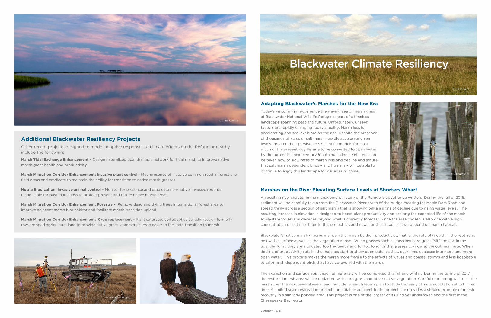
Blackwater Climate Resiliency
Adapting Blackwater’s Marshes for the New Era
Today’s visitor might experience the waving sea of marsh grass
at Blackwater National Wildlife Refuge as part of a timeless
landscape spanning past and future. Unfortunately, unseen
factors are rapidly changing today’s reality: Marsh loss is
accelerating and sea levels are on the rise. Despite the presence
of thousands of acres of salt marsh, rapidly accelerating sea
levels threaten their persistence. Scientific models forecast
much of the present-day Refuge to be converted to open water
by the turn of the next century if nothing is done. Yet steps can
be taken now to slow rates of marsh loss and decline and assure
that salt marsh dependent birds – and humans – will be able to
continue to enjoy this landscape for decades to come.
Additional Blackwater Resiliency Projects Other recent projects designed to model adaptive responses to climate effects on the Refuge or nearby
include the following:
Marsh Tidal Exchange Enhancement – Design naturalized tidal drainage network for tidal marsh to improve native
marsh grass health and productivity.
Marsh Migration Corridor Enhancement: Invasive plant control - Map presence of invasive common reed in forest and
field areas and eradicate to maintain the ability for transition to native marsh grasses.
Nutria Eradication: Invasive animal control – Monitor for presence and eradicate non-native, invasive rodents
responsible for past marsh loss to protect present and future native marsh areas.
Marsh Migration Corridor Enhancement: Forestry - Remove dead and dying trees in transitional forest area to
improve adjacent marsh bird habitat and facilitate marsh transition upland.
Marsh Migration Corridor Enhancement: Crop replacement – Plant saturated soil adaptive switchgrass on formerly
row-cropped agricultural land to provide native grass, commercial crop cover to facilitate transition to marsh.
October, 2016
Marshes on the Rise: Elevating Surface Levels at Shorters Wharf
An exciting new chapter in the management history of the Refuge is about to be written. During the fall of 2016,
sediment will be carefully taken from the Blackwater River south of the bridge crossing for Maple Dam Road and
spread thinly across a section of salt marsh that is showing telltale signs of decline due to rising water levels. The
resulting increase in elevation is designed to boost plant productivity and prolong the expected life of the marsh
ecosystem for several decades beyond what is currently forecast. Since the area chosen is also one with a high
concentration of salt marsh birds, this project is good news for those species that depend on marsh habitat.
Blackwater’s native marsh grasses maintain the marsh by their productivity, that is, the rate of growth in the root zone
below the surface as well as the vegetation above. When grasses such as meadow cord grass “sit” too low in the
tidal platform, they are inundated too frequently and for too long for the grasses to grow at the optimum rate. When
decline of productivity sets in, the marshes start to show open patches that, over time, coalesce into more and more
open water. This process makes the marsh more fragile to the effects of waves and coastal storms and less hospitable
to salt-marsh dependent birds that have co-evolved with the marsh.
The extraction and surface application of materials will be completed this fall and winter. During the spring of 2017,
the restored marsh area will be replanted with cord grass and other native vegetation. Careful monitoring will track the
marsh over the next several years, and multiple research teams plan to study this early climate adaptation effort in real
time. A limited scale restoration project immediately adjacent to the project site provides a striking example of marsh
recovery in a similarly ponded area. This project is one of the largest of its kind yet undertaken and the first in the
Chesapeake Bay region.
© Nikographer
© Chris Koontz
© Nikographer© Albert McCullough
© Erik Meyers

What’s Happening to Blackwater’s Marshes? Over the past seven decades, Blackwater has lost nearly 5,000 acres of marsh to open water. The factors described in the Primer on Sea Level Rise contributed to the marsh loss, but nature is complex and other factors also affect the marshes. A South American rodent, the nutria, was introduced in the area during the mid-20th century. Nutria populations increased rapidly and were responsible for consuming large quantities of marsh plants, even the roots, which led to soil erosion an conversion of marsh areas to open water.
Scientific studies of Blackwater’s marshes document that much of the loss comes from collapse of healthy tidal marsh areas from within. Native marsh grasses such as Spartina patens, or meadow cord grass, are naturally at their best within a relatively narrow tidal range. Too much inundation by the tides slows plant root growth and the decline in the marsh grasses health leads to less plant material to build the marsh for the next growing season. As plant health declines due to rising water levels, more gaps open among clumps of grass until entire segments of marsh become open water. Without the marsh grasses to anchor the soil, these marshes erode more and more with each tide and storm event.
Despite the observed historic loss of Blackwater’s marshes, aerial photographs taken during the same period shows some new marsh development in formerly upland areas as forest and field gave way to marsh vegetation with rising sea levels.
For more information, contact Project Partners:Matt Whitbeck, US Fish and Wildlife Service – [email protected] J. Meyers, The Conservation Fund – [email protected] Curson, PhD, Audubon- Maryland-DC – [email protected]
Blackwater Resiliency Projects
Primer on Sea Level Rise Blackwater National Wildlife
Refuge is particularly vulnerable
to rising sea levels due to
its location, elevation, and
geological history. The Refuge
sits low on the horizon with
long expanses only a foot or
two above high tide and little
elevation inland. Major Atlantic
coastal storms regularly sweep
through the Chesapeake region
causing tidal surges, heavy wave
impacts, and torrential rain.
Combined with the factors just
mentioned, the loss of massive
glaciers that once covered
much of North America 10,000
years ago creates a giant see-
saw effect, lifting land levels in
the north and dropping them
in the south, particularly here
in the Chesapeake Bay region.
Add one more piece to the
puzzle: Higher levels of global
atmospheric carbon (CO2). More
carbon and other “greenhouse
gases” trap more of the Sun’s
solar energy which warms and expands the seas as well
as the air. Combined, all these factors contribute to
rising sea levels in the Chesapeake Bay. Over the past
century, the average sea level in the Bay has risen over
a foot.
There is more to come. Using respected world and
local scientists to inform its work, Maryland convened
a Climate Change Commission Scientific and Technical
Working Group. Their conclusion was the most likely
range of sea level rise in this century will be between
2.7 and 3.4 feet due to the rapidly increasing levels of
atmospheric carbon. A subsequent update moved the
likely range even higher. © Whitney Flanagan
Acknowledgements The Conservation Fund gratefully acknowledges the support of a generous grant from the National Fish and Wildlife
Foundation and its Hurricane Sandy Coastal Resiliency Competitive Grant Program funded by the US Department of Interior
for the marsh elevation project and other climate resiliency/ adaptation work at the Refuge and in adjacent areas. The
Fund also wishes to acknowledge the support of the WCS Climate Adaptation Fund for other adaptation pilot projects and
the Town Creek Foundation for its support of work assessing the impact of sea level rise and developing comprehensive
strategies for adaptation for the marshes of southern Dorchester, Maryland.
© Erik Meyers