blair county - pennsylvaniawatersheds.org
TRANSCRIPT

Recommended Model Development Principles for Blair County, Pennsylvania
May 2006
Consensus of the Local Site Planning Roundtable
Blair County
Funded in part by:Chesapeake Bay Small Watershed Grants Program through the National Fish & Wildlife FoundationChesapeake Bay ProgramWestern Pennsylvania Watershed Program
An Initiative of the Builders for the Bay:Center for Watershed ProtectionAlliance for the Chesapeake BayBlair County Builders Association

The Blair County Site Planning Roundtable would
not have been possible without the time and effort
extended by the roundtable members and the gener-
ous support of the Chesapeake Bay Program, Chesapeake
Bay Small Watershed Grants Program through the
National Fish & Wildlife Foundation and the Western
Pennsylvania Watershed Program.
We would also like to thank the Blair County Builders
Association; Blair County Planning Commission; Blair
County Conservation District; Juniata Clean Water Part-
nership; Juniata Valley Audubon Society; Blair, Logan,
Frankstown, Allegheny and Snyder townships; and the
boroughs of Hollidaysburg and Duncansville for their
partnership in this Builders for the Bay roundtable.
Team members included Pat Devlin and Donna
Morelli from the Alliance for the Chesapeake Bay,
and Pam Rowe and Julie Tasillo from the Center
for Watershed Protection. Assistance was also
provided by Anna Breinich of the Pennsylvania
Environmental Council.
Copies of this document are available from the Alli-
ance for the Chesapeake Bay, 3310 Market Street,
Suite A, Camp Hill, PA 17011/ phone 717-737-8622.
Copies are also available from each of the partner
organizations and agencies. The fi nal consensus
document can be downloaded from the website:
www.buildersforthebay.net.
Acknowledgments
This document was prepared by the
Alliance for the Chesapeake Bay
and
Center for Watershed Protection
Cover Photo Credit: Pat Devlin
May 2006
A Consensus of the Local Site Planning Roundtable
This document is a product of the Blair County Site Planning Roundtable, a year-long
consensus process initiated by the Builders for the Bay to review existing development
ordinances and identify regulatory barriers to environmentally-sensitive residential
and commercial development at the site level. A diverse cross-section of local government,
non-profi t, environmental, homebuilding, business, development and other community pro-
fessionals made up the membership of the Blair County Roundtable. Through a consensus
process, members of the Roundtable adapted the National Model Development Principles to
specifi c conditions. Roundtable recommendations include specifi c ordinance revisions that
would increase fl exibility in site design standards and promote the use of open space and
fl exible design development in Blair County.
The National Model Development Principles adapted by the Blair County Site Planning
Roundtable are designed to collectively meet the objectives of Better Site Design (BSD), which
are to 1) reduce overall site impervious cover, 2) preserve and enhance existing natural areas,
3) integrate stormwater management, and 4) retain a marketable product. Code modifi ca-
tions and other Roundtable recommendations were crafted to remove regulatory hurdles and
provide incentives, fl exibility, and guidance for developers implementing BSD.
i
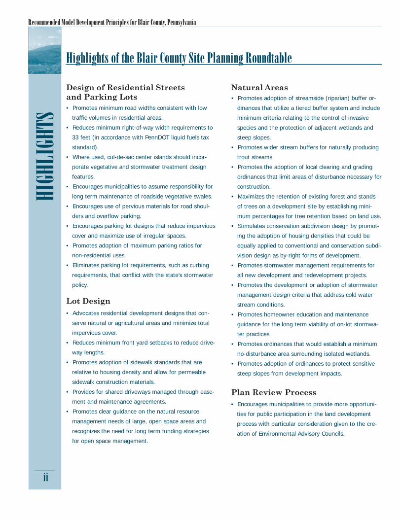
Executive SummaryEXECUTIVE SUMMARY
Recommended Model Development Principles for Blair County, Pennsylvania
HIGH
LIGH
TS
Design of Residential Streets and Parking Lots• Promotes minimum road widths consistent with low
traffi c volumes in residential areas.
• Reduces minimum right-of-way width requirements to
33 feet (in accordance with PennDOT liquid fuels tax
standard).
• Where used, cul-de-sac center islands should incor-
porate vegetative and stormwater treatment design
features.
• Encourages municipalities to assume responsibility for
long term maintenance of roadside vegetative swales.
• Encourages use of pervious materials for road shoul-
ders and overfl ow parking.
• Encourages parking lot designs that reduce impervious
cover and maximize use of irregular spaces.
• Promotes adoption of maximum parking ratios for
non-residential uses.
• Eliminates parking lot requirements, such as curbing
requirements, that confl ict with the state’s stormwater
policy.
Highlights of the Blair County Site Planning Roundtable
Natural Areas• Promotes adoption of streamside (riparian) buffer or-
dinances that utilize a tiered buffer system and include
minimum criteria relating to the control of invasive
species and the protection of adjacent wetlands and
steep slopes.
• Promotes wider stream buffers for naturally producing
trout streams.
• Promotes the adoption of local clearing and grading
ordinances that limit areas of disturbance necessary for
construction.
• Maximizes the retention of existing forest and stands
of trees on a development site by establishing mini-
mum percentages for tree retention based on land use.
• Stimulates conservation subdivision design by promot-
ing the adoption of housing densities that could be
equally applied to conventional and conservation subdi-
vision design as by-right forms of development.
• Promotes stormwater management requirements for
all new development and redevelopment projects.
• Promotes the development or adoption of stormwater
management design criteria that address cold water
stream conditions.
• Promotes homeowner education and maintenance
guidance for the long term viability of on-lot stormwa-
ter practices.
• Promotes ordinances that would establish a minimum
no-disturbance area surrounding isolated wetlands.
• Promotes adoption of ordinances to protect sensitive
steep slopes from development impacts.
Lot Design• Advocates residential development designs that con-
serve natural or agricultural areas and minimize total
impervious cover.
• Reduces minimum front yard setbacks to reduce drive-
way lengths.
• Promotes adoption of sidewalk standards that are
relative to housing density and allow for permeable
sidewalk construction materials.
• Provides for shared driveways managed through ease-
ment and maintenance agreements.
• Promotes clear guidance on the natural resource
management needs of large, open space areas and
recognizes the need for long term funding strategies
for open space management.
ii
Plan Review Process• Encourages municipalities to provide more opportuni-
ties for public participation in the land development
process with particular consideration given to the cre-
ation of Environmental Advisory Councils.

A Consensus of the Local Site Planning Roundtable
Every year, over two million acres of land are altered as a part of the development process. Development has historically led
to degradation in water quality and biological integrity (NRCS, 2001). The impacts of water-shed urbanization on the water quality, biol-ogy, and physical conditions of aquatic systems have been well documented (CWP, 2003). The development radius around many of our cities and smaller municipalities continues to widen at a rapid rate, far outpacing the rise in popula-tion (Leinberger, 1995). In the Chesapeake Bay Region, it is estimated that more than 90,000 acres of open land are converted annually by development, at a rate four to fi ve times greater per person than seen 40 years ago (Chesapeake Bay Foundation, 2002). As a result, local codes and ordinances that promote reduced impact of development on local water resources are critical to future sustainability.
The protection of water resources and the char-acter of the landscape under a continued growth scenario requires local governments, developers, and site designers to fundamentally change the way that land is developed. Deciding where to allow or encourage development, promote rede-velopment, and protect natural resources are
INTRODUCTION
1
diffi cult issues that jurisdictions have to bal-ance. While effective zoning and comprehensive planning are critical, communities should also explore measures to minimize the impact of im-pervious cover, maintain natural hydrology, and preserve contiguous open space on sites where development is to occur.
Toward this end, the Center for Watershed Protection in concert with the Alliance for the Chesapeake Bay, and the Blair County Build-ers Association convened a local Site Planning Roundtable for Blair County. The local Round-table process in Blair County was modeled after the National Site Planning Roundtable, the 22 Model Development Principles and four basic objectives:
1. Reduce overall site impervious cover2. Preserve and enhance existing natural areas3. Integrate stormwater management4. Retain a marketable product
The 22 Model Development Principles act as benchmarks upon which more specifi c code and ordinance recommendations were adapted for Blair County. The benefi ts of applying these 22 Model Development Principles are summarized in the table below.
Introduction and Background
Purpose
This document presents specifi c recommendations on how to foster more environmentally sensi-tive local site design in Blair County. The recommendations were crafted in conjunction with a diverse cross-section of development, local government, civic, non-profi t, environmental, and
other community professionals that participated in the Blair County Planning Roundtable initiated by the Builders for the Bay Program.
Benefi ts of Applying the Model Development PrinciplesLocal Government:• Increase local property tax revenues• Facilitate compliance with wetlands and other
regulations• Assist with stormwater regulation compliance
Developers:• Flexibility in design options• Reduce development costs• Allow for more sensible locations for stormwater facilities• Facilitate compliance with wetlands and other regulations
Homeowners:• Increase property values• Create more pedestrian friendly neighborhoods• Provide open space for recreation• Result in a more attractive landscape• Reduce car speed on residential streets• Promote neighborhood designs that provide a sense of
community
Environment:• Protect sensitive forests, wetlands, and habitats from clearing• Preserve urban wildlife habitat• Protect the quality of local streams, lakes, and estuaries• Generate smaller loads of stormwater pollutants• Help to reduce soil erosion during construction

Recommended Model Development Principles for Blair County, Pennsylvania
• The Beaverdam Stormwater Management Plan (Act 167 Plan, 2000) estimates 10% growth in developed areas in the watershed. Challenges identifi ed in the plan include soils with slow in-fi ltration, mountainous topography, and fl ooding from increased stormwater volume and velocity. A similar Little Juniata River Stormwater Man-agement Plan is now under development.
• Recently adopted stormwater ordinances in Municipal Separate Storm Sewer System (MS4) communities must now address water quality, infi ltration, and stream channel conditions in addition to fl ood control; however, existing subdi-vision & land development or zoning ordinances can hinder or prohibit the use of best manage-ment practices that meet these objectives. The roundtable helps communities consider ways to coordinate stormwater and other land develop-ment ordinances.
• Municipalities, county agencies, local builders/developers, area conservation organizations, and engineering fi rms expressed interest and were willing to commit staff time to the roundtable process. The Blair County Planning Commission was highly supportive of being included in this review process in order to consider improve-ments to its model ordinances.
• Completion of the Codes and Ordinance Work-sheets (COW) indicated that local development rules are insuffi cient to protect this area’s water resources and aquatic communities.
Blair County is made up of fi fteen townships, nine boroughs and one city. Five townships and two boroughs participated in the roundtable process. Of these municipalities, only four have zoning ordinances and all have subdivision and land development ordinances (SALDO’s). This presents a unique challenge for making specifi c recommendations for language that is traditionally incorporated into zoning ordinances. As part of this process, the Pennsylvania Environmental Council will be working to develop ordinance language that can be part of both zoning and subdivision and land development ordinances to accommodate this document’s recommendations.
INTR
ODUC
TION
The purpose of a local site planning roundtable is to adapt the national model development principles for local application by identifying
how local codes and ordinances can be modifi ed to allow for better site design.
Blair County was selected as a location for a roundtable for multiple reasons:
• Blair County is within the Chesapeake Bay watershed, located in the headwaters of the Juniata River which feeds the Susquehanna River and ultimately the Chesapeake Bay.
• A series of stormwater workshops in 2003 sparked interest in a detailed review of local development ordinances.
• The Juniata River Watershed Management Plan (September 2000) identifi ed stormwater runoff as the number one problem in Blair County. Flooding and streambank damage from non-agricultural sources were also identifi ed as key concerns.
• The Juniata River Watershed Management Plan’s implementation strategy recommends:• discouraging development in environmen-
tally sensitive areas, such as steep slopes, fl oodplains and wetlands;
• providing education for better site design standards, including open space/conserva-tion subdivision design planning; and
• incorporating riparian buffer requirements in local subdivision and zoning ordinances.
• There are large undeveloped lands still remain-ing in Blair County, with signifi cant areas of contiguous forests, four signifi cant Important Bird Areas, and the presence of High Quality Cold Water Fishery streams. Better site de-sign principles promote the protection of such natural areas.
• Reliance on small reservoirs for public water supplies makes the groundwater recharge to these supplies an important consideration in land use planning and development.
• Improvements to Interstate 99 in the northern region of Blair County will bring additional growth and development along this corridor in the near future.2
Why Blair County?
A Consensus of the Local Site Planning Roundtable
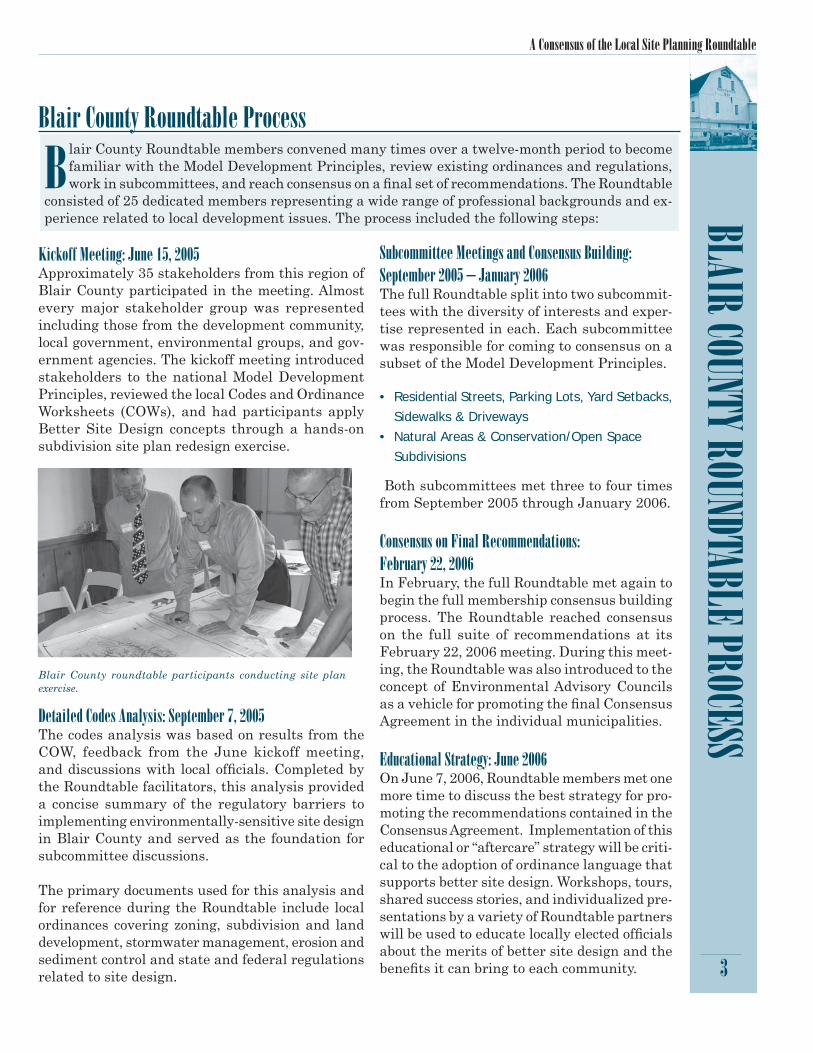
BLAIR COUNTY ROUNDTABLE PROCESS
3
Blair County Roundtable Process
Blair County Roundtable members convened many times over a twelve-month period to become familiar with the Model Development Principles, review existing ordinances and regulations, work in subcommittees, and reach consensus on a fi nal set of recommendations. The Roundtable
consisted of 25 dedicated members representing a wide range of professional backgrounds and ex-perience related to local development issues. The process included the following steps:
Kickoff Meeting: June 15, 2005Approximately 35 stakeholders from this region of Blair County participated in the meeting. Almost every major stakeholder group was represented including those from the development community, local government, environmental groups, and gov-ernment agencies. The kickoff meeting introduced stakeholders to the national Model Development Principles, reviewed the local Codes and Ordinance Worksheets (COWs), and had participants apply Better Site Design concepts through a hands-on subdivision site plan redesign exercise.
Detailed Codes Analysis: September 7, 2005The codes analysis was based on results from the COW, feedback from the June kickoff meeting, and discussions with local offi cials. Completed by the Roundtable facilitators, this analysis provided a concise summary of the regulatory barriers to implementing environmentally-sensitive site design in Blair County and served as the foundation for subcommittee discussions.
The primary documents used for this analysis and for reference during the Roundtable include local ordinances covering zoning, subdivision and land development, stormwater management, erosion and sediment control and state and federal regulations related to site design.
Subcommittee Meetings and Consensus Building: September 2005 – January 2006The full Roundtable split into two subcommit-tees with the diversity of interests and exper-tise represented in each. Each subcommittee was responsible for coming to consensus on a subset of the Model Development Principles.
• Residential Streets, Parking Lots, Yard Setbacks, Sidewalks & Driveways
• Natural Areas & Conservation/Open Space Subdivisions
Both subcommittees met three to four times from September 2005 through January 2006.
Consensus on Final Recommendations: February 22, 2006In February, the full Roundtable met again to begin the full membership consensus building process. The Roundtable reached consensus on the full suite of recommendations at its February 22, 2006 meeting. During this meet-ing, the Roundtable was also introduced to the concept of Environmental Advisory Councils as a vehicle for promoting the fi nal Consensus Agreement in the individual municipalities.
Educational Strategy: June 2006On June 7, 2006, Roundtable members met one more time to discuss the best strategy for pro-moting the recommendations contained in the Consensus Agreement. Implementation of this educational or “aftercare” strategy will be criti-cal to the adoption of ordinance language that supports better site design. Workshops, tours, shared success stories, and individualized pre-sentations by a variety of Roundtable partners will be used to educate locally elected offi cials about the merits of better site design and the benefi ts it can bring to each community.
Blair County roundtable participants conducting site plan exercise.

Recommended Model Development Principles for Blair County, Pennsylvania
MEMB
ERSH
IP ST
ATEM
ENT O
F SUP
PORT
This document of recommended development principles was crafted in conjunction with the di-verse cross-section of development, local government, non-profi t, environmental, and other com-munity professionals who participated in the Builders for the Bay Blair County Site Planning
Roundtable.
Members of the Roundtable provided the technical experience needed to craft and refi ne the model development principles for Allegheny, Blair, Frankstown, Logan, and Snyder townships and Dun-cansville and Hollidaysburg boroughs. These recommendations refl ect our professional and personal experience with land development and do not necessarily carry the endorsement of the organizations and agencies represented by their members. Endorsement implies support of the principles and recom-mendations as a package and does not necessarily imply an equal level of support among individual recommendations by all Roundtable members.
The members of the Blair County Site Planning Roundtable endorse the model development prin-ciples presented in this document, known as Recommended Model Development Principles for Blair County.
4
Membership Statement of Support
Terry GephardtAllegheny Township
Palmer BrownBlair Township
Charles ElderBlair Township
Cassandra SchmickLogan Township
Robert AyersSnyder Township
Theodore KochTheodore E. Koch & Associates, Inc.Duncansville Borough
Ethan ImhoffHollidaysburg Borough
Michael MakufkaJuniata Clean Water Partnership
William HilsheyClearwater ConservancyFrankstown Township
Teddie KreitzKeller Engineers
Robert BuddenbohnBlair County Builders Association
Richard HimesRichard Himes General ContractorBlair County Builders Association
Donald DelozierDonald C. Delozier, Inc.
Richard HainesBlair County Planning Commission
Donna FisherBlair County Conservation District
Amanda RitcheyBlair County Conservation District
James EckenrodeBlair County Conservation District
Stan KotalaJuniata Valley Audubon
Pat Devlin, FacilitatorAlliance for the Chesapeake Bay
Donna Morelli, FacilitatorAlliance for the Chesapeake Bay
Pam Rowe, FacilitatorCenter for Watershed Protection
Julie Tasillo, FacilitatorCenter for Watershed Protection
Anna BreinichErin TaylorPennsylvania Environmental Council
A Consensus of the Local Site Planning Roundtable
5
Model Development PrinciplesRecommended by the Blair County Site Planning Roundtable
RESIDENTIAL STREETS AND PARKING LOTS
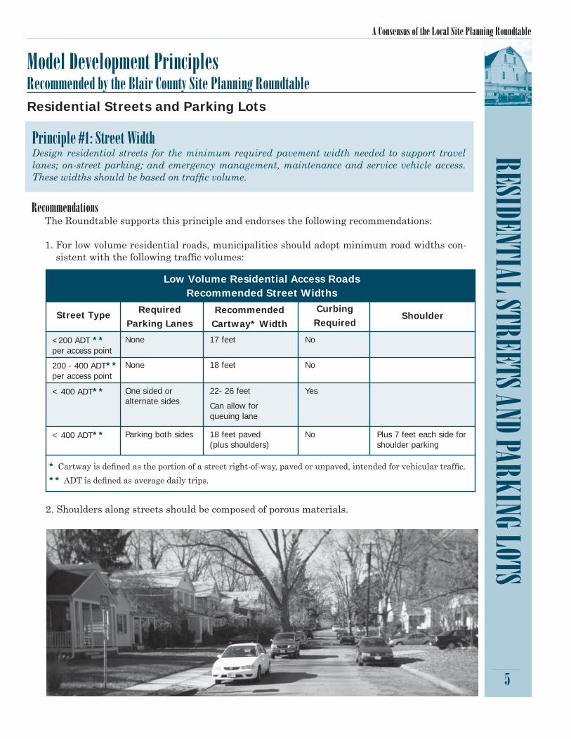
RecommendationsThe Roundtable supports this principle and endorses the following recommendations:
1. For low volume residential roads, municipalities should adopt minimum road widths con-sistent with the following traffi c volumes:
Residential Streets and Parking Lots
Principle #1: Street WidthDesign residential streets for the minimum required pavement width needed to support travel lanes; on-street parking; and emergency management, maintenance and service vehicle access. These widths should be based on traffi c volume.
2. Shoulders along streets should be composed of porous materials.
* Cartway is defi ned as the portion of a street right-of-way, paved or unpaved, intended for vehicular traffi c.
** ADT is defi ned as average daily trips.
Low Volume Residential Access RoadsRecommended Street Widths
Street Type
<200 ADT **per access point
200 - 400 ADT** per access point
< 400 ADT**
< 400 ADT**
Required Parking Lanes
None
None
One sided or alternate sides
Parking both sides
RecommendedCartway* Width
17 feet
18 feet
22- 26 feet
Can allow for queuing lane
18 feet paved (plus shoulders)
Curbing Required
No
No
Yes
No
Shoulder
Plus 7 feet each side for shoulder parking

Recommended Model Development Principles for Blair County, Pennsylvania
RESI
DENT
IAL S
TREE
TS AN
D PAR
KING
LOTS
6
RationaleResidential streets are often unnecessarily wide and these excessive widths contribute to the larg-est single component of impervious cover in a subdivision (CWP, 1998). Narrower street widths not only reduce impervious cover, but also promote lower vehicular speeds and increased safety and can reduce construction and maintenance costs.
While minimum road widths are not excessive in Blair County, many ordinances do not clearly connect widths to traffi c volumes and parking requirements. In Pennsylvania, many ordinances are based on mobility and land access, not traffi c volume. Recommendations aim to add consis-tency between municipalities based on Average Daily Traffi c (ADT) for low volume roads, as well as clarify the connection between minimum road widths and parking or curbing requirements.
Principle #2: Street LengthReduce the total length of residential streets by encouraging alternative street layouts for the purpose of reducing impervious cover.
RecommendationsThe Roundtable endorses this principle with no additional recommendations.
RationaleTotal street length is often a function of the frontage, number of entrances, pedestrian safety, and physical site conditions. Guidance encouraging thoughtful, fl exible and practical subdivision design criteria that reduces the overall street length can be useful to reduce impervious cover while maintaining the number of desired dwelling units.
No additional recommendations were made for this principle because no current ordinances work against the reduction of street length.
Principle #3: Rights-of-WayWherever possible, residential street right-of-way widths should refl ect the minimum required to ac-commodate the travel-way, sidewalk, and vegetated open channels. Utilities and storm drains should be allowed to be located within the pavement section of the right-of-way wherever possible.
RecommendationsThe Roundtable supports this principle and endorses the following recommendations:
1. Minimum Right-of-Way widths should fall within the range of 33 – 50 feet for local residential access roads (use wider range to provide for vegetated open channels).
2. Municipalities should encourage common ditches and other design techniques that minimize the amount of ROW needed to install utilities.
A Consensus of the Local Site Planning Roundtable
RecommendationsThe Roundtable supports this principle and endorses the following recommendations:
1. Where no landscaped island is provided, a cul-de-sac radius may have a minimum width of 40 feet.
2. Altoona should reduce its minimum cul-de-sac radius of 70 feet.3. When a cul-de-sac is designed, municipalities’ ordinances should explicitly encourage land-
scaped islands or center areas composed of pervious materials and make reference to design criteria in their stormwater management ordinances.
4. Municipalities should allow for loop or t-shaped turnarounds as alternatives to cul-de-sac end roads.
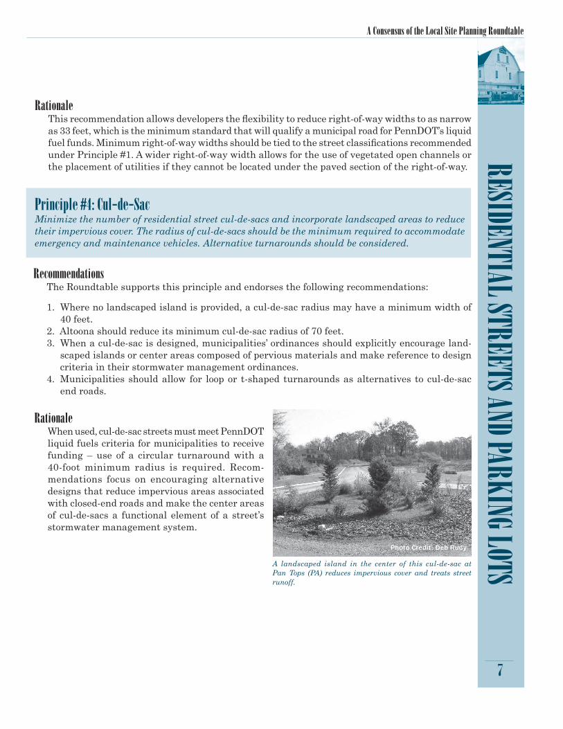
A landscaped island in the center of this cul-de-sac at Pan Tops (PA) reduces impervious cover and treats street runoff.
7
RESIDENTIAL STREETS AND PARKING LOTS Rationale
This recommendation allows developers the fl exibility to reduce right-of-way widths to as narrow as 33 feet, which is the minimum standard that will qualify a municipal road for PennDOT’s liquid fuel funds. Minimum right-of-way widths should be tied to the street classifi cations recommended under Principle #1. A wider right-of-way width allows for the use of vegetated open channels or the placement of utilities if they cannot be located under the paved section of the right-of-way.
Principle #4: Cul-de-SacMinimize the number of residential street cul-de-sacs and incorporate landscaped areas to reduce their impervious cover. The radius of cul-de-sacs should be the minimum required to accommodate emergency and maintenance vehicles. Alternative turnarounds should be considered.
RationaleWhen used, cul-de-sac streets must meet PennDOT liquid fuels criteria for municipalities to receive funding – use of a circular turnaround with a 40-foot minimum radius is required. Recom-mendations focus on encouraging alternative designs that reduce impervious areas associated with closed-end roads and make the center areas of cul-de-sacs a functional element of a street’s stormwater management system.
Photo Credit: Deb Rudy

Recommended Model Development Principles for Blair County, Pennsylvania
8
RESI
DENT
IAL S
TREE
TS AN
D PAR
KING
LOTS
Principle #5: Vegetated Open ChannelsWhere density, topography, soils and slope permit, vegetated open channels should be used in the street right-of-way to convey and treat stormwater runoff.
RecommendationsThe Roundtable supports this principle and en-dorses the following recommendations:
1. Municipalities should assume responsibility for long term maintenance of vegetated swales, in-cluding obtaining easements for access and main-tenance of swales or other stormwater practices located on private property.
2. Municipalities should educate homeowners about the important function of vegetated swales and the maintenance necessary for long term manage-ment of stormwater runoff.
3. Where housing density, soils and slope do not provide suitable conditions for vegetated open channels, ordinances should allow for other in-fi ltration practices, such as rock-lined channels, within the right-of-way.
RationaleStreets contribute higher loads of pollutants to urban stormwater than any other source area in residential developments (Bannerman, et al., 1993 and Steuer, et al., 1997). The use of vegetated open channels to convey stormwater runoff can remove some of these pollutants and decrease the volume of stormwater generated from a site.
Timber check dams control runoff velocity in this open vegetated swale.
Photo Credit: Pat Devlin
A Consensus of the Local Site Planning Roundtable
9
RESIDENTIAL STREETS AND PARKING LOTS Principle #6: Parking RatiosThe required parking ratio governing a particular land use or activity should be enforced as both a maximum and a minimum in order to curb excess parking space construction. Existing parking ratios should be reviewed for conformance taking into account local and national experience to see if lower ratios are warranted and feasible.
RecommendationsThe Roundtable supports this principle and endorses the following recommendations:
1. Adopt maximum parking ratios for non-residential uses. Any parking spaces needed beyond the maximum number should be in pervious material.
2. If a proposed land use is shown to need fewer parking spaces than the required minimum, municipal ordinances should allow for the difference to be reserved as an unpaved, vegetated area; however, stormwater management practices must be provided upfront to handle runoff from this area should it become impervious.
3. Municipal ordinances should reference an accepted parking reference guide in adopting up-dated parking ratios, such as the Institute of Traffi c Engineers’ Parking Generation, 3rd ed. (2004), which provides parking demand data for 91 land uses by hour of day.
RationaleParking ratios usually represent the minimum number of spaces needed to accommodate the highest hourly parking at the site. In many cases, these ratios are cut and paste recommenda-tions and can result in far more spaces than are actually needed.
Revising parking ratios to refl ect actual parking demand should reduce impervious cover from parking lots. Municipalities may elect to conduct a local parking study or to utilize existing na-tional studies such as ITE (2004) and ULI (1999) for data on parking demand for various land uses. Requiring all overfl ow parking to be constructed in pervious materials would further reduce parking lot imperviousness.
Principle #7: Parking Codes and Shared ParkingParking codes should be revised to lower parking requirements where mass transit is available or when enforceable, shared parking arrangements are made.
RecommendationsThe Roundtable supports this principle and endorses the following recommendation:
1. Municipalities should adopt a shared parking ordinance and include a model agreement in its ordinance to alleviate future parking disputes.
RationaleParking demand represents the actual number of parking spaces required to accommodate the parking needs of a particular land use. Depending on site conditions, it may be possible to reduce the number of parking spaces needed. For example, when mass transit is available nearby, or when shared parking is utilized, the number of parking spaces constructed may be reduced.
Recommended Model Development Principles for Blair County, Pennsylvania
10
RESI
DENT
IAL S
TREE
TS AN
D PAR
KING
LOTS
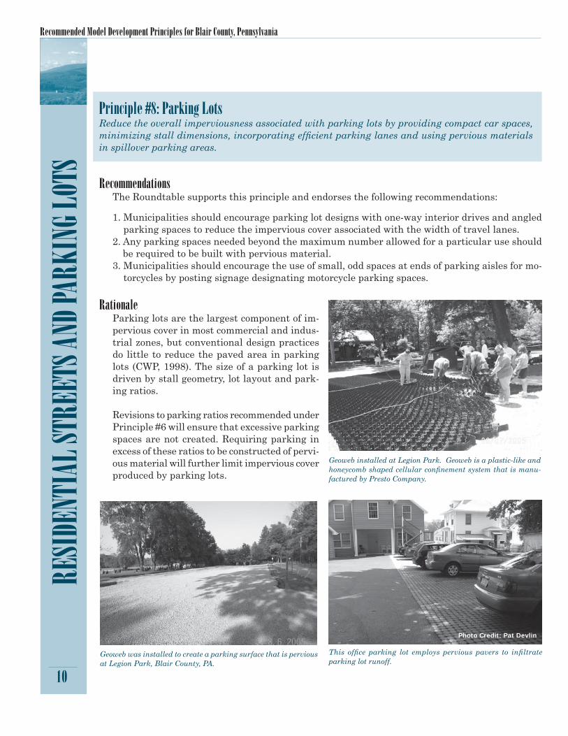
RationaleParking lots are the largest component of im-pervious cover in most commercial and indus-trial zones, but conventional design practices do little to reduce the paved area in parking lots (CWP, 1998). The size of a parking lot is driven by stall geometry, lot layout and park-ing ratios.
Revisions to parking ratios recommended under Principle #6 will ensure that excessive parking spaces are not created. Requiring parking in excess of these ratios to be constructed of pervi-ous material will further limit impervious cover produced by parking lots.
Geoweb installed at Legion Park. Geoweb is a plastic-like and honeycomb shaped cellular confi nement system that is manu-factured by Presto Company.
Geoweb was installed to create a parking surface that is pervious at Legion Park, Blair County, PA.
This offi ce parking lot employs pervious pavers to infi ltrate parking lot runoff.
Principle #8: Parking LotsReduce the overall imperviousness associated with parking lots by providing compact car spaces, minimizing stall dimensions, incorporating effi cient parking lanes and using pervious materials in spillover parking areas.
RecommendationsThe Roundtable supports this principle and endorses the following recommendations:
1. Municipalities should encourage parking lot designs with one-way interior drives and angled parking spaces to reduce the impervious cover associated with the width of travel lanes.
2. Any parking spaces needed beyond the maximum number allowed for a particular use should be required to be built with pervious material.
3. Municipalities should encourage the use of small, odd spaces at ends of parking aisles for mo-torcycles by posting signage designating motorcycle parking spaces.
Photo Credit: Pat Devlin
A Consensus of the Local Site Planning Roundtable
11
RESIDENTIAL STREETS AND PARKING LOTS Principle 9: Structured ParkingProvide meaningful incentives to encourage structured and shared parking to make it more eco-nomically viable.
RecommendationsThe Roundtable supports this principle and endorses the following recommendation:
1. Adopt specifi c language in ordinance to offer incentives for structured parking, such as tax breaks, additional parking space allowances, or additional height allowance for buildings.
RationaleThe construction costs of vertical parking structures are signifi cantly higher than that of sur-face lots. Because economics largely drive the feasibility of structured parking, the Roundtable encourages the inclusion of incentives in parking ordinances for situations that might warrant above or below-ground parking structures.
Principle #10: Parking Lot RunoffWherever possible, provide stormwater treatment for parking lot runoff using bioretention areas, fi lter strips, and/or other practices that can be integrated into required landscaping areas and traffi c islands.
RecommendationsThe Roundtable supports this principle and endorses the following recommendations:
1. Eliminate parking lot requirements for curbed landscaped areas that are in direct confl ict with the state’s stormwater policy. Ordinances should allow for optional curbing in parking lots based on stormwater management needs.
2. For bioretention purposes, ordinances should offer fl exibility in plant selection for landscaped areas in parking lots. Native and/or benefi cial plant species should be encouraged for bioreten-tion areas.
3. Adopt language within parking codes that connects parking ordinance with stormwater or-dinance requirements and approaches; language should support Best Management Practices (BMPs) to be consistent with PA’s DEP stormwater management manual.
4. Municipal ordinances should allow for the use of pervious surface parking materials for entire parking lots.
RationaleParking lots are a signifi cant source of stormwater pollutants in the suburban landscape, particularly lots in commercial areas (CWP, 1998). Typically, landscaping requirements are used to enhance the appearance of a parking lot or to visually separate land uses or de-velopments and can account for 10-15% of the total parking lot area (CWP, 1998). These same areas can be used for stormwater manage-ment if properly designed.
These recommendations are aimed at eliminating confl icts between existing stormwater ordinances and the state’s comprehensive stormwater management policy (2002), which promotes a best management practice approach to improve water quality, sustain water quantity and integrate federal stormwater management obligations.
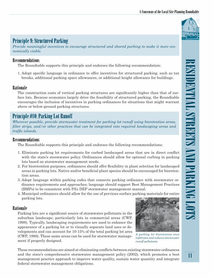
A parking lot bioretention area infi ltrates and reduces stormwater runoff pollutants.
Recommended Model Development Principles for Blair County, Pennsylvania
LOT D
EVEL
OPME
NT
12
Lot Development
Principle #11: Open Space (Conservation Subdivision) DesignAdvocate a type of development that conserves natural areas by incorporating smaller lot sizes [more compact development footprint] to minimize total impervious area and reduce total construc-tion costs, consolidate contiguous open space areas, provide community recreational space, protect agricultural lands, and promote watershed protection.
RecommendationsThe Roundtable supports this principle and endorses the following recommenda-tions:
1. Develop model ordinance language for conservation design that can be applied to:• Both subdivision & land development
and zoning ordinances• Areas with and without sewer
2. Development in or adjacent to agricul-tural security areas must be clustered to promote the consolidation of agricul-tural areas.
3. Locate open space areas to provide maximum buffering between new devel-opment and agricultural lands.
4. Develop a multi-municipal plan for Blair County and adjacent areas to address the issue of agricultural preservation and appropriate development patterns and buffering adjacent to agricultural areas.
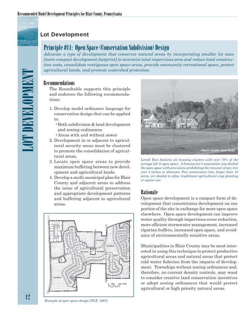
Lenah Run features six housing clusters with over 70% of the acreage left in open space. A homeowner’s association was deeded the open space with provisions prohibiting the removal of any tree over 4 inches in diameter. Five conservancy lots, larger than 10 acres, are deeded to allow traditional agricultural crop planting or equine use.
Example of open space design (NLT, 1997).
RationaleOpen space development is a compact form of de-velopment that concentrates development on one portion of the site in exchange for more open space elsewhere. Open space development can improve water quality through impervious cover reduction, more effi cient stormwater management, increased riparian buffers, increased open space, and avoid-ance of environmentally sensitive areas.
Municipalities in Blair County may be most inter-ested in using this technique to protect productive agricultural areas and natural areas that protect cold water fi sheries from the impacts of develop-ment. Townships without zoning ordinances and, therefore, no current density controls, may want to consider creative land conservation incentives or adopt zoning ordinances that would protect agricultural or high priority natural areas.
Photo Credit: Deb Rudy

A Consensus of the Local Site Planning Roundtable
LOT DEVELOPMENT
13
Principle #12: Yard Setbacks for Conservation Subdivision DesignTo encourage conservation subdivision design, relax side yard setbacks and allow narrower frontages to reduce total road length in the community and overall site imperviousness. Relax front setback requirements to minimize driveway lengths and reduce overall lot imperviousness.
RecommendationsThe Roundtable supports this principle and endorses the following recommendations:
1. Adopt minimum front yard setback requirement of 25 feet in all municipalities. Where built-out neighborhoods exist, front yard setbacks should be consistent with existing setbacks and, therefore, may be less than 25 feet.
2. Where side setback requirements require a sum of both sides, allow for a minimum require-ment of 7 feet on one side.
RationaleOften zoning ordinances have very strict requirements that govern the geometry of the lot. Re-laxing setbacks and utilizing non-traditional designs can minimize imperviousness while reduc-ing driveway lengths. Relaxing minimum setbacks also allows for smaller lot sizes which is an important design element of open space design.
While frontage requirements in single-family developments are not excessive in any of the Round-table municipalities, some reductions in front yard setback requirements are recommended to reduce impervious cover contributed by driveways and roads and promote the “walkability” of streets.
Principle #13: SidewalksPromote more fl exible design standards for residential subdivision sidewalks. Where practical, consider locating sidewalks on only one side of the street and providing common walkways linking pedestrian areas.
RecommendationsThe Roundtable supports this principle and endorses the following recommendations:
1. Side walks on both sides of a residential street should only be required where aver-age lot size equates to four dwelling units per acre.
2. Sidewalks should not be required where lot densities are less than two lots per acre.
3. Sidewalks should not be required along cul-de-sacs due to low traffi c volume.
4. Ordinances should encourage alternative, permeable sidewalk surfaces.
5. Ordinances should require that sidewalks be sloped to direct runoff into pervious areas for infi ltration.
At Bancroft (MD), narrower street width with no curbs or gutters reduced impervious cover and minimized clearing and grading. Moving the bike lane into the wooded areas fronting properties reduced the need to place 12 feet of non-porous pavement.
Photo Credit: Deb Rudy

Recommended Model Development Principles for Blair County, Pennsylvania
14
LOT D
EVEL
OPME
NT
RationaleSidewalk requirements are an important element of many subdivision and land development ordinances and are intended to protect pedestrians and address liability concerns. However, re-quirements should be fl exible enough to meet pedestrian demands, while minimizing the amount of impervious cover.
While existing ordinances in this area are not excessively restrictive, Roundtable members en-courage greater clarity in the ordinances relating to the necessity of sidewalks and allowance for alternative construction materials.
Principle #14: Driveways and Alternative SurfacesReduce overall lot imperviousness by promoting alternative driveway surfaces and shared driveways that connect two or more homes together.
RecommendationsThe Roundtable supports this principle and endorses the following recommendations:
1. Ordinance language should encourage designs that direct runoff from drive-ways away from street conveyance sys-tems and into pervious areas.
2. Shared driveways should be designed to reduce the amount of impervious surface serving multiple homes.
3. Ordinances should provide for options in driveway surfaces and encourage the use of pervious materials.
4. Municipalities should adopt a model shared driveway agreement to avoid confl icts over use and management responsibilities. Such agreements should specify that parking is not allowed on the travel section of the driveway.
RationaleStudies show that 20% of the impervious cover in residential subdivisions can consist of driveways (Schueler, 1995). Flexible local subdivision codes can allow developers the ability to address this concern.
Roundtable municipalities currently have few standards for driveway design and shared drive-ways are not addressed by all but one municipality.

A Consensus of the Local Site Planning Roundtable
Photo Credit: Pat Devlin
RecommendationsThe Roundtable supports this principle and endorses the following recommendations:
1. Develop long-term funding sources for townships and boroughs to accept man-agement responsibility for open space areas.
2. Develop resource management guid-ance for the management of these areas including invasive species control, allow-able uses (such as types of stormwater management facilities, paths, etc.), and reforestation/native planting goals.
3. Explore the use of recreation councils es-tablished by inter-municipal agreement that could provide long-term manage-ment of natural open space areas.
15
LOT DEVELOPMENT Principle #15: Open Space ManagementClearly specify how community open space will be managed and designate a sustainable legal entity responsible for managing both natural and recreational open space.
Studies have shown that managing open space in a natural condi-tion compared to lawns and passive recreation is the least expensive maintenance strategy for community associations.
RationaleOpen space management is often poorly defi ned in most communities, leaving the design and maintenance of the space up to the homeowner, homeowners’ associations (HOAs), or other enti-ties that may be ill equipped to properly maintain high quality open space (Heraty, 1992).
Only those municipalities that are largely built out (boroughs and cities) currently have any type of open space provisions in their zoning ordinances, and associated management plans in-clude few management criteria. Whether a public or private entity is responsible for open space management, Roundtable members recognize the importance of clearly identifying resource management responsibilities and fi nancing mechanisms for the long term management of any open space or common areas.
Recommended Model Development Principles for Blair County, Pennsylvania
16
CONS
ERVA
TION
OF NA
TURA
L ARE
AS
Principle #16: Riparian Buffer SystemsCreate a variable width, naturally vegetated buffer system along all perennial and intermittent streams that also encompasses critical environmental features including the 100-yr fl oodplain, springs and seeps, adjacent steep slopes, and freshwater wetlands. The riparian stream buffer should be maintained in a natural forested condition, or restored with native vegetation. The buf-fer system should be clearly delineated on plans and through the use of appropriate signage and establishment of limits of disturbance during the plan review, construction, and post-development stages. Municipalities should discourage development within the 100-year fl oodplain.
RecommendationsThe Roundtable supports this principle and endorses the following recommendations:
1. Utilize a tiered buffer system that is less restrictive in the outer zones where the fl oodplain is extended beyond the minimum buffer zone; identify the types of uses, such as restricted development, recreational facilities, stormwater management, etc., that are appropriate in the different buffer zones.
2. Develop model stream buffer language that can be applied either through the subdivision & land development ordinance, separate ordinance, or zoning ordinance.
3. Develop property owner education program on good buffer maintenance practices.4. Provide model documents for the protection of buffer areas within dedicated conservation
easements that restrict general public access, and explain allowable uses (e.g., paths, certain types of stormwater management practices).
5. Buffers should include the following elements:a. Include perennial and intermittent streams and springs/seepsb. Bumped out to include adjacent wetlands and certain steep slopes c. Measured from the top of bankd. No clearing and gradinge. Eradication and long-term control of invasive speciesf. Replanting of cleared buffers with native trees/shrubs/grasses during the construction
phase6. Utilize the buffers established by the DEP Timber Harvesting Guidelines as a starting point
for minimum buffer width:a. 0 – 10% slope: 45’ minimum bufferb. 11 – 20% slope: 65’ minimum bufferc. 21 – 30% slope: 85’ minimum bufferd. 31 – 40% slope: 105’ minimum buffere. over 40% slope: 125’ minimum buffer
7. An alternative stream buffer guideline is provided in PA DEP State Forest Resource Manage-ment Plan guidance:a. Roads and rights-of-way should be located away from stream courses. The fi lter strip between
a stream and road or right-of-way should be 50 feet plus 4 feet for each one percent of slope. This formula for determining buffer width could be used as an alternative.
8. Establish wider buffers for naturally reproducing trout streams identifi ed by the PA Fish Commission.
Conservation of Natural Areas

A Consensus of the Local Site Planning Roundtable
17
CONSERVATION OF NATURAL AREAS
A tiered buffer system offers fl exibility in allowed uses and functions.
RationaleThe creation of a riparian buffer system is key to protecting the water quality of streams and offers many additional benefi ts: 1) provides fl ood control, 2) protects streambanks from erosion, 3) enhances pollution removal, 4) provides food and habitat for wildlife, 5) prevents disturbance to steep slopes, 6) provides a foundation for future greenways, 7) reduces small drainage problems and complaints, 8) increases property values, and 9) provides space for stormwater facilities.
Stream buffer protection in Roundtable municipalities is generally limited to the fl oodway, lim-iting construction of permanent structures but not regulating clearing and grading in any way. Recommendations focus on both the protection and management of buffer systems, especially those next to steep slopes and productive cold water and naturally producing trout streams.

Recommended Model Development Principles for Blair County, Pennsylvania
RecommendationsThe Roundtable supports this principle and endorses the following recommendations:
1. All municipalities should develop specifi c language in their subdivision & land development ordinances, or develop a separate ordinance, that addresses clearing and grading, including the following provisions:a. Subdivision plans and subsequent development phase plan submissions must establish a
limit of disturbance that is limited to the minimum amount necessary to provide building footprints, access for ingress/egress for a site and the provision of utilities.
b. Limits of disturbance must be fl agged in the fi eld and inspected prior to any clearing and grading activities.
c. An approved, stamped erosion and sediment control plan must be on-site at all times during active construction activities.
d. Limits of disturbance must be enforced during all earth moving activities, including preliminary grading and stockpiling activi-ties.
e. Limits should be set on the dura-tion of time that a site may remain unstabilized following a temporary halt to work. Sites should be sta-bilized within 7 days. Ordinances should provide specifi cations for the type of temporary stabiliza-tion that is required, as well as permanent stabilization.
18
CONS
ERVA
TION
OF NA
TURA
L ARE
AS
Principle #17: Clearing and GradingClearing and grading for land development should be limited to the minimum amount needed to provide building footprints, access for ingress/egress and the provision of utilities. Clearing and grading for any purpose should be managed by establishing review and permit trigger mechanisms that encompass all potential land disturbance, and establishing best management practices (BMPs) appropriate to the type of disturbance.
At Forest Brooke (VA), developer prohibited mass clearing and grading which added to the costs but was recouped by the increase in desirability and market value of homes. Sixty percent of site was left in trees. Smaller equipment was used to clear home footprints.
Photo Credit: Deb Rudy

A Consensus of the Local Site Planning Roundtable
19
CONSERVATION OF NATURAL AREASf. Provide provisions for temporary stockpile
operations, such as seeding/covering of stockpiles, locations of stockpiles (outside of stream buffers, etc.).
2. The Blair County Conservation District will work with the local jurisdictions to develop training modules for plan preparers, plan reviewers, and inspectors on how to prepare, review and enforce clearing and grading plans and erosion and sediment controls.
3. The local jurisdictions will update their ordi-nances to include provisions that cover ALL clearing and grading activities, not just those associated with development; the Allegheny Township Earthmoving Ordinance is recom-mended as a good model ordinance.
RationaleMost communities allow clearing and grading of an entire site except for a few specially regu-lated areas such as jurisdictional wetlands, steep slopes and fl oodplains. In Blair County, most municipalities reference the Blair County Conservation District’s erosion and sediment control requirements; two Roundtable municipalities have ordinances that generally aim to protect natural areas. Recommendations urge municipalities to adopt clearing and grading ordinances that would reinforce state erosion control regulations and address clearing and grading that oc-curs outside the permitting process.
Properly installed erosion control fences are critical to protecting waterways and natural areas from sediment pollution.

Recommended Model Development Principles for Blair County, Pennsylvania
20
CONS
ERVA
TION
OF NA
TURA
L ARE
AS
RationaleNative trees, shrubs, and grasses are important contributors to the overall quality and viability of the environment. In addition, they can provide noticeable economic benefits to developers and homeowners. Most of the Roundtable municipalities have no tree preservation ordinances, and there are presently no minimum thresholds for on-site tree or forest canopy. The location of environ-mentally sensitive areas and heritage inventory sites is an important step in targeting the conservation of existing trees and forest.
At Forest Ridge (PA), developer walked each lot with homeowners to determine placement of homes based on saving the most trees and pur-chased smaller excavation equipment to limit tree disturbance. Deed restrictions imposed by the developer curtails the cutting of trees.
Principle #18: Conservation of Trees and Native VegetationMaximize the retention of existing forest and stands of trees and other native vegetation on a devel-opment site. Wherever possible, plant native trees and vegetation in community public space, street rights-of-way, parking lot islands, and other landscaped areas to promote natural vegetation. Target the conservation of existing forest/trees and replanting of areas to give priority to environmentally sensitive areas. Forest and tree preservation percentages may be higher in biological diversity areas, landscape conservation areas, and greenways.
RecommendationsThe Roundtable supports this principle and endorses the following recommendations:
1. Retain a percentage of existing forest and tree stands on a development site.2. Manage forest and tree stands on a development site to remove and control invasive spe-
cies.3. Encourage replanting of a certain percentage of trees on a development site.4. Target the conservation of existing forest and trees and replanting efforts on development
sites to give priority to certain environmentally sensitive areas including:a. Wetland areasb. Riparian buffer areasc. Steep slopesd. Natural Heritage Areas: Biological Diversity Areas (BDAs) and Landscape Conservation
Areas (LCAs)5. Establish minimum percentages for the retention of trees and forests based on land use.
Photo Credit: Deb Rudy

A Consensus of the Local Site Planning Roundtable
21
CONSERVATION OF NATURAL AREASPrinciple #19: Land Conservation IncentivesIncentives and fl exibility in the form of density compensation, buffer averaging, property tax reduc-tion, stormwater credits, and conservation subdivision development should be encouraged to promote conservation of stream buffers, forests, meadows, and other areas of environmental value. In addi-tion, off-site mitigation consistent with locally adopted watershed plans should be encouraged.
RecommendationsThe Roundtable supports this principle and endorses the following recommendations:
1. Municipalities should defi ne a density that allows for clustering of housing units in conserva-tion subdivision design.a. Develop a by-right form of development approval mechanism that provides fl exibility for unit
type while establishing strong standards for buffering of sensitive environmental features and buffering or landscaping to protect viewsheds and adjacent uses.
2. In encouraging conservation subdivision development, municipalities can demonstrate that this type of development improves adjacent property values and offers a viable option in the residential market.a. Local real estate transaction time and sales values in areas in Centre County that have
development restrictions and open space preservation requirements sell houses faster than in conventional developments and at 100% or more of their listed value. Providing more sensitive site plans and progressive site design may attract a certain type of buyer.
RationaleFew communities provide incentives for developers to consider better site design techniques that promote preservation of natural areas. In fact, lengthy plan reviews, additional up-front costs for the developer and uncertainty in plan review and approvals dissuade many developers from proposing conservation measures. Open space designs that ultimately protect large natural fea-tures, such as farming, are often confused in the public mind with “cluster development” that has been known to simply cluster houses to save costs, leaving leftover snippets of green space here and there (Arendt, 1994). In reality, a variety of open space or conservation subdivision design options are available for communities to promote in both urban and rural areas.
Recommended Model Development Principles for Blair County, Pennsylvania
22
CONS
ERVA
TION
OF NA
TURA
L ARE
ASPrinciples #20: Stormwater ManagementStormwater management should be required for all new development and redevelopment projects utilizing measures that promote groundwater recharge, protect natural channel conditions, and address the quality of water leaving a site, including temperature impacts to streams.
RecommendationsThe Roundtable supports this principle and endorses the following recommendations:
1. Incorporate a map of cold-water streams to be referenced in the subdivision & land develop-ment ordinance’s stormwater section, to be used to target appropriate stormwater management practices to protect in-stream water temperatures.
2. Develop local stormwater management design criteria that address cold-water stream condi-tions, or reference state Chapter 93 water quality requirements for specifi c stream segments and select appropriate best management practices.
3. Develop stormwater best management practice design criteria that address the attractiveness of design and landscaping plantings and the long-term maintenance of landscaping.
4. Develop homeowner education and maintenance guidance for the long-term viability of on-lot practices.
5. Municipalities should assume responsibility for the long term maintenance of vegetated swales, including obtaining easements for access and maintenance of swales or other stormwater prac-tices located on private property. (See Principle #5)
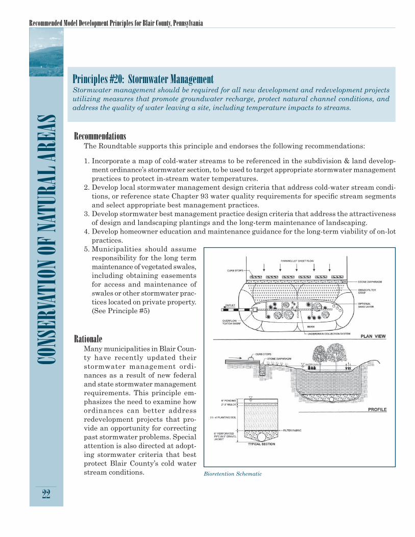
RationaleMany municipalities in Blair Coun-ty have recently updated their stormwater management ordi-nances as a result of new federal and state stormwater management requirements. This principle em-phasizes the need to examine how ordinances can better address redevelopment projects that pro-vide an opportunity for correcting past stormwater problems. Special attention is also directed at adopt-ing stormwater criteria that best protect Blair County’s cold water stream conditions. Bioretention Schematic

A Consensus of the Local Site Planning Roundtable
23
CONSERVATION OF NATURAL AREASPrinciple # 21: Wetlands ProtectionAll wetlands - including those not encompassed within a riparian buffer system – should be protected by establishing a minimum no disturbance area surrounding the wetland area.
RecommendationsThe Roundtable supports this principle and endorses the following recommendations:
1. A minimum buffer width of 25 feet will be established around wetlands, springs and seeps. The buffer will be expanded up to 100 feet around wetlands with adjacent areas containing steep slopes, and around wetlands of special concern identifi ed by local plans or Natural Heritage inventories.
2. Discourage site designers from locating isolated wetlands within individual private lots to avoid negative impacts on these wetlands from future property owners.
RationaleState and federal laws currently regulate activities that fi ll or encroach upon wetlands in Penn-sylvania. Wetlands along streams are also afforded protection through fl oodplain or stream buffer ordinances in some communities. Concern over smaller, isolated wetlands, led to the adoption of this principle that is intended to protect wetlands outside of stream systems by requiring a no-disturbance zone around isolated wetlands.
Principle #22: Steep Slope ProtectionControl the disturbance of sensitive steep slopes during the land development process in order to limit erosion and sedimentation, protect watersheds and streams from increases in sediment and pollutants, limit increases in stormwater runoff, prevent an increase in the possibility of slope fail-ures, and maintain adequate vegetative cover on hillsides.
RecommendationsThe Roundtable supports this principle and endorses the following recommendations:
1. Localities should explore restricting development on 25% and greater slopes under certain conditions – these conditions could include the extent of the slope, geotechnical conditions, and local experience with steep slope failures.
2. Develop model slope protection language for use in subdivision and zoning ordinances.3. Review and modify side slope and grading requirements associated with road cuts and house
pads to reduce the amount of grading required. Currently there is a large amount of grading into steep slope areas that is caused by the need to provide 4:1 or 3:1 side slopes on roadways. Road and ditch designs need to be revised to reduce the amount of side-slope grading necessary. A similar issue exists for clearing required for house pads and lawn areas.
RationaleSteep slopes are prevalent in Blair County, and past experiences with slope failures led to the adoption of this principle to add protection for steeply sloped areas.

Recommended Model Development Principles for Blair County, Pennsylvania
24
PLAN
PROC
ESS R
EVIE
WPlan Process Review
Principle #23: Plan Process ReviewMunicipalities should provide more opportunities for public participation in the land development process. Efforts should be made to institute a development review process that involves the com-munity early in the process so that public concerns can be addressed.
RecommendationsThe Roundtable supports this principle and endorses the following recommendations:
1. Townships/Boroughs should establish Environmental Advisory Councils (EACs) to provide input to the local offi cials and provide early public input to the plan review process.a. Local offi cials should determine a framework for establishing these councils, and how they
can be best organized in Blair County.b. To be effective, EACs should be established at a scale aligned as closely as possible to the
municipal level. The preferred order of scale is 1) Municipal level; 2) School District level; and 3) Multi-school district/County level.
c. The funding implications and advantages of establishing EACs should be explored.
RationaleAn Environmental Advisory Council is a group of three to seven community residents, appointed by local elected offi cials, that advises the local planning commission, park and recreation board and elected offi cials on the protection, conservation, management, promotion and use of natural resources within its territorial limits. Municipalities are authorized to establish EACs through Act 177 of 1996, originally Act 148 of 1973.
EAC members devote time and energy to assist elected and appointed offi cials in protecting the environment. While municipal offi cials have a high demand for their time and attention, an EAC can devote its full attention to helping offi cials make environmentally sound decisions. They can act on a municipal or multi-municipal level.
EACs are authorized to:• Identify environmental problems and rec-
ommend plans and programs to protect and improve the quality of the environ-
ment;• Make recommendations about the use of
open land;• Promote a community environmental
program;• Keep an index of all open space areas to
determine the proper use of such areas;• Review plans, conduct site visits, and pre-
pare reports for municipal offi cials; and• Advise local government agencies about
the acquisition of property.
West Hanover Township EAC plants a raingarden at a township park.
Rebecca Wertime
A Consensus of the Local Site Planning Roundtable
In December 2001, the Alliance for the Chesapeake Bay, the Center for Watershed Protection, and the National Association of Homebuilders launched a partnership known as Builders for the Bay. The primary mission of the Builders for the Bay coalition is to coalesce local builders, developers,
environmental groups, governments, and other important stakeholders in a process to review their existing codes and ordinances and begin a locality specifi c roundtable process. More information and resources related to the Builders for the Bay program can be accessed at www.buildersforthebay.net.
Founded in 1992, the Center for Watershed Protection (CWP) is a non-profi t organization that works with local, state, and federal governmental agencies, environmental consulting fi rms, watershed organizations, and the general public to provide objective and scientifi cally sound information on effective techniques to protect and restore urban watersheds. The Center for Watershed Protection also acts as a technical resource for local and state governments around the country to develop more effective urban stormwater and watershed protection programs. For more information on the Center for Watershed Protection visit www.cwp.org.
The Alliance for the Chesapeake Bay (ACB) is a regional non-profi t organization that fosters partner-ships for the restoration of the Bay and its rivers. The Alliance for the Chesapeake Bay is known as the “Voice of the Bay” for its objective, unbiased information on Bay-related issues. Since 1971, the Alliance for the Chesapeake Bay has been helping to build consensus on Bay policies; engaging volunteers in important hands-on restoration projects; educating citizens about the Chesapeake Bay watershed; and strengthening the capacity of grassroots watershed organizations. For more information on the Alliance for the Chesapeake Bay visit www.alliancechesbay.org.
The Blair County Builders Association (BCBA) is the comprehensive and authoritative source for information on building, construction and UCC implementation in Blair and Bedford counties. The Blair County Builders Association represents more than 230 members in the two-county area, including more than 100 professional builders, remodelers, plumbing, mechanical and electrical contractors. The Blair County Builders Association also offers educational programs and seminars for its members and the general public, sponsors an annual scholarship program for students in Blair and Bedford counties, fi nancially supports local charities, and supports the House Building Project of the Greater Altoona Career and Technology Center and the Blitz Build Projects of Habitat for Humanity of Blair County.
Alliance for the Chesapeake Bay
Center for Watershed Protection
Blair County Builders Associaton
ABOUT THE PARTNERS
25
Recommended Model Development Principles for Blair County, Pennsylvania
26
REFE
RENC
ES
Alliance for the Chesapeake Bay, 2005. “Forest Friendly Development: Chesapeake Bay Watershed Case Studies.” Baltimore, MD.
Arendt, R., et al. 1994. Rural by Design: A Handbook for Maintaining Small Town Character. Chicago: American Planning Association.
Bannerman, R. et al. 1993. Sources of Pollutants in Wisconsin Stormwater. Water Science Technology, 28 (3-5): 241-259.
Cappiella, K., T. Schueler, and T. Wright. 2005a. Urban Watershed Forestry Manual. Part 1: Methods for Increasing Forest Cover in a Watershed. USDA Forest Service, Newtown Square, PA.
Cappiella, K., T. Schueler, and T. Wright. 2005b. Urban Watershed Forestry Manual. Part 2: Conserving and Planting Trees at Development Sites. USDA Forest Service, Newtown Square, PA.
Cappiella, K., T. Schueler, and T. Wright. 2006. Urban Watershed Forestry Manual. Part 3: Urban Tree Planting Guide. USDA Forest Service, Newtown Square, PA.
Center for Watershed Protection (CWP), 1998. Better Site Design: A Handbook for Changing Development Rules in Your Community. Ellicott City, MD.
Heraty, M. 1992. Riparian Buffer Programs: A Guide to Developing and Implementing a Riparian Buffer Program as an Urban Stormwater Best Management Practice. Metropolitan Washington Council of Governments. Produced for U.S. EPA Offi ce of Wetlands, Oceans and Watersheds. Washington, D.C.
Institute of Transportation Engineers (ITE). 2004. Parking Generation. 3rd Ed. ITE. Washington, D.C.
Natural Lands Trust, Inc. (NLT) 1997. Growing Greener. Media, PA.
Schueler, T. R. 1995. Site Planning for Urban Stream Protection. Center for Watershed Protection. Ellicott City, MD. Prepared for the Metropolitan Washington Council of Governments. Washington D.C.
Steuer, J., W. Selbig, N. Hornewer, and J. Prey. 1997. “Sources of Contamination in an Urban Basin in Marquette, Michigan and an Analysis of Concentrations, Loads, and Data Quality.” U.S. Geological Survey, Water-Resources Investigations Report 97-4242.
Urban Land Institute. 1999. Parking Requirements for Shopping Centers., 2nd Ed.
References

Blair County, Pennsylvania

Center for WatershedProtection8390 Main Street, 2nd FloorEllicott City, MD 21043www.cwp.org
Blair County Builders Association101 Allegheny StreetHollidaysburg, PA 16648www.blairbuilders.com
Alliance for the Chesapeake Bay3310 Market Street, Suite A Camp Hill, PA 17011www.alliancechesbay.org
www.buildersforthebay.net