blanton, unc dhs coastal resilience center research
TRANSCRIPT

BLANTON, UNC DHS Coastal Resilience Center
Research Project Annual Project Performance Report
Covers reporting period January 1, 2016 – June 30, 2016
1. Project Title: A multi-tiered ADCIRC-based storm surge and wave prediction system
2. Principal Investigator / Institution: Brian Blanton, Renaissance Computing Institute, UNC-Chapel Hill
3. Other Research Participants/Partners: o Rick Luettich, Institute of Marine Sciences, UNC-Chapel Hill, co-PI o Chris Calloway, Renaissance Computing Institute, UNC-Chapel Hill, software engineer o Jason Fleming, Seahorse Coastal Consulting, ASGS developer, ADCIRC
Bootcamp organizer o Crystal Fulcher, Institute of Marine Sciences, UNC-Chapel Hill, ADCIRC grid
development o Jess Smith, Masters student, UNC-Chapel Hill, Department of Marine Sciences. (50%,
as of Aug 1, 2016)
4. Short Project Description: Decision makers need critical and helpful information delivered on time and in formats that are easily understandable. This is particularly true with dangerous and destructive natural hazards such as hurricanes and the resulting wind, storm surge, and wave impacts. Late and/or incomprehensible information is useless. This DHS CRC project is about reducing the time needed to deliver hazard information to end users by using advanced models for storm surge, very high performance computing resources, and statistical methods that can provide early guidance information in a matter of minutes as opposed to hours.
5. Abstract: We will enhance and extend a multi-tiered, ADCIRC-based storm surge and wave prediction system covering the US East Coast with highest resolution in North Carolina (NC) and southern Chesapeake Bay coastal waters. The system has two main components: (i) the ADCIRC Surge Guidance System (ASGS) that provides fully dynamic, deterministic, highly accurate ADCIRC-based storm surge and wave predictions ~1-2 hrs following the release of meteorological forecasts and (ii) ADCIRC-Lite, which utilizes a response surface method (Taflanidis et al, 2013, Rapid assessment of wave and surge risk during landfalling hurricanes: Probabilistic approach, Journal of Waterway, Port, Coastal, and Ocean Engineering, 139, 171–182.) with a pre-computed database of ADCIRC surge and wave solutions to provide rapid (e.g., within minutes) probabilistic or deterministic surge and wave predictions for hurricanes using either forecast meteorological input or end user specified storm parameters. A graphical interface will facilitate user interaction and provide an important tool for risk assessment, education and outreach.

6. End users: Dr. Joe DiRenzio, LCDR B. Sweigart, US Coast Guard, will provide essential usability feedback on project outcomes. USCG uses ADCIRC-based information routinely, but generally does not have the resources to either run the model or create derived products themselves. Instead, they rely on the products generated by ASGS and accessed through the nc-cera.renci.org website, not the ASGS output itself. They are thus perhaps our most critical end user and have previously provided essential feedback on ADCIRC products, including ADCIRC-Lite-NC. We will hold several WebEx meetings with USCG to demonstrate the project activities, particularly for ADCIRC_Lite. We will specifically request feedback as to the user interface and general functionality. We will then update the application. Tucker Mahoney, Jonathan Westcott, FEMA HQ, advisors on federal level coastal hazards and risk. Both Westcott and Mahoney are acquainted with ADCIRC, primarily from the federal NFIP perspective. Mahoney was previously in Region 4, and oversaw most of the technical aspects of the recent coastal Flood Insurance Study that RENCI conducted (with the State, Dewberry and Davis, Applied Research Associates, and US ACE). With our FEMA end users, we will be particularly interested in how they view ADCIRC_Lite as a potential outreach and education tool. Thus, being able to extend ADCIRC_Lite to more areas will be critical. We will invite FEMA to participate in the WebEx meetings to get a “multi-user” perspective on our project. Christina Lindamer, Coastal Engineer, FEMA Region 4, Atlanta, GA, is knowledgeable of ADCIRC, having previously been a coastal engineer for Dewberry and Davis. Dewberry is the prime contractor for FEMA-related activities for the State of North Carolina, and Lindamer worked extensively on the coastal extra-tropical statistical problem for the comprehensive sea level rise impacts study recently completed. See above.
Maxwell Agnew, USACE, MVN District, user of ADCIRC products for operational decision making for New Orleans area. Agnew is well acquainted with ADCIRC and ASGS, and will provide end-user critiques of product usefulness, accessibility, and confidence. Agnew typically engages with the UNC ADCIRC group during active tropical events that pose a threat to the New Orleans region. During those periods, we work extensively with him to ensure that the ASGS systems are producing needed output in a timely manner. Agnew frequently advises us as to functionality feedback, and we expect this to continue over the next Atlantic hurricane seasons, as well as interactions during the ADCIRC users group meetings. Max Agnew attended the 2016 ADCIRC Meeting and Boot Camp and is now working with ASGS and related software to develop customized capabilities for the USACE to leverage ASGS code, interface, and results. Boot Camp information was essential for Agnew to embark on this activity.
NOAA: We note that Dr. Jesse Feyen has taken a new position at NOAA and is no longer in the Coast Survey Development Laboratory. We have several possible “replacements” and will attempt to fill this void prior to the next CRC Annual Meeting. Feyen’s replacement at CSDL, Dr. Sergey Vinogradov, has expressed substantial interest in this project, ranging from ASGS

operations and the statistical prediction approach, and he has agreed to provide end-user feedback on both aspects. ADCIRC/ASGS Users: While not a specific individual, the collection of ADCIRC/ASGS users is an important end-user group, as they are the first point of transition/translation of research and applications results to the science and engineering communities. In addition to frequent concalls and impromptu gatherings at professional events, the primary organized contact is at the Annual ADCIRC Meeting and Boot Camp. Attendees to these events span from academic institutions, government agencies, and the commercial sector.
7. Explanation of Changes: The response surface method is fundamentally an interpolation method, and as such the results are very sensitive to the input data (in our case, the FEMA NC storm surge simulation database). While the statistical distributions of dynamic hurricane parameters (radius to maximum winds, central pressure, etc) are evenly sampled, the landfalling location is randomly drawn from a uniform distribution. For the intended purposes of the FEMA coastal flood insurance study, this is appropriate because, for larger storms that contribute more to low-frequency water levels (such as the 1% or 0.5% annual exceedance levels), the storms’ radii are large enough to fill in unevenness in landfall location. However, for general interpolation problems, where it is necessary to compute a weighted response from a set of “nearest” neighbors, the interpolated results can be unexpected. For example, if the nearest neighbor set contains storms whose landfall location is to the left of the storm being predicted, the resulting water level will have unphysical higher water to the left of the storm. An example of this behavior is shown in the figure to the right. The majority of the high water is to the left of the track (yellow line), which is not expected. The implications of this behavior are that it may be necessary to enforce even sampling of the landfalling location, with the set of dynamic parameters being repeated for each landfall location. While this does not eliminate the above-mentioned issue, it will mitigate it to a large extent. We are planning on computing a different dataset where all parameters are evenly sampled. This will require many more storm simulations, but we will do this on a coarse ADCIRC grid for demonstration purposes.
This behavior also implies that the Region 3 area will exhibit the same issue, but with perhaps an even larger extent because there are fewer storms (189) covering a larger coastline, with less storms making actual landfall (as opposed to bypassing the coastline). Instead of pursuing the

Region 3 activities, we will compute a better-resolved North Carolina dataset as noted above, with a coarse ADCIRC grid.
Finally, we note that this behavior may not be specific to response surfaces, or our specific implementation of Taflanidis et al. It seems likely that any interpolation method will exhibit this characteristic. It may not have been noticed in prior studies since most of those are focused on wind-wave heights on relatively narrow continental shelves (e.g., Hawaii). Waves generated in deep water naturally spread out and may mask this behavior to a large extent. We are planning to discuss this with Taflanidis and Kennedy at Notre Dame in the immediate future.
8. Unanticipated Problems:
The main challenge that has occurred is in developing a web-based interface to ADCIRC_Lite. The primary complication has been in trying to use standard web page programming to build a graphical user interface similar to what was done in MATLAB for the current desktop version. This has proved more difficult than anticipated, and we thus took a different approach. The Python community has developed a concept called notebooks which allow Python code to be easily shared. The notebooks can be put onto a stand-alone server so that users of the notebook do not need to install any software (other than a web browser). In addition, “dashboards” have become a common way of providing data analysis functionality in a web page, and the Python community has been central in developing the dashboard mechanics. So, we ported (into Python) the parts of ADCIRC_Lite that evaluate storm surge given a set of hurricane parameters and used the notebook, dashboard, and dashboard widgets to put ADCIRC_Lite on a webpage. See below for the webpage dashboard for ADCIRC_Lite.
9. Project Outcomes:
• The new ADCIRC grid that extends the current coastal North Carolina coverage into the lower Chesapeake Bay is progressing. The lower Chesapeake Bay area in the FEMA Region 3 ADCIRC grid has been extracted and inserted into the North Carolina grid. This is shown in the figure to the right, where the grid part in the red polygon is from the Region 3 grid. Grid nodes above the 5 m elevation (land) have also been eliminated to reduce the overall gridsize. It is important to keep the grid at or below about 750K nodes so as not to impact computation time for forecasts. Currently, we are smoothing out the transition between the different resolutions. We anticipate beginning tests on this new grid in mid-October 2016.

• We have also made progress on a hurricane track generator that uses the NHC’s published forecast error database. An example of the track generator output is shown in the next figure. This shows NHC Forecast Advisory #23 for Hurricane Isabel (2003) and 729 probabilistic tracks (gray). The red polygon is the NHC’s forecast probability cone, which contains 67% of the probabilistic tracks. The green line is the best-track (observed) for Isabel, for reference.
• The web-based interface to ADCIRC_Lite has finally reached a state where it is available in “beta” mode. The webpage is shown in the figure below. The webpage can be found at: https://bluheron.europa.renci.org:9999/notebooks/RSM-ipympl-basemap.ipynb?dashboard. This requires a password (“stormsurge”).
• The 2016 ADCIRC Annual Meeting and Boot Camp events were co-organized with Chris Massey and Mary Cialone at the host site, the US Army Engineer Research and Development Center (ERDC) Coastal and Hydraulics Lab (CHL) in Vicksburg, Mississippi. They were held 5-6 May and 2-4 May 2016, respectively. The Boot Camp included sessions on grid development with SMS, ADCIRC setup, simulations, and diagnostics, and deploying the ASGS for forecasting applications. In attendance were:
o 50+ in-person and 7 virtual via webinar o 8 students attended the ADCIRC Boot Camp, with the following organizational
affiliations:

§ North Carolina State University x2 § University of Central Florida § Kunsan University (Korea) x4 § RPS Group
o 9 professionals attended the ADCIRC Boot Camp, with the following organizational affiliations:
§ Stantec x3 § Taylor Engineering § Woods Hole Group § Florida Department of Environmental Protection § Applied Technology & Management § Ransom Environmental § USACE ERDC CHL
• Several storm events occurred in this period. Most notably, historic flooding of the Sabine
River in Louisiana and the flooding of the Pearl River in Mississippi occurred as a result of high rainfall in the mid-US. We we were contacted by Derek Giardino (Senior Hydrologist at the West Gulf River Forecast Center, [email protected]) with the following request:
“As this flood approaches the Gulf in East Texas, its [sic] getting out of our domain. As well as significant impacts happening in Orange Texas that have no real modeling available and really should be performed by a coastal model. Is [sic]there any thoughts or plans or possibly any completed runs that can be performed in ADCIRC?”
We were able to provide guidance information from ASGS running on the Gulf of Mexico to “unanticipated” end-users.
• During the reporting period, we provided transition support to Yuji Funakoshi, Ph.D. in the NOAA Coast Survey Development Laboratory (CSDL). The CSDL has developed a Hurricane Surge On-demand Forecast System (HSOFS) using ADCIRC and the ASGS running on the National Centers for Environmental Prediction (NCEP) Central Operations (NCO) Weather and Climate Operational Supercomputing System (WCOSS). We were able to provide provenance information for the code in the ASGS to facilitate technical support within the NCEP Central Operations, and we will continue to support the transition of our technology into operations.
• Professionals with other NOAA offices have also sought collaboration with our efforts, including Greg Dusek, Ph.D., Senior Scientist with NOAA/National Ocean Service, Center for Operational Oceanographic Products and Services. He is specifically interested in including the effect of sea level anomaly in forecast products:
“If you are looking for any further collaboration on this for the observational side of things, definitely let us know. And regardless, will be interested to hearing more about how your assimilation approach comes together, so stay in touch. “

We are addressing the incorporation of sea level anomaly using a new ADCIRC nodal attribute that will be transitioned into practice with the next major version release of ADCIRC.
10. Research Activity and Milestone Progress:
Research Activities and Milestones: Progress to Date
Reporting Period 1/1/2016 – 6/30/2016
Research Activity Proposed Completion
Date
% Complete
Explanation of why activity / milestone was not reached, and when completion is expected
Develop ADCIRC grid for NC and lower Chesapeake Bay by merging existing NC grid with portions of the existing FEMA Region III grid
03/30/2016 50 The two grids being worked with (the FEMA grids for Region 3 and NC) are large, and it is requiring a bit more attention than expected. However, we expect a testable grid by the end of September 2016.
Test early grids with historical storms and in the ASGS
05/31/2016 0 A draft grid is not yet ready for testing. We expect a testable grid by the end of September 2016 and ASGS testing in mid-October 2016.
Review existing literature on probabilistic hurricane track generation
05/31/2016 50 We have compiled a list of relevant publications on statistical models for hurricane tracks. A literature review document will be ready in mid November 2016.
Continue operation of ASGS at RENCI Ongoing 100 RENCI continues to support the ASGS by providing computational resources to ASGS.
Research Milestone
Presentation on project’s ASGS activities to ADCIRC Annual Meeting
May 5-6 2016
100 Jason Fleming gave an overview on ASGS to attendees at the ADCIRC Annual Meeting held U.S. Army Corps of Engineer’s Coastal and Hydraulics Laboratory in Vicksburg, Mississippi. Please see Project Outcomes for more details.
Status report on ASGS system upgrades and initial tests with new grid
05/31/2016 25 We have not yet started testing the new ADCIRC grid. The grid is still under development. We expect to start testing in mid-October 2016.
Draft ADCIRC grid for NC and lower Chesapeake Bay
05/31/2016 50 The grid is still under development. We expect to start testing in mid-October 2016.
Literature review of current track generation methods and implementation plan for project’s ensemble generator
06/15/2016 50 The literature review is part of track generator activities, being done concurrently with other CRC project activities. The track generator itself is about 90% complete.
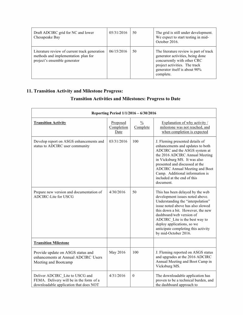
11. Transition Activity and Milestone Progress: Transition Activities and Milestones: Progress to Date
Reporting Period 1/1/2016 – 6/30/2016
Transition Activity Proposed Completion
Date
% Complete
Explanation of why activity / milestone was not reached, and when completion is expected
Develop report on ASGS enhancements and status to ADCIRC user community
03/31/2016 100 J. Fleming presented details of enhancements and updates to both ADCIRC and the ASGS system at the 2016 ADCIRC Annual Meeting in Vicksburg MS. It was also presented and discussed at the ADCIRC Annual Meeting and Boot Camp. Additional information is included at the end of this document.
Prepare new version and documentation of ADCIRC-Lite for USCG
4/30/2016 50 This has been delayed by the web development issues noted above. Understanding the “interpolation” issue noted above has also slowed this down a bit. However, the new dashboard/web version of ADCIRC_Lite is the best way to deploy applications, so we anticipate completing this activity by mid-October 2016.
Transition Milestone
Provide update on ASGS status and enhancements at Annual ADCIRC Users Meeting and Bootcamp
May 2016 100 J. Fleming reported on ASGS status and upgrades at the 2016 ADCIRC Annual Meeting and Boot Camp in Vicksburg MS.
Deliver ADCIRC_Lite to USCG and FEMA. Delivery will be in the form of a downloadable application that does NOT
4/31/2016 0 The downloadable application has proven to be a technical burden, and the dashboard approach to

require a MATLAB license. deployment is substantially simpler. Since we have recently worked out the latter, we anticipate completing this milestone by mid-October 2016.
Host a WebEx to demonstrate ADCIRC_Lite operations and features
5/31/2016 0 We will host this WebEx in mid-November 2016.
12. Interactions with education projects:
While not a CRC education project interaction, we note the following. During the 2016 summer, the CRC hosted Anton Bezugloz (Associate Professor of Computer Science) and Reinaldo Santiago (rising senior in Computer Engineering) from Benedict College in Columbia South Carolina. This was through the DHS Summer Research Team for Minority Serving Institutions (SRT MSI). Bezuglov and Santiago were in residence at RENCI, where they developed an artificial neural network that uses hurricane parameters and storm surge responses from our FEMA North Carolina coastal flood insurance study to simulate storm surges at coastal locations. The network is an accurate and fast method and is a strong complement to ongoing CRC-funded research at RENCI on response surface methods for storm surge prediction. A manuscript describing the research and results is in preparation for submission to the Journal of Expert Systems and Applications.
This summer research has led to a recently submitted follow-on proposal to the DHS SRT MSI program, where different neural network methods will be developed and applied to the same prediction problem. If funded, this research will occur at Benedict College under the direction of Prof. Bezuglov with support from the CRC through RENCI’s computing resources.
13. Publications:
None.
DHS SRT researchers in residence at RENCI, a collaborator with the CRC. Mr. R. Santiago (left) and Prof. A. Bezuglov (Right).

14. CRC Performance Metrics:
CRC Performance Metrics Metric Research
Project Education
Project Center
Courses/certificates developed, taught, and/or modified
See Table
Enrollments in Center-supported courses/certificates HS-related internships (number) 0 Undergraduates provided tuition/fee support (number) 0 Undergraduate students provided stipends (number) 0 Graduate students provided tuition/fee support (number) 0 Graduate students provided stipends (number) 0 Undergraduates who received HS-related degrees (number) 0 Graduate students who received HS-related degrees (number) 0 Certificates awarded (number) Graduates who obtained HS-related employment (number) 0 SUMREX program students hosted (number) 0 Lectures/presentations/seminars at Center partners (number) 1 DHS MSI Summer Research Teams hosted (number) 1 Journal articles submitted (number) 0 Journal articles published (number) 0 Conference presentations made (number) 2 Other presentations, interviews, etc. (number) 0 Patent applications filed (number) 0 Patents awarded (number) 0 Trademarks/copyrights filed (number) 0 Requests for assistance/advice from DHS agencies (number) 0 Requests for assistance/advice from other Federal agencies or state/local governments (number)
0 Total milestones for reporting period (number) 7
Accomplished fully (number) 2 Accomplished partially (number) 3
Not accomplished (number) 2 Product/s delivered to end-user/s (description and recipients) See Table External funding received
See Table Leveraged support Articles on Center-related work published on website (number) Coverage in media, blogs (number) Social media followers (number) Posts to social media accounts (number) Events hosted (number) Website hits (number)

Table for Documenting CRC Research Project Product Delivery
Product Name Product Type Approx. Delivery Date
Recipient or Anticipated End Users ADCIRC_Lite-NC Webpage/dashboard November 2016 USCG, FEMA
Table for Documenting External Funding and Leveraged Support
External Funding Title PI Total Amount Source
N/A Leveraged Support
Description Estimated Annual Value RENCI Computing Resources for ASGS 30,000

120
Multi-tiered ADCIRC-based Storm Surge and Wave Prediction System Seahorse Coastal Consulting, LLC Detailed Reporting Period Activities.
Introduction Continuous delivery of model guidance from the multi-tiered ADCIRC-based storm surge and wave prediction system provides key authorities and decision makers with actionable information on coastal hazards on a daily basis. The U.S. Coast Guard as well as NOAA offices including local Weather Forecast Offices (WFOs) and River Forecast Centers (RFCs) use these results routinely, and have expressed a strong interest in expanded capabilities. This report describes progress and achievements that were delivered during this reporting period. Capability In previous years, the North Carolina v6c ADCIRC mesh has been used to produce real time storm surge guidance. However, a newer mesh for North Carolina has been developed (the v9.99 mesh) and used in offline risk and design studies. After an extended period of experimentation, we used the ASGS to redeploy the NC v9.99 mesh on the Hatteras HPC machine at RENCI. Our technology roadmap includes a full transition to the higher resolution mesh in time for hurricane season 2016. The improved capabilities of this new mesh are illustrated in the figures below.
Figure 1: The new NCv9.99 ADCIRC mesh (on the right) extends farther north, into the lower Chesapeake, and includes higher resolution, particularly in the southern half of the North Carolina coast.

Figure 2: The NCv9.99 ADCIRC mesh (on the right) represents a significant improvement in the accuracy of representation in the upper Cape Fear River as well as the intracoastal waterway in the southern half of the North Carolina coast, in comparison with the older NCv6c mesh on the left.
Figure 3: The new NCv9.99 ADCIRC mesh substantially improves the resolution and accuracy of the Oregon Inlet representation. Oregon Inlet is a key maritime connection between Pamlico Sound and the Atlantic Ocean, and is the site of the Oregon Inlet Coast Guard station as well as the Bonner Bridge, a high volume and at-risk link in the coastal transportation infrastructure.

Figure 4: The functional representation of the dune line has improved in the new mesh, allowing it to represent the storm surge inundation reduction performed by coastal dunes more accurately. Transition Transition activities in the reporting period include (1) the continuous presentation of the latest high resolution results to end users via the Coastal Emergency Risks Assessment (CERA) application; (2) organization, preparation, and execution for the 2016 ADCIRC Boot Camp; and (3) support for transitioning ASGS technologies into the Hurricane Surge On-demand Forecast System (HSOFS) at NOAA. High Resolution Results The new high resolution results produced by the ASGS at RENCI are being provided to decision makers continuously via the Coastal Emergency Risks Assessment web application as shown in the following figures. In addition to improved accuracy, the higher mesh resolution resolves some visual artifacts that may have been confusing for emergency managers that use the web application to make decisions.

Figure 6: The transition of the results on the high resolution v9.99 ADCIRC mesh to decision makers and emergency managers is being achieved via the Coastal Emergency Risks Assessment (CERA) site.
Figure 7: The bathymetric representation of the lower resolution mesh was causing visual artifacts in the presentation web site. This example shows what looks like a false inlet Near Indian Beach on Bogue Banks.

Figure 8: The improved bathymetric representation of the higher resolution v9.99 ADCIRC mesh provides correct visual representation to decision makers when presented with the CERA web application. ADCIRC Boot Camp The annual ADCIRC Boot Camp event is a key vector supporting the transition of research results to the science and engineering communities of practice. Over the course of the 2016 reporting period, we developed the registration website for the 2016 ADCIRC Boot Camp, a portion of which is shown in the following figure. The ADCIRC Boot Camp event is used to provide training for the ADCIRC model including the latest features produced by the research community. It also provides an opportunity to transition the tech- nologies of the ASGS to public, private, and university scientists and engineers. During the reporting period we co-organized the event in collaboration with Chris Massey and Mary Cialone at the host site, the US Army Engineer Research and Development Center (ERDC) Coastal and Hydraulics Lab (CHL) in Vicksburg, Mississippi.

Figure 9: The ADCIRC Boot Camp Registration site for 2016 provides visibility for training activities as well as practical support for managing the event and its participants. Continuity of Operations In this reporting period, four service outages and two instances of solution degradation occurred with the NCFS which required attention, determination of root cause, and corresponding correction in order to maintain continuity of operations. Three examples of these outages, their root causes, and the corresponding corrective action that we took to resolve them are described below:
1. During a severe coastal storm event, on 8 February, Rick Luettich reported good accuracy along the coast but expressed concern about predictions further inland along the Neuse River. We determined that the root cause was an outage of the Local Data Manager (LDM) server at RENCI. This server downloads real time river flow prediction data from our partners at the NOAA National Severe Storms Lab (NSSL). I restarted the LDM server and the acquisition of boundary condition data for rivers from our collaborators resumed successfully.
2. On 23 February, all the computational jobs submitted by the NCFS suddenly started to fail. During the root cause analysis, it was found that these jobs were executing much more

slowly than usual, and were not able to complete within the 5 hour wall clock time window as expected (typical run times are less than one hour). There were no error messages present, and the numerical results up to the point where the jobs were killed by the queueing system all appeared stable. We notified the sysadmins on Hatteras and were informed that the issue was likely a result of a system change made in the resource allocation on Hatteras, and we were advised to modify the configuration of the queue scripts produced by the NCFS on Hatteras. We did so and the issue was resolved.
3. On 29 February, it was found that the NCFS was running as expected, but was not able to produce results because it had exhausted its disk storage quota. The RENCI systems administrators increased our quota enough for the NCFS to resume production and suggested that we reduce our use of disk storage. We complied, finding and deleting old model results that appeared to no longer be of interest. However, we were contacted by our collaborators at NC State (Casey Dietrich) about restoration of a range of files that were the subject of current re- search. We started a restoration operation for the deleted files in cooperation with RENCI systems administrators and our collaborators, and quantified future storage needs and requested automated mechanisms for anticipating and avoiding outages resulting from exhausted disk storage quotas in the future.