boone county area comprehensive plan
TRANSCRIPT

BOONE COUNTY AREA COMPREHENSIVE PLAN
Adopted by:
Boone County Area Plan Commission - January 23, 2009
Boone County Commissioners - May 7, 2009
Town Council of Whitestown - TBD
Town Council of Advance - June 8, 2009


i
BOONE COUNTY AREA COMPREHENSIVE PLAN TABLE OF CONTENTS
INTRODUCTION 1
VISION 9
GOALS, OBJECTIVES, AND ACTION PLANS 11
LAND-USE PLAN 103
PUBLIC PARTICIPATION 125
PLANNING PROCESS 139
COMMUNITY PROFILE 143


INTRODUCTION

2
BOONE COUNTY AREA COMPREHENSIVE PLAN
ACKNOWLEDGEMENTS
BOONE COUNTY COMMISSIONERSHuck LewisCharles EatonMarc Applegate
BOONE COUNTY AREA PLAN COMMISSIONERSKevin Schiferl - President Doug Akers Quella Rutledge John PughKen Hedge L.J. JernstadtStephen Schanke
BOONE COUNTY AREA PLAN COMMISSION STAFFSteven Niblick - Executive Director Bob Clutter - AttorneyRachel Whittington - Planner John Hudson - Building InspectorCarla Hedrick - Administrative Assistant Mike Thomas - Building Inspector
BOONE COUNTY BOARD OF ZONING AND APPEALSKevin SchiferlQuella RutledgeJune NickelsJim CarterMike Hancock
BOONE COUNTY ECONOMIC DEVELOPMENT CORPORATION BOARDJim Edwards - President Mike KincaidMichael Latz Kerry KriesRick Isenhower Phil LudlowBrian Goldthorp Michael MartinCraig Anderson Andrea MontgomeryMarc Applegate Scott RobisonMichelle Barrett Bob TaylorClyde Bodkin Joe ThomasBill Conley Jill TrohaEric Estes Todd VannattaKent Frandsen Jeff Welty
BOONE COUNTY ECONOMIC DEVELOPMENT CORPORATION STAFFKristie McKillip - Executive DirectorTina Staley - Administrative AssistantSTEERING COMMITTEE

3
INTRODUCTION
Sharon Adams - Health Department Craig Anderson - Duke Realty Jim Edwards - Economic Development Corporation Board Kent Frandsen - Economic Development Corporation Board Bob Guernsey - Agriculture Industry Carla Hedrick - Area Plan Commission Staff Terry Jones - Zionsville Planner Hope Kamalabad - Chamber of Commerce Don Lawson - Agriculture Industry Huck Lewis - County Commissioner Kristie McKillip - Economic Development Corporation Andi Montgomery - Indianapolis Executive AirportSteven Niblick - Area Plan Commission Staff Steve Pittman - Pittman PartnersJohn Pugh - Area Plan CommissionDick Robertson - CitizenQuella Rutledge - Area Plan CommissionerTina Staley - Economic Development Corporation Staff Jason Tribby - CitizenRachel Whittington - Area Plan Commission Staff Marcia Wilhoite - County CouncilBob Clutter - Attorney
PROJECT TEAMShane Burkhardt, AICP - American Structurepoint, Inc.K.K. Gerhart-Fritz, AICP - The Planning WorkshopMegan Coler - American Structurepoint, Inc.

4
BOONE COUNTY AREA COMPREHENSIVE PLAN
FOCUS GROUP MEMBERS
Agribusiness Industry ProfessionalsTom Lingafelter
Area Group: Center and NortheastAudra PoeJeff TribbettAllen MilburnBob WaplesJim StevensonTed CaldwellHuck Lewis
Area Group: Perry and Worth TownshipsRick ElsburyLarry BrennerMike HancockL. J. JernstadtMichelle FieldsKevin Russell
Area Group: Southeast Boone CountySusan AustinEric HandDan BrackemyreEd MitroRob GuestTom LingafelterMatt Price
Area Group: Union Township and Greater Zionsville
Kathi PostlethwaitStan HulaCraig VonDeylenSteve MuellerAl WopshallDan DiagostiniJoseph TurkCandace UlmerStacy DeHartCharles AndersonDonna Burgard
Area Group: Western BooneKaren NiemeyerJudi HendrixWayne HenryJim CaldwellKirt AdamsJoe Thomas
Bio-Technology Industry ProfessionalsMike BrooksBrian Stemme
Developers, Builders, and Development Industry Professionals
Michael JansonTom TheobaldAndy PritchardMark SandersSteve PittmanCraig AndersonMark Ransom
Development Attorneys, Land Use, and Regulatory Professionals
Michael AndreoliKent Frandsen
Environmental, Tourism, and Historic PreservationJohn UlmerDavid Cook
Existing BusinessClyde BodkinDan MontgomerySteve SniderBob Harris
Realtors and Real Estate Industry ProfessionalsJim RodgersAndrew GutweirPhil LudlowChris Pryor
Recreation and ParksRichard Stroup
TransportationLance LantzTom KounsMark Albers
Workforce Development EducationJerry CoddingtonPam TaylorGary LanpherChris WillisJim EggersKerry Dull
YouthTeale RutledgeElizabeth MercerJohn PadgettFrank NolandSamuel DittmerBen WrightAndy DardiniMatt SandersJennife YuKevin McCarthyDevney HamiltonValerie Kenneson

INTRODUCTION
5
TASKFORCE GROUP MEMBERS
Parks and RecreationSharon AdamsRachel WhittingtonMissi BrookeTom RhoadesSusan SieversTerri SelmierMarc ApplegateRichard StroupSusan AustinKristi Tidwell
EnvironmentalSharon AdamsRachel WhittingtonDavid LammBrian BojeRita BojeBill HoustonJohn UlmerJohn BushJay TranbargerSherry MillerFred PrazeauRandy SmileyJim Barnes
InfrastructureKristi McKillipAndi MontgomeryJay AlleyRob GuestEric HandBob HarrisTom KounsMike MartinSteve MuellerDan MontgomeryCraig AndersonMike LatzAndy PritchardRichard StroupMatt PriceEd MitroTerry JonesJoe RascheDan BrackemeyerJudi EssexCandace UlmerTom MelindGreg TurnerWayne Henry
Economic DevelopmentKristi McKillipAndi MontgomeryAudra PoeAllen MilburnMark PlassmanMichelle BarrettDick RobertsonJohn LasleyMark RansomTom LingafelterPhil LudlowHope KamalabadCarol MarquissSteve JacobRay InghamJudi HendrixRobert TaylorScott RobisonSusan AustinMichael BurtronTony CarrellBuddy DownsKatie CulpGerry CumminsJeff WeltyLinda IsenhowerDawn SemmlerBrian StemmeTina Staley
Growth and CharacterCarla HedrickSteve NiblickQuella RutledgeRachel WhittingtonDoug AkersKen HedgeJohn PughStephen SchankeLJ JernstadtKevin SchiferlBob ClutterMike HancockJim CarterJune NickelsScott AlexanderMatt JacksonKevin Russell
GovernmentKent FrandsenJohn LasleyDick RobertsonMatt PriceJoe ThomasCandace UlmerMarc ApplegateSteve JacobPat McPeakJason TribbyRob GuestTerry Jones
TransportationCarla HedrickHuck LewisSteve PittmanTom KounsMarcia WilhoiteLeeAnn NashJohn LasleyLarry LeeDawn SemmlerLance LantzScott Burress
ResidentialSteve PittmanHuck LewisMark PlassmanScott BowersTim WaltersEric PingJim RodgersHeidi WolfeTodd CarlileZac ChapmanWayne Follstad
Craig VonDeylenAgriculture
Carla HedrickGreg SlipherJim EdwardsDon WeberDan HineChris BranamanRon MerrillBob GuernseyTom DullGary ArtmanDonnie LawsonKen HedgeRichard WeberMyron CragunJim Michalke JrKim DemareeGeorge MortonDoug AkersDave ChanceAlan WilhoiteGerry MennenJoe SlipherDanny LawsonAllen Mohler

6
BOONE COUNTY AREA COMPREHENSIVE PLAN
PURPOSE OF COMPREHENSIVE PLAN
The Comprehensive Plan is a legal document that serves as a decision-making guide for both offi cials and citizens and is intended to serve as a tool for making decisions about the promotion of public health, safety, morals, convenience, order, or the general welfare and for the sake of effi ciency and economy in the process of development. Comprehensive Plans are defi ned by state statute IC36-7-4-500 series, which outlines the intent and details of the necessary content for all plans.
Boone County’s Comprehensive Plan is intended to serve as a guide for future growth and development in unincorporated areas of Boone County, Whitestown, and Advance over the next 20 years. Incorporated areas, not under the jurisdiction of the Area Plan Commission (Zionsville, Lebanon, Thorntown, and Jamestown) are in charge of planning for their com-munities, but are strongly encouraged to use this County Comprehensive Plan as a guiding tool to help assure contiguous planning occurs throughout the County. This plan has been initiated to address the issues of growth, land use, economy, culture, and technology. Citizens want Boone County to continue to be a unique place with rural character and a diverse economic base. Through this plan, county residents have sought to identify and enhance the various characteristics that make Boone County a special place.
Planning is a continuous process that had been initiated prior to this plan and will continue after its publication. The last comprehensive plan for Boone County was created in 1998. Since then, the county has experienced several changes, demanding a new vision for the County to readdress existing factors and to plan for future issues that will infl uence growth and development throughout the county. Through a joint planning process between the Area Plan Commission and the Boone County Economic Development Corporation, this new Comprehensive Plan is the result of a detailed process that brought county residents together to identify existing conditions throughout Boone County, analyze relationships, recog-nize trends, and ultimately create recommendations. This plan is clearly a refl ection of the needs and desires of today’s resident population. The Comprehensive Plan is based on information obtained primarily through public participation and input. Public work-shops along with Focus Group meetings were held throughout the county during the development of the plan. The input generated by these meetings, along with a county-wide Steering Committee, helped form a basis for the recommenda-tions in this plan. The full public participation process is explained in depth in Chapter 5: Public Participation.

INTRODUCTION
7


VISION
10
BOONE COUNTY AREA COMPREHENSIVE PLAN
WHAT IS A VISION?
A vision is a statement that refl ects local potential and makes a commitment to future action. A vision generally describes what the community wants to be. The vision statement is a clear, succinct, and purposeful statement that everyone generally agrees with and is easily understood to help defi ne the direction in which the plan should proceed.
At the second round of public meetings in October 2007, citizens were asked what they value about Boone County and what they would like to see improved in the future. Areas such as social and economic well being, physical character, growth standards, and employment were considered. The Steering Committee refi ned the elements of the vision that were created during the public workshops. The actual vision statement then began to take shape. By the end of April 2008, the Steering Committee had reached a consensus on the fi nal Vision Statement.
BOONE COUNTY VISION STATEMENTVision IntroductionComprehensive planning eff orts, at best, represent the desires and needs of a community. These values can be developed in a vision statement. In order for communities to succeed, they must have a vision for the future. The feeling of “community” evident in most successful counties exists in part because of a defi ned vision. Such a community vision helps create the sense among citizens they are in control of their future.
A comprehensive plan sets forth the guidelines for achieving the community’s vision. The plan includes goals, policies, and implementation strategies to support and promote the vision. Adherence to a plan is much more likely to allow a community to realize its vision than are random undirected decisions. The broad goals and policies that drive a plan must be determined by the community and should refl ect the values and vision of its residents. Most plans are built upon concepts that are basic components of the vision. These components address issues, such as land use, economic development, public facilities and infrastructure, and environmental protection.
In the process of reviewing and revising the County’s comprehensive plan, several community visioning exercises were held through a public participation process. The vision described here relies on input from those forums, as well as input from the Steering Committee.
Vision StatementBased on this citizen input, the following narrative vision of the future community has been prepared for review by the Area Plan Commission.
“The vision of Boone County, Indiana, is to provide a high quality of life for a diverse community, respecting the historically strong farming and rural communities, while encouraging trail systems, commerce, and attracting innovative industries that create sustainable job growth, and that also supports all families and businesses of all sizes, with a strong foundation of responsive County government to ensure eff ective services for all residents.”
GOALS, OBJECTIVES, AND ACTION PLANS
12
BOONE COUNTY AREA COMPREHENSIVE PLAN
GOALS, OBJECTIVES, AND ACTION PLANSThe purpose of this chapter is to establish the goals, objectives, and action steps that will guide future growth and development in a manner that will refl ect the county’s unique character. In developing the goals and objectives, it is important to analyze demographics, housing, economic conditions, services and facilities, cultural and natural resources, and existing land use. Preceding chapters of this comprehensive plan have documented the above characteristics.
An equally important step in developing goals is public input. From all the information gathered throughout the public workshops and focus group interviews, basic goals and objectives were derived to address issues in nine broad categories, including parks and recreation, environment, government, transportation, infrastructure, growth and character, agriculture, economic development, and residential. Nine Task Force Groups were formed under each of these categories to brainstorm and propose action plans necessary to carry out each objective. The action plans created by each Task Force Group were then reviewed and modifi ed by the Steering Committee to generate a fi nal list of action plans that would help to achieve the goals of the plan.
WHAT ARE GOALS, OBJECTIVES, AND ACTION PLANS?The Comprehensive Plan is based upon goals and objectives. Each has a distinctive meaning and purpose in the planning process. Together, goals and objectives serve as the basis for development decisions. They are implemented by legislative and policy actions throughout the county, such as zoning ordinances, design regulations, capital improvement programs, and building code enforcement.
Goals are concise statements that describe in general terms, a desired future condition that further defi nes the vision statement. They are the future of the plan and address those things the County wants to accomplish over the life of the plan. Goals also form the framework for more detailed decision making and are used by the County to establish priorities for public and private discussion and consideration, as well as to identify needed public improvements and services.
Objectives are statements that describe a specifi c, measurable, future condition to be attained during a stated period of time and, ultimately, the course of action required to achieve a stated goal. Furthermore, objectives are tasks that recommend how a goal will be accomplished. Objectives are statements of community intent against which individual actions and decisions are evaluated. Objectives should be suffi ciently quantifi able to gauge the appropriateness of development applications, have a general time frame, and be understood by both the decision-makers and the general community.
Once the goals and objectives are established, the Action Steps necessary to achieve the objective are determined. An Action Step is an organized activity to accomplish an objective. Responsible Parties for each of the action steps are then formulated. And fi nally, the Completion Date is identifi ed so the Action Steps and Objectives can be prioritized. The following describe the time frames in which Action Steps should be completed.
• Immediate – Action Steps that must be taken immediately after the plan is adopted• Short – Action Steps that should be taken within approximately one to three years of adopting the plan• Medium – Action Steps that should be taken between three to seven years after the adoption of the plan• Long – Action Steps that would most likely be taken more than seven years after the plan is adopted• Ongoing – Action Steps that should be taken immediately and continually after the plan is adopted
GOALS, OBJECTIVES, AND ACTION PLANS FOR BOONE COUNTYTwenty-seven goals have been developed for Boone County that are intended to enhance existing communities and maintain the level of services to which the current residents have become accustomed.

GOALS, OBJECTIVES, AND ACTION PLANS
13
1. Increase the opportunities for passive and active recreation for residents and visitors, which continually promotes the culture of a healthy and active lifestyle for all Boone County residents
2. Promote recreation connectivity and accessibility between neighborhoods and towns3. Promote local policies and practices that protect WATER through the use of best management practices to ensure
sustainable long-term use4. Promote local policies and practices that protect AIR through the use of best management practices to ensure
sustainable long-term use5. Promote local policies and practices that protect LAND through the use of best management practices to ensure
sustainable long-term use6. Promote local policies and practices in regards to SOLID WASTE through the use of best management practices to
ensure sustainable long-term use7. Improve inter- and intra-governmental communications and cooperation, while respecting diverse interests and
objectives of each government and community8. Develop a customer-oriented government culture that values creativity, fl exibility, and responsiveness9. Improve leadership and the eff ectiveness of government agencies through investment in education and training10. Review the Comprehensive Plan regularly11. Encourage proactive local government12. Promote the development of a transportation system to ensure the most effi cient and safe movement of people and
goods13. Employ best management practices to minimize negative short- and long-term impacts of development14. Encourage the expansion of existing infrastructure to targeted growth areas through coordination between utility
providers, municipalities, and the County15. Create development standards to defi ne growth character appropriate to the culture and heritage unique to the
area within the county it occurs16. Identify target growth areas that take into account environmental sensitivity, agriculture conservation, and existing
infrastructure availability17. Growth standards shall refl ect a cohesive and unique character that emphasizes a connection between creating a
rural and small town sense of place and the convenience between places to live, work, and play18. Recognize agriculture as productive landscape and preserve these uses for the production of food, fi ber, and fuel19. Preserve the viability, productivity, character, and quality of Boone County's agricultural and water resources20. Conserve farmland and agriculture with zoning standards that protect, promote, and grow agriculture within Boone
County21. Limit land-use confl icts22. Improve appearance of residential subdivisions23. Improve appearance of individual homes and dwellings24. Encourage mixed-use development and the fl exibility to create traditional neighborhood developments (TND)25. Encourage a variety of housing types26. Recognize there is not a "one size fi ts all" housing solution for the county (diff erent areas have diff erent needs and
expectations)27. Support green development and environmentally responsible residential development and housing

14
BOONE COUNTY AREA COMPREHENSIVE PLAN
Action StepsCompletion Time Frame
Immediate Short Medium Long Ongoing1. Identify urban and recreational development areas Responsible Party: Boone County Area Plan Commissioners, Transportation Taskforce X
2. Develop a County Parks/Trail Task Force Responsible Party: Boone County Parks Board,
Boone County Commissioners, Highway Department, Utility Companies, Trails Groups
X
3. Research funding for trails/bicycle pathway development
Responsible Party: Transportation TaskforceX
4. Encourage zoning ordinance regulations to allow for right-of-ways of the trail systems
Responsible Party: Boone County Area Plan Commissioners
X
5. Place strong emphasis on creating existing and future trail maps
Responsible Party: Boone County Area Plan Commissioners, Boone County Area Plan Commission Staff , Boone County Commissioners, Boone County Board Representative
X
6. Provide a clear and consistent understanding of trail requirements to developers
Responsible Party: Boone County Area Plan Commissioners, Planning staff , Boone County Commissioners
X
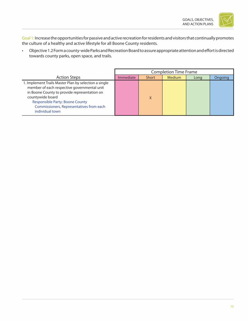
Goal 1: Increase the opportunities for passive and active recreation for residents and visitors that continually promotes the culture of a healthy and active lifestyle for all Boone County residents.
• Objective 1.1 Develop a Trails Master Plan in order to create, build, and promote a diverse network of trails that connects homes, schools, parks, and residential communities in Boone County.
GOALS, OBJECTIVES, AND ACTION PLANS
15
Action StepsCompletion Time Frame
Immediate Short Medium Long Ongoing1. Implement Trails Master Plan by selection a single
member of each respective governmental unit in Boone County to provide representation on countywide board
Responsible Party: Boone County Commissioners, Representatives from each individual town
X
Goal 1: Increase the opportunities for passive and active recreation for residents and visitors that continually promotes the culture of a healthy and active lifestyle for all Boone County residents.
• Objective 1.2 Form a county-wide Parks and Recreation Board to assure appropriate attention and eff ort is directed towards county parks, open space, and trails.

16
BOONE COUNTY AREA COMPREHENSIVE PLAN
Action StepsCompletion Time Frame
Immediate Short Medium Long Ongoing1. Research appropriate construction and design
standards which are necessary to create eff ective, safe and durable trails
Responsible Party: Boone County Area Plan Commissioners, Boone County Area Plan Commission Staff , Boone County Commissioners
X
2. Work with the formation of the Trails Master Plan document to incorporate necessary standards into the Trails Master Plan
Responsible Party: Boone County Area Plan Commissioners, Boone County Parks Board
X
3. Adopt construction and design standards language into zoning and subdivision control ordinances
Responsible Party: Boone County Area Plan Commissioners, Boone County Commissioners
X
Goal 1: Increase the opportunities for passive and active recreation for residents and visitors that continually promotes the culture of a healthy and active lifestyle for all Boone County residents.
• Objective 1.3 Incorporate trail construction and minimum design standards into the Ordinance to help create a county wide trail network.

GOALS, OBJECTIVES, AND ACTION PLANS
17
Action StepsCompletion Time Frame
Immediate Short Medium Long Ongoing1. Research appropriate open space design standards
language in example ordinances Responsible Party: Boone County Area
Plan Commissioners, Boone County Area Plan Commission Staff , Boone County Commissioners
X
2. Amend Zoning and Subdivision Control ordinances to refl ect the desired language to require certain open space design standards
Responsible Party: Boone County Area Plan Commissioners
X
3. Adopt Open Space Design Standards language in the County’s Zoning and Subdivision Control ordinances
Responsible Party: Boone County Area Plan Commissioners, Boone County Commissioners
X
Goal 1: Increase the opportunities for passive and active recreation for residents and visitors that continually promotes the culture of a healthy and active lifestyle for all Boone County residents.
• Objective 1.4 Create open-space design standards for Zoning and Subdivision Control ordinances in the County.

18
BOONE COUNTY AREA COMPREHENSIVE PLAN
Action StepsCompletion Time Frame
Immediate Short Medium Long Ongoing1. Identify all County utility providers (public and
private) with particular interest and resources that would be benefi cial to the implementation and dedication of a trail network
Responsible Party: Parks Board, Representatives from each Utility provider
X
2. Invite utility representatives with specifi c interest or resources that would benefi t the implementation and dedication of a trail network to sit on commit-tee that is creating a Trails Master Plan
Responsible Party: Parks Board, Boone County Area Plan Commission
X
Goal 1: Increase the opportunities for passive and active recreation for residents and visitors that continually promotes the culture of a healthy and active lifestyle for all Boone County residents.
• Objective 1.5 Pursue the coordination of utility providers in the county as a considerably involved component of the creation of the County wide Trails Master Plan to explore the future possibilities of joint ventures on new trail routes.

GOALS, OBJECTIVES, AND ACTION PLANS
19
Action StepsCompletion Time Frame
Immediate Short Medium Long Ongoing1. Identify urban and recreational development areas Responsible Party: Boone County Area Plan
Commission Staff X
2. Develop a County Parks and Trails Board Responsible Party: Boone County Area Plan
Commissioners, Boone County CommissionersX
3. Place strong emphasis on creating existing and future park maps
Responsible Party: Boone County Parks BoardX
4. Provide a clear and consistent understanding of requirements to county offi cials and the general public
Responsible Party: Boone County Area Plan Commissioners, Boone County Commissioners
X
Goal 1: Increase the opportunities for passive and active recreation for residents and visitors that continually promotes the culture of a healthy and active lifestyle for all Boone County residents.
• Objective 1.6 Create a Park Master Plan that meets the Indiana Department of Natural Resources Standards to cre-ate, build, and promote a diverse network of parks and recreation opportunities throughout Boone County.

20
BOONE COUNTY AREA COMPREHENSIVE PLAN
Action StepsCompletion Time Frame
Immediate Short Medium Long Ongoing1. Research existing ordinance language for
pedestrian connectivity in the current subdivision control ordinance
Responsible Party: Boone County Area Plan Commissioners, Boone County Area Plan Commission Staff , Boone County Commissioners
X
2. Refer to Trails Master Plan to ensure appropriate language is addressed in the subdivision control ordinance that will promote the goals and objectives of the Trails Master Plan
Responsible Party: Boone County Area Plan Commissioners, Boone County Area Plan Commission Staff , Boone County Commissioners
X
3. Amend current subdivision control ordinance with language that will increase requirements for pedestrian connectivity between and within neighborhoods
Responsible Party: Boone County Area Plan Commissioners, Boone County Area Plan Commission Staff , Boone County Commissioners
X
Goal 2: Promote recreation connectivity and accessibility between neighborhoods and towns.
• Objective 2.1 Revise the Subdivision Control Ordinance to require pedestrian connectivity between and within neigh-borhoods.

GOALS, OBJECTIVES, AND ACTION PLANS
21
Action StepsCompletion Time Frame
Immediate Short Medium Long Ongoing1. Request additional environmental studies deemed
necessary to have the ability to evaluate future land use decisions
Responsible Party: Boone County Area Plan Commission Staff , Boone County Health Department
X
Goal 3: Promote local policies and practices that protect WATER through the use of best management practices to ensure sustainable long-term use.
• Objective 3.1 Coordinate with the County Health Department, IDEM, USGS, IDNR for water quality and quantity pro-tection in Boone County and amend ordinance in appropriate cases where water quality/quantity is jeopardized.

22
BOONE COUNTY AREA COMPREHENSIVE PLAN
Action StepsCompletion Time Frame
Immediate Short Medium Long Ongoing1. Hold educational opportunities through
demonstrated projects Responsible Party: Drainage Board, Surveyors,
Boone County Area Plan Commissioners, Boone County Area Plan Commission Staff , Boone County Commissioners
X
Goal 3: Promote local policies and practices that protect WATER through the use of best management practices to ensure sustainable long-term use.
• Objective 3.2 Utilize Best Management Practices and Low-Impact Development Practices in new construction projects that minimizes/controls/diverts surface water runoff .
GOALS, OBJECTIVES, AND ACTION PLANS
23
Action StepsCompletion Time Frame
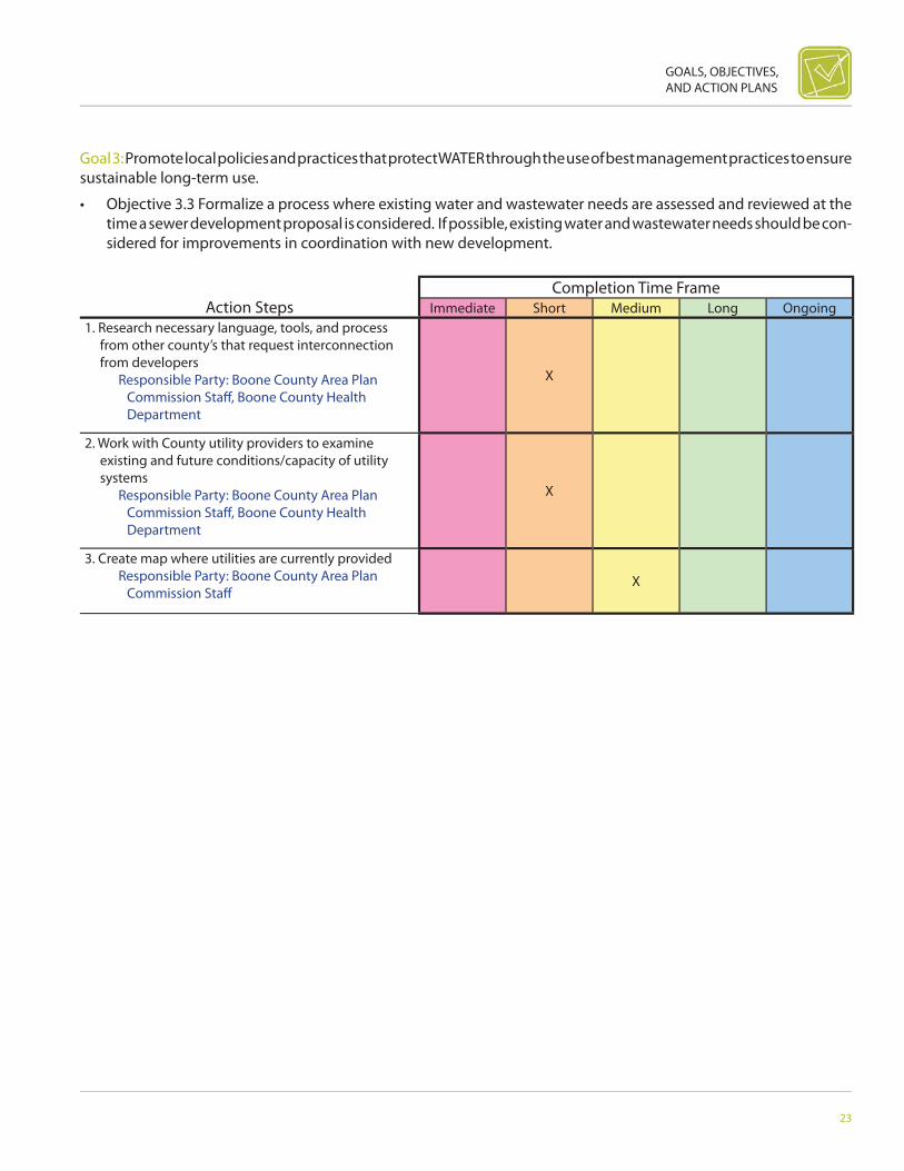
Immediate Short Medium Long Ongoing1. Research necessary language, tools, and process
from other county’s that request interconnection from developers
Responsible Party: Boone County Area Plan Commission Staff , Boone County Health Department
X
2. Work with County utility providers to examine existing and future conditions/capacity of utility systems
Responsible Party: Boone County Area Plan Commission Staff , Boone County Health Department
X
3. Create map where utilities are currently provided Responsible Party: Boone County Area Plan
Commission Staff X
Goal 3: Promote local policies and practices that protect WATER through the use of best management practices to ensure sustainable long-term use.
• Objective 3.3 Formalize a process where existing water and wastewater needs are assessed and reviewed at the time a sewer development proposal is considered. If possible, existing water and wastewater needs should be con-sidered for improvements in coordination with new development.

24
BOONE COUNTY AREA COMPREHENSIVE PLAN
Action StepsCompletion Time Frame
Immediate Short Medium Long Ongoing1. Form working relationship with IDEM in order
to work together to create regulations specifi c to Boone County
Responsible Party: Health Department, All Fire Departments within County, Boone County Commissioners
X
Goal 4: Promote local policies and practices that protect AIR through the use of best management practices to ensure sustainable long-term use.
• Objective 4.1 Develop local regulations for open burning in the county, which demonstrates compliance with Indiana Department of Environmental Management guidelines for open burning.

GOALS, OBJECTIVES, AND ACTION PLANS
25
Action StepsCompletion Time Frame
Immediate Short Medium Long Ongoing1. Create list of appropriate and inappropriate source
controls Responsible Party: Boone County Area
Plan Commissioners, Boone County Area Plan Commission Staff , Boone County Commissioners, Sheriff ’s Department
X
2. Create language to adopt in the zoning ordinance that addresses the required submission of innovative source control
Responsible Party: Boone County Area Plan Commission Staff , Boone County Area Plan Commissioners
X
3. Create a process in order to review the requirements that the new language of the ordinance would demand
Responsible Party: Boone County Area Plan Commission Staff , Boone County Area Plan Commissioners
X
Goal 4: Promote local policies and practices that protect AIR through the use of best management practices to ensure sustainable long-term use.
• Objective 4.2 Create Zoning Provisions that requires the submission of innovative source control.
26
BOONE COUNTY AREA COMPREHENSIVE PLAN
Action StepsCompletion Time Frame
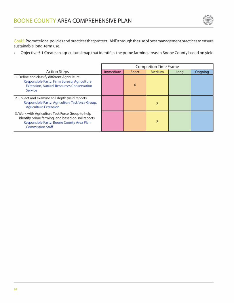
Immediate Short Medium Long Ongoing1. Defi ne and classify diff erent Agriculture Responsible Party: Farm Bureau, Agriculture
Extension, Natural Resources Conservation Service
X
2. Collect and examine soil depth yield reports Responsible Party: Agriculture Taskforce Group,
Agriculture ExtensionX
3. Work with Agriculture Task Force Group to help identify prime farming land based on soil reports
Responsible Party: Boone County Area Plan Commission Staff
X
Goal 5: Promote local policies and practices that protect LAND through the use of best management practices to ensure sustainable long-term use.
• Objective 5.1 Create an agricultural map that identifi es the prime farming areas in Boone County based on yield
GOALS, OBJECTIVES, AND ACTION PLANS
27
Action StepsCompletion Time Frame
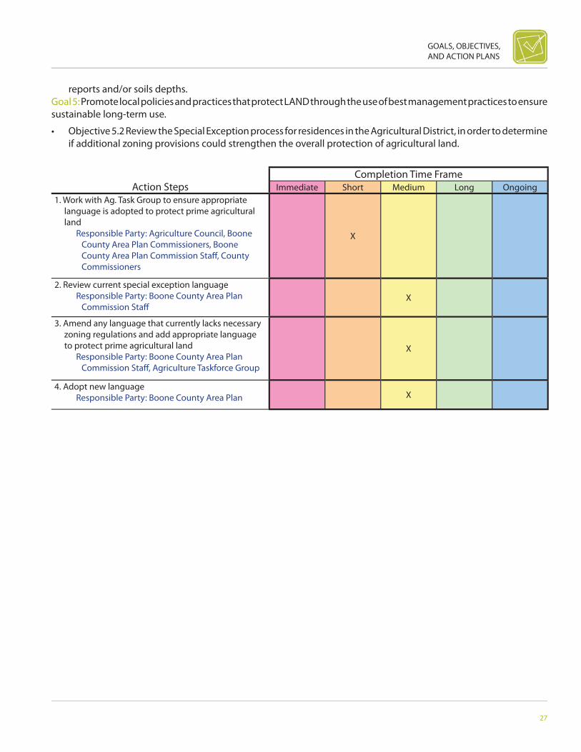
Immediate Short Medium Long Ongoing1. Work with Ag. Task Group to ensure appropriate
language is adopted to protect prime agricultural land
Responsible Party: Agriculture Council, Boone County Area Plan Commissioners, Boone County Area Plan Commission Staff , County Commissioners
X
2. Review current special exception language Responsible Party: Boone County Area Plan
Commission Staff X
3. Amend any language that currently lacks necessary zoning regulations and add appropriate language to protect prime agricultural land
Responsible Party: Boone County Area Plan Commission Staff , Agriculture Taskforce Group
X
4. Adopt new language Responsible Party: Boone County Area Plan X
reports and/or soils depths.Goal 5: Promote local policies and practices that protect LAND through the use of best management practices to ensure sustainable long-term use.
• Objective 5.2 Review the Special Exception process for residences in the Agricultural District, in order to determine if additional zoning provisions could strengthen the overall protection of agricultural land.

28
BOONE COUNTY AREA COMPREHENSIVE PLAN
Action StepsCompletion Time Frame
Immediate Short Medium Long Ongoing1. Form working relationship with Indiana Department
of Environmental Management to gain assistance in appropriate actions/language needed for environmental protection
Responsible Party: Boone County Area Plan Commissioners, Boone County Area Plan Commission Staff , Boone County Commissioners
X
2. Review current Authorized Land Use tables Responsible Party: Boone County Area Plan
Commission Staff X
3. Amend tables according to recommendations of Indiana Department of Environmental Management
Responsible Party: Boone County Area Plan Commission Staff
X
4. Adopt amended tables Responsible Party: Boone County Area Plan
Commissioners, Boone County CommissionersX
Goal 6: Promote local policies and practices in regards to SOLID WASTE through the use of best management practices to ensure sustainable long-term use.
• Objective 6.1 Explore and review Authorized Land-Use Table of the Ordinance to incorporate special land-use standards for environment protection including wind technology and renewable resources.

GOALS, OBJECTIVES, AND ACTION PLANS
29
Action StepsCompletion Time Frame
Immediate Short Medium Long Ongoing1. Identify county and municipal entities that would
participate Responsible Party: Boone County
Commissioner with assistance of local private support from Boone County Economic Development Corporation Board, Chamber of Commerce, others
X
2. Garner support for the concept and objective Responsible Party: Boone County
Commissioner with assistance of local private support from Boone County Economic Development Corporation Board, Chamber of Commerce, others
X
3. Establish details of the make-up and process for selecting representatives
Responsible Party: Representatives of the participating entities
X
4. Determine frequency, location and protocols for meetings, e.g., regular or as needed, authority, open door law
Responsible Party: Representatives of the participating entities
X
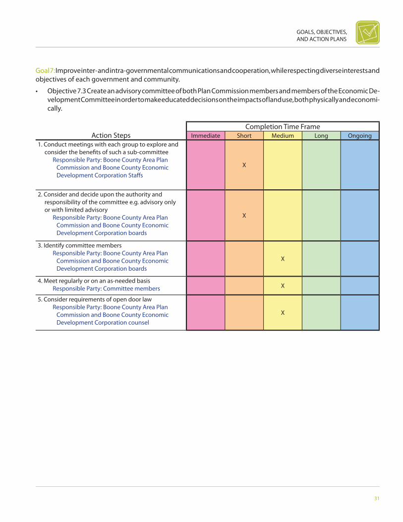
Goal 7: Improve inter- and intra-governmental communications and cooperation, while respecting diverse interests and objectives of each government and community.
• Objective 7.1 Create an unoffi cial intergovernmental board comprised of county and municipal leaders to address local government services in order to ensure there is coordination and communication.
30
BOONE COUNTY AREA COMPREHENSIVE PLAN
Action StepsCompletion Time Frame
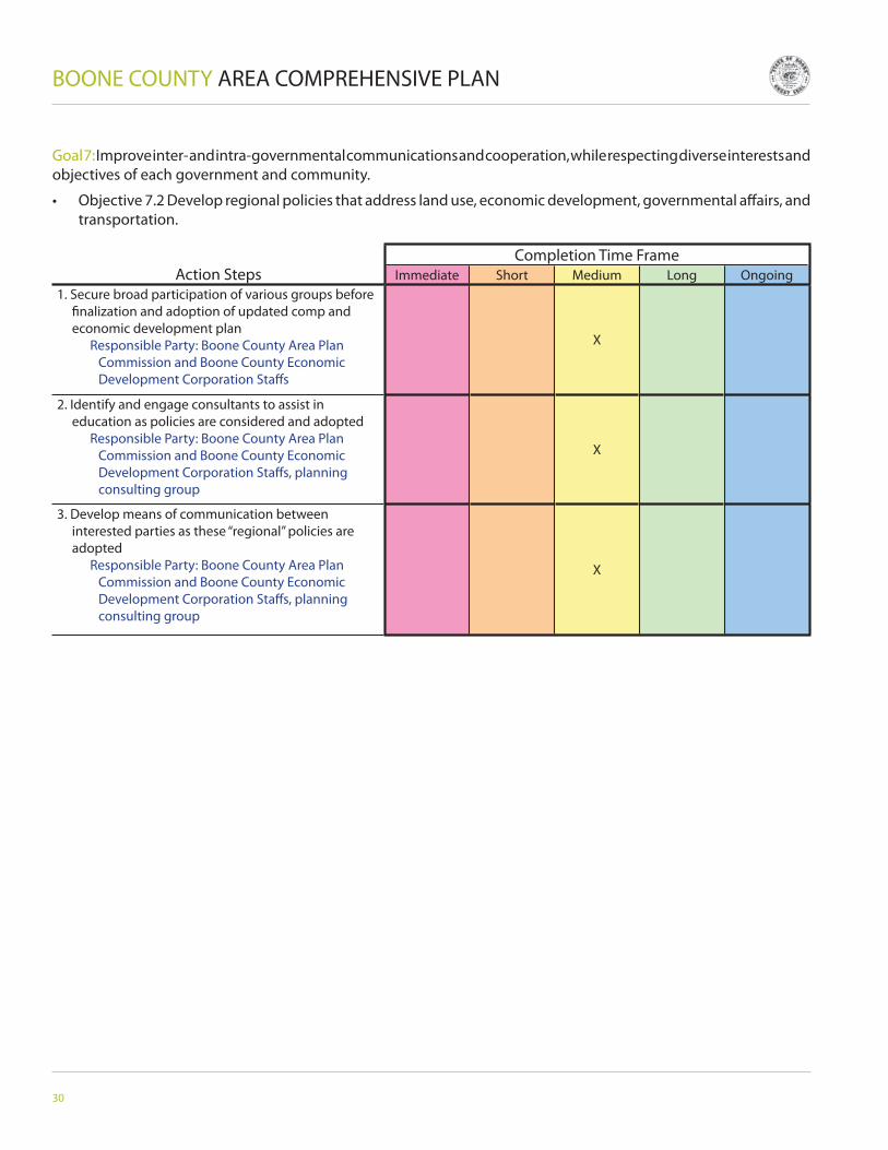
Immediate Short Medium Long Ongoing1. Secure broad participation of various groups before
fi nalization and adoption of updated comp and economic development plan
Responsible Party: Boone County Area Plan Commission and Boone County Economic Development Corporation Staff s
X
2. Identify and engage consultants to assist in education as policies are considered and adopted
Responsible Party: Boone County Area Plan Commission and Boone County Economic Development Corporation Staff s, planning consulting group
X
3. Develop means of communication between interested parties as these “regional” policies are adopted
Responsible Party: Boone County Area Plan Commission and Boone County Economic Development Corporation Staff s, planning consulting group
X
Goal 7: Improve inter- and intra-governmental communications and cooperation, while respecting diverse interests and objectives of each government and community.
• Objective 7.2 Develop regional policies that address land use, economic development, governmental aff airs, and transportation.
GOALS, OBJECTIVES, AND ACTION PLANS
31
Action StepsCompletion Time Frame
Immediate Short Medium Long Ongoing1. Conduct meetings with each group to explore and
consider the benefi ts of such a sub-committee Responsible Party: Boone County Area Plan
Commission and Boone County Economic Development Corporation Staff s
X
2. Consider and decide upon the authority and responsibility of the committee e.g. advisory only or with limited advisory
Responsible Party: Boone County Area Plan Commission and Boone County Economic Development Corporation boards
X
3. Identify committee members Responsible Party: Boone County Area Plan
Commission and Boone County Economic Development Corporation boards
X
4. Meet regularly or on an as-needed basis Responsible Party: Committee members X
5. Consider requirements of open door law Responsible Party: Boone County Area Plan
Commission and Boone County Economic Development Corporation counsel
X
Goal 7: Improve inter- and intra-governmental communications and cooperation, while respecting diverse interests and objectives of each government and community.
• Objective 7.3 Create an advisory committee of both Plan Commission members and members of the Economic De-velopment Committee in order to make educated decisions on the impacts of land use, both physically and economi-cally.

32
BOONE COUNTY AREA COMPREHENSIVE PLAN
Action StepsCompletion Time Frame
Immediate Short Medium Long Ongoing1. Explore with county and various municipal board
and councils the benefi t and wisdom of such eff orts Responsible Party: Boone County
Commissioners and representative of the Boone County Area Plan Commission and/or the Boone County Economic Development Council
X
2. Explore with counsel the legal requirements and parameters of such agreements
Responsible Party: Boone County and municipal counsel
X
3. Determine the eff ects of such agreements, e.g. binding advisory only, etc.
Responsible Party: X
4. Review the legality, enforceability, benefi ts, wisdom of such a policy
Responsible Party: Boone County Commissioners in consultation with municipal boards and councils
X
5. Agree upon the terms of the policy Responsible Party: Boone County
Commissioners in consultation with municipal boards and councils
X
6. Review and update policy as circumstances justify Responsible Party: Boone County
Commissioners in consultation with municipal boards and councils
X
Goal 7: Improve inter- and intra-governmental communications and cooperation, while respecting diverse interests and objectives of each government and community.
• Objective 7.4 Create inter-local agreements to improve cooperation especially regarding the review of cases adja-cent to existing planning jurisdiction boundaries and regarding and coordinating annexation policies.

GOALS, OBJECTIVES, AND ACTION PLANS
33
Action StepsCompletion Time Frame
Immediate Short Medium Long Ongoing1. Make sure applications and required submittals are
clear and understandable Responsible Party: Boone County Area Plan
Commissioners and staff in consultation with knowledgeable parties
X
2. Review time lines for fi ling and notice deadlines Responsible Party: Boone County Area Plan
Commissioners and staff in consultation with knowledgeable parties
X
3. Make maximum use of the Internet and keep website relevant and current
Responsible Party: Boone County Area Plan Commission Staff
X
4. Consider having meetings more often than monthly or using committees to perform routine matters
Responsible Party: Boone County Commission Staff and counsel
X
5. Develop better track record of following staff recommendations (or else replace staff )
Responsible Party: Boone County Area Plan Commissioners
X
Goal 8: Develop a customer-oriented government culture that values creativity, fl exibility, and responsiveness.
• Objective 8.1 Revise current local process for reviewing site-specifi c land development applications that are reason-able, predictable, and fair for applicants, contiguous neighbors, and community.

34
BOONE COUNTY AREA COMPREHENSIVE PLAN
Action StepsCompletion Time Frame
Immediate Short Medium Long Ongoing1. Identify the standards of customer that are
important to both applicants and the community at large
Responsible Party: Boone County Area Plan Commissioners and staff in consultation with knowledgeable parties
X
2. Agree upon those standards and implement them Responsible Party: Boone County
CommissionersX
3. Establish ways of measuring whether standards are being met
Responsible Party: Boone County Area Plan Commission Staff
X
Goal 8: Develop a customer-oriented government culture that values creativity, fl exibility and responsiveness.
• Objective 8.2 Have County-elected offi cials adopt a strategic plan that includes their mission and standards for

GOALS, OBJECTIVES, AND ACTION PLANS
35
Action StepsCompletion Time Frame
Immediate Short Medium Long Ongoing1. Continue to publish booklets and forms for people
to read and follow Responsible Party: Boone County Area Plan
Commissioners and staff in consultation with knowledgeable parties
X
2. Pursue maximum use of Internet as means of informing and processing
Responsible Party: Boone County Area Plan Commissioners
X
customer service.
Goal 8: Develop a customer-oriented government culture that values creativity, fl exibility, and responsiveness.
• Objective 8.3 Develop a coordinated streamlined “one-stop shopping” for permits to make it easier and faster for

36
BOONE COUNTY AREA COMPREHENSIVE PLAN
Action StepsCompletion Time Frame
Immediate Short Medium Long Ongoing1. Assess current local service standards Responsible Party: Boone County Area Plan
Commissioners and staff in consultation with knowledgeable parties
X
2. Create and enforce performance benchmarks Responsible Party: Boone County Area Plan
Commissioners, Boone County Commissioners, County Council
X
3. Determine service standards Responsible Party: Boone County Area Plan
Commission Staff X
4. Adopt policies on the criteria for departmental growth including reexamination of existing and future structure of departments
Responsible Party: Boone County Area Plan Commission Staff and counsel
X
citizens to comply with land-use laws.
Goal 8: Develop a customer-oriented government culture that values creativity, fl exibility, and responsiveness.
• Objective 8.4 Review of staff and funding based upon increased responsibility and the total capacity of planning

GOALS, OBJECTIVES, AND ACTION PLANS
37
Action StepsCompletion Time Frame
Immediate Short Medium Long Ongoing1. Create standards and criteria to be covered in staff
reports Responsible Party: Boone County Area Plan
Commissioners and staff in consultation with knowledgeable parties
X
2. Create/randomly adopt a subcommittee from Plan Commission members
Responsible Party: Boone County Area Plan Commission Staff , Boone County Area Plan Commissioners
X
department.
Goal 8: Develop a customer-oriented government culture that values creativity, fl exibility, and responsiveness.
• Objective 8.5 Examine purpose of the staff recommendation and include ad-hoc subcommittees of the Plan Com-mission in preliminary review of complex projects to improve communications, response, and quality of development

38
BOONE COUNTY AREA COMPREHENSIVE PLAN
Action StepsCompletion Time Frame
Immediate Short Medium Long Ongoing1. Require educational training for planning staff and
board members Responsible Party: Boone County Area Plan
CommissionersX
2. Subscribe to educational services and share information with board members
Responsible Party: Boone County Area Plan Commissioners
X
proposals.
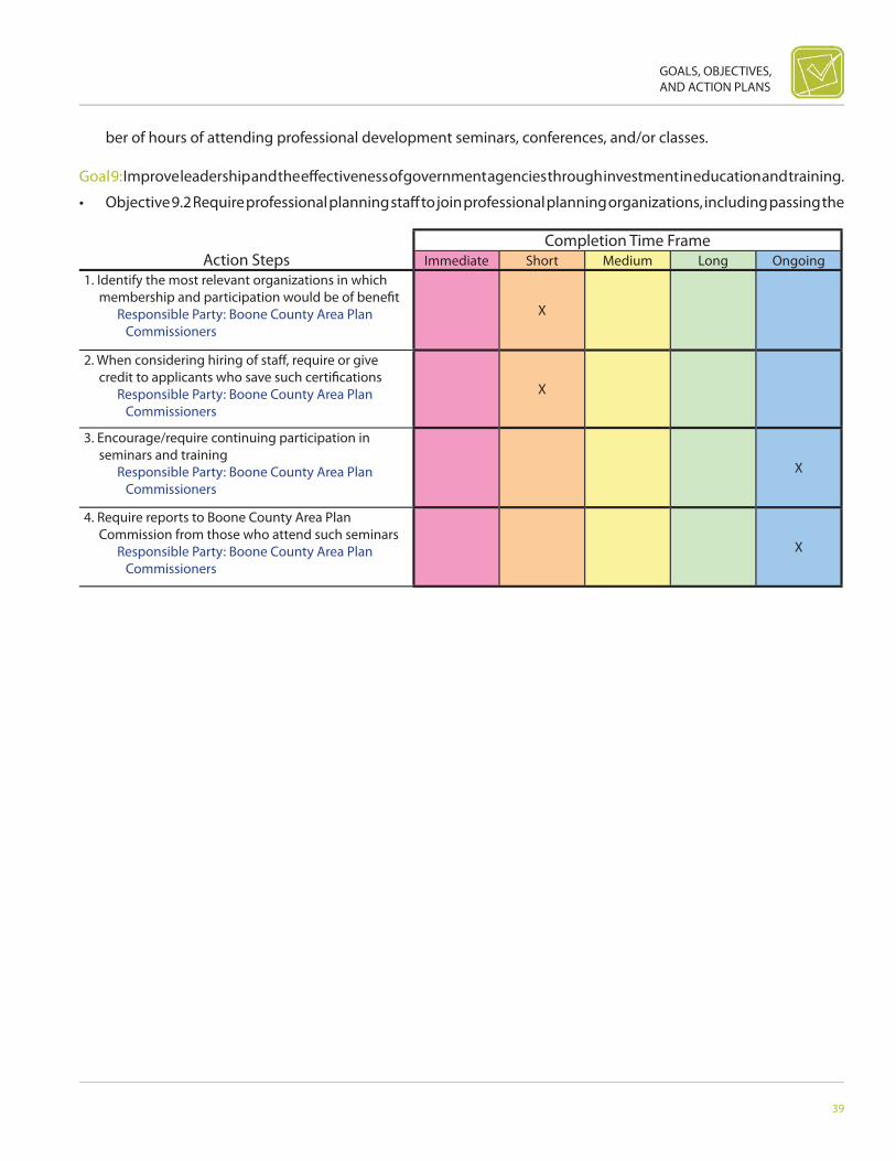
Goal 9: Improve leadership and the eff ectiveness of government agencies through investment in education and training.
• Objective 9.1 Create minimum standards for continuing education for County staff , such as requiring a minimum num-
GOALS, OBJECTIVES, AND ACTION PLANS
39
Action StepsCompletion Time Frame
Immediate Short Medium Long Ongoing1. Identify the most relevant organizations in which
membership and participation would be of benefi t Responsible Party: Boone County Area Plan
CommissionersX
2. When considering hiring of staff , require or give credit to applicants who save such certifi cations
Responsible Party: Boone County Area Plan Commissioners
X
3. Encourage/require continuing participation in seminars and training
Responsible Party: Boone County Area Plan Commissioners
X
4. Require reports to Boone County Area Plan Commission from those who attend such seminars
Responsible Party: Boone County Area Plan Commissioners
X
ber of hours of attending professional development seminars, conferences, and/or classes.
Goal 9: Improve leadership and the eff ectiveness of government agencies through investment in education and training.
• Objective 9.2 Require professional planning staff to join professional planning organizations, including passing the
40
BOONE COUNTY AREA COMPREHENSIVE PLAN
Action StepsCompletion Time Frame
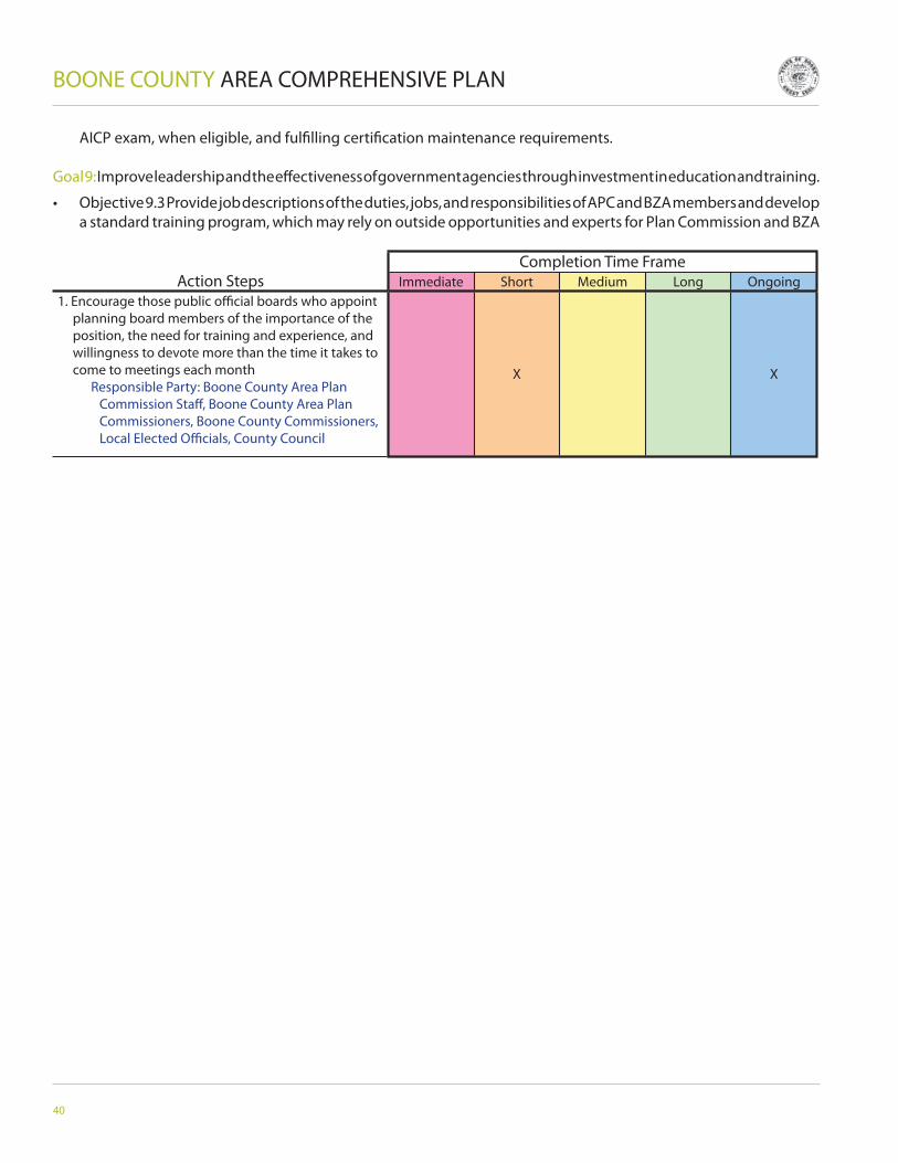
Immediate Short Medium Long Ongoing1. Encourage those public offi cial boards who appoint
planning board members of the importance of the position, the need for training and experience, and willingness to devote more than the time it takes to come to meetings each month
Responsible Party: Boone County Area Plan Commission Staff , Boone County Area Plan Commissioners, Boone County Commissioners, Local Elected Offi cials, County Council
X X
AICP exam, when eligible, and fulfi lling certifi cation maintenance requirements.
Goal 9: Improve leadership and the eff ectiveness of government agencies through investment in education and training.
• Objective 9.3 Provide job descriptions of the duties, jobs, and responsibilities of APC and BZA members and develop a standard training program, which may rely on outside opportunities and experts for Plan Commission and BZA
GOALS, OBJECTIVES, AND ACTION PLANS
41
Action StepsCompletion Time Frame
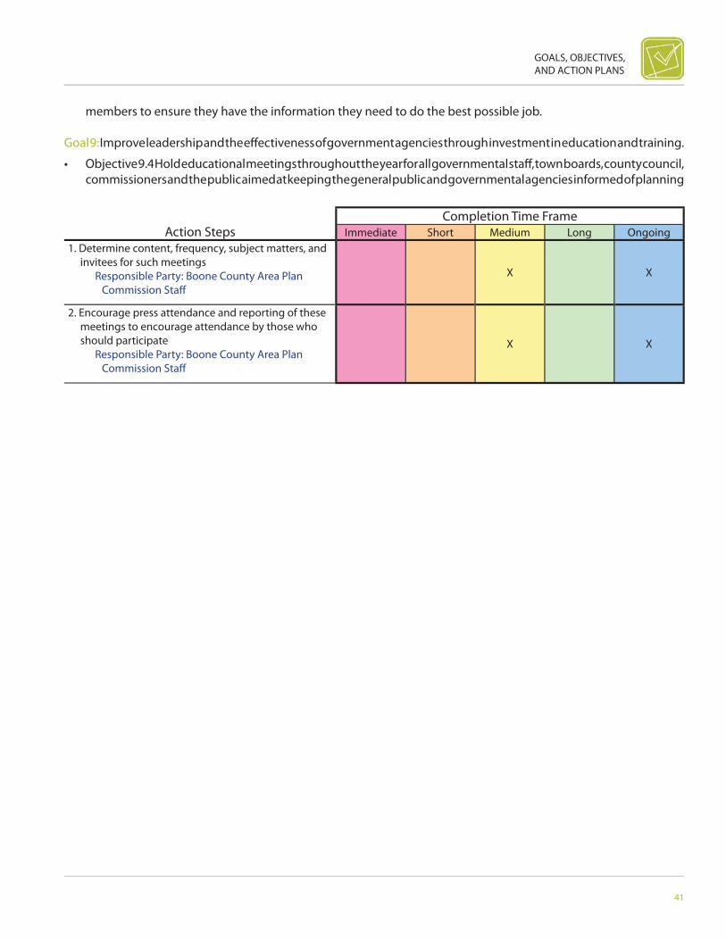
Immediate Short Medium Long Ongoing1. Determine content, frequency, subject matters, and
invitees for such meetings Responsible Party: Boone County Area Plan
Commission Staff X X
2. Encourage press attendance and reporting of these meetings to encourage attendance by those who should participate
Responsible Party: Boone County Area Plan Commission Staff
X X
members to ensure they have the information they need to do the best possible job.
Goal 9: Improve leadership and the eff ectiveness of government agencies through investment in education and training.
• Objective 9.4 Hold educational meetings throughout the year for all governmental staff , town boards, county council, commissioners and the public aimed at keeping the general public and governmental agencies informed of planning

42
BOONE COUNTY AREA COMPREHENSIVE PLAN
Action StepsCompletion Time Frame
Immediate Short Medium Long Ongoing1. Consider special meetings for such purpose, if
regular meetings are too full to allow Responsible Party: Boone County Area Plan
Commissioners, Boone County Area Plan Commission Staff
X X
2. Expect staff to come forward with information and recommendations of what others similarly situated are doing to move forward
Responsible Party: Boone County Area Plan Commissioners
X X
activities and programs.
Goal 9: Improve leadership and the eff ectiveness of government agencies through investment in education and training.
• Objective 9.5 Continue to set aside regular APC meeting times for the plan commission to discuss long-range plan-

GOALS, OBJECTIVES, AND ACTION PLANS
43
Action StepsCompletion Time Frame
Immediate Short Medium Long Ongoing1. Monitor rezone decisions to see if consistent with
existing Comp Plan; if frequently not, perhaps time to revisit plan
Responsible Party: Boone County Area Plan Commission Staff
X X
2. Don’t wait for entire overhaul of Comp Plan for making changes to plan as circumstances dictate or justify
Responsible Party: Boone County Area Plan Commissioners
X
3. Completely review Comp Plan no less than every fi ve years, especially and perhaps more often if it has not been tweaked along the way
Responsible Party: Boone County Area Plan Commissioners, Boone County Area Plan Commission staff
X
ning and projects.
Goal 10: Review the Comprehensive Plan regularly.
• Objective 10.1 Hold regular meetings, on an annual basis, between the Planning Department and Plan Commission

44
BOONE COUNTY AREA COMPREHENSIVE PLAN
Action StepsCompletion Time Frame
Immediate Short Medium Long Ongoing1. Convince APC members of the need for this Responsible Party: Boone County Area Plan
Commission Staff X X
2. Conduct annual retreat, including both county and municipal commissioners, APC, and BZA members with help of facilitator with planning expertise
Responsible Party: Boone County Area Plan Commissioners and Town Offi cials
X X
to address the progress of the action plans outlined in the Comprehensive Plan.
Goal 10: Review the Comprehensive Plan regularly.
• Objective 10.2 Establish an annual plan commission retreat, which will include a Comprehensive Plan review to assess
GOALS, OBJECTIVES, AND ACTION PLANS
45
Action StepsCompletion Time Frame
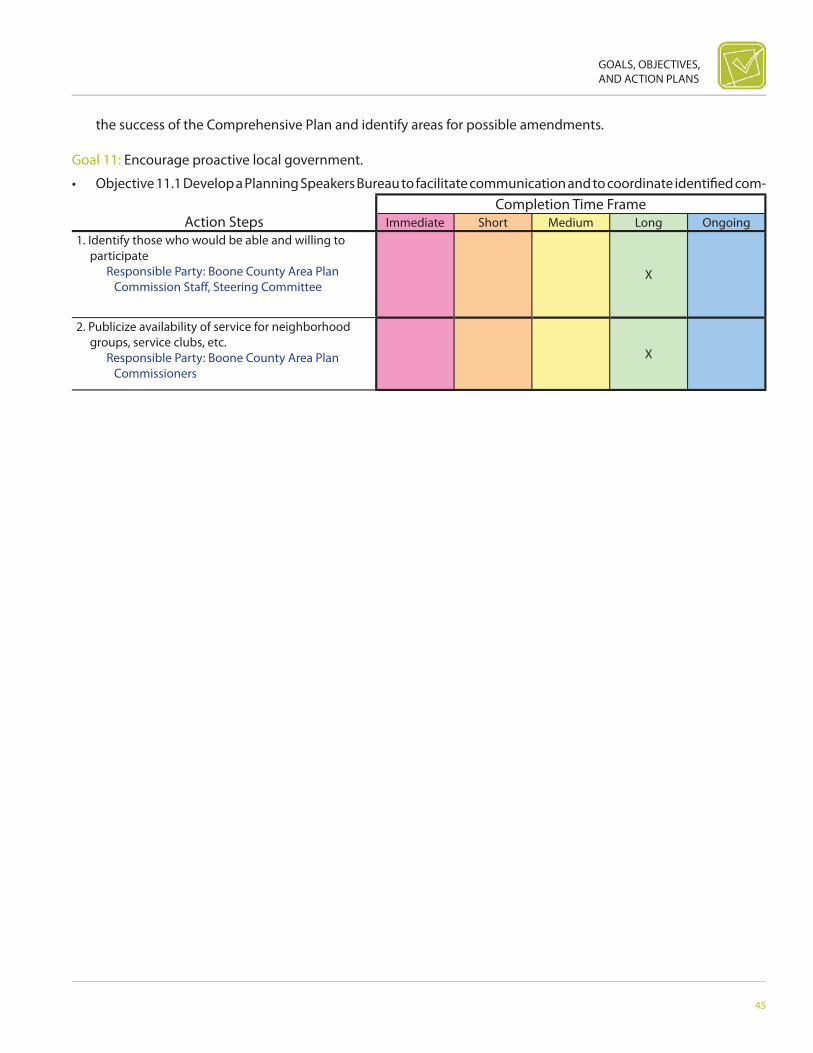
Immediate Short Medium Long Ongoing1. Identify those who would be able and willing to
participate Responsible Party: Boone County Area Plan
Commission Staff , Steering CommitteeX
2. Publicize availability of service for neighborhood groups, service clubs, etc.
Responsible Party: Boone County Area Plan Commissioners
X
the success of the Comprehensive Plan and identify areas for possible amendments.
Goal 11: Encourage proactive local government.
• Objective 11.1 Develop a Planning Speakers Bureau to facilitate communication and to coordinate identifi ed com-

46
BOONE COUNTY AREA COMPREHENSIVE PLAN
Action StepsCompletion Time Frame
Immediate Short Medium Long Ongoing1. Create schedule of all possible learning
opportunities, conferences, meetings, and learning seminars that would be good opportunities for staff or Plan Commission members to attend
Responsible Party: Boone County Area Plan Commission Staff , Boone County Area Plan Commissioners, Boone County Commissioners
X X
2. Create schedule of those attending which learning, seminars, conferences, and meetings
Responsible Party: Boone County Area Plan Commission Staff , Boone County Area Plan Commissioners
X
3. Allow and encourage for staff and Plan Commission members to attend appropriate conferences and learning opportunities when opportunities arise
Responsible Party: Boone County Area Plan Commissioners, Boone County Commissioners, County Council
X
munity resources.
Goal 11: Encourage proactive local government.
• Objective 11.2 Strongly encourage Plan Commission and staff to attend Association of Indiana Counties, Indiana As-sociation of County Commissioners, and APA learning seminars and conferences or similar organizations to increase

GOALS, OBJECTIVES, AND ACTION PLANS
47
Action StepsCompletion Time Frame
Immediate Short Medium Long Ongoing1. If becomes requirement by law, take steps to
implement statue Responsible Party: County and Municipal
Offi cialsX
2. Identify those who would be best suited to serve on such a board
Responsible Party: County and Municipal Offi cials
X
3. Develop ways for them to make informed decisions, rather than being adversely impacted by splinter groups and applause meter
Responsible Party: County and Municipal Offi cials
X
knowledge and understanding of new and best practices.
Goal 11: Encourage proactive local government.
• Objective 11.3 Create a County Capital Improvements Plan to identify necessary capital projects, provide a plan-
48
BOONE COUNTY AREA COMPREHENSIVE PLAN
Action StepsCompletion Time Frame
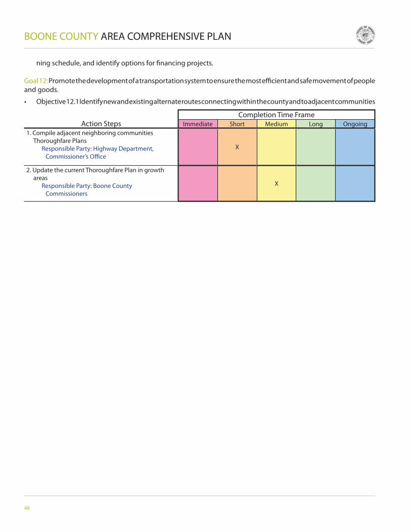
Immediate Short Medium Long Ongoing1. Compile adjacent neighboring communities
Thoroughfare Plans Responsible Party: Highway Department,
Commissioner’s Offi ceX
2. Update the current Thoroughfare Plan in growth areas
Responsible Party: Boone County Commissioners
X
ning schedule, and identify options for fi nancing projects.
Goal 12: Promote the development of a transportation system to ensure the most effi cient and safe movement of people and goods.
• Objective 12.1 Identify new and existing alternate routes connecting within the county and to adjacent communities
GOALS, OBJECTIVES, AND ACTION PLANS
49
Action StepsCompletion Time Frame
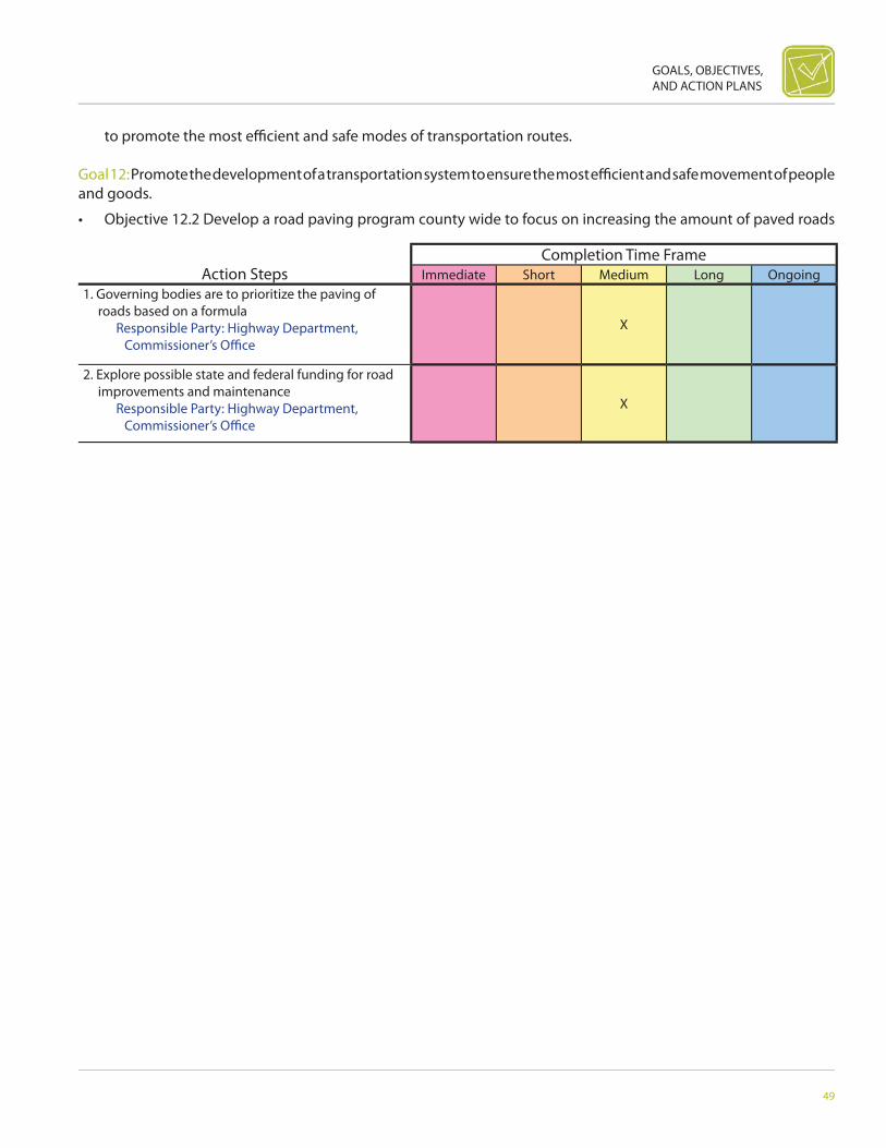
Immediate Short Medium Long Ongoing1. Governing bodies are to prioritize the paving of
roads based on a formula Responsible Party: Highway Department,
Commissioner’s Offi ceX
2. Explore possible state and federal funding for road improvements and maintenance
Responsible Party: Highway Department, Commissioner’s Offi ce
X
to promote the most effi cient and safe modes of transportation routes.
Goal 12: Promote the development of a transportation system to ensure the most effi cient and safe movement of people and goods.
• Objective 12.2 Develop a road paving program county wide to focus on increasing the amount of paved roads

50
BOONE COUNTY AREA COMPREHENSIVE PLAN
Action StepsCompletion Time Frame
Immediate Short Medium Long Ongoing1. Develop a plan for alternate transportation (i.e.,
Park & Ride, Bus) Responsible Party: Chamber of Commerce,
Transportation TaskforceX
2. Develop a regional (Boone County) transportation task force
Responsible Party: Boone County Commissioners, All Municipalities, Governing Leaders
X
throughout the county to improve transportation access, fl ow, capacity, and safety.
Goal 12: Promote the development of a transportation system to ensure the most effi cient and safe movement of people and goods.
• Objective 12.3 Promote and cooperate in area regional transportation eff orts to expand alternative methods of

GOALS, OBJECTIVES, AND ACTION PLANS
51
Action StepsCompletion Time Frame
Immediate Short Medium Long Ongoing1. Identify the maximum service the airport could
provide Responsible Party: Airport Offi cials, Boone
County Commissioners, Boone County Economic Development Corporation
X
2. Support through zoning Transportation (Thoroughfare Plan) the potential of Indianapolis Executive Airport
Responsible Party: Boone County Area Plan Commissioners, Boone County Commissioners
X
3. Develop an overlay district for State Road 32 Responsible Party: Boone County Area Plan
Commissioners X
transportation.
Goal 12: Promote the development of a transportation system to ensure the most effi cient and safe movement of people and goods.
52
BOONE COUNTY AREA COMPREHENSIVE PLAN
Action StepsCompletion Time Frame
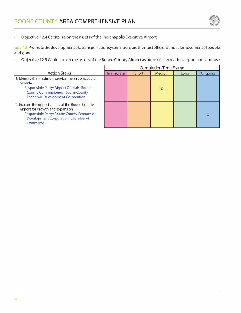
Immediate Short Medium Long Ongoing1. Identify the maximum service the airports could
provide Responsible Party: Airport Offi cials, Boone
County Commissioners, Boone County Economic Development Corporation
X
2. Explore the opportunities of the Boone County Airport for growth and expansion
Responsible Party: Boone County Economic Development Corporation, Chamber of Commerce
X
• Objective 12.4 Capitalize on the assets of the Indianapolis Executive Airport.
Goal 12: Promote the development of a transportation system to ensure the most effi cient and safe movement of people and goods.
• Objective 12.5 Capitalize on the assets of the Boone County Airport as more of a recreation airport and land-use

GOALS, OBJECTIVES, AND ACTION PLANS
53
Action StepsCompletion Time Frame
Immediate Short Medium Long Ongoing1. Identify the maximum service the heliport could
provide Responsible Party: Airport Offi cials, Boone
County Commissioners, Boone County Economic Development Corporation
X
2. Explore the opportunities of the Boone County Heliport for growth and expansion
Responsible Party: Boone County Economic Development Corporation, Chamber of Commerce
X
function.
Goal 12: Promote the development of a transportation system to ensure the most effi cient and safe movement of people and goods.

54
BOONE COUNTY AREA COMPREHENSIVE PLAN
Action StepsCompletion Time Frame
Immediate Short Medium Long Ongoing1. Identify the major players with REMC, Lebanon
Utilities, Duke, Cinergy, IPL, the various town offi cials associated with utilities, as well as the water providers from Indy
Responsible Party: Rural Electric Membership Corporation, Lebanon Utilities, Duke, Cinergy, Indianapolis Power and Light, Various Town Offi cials, Water Providers from Indianapolis
X
2. Set up a meeting with all the parties to strategize and identify the utility corridors and the placement of transmission and substations in advance of development and to fi ll in the gaps for logical process
Responsible Party: Boone County Area Plan Commission Staff , Boone County Area Plan Commissioners, Utility Board
X
3. Create a group of these professionals to meet regularly to continue to defi ne the corridors and assist the Boone County Area Plan Commissioners
Responsible Party: Boone County Area Plan Commissioners, Taskforce
X
• Objective 12.6 Capitalize on the assets of the Boone County Heliport.
Goal 13: Employ best management practices to minimize negative short- and long-term impacts of development.
• Objective 13.1 Hold utility coordination meetings with utility providers throughout the county, plan commission mem-
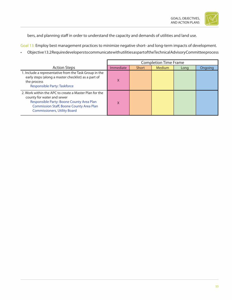
GOALS, OBJECTIVES, AND ACTION PLANS
55
Action StepsCompletion Time Frame
Immediate Short Medium Long Ongoing1. Include a representative from the Task Group in the
early steps (along a master checklist) as a part of the process
Responsible Party: Taskforce
X
2. Work within the APC to create a Master Plan for the county for water and sewer
Responsible Party: Boone County Area Plan Commission Staff , Boone County Area Plan Commissioners, Utility Board
X
bers, and planning staff in order to understand the capacity and demands of utilities and land use.
Goal 13: Employ best management practices to minimize negative short- and long-term impacts of development.
• Objective 13.2 Require developers to communicate with utilities as part of the Technical Advisory Committee process
56
BOONE COUNTY AREA COMPREHENSIVE PLAN
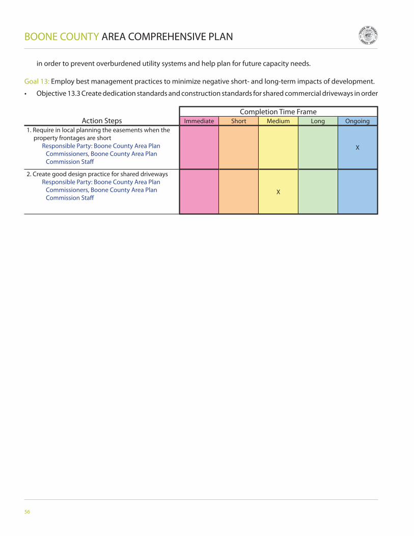
Action StepsCompletion Time Frame
Immediate Short Medium Long Ongoing1. Require in local planning the easements when the
property frontages are short Responsible Party: Boone County Area Plan
Commissioners, Boone County Area Plan Commission Staff
X
2. Create good design practice for shared driveways Responsible Party: Boone County Area Plan
Commissioners, Boone County Area Plan Commission Staff
X
in order to prevent overburdened utility systems and help plan for future capacity needs.
Goal 13: Employ best management practices to minimize negative short- and long-term impacts of development.
• Objective 13.3 Create dedication standards and construction standards for shared commercial driveways in order

GOALS, OBJECTIVES, AND ACTION PLANS
57
Action StepsCompletion Time Frame
Immediate Short Medium Long Ongoing1. The bond issue should meet the specs Responsible Party: Boone County Area Plan
Commissioners, Taskforce, Technical Advisory Committee
X
2. Defi ne in more depth subdivision improvement agreements and adopt these standards by Technical Advisory Committee and Boone County Area Plan Commissioners
Responsible Party: Boone County Area Plan Commissioners, Taskforce, Technical Advisory Committee
X
to ensure safety and control traffi c fl ow at entrances and exits.
Goal 13: Employ best management practices to minimize negative short- and long-term impacts of development.
• Objective 13.4 Explore using subdivision improvement agreements to help off set public improvement costs necessary

58
BOONE COUNTY AREA COMPREHENSIVE PLAN
Action StepsCompletion Time Frame
Immediate Short Medium Long Ongoing1. Ensure impact fees cover the entire county including
unincorporated areas Responsible Party: Boone County
CommissionersX
2. If developers are required to set up larger lines, allow them to recoup as others are added for a limited time
Responsible Party: Boone County Area Plan Commission Staff , Utility Board
X
3. Ensure impact fees are attractive to developers, but the money should be care marked for paving roads
Responsible Party: Boone County Commissioners
X
4. Create a county-wide group to study, evaluate, and advise on impact fees
Responsible Party: Boone County Area Plan Commission Staff
X
5. Collect for a variety of designated facilities, such as schools, parks, and paving of roads
Responsible Party: Boone County Area Plan Commissioners
X
6. Set up informational meetings to explain the facts regarding districts
Responsible Party: Boone County Area Plan Commissioners, Boone County Area Plan Commission Staff
X
for new developments.
Goal 13: Employ best management practices to minimize negative short- and long-term impacts of development.
• Objective 13.5 Explore overall use of impact fees to help off set public improvement costs necessary for the upkeep
GOALS, OBJECTIVES, AND ACTION PLANS
59
Action StepsCompletion Time Frame
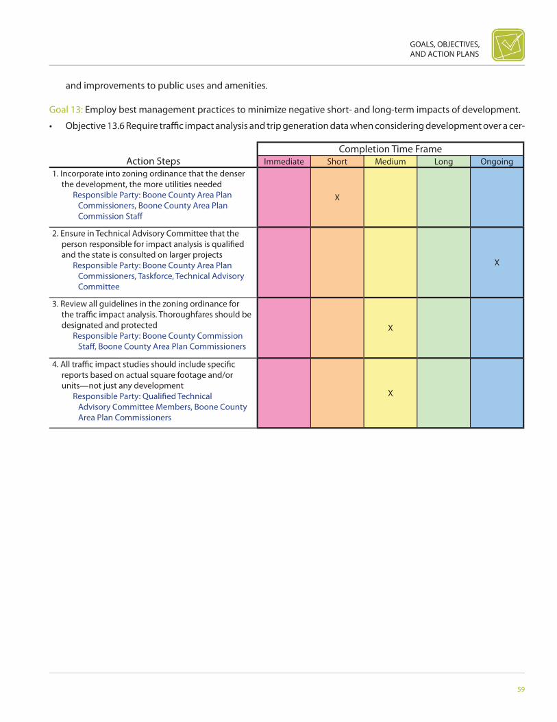
Immediate Short Medium Long Ongoing1. Incorporate into zoning ordinance that the denser
the development, the more utilities needed Responsible Party: Boone County Area Plan
Commissioners, Boone County Area Plan Commission Staff
X
2. Ensure in Technical Advisory Committee that the person responsible for impact analysis is qualifi ed and the state is consulted on larger projects
Responsible Party: Boone County Area Plan Commissioners, Taskforce, Technical Advisory Committee
X
3. Review all guidelines in the zoning ordinance for the traffi c impact analysis. Thoroughfares should be designated and protected
Responsible Party: Boone County Commission Staff , Boone County Area Plan Commissioners
X
4. All traffi c impact studies should include specifi c reports based on actual square footage and/or units—not just any development
Responsible Party: Qualifi ed Technical Advisory Committee Members, Boone County Area Plan Commissioners
X
and improvements to public uses and amenities.
Goal 13: Employ best management practices to minimize negative short- and long-term impacts of development.
• Objective 13.6 Require traffi c impact analysis and trip generation data when considering development over a cer-
60
BOONE COUNTY AREA COMPREHENSIVE PLAN
Action StepsCompletion Time Frame
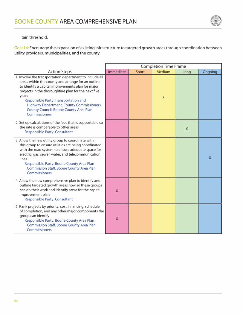
Immediate Short Medium Long Ongoing1. Involve the transportation department to include all
areas within the county and arrange for an outline to identify a capital improvements plan for major projects in the thoroughfare plan for the next fi ve years
Responsible Party: Transportation and Highway Department, County Commissioners, County Council, Boone County Area Plan Commissioners
X
2. Set up calculations of the fees that is supportable so the rate is comparable to other areas
Responsible Party: ConsultantX
3. Allow the new utility group to coordinate with this group to ensure utilities are being coordinated with the road system to ensure adequate space for electric, gas, sewer, water, and telecommunication lines
Responsible Party: Boone County Area Plan Commission Staff , Boone County Area Plan Commissioners
X
4. Allow the new comprehensive plan to identify and outline targeted growth areas now so these groups can do their work and identify areas for the capital improvement plan
Responsible Party: Consultant
X
5. Rank projects by priority, cost, fi nancing, schedule of completion, and any other major components the group can identify
Responsible Party: Boone County Area Plan Commission Staff , Boone County Area Plan Commissioners
X
tain threshold.
Goal 14: Encourage the expansion of existing infrastructure to targeted growth areas through coordination between utility providers, municipalities, and the county.
GOALS, OBJECTIVES, AND ACTION PLANS
61
Action StepsCompletion Time Frame
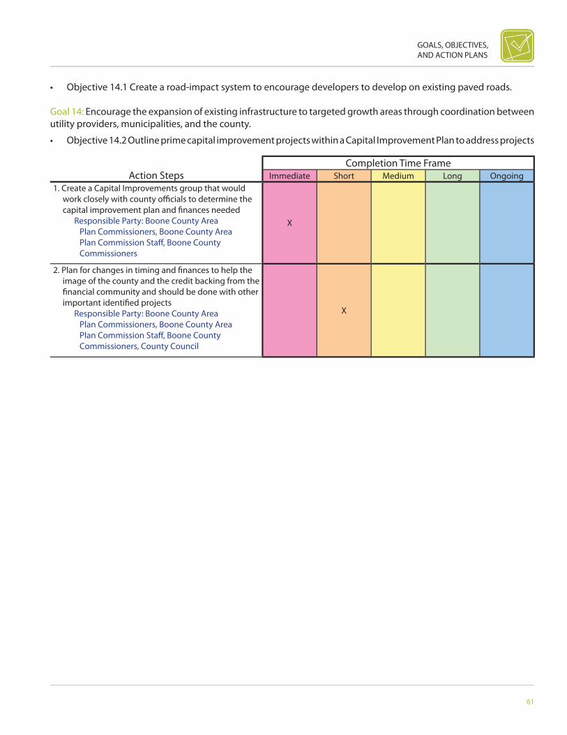
Immediate Short Medium Long Ongoing1. Create a Capital Improvements group that would
work closely with county offi cials to determine the capital improvement plan and fi nances needed
Responsible Party: Boone County Area Plan Commissioners, Boone County Area Plan Commission Staff , Boone County Commissioners
X
2. Plan for changes in timing and fi nances to help the image of the county and the credit backing from the fi nancial community and should be done with other important identifi ed projects
Responsible Party: Boone County Area Plan Commissioners, Boone County Area Plan Commission Staff , Boone County Commissioners, County Council
X
• Objective 14.1 Create a road-impact system to encourage developers to develop on existing paved roads.
Goal 14: Encourage the expansion of existing infrastructure to targeted growth areas through coordination between utility providers, municipalities, and the county.
• Objective 14.2 Outline prime capital improvement projects within a Capital Improvement Plan to address projects

62
BOONE COUNTY AREA COMPREHENSIVE PLAN
Action StepsCompletion Time Frame
Immediate Short Medium Long Ongoing1. Defi ne and identify large blocks of productive
agricultural land Responsible Party: Farm Bureau, Agriculture
Community, FSA, Producer Groups, Boone County Area Plan Commissioners
X
2. Develop defi nitions of presumptive protected agricultural areas and uses
Responsible Party: Boone County Area Plan Commissioners, Farm Bureau, Agriculture Community, FSA, Producer Groups
X
3. To the extent necessary, develop zoning rules and regulations to implement and facilitate this goal and objective
Responsible Party: Boone County Area Plan Commissioners, Boone County Commissioners
X X
necessary for targeted growth areas to be successful.
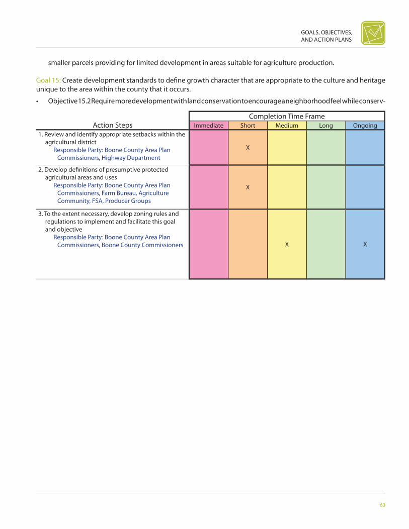
Goal 15: Create development standards to defi ne growth character that are appropriate to the culture and heritage unique to the area within the county that it occurs.
• Objective 15.1 Protect large blocks of farmland designated for agriculture while discouraging the creation of
GOALS, OBJECTIVES, AND ACTION PLANS
63
Action StepsCompletion Time Frame
Immediate Short Medium Long Ongoing1. Review and identify appropriate setbacks within the
agricultural district Responsible Party: Boone County Area Plan
Commissioners, Highway Department
X
2. Develop defi nitions of presumptive protected agricultural areas and uses
Responsible Party: Boone County Area Plan Commissioners, Farm Bureau, Agriculture Community, FSA, Producer Groups
X
3. To the extent necessary, develop zoning rules and regulations to implement and facilitate this goal and objective
Responsible Party: Boone County Area Plan Commissioners, Boone County Commissioners X X
smaller parcels providing for limited development in areas suitable for agriculture production.
Goal 15: Create development standards to defi ne growth character that are appropriate to the culture and heritage unique to the area within the county that it occurs.
• Objective 15.2 Require more development with land conservation to encourage a neighborhood feel while conserv-

64
BOONE COUNTY AREA COMPREHENSIVE PLAN
Action StepsCompletion Time Frame
Immediate Short Medium Long Ongoing1. Create map of existing infrastructure network Responsible Party: Utility Board, Boone County
Area Plan Commission Staff X
2. Work with utility companies to examine current and future capacity loads
Responsible Party: Boone County Area Plan Commissioners, Boone County Area Plan Commissioners Staff
X X
3. Amend and adopt new ordinance language to address the requirements for new developments to tie into existing infrastructure network
Responsible Party: Boone County Area Plan Commissioners, Boone County Commissioners
X
ing viable farmland and sensitive areas.
Goal 15: Create development standards to defi ne growth character that are appropriate to the culture and heritage unique to the area within the county that it occurs.
GOALS, OBJECTIVES, AND ACTION PLANS
65
Action StepsCompletion Time Frame
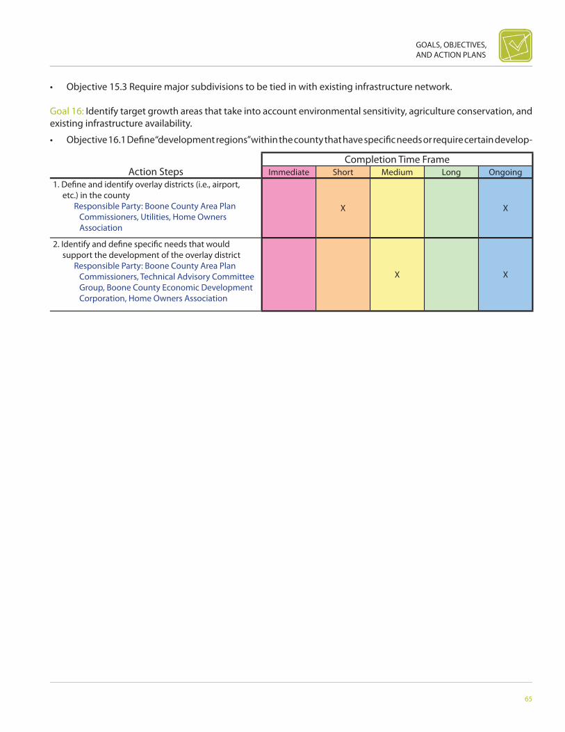
Immediate Short Medium Long Ongoing1. Defi ne and identify overlay districts (i.e., airport,
etc.) in the county Responsible Party: Boone County Area Plan
Commissioners, Utilities, Home Owners Association
X X
2. Identify and defi ne specifi c needs that would support the development of the overlay district
Responsible Party: Boone County Area Plan Commissioners, Technical Advisory Committee Group, Boone County Economic Development Corporation, Home Owners Association
X X
• Objective 15.3 Require major subdivisions to be tied in with existing infrastructure network.
Goal 16: Identify target growth areas that take into account environmental sensitivity, agriculture conservation, and existing infrastructure availability.
• Objective 16.1 Defi ne “development regions” within the county that have specifi c needs or require certain develop-

66
BOONE COUNTY AREA COMPREHENSIVE PLAN
Action StepsCompletion Time Frame
Immediate Short Medium Long Ongoing1. Identify standards that are compatible with nearby
or adjacent to development/land uses/character of the area
Responsible Party: Boone County Area Plan Commissioners, Government Entities
X
ment standards.
Goal 16: Identify target growth areas that take into account environmental sensitivity, agriculture conservation, and existing infrastructure availability.
• Objective 16.2 Establish separate development standards that are appropriate for the diff erent parts of the county

GOALS, OBJECTIVES, AND ACTION PLANS
67
Action StepsCompletion Time Frame
Immediate Short Medium Long Ongoing1. Explore additional zoning classifi cations for
residential districts Responsible Party: Boone County Area Plan
Commissioners, Boone County Area Plan Commission Staff
X
through additional zoning districts and/or overlays.
Goal 16: Identify target growth areas that take into account environmental sensitivity, agriculture conservation, and existing infrastructure availability.
68
BOONE COUNTY AREA COMPREHENSIVE PLAN
Action StepsCompletion Time Frame
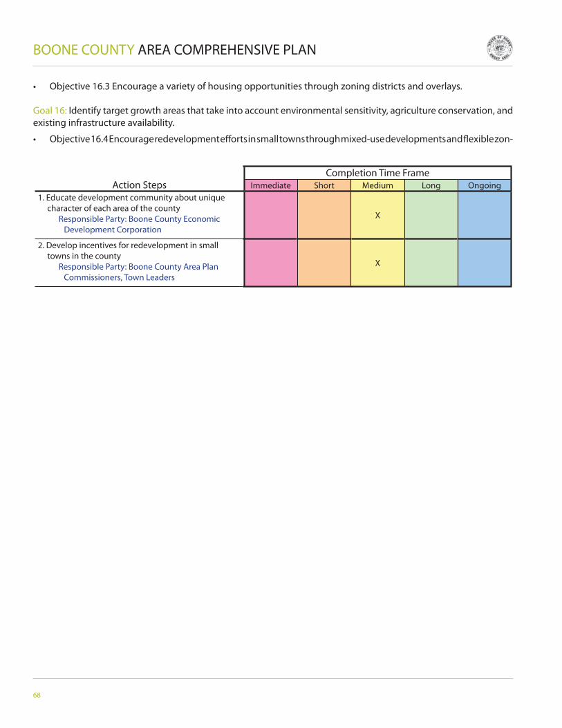
Immediate Short Medium Long Ongoing1. Educate development community about unique
character of each area of the county Responsible Party: Boone County Economic
Development Corporation
X
2. Develop incentives for redevelopment in small towns in the county
Responsible Party: Boone County Area Plan Commissioners, Town Leaders
X
• Objective 16.3 Encourage a variety of housing opportunities through zoning districts and overlays.
Goal 16: Identify target growth areas that take into account environmental sensitivity, agriculture conservation, and existing infrastructure availability.
• Objective 16.4 Encourage redevelopment eff orts in small towns through mixed-use developments and fl exible zon-

GOALS, OBJECTIVES, AND ACTION PLANS
69
Action StepsCompletion Time Frame
Immediate Short Medium Long Ongoing1. Research and examine appropriate open space
preservation tools for Boone County Responsible Party: Boone County Area Plan
Commission Staff
X
2. Create a map that illustrates environmentally scenic and culturally signifi cant areas that need protected from development
Responsible Party: Boone County Area Plan Commission Staff
X
3. Amend language in the zoning ordinance to outline areas that need protected and the tools necessary to protect these areas
Responsible Party: Boone County Area Plan Commissioners
X
ing.
Goal 16: Identify target growth areas that take into account environmental sensitivity, agriculture conservation, and existing infrastructure availability.
• Objective 16.5 Integrate open space preservation tools in the Zoning Ordinance that includes the encouragement of cluster zoning, and/or conservation easements in order to protect environmentally scenic and culturally signifi cant

70
BOONE COUNTY AREA COMPREHENSIVE PLAN
Action StepsCompletion Time Frame
Immediate Short Medium Long Ongoing1. Form relationship with local town offi cials to
discuss possible redevelopment areas Responsible Party: Boone County Area Plan
Commission Staff , Boone County Area Plan Commissioners
X
2. Identify and market areas that are prime for residential redevelopment
Responsible Party: Boone County Area Plan Commissioners
X
3. Review and discuss possible incentives that could be off ered for developments locating in redevelopment areas
Responsible Party: Boone County Area Plan Commissioners
X
areas from development and maintain the rural character of the unincorporated areas.
Goal 16: Identify target growth areas that take into account environmental sensitivity, agriculture conservation, and existing infrastructure availability.
• Objective 16.6 Encourage residential redevelopment in municipal downtown areas to maintain or increase density

GOALS, OBJECTIVES, AND ACTION PLANS
71
Action StepsCompletion Time Frame
Immediate Short Medium Long Ongoing1. Amend language in the zoning ordinance to require
fi scal impact studies for developments Responsible Party: Boone County Area Plan
Commission Staff , Boone County Area Plan Commissioners
X
over the previous development.
Goal 16: Identify target growth areas that take into account environmental sensitivity, agriculture conservation, and existing infrastructure availability.

72
BOONE COUNTY AREA COMPREHENSIVE PLAN
Action StepsCompletion Time Frame
Immediate Short Medium Long Ongoing1. Review minimum standards for mixed use
developments Responsible Party: Boone County Area Plan
Commission Staff , Boone County Area Plan Commissioners, Boone County Commissioners
X
• Objective 16.7 Develop a requirement for fi scal impact studies for development reviews.
Goal 17: Growth standards shall refl ect a cohesive and unique character that emphasizes a connection between creating a rural and small town sense of place and the convenience between places to live, work, and play.
• Objective 17.1 Allow fl exible mixed-use zoning provisions, to reduce dependency on automobiles, and create health-ier pedestrian-oriented communities through creative design in targeted growth areas that have adequate infrastruc-

GOALS, OBJECTIVES, AND ACTION PLANS
73
Action StepsCompletion Time Frame
Immediate Short Medium Long Ongoing1. Explore incentives to encourage cluster
development Responsible Party: Boone County Area Plan
Commissioners, Board of Zoning and AppealsX
2. Establish a minimum distance between driveway entrances on public roads in the agriculture district to maintain a rural atmosphere and improve safety
Responsible Party: Boone County Area Plan Commissioners, Highway Department
X
3. Limit access to county roads for driveway and roadway cuts to allow open views of agriculture land
Responsible Party: Boone County Area Plan Commissioners, Highway Department
X
4. To the extent necessary, identify and defi ne commercial, industrial, and major residential
Responsible Party: Boone County Area Commission Staff , Boone County Area Commissioners
X
5. Encourage compatible zoning to urban areas Responsible Party: Boone County Area Plan
Commission Staff , Boone County Area Plan Commissioners
X
6. Change major subdivision ordinances to require utilities
Responsible Party: Boone County Area Plan Commission Staff , Boone County Area Plan Commissioners
X
ture.
Goal 17: Growth standards shall refl ect a cohesive and unique character that emphasizes a connection between creating a rural and small town sense of place and the convenience between places to live, work, and play.
• Objective 17.2 Encourage cluster development as opposed to strip residential or commercial uses along existing roadways and require these new commercial, industrial, and major residential developments are located in proximity

74
BOONE COUNTY AREA COMPREHENSIVE PLAN
Action StepsCompletion Time Frame
Immediate Short Medium Long Ongoing1. Evaluate and modify as necessary Boone County
Ordinances and Subdivision Control Ordinance to allow for safe pedestrian traffi c
Responsible Party: Boone County Area Plan Commissioners
X
2. Evaluate and modify as necessary Boone County Ordinances and Subdivision Control Ordinance to foster pedestrian and vehicular inter-connectivity through requiring sidewalks and stubbed streets
Responsible Party: Boone County Area Plan Commissioners
X
3. Encourage a county-wide published Greenway and Trail Master Plan
Responsible Party: Commissioners, Park Departments, Rails to Trails Group, Utilities
X
to existing or planned infrastructure.
Goal 17: Growth standards shall refl ect a cohesive and unique character that emphasizes a connection between creating a rural and small town sense of place and the convenience between places to live, work, and play.
• Objective 17.3 Require new developments to incorporate necessary extensions through pedestrian and vehicular inter-connectivity between all types of developments and including, but not limited to, existing or a planned Green-

GOALS, OBJECTIVES, AND ACTION PLANS
75
Action StepsCompletion Time Frame
Immediate Short Medium Long Ongoing1. Preserve Class 1 and 2 farm land for productive
agriculture uses Responsible Party: Natural Resources
Conservation Service, Agriculture Community, Agriculture Taskforce
X
way/Trail Master Plan.
Goal 18: Recognize agriculture as productive landscape and preserve these uses for the production of food, fi ber, and fuel.

76
BOONE COUNTY AREA COMPREHENSIVE PLAN
Action StepsCompletion Time Frame
Immediate Short Medium Long Ongoing1. Identify areas that can accommodate livestock
production Responsible Party: Boone County Area Plan
Commissioners, Agriculture Taskforce, Producer Groups
X
2. Preserve and allow growth for current livestock facilities
Responsible Party: Boone County Area Plan Commissioners, Agriculture Taskforce, Producer Groups
X
3. Create an Agriculture Taskforce Committee Responsible Party: Boone County Area Plan
Commission Staff X
• Objective 18.1 Target areas for diff erent types of agricultural growth and expansion.
Goal 18: Recognize agriculture as productive landscape and preserve these uses for the production of food, fi ber, and fuel.
• Objective 18.2 Preserve agricultural land for livestock production by preserving fl exible uses within the zoning ordi-

GOALS, OBJECTIVES, AND ACTION PLANS
77
Action StepsCompletion Time Frame
Immediate Short Medium Long Ongoing1. Require County decision makers to gain knowledge
on agriculture industry practices Responsible Party: Agriculture Taskforce,
County ExtensionX X
2. Educate public about agriculture with a printed brochure school, presentations, and through speakers bureau
Responsible Party: Agriculture Taskforce, County Extension, Producer Groups, Purdue, Farm Bureau, Agriculture Community
X
nance and a right to farm provisions, while also protecting the rights of the existing adjacent uses.
Goal 18: Recognize agriculture as productive landscape and preserve these uses for the production of food, fi ber, and fuel.

78
BOONE COUNTY AREA COMPREHENSIVE PLAN
Action StepsCompletion Time Frame
Immediate Short Medium Long Ongoing1. Form working relationship with Agriculture
Taskforce Group to determine appropriate science based agricultural operations and reverse screening tools that should be used in Boone County
Responsible Party: Agriculture Taskforce, Surveyor’s Offi ce, Farm Bureau, Boone County Solid Waste District
X
2. Amend zoning ordinance to address the appropriate and inappropriate science based agriculture operations and screening mechanisms to be used in Boone County
Responsible Party: Boone County Area Plan Commissioners, Board of Zoning and Appeals, Agriculture Task Group, Agriculture Community
X X
• Objective 18.3 Educate local decision makers regarding agricultural practices and economic viability.
Goal 19: Preserve the viability, productivity, character, and quality of Boone County’s agricultural and water resources.
• Objective 19.1 Develop zoning rules and regulations that govern science-based agricultural operations and require
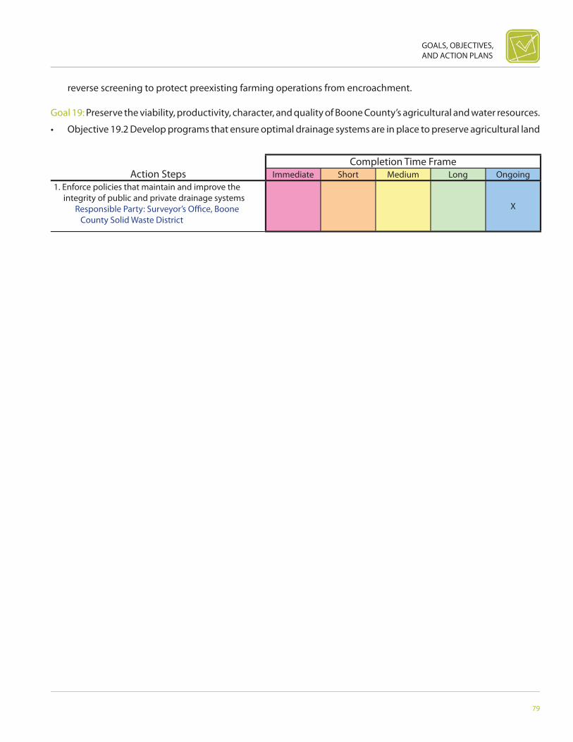
GOALS, OBJECTIVES, AND ACTION PLANS
79
Action StepsCompletion Time Frame
Immediate Short Medium Long Ongoing1. Enforce policies that maintain and improve the
integrity of public and private drainage systems Responsible Party: Surveyor’s Offi ce, Boone
County Solid Waste DistrictX
reverse screening to protect preexisting farming operations from encroachment.
Goal 19: Preserve the viability, productivity, character, and quality of Boone County’s agricultural and water resources.
• Objective 19.2 Develop programs that ensure optimal drainage systems are in place to preserve agricultural land

80
BOONE COUNTY AREA COMPREHENSIVE PLAN
Action StepsCompletion Time Frame
Immediate Short Medium Long Ongoing1. Examine a system to help with private drainage
issues such as assigning a staff member from the County Surveyor’s Offi ce to assist residents in resolving their private drainage problems
Responsible Party: County Surveyor’s Offi ce
X
2. Create system and ongoing map that identifi es current private drains, their owners, and surrounding landowners in the County
Responsible Party: Boone County Area Plan Commission Staff , County Surveyor’s Offi ce
X
3. Create a system that will help assist property owners in petitioning of the County Drainage Board for removal of obstructions in private drains
Responsible Party: County Surveyor’s Offi ce, Boone County Commissioners
X
productivity.
Goal 19: Preserve the viability, productivity, character, and quality of Boone County’s agricultural and water resources.

GOALS, OBJECTIVES, AND ACTION PLANS
81
Action StepsCompletion Time Frame
Immediate Short Medium Long Ongoing1. BCSWD and Boone County Extension would conduct
educational programs that promote best practices Responsible Party: Boone County Solid Waste
District, County ExtensionX
• Objective 19.3 Incorporate/include in the County Drainage Ordinance a section addressing private drains to ensure private drains do not have adverse eff ects on the natural environment or surrounding properties.
Goal 20: Conserve farmland and agriculture with zoning standards that protect, promote, and grow agriculture within Boone County.

82
BOONE COUNTY AREA COMPREHENSIVE PLAN
Action StepsCompletion Time Frame
Immediate Short Medium Long Ongoing1. Work with State and County legislators and the Ag
Task Force to develop a Purchase of Development Rights Program
Responsible Party: Legislative Bodies (State, County, Commissioners), Agriculture Taskforce
X
• Objective 20.1 Encourage, educate, and help local farmers utilize best management practices through conservation tillage.
Goal 20: Conserve farmland and agriculture with zoning standards that protect, promote, and grow agriculture within Boone County.

GOALS, OBJECTIVES, AND ACTION PLANS
83
Action StepsCompletion Time Frame
Immediate Short Medium Long Ongoing1. Work with State and County legislators and the Ag
Task Force to develop a Transfer of Development Rights Program
Responsible Party: Legislative Bodies (State, County, Commissioners), Agriculture Taskforce
X
• Objective 20.2 Establish a Purchase of Development Rights program in order to protect land (open space and farm-land) from being subdivided.
Goal 20: Conserve farmland and agriculture with zoning standards that protect, promote, and grow agriculture within Boone County.

84
BOONE COUNTY AREA COMPREHENSIVE PLAN
Action StepsCompletion Time Frame
Immediate Short Medium Long Ongoing1. Continue and expand conservation programs for the
benefi t of farmers Responsible Party: Boone County Solid Waste
District, County Extension, Surveyor’s Offi ceX
2. Promote public awareness of the importance of conservation buff ers
Responsible Party: Boone County Solid Waste District, County Extension, Surveyor’s Offi ce
X
• Objective 20.3 Encourage Plan Commission, County Commissioners, and Planning Staff to work with state legislators to develop a Transfer of Development Rights Program to change Indiana planning statutes.
Goal 21: Limit land-use confl icts
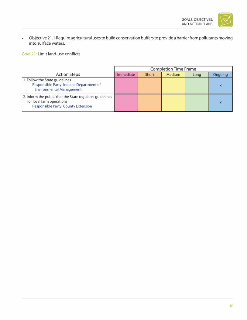
GOALS, OBJECTIVES, AND ACTION PLANS
85
Action StepsCompletion Time Frame
Immediate Short Medium Long Ongoing1. Follow the State guidelines Responsible Party: Indiana Department of
Environmental ManagementX
2. Inform the public that the State regulates guidelines for local farm operations
Responsible Party: County ExtensionX
• Objective 21.1 Require agricultural uses to build conservation buff ers to provide a barrier from pollutants moving into surface waters.
Goal 21: Limit land-use confl icts
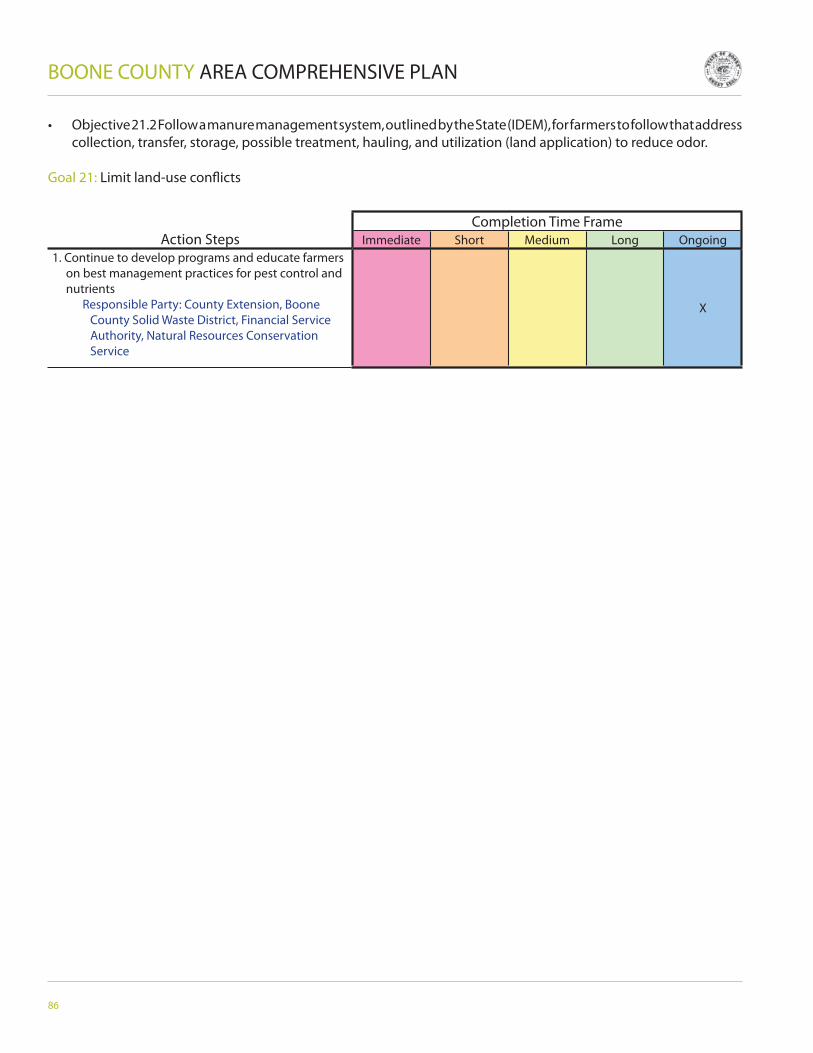
86
BOONE COUNTY AREA COMPREHENSIVE PLAN
Action StepsCompletion Time Frame
Immediate Short Medium Long Ongoing1. Continue to develop programs and educate farmers
on best management practices for pest control and nutrients
Responsible Party: County Extension, Boone County Solid Waste District, Financial Service Authority, Natural Resources Conservation Service
X
• Objective 21.2 Follow a manure management system, outlined by the State (IDEM), for farmers to follow that address collection, transfer, storage, possible treatment, hauling, and utilization (land application) to reduce odor.
Goal 21: Limit land-use confl icts

GOALS, OBJECTIVES, AND ACTION PLANS
87
Action StepsCompletion Time Frame
Immediate Short Medium Long Ongoing1. Develop a conservation easement program for the
agricultural area through guidelines and standards Responsible Party: Agriculture Taskforce
X
• Objective 21.3 Encourage farmers to adopt best management practices for nutrients and pest control in order to enhance soil and water quality.

88
BOONE COUNTY AREA COMPREHENSIVE PLAN
Action StepsCompletion Time Frame
Immediate Short Medium Long Ongoing1. Defi ne a streamline process to enforce setbacks Responsible Party: Boone County Area Plan
Commissioners, Agriculture TaskforceX X
2. Develop a punitive ordinance to cover the cost of removal of structures and plantings in setbacks
Responsible Party: Boone County Area Plan Commissioners, Agriculture Taskforce, Commissioners
X X
Goal 21: Limit land-use confl icts
• Objective 21.4 Establish a conservation easement program as another method to protect agricultural land.
Goal 21: Limit land-use confl icts

GOALS, OBJECTIVES, AND ACTION PLANS
89
Action StepsCompletion Time Frame
Immediate Short Medium Long Ongoing1. Review current zoning ordinance for residential
architectural standards Responsible Party: Staff , Boone County Area
Plan CommissionersX
2. Draft ordinance language for desired residential architectural standards
Responsible Party: Staff , Boone County Area Plan Commissioners, Ordinance Amendment Task group, Consultant, Building Inspector
X
3. Amend current zoning ordinance to refl ect desired architectural standards
Responsible Party: Staff , Boone County Area Plan Commissioners
X
4. Pass and adopt amendments to zoning ordinance Responsible Party: Staff , Boone County
Area Plan Commissioners, Boone County Commissioners
X
• Objective 21.5 Develop and enforce a county wide policy regarding agricultural setbacks to help minimize the im-pacts of tilling, fertilizing, and pesticide treatment.

90
BOONE COUNTY AREA COMPREHENSIVE PLAN
Action StepsCompletion Time Frame
Immediate Short Medium Long Ongoing1. Review current zoning ordinance for residential
landscaping standards Responsible Party: Staff , Boone County Area
Plan CommissionersX
2. Draft ordinance language for desired residential landscaping standards
Responsible Party: Staff , Boone County Area Plan Commissioners, Ordinance Amendment Task group, Consultant, Building Inspector
X
3. Amend current zoning ordinance to refl ect desired landscaping standards
Responsible Party: Staff , Boone County Area Plan Commissioners
X
4. Pass and adopt amendments to zoning ordinance Responsible Party: Staff , Boone County
Area Plan Commissioners, Boone County Commissioners
X
Goal 22: Improve appearance of residential subdivisions
• Objective 22.1 Incorporate anti-monotony provisions in the zoning ordinance.
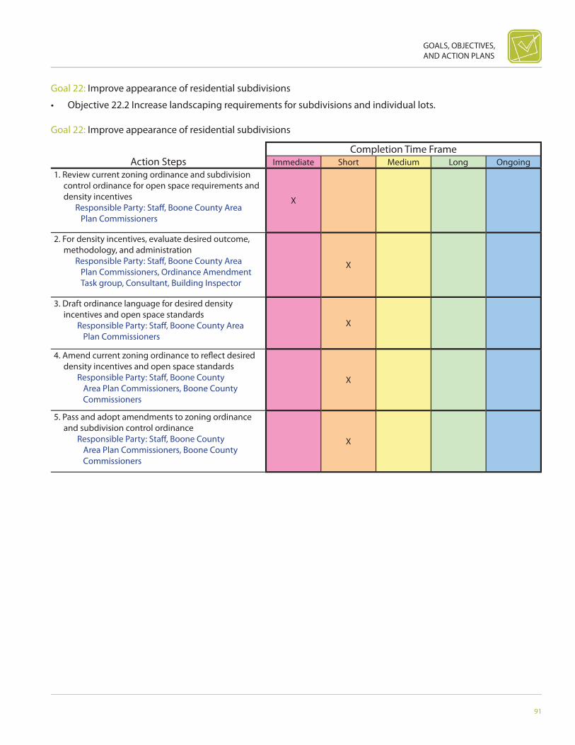
GOALS, OBJECTIVES, AND ACTION PLANS
91
Action StepsCompletion Time Frame
Immediate Short Medium Long Ongoing1. Review current zoning ordinance and subdivision
control ordinance for open space requirements and density incentives
Responsible Party: Staff , Boone County Area Plan Commissioners
X
2. For density incentives, evaluate desired outcome, methodology, and administration
Responsible Party: Staff , Boone County Area Plan Commissioners, Ordinance Amendment Task group, Consultant, Building Inspector
X
3. Draft ordinance language for desired density incentives and open space standards
Responsible Party: Staff , Boone County Area Plan Commissioners
X
4. Amend current zoning ordinance to refl ect desired density incentives and open space standards
Responsible Party: Staff , Boone County Area Plan Commissioners, Boone County Commissioners
X
5. Pass and adopt amendments to zoning ordinance and subdivision control ordinance
Responsible Party: Staff , Boone County Area Plan Commissioners, Boone County Commissioners
X
Goal 22: Improve appearance of residential subdivisions
• Objective 22.2 Increase landscaping requirements for subdivisions and individual lots.
Goal 22: Improve appearance of residential subdivisions

92
BOONE COUNTY AREA COMPREHENSIVE PLAN
Action StepsCompletion Time Frame
Immediate Short Medium Long Ongoing1. Review current zoning ordinance and subdivision
control ordinance for conservation subdivision standards
Responsible Party: Staff , Boone County Area Plan Commissioners
X
2. Evaluate methodologies for open space maintenance
Responsible Party: Staff , Boone County Area Plan Commissioners, Ordinance Amendment Task group, Consultant, Building Inspector
X
3. Draft ordinance language for conservation subdivision design standards
Responsible Party: Staff , Boone County Area Plan Commissioners
X
4. Amend current zoning ordinance and subdivision control ordinance to refl ect desired conservation subdivision design standards
Responsible Party: Staff , Boone County Area Plan Commissioners, Boone County Commissioners
X
5. Pass and adopt amendments to zoning ordinance and subdivision control ordinance
Responsible Party: Staff , Boone County Area Plan Commissioners, Boone County Commissioners
X
• Objective 22.3 Increase common, useful, and accessible open space requirements for subdivisions through open space standards and density incentives.

GOALS, OBJECTIVES, AND ACTION PLANS
93
Action StepsCompletion Time Frame
Immediate Short Medium Long Ongoing1. Review current zoning ordinance for contextual
architectural residential standards Responsible Party: Staff , Boone County Area
Plan CommissionersX
2. Establish methodology for determining contextual design elements to be incorporated into ordinance language
Responsible Party: Staff , Boone County Area Plan Commissioners, Ordinance Amendment Task group, Consultant, Local Realtors
X
3. Draft ordinance language for desired contextual standards
Responsible Party: Staff , Boone County Area Plan Commissioners, Ordinance Amendment Task group, Consultant
X
4. Amend current zoning ordinance to refl ect desired contextual standards
Responsible Party: Staff , Boone County Area Plan Commissioners
X
5. Pass and adopt amendments to zoning ordinance Responsible Party: Staff , Boone County
Area Plan Commissioners, Boone County Commissioners
X
Goal 22: Improve appearance of residential subdivisions
• Objective 22.4 Amend ordinances to include conservation subdivision standards.
Goal 23: Improve appearance of individual homes and dwellings.

94
BOONE COUNTY AREA COMPREHENSIVE PLAN
Action StepsCompletion Time Frame
Immediate Short Medium Long Ongoing1. Review current zoning ordinance for residential
architectural standards and materials Responsible Party: Staff , Boone County Area
Plan CommissionersX
2. Establish methodology for choosing desired building materials
Responsible Party: Staff , Boone County Area Plan Commissioners, Ordinance Amendment Task group, Consultant, Building Inspector
X
3. Draft ordinance language for desired residential architectural materials standards
Responsible Party: Staff , Boone County Area Plan Commissioners, Ordinance Amendment Task group, Building Inspector
X
4. Amend current zoning ordinance to refl ect desired architectural standards for materials
Responsible Party: Staff , Boone County Area Plan Commissioners
X
5. Pass and adopt amendments to zoning ordinance Responsible Party: Staff , Boone County
Area Plan Commissioners, Boone County Commissioners
X
• Objective 23.1 Develop basic architectural standards for residential subdivisions based upon context of geographic location surrounding uses.
Goal 23: Improve appearance of individual homes and dwellings.

GOALS, OBJECTIVES, AND ACTION PLANS
95
Action StepsCompletion Time Frame
Immediate Short Medium Long Ongoing1. Review current zoning ordinance and subdivision
control ordinance for multiple use standards, PUD requirements, and subdivision layout standards
Responsible Party: Staff , Boone County Area Plan Commissioners, Consultant
X
2. Establish a means of encouraging mixed-use and TND development methods instead of using PUD’s
Responsible Party: Staff , Boone County Area Plan Commissioners, Ordinance Amendment Task group, Consultant
X
3. Draft ordinance language for desired subdivision layout and mixed-use standards
Responsible Party: Staff , Boone County Area Plan Commissioners, Ordinance Amendment Task group, Consultant
X
4. Amend current zoning ordinance to refl ect desired mixed-use standards and the subdivision control ordinance for desired subdivision layout standards
Responsible Party: Staff , Boone County Area Plan Commissioners
X
5. Pass and adopt amendments to zoning ordinance and subdivision control ordinance
Responsible Party: Staff , Boone County Area Plan Commissioners, Boone County Commissioners
X
• Objective 23.2 Support and encourage developments that use a variety of building materials, colors, and architec-tural design that encourages the use of higher-quality building materials.
Goal 24: Encourage mixed use development and the fl exibility to create traditional neighborhood developments (TND).
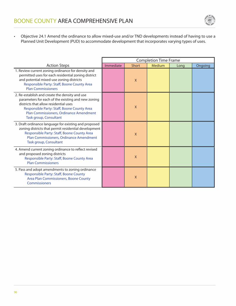
96
BOONE COUNTY AREA COMPREHENSIVE PLAN
Action StepsCompletion Time Frame
Immediate Short Medium Long Ongoing1. Review current zoning ordinance for density and
permitted uses for each residential zoning district and potential mixed-use zoning districts
Responsible Party: Staff , Boone County Area Plan Commissioners
X
2. Re-establish and create the density and use parameters for each of the existing and new zoning districts that allow residential uses
Responsible Party: Staff , Boone County Area Plan Commissioners, Ordinance Amendment Task group, Consultant
X
3. Draft ordinance language for existing and proposed zoning districts that permit residential development
Responsible Party: Staff , Boone County Area Plan Commissioners, Ordinance Amendment Task group, Consultant
X
4. Amend current zoning ordinance to refl ect revised and proposed zoning districts
Responsible Party: Staff , Boone County Area Plan Commissioners
X
5. Pass and adopt amendments to zoning ordinance Responsible Party: Staff , Boone County
Area Plan Commissioners, Boone County Commissioners
X
• Objective 24.1 Amend the ordinance to allow mixed-use and/or TND developments instead of having to use a Planned Unit Development (PUD) to accommodate development that incorporates varying types of uses.

GOALS, OBJECTIVES, AND ACTION PLANS
97
Action StepsCompletion Time Frame
Immediate Short Medium Long Ongoing1. Review current zoning ordinance, subdivision
control ordinance, and PUD requirements Responsible Party: Staff , Boone County Area
Plan
X X
2. Identify the characteristics of the desired housing types to accommodate the aging population
Responsible Party: Staff , Boone County Area Plan Commissioners, Ordinance Amendment Task group, Consultant, Building Inspector
X
3. Develop density incentives within the PUD process to encourage the development of desired housing
Responsible Party: Staff , Boone County Area Plan Commissioners, Ordinance Amendment Task group, Consultant
X
4. Draft ordinance language for the PUD process to support the desired housing
Responsible Party: Staff , Boone County Area Plan Commissioners, Ordinance Amendment Task group, Consultant
X
5. Amend the PUD portion of the current zoning ordinance and subdivision control ordinance to accommodate the development of the desired housing
Responsible Party: Staff , Boone County Area Plan Commissioners
X
6. Pass and adopt amendments to the PUD portion of the zoning ordinance and subdivision control ordinance
Responsible Party: Staff , Boone County Area Plan Commissioners, Boone County Commissioners
X
Goal 25: Encourage a variety of housing types.
• Objective 25.1 Amend the number of zoning districts to allow more housing that serves our varied populations.
Goal 25: Encourage a variety of housing types.

98
BOONE COUNTY AREA COMPREHENSIVE PLAN
Action StepsCompletion Time Frame
Immediate Short Medium Long Ongoing1. Review current zoning ordinance and subdivision
control ordinance for multiple residential use standards, PUD requirements, and subdivision layout standards
Responsible Party: Staff , Boone County Area Plan Commissioners
X
2. Establish a means of encouraging mixed-use residential development using the PUD process
Responsible Party: Staff , Boone County Area Plan Commissioners, Ordinance Amendment Task group, Consultant
X
3. Draft ordinance language for desired subdivision layout and mixed-use residential standards
Responsible Party: Staff , Boone County Area Plan Commissioners, Ordinance Amendment Task group, Consultant
X
4. Amend current zoning ordinance and subdivision control ordinance to refl ect desired mixed-use residential standards
Responsible Party: Staff , Boone County Area Plan Commissioners
X
5. Pass and adopt amendments to zoning ordinance and subdivision control ordinance
Responsible Party: Staff , Boone County Area Plan Commissioners, Boone County Commissioners
X
• Objective 25.2 Encourage the construction of housing stock to support an aging population by reviewing the PUD ordinance to make it a more reasonable option.
Goal 25: Encourage a variety of housing types.
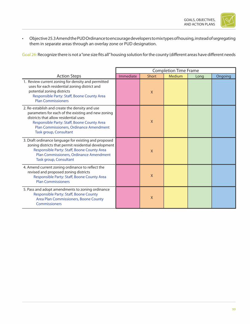
GOALS, OBJECTIVES, AND ACTION PLANS
99
Action StepsCompletion Time Frame
Immediate Short Medium Long Ongoing1. Review current zoning for density and permitted
uses for each residential zoning district and potential zoning districts
Responsible Party: Staff , Boone County Area Plan Commissioners
X
2. Re-establish and create the density and use parameters for each of the existing and new zoning districts that allow residential uses
Responsible Party: Staff , Boone County Area Plan Commissioners, Ordinance Amendment Task group, Consultant
X
3. Draft ordinance language for existing and proposed zoning districts that permit residential development
Responsible Party: Staff , Boone County Area Plan Commissioners, Ordinance Amendment Task group, Consultant
X
4. Amend current zoning ordinance to refl ect the revised and proposed zoning districts
Responsible Party: Staff , Boone County Area Plan Commissioners
X
5. Pass and adopt amendments to zoning ordinance Responsible Party: Staff , Boone County
Area Plan Commissioners, Boone County Commissioners
X
• Objective 25.3 Amend the PUD Ordinance to encourage developers to mix types of housing, instead of segregating them in separate areas through an overlay zone or PUD designation.
Goal 26: Recognize there is not a “one size fi ts all” housing solution for the county (diff erent areas have diff erent needs

100
BOONE COUNTY AREA COMPREHENSIVE PLAN
Action StepsCompletion Time Frame
Immediate Short Medium Long Ongoing1. Review current zoning for density and permitted
uses for each zoning district Responsible Party: Staff , Boone County Area
Plan Commissioners
X
2. Identify special focus areas of the county that would benefi t from new zoning districts
Responsible Party: Staff , Boone County Area Plan Commissioners, Ordinance Amendment Task group, Consultant, Community Groups, Local Realtors
X
3. Draft ordinance language for existing and proposed zoning districts that permit the desired types of development in the special focus areas
Responsible Party: Staff , Boone County Area Plan Commissioners, Ordinance Amendment Task group, Consultant
X
4. Amend current zoning ordinance and zoning map to refl ect the revised and proposed zoning districts
Responsible Party: Staff , Boone County Area Plan Commissioners
X
5. Pass and adopt amendments to zoning ordinance and zoning map
Responsible Party: Staff , Boone County Area Plan Commissioners, Boone County Commissioners
X
and expectations).
• Objective 26.1 Maintain a variety of residential zoning districts.
Goal 26: Recognize that there is not a “one size fi ts all” housing solution for the county (diff erent areas have diff erent
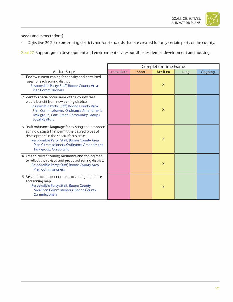
GOALS, OBJECTIVES, AND ACTION PLANS
101
Action StepsCompletion Time Frame
Immediate Short Medium Long Ongoing1. Review current zoning for density and permitted
uses for each zoning district Responsible Party: Staff , Boone County Area
Plan Commissioners
X
2. Identify special focus areas of the county that would benefi t from new zoning districts
Responsible Party: Staff , Boone County Area Plan Commissioners, Ordinance Amendment Task group, Consultant, Community Groups, Local Realtors
X
3. Draft ordinance language for existing and proposed zoning districts that permit the desired types of development in the special focus areas
Responsible Party: Staff , Boone County Area Plan Commissioners, Ordinance Amendment Task group, Consultant
X
4. Amend current zoning ordinance and zoning map to refl ect the revised and proposed zoning districts
Responsible Party: Staff , Boone County Area Plan Commissioners
X
5. Pass and adopt amendments to zoning ordinance and zoning map
Responsible Party: Staff , Boone County Area Plan Commissioners, Boone County Commissioners
X
needs and expectations).
• Objective 26.2 Explore zoning districts and/or standards that are created for only certain parts of the county.
Goal 27: Support green development and environmentally responsible residential development and housing.


LAND-USE PLAN

104
BOONE COUNTY AREA COMPREHENSIVE PLAN
INTRODUCTIONThe Future Land-Use Plan is intended to serve as a tool to guide growth in an orderly and desirable fashion and work in conjunction with other planning documents. The Plan should address the needs and concerns of the current residents of Boone County while striving to maintain and improve the quality of life for future residents.
Boone County’s landscape exhibits a primarily rural character. Agricultural fi elds and isolated woodlands are the dominant features with homes, business, and farm-related structures scattered throughout the countryside. The expansion of Indianapolis’ metropolitan area has created development pressure along the I-65 corridor and in the southeastern portion of the county. These growth pressures must be considered and addressed in conjunction with the availability of aff ordable land, large clusters of productive agricultural acreage, and the rural sense of community the county off ers. The rural character defi nes “quality of life” for the county’s residents. Current trends of non-agricultural rural development are often viewed as a threat to the character of a rural area. It is this rural character the Future Land-Use Plan must attempt to identify and protect. The Plan must also acknowledge that growth and development in Boone County will inevitably occur. Therefore, it is time for the County to assess their position on development and affi rm the management of future land development and growth.
The Future Land-Use Plan was created by a careful inventory and analysis of existing patterns of development. Existing development (or lack thereof ) refl ects past economic, market, and environmental conditions. This pattern of the past provides a point of reference from which to predict future development scenarios, based on recently identifi ed trends and market changes.
Formulating the Future Land-Use Plan for Boone County has been challenging, especially where residential uses and agricultural areas are concerned. The consensus has been that both residential and agricultural uses should be permitted to overlap in some areas. Residents realize that guiding future residential development growth to areas with necessary services (sewer, water, parks, schools, shopping, etc.) is preferable to the large-lot development occurring in the agricultural areas. Furthermore, locating commercial and industrial development along major corridors and in proximity to established commercial centers will ultimately reduce the impact on roadways and county services.
The preferred locations of the diff erent land uses in the plan are based on existing land uses, past development trends, anticipated changes, community input, and the goals and objectives that were developed. In addition, the Land-Use Plan builds on the goals and objectives of the residents of Boone County and identifi es the preferred land development patterns. The Plan was developed to ensure future land uses are compatible and, therefore, acts as the policy guide for future development.
When using the Future Land-Use Plan as a guide to changing land uses and future development, additional factors need to be taken into consideration. Public sewer and water, proximity to incorporated areas, access to adequate roadways, availability of safety services and schools all foster smart growth. Development standards that incorporate these desirable factors should be incorporated into the Zoning Ordinance in order to determine the appropriateness of proposed growth in the decision making process.
IDENTIFIED LAND USE CATEGORIESOf the many land uses present in Boone County, there are seven primary categories:
• Agriculture• Residential• Institutional

LAND-USE PLAN
105
Existing Land Use Distribution within Boone County Planning Jurisdiction
Agriculture, 92.3%
Residential, 5.9%
Commercial, 1.2%
Industrial, 0.2%
Open Space/Recreation, 0.4%
Public/Semi-public, 0.0%
Source: Boone County Property Tax Records
• Open Space• Mixed Use• Commercial• Industrial• Airports
EXISTING LAND USEIn order to plan for the future, it is crucial we know what existing land uses are currently on the ground. This existing land-use research provides us with a good understanding of what land is available for development and what the existing mix of land uses are. Boone County Area Plan Commission staff completed an existing land-use study in 2007 that used the County’s tax records as a starting point for GIS mapping. The existing land-use map documented that 92.3% of the land within the county’s planning jurisdiction is currently used for agriculture. The study also revealed the majority of the developed land within the county is currently single-family residential land use. The total acreage for existing land use was calculated for the following land-use categories: agricultural, residential, commercial, industrial, public/semi-public, and parks/recreation.
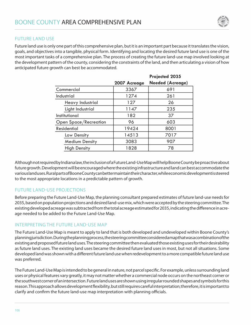
106
BOONE COUNTY AREA COMPREHENSIVE PLAN
2007 AcreageProjected 2035 Needed (Acreage)
3367 6911274 261
Heavy Industrial 127 26Light Industrial 1147 235
182 3796 603
19424 8001Low Density 14513 7017Medium Density 3083 907High Density 1828 78
Commercial
ResidentialOpen Space/RecreationInstitutional
Industrial
FUTURE LAND USEFuture land use is only one part of this comprehensive plan, but it is an important part because it translates the vision, goals, and objectives into a tangible, physical form. Identifying and locating the desired future land use is one of the most important tasks of a comprehensive plan. The process of creating the future land-use map involved looking at the development pattern of the county, considering the constraints of the land, and then articulating a vision of how anticipated future growth can best be accommodated.
Although not required by Indiana law, the inclusion of a Future Land-Use Map will help Boone County be proactive about future growth. Development will be encouraged where the existing infrastructure and land can best accommodate the various land uses. Rural parts of Boone County can better maintain their character, while economic development is steered to the most appropriate locations in a predictable pattern of growth.
FUTURE LAND-USE PROJECTIONSBefore preparing the Future Land-Use Map, the planning consultant prepared estimates of future land-use needs for 2035, based on population projections and desired land-use mix, which were accepted by the steering committee. The existing developed acreage was subtracted from the total acreage estimated for 2035, indicating the diff erence in acre-age needed to be added to the Future Land-Use Map.
INTERPRETING THE FUTURE LAND-USE MAPThe Future Land-Use Map is meant to apply to land that is both developed and undeveloped within Boone County’s planning jurisdiction. During the planning process, the steering committee considered a map that was a combination of the existing and proposed future land uses. The steering committee then evaluated those existing uses for their desirability as future land uses. The existing land uses became the desired future land uses in most, but not all situations. Some developed land was shown with a diff erent future land use when redevelopment to a more compatible future land use was preferred.
The Future Land-Use Map is intended to be general in nature, not parcel specifi c. For example, unless surrounding land uses or physical features vary greatly, it may not matter whether a commercial node occurs on the northeast corner or the southwest corner of an intersection. Future land uses are shown using irregular rounded shapes and symbols for this reason. This approach allows development fl exibility, but still requires careful interpretation; therefore, it is important to clarify and confi rm the future land-use map interpretation with planning offi cials.
LAND-USE PLAN
107
PROPOSED FUTURE LAND USES
AgricultureAgriculture remains the largest land use on the Future Land-Use Plan. Agricultural areas are identifi ed on the Future Land-Use Map as Production Agriculture and General Agriculture. These areas were identifi ed to conserve the rural character in the unincorporated areas of the county, as well as to protect farming operations.
Production Agriculture -- The production agriculture designation has been applied to areas recommended for traditional farming practices, such as crop production, livestock (grazing and confi ned animal feeding operations), agricultural production and storage centers (such as grain elevators); agricultural research; stables, wineries, and other natural and food production-related activities. Production agriculture areas were mapped so they were not fronting on the county’s major roads, leaving that frontage open for other development. It is not intended that new residential development will occur within production agriculture areas, with the exception of farmsteads and minor subdivisions, provided condition such as adequate access and safety services are present. Existing residential lots containing single-family housing units could also have agricultural-related uses, such as stables and small-scale, non-commercial food production, and limited livestock production. Activities characterized as agri-tourism (farmers’ markets and roadside stands) may also be in these areas.
General Agriculture -- The general agriculture areas are intended to serve as buff ers between medium- or high-intensity land uses, and the relatively low-intensity residential uses. These areas will allow both continued farming and some residential development that may occur on well and septic. General agricultural areas are not intended to include intensive agricultural uses, such as confi ned feeding. All new residential development will need to be accepting of adjacent agricultural uses.
ResidentialThe overall character of both existing and future residential development in Boone County is low density (less than one dwelling unit per acre), single family. Residential areas adjacent to (or within) corporate limits are considered more appropriate for moderate-density (one to three dwelling units per acre) to high-density (more than three dwelling units per acre) development simply because of their proximity to existing utility services.
Low-Density Residential -- The low-density residential areas are intended to be primarily single-family development, with less than one dwelling unit per acre, but may also include institutional uses, such as civic, church, and educational facilities, or may contain neighborhood serving mixed-use developments. These areas radiate out to areas of anticipated growth without “leapfrogging” over agricultural land. Development should occur near established areas where new residents can work, shop, and play, and should not rely on well and septic systems. Conservation subdivisions are an appropriate type of development when the low-density residential site includes natural areas that can be preserved, including such things as riparian areas, wetlands, and woodlots.
Medium-Density Residential -- The medium-density areas are characterized by smaller-lot subdivisions (one to three dwelling units per acre) that contain single-family dwellings and some duplexes. Medium density residential requires suffi cient access to goods and services, transportation, parks and open spaces, and is located near incorporated cities and towns that may eventually include these subdivisions. Medium density residential development should have a high level of connectivity to adjacent residential and non-residential uses. These areas of medium density often serve as transitional areas between low-density residential and more intensive commercial or institutional activities. Development in these areas should only occur with public water and public sewer and on adequate roads.
High-Density Residential -- The high-density residential classifi cation supports more than three dwelling units per acre and is limited generally to a few areas on the outer edges of incorporated communities. Proximity to incorporated areas is critical because existing infrastructure, safety services, access, and public utilities are already in place to serve this type of development. Furthermore, high-density residential is one of the key components to mixed-use developments. It is anticipated these sites will be adequate for future high-density residential needs of the community, providing sites

108
BOONE COUNTY AREA COMPREHENSIVE PLAN
for a wide range of residential development, including smaller lot single-family, zero-lot line, townhouses, duplexes, and apartment complexes. Development in this area should only occur with public water and public sewer and on adequate roads.
InstitutionalThis classifi cation includes areas for public or semi-public uses, such as facilities for government, private, and public schools, religious organizations, correctional institutions, libraries, medical facilities, emergency services, and civic or social organizations. These uses are scattered throughout the county but are generally located in or near existing incorporated areas. While these uses generally do not consume large amounts of land, it is important to plan for expansion of existing facilities or new institutional areas, because these uses expand in response to residential, commercial, and industrial growth. New institutional facilities should be built to architectural, lighting, landscaping, and site design standards that refl ect the desired character of the area where they are located.
Open Space
Open space areas on the Future Land-Use Map represent land that is not intended or suitable for development, other than for agricultural and recreation activities where appropriate. Open space areas include sensitive environmental areas such as wetlands and land within the 100-year fl oodplain.
Parks and Recreation -- Parks can include both active and passive recreational areas, which may be either publicly or privately owned. Sports fi elds would be considered “active,” while nature parks containing trails, picnic areas, and grassy open spaces are passive. Parks may be publicly owned by local government or privately owned (i.e., by a homeowners association or a recreation business). Some non-profi t organizations may also own park or recreation areas (i.e., club soccer fi elds or ball fi elds). Not all appropriate park locations have been shown on the Future Land-Use Map. Off ers of donations of other large parcels of land should be considered for future park development.
Greenways -- Greenways are a system of publicly owned trails and open space connected throughout the county. Trails may be existing or proposed and typically intended for bicycle and pedestrian use (“hard” surface), but some rural trails (“soft” surface) may also support horses. Land designated for greenways may include property in fl oodplains and other environmentally sensitive areas. Shared utility easements and trails may also be considered. Greenways should connect to existing and proposed parks and town or city trail systems whenever possible.
Conservation Areas -- This designation refers to lands unsuitable for development due to the potential impact of development on the environment. Conservation areas may be publicly or privately owned and may also be owned by non-profi t organizations. These areas include many diff erent types of natural features, such as fl oodways, wetlands, woodlands, and riparian areas. The conservation designation helps protect environmentally sensitive natural features from potential negative impacts, such as pollution, sedimentation, and erosion. It also promotes the safety and protection of private investment and property in fl ood-prone areas or areas that may present other natural hazards. There should be minimal development in or near the fl oodplains. Adjacent land-use designations should provide areas of transition or buff ers between the conservation areas and more intense development. No conservation areas have been shown on the Future Land-Use Map at this time, allowing property owners the ability to designate their land as a conservation area in the future.
Mixed UseMixed-use developments can produce new and unique nodes in a community that can have the added benefi t of reducing traffi c and providing for a variety of land uses. By integrating diff erent uses such as residential, offi ces, and retail, many daily vehicle trips can be eliminated or reduced in length. Furthermore, mixed-use development generates a type of community that integrates various land uses and housing types to create a form more like the downtowns of the past rather than dominated suburbs we have come to know. Ideally, mixed-use communities allow residents to walk to shops, schools,
LAND-USE PLAN
109
places of worship, and parks. Zoning often prohibits this type of development, but Boone County has the opportunity to adopt new zoning codes to permit it.
The mixed-use, land-use classifi cation strives to integrate a mix of land uses to keep residential and non-residential lands in balance for a variety of reasons, including increasing quality of life, maintaining housing aff ordability, reducing vehicular traffi c, and generating tax revenues for existing and future services and facilities. Mixed-use areas may be either new “greenfi eld” type development, in the form of “new town” or Anson-type developments, or may occur by further developing existing incorporated areas or highway and major thoroughfare corridors. It is intended mixed-use development conform to traditional neighborhood development (TND) principles, such as connectivity, promotion of pedestrian-oriented transportation, and increased commercial and residential density. Development of mixed-use areas should not occur without public water and public sewer.
The mixed-use designation may be applied to any mix of land uses. Typically mixed use includes a commercial center and residential areas, such as those seen within small towns, but mixed use may also include any combination of open space, institutional, residential, commercial, industrial, and agricultural uses that are compatible with each other and the surrounding land uses. In addition to land-use compatibility, scale and patterns of the mix of uses must be compatible to succeed.
New mixed-use development should occur where public utilities are available and where adequate infrastructure and support services are in place. While the Future Land-Use Map shows new areas of mixed-use development, additional areas may be added in the future, when conditions warrant. It is not intended that new mixed-use development “leapfrog” into undeveloped areas of Boone County.
Existing small towns in Boone County are good candidates for revitalization and are a major component of the county’s rural identity. Mixed-use infi ll development, including small parks, schools, churches, neighborhood-serving businesses, single-family and multi-family residences should be encouraged in the small towns, as long as they are compatible uses and respect the traditional/historic scale and pattern of the area. Developers and residents are encouraged to rehabilitate existing structures and residences whenever possible.
Commercial
Future commercial development is located along major thoroughfares and intersections, adjacent to existing commercial uses and as smaller-scale nodes in mixed use or residential areas. All commercial development should occur on public utilities.
Commercial -- Commercial areas are typically located along areas of heavy vehicular traffi c, on major road corridors and at major intersections. These areas contain goods and services to serve the needs of the county, including such things as convenience and grocery stores, “big box” retail, shopping centers, and restaurants. Commercial development has a big impact on the small town and county image, prompting the need for high-quality development standards, including site design, building materials, architecture, landscaping, and signage. Controlled access, frontage roads, and synchronized traffi c signals along major road corridors should be used to mitigate traffi c congestion and safety concerns.
Commercial Node -- These are smaller scale commercial areas intended to serve only the surrounding area’s needs, not the needs of the entire community. Commercial nodes do not have to be located at major intersections or on major road corridors as long as adequate attention is given to access and circulation. Buildings and sites are expected to be smaller in scale, but should still adhere to development standards. The County is encouraged to allow for additional small, commercial nodes in and amongst residential areas that would include personal services and convenience stores compatible with the neighborhood character to reduce trip generation. It is not intended that shopping centers or “big box” retailers be allowed within commercial nodes.
110
BOONE COUNTY AREA COMPREHENSIVE PLAN
IndustrialFuture industrial development includes both light- and heavy-industrial uses and should be located near existing industrial areas that have interstate and/or rail access. These high-intensity areas should be protected from the encroachment of other land uses in order to preserve economic viability, but at the same time, must provide buff ers to lessen their impact and make them more compatible with adjacent land uses. Special attention should be given to traffi c management, particularly relative to truck traffi c. All industrial development should occur on public utilities.
Light Industrial -- Light industrial uses include manufacturing, bulk warehousing, and distribution, where all activities take place inside a building and there is no outside storage. Light industrial is typically located along major road corridors, such as I-65, and in business parks designated for industrial.
Consideration should be given to adequate utilities, road access and classifi cation and possibly rail access. State-of-the-art technology, such as fi ber optics, is also important. Light industrial development is generally incompatible with residential uses due to traffi c, hours of operation, etc., and should be well buff ered from adjacent uses. Views of truck loading, truck parking, service bays, dumpster, recycling, and storage facilities should be screened from roadways.
Heavy Industrial -- Heavy industrial includes more intense industrial uses, which may also include outside storage and operations. Considerations are similar to those of light industrial; however, higher impacts from noise, odor, etc., should be expected. Heavy industrial uses should generally only be located so they have direct access to major thoroughfares. Larger buff ers from adjacent land uses are required. Heavy industrial uses should always be considered incompatible with residential uses. It is important to screen all areas of outside storage and operations from adjacent land uses and surrounding roadways.
AirportsBoone County has two existing airports, which are expected to remain in operation. No new airports are anticipated. When making land use decisions regarding expansion of the airport and development surrounding the airport, land-use compatibility, the impact on existing uses, residential density, land-use intensity, noise (also beyond the boundary of an airport), and general safety should all be considered.
The Boone County Airport is intended for less intensive use, both in frequency of use and size of aircraft. The Boone County Airport may be appropriate for new residential development, especially in the form of an aviation subdivision that is a residential area targeted to people who own and pilot small aircraft.
DRAFTING THE FUTURE LAND-USE MAPThe consultants conducted a work session with steering committee members, where they were divided into two teams and given colored dots in a quantity scaled to represent the additional amount of land needed in each category. They were asked to place these dots on existing land-use maps. Teams were also given colored markers to draw in missing road connections and trails.
Each of the two teams approached the task diff erently. One group fi rst identifi ed agricultural lands to preserve, as well as potential parkland and trail locations before placing new development. The other team initially identifi ed prime locations for commercial, industrial, and residential development before moving to parks and agricultural preservation. When the two teams compared their maps, they were remarkably similar. Each group then presented their proposals that served as a starting point for a discussion of future land use. Both alternatives had the following in common.
• New residential development clustered near existing development and where infrastructure will be available to support it. This was primarily adjacent to existing municipalities in the county.
• Mixed use as redevelopment and infi ll for existing municipalities and new mixed use located near major cross-roads and where utilities are available.
LAND-USE PLAN
111
• Trails along abandoned railroad right-of-way• Light industrial/commercial uses around Indianapolis Executive Airport and Anson development• Neighborhood commercial near single-family areas• Parks located near residential areas, areas with trail opportunities and sensitive areas declared by fl oodplains• More dense development in the southeast quadrant of the county and surrounding Lebanon• Agricultural protection shown as large areas in the western and northern portions of the county
The steering committee then directed the consultants to prepare a draft Future Land-Use Map that coordinated and combined the concepts of both groups on one single map. The consultants reference the Comprehensive Plans of the incorporated areas within the county to coordinate the land uses adjacent to town and city limits. The steering committee then further refi ned that draft to arrive at the resulting Future Land-Use Map.
FUTURE LAND-USE MAPThe Future Land-Use Map is an indispensable tool for all sectors of the community and all levels of government. The County can invest public infrastructure dollars more wisely if the location and magnitude of anticipated growth is identifi ed. The Future Land-Use Map will also enable individual citizens to be more aware of how Boone County and its participating communities will develop, assisting them in making more informed decisions about where to live and even where to work.
The private sector can also benefi t from the Future Land-Use Map. Businesses can use the map to make accurate growth projections and better position themselves to meet the needs of the future population. In addition, the Future Land-Use Map will provide developers and landowners with a clear idea of the location and type of development desired by the community, saving them both time and money in assembling development plans.
Center TownshipCenter Township is dominated by the City of Lebanon, I-65, and the interstate’s four interchanges. The small town of Ulen is also located within this area, although it is totally surrounded by Lebanon. The Lebanon corporate limits defi ne development on the south and west sides. Prairie Creek fl oodplain acts as a barrier to growth to the southeast. The northern and northeastern boundaries of Lebanon have seen the most recent growth. Development within this area has extended beyond the city limits and is characterized by strip residential lots along SR 39, Witt Road, CR 150 W, John Bart Road, and Elizaville Road. Lot sizes are typically small and homes front directly onto these roadways. Subdivision and strip lot development is also occurring along CR 250 N and CR 300 N on the north side of Lebanon.
The four interchanges along I-65 off er excellent access to Lebanon, as well as the unincorporated areas directly to the south. Unfortunately, interchange development has been unorganized and misdirected.
The presence of Lebanon and the I-65 corridor have a great impact on the proposed land uses in this area. The fl oodplain of Prairie Creek has limited existing development and acts as a barrier to new development northwest of Lebanon. New residential development around the city of Lebanon should occur adjacent to established residential areas.
Center Township and Lebanon provide good access for commercial uses and large tracts of undeveloped land. The Prairie Creek fl oodplain acts as a natural buff er for proposed residential development to the east. Development standards or planned development zoning should be implemented in this area to mitigate any negative impacts of new commercial or industrial development.
The Boone County Airport to the south of Lebanon is a smaller, recreational airport that serves as a resource to agricultural, industrial, and commercial uses in and around the county. As shown on the Land-Use Map, this airport may be appropriate for new residential and mixed-use residential development, especially in the form of an aviation subdivision that is a residential area targeted to people who own and pilot small aircraft. Specifi c development standards and land-use requirements should be incorporated into any expansion or new development in or around the airport.
112
BOONE COUNTY AREA COMPREHENSIVE PLAN
Mixed-use development is proposed in several areas around the perimeter of Lebanon. Industrial and commercial development is expected to continue on the west side in conjunction with the expansion of the existing business park. Mixed-use development that is composed of high-density residential, commercial, and recreational uses is anticipated on the north and southeast sides of Lebanon. Proximity to local highways and I-65 makes these areas readily accessible and practical for this type of development.
Annexation is generally a priority for a town. As mentioned in the Goals and Objectives section of the Comprehensive Plan, the coordination between Town and County offi cials for establishing a policy and guidelines for annexation is encouraged. Public offi cials from Lebanon should work together with Boone County offi cials to ensure the Boone County Comprehensive Plan will be taken into consideration when forming their annexation policy.
The remaining portions of Center Township are proposed to be retained as agricultural land uses. Farmlands within this area will continue to experience development pressures associated with Lebanon and interstate access. Agriculture-related businesses should be allowed to operate and expand in these areas to serve farming operations.
Æ_
Æ_
Æ_
Æ_
Æ_
Æ_
Æ_Lebanon
LegendTownship
Corporate BoundariesArea Plan Commission
Incorporated Area
Whitestown
TransportationInterstate
Major Arterial
Major Collector
Minor Collector
Proposed Road
Local Roads
Proposed Trails
Railroad
Rivers
Future Land UseMixed Use
Residential - low
Residential - medium
Residential - high
Commercial
Light Industrial
Heavy Industrial
Ag Production
Æ_ Parks/Recreation
Ag General
Airport District
Landfill
´
Center TownshipFuture Land Use
0 7,000Feet
¬«39¬«52
¬«32
¬«39
¬«32
Refer to Whitestown Comprehensive Plan
for Land Use
Proposed Bypass
Boone County Airport

LAND-USE PLAN
113
Æ_
Æ_
Æ_
Æ_
Æ_
Æ_
Æ_
Zionsville
§̈¦865
¬«334
¬«421
LegendTownship
Corporate BoundariesArea Plan Commission
Incorporated Area
Whitestown
TransportationInterstate
Major Arterial
Major Collector
Minor Collector
Proposed Road
Local Roads
Proposed Trails
Railroad
Rivers
Future Land UseMixed Use
Residential - low
Residential - medium
Residential - high
Commercial
Light Industrial
Heavy Industrial
Ag Production
Æ_ Parks/Recreation
Ag General
Airport District
Landfill
´
Eagle TownshipFuture Land Use
0 4,000Feet
Eagle and Union TownshipsEagle and Union Townships have continued to experience the most intense development pressure in Boone County, due to their proximity to Indianapolis and the access from I-65 and US Hwy 421. Zionsville exhibits an attractive small-town atmosphere, and the surrounding area boasts rural scenery including rolling hills, streams and fl oodplains, roads lined with mature trees, and the horse farms southwest of town. Whitestown has greatly expanded their town boundaries in recent years, and while part of the area plan commission, has developed their own comprehensive plan.
The landscape within Eagle and Union townships exhibits a scenic character with rolling hills, wooded stream fl ood plains, and tree-lined county roads. The fl ood plains of Big and Little Eagle Creeks and their accompanying tributaries have limited development along the northeast side of Zionsville but provide a network of available open space, particularly connecting Union Township with Eagle Township and Zionsville. The fl oodplain of Fishback Creek creates open space links between southeast Boone County and northern Marion County that should be preserved as potential greenways connecting developed areas. A portion of the abandoned Penn Central Railroad line through Zionsville has been developed as a linear trailway. Eff orts should be made to expand this trailway along the abandoned railroad right-of-way to the northwest connecting Zionsville with Whitestown and eventually linking with Lebanon.

114
BOONE COUNTY AREA COMPREHENSIVE PLAN
The desirability of the rural, small-town character and quality of life of the area combined with ease of access to two townships has created a brisk real estate market for new residential development. Many new homes in the area surrounding Zionsville tend to be high priced compared to other areas of the county. Strip residential development has occurred along a number of the rural roads creating safety and traffi c concerns. Sanitary sewer availability from Zionsville and especially from Whitestown has contributed to more residential development.
New residential areas are proposed throughout these two townships adjacent to existing residential development. With respect to undeveloped property in Eagle and Union Townships that is currently adjacent to land developed at 1.75 dwelling units per acre or less, the new development should be consistent with that existing density. Public input strongly supports new residential development and should respect the unique rural and natural character of the area. A variety of open space preservation techniques should be employed to insure new development respects the existing scenic features of the landscape.
As one of the leading towns experiencing growth in Boone County, Zionsville is expected to continue to grow. As mentioned in the Goals and Objectives section of the Comprehensive Plan, the coordination between Town and County offi cials for establishing a policy and guidelines for annexation is encouraged. Public offi cials from Zionsville should work together with Boone County offi cials to ensure the Boone County Comprehensive Plan will be taken into consideration when forming their annexation policy for future growth.
Landfill
´
UnionTownshipFuture Land Use
0 4,000FeetÆ_
Æ_Æ_
Æ_Æ_¬«32
LegendTownship
Corporate BoundariesArea Plan Commission
Incorporated Area
Whitestown
TransportationInterstate
Major Arterial
Major Collector
Minor Collector
Proposed Road
Local Roads
Proposed Trails
Railroad
Rivers
Future Land UseMixed Use
Residential - low
Residential - medium
Residential - high
Commercial
Light Industrial
Heavy Industrial
Ag Production
Æ_ Parks/Recreation
Ag General
Airport District
¬«421
Indianapolis Executive
Airport
Special Interest Area

LAND-USE PLAN
115
Landfill
´
Perry TownshipFuture Land Use
0 4,000Feet
Whitestown
¬«267
LegendTownship
Corporate BoundariesArea Plan Commission
Incorporated Area
Whitestown
TransportationInterstate
Major Arterial
Major Collector
Minor Collector
Proposed Road
Local Roads
Proposed Trails
Railroad
Rivers
Future Land UseMixed Use
Residential - low
Residential - medium
Residential - high
Commercial
Light Industrial
Heavy Industrial
Ag Production
Æ_ Parks/Recreation
Ag General
Æ_
Æ_
Æ_
Æ_
Airport District
Refer to Whitestown Comprehensive Plan
for Land Use
§̈¦65
Proposed Ronald Reagan Parkway
The intersection of Highways 421 and 334 serves as an entry corridor into Zionsville. New commercial and mixed-use development should be restricted to the east side of US 421. New development should follow the US 421 overlay standards.
Mixed-use commercial and industrial development is proposed in the southeast corner of Eagle Township, along I-65 and adjacent to Marion County. This mixed-use development should be restricted to the east side of the creek. This area provides good transportation access, open land, and available utilities necessary for industrial development.
The Indianapolis Executive Airport (formerly Terry Airport) in eastern Union Township provides an excellent resource to industrial and commercial uses in and around Boone County. The airport has experienced substantial growth due to the overfl ow of general aviation uses from Indianapolis International Airport. The capacity of this airport, its proximity to surface transportation to Indianapolis along SR 421 and US 31, and existing area commercial and industrial land uses provide the perfect opportunity for mixed-use development to occur around the airport with focus on additional commercial and industrial opportunities. Specifi c development standards and land-use requirements that help protect existing property values, promotes the health and safety of the surrounding areas while accommodating future airport expansion should be incorporated into any type of growth and new development in or around the airport.
Perry and Worth Townships

116
BOONE COUNTY AREA COMPREHENSIVE PLAN
Landfill
´
Worth TownshipFuture Land Use
0 4,000Feet
¬«32 LegendTownship
Corporate BoundariesArea Plan Commission
Incorporated Area
Whitestown
TransportationInterstate
Major Arterial
Major Collector
Minor Collector
Proposed Road
Local Roads
Proposed Trails
Railroad
Rivers
Future Land UseMixed Use
Residential - low
Residential - medium
Residential - high
Commercial
Light Industrial
Heavy Industrial
Ag Production
Æ_ Parks/Recreation
Ag General
Æ_
Æ_
Æ_
Airport District
Prop
osed
Byp
ass
Refer to Whitestown Comprehensive Plan for
Land Use
§̈¦65
These townships occur in the southeast portion of the County and are both well served by the interchange at I-65 and SR 267. Perry Township also has access to the SR 334 interchange at I-65. This area exhibits a primarily rural character with large expanses of agricultural fi elds bisected occasionally by wooded stream banks and drainage ditches.
Whitestown is located approximately three and one half miles east of the SR 267 interchange at I-65 and three and one half miles north of the I-65 and SR 334 interchange within Worth Township. While access to the interchange from this community is poor along CR 300 S and CR 400 E, access from SR 334 has been established.
Medium-density residential development surrounding Whitestown should continue to occur adjacent to existing infrastructure, and strip residential growth should be discouraged within Worth Township.
Buff ering between diff ering land uses, utilization of open space, and agricultural land preservation should be incorporated into development in this area to refl ect its rural character. Expansion of strip-lot development should be discouraged due to aesthetic and safety service concerns.
Development areas are shown at the interchanges of I-65 with both SR 267 and SR 334. Mixed-use development with residential and commercial land uses, as well as medium- and high-density residential development, is located next to areas with existing infrastructure.
Agricultural uses continue to dominate Perry and Worth Townships. Eff orts should be made to provide for the sustained production of agricultural products within this area. Uses other than farm-related residential development should be discouraged on prime agricultural soils.

LAND-USE PLAN
117
Whitestown has expanded signifi cantly over the last few years and it is expected to continue to grow. As mentioned in the Goals and Objectives section of the Comprehensive Plan, the coordination between Town and County offi cials for establishing a policy and guidelines for annexation is encouraged. Public offi cials from Whitestown should work together with Boone County offi cials to ensure the Boone County Comprehensive Plan will be taken into consideration when forming their annexation policy.
The intersection of SR 267 and I-65 where Worth Township, Perry Township, and northwest Whitestown adjoin each other is shown as an area prime for development. Community commercial and residential uses make up the anticipated mixed-use development suggested for this area. Future changes in the Thoroughfare Plan are contemplated for this area, including a proposed bypass around Whitestown and a proposed trail system. These elements would compliment mixed-use development by providing for recreational opportunities and desirable access to Lebanon, Chicago, and Indianapolis along I-65.
The extension of the proposed new Ronald Reagan Parkway from Hendricks County will provide an important new north/south connection. A trail should be included along the Parkway connecting with other trails throughout the County that will eventually connect the diff erent park districts. New medium-residential development is planned on the east side of the street, with commercial development proposed farther north. It is important development standards are adopted for this corridor, and all new development meets these standards. Hendricks County’s Ronald Reagan Parkway Master Plan and Model Ordinance may serve as a starting point for creation of those standards for Boone County.
118
BOONE COUNTY AREA COMPREHENSIVE PLAN
Jackson, Jeff erson, and Harrison TownshipsThese three rural townships occupy the southwest portion of the county. This area is characterized by large open farm fi elds with creeks draining to the south and west. I-74 crosses the southwest corner of the county in this area for a length of only seven miles. An interchange with SR 75 allows access to Jamestown, which lies just south of I-74. An active Conrail and Amtrak rail line bisects Jamestown and parallels US 136.
The small communities of Advance and Dover provide housing and limited commercial development, although growth in these areas appears to be increasing. Western Boone High School is located adjacent to Dover in Jeff erson Township and provides a focus for area educational and social activities.
Medium-density residential development is likely to occur in Advance within the existing city limits. Residential, commercial, and mixed-use development is anticipated adjacent to Jamestown along SR 75. This area is well-served by transportation links of SR 234, US 136, and SR 75. Strip residential development should be discouraged to preserve the rural character of the area.
Landfill
´
Jackson TownshipFuture Land Use
0 6,000Feet
Æ_
Æ_
Jamestown
Advance
§̈¦74
¬«234
¬«136
¬«75 LegendTownship
Corporate BoundariesArea Plan Commission
Incorporated Area
Whitestown
TransportationInterstate
Major Arterial
Major Collector
Minor Collector
Proposed Road
Local Roads
Proposed Trails
Railroad
Rivers
Future Land UseMixed Use
Residential - low
Residential - medium
Residential - high
Commercial
Light Industrial
Heavy Industrial
Ag Production
Æ_ Parks/Recreation
Ag General
Airport District

LAND-USE PLAN
119
Landfill
´
Harrison TownshipFuture Land Use
0 4,000Feet
¬«39
LegendTownship
Corporate BoundariesArea Plan Commission
Incorporated Area
Whitestown
TransportationInterstate
Major Arterial
Major Collector
Minor Collector
Proposed Road
Local Roads
Proposed Trails
Railroad
Rivers
Future Land UseMixed Use
Residential - low
Residential - medium
Residential - high
Commercial
Light Industrial
Heavy Industrial
Ag Production
Æ_ Parks/Recreation
Ag General
Airport District
The fl oodplain corridors of Big Walnut Creek and Big Raccoon Creek should be preserved to ensure continued fl ood control and drainage within the southwestern portion of the county. Agricultural areas dominate most of this three-township area. Sustained agricultural development should be encouraged and non-farm-related residential development should be discouraged on prime agricultural soils.
Buff ering between diff ering land uses, utilization of open space, and agricultural land preservation should be incorporated into development in this area to refl ect its rural character. Expansion of strip-lot development should be discouraged due to aesthetic and safety service concerns.
As growth is guided toward incorporated areas, it is likely the Town of Advance and the Town of Jamestown will expand. As discussed in the Goals and Objectives section of the Comprehensive Plan, the coordination between Town and County offi cials for establishing a policy and guidelines for annexation is encouraged. Public offi cials from Advance and Jamestown should work together with Boone County offi cials to ensure that when the respective town is ready to expand, the Boone County Comprehensive Plan will be taken into consideration as part of the decision-making process.
120
BOONE COUNTY AREA COMPREHENSIVE PLAN
Landfill
´
Jefferson TownshipFuture Land Use
0 6,000Feet
Æ_
Æ_
Æ_
Ad
¬«32
¬«75
¬«52Legend
Township
Corporate BoundariesArea Plan Commission
Incorporated Area
Whitestown
TransportationInterstate
Major Arterial
Major Collector
Minor Collector
Proposed Road
Local Roads
Proposed Trails
Railroad
Rivers
Future Land UseMixed Use
Residential - low
Residential - medium
Residential - high
Commercial
Light Industrial
Heavy Industrial
Ag Production
Æ_ Parks/Recreation
Ag General
Airport District

LAND-USE PLAN
121
Landfill
´
Marion TownshipFuture Land Use
0 6,000Feet
¬«421
¬«38
¬«47
LegendTownship
Corporate BoundariesArea Plan Commission
Incorporated Area
Whitestown
TransportationInterstate
Major Arterial
Major Collector
Minor Collector
Proposed Road
Local Roads
Proposed Trails
Railroad
Rivers
Future Land UseMixed Use
Residential - low
Residential - medium
Residential - high
Commercial
Light Industrial
Heavy Industrial
Ag Production
Æ_ Parks/Recreation
Ag General
Airport District
Marion and Clinton TownshipsThese townships are located in the northeast corner of the county and exhibit the typical central Indiana rural landscape. Farming activities dominate this area with houses and farm-related structures scattered throughout the landscape. No incorporated communities occur within this area, yet both townships possess access from US 421 and SR 47. Transportation of agricultural products is easily accomplished. A number of agricultural-related industries occur in this area, including grain storage, seed production, and poultry production facilities.
Portions of Sugar Creek, Brown’s Wonder Creek, and Mud Creek traverse this area, adding scenic wooded stream corridors to a largely cultivated landscape. The Sugar Creek, Browns Wonder Creek, and Mud Creek fl oodplains are heavily wooded and well defi ned. Eff orts should be made to preserve and protect these corridors for fl ood control, drainage, and wildlife habitat. A scenic roadway corridor extends north of Elizaville along CR 500 E, and then turns east along CR 675 N to Pumpkin Vine Road at the township line. This scenic corridor should be protected to reinforce the rural character of the area.
Buff ering between diff ering land uses, utilization of open space, and agricultural land preservation should be incorporated into development in this area to refl ect its rural character. Expansion of strip-lot development should be discouraged due to aesthetic and safety service concerns.

122
BOONE COUNTY AREA COMPREHENSIVE PLAN
Landfill
´
Clinton TownshipFuture Land Use
0 4,000Feet
Æ_
¬«47
LegendTownship
Corporate BoundariesArea Plan Commission
Incorporated Area
Whitestown
TransportationInterstate
Major Arterial
Major Collector
Minor Collector
Proposed Road
Local Roads
Proposed Trails
Railroad
Rivers
Future Land UseMixed Use
Residential - low
Residential - medium
Residential - high
Commercial
Light Industrial
Heavy Industrial
Ag Production
Æ_ Parks/Recreation
Ag General
Airport District

LAND-USE PLAN
123
Æ_
Æ_
Æ_
Æ_
¬«52¬«39
¬«47
LegendTownship
Corporate BoundariesArea Plan Commission
Incorporated Area
Whitestown
TransportationInterstate
Major Arterial
Major Collector
Minor Collector
Proposed Road
Local Roads
Proposed Trails
Railroad
Rivers
Future Land UseMixed Use
Residential - low
Residential - medium
Residential - high
Commercial
Light Industrial
Heavy Industrial
Ag Production
Æ_ Parks/Recreation
Ag General
Airport District
Landfill
´
Washington TownshipFuture Land Use
0 5,000Feet
§̈¦65
Proposed Bypass
Washington TownshipWashington Township is located in the north central portion of the county and is bisected by I-65. Vehicular access to this area is excellent with an interchange at I-65 and SR 47. Three highways, SR 47, SR 39, and US 52, also traverse the township in a north-south direction. The character of the township is unique with its agricultural fi elds and scenic stream corridors. A mix of industrial, commercial, and agricultural land uses occur throughout the township.
Mixed-use commercial and light-industrial development is anticipated at the intersection of I-65 and SR 47. Additional commercial development is expected to continue along US 52, south of SR 47. Strip-lot residential development should be discouraged throughout the remainder of the township due to aesthetics, safety service concerns, and inadequate drainage.
Sugar Creek TownshipThis township is located within the extreme northwest corner of the county. The area is characterized by the wooded Sugar Creek fl oodplain and the residential community of Thorntown. Vehicular access to Thorntown is gained along SR 75 and SR 47, just three miles from US 52 and four miles from I-65. The township is largely agricultural with most development occurring in and around Thorntown. Some mineral extraction operations have developed in the Sugar Creek fl oodplain northwest of Thorntown. The wooded corridors of Sugar Creek, Wolf Creek, Fall Road, and Sugar Creek Road exhibit a unique scenic character within the primarily agricultural landscape.

124
BOONE COUNTY AREA COMPREHENSIVE PLAN
Æ_Æ_
Thorntown
LegendTownship
Corporate BoundariesArea Plan Commission
Incorporated Area
Whitestown
TransportationInterstate
Major Arterial
Major Collector
Minor Collector
Proposed Road
Local Roads
Proposed Trails
Railroad
Rivers
Future Land UseMixed Use
Residential - low
Residential - medium
Residential - high
Commercial
Light Industrial
Heavy Industrial
Ag Production
Æ_ Parks/Recreation
Ag General
Airport District
Landfill
´
Sugar CreekTownship
Future Land Use
0 4,000Feet
¬«47
¬«52
¬«75
The existing mineral extraction operations that are located to the northwest of Thorntown plan to continue. Low-, medium-, and high-density residential development should be located adjacent to Thorntown where existing infrastructure and safety services exist. The opportunity for mixed residential and commercial uses exist southeast of Thorntown because of its proximity to SR 47, as well as having direct access to the Farm Heritage Trail and connection to the Kewasakee Trail.
The scenic wooded corridors of Sugar Creek and Wolf Creek bisect the township. These wooded fl oodplains should be protected to ensure continued ground water recharge, maintain fl ood control capacity, and protect high-quality wildlife habitat. An Indian cemetery is located on SR 47 just east of Thorntown.
Development adjacent to Thorntown is anticipated to its west, and it is expected these areas will eventually be annexed into the town. As discussed in the Goals and Objectives section of the Comprehensive Plan, the coordination between Town and County offi cials for establishing a policy and guidelines for annexation is encouraged. Public offi cials from Thorntown should work together with Boone County offi cials to ensure that when the town is ready to expand, the Boone County Comprehensive Plan will be taken into consideration as part of the decision-making process.
Sustained agricultural production should be encouraged to continue throughout the township. Soil erosion practices should be implemented in accordance with guidelines established by the Department of Natural Resources.

PUBLIC PARTICIPATION

126
BOONE COUNTY AREA COMPREHENSIVE PLAN
INTRODUCTION
Although technical aspects of a plan, such as providing for adequate infrastructure, determining growth regulations, and providing for public safety, are important in a good plan, what makes a good plan great is remembering that building community is about the people who live, work, farm, and play in it.
Planning for people means planning with people. The old methods of planning meant following the “DAD” approach (design, advocate, and defend). This closed-door approach to planning often bred distrust in government and resulted in contentious public hearings at the end of the process as the plan was unveiled to a skeptical public.
Great planning incorporates the public and stakeholders at the beginning of the process, building the plan on local ideas and values, and creating ownership in the fi nal plan. Participatory planning results in plans tailored to the community and owned by the community, and act as active tools in policy and decision making. Public participation in planning should meet the following standards.
• Involve all relevant parties• Empower and encourage people• Utilize multiple forms of information and discussion to provide participants with information so they can participate
in meaningful ways• Be ongoing, not just a one-shot deal• Help move individuals from positions to interests, needs, and mutual solutions• Help people feel fully heard and understand how their input helped aff ect decisions
Although we are often asked to map out specifi c participation strategies as a part of the proposal for a project, public participation planning at the beginning of the project is the best way to create a participation strategy that will work for the project and the community. The public participation plan addresses:
• The type of engagements that are going to be most eff ective in various phases of the process• The type of information to disseminate to the public and interested stakeholders• The type of information we need from the public and interested stakeholders and how that will be used in decision
making during the project• Public relations and advertising• Media relations• Meeting logistics such as advertising, facilities, and scheduling• Responsibilities and timelines for pubic participation and relations
TYPES OF PUBLIC PARTICIPATIONCitizen involvement can be classifi ed into fi ve diff erent categories, depending upon the intent of the involvement, including:
• Awareness• Education• Input• Interaction• Partnership

127
PUBLIC PARTICIPATION
PUBLIC PARTICIPATION SPECTRUM
These diff erent categories are all important throughout the planning process to ensure the proper dissemination of information to the public; obtain useful and meaningful information from the public; and develop consensus, collaboration, and community support.
• Public Notice – usually a legal requirement necessary to advertise opportunities for offi cial public hearings and participation. The less legalese used in the notice and the more prominent its location, the more eff ective it will be in communicating necessary information. To be more eff ective means to include paid advertisements in more prominent locations in local newsletters and newspapers, as well as posters placed in strategic locations throughout the county.
• Mass Media – the use of radio, television, newspapers, local publications, and other media sources to disseminate information. Used to keep the planning project in the public eye and inform the public regarding developments and decisions in the planning process. This can reach a large number of people but depends upon interest and cooperation from the media to be eff ective.
• Web – The age of the internet allows for more controlled mass distribution of information through a website maintained specifi cally for the planning project. The Web can serve as an electronic newsletter to inexpensively disseminate updates on the process, as well as full reports being produced. As internet access, and even high-speed access become more ubiquitous, the Web can be a useful tool, although it is still not accessible by everyone, so it should not be depended upon as the only public source of information.
• Focus Group – usually small homogeneous groups that interact with a facilitator to discuss a specifi c issue or set of issues and provide feedback. Focus groups are very useful in gathering information from certain subsets of the overall community, such as business, specifi c demographic groups, etc. Focus groups can be formally conducted meetings or more informal, such as coff ee meetings or lunches.
• Workshops – interactive meetings where a facilitator stimulates the fl ow of ideas among participants. Methods include brainstorming, small group discussion, and a variety of group process techniques. Education techniques can be used to further stimulate and elevate discussion.

128
BOONE COUNTY AREA COMPREHENSIVE PLAN
• Advisory Committee – a citizen committee designed to make decisions regarding planning issues. Committees might oversee the entire planning process or be responsible for products such as creation of land-use ordinances. These committees will make recommendations to governing bodies for fi nal decisions.
• Taskforces – small temporary groups focused on one specifi c objective. Usually taskforces can support advisory committees by focusing on one particular aspect of a problem and brainstorming solutions. Taskforces are usually small nimble groups that include stakeholders and technical experts.
PUBLIC PARTICIPATION IN BOONE COUNTY
Steering CommitteeA 21-member steering committee was appointed by the Boone County Area Plan Commission staff and Boone County Economic Development Corporation staff . The members of the committee represented various interests, municipalities, townships, and stakeholders in the County planning process. The members also acted on behalf of the public interest and were key decision makers on the fi nal contents of the comprehensive and economic development plan.
Public MeetingsTwo public meetings were held for public engagement. The fi rst public meeting in August 2007 was a chance for the public to learn of the planning process and participate in small groups to discuss the strengths, weaknesses, opportunities, and threats facing the county. The second public meeting held in September and October 2007 allowed citizens to create a vision for the county. Once the vision was created, citizens worked in groups to brainstorm possible goals and objectives to set to achieve the vision.
Public Forum I – Issue Identifi cationThe initial public meeting, Public Forum I – Issue Identifi cation, was held at four diff erent locations on four separate dates around the county in order to accommodate a wider array of Boone County citizens. The meetings took place at the following:
• Monday, August 6, 2007 – Lebanon High School – Lebanon• Tuesday, August 7, 2006 – Western Boone Jr. /Sr. High School – Thorntown• Monday, August 13, 2007 – Zionsville High School – Zionsville• Wednesday, August 15, 2007 – Boone County 4-H Fairgrounds – Lebanon
The meeting was held to inform the public of the planning process along with gaining their input on important issues facing Boone County. Attendees heard the County’s reasoning behind updating the comprehensive plan and became educated on planning in general, more specifi cally on the planning process for the project.
Those who attended the meeting viewed the initial results of the countywide site analysis and participated in interactive exercises to identify the strengths, weaknesses, opportunities, and threats of the county. Attendees of Public Forum I were divided into groups of fi ve to ten people. Each group came up with their views of strengths, weaknesses, opportunities, and threats that currently aff ect or could aff ect the county in the future. Each of the groups lists per category were combined to make an ultimate list of strengths, weaknesses, opportunities, and threats. Attendees of the meeting were then allowed to vote for their top seven areas, regardless of the category. The following are results from citizen’s votes on strengths, weaknesses, opportunities, and threats existing in Boone County.
STRENGTHSStrengths are those elements of the county that defi ne its greatness. These are the elements that must be preserved and protected during any planning process. The top two strengths identifi ed and combined in the public participation process
129
PUBLIC PARTICIPATION
were fertile agricultural farmland and small-town, rural character, respectively. The transportation access throughout the county and the County’s location were also considered major strengths.
WEAKNESSESWeaknesses are issues or problems within the county that can be changed, corrected, or turned into strengths through local control or infl uence. According to county citizens, major weaknesses in the county include the lack of a diverse tax break, and the perception of a divided county in areas of an overall vision, communications, municipalities, townships, etc. Other major weaknesses include lack of impact fees and planning and zoning choices creating spot zoning, unattractive gateways, inconsistent land uses, and lack of public involvement.
OPPORTUNITIESOpportunities are those elements of the county that may not necessarily be strengths, but could potentially be built upon. An opportunity is a positive that hasn’t yet been realized. County citizens felt preserving agriculture land, business, and character and controlling growth through zoning were the top opportunities for the county to establish. Other major elements that are important to the success of the county, identifi ed in the overall public participation, included increasing recreational opportunities and creating a long-term vision for the county.
THREATSThreats are those issues or problems felt by the community that have not yet happened and not necessarily within local control. At the time of the public participation exercises throughout the county, the overall control local developers have in land-use decisions along with property taxes were the two major threats county citizens voted for. Additional threats that face Boone County include impacts from growth and development and the loss of agri-businesses in the county.

130
BOONE COUNTY AREA COMPREHENSIVE PLAN
COMBINED S.W.O.T. ANALYSISThe following are the combined public results for strengths, weaknesses, opportunities, and threats voted upon during the public meeting.
Strengths Votes Weaknesses VotesFertile Agricultural Farmland 26 Lack of diverse tax base 30Small town rural character 25 Split County - vision, communications, munincipalities, townships 24Transportation - access throughout County/Roads 21 No impact fees 23
Location 20Planning and zoning choices (creating spot zoning, unattractive gateways, inconsistent land uses, lack of public involvement) 20
Schools 17 Maintaining Agricultural character 19Agri-business 14 Condition of roads 16Current Ag-preservation zoning 10 Shortage of senior living facilities 11Ag productivity 8 Education consistancy and opportunties (for continuing education) 11Economic Development Opportunities 8 Lack of teen/family opportunities 10Public services - police, hospitals, libraries, airports 6 Antiquated government (no change mind set) 9Parks and trails 5 Appropriate growth (residential, commercial) 9Healthcare quality 4 Lack of tourism 7Fairgrounds 3 Ronald Ragean Parkway location 6Taxes 3 Drugs 5Proactive towards development 3 Lack of shopping/retail 4Topography 1 Tax abatements 3Employment base 1 Water/sewer utilities/supply 3Low crime 1 Property tax base 3Infrastructure 1 Lack of cultrual opportunities 3
Lack of recreational opportunities 2Outside influences 2Lack of Ag-business 1Existing plans not being adhered to 1Lack of infrastructure for new development 1
Opportunities Votes Threats VotesPreserve agricutlure (land, business, character) 48 Developers have too much control 33Control Growth/zoning 42 Taxes (property, residential burden) 26Recreational opportunities (parks, trails, cultural) 29 Growth/development impacts (infrastructre follows growth,) 19Long tern, unified vision 28 Loss of Agri-business 12I-65 Corridor as business opportunity 27 Lack of tax base (high paying jobs) 12Simplify county government (centralized government authority or collaboration) 23 Zoning (conflicting, annexation) 11Diversify business base 17 Ronald Ragean Parkway location 10Keep spending and money inside county 13 Increased pollution 8Tighter development standards 13 Lack of regional focus, communication, government 6Family/teen opportunities 12 Loss of identity 5Hold developers/stakeholders to same standards 12 Property right infringment 4Market county with branding and image 10 Crime 3Bio-Agri business attraction 8 Outdated Infrastructure 3Airport 8 Illegal immigration 320 Year financial plan 7 Water supply 2Ronald Reagan Pkwy 6 Uncontrolled tax abatement 2

131
PUBLIC PARTICIPATION
Public Forum II – Public PrioritiesFour separate workshops were held throughout the county as the second round of interactive public workshops. The workshop dates and locations were as follows.
• Monday, September 24, 2007 – Zionsville High School, Zionsville• Thursday, September 27, 2007 – Boone County 4-H Fairgrounds – Lebanon• Monday, October 1, 2007 – Boone County 4-H Fairgrounds – Lebanon• Thursday, October 4, 2007 – Western Boone Jr. /Sr. High School – Thorntown
The purpose of the workshop was to develop a common picture of Boone County’s future and start developing the major goals and objectives that serve as the base of the County’s new comprehensive and economic development plan. Attendees at the meeting reviewed the strengths, weaknesses, opportunities, and threats facing the county that participants from the workshop identifi ed, and then worked in small groups to develop a vision of where the county will be in 20 years. Each group then brainstormed on appropriate goals that would need to be formed in order to accomplish the overall vision.
Attendees of each of the multiple meetings broke into groups of fi ve to ten people and each came up with a vision statement. The vision statements are clear, succinct general statements that are agreed upon as the primary focus of the plan. Vision statements address social, economic, basic values, and physical characteristics desired to be addressed in planning the county’s future. Vision statements then help to derive goals and objectives or tangible outcomes to achieve. Goals and objectives are later designed in the planning process to address the necessary steps needed to achieve the initial vision statement. The following vision statements were created during the public workshops.
Vision Statement 1 - Maintain our rural, small-town character by promoting good sustainable growth and responsible development that is in harmony with existing uses and preserving the integrity of agricultural land use. We will diversify our tax base by promoting and projecting growth in logical extensions of existing infrastructure.
Vision Statement 2 - The vision of Boone County, Indiana, is to provide a high quality of life for a diverse community, respecting the historically strong farming and rural communities, while encouraging commerce and attracting innovative industries. These industries will help create sustainable job growth, which supports families and businesses of all sizes. A responsive government will work with public groups to promote transportation needs on educational corridors and help defi ne trails and rails.
Vision Statement 3 - It is important to Boone County to preserve an exceptional quality of life. The county values and promotes diversifi ed educational opportunities that meet the needs of all learners. The County desires quality-controlled growth through planning, transitional zoning, and enforcement and providing strategic location to roads and rails.
Vision Statement 4 - Maintain the presence of the agricultural community and the character of small towns while allowing growth in a carefully planned fashion to sustain quality of life for Boone County residents by responsible leadership, while continuing to embrace the existing and future greenspaces of the community and promoting opportunities for preservation tools.
Vision Statement 5 - Preserve small town and rural character by clustering similar developments with high development, architectural, and fi scal standards that promote good transitional zoning. We will strongly promote infrastructure planning that allows for future mass transit and other transportation and recreational alternatives to avoid traffi c congestion. We will diversify the tax base by targeting high-wage/high-skill industry sectors.
132
BOONE COUNTY AREA COMPREHENSIVE PLAN
Vision Statement 6 - We envision a balance between various development types that is compatible with the natural landscape and topography. Residential and commercial development areas should be clearly defi ned and placed within incorporated municipalities. All government units should adhere to commitments and provide coordination between the county, town, and townships to carry out the vision of the Comprehensive Plan.
Vision Statement 7 - The vision for Boone County is to eliminate spot zoning by the interconnection of development and infrastructure, which provides a diversifi ed tax base. This occurs in a manner that promotes and protects the natural resources, which include ground water, surface water, soil, and woodlands, and the rural, historic character. The county provides a countywide parks and recreation system, including development of a biking and hiking trail system within and connecting to adjacent counties. The development of a mass transit system and the elimination of “leap frog” development is also envisioned for the county’s future.
Vision Statement 8 - Project the sense of community in small towns and retain the high quality of life (safety, low crime) while exploring diverse growth opportunities, to retain residency prior to graduation of future generations.
Vision Statement 9 - While maintaining the small-town feel and quality of life, we strive to provide top-quality education, development for the establishment of a diversifi ed workforce with employment opportunities for all. Through thoughtful implementation of mixed-use, planned development, we create a more diversifi ed tax base. Countywide collaboration and coordination of government, services, infrastructure, and utilities with a common, planned goal is desired. It is imperative to maintain and support our current agricultural heritage. It is desired to expand the recreational opportunities countywide through greenspace, trails, and other amenities.
Vision Statement 10 – We envision Boone County to maintain its identity through the preservation of agricultural resources by focusing growth along major transportation corridors to enhance the economic viability of the county. We envision a county where one can live, work, and play in the same community. The positive reputation of the school systems in the county should be maintained.
Vision Statement 11 – We envision Boone County to manage job opportunities to create a strong and diversifi ed tax base. We also want to provide well-defi ned land use and professional business areas. We wish to have easy transportation systems that include public transportation. Boone County shall maintain high standards of all education and encourage the establishment and growth of all levels of education. Boone County shall add value to growth in order to maintain high standards of housing, promoting a home-/small-town living and encourage parks and facilities.
133
PUBLIC PARTICIPATION
Following the vision statement public engagement process, attendees of the meetings helped derive major goals and objectives to be incorporated into the plan. These initial goals and objectives then formed the basis for the goals and objectives outlined further in the comprehensive and economic development plan. The following were goals and objectives citizens wanted to incorporate into the plan:
Goal Objective
1Promote and build upon our assets that support agribusiness development
1aLook for and create synergies with DOW, FFA, Purdue and existing business within agribusiness sector
1b Agribusiness park
2Maintain and Develop talented workforce for agribusiness sector
2aStart from ground-up with our youth/student population by educating them about the growth opportunities in this sector
2bUtilizing and marketing our small town, rural character to attract talent here to live and work
Economic Growth and Work
Goal Objective1 Improving communication and unity amongst
government entities throughout county
1a Making Chamber more county wide - by holding meetings around county1b Create more advisory councils1c Reduce the number of taxing units to streamline the overall tax process1d Create 1 countywide parks and recreation board1e Create a board which properly represents a mix of the entire community
2 Encourage entrepreneurship/Business attraction/retention
2a Business Incubators2b Identify corridors prime for commercial retail
3 Increase community awareness of governmental decisions and process
3a Inform public of meetings3b More ways to inform public3c Have County government involved in economic development3d Create packets of information prior to meetings
Break down political boundaries when it has to do with planning issues4 Implement rules
4a Create citizen advisory group4b Update website4c Create more public interest4d Promote professional leadership
Business and Government

134
BOONE COUNTY AREA COMPREHENSIVE PLAN
3 Attract high wage/high skill industry sectors3a Establish tech park3b Collaborate with universities3c Market our location advantage between major education institutions
3dWork with state on industrial/manufacturing corridor between Indianapolis and Lafayette
3eLeverage location/market location between I.U. Indianapolis and Lafayette (Purdue)
3fFocus on agri-business - make attractable business climate for these businesses
3gIdentify major transportation corridors that are prime for bringing industrial/manufacturing businesses
4 Continually improve labor force4a Offer higher education opportunities locally
4bWork with school systems to develop high performance tracts in science and math and computer technology
4c Create diverse, high quality residential options4e Career fairs for high school students4f Leverage proximity to Purdue/IU
4g Develop research park - offer continued educational opportunities locally4e Create local professional employment opportunities
5 Workforce
5a Encourage high school students to stay or come back to the community5b Maintain high quality schools, premier school systems
6 Attracting6a Promote and market our strategic location
6bChange perception by developing comprehensive marketing campaign that identifies existing assets
6c Find local success stories of graduates
6d Utilize and implement a search engine strategies on the web to promote6e Attract bio-technology - medical/healthcare industries
6fTarget business niche with assets of location between Purdue and Indianapolis
6g Target research/tech6h Attract sports/recreational opportunities
7 Support Existing Industries7a Improve economic environment by interviewing existing businesses7b Take care of existing business needs
8 Help local entrepreneurial business/opportunities8a Programs to help create business plans8b Retired business leaders for mentoring
9 Workforce training (Bring opportunities locally)9a Business to Purdue9b Extension programs9c Continuing educational programs9d Create technology opportunities for all citizens 9e Maintain/promote strong quality of life aspect9f Vocational Education9g Get existing industries to work with school systems9h Communicating/marketing job opportunities9i Mentoring program with school systems
10 Market asset of Boone County Airport 10a Control encroachment
135
PUBLIC PARTICIPATION
136
BOONE COUNTY AREA COMPREHENSIVE PLAN
Transportation and Infrastructure
Goal Objective1 Maximize use of existing transportation corridors
1a Pave all roads1b Maintain roads1c Ronald Regan Parkway - Control effects of road improvements for fluid
transportation patterns1d Hi-Tech Corridor - Pharma, Biotech, Agra1e Create a "Master" corridor overlay - include basics on architecture, site layout,
etc.2 Low impact transportation and alternative methods
2aNot intrusive to natural terrain of the county/Low impact installation of utilities
2b Bus Systems2c Environmental - Measure for transportation impacts2d Pedestrian lanes for wellness and recreation2e Higher right of way standards2f Encourage shared driveways2g Limit curb cuts2h Explore roundabouts and traffic calming techniques2i Park and Ride2j Consider Identifying mass transit corridor so appropriate density occurs
3Master utility plan based on citizen impact/cross-jurisdiction
3a Development application should include cost analysis for proposed project3b Inventory of water supply3c Countywide utility master plan - logical extensions3d Offer wi-fi as economic development tool3e As density increases, don't rely on septic - require maintenance programs, extra
site, etc.3f More influence on water and sewer from government entities - coordinate
between entities plans3g Make sure lines have extra capacity - plan for future3h Countywide utility planning3i Technological infrastructure3j Use area under trails/RR corridors as conduits for fiber optics
5 Increase trails4a Trail Transportation routes4b Development standards and subdivision control ordinance4c Acquire enough land for future generations4d Communication lines open between community interest groups
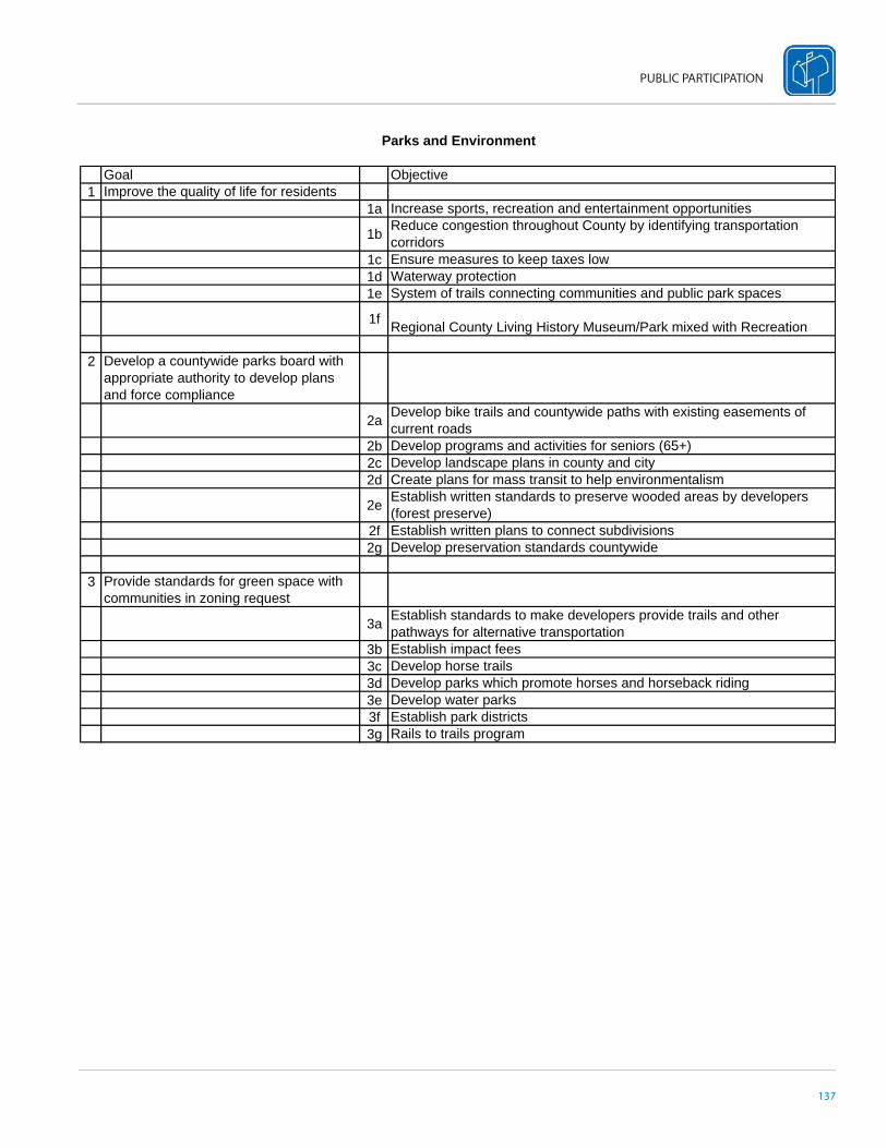
137
PUBLIC PARTICIPATION
Parks and Environment
Goal Objective1 Improve the quality of life for residents
1a Increase sports, recreation and entertainment opportunities
1b Reduce congestion throughout County by identifying transportation corridors
1c Ensure measures to keep taxes low1d Waterway protection1e System of trails connecting communities and public park spaces
1f Regional County Living History Museum/Park mixed with Recreation
2 Develop a countywide parks board with appropriate authority to develop plans and force compliance
2a Develop bike trails and countywide paths with existing easements of current roads
2b Develop programs and activities for seniors (65+)2c Develop landscape plans in county and city2d Create plans for mass transit to help environmentalism
2e Establish written standards to preserve wooded areas by developers (forest preserve)
2f Establish written plans to connect subdivisions2g Develop preservation standards countywide
3 Provide standards for green space with communities in zoning request
3a Establish standards to make developers provide trails and other pathways for alternative transportation
3b Establish impact fees3c Develop horse trails3d Develop parks which promote horses and horseback riding3e Develop water parks3f Establish park districts3g Rails to trails program


PLANNING PROCESS

140
BOONE COUNTY AREA COMPREHENSIVE PLAN
INTRODUCTION
In the summer of 2007, the Boone County Area Plan Commission and the Boone County Economic Development Corpora-tion contracted the consulting fi rm, American Structurepoint, Inc., to guide them through a strategic planning process to create an updated county comprehensive and economic development plan. The countywide economic development stra-tegic plan has been developed in conjunction with the comprehensive land-use plan throughout the planning process. The process has resulted in a strategic plan and comprehensive plan that equally regard the county’s overall growth vision, land use, and infrastructure needs. Although the county comprehensive plan is limited to the unincorporated areas of the county, the strategic plan includes the needs of both unincorporated and incorporated communities within the county.
The overall purpose of the updated county comprehensive and economic development plan and strategies were to:
• Update and provide a new vision for the county• Create a new land-use map• Outline economic opportunities and potential for the county• Generate community involvement
PHASE IBoone County Steering CommitteeAn initial step in the planning process was creating a steering committee that represented diff erent stakeholder groups throughout the county. These stakeholders were asked to sit on the steering committee as representatives for their respec-tive area of the county. The Committee’s main tasks were to help identify issues relevant to the county, formulate policies, goals, and objectives of the comprehensive plan, provide direction in the planning process, make decisions on content, and be leaders in plan implementation.
Public Forum I - Issue Identifi cationThe initial public meeting, Public Meeting I – Issue Identifi cation, was the fi rst opportunity for residents to learn about the planning process and actively partake in discussions and brainstorming sessions about their community. In order to make it as convenient as possible and to engage a larger number of county citizens, four separate workshops were held throughout the county. The workshop dates and locations were as follows.
• Monday, August 6, 2007 – Lebanon High School, Lebanon• Tuesday, August 7, 2007 – Western Boone Jr. /Sr. High School, Thorntown• Monday, August 13, 2007 – Zionsville High School, Zionsville• Wednesday, August 15, 2007 – Boone County 4-H Fairgrounds, Lebanon
The well-attended, cross-county meetings allowed attendees to view initial results of the county-wide analysis and participate in interactive exercises to identify the strengths, weaknesses, opportunities, and threats of the county along with the desired needs and dreams for the county as a whole.
PHASE IISite AnalysisA site inventory was conducted by the American Structurepoint staff to analyze existing land use and conditions within the county. The analysis outlined existing conditions and land uses in the county deemed signifi cant to incorporate in the updated plan and those land uses and issues that needed to be addressed in order to improve the value, aesthetics and character of the county. Inventory and analysis were collected and performed in areas of prime farmland, at-risk farmland, population density, transportation, and hydrology.
141
PLANNING PROCESS
Public Forum II - Public PrioritiesThe purpose of the second public workshop was to expand on the results from the fi rst round of public workshops and develop a vision for the county in 20 years. Four separate workshops were held throughout the county as the second round of interactive public workshops. The workshop dates and locations were as follows.
• Monday, September 24, 2007 – Zionsville High School – Zionsville• Thursday, September 27, 2007 – Boone County 4-H Fairgrounds – Lebanon• Monday, October 1, 2007 – Boone County 4-H Fairgrounds – Lebanon• Thursday, October 4, 2007 – Western Boone Jr. /Sr. High School – Thorntown
Once a consensus on the vision was achieved, the workshop focused on strategies, programs, and policies necessary to achieve the vision. The information gathered by all the public workshops then became the groundwork for the Steering Committee to develop details of the comprehensive and economic development plan.
PHASE IIIFocus Group InterviewsThe goal of the Focus Group Interviews was to assess the issues each homogenous group faces in terms of economic development, workforce development, land use, growth, and other important factors, to get a better understanding of what may be addressed through both the comprehensive and economic development planning processes.
Each identifi ed Focus Group had its own interview meeting throughout the month of October with American Structurepoint staff . Meetings lasted 45 minutes and were conducted with a “conversational” type of format in order to gather information. Group interviews were recorded to summarize fi ndings and present to the Steering Committee to help enhance decisions based on community input.
Focus Groups included:
• Farming/Agriculture• Agribusiness Industry Professionals • Environmental, Tourism, and Historic Preservation• Transportation • Recreation and Parks • Workforce Development/Education • Local Government – Southeast Region• Local Government – Western Region• Local Government – Central and Northeast Regions• Residential and Commercial Realtors/Real Estate Industry Professionals • Developers/Builders/Development Industry Professionals • Youth Group • Existing Business• Biotechnology Industry Professionals/Community Leaders• Development Attorneys/Regulatory and Land Use • Active Citizens – Union Township/Greater Zionsville • Active Citizens – Perry/Worth Area • Education/Superintendents• Labor Force/Education Providers• Human Resources Professionals
142
BOONE COUNTY AREA COMPREHENSIVE PLAN
Vision, Goals, and ObjectivesAn overall vision was created to outline the desired direction for the county comprehensive and economic development plan over the next 20 years. The vision focuses on nine major components: parks and recreation, environment, government, transportation, infrastructure, growth and character, agriculture, economic development, and residential. Twenty-seven main goals were created with their own subsequent objectives in each of the categories listed above. The goals were derived from community input collected from the various public participation functions, needs, and desires of stakeholders and concepts for the comprehensive and economic development plan. The objectives created an outline of tasks to perform in order to achieve the goal. This step of the planning process helps lay the framework in which a program can be implemented that addresses the needs, dreams, and goals of the entire plan.
PHASE IVTask Force GroupsBasic goals and objectives were derived to address issues in nine broad categories, including parks and recreation, environmental, government, transportation, infrastructure, growth and character, agriculture, economic development, and residential. Task Force Groups were formed under each of these categories to brainstorm and propose action plans necessary to carry out each objective. Task Force Groups comprised of citizens who were engaged in the previous public workshops and have a specifi ed knowledge about one of the topic categories. The action plans that were created by each Task Force Group were then reviewed and modifi ed by the Steering Committee to generate a fi nal list of action plans that would help to achieve the goals of the plan.
Action PlansOnce goals and objectives are established for the comprehensive and economic development plan, Action Steps are created as the key element to outline the implementation of this plan. Action steps are necessary to achieve the determined objectives. An Action Step is an organized activity to accomplish an objective. Responsible parties and resources for each of the action steps are then formulated to further outline who and what resources will be needed to implement and ultimately fulfi ll the action step. A Completion Date is also identifi ed in the Action Step so that each Action Step and Objective can be appropriately prioritized.
PHASE VImplementation and EvaluationThe implementation and evaluation phase involves major public participation in order to carry out the action plans laid out in the plan. The fi nal comprehensive and economic development plan will be presented to the Plan Commission for approval. Implementation should then follow the approval with the support of a wide array of community members and leaders.
After implementation of the plan has begun, periodic reviews of the implementation process should take place by the Plan Commission. This helps to ensure the plan is continually eff ective and progress is being made throughout the county on important issues addressed in the plan.

COMMUNITY PROFILE

144
BOONE COUNTY AREA COMPREHENSIVE PLAN
INTRODUCTIONBoone County is experiencing growth pressures as the Indianapolis metropolitan area continues to expand within the county. The current population is estimated to have grown over ten percent since the census in 2000 and is expected to grow another 2.6 percent by 2010. This is a growth rate almost twice the national average. Most of the growth between 1990 and 2000 was seen in areas around Zionsville and Lebanon. As the new Anson development builds out, growth in the Whitestown area is expected to surpass current projections. These growth trends are expected to continue with the urbanized areas extending further into the county. This will place further pressures on existing transportation and utility infrastructures while also increasing the rate of farmland conversion.
It has been important to the County to craft a plan that strikes a balance between future growth and economic development with a plan that focuses on agriculture as an economic development industry and maintains the rural character and quality of life that so many Boone County residents enjoy and cherish. The Boone County Area Plan Commission and County Commissioners have taken the initial step in proactively preparing the county for growth and development by updating their current comprehensive plan. This chapter includes statistics and data specifi cally about Boone County in order to determine trends and projections on population, households, commuting patterns, income, education, employment, and land use.
BACKGROUND HISTORYBoone County was established on April 1, 1830, and was named after the celebrated Daniel Boone, pioneer settler of Kentucky. The heavily wooded landscape consisted of merely a handful of log cabins, a few areas of cleared ground, and 622 white pioneer settlers. The newly established county measured 17.5 miles from north to south and 24 miles east to west, containing 420 square miles (268,800 acres).
The County Commissioners originally selected Jamestown as the county seat, located at the southwestern corner of the county. However, a state law was enacted in 1832 that forced the county seat to be located within two miles of the county’s center. A new site was chosen and the newly named location of “Lebanon” offi cially became the county seat in 1833. The name Lebanon was chosen because the tall hickory trees on the site reminded the Commissioners of the biblical “Cedars of Lebanon,” as well as the fact the hometown of one of the Commission-ers was Lebanon, Ohio. The fi rst log courthouse was constructed later that same year, even though Lebanon had no settlers at the time.
Boone County was originally established with eleven townships: Center, Clinton, Eagle, Harrison, Jackson, Jeff erson, Mar-ion, Perry, Sugar Creek, Union, and Washington. Worth Township was established in 1851 with territory from adjoining townships. The reason for establishing this 12th township is unknown, except to say that someone(s) within its bounds went to the County Commissioners with a petition for a new township, and it was granted.
The soil in most parts of the county is very fertile and well-adapted for the production of wheat, corn, oats, grasses, and vegetables. When the county was established, there was no part of the state where the timber was heavier or of a better quality. With the instal-lation of miles and miles of ditching, swamps disappeared and the soils were eff ectively drained and made dry enough to till. To this date, Boone County has the second most linear miles of recorded legal drains in the state.
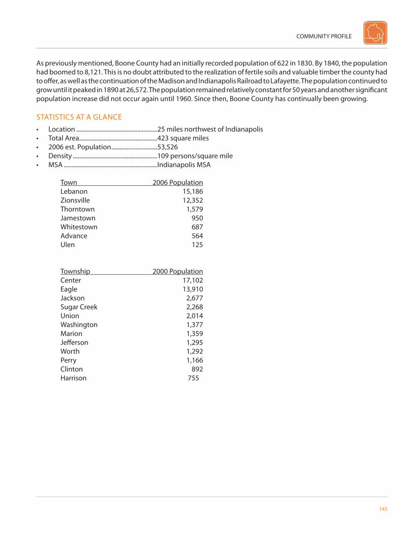
COMMUNITY PROFILE
145
As previously mentioned, Boone County had an initially recorded population of 622 in 1830. By 1840, the population had boomed to 8,121. This is no doubt attributed to the realization of fertile soils and valuable timber the county had to off er, as well as the continuation of the Madison and Indianapolis Railroad to Lafayette. The population continued to grow until it peaked in 1890 at 26,572. The population remained relatively constant for 50 years and another signifi cant population increase did not occur again until 1960. Since then, Boone County has continually been growing.
STATISTICS AT A GLANCE• Location .....................................................25 miles northwest of Indianapolis• Total Area ...................................................423 square miles• 2006 est. Population ..............................53,526• Density .......................................................109 persons/square mile• MSA .............................................................Indianapolis MSA
Town 2006 PopulationLebanon 15,186Zionsville 12,352Thorntown 1,579Jamestown 950Whitestown 687Advance 564Ulen 125
Township 2000 PopulationCenter 17,102Eagle 13,910Jackson 2,677Sugar Creek 2,268Union 2,014Washington 1,377Marion 1,359Jeff erson 1,295Worth 1,292Perry 1,166Clinton 892
Harrison 755
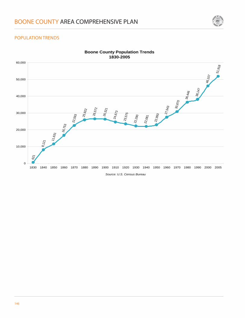
146
BOONE COUNTY AREA COMPREHENSIVE PLAN
POPULATION TRENDS
Boone County Population Trends1830-2005
621
8,12
1 11,6
31
16,7
53
22,5
93 25,9
22
26,5
72
26,3
21
24,6
73
23,5
75
22,2
90
22,0
81
22,9
93
27,5
43 30,8
70
36,4
46
38,1
47
46,1
07
51,9
18
0
10,000
20,000
30,000
40,000
50,000
60,000
1830 1840 1850 1860 1870 1880 1890 1900 1910 1920 1930 1940 1950 1960 1970 1980 1990 2000 2005
Source: U.S. Census Bureau

COMMUNITY PROFILE
147
Boone County Projected Population Trends2000-2030
46,107
51,91853,319
59,24361,564
63,401 64,754
0
10,000
20,000
30,000
40,000
50,000
60,000
70,000
2000 2005 2010 2015 2020 2025 2030
Source: STATS Indiana
• The population has continually increased since 1940.• The county experienced a 21% population increase between 1990 and 2000, the largest change since 1940.• The population is expected to increase over the next 30 years.• The rate of increase is expected to level off after 2015.
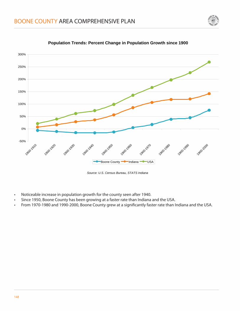
148
BOONE COUNTY AREA COMPREHENSIVE PLAN
• Noticeable increase in population growth for the county seen after 1940.• Since 1950, Boone County has been growing at a faster rate than Indiana and the USA.• From 1970-1980 and 1990-2000, Boone County grew at a signifi cantly faster rate than Indiana and the USA.
Population Trends: Percent Change in Population Growth since 1900
-50%
0%
50%
100%
150%
200%
250%
300%
1900
-1910
1900
-1920
1900
-1930
1900
-1940
1900
-1950
1900
-1960
1900
-1970
1900
-1980
1900
-1990
1900
-2000
Boone County Indiana USA
Source: U.S. Census Bureau, STATS Indiana
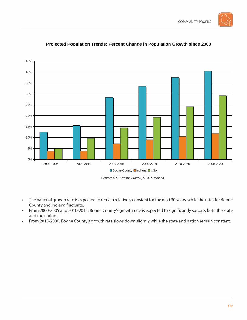
COMMUNITY PROFILE
149
• The national growth rate is expected to remain relatively constant for the next 30 years, while the rates for Boone County and Indiana fl uctuate.
• From 2000-2005 and 2010-2015, Boone County’s growth rate is expected to signifi cantly surpass both the state and the nation.
• From 2015-2030, Boone County’s growth rate slows down slightly while the state and nation remain constant.
Projected Population Trends: Percent Change in Population Growth since 2000
0%
5%
10%
15%
20%
25%
30%
35%
40%
45%
2000-2005 2000-2010 2000-2015 2000-2020 2000-2025 2000-2030
Source: U.S. Census Bureau, STATS Indiana
Boone County Indiana USA

150
BOONE COUNTY AREA COMPREHENSIVE PLAN
AGE DISTRIBUTION
1990 Boone County Age Distribution
(3087)
(2860)
(2258)
(3195)
(2680)
(1784)
(1404)
(811)
(386)
(2,755)
(2,674)
(2,480)
(3,336)
(2,808)
(1,781)
(1,590)
(1,250)
(1,008)
Age 0 to 9
Age 10-19
Age 20-29
Age 30-39
Age 40-49
Age 50-59
Age 60-69
Age 70-79
Age 80 and over
Source: STATS Indiana
Female Male
2000 Boone County Age Distribution
(3,404)
(3,434)
(2,242)
(3,690)
(4,021)
(2,756)
(1,686)
(1,320)
(1,145)
(3773)
(3466)
(2197)
(3445)
(3920)
(2589)
(1580)
(1007)
(432)
Age 0 to 9
Age 10-19
Age 20-29
Age 30-39
Age 40-49
Age 50-59
Age 60-69
Age 70-79
Age 80 and over
Source: STATS Indiana
Female Male
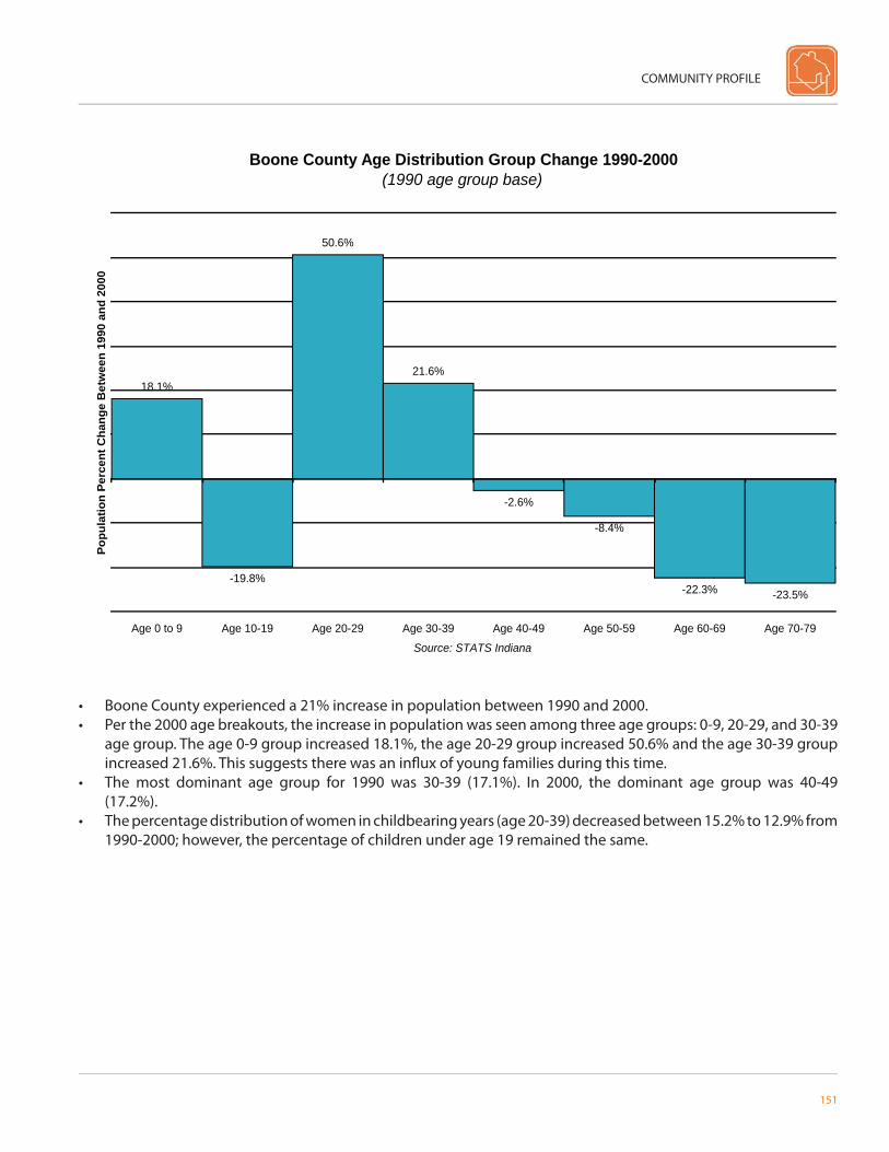
COMMUNITY PROFILE
151
• Boone County experienced a 21% increase in population between 1990 and 2000.• Per the 2000 age breakouts, the increase in population was seen among three age groups: 0-9, 20-29, and 30-39
age group. The age 0-9 group increased 18.1%, the age 20-29 group increased 50.6% and the age 30-39 group increased 21.6%. This suggests there was an infl ux of young families during this time.
• The most dominant age group for 1990 was 30-39 (17.1%). In 2000, the dominant age group was 40-49 (17.2%).
• The percentage distribution of women in childbearing years (age 20-39) decreased between 15.2% to 12.9% from 1990-2000; however, the percentage of children under age 19 remained the same.
Boone County Age Distribution Group Change 1990-2000(1990 age group base)
18.1%
-19.8%
50.6%
21.6%
-2.6%
-8.4%
-22.3% -23.5%
Age 0 to 9 Age 10-19 Age 20-29 Age 30-39 Age 40-49 Age 50-59 Age 60-69 Age 70-79
Source: STATS Indiana
Popu
latio
n Pe
rcen
t Cha
nge
Bet
wee
n 19
90 a
nd 2
000
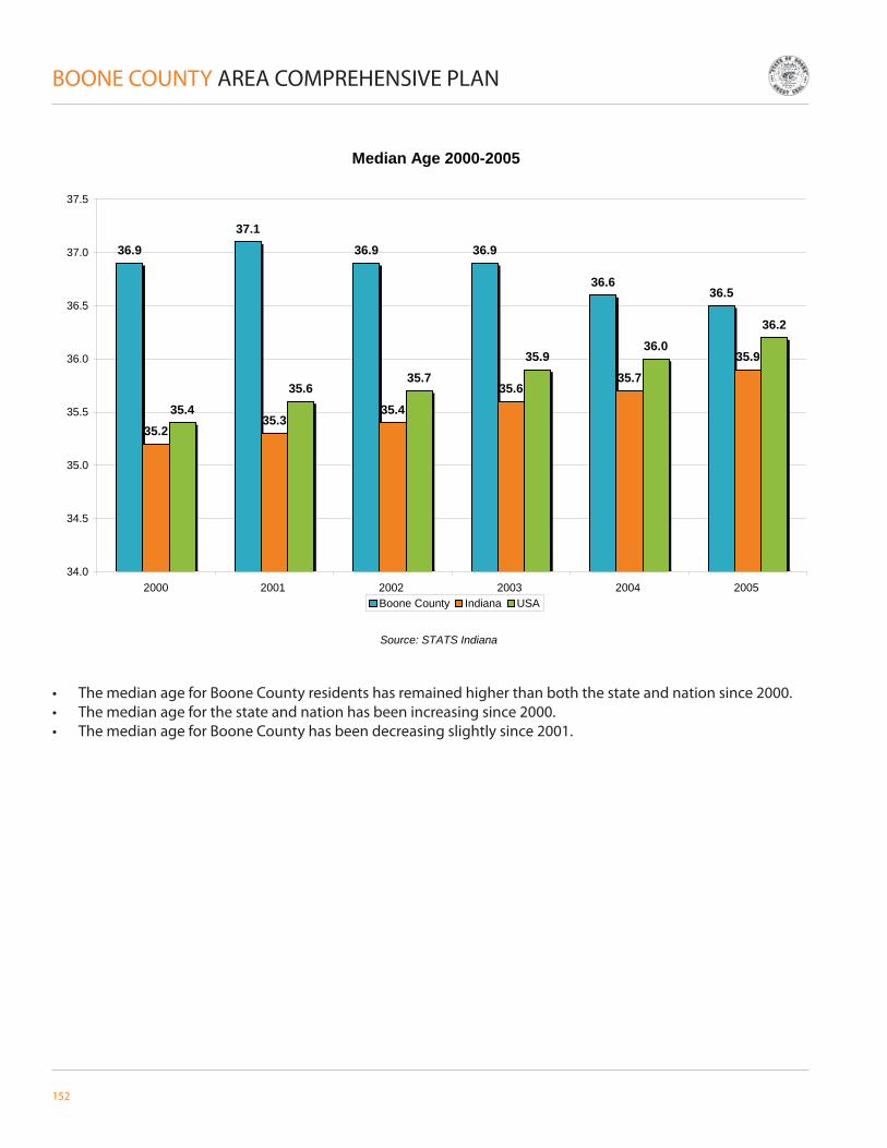
152
BOONE COUNTY AREA COMPREHENSIVE PLAN
• The median age for Boone County residents has remained higher than both the state and nation since 2000.• The median age for the state and nation has been increasing since 2000.• The median age for Boone County has been decreasing slightly since 2001.
Median Age 2000-2005
36.937.1
36.9 36.9
36.636.5
35.235.3
35.435.6
35.735.9
35.435.6
35.735.9
36.036.2
34.0
34.5
35.0
35.5
36.0
36.5
37.0
37.5
2000 2001 2002 2003 2004 2005
Source: STATS Indiana
Boone County Indiana USA
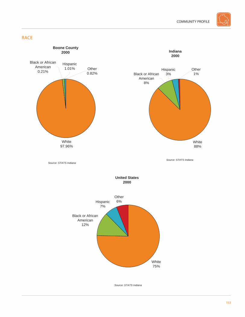
COMMUNITY PROFILE
153
RACE
Boone County2000
White97.96%
Hispanic1.01% Other
0.82%
Black or African American
0.21%
Source: STATS Indiana
Indiana2000
Black or African American
8%
Other1%
Hispanic3%
White88%
Source: STATS Indiana
United States2000
White75%
Black or African American
12%
Hispanic7%
Other6%
Source: STATS Indiana
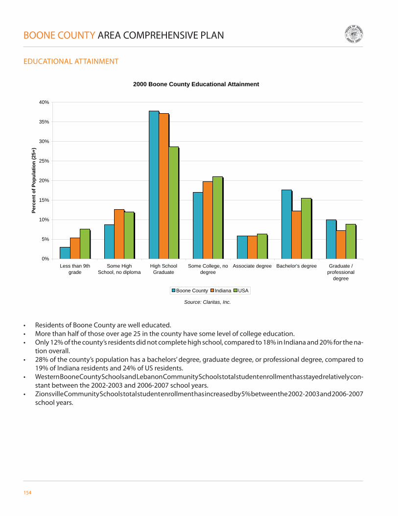
154
BOONE COUNTY AREA COMPREHENSIVE PLAN
EDUCATIONAL ATTAINMENT
• Residents of Boone County are well educated. • More than half of those over age 25 in the county have some level of college education.• Only 12% of the county’s residents did not complete high school, compared to 18% in Indiana and 20% for the na-
tion overall.• 28% of the county’s population has a bachelors’ degree, graduate degree, or professional degree, compared to
19% of Indiana residents and 24% of US residents.• Western Boone County Schools and Lebanon Community Schools total student enrollment has stayed relatively con-
stant between the 2002-2003 and 2006-2007 school years.• Zionsville Community Schools total student enrollment has increased by 5% between the 2002-2003 and 2006-2007
school years.
2000 Boone County Educational Attainment
0%
5%
10%
15%
20%
25%
30%
35%
40%
Less than 9thgrade
Some HighSchool, no diploma
High SchoolGraduate
Some College, nodegree
Associate degree Bachelor's degree Graduate /professional
degree
Source: Claritas, Inc.
Perc
ent o
f Pop
ulat
ion
(25+
)
Boone County Indiana USA

COMMUNITY PROFILE
155
Total Enrollment by School District (K-12)
1890
4012
3335
4190
3352
4430
34083526
4922
3505
1865 1876
4760
1834 1828
0
1000
2000
3000
4000
5000
6000
Western Boone County Schools Zionsville Community Schools Lebanon Community Schools
Enro
lled
Stud
ents
K-1
2
2002-2003 2003-2004 2004-2005 2005-2006 2006-2007
School Enrollment by District (Primary and Secondary Levels)
0
500
1000
1500
2000
2500
3000
2002-2003
2003-2004
2004-2005
2005-2006
2006-2007
2002-2003
2003-2004
2004-2005
2005-2006
2006-2007
2002-2003
2003-2004
2004-2005
2005-2006
2006-2007
Enro
lled
Stud
ents
K-6 7-12
Western Boone County Schools Zionsville Community Schools Lebanon Community Schools
Source: Indiana Department of Education
Source: Indiana Department of Education
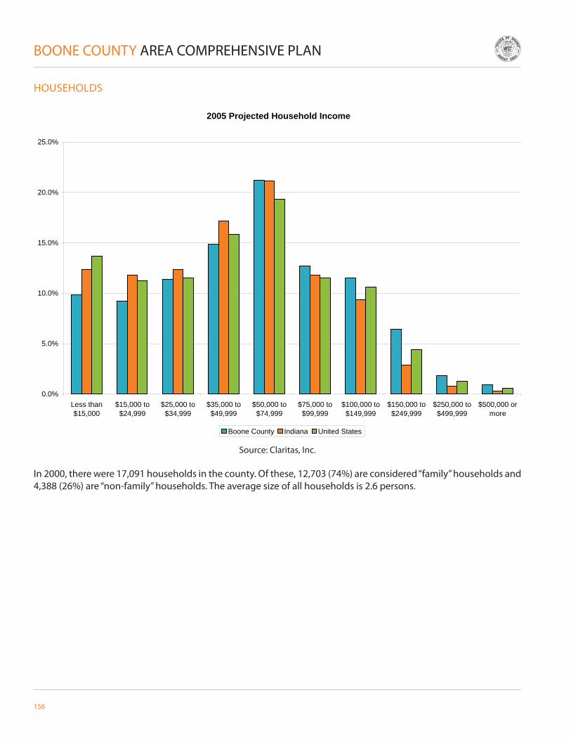
156
BOONE COUNTY AREA COMPREHENSIVE PLAN
HOUSEHOLDS
In 2000, there were 17,091 households in the county. Of these, 12,703 (74%) are considered “family” households and 4,388 (26%) are “non-family” households. The average size of all households is 2.6 persons.
2005 Projected Household Income
0.0%
5.0%
10.0%
15.0%
20.0%
25.0%
Less than$15,000
$15,000 to$24,999
$25,000 to$34,999
$35,000 to$49,999
$50,000 to$74,999
$75,000 to$99,999
$100,000 to$149,999
$150,000 to$249,999
$250,000 to$499,999
$500,000 ormore
Boone County Indiana United States
Source: Claritas, Inc.

COMMUNITY PROFILE
157
HOUSING
• In 2000, there were 17,929 housing units in the county. • Between 2000 and 2010, it is projected there will be 21.2% additional housing units in Boone County. • The dominant housing structure in Boone County is a 1-unit detached structure.
Boone County Housing Units by Units in Structure (2005 Estimate)
1 Unit Attached2.5%
1 Unit Detached80.4%
20 to 49 Units0.6%
50 or More Units0.9%
Mobile Home or Trailer4.3%
Boat, RV, Van, etc.0.0%
3 to 19 Units9.3%
2 Units2.1%
Indianapolis MSA Housing Units by Units in Structure (2005 Estimate)
1 Unit Attached5.3%
1 Unit Detached67.2%
2 Units2.4%
3 to 19 Units16.4%
20 to 49 Units2.3%
50 or More Units3.0%
Mobile Home or Trailer3.4% Boat, RV, Van, etc.
0.0%
Source: Claritas, Inc.
Source: Claritas, Inc.

158
BOONE COUNTY AREA COMPREHENSIVE PLAN
BUILDING PERMITS
Residential Building Permits in Unincorporated Areas of Boone County1996-2006
0
50
100
150
200
250
300
350
1996 1997 1998 1999 2000 2001 2002 2003 2004 2005 2006
1 Family 2 Family 3 & 4 Family 5 or More Family
Source: U.S. Census Bureau
• Boone County experienced a large growth of residential structures between 1997 and 1999. While there was a slight decrease in building permits from 1996 to 1997, from 1997 to 1998, the total number of permits issued in-creased by 64%, with an additional increase from 1998 to 1999 of 18%.
• From 1999 to 2000, the total number of permits issued decreased by 36%. There has been a gradual increase in building permit since 2000, with a slight decrease between 2005 and 2006.

COMMUNITY PROFILE
159
LAND USE
2000 Boone CountyUrban vs Rural Population
54.2%
70.8%79.0%
2.3%
2.1%
1.1%43.5%
27.2%19.9%
0%
10%
20%
30%
40%
50%
60%
70%
80%
90%
100%
Boone County Indiana United StatesUrban Rural - Farm Rural - Non-Farm
Source: Claritas, Inc.
• Boone County’s population is almost split evenly between rural population and urban population.• Boone County has 16.3% more population living in rural, non-farm areas compared to the state.• Boone County has a higher proportion of total population living in rural areas than the state average.

160
BOONE COUNTY AREA COMPREHENSIVE PLAN
TRANSPORTATION
The following maps illustrate the number of persons in the workforce who commuted in and out of Boone County on a daily basis in 2000 and 2005. The top fi ve surrounding counties who receive and send workers from Boone County are shown for each of these years.
• Resident Labor Force – working persons who reside in Boone County• Work Force (implied) – total number of persons who work in Boone County, regardless of residency
2000
2005
• The residential labor force commuting OUT of Boone County to work has remained at 30% between 2000 and 2005.
• 8% of the work force commuted INTO Boone County in 2000 and increased to 10% in 2005.
Source: STATS Indiana
Source: STATS Indiana
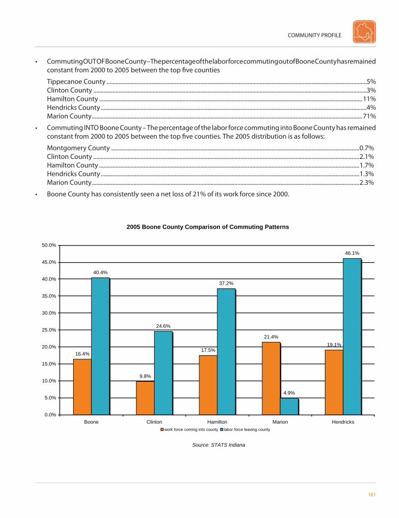
COMMUNITY PROFILE
161
• Commuting OUT OF Boone County – The percentage of the labor force commuting out of Boone County has remained constant from 2000 to 2005 between the top fi ve counties
Tippecanoe County ...............................................................................................................................................................................5%Clinton County ........................................................................................................................................................................................3%Hamilton County .................................................................................................................................................................................11%Hendricks County ...................................................................................................................................................................................4%Marion County ......................................................................................................................................................................................71%
• Commuting INTO Boone County – The percentage of the labor force commuting into Boone County has remained constant from 2000 to 2005 between the top fi ve counties. The 2005 distribution is as follows:
Montgomery County .......................................................................................................................................................................0.7%Clinton County ...................................................................................................................................................................................2.1%Hamilton County ...............................................................................................................................................................................1.7%Hendricks County ..............................................................................................................................................................................1.3%Marion County ....................................................................................................................................................................................2.3%
• Boone County has consistently seen a net loss of 21% of its work force since 2000.
2005 Boone County Comparison of Commuting Patterns
16.4%
9.8%
17.5%
21.4%19.1%
40.4%
24.6%
37.2%
4.9%
46.1%
0.0%
5.0%
10.0%
15.0%
20.0%
25.0%
30.0%
35.0%
40.0%
45.0%
50.0%
Boone Clinton Hamilton Marion Hendricks
Source: STATS Indiana
work force coming into county labor force leaving county

162
BOONE COUNTY AREA COMPREHENSIVE PLAN
• Boone County has an average travel time slightly higher than the state average and less than the national average.• The larger percentage of commuters who have a 30- to 59-minute commute refl ect the large number of Boone
County residents who work in Marion County.
Average Commute Time to Work
23
22.6
25.5
21
21.5
22
22.5
23
23.5
24
24.5
25
25.5
26
Boone County Indiana United States
Min
utes
Source: Claritas, Inc.

COMMUNITY PROFILE
163
Boone County Mode of Transportation to Work2005 Estimates
0%
2%
4%
6%
8%
10%
12%
14%
Drove alone Carpooled Publictransportation
Motorcycle Bicycle Walked Other means
Boone County Indiana USA
Source: Claritas, Inc.
• The majority of commuters drive alone in Boone County, Indiana, and the nation.• Boone County has a higher percentage of persons who work from home than both the state and national averages.

164
BOONE COUNTY AREA COMPREHENSIVE PLAN
EMPLOYMENT STATISTICS
• The majority of population in the county, state, and nation are employed in the sales and offi ce occupations.• Boone County has a higher percentage of residents employed in Management, Business, and Financial Operations
than both the state and nation• 14.7% of Boone County’s working population is in Production, Transportation, and Material Moving occupations,
compared to 21.2% in the state. • In June 2007 Boone County’s unemployment rate was 3.7%• In June 2007 Indiana’s unemployment rate was 4.6%
Boone County 2005 Estimated Employment Status (Age 16+)
In Armed Forces0.1%
Not in Labor Force30.2%
Unemployed2%
Employed68%
Source: Claritas, Inc.

COMMUNITY PROFILE
165
• The majority of occupations held by Boone County residents are classifi ed as White Collar, while the majority of oc-cupations in both Indiana and the United States are classifi ed as Service and Farm.
• The Construction Industry, Retail Trade, and the Government have the highest percentage of the county’s labor force.
2005 Estimated Employment by Occupation
0%
5%
10%
15%
20%
25%
30%
Management,Business, and
FinancialOperations
Professional andRelated
Occupations
Service Sales and Office Farming, Fishing,and Forestry
Construction,Extraction, andMaintenance
Production,Transportation,
and MaterialMoving
Perc
ent E
mpl
oyed
(Age
16+
)
Boone County Indiana USA
Source: Claritas, Inc.

166
BOONE COUNTY AREA COMPREHENSIVE PLAN
BOONE COUNTY INDUSTRY DATA
Employees Sales ($ Millions)Health services 1738 118Eating & drinking places 1263 60Educational services 1157 137Government 889 0Special trade contractors 881 143Social services 868 68Miscellaneous 734 68Building, garden supplies 647 101General building contractors 620 170Wholesale: durable goods 523 93
Employees Sales ($ Millions)General building contractors 620 170Special trade contractors 881 143Educational services 1157 137Auto dealers, gas stations 496 121Health services 1738 118Building, garden supplies 647 101Wholesale: durable goods 523 93Engineering & management 466 82Miscellaneous 734 68Social services 868 68
Top 10 Industries by Employees
Top 10 Industries by Total Sales
Source: Claritas, Inc.

COMMUNITY PROFILE
167
INCOME
Boone County Per Capita Peronsal Income1990-2005
$-
$5,000
$10,000
$15,000
$20,000
$25,000
$30,000
$35,000
$40,000
$45,000
$50,000
1990 1991 1992 1993 1994 1995 1996 1997 1998 1999 2000 2001 2002 2003 2004 2005
Indiana Boone
Source: Bureau of Economic Analysis
• The per capita personal income in Boone County had historically remained signifi cantly higher than that of the state.
• Between 1990 and 2005 Boone County has experienced a strong fl uctuation (both positive and negative) in personal income.

168
BOONE COUNTY AREA COMPREHENSIVE PLAN
Boone County Percent Change in Personal Income1990-2005
-4.0%
-2.0%
0.0%
2.0%
4.0%
6.0%
8.0%
10.0%
1990-1991
1991-1992
1992-1993
1993-1994
1994-1995
1995-1996
1996-1997
1997-1998
1998-1999
1999-2000
2000-2001
2001-2002
2002-2003
2003-2004
2004-2005
Indiana Boone
Source: Bureau of Economic Analysis
• Boone County has experienced greater increases in personal income than Indiana between 1991 and 1998 (exclud-ing 1994-1995).
• Between 1998 and 2003, the percent change in personal income in Boone County was less than the state’s percent change in personal income.
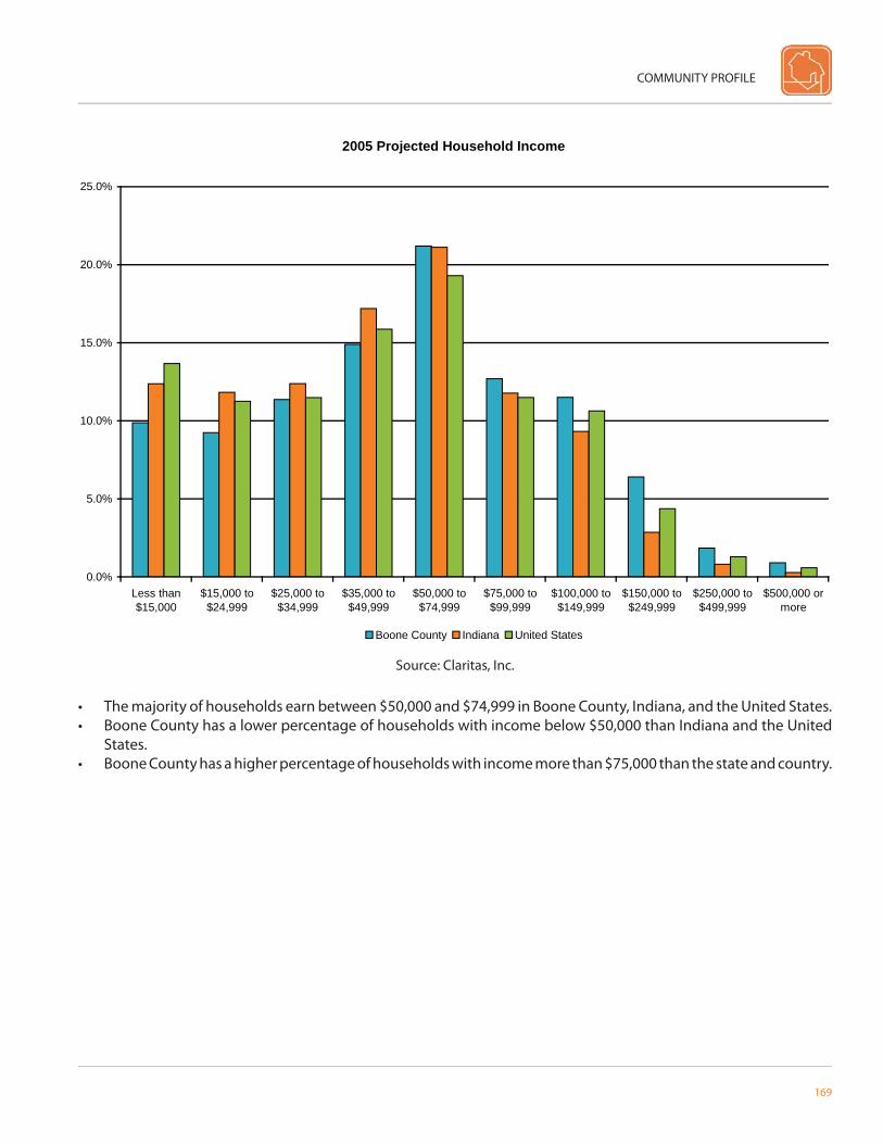
COMMUNITY PROFILE
169
• The majority of households earn between $50,000 and $74,999 in Boone County, Indiana, and the United States.• Boone County has a lower percentage of households with income below $50,000 than Indiana and the United
States.• Boone County has a higher percentage of households with income more than $75,000 than the state and country.
2005 Projected Household Income
0.0%
5.0%
10.0%
15.0%
20.0%
25.0%
Less than$15,000
$15,000 to$24,999
$25,000 to$34,999
$35,000 to$49,999
$50,000 to$74,999
$75,000 to$99,999
$100,000 to$149,999
$150,000 to$249,999
$250,000 to$499,999
$500,000 ormore
Boone County Indiana United States
Source: Claritas, Inc.
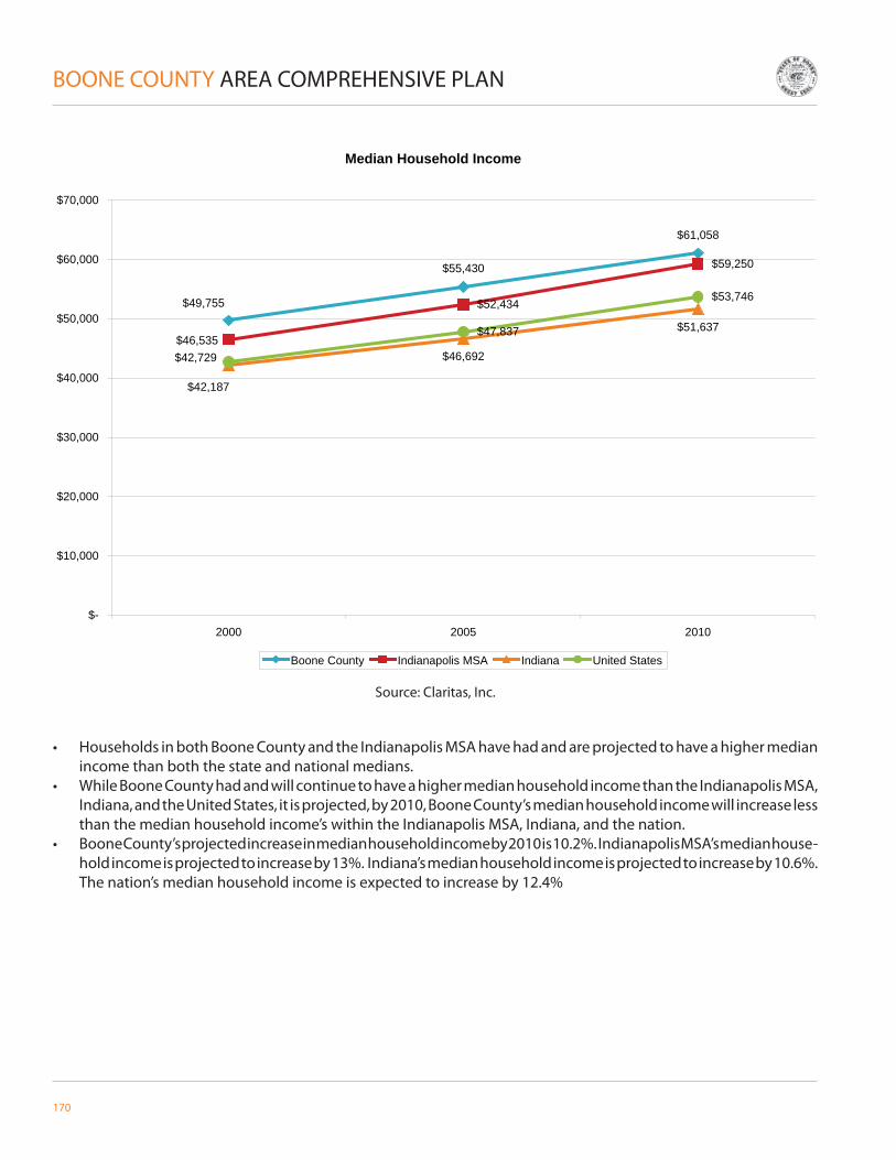
170
BOONE COUNTY AREA COMPREHENSIVE PLAN
• Households in both Boone County and the Indianapolis MSA have had and are projected to have a higher median income than both the state and national medians.
• While Boone County had and will continue to have a higher median household income than the Indianapolis MSA, Indiana, and the United States, it is projected, by 2010, Boone County’s median household income will increase less than the median household income’s within the Indianapolis MSA, Indiana, and the nation.
• Boone County’s projected increase in median household income by 2010 is 10.2%. Indianapolis MSA’s median house-hold income is projected to increase by 13%. Indiana’s median household income is projected to increase by 10.6%. The nation’s median household income is expected to increase by 12.4%
Median Household Income
$55,430
$61,058
$52,434
$59,250
$46,692
$51,637$47,837
$53,746$49,755
$46,535
$42,187
$42,729
$-
$10,000
$20,000
$30,000
$40,000
$50,000
$60,000
$70,000
2000 2005 2010
Boone County Indianapolis MSA Indiana United States
Source: Claritas, Inc.

COMMUNITY PROFILE
171
CRIME
• Driving under the infl uence, total drug violation, and liquor law violations are within the fi ve highest percentages of crimes that people were arrested in Boone County.
• The majority of crimes reported in Boone County, Indiana, and the United States were larceny theft. However, Boone County had 16.6% more larceny theft crimes reported than Indiana and 19.9% more reported than the United States.
• Boone County had a larger percent of aggravated assault crimes reported than both the state and nation• While Boone County had more larceny theft and aggravated assaults than both the state and nation, there were no
additional crimes reported other than motor vehicle theft.
Crimes Reported in 2000
0.0%
10.0%
20.0%
30.0%
40.0%
50.0%
60.0%
70.0%
80.0%
90.0%
Murder Rape Robbery AggravatedAssault
Burglary Larceny - theft Motor vehiclethefts
Perc
ent o
f Crim
es
Boone County Indiana United States
Source: Federal Bureau of Investigation to the National Archive of Criminal Justice Data, University of Michigan

172
BOONE COUNTY AREA COMPREHENSIVE PLAN
AGRICULTURE
2000 1997 % ChangeFarms (number) 672 698 -3.7%Land in Farms (acres) 225,906 230,106 -1.8%Average size of farm (acres) 336 330 1.8%Total Cropland (farms) 557 556 0.2%Total Cropland (acres) 212,563 212,137 0.2%Total havested cropland (farms) 476 515 -7.6%Total havested cropland (acres) 207,304 206,132 0.6%Market value of production 74,766,000$ 81,525,000$ -8.3%Market value of production (avg. per farm) 111,260$ 116,798$ -4.7%
2000 1997 % ChangeFarms (number) 60,296 66,707 -9.6%Land in Farms (acres) 15,058,670 15,525,154 -3.0%Average size of farm (acres) 250 233 7.3%Total Cropland (farms) 53,725 59,496 -9.7%Total Cropland (acres) 12,909,002 13,065,057 -1.2%Total havested cropland (farms) 44,298 51,984 -14.8%Total havested cropland (acres) 11,937,370 11,844,628 0.8%Market value of production 4,783,158,000$ 5,323,116,000$ -10.1%Market value of production (avg. per farm) 79,328$ 79,798$ -0.6%
2000 1997 % ChangeFarms (number) 2,128,982 2,215,876 -3.9%Land in Farms (acres) 938,279,056 954,752,502 -1.7%Average size of farm (acres) 441 431 2.3%Total Cropland (farms) 1,751,450 1,857,239 -5.7%Total Cropland (acres) 434,164,946 445,234,765 -2.5%Total havested cropland (farms) 1,362,608 1,545,681 -11.8%Total havested cropland (acres) 302,697,252 318,937,401 -5.1%Market value of production 200,646,355,000$ 201,379,812,000$ -0.4%Market value of production (avg. per farm) 94,245$ 90,880$ 3.7%
US Census of Agriculture - County HighlightsBoone County
Indiana
United States
Source: US Department of Agriculture, Economic Research Service

COMMUNITY PROFILE
173
• Boone County is the fourth leading producer of soybeans among the 92 Indiana counties.• Boone County is the fi fth leading producer of corn among the 92 Indiana counties.• While Indiana is losing farms, there is an increase in their average size. Between 1997 and 2000, Indiana has lost a
signifi cantly higher percent of farms than Boone County. • Boone County has stayed relatively constant with the total amount of crop land it possesses while both the state and
nation experienced a decline in the total amount of cropland.• While there has been a decrease in number of farms harvesting cropland, Boone County and the state have experi-
enced an increase in the total acreage of harvested cropland while the nation has experienced a drastic decline.
Selected Agricultural Trends 1997 - 2000
-20.0%
-15.0%
-10.0%
-5.0%
0.0%
5.0%
10.0%
Farms(number)
Land inFarms (acres)
Average sizeof farm(acres)
TotalCropland(farms)
TotalCropland(acres)
Totalhavestedcropland(farms)
Totalhavestedcropland(acres)
Market valueof production
Market valueof production
(avg. perfarm)
Perc
ent C
hang
e 19
97-2
000
Boone County Indiana United States
Source: US Department of Agriculture, Economic Research Service