botanic gardens of wellington management plan/media/your-council/plans-policies-and... · botanic...
TRANSCRIPT

Botanic Gardens of Wellington Management PlanSeptember 2014
Wellington Botanic Garden (including Anderson Park)Otari Native Botanic Garden and Wilton’s Bush ReserveBolton Street CemeteryTruby King Park

BOTANIC GARDENS OF WELLINGTON MANAGEMENT PLAN 2014 | 1
Contents
INTRODUCTION ................................................................................................................ 5 1
1.1 The Botanic Gardens of Wellington ........................................................................... 5 1.1.1 The Wellington Botanic Garden (and Anderson Park) ............................................ 5 1.1.2 Otari Native Botanic Garden and Wilton’s Bush Reserve ....................................... 7 1.1.3 Bolton Street Cemetery (formerly Bolton Street Memorial Park) .......................... 7 1.1.4 Truby King Park ....................................................................................................... 8
1.2 The Botanic Gardens of Wellington Management Plan ............................................. 8 1.2.1 Purpose of the plan ................................................................................................. 8 1.2.2 Scope of the plan .................................................................................................... 8 1.2.3 Structure of the plan ............................................................................................... 9 1.2.4 What does the plan include? .................................................................................. 9 1.2.5 Future review of this plan ..................................................................................... 10
1.3 Strategic Framework ............................................................................................... 11 1.3.1 Strategic framework diagram................................................................................ 11 1.3.2 Global Strategy for Plant Conservation (GSPC) ..................................................... 11 1.3.3 Wellington Towards 2040: Smart Capital (2011) .................................................. 12 1.3.4 Our Living City programme ................................................................................... 13 1.3.5 Our Capital Spaces – Open Space and Recreation Framework 2013 .................... 13 1.3.6 Biodiversity Action Plan 2007................................................................................ 13
1.4 Legislative context for the Botanic Gardens of Wellington ...................................... 14 1.4.1 Reserves Act 1977 ................................................................................................. 14 1.4.2 Heritage New Zealand Pouhere Taonga Act 2014 ................................................ 14 1.4.3 Burials and Cremations Act 1964 .......................................................................... 14 1.4.4 Other key guiding policies and plans .................................................................... 14 1.4.5 Wellington District Plan......................................................................................... 15 1.4.6 Leases Policy for Community and Recreation Groups (2012) ............................... 15 1.4.7 Open Space Access Plan (2008) ............................................................................ 15
GENERAL MANAGEMENT FRAMEWORK ......................................................................... 17 2
2.1 Management framework summary ......................................................................... 17
2.2 Governance and management ................................................................................ 18
GENERAL OBJECTIVES AND POLICIES .............................................................................. 19 3
3.1 Plant collections ...................................................................................................... 19 3.1.1 Objectives .............................................................................................................. 19 3.1.2 Policies .................................................................................................................. 19
3.2 Education and awareness ........................................................................................ 22 3.2.1 Objectives .............................................................................................................. 22 3.2.2 Policies .................................................................................................................. 22 3.2.3 Implementation .................................................................................................... 26
3.3 Recreation and visitor use ....................................................................................... 26 3.3.1 Objectives .............................................................................................................. 26 3.3.2 Policies .................................................................................................................. 27
3.4 Cultural and natural heritage .................................................................................. 30 3.4.1 Objectives – Cultural Heritage .............................................................................. 31 3.4.2 Policies .................................................................................................................. 31 3.4.3 Objectives – landscape character ......................................................................... 32 3.4.4 Objectives – natural heritage and ecosystems ..................................................... 32 3.4.5 Policies .................................................................................................................. 32
3.5 Marketing and promotion ....................................................................................... 34 3.5.1 Objectives .............................................................................................................. 34 3.5.2 Policies .................................................................................................................. 34

2 | BOTANIC GARDENS OF WELLINGTON MANAGEMENT PLAN 2014
3.5.3 Implementation .................................................................................................... 35
3.6 Partnerships and community involvement .............................................................. 36 3.6.1 Objectives ............................................................................................................. 36 3.6.2 Policies .................................................................................................................. 36 3.6.3 Implementation .................................................................................................... 38
THE WELLINGTON BOTANIC GARDEN (INCLUDING ANDERSON PARK) ............................ 40 4
4.1 Plant collections ...................................................................................................... 41 4.1.1 Lady Norwood Rose Garden / Begonia House ...................................................... 41 4.1.2 Main Garden ......................................................................................................... 41 4.1.3 Treehouse Visitor Centre / Children’s Garden ...................................................... 42 4.1.4 Cable Car / Play Area ............................................................................................ 43 4.1.5 Implementation .................................................................................................... 43
4.2 Education and awareness ........................................................................................ 44 4.2.1 Policies .................................................................................................................. 44 4.2.2 Implementation .................................................................................................... 46
4.3 Cultural and natural heritage .................................................................................. 46 4.3.1 Policies .................................................................................................................. 46 4.3.2 Implementation .................................................................................................... 52
4.4 Recreation and use .................................................................................................. 52 4.4.1 Policies .................................................................................................................. 52 4.4.2 Public events ......................................................................................................... 55 4.4.3 Implementation .................................................................................................... 55
4.5 Partnerships and community involvement .............................................................. 56 4.5.2 Implementation .................................................................................................... 56
OTARI-WILTON’S BUSH ................................................................................................... 57 5
5.1 Plant collections ...................................................................................................... 60 5.1.1 Policies .................................................................................................................. 60 5.1.2 Cockayne collections ............................................................................................ 62 5.1.3 Forest collections .................................................................................................. 62 5.1.4 The beech collection ............................................................................................. 63 5.1.5 Implementation .................................................................................................... 64
5.2 Education and awareness ........................................................................................ 64 5.2.1 Policies .................................................................................................................. 65 5.2.2 Implementation .................................................................................................... 66
5.3 Cultural and natural heritage .................................................................................. 66 5.3.1 Cultural history ..................................................................................................... 66 5.3.2 Policies .................................................................................................................. 67 5.3.3 Natural heritage .................................................................................................... 67 5.3.4 Policies .................................................................................................................. 67 5.3.5 Implementation – cultural and natural history .................................................... 70
5.4 Recreation and visitor use ....................................................................................... 71 5.4.1 Otari-Wilton’s Bush landscape development plan 2010 (LDP) ............................. 71 5.4.2 Circulation and orientation ................................................................................... 72 5.4.3 Enabling access to all ............................................................................................ 73 5.4.4 Implementation (based on initiatives in the LDP) ................................................ 74
5.5 Partnerships and community involvement .............................................................. 75 5.5.1 Implementation .................................................................................................... 75
BOLTON STREET CEMETERY ............................................................................................ 77 6
6.1 Historic significance................................................................................................. 77 6.1.1 Identity and name ................................................................................................ 77
6.2 Cultural and natural heritage .................................................................................. 78

BOTANIC GARDENS OF WELLINGTON MANAGEMENT PLAN 2014 | 3
6.2.1 Policies .................................................................................................................. 78
6.3 Visitor Experience – recreation and access .............................................................. 83 6.3.1 Access, parking and entrances .............................................................................. 83 6.3.2 Visitor facilities ...................................................................................................... 84 6.3.3 Information and interpretation ............................................................................. 84 6.3.4 Policies .................................................................................................................. 84
6.4 Partnerships and community involvement .............................................................. 84 6.4.1 Policies .................................................................................................................. 85 6.4.2 Mana whenua ....................................................................................................... 85 6.4.3 Implementation .................................................................................................... 86
TRUBY KING PARK .......................................................................................................... 87 7
7.1 Cultural significance ................................................................................................ 87 7.1.1 Historic summary .................................................................................................. 87
7.2 Objectives ............................................................................................................... 89
7.3 The garden .............................................................................................................. 90 7.3.1 Assessment and significance ................................................................................. 90 7.3.2 Policies .................................................................................................................. 90 7.3.3 Implementation .................................................................................................... 92
7.4 The house and mausoleum ..................................................................................... 93 7.4.1 Policies .................................................................................................................. 93 7.4.2 Implementation .................................................................................................... 95
7.5 Recreation and use (visitor experience) .................................................................. 95 7.5.1 Policies .................................................................................................................. 96 7.5.2 Implementation .................................................................................................... 97
7.6 Community partnerships ......................................................................................... 97 7.6.1 Implementation .................................................................................................... 97
RULES FOR USE AND DEVELOPMENT .............................................................................. 99 8
8.1 Objective ................................................................................................................. 99
8.2 Policies .................................................................................................................... 99
8.3 allowed activities .................................................................................................. 100
8.4 Managed activities ................................................................................................ 101
8.5 Decision-making guidelines ................................................................................... 103
8.6 prohibited activities .............................................................................................. 107
APPENDIX 1: LAND SCHEDULES ..................................................................................... 111 9
9.1 Land covered by the Botanic Gardens of wellington Management Plan ................ 111
APPENDIX 2: HISTORIC OUTLINE ............................................................................... 117 10
10.1 The four Botanic Gardens of Wellington ............................................................... 117
10.2 Traditional Māori History of Wellington ................................................................ 117
10.3 Māori history of the Wellington Botanic Garden, Anderson Park and Bolton Street Cemetery .......................................................................................................................... 118
10.4 The Wellington Botanic Garden ............................................................................ 122 10.4.1 Introduction ........................................................................................................ 122 10.4.2 The Victorian Era ................................................................................................. 122 10.4.3 Edwardian – mid-20th century era ..................................................................... 123 10.4.4 Post-WWII 20th century era ............................................................................... 126 10.4.5 21st century ........................................................................................................ 130 10.4.6 The Observatory and Carter Observatory Reserves ............................................ 130

4 | BOTANIC GARDENS OF WELLINGTON MANAGEMENT PLAN 2014
10.5 Bolton Street Cemetery (formerly Bolton Street Memorial Park) .......................... 132 10.5.1 The Cemetery Reserves, 1840– 1978 ................................................................. 132 10.5.2 Memorial Park – Historic Purpose Reserve, 1978–2013 ................................... 137
10.6 Otari-Wilton’s Bush ............................................................................................... 143 10.6.1 Introduction ........................................................................................................ 143 10.6.2 Māori history of Otari-Wilton’s Bush Reserve .................................................... 143 10.6.3 A forest remnant survives .................................................................................. 144 10.6.4 A reserve is created ............................................................................................ 144 10.6.5 An Open-Air Plant Museum is created ............................................................... 145 10.6.6 Towards a botanic garden .................................................................................. 147 10.6.7 Otari Native Botanic Garden and Wilton’s Bush Reserve ................................... 149 10.6.8 The role of Dr Leonard Cockayne, 1855–1934 ................................................... 150 10.6.9 Plant collections .................................................................................................. 153
10.7 Truby King Park ..................................................................................................... 155 10.7.1 Māori history ...................................................................................................... 155 10.7.2 Truby King (1858–1938) ..................................................................................... 155 10.7.3 The development years at Mount Melrose (1922–1932)................................... 156 10.7.4 Plunket and Karitane management (1932–1990) ............................................... 157 10.7.5 Council ownership and management (1990–2014) ........................................... 159
10.8 History References and Recommended Reading ................................................... 161 10.8.1 Māori History ...................................................................................................... 161 10.8.2 Wellington Botanic Garden, Anderson Park & Bolton Street Cemetery histories 162 10.8.3 Otari-Wilton’s Bush history ................................................................................ 163 10.8.4 Truby King Park history ....................................................................................... 164 10.8.5 List of historic photographs ................................................................................ 164
APPENDIX 3: GLOBAL STRATEGY FOR PLANT CONSERVATION 2011–2020 ................ 167 11
11.1 Objective I ............................................................................................................. 167
11.2 Objective II ............................................................................................................ 167
11.3 Objective III ........................................................................................................... 167
11.4 Objective IV ........................................................................................................... 168
APPENDIX 4: WILDLIFE IN THE WELLINGTON BOTANIC GARDEN AND OTARI-WILTON’S 12BUSH 169
12.1 Lizards ................................................................................................................... 169
12.2 Birds ...................................................................................................................... 169
APPENDIX 5 BIOBLITZ 2007 SUMMARY .................................................................... 171 13
APPENDIX 6: IMPLEMENTATION PLAN ...................................................................... 172 14
14.1 Action Plan – Funded ............................................................................................ 172

BOTANIC GARDENS OF WELLINGTON MANAGEMENT PLAN 2014 | 5
INTRODUCTION 1
1.1 THE BOTANIC GARDENS OF WELLINGTON Botanic gardens are institutions holding documented collections of living plants for the purposes of scientific research, conservation, display and education1.
The Botanic Gardens of Wellington are four unique yet complementary nature-based and cultural visitor attractions. They are:
• the Wellington Botanic Garden (including Anderson Park)
• Otari Native Botanic Garden and Wilton’s Bush Reserve (Otari-Wilton’s Bush)
• Bolton Street Cemetery (formerly Bolton Street Memorial Park)
• Truby King Park.
For the purpose of this Draft Management Plan these four sites collectively will be referred to as the “Gardens”.
The Gardens play an important environmental and social role. Globally, the Wellington Botanic Garden and Otari-Wilton’s Bush work towards the targets identified in the Global Strategy for Plant Conservation (GSPC) – an international framework aimed at halting the loss of plant diversity. The Wellington Botanic Garden and Otari-Wilton’s Bush are Gardens of National Significance2 and work with a number of national botanical and conservation organisations. At a local level, the Gardens showcase Wellington’s environmental leadership and contribute to the city’s open space and recreation network.
The Gardens inspire and are places to share knowledge about plants, conservation, horticulture, Māori and European heritage, and sustainable environmental management.
They are valued and enjoyed by the local community for a wide range of casual and organised activities. They contribute towards public health and well-being.
1.1.1 THE WELLINGTON BOTANIC GARDEN (AND ANDERSON PARK) The Wellington Botanic Garden (“the Garden”) is one of New Zealand’s oldest public gardens. Land was set aside for a botanic garden in 1844 and formalised in 1868. Today it comprises 25 hectares of heritage garden landscape, set amongst the first line of hills behind Wellington’s city centre, between the suburbs of Kelburn and Thorndon.
Anderson Park is a well-used sports field for both summer and winter codes, and is classified as recreation reserve. 20th
The green backdrop of ridgelines and gullies is home to mature conifers, native forest, plant collections from around the world, and seasonal floral displays – interwoven with public art and heritage features.
Most of the Garden is classified as Local Purpose Reserve (Public Gardens) under the Reserves Act 1977. It is managed under the Wellington Botanic Garden Vesting Act 1891, which vested control of the Garden in the Wellington City Council. The Act states that the Garden is to be maintained for recreation and enjoyment of the citizens of Wellington, and provides that the original 13 acres (5 hectares) set aside by the Wellington Botanic Garden Act 1869 be maintained as a true botanic garden in perpetuity.
1 Botanic Gardens Conservation International 2 Registered under the New Zealand Gardens Trust

6 | BOTANIC GARDENS OF WELLINGTON MANAGEMENT PLAN 2014
Figure 1. The location of the four Botanic Gardens of Wellington.

BOTANIC GARDENS OF WELLINGTON MANAGEMENT PLAN 2014 | 7
The Garden is a major regional recreation and tourism destination and a major green space close to the central city. There are around 1.2 million visits a year. People visit the Garden for a range of reasons including viewing plants, walking and exercising, attending events, and relaxing and enjoying time with family and friends.
1.1.2 OTARI NATIVE BOTANIC GARDEN AND WILTON’S BUSH RESERVE
Otari Native Botanic Garden and Wilton’s Bush Reserve (Otari-Wilton’s Bush) is about 5 kilometres from the central city and nestles in the deep valley formed by the Kaiwharawhara Stream (also known as the Te Mahanga Stream), between the suburbs of Wilton, Karori and Crofton Downs.
Otari-Wilton’s Bush is the only public garden in New Zealand dedicated solely to native plants. It’s a place of inspiration, learning and engaging with New Zealand’s natural environment.
At 100 hectares, it’s the largest of the four Gardens. It contains the largest remaining primary native forest remnant (17 hectares) in Wellington City and 5 hectares of plant collections. The balance of the area is fragmented bush remnants and large tracts of regenerating bush. The native plant collections highlight New Zealand flora’s extent, diversity, use and rarity. It has a sense of wilderness and naturalness in comparison with the Wellington Botanic Garden and provides a bush experience close to the central city.
Otari-Wilton’s Bush has been used recreationally by Wellingtonians since the 1860s, and continues to be a recreation destination for locals and tourists. The most popular activities are walking, running, sight-seeing and picnicking. A range of pedestrian experiences are offered from the well-used and maintained Circular Walkway to more rugged routes of the yellow, red and blue trails. There are also well-formed links to the Outer Green Belt, Johnston’s Hill Reserve and Karori Cemetery. Current visitation is around 80,000 a year.
1.1.3 BOLTON STREET CEMETERY (FORMERLY BOLTON STREET MEMORIAL PARK)
Bolton Street Cemetery (“the Cemetery”) was developed from three 19th-century cemeteries for the Wellington colony, being the Public, Church of England and Jewish cemeteries. As well as containing the historic memorials, it has an extensive collection of heritage roses and a visitor centre displaying information on the graves.
The Cemetery is located on the slope, divided by the motorway, falling away to the east from Anderson Park and the Seddon Memorial. It provides a green link between the Wellington Botanic Garden, the Terrace and the central city.
8769 people are interred in the Cemetery. There are 1334 visible memorials and headstones commemorating the city’s early colonial history, resting amongst a heritage rose collection and mature trees. In addition, approximately 3700 graves were uncovered and reburied to make way for the Wellington motorway.
It has a peaceful and contemplative ambience. The layout is informal and irregular emphasising its historic character. Rich with pathways, historic artefacts and plants, the Cemetery offers the opportunity for quiet exploration and appreciation of Wellington’s colonial history.
The Cemetery is classified as historic reserve.

8 | BOTANIC GARDENS OF WELLINGTON MANAGEMENT PLAN 2014
1.1.4 TRUBY KING PARK
This historic property sits on a ridge in Melrose with magnificent views over Evans Bay, Lyall Bay and Newtown. Formerly the home of Sir Frederic Truby King and his wife Isabella, it comprises the original house designed in 1923 by architect Gray Young, the historic garden laid out between 1925 and 1935 by Truby King, and a mausoleum where Frederic and Isabella Truby King are interred.
The 1.9-hectare site was acquired by the Council in 1990 and is classified as historic reserve.
At its peak it was a garden that was highly regarded throughout Wellington for its use of plants and its built landscape.
1.2 THE BOTANIC GARDENS OF WELLINGTON MANAGEMENT PLAN
1.2.1 PURPOSE OF THE PLAN
The purpose of this plan is to provide Wellington City Council with a clear, consistent and co-ordinated framework for managing the Gardens over the next 10 years. It pulls together and addresses issues that are common across these areas, while still recognising the uniqueness and role of each garden.
The management plan meets the requirements of the Reserves Act 1977.
1.2.2 SCOPE OF THE PLAN
This plan amalgamates three separate but complementary plans into one guiding document, to reflect the management and operational structure of the Gardens and streamline management plan reviews.
In 1991 the Council decided to manage the four public gardens collectively as “The Botanic Gardens of Wellington”.
The Council currently manages the Gardens under the following plans, which will be replaced by this plan:
◦ Truby King Park Conservation and Management Plan 1993
◦ The Combined Management Plan for the Wellington Botanic Garden, Anderson Park and Bolton Street Memorial Park 2002, and
◦ The Otari Native Botanic Garden and Wilton’s Bush Reserve Management Plan 2007.
Since the last management plans were adopted, with the exception of the Otari-Wilton’s Bush plan, there have been many strategic, social and environment changes that have a significant impact on how we relate to and manage the Gardens. The Council has also completed many of the major projects identified in previous plans.
This plan seeks to build on past achievements, guide decisions and prioritise where we need to focus our efforts over the next 10 years.
The plan identifies:
1. The overall long-term vision for the Botanic Gardens of Wellington;
2. The guiding principles;
3. The general plant collection concepts across the Gardens as well as the roles and themes for each Garden;

BOTANIC GARDENS OF WELLINGTON MANAGEMENT PLAN 2014 | 9
4. The general education and awareness messages and delivery techniques across the Gardens;
5. The recreation role and activities of the Gardens;
6. The collective and integrated marketing and promotion requirements;
7. The cultural and natural heritage features of the Gardens and how these will be protected;
8. Key partnerships and community involvement with the Gardens;
9. Actions required to implement this plan.
1.2.3 STRUCTURE OF THE PLAN
This plan is divided into eight chapters.
Chapter 1: Introduction describes what the Botanic Gardens of Wellington are, and outlines the purpose, structure, and coverage of the plan and the strategic framework.
Chapter 2: Botanic Gardens of Wellington Management Framework outlines the overall vision for the Gardens and the guiding principles on which the objectives and policies are based.
Chapter 3: General Objectives and Policies explains the intended methods for the overall management, operation, development, protection, and public use of the Gardens. It is structured around six key themes:
1. Plant collections
2. Education and awareness
3. Recreation and access
4. Cultural and natural heritage
5. Marketing and promotion
6. Partnerships and community involvement.
Chapter 4: The Wellington Botanic Garden includes specific Garden Objectives and Policies, key characteristics of the Garden, legal status, management focus and garden maps.
Chapter 5: Otari-Wilton’s Bush includes specific Garden Objectives and Policies, key characteristics of the Garden, legal status, management focus and garden maps.
Chapter 6: Bolton Street Cemetery includes specific Garden Objectives and Policies, key characteristics of the Garden, legal status, management focus and garden maps.
Chapter 7: Truby King Park includes specific Garden Objectives and Policies, key characteristics of the Garden, legal status, management focus and garden maps.
Chapter 8: Rules for Use and Development outlines the rules relating to the provision and management of all development and activities with the four Gardens. Activities are categorised into allowed, managed or prohibited activities.
1.2.4 WHAT DOES THE PLAN INCLUDE?
Objectives and Policies in this plan will cover:
The Wellington Botanic Garden
◦ 25.44 hectares of Local Purpose Reserve
10 | BOTANIC GARDENS OF WELLINGTON MANAGEMENT PLAN 2014
◦ 2.82 hectares of Recreation Reserve (Anderson Park).
This includes the Cable Car terminus/Skyline Restaurant area. Council owns the land at 1 Upland Road, Kelburn, known as the Cable Car terminus/Skyline Restaurant area. The majority of the site is occupied by the Skyline building and the car park. This land was vested as Botanic Garden through the 1891 Vesting Act. In 1995, the site was classified as Local Purpose Reserve (Public Gardens).
Bolton Street Cemetery
◦ 2.24 hectares of Historic Reserve
◦ 0.1554 hectares of leased land (above the car park on Mowbray Street).
Otari Native Botanic Garden and Wilton’s Bush Reserve
◦ 75.5 hectares of Scenic Reserve
◦ 23.55 hectares of land with other reserve status.
Truby King Park
◦ 1.97 hectares of Historic Reserve.
Adjacent lands not covered by the plan
The Observatory Reserve is owned by the Crown and administered by the Department of Conservation (DoC). It comprises the Dominion Observatory, Thomas King Observatory, Met Services building and adjacent building now occupied by the Salamanca Group. The Wellington Botanic Garden maintains the grounds and owns some of the assets such as the colonial lighting. The building leases are managed separately by DoC.
The Carter Observatory is owned and managed by the Council through the Wellington Museums Trust.
Neither of these areas is formally covered by this management plan. However, the Council will continue to manage them consistently with the adjacent Garden to ensure a seamless experience for garden visitors and look to prepare a Memoranda of Understanding (MOU) with DoC clarifying responsibilities within the Observatory Reserve.
Road Reserve
Road Reserve adjoining the Wellington Botanic Garden, Bolton Street Cemetery, Otari-Wilton’s Bush and Truby King Park will be managed in a consistent manner with the objectives and policies of this Management Plan.
1.2.5 FUTURE REVIEW OF THIS PLAN
This plan may be reviewed at any time in accordance with increased knowledge and /or changing circumstances. The term of this plan is expected to be 10 years and the implementation plan, five years.
Any review of this plan will be carried out in accordance with the Reserves Act (1977).

BOTANIC GARDENS OF WELLINGTON MANAGEMENT PLAN 2014 | 11
1.3 STRATEGIC FRAMEWORK
1.3.1 .. STRATEGIC FRAMEWORK DIAGRAM
There are a number of strategic and regulatory frameworks that guide the management of the Gardens. The diagram below (Figure 2) shows where this management plan fits with relevant strategic and regulatory frameworks including Council plans and policies.
Figure 2: Strategic and regulatory framework
1.3.2 GLOBAL STRATEGY FOR PLANT CONSERVATION (GSPC)
The GSPC is an international framework aimed at stopping the loss of plant diversity by working locally, nationally and globally. Through 16 targets it encourages the greater awareness and understanding of the importance of plants, their conservation needs and sustainable use.
Botanic gardens need to retain a core focus on plants, education and conservation. They can do this whilst working towards the targets in the GSPC.
The Gardens’ level of involvement varies between the targets and can be categorised into four levels:
1. Active participatory role – where the Gardens will endeavour to fully contribute to the target as resources permit.

12 | BOTANIC GARDENS OF WELLINGTON MANAGEMENT PLAN 2014
2. Management and protection role – where the Gardens will manage and protect the plants and their environment on the lands covered under this management plan.
3. Partnership and advisory role – where the Gardens will continue to work with and support others to contribute to the target.
4. Support in principle – where the Gardens support the target but the level of contribution is minimal because the target is not applicable to the Gardens.
The table below outlines the Gardens’ involvement with each target. A full description is provided in Appendix 3.
GLOBAL STRATEGY FOR PLANT CONSERVATION TARGETS
Garden Role / level of involvement GSPC Targets
An active participatory role
• Target 8, which is about the development and use of ex situ collections in species recovery programmes.
• Target 3 and 14, which are aimed at raising the awareness of the importance of plant diversity and sharing knowledge, understanding and information about plant diversity.
Management and Protection Role • Targets 10 and 12, which focus on managing important areas of plant diversity and harvesting and collecting wild-sourced plants.
Partnership and advisory role • Targets 1,2, 4 and 7, which focus on research, documentation and in situ conservation.
• Target 13, which looks at local and indigenous knowledge.
• Targets 15 and 16, which are aimed at addressing the need for capacity building and networking for enhanced plant diversity conservation.
Support in principle • Targets 5, 6, 9 and 11.
• Target 5 includes New Zealand Plant Conservation Network’s Important Plant Areas and Landcare Research “Naturally Uncommon Ecosystems”.
• Target 11 includes requests from overseas for New Zealand plants.
1.3.3 WELLINGTON TOWARDS 2040: SMART CAPITAL (2011)
Wellington City Council's vision is focused on the future development of the city over the next 30 years. It builds on Wellington’s current strengths, acknowledges the challenges the city faces now and over the medium to long term, understands the changing role of cities, and is informed by Wellington’s communities. The vision is supported by four community outcomes based on the city’s competitive advantage. These are: eco-city; connected city; people-centred city and dynamic central city. These goals are central to the Council’s Long-term Plan 2012–2022.

BOTANIC GARDENS OF WELLINGTON MANAGEMENT PLAN 2014 | 13
1.3.4 OUR LIVING CITY PROGRAMME
The Our Living City programme is about achieving the Wellington Towards 2040: Smart Capital vision and aims to enhance and showcase our natural resources, transform our economy, and reduce our environmental footprint/impact and show leadership.
To achieve these goals, Our Living City actions include engaging with the community, sharing stories, aligning Council policies and programmes, and growing partnerships. The actions most relevant to the Gardens are making sure policies and programmes support urban nature connections and create partnerships to grow Wellington’s reputation as a leader in ecological sustainability.
1.3.5 OUR CAPITAL SPACES – OPEN SPACE AND RECREATION FRAMEWORK 2013
Our Capital Spaces is a plan for managing and protecting our parks, reserves, sport and recreation facilities and associated activities over the next 10 years. This plan replaces and updates both the Wellington City Council’s Capital Spaces Strategy (1998) and Recreation Strategy (2003).
There are a range of initiatives that fall under the following outcomes:
◦ getting everyone active and healthy
◦ protecting our birds, nature, streams and landscapes
◦ contributing to Wellington’s outstanding quality of life
◦ doing it together.
The plan will focus on the following priorities and key actions:
OUTCOME 3 – Contributing to Wellington’s outstanding quality of life
PRIORITIES ACTIONS
3.1 Our natural attractions showcase our environment and conservation values
3.1.1 Otari-Wilton’s Bush, Wellington Botanic Garden, Outer Green Belt, Wellington Town Belt, Skyline Walkway, Zealandia and Wellington Zoo continue to showcase Wellington as an eco-city
1.3.6 BIODIVERSITY ACTION PLAN 20073
The Biodiversity Action Plan coordinates the Council’s biodiversity activities and identifies local priorities and actions for biodiversity. Biodiversity activities include pest control, revegetation planting, and partnerships with other organisations and groups.
The outcomes of the plan include:
◦ identifying the current state of Wellington’s biodiversity and the areas/species that require the most protection;
◦ protecting Wellington’s indigenous biodiversity on public and private land;
◦ motivating the community to become more involved in biodiversity conservation;
◦ working closely with other organisations to ensure the conservation of Wellington’s biodiversity;
3 Currently under review

14 | BOTANIC GARDENS OF WELLINGTON MANAGEMENT PLAN 2014
◦ restoring our indigenous biodiversity where possible and ensuring it is easily accessible for all Wellingtonians;
◦ generating quality information through monitoring and research to enable us to conserve and manage our biodiversity into the future.
1.4 LEGISLATIVE CONTEXT FOR THE BOTANIC GARDENS OF WELLINGTON
1.4.1 RESERVES ACT 1977 This management plan has been prepared under the provisions of the Reserves Act 1977 (“the Act”). Reserve management plans are required under the Act in order that Wellington City Council can outline its intentions for the use, enjoyment, maintenance, protection and preservation of its parks and reserves. The aim of this legislation is to ensure that reserve management and development is based on sound principles, and that there are adequate controls for the purpose of the reserve. Section 41 of the Act sets out the purpose and procedure for preparing a Reserve Management Plan:
“The Management Plan shall provide for and ensure the use, enjoyment, maintenance, protection and preservation, as the case may require, and, to the extent that the administering body’s resources permit, the development, as appropriate, of the Reserve for the purpose for which it is classified …”.
The Act also states that management plans shall be kept under continuous review so that the plans are adapted to changing circumstances or in accordance to increased knowledge.
1.4.2 HERITAGE NEW ZEALAND POUHERE TAONGA ACT 2014
The Heritage New Zealand Pouhere Taonga Act 2014 establishes Heritage New Zealand as being responsible for administering the functions of heritage protection in New Zealand.
The legislation promotes the identification, protection, preservation and conservation of the historic and cultural heritage of New Zealand.
The Act also provides for the entering of places of interest on the New Zealand Heritage List / Rārangi Kōrero (the list) and an authority process in relation to archaeological sites.
1.4.3 BURIALS AND CREMATIONS ACT 19644
The Act covers the establishment, maintenance and regulation of cemeteries, burial grounds, cremation, closing of cemeteries, general provisions, offences and regulations.
The Act does not apply to Māori-owned burial grounds. Councils can make bylaws and have specific requirements for record-keeping and managing burials.
1.4.4 OTHER KEY GUIDING POLICIES AND PLANS Council plans that give guidance in managing the Gardens and/or in developing the policies in this plan are listed below.
4 Under review

BOTANIC GARDENS OF WELLINGTON MANAGEMENT PLAN 2014 | 15
1.4.5 .. WELLINGTON DISTRICT PLAN
This is the Council’s principal regulatory document setting out objectives and policies, methods and rules for managing the city environment, land uses and associated activities. The Wellington City District Plan is prepared in accordance with the Resource Management Act 1991.
The District Plan zonings for each of the Gardens are as follows:
◦ The Wellington Botanic Garden – Open Space C (Inner Town Belt)
◦ Anderson Park – Open Space A (Recreation Facilities)
◦ Bolton Street Memorial Park (Cemetery) – Open Space B (Natural Environment) above the motorway and Open Space A below the motorway.
◦ Otari-Wilton’s Bush – Conservation Site except for the collections area (Open Space A) and part of the Kaiwharawhara Stream (Open Space B).
◦ Truby King Park – Part zoned Open Space B, part zoned Outer Residential.
1.4.6 LEASES POLICY FOR COMMUNITY AND RECREATION GROUPS (2012)
The Council provides leases of land and/or buildings at a subsidised rental to a wide range of community and recreation groups (“groups”). As Council-owned land and buildings are a limited resource, the Council needs to allocate this resource in a way that maximises the use of its assets and responds to changing demands.
The Leases Policy for Community and Recreation Groups (“policy”) sets out the Council’s role in leasing land and/or buildings to groups and provides guidance on:
◦ granting leases of land and/or buildings to community and recreation groups;
◦ managing leases relating to the groups;
◦ the standard to which land and/or buildings will be maintained to ensure appropriate asset management.
The objectives of the policy are to:
◦ ensure maximum community benefit is derived from Council-owned land and buildings;
◦ strengthen participation and engagement in community and recreational activities;
◦ ensure leases are managed fairly, processes are transparent and Council staff have the flexibility to respond to community needs.
The policy applies to all community and recreation groups that lease Council-owned land and/or buildings. There are two leases covered by this policy in the Gardens:
◦ Salamanca Tennis Club, which owns and manages two outdoor tennis courts and a club building in the Wellington Botanic Garden on Salamanca Road;
◦ Collegians Cricket Club, which leases the upper floor of the Anderson Park Pavilion.
1.4.7 .. OPEN SPACE ACCESS PLAN (2008)
This plan sets out the Council’s strategic vision for tracks in the city’s parks, reserves and open spaces. The plan’s vision is to strengthen and improve the open-space access network by:

16 | BOTANIC GARDENS OF WELLINGTON MANAGEMENT PLAN 2014
◦ providing outstanding opportunities for recreation and tourism within the open spaces of Wellington;
◦ ensuring tracks provide for a range of user interests, skills, abilities and fitness levels within each area;
◦ achieving a quality primary network accessing major destination points in Wellington and adjoining districts, and linking with an equitable distribution of secondary and local track networks and recreational facilities.
The plan outlines areas that are closed to mountain bikes, including Wellington Botanic Garden, Otari-Wilton’s Bush and Bolton Street Cemetery, apart from the designated route between Upland Road and Salamanca Road through the Wellington Botanic Garden and the sealed driveway in the Rose Garden. The sealed driveways at Truby King Park are also open to bikes.

BOTANIC GARDENS OF WELLINGTON MANAGEMENT PLAN 2014 | 17
GENERAL MANAGEMENT FRAMEWORK 2The overall vision for the Botanic Gardens of Wellington is:
Internationally recognised nature-based and cultural visitor attractions that contribute to Wellington’s outstanding quality of life.
2.1 MANAGEMENT FRAMEWORK SUMMARY The management framework sets out how the gardens will be managed and guide decisions on future projects, programmes, development, and activities across the four gardens.
1. The vision identifies what we will focus on over the next 10 years.
2. The guiding principles reflect the common values shared across the gardens and the community.
3. The General Garden Objectives will help us achieve the overall vision, and are based around six key themes: plant collections, learning experiences (education and awareness), recreation and visitor use, cultural and natural heritage, partnerships and community involvement, and marketing and promotion.
4. Each garden has its own special unique characteristics and contributes to the overall vision.
Guiding principles
Guiding principles summarise common values shared by an organisation or a group of people for a collective purpose. They help establish priorities and guide decision making.
Our Botanic Gardens of Wellington are about:
The importance of plants
The Gardens are places where the emphasis is on plants, their diversity, value, use and conservation and our dependence on them.
Sharing our knowledge
The Gardens are places where information and knowledge about plants, conservation, horticulture, Māori and European heritage, and sustainable environment management is shared.
Attracting and engaging visitors
The Gardens are a ‘must-see and do’ visitor destination. They will showcase Wellington’s natural beauty and environmental leadership.
Being used and accessible by all
The Gardens are valued and accessible by the local community for a wide range of outdoor recreation activities and events for all ages and abilities. They will contribute towards improved health and well-being.
Protecting and interpreting our heritage
The Gardens are rich in cultural and natural heritage and, together with vegetation and landforms, create distinctive garden landscapes. Landscape character and heritage features will be recognised, protected and preserved for future generations. Our stories of the past will be acknowledged and shared.

18 | BOTANIC GARDENS OF WELLINGTON MANAGEMENT PLAN 2014
Working in partnership with mana whenua5 and the community
This recognises the important role of mana whenua and volunteers and community groups in the ongoing management of the Gardens.
Being part of a global network
The Gardens need to work with global partners and networks to help achieve the objectives in the Global Strategy for Plant Conservation (GSPC).
Sustainable management
The Gardens will be managed in a sustainable manner to reduce the environmental and social impact of our management activities. We will continue to improve and share our sustainability experiences and knowledge with the community.
2.2 GOVERNANCE AND MANAGEMENT The Botanic Gardens of Wellington will be managed under the Reserves Act 1977.
The plan is approved by the Council or delegated Committee. There is no separate governance or management board. Management is carried out through the Parks, Sport and Recreation (PSR) Business Unit and managed as a cluster under a Curator / Manager.
5 Mana whenua means customary authority exercised by an iwi or hapu in an identified area

BOTANIC GARDENS OF WELLINGTON MANAGEMENT PLAN 2014 | 19
GENERAL OBJECTIVES AND POLICIES 3
3.1 PLANT COLLECTIONS Botanic gardens are institutions with an increasing focus on advocating for and maintaining biodiversity. They are key players in the Global Strategy for Plant Conservation (GSPC), which aims to halt the continued loss of plant biodiversity and secure a future where human activities support the diversity of plant life.
They play a key educational role and, increasingly, are integrating their values into the visitor experience through their plant collections.
We can define plant collections as:
A managed group of plants demonstrating a particular theme. They can be in one place or dispersed throughout the garden and are managed for scientific research, conservation, display and/or education purposes.
Each garden and their plant collections have a different emphasis:
◦ The Wellington Botanic Garden – collections of both native and exotic plants in a heritage landscape
◦ Otari-Wilton’s Bush – dedicated solely to native plants
◦ Bolton Street Cemetery – a historic cemetery with a collection of heritage roses
◦ Truby King Park – a historic house and garden with plants that reflect its unique character and heritage.
3.1.1 OBJECTIVES
The plant collections within the Gardens will:
1. Inspire people to value plants, engage and educate in ways that provoke ideas and facilitate behaviour change6 ;
2. Enhance the garden environment and landscape;
3. Contribute to ex situ conservation of threatened plant species7;
4. Be well-managed and documented.
3.1.2 POLICIES
3.1.2.1 Policies: inspire, engage, and educate
a) Collections will be managed and developed in ways that inspire, raise interest and tell stories about plants and biodiversity.
b) Collections will facilitate scientific study and science education.
Traditional botanic gardens managed and arranged collections of plants primarily for research purposes. These plants were often set out in taxonomic collections with collections of related plants together with little focus on interpretation and education. While the scientific study objective of the gardens should be retained, and in the case of Otari-Wilton’s Bush remain a major objective, there is a need to use the collections to raise awareness and provoke behaviour change. This can be achieved by telling stories about plants and biodiversity in ways that will engage the casual visitor. If collections are
6 Linked to Policies in chapter 3.2 Education and Awareness 7 Linked to target 8 of the Global Strategy for Plant Conservation – At least 75% of known threatened species
in ex situ collections, preferably in the country of origin, and at least 20% available for recovery and restoration programmes.

20 | BOTANIC GARDENS OF WELLINGTON MANAGEMENT PLAN 2014
re-organised to better meet that purpose, other tools can be used to maintain the value of collections for research and people wishing to explore taxonomic study. We discuss the links between plant collections and learning and awareness in chapter 3.2.
3.1.2.2 Policies: enhance the garden environment and landscape
a) Collections will be developed and managed to contribute to the wider landscape and the beauty of each garden.
The collections need to be seen as part of a unique and seamless garden experience with each collection being an integral part of, and contributing to, the wider landscape and beauty of the garden. This may mean that some collections will need to be dispersed to enhance the wider garden landscape rather than grouped together. Plant use and placement will need to recognise the unique character of each garden. Good design will not only integrate the collection into the landscape but will contribute towards the interpretation of plants.
3.1.2.3 Policies: ex-situ conservation of threatened plants
The plant collections of the Gardens will:
a) educate visitors about why plants become threatened and what we can do about it. They will demonstrate and encourage the use of threatened plants in public parks and private gardens;
b) act as ex-situ ‘insurance’ populations of threatened plants. Either from authorised ‘wild source’ provenance or from using cultivated plants as source material to propagate plants that can be planted back into the wild to support and increase wild (in situ) populations;
c) be used to gather and record information about the propagation and cultivation requirements of threatened plants.
Wellington Botanic Garden and Otari-Wilton’s Bush contain many plants that are threatened in the wild. Botanic gardens generally have plants that are threatened in the wild but exotic to that country – for instance Pinus radiata and Cupressus macrocarpa, two commonly planted trees in Wellington Botanic Garden, are threatened in their native California.
Otari-Wilton’s Bush in particular contains around 40 percent of New Zealand’s threatened plants. It works closely with partners such as DoC, Greater Wellington Regional Council (GRWC) and the New Zealand Plant Conservation Network to provide plant material for planting back into the wild as part of national recovery programmes.
3.1.2.4 Policies: be well-managed and documented
a) Plant collections will be managed according to a general collections policy for plant collections. This will include but is not limited to record-keeping, provenance, labelling and plant naming, deaccession, sharing of plant material, commercial uses, review and monitoring and so on.
b) Each collection will have their own specific collection plan including the objectives for the collection, management regime, associated education and/or conservation programmes.
c) Plant collections will be reviewed every five years to ensure they contribute collectively and individually to the above objectives.
d) Plant collections will be managed using Integrated Pest Management (IPM) practices.
One of the fundamental differences between a public garden and botanic garden is in the documentation of the plant collections and the policies around their management. The basis of this management in the Gardens is the use of BG-BASE, an internationally used and accepted database that contains the records and accession8 information of
8 Accession information is the known information on each plant including its name type, and origin.

BOTANIC GARDENS OF WELLINGTON MANAGEMENT PLAN 2014 | 21
each plant in a plant collection. BG-BASE accessioning is now around two-thirds complete for the Wellington Botanic Garden and completed for Otari-Wilton’s Bush with processes for new accessions and de-accessions now well established.
In addition, one of the major values of botanic garden collections is that the plants are generally of known wild origin. That is the actual location and/or population of the species is known so that plants propagated from these plants can be used in species recovery programmes and planted back into the wild. This is of major interest and application at Otari-Wilton’s Bush.
Since 1996 the Wellington Botanic Garden has been operating using the principles of Integrated Pest Management (IPM).
IPM is a pest and disease control system that combines biological, cultural and chemical methods in a compatible manner to reduce pest populations and maintain them at levels below that which cause economic injury to individual plants and crops. With the variety of plants, pest and ecosystems at the Wellington Botanic Garden a corresponding variety of methods are used. IPM involves monitoring, experimentation and study, and a combination of controls. There is no one system of IPM and it is dependent on taking a long-term view.
Garden management regimes are increasingly greener in their approach both above and below the soil. Synthetic fertilisers have been replaced by environmentally friendly alternatives in the outdoor garden spaces, and soil specialists are contacted regularly to assist with holistic recommendations and advice.
As part of the IPM programme, Wellington Botanic Garden nursery staff have been breeding some predator insects for release on infected plants on a regular and ongoing basis. Other predators/beneficial insects, nematodes, mites etc are purchased/sourced from external suppliers as required.
The result of IPM enables an environment where it is possible for organisms to live in balance, whether natural or contrived, making a significant contribution to sustainable management practices and maintenance of biodiversity.
3.1.2.5 Policies: research and education
a) The Gardens will work with Council specialists and botanical, research and conservation organisations such as Te Papa, Victoria University, DoC, GWRC, Zealandia and Wellington Zoo to:
share knowledge and promote the values of plants and the natural environment;
develop and implement a research framework on ecological management in the context of an overall city wide framework;
promote the natural and knowledge-based research resources available at Otari-Wilton’s Bush;
collaborate with conservation organisations and programmes to promote the values of New Zealand’s flora and participate in joint programmes where appropriate.
Otari-Wilton’s Bush and the Wellington Botanic Garden function as a research resource for tertiary institutions and specialist organisations (e.g. conservation and horticultural). The plant collections and forest areas are a resource for horticultural, botanical and ecological studies, as well as for research on traditional uses of plants (e.g. medicines, weaving). The knowledge of staff is also a significant part of the Gardens’ research role. For example, staff expertise in horticulture and botany means that propagation and cultivation techniques can be developed for plants not usually cultivated. This is particularly important for plant conservation recovery programmes.
22 | BOTANIC GARDENS OF WELLINGTON MANAGEMENT PLAN 2014
3.2 EDUCATION AND AWARENESS Inspiring people to value and appreciate plant life and conservation is an important function of any botanic garden. Effective education and interpretation are essential ingredients for this inspiration. Learning experiences will use the extensive collections of plants within each garden but will also use the gardens as learning spaces to explore the wider plant world and natural environment.
3.2.1 OBJECTIVES
1. Promote education and awareness about plant diversity, its role in sustainable livelihoods and importance to all life on earth9
2. Learning experiences will emphasise:
the importance of plants for people
plant diversity
sustainable living
healthy parks, healthy people
our cultural and natural heritage.
Education is about building awareness, knowledge, attitudes and skills. These aspects can be developed through a variety of means, from educational programmes and guided walks, to interpretative information. There are also a variety of target audiences for education and awareness programmes; from school and tertiary students to visitors and home gardeners. Learning experiences should be carefully targeted to specific audiences. In other words, it is important to clearly identify which stories to tell, how to tell them, and who to tell them to.
Interpretation can add an extra dimension to our appreciation of the places we visit. We see familiar places in a new light when we find out how they used to be, value a plant more when we find that it is rare or has an unexpected use.
For interpretation to be successful, however, it needs to be interesting, easily understood and tell a logical story or series of stories around a site.
Methods of interpretation are changing. The more traditional methods of on-site signage and brochures are being replaced to a certain extent with technology. Technology can enable visitors to download up-to-date information prior to visiting the garden, by using mobile technology and downloadable apps when they arrive. For example, there is now the technology available so that when you enter a space such as a garden it triggers relevant information using field beacons or GPS positioning. This will not completely replace the more traditional methods but caters for and attracts a wider and particularly younger audience and provides a convenient portal to information about plants and the natural environment.
3.2.2 POLICIES
3.2.2.1 Policies: interpretation planning
a) Interpretation plans will be prepared and kept under regular review for each garden.
b) Interpretation plans will focus on entry points, moments and important places and key sites.
9 Objective 4 – Global Strategy for Plant Conservation (GSPC)

BOTANIC GARDENS OF WELLINGTON MANAGEMENT PLAN 2014 | 23
Each garden needs a comprehensive interpretation plan that tells the unique story of each place. The plan will identify appropriate interpretive themes in detail, set out the techniques to be used, and show where on-site interpretation is to be located.
These plans should be closely linked to landscape development planning, visitor demographics and on-site circulation and movement.
Interpretation planning should focus on a key hierarchy based on good site specific design:
Entry points: This is where most people enter the garden and can simply be an entrance or an interpretation centre. There could be one or more main entry points and several secondary or minor entrances. Entry points should include:
> comprehensive location information, including maps
> interpretation at major entry points especially if the entry point is associated with an information/interpretation centre, such as the chapel at Bolton Street Cemetery.
Moments and important places: These are important places that form a natural place to stop or are spaces between areas. For instance, where a view opens up or where one activity transitions into another, such as the Cockayne Lookout, the Henry Moore sculpture, the view from the Herb Garden and so on. These are often decision points where directional signage is needed. They can also be key points where interpretation can help explain the moment.
Sites: These are places where most interpretive detail is delivered. They can act as a repository of different types of information, such as the website, Leonard Cockayne Centre, Treehouse, or a specific plant collection. They can also be places where there is a specific story to tell, for instance the native forest remnants in the Wellington Botanic Garden, the Kaiwharawhara Stream at Otari-Wilton’s Bush or the Mass Grave at Bolton Street Cemetery.
Sites can also be defined as areas that have specific themes and/or have stories to tell as you move along a trail. For instance, the Nature Trail at Otari-Wilton’s Bush, the Heritage Trail at Bolton Street Cemetery and the Solander Trail at the Wellington Botanic Garden.
3.2.2.2 Policies: education and awareness themes
a) Education and interpretation themes will broadly focus on:
plants and people
plant diversity
sustainable living
healthy plants, healthy people
our cultural and natural heritage.
b) We are aiming to raise people’s awareness and/or change their attitudes and/or behaviour in the following areas: Plants and people: The importance of plants to people and the planet across four
principal plant services: food, fibre, construction, and medicine.
Plant diversity: The rich biodiversity of plant life and the importance of conserving it.
Sustainable living: Using sustainable gardening and management practices in the Gardens as a benchmark to develop a resilient city, and to help people to understand environmental weeds and restoration practices.
Healthy gardens, healthy people: Getting people more active more often through use of the Gardens for physical activity. This includes initiatives such as green prescription programmes where people are prescribed exercise programmes through the health system to improve personal health and well-being.

24 | BOTANIC GARDENS OF WELLINGTON MANAGEMENT PLAN 2014
Our cultural and natural heritage: The significance of the Gardens and their role in connecting the Māori and colonial history of Wellington, as well as connecting with the contemporary multicultural population.
3.2.2.3 Policies: programme delivery
a) Education programmes will be developed and implemented in liaison with other regional nature-based attractions and programmes including Zealandia and the Zoo.
b) The Gardens will participate in the regional Nature Connections Project.
c) Education programmes, including interpretation, will be delivered in a variety of ways to cater for the diverse needs of visitors.
d) Self-guiding brochures will be available online and in hard copy to the public at no charge.
e) Added value interpretation and/or education programmes may incur charges to defray costs.
f) Support for the guided walks led by volunteers will continue, and be enhanced.
g) Primary and secondary school resources and education programmes will link with school curriculum guidelines.
h) Delivery of on-site education services and programmes will be a mix of self-directed learning and on-site support and delivery.
i) Mana whenua will be invited to have input to and involvement in all education and interpretation programmes.
j) Resource the delivery and coordination of educational and interpretive activities and programmes, in particular those from the proposed Children’s Garden.
Traditionally, information has been provided by such means as on-site signage, brochures and guide books. New mobile and web-based tools are enabling a wider range of options to provide information and interpretation both on and off-site prior to a visit. Messages will be told by providing a variety of learning experiences across the cluster through:
on-site interpretation – signage, brochures, self-guided walks etc
use of digital media /online information and web experiences/ wireless coverage etc
organised talks and programmes/demonstrations.
using experts including gardeners/curators/volunteers in promoting education awareness and our key messages.
The Gardens will also participate in regional and national programmes, in particular the Nature Connections Project.
The Wellington Botanic Garden and Otari-Wilton’s Bush have an opportunity to work more closely with Wellington Zoo and Zealandia who are lead partners in seeking programme assistance from the Wellington Regional Amenities Fund. The fund has assisted with creating improved experiences across the region’s visitor attractions through consistent staff training and interpretation resources. As this is a regional fund, its ability to support all the regions’ attractions is limited but the Wellington Botanic Garden and Otari-Wilton’s Bush will seek to be part of the programme in support of their contribution to Wellington as an eco-city and their regional and national roles.
The opportunity for visitors to have a guided walk and/or tour of one garden or a combination with experienced and knowledgeable guides is also an important service of any visitor attraction facility. The guided walks of each of the Gardens are coordinated and organised by volunteer groups such as the Friends of the Wellington Botanic Garden, Otari-Wilton’s Bush Trust and the Friends of Bolton Street Cemetery, with the support of the Council.

BOTANIC GARDENS OF WELLINGTON MANAGEMENT PLAN 2014 | 25
3.2.2.4 Policies: capacity building
a) The Gardens will support apprenticeships and internships of both national and international students, in particular based at Otari-Wilton’s Bush.
b) The Gardens will work in conjunction with Botanic Gardens Australia New Zealand (BGANZ) to help build capacity within the Pacific Island botanic garden community.
c) The Gardens will build the capacity of residents to garden sustainably in private or community gardens.
The Gardens have an important role in developing skills and expertise in-house as part of a wider apprenticeship programme. They can also provide experience for overseas students as part of short-term internship programmes that facilitate exchanges of ideas and improve relationships with overseas gardens.
The Gardens encourage capacity building for local communities through volunteer programmes. The Children’s Garden as a catalyst for learning and action will contribute towards community capacity building.
There is an opportunity, especially as a capital city garden, to foster capacity building for Pacific Island botanic gardens. Through vocational training this will help to develop and reinforce skills in horticulture, garden management and conservation. It will empower participants to lead conservation, especially for in situ and ex situ plant populations, and to develop the resources to support their communities in conserving threatened species and ecosystem restoration. This will enable Pacific Island gardens to address GSPC targets 7,8,14 and 15. The physical and people resources are available at the Wellington Botanic Garden and Otari- Wilton’s Bush but external funding will be required to support such a programme. Initial discussions with Honiara Botanic Garden and the proposed botanic garden at Hofua in Tonga have shown that there is a need and desire for this type of training.
Regional capacity building is also a focus of activity for BGANZ on behalf of BGCI.
3.2.2.5 Policies: reference libraries
a) A reference library will be maintained at both the Wellington Botanic Garden and Otari-Wilton’s Bush for use primarily by staff, volunteers, and Friends of the Wellington Botanic Garden and members of the Otari-Wilton’s Bush Trust. On application, the public may use either for reading and research.
b) Enhance both reference libraries by recording and documenting all resources in BG-BASE.
c) Make books and learning resources available to the public as part of education and interpretation programmes based in the visitor centres in each Garden.
The reference libraries at both the Wellington Botanic Garden and Otari-Wilton’s Bush are catalogued in the BG-BASE library model. Both spaces will become portals for online information on regional and national plant collection databases. They provide important information for staff working at each garden as well as interested researchers and volunteers who benefit from having access to technical information on plants and gardens.
26 | BOTANIC GARDENS OF WELLINGTON MANAGEMENT PLAN 2014
3.2.3 IMPLEMENTATION
THEME ACTION
Education and Awareness
Prepare interpretation plans for each Garden.
Participate in the Nature Connections Project.
Investigate alternative forms of technology-based advisory information with an emphasis on:
> on-site apps;
> web-based plant collection information links available on and off-site.
Work with BGANZ to develop and fund a capacity building project with Pacific Island gardens.
3.3 RECREATION AND VISITOR USE The essence of being a highly regarded visitor attraction and recreation resource is ensuring that the garden environment is developed and maintained at a high level and meets users’ expectations.
People visit the gardens for a diverse range of reasons, whether for personal enjoyment and recreation, or attending or organising an event.
Our role is to ensure the gardens are available for all Wellingtonians and visitors to use and enjoy, understand and enhance the visitor experience and sense of place of the Gardens, provide the best possible facilities and services, apply good design and maintenance standards, and ensure a welcoming and friendly environment.
We value all our visitors and will strive to be aware and responsive to their needs in an environmentally sustainable manner.
3.3.1 OBJECTIVES
1. To provide high-quality garden environments for the use and enjoyment of visitors by:
enhancing the visitor experience and sense of place of each garden
having a high standard of design and presentation
providing quality visitor facilities and services
enabling access and enjoyment for all
encouraging and catering for casual use of the Gardens
managing events and organised activities in a sustainable manner.
2. The Gardens are used for a diverse range of events and activities. The events and activities can be divided into the following categories: Casual visitor use and activities: This includes the casual garden visitors/users who
are visiting the Gardens for their personal activities. For example, going for a stroll through the gardens, viewing plants or heritage features, walking the dog, walking to work, going for a lunchtime run, having a picnic, playing informal sports, visiting the playground, or just enjoying time out with friends and family. These can either be regular local visitors or first-time tourists.

BOTANIC GARDENS OF WELLINGTON MANAGEMENT PLAN 2014 | 27
Events and activities organised by the Gardens: These public events and activities aim to inspire, educate and raise the profile of the Gardens and all they have to offer. Such events and activities include the annual Spring Festival, Meet the Curator series, Otari Plant Sale, the Truby King Open Day, and guided walks and tours. Garden events and activities complement casual use of the Gardens and add to the visitor experience=.
Public events: These are public community events organised by the Council or an external group. Events include the Summer City concert series and other concerts, art and craft exhibitions, and community markets/fairs etc. Public events and exhibitions bring a diverse range of people and vibrancy to the Gardens. These are managed activities under the Rules for Use and Development (Chapter 8)
Personal events and organised activities: These include one-off events or activities arranged by individuals or organisations in use an area or space within the Gardens. For example, corporate meetings or workshops, corporate or group picnics, team building activities, wedding ceremonies, celebrations and photography. These organised events and activities do not have exclusive use of a particular area but booking is required to avoid conflicts in use and minimise any disruption to other garden visitors. Many groups and organisations are not aware that they need to book to use the Gardens for a personal organised event or activity.
Formal sports and activities: The sports ground at Anderson Park provides for formal sporting activities such as cricket, soccer and touch rugby.
Commercial use and activities (concessions): There are two kinds of potential commercial activities for the Gardens: those that add to the service provided by the Gardens (e.g. the Botanic Garden cafe) and those that capitalise on the products of the Gardens (e.g. commercial nurseries harvesting seed). This is a managed activity under the Rules for Use and Development.
3.3.2 POLICIES
3.3.2.1 Policies: enhancing the visitor experience and sense of place for each garden
a) Recognise and enhance the sense of place of each garden.
b) Carefully planned experiences that create anticipation and surprise will be developed in each garden.
c) Staff and volunteers will be trained to be ambassadors for the gardens and provide information in the gardens, their activities and programmes.
3.3.2.2 Policies: having a high standard of design and presentation
a) Incorporate and maintain a high standard of design which balances diversity, unity and continuity.
b) Each garden to maintain a recognisable design style and maximise the natural qualities of its setting.
c) All signs will be designed and located to complement and enhance the garden environment and visitor experience.
d) Signage within the gardens will be restricted to those needed for direction, interpretation, acknowledgment, and promotion of the Garden and its events and programmes.
e) Development for garden purposes will be sensitively designed and implemented to protect the landscape and open space values of the gardens.
f) Standards of presentation and maintenance will be appropriate to a national visitor attraction
g) Utility services and operations where practicable will be screened from public view, except when the service or operation can support environmental education and sustainability messages. (Refer to Rules for Use and Development Chapter 8.)

28 | BOTANIC GARDENS OF WELLINGTON MANAGEMENT PLAN 2014
3.3.2.3 Policies: providing quality visitor facilities and services
Entrances
a) A hierarchy of entrances will be determined for each garden and categorised into main, secondary and minor entrances.
b) Clear entry signs will be provided at all main entrances and clear directional signage provided on the roading network.
Orientation and circulation
c) Each Garden will maintain a diverse and hierarchical network of paths and tracks that enable the public to explore and circulate around the Gardens and their main attractions.
d) Each Garden will provide a clear and easily understood circulation system (path and track network) by:
providing clear maps of each Garden at all main entrances, which show the path and track network, main attractions and visitor facilities
providing orientation and navigation signage appropriate to the level of path use and garden character
using a simple path and track naming and identification system.
e) Accurately mapped and interpreted, this information will be freely available to the community.
f) All paths and tracks will be physically sustainable and have minimal environmental impact, as far as possible.
g) Paths and tracks will be designed and maintained to defined standards in the Open Space Access Plan, with significant hazards identified and/or mitigated.
h) The path and track networks of the Gardens will link into the wider city open space access network.
i) Before any new paths or tracks are created or existing tracks and paths upgraded and/or realigned, full consideration will be given to:
user demand
environmental impact
improvement to the visitor experience
track function (e.g. education, heritage appreciation)
any risks.
Toilet facilities/public conveniences
j) The Council shall maintain all toilets in the Gardens in a clean and hygienic state in keeping with users’ expectations..
k) The direction and location of existing public toilets will be clearly sign-posted within each Garden and identified on maps and map boards.
Clean, well-maintained public toilets that are accessible, safe and strategically located are an important part of a visitor attraction facility.
Visitor information facilities
l) The current provision of visitor information facilities in the Gardens will be supported and maintained.
The role of the Treehouse Visitor Centre at the Wellington Botanic Garden is to provide a focus and venue for education in the Garden; provide information about and promote all four Gardens and their features; and coordinate a Gardens’ events calendar and booking service.

BOTANIC GARDENS OF WELLINGTON MANAGEMENT PLAN 2014 | 29
The Begonia House in the Wellington Botanic Garden shall be used as a secondary exhibition display area.
Te Marae o Tane is the main public facility at Otari-Wilton’s Bush, which provides a range of visitor services and information.
The Leonard Cockayne Centre at Otari-Wilton’s Bush has been developed from the ex-curator’s residence and will be developed as a resource centre.
The role of the Bolton Street Cemetery Chapel is to provide information about the cemetery and display burial records.
m) There shall be no provision for a formal visitor information centre at Truby King Park, given the level of use.
Visitor information facilities are a vital part of the visitor experience. They provide a central point for the dissemination of information and provide a positive experience for tourists by providing them with information about the Gardens and its programmes and activities. Across the Gardens, there are five facilities that offer visitor information. It’s important to understand the role of each facility so that the appropriate information, level of assistance and service is provided in a consistent and coordinated approach.
Other visitor facilities – shelters, seating, picnic areas, tables and barbecues
n) Facilities that provide for visitor comfort and enjoyment of the Gardens will be provided, taking into account their environmental impact and user demand.
o) Any new facilities including outdoor furniture will be designed and detailed so that they are visually integrated with the heritage and landscape character of the particular setting.
p) Visitor facilities such as seating, shelters, picnic areas, rubbish bins and barbecues are an important part of enhancing the visitor experience. As a general rule, buildings and structures within the gardens are to be kept to a minimum. However visitor facilities may be provided for visitor comfort or to enhance visitors’ enjoyment.
3.3.2.4 Policies: enabling access and enjoyment to all
a) Public entry to the four Gardens shall be free of charge.
b) Support and promote the different transport options available to get to the Gardens, including car, bus, walking, cycling and cable car options.
c) Ensure information on how to get to the Gardens is easily accessible and promoted.
d) Promote areas that are wheelchair and pushchair friendly.
e) Extend opportunities for people with disabilities and limited mobility, use pushchairs and wheelchairs to enjoy as much of the Gardens as practicable.
f) Public access to part or whole of the Gardens may be restricted for management purposes.
The Gardens should be available for all Wellingtonians and visitors to experience and enjoy free of charge. It’s important that our visitors can find their way to the Gardens either by using public transport, car or by walking, and any transport difficulties to the Gardens are mitigated.
The Gardens, with their higher levels of service and standards, are places that can target and cater for the recreational needs of specialist groups (such as the elderly, people with disabilities, people using pushchairs or wheelchairs). Efforts have been made to make the Gardens more accessible for all but there is room to further extend these opportunities, while still accommodating a diverse range of users and abilities.
3.3.2.5 Policies: encouraging and catering for casual visitor use
a) Casual visitor experiences in the Gardens are safe, enjoyable and informative.
30 | BOTANIC GARDENS OF WELLINGTON MANAGEMENT PLAN 2014
b) Provide informal recreation spaces and picnic areas in a variety of settings for people to enjoy time out with friends and family, explore nature, and learn in a safe environment.
c) A range of pedestrian experiences will be offered throughout the Gardens, from short circular interpretative walks such as around the Lady Norwood Rose Garden and Begonia House to more rugged routes of the yellow, blue and red trails at Otari-Wilton’s Bush.
Dog walking
d) Dog exercise areas and off-leash areas are not provided in the Gardens.
e) For dog activities and control, refer to the Rules on Use and Development (Chapter 8).
The Council recognises that walking their dogs is a popular recreational activity for local residents and permits dogs in the Gardens providing they are kept on a leash and controlled by the person walking them.
Bicycles
f) In accordance with the Council’s Open Space Access Plan 2008, all walkways and tracks in the Gardens are closed to mountain biking/cycling except the following areas:
the formed roadway in Truby King Park
the designated cycle lane from Upland Road through the MetService land to Salamanca Road
the sealed road between Glenmore Street, the Lady Norwood Rose Garden and Kinross Street.
The Gardens are places where bikes are not suitable because of the intensity and range of public use, and the potential conflict between bikers and walkers. In addition, many of the steep bush and tramping tracks at Otari-Wilton’s Bush and through the forest remnants at the Wellington Botanic Garden are unsuitable for bikes.
3.3.2.6 Policies: managing events and organised activities
a) A diverse range of indoor and outdoor event venues and sites throughout the Gardens will be provided.
b) The venues and sites suitable for events and organised activities are identified in the individual Garden sector plans.
c) Events and organised activities will be encouraged to occur in specific sites in the Gardens, providing the event and activity is compatible with the setting.
d) Preference will be given to horticultural, cultural and educational activities and those that complement and promote the Gardens.
e) The impact of large crowds on event venues and sites and the adequacy of facilities at events will be monitored, and measures to protect vulnerable areas or redirect heavy use introduced where necessary.
f) Further promote Garden event venues and sites and the booking process.
3.4 CULTURAL AND NATURAL HERITAGE In the context of this plan, natural heritage focuses on significant components of indigenous and native ecosystems. Cultural heritage includes the built, planted and introduced features that are of historical, social, aesthetic or scientific significance within the Gardens. It should be noted that these are places that, by their very nature, change over time as plants grow and conditions such as micro-climates change. Conservation,
BOTANIC GARDENS OF WELLINGTON MANAGEMENT PLAN 2014 | 31
as distinct from preservation, allows for them to evolve within the framework and spirit of the past.
Natural and cultural heritage is very much interwoven within the Gardens, and the distinction between the two is not always clear. For instance, native bird species are part of our natural heritage but have come to depend upon exotic as well as native plants for food.
The Wellington Botanic Garden, Otari-Wilton’s Bush and Bolton Street Cemetery are listed as Heritage Areas in the Wellington City District Plan with the Wellington Botanic Garden and Truby King Park also entered on the New Zealand Heritage List / Rārangi Kōrero as historic areas under the Heritage New Zealand Pouhere Taonga Act 2014.
3.4.1 OBJECTIVES – CULTURAL HERITAGE
1. Significant historical and cultural features and values of the Gardens are identified, managed and protected.
2. Appreciation of the cultural heritage of the Gardens is enhanced through research and interpretation.
3.4.2 POLICIES
3.4.2.1 Policies: recognition and protection
a) Historic buildings and sites, and traditional and wahi tapu sites within the Gardens, will be protected and managed according to recognised conservation principles and policies. Consultation with Heritage New Zealand and mana whenua will be important in implementing this policy.
b) The Gardens will be protected and managed in a manner reflecting their value and significance, in consultation with any directly affected groups or individuals.
c) Where possible, proposed works will avoid recorded archaeological sites. Where avoidance of recorded sites is not possible, authority shall be sought from Heritage New Zealand before any work is carried out. In areas of high archaeological potential, when there is reasonable cause to suspect that an archaeological site (recorded, or for the discovery of unrecorded sites) may be damaged, modified or destroyed by any activity, an archaeological authority shall be applied for from Heritage New Zealand in accordance with the Heritage New Zealand Pouhere Taonga Act 2014.
d) Wherever possible, Māori place names will be used on signs and maps, plant labels and interpretation.
e) Any activity occurring on or near the “Sites of Significance to mana whenua or other Māori” listed in the District Plan will be discussed with mana whenua before the activity starts.
f) Interpretation of these significant sites will be carried out in partnership with mana whenua.
3.4.2.2 Policies: research
a) Record and disseminate Māori and European historical information about the Gardens. This may include conducting archaeological surveys as changes are proposed in the landscape.
3.4.2.3 Policies: heritage interpretation
a) Work with mana whenua, community and friends groups and historical societies to identify, assess and interpret important heritage sites.

32 | BOTANIC GARDENS OF WELLINGTON MANAGEMENT PLAN 2014
3.4.3 OBJECTIVES – LANDSCAPE CHARACTER
1. The essential qualities and characteristics of the landscape character of each garden are maintained and enhanced.
2. Long-term vegetation change is managed to enhance the variety of functions, activities and experiences the vegetation provides.
3.4.3.1 Policies: landscape character
a) The vegetation in the Gardens, particularly that which is characteristic and has become an identifiable feature, will where possible be protected and enhanced, and recognised in replanting programmes.
b) All new buildings and structures will be designed and sited to complement the landscape character of the gardens.
3.4.4 OBJECTIVES – NATURAL HERITAGE AND ECOSYSTEMS
1. Indigenous biodiversity and indigenous ecosystems in the Gardens, including freshwater ecosystems, are protected and where appropriate restored.
3.4.5 POLICIES
3.4.5.1 Policies: identifying and planning
a) The ecologically important areas for protection will be identified and assessed, taking into account their representativeness, rarity, connectivity or buffering function, diversity, health and special features.
b) The important areas for ecological restoration will be identified and prioritised around:
improving the ecological connectivity of the Gardens and adjacent reserve land
enhancing the species diversity
improving freshwater habitats and fish passage
improving the halo (ecological buffer zone) around Karori Sanctuary (Zealandia).
c) Areas requiring revegetation will be identified and their revegetation planned taking into account the site conditions and the potential for natural regeneration.
d) Plant and animal pest threats will be identified and assessed, and their management prioritised in accordance with the relevant policies and priorities in the Council’s Pest Management Plan10 (2004) and current regional pest management plans.
e) Restoration, revegetation, and pest management programmes will be reviewed and adapted as necessary in response to the results of ongoing monitoring.
3.4.5.2 Policies: protection
a) The Council will protect the Gardens’ native biodiversity, including the biological life in streams, natural water courses and soil, from threats such as pests, fire, earthworks and recreational activities.
b) The Council will protect the natural drainage patterns from modification, particularly the structure and flow of streams through stormwater management.
c) Plant and animal pest management will be carried out in accordance with the relevant policies and priorities set out in the Council’s Pest Management Plan (2004).
10 Currently under review and will be incorporated into the revised Biodiversity Action Plan.

BOTANIC GARDENS OF WELLINGTON MANAGEMENT PLAN 2014 | 33
d) Partnerships between the Council, other organisations and adjacent landowners in implementing pest management programmes will be promoted.
e) Infrastructure within the Gardens, including stormwater management devices, will be managed and, if necessary, redesigned to minimise impacts on the natural environment.
f) The Gardens’ environment will be managed to maintain and enhance their ecosystem services, prioritising carbon storage, water quality and biodiversity protection.
3.4.5.3 Policies: restoration
a) The natural remnants within the Gardens will be available for use as sources of propagules for nearby restoration projects.
b) Areas cleared of exotic vegetation and invasive weeds will be revegetated with locally occurring, site appropriate indigenous species through planting and/or enabling natural regeneration.
c) Regular follow-up maintenance will be carried out on all areas being revegetated until the new plants have closed over the ground and as required thereafter.
d) Enhancement planting will be carried out in native forest areas to diversify the range of indigenous plant species, to provide additional habitat for birds and, where appropriate, to add to the tall tree framework.
e) Eco-sourced plants will be used in all restoration planting.
f) Fish will be able to move into and from streams flowing through the Gardens where practicable.
g) The Council will encourage, support and work in partnership with iwi, local communities, businesses, and interested groups to develop and implement revegetation and restoration programmes in the Gardens in accordance with the Biodiversity Action Plan (2007)11.
h) Partnerships will be promoted between the Council and nearby landowners in managing and enhancing vegetation and wildlife corridors connecting with the native forest in the Wellington Botanic Garden and Otari-Wilton’s Bush.
3.4.5.4 Policies: monitoring, research and education
a) The ecology – including plant and animal biodiversity, water quality, weediness and impacts of animal pests of the forest remnants – will be monitored as part of the Council’s citywide monitoring programmes, and will include continuing bird monitoring.
b) Monitoring will include record-keeping of Council and community-based revegetation and pest control activities.
c) Monitoring results will be reported regularly to inform the Council and the public about trends and issues.
d) Research and information sharing about the forest remnants, their management and role in the city’s urban ecology will be encouraged through partnerships and communication networks involving the Council, research organisations and interested community groups.
e) The Gardens will be promoted as outdoor ecological classrooms and opportunities for on-site learning experiences, such as school activities and interpretative signage, will be enabled.
11 Currently under review

34 | BOTANIC GARDENS OF WELLINGTON MANAGEMENT PLAN 2014
3.5 MARKETING AND PROMOTION One of the objectives in identifying the Gardens collectively is to market them as major attractions for both local residents and tourists. The Wellington Botanic Garden is already a very popular destination and there is potential for the other gardens, particularly Otari-Wilton’s Bush, to become more popular with well-planned and targeted promotion. In addition there is the opportunity to market them as part of the wider nature-based attractions in Wellington, and to work closely with Wellington Zoo and Zealandia as part of an overall eco-city cluster.
The first step is the development of a marketing strategy for the Gardens, including identifying the different roles and characteristics of each Garden and the regional and national roles of the Wellington Botanic Garden and Otari-Wilton’s Bush respectively.
Promotion needs to be considered at three levels:
1. Eco-city – work with other nature-based attractions and Positively Wellington Tourism (PWT) to promote Wellington as an eco-city.
2. Collective – promote awareness of all four gardens as a complementary group, recognising the major role played by Wellington Botanic Garden and Otari-Wilton’s Bush.
3. Separate – clearly publicise the different identities and special points of difference of each Garden so that visitors do not assume that if they have seen one Garden they have seen them all.
3.5.1 OBJECTIVES
1. The Gardens shall be promoted as major city attractions by:
implementing a co-ordinated marketing initiative that publicises the special identities, attractions and complementary roles of each Garden with a focus on the regional and national roles of the Wellington Botanic Garden and Otari-Wilton’s Bush.
maintaining a high standard of service and facilities to encourage repeat visits and promote the reputation of the Gardens.
Recent visitor surveys12 reveal the following:
• Visitors to the Wellington Botanic Garden are primarily from overseas (42%) followed by Wellingtonians (38%), and visitors from other parts of New Zealand (19%). Visitors to Otari-Wilton’s Bush are primarily from Wellington (82%) followed by overseas (9%) and other parts of New Zealand (9%).
• Visitors primarily visit the Wellington Botanic Garden for viewing plants (39%) and walking/exercise (20%). At Otari-Wilton’s Bush the main activity is walking/exercise (48%) and either viewing plants (14%) or learning about plants (7%).
• Visitors are primarily women (60–63 %) in both Gardens.
• The majority of visitors spend up to two hours in each Garden, with 77% of visitors to Otari-Wilton’s Bush arriving by car compared to 32% at the Wellington Botanic Garden. 22% arrive at the Wellington Botanic Garden via public transport (mainly the Cable Car) while only 3% using public transport to get to Otari-Wilton’s Bush.
3.5.2 POLICIES
3.5.2.1 Policy: eco-city
Wellington is a world leader in fostering co-existence of the built and natural environment, conserving the city’s natural attractions, maintaining biodiversity and expanding environmental awareness. Wellington Zoo, Zealandia and the Gardens have
12 Otari-Wilton’s Bush and Wellington Botanic Garden CSQ Review May 2012. Centre for Tourism and Leisure Management, university of South Australia

BOTANIC GARDENS OF WELLINGTON MANAGEMENT PLAN 2014 | 35
their own unique identities but they share a focus on nature, conservation and environmental awareness and appreciation. There are opportunities to expand this collaboration regionally and include other attractions, such as Percy’s Reserve in Lower Hutt and Nga Manu in Waikanae. This could take the form of:
a) working together on interpretation and awareness programmes such as the Nature Connections Project;
b) linked marketing and visitor experience packages as part of a nature-based attraction package for Wellington.
3.5.2.2 Policies: identity and profile of Otari-Wilton’s Bush
In 2004, a Marketing and Brand Concept Development report was prepared for Otari-Wilton’s Bush. This proposed positioning Otari-Wilton’s Bush as a national and international destination.
The report identifies four key steps:
a) gain greater visibility;
b) position itself as a lead organisation;
c) create visitor and audience targets;
d) build a network of national relationships.
3.5.3 IMPLEMENTATION
THEME ACTION
Marketing and Promotion
Develop a marketing strategy for the Gardens with a focus on adding value to garden visits by providing more opportunities for visitors to access education and conservation messages.
Focus on the national profile and role of Otari-Wilton’s Bush and regional role of the Wellington Botanic Garden.
Work with Zealandia and Wellington Zoo to showcase and promote Wellington as an eco-city.
Achieve Green Flag Award status for the Wellington Botanic Garden and Otari-Wilton’s Bush.

36 | BOTANIC GARDENS OF WELLINGTON MANAGEMENT PLAN 2014
3.6 PARTNERSHIPS AND COMMUNITY INVOLVEMENT
3.6.1 OBJECTIVES
1. Work in partnership with mana whenua.
2. Facilitate and support community group and volunteer involvement in the management of the Gardens.
3. Collaborate with local, regional and national partners to enhance the role of the Gardens as nature-based attractions.
3.6.2 POLICIES
3.6.2.1 Policies: Mana whenua
a) The Council recognises the significance of Gardens land to mana whenua.
b) Mana whenua and the Council agree that to the extent that they are able under the Reserves Act 1977 and the Port Nicholson Block (Taranaki Whānui ki Te Upoko o Te Ika) Claims Settlement Act 2009, and the Ngati Toa Rangatira Claims Settlement Act 2014, they will have particular regard to the mana whenua view.
c) Mana whenua will recognise the role of the Council on matters relating to governance of the Gardens under the Reserves Act (1977)
d) Mana whenua and the Council will meet annually to review and report on the performance of the management year and proposed work programme for the upcoming year.
The Waitangi Tribunal found that at 1840 the iwi groups that had take raupatu13, or rights of conquest, over all the lands within the Port Nicholson block were: Te Ātiawa, Ngāti Ruanui, Taranaki, Ngāti Tama and Ngāti Toa Rangatira. However, the Tribunal also found that these iwi each had their own ahi kā14 over particular areas as follows:
> Te Ātiawa at Te Whanganui ā Tara and parts of the south-west coast
> Taranaki and Ngāti Ruanui at Te Aro
> Ngāti Tama at Kaiwharawhara and environs, and parts of the south-west coast
> Ngāti Toa at parts of the south-west coast.
From 1840, when the first New Zealand Company ships began to arrive at Port Nicholson (Wellington), conflict quickly escalated between local Māori (mana whenua) and new settlers. Land inhabited by mana whenua was invalidly ‘purchased’ by the New Zealand Company and sold to settlers. As settler numbers increased, mana whenua were forcibly displaced and their lands taken – including that area of land now known as the Wellington Town Belt.
Following their initial displacement and the subsequent loss of almost all their land, mana whenua struggled to obtain the return of their lands through legal means e.g. McCleverty Award.
For more than 150 years little progress was made to resolve the grievances of mana whenua and address the historical deprivation they had experienced. This changed in
13 Take raupatu refers to rights associated with conquest and is described as interests in: “…a wider area in which a group had more general rights by virtue of having participated in the conquest of that area, provided the group had sufficient strength to sustain those rights.”
14 Ahi kā refers to non-contestable rights associated with occupation and is described as interests in: “…those areas which a group resided on or cultivated, or where it enjoyed the continuing use of the
surrounding resources, provided such occupation or use was not successfully challenged by other Māori groups. Ahi kā is used in the report only in respect of those areas where a group had established non-contestable rights…”
BOTANIC GARDENS OF WELLINGTON MANAGEMENT PLAN 2014 | 37
2003, following the release of the Waitangi Tribunal report Te Whanganui ā Tara me ōna Takiwā on the Wellington District. In this report, the Tribunal concluded that serious breaches of the Treaty of Waitangi by the Crown occurred in the Port Nicholson Block, and in particular:
“The Tribunal finds that the Crown, in taking most of the Town Belt land from Māori without their consent or any consultation, and without making any payment, acted in breach of article 2 of the Treaty and failed to respect the rangatiratanga of Māori in and over their land.”
The Tribunal recommended that representatives of these groups enter into negotiation with the Crown to settle these grievances.
Following the publication of the 2003 report, the Crown entered into negotiations with the claimants representing the descendants of tūpuna of Te Ātiawa, Taranaki, Ngāti Ruanui and Ngāti Tama. The Crown mandated claimant collective was named Taranaki Whānui ki te Upoko o te Ika. After six years of negotiation, the Port Nicholson Block (Taranaki Whānui ki te Upoko o te Ika) Claims Settlement Act 2009 came into force on 2 September 2009 following a signing between the Crown and representatives of Taranaki Whānui ki te Upoko o te Ika.
The Ngāti Toa Rangatira Claims Settlement Act came into force on 22 April 2014.
At present, the Council’s relationship with mana whenua is managed through Memoranda of Understanding (MOU) with the Port Nicholson Block Settlement Trust and Te Rūnanga o Toa Rangatira Incorporated.
Mana whenua have indicated they wish to be involved in and consulted on management and development of the Gardens.
3.6.2.2 Policies: Friends and community partners
a) The active participation by each Garden’s Friends group in the ongoing management, maintenance, development and monitoring of the Gardens will be encouraged and supported.
b) To provide opportunities for individuals, groups and businesses to be involved in activities in the Gardens, such as habitat restoration; recreation development, such as tracks; and events.
c) To establish, as appropriate, Memoranda of Understanding (MOU) with groups that contribute to activities in the Gardens, such as habitat restoration, recreation development, and events.
d) To report regularly to community groups on progress towards key objectives in the Botanic Gardens of Wellington Management Plan.
e) We will support Māori community-based groups to practise kaitiakitanga (guardianship), and to use the Gardens for the development of indigenous knowledge and traditional activities, such as raranga (weaving) for the benefit of all.
f) Encourage regular visitors to become involved in the Gardens as volunteers.
There has always been public involvement in the management, development and protection of the Gardens. This involvement ranges from the Friends groups who assist with managing and supporting the Gardens through to individual volunteers who provide their expertise and skills as hosts or tour guides. The key Garden support groups are:
> The Friends of the Wellington Botanic Gardens
> Otari-Wilton’s Bush Trust
> Friends of Bolton Street Cemetery
> Truby King Park Trust.

38 | BOTANIC GARDENS OF WELLINGTON MANAGEMENT PLAN 2014
Each group has a slightly different emphasis and, individually and collectively, provide wide ranging support to the Gardens by:
lobbying for adequate resourcing for the ongoing management and development of the Gardens
fundraising for activities and projects
providing volunteer support and technical expertise for a wide range of activities such as guiding, teaching, hosting, gardening, pest management, and so on.
There is the opportunity to get a wider section of the community involved in the Gardens including urban Māori, ethnic communities and young people.
3.6.2.3 Policies: commercial partnerships
a) Sponsorship agreements shall ensure that: the reputation of potential sponsors is not in conflict with the goals of the Botanic
Gardens and the particular project;
on-site advertising of the sponsorship is discrete and does not compromise the character of the surrounding area(s);
the potential for funding from grants will be considered for special projects.
The management and maintenance of the Gardens is substantially funded by the Council. The current funding policy requires 90 percent of the costs of running the Gardens to be provided through rates with 10 percent raised through income, user fees and so on.
Funding for large projects and items such as events, education programmes and publications will not always be available, given the Council’s other city-wide responsibilities. Alternative funding sources such as grants and sponsorship need to be considered to enable the Council to achieve its objectives despite budget constraints. Various companies and the Lotteries Board, for instance, have sponsored development of the Treehouse. The Duck Pond redevelopment was funded jointly by the Charles Plimmer Bequest, the Friends of the Wellington Botanic Gardens and the Council. The proposed Children’s Garden will be funded from the Charles Plimmer Bequest and private donations and/or grants.
There are two different but complementary approaches to long-term fundraising: developing a long-term fund to use on projects and programmes consistent with this plan, or fundraise for specific projects as they are identified.
3.6.3 IMPLEMENTATION
THEME ACTION
Partnership and Community Involvement
Develop a long-term sponsorship/fundraising strategy linked to the key projects in the Implementation Plan.

BOTANIC GARDENS OF WELLINGTON MANAGEMENT PLAN 2014 | 39
Figure 3. Map of Wellington Botanic Garden.
40 | BOTANIC GARDENS OF WELLINGTON MANAGEMENT PLAN 2014
THE WELLINGTON BOTANIC GARDEN 4(INCLUDING ANDERSON PARK)
The Wellington Botanic Garden comprises an area of comparatively sheltered, level ground in the valley bottom adjacent to Glenmore Street, backed by steep slopes that rise southeast to exposed ridge tops. The Carter Observatory, Observatory Reserve and Cable Car terminus area are located at the top of the main ridge, overlooking the city. The main ridge descends north to an artificial platform occupied by Anderson Park and the Lady Norwood Rose Garden. Beyond this, the Bolton Street Cemetery follows a spur, truncated by the Wellington motorway, down to the central city.
The original landforms have been extensively modified in places. Pipitea Stream is now mainly piped underground to make way for Glenmore Street but flows for a short distance through the Wellington Botanic Garden. Anderson Park was formed by levelling part of the main ridge and filling a former gully. The Magpie, Glenmore and Soundshell Lawns were formed in a similar way.
A detailed historical outline is included in Appendix 2.
The Wellington Botanic Garden is an important part of the inner city open space network. It is easily reached from numerous access points and provides important commuting and recreational walking routes between the inner suburbs of Kelburn, Thorndon and Northland and the central city. It is also the starting point for trails such as the City to Sea Walkway between the Wellington Botanic Garden and Island Bay and the Northern Walkway to Johnsonville.
Soils and climate
Soil types are Paremata silt loam, Korokoro hill soil and Makara hill soil. These are low fertility soils with a high clay content and low pH.
Wellington has a cool temperate climate, with persistent, sometimes salt-laden winds influenced by the proximity of Cook Strait. Shelter provided by the varied topography and mature pines on the hilltops, especially at the Wellington Botanic Garden, has created microclimates where more species can grow than would be possible on a more uniform and flat site.
Vegetation
At the time of European settlement, Te Ahumairangi Hill was densely forested but there was less of this tall forest cover in the area now occupied by the three parks. Coastal broadleaf and/or podocarp broadleaf forest was found mainly in the damper gullies of the Wesleyan Reserve land, and on the south face and parts of the north face of the Magpie Hill/Glenmore slopes. The valley now occupied by Anderson Park was probably also forested, as a large matai is known to have been there. The remainder of the reserve land, including the Salamanca slope and cemetery, was clad mainly in tall kanuka/manuka shrubland which, from its height, would have been at least 90 years old.
Although the tall forest species did not survive, significant remnants of the original native forest remain in the Wellington Botanic Garden. Areas of secondary native bush are now regenerating in the gullies at Bolton Street Cemetery. Both Gardens now contain extensive introduced plantings including formal displays and plant collections at the Wellington Botanic Garden and ‘old world’ semi-naturalised garden plants from the 19th century at Bolton Street Cemetery. Historic conifers are a dominant feature in both Gardens.

BOTANIC GARDENS OF WELLINGTON MANAGEMENT PLAN 2014 | 41
4.1 PLANT COLLECTIONS The Wellington Botanic Garden is noted for its wide range of exotic and native collections with an emphasis on seasonal floral displays.
There are currently 49 horticultural planting / plant collection areas clustered into four sectors15:
• Lady Norwood Rose Garden/Begonia House
• Main Garden
• Treehouse Visitor Centre/Children’s Garden
• Cable Car/Play Area.
4.1.1 LADY NORWOOD ROSE GARDEN / BEGONIA HOUSE
The 1.21 hectare Lady Norwood Rose Garden was opened in 1953 and is regarded as one of New Zealand’s finest rose gardens. It comprises a large collection of modern roses and is, along with the Main Garden, one of the most popular parts of the Wellington Botanic Garden. The proximity of the Begonia House, Picnic Café, Peace Garden, Herb Garden and The Dell adds to the attraction. Vehicle access from Glenmore Street makes it accessible for tourist buses and visitors who cannot easily access other parts of the garden.
The Begonia House was built in 1960 and the adjacent Peace Garden established. The Lily House was added in 1989. The Begonia House comprises a temperate collection with changing seasonal displays including begonias, a tropical plant section and the adjacent lily pond containing the Victoria amazonica lily.
The main collections are outlined below:
COLLECTION THEME/ROLE
Lady Norwood Rose Garden
Collection of more than 3000 modern roses providing a riot of colour and fragrance.
Begonia House – temperate collection
Exhibition of lush foliage and floral exuberance.
Begonia House – tropical collection
Lush tropical style experience.
Begonia House – lily pond Showcasing the Victoria lily.
Bolton Street Cemetery Heritage plant collections, especially heritage rose and hydrangea species, which display what Wellington’s founders would have planted.
4.1.2 MAIN GARDEN
This area includes the original 13 acres (5 hectares) set aside as botanic garden in 1869. The Glenmore Street frontage with the popular massed bedding displays is one of the three main entrances to the Wellington Botanic Garden. The area functions as a promenade between Glenmore Street and the duck pond along William Bramley Drive.
15 Native forest areas and amenity and framework trees are considered as part of the wider natural and cultural landscape of the Garden (See Chapter 4.3).

42 | BOTANIC GARDENS OF WELLINGTON MANAGEMENT PLAN 2014
The Main Garden has a recognisable style and framework of planting that reflects its origins. It features plantings from all periods of the Garden’s development, particularly conifers introduced in the 19th century. There are still some of the early framework conifer plantings around the duck pond but many have been removed over the past 20 years as they became hazardous. Later plantings of Phoenix palms, magnolias and pohutukawa have matured and complement the recent collections. The floral bedding and tulip displays became established in the 1950s and reflect horticultural fashions for public gardens.
More recent plantings and collections have focussed on developing and improving the overall landscape and visitor experience within the Garden. They include extending the seasonal interest through increased planting of magnolia species and cultivars and low-maintenance ground cover and herbaceous plantings.
In addition, there has been a focus on developing themes that link with other activities and programmes in the Garden such as floral quilt patterned displays linked to a quilt exhibition. The innovation garden at the grand entrance focuses on outstanding contemporary planting design.
COLLECTION THEME/ROLE
Main Garden – Floral Room Celebrating the spirit and history of the Garden by providing a park-like landscape that blends the seasonal colour with ornamental trees and shrubs.
Main Garden – duck pond Tranquil enclosed space with woodland style planting.
Camellia gully A sheltered gully landscaped with camellia species and cultivars that provide stunning autumn and winter displays beneath a canopy of native and deciduous trees.
Dwarf conifer collection Established display of dwarf conifers illustrating the wide variety of forms and textures.
Fern forest garden Native and exotic fern form, colour and texture in a native forest setting.
Fragrant garden Enclosed highly perfumed garden demonstrating a wide range of scented flowers.
Fuchsia collection Elevated border of fuchsias and spring bulbs providing colour from spring to autumn.
Soundshell collections Elevated perennial bank surrounding Soundshell lawn.
Rock gardens Small plants providing year-round interest.
Herb Garden A collection of culinary, domestic, medicinal and Māori (Rongoa) herbs in traditional English style set on a ridgeline offering stunning views across the harbour and city.
4.1.3 TREEHOUSE VISITOR CENTRE / CHILDREN’S GARDEN
This sector is being developed as the learning hub of the Wellington Botanic Garden and provides for an increasing range of groups, such as schools, who take part in activities and programmes run through the Treehouse Visitor Centre and proposed Children’s Garden. As a key node on the Downhill to Downtown Walk (between the Cable Car and the central city), it is ideally located as a learning hub.
The collections in this area support and enhance the education programmes being run through these facilities (see section 3.2), as well as the key walking routes through the Garden.

BOTANIC GARDENS OF WELLINGTON MANAGEMENT PLAN 2014 | 43
COLLECTION THEME/ROLE
Cacti and succulent collection
Plant shape and form in a garden landscape.
Nursery Propagation and production of indoor and outdoor plants for collections.
Threatened species Why plants become threatened and how we can halt the loss of plant diversity.
4.1.4 CABLE CAR / PLAY AREA
The Cable Car is the entry point for most overseas visitors to the Wellington Botanic Garden. Some will go no further than the lookout, Cable Car Museum and Carter Observatory. Others will venture into the Garden along the Downhill to Downtown Walk that links all of the major Garden attractions. Along the route between the Cable Car and the Treehouse Visitor Centre are a series of plant collections that provide seasonal interest and learning experiences.
In addition there are a number of options for short walking loops ending up back at the Cable Car. Key collections in this area and along the route to the Treehouse Visitor Centre are:
COLLECTION THEME/ROLE
Australian garden A snapshot of Australian plants within a managed landscape.
Horseshoe Bend Peaceful contemplative garden exhibiting strong seasonal variations.
Araucaria Tree collection providing clear linkages with related genera within the SW Pacific basin.
4.1.5 IMPLEMENTATION
THEME ACTION
Lady Norwood Rose Garden/Begonia House
Extend the Herb Garden south towards Serpentine Way to develop a space suitable to hire out for special events including weddings.
Commemorate the centenary of the First World War with appropriate planting on Remembrance Ridge.
Main Garden sector
Complete restoration of the dwarf conifer area and develop it into a major feature at the Glenmore Street entrance
Develop year-round interest in the Camellia Garden with new herbaceous plantings.
Develop interpretation for the Fern Forest Garden.
Treehouse Visitor Centre / Children’s Garden sector
Investigate the potential role and site for a cacti house within the nursery area.
Review planting and interpretation in the Threatened Species Garden to better articulate the messages around the pressure on plants and ecosystems.
Review the wider landscape and plant collections between the Play Area and the duck pond to enhance it with attractive, inspiring, educational themed gardens.
Cable Car / Play Area Develop a landscape concept plan (soft and hard landscape)

44 | BOTANIC GARDENS OF WELLINGTON MANAGEMENT PLAN 2014
for the Cable Car entrance that recognises its status as a major entrance and ensures it encourages visitors to enter and explore.
Review the tree framework as part of the concept plan and open up the area by removing poorly performing pohutukawas and reviewing the future management and health of the bucket tree.
4.2 EDUCATION AND AWARENESS There is the opportunity for Wellington Botanic Garden to deliver different and complementary messages to Otari-Wilton’s Bush with its wider focus on the plant kingdom and the role and uses of plants. This will be highlighted in the Children’s Garden, which will focus on people’s dependence on plants for life across four principal plant services: food, fibre, construction and medicine.
4.2.1 POLICIES
4.2.1.1 Policies: education and awareness
Key themes will be:
a) Plants and people
An awareness of the importance of plants. Plant diversity, its role in sustainable livelihoods and importance to all life on earth.
b) Our cultural and natural heritage
History of gardening and garden design.
The evolution of a garden, particularly the oldest Main Garden area: how it used to look and be used, the changing styles of garden fashion still evident today.
Use and significance of plants to Māori, including for food, rongoa, fibre, and construction. .
The stories behind the numerous historic features (see 3.24) including Māori historic sites, the Carter Observatory and Dominion Observatory.
c) Plant diversity The significance and conservation of the native forest remnants.
The characteristics and recognition of different types of plants.
The scientific and historic interest of the conifer collection and its significance to exotic forestry in New Zealand.
The science themes at the Carter Observatory and the Observatory Reserve (see 3.24).
d) Sustainable living Information about the cultivation requirements and techniques for plants suitable for
gardens in Wellington.
Showcasing sustainable practices to stimulate behaviour change.
How to live sustainably: Show models for sustainable living. Decide on some showcase projects – recycling, compost, discovery garden, green walls, smart energy and so on based at the Children’s Garden/Treehouse Nursery hub.
How some plants become environmental weeds and how they can be controlled in restoration work.
Most of these themes relate closely to the development of plant collections (see 3.3) and the two should be planned together.

BOTANIC GARDENS OF WELLINGTON MANAGEMENT PLAN 2014 | 45
4.2.1.2 Education facilities
The Treehouse: Opening of the Treehouse in 1991 was a major step forward in providing a focus and venue for education in the Garden. The centre has an information room where displays are exhibited and a classroom/studio available for school visits and adult education. It also contains offices for Wellington Botanic Garden staff, and a reference library.
The World Wide Fund for Nature (WWF) used to have its offices in the Treehouse and provided teaching sessions in the classroom and surrounding garden. WWF moved out in 2010. This has prompted a review of the ongoing role of the Treehouse and its role as the major visitor centre as well as how it can complement and support the Children’s Garden. This could include further use by the community and for small events.
The Begonia House will continue to be used as a secondary exhibition display area and visitor information centre, given the location and visitor count in the Rose Garden area. Most of this information will be provided through the retail shop.
The nursery: is adjacent to the Treehouse, and is another important teaching venue for demonstrating propagation and displaying special-care plants to schools and other groups. The nursery can provide work experience opportunities for horticulture students. It occupies a sizeable flat area and, in addition to its principal propagation function, has potential to be a display area for plant collections that require special care or security from theft such as the cactus collection and pot plants. The nursery glasshouses and shade houses were renewed in 2010 with the glasshouses now having better spaces for group tours and learning activities.
The Children’s Garden: The Proposed Children’s Garden will be located on the slope between Myrtle Path and the nursery. The site looks over the Treehouse to Te Ahumairangi Hill and is bounded by William Wakefield Way to the East – part of the main pedestrian route through the Garden.
The Children’s Garden will demonstrate our dependence on plants and the ecosystem services they provide. Children and families will leave knowing that they can make a difference: think global – act local – it will be a catalyst to action.
It is to have a single recurring theme of people’s dependence on plants for life across four principal plant services: food, fibre, construction, and medicine.
The Cable Car Entrance: This is the primary tourist entrance but has no landmark features for orientation or New Zealand/Wellington context. Landscape improvements linked to interpretation will improve the experience and encourage tourists to enter and enjoy the Garden.
4.2.1.3 Policies: education programmes and events
In addition to these education facilities, a series of programmes and events have been used to give practical instruction on gardening, such as the rose pruning demonstrations and ‘Gardening Gurus’ days. These events have proved popular, reflecting the enormous interest in gardening.
a) The potential to develop workshops, talks and events about traditional Māori use of plants will be investigated.
b) Guided tours on a wide range of themes conducted by trained staff or volunteers will be developed and promoted.
There is also potential to introduce other special events and demonstrations such as lectures and demonstrations on Māori use of plants for dye and medicinal purposes.
Staff and volunteers from the Friends of the Wellington Botanic Gardens also conduct tours by arrangement, particularly on days when there are large numbers of tourists from cruise ships in the Garden.

46 | BOTANIC GARDENS OF WELLINGTON MANAGEMENT PLAN 2014
Although no commercial tours operate officially, some tourist bus operators provide a commentary on an informal basis.
4.2.2 IMPLEMENTATION
THEME ACTION
Education and awareness
Develop the Children’s Garden with a single recurring theme of people’s dependence on plants for life across four principal plant services: food, fibre, construction, and medicine.
Develop the Treehouse as the major visitor centre providing changing exhibitions about conservation, environmental issues and gardening, as well as meeting and community space.
Increase the public role and profile of the nursery in conjunction with the development of the Children’s Garden and associated education programmes.
Develop an integrated interpretive experience from the Cable Car entrance and trail to the Play Area.
4.3 CULTURAL AND NATURAL HERITAGE The Wellington Botanic Garden was established in October 1868 with the passing of the Public Domains Act Extension Act and formal gazetting of the 13-acre reserve. In 1869 the Wellington Botanic Garden Act handed control of the Garden to the New Zealand Institute. The Garden was transferred to the City of Wellington in 1891 through the Wellington Botanic Garden Vesting Act. October 2018 will be the 150th anniversary of the founding of the Garden. A series of events are planned to celebrate the anniversary.
The Wellington Botanic Garden is notable for the diversity of its environments, ranging from sheltered gullies and streams to steep hillsides and exposed hilltops. The native forest remnants and 19th-century conifer plantings are a dominant element, which provides a framework of vegetation and shelter for the horticultural collections, formal planting beds and lawns. The series of recognisable areas with different scents, smells, micro-climates, wildlife, and seasonal changes provide environments that appeal to a wide cross-section of the public.
It is important that these qualities are protected while providing for increasing visitor numbers and adapting to new demands. The development of a comprehensive landscape development plan (2002) established an overall direction for future development of this special landscape.
Anderson Park is a sports ground and its open expanse of playing field contrasts with the detailed, planted character of the Garden. Its landscape character derives principally from the pohutukawa around the north-west and north-east boundaries, eucalyptus around the north boundary and the plantings on the Wesley Road slope to the south-east. On its eastern side, redevelopment of the roadway with a pedestrian route combined with structural planting has created a green link between the Garden and Bolton Street Cemetery.
4.3.1 POLICIES
4.3.1.1 Policies: historic and cultural features
a) All historic and cultural features will be protected and maintained to a high standard. Advice from suitably qualified historians, artisans, and Heritage New Zealand will be sought on issues relating to the conservation of specific features.

BOTANIC GARDENS OF WELLINGTON MANAGEMENT PLAN 2014 | 47
b) Donated or commissioned artworks will be sought for predetermined sites, according to specified requirements, in preference to accepting ad hoc donations.
c) Donated artwork or proposed cultural projects will be approved through the process outlined in the Public Art Policy 201216 in consultation with the Botanic Gardens Manager taking into account:
i. whether a suitable site can be found where the proposed feature would be appropriate to the immediate context and setting; and
ii. whether the proposed feature contributes to the overall character and cultural associations in the Garden.
The Wellington Botanic Garden is listed as a Heritage Area in the District Plan and three features are listed specifically as Heritage Buildings or Objects. These are:
• the gazebo in the main garden, 1914
• the wrought iron main entrance gate and fence at Glenmore Street
• the overseer’s house, 1876 –also classified as category 2 historic place on the New Zealand Heritage List/Rārangi Kōrero under the Heritage New Zealand Pouhere Taonga Act (2014).
The Garden is also on the New Zealand Heritage List / Rārangi Kōrero as an historic area.
In order to manage the Wellington Botanic Garden as a Heritage Area, it is necessary to define the features that give it this status so that they can be appropriately maintained and the effects of new developments assessed. These features may include items that, individually, do not warrant heritage listing but which, in combination, tell the story of the Garden’s development. They may include specific features such as the Joy Fountain, stables and historic potting sheds, typical detailing such as stone walls, or trees and plantings of particular eras.
More recent features such as donated artworks or special civic projects like the Peace Flame Garden also have cultural associations. While the Garden is an ideal location for such features, it is not simply a repository, and applications need to be carefully considered in the context of the Garden as a whole. Preferably, Council should take the initiative to seek suitable artworks or projects where a specific opportunity within the Garden is identified.
4.3.1.2 Policies: tree framework/replanting programme
a) Management of the tree framework will be governed by the policies in the Tree Plan17. In particular:
Tall conifers will be retained as a key element of the tree framework but future planting will be situated away from the edges of the native forest remnants, taking into account the effect of the prevailing wind in carrying pine needles and seed into the remnants and potential to protect against this with buffer planting.
The potential for providing food sources for native birds will be considered when selecting species for replanting.
Prior to the removal of any vegetation its historic, scientific and aesthetic merit will be assessed against the reasons for its removal. Where necessary, for continuance of the genetic resource, propagation will be undertaken before removal.
Replacement species will be planted based on their rarity or historical significance to the Garden or the form and characteristics required at that planting site.
A greater diversity of tree species will be explored.
16 The City Arts team will assess proposals it receives in collaboration with Council’s Public Art Panel to ensure they meet the criteria and reflect the outcomes for public art activity.
17 Tree Plan Wellington Botanic Garden (for amenity and framework trees) 2011 – note the plan includes Bolton Street Cemetery

48 | BOTANIC GARDENS OF WELLINGTON MANAGEMENT PLAN 2014
The Wellington Botanic Garden management will be proactive in its public advice about maintaining and replacing the tree framework trees.
Tree interpretation is required especially for rare and unusual trees or trees that are important for the resources they provide.
The skyline of the Wellington Botanic Garden is characterised by many tall conifers, most of which are pines. These, together with the native forest remnants, provide the main framework of vegetation in the Garden, although other tall tree species do occur, mainly as specimen trees. With assistance, tall native forest species within the forest remnants should eventually re-emerge but this will be a long-term process.
The pines are an important part of the Garden’s character and have also helped to create microclimates by providing shelter. They are some of the oldest pines in New Zealand and, because of their age, some of the trees are dying, are unhealthy or damaged and so represent a safety hazard. Already some groups of trees have been removed and other groups will be removed when they present a safety risk. A replanting programme has been planned to ensure that there is a continuity of tall trees to provide shelter and an appropriate visual framework for the Garden. This is outlined in the Tree Plan Wellington Botanic Garden (for amenity and framework trees) 2011.
The plan itemises actions for individual trees and cohorts by providing direction for their management over the next 30 years. Its aim is to preserve and enhance the landscape and the many views (including the borrowed ones) within and outside the Garden’s boundaries. It sets out to carefully manage the impact of tree removals and replacements and to ensure that the tree heritage of the garden is maintained, perpetuated and enhanced in the face of a rapidly maturing tree population, climate change, pest animals, pest pathogens and the random impacts of storms on the garden.
The Tree Plan notes that conifers contribute a recognised character to the Garden, have demonstrated their suitability to the site conditions and have important historic and scientific value. Therefore, replanting should include a significant proportion of these species. However, in close proximity to the native forest remnants, the pines present management problems as pine needles on the forest floor smother potential native regeneration and wilding pines occur. Location of future conifer replanting will need reviewing particularly on the exposed ridge tops, where the existing conifers form landmarks and provide shelter but are in close proximity to native forest remnants. Buffer planting of other species around the native forest remnants will be considered to reduce the adverse effects of the conifers on the native forest.
It is important that the tall tree framework provides a consistent yet diverse element through the Garden but accent planting of other tall tree species can supplement the main conifer/native forest framework to provide feature areas of interest, particularly as buffer plantings around the native forest remnants, or in under-developed areas of the Garden. These trees, spread across the gardens, are collections in their own right with botanical/educational value, which also provide appropriate settings and shelter for other collections. Species need to be selected for suitability to site conditions, botanical interest and compatibility with the native forest remnants, and may include feature plantings of selected native emergent species.
The planting programme began in 2011, with deciduous trees being planted to replace trees identified as declining, removed or fallen – for instance, the southern end of the Glenmore Street fenceline opposite Orangi Kaupapa Road. On the ridgelines replanting will occur. This will include new planting of pines on the lower slopes of Druid Hill and additional pines planted towards the southern end of Magpie Ridge.
Apart from ageing, trees are also vulnerable to animals and pathogens. Monitoring for pathogens will continue and be managed as practicable. While possums are now largely eradicated, kaka are inflicting serious damage to exotic species, especially new plantings of conifers, and will need to be monitored. Araucaria species do not seem to be as attractive to kaka and may prove valuable as substitutes and shelter trees in specific locations. Non-local natives can be potential weeds in the native forest, for instance pohutukawa (Metrosideros excelsa), karaka, Hoheria populnea and

BOTANIC GARDENS OF WELLINGTON MANAGEMENT PLAN 2014 | 49
Pittosporum ralphii. They are being targeted for removal from the bush areas. Replacements using similar (non-weedy) species should be allowed to regenerate, such as rata Metrosideros robusta. In the first instance, trees need to be selected as the ‘right plant for the right place’. With significant advances in tree care over the past 20 years it is clear that intensive maintenance is required in their formative years to ensure that they will exhibit good form and be structurally sound.
To future-proof for climate change, species should be selected on their ability to survive a 3-5 degree upward temperature shift. Therefore Picea species and other species currently in poor health should be reconsidered carefully as to their suitability for use as replacement trees.
Future tree planting in the proposed arboretum area (north of James Hector Pinetum – west and below Magpie Lawn) and the gully between the Vireya Garden – Nursery still require strong design input and planning to ensure tree plantings meet the long term tree framework and planting objectives.
4.3.1.3 Policies: native forest remnants
a) Management of the native forest remnants will be governed by the policies contained in “Ecological Assessment of the Wellington Botanic Garden Forest Remnants by Forsyth and Blaschke (2009)18 and focus on maintenance, and where necessary, enhancement of natural ecosystem processes.
The extent of the native forest remnants and their names are as defined in the above report and as shown in figure on the next page.
b) All plantings of locally occurring native species will be grown from eco-sourced seed (or cutting).
c) Planting adjacent to the native forest remnants will take account of the potential effect that leaf litter or seed dispersal may have on the health of the native forest.
d) Trees or branches of native species in the native forest remnants that have fallen or are likely to fall will only be removed where they are a hazard to public safety, obstruct a track, block waterways, endanger other plants, or could damage buildings and cannot be placed within the remnant. Such timber may be made available for special uses, such as Māori cultural purposes.
The Wellington Botanic Garden contains areas of indigenous vegetation that are significant because they link back to the forest cover that preceded European settlement.
18 Ecological; Assessment of the Wellington Botanic Garden Forest Remnants – Forsyth and Blaschke (2009) commissioned by the Friends of the Wellington Botanic Garden.

50 | BOTANIC GARDENS OF WELLINGTON MANAGEMENT PLAN 2014
Figure 4: native vegetation areas in Wellington Botanic Garden

BOTANIC GARDENS OF WELLINGTON MANAGEMENT PLAN 2014 | 51
Some of these areas were well-documented by Buchanan in 187519, which revealed that podocarps and a large proportion of other native species existed at that time. Mature trees of hinau, kahikatea, miro, northern rata, maire, pukatea, rewarewa, rimu and totara were present, together with epiphytes and three mistletoe species. Hinau, northern rata and several pukatea and rewarewa remain today
The podocarps completely disappeared by the early 1900s, probably due to their exposure to wind after removal of firewood and timber from the bush. However, apart from this lack, the forest remnants strongly resemble past vegetation and the majority of the present native trees are descended from the original forest.
The native forest in Wellington Botanic Garden is an example of rich lowland podocarp-broadleaved forest including old growth forest and related regenerating forest types. The remnants represent small fragments of natural vegetation recognised as acutely or chronically threatened in this environment. Lowland areas such as this are generally totally bereft of old growth forest apart from occasional individual trees. Despite the fact that most of the original large native trees are missing from the structure of this forest, and some native plant species are also missing, the area remains botanically and ecologically important.
Today, as well as the forest remnant areas (4.6 hectares divided into 7 stands), there are larger areas of regenerating native forest within the Garden. The remnants and regeneration areas are relatively clearly defined. Regenerating areas generally form an understory to specimen trees such as eucalypts or forms a canopy itself over or around smaller shrubs and perennials in the collection. The native vegetation in the Garden is also linked across the city to other larger areas of regenerating and remnant native forest by growing populations of native birds, the most common pollinators and seed dispersers of many native plants.
Since Buchanan’s 1875 survey there have been a number of others including a recent detailed botanical survey20. This last report raised a number of issues, in particular: the proliferation of some non-local native plants, the likely future recruitment structure of the forest areas and levels of intervention required in maintaining the forest.
In 2007 Blaschke and Rutherford were requested by the Friends of the Wellington Botanic Garden Incorporated to undertake an ecological survey to look further at these issues and make recommendations as to the future management of the Garden forest areas with particular emphasis on the pre-European remnants.
The report21 identified a number of key issues:
• loss of species and the lack of seed sources for them
• the disturbance regime including mortality of native seedlings
• weeds and the disruption they cause to natural succession
• fragmentation and the critically small size of the remnants
• the contribution of introduced botanical specimens
• the extent to which existing plant composition should be supplemented
• lack of knowledge of the influence of many animals, birds and insects.
19 Buchanan, J., 1875. Notes on the Colonial Botanic Gardens Wellington and its flora. Unpublished, Te Papa. 20 Mitcalfe, B.J. & Horne, J.C. 2003 (revised 2005). A botanical survey of the indigenous forest remnants in
Wellington Botanic Garden, Glenmore Street, Wellington. Unpublished report for the Friends of Wellington Botanic Garden Inc.
21 Ecological; Assessment of the Wellington Botanic Garden Forest Remnants – Forsyth and Blaschke (2009) commissioned by the Friends of the Wellington Botanic Garden.

52 | BOTANIC GARDENS OF WELLINGTON MANAGEMENT PLAN 2014
4.3.2 IMPLEMENTATION
THEME ACTION
Historic and Cultural Features
Complete an assessment of the Wellington Botanic Garden’s heritage values, including more recent cultural features such as artworks, shall be carried out and a descriptive list and location map of all the items considered to have historic or cultural value shall be prepared This shall be carried out as part of the asset management planning for the Garden. Assistance from local historians and Heritage New Zealand shall be sought in preparing the list.
Botanic Garden 150th anniversary
The Council in conjunction with the Friends of the Wellington Botanic Gardens will organise an event to celebrate the 150th anniversary of the founding of the Garden.
Tree Framework Replanting Programme
Continue the five-year Implementation Plan in the Tree Plan22.
Native Forest Remnants
Identify and work to restore sparse or absent plant species from the forest.
Develop and implement a weed control programme that includes current and potential non-local native species.
Improve management of the Waipiro Slopes through narrowing of Serpentine Way where practicable and reduce run-off of road gravel.
Establish and monitor permanent vegetation plots consistent with other plots in the WCC open space network.
4.4 RECREATION AND USE The Wellington Botanic Garden is one of Wellington’s major visitor attractions and recreation spaces, and a venue for many cultural events and performances.
Anderson Park is a sports recreation ground incorporating a full-size cricket and soccer ground. It was developed in the early 20th century by filling in a valley. It has been a sports recreation ground since 1910.
4.4.1 POLICIES
4.4.1.1 – Policies: entrances and car parks
a) Public vehicle access into or through the Garden will be restricted to the Lady Norwood Rose Garden and Anderson Park area.
b) Information about alternative modes of access to the Garden will encourage visitors to travel to the Garden by active transport.
c) Controlled vehicle access will be permitted for older people, and those with disabilities, at the discretion of the Botanic Gardens Manager.
d) Vehicle parking in the Garden will be managed to ensure regular turnover but will not be charged for.
e) Work with tour operators particularly around cruise ship visits to manage bus access into the Garden.
The main entrances into the Garden are:
22 Tree Plan Wellington Botanic Garden (for amenity and framework trees) 2011 – note the plan includes Bolton Street Cemetery.

BOTANIC GARDENS OF WELLINGTON MANAGEMENT PLAN 2014 | 53
• Glenmore Street: with limited parking on Glenmore Street during the week. At the weekend the coupon parking areas provide ample free parking.
• Upper Cable Car terminus: with access primarily via the cable car from Lambton Quay. Minimal car parking is available near this entrance. This area is very congested with conflicting information and signage for visitors. The entrance to the Garden is hard to find and uninviting. It is also the major entrance for freedom travellers from overseas and the location where the Friends of Wellington Botanic Gardens provide a guiding service from a small shelter, especially on cruise ship days.
• Lady Norwood Rose Garden: with public vehicle access via a sealed driveway between Glenmore and Kinross streets. There is a large parking area providing free two-hour parking near the rose garden and a small public car park by the Seddon Memorial Tour buses visiting the garden also use this roadway and two bus parks are available. Vehicle congestion can occur along the road especially during the cruise ship season, when tour bus numbers increase at peak times.
4.4.1.2 Policies: circulation, orientation and way-finding signage
a) A network of tracks will be provided to enable the public to experience and use the gardens – taking them through the collections and heritage features.
b) The network will be periodically reviewed against changing needs and modified where necessary. Questions to consider include:
Are the main entrances and popular destinations within the three parks connected by a logical network of main paths?
Are paths in areas of easier topography suitable for disabled and aged visitors?
Is there a need to provide access to new viewpoints because of vegetation growth?
Is the need for new or wider paths indicated by visitors following non-formed routes or by damage to vegetation?
Do paths bring visitors close enough to plant collections for adequate viewing?
Is the path still necessary and safe?
c) Paths will be designed and maintained as a clearly recognised hierarchy of main, secondary and minor routes according to surface treatment and width.
d) All main routes will be sealed.
e) Any upgrading or new path or track formation must be justified by need and be sympathetic to the character, topography and existence of heritage features.
f) Paths and tracks that have historical significance because they are commemorative or were influential in the way the three parks developed will be retained.
There is an extensive path network within the Garden that was in place prior to 1875 and forms the basis of pedestrian circulation today. The original paths are named and are important historic features of the Garden. These are named in the brochure but the original path names have become damaged or faded over time and need replacing, or a different way of naming the paths needs consideration.
Upgrading and redevelopment of the pedestrian network may be required as visitor numbers increase and use patterns change along with development of new attractions such as the Children’s Garden.
The steepness of the terrain does limit access in places; in particular the steep entrance from the Cable Car does limit visitors who will be concerned about the return trip. The development of trails that are of easy grade or downhill such as the Downhill to Down Town walk will encourage more people to walk in the Garden.
Local walkers, commuters and runners are also frequent users of the Garden and often use the less popular tracks and trails to complete circular routes.
The network should:
• provide a range of walkways and trails so visitors can experience what’s on offer
54 | BOTANIC GARDENS OF WELLINGTON MANAGEMENT PLAN 2014
• clarify navigation and link the main attractions and collections
• provide a series of circular routes as well as through routes
• link to a series of themed interpretive trails linked to the education and awareness programmes, such as the Sculpture Trail
• provide decision points/map board locations and navigation signage at major intersections.
4.4.1.3 Public facilities
As a general principle, in keeping with the Open Space zoning, buildings and structures within the Garden should be kept to a minimum. However, facilities may be provided for visitor comfort (e.g. toilets, shelter) or to enhance visitor enjoyment (e.g. refreshment outlets, children’s playground, the Soundshell, Begonia House, cricket pavilion.) In addition to buildings, outdoor furniture such as seating, lighting and rubbish bins are provided for visitor convenience.
With changing usage levels and patterns, new facilities or upgrading of existing ones need to considered. Issues include:
Provision of public toilets, particularly in areas of the Garden where visitation could increase, such as the Magpie Lawn. Most of the toilets in the Garden have been upgraded in the last 10 years. However, the Play Area toilet block is old and is not built to full accessibility standards. With the development of the adjacent Children’s Garden and the increase in use of this area by families and larger school groups, a full assessment of the need for toilets in this area is needed.
The Treehouse Visitor Centre occupies a central position in the Garden but attracts only about 30% of casual visitors. Factors that contribute to this may be its physical separation from the main entrance and promenade in the Main Garden, and its specific information role. Only some visitors specifically seek information.
Circulation and layout of the Treehouse has been improved recently and the changing displays including short-term exhibitions such as the Quilting Exhibition in 2014 attract large crowds. With its elevated views and wealth of information, coupled with its proximity to the proposed Children’s Garden, it has potential to become much more of an attraction.
4.4.1.4 Policies: other visitor facilities such as seating, shelter, barbecues and rubbish bins
a) To provide visitor shelters in the Main Garden and Lady Norwood Rose Garden that are sensitively designed and located to minimise any negative impact of the structure on the garden environment and be sympathetic to garden character.
b) No additional seating will be provided in the Main Garden and the Rose Garden.
4.4.1.5 Policies: Anderson Park facilities
a) A full-size playing field shall remain available for the existing sports codes and any proposed changes shall be fully discussed with these codes and with interest groups.
b) Activities associated with public events will be permitted on the playing field at times when the field is not being used for organised sport, provided that the field is protected from damage.
The sports ground at Anderson Park provides for a rather different group of users compared to the Gardens. The ground is being more intensively used for both the traditional uses of cricket and soccer, and for new sports such as touch rugby. User groups have defended the continued use of the Park for sporting activities and proposals to significantly reduce the size of the playing field were shelved after widespread opposition.

BOTANIC GARDENS OF WELLINGTON MANAGEMENT PLAN 2014 | 55
The Park also has considerable value as a ‘spill-over’ area for events held in The Dell/Rose Garden area. The large flat open space is ideal for children’s rides and market stalls.
4.4.2 PUBLIC EVENTS
Public events have proved to be highly popular attractions in recent years. These include Tulip Sunday and the Spring Festival, the Summer City programme of concerts and light show, Summer Shakespeare, and a mid-winter Rose Pruning Day. Recent visitor surveys indicated considerable interest in other types of event.
Events need to be well-managed so they do not compromise other users’ experience of the Garden or put too much pressure on existing infrastructure. For instance, some recent Summer City concerts have attracted very large crowds of up to 5000 that put a huge strain on the Garden and cause occasional damage to plant collections and the wider landscape.
Many private activities and events also take place in the Garden, from large family gatherings, picnics and barbecues through to weddings. There are a limited number of spaces for these activities within the Garden, particularly smaller more intimate spaces. There are several opportunities including the space south of the Herb Garden on the site of a custodial residence and Magpie Lawn near the Mariri Road entrance. Both have vehicle access but limited facilities.
4.4.3 IMPLEMENTATION
THEME ACTION
Entrances and car parks
Develop a landscape concept plan for the Cable Car entrance that emphasises the Garden’s relationship with the Cable Car precinct and Observatory Reserve.
Investigate increased off-street parking for the Garden along the Salamanca Road frontage.
Circulation, orientation and way-finding signage
The interpretation plan/strategy being prepared (refer Education and Interpretation section), shall consider visitor circulation patterns and include improvements to the orientation and way-finding signage.
Carry out a review of the Nursery/ Treehouse/Children’s Garden sector to improve pedestrian circulation and resolve conflicts with operational vehicle movements.
Encourage use of the Garden as a pedestrian commuting route and assess the potential for improving interpretation on some of these major routes.
Public facilities
Develop a landscape concept plan for Magpie Lawn that considers the provision of public toilets, visitor shelter, barbecue and screening of the compost heaps.
Review toilet provision in the Play Area/Children’s Garden area and the feasibility of upgrading or replacing the existing facility.
Public events Investigate the demand for additional event spaces and carry out a feasibility study on the area south of the Herb Garden.

56 | BOTANIC GARDENS OF WELLINGTON MANAGEMENT PLAN 2014
4.5 PARTNERSHIPS AND COMMUNITY INVOLVEMENT The Friends of Wellington Botanic Gardens were formed in 1989 and grew out of the Floriade festival and the celebration of 100 years of Council management of the Garden. Today the Friends work closely with the Council to preserve, protect and develop, and interpret the Garden.
The Friends have many roles, including:
• running guided tours to encourage public interest in the Garden. This includes occasional tours at Truby King Park.
• providing hosts at events and during cruise ship visits to provide information to garden visitors
• fundraising for specific projects such as the Children’s Garden
• organising events such as the ceremonial plantings by the Governor General
• lobbying in support of the Garden.
Kelburn Normal School is adjacent to the Garden, which provides a great learning environment and recreational area for the students at the school. There are opportunities for the school to become involved in the Children’s Garden as a guardian school.
4.5.1.1 Policies – Mana whenua
a) Work with mana whenua to investigate the development of a Kumutoto Cultural Garden.
Historically, the Ngāti Te Whiti hapu of Te Ātiawa used the area now known as the Wellington Botanic Garden for gardening and food gathering for Kumutoto Pā, in particular prior to the arrival of the New Zealand Company settlers in 1840. The various arrangements after the signing of the Treaty of Waitangi saw these lands transfer into the Town Belt for the Town of Wellington while still being used by Māori. Some 52.6 acres of Garden lands were granted to Māori from Kumutoto in 1847, however soon after it was all sold to the Government. The Māori population at Kumutoto went from 30 in 1844 to just 14 by 1857. The Wesleyan mission became the beneficiary of this land initially, and later much was to transfer to the Town of Wellington and become part of the Wellington Botanic Garden.
Port Nicholson Block Settlement Trust has proposed that a cultural garden be established within the Garden in recognition of Te Ātiawa – Taranaki Whanui. A possible site for the garden could be the section adjoining Salamanca Road down to where it meets Bolton Street along Pukehinau Ridge and overlooking the old Kumutoto Pā. This would be designed with flora of significance to Māori in this area including the Hinau of Pukehinau, the Kawakawa of Haukawakawa and a habitat for Kaka from Paekaka. This garden could feature sculptures or carvings based on Māori tradition.
4.5.2 IMPLEMENTATION
THEME ACTION
Fundraising
The Friends of the Wellington Botanic Gardens will support and work with the Council to raise the funds needed for the Children’s Garden.
Guiding
Work with the Friends to increase the number of trained guides and hosts.
Mana whenua Work in partnership with Port Nicholson Block Settlement Trust to investigate the development of a Kumutoto Cultural Garden.

BOTANIC GARDENS OF WELLINGTON MANAGEMENT PLAN 2014 | 57
OTARI-WILTON’S BUSH 5Otari-Wilton’s Bush is recognised nationally and internationally as New Zealand’s Native Botanic Garden.
Otari Native Botanic Garden and Wilton’s Bush Reserve (Otari-Wilton’s Bush) comprises about 5 hectares of cultivated native plant collections and about 96 hectares of mature and regenerating native forest. Otari-Wilton’s Bush is the only botanic garden in New Zealand dedicated solely to native plants, and its mature podocarp northern rata forest is one of the few remaining remnants of this once common forest type on the Wellington Peninsula.
Otari-Wilton’s Bush nestles in the deep valley formed by the Kaiwharawhara Stream (also known as Te Mahanga Stream) flowing northeast towards Ngaio Gorge. The northwestern boundary borders the Te Wharangi ridge on the skyline and the southwestern boundary borders Karori Cemetery, Ian Galloway Park, and mixed exotic/indigenous forest on private land. Surrounding the rest of Otari-Wilton’s Bush to the east and north are the suburbs of Wilton and Chartwell. Wilton Road forms much of the south eastern boundary and Otari School and Wilton Bowling Club adjoin Otari-Wilton’s Bush on Wilton Road.
Most of Otari-Wilton’s Bush is classified as Scenic Reserve. The original reserve area was gazetted in 1906 under the Scenery Preservation Act (1903). In 1918 the reserve was acquired by Wellington City Council “in Trust for Recreation purposes and for the preservation of Native Flora” (s62 of the Reserves and Land Disposal and Public Bodies Empowering Act 1917).
Otari Open-Air Native Plant Museum was officially opened in 1926, and a kauri was planted just inside Banks Entrance.
The earliest ‘official’ role of the Reserve was set by Dr Leonard Cockayne in his 1932 “A Scheme for the Development and Arrangement of the Otari Open Air Native Plant Museum”. Dr Cockayne identified four themes for the development of Otari-Wilton’s Bush:
• Flora: To establish a collection of all the New Zealand species possible to cultivate in the native plant museum.
• Vegetation: Examples artificially produced of various types of the primitive vegetations of New Zealand.
• Horticulture: The use of indigenous plants for horticultural purposes shall be illustrated in various ways for the information of those desirous of using such plants in their garden.
• Forest restoration: The forest shall be brought back as far as possible to its original form, both as to its structure and composition.
Since then, the collections have continued to grow. These have included plantings into the regenerating forest area (e.g. beech plantings around the flax clearing) but in recent years have been mostly confined to the Banks Entrance and Wilton Road car park area. Since their inception, the native plant collections have focussed on the conservation of native plants, providing examples of New Zealand vegetation types, the use of native plants for horticultural purposes, and for scientific study and education.
Today, there are over 1200 taxa (taxonomic units or groupings) represented in the plant collections; approximately one half of New Zealand’s known higher plant taxa.
The area on the Wilton Road side of the Kaiwharawhara Stream, including Wilton’s Bush, was added to Otari Scenic Reserve in 1925 (ex-Chapman Estate). From the 1960s to 1990s, the Council continued to acquire adjacent areas to the north (ex-Chartwell Subdivision) and northeast (ex-Curtis Estate). In the 2007 Management Plan, the reserve land between the Troup Picnic Area and Ian Galloway Park was added to

58 | BOTANIC GARDENS OF WELLINGTON MANAGEMENT PLAN 2014
Figure 5. Map of Otari Wilton’s Bush Botanic Garden

BOTANIC GARDENS OF WELLINGTON MANAGEMENT PLAN 2014 | 59
Otari-Wilton’s Bush and in May 2011 the Council approved the classification of this area as Scenic Reserve A under the Reserves Act 1977.
In 2000, the name of the reserve was officially changed to Otari Native Botanic Garden and Wilton’s Bush Reserve and is now commonly referred to as Otari-Wilton’s Bush. The latest management plan was prepared in 2007. Full legal descriptions are provided in Appendix 1.
Over the past 80 years, the role of Otari-Wilton’s Bush has undergone a subtle shift from a focus on providing a “living collection” of all New Zealand’s plants and “primitive” vegetation types to an emphasis on the conservation of native plants and the development of a resource for scientific studies and education.
A detailed historical outline is included in Appendix 2.
Landscape and landform: Otari-Wilton’s Bush ranges from 70–280 metres above sea level. The reserve is incised by the Kaiwharawhara Stream and is a key part of the Kaiwharawhara Catchment. To the west of the stream, the reserve is dominated by very steep hill slopes leading up to Te Wharangi Ridge. To the east of the stream are more gentle slopes, which beyond the reserve eventually climb to the Te Ahumairangi Hill ridgeline. The forest of Otari-Wilton’s Bush is a visually significant feature, viewed from Churchill Drive below Chartwell and seen from Wilton Road.
Indigenous ecosystems: The area known as Wilton’s Bush near Wilton Road and part of the forest up the western ridge is of national significance as one of the few remaining areas of original podocarp-northern rata forest on the Wellington Peninsula. Much of the surrounding forest is also of significance as advanced secondary forest with remnant elements of primary forest. Large podocarps such as rimu, totara, miro and matai can be readily seen. Kohekohe, rewarewa, tawa and mahoe trees dominate the upper slopes, and in valley areas tall pukatea are found.
About 150 species of flowering plants, podocarps and ferns can be found growing naturally in the forest.
Bird life was greatly diminished with the loss of mature forest in the catchment and with intense hunting of kaka, kereru, and tui in the 19th century. However, in recent years records show that bird numbers are increasing in Otari-Wilton’s Bush, and they are likely to be benefiting from a number of factors including a rigorous pest control programme throughout the area, the development of Zealandia, and the conscious development of the Outer Green Belt as a corridor providing suitable habitats and range. Native birds recently observed in Otari-Wilton’s Bush include silvereye, kingfisher, fantail, grey warbler, tui, kereru, paradise shelduck, shining cuckoo, morepork, New Zealand falcon, bellbird, kaka, kakariki, falcon and tomtit (see Appendix 4).
Other fauna recorded as present within the forest ecosystem include cicada, dragonfly, lizards (including forest gecko and copper skink), glow worms, weta and a generally rich invertebrate population; however this information is limited to only a few studies.
In March 2007, a ‘Bioblitz’ was conducted with the goal of counting as many species as possible during a 24-hour period. The final count was 1345 species (see Appendix 5 for summary of results).
The main threats to the forest are pest plants and animals, lack of podocarp and other sparse species recruitment, surrounding land use pressures, and fire.
The other key ecological feature of Otari-Wilton’s Bush is the Kaiwharawhara Stream (also known locally as Te Mahanga branch of the Kaiwharawhara Stream), which runs through the middle of the reserve. The stream retains a relatively healthy habitat despite the land use pressures placed upon it. The head of the stream sits within Karori Wildlife Sanctuary where it is dammed. The stream is then piped under Appleton Park and Ian Galloway Park (closed landfills), and surfaces again to flow down through Otari-Wilton’s Bush, Trelissick Park/Ngaio Gorge and into the harbour.

60 | BOTANIC GARDENS OF WELLINGTON MANAGEMENT PLAN 2014
Cultural heritage: Otari-Wilton’s Bush is named both for its Māori heritage where Otari means “place of snares” and was settled by Te Ātiawa/Taranaki Whanui. Job Wilton was one of the pioneer farmers in the region and owned the land adjacent to the reserve, including a part of the reserve from 1860. These aspects, along with its natural, built and continuing social heritage contribute to the uniqueness of Otari-Wilton’s Bush.
In 1825, Ngāti Tama and Ngāti Mutunga – a hapu of Te Ātiawa Nui Tonu – settled the area largely left vacant by the previous tangata whenua groups such as Ngāti Ira. Ngāti Tama and Ngāti Mutunga moved first to the Ohariu District along the west coast. In time they moved inland ending at where they established a pā at Kaiwharawhara. Otari was occupied in the 1820s. It was also on the trail from Kaiwharawhara and Makara with people moving regularly between the Harbour and the coast. Gardens were made and birds were shared.
Recreational resources and linkages: The recreational history of Otari-Wilton’s Bush goes back to the 1860s, gaining in popularity as it became one of the few surviving forest remnants near the city. The forested areas on both sides of the stream have been known locally as “Wilton’s Bush” since the 1870s, even though only the area on the true right of the Kaiwharawhara Stream was actually owned by Wilton.
Today, Otari-Wilton’s Bush still enjoys high levels of recreational use. These are pedestrian-based, and include walking, running, dog walking (on-leash), picnics and barbecues.
5.1 PLANT COLLECTIONS The location and climate of Otari-Wilton’s Bush means that it has been able to develop the most comprehensive collection of plants from the New Zealand flora in one place in keeping with Leonard Cockayne’s original vision for the reserve.
Otari-Wilton’s Bush celebrates two important dimensions: the natural (forest) and the cultural (cultivated areas).
5.1.1 POLICIES
5.1.1.1 Policies: plant collections
Themes and roles of plant collections
The principle themes/roles of the collections are: Patterns of variation: providing the opportunity for visitors to explore the diversity of
New Zealand’s flora, including both taxonomic groups and plant community associations and providing a basis for scientific study of New Zealand’s flora.
Plants of interest: showcasing plants with unusual and fascinating characteristics that tell the story of New Zealand’s unique flora and ecological history. Use of New Zealand indigenous plants for cultural, medicinal and horticultural purposes. There is also the opportunity to show the relationships between the NZ flora and other floras through interpretation and displays in Te Marae o Tane and/or the Treehouse Visitor Centre in the Wellington Botanic Garden.
Conserving New Zealand indigenous plants: To meet the modern day expectations of education and conservation, and to position Otari-Wilton’s Bush internationally, the plant collections must be informative and offer the visitor a sense of understanding and awareness of New Zealand’s flora, as well as provide an opportunity for people to see how native plants can be used in horticultural and garden settings.
Range and scope of collections
The area for collections is limited by their location within an important native forest remnant. Any increase in the collection area would need to ensure there were no negative effects on these remnants. In addition, the existing environmental and climatic

BOTANIC GARDENS OF WELLINGTON MANAGEMENT PLAN 2014 | 61
conditions limit the range of species that can be successfully grown. Some species could be grown at the Wellington Botanic Garden.
Otari-Wilton’s Bush can show a leadership role through partnerships with external collections to develop a virtual regional and national ex situ collection of native plants. For instance:
Other regional collections or ecotypes to ensure complementary and backup collections are grown, for instance Percy’s Reserve in Lower Hutt and Nga Manu Sanctuary in Waikanae.
National collections including those held by other botanic gardens especially in Auckland, Christchurch and Dunedin.
The Landscape Development Plan (LDP)23:
This plan identifies ways the collections can showcase the plants and the landscape in a manner that will engage with visitors. In particular it proposes:
having a clear hierarchy of pathways through the plant collections, with one main path and a series of secondary tracks leading off it;
refining the collections so that as people journey along the main path, they will be immersed and able to experience the different vegetation types;
making a feature of the places (or moments) where the physical relationship between collections and/or forest becomes apparent, where small groups can gather, and where key messages can be delivered.
This management plan includes the major initiatives in the Landscape Development Plan that are a priority for implementation.
Conservation programmes
Otari-Wilton’s Bush contains around 35% of New Zealand’s threatened plants. Guided by the Global Strategy for Plant Conservation, Otari–Wilton’s Bush works closely with partners such as DoC, GWRC and New Zealand Plant Conservation Network to provide plant material for planting back into the wild as part of national recovery programmes, as well as raising awareness around threats to New Zealand native plants.
Threatened and uncommon plants of New Zealand – numbers held at Otari 17 February 2014
Otari accessions
De Lange list (2012)
% held at Otari
Data-deficient 2 48 4%
Threatened (includes nationally critical, nationally endangered and nationally vulnerable)
83 235 35%
At-risk (includes declining, recovering, relict and naturally uncommon)
199 683 29%
Non-resident native (includes vagrant and colonizer)
2 29 7%
Taxonomically indeterminate (includes data-deficient)
3 48 6%
Otari-Wilton’s Bush works closely with The New Zealand Indigenous Flora Seed Bank24, based at Massey University in Palmerston North. This can involve staff collecting threatened species in the wild and providing some seed to the Seed Bank as well as using seed held by the Seed Bank for propagating plants for return to the wild.
23 Otari-Wilton’s Bush Landscape Development Plan September 2010 24 The aim of the NZIFSB is to collect the seeds of New Zealand flora as part of an ex-situ conservation
strategy to conserve the biodiversity within New Zealand’s indigenous flora.
62 | BOTANIC GARDENS OF WELLINGTON MANAGEMENT PLAN 2014
There are currently three clusters of plant collections in the native botanic gardens:
• The Cockayne collections in the vicinity of the Cockayne lawn and lookout
• The Forest collections comprising the fernery, conifers, 38° garden, alpine collections
• The beech collection near the northern entrance off Churchill Drive.
5.1.2 COCKAYNE COLLECTIONS
The Cockayne collections are located adjacent to the Bank’s Entrance, Cockayne lawn and lookout. They are on the route of the Circular Walk and adjacent to the ex-curator’s house and nursery. The house has been converted into a public resource centre and includes space for meetings, school visits and education. The garden space around the house will become a public area showcasing plants suitable for use in home gardens. The building is known as the Leonard Cockayne Centre in recognition of Dr Leonard Cockayne who directed the philosophy and development of Otari-Wilton’s Bush.
The landscape development plan proposes redevelopment of the sector. In particular:
change the Bank’s entrance to the north side of the house and relocate the nursery to the existing site of the Bank’s entrance. Alternatively, provide access to the nursery from Wilton Road.
Key collections in the sector include:
COLLECTION THEME/ROLE
Walter Brockie Rock Garden Remarkable plants from New Zealand’s exposed landscapes and wide open spaces.
Wellington Coastal Garden A selection of Wellington’s coastal plants.
Threatened species Showcasing New Zealand threatened plants and a resource for ex situ conservation.
Rain shadow border Reflecting the distinctive climate and vegetation types east of the Main Divide in the South island.
Daisy collection Showcasing the diversity of the New Zealand daisy family (Asteraceae) with an emphasis on woody forms.
Offshore island collection Predominantly northern off-shore islands plus a few from the far north mainland; also includes Chatham Islands and Stewart Island.
Phormium and Hebe (Veronica) cultivar collections
Showcasing the variety of forms and their use as garden plants. The Phormium collection will be disestablished as the house garden becomes available and will be converted to extending the adjacent existing taxonomic gardens.
Coprosma, Hebe, Pittosporum, Pseudopanax collections
Taxonomic collections showing the range of forms within each genus.
Divaricate collection To showcase this distinctive growth form in a range of New Zealand species.
5.1.3 FOREST COLLECTIONS
This sector is adjacent to the main entrance and car park off Wilton Road and includes the ponga and kauri lawns, and the fernery, 38o garden, alpine garden and conifer collections. It extends to the Bowling Club entrance where the former Carmichaelia collection was planted.
The landscape development plan proposes redevelopment of the sector. In particular:
reconfigure the pedestrian entry from Wilton Road car park to the visitor centre, Te Marae o Tane

BOTANIC GARDENS OF WELLINGTON MANAGEMENT PLAN 2014 | 63
create a new canopy walk that links the fernery to Te Marae o Tane.
Since the development of the landscape plan several of the mature tawa trees have been blown over during major storm events. This has opened up the fernery and required extensive replanting.
The Fernery, Tree Fern, 38º South and Alpine gardens are under or adjacent to forest canopy cover and, as a result, the surrounding trees all require occasional proactive pruning to ensure enough the gardens are receiving an appropriate amount of sunlight.
Key collections in the sector include:
COLLECTION THEME/ROLE
The Fernery Diversity of ground tree and climbing ferns within a forest canopy.
Tree Fern Garden Collection of tree ferns under-planted with perennials and ground covers suited to shady conditions.
38º South collection Reflects a botanical boundary at latitude 38° south; the southernmost limit of several species including kauri.
Gymnosperm collection Showcases New Zealand native conifers and provides a dramatic entrance to Te Marae o Tane.
Alpine Garden An attractively planted area showing the diversity of native alpine species.
5.1.4 THE BEECH COLLECTION
The beech collection was planted in 1984 and contains five species and two sub-species of New Zealand beech (Fuscospora spp. and Lophozonia sp.). It is situated on a steep bank between Wilton Bush Road and Churchill Drive, adjacent to the Solander entrance. It is a significant representation of an important forest type in New Zealand. Beech forest does not occur naturally in Wellington City. It is the common vegetation on the eastern Hutt hills and behind Eastbourne.
The nursery
Otari-Wilton’s Bush will retain its own nursery in order to maintain control and accuracy in the handling of accessioned plant material. The primary role of the nursery will be to support the collections and threatened plant conservation strategies.
Plants required for revegetation and restoration programmes within the reserve and Kaiwharawhara catchment, as well as plants for Open Days, may be grown at other nurseries, where possible using Otari-Wilton’s Bush sourced material.

64 | BOTANIC GARDENS OF WELLINGTON MANAGEMENT PLAN 2014
5.1.5 IMPLEMENTATION
THEME ACTION
Cockayne collections Construct a central pathway through the collections with viewing points, spaces for small groups to gather and links onto the Circular Walk and Nature Trail as proposed in the Landscape Dev5.2.3elopment Plan.
Redevelop the taxonomic collections in the lower collections (below the Cockayne Lookout) around the proposed redeveloped pathways.
Develop the garden around the Leonard Cockayne Centre to display a range of native species and to showcase natives as garden plants. Relocate the Phormium and Hebe cultivar collections into the garden.
Investigate integrating the nursery and its collections into the visitor experience
Develop ‘up close and personal’ walks through Phormium ‘Goliath’, a lancewood forest ‘thicket’, and a divaricate tunnel.
Forest collections Complete replanting of the Fernery and the replacement tree canopy.
Continue to develop collection themes for the 38º garden with further plantings.
Continue to develop understory/ground cover amenity plantings in the tree fern garden.
Continue to manage existing plants in the former Carmichaelia collection, propagating to produce further accessions and identify opportunities for displaying Carmichaelia spp. more visibly throughout the wider collections areas.
Beech collections Develop a circular walking circuit through the collection from the north picnic lawn.
Investigate the construction of a lookout structure above the beech collection, with access from the new circular walking circuit identified above.
5.2 EDUCATION AND AWARENESS Otari-Wilton’s Bush fosters appreciation and understanding of New Zealand’s natural heritage and cultural heritage through the lens of plants and horticulture. It has the potential to become recognised as one of Wellington’s leading environmental education experiences, complementing and working with the similar experiences offered at the Wellington Zoo and Zealandia.
The plant collections present unique interpretation and educational opportunities. The natural ecosystems (the forest and the Kaiwharawhara Stream) are of special educational value because they are so close to the central city.

BOTANIC GARDENS OF WELLINGTON MANAGEMENT PLAN 2014 | 65
5.2.1 POLICIES
5.2.1.1 Policies: education and awareness
Key themes will be:
a) Plants and people.
Describing the relationship of all people to the land, their connections to it and how they manage and conserve it.
b) Our cultural and natural heritage.
Otari as a place of connection: The site’s significance from early Māori occupation and use through to the development of Wellington and the historic and contemporary connection between cultures. In particular the roles of Leonard Cockayne and Job Wilton in the preservation of the bush and development of the plant collections.
c) Plant diversity
Wilderness stories (natural ecosystems): Ecology and biodiversity both locally, as part of the Kaiwharawhara catchment and Wellington City, and nationally.
d) Sustainable living
Plant cultivation stories: The distinctiveness and uniqueness of native plants and their traditional (for example rongoa25), and horticultural uses.
e) The plant collections will enhance the visitor experience.
Te Marae o Tane
This is the main public facility providing a range of visitor services and information. With the development of the Leonard Cockayne Centre in the ex-curator’s house it will enable Te Marae o Tane to focus on education activities and information, with meeting space being relocated to the Leonard Cockayne Centre. The current interpretation lacks a legible hierarchy and could be improved with the addition of regularly changing displays and information on the reserve. The deck could also be considered for use as an outdoor classroom.
Te Marae o Tane includes:
• A base for staff and administration
• A base for volunteers and hosts
• A reference library for staff and researchers
• Interpretive displays and visitor information
• Small conservation/ecological focussed exhibitions
• An indoor/outdoor classroom and occasional meeting space.
• Space to host events.
The Leonard Cockayne Centre
The former curator’s house is being developed into an education resource and teaching centre. It will also have information and displays that support the primary interpretive displays in Te Marae o Tane. There will also be public space for small meetings and events. . The house garden will be redeveloped to showcase natives as garden plants and there may be potential to include the nursery into the overall visitor experience on the site.
25 Rongoa is the Māori use of traditional methods to deal with illness.

66 | BOTANIC GARDENS OF WELLINGTON MANAGEMENT PLAN 2014
The Centre will comprise: interpretive displays and information resources (detailed and technical) centred on the
native botanic gardens history and functions, horticulture and plants
an education resource and teaching centre with meeting and small event space for hire
a native garden around the house
short-term intern/staff accommodation.
Role of plant collections
Interpretation and improved access to the collections will improve the visitor experience. There are several ways of achieving this:
ensuring most plants are labelled on the major routes through the garden and within collections
installing on-site interpretation with QR links and/or onsite apps
providing public access to the online plant database along with location on site (subject to restriction for some threatened species).
5.2.2 IMPLEMENTATION
THEME ACTION
Education and awareness Develop and upgrade Te Marae o Tane as the main visitor centre.
Refresh the interpretive displays in the Centre.
Develop the Leonard Cockayne Centre as an education, resource and research centre.. The surrounding garden will be developed as a showcase for using native plants in home gardens.
Develop the Nature Trail and Treasure trail as the main educational trails with interpretative signage, plant labelling of all common trees and curriculum based self-guiding material.
Identify and test new interactive trails possibly using new technology. In particular a family trail and an ethno-botanical trail.
5.3 CULTURAL AND NATURAL HERITAGE
5.3.1 CULTURAL HISTORY
Otari-Wilton’s Bush has a rich cultural history, from early Te Ātiawa/Taranaki Whanui settlement, to its use as an informal public recreation and reserve area, through to its years as a gazetted reserve (see Appendix 2 for an Historic Outline).
As with the rest of the city, several layers of culture have developed at Otari-Wilton’s Bush; mainly a reflection of Māori and then European land occupation. It is important to acknowledge each layer for a full understanding of our heritage, and that these layers create a unique cultural landscape.

BOTANIC GARDENS OF WELLINGTON MANAGEMENT PLAN 2014 | 67
5.3.2 POLICIES
5.3.2.1 Policies – Cultural History
a) Recognise the cultural heritage of Otari-Wilton’s Bush through collating relevant historical material on-site as an archival resource for staff, Otari-Wilton’s Bush Trust, and users of the reserve.
b) Facilitate further research to record the history of Otari-Wilton’s Bush.
c) Provide on-site interpretation of important heritage features.
d) Recognise the importance of Job Wilton and Leonard Cockayne in preserving Wilton’s Bush and developing the area into a native botanic garden.
This cultural history, as well as the natural, built, and social heritage helps make Otari-Wilton’s Bush the place it is today. Heritage provides a context for the present, and also helps to shape the future. It is important that the heritage aspects of Otari-Wilton’s Bush are recognised, protected, and communicated.
Otari-Wilton’s Bush is a significant historic place, both nationally and in Wellington, as it is the only public botanic garden in New Zealand dedicated solely to native plants. It was recognised as a Garden of National Significance by the Royal New Zealand Institute of Horticulture in 2004. Its mature podocarp northern rata forest is one of few remaining remnants of this once common forest type on the Wellington Peninsula and contains Wellington city’s oldest tree, a rimu estimated to be over 800 years old.
There is a strong connection to settler and farmer Job Wilton and Wilton Farm House, which still exists adjacent to the reserve. Wilton’s Bush, owned by Job Wilton, was already a popular recreation area from the 1860s. The bush was protected by its owners until it was added to the reserve in 1925.
Otari-Wilton’s Bush is also intimately associated with Dr Leonard Cockayne who was an internationally renowned botanist. Dr Cockayne contributed his knowledge through botanical and ecological research. He was involved in the development of Otari-Wilton’s Bush as an open-air native plant museum, which was opened in 1926.
Otari-Wilton’s Bush has high historic, social, and scientific values.
The area is already recognised as a Heritage Area in the Wellington City Council District Plan, and the privately owned Wilton Farmhouse and Outbuildings (1860) are listed as Heritage Buildings.
5.3.3 NATURAL HERITAGE
Otari-Wilton’s Bush contains one of the largest areas of native forest on the Wellington Peninsula. One of the few remaining remnants of podocarp-northern rata forest (Wilton’s Bush) occurs within the forest area; a forest type that was once common throughout inland Wellington of which less than 1 percent remains. The protection of the forest area is important due to its heritage and intrinsic value, its role as a seed source, its biodiversity values, and ecosystem services.
5.3.4 POLICIES
5.3.4.1 Policies: forest management
a) Prepare a long-term forest management plan in conjunction with Greater Wellington.
b) Manage the native forest at Otari-Wilton’s Bush as a core area for indigenous flora and fauna, from which species can disperse, and ensure they have safe habitat in the areas surrounding Otari

68 | BOTANIC GARDENS OF WELLINGTON MANAGEMENT PLAN 2014
c) Enhancement planting within the original forest at Otari - Wilton’s Bush will only occur if monitoring shows little evidence of natural recovery.
d) Retain the planted kauri, podocarpus and nothofagus groves.
The forested area contributes to Otari-Wilton’s Bush as a ‘living museum’, preserving habitat for species that would have once been common in Wellington; including less charismatic forest species such as fungi and invertebrates. It also provides habitat for wildlife, particularly for many of the birds reintroduced via Zealandia. Having such a significant area of forest so close to the city provides unique educational opportunities and a research resource. In addition, it is an essential part of the history and heritage of Otari-Wilton’s Bush.
The forest area of around 90 hectares comprises 11 hectares of original forest known as Wilton’s Bush with around 80 hectares of secondary forest and shrublands regenerating naturally on land that used to be grazed. In addition, there is a small area still containing the kauri and nothofagus planting carried out in the early 1930s.
To date, the management of the forest area (with the exception of the re-vegetation project between Ian Galloway Park and Otari-Wilton’s Bush) has been based on low levels of intervention. The most significant management intervention has been the extensive possum control programme, following which a marked increase in bird numbers in the reserve was observed. This is carried out in collaboration with GWRC and has been running since 1993. It has also resulted in some rodent by-kill. Since 2007 volunteers have been managing a mustelid and rat control programme using a matrix of DoC200 traps throughout Otari-Wilton’s Bush.
Weed control is now proactive, with a long-term old man’s beard (Clematis vitalba) eradication programme still under way. Weeds are monitored and managed in accordance with the Pest Management Plan (2005), where Otari-Wilton’s Bush is identified as a Key Native Ecosystem, and with GWRC’s Regional Pest Management Strategy. Otari-Wilton’s Bush has also been recognised by GWRC as a Key Native Ecosystem and is managed as part of the Wellington Western Forests.
A fencing programme along the Outer Green Belt has ensured that domestic stock no longer get into the reserve. Five-minute bird counts are carried out annually as part of the city-wide biodiversity monitoring programme.
By utilising the support of GWRC and the DoC, there is the opportunity to more actively manage the forested area so that it provides a relatively safe habitat for indigenous wildlife, and to ensure that sparse species (including podocarps) recruitment is sufficient to return the whole forested area back to its pre-European state. Although the nature of the forest varies throughout the reserve (from original primary forest, to disturbed secondary forest) the goals are the same for the whole forest area, and so it may be managed as one.
Working with neighbours
There are many opportunities to create an ecological buffer zone protecting native flora and fauna around Otari. This is in keeping with the halo concept being used at Zealandia, and will strengthen biodiversity links between these areas. Efforts will be made to engage local residents and visitors with carrying out pest control on their own land. Also to inform them of the predatory effects of domestic cats and dogs and offer advice as to how to reduce the impact of their pets on the wildlife of Otari-Wilton’s Bush. They will also be encouraged to provide habitat in their gardens for native wildlife, to remove weeds and plant appropriate species and to watch what goes down the stormwater as it affects the Kaiwharawhara Stream.
5.3.4.2 Policies: riparian management
a) Council will continue to seek improvement in the water quality of the Kaiwharawhara Stream to a level that meets the relevant standards set by GWRC.

BOTANIC GARDENS OF WELLINGTON MANAGEMENT PLAN 2014 | 69
b) Otari-Wilton’s Bush will continue to contribute to the objectives of Project Kaiwharawhara.
The Kaiwharawhara Catchment is an area of intensive restoration work, much of which is carried out by community volunteers. Nearly 20 percent of the Kaiwharawhara Catchment is covered by native vegetation, and the forest area of Otari-Wilton’s Bush is a significant part of this.
Protecting and enhancing the forest ecosystems of Otari-Wilton’s Bush has always been a fundamental role of the reserve. In recent years there has been a shift in focus from just the remnant forest, to the wider ecology of the Kaiwharawhara Catchment. Of particular importance is the role of Otari-Wilton’s Bush as an ecological corridor, both for bird movement from Zealandia, east to the mouth of the Kaiwharawhara Stream, and north along the Outer Green Belt; and as a biodiversity pocket for fish and aquatic invertebrate movement along the Kaiwharawhara Stream.
In 2002, fish sampling within Otari-Wilton’s Bush found the following species: banded kokopu, long finned eel, koaro, as well as the introduced brown trout.26 During the Bioblitz in 2007, redfin bully were also observed, probably due to the recent installation of a fish ladder downstream.
Currently, the main issue for the Kaiwharawhara Stream is pollutants from stormwater run-off, particularly during high peak flow events. Leachates from the upstream landfills are directed into the sewer system, and most of the main sewer line running along Kaiwharawhara Stream was replaced in the 1990s. These are monitored in accordance with infrastructure asset maintenance requirements.
Stream bank erosion caused by stormwater flow from culverts is another issue. This is being mitigated by some of the voluntary planting carried out as part of Project Kaiwharawhara, the community catchment protection project.
There is an opportunity for Otari-Wilton’s Bush to advocate for stream and water quality protection in liaison with GWRC.
Both the forested area and stream are already used for research by tertiary students, adult education and occasional school groups.
5.3.4.3 Policies: monitoring and research programme
a) The seasonal five-minute bird count programme will be continued. In addition, monitoring for bird breeding success will be established.
b) Research and information gathering of the presence of native fauna, including aquatic fauna, invertebrates, and herpetofauna will be supported. Recognise the value of Otari for research into forest management and successions.
c) Investigate the establishment of a joint research and monitoring programme with Zealandia, GWRC and research institutes.
26 Source: Kingett Mitchell Ltd (June 2002). Ecological condition and health of the Kaiwharawhara Stream, Wellington. Prepared for Wellington City Council.

70 | BOTANIC GARDENS OF WELLINGTON MANAGEMENT PLAN 2014
5.3.5 IMPLEMENTATION – CULTURAL AND NATURAL HISTORY
THEME ACTION
Cultural history Facilitate the collation and publishing of a history of Otari-Wilton’s Bush.
Forest management Prepare a long-term forest management plan in conjunction with GWRC.
Investigate plant species that could be considered sparse, or are now absent in the forest, and set up monitoring of recruitment planting of these species, including Podocarpaceae members.
Consider reintroducing fauna known historically to have occurred in the Wellington Peninsula forests, where possible in conjunction with Zealandia.
Retain and manage the planted kauri, podocarp and native beech groves that are planted in the vicinity of the Red Trail and Flax Clearing.
Pest management Sustain a possum and rodent control programme in collaboration with GWRC.
Sustain a mustelid control and monitoring programme with RAMBO27.
Control or removal of other pest species as required.
Monitor the population of eastern rosellas and their impacts on native biodiversity.
Ensure the public land surrounding Otari-Wilton’s Bush has sufficient pest control to ensure safe habitat.
Weed management The focus of a weed management programme will be:
Species-led control of priority weeds including old man’s beard, tradescantia etc.
A programme to remove young karaka seedlings to prevent further spread in the area Job Wilton initially fenced.
Develop and implement a weed control programme that includes current and potential non-local native species.
Monitoring the spread of non-local natives particularly Hoheria populnea and Pomaderris apetala, and Pittosporum ralphii.
Monitoring and surveying the current cover and distribution of Berberis darwinii and developing a long-term programme to limit spread.
Weeds along the riparian margin.
Co-ordinating weed control on adjacent Council land..
Project Kaiwharawhara Restoration planting along riparian zones (the interface between land and a river or stream) will be encouraged in order to prevent degradation of stream banks and stream life; with the exception of the Troup Picnic Lawn.
Education and awareness Promoting to neighbours how they can be ‘Otari friendly’ with regard to responsible pet ownership and creating wildlife friendly habitats in their gardens.
Work with Zealandia on a campaign to encourage the public to carry out predator control to create a safe buffer zone for
27 Rat And Mustelid Blitzing at Otari.

BOTANIC GARDENS OF WELLINGTON MANAGEMENT PLAN 2014 | 71
native species around both areas.
5.4 RECREATION AND VISITOR USE Otari-Wilton’s Bush is one of the city’s largest nature-based visitor attractions offering recreational opportunities and experiences amongst New Zealand’s unique flora and natural heritage.
Otari-Wilton’s Bush is a popular recreational destination with the local community, however according to previous visitor surveys nearly half of the more than 80,000 people who visited in 2012 came for a walk or recreation and 24% came especially to see or learn about plants. With its unique ‘sense of place’, New Zealand botanical collections and environmental and cultural learning experiences and connections, Otari-Wilton’s Bush has the potential to attract more people.
There are two primary entrances on Wilton Road: the Banks Entrance to the main garden area with its commanding views across the valley and the Carpark Entrance further north along the road. Near the Banks Entrance are the Leonard Cockayne Centre and small plant nursery. The combined Information Centre – Te Marae o Tane, staff offices and workshop are located in a building midway between the two Wilton Road entrances. There is also a second extensive garden area behind the Carpark Entrance.
From the garden areas, tracks drop down to the Kaiwharawhara Stream either to the open Troup Picnic Lawn (with toilets and barbecue facilities) or through mature podocarp forest. A car park and another picnic area (North Picnic Lawn) are reached from the low point on Churchill Drive, another primary entrance to the reserve. Wilton Bush Road is also accessed from here, leading to the privately owned Wilton House. A network of tracks provide loop walks through forest and clearings and give access to the suburb of Chartwell, to the Karori Cemetery, to Ian Galloway Park, and to the Outer Green Belt Skyline Track and Johnston’s Hill Reserve.
5.4.1 OTARI-WILTON’S BUSH LANDSCAPE DEVELOPMENT PLAN 2010 (LDP)
In 2010 the LDP was prepared. It recommended some key projects to improve the visitor experience and ensure the provision of a high-quality garden environment for the enjoyment of visitors and users. It sets out an overall concept for the development of Otari-Wilton’s Bush, including main character areas, key focal points, the track network and location of visitor and management facilities.
The major initiatives in the LDP are identified in the Implementation Plan, either as a priority for implementation or requiring further review or analysis.
5.4.1.1 Policies: enhancing the visitor experience
a) Preserve and enhance Otari-Wilton’s Bush site experiences.
Otari-Wilton’s Bush offers three key site experiences:
botanic gardens expressed through the cultivated collections
the Primary forest
the transitions or ‘Moments’ as referred to in the LDP, where the relationship between the cultivated and the wilderness is clearly apparent.
These three experiences are fundamental to the Otari-Wilton’s Bush experience and need to be preserved.

72 | BOTANIC GARDENS OF WELLINGTON MANAGEMENT PLAN 2014
5.4.1.2 Policies: providing quality visitor facilities and services
Entrances and car parks
a) The Wilton Road car park Banks Entrance, Wilton Road (pedestrian only), North Picnic Lawn, Churchill Drive (car park) entrances will be maintained and developed as outlined in the implementation plan
b) If the land and buildings ever became available then the Wilton Bowling Club should be considered as an addition to Otari-Wilton’s Bush.
c) Access by public transport from the central city will be encouraged through provision of facilities and information at Otari-Wilton’s Bush.
Entry to Otari-Wilton’s Bush is possible from all sides, which is important to frequent users. Many recreational users prefer to access the Garden through the Churchill Drive entry, while botanical visitors and first timers tend to use the entries around the plant collections.
The LDP proposes to redevelop the pedestrian entry from Wilton Road car park to Te Marae O Tane, to create a more immediately immersive visitor experience and relocate the Banks Entrance and better integrate the house into the Otari-Wilton’s Bush experience.
The LDP also identified a possible development of a new entrance and visitor facilities where the Wilton Bowling Club is now. The Wilton Bowling Club is on land leased from the Council and is bordered on three sides by Otari-Wilton’s Bush. The lease was reviewed and renegotiated for another 10 year term in 2012. In the meantime Otari-Wilton’s Bush should work closely with the Bowling Club to explore opportunities for joint use of their facilities.
Free car parks for Otari-Wilton’s Bush visitors are provided at both the Wilton Road entry and the Churchill Drive entry, with each car park having 20 bays. There is also a smaller car park (five bays) at the John Witton Drive entry, and Otari-Wilton’s Bush visitors can park at Ian Galloway Park.
Visitor facilities
d) Toilets will be provided at each of the buildings and the Troup Picnic Lawn.
e) The provision of any new toilets will be based on user demand and environmental impact.
f) The current picnic areas (the Troup Picnic Lawn, North Picnic Lawn and the South Picnic Lawn) will be maintained and upgraded, including the erection of structures and the maintenance of barbecue facilities in accordance with user need and in a manner that does not compromise the natural beauty of the area.
g) Seating will be provided at regular intervals and based on user demand.
h) Use vegetation to provide wind protection where possible.
5.4.2 CIRCULATION AND ORIENTATION
The existing path and track network through Otari-Wilton’s Bush is sufficient in quantity and allows visitors to experience most parts of Otari-Wilton’s Bush. The LDP identified sections where the visitor experience could be better enhanced by improving layout and circulation through main attractions, creating a path hierarchy, developing transitional areas or ‘moments’ and surface upgrades.
BOTANIC GARDENS OF WELLINGTON MANAGEMENT PLAN 2014 | 73
5.4.2.1 Policies: circulation and orientation
The Collections Areas (from LDP)
a) The collections areas will:
provide a main path with disabled access that links the existing main car park, the deck, the canopy walkway, Cockayne Lawn and the newly organised collection areas
provide secondary paths at areas of interest
provide a circular path in the collections areas that highlight the reorganised vegetation types where appropriate
develop transition points on the main path – these would be a place to appreciate the surroundings, provide interpretative signage, seats and views to the forest and between collections
ensure the main path immerses visitors in the bush, collections and representation vegetation types.
A clearly-defined main path through the native botanic gardens areas is paramount to the visitor experience. Laid out originally in the 1920s, the terrace style used in the collections below the Cockayne lookout does not provide a coherent, easy route for visitors. With no clear hierarchy of paths it is difficult to decide which path to take. A central path with secondary loops returning to the central path will provide some clarity for visitors of where to go.
The Wilderness Areas
b) Enhance the Kaiwharawhara Stream path by improving the quality of existing surface finishes and structures, establishing view shafts and making it easier to appreciate the stream.
c) Provide direct access to the Troup Picnic Lawn from Kaiwharawhara or from the Circular Walk path at the Wilton Road entrance, taking pressure off the collections areas.
d) Improve the quality of the walkways and tracks.
e) Rename paths to reflect their cultural significance.
f) Incorporate distance and way-finding changes into directional signs.
5.4.3 ENABLING ACCESS TO ALL
Getting to and finding Otari-Wilton’s Bush can be difficult for some, especially with the circuitous road network, no bus stop at the main entrance and no defined pedestrian access route from the central city to Otari-Wilton’s Bush. Further investigation into how we can improve transport and way-finding options to Otari-Wilton’s Bush is required.
Efforts have been made to ensure Otari-Wilton’s Bush is accessible for all and it’s important to continue expanding these opportunities where practicable, particular access for wheelchair users and prams.
5.4.3.1 Policies: encouraging and catering for casual visitor use
a) Continue to provide for a range of pedestrian-based recreational experiences, from back country routes to easily accessible paths
b) Maintain links with the Outer Green Belt, Kaiwharawhara stream and reserve network.
c) Continue providing advocacy and signage advising dog walkers of their responsibilities and mountain bikers that the reserve is closed to mountain biking.

74 | BOTANIC GARDENS OF WELLINGTON MANAGEMENT PLAN 2014
5.4.3.2 Policies: managing events and organised activities
a) The following areas may be hired out for appropriate private functions and uses and bookings made through the Treehouse Visitor Centre Booking system:
Te Marae o Tane;
Rooms in the Leonard Cockayne Centre;
The Cockayne Lawn;
The Troup Picnic Lawn.
5.4.4 IMPLEMENTATION (BASED ON INITIATIVES IN THE LDP)
THEME ACTION
Recreation and Visitor use
Continue constructing a central pathway through the collections with viewing points and links onto the Circular Walk and Nature TrailP.
Change the Banks Entrance to the north side of the house and relocate the nursery to the existing site of the Banks Entranceor provide access to the nursery from Wilton Road.
Develop a circular walking circuit through the collection from the North Picnic Lawn.
Investigate the construction of a lookout structure above the beech collection with access from the new circular walking circuit identified above.
Redevelop the Churchill Drive Entrance to encourage access into the reserve and use of lawn areas.
Continue to refresh and upgrade the edge along Wilton Road to include planting and a more coherent streetscape that provides hints of the qualities of Otari-Wilton’s Bush forest and gardens.
Develop a furniture and finishes strategy.
Investigate reconfiguring the pedestrian entry from Wilton Road car park to the existing visitor Information Centre, Te Marae O Tane.
Investigate improving transport and way-finding to Otari-Wilton’s Bush.
Investigate relocating the existing bus shelter to a more prominent position to the west along Wilton Road.
Investigate developing a multi-purpose track naming and identification system that is better associated with the history and experiences of Otari -Wilton’s Bush, as part of the interpretation and way-finding strategy.
Investigate linking Otari-Wilton’s Bush with the Te Araroa National Walkway.
Continue providing advocacy and signage advising dog walkers of their responsibilities and mountain bikers that the area is closed to biking.

BOTANIC GARDENS OF WELLINGTON MANAGEMENT PLAN 2014 | 75
5.5 PARTNERSHIPS AND COMMUNITY INVOLVEMENT The Otari-Wilton’s Bush Trust was formed in 1999 and grew out of the redevelopment of Otari-Wilton’s Bush in the late 1990s with a primary focus on promoting the educational uses of Otari-Wilton’s Bush. Today the Trust works closely with the Wellington City Council to preserve, protect, develop, and interpret the Garden.
The Trust has many roles including:
• running guided tours to share knowledge about indigenous flora and ecosystems and encourage public interest in the Garden
• providing hosts at the weekends, at events and during cruise ship visits to provide information to garden visitors
• providing educational activities and programmes for schools
• fund-raising for specific projects such as the Leonard Cockayne Centre and travel scholarships
• managing projects such as re-vegetation of the Kaiwharawhara stream
• lobbying in support of the garden.
A network of strategic relationships will play a strong role in positioning and enhancing Otari-Wilton’s Bush. In particular, external relationships that work at a variety of levels including:
• research and conservation organisations such as Te Papa, Victoria University, NZ Plant Conservation Network and Landcare Research
• schools and tertiary institutions,in particular Otari School given their proximity and use of the reserve.
• local organisations involved in projects such as Project Kaiwharawhara including Zealandia, Wellington Botanical Society, Trelissick Park Working Group.
5.5.1 IMPLEMENTATION
THEME ACTION
Partnership The Trust and Council develop a joint approach to the development and delivery of a comprehensive education package at Otari Wilton’s Bush.
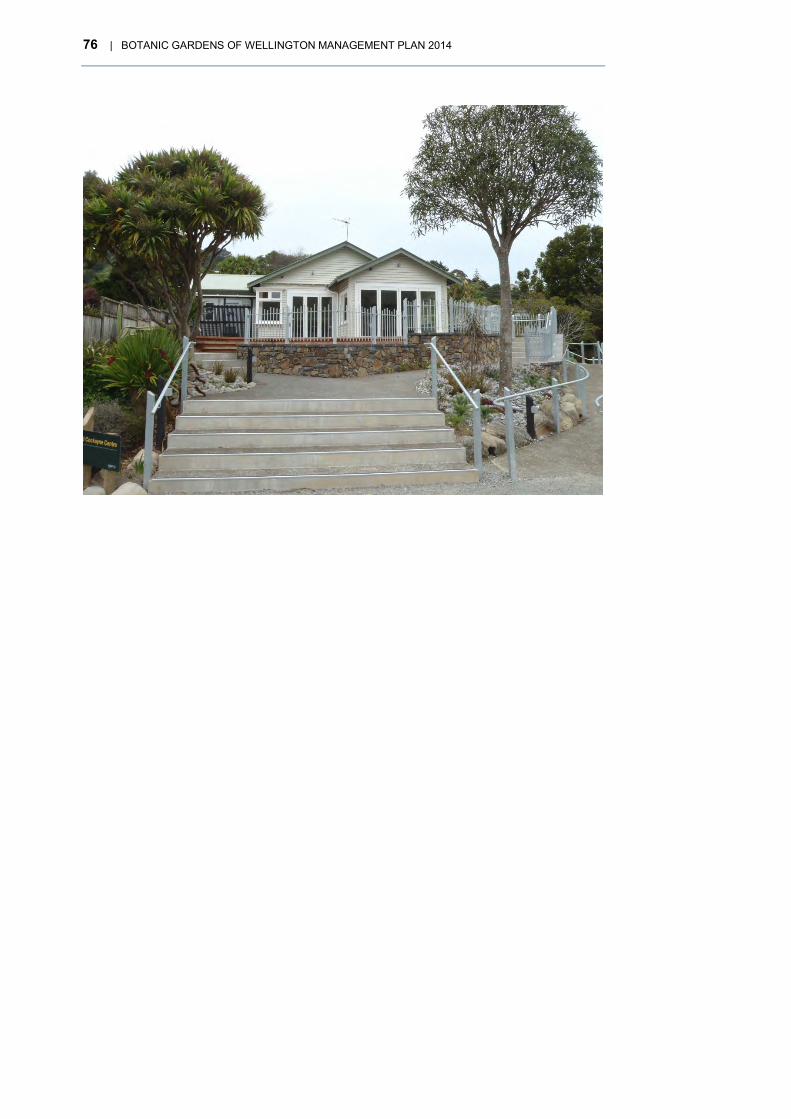
76 | BOTANIC GARDENS OF WELLINGTON MANAGEMENT PLAN 2014
BOTANIC GARDENS OF WELLINGTON MANAGEMENT PLAN 2014 | 77
BOLTON STREET CEMETERY 6Bolton Street Cemetery28 was developed from three 19th century cemeteries for the Wellington colony: the Public, Church of England and Jewish. As well as containing the historic memorials, it has an extensive collection of heritage roses and a visitor centre displaying information on the graves.
The cemetery is divided in two parts by the Wellington suburban motorway. The upper half – located on the slope below Anderson Park, including the Seddon Memorial – is joined to the lower part by a pedestrian footbridge. It provides an essential green link between Wellington Botanic Garden, the Terrace and the central city.
It is Wellington’s earliest cemetery set in a distinctive heritage landscape containing the graves of over 8600 people. It comprises 1334 visible memorials and headstones commemorating the city’s early colonial history, resting amongst a heritage rose collection and mature trees. Beneath the lawns are thousands of unmarked graves including approximately 3700 graves disinterred to make way for the Wellington motorway and placed in a mass grave.
It has a peaceful and contemplative ambience. The layout is informal and irregular, emphasising its historic character. Rich with pathways, historic artefacts and plants, the cemetery offers the opportunity for quiet exploration and appreciation of Wellington’s colonial history.
A detailed historical outline is included in Appendix 2.
6.1 HISTORIC SIGNIFICANCE The cemetery is an Historic Reserve under the Reserves Act 1977 and a Heritage Area under the District Plan. It is historically significant for a number of reasons.
• Together with Mount Street (Roman Catholic Cemetery) it was the first Wellington burial ground. It commemorates many early pioneers such as Edward Gibbon Wakefield and John Plimmer.
• It has wide historical links in commemorating notable leaders such as Richard John Seddon, Harry Holland, Samuel Parnell and James Edward Fitzgerald.
• It is a good example of a typical 19th-century cemetery with its memorials of stone, iron and wood forming an irregular vertical profile made up of slabs, pedestals, statuary and crosses. The wooden memorials are particularly unusual and important.
• The number and variety of fences surrounding the graves are of particular significance. They are comparatively rare in New Zealand and, quite apart from their historical value, are extremely attractive in the variation of their patterns, whether in wood, cast iron or wrought iron.
6.1.1 IDENTITY AND NAME
In the early days of settlement each of the three cemeteries in Bolton Street had their own identities, entrances and distinct names. Once the cemeteries at Bolton Street were closed to all burials except for next of kin in 1892 the whole area gradually became known as Bolton Street Cemetery.
When the significant motorway changes took effect in the 1960s, the idea arose of referring to the remaining burial ground and re-landscaped area as a memorial park, the first suggestion being the Early Settlers Memorial Park but the final decision being the Bolton Street Memorial Park. The official opening of the Bolton Street Memorial Park took place in 1990.
28 The name was formally changed from Bolton Street Memorial Park during the preparation and approval of this management plan.

78 | BOTANIC GARDENS OF WELLINGTON MANAGEMENT PLAN 2014
• Renaming of the area occurred during the development of this management plan for the following reasons. The word “cemetery” reflects more closely the history and significance of the area. Although it is a closed burial ground, it continues to be a cemetery because human remains are interred there. It is unusual in New Zealand for a burial ground not to be described as a cemetery.
• The customary usage is to refer to it as Bolton Street Cemetery despite the previous name change.
• The public do not necessarily associate the term “Memorial Park” with a cemetery. This will be exacerbated and lead to further confusion when the National War Memorial Park is opened in Buckle Street,
• Calling the area Bolton Street Cemetery gives it a recognisable identity for visitors, give it a clear identity as a cultural destination and make it easier to for researchers through the internet.
6.2 CULTURAL AND NATURAL HERITAGE Bolton Street Cemetery has a peaceful and contemplative atmosphere appropriate to a cemetery. The layout is informal and the garden, with its many naturalised plants growing in profusion, has a ‘wild,’ ‘old world’ quality that adds to the sense of history. It is rich in detail of pathways, historic artefacts and plants. Apart from the main gully system, it is very much a created and constantly tended landscape aimed at safeguarding a unique piece of Wellington’s cultural history.
6.2.1 POLICIES
6.2.1.1 Policies: landscape character
a) The relaxed and informal character of the cemetery shall be maintained.
b) In appropriate areas the ‘wild’ garden theme of naturalised garden plants that were introduced during the 19th century shall be maintained, provided that graves and monuments are not damaged by vegetation.
c) The historic character of the cemetery shall be maintained and no buildings other than the Memorial Chapel, Sexton’s cottage and equipment shed shall be permitted.
d) Management of the tree framework shall be governed by the policies the Tree Plan29.
e) Vegetation shall be controlled to prevent the destruction, damage or obliteration of graves and monuments based on the Maintenance and Repair Guidelines.
f) Planting shall, in general, be with species and plant associations that are in keeping with the 19th-century character and style of the cemetery taking into account:
i.) planting associated with particular graves is to be in keeping with the character and style of the graves
ii.) trees are to be planted where the roots, at maturity, will not damage graves
iii.) open areas are to be maintained along the main walking and interpretation routes for visitor safety, and to preserve vistas.
g) The potential for providing food sources for native birds shall be considered when selecting species for replanting.
h) Existing plantings adjacent to the motorway shall be gradually replaced with a mixture of local native species and species of 19th-century character.
29 Tree Plan Wellington Botanic Garden (for amenity and framework trees) 2011 – note the plan includes Bolton Street Cemetery
BOTANIC GARDENS OF WELLINGTON MANAGEMENT PLAN 2014 | 79
i) Those parts of the cemetery that are to be managed as ‘wild garden’ and ‘semi-wilderness’, including areas of regenerating native bush, shall be clearly identified.
j) The heritage rose collection shall be managed, extended and developed with the aim of establishing a heritage rose site of national importance.
k) The heritage rose collection shall have an emphasis on species and varieties available in the 19th century and early 20th century.
In 2006 maintenance and repair guidelines for graves were prepared30 that focussed on:
i.) the broader implications of vegetation, extent, type and character and its specific impacts on graves together with suggested remedial measures
ii.) a repair and maintenance philosophy for graves and monuments, methods of cleaning, and appropriate repair techniques.
Planting character and tree framework
The semi-wilderness and over-grown nature of the plantings in Bolton Street Cemetery is an important part of its character. Many of the mature trees have historical interest as their planting dates back to the early days of the cemetery and many of the ornamental plantings throughout the main burial areas are ‘old world’ garden plants that were introduced in colonial times.
Some plants were apparently associated with particular graves, but many appear to have self-seeded and colonised areas and sites. The areas of regenerating native bush add to the semi-wilderness character and are in keeping with the early history of the cemetery, when David Robertson, the first sexton, planted many native species to preserve them from extinction.
We can broadly divide the vegetation into:
• Closed canopy native vegetation comprising some of the plant species that typified Wellington’s pre-settlement coastal and semi-coastal forest. Such native vegetation is dominant only within the extensive gully system in the main body of the cemetery (above and west of the urban motorway) generally south-west of Strang Path and the upper section of T H Fitzgerald Path. Recent removal of trees adjacent to or damaging graves has opened up these areas leaving only small pockets of the original vegetation.
• Mixed exotic and native vegetation containing a much more random plant association than the preceding, with some of the plants having been planted. It is drier and more exposed than the closed canopy native vegetation, with greater light penetration, and lacks the tiered structure of the closed canopy. The interface between native and exotic vegetation is variable. For instance, native trees as specimens and groups are found throughout the park within areas of predominantly exotic vegetation. Generally exotic vegetation tends to predominate along the motorway boundary and, to a lesser extent, along the Bolton Street boundary where it is mixed with native vegetation.
• Heritage roses and climbers that are found growing within graves and/or growing on the support structure or where the structure was formerly surrounding the grave. They are distributed throughout the cemetery with many dating back to the late 19th or early 20th century. They provide historic interest and amenity appeal. In the 1980s the importance of these early plantings was recognised and a heritage rose collection was gradually established. The collection now includes over 100 varieties of old roses. Heritage Roses New Zealand recognises the collection and assists with guided tours and pruning demonstrations.
• Framework trees tend to be readily visible large-scale specimens in their own right, predominantly exotic, coniferous and, therefore, evergreen. Native signature trees are exclusively pohutukawa and while pohutukawa has become naturalised and prevalent throughout Wellington it was not part of the pre-settlement native forest. The trees are fairly evenly distributed throughout the lower portion of the cemetery and also
30 Bolton Street Memorial Park – Maintenance and Repair Guidelines for Graves Titchener Monzingo Aitken, Landscape Architects and Chris Cochran, Conservation Architect (2006)

80 | BOTANIC GARDENS OF WELLINGTON MANAGEMENT PLAN 2014
throughout the upper cemetery, apart from the gully system described previously. Duration of the existing conifer framework in the park is unknown and changes, probably from storms, are likely to be sudden and dramatic.
The existing vegetation has, in many cases, a direct bearing on the condition, visibility and appreciation of the graves. The management of the existing vegetation and the introduction of new planting is of the utmost importance.
6.2.1.2 Policies: graves and monuments
A maintenance and repair philosophy for the cemetery is based on the principles espoused in the ICOMOS Charter for the Conservation of Places of Cultural Heritage Value, widely accepted in New Zealand and Australia as providing a benchmark for conservation practice.
Over 8500 people have been interred in the cemetery. There are about 1334 visible tombstones and other memorials – 600 in their original location and 734 re-located after the construction of the Wellington urban motorway.
a) All graves, monuments and surrounds shall be maintained and managed in accordance with the ICOMOS charter and based on the Maintenance and Repair Guidelines for Graves31 and any subsequent amendments.
b) Graves and monuments shall be regularly inspected for damage from vandalism or vegetation and for signs of general decay.
c) Where damage occurs, immediate steps shall be taken to prevent further damage and repairs carried out as soon as possible. Wherever possible and practicable, the Council will seek to recover the cost of repairs from descendants or family.
d) Vegetation around graves and monuments shall be managed to protect the graves and monuments from damage and to maintain adequate visual and physical access.
e) Interested parties, such as family, shall be consulted, provided that they can be contacted, before beginning major restoration work. In addition, the Council’s intention to carry out annual remedial work shall be publicly advertised in accordance with the Burial and Cremation Regulations 1967, giving specific details of the headstones and memorials.
f) All grave and monument fragments shall be securely stored and catalogued to be available for restoration work.
g) Records of all historic assets within the cemetery and any that may be stored off site shall be kept up to date with records of damage, remedial work and significant alterations noted.
The graves and monuments are the main features of Bolton Street Cemetery. They are a valuable historic record and a source of great human interest but many of the memorials and surrounds are quite fragile and vulnerable to damage. Access to the graves is important both for the families and interested members of the public so it is essential that reasonable access be provided to graves to avoid unnecessary clearing by visitors.
Maintenance and Repair Philosophy
The maintenance and repair philosophy is based on the over-riding principle of doing the minimum required. This is the best guarantee of retaining the authenticity of each grave.
In the words of the Historic Cemeteries Conservation Trust of New Zealand,
“Do as much as necessary, and as little as possible”.
31 31 Bolton Street Memorial Park – Maintenance and Repair Guidelines for Graves Titchener Monzingo Aitken, Landscape Architects and Chris Cochran, Conservation Architect (2006)

BOTANIC GARDENS OF WELLINGTON MANAGEMENT PLAN 2014 | 81
The following section is taken from the Maintenance and Repair Guidelines for Graves32.
In increasing levels of intervention, conservation work may involve:
> doing nothing
> cleaning, weeding, general maintenance etc
> stabilising
> repairing
> restoring
> reconstructing.
Generally, while most graves will require, at one time or another, cleaning and general maintenance, work of a higher level of intervention should be carefully rationed.
Doing nothing This is appropriate for graves in a stable but weathered condition and in some cases for graves that have decayed to such an extent that repair is no longer feasible. This fits the ethos of a closed cemetery, where graves will slowly weather and age. The patina of age, weathered surfaces and the evidence of slow change over time are aesthetic qualities that contribute significantly to the importance of the cemetery.
This should remain an option given the financial constraints of cleaning and maintaining graves as identified in the next option.
Cleaning, weeding, general maintenance If graves are to have a long life, some basic and regular maintenance is essential. A well-maintained grave will survive the detrimental effects of weathering and time better than one that is not maintained.
Maintenance should be carried out on a planned basis. Methods should be as benign as possible, should minimise any change to heritage fabric, and in particular should aim to preserve the patina of age.
Stabilising Graves should be stabilised where they are at risk of collapse. Such work involves preventing things from getting worse by propping, building a new foundation or tying elements together.
Repairing Repair involves putting things back as they were; not to as new condition, but to a secure, tidy state where all elements are in good condition and stable for their age.
Where it is decided that repair should be carried out, several principles apply.
> Repair rather than replace.
> Repair in compatible materials.
> Use traditional techniques as guidelines.
> Ensure new work is identifiable and can be reversed.
> Identify cause of failure.
Restoring Restoration of lost features should be carried out only if there is clear evidence of the
32 Bolton Street Memorial Park – Maintenance and Repair Guidelines for Graves Titchener Monzingo Aitken, Landscape Architects and Chris Cochran, Conservation Architect (2006)

82 | BOTANIC GARDENS OF WELLINGTON MANAGEMENT PLAN 2014
original form and detail. Restoration would be carried out only in special circumstances such as in the case of the grave of an important person, or a grave that has (or had before being damaged) particular aesthetic significance.
Reconstructing Reconstruction implies the more or less complete rebuilding of a grave, utilising some extant parts but incorporating a significant amount of new material. As for restoration, it should only be attempted if there is clear evidence of the original form and detail, and only in very special circumstances, where for example, a grave of historic or aesthetic value was badly damaged by a falling tree, landslide or vandalism.
Reconstruction is a valid option in Bolton Street Cemetery, since many graves were dismantled and reconstructed (or more accurately partially reconstructed, since it was headstones alone rather than complete graves that were brought back) after the advent of the motorway in the 1970s.
Although the cemetery is closed and administered as an historic reserve, the headstones and memorials still legally belong to the family of those buried. Where family members can be contacted, their permission is needed before remedial work can be undertaken and the cost of remedial work should be passed on to the family.
6.2.1.3 Policies: burial records and new interments
a) New tablets, additions to existing memorials and ash interments shall only be permitted in existing or known graves. The Botanic Gardens Manager shall approve such applications, in consultation with the Friends of the Bolton Street Cemetery.
b) New tablets should complement existing memorials in terms of size and location and shall be in similar materials, lettering style and shape to other memorials on the plot.
c) Where space exists for lettering to be inserted on an existing memorial, the wording and setting out must be in keeping with the existing memorial and shall be in a similar lettering style.
d) Families should be encouraged to fund/contribute to costs associated with the placement of new tablets and additions to new memorials.
e) No artificial flowers or other elements extraneous to the heritage character of the cemetery are permitted to be placed in the cemetery.
f) Both the Sexton at Karori Cemetery and the Botanic Garden Manager shall approve applications for new interments of ashes and register all new interments in the Public Cemeteries Register. The Sexton shall be responsible for verifying and recording amendments to the Burials List on the Database, in consultation with the Friends of Bolton Street Cemetery.
g) New interments will be appended to the burial list held at the Chapel.
h) An up to date electronic list of burials shall be maintained on the Council’s Cemeteries Database and made available to the public.
i) An up to date List of Burials, either in hard copy or electronically, listing those identified as having been disinterred for the motorway and dedicated to them shall be held in the Memorial Chapel.
Although the cemetery is closed to burials, relatives occasionally request to have ashes of a family member interred and acknowledged within a family plot, or interred under a single family member’s reinstated memorial (a relocated memorial whose grave has been dismantled.) This is permitted, but new acknowledgements must be in keeping with the historic character of the cemetery.
A memorial is defined as any marker in stone, wood or iron. A tablet is a small rectangular stone memorial, usually additional to the main memorial.

BOTANIC GARDENS OF WELLINGTON MANAGEMENT PLAN 2014 | 83
In recent years the Friends of Bolton Street Cemetery have compiled a full list of burials in the cemetery and a list of those disinterred during the motorway construction. This is a valuable record of the cemetery’s history, which will be require regular updating as more information is obtained from on-going research.
6.2.1.4 Policies: heritage buildings
a) The Sexton’s Cottage shall be managed according to the conservation plan and continue to be used for short-term accommodation. The Council and Friends of Bolton Street Cemetery will explore the possible opening and use of the cottage for activities and events between its use for accommodation that contribute to the tourist and heritage potential of the Cemetery.
b) Heritage New Zealand shall be consulted about any proposed alterations to the structure of the Memorial Chapel, to ensure that the replicated architectural integrity of the building is retained.
c) The displays and information material in the Chapel should be reviewed and refreshed at appropriate intervals.
There are two buildings with heritage value in Bolton Street Cemetery.
The Sexton’s Cottage, dating from 1857, is entered on the New Zealand Heritage List/Rārangi Kōrero as a Category 1 Historic Place and is listed as a heritage item under the District Plan. The cottage was previously used as accommodation for Botanic Garden staff but more recently has been used for short-term ‘artist-in-residence’ accommodation. Future use is likely to be based on short-term accommodation including possible visitor accommodation with public activities in the house scheduled around times when the cottage is available. The adjacent chapel provides suitable visitor facilities and information on the park.
The Memorial Chapel is a replica of the mortuary chapel that was built in 1866. The original was dismantled to make way for the motorway but had deteriorated too much for it to be reconstructed. The chapel contains interpretation on the park, and the Memorial Book containing details of all those buried in the three cemeteries.
6.3 VISITOR EXPERIENCE – RECREATION AND ACCESS Bolton Street Cemetery is an inner city park close to the central city that provides a peaceful space for passive recreation and use by local residents, city workers and tourists. It tells the colonial history of Wellington and is a popular place for genealogists, relatives, and researchers.
The City to Sea Walkway and the main route from the Cable Car to the central city pass through the cemetery. It is also a major commuting route for walkers from Kelburn, Northland and Thorndon.
6.3.1 ACCESS, PARKING AND ENTRANCES
The main entrances are at Bolton Street by the Memorial Chapel and the Seddon Memorial adjacent to Anderson Park. There are also several secondary entrances generally accessed by locals.
Vehicle access is limited to a small car park off Kinross Street with a two-hour limit, which is shared by visitors to Anderson Park and the Lady Norwood Rose Garden. Parking near the Bolton Street entrance is limited to on-street metered Council parks. There have been initiatives to charge for parking at the Seddon Entrance in conjunction with Rose Garden parking. These have never been approved and implemented by the Council.

84 | BOTANIC GARDENS OF WELLINGTON MANAGEMENT PLAN 2014
There is an extensive network of paths and walkways consistent with an historic cemetery. Over the past 20 years there has been an extensive programme to upgrade the path network and improve directional signage and information. This has opened up new parts of the cemetery for visitors and given better access to the historic graves.
6.3.2 VISITOR FACILITIES
The location of the cemetery close to the Wellington Botanic Garden and the central city means that it does not require major visitor facilities. This is consistent with the historic nature and role of the cemetery.
There is visitor information and interpretation in the Memorial Chapel off Bolton Street. There are no public toilets in the cemetery but some are located near the Seddon Memorial entrance (Anderson Park Cricket Pavilion) and in the central city (bus terminal and railway station).
6.3.3 INFORMATION AND INTERPRETATION An Interpretation Strategy was prepared for the cemetery in the 1990s and visitor experience has been enhanced through the development of interpretation based on the following themes:
• colonial history of Wellington, in particular church history and stories of the early colony through individuals buried there;
• motorway protest and development;
• heritage roses;
• architectural interest, in particular the Memorial Chapel and Sexton’s Cottage.
Interpretation takes several forms:
• memorial trail identifying graves significant for historical or architectural reasons;
• leaflets relating to the Memorial Trail and about identifying graves;
• guided tours run by the Friends of Bolton Street Cemetery;
• displays in the Memorial Chapel.
6.3.4 POLICIES
6.3.4.1 Policies: events and activities
a) Small events and activities are allowed that are in keeping with the historic nature of the cemetery and will generally be limited to the grass spaces above the car park.
b) No events will take place on the mass grave or any other grave whether marked or unmarked.
The nature and quiet ambience of the cemetery mean that it is not suitable for large community events, apart from guided tours and activities associated with interpretation. Small functions can take place in the Memorial Chapel but this does not have suitable facilities such as a kitchen or toilet. The adjacent Memorial Lawn containing the mass grave is unsuitable for activities and events.
6.4 PARTNERSHIPS AND COMMUNITY INVOLVEMENT The history of the cemetery is closely linked with the Friends of Bolton Street Cemetery. The society grew out of the Bolton Street Cemetery Preservation Society established in 1964 out of community concern for the well-being of the cemetery, during and following motorway construction and the need to recognise the overall values of the cemetery. Today the Friends work closely with the Council to preserve and develop the heritage

BOTANIC GARDENS OF WELLINGTON MANAGEMENT PLAN 2014 | 85
aspects of this historic cemetery. The Society’s primary aim is defined as being “to preserve, protect and enhance for the public benefit the three Wellington historic cemeteries now known collectively as the Bolton Street Cemetery”.
6.4.1 POLICIES
6.4.1.1 Policies: Friends of Bolton Street Cemetery
a) A close relationship will be maintained with the Friends of Bolton Street Cemetery and their role in assisting with management and promotion of Bolton Street Cemetery supported.
The Friends of Bolton Street Cemetery
The Friends group was formed in 1977 out of community concern for the well-being of the cemetery, during and following motorway construction and the need to recognise the overall values of the cemetery. Today the Friends work closely with the Council to preserve, protect and develop the heritage aspects of this historic cemetery.
One of the original roles of the Friends was the preparation of an authoritative combined Burial List for the three separate town cemeteries. This list has been compiled over a number of years from diverse and sometimes conflicting historic records of varying degrees of reliability. It is constantly updated as family members and researchers identify fresh information. An up to date burial list can be accessed on the Friends website and at Karori Cemetery. New technologies provide opportunities to build electronic maps and use such tools for location finding.
The Friends of Bolton Street Cemetery have many roles in addition to assisting the Council with managing and updating the database. These include:
maintaining graves and assisting in further development of the cemetery
advising the Council on issues relating to park and grave management
running guided tours to encourage public interest in the park.
Mount Street Cemetery
The closed Mount Street Roman Catholic Cemetery is situated between Victoria University and the Terrace. It was established at the same time as the three cemeteries at Bolton Street. It is therefore of a similar age, has important early historical interments and has cemetery architecture similar to Bolton Street. The City to Sea Walkway follows the main path of the cemetery connecting both cemeteries via the Wellington Botanic Garden. There is an opportunity to work more closely with the Friends of Mount Street Cemetery and the Archdiocese of Wellington to integrate administrative records and to ensure common standards for maintenance and restoration. Mount Street Cemetery has recently begun a significant memorial and grave refurbishment and grounds restoration programme, partly funded by the Archdiocese of Wellington, Victoria University of Wellington, donations and grant funding. While the Council does not provide resources to maintain Mount Street Cemetery, there are natural synergies between these two historic cemeteries that should be further explored.
6.4.2 MANA WHENUA
The history of Bolton Street Cemetery goes back to the early colonial settlement of Wellington. The area was probably already used by Māori for burials and for the earlier traditional processes for dealing with the dead. Both Kumutoto and Pipitea would have used these areas for this purpose. The names of the streams give some indication of that purpose being the Waipiro (evil smelling water) and Tutaenui.
The history of the two nearby pā should be marked in an appropriate way. This should include some additional interpretation within the park, which sets out some of the history

86 | BOTANIC GARDENS OF WELLINGTON MANAGEMENT PLAN 2014
of the site prior to colonisation as well as some of the stories of those interred and re-interred in the park.
6.4.3 IMPLEMENTATION
THEME ACTION
Identity and name Change the name of Bolton Street Memorial Park to Bolton Street Cemetery.
Landscape character Continue the five year Implementation Plan in the Tree Plan33.
Graves and monuments Electronically locate all known grave sites and headstones and store them on the Council Geographic Information System (GIS).
Redesign the landscape around the mass grave to discourage access and provide a suitable setting for this historic site.
Partnerships Work with the Archdiocese of Wellington to integrate administrative records and maintenance standards between the two historic cemeteries at Mount Street and Bolton Street.
Work with Port Nicholson Block Settlement Trust on interpretation that outlines the significance of the site and cemetery to Māori.
Signage and way-finding Review and improve way-finding between Bolton Street and the entrance into Wellington Botanic Garden, the cemetery and Anderson Park off Kinross Street.
33 Tree Plan Wellington Botanic Garden (for amenity and framework trees) 2011 – note the plan includes Bolton Street Cemetery

BOTANIC GARDENS OF WELLINGTON MANAGEMENT PLAN 2014 | 87
TRUBY KING PARK 7This historic property sits on a ridge in Melrose with magnificent views over Evans Bay, Lyall Bay and Newtown. Formerly the home of Sir Frederic Truby King and his wife Isabella, it comprises the original house designed in 1923 by Architect Gray Young, the historic garden laid out between 1925 and 1935 by Truby King and a mausoleum where Frederic and Isabella Truby King are interred.
The 1.9-hectare site was acquired by the Council in 1990 and is classified as Historic Reserve under the Reserves Act 1977.
7.1 CULTURAL SIGNIFICANCE Truby King is probably New Zealand’s most widely known medical practitioner. He influenced the course of health care in New Zealand, both in mental health and more particularly in the health and welfare of mothers and babies. With his wife Isabella he founded the Plunket Society, still active today after over 100 years. He was knighted for his work and accorded a state funeral on his death.
Mount Melrose has great historical significance as the former home and garden of Sir Frederic Truby King and his wife Isabella, modest architectural significance and important landscape significance in the context of a dramatic Wellington hilltop site and developed garden.
Truby King Park as we know it today is one part of the original “Mount Melrose” estate that also comprised the Karitane Products Society Factory and Karitane Hospital. Both buildings remain but are privately owned.
The landscape context of the three buildings and their original role and relationship remains today and provide a unique historic precinct that has been entered on the New Zealand Heritage list/Rārangi Kōrero as the Truby King Historic Area. Truby King House, the Mausoleum and the adjacent ex Products Factory building are listed as heritage buildings in the Wellington District Plan.
7.1.1 HISTORIC SUMMARY34
The original 10-acre site on the summit of Mount Melrose was purchased in 1923 by Sir Truby King following his posting to Wellington as the Director of Child Welfare. King commissioned William Gray Young, a prominent New Zealand architect, to design the Karitane Products Factory along with a house that became the family home for the next nine years.
King, along with his head gardener, Daniel Russell, developed the land around the house and factory into a garden featuring exotic roses, a rhododendron dell and a wide range of other native and exotic plants, surrounded by a shelter planting of radiata pines. In addition he constructed an intricate series of roads, paths, wind screens, and an extensive series of brick walls, lookouts and arches which today are a particular feature of the garden.
In 1925 King decided to build a model Karitane Hospital and gifted land at the southern edge of the property. The money for construction was raised by public donation, and in 1927 the hospital was opened by the Duchess of York.
Isabella King died in the same year, affecting Truby King greatly. Five years later he made public his intention to gift the house to the Plunket Society. Following his death in
34 Based on the New Zealand Heritage List/Rārangi/Kōrero registration report number 7040

88 | BOTANIC GARDENS OF WELLINGTON MANAGEMENT PLAN 2014
Figure 6. Aerial view showing the boundaries of Truby King Park.

BOTANIC GARDENS OF WELLINGTON MANAGEMENT PLAN 2014 | 89
1938 he was the first private citizen to be granted a state funeral, and special legislation was passed allowing King and Isabella to be buried in a mausoleum at the bottom of the hill below the house.
The Plunket Society received the house and garden while the Karitane Products Society took over the Products Factory and adjacent hospital.
The garden was maintained with little development during the 1940s but as the overall costs of maintenance became prohibitive during the 1950s the garden was modified to make it easier to maintain. Much of the original character and original plantings were lost during this time. A survey in 1991 showed that only three or four of the remaining rhododendrons could have been planted by Truby King.
By the 1970s the Plunket Society was in financial difficulties and in 1978 the hospital was closed down. It was finally sold in 1982 and since that time has been used periodically as a conference centre. The Products Factory was sold in 1988 and has been converted into residential units.
A detailed historical outline is included in Appendix 2.
Development of Truby King Park
In late 1988 the Council commenced negotiations with the Plunket Society and private owners of the adjacent rhododendron dell, which had been identified for possible residential development. By May 1990 the Council acquired these properties plus an adjacent property that provided a relatively easy gradient between the park, Wellington Town Belt and Duncan Terrace.
The Council carried out extensive background research on the house and garden, which culminated in the preparation of the Truby King Park Conservation and Management Plan in 1993. This has guided work on the park over the past 20 years including:
• repair of the house, including new roof, fire proofing and replacement of underground services
• reconstruction of the rhododendron dell and path network, cherry lined driveways and hedging; replanting of the central ‘teardrop’;removal and thinning of pine trees on the eastern slopes below the house
• recovery of the garden areas from adventive growth or ornamental species and weeds
• restoration of the mausoleum
• reconstruction of some of the brick walls, arches and landscape features. Several major structures remain to be restored especially around the house
• replanting of the central ‘teardrop’ of the house and mausoleum.
7.2 OBJECTIVES 1. To promote and manage the park as a passive recreational amenity for the use and
enjoyment of the public.
2. To reconstruct and manage the historic garden as near as practicable to its original form and character.
3. To protect, manage and use the house and mausoleum in a sensitive and dignified manner.
4. To interpret and promote an awareness and appreciation of the historic importance of the property and its association with the family and work of Sir Truby King.
90 | BOTANIC GARDENS OF WELLINGTON MANAGEMENT PLAN 2014
7.3 THE GARDEN
7.3.1 ASSESSMENT AND SIGNIFICANCE
The layout of the Mount Melrose site was clearly influenced by the hilltop nature of the site, the prevailing site conditions and the desire of Truby King to create a pleasant and attractive garden environment. The house was sited on the crest of the hill where it obtained extensive and expansive views. Access to the house from Manchester Street was by way of a long drive that formed a loop driveway around the house and adjacent knoll. The tear drop formed the basis for the inner garden adjacent to the house.
Within the tear drop a path system extended informally from the driveway up to the house. On the southern and eastern sides of the house a brick wall and archway system was constructed. This was carefully planned to frame views from within the house.
On the eastern side of the access road, above the Rhododendron Dell, a series of viewing platforms were constructed to enable views over the eastern suburbs and Cook Strait as well as provide views into the Dell.
While the planting within the garden has been greatly modified, the essential structure and form has largely been maintained due to the presence of the extensive brick walls, steps and piers. The only major structural additions to the garden were the stone walls built in the 1950s to retain areas eroding following vegetation removal.
Extensive research during the preparation of the 1993 plan found extensive information on the plants ordered for the garden but failed to locate any useful information or documentation on its unusual layout or design. The garden does not reflect a particular style, nor is it based on traditional design layouts. The Mount Melrose garden is the individual creation of one person.
7.3.2 .. POLICIES
7.3.2.1 Policies: landscape character
a) No additional buildings or structures to be constructed or located on site that would compromise views to or from the house and garden.
b) The visual links and view shaft between the house, former Karitane Hospital and the wider landscape will be maintained.
c) The right of way serving the three properties will be maintained in its present form.
d) All above ground utilities will be placed underground where feasible.
7.3.2.2 Policies: garden reconstruction and management
a) Retain the essential landscape character of the garden by reconstructing it based on the form and character of the garden in the 1940s.
b) Adapt the planting and range of species used to suit the current environmental conditions and levels of service.
Conservation of historic gardens
The International Council for the Conservation and Restoration of Monuments and Sites (ICOMOS) has prepared the Florence Charter, which identifies approaches to the conservation of historic gardens. Mount Melrose is considered to be a historic garden and worthy of conservation.
The ICOMOS New Zealand charter (2010) notes that conservation may involve, in increasing levels of intervention: preservation, restoration, reconstruction and adaptation.

BOTANIC GARDENS OF WELLINGTON MANAGEMENT PLAN 2014 | 91
Preservation: Involves as little intervention as possible, to ensure its long-term survival and the continuation of its cultural heritage value. This has limitations in a garden context as it involves retaining components of the garden in their existing state and retarding their deterioration, which is very difficult to achieve with living material. It may be possible to preserve elements of a garden structure such as pathways and built elements.
Restoration: Involves reassembly or reinstatement and may involve removal of additions that detract from the cultural heritage value of a place. This involves returning a garden to an earlier form by removal of accretions (additions) or reassembling existing components without the addition of new material. This has limited application where there are several periods of modification and much of the original plant material has been removed or has died.
Reconstruction: Distinguished from restoration by the introduction of new material to replace material that has been lost. This involves returning a garden to an earlier form whilst incorporating new material. This is the preferred option for garden conservation and should be followed if sufficient information and resources are available.
Adaptation: The conservation of a place of cultural heritage value is usually facilitated by the place serving a useful purpose. Adaptation may arise from maintaining its continuing use or from a proposed change of use. This can come about where costs of maintenance are limiting. This could include simplification or modification but should only take place once the following have been completed:
recording the existing garden form in photographs and measured drawings
evaluating areas to be simplified to restrict damage to the overall garden
preparing an inventory of plants and if necessary propagating from these plants if they risk being lost.
The site and its development were thoroughly researched and documented and we have a reasonably clear picture of the original design, the garden development and subsequent modifications.
A garden constantly changes and can be modified, revised or renewed over time to suit changing needs. The most appropriate strategy is one that accepts changes that have occurred over time provided there is an historical framework showing the clear intent of the original garden.
The 1993 plan proposed to retain the house in its present form and to reconstruct the garden as far as possible to a form and character that best represent the period illustrated in the 1943 photograph.
It is not intended that every brick be replaced or that structures are returned to a pristine condition. The reconstruction and repairs have been based on retaining and protecting the form and character of the garden’s layout: upgrading and strengthening where necessary for safety and public use and rebuilding damaged structures and replacing components that for aesthetic reasons require attention. Damaged or missing elements will in some instances be left as they are.
Garden structures should be surveyed to assess the most appropriate conservation intervention that would be suitable. It would be appropriate to identify the significance of each structure where possible, for instance those that relate to views from the house. In some cases preservation or restoration might be applicable rather than reconstruction.
The relationship of the house, garden structures, paths to garden and wider landscape needs to be considered. A plan of the site identifying view shafts to and from the house, including how the garden structures frame, should be developed. This will identify the changes as significant trees have grown in these view shafts.
92 | BOTANIC GARDENS OF WELLINGTON MANAGEMENT PLAN 2014
Garden reconstruction 1993– 2013
Over the last 20 years, Council’s management of the garden has involved:
• Removal of extensive areas of weed growth established as a result of many years of neglect of the garden. Much of this work was done prior to the detailed research into the original garden design and enabled the preparation of an inventory of the original plants still in situ.
• Rebuilding several of the retaining structures and lookouts including those along the driveway, on the east side of the house and within the rhododendron dell. There are several very large sections still to complete. Many of these will be complex and expensive to stabilise and rebuild.
However they need to be completed to enable access to the rear of the house and reduce the risk of damage to the house if they fail during an earthquake.
Where appropriate, input will be required from a suitably experienced heritage engineer. There may be the case to rebuild those in danger of falling and stabilise/ maintain others as Truby King constructed them.
• Planning and replanting of large parts of the Rhododendron Dell in species and cultivars including those known to have been planted by Truby King. In addition, removal of wilding trees and their replacement with smaller deciduous trees more in scale with the area. Several tracks were also rebuilt. Some of the large pines between the park and private properties on Duncan Terrace have been removed and have opened up the Dell and provided more light.
Future pine tree removal may expose the garden and house to wind so replanting with native species as a buffer along the boundary should be considered. This removal will open up some of the historic views towards the Hutt Valley.
The redevelopment of the Dell has been partially successful. Many of the rhododendrons planted have suffered badly from thrips, and the level of maintenance has not enabled additional planting of azaleas, camellias and other complementary species, or mulching of the area.
Replanting with smaller deciduous trees and the development of a community orchard is proposed in keeping with the holistic nature of the garden. This could occur both within the Rhododendron Dell and further north as the pine framework is gradually removed.
• Replanting of the cherry avenue and associated hedging has occurred along the driveway. Small azaleas have been planted along the inside of the driveway to provide spring colour.
Further replanting and replacement of trees should occur as required.
• Planting the ‘tear drop garden’ or feature garden has been based on the range of plant species and cultivars used during Truby King’s time but modified to enable a low-maintenance regime. Several areas of lawn have been retained for ease of maintenance. This planting is 80 percent complete. A decision was made not to reconstruct the rock garden on the south-east side of the house because of the high development and maintenance costs.
• The garden originally contained an extensive herb garden.
The rear of the house could be developed as a kitchen garden including herbs and vegetables once the landscape structures have been stabilised. This could be managed as a community garden by the trust and local community.
7.3.3 IMPLEMENTATION
THEME ACTION
Garden Complete reconstruction of the hard landscape features particularly the walls and archways around the house.
Replace the large pine tree framework with a framework of smaller trees.
Open up the house’s views over Evans Bay.
Increase the use of edible plant and tree species to emphasise the holistic nature of the garden.

BOTANIC GARDENS OF WELLINGTON MANAGEMENT PLAN 2014 | 93
7.4 THE HOUSE AND MAUSOLEUM Architect William Gray Young was commissioned to design a house for Truby and Isabella King in 1923. In its original form, the house had an American colonial character, especially the long veranda of the north elevation. The veranda was under the slope of the main roof, supported on large square timber columns with small paned French doors set back on the veranda. Truby King wanted the house to be light and airy hence its construction on top of a hill exposed to the elements. The house was originally designed so that every room received some sun.
The architecture is unpretentious – a plain weatherboard structure and a low pitched iron roof.
Mary King, the daughter of Truby and Isabella King, recalls a visitor to Mount Melrose calling it the “House of Windows” and they are certainly a feature of the design. On the north, east and south sides, views of the harbour, hills and open seas are stunning. One window is of particular interest in the study: a large vertically sliding sash window that could be wound down so that Truby King could use his telescope at night.
Generally the timber used in the house is rimu, both for the framing and interior finishing. Matai was used for the bevel back rough sawn weatherboarding, the exterior trim and some flooring. Jarrah was used for the flooring in the study and living room.
7.4.1 POLICIES
7.4.1.1 Policies: future use and management
a) Review the long-term role of the house to enable managed access for visitors whilst retaining its primary role as a residence.
b) Provide physical access to the house consistent with Heritage New Zealand guidelines that limits impact on the house and garden.
c) Review the conservation plan and ensure that adaptation of the house to suit a new use does not involve the loss or excessive modification of elements and spaces of considerable cultural significance (see below).
d) Improve information on and access to the park from adjacent suburbs.
Cultural significance
In 1992 a conservation report35 was completed on the house that included an inventory of spaces grouped according to their relative significance. The evaluation was based on:
• the historic importance of the space;
• its ability to evoke the lifestyle and values of Truby King;
• its architectural quality; and
• the degree of intactness.
Elements and spaces of considerable cultural significance: – maintenance and repair are allowable. Priorities for access by the public in any future use:
> hall and passage
> bedroom number 3
> study
> living room and nook
> dining room.
35 Conservation report 1992, Truby King House, Mount Melrose, Wellington prepared by Chris Cochran.

94 | BOTANIC GARDENS OF WELLINGTON MANAGEMENT PLAN 2014
Elements and spaces of some cultural significance: – further modifications to these spaces, particularly the boardroom, to meet new requirements are acceptable. Other elements include the external facades, original doors and hardware for windows etc.
Elements and spaces of little cultural significance: – maintenance, repair restoration and adaptation are allowable. These are generally service areas that can be adapted to serve new uses and include the flat and bathrooms.
A long-term sustainable use should be found for the house that involves its retention as an historic site whilst enabling public access on either a regular or managed basis. Access could be to parts of the house that best tell the story of Isabella and Truby King in the medical and social history of New Zealand as well as the history of Mount Melrose. This could involve development of the study as a small museum with an exterior entrance to enable it to be opened regularly in the same way as the Bolton Street Chapel.
Given its original role as a home and garden it is proposed that it be retained primarily for long-term accommodation provided significant parts of the house can be opened up on a managed basis. There have been proposals for the development of the house as a boutique meeting venue or small function centre. However, its location, poor access and wide range of function rooms and facilities in the city suggest that it would struggle to develop as a sustainable use.
There is a need to improve physical access to the house. Current access from the garden and car park is up a series of steps and onto a deck to the front door. Heritage New Zealand guidelines recommend where possible access for all users should not be separated. However there is a much easier access to the rear of the house into what may become in future a kitchen garden and alternative entrance to the house.

BOTANIC GARDENS OF WELLINGTON MANAGEMENT PLAN 2014 | 95
7.4.1.2 Policies: the mausoleum
a) A maintenance plan and programme for the mausoleum will be prepared consistent with the Truby King Mausoleum Conservation Plan36.
b) Planting around the Mausoleum will be carried out in a sensitive manner and shall not unduly screen views of the mausoleum and structures associated with it.
The Mausoleum was planned by Truby King as a final resting place for himself and his wife, on a site originally occupied by a pergola. The tomb was built in 1936 two years before his death. His wife, who predeceased him, was reinterred with him. It was very unusual for anyone other than a head of state to be buried outside a cemetery and a law was passed to approve it. In 1941 fundraising by the Plunket Society enabled an inscribed granite slab and balustrade to be built above the vault.
The wider mausoleum site includes brick walls, paths and gardens typical of the wider garden landscape. The steps below the Mausoleum are flanked by rows of yews and provide a formal approach to this place of solemnity.37
The Mausoleum is in good condition but there are structural issues with the paths and walls that require earthquake strengthening. There is slumping on the east side of the ridge which will require reinforcing in the longer term involving either construction of a new retaining wall on either side of the triangular ridge or installation of retaining piles on each side of the ridge.
7.4.2 IMPLEMENTATION
THEME ACTION
House Develop a long-term plan to enable managed public access to significant parts of the house whilst retaining accommodation for management and security purposes.
Provide accessible access to the house.
Develop the house and surrounds as the central interpretation centre for the park.
Investigate increased parking at the rear of the property for use by visitors to the Wellington Town Belt and Truby King Park.
7.5 RECREATION AND USE (VISITOR EXPERIENCE) Truby King Park is still a little-known visitor attraction. There are regular garden visitors especially during spring when the garden is at its best. An annual open day for the house and garden attracts up to 200 people. The house itself is opened as required for interest and tour groups. In the past few years this has averaged 4-5 groups a year. Being located on the popular Southern Walkway between Mt Victoria and Island Bay, the park is used mainly by locals.
Whilst one of the major objectives is to ensure the historic house and garden are managed and protected, it is important they are used and appreciated by Wellingtonians and visitors to the city. The park needs to provide an outstanding and memorable visitor experience.
36 Truby King Mausoleum Conservation Plan February 2007 prepared by Michael Kelly 37 Summary based on the Truby King Mausoleum Conservation Plan February 2007 prepared by Michael
Kelly.

96 | BOTANIC GARDENS OF WELLINGTON MANAGEMENT PLAN 2014
7.5.1 POLICIES
7.5.1.1 Policies: education and awareness
a) An interpretation plan will be developed to interpret the historic importance of the property and its association with the family and work of Sir Truby King. This shall include:
the house will be used as a central information and interpretation centre for the park
a schedule of regular open days and guided tours for the house and garden will be developed in conjunction with the Truby King House and Garden Trust.
The park needs to offer opportunities to both local residents who use it as their neighbourhood park and visitors who are incorporating the park into a longer walk. All visitors should be encouraged to experience a unique historic house and garden and learn about the work of Sir Frederic and Isabella Truby King.
The location and size of the property mean that casual visitation will remain low except during spring. Open days and guided tours where face-to-face interpretation can unlock the stories have been successful and could provide a way of increasing visitation as well as providing memorable experiences. Regular activities where the house and garden are open with guides present to tell stories and give guided walks could increase use and the profile of this special place. For instance, regular monthly open days on a Sunday would provide a guaranteed service. In addition, provision of on-demand tours could cater for out of town visitors/cruise ship passengers and so on. This could be linked to tours of the other botanic gardens or as part of more specialist historical tours.
7.5.1.2 Policies: access and visitor infrastructure
a) Public access to the house will be limited to regular events and on-demand guided tours.
b) Disability access will be provided into the house.
c) Vehicle access and parking will be restricted and controlled.
d) The feasibility of providing additional car parking will be investigated.
e) Maintain regular contact between the Council and adjoining land owners particularly regarding vehicle access, character of the shared driveway and the landscape character of the grounds.
f) Access by walking or public transport will be encouraged through improved information, walking links and signage.
Truby King Park is a former private residence. Access into and around the property reflects that. In particular:
• The narrow access road from Manchester Street with no footpath and few passing bays.
• The one way single lane road around the inner teardrop and house.
• The lack of parking space inside the park. There is parking for a maximum of six cars around the house.
• Very difficult access for large service vehicles.
• Conflict between walkers within the park and vehicles at peak times.
In addition, the location of the park above Wellington Zoo off Manchester Street means it is difficult to find and isolated from other attractions. The entranceway itself is not inviting and does not encourage exploration.
In order to maximise pedestrian use and enjoyment of the park, vehicle access needs to be controlled. Visitors will be encouraged to park outside and walk into the park. Vehicle access will be limited to service vehicles and those attending activities at the house. Consideration should be given to improving walking access from Manchester Street.

BOTANIC GARDENS OF WELLINGTON MANAGEMENT PLAN 2014 | 97
The only location where car parking on site can be improved is around the house. There is an opportunity to extend the parking area. Depending on the configuration this may need to be partly located on the Wellington Town Belt. This would be on the basis that parking was also for those visiting and using the Town Belt. The need for increased parking will be linked to any future public use of the house.
The park is on the route of the Southern Walkway between Mt Victoria and Island Bay. Walking and cycling are allowed on the sealed route through the garden. Cyclists are not permitted to use the smaller garden tracks including those in the Rhododendron Dell.
Within the park, access is limited for those with limited mobility. In particular, the steep paths into and through the Rhododendron Dell. The house is not fully accessible. Any future public use would need to provide for this.
The park has legal frontage onto Duncan Terrace in two places. However, the steep ground prevents the building of pedestrian access ways.
Adjacent land use
The main access to the park is shared with two adjoining owners. Originally both properties were part of the original Truby King Estate. The gardens of the old Karitane Hospital are visually part of the Truby King Park landscape.
7.5.2 IMPLEMENTATION
THEME ACTION
Community Support the Trust and work with the community to encourage increased involvement and use of the park by local residents.
7.6 COMMUNITY PARTNERSHIPS The Truby King House and Garden Trust ensure the property is maintained as an accessible community asset.
The Trust looks after the house and is dedicated to conserving the site’s heritage values and unique features. It was established in 2002 and works in partnership with the Council to:
• help maintain New Zealand’s heritage
• help with the conservation, restoration and maintenance of the house and garden
• encourage people to visit.
Given the main use of the park by the local community, it is important that they are engaged in the park and active in its maintenance and development. This could be in a number of ways including:
• supporting the Trust on open days and community events;
• helping to maintain and develop the garden;
• fundraising.
7.6.1 IMPLEMENTATION
THEME ACTION

98 | BOTANIC GARDENS OF WELLINGTON MANAGEMENT PLAN 2014
Visitation and access Enhance pedestrian links to the park, and look at ways to encourage use of the park as a feature on longer walking routes.
Examine ways to encourage increased use of public transport to access the park.

BOTANIC GARDENS OF WELLINGTON MANAGEMENT PLAN 2014 | 99
RULES FOR USE AND DEVELOPMENT 8This part of the plan outlines the rules relating to the provision and management of all development and activities within Wellington Botanic Garden, Otari-Wilton’s Bush, Bolton Street Cemetery and Truby King Park38.
Within the Gardens a number of activities and experiences are offered, and there is a range of values associated with the Gardens as a whole and with each individual garden. As activities have the potential to impact on other park visitors and the environment, they need to be managed by Wellington City Council (Parks, Sport and Recreation) giving approval for some activities through this plan.
Each activity fits into one of the following three categories, and this determines what type of permission applies and what process the activity is subject to:
• allowed activities
• managed activities
• prohibited activities.
Rules for use and development must be adhered to by both the Council and the public. However the rules are not intended to preclude day-to-day management by the Council. For example, public vehicle access is prohibited, but Council staff or their contractors will be permitted to use vehicles, chainsaws and so on as required for garden management.
8.1 OBJECTIVE 1. Manage the Gardens in a manner that recognises and protects their key values:
ecological, landscape, recreation, educational, culture and history.
8.2 POLICIES 8.2.1.1 Policies: activities, general
a) Provide for environmentally sustainable activities and uses that are consistent with the objectives and policies of this plan.
b) Manage and maintain discretion over activities to ensure appropriate allocation of resources, protection of open space values and the safety of users.
c) Maintain discretion over placement and management of new activities and utilities to avoid or limit impacts on the environment and open space values.
d) Follow a process for determining whether new activities and development are appropriate for the garden directly affected and for the Gardens in general.
e) Prohibit activities that are inappropriate for the Gardens.
f) Guide balanced decision-making when assessing potentially conflicting activities and/or when assessing effects of activity on the range of open space values.
38 These rules should be read in conjunction with the Wellington Consolidated Bylaw 2008

100 | BOTANIC GARDENS OF WELLINGTON MANAGEMENT PLAN 2014
8.3 ALLOWED ACTIVITIES a) These are activities that are generally ‘allowed’ or anticipated in the Gardens, but
may be subject to restrictions in order to protect open space values and provide for the health, safety and well-being of visitors.
b) The following activities by individuals or groups are permitted for non-commercial purposes and may be subject to certain conditions and temporary restrictions:
walking
running (but not the marking of routes or courses)
cycling and mountain biking on the designated route between Upland Road and Salamanca Road through the Wellington Botanic Garden, the formed road through the Rose Garden, and the formed driveways in Truby King Park
dog walking (on leash unless in a specified off-leash area, refer also to the Council’s Dog Policy)
sightseeing
picnics, barbecues (gas only at picnic sites), informal gatherings and group games and other similar activities. Restrictions may apply to some locations or activities (refer to (8.2.1.2 (c) below)
informal games that are appropriate and where directed
painting, amateur photography and filming39
wildlife spotting
orienteering
organised sport on Anderson Park – subject to standard conditions for booking with Parks, Sport and Recreation
access for park management and emergency vehicles at a maximum speed when in the gardens of 10km/h.
motorised vehicle access to public car parks and leased facilities
mobility scooters.
c) In order to protect the garden, the environment, the health, safety and well-being of other users and to facilitate garden operations, restrictions may be placed on allowed activities. The following is a guide of potential issues that may result in restrictions:
i.) group size for informal activities (up to 20 people is generally considered allowed, subject to assessment of the impact of what the group is doing);
ii.) time of the day and duration of activity (assessed on impact);
iii.) location (ensuring there is no user conflict between park users and activities);
iv.) day in the week or time of the year (restriction in regards to events during public holidays and considering weekday and weekend activity);
v.) the weather (restriction of activities and use of certain areas or facilities);
vi.) environmental conditions (any impact on the land and surrounding environment).
d) Maintenance or management of the gardens may limit allowed activities at certain times.
39 Non-commercial filming that is anything other than a home video-type activity is a managed activity. The need for commercial photography to obtain landowner approval will be assessed on a case-by-case basis, primarily considering the impact of the activity.

BOTANIC GARDENS OF WELLINGTON MANAGEMENT PLAN 2014 | 101
Explanation
Allowed activities are largely informal and unstructured, and traditionally associated with casual use of the gardens by locals and tourists. In addition, organised sport is allowed on Anderson Park subject to booking and payment (as per Council user charges). Allowed activities have a low impact on park values and other users and need few restrictions. Members of the public may not need to book these activities (apart for use of Anderson Park) or seek approval for them (subject to (c)).
Commercial activity is not an ‘allowed’ activity. Commercial use refers to use by an individual, group or organisation that is carried out for profit or as a means of livelihood or gain. This includes, but is not limited to, recreation and sport, food and beverage, tourism and filming businesses.
Some activities, like mountain biking and walking a dog off leash, will only be allowed on identified tracks or areas. Dog walking, for example, is also governed by a separate and specific Council policy (Bylaw and Dog Policy 2009).
e) The gardens are closed to mountain biking and cycling apart from:
the formed roadway in Truby King Park
the designated cycle lane from Upland Road through the MetService land to Salamanca Road
the drive through access from Glenmore Street to Kinross Street in the Wellington Botanic Garden.
Bicycles shall be ridden at a maximum of 10km/h through these routes.
8.4 MANAGED ACTIVITIES a) Managed activities are those that are not specifically ‘allowed’ or ‘prohibited’ and
any that are not listed in this management plan or require a case-by-case assessment. These activities are generally undertaken in a specific location and may involve temporary or longer term allocation of a park area or structure for a specific use.
Each application is considered on its merits, compatibility and appropriateness to both the garden in general and the location proposed. Some applications may need to be publicly notified, and all applications can either be approved, subject to conditions, or declined.
They may:
> be new activities and development
> be existing activities or development that do not have the appropriate approval in place
> involve the exclusive use of an area for an extended period of time
> require the development of temporary or permanent structures and buildings
> include commercial activities
> be large-scale events and a range of other uses.
b) The Council will manage activities and development through landowner approval as either a:
concession
easement
lease
licence

102 | BOTANIC GARDENS OF WELLINGTON MANAGEMENT PLAN 2014
permit 40
booking.
c) Note that other approvals from the Council and other organisations may be required for some activities including:
> resource consent (Resource Management Act)
> liquor licence
> archaeological authority (from Heritage New Zealand ).
d) Managed activities that require a permit or booking require approval by Council officers. These include:
conducting events (e.g. Summer City) and including, but not limited to, events and activities run on a ‘cost-recovery’ or ‘not-for-profit’ basis
camping (for educational purposes only)
conducting one-off activities involving site occupation or use (e.g. weddings, concerts)
commercial filming and photography (see footnote, 8.2.1.2 (b))
temporary access (except for park management, emergency access and as identified in the sector plans), e.g. infrastructure maintenance, art installations, vehicle access, construction access
markets and fairs consistent with the objectives of this plan
collecting natural materials, removal of living plant material, cultural harvesting
planting (unless carried out by the Council or its contractors or as approved by Parks, Sport and Recreation)
commemorative planting, seats and plaques (outlined in the Commemorative Policy)
formal environmental education activities and programmes
total or partial demolition or removal of buildings or structures
structures and furniture (including track infrastructure, gates, footbridges, track overpasses, fences, walls, retaining walls, artworks, sculpture, plaques, memorials, seats, interpretation, lighting, sun/shade shelters. Does not include utilities)
signs in relation to garden activity only (signs and/or advertising for non-reserve-related activity are prohibited) (see 8.5.1.1).
e) Managed activities that require a lease, licence, concession or easement will be assessed by Council staff and Council (or a delegated Committee) will approve or decline. These include:
leasing buildings and/or reserve land (consistent with the Leases Policy for Community and Recreational Groups)
commercial activities that are either large one-off events or are concessions for six months or more (including but not limited to, multisport events, guiding tours, selling food or drinks or hiring equipment) (see 8.5.1.4)
new buildings, building extensions, car parks and hard surfaces, additions and alterations often associated with leases
utilities (essential systems and networks that provide the city with water, energy, communications and wastewater removal) (see 8.5.1.2).
f) Public notification. Applications for managed activities will be publicly notified when:
it is required under the Reserves Act 1977;
it is required by Council policy (e.g. granting a lease or licence under the Leases Policy for Community and Recreational Groups);
an application to construct or modify a permanent utility would significantly alter the nature, scale or intensity of the effect on the park or reserve;
40 By form., letter or email

BOTANIC GARDENS OF WELLINGTON MANAGEMENT PLAN 2014 | 103
the nature and/or scale of the proposed activity has the potential to adversely impact on reserve values, including permanent public access and open space;
they involve a commercial sub-lease or sub-licence or concession.
g) Information required with application. All applications are required to include the following41 relevant information:
i.) a description and/or plans of the proposal with enough detail for Council staff to determine all potential effects;
ii.) an assessment of the impacts the development/activity will have on the immediate and wider environment;
iii.) the purpose of the proposed development/activity and why it needs to take place on the reserve network;
iv.) an explanation of how the development/activity is aligned with the objectives and policies in this plan;
v.) details of other approvals or consents required (e.g. if consent is required under the Resource Management Act 1991);
vi.) consultation with affected parties;
vii.) identification of health and safety issues and how these will be managed;
viii.) where required, a business plan for concessions, leases and licence applications;
ix.) information as required by other Council policy (e.g. the Leases Policy) or as required on any specific application form (e.g. the Temporary Access Permit).
8.5 DECISION-MAKING GUIDELINES a) Wellington City Council (Parks, Sport and Recreation) will consider the following
when assessing applications for landowner approval:
i.) if the activity and/or development could be co-located, in particular when associated with formal sports facilities;
ii.) whether the proposal could reasonably be undertaken in another location, e.g. on non-reserve land, on another park, or at another location in the open space network where potential adverse effects would be less;
iii.) the degree to which the proposal is consistent with the relevant objectives and policies of each section of this management plan;
iv.) effects (positive and negative) on garden infrastructure, approved activities, the surrounding environment and the enjoyment of other garden users. Limits may be placed on the frequency of the proposed activity and the need for temporary closure;
v.) the level of any additional benefits, enjoyment and use opportunities for garden visitors, local and regional community and mana whenua;
vi.) the extent to which the proposal affects current or future public access;
vii.) assessment of the effects of the location, extent, design and cumulative effect of any infrastructure (such as earthworks, lighting, fencing, car parking, access roads and so on) associated with a development or activity proposal;
41 The amount of detail required will be in relation to the scale and complexity of the proposal and potential for effect on the reserve and other reserve users.

104 | BOTANIC GARDENS OF WELLINGTON MANAGEMENT PLAN 2014
viii.) the potential to mitigate the effects of the development or activity in a way that is in keeping with individual reserve landscape character and values;
ix.) the degree of risk associated with any activity (in relation to biosecurity, sustainability etc).
8.5.1.1 Signs
a) No signs or hoardings shall be permitted in the Gardens that are not immediately relevant to the activities occurring on, or features of, each garden. This includes election hoardings and any commercial advertising.
b) The size, location, design and appearance of signs and sponsorship information must not detract from the amenity of the area nor appear to dominate other public information signs. All signs must comply with the legislative requirements, District Plan and Leases Policy where relevant.
c) In general, the use of the gardens for advertising purposes is not permitted. However, existing and future sponsorship advertising will be permitted where:
i.) the wording of the sign is readable only from within the area concerned and the structure supporting the advertising is sited as unobtrusively as possible;
ii.) sponsorship signs are proposed on a building, the name of the sponsor must be incorporated into the external name signs for buildings rather than as a separate sign.
d) The Council has the right to refuse permission for the display of any sponsorship or advertising material that may offend any section of the community.
e) Temporary signs relating to special events will be approved as part of an event permit application and assessment.
8.5.1.2 Utilities
Use of the Gardens for public utilities is considered appropriate in some circumstances. This does not mean that the utility must be in public ownership, but it must provide an essential service to the public. All new utilities and all replacements and upgrades42 of existing utilities, will be allowed in the Gardens where the Council's specific conditions have been met (see policies below):
a) New utilities, replacement or upgrades of existing utilities may be permitted by granting leases or easements provided:
it is an essential service to the public;
it cannot be reasonably located elsewhere;
the recreational nature of the garden is not significantly disturbed;
the public benefits outweigh any adverse impacts on this recreational nature43.
b) All new utilities and replacement or upgrades of existing utilities shall comply with the following conditions to the satisfaction of the Council:
i.) The impact of all utilities on each garden and its values shall be minimised.
ii.) Utility infrastructure shall be as unobtrusive as practicable with form appropriate for the landscape and finished in low-reflective colours
42 ‘Upgrading’ means an increase in the carrying capacity, efficiency or security of the facility. It may require a bigger footprint for the easement for a bigger cable or higher mast/aerial which changes the scale or character of the existing structure.
43 ‘Recreational nature’ means such features as the openness, the greenness and the peaceful, informal character and the public recreation opportunities provided on parks and reserves.

BOTANIC GARDENS OF WELLINGTON MANAGEMENT PLAN 2014 | 105
derived from the background landscape. Structures will be screened from view through planting where possible.
iii.) All utility services shall be placed underground, except where it is not practicable to do so.
iv.) Underground services shall be sited to minimise interference with existing features, facilities and vegetation.
v.) Utility services shall be located so as not to restrict areas usable for outdoor activities or required for future facilities or tree planting.
vi.) Any disturbance of the existing site during installation of a utility shall be minimised and made good immediately after completion.
vii.) Opportunities for the utility structure to benefit the garden will be explored where appropriate (e.g. an essential maintenance track might provide an alternative walking route for the general public).
viii.) Recorded archaeological sites are avoided and where required an Archaeological Authority is obtained from Heritage New Zealand.
c) All utility companies wanting to build new or upgrade or replace existing structures in the Gardens will need to obtain a lease and/or easement from the Council (as per the Reserves Act 1977). Easements shall be granted for utilities that are located underground in terms of Section 48 of the Reserves Act. Leases shall be granted for utilities that are located on or above the ground and shall be for less than 20 years. This period shall include both the term of the current lease and the term of any right of renewal. Leases and easements will require the approval of the Council (or delegated committee).
d) For existing utilities, where there is no lease or easement, utility companies will need to negotiate an agreement with the Council setting out the terms and conditions of access for inspection, maintenance and emergency repairs. Landowner approval will be required for any non-urgent earthworks.
e) Private discharge utilities: – the routing of stormwater or sewer discharges from private houses and businesses across reserve land to connect to main Council networks may be allowed with the granting of an easement by the Council provided: it cannot be reasonably located elsewhere because of the contour of the land
the recreational nature of the park or reserve is not significantly disturbed
the ecological values are not significantly disturbed
f) Approval from the Council for private discharge utilities will be subject to the following conditions:
i.) A fee for use of the route and a refundable site restoration bond, as determined by the Council, shall be paid.
ii.) The adjoining property owner shall be responsible for accurately mapping the connection(s) and shall provide documentation of this to the Council.
iii.) The property owner shall be responsible for any future maintenance and repairs (including costs) of the private connection and shall be required to make good any site disturbance on the reserve to the Council’s satisfaction. This includes any emergency works being undertaken without the owners’ prior consent.
iv.) The property owner shall be liable for removing any redundant materials, structures or utility infrastructure if required by the Council.
g) All existing and future public and private utilities (above and below ground) will be accurately mapped and documented.

106 | BOTANIC GARDENS OF WELLINGTON MANAGEMENT PLAN 2014
h) All costs arising from the application for a new utility or upgrade or replacement of an existing one shall be met by the applicant. This also includes mapping and surveying, resource consent, legal encumbrance and public notification costs.
i) Subject to the ability of the Council to do so under relevant legislation concerning utilities, the Council shall charge a market rental for any existing installations on a park or reserve if the ownership of the utility service or any of its installations changes (when replaced or upgraded). (Existing utilities do not necessarily have easements and/or leases.)
j) When a utility is no longer required then that utility, including all related services, structures and materials, shall be removed and the site reinstated as necessary. This will be required at the utility operator’s or private owner’s expense.
8.5.1.3 Availability of plant material:
Seeds and cuttings are sought from the plant collections and forest area by researchers, conservation groups and home gardeners, as well as commercial nurseries. Whilst the Gardens have a role to encourage the public to make use of plants, the relevant provision of the Reserves Act 1977 (Section 49: Taking of Specimens) must also be taken into account. Uncontrolled collection of plant material could put some rare plant or propagation programmes at risk. It is therefore more efficient to continue to provide the general public with material on specified ‘open days’. In addition, care must be taken in relation to certain restricted material collected under permit from areas administered by the Department of Conservation. Such restricted material or derivatives may not be distributed for commercial use.
a) Restricted material collected from Department of Conservation areas will not be provided for commercial use.
b) Promotional ‘open days’ will continue when practical, as a way of making native plant and seeds, and in particular those of uncommon species, available to the public.
c) Collection of plant material for home garden use or food will not be permitted.
d) Requests for plant material will be treated as follows:
i.) Requests are subject to availability of plant material and will be granted at the Curator/Manager’s discretion.
ii.) Plant material for commercial purposes will incur charges.
iii.) Plant material will be free for research with no commercial applications, education, cultural and conservation purposes.
iv.) Māori requesting plant material for non-commercial use will in the first instance be offered seeds or propagating material from which to cultivate their own supplies. The exception is the cultural harakeke collection.
8.5.1.4 Policies: commercial activities
a) Any approval to carry out commercial activity will only be permitted to the extent that:
i.) the activity is necessary to enable the public to obtain the benefit and enjoyment of the garden or for the convenience of people using the garden;
ii.) commercial activity does not require a new permanent building or structure.
b) In addition, where the activity is related to an existing sporting or community club or group who are leasing land in the gardens:
i.) the commercial activity must complement and be ancillary to the group’s primary community or recreational activity

BOTANIC GARDENS OF WELLINGTON MANAGEMENT PLAN 2014 | 107
ii.) excess funds generated by the activity are in the first instance applied to any maintenance obligations the group has under its lease and then to the group’s community or recreational activity.
8.6 PROHIBITED ACTIVITIES These are activities considered to be inappropriate because of the permanent adverse effects on the environment or those that are incompatible with open space values, characteristics and/or management focus or other approved activities.
a) Prohibited activities include all those activities prohibited by Wellington City Council bylaws or prohibited by the Reserves Act 1977.
b) The Council will prohibit activities that would have a permanent adverse effect on open space values or would significantly detract from the enjoyment and safety of other garden users.
c) Enforcement of all activities will be through the Wellington City Council Consolidated Bylaw 2008, and the Reserves Act 1977.
d) The following activities are specifically prohibited:
mountain biking in Wellington Botanic Garden, Otari-Wilton’s Bush, Bolton Street Cemetery and Truby King Park (under the Open Space Access Plan 2008) apart from the designated route between Upland Road and Salamanca Road through Wellington Botanic Garden, the access from Glenmore Street to Kinross Street in the Wellington Botanic Garden and the formed driveways in Truby King Park;
spreading of ashes or placenta (unless approved through the Commemorative Policy);
construction of private dwellings or landscaping;
all mining activities;
commercial resource harvesting;
permanent vehicle access for private purposes;
firearms and weapons use;
fireworks and/or amplified sound (not associated with an approved event);
use of motorised vehicles including scooters and Segways (other than in public car parks);
hunting;
use of a chainsaw;
golf;
keeping of pets or livestock (including but not limited to horses, chickens, pigs, sheep, goats, and cattle);
open fires (except as approved by permit for special events);
gaming machines;
camping (except for educational purposes) (see 8.4.d);
firewood collection;
parachuting, parapenting, hang gliding, kite carts/boards, model aeroplanes including remote control ‘drone’ type aircraft44;
aircraft and helicopter landing and activity;
community gardens and orchards other than those linked to education and awareness programmes in the Gardens;

108 | BOTANIC GARDENS OF WELLINGTON MANAGEMENT PLAN 2014
storage of materials or plant (such as gravel in parking areas, or construction lay-down sites for infrastructure projects).
Encroachments
Encroachments into open space are a significant issue for the management of reserve land. The use of public reserve land by private property owners effectively alienates the public from use or enjoyment of that land45. This is contrary to both the Reserves Act and the purpose of provision of public open space.
The Gardens are recognised as a unique and very valuable area of open space and require protection against encroachment.
e) Encroachments are a prohibited activity.
f) The Council will resolve the existing encroachments with a view to regaining lost land.
g) The Council will protect the Gardens from new encroachments.
Encroachments range in scale and effect, from the minor and easily removed without effect (such as washing lines and children’s play equipment), to access driveways and, in the more extreme cases, to parts of dwellings or landscaping. A few encroachments are very old and associated with early settlement and building in the city while some are more recent. Encroachments include access encroachments.
In some cases, owners of encroachments believe these have been authorised by the Council through the resource consent process under the Resource Management Act 1991 (RMA). Encroachments must be authorised under the provisions of the Reserves Act and not the RMA.
h) The process to manage encroachments is:
i.) The Council will keep a record of all known encroachments.
ii.) The Council will require removal of all encroachments either immediately or as a managed process. Managed removal will require issuing a letter of understanding, and a licence or agreement to formalise the removal process.
iii.) Managed removal of encroachments will result in a signed agreement between the property owner concerned and the Council and will detail:
> a description of the encroachment
> a process for removal
> a timeframe for removal
> responsibilities of each party for particular actions
> the payment of any one-off or ongoing fees
> any other matter the Council deems necessary to manage the encroachment removal.
iv.) If the encroachment can be practically removed or stopped (it might be a garden fence, a shed, a path, an area of garden, part of a deck, a clothesline or a private vehicle access) it will be removed with full reinstatement of the land generally within 12 months or sooner. This type of removal will be managed by way of a signed letter of understanding including details as listed above (see 8.6.h).
v.) If the encroachment is associated with private vehicle or private pedestrian access and immediate removal is complicated by long-term historic use, then a longer term removal agreement such as a fixed-term
45 Use and enjoyment may be indirect or indirect. Examples of indirect use and enjoyment include tourist revenue from having a Town Belt, views of open space or ecological value of vegetation.
BOTANIC GARDENS OF WELLINGTON MANAGEMENT PLAN 2014 | 109
licence may be negotiated. This will allow agreement of reasonable terms while also ensuring that the access encroachment is removed as per policy 8.6.e, 8.6.f and 8.6.g. The maximum period of time for this type of agreement will be until there is a change of ownership or occupation in the property associated with the encroachment. The Council may limit access to manage the removal process by, for example, installing gates, specifying access hours and days, limiting numbers of people and/or vehicles.
vi.) If the encroachment cannot be removed because of ground stability (such as a retaining wall or part of a building46) then a longer term removal agreement may be negotiated.
vii.) Emergency retaining and/or land stabilisation will be managed by way of a licence and only where there is no alternative remedial action available. This clause is only intended to apply to unforeseen stability issues (it is the landowner and their contractor’s responsibility to carry out appropriate investigation before starting any work) and where there is an immediate need to retain the land and a public benefit to doing the work.
viii.) If an application is received for a new retaining structure on a reserve boundary, the applicant will be required to provide a survey of the boundary and the completed structure. The completed structure must be built on the applicant’s side of the boundary and not on the reserve. The applicant can apply for a temporary access permit to build the wall however there should not be an assumption that access will be permitted. The completed structure must be contained on the applicant’s property and will be the responsibility of the owner so no encroachment licence is needed.
ix.) If the encroachment is part of a house or other building, the timeframe for removal is likely to be longer and an encroachment licence may be negotiated47 to manage long-term removal. The agreement will generally link removal of the encroachment to a specified situation, such as where there are renovations done to that wall or if the house is removed, demolished or falls down.
x.) Any managed removal agreement does not run with the land. Any new owner will have to apply for an agreement. It is expected that change of property ownership will often be the point at which a licence will end and the encroachment is removed or access stopped.
xi.) The removal of all encroaching features is the responsibility of the owner concerned. If the owner fails to comply with the immediate or managed removal as specified by the Council, the work will be carried out by the Council after consultation with the owner and the owner will be charged for the work.
xii.) All costs associated with immediate or managed removal, including survey and legal costs, shall be met by the owner of the encroachment.
xiii.) Reserve land will not be sold to resolve encroachment issues.
xiv.) Formalisation of managed removal through a licence may be publicly notified if the Council deems the effects of the agreement to be of a nature and scale that public notification is in the public interest and/or if required under the Reserves Act 1977.
xv.) All encroachment easements and licences require approval by the Council or a delegated committee.
xvi.) Botanical enhancements: These are small areas of land that are maintained and/or enhanced by a neighbour through planting or
46 This does not apply to new retaining or building as that will be removed immediately. 47 This does not apply to new houses or parts of houses as they will be removed immediately.

110 | BOTANIC GARDENS OF WELLINGTON MANAGEMENT PLAN 2014
vegetation management in keeping with open space values and character. These are managed by way of a ‘letter of understanding’, which must be obtained by anyone who has or proposes to undertake ‘botanical enhancement’. For the purposes of managing encroachments, botanical enhancements are not considered encroachments and therefore are not by default prohibited. A letter of understanding to permit a ‘botanical enhancement’ will only by issued if all of the following conditions are met. The botanical enhancement:
o is vegetation only (ie no paths, steps, walls, fences or structures of any kind are permitted);
o is in keeping with the values and character of the particular park or reserve;
o does not include any plant species considered weeds or that may result in unwanted maintenance issues;
o must provide a level of public good;
o must not prevent or discourage public access;
o must be adjacent to the applicant’s property (ie you will not be permitted to carry out botanical enhancement on reserve land that affects or is adjacent to your neighbour’s property).
There is no formal right of occupation associated with a ‘botanical enhancement’ and responsibility of the ongoing maintenance of the area will be negotiated.

BOTANIC GARDENS OF WELLINGTON MANAGEMENT PLAN 2014 | 111
APPENDIX 1: LAND SCHEDULES 9
9.1 LAND COVERED BY THE BOTANIC GARDENS OF WELLINGTON MANAGEMENT PLAN
The Wellington Botanic Garden
Map No.
Certificate of Title
Legal Description Area (ha) Status of Land/Date
CT 48A/126 Pt Lot 1 DP 8530 24.7969 Local Purpose Reserve (Public Gardens). Gazette 1995, page 4324
CT C2/1321 Sec 1224 Town of Wellington , SO 25200
0.1410 Local Purpose Reserve (Public Gardens) Gazette 1995, page 4324
CT C2/1321 Sec 1225 Town of Wellington. SO 25200
0.0452 Local Purpose Reserve (Public Gardens). Gazette 1995, page 4324
CT 25B/56 Lot 1 DP 55960 0.2840 Local Purpose Reserve (Public Gardens). Gazette 1995, page 4324
CT 25B/57 Lot 2 DP 55960 0.1353 Local Purpose Reserve (Public Gardens). Gazette 1995, page 4324
CT 43A/732 Lot 2 DP 74620 0.0405 Local Purpose Reserve (Public Gardens). Gazette 1995, page 4324
Total area 25.4429
Anderson Park
Map No.
Certificate of Title
Legal Description Area (ha) Status of Land
Lot 1 DP 50793 2.8202 Recreation reserve, Gazette 1980, page 4060

112 | BOTANIC GARDENS OF WELLINGTON MANAGEMENT PLAN 2014 Figure 7: Wellington Botanic Garden, Anderson Park and Bolton Street Cemetery boundaries

BOTANIC GARDENS OF WELLINGTON MANAGEMENT PLAN 2014 | 113
Bolton Street Memorial Park
Map No.
Certificate of Title
Legal Description Area (ha) Status of Land
Pt Cemetery Reserve, Town of Wellington
0.0303 Gazetted as private Burial Ground of the Right Honourable Richard John Seddon and his wife and descendants, Gazette 1923, page 2752
Lot 2 DP 50793 1.3580 Historic Purposes Reserve, Gazette 1980, page 3765
Pt Lot 1 “A” , DP 8370, SO 327005
0.3104 Historic Purposes Reserve, Gazette 1989, page 3413
Pt Lot “B” DP 8370, SO 32706
0.4815 Historic Purposes Reserve, Gazette 1989, page 6283
Pt Sec 473, Town of Wellington, SO 10408 A 1203
0.0139 Historic Purposes Reserve, Gazette 1989, page 3413
Sec 1, SO 36610 0.02062 Historic Purposes Reserve, Gazette 1991, page 3593
Lot 2 DP 304234 0.0238 Local Purpose Reserve (Public garden)
Lot 2 DP 69092 0.1554 Registered lease B.276860.1, registered on 12 February 1993, and recorded on CT 37 D/407
Total Area 2.39392
Truby King Park
Map No.
Certificate of Title
Legal Description Area (ha) Status of Land
WN47B/601 Pt Lot 2 DP 12692 0.6706 Historic Reserve
WN31D/11 Lot 3 DP 12692 0.7348 Historic Reserve
WN 15C/229 Lot 2 DP 43888 0.5188 Historic Reserve
WN47B/601 LOT 1 DP 80801 0.0420 Historic Reserve
Total Area 1.9662
Otari-Wilton’s Bush
Map No.
Certificate of Title
Legal Description Area (ha) Status of Land/Date
1 CT WN255/167 17 October 1918
Otari 1-5, Pt Sbdn VI-VIII Kaiwharawhara District & Pt Sec 2 Kaiwharawhara Distict, also known as Sbdn 1-5 Lot IX Otari Native Reserve, Pt Lot VI, Pt Lot VII and Pt Lot VIII Otari Native Reserve and Pt Sec 2 Blk VI Port Nicholson Survey District
57.7689 Classified Scenic Reserve on 19/2/1998, transfer B651009.1

114 | BOTANIC GARDENS OF WELLINGTON MANAGEMENT PLAN 2014
2 CT WN176/113 22 May 1925
Lot 1 A/2512, also known as Pt Sec 1 Kaiwarra District, Block IV, Port Nicholson Survey District
1.4113 Classified Scenic Reserve on 7/2/1983, transfer no. 539565.1
3 CT WN158/218 22 May 1925
Lot 3 DP 3647. All of land contained in WN248/171 (now cancelled). Now held in gazette notice 539565.1
0.1209 Classified scenic reserve on 7/2/83. Gazette notice 539565.1
4 CT WN158/218 22 May 1925
Pt Sec 1 Kaiwharawhara District. Used to be known as Lot 1 Plan A/2216 situated in Block VI, Port Nicholson Survey District
5.0796 Classified scenic reserve on 7/2/83. Gazette notice 539565.1
5 CT WND1/76 18 February 1970
Pt Sec 12 Kaiwharawhara District, situated in Block IV, Port Nicholson Survey District
0.0033 Classified scenic reserve on 7/2/83. Gazette notice 539565.1
6 CT WN5A/1080 4 September 1969
Lot 1 DP 27801 situated in Block VI, Port Nicholson Survey District
0.5413 Classified scenic reserve on 7/2/83. Gazette notice 539565.1
7 CT D1/75 18 February 1970
Lots 1 & 2 DP 25475 & Pt Sec 2 & Pt Sec 12 Kaiwharawhara District, situated in Block VI, Port Nicholson Survey District. SO plan 24211
0.5929 Classified scenic reserve on 7/2/83. Gazette notice 539565.1
8 CT 6D/1259 18 February 1970
Lot 2 DP 30270, situated in Block VI, Port Nicholson Survey District
0.9247 Classified scenic reserve on 7/2/83. Gazette notice 539565.1
9 CT 20D/1093 16 December 1980
Lot 54 DP 46309 situated in Block VI, Port Nicholson Survey District
6.55 Classified as scenic reserve on 19/2/98. Gazette notice B651009.1
10 CT 20D/1094 16 December 1980
Lot 1 DP 32083 situated in Block VI, Port Nicholson Survey District
1.8234 Classified scenic reserve on 7/2/83. Gazette notice 539565.1
11 CT WN44C/557 15 February 1995
Lot 3 DP 77941 0.1201 Classified as a scenic reserve when transferred to Council on 15/2/95.
12 CT 227325 2005
Section I Survey Office Plan 318813
0.4977 Classified as scenic reserve when transferred to Council.
13 CT 108430 5 August 2003
Section 2 Survey Office Plan 316459
0.04649 Fee Simple
14 CT 64279 4 April 2003
Lot 2 Deposited Plan 316442
0.01557 Scenic Reserve
15 Izard Park areas Part CT 314/128
Parts Section 2, Kaiwharawhara District, Block IV, Port Nicholson Survey District
0.1545
16 Izard Park areas Part CT
Parts Section 2, Kaiwharawhara District,
0.7233

BOTANIC GARDENS OF WELLINGTON MANAGEMENT PLAN 2014 | 115
314/128 Block IV, Port Nicholson Survey District
17 Izard Park areas Part CT 314/128
Parts Section 2, Kaiwharawhara District, Block IV, Port Nicholson Survey District
0.1472
18 CT WN52A/734; WN33C/886; WN33C/807
Lot 5 DP 64470 & Lot 9 DP 84537; Lot 6 DP 64470; Lot 1 DP 59984
9.8743; 5.23; 7.42
Total Area 99.045

116 | BOTANIC GARDENS OF WELLINGTON MANAGEMENT PLAN 2014
Figure 8. Otari Wilton’s Bush boundaries

BOTANIC GARDENS OF WELLINGTON MANAGEMENT PLAN 2014 | 117
APPENDIX 2: HISTORIC OUTLINE 10
10.1 THE FOUR BOTANIC GARDENS OF WELLINGTON This Appendix contains historic outlines of the four Botanic Gardens of Wellington. They provide an overview about the origins and subsequent development of the four gardens.
• Traditional Māori History in Wellington
• Māori History of the Wellington Botanic Garden, Anderson Park and Bolton Street Cemetery
• Wellington Botanic Garden
• Bolton Street Cemetery
• Otari-Wilton’s Bush
• Truby King Park.
In terms of the Māori history, there is a distinct story for each botanic garden area but there is also a history common to all. That common history starts with the earliest settlement of Māori as they settled to build pā and kainga and to garden large areas to support their settlements. The early 19th century saw significant changes in the Māori occupation of Wellington, followed by a relatively brief period of transition in land use and ownership, when Māori and Pakeha both lived in the area. However, by the late 19th century, Māori had become less of a presence in Wellington as a result of disease and death but mostly as a result of their moving away to the Hutt and other places, including for some hapu migration back to Taranaki. It was not until the late 20th century that Māori started to once again become involved with the botanic garden areas, through formal relationships between the Wellington City Council and Port Nicholson Block Settlement Trust and Wellington Tenths Trust for Te Ātiawa/Taranaki Whānui and Te Rūnanga o Ngāti Toa Rangatira through memoranda of understandings.
10.2 TRADITIONAL MĀORI HISTORY OF WELLINGTON The history and traditions related to the places that now make up Wellington’s botanic garden reserves go back to the earliest arrival of Māori in Wellington. That time was arguably 850 AD but perhaps nearer 1200 AD. Ngāi Tara was probably the first iwi to settle the area, constructing pā and developing gardens and using the forests to gather food. Before Ngāi Tara were people who were more of the hunter-gatherer groups who moved around with the natural resources of the region, known by some as the Kahui Tipua.
Before them was the time of the taniwha, with the most famous being the two in the harbour, Ngāke and Whataitai. In their time, the harbour was a lake blocked from the ocean and Ngāke drove to escape to the open ocean and crashed out to form the channel known as Te Au a Tane, the present channel into Wellington harbour.
Ngāi Tara built a series of pā, the largest being the Akatarewa Pā, on the Town Belt around Wellington College and extending up to the ridgeline. The Basin Reserve was the mahinga kai called Hauwai, where the eels and other fish from the swamp streams were gathered. The earliest gardens made by Māori simply involved clearing of the forest and allowing the re-growth of ferns as happens after a fire in forest. The bracken ferns have edible roots, which Māori called aruhe. The terracing of the hills allowed the growth of the tropical kumara or sweet potato. Later, potatoes, melons and corn were planted in gardens where land was left to lie fallow. The garden areas of Taranaki Whānui at Otari, Kumutoto and elsewhere were used in these ways often well after the town of Wellington was surveyed in 1840. Much of the forests were maintained as the habitat for bird such as kaka, kereru and others, which were hunted for food.

118 | BOTANIC GARDENS OF WELLINGTON MANAGEMENT PLAN 2014
Not all the areas included in today’s reserve lands were occupied by Māori with pā and kainga, but the entire area would have been used for food gathering and bird-snaring. This is acknowledged in names such as Otari, which can mean the ‘place for snaring birds’.
Charles Heaphy speaking in 1879 to the Wellington Philosophical Society recalled that when he had arrived 40 years earlier, Tinakori Hill was “densely timbered .... the rata being conspicuous”. Wellington Terrace was timbered with “high manuka some 40ft high”48. Hinau also grew in the area and the berries were used in bread and rongoa/medicines as well as being used in ta moko/tattooing.
The agreement that transferred title from customary title to the creation of the Crown and New Zealand Company’s title was based on three sets of documents:
• the 1839 agreement between the New Zealand Company and Māori, which was accompanied by surveys and allocation of sections in 1840 and 1842
• the 1844 releases, which appear to have amounted to an agreement from the Crown to exclude certain Māori lands (pā, cultivations, sacred places, and company reserves) from any grant to the New Zealand Company in exchange for monetary compensation of £1500 and in exchange for Māori agreeing to release their interests in all other company claimed land
• the 1847 McCleverty arrangement, which exchanged certain lands occupied by Māori pā and cultivations in ‘exchange for other land’. This agreement led to the 1848 Port Nicholson Crown Grant49.
10.3 MĀORI HISTORY OF THE WELLINGTON BOTANIC GARDEN, ANDERSON PARK AND BOLTON STREET CEMETERY
From the Māori perspective, the area now comprising Wellington Botanic Garden, Anderson Park and Bolton Street Cemetery was, prior to the arrival of the New Zealand Company settlers in 1840, part of the estate of Kumutoto Pā, of which today’s Botanic Garden occupies a great part. The Ngāti Te Whiti hapu of Te Ātiawa used the area for gardens (ngākinga) and for food gathering, particularly for Kumutoto Pā.
The area was closely connected to both Kumutoto and Pipitea Pā. Kumutoto Pā was located near the Terrace and along Kumutoto Stream, which flowed down Woodward Street having flowed from the Pukehinau Ridge. The Pukehinau Ridge (Hill of Hinau trees) runs to the west of the Kelburn campus of Victoria University towards Wellington Botanic Garden. Pipitea Pā was located along what became Thorndon Quay and across Thorndon Flat, known by Māori as Haukawakawa. The Pipitea Stream runs through the Botanic Garden and thence through where Pipitea Pā (now Wellington Girls College) was located to discharge at Pipitea Point in the harbour, Te Whanganui a Tara.
The land that was set aside as cemetery in the 1840 plan of Wellington (now the Bolton Street Cemetery) was probably already used by Māori from both pā for burials and for the earlier traditional processes for dealing with the dead. The following story was constructed from historical records50.
48 Heaphy , C. 1880 Notes on Port Nicholson and the Natives in 1839. Transactions and Proceedings of the New Zealand Institute XII.
49 Quinn Steve, Report on the McCleverty Arrangements and McCleverty Reserves, November 1997, evidence document I8, Wai 145, Wellington Tenths Claim.
50 Gilmore, Neville Cultural Report, Lambton Harbour, 2004, Wellington Tenths Trust

BOTANIC GARDENS OF WELLINGTON MANAGEMENT PLAN 2014 | 119
The names of the streams mentioned, the Tutaenui Creek and the Waipiro Stream (evil smelling water), gives some indication of the purposes. The Tutaenui Stream is located in a gully within the park. ‘Atamira’, a platform or low stage, is a bier for the dead, with one end slightly elevated for the head. A dead chief was laid on the atamira, with his hair adorned with feathers, his body covered with the finest flax and feather cloaks, and his weapons arrayed about him.
The pā rapidly succumbed to the rapid growth of the Town of Wellington and gardens and food gathering areas disappeared despite arrangements for land in the Wellington Town Belt to remain as Māori reserves. Kumutoto Pā was the first to disappear due to pressure on land from the early settlers and the needs of the new society.
With the arrival of the settlers came the process of providing Crown grants for particular land parcels including the allocation of Māori reserves (1840), as well as the further process of the allocation of what became known as McCleverty reserves (1848).
A cultivation area that now forms the bulk, but not all, of Wellington Botanic Garden fronting Glenmore Street and Section 487, which ran down to the foreshore and is now bisected by Woodward Street, were allotted to the Kumutoto Pā people in substitution for the original pā on The Terrace. The awards of Colonel McCleverty made in 1847 gave a parcel of land of some 52 acres (21.34 ha). Kumutoto’s McCleverty deed is recorded in the District Lands Register. In the deed, Kumutoto agreed to give up cultivations in Karori, Ohiro and upper ‘Kaiwarrawarra’. In exchange they received two areas of land:
• the Town Belt area below Wellington Botanic Garden. This total area amounts to 52 acres 2 roods 37 perches (some 21.34 ha);
• Wellington Town Acre 487, which included Kumutoto Pā.
Town Belt land was treated by the Crown as Crown land and its ‘exchange’ to Kumutoto was seen as an act of generosity on the Crown’s behalf. The land was subsequently used as cultivation land – some 62 acres of Māori cultivations were already situated on this land prior to this, and these were guaranteed to Māori by Governor Fitzroy.51
In October 1852, the entire Town Belt land awarded to Kumutoto was purchased by the Government52:
51 H Hansen Turton, ‘Wellington Tenths: Turton’s Epitome of Official Documents relative to Native Affairs and Land Purchases in the North Island of New Zealand, p D12
52 2 Deed 157 and 1 Deed 306
“We crossed the Waipiro and Tutaenui streams upstream of the beach and as we did so I thought to ask why we had not crossed to Kumutoto Pā at the top of Te Iwamata ngakinga and we were told that this area was wāhi tapu. Te Ropiha qualified this by saying that in this area there was an urupa that belonged to the people of Poneke (inner harbour). We pressed him to let us pass by. I’m glad that we did. We kept a respectful distance but were able to see several impressive burial platforms (Atamira). One of our party had gone ahead to tell Wi Tako Ngatata of our impending arrival and when we arrived at the Pā we went through the same welcome that we experienced at Pipitea early that same day. Ropiha stayed with us at Kumutoto and agreed to take us the next day across to Huriwhenua (Te Aro flats) to visit the Pā at Te Aro”.

120 | BOTANIC GARDENS OF WELLINGTON MANAGEMENT PLAN 2014
While Māori sold this land on 11 October, on 27 October Governor Grey issued a Crown Grant to the Superintendent of the Wesleyan missions, Reverend James Watkin for the establishment of a school. Although no school was forthcoming, the Wesleyan Church became the beneficiary of the land initially and later much was to transfer to the Town of Wellington, including the area at the top of the Cable Car.
The Māori population at Kumutoto went from 30 in 1844 to just 14 by 1857. However, there remains a strong connection between Ngāti Te Whiti and the Botanic Garden.
We the undersigned having accepted the sum of 160 pounds sterling, the receipt whereof is hereby acknowledged in payment for the block of land containing fifty-two acres, three roods and thirty perches, the boundaries which are described in the within deed, reconvey the same to the Governor-in-Chief upon behalf of Her Majesty Queen Victoria and renounce all rights and title and interest in the same forever.
Signed: Wiremu Tako for himself and for Tamati Paratene
Paora Hukiki for himself and Raniera
Signed in my presence, having been previously translated this 11/10/52
H. T. Kemp Native Secretary
S. E. Grimestone, Chief Clerk Colonial Secretary’s Office

BOTANIC GARDENS OF WELLINGTON MANAGEMENT PLAN 2014 | 121
Figure 9. Botanic Garden Kumutoto Ngakinga. The lands to Kumutoto did not include all of what is now the Wellington Botanic Garden and Anderson Park. Note, in particular, the land bordering Glenmore Street where the original 13 acres of the Botanic Garden were put aside, which is outside of the Ngakinga area.

122 | BOTANIC GARDENS OF WELLINGTON MANAGEMENT PLAN 2014
10.4 THE WELLINGTON BOTANIC GARDEN
10.4.1 INTRODUCTION
Since the time of Māori settlement, the area now occupied by the Wellington Botanic Garden has been associated with gardens and food gathering. The Garden is historically significant as one of New Zealand’s earliest public gardens, established not only as a place for public enjoyment but also for scientific and acclimatisation purposes that were influential throughout colonial New Zealand. Inevitably, the Garden has matured and been adapted to changing requirements, yet much of the original design as well as features from successive eras in its development are still evident today.
The adjacent Observatory Reserves, the grounds of which are managed as an extension of the Garden, are also rich in history relating to a range of astronomical, meteorological, seismological and geomagnetic science work that has been based there for more than 100 years.
The following historic outline is drawn from the previous 2002 management plan, and should be read in conjunction with the preceding Māori History section.
10.4.2 THE VICTORIAN ERA The Wellington Botanic Garden was established on approximately 13 acres of land along Glenmore Street, first shown on the 1840 City Plan as Town Belt and then reserved for the purpose of a botanic garden in 1844. The Wellington Botanic Garden was established in October 1868 with the passing of the Public Domains Act Extension Act and formal gazetting of the 13 acre reserve. In 1869 the Wellington Botanic Garden Act handed control of the Garden to the New Zealand Institute. The Garden was further extended to 68 acres with the addition of Wesleyan Reserve (former Town Belt) granted to the city under the City Reserves Act 1871.
From 1869 to 1891, a Board comprising the governors of the New Zealand Institute administered the Garden, which was then developed to meet three identifiable but overlapping needs, typical of British colonial botanic gardens:
• for Government – a trial ground for acclimatising and examining the economic potential of plants, particularly forestry species
• for scientists – a garden for the study and collection of indigenous flora and the establishment of exotic plants
• for the public – a place of recreation and enjoyment.
The Garden Reserve underwent intensive development. It was fenced and mapped (the first map being produced in 1875), paths were formed and named, and the site of the present-day Soundshell lawn was levelled and laid out as a Teaching Garden that included parterre plantings established in 1880. Plants were labelled, areas of native forest were ringed with trees to provide shelter and extensive plantings were made on ridges, along the Main Drive and around what was then called the lily pond.
During 1870s and 80s, the major source of revenue came from the central government for testing the economic potential of introduced plants. Conifer plantings from this era grew to be a dominant feature that thereafter provided the framework of vegetation and shelter for the horticultural collections and formal garden areas.
An Overseer’s House was built in 1876, overlooking what was then Anderson Gully. It became the constable’s house after the Botanic Garden constabulary was established in

BOTANIC GARDENS OF WELLINGTON MANAGEMENT PLAN 2014 | 123
1880. The house, which is now used as a custodian’s house, was registered as a Category 2 Historic Place53 in 2005.
When, in 1891, the Wellington Botanic Garden Vesting Act vested control in the Council, and stipulated that the original 13-acre area be maintained as a botanic garden in perpetuity, it was well formed. There were, nevertheless, three major issues facing the Council in its new management of the Garden: the spread of gorse, broken fences, and lack of funds from the depression of the 1880s.
Prosperity had returned by 1895, and with it demand grew for the Garden to be developed as a ‘pleasure ground’ rather than a ‘scientific reserve’54.
10.4.3 EDWARDIAN – MID-20TH CENTURY ERA
Public use of the Garden increased as accessibility improved with the opening of the Kelburn Cable Car in 1902 and the introduction of tramways up Glenmore Street in 1904.
More amenities were developed in the Garden to support its growing popularity as a pleasure ground. The Tea Kiosk at the top of the Cable Car opened in 1904 on land leased to the Kelburn and Karori Tramway Company. In 1905, a children’s playground was established in the vicinity of Anderson Park and women’s toilets were provided. A rotunda was built near the Duck Pond in 1907 and men’s toilets in 1915.
The huge task of filling and developing the Anderson Park Gully as a recreation ground began in 1906, in response to community pressure. The land had formerly been part of the Bolton Street Cemetery, and 55 graves had to be re-interred. The park was ready for use by 1910, though the scale of earthworks caused considerable visual and physical damage, with a large dark gully ending abruptly at a wall of fill. The gully was filled in when Anderson Park was extended between 1931 and 1934, using unemployment relief labour, and then used for sports fields until the Second World War, when it was used for an American Marine Camp.
The installation of the wrought iron ‘Founder’s Gate’ and fence in 1925 (a project that had languished since 1905) emphasised Glenmore Street as the main entrance to the Garden. The entire frontage was then remodelled over several years as a result of widening Glenmore Street and Tinakori Road and finally completed in 1930.
The plant collections were also refurbished and further developed. In the first decade of the 20th century, pines and many earlier tree plantings were removed from near the main gates through the Main Garden to the first ridge and the area was extensively replanted, including magnolias along the Bamboo Path. From 1910, the Teaching Garden was gradually replaced by a rose garden in the area now occupied by the Soundshell lawn. A fernery was completed and opened to the public in 1911 and the alpine garden (opposite the then band rotunda) was extended in 1912. Other rockeries were developed later. More pines were removed from Druid’s Hill during the 1910s and much new planting, particularly of flowering trees, started in 1918.
Meanwhile, new facilities were developed for staff. Stables and a mess room were built in 1914 and a potting shed and nursery soon after.
Work began in 1927 to form the Magpie and Glenmore Lawns, using unemployment relief labour, to level the ridge in the southwest section of the garden and fill an adjacent gully. The Mariri Road entrance and lawn were also formed.
53 Under the Heritage New Zealand Pouhere Taonga Act 2014 Registration No, 1414 54 Shepherd & Cook (1988), 232.

124 | BOTANIC GARDENS OF WELLINGTON MANAGEMENT PLAN 2014
The Main Garden
Photograph 1. The Main Garden, circa 1907. Photograph: Alexander Turnbull Library.
The Main Garden is the most well-known part of the Wellington Botanic Garden. It corresponds with the original 13 acres set aside as a botanic garden in 1852. The formality of layout and its use as a promenade is typical of Victorian gardens world-wide.
This area still features plantings from all periods of the Garden’s development, particularly relating to plant discoveries of the 19th century. Early framework plantings of macrocarpas, cedars and pines around the Duck Pond and conifers on the Glenmore Hills remain, for instance. These have been augmented by subsequent plantings such as pohutukawas, magnolias and phoenix palms. The clipped hollies, of which only one remains, were also planted in the 19th century but the woodland garden, rockeries, fuchsia border and camellia gardens in and around the area came later. The bog and wetland planting was introduced at the time of the Duck Pond redevelopment in the 1990s. The bedding displays are of relatively recent origin, reflecting world-wide horticultural fashions in public gardens.
The history of development is also evident in the range of architectural styles present. The entrance gates and wrought iron work along the Glenmore Street boundary, statuary, urns, gazebo and the Soundshell all date from the early decades of the 20th century. These, together with fences, seats, latticework and buildings such as the stables and potting shed were typical of the Edwardian garden style that was influenced by the Romantic and Arts and Crafts movements, which favoured rustic simplicity in design.

BOTANIC GARDENS OF WELLINGTON MANAGEMENT PLAN 2014 | 125
The Conifer Collection
Photograph 2. Wellington Botanic Garden, Kelburn, Wellington, circa 1900s – 1930s, with the tall conifer framework well developed beyond Hector’s Teaching Garden (foreground). Photograph: Alexander Turnbull Library
The tall conifers are some of the oldest trees in the Garden and the pines are some of the oldest in New Zealand. These were important experimental plantings at the outset of commercial forestry in New Zealand and contributed to plantings of conifers in the Wellington Town Belt, and throughout New Zealand in other botanic gardens, domains, schools, farm homesteads and cemeteries – including those in Bolton Street Cemetery. The conifers have been a significant component of the tall tree framework in the Garden, providing the quick-growing shelter that was needed to establish other plantings. Consequently, the tall conifers are of scientific, genetic and historic value.
The conifer collection also includes the very comprehensive dwarf conifer collection, established in the 1960s, and the James Hector Pinetum on Magpie Hill. The pinetum, representing the different gymnosperm plant families, was started in 1992 as an educational arboretum to demonstrate the diversity of conifers. It was named after Sir James Hector, who guided the Garden’s early development when he was Manager between 1868 and 1890. He was a prominent scientist who advocated the Garden’s value not only as a place for public enjoyment but also as a scientific reserve for studying plants and as a place for trialling the economic potential of plants.
Menagerie
The Botanic Garden Act 1869 provided for the acclimatisation of introduced animals as well as plants. Consequently, the Wellington Acclimatisation Society established bird hatcheries in the garden during the 1870s, which gradually developed into a small menagerie near the site of the present-day playground. Its management was problematic, however, so it was closed down and the animals transferred when the Newtown Park Zoo opened in 1906.
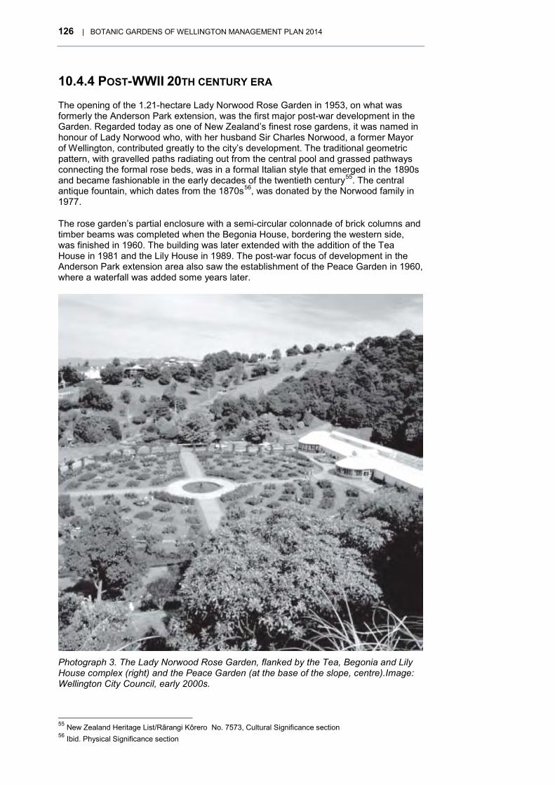
126 | BOTANIC GARDENS OF WELLINGTON MANAGEMENT PLAN 2014
10.4.4 POST-WWII 20TH CENTURY ERA
The opening of the 1.21-hectare Lady Norwood Rose Garden in 1953, on what was formerly the Anderson Park extension, was the first major post-war development in the Garden. Regarded today as one of New Zealand’s finest rose gardens, it was named in honour of Lady Norwood who, with her husband Sir Charles Norwood, a former Mayor of Wellington, contributed greatly to the city’s development. The traditional geometric pattern, with gravelled paths radiating out from the central pool and grassed pathways connecting the formal rose beds, was in a formal Italian style that emerged in the 1890s and became fashionable in the early decades of the twentieth century55. The central antique fountain, which dates from the 1870s56, was donated by the Norwood family in 1977.
The rose garden’s partial enclosure with a semi-circular colonnade of brick columns and timber beams was completed when the Begonia House, bordering the western side, was finished in 1960. The building was later extended with the addition of the Tea House in 1981 and the Lily House in 1989. The post-war focus of development in the Anderson Park extension area also saw the establishment of the Peace Garden in 1960, where a waterfall was added some years later.
Photograph 3. The Lady Norwood Rose Garden, flanked by the Tea, Begonia and Lily House complex (right) and the Peace Garden (at the base of the slope, centre).Image: Wellington City Council, early 2000s.
55 New Zealand Heritage List/Rārangi Kōrero No. 7573, Cultural Significance section 56 Ibid. Physical Significance section

BOTANIC GARDENS OF WELLINGTON MANAGEMENT PLAN 2014 | 127
Photograph 4. Open-air performance at Wellington Botanic Gardens Soundshell, featuring strings of lights and spectators, 1956. Photograph: Alexander Turnbull Library
After the Wahine storm struck in 1968, destroying a large number of mature trees, a period of refurbishment ensued in which much old growth was felled. The Herb Garden was established during the 1970s, with the support of the former Wellington Herb Society, and further additions were completed in 1985.
In 1983 an Interpretative Centre was established in the Winding House that had previously housed the engine for the cable car. The centre, which contained botanical, horticultural and historical displays and information relating to the Botanic Garden, was closed in 1987.
It was replaced in 1991 by a new purpose-built Education and Environment Centre built above the Main Garden, now known as The Treehouse. As well providing a visitor information centre, education facility and staff offices, the Treehouse also became the headquarters for the New Zealand office of the World Wide Fund for Nature (WWF). This dual role, introduced complementary themes of natural heritage conservation and botanic/garden education, cemented by an agreement whereby a WWF education officer based at the Treehouse would work with Botanic Garden staff and provide education programmes geared to the school curriculum. WWF moved out of the Treehouse in 2010.
Further significant redevelopment work continued, including the Cable Car lookout area and nearby establishment of a grass collection in 1995; the Duck Pond area in 1997, funded jointly by the Council, Charles Plimmer Bequest and Friends of the Wellington

128 | BOTANIC GARDENS OF WELLINGTON MANAGEMENT PLAN 2014
The Native Forest
The Garden’s areas of indigenous vegetation are significant because they link back to the forest cover that preceded European settlement. Some specialist investigations indicate that the native forest areas in The Glen and in Stable Gully are the only examples of the type in the city and Wellington Ecological District.
That these remnants survived no doubt owes much to the influence of early scientists within the New Zealand Institute such as the Garden’s first Director, Sir James Hector, who noted in 1867 that the forest on the Wesleyan reserve was in a “tolerable state of preservation” and Dr Leonard Cockayne, who wrote of its importance in 1925. In parallel, the less scientific but highly influential Romanticism of the late 19th century would have led to the native forest being appreciated and preserved for its natural qualities and perceived wildness.
Some of the native forest areas were well-documented in the 19th century. A species list for the forest areas prepared by Buchanan in 1875 reveals that podocarps and a large proportion of other native species existed at that time. Mature examples of hinau, kahikatea, miro, northern rata, maire, pukatea, rewarewa, rimu and totara were present, together with epiphytes and three mistletoe species. The podocarps completely disappeared by the early 1900s, probably due to their exposure to wind after removal of firewood and timber from the bush. However, apart from this lack, the bush areas of today strongly resemble past vegetation and the majority of the present native trees are descended from the original forest. Growing close to the city centre, these native forest areas are important scientifically and historically.
In 2007, Forsyth and Blaschke undertook an ecological survey and made recommendations as to the future management and restoration of the forest areas with particular emphasis on the pre-European remnants. At that time, the larger areas of native bush in the Garden were generally healthy and self-sufficient but the smaller areas were in poor condition and adversely affected by pest plants and animals, erosion and modified site conditions. A pest control programme was initiated along with a bird monitoring programme as part of a city wide programme.
Photograph 5. Native forest remnant, Botanic Garden, Wellington, circa 1887. Photograph: Alexander Turnbull Library

BOTANIC GARDENS OF WELLINGTON MANAGEMENT PLAN 2014 | 129
Botanic Garden; and the playground in 2001. The Sculpture Trail was also started in 1991, in collaboration between the Wellington Sculpture Trust and the Council that has seen six major works installed in the Garden to date.
Controversy erupted in 1991 when a peace garden link to the Bolton Street Memorial Park (now Cemetery) was proposed that would have reduced the size of the Anderson Park playing field. After public consultation in 1995, it was decided that a full size cricket/soccer field would remain. An improved pedestrian and visual link was instead developed alongside the roadway between Glenmore and Kinross streets in 2005.
The Garden’s growing popularity can be attributed to the increase in number and variety of public events and activities set up and promoted by the Council, such as the highly successful ‘Summer City’ festival at the Dell and Anderson Park that was established in 1979. Outdoor concerts had occurred at the garden ever since the Soundshell was completed in the early 1950s, however, the range and spread of events throughout the year increased in recent decades, including: Tulip Sunday, run with the New Zealand Netherlands Society; the Spring Festival; the Summer City programme of outdoor concerts; the summer light show, started in the late 1990s; children’s entertainments such as the Teddy Bear’s picnic; and practical gardening demonstrations such as the mid-winter rose pruning day. The development of the Northern Walkway (1985) and City-to-Sea Walkway (1992) through the Garden also encouraged its use for recreational walking.
The Garden also grew in popularity as a tourist destination, promoted by tourist operators and the Council. By 1995/1996 the proportion of visitors from outside the Wellington region had increased to nearly 47%.
In 1991, the Council celebrated the Centennial of its management of the Garden with a major public celebration in the form of a Floriade Festival.
Soon after, a significant change in that management came about with the decision, in 1994, to make the Garden a business unit within the Council’s Parks Business Unit. This followed a gradual evolution in management style over the preceding 100 years. For most of that period, the Garden had been managed by individuals who had generally served in long-term appointments as Superintendent (Director/Curator) of the Wellington Botanic Garden and had been relatively autonomous. The 1980s saw a change to shorter-term curatorships and the formalisation of policy development in public management plans, as required by the Reserves Act 1977. The first management plan was produced 1981, followed by a further more comprehensive one in 1990, and a combined one for the Wellington Botanic Garden, Anderson Park and Bolton Street Cemetery in 2002.
Widened participation in the Garden’s management was another trend in the late 20th century. The Friends of the Wellington Botanic Garden (now Gardens) was established in 1989 to assist with overall management and provide assistance with special projects. This group was instrumental in initiating the design competition for the Duck Pond redevelopment in 1994, in setting up and running the still continuing guided tours of the Garden, and volunteering at the Treehouse information counter until the early 2000s.
External input to the Garden’s management was formalised with the establishment of the Botanic Gardens of Wellington Advisory Board in 1997. Appointed to provide specialist advice, peer review and foster external relationships, the Board continued for over a decade before going into recess.
The rise of the environmental movement in the latter part of the 20th century also influenced the Garden’s long-held role as a showcase of horticultural best practice. More environmentally friendly practices, such as mulching to reduce water use, were gradually introduced to set an example as well as saving costs. In the late 1990s an integrated pest and disease management programme commenced in the Garden to reduce pesticide use and use biological control where practical.

130 | BOTANIC GARDENS OF WELLINGTON MANAGEMENT PLAN 2014
10.4.5 21ST CENTURY
The Wellington Botanic Garden was registered as an Historic Area under the Historic Places Act 1993 in 200457 – recognised as being nationally and regionally significant for its historic, physical and cultural values.
As a result of a landscape development plan and a plant collections review completed in the early 2000s, a number of key projects were identified. Amongst these was the need to replant the tall tree framework, including the historic but ageing conifers. A Tree Plan was completed in 2011 to prioritise the replanting work. Another urgent project, the refurbishment and seismic upgrade of the Begonia House and cafe, took place in 2012.
10.4.6 THE OBSERVATORY AND CARTER OBSERVATORY RESERVES
The Observatory Reserve and the Carter Observatory Reserve are generally perceived to be part of the Wellington Botanic Garden although they are legally separate. Both reserves were registered as the Dominion Observatory Historic Area in 199458.
In 1891 the Wellington Botanic Garden Vesting Act made provision for the Government to appropriate 6 acres as a site for an observatory, to replace the observatory that had been built in the Bolton Street Cemetery in 1869. A gun battery was first developed on the new site in 1896, in response to the ‘Russian scare’. The Gardens battery, as it was known, was dismantled in 1904, although there are some remnants. The Hector Observatory (renamed the ‘Dominion Observatory’ in 1925) was constructed on the site in 1907. The Observatory Reserve was formally gazetted on 11 October 1962 and the Dominion Observatory was registered as a Category 1 Historic Place in 198659.
The Observatory Reserve also contains the Meteorological Service Building (built in 1968). The adjacent wooden building was occupied by the Institute of Geological and Nuclear Sciences until the early 1990s and then leased to Victoria University’s ‘Innovation Greenhouse’. The Crown-owned reserve is administered by DoC.
The Carter Observatory opened on an adjacent site in 1941 and is a Category 2 Historic Place60. It originated when C R Carter bequeathed £2,240 to the New Zealand Institute in 1896 for building an observatory. Ambiguities in his will and disagreement over who should receive the money delayed any action until 1938 when the Carter Observatory Act was passed, under which the Carter Observatory Board was established to run the new facility. Legal title for the nearby Thomas King Observatory (built in 1912) was later gifted to the Board by Science Wellington (previously the Wellington Branch of the Royal Society of New Zealand.) The Carter Observatory was the National Observatory from 197761 to 2006, when the Government decided the status was no longer appropriate and withdrew funding62. In 2010, legislation63 was passed to dissolve the Board and transfer ownership and management to the Council. The Observatory, which had already been developed as a visitor destination in the late 20th century with a planetarium, audio-visual displays and a shop, is now administered by Wellington Museums Trust.
The Council has maintained the grounds around the observatories as an adjunct to the Botanic Garden, including the development of the flax collection, Kowhai Walk and the Sundial of Human Involvement.
57 Now New Zealand Heritage List/Rārangi Kōrero Registration No. 7573 58 New Zealand Heritage List/Rārangi Kōrero No. 7033 59 New Zealand Heritage List/Rārangi Kōrero No. 4700 60 New Zealand Heritage List/Rārangi Kōrero No. 3596 61 http://www.carterobservatory.org/about-us (27 .02.2014) 62 Deed recording management arrangements in relation to the Carter Observatory (2008) 63 Carter Observatory Act Repeal Act 2010

BOTANIC GARDENS OF WELLINGTON MANAGEMENT PLAN 2014 | 131
Photograph 6. Dominion Observatory, Wellington Botanic Gardens, circa 1900s. Photograph: Alexander Turnbull Library
132 | BOTANIC GARDENS OF WELLINGTON MANAGEMENT PLAN 2014
10.5 BOLTON STREET CEMETERY (FORMERLY BOLTON STREET MEMORIAL PARK)
Bolton Street Cemetery is historically significant for a number of reasons. Prior to 1840, the area was probably used by Māori for burials and after 1840, it was, together with Mount Street (Roman Catholic Cemetery), the first burial ground in the New Zealand Company colony of Wellington. It commemorates early pioneers such as Edward Gibbon Wakefield and John Plimmer, many colonial settlers and notable national leaders, such as Richard John Seddon, Harry Holland, Samuel Parnell and James Edward Fitzgerald. It is a good example of a typical 19th century cemetery64 with its range of memorials, slabs, statuary and crosses in arrange of materials. The wooden memorials are particularly important and the number and variety of fences surrounding the graves comparatively rare within New Zealand.
The cemetery’s management as a botanic garden dates officially from 1991, although staff from the Wellington Botanic Garden have maintained it since 197665. Since then, the focus has been on maintaining plantings typical of the 19th century cemetery, including historic specimens dating back to the early days, managed to provide an appropriate setting for the heritage cemetery artefacts and including a notable heritage rose collection, developed from the 1970s, from the old roses already present.
The following historic outline is largely drawn from Unquiet Earth by M H Alington, which contains a complete and detailed history of the three cemeteries into which the Sydney Street and Bolton Street area were divided and of the early history of Anderson Park when it was part of the cemetery. It is a valuable reference for anyone interested in finding out more about the cemetery history.
10.5.1 THE CEMETERY RESERVES, 1840– 1978 The Colonial Years
When Captain William Mein Smith, Chief Surveyor of the New Zealand Company, arrived at Port Nicolson in January 1840, he carried detailed instructions for the laying out of the new town of Wellington. Amongst them was a request that he provide “ample reserves for all public purposes such as cemetery…botanical garden…” etc.66
Approximately 7.3 hectares between Bolton and Sydney Streets were duly set aside as a cemetery and were available for use when the town sections were given out in July 1840. This was to be the town’s only burial ground apart from a small area to the south for Roman Catholic burials, (the Mount Street Cemetery).
When Bishop Selwyn arrived in 1842, he wished to consecrate a portion of the cemetery for burials of members of the Church of England, in accordance with customary church practice. A locally appointed land board made him a grant that included a portion already in use for all burials, regardless of creed. The Bishop’s request subsequently met with strong opposition from those whose deceased relatives lay in the ground to be consecrated, to which they themselves, when deceased, would not be admitted. After seven years of sometimes bitter controversy, agreement was reached, and the cemetery was divided into three.
In 1851 a title was issued for the Church of England portion in Bolton Street, together with some reserved land further to the west for expansion. The Jewish community received its title in 1852. The public portion, accessed from Sydney Street, was not given a title until 1860. Three separate boards of trustees administered the three cemetery areas until February 1st 1892, when the entire cemetery was closed to all
64 Refer White, H. L. (1978). Monuments and their Inscriptions. 65 Alington, M. (1978), 256. 66 Secretary to Captain Mein Smith, 1 August 1839. National Archives, New Zealand Company Series 102/1.
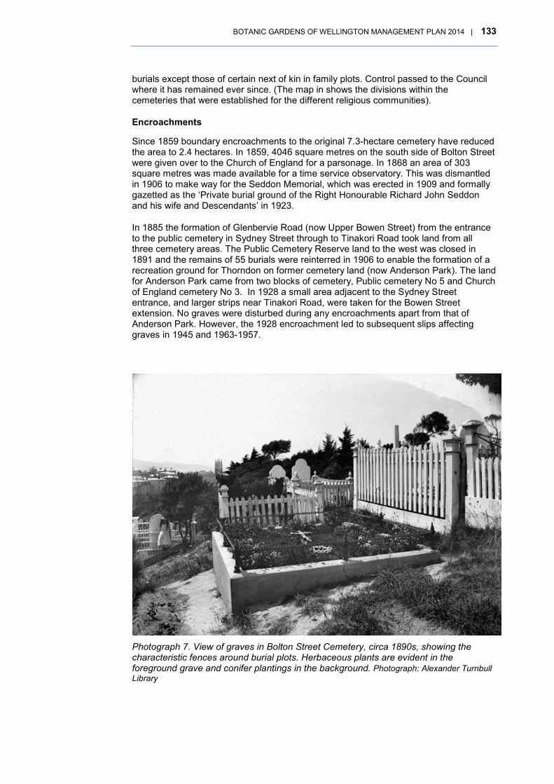
BOTANIC GARDENS OF WELLINGTON MANAGEMENT PLAN 2014 | 133
burials except those of certain next of kin in family plots. Control passed to the Council where it has remained ever since. (The map in shows the divisions within the cemeteries that were established for the different religious communities).
Encroachments
Since 1859 boundary encroachments to the original 7.3-hectare cemetery have reduced the area to 2.4 hectares. In 1859, 4046 square metres on the south side of Bolton Street were given over to the Church of England for a parsonage. In 1868 an area of 303 square metres was made available for a time service observatory. This was dismantled in 1906 to make way for the Seddon Memorial, which was erected in 1909 and formally gazetted as the ‘Private burial ground of the Right Honourable Richard John Seddon and his wife and Descendants’ in 1923.
In 1885 the formation of Glenbervie Road (now Upper Bowen Street) from the entrance to the public cemetery in Sydney Street through to Tinakori Road took land from all three cemetery areas. The Public Cemetery Reserve land to the west was closed in 1891 and the remains of 55 burials were reinterred in 1906 to enable the formation of a recreation ground for Thorndon on former cemetery land (now Anderson Park). The land for Anderson Park came from two blocks of cemetery, Public cemetery No 5 and Church of England cemetery No 3. In 1928 a small area adjacent to the Sydney Street entrance, and larger strips near Tinakori Road, were taken for the Bowen Street extension. No graves were disturbed during any encroachments apart from that of Anderson Park. However, the 1928 encroachment led to subsequent slips affecting graves in 1945 and 1963-1957.
Photograph 7. View of graves in Bolton Street Cemetery, circa 1890s, showing the characteristic fences around burial plots. Herbaceous plants are evident in the foreground grave and conifer plantings in the background. Photograph: Alexander Turnbull Library

134 | BOTANIC GARDENS OF WELLINGTON MANAGEMENT PLAN 2014 Figure 10. Bolton Street Cemetery, circa 1852, showing the areas of grants for Public, Jewish and Church Of England Use

BOTANIC GARDENS OF WELLINGTON MANAGEMENT PLAN 2014 | 135
Figure 11. Bolton Street Cemetery, encroachments, showing the areas taken for other purposes.

136 | BOTANIC GARDENS OF WELLINGTON MANAGEMENT PLAN 2014
Effects of the Wellington Urban Motorway
In 1960 proposals were being formulated to extend the Wellington Urban Motorway through the Bolton Street Cemetery. Considerable opposition was generated and in 1964 the Bolton Street Cemetery Preservation Society was formed with the objective of preventing the despoliation of the cemetery. Three authorities –Wellington City Council, National Roads Board and Ministry of Works – were involved in the advancement of plans for the motorway but the Council was responsible for the final decision to proceed through an Act of Parliament in 196767 that enabled the motorway’s 10-year construction to begin the following year. The last burial before the three cemeteries were finally closed for further burials took place in 1967, although interment of ashes in family plots continued to be allowed.
When the motorway opened in 1978, the Bolton Street Cemetery had been severed, with the destruction of 1 hectare of the historic site, which had necessitated the disinterment of approximately 3700 burials. Most of these remains now lie in a large vault beneath the Early Settlers Memorial Lawn situated behind the Memorial Chapel on the east side of the motorway. The integrity and character of Bolton Street Cemetery had been severely compromised. Fortunately, a belated decision to save and reinstate all the removed memorials slightly alleviated the extent of heritage lost, although most bases and fences were destroyed.
Restoration of the Sexton’s Cottage and reinstatements of headstones removed from motorway land began in 1977. To lessen the impact of the motorway, the National Roads Board agreed to provide a connecting link between the two portions of the bisected cemetery. This was to be a piazza or wide platform over the motorway but initial work was subsequently abandoned in favour of a small footbridge, which was in use, though not fully completed, when the motorway opened in May 197868.
Photograph 8. Roadworks through Bolton Street Cemetery in preparation for the Wellington motorway, circa 1969. Shows earth-moving vehicles working below a statue on the Flyger family grave. The city sexton, P J E Shotter, is nearest the statue. Photograph: Alexander Turnbull Library
67 Finance (No 2) Act 1967, clause no. 6 68 Alington, M. (1978), Unquiet Earth. 260

BOTANIC GARDENS OF WELLINGTON MANAGEMENT PLAN 2014 | 137
Rachel Buchanan, a writer with tribal links to Te Aro Pā, went in search of her tupuna (ancestor) Hemi Parai, who died in 1877 and was buried, according to later newspaper reports, at “Waipiro”69. Buchanan believed that he might have been buried in Bolton Street Cemetery.
In her book The Parihaka Album: Lest we forget70 she documents her visit to the Cemetery and her feelings about the effects on the motorway and the disinterment of Māori. Despite the presence of many Māori graves she feels it is still a place for Pakeha pioneers and early settlers. She quotes from the diary of Johnson who was involved with the disinterments and kept a diary of proceedings:
On 28 April 1969, around plot number 1414, Johnson notes that six unknown Māori burials were found next to the five known graves. “During the opening of this UKN grave a very fine Greenstone mere was found and we are now classing this as a Māori grave and the boxes will be kept in the memorial grave but will be available if needed, hand over to Māori Affairs Dept, the mere will be placed in one of the boxes,” he wrote.
On 1 May, Johnson’s diary shows that 16 known graves were dug up and 17 unknown ones. These statistics are followed by the note: “During the opening of a large Unknown grave a Greenstone mere was found, have been in contact with Māori Affairs Department and they are interested and state that it should stay in the memorial grave and they do not want any publicity made about the mere. So we have it in there but not put directly away in case any of them would like to see it.”71
10.5.2 MEMORIAL PARK – HISTORIC PURPOSE RESERVE, 1978–2013
The Bolton Street Memorial Park is established
The Council renamed the remaining cemetery land the Bolton Street Memorial Park in 1978. A proposed remedy for the motorway damage was not finalised for another two decades, however.
In 1965 the National Roads Board had agreed to give the city a 0.4-hectare block of land bounded by Bowen, Mowbray and Bolton streets to make up for the loss of approximately 1.5 hectares of land taken for motorway purposes. The National Roads Board did not acquire the land and subsequently indicated that it could not afford to purchase it. After much debate the Board gave the Council $500,000 to assist with the
69 Waipiro. The stream flowing down Sydney Street from Honeyman's Gully69 to the beach at east end of Bowen Street.69
70 Buchanan, Rachel, The Parihaka Album: Lest We Forget, Huia Publishers, 2009 p 262 71 71 The reburial of the mere was within the rules established for the disinterments. Alington, M. (1978),
Unquiet Earth. 169
Māori experience of the motorway disinterments
Bolton Street Cemetery is a symbol of some sadness for Māori of Pipitea, Kumutoto and Te Aro. Ancestors, particularly those who converted to Christianity, were buried there and some were disinterred in the 1960s for the building of the Wellington motorway. The graves in the way of the motorway were disinterred and the koiwi / bones were placed in a large common burial place in the Memorial Park.

138 | BOTANIC GARDENS OF WELLINGTON MANAGEMENT PLAN 2014
purchase of the site in the late 1980s and provided an additional $50,000 to upgrade the Mortuary Chapel (now Memorial Chapel).
A commercial development on the land was subsequently proposed. In 1987 a plan for a 12-storey office building and a six-storey underground car park with the Memorial Park on its roof was approved by the Council, the Friends of Bolton Street Cemetery and the Historic Places Trust. The rooftop area was leased to the Council for a period of 999 years from 1989 with perpetual rights of renewal and a $1 annual rent, if demanded, which is not subject to review. The project was completed in 1990 and the National Roads Board funding was used in the development of the Memorial Park and replication of the Mortuary Chapel (now Memorial Chapel), which was opened circa 1990.
A decision to delete an off-ramp resulted in transfer back to the cemetery of the unwanted land, where the graves had unfortunately already been removed. This land has been used for planting memorial trees to environmentalists.
The various parcels of land that now comprise the Bolton Street Cemetery (formerly Bolton Street Memorial Park) were progressively gazetted as Historic Reserve in 1980, 1989 and 1991.
Other developments and administration
In 1990, the first management plan was completed to guide the Cemetery’s management and development. The following year, the Council decided to manage four of its public gardens collectively as ‘The Botanic Gardens of Wellington’, including the Bolton Street Cemetery. In 2002, a combined management plan for the Botanic Garden, Anderson Park and Bolton Street Memorial Park was published.
In 1999, a list of burials in the cemetery and a list of those disinterred during the motorway construction was made available at the Memorial Chapel. Subsequently, the lists, which the Friends of Bolton Street Cemetery originally compiled and continue to maintain, were digitised and made available for online viewing on Friends’ website72, established in 2011. Since their formation in 1977 (originally as the Friends of Bolton Street Memorial Park), the Friends have assisted with answering public enquiries about historic interments, conducted tours of the Memorial Park by arrangement, and actively assisted with and advocated for the repair and maintenance of the memorials and other heritage artefacts.
Gravestones, monuments and paths were damaged by natural hazards such as slips, tree fall and root damage, earthquakes and run-off since the early days of the cemetery73 . Vandalism and wilful damage to headstones, park furniture and plants was infrequent up to the late 1950s74 but has been a recurring problem in recent decades, instigating the Council to periodically hire security firms to patrol the area and encourage the occupants of the Sexton’s Cottage to provide surveillance.
In 2001, the verified site, near the end of Kinross Street and the Seddon Memorial, of the 1906 re-interments that made way for the Anderson Park development were marked with a perimeter of bricks and a plaque erected.
In 2003, title was issued to the Council on a 200 square metre area that was subdivided from the rear of a neighbouring residential property, 2 Easdale Street. The land, which was duly gazetted as Local Purpose Reserve and added to the Bolton Street Memorial Park, was gifted by Mrs Morva Williams. Mrs Williams, a keen gardener who had a long-standing association with the Easdale property, wanted to see the garden protected and had offered the land to the Council in 2001. Located alongside the Tucker Stafford Masonic memorial, physically connected to the Park and accessible from the Powles Path, the garden was considered a worthwhile addition and Mrs Williams’s gift was accepted. The garden was officially opened to the public in 2005.
72 http://www.boltoncemetery.org.nz/ 73 Alington, M. (1978), 109 74 Allington, M (1978), 109.

BOTANIC GARDENS OF WELLINGTON MANAGEMENT PLAN 2014 | 139
In 2006, guidelines75 were produced on the maintenance and repairs of the graves and monuments, and in 2011, a Tree Plan for both the Wellington Botanic Garden and the Bolton Street Memorial Park was completed to prioritise replanting of the conifer collection/tall tree framework.
Botanical and garden history
The vegetation of Bolton Street Cemetery at the time of European settlement appears to have been tall manuka / kanuka shrubland which, from its height, would have been at least 90 years old. It was subsequently cleared and planted over.
Despite the efforts of the resident sextons in the 19th century, the cemetery area, with its ridges and gullies, fast-spreading scrub and noxious weeds (notably gorse), and exposure to wind, was not easy to maintain and there were complaints about neglect and poor appearance during this era. Nevertheless, there was much planting in the early years, much of it aimed at providing the shelter needed to grow the flowering garden plants that the settlers liked to plant on graves. In 1882, the Botanic Garden Trustees donated 200 plants, which included, as well conifers, native shrub species that Sexton David Robertson noted had been plentiful but were becoming ‘extinct’. He hoped to preserve them by giving them a place in the cemetery76. In any event, by the late 20th century, areas of secondary native bush were regenerating in the gullies.
By 1892, when the Council took over, trees were growing through thick scrub and wild pea and onion plant were widespread. After 1903 maintenance staff no longer lived on site. Caretakers were supplied on a day basis from the Karori Cemetery instead. The Council was legally responsible for the paths and general appearance of the cemetery but not the graves, which were the families’ responsibility. During the 1930s the Beautifying Society and the Early Settlers’ Association expressed concern at the general dilapidation and unkempt appearance. Volunteers worked for some weeks tending graves and planting.
By the early 1900s, trees had grown large enough to cause root damage to burial plots and shading of nearby properties. There were requests to remove trees in succeeding years, but the Council generally declined on the grounds of preserving the historic atmosphere. During the 20th century, the vegetation developed into a mix of mature trees (many dating back to the 19th century), ornamental planting and native regrowth. Many of the ornamental plantings in the main burial areas were garden plants that were first introduced in colonial times. A good many of these self-seeded and naturalised in the cemetery.
When botanists surveyed the trees and shrubs in the area in 1965, prior to the motorway construction, they noted that many trees were overcrowded and had been poorly maintained. Trees noted as being of at least 50 years old at that time included macrocarpa and Pinus radiata as well as two oaks. In 1968, Ray Mole, the Curator of the Council’s Parks Department, compiled a detailed plant survey, recording 180 different exotic and native trees, shrubs, climbing and herbaceous plants, including yew and holly specimens that were typical of cemetery plantings. Plantings along the motorway edges in the 1970s, included species such as acacia and protea, that the 2002 management plan noted as being ‘out of character’.
The cemetery came under the care of staff from the neighbouring Wellington Botanic Garden in November 1976. An aftermath of the motorway construction was renewed interest in preserving and restoring the cemetery’s heritage assets, bringing to the fore the issue of managing the vegetation to maintain its ‘old world’ character while avoiding damage to graves, monuments and other built features such as old pathways. The historical value of many of the trees and the need to replace them suitably as they aged was also recognised.
75 Aitken and Cochrane, Maintenance and Repair Guidelines for Graves and Memorials, Bolton Street Memorial Park, 2006.
76 Alington, M. (1978), 247.

140 | BOTANIC GARDENS OF WELLINGTON MANAGEMENT PLAN 2014
The heritage rose collection
Interestingly, Mole’s list77 did not include roses, although he did note the presence of ‘rose seedlings” and Margaret Alington noted that “several old and desirable rose varieties were found in 1968”78. Rodney Read, in investigating the history of heritage roses in the Cemetery, was unable to find any formal record of roses growing there from 1840 to 1980, although he listed a number of varieties that people remembered there and concluded that roses had been planted on family graves by visitors, without record79. Botanic Garden staff member, Peter Tijsen, recalls seeing roses inside and outside grave enclosures in the mid-1960s and recalls that staff took cuttings in 1968 (when the motorway work began) which were propagated and planted back into the cemetery some years later80.
Since 1982, all roses planted in the Cemetery have been recorded and given an accession number and label. Read noted that there were 201 heritage roses in the Cemetery.
Visitor trends
Over its history, the reasons for visiting the Cemetery have gradually changed. Originally, family members tending and acknowledging family gravesites would have been the primary reason for visits but, as so often happens with cemeteries, family visits declined as connections became less immediate, and gradually, the area’s use became more associated with its value as a public open space. A visitor survey in 1997, for instance, showed that 29 percent of visitors came to the Bolton Street Cemetery for relaxation and exercise and 50 percent passed through primarily using it as a through route to other destinations. At that time most visitors (64 percent) lived or worked locally.
Interestingly, although no recent statistics are available, the Friends of Bolton Street Cemetery report that noticeably more New Zealanders and foreign visitors are now exploring the park both in person and online, due to the growth in popularity of genealogical research.
77 As reproduced in Alington (1978) 78 Alington, M. (1978) 47. 79 Read, Rodney (undated). History of heritage roses in the Bolton Street Memorial Park. 80 Personal comment, Peter Tijsen, email, 3 March 2014.

BOTANIC GARDENS OF WELLINGTON MANAGEMENT PLAN 2014 | 141
Heritage buildings
Three buildings have been associated with the Bolton Street Cemetery: two former sexton’s cottages and the former chapel.
The two sexton’s cottages were built in 1857, one for the sexton of the cemetery’s public section and one for the sexton of the Church of England section. The Public Sexton’s cottage, which backed onto the north-eastern boundary of the Jewish section of the Cemetery, was demolished in 19081. The Church’s cottage still stands in Bolton Street within the Cemetery and was restored in 1978. It was used as accommodation for Botanic Garden staff until recent years, when it has been used for short-term ‘artists-in-residence’ accommodation. Believed to be the oldest house extant in Wellington city, it is registered as an Historic Place Category 1 with Heritage New Zealand1 and is listed as a heritage item under the District Plan. A Conservation Plan was completed in 20001.
Photograph 9. The former Sexton’s Cottage, Bolton Street, dates back to 1857. Photograph: Courtesy Friends of Bolton Street Cemetery
The chapel was built in December 1866. A new church on Mulgrave Street (now known as Old St Paul’s) had replaced the earlier St Paul’s on the Government Reserve, necessitating a chapel for funeral services in the church cemetery. The chapel was a simple building, based on a design by Frederick Thatcher, and some of the timber from the dismantled first St Paul’s was used in its construction. In the early years of this century, its use began to decrease and by 1922 it was so derelict that a decision was made to demolish it. The Early Settlers and Historical Association worked for six years to save the chapel and in 1928 achieved its goal. Subsequent repainting and repairs kept it standing until it was dismantled for the motorway in 1969. Unfortunately, the original could not be reassembled due to general deterioration and, instead, a replica was built on the roof plaza, adjacent to the cottage, on the same axis as the original chapel. Now known as the Memorial Chapel, it contains memorial and interpretative material.

142 | BOTANIC GARDENS OF WELLINGTON MANAGEMENT PLAN 2014
The chapel was built in December 1866. A new church on Mulgrave Street (now known as Old St Paul’s) had replaced the earlier St Paul’s on the Government Reserve, necessitating a chapel for funeral services in the church cemetery. The chapel was a simple building, based on a design by Frederick Thatcher, and some of the timber from the dismantled first St Paul’s was used in its construction. In the early years of this century, its use began to decrease and by 1922 it was so derelict that a decision was made to demolish it. The Early Settlers and Historical Association worked for six years to save the chapel and in 1928 achieved its goal. Subsequent repainting and repairs kept it standing until it was dismantled for the motorway in 1969. Unfortunately, the original could not be reassembled due to general deterioration and, instead, a replica was built on the roof plaza, adjacent to the cottage, on the same axis as the original chapel. Now known as the Memorial Chapel, it contains memorial and interpretative material.
Photograph 10. The St Paul’s Chapel, in the Bolton Street Cemetery, circa 1920s-1940s, of which the present-day Memorial Chapel is a replica. Evident in the plantings are a conifer and tree fern (foreground) and low clipped shrubs around graves (middle). Photograph: Alexander Turnbull Library

BOTANIC GARDENS OF WELLINGTON MANAGEMENT PLAN 2014 | 143
10.6 OTARI-WILTON’S BUSH
10.6.1 INTRODUCTION
The story of Otari-Wilton’s Bush is one of leadership in the wider story of studying and conserving New Zealand’s ecology and flora. Even in the 19th century, before it became a reserve, Wellington’s colonial citizens were starting to appreciate the scenic quality of the fast-disappearing native forest; others in the science community were seeking to better understand it. These dual motivations of scenery preservation and science have underpinned the survival of Otari’s forest, its formal protection and its continued management.
This section is an abridged version of the detailed history contained in Appendix 2 of the previous 2007 management plan, with some additional information on the Māori history and recent events.
10.6.2 MĀORI HISTORY OF OTARI-WILTON’S BUSH RESERVE
Otari- Wilton’s Bush played an important part in the history of Taranaki Whānui in Wellington. In the early 19th century, Ngāti Tama, Ngāti Mutunga and Te Ātiawa from Taranaki settled the area largely left vacant by the previous tangata whenua groups such as Ngāti Ira. Ngāti Tama and Ngāti Mutunga moved first to the Ohariu District along the west coast. In time they moved inland ending at where they established a pā at Kaiwharawhara. Otari was occupied in the 1820s. It was also on the trail from Kaiwharawhara and Makara, with people moving regularly between the harbour and the coast. Gardens were made and birds were snared.
Under the Native Reserves established by the McCleverty awards of 1847/48, the Otari Native Reserve, amounting to some 500 acres, was awarded to Māori from Kaiwharawhara, Pipitea and Ohariu Pā .
The upper section of 244 acres, known as the Kaiwharawhara Block, was awarded to Ngāti Tama. The land was leased and then most sold to Mr Kilmister in 1877. Charles Heaphy purchased 50 acres, which was improved by Kilmister by mistake, including building a house. Some 4.24 hectares of the Block still remains in Māori ownership81. The south-eastern 167 acres of the Native Reserve, awarded to Ohariu Pā (Ngāti Tama), was sold in 1856 and then purchased by the Witton family in 1876. Parts of it that were later acquired by the Council are now part of Otari-Wilton’s Bush.
The land awarded to Pipitea Pā was on the south-western corner of the block and consisted of 134 acres. Of this some 80 acres was cultivated by the Pipitea natives. In 1875 Commissioner Heaphy let all 134 acres to a Mr Samuel Woodward. The land was partitioned into five strips of roughly 30 acres each. Subdivision 1 was sold to Henry Pitt. In 1906, the other four subdivisions were taken by proclamation82 and made a scenic reserve. This land is a substantial part of today’s Otari-Wilton’s Bush.
Occupation of the Otari area by Te Ātiawa/Taranaki Whānui continued well past the arrival of the New Zealand Company and its sale of land blocks in the area. European settlers recorded gardens on the north-facing slopes in the vicinity of Otari in the 1840s. A local farmer, Albert Kilmister, described “a Māori and his wife [who caught kaka in a clearing across the stream] living in a whare near Wilton’s Bush” in the 1850s.83
81 Described as Otari A No 5. 82 under the Public Works Act 1905 83 Albert Kilmister, Kilmister Reminiscences 1932, Alexander Turnbull Library

144 | BOTANIC GARDENS OF WELLINGTON MANAGEMENT PLAN 2014
10.6.3 A FOREST REMNANT SURVIVES
Otari-Wilton’s Bush would not exist today were it not for the survival of a significant area of native forest in the early days of Wellington’s settlement, when most of the Wellington Peninsula was being cleared of forest and developed in farmland. How this came about traces back to the land allocations and ownership in the early 19th century of the area currently occupied by Otari-Wilton’s Bush.
On the true right of Kaiwharawhara Stream, what was known as ‘country acre’ sections were balloted under New Zealand Company’s private colonisation scheme to Samuel Maxton and Charles Beard Izard.
Samuel Maxton formally took up his 108 country acres (43.7 ha) in 1859 and then sold his land to Job Wilton in 1860. The Wilton family (who also leased Izard’s adjoining country acres) cleared and farmed most of the block, which stretched almost to the top of Tinakori Hill, but fenced off an area of 17 acres (7 hectares) of forest near their homestead. Job Wilton was happy for picnickers to enjoy the stream, the views and bush walks and, with easy road access from 1877, the area became a popular leisure-time destination for town folk. One member of the family was always at home during weekends and the bush was patrolled to make sure any picnic fires had been extinguished. The entire area in forest on both sides of the Kaiwharawhara Stream, became known as "Wilton’s Bush".
On the true left of the stream, areas of the 500 acres (202 hectares) known as the Otari Native Reserve awarded to Māori in 1847 were leased out, cultivated, cleared and sold but a substantial part of the block awarded to Pipitea Pā remained largely forested (see preceding Māori History section also).
Records about the area’s vegetation before and during this early phase of European settlement are incomplete but botanical studies suggest the forest on the north-western flanks of the Te Whārangi Ridge was young when European settlers arrived. At that time Māori clearings were recorded on the true right of the Kaiwharawhara Stream and a track led up a spur on the true left. As soon as European settlement began, podocarps were felled for milling. Broad-scale land clearance for pasture followed. Even Job Wilton’s ‘protected’ patch of forest probably lost some totara for house timber. Several fires raged out of control across the area in 1851 and survey maps show that by 1877 the ridge-top land above Otari-Wilton’s Bush was being grazed and both flanks of what is now Chartwell were also clear of bush.
The Pipitea Native Reserve land, which later became Otari Scenic Reserve, was still in heavy bush in 1879, although fires had apparently come down spurs from the ridge-top above. It is not known what timber may have been removed from the block although Cockayne later noted an overall depletion of nikau in gullies. Local Māori did take forest timber to sell as firewood to settlers and nikau was particularly popular in this respect. Even as late as the 1940s, after Otari was made a reserve, hinau was being felled there for use as boundary fence posts.
Bird life greatly diminished with the loss of mature forest in the catchment and with intense hunting of kaka, kereru, tui and weka last century. Huia were present in the 19th century. Brockie84 made diary entries of kereru sightings in the 1940s which suggests numbers were very low then.
10.6.4 A RESERVE IS CREATED
By the turn of the 19th century, the almost total demise of natural vegetation around Wellington City was concerning many residents. When it was realised in 1902 that the Pipitea Natives’ of Otari Native Reserve were keen to sell their block, a delegation of prominent citizens asked the Minister of Lands to take steps to preserve the forest. The
84 Walter Brockie personal diaries – Wellington City Archives

BOTANIC GARDENS OF WELLINGTON MANAGEMENT PLAN 2014 | 145
Minister responded favourably and also gained assurance from Job Wilton that Wilton’s own forest would be protected as well.
In 1906, after several years of negotiations, during which the Government and the Council approved expenditure of 500 pounds each, the 135.75-acre (55 hectare) area was acquired by the Crown and gazetted as a Scenic Reserve under the Scenery Preservation Act 1903. Compensation was paid to the relevant hapu by the Native Land Court. In 1907, an additional 7.5 acres (3 hectares) was purchased from the Witton family and added to the reserve.
After the Wilton family subdivided their farm in 1906, the 17-acre (6.8 hectare) forested part of the property was purchased by lawyer Martin Chapman, son of Henry Chapman (Wellington’s first judge). Chapman excavated a house site but never built, although his gardener, ‘Old Mac’ (James MacDonald), lived in a small whare on the property. Chapman was happy to let visitors use the tracks he made and share the pleasures of the forest and exotic flowering shrubs he planted. The property became known locally as ‘Chapman’s Gardens’.
In 1915 the Department of Lands and Survey appointed a Board to manage Otari Scenic Reserve. The seven member Board was chaired by the Commissioner of Crown Lands for the Wellington District and included Martin Chapman, the Council’s Reserves Committee Chairman and botanist Dr Leonard Cockayne.
Lack of funds for the Board led to the reserve being vested in the Wellington City Council in January 1918. The reservation for scenic purposes was cancelled and, instead, the land became a reserve85 held “in Trust for Recreation purposes and for the preservation of Native Flora”.
During the early 1920s the reserve’s popularity grew, and the Council responded with improved road and track access, car parking, bridging of the stream and relinquishment of grazing leases within the reserve boundaries. There were even suggestions of a band rotunda.
When Martin Chapman died in 1924, his main beneficiary and brother, Sir Frederick Chapman, asked for his brother's 6.8 hectares of land and the small cottage on it to be offered to the Council as an addition to the reserve. The Council duly purchased ‘Chapman’s Gardens’ in 1925. The acquisition assured the permanent protection of the last sizeable remnant of podocarp northern rata forest on the Wellington Peninsula.
10.6.5 AN OPEN-AIR PLANT MUSEUM IS CREATED
During the 1920s the idea of creating a collection of indigenous plants within easy reach of the city that could be enjoyed by the public and provide material for study began to gather support. The City’s Director of Parks and Reserves, JG MacKenzie, promoted the Otari Reserve as a logical site and, in 1926, the Institute of Horticulture’s Honorary Botanist, Dr Leonard Cockayne, presented a formal proposal to the Council’s Reserves Committee, which was accepted in its entirety and published in all the Wellington daily papers.
Otari Open-Air Native Plant Museum was officially opened by the Mayor, Charles Norwood, on 12 October 1926. By this time, the reserve comprised 143 acres (approximately 58 hectares), of which about half was forested, with the rest in pasture or reverting to native vegetation. Dr Cockayne was appointed Honorary Botanist to the Wellington City Council and effectively became the Director of the Plant Museum.
85 Under s62 of the Reserves and Land Disposal and Public Bodies Empowering Act 1917

146 | BOTANIC GARDENS OF WELLINGTON MANAGEMENT PLAN 2014
Figure 12. Otari Land Tenure, 1847.The Otari Native Reserve occupied land on the true left of the Kaiwharawhara Stream and ‘country acres’ originally balloted to Maxton and Izard occupied the true right.
Photograph 11. Dray Road to Wilton’s Homestead 1896. The Dray Road (left) is still used for vehicle access and parts of the Circular Walk. The gate was a few metres away from the current footbridge near what is now called the Solander Picnic Area. Many of the trees on the right-hand skyline can still be recognised. The fence to the right was to contain Witton’s stock but was not the boundary to his property. His forested land beyond the fence was incorporated into Otari Scenic Reserve in 1907. Photograph: Alexander Turnbull Library

BOTANIC GARDENS OF WELLINGTON MANAGEMENT PLAN 2014 | 147
A caretaker's residence was erected in 1926 and work began in earnest. By 1931, the Alpine Garden already featured 300 species, several other specialist beds were being developed and planting of forest species was well under way. The rockery around the caretaker’s residence had been established and a nursery area provided. Dr Cockayne also recognised the threat posed to forest health by possums and instigated possum control in 1928.
In 1932, Cockayne published A Scheme for the Development and Arrangement of the Otari Open-Air Plant Museum, which guided work at Otari long after his death in 1934. Throughout the 1930s and 1940s the cultivated area continued to expand and public facilities such as seats were also progressively improved.
Officer-in-Charge Andrew McKay, who lived on-site from 1926 to 1946, was responsible for much of the implementation in the museum’s early years. He planted the hebe collection and, later, the Lukin Alpine Garden. He would, no doubt, have worked with the Native Plant Preservation Society’s Advisory Committee, which was set up in 1937, when the Society gained approval for Otari to become its headquarters for propagation and planting work.
Hares were becoming a problem in Otari in the late 1930s. New plantings were suffering and collections had to be protected with wire netting.
The first botanical survey of Otari was undertaken by Stan Reid for a thesis produced in 1934. He recognised four broad vegetation zones, being: a coastal forest association predominantly of kohekohe; a podocarp/northern rata/tawa rainforest association; a semi-coastal association; and an intermediate association between rainforest and the semi-coastal forest.
Reid tried to determine the reasons for these types, taking into particular account the effects of site disturbance, frost, wind exposure and coastal influence. His study concentrated on the successional phases following land clearance and it was then, in the 1930s, that he noted the presence of Darwin’s barberry and warned of its aggressive threat to revegetation. He noted that kohekohe was increasing and displacing tawa-dominated canopies and that rimu was not regenerating in the reserve – trends also observed in studies 50 and 60 years later86.
10.6.6 TOWARDS A BOTANIC GARDEN
Council recognised the special place of Otari-Wilton’s Bush with the appointment in 1947 of a curator, Walter Brockie, who remained in the role for the following 15 years to his retirement in 1962. The rock garden and the impressive number of alpine plants in the collection were probably his most significant contributions. Willow, plane, cherry, sycamore, gum and walnut trees – vestiges of Chapman’s gardens – were also removed from the reserve. During the 1950s, accidental fires were a constant threat, probably due to neighbouring owners trying to control the gorse that was reverting on their properties with burn-offs.
In his 1947 report, Brockie noted the absence of juvenile podocarps, even within mature forest areas, a trend he noted as ‘inexplicable’, although he wondered whether low bird numbers and low seed viability (due to changed site conditions) might be contributing. He proposed replenishing the forest with juvenile podocarps at a rate of 200 rimu and 100 each of miro, matai, kahikatea and totara annually for the following five years. His actual recorded plantings were much less than this, however.
In 1949, the reserve was renamed ‘Otari Gardens’ by Council resolution. Cockayne’s guiding principles remained valid, however, and the plant collections at Otari Gardens were steadily developed and expanded in succeeding decades.
86 Reid (1982) and Marjot (1992), cited in Wellington City Council, Otari Native Botanic Garden and Wilton’s Bush Reserve (2007), 81.

148 | BOTANIC GARDENS OF WELLINGTON MANAGEMENT PLAN 2014
Figure 13. Otari-Wilton’s Bush Land Acquisitions, 1918–2014.

BOTANIC GARDENS OF WELLINGTON MANAGEMENT PLAN 2014 | 149
Brockie’s successor, Raymond Mole, managed Otari from 1962 to 1991, receiving the Loder Cup in 1981 for his substantial contribution to the preservation of native plants. Although his role was expanded to include other Wellington reserves, he concentrated his efforts at Otari Gardens, developing specialist beds including flax and hebe cultivars. He developed the Wild Garden, following the Wahine Storm, and promoted the educational potential of Otari generally.
The condition of the forest vegetation improved noticeably after the top boundary from Johnston’s Hill was fenced in 1967 to prevent stock invading from adjacent rural properties. Otari’s forest could not be so easily protected from the storm that hit Wellington in April 1968. The forest was badly damaged, with immediate losses of hinau, rimu and rata, especially in the mature forest beside Wilton Road, and ongoing losses from canopy weakening and crown damage. An overall decline of species followed and a change in forest structure, which saw the spread of kohekohe and karaka.
In 1952, two memorials related to Otari’s origins were put in place. The Wilton Memorial Gate, funded by the Wilton family, was built where an access road had formerly led to the Wilton homestead. The Cockayne Memorial was placed over the graves of Dr Cockayne and his wife Maud, comprising a large rock inscribed with Cockayne’s own words, “Will our descendants prize this unique heritage from the dim past and preserve these sanctuaries intact?".
That Otari Gardens’ heritage was prized was demonstrated by events in the 1970s. When a North West Connector road was proposed that would cut across part of Otari, vigorous opposition from scientists and local residents ensued. The roading scheme was never developed. Instead, the concept of linking clusters of reserves into an ‘Outer Town Belt’ (later, ‘Outer Green Belt’) around the western edge of Wellington’s urban area was adopted, and the Otari Gardens were included within this.
The 1980s dawned with the publication of the Council’s second Otari management plan, which reaffirmed Cockayne's original objectives whilst also recognising changing recreation and educational trends. Later in the same year, the building now known as the Information Centre – Te Marae o Tane was built, providing a small lecture room, library, toilets, storage, workshop, and offices.
In 1980 the Council also resolved to bring all the land it had acquired at Otari since 1918 and not formally gazetted as reserve under the Reserves Act 1977. This was implemented in 1982.
In 1991, the reserve was renamed ‘Otari Native Botanic Garden’ (formally gazetted as such in 1993), to more clearly define its purpose, especially for visitors to the city. At the same time, the Council appointed the first Curator of The Botanic Gardens of Wellington to rationalise the overall management of its four botanic gardens. Under this regime, the day-to-day operations at Otari were managed by a supervisor.
By the 1990s, the possum population had built up to an estimated 12 possums per hectare. A major possum poisoning programme was undertaken in 1993 by the Regional Council and, by 1995, significant recovery of the vegetation was evident.
10.6.7 OTARI NATIVE BOTANIC GARDEN AND WILTON’S BUSH RESERVE
In 1999, the reserve’s name was changed to Otari Native Botanic Garden and Wilton’s Bush Reserve in consultation with interest groups and iwi, to better identify its purpose and recognise Job Wilton’s legacy.
As Cockayne would have wanted, science has remained an important thread at Otari-Wilton’s Bush. Strong teaching and research relationships have developed with Victoria University of Wellington and the Museum of New Zealand Te Papa Tongarewa during the last decade, with the botanical collections and native forest being used for research

150 | BOTANIC GARDENS OF WELLINGTON MANAGEMENT PLAN 2014
projects, undergraduate teaching programmes and the provision of plant material for student use.
The establishment of the Otari-Wilton’s Bush Trust in 2000 also saw the continuation of community appreciation and involvement that Job Wilton first enabled at ‘Wilton’s Bush’ in the 19th century. The Trust is a voluntary organisation that raises funds, co-ordinates tour guides, hosts visitors and assists with other programmes.
A major redevelopment of the collection and visitor facilities took place in 1999 with substantial funding from the Charles Plimmer bequest. The entrance and car parking on Wilton Road were upgraded, the alpine garden developed and the deck and canopy walkway adjacent to the Visitor Centre Te Marae o Tane installed. The waharoa were also placed at entranceways.
In 2002, Project Kaiwharawhara was initiated to manage and enhance the health of the Kaiwharawhara catchment. Major riparian planting project took place in Otari-Wilton’s Bush between the Troup Picnic Area and Ian Galloway Park.
In 2004, Otari-Wilton’s Bush was recognised as a Garden of National Significance by the New Zealand Gardens Trust.
A ‘Bioblitz’ in 2007 was organised by the Otari-Wilton’s Bush Trust and the Council, in collaboration with Victoria University, bringing scientists on-site to count as many different living species as they could find in 24 hours. The event, in which 1345 species of animals, plants, insects and other life forms were recorded, was also used to promote public understanding and appreciation of the reserve’s biodiversity.
Since 2010, following a landscape development plan and plant collections review, some major new projects have been planned to improve visitor experience and use of the reserve. Implementation has started with the development of the Leonard Cockayne Centre in the ex-curator’s house, and improvements to collections including the Fernery, the 38º South Garden and taxonomic collections.
10.6.8 THE ROLE OF DR LEONARD COCKAYNE, 1855–1934
Dr Leonard Cockayne articulated the vision and underlying principles that have guided the development and management of Otari-Wilton’s Bush since the 1920s. The English-born Cockayne emigrated in 1876, first to Australia and then to New Zealand, moving to Wellington in 1914. He led the way in the new science of ecology and was recognised as one of the world’s leading plant ecologists. He and wife, Maude, are buried at Otari-Wilton’s Bush.
Representing the New Zealand Institute of Horticulture, Cockayne worked closely with the Council’s Director of Parks and Reserves, J R McKenzie, to successfully promote to the Council the concept of the Otari Open Air Native Plant Museum in 1926. He was appointed the Council’s Honorary Botanist and effectively became the Director of the museum until his death in 1934.
Photograph 12. Dr Leonard Cockayne, 1928. Photograph: Alexander Turnbull Library

BOTANIC GARDENS OF WELLINGTON MANAGEMENT PLAN 2014 | 151
Cockayne divided New Zealand into botanical districts, recording ‘virgin’ vegetation associations and studying the succession of plant associations after disturbances. His particular interest in wild hybrids was associated with his pioneering work in experimental taxonomy. Cockayne campaigned vigorously for nature reserves and protection of flora from introduced animals. His prolific publishing both in scientific circles and for the lay reader gave his ideas a high profile, helping them become assimilated quickly into botanical teaching.
Otari was a symbol of everything he believed in – conserving primeval New Zealand, advocating the use of native plants in horticultural settings, and teaching New Zealanders about ecological groupings of native vegetation. His 1927 and 1932 publications87 outlined the guiding principles for the museum, covering:
• the development of a flora collection ‘for the plant-classifier and the student of evolution’ with as many native species and hybrids as could be cultivated at Otari, arranged as far as practicable according to plant families
• the display of vegetation examples by artificially producing examples of various types of the ‘primitive vegetation of New Zealand’, such as kauri forest, southern beech forest, tall and low tussock grassland, and various subalpine scrubs
• the restoration of the forest as far as possible to its original form, both as to its structure and composition
• the illustration of how indigenous plants could be used for horticultural purposes. Cockayne’s vision included naming paths and certain features after eminent botanists, although few of these
early names are still in current usage.88
87 MacKenzie, J.G., Cockayne, L. (1927). The Otari Open-Air Native Plant Museum. Bulletin of the New Zealand Institute of Agriculture, 34, 309-321; and Cockayne, L. (1932). A Scheme for the Development and Arrangement of the Otari Open-Air Native Plant Museum, and Other Matters Connected Therewith. Wellington: Published by the direction of His Worship the Mayor, Mr T.C.A. Hislop.
88 See Appendix 4, Otari Native Botanic Garden and Wilton’s Bush Reserve Management Plan 2007 for a map of the tracks, dated 1934, and a list of Cockayne’s path names.
The Kauri Grove and Gymnosperm Collection
Cockayne’s idea of recreating vegetation associations typical of other parts of New Zealand within the museum was visionary but also experimental, given the still-emerging understanding of ecology, the related site conditions and native plant cultivation. Inevitably, there was mixed success, as Cockayne’s Kauri Grove shows.
Following ground preparation, the grove was developed during the 1930s on a spur reverting from pasture to native bush below the Flax Clearing. Many of the juveniles were soon damaged by storms and then their growth was suppressed as local native plants regenerated, making maintenance difficult and inducing Ray Mole to later decide to let nature take its course. Although not quite the grove that Cockayne originally envisaged, many of the trees did survive. A survey carried out in 20021 recorded 156 kauri trees with sizes ranging from 48.5 cm to 1 cm diameter at breast height.
Cockayne also started the original New Zealand Gymnosperm Collection towards the bottom of the same spur. Additional tracks were made through the forest. Cockayne intended planting 50 young rimu into the forest “so as to eventually become a grove about two acres in extent”. Stan Reid1 noted that rimu and nikau palms had been planted in the forest but did not record the numbers and positions. As native regrowth was vigorous, the Gymnosperm Collection was continued near the current Information Centre – Te Marae o Tane building.
A few specimens of Libocedrus plumosa, kauri, Phyllocladus spp, totara, kahikatea, Halocarpus kirkii, Ackama rosaefolia, taraire and more recently planted rimu persist in the original area.

152 | BOTANIC GARDENS OF WELLINGTON MANAGEMENT PLAN 2014
Figure 14. Vegetation modifications, Otari-Wilton’s Bush. Information generated from Stan Reid’s map, early survey plans and Otari work diaries89.
89 Copied from Otari Native Botanic Garden and Wilton’s Bush Reserve Management Plan (2007), 75.

BOTANIC GARDENS OF WELLINGTON MANAGEMENT PLAN 2014 | 153
10.6.9 PLANT COLLECTIONS The Otari-Wilton’s Bush archives are of considerable scientific and historic value as they contain the detailed records that have always been kept of the plant collections, including plant accessions and movements, and introductions into the forest area. These all-important plant records were computerised in 1992. The following outline is a brief summary of the main plant collection developments.
1926–1930s
Collections begun during this period included the Hebe90, Olearia, Carmichaelia, Pittosporum, Senecio and Grass Collections and the Asplenium Collection, the latter gifted by a Mrs Martin. The Gresley Lukin Alpine Garden was established at the Solander entrance on Wilton Bush Road, the Kowhai Border (now removed) and Pittosporum Border were planted, and a large rockery around the caretaker’s residence begun. Work started on establishing areas representing Otira Gorge Scrub Forest, Nothofagus Forest, a Kauri Grove and a North Auckland Coastal Forest.
1940s
The Rock Garden, complete with fish pond, was commenced in 1948, after removal of flowering cherries (from Chapman’s gardens). The Gresley Lukin Alpine Garden was abandoned in favour of this new area.
1960s
In the early 1960s, the Karo Hedge bordering Otari School was formed using transplants from near Cockayne’s grave.
The Main Cultivar Border alongside the lawn was begun after the 1968 Wahine Storm, using plants obtained mostly from garden centres and the Council nursery at Berhampore.
The Fernery was developed, ready for planting in the following decade.
1970s
Planting of the Fernery began, using species from the surrounding bush, private collectors and the Wildlife Service.
The Wild Garden was established in an area badly damaged by the Wahine Storm, taking advantage of the altered site conditions to plant tree and shrub species from other parts of New Zealand that grow well under a forest canopy.
In the mid-1970s the area between Wilton Bush Road and Churchill Drive was cleared of exotic species and 500 specimens representing the five types of Nothofagus which occur in New Zealand were planted. The Dracophyllum Garden was started in the late 1970s.
A Flax Cultivar Collection was developed between 1975 and 1980, replacing a border of Coprosma species and hybrids, and a Pomaderris Collection was started in 1975. The north-facing extension of the Main Cultivar Border was started in the late 1970s.
1980s
Earlier grass plantings along the Karo Hedge were formally developed into a Grass and Sedge Collection in 1980.
90 Instigated when the New Zealand Institute of Horticulture became the international registration authority of the genus Hebe for the International Society for Horticultural Science.

154 | BOTANIC GARDENS OF WELLINGTON MANAGEMENT PLAN 2014
A Divaricate Border was established in 1985, to replace a Leptospermum Cultivar Collection, which was abandoned after years of problems with scale insects.
The Hebe Cultivar Collection was moved closer to the main cultivar border to overcome mildew problems at the old site, where, in 1989, the Olearia Border was moved from its original site to overcome unsuitable soil problems.
1990s
A new Hebe Species Border was developed where the Olearia garden had been, to make more space available. It complemented the old Hebe Species Border, established under Cockayne, to which more species had been added during the 1960s and 1970s.
The Volcanic Plateau Section, with alpine species, replaced an Alpine Bog Garden when the work required to maintain the bog garden proved too great.
A number of new collections were begun in this decade: an Asteraceae Collection in 1992; a Clematis Collection in 1994; and, in 1996, a Marlborough Collection, a Pseudopanax Collection and a Juvenile/Adult Collection. Subsequently, a Coprosma Collection and a Threatened Species Collection have also been developed.
The Kowhai Border adjacent to Otari School was removed in 1994 because of Armillaria mellea infection.
2000s
Two duplicate collections were established in 2004 and 2005 of off-site collections containing predominantly alpine plants, which included several threatened species in the wild and rare in cultivation. These were the Dench Collection, a private plant collection held by Arnold and Ruth Dench, and the Druce Collection (A P Druce), held at Percy Scenic Reserve, Lower Hutt.

BOTANIC GARDENS OF WELLINGTON MANAGEMENT PLAN 2014 | 155
10.7 TRUBY KING PARK Truby King Park is a locally and nationally significant place for its historic connection with Sir Frederick Truby King, the co-founder of the internationally influential New Zealand Plunket Society and influential proponent of maternity, infant and child care philosophies that were influential though much of the 20th century.
The Park comprises King’s house, gardens and mausoleum – part of the larger property at Mount Melrose that King developed during the 1920s for both his own residence and the headquarters of the Plunket Society and the related Karitane infant products factory and maternity hospital. The layout of the buildings and extensive surrounding gardens was very much King’s creation, reflecting not only his personal design preferences but also concepts related to his wider philosophies about people’s health and well-being.
10.7.1 MĀORI HISTORY
Truby King Park lies along the ridgeline of Te Ranga a Hiwi – or the ridge of Hiwi. Hiwi was the son of the daughter of Tara, the eponymous ancestor of Ngāi Tara. The ridge was an important feature to Māori prior to 1840. It connected the ancient pā in the harbour area with the significant Akatarewa Pā located on Mt Alfred and the South Coast Pā of Uruhau. In the times of Taranaki Whānui, the ridgeline was a feature associated with the harbour pā of Te Aro with its with its ngākinga/gardens extending into the Newtown area and the kainga of Mapunga at Island Bay.
The Mount Melrose piece of the ridgeline of Te Ranga a Hiwi did not have Pā or other sites of significance for Māori aside from being a part of this important ridgeline.
10.7.2 TRUBY KING (1858–1938)
Sir (or Dr, as he preferred to be known) Truby King was born in New Plymouth in 1858. He studied medicine in Edinburgh, where he graduated in 1886, and then spent two more years studying for his B.Sc in Public Health. With his Scottish wife, Isabella, he returned to New Zealand in 1887 where he was appointed medical superintendent at Wellington General Hospital and then, in 1989, of Seacliffe Asylum in Dunedin. His subsequent career was busy and varied, including involvement in the fields of psychological medicine, medical jurisprudence, alcoholism, nutrition and child care. He was noted for his innovation and ability to span fields of knowledge. For instance, from his interest in agricultural science and the feeding of plants and animals, he developed theories on the parallels between good animal nutrition and good nutrition for children.
In 1907, Truby and Isabella King co-founded the Society for the Health of Women and Children, which soon became known as the ‘Plunket Society’ from the name of its first patron, Lady Plunket, wife of the Governor General. It became the Royal New Zealand Society for the Health of Women and Children after receiving a royal charter in 1916. The
Society’s aim was to reduce high infant mortality rate through the promotion of breastfeeding, domestic hygiene and strict
Photograph 13. Sir Truby King, circa 1918. Photograph: Alexander Turnbull Library.

156 | BOTANIC GARDENS OF WELLINGTON MANAGEMENT PLAN 2014
adherence to routine. King wrote a number of frequently reprinted publications on these subjects. Plunket Society clinics and ‘Karitane’ hospitals were opened throughout New Zealand and, in due course, in other Commonwealth countries.
Amongst his various roles, he was appointed a child welfare expert to the Red Cross Conference after World War I, and Inspector of Mental Asylums and the Director of Child Welfare in the Health Department. It was the latter role that, in 1921, brought the Kings to Wellington where, in 1923, they bought land at Mount Melrose and developed it for their own house and garden as well as a Karitane hospital, maternity hospital and Karitane infant food products factory. After he retired from his Government roles in 1927, King devoted much of his remaining time and energy to the gardens at Mount Melrose. He became increasingly eccentric and reclusive after Isabella died in 1927. He died in 1938.
Truby King was awarded a Companion of St Michael and St George in 1917 and was knighted for his services to health in 1925. He was the first private New Zealand citizen to be granted a state funeral. King was a highly influential figure, whose work has affected many New Zealanders. He was held in very high esteem by his own and subsequent generations, even though his professional reputation and the role of the Plunket Society in reducing infant mortality has subsequently been revisited.
10.7.3 THE DEVELOPMENT YEARS AT MOUNT MELROSE (1922–1932)
When, in 1922, the Kings purchased their 10-acre (4 hectare) property at Mount Melrose, Truby King had plans to develop it for both his own residence and for facilities related to the Plunket Society. He commissioned eminent architect Willam Gray Young to design his own bungalow-style home and the Karitane Products Society factory, both of which were completed on the property in 1924. He then commissioned Young to design a Karitane hospital to be built on a site he donated for the purpose to the southeast of his house. Funds were raised through public donations with help from the Rotary Club of Wellington and the new hospital was opened by the Duchess of York in 1927.
Meanwhile, King set about planning, designing and supervising the development of the grounds around the house and factory. Prior to any building taking place, he and his adopted daughter, Mary, had planted trees for wind breaks on the windswept, gorse and broom-covered hilltop site. Then, with head gardener Daniel Russell and considerable hired labour, King created an impressive garden, remarkable for its complex layout of pathways and extensive brick structures, as well as the hundreds of exotic plants that King obtained from both New Zealand and overseas sources. Of particular note was the rhododendron dell, which was, according to his daughter Mary, regarded as the finest in the southern hemisphere.
Remarkable too was the absence of any written or drawn plan of the garden. King apparently carried the design in his head, including his adept use of the natural topography of the spectacular ridge-top site. The house, for instance, was positioned to maximise sun and light, the garden designed to weave around the contours and the factory designed to take advantage of the sloping hillside it was built on. King’s papers contain very little about his specific design preferences91 and it seems his decisions were largely governed by the plants that appealed to him and his interests in plant health, soil conditions, garden maintenance and plant collections. No particular garden style or tradition is evident and it would seem that the “Mount Melrose garden is the individual creation of one person”92.
The design of the grounds and buildings reflected ideas that were important to King. His interest in gardening and plant husbandry, for instance, was connected to his views, first developed when he was in charge of Seacliffe asylum and later carried
91 Truby King Park Wellington, Draft Conservation and Management Plan (1992), 32. 92 Ibid
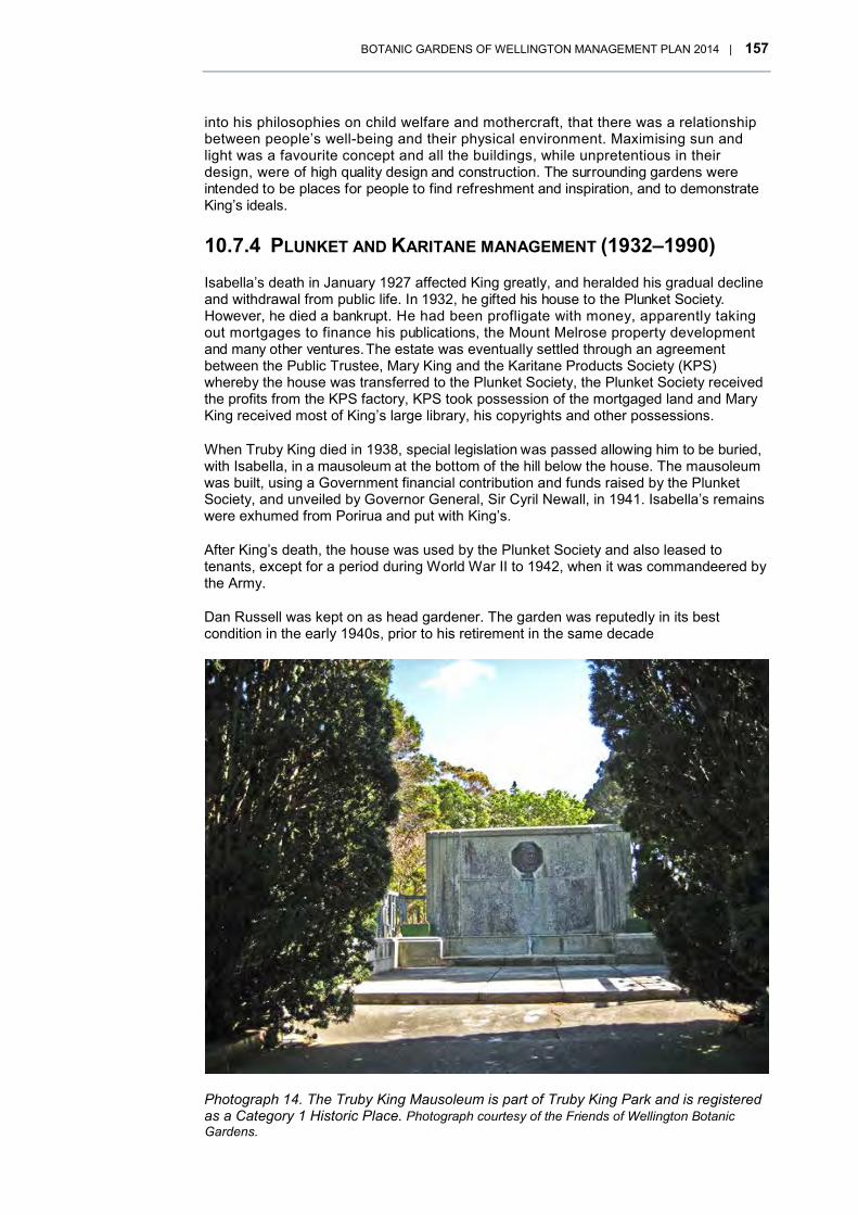
BOTANIC GARDENS OF WELLINGTON MANAGEMENT PLAN 2014 | 157
into his philosophies on child welfare and mothercraft, that there was a relationship between people’s well-being and their physical environment. Maximising sun and light was a favourite concept and all the buildings, while unpretentious in their design, were of high quality design and construction. The surrounding gardens were intended to be places for people to find refreshment and inspiration, and to demonstrate King’s ideals.
10.7.4 PLUNKET AND KARITANE MANAGEMENT (1932–1990) Isabella’s death in January 1927 affected King greatly, and heralded his gradual decline and withdrawal from public life. In 1932, he gifted his house to the Plunket Society. However, he died a bankrupt. He had been profligate with money, apparently taking out mortgages to finance his publications, the Mount Melrose property development and many other ventures. The estate was eventually settled through an agreement between the Public Trustee, Mary King and the Karitane Products Society (KPS) whereby the house was transferred to the Plunket Society, the Plunket Society received the profits from the KPS factory, KPS took possession of the mortgaged land and Mary King received most of King’s large library, his copyrights and other possessions.
When Truby King died in 1938, special legislation was passed allowing him to be buried, with Isabella, in a mausoleum at the bottom of the hill below the house. The mausoleum was built, using a Government financial contribution and funds raised by the Plunket Society, and unveiled by Governor General, Sir Cyril Newall, in 1941. Isabella’s remains were exhumed from Porirua and put with King’s.
After King’s death, the house was used by the Plunket Society and also leased to tenants, except for a period during World War II to 1942, when it was commandeered by the Army.
Dan Russell was kept on as head gardener. The garden was reputedly in its best condition in the early 1940s, prior to his retirement in the same decade
Photograph 14. The Truby King Mausoleum is part of Truby King Park and is registered as a Category 1 Historic Place. Photograph courtesy of the Friends of Wellington Botanic Gardens.

158 | BOTANIC GARDENS OF WELLINGTON MANAGEMENT PLAN 2014
Yopp and Jan Tetteroo took over the garden in the 1950s, by which time it had apparently become overgrown and neglected. It was during this period that most of King’s original plantings were lost during clearance work, including the rose hedge along the driveway and many plants in the rhododendron dell. The sowing of grass and planting of new trees in cleared areas changed he garden’s character. Stone walls of a different character were also constructed to try to contain erosion that had developed after clearance work on the banks around the walkways.
Extensive damage was reportedly inflicted by the Wahine storm of April 1968 but little more than routine maintenance was carried out for more than two decades after that, with little or no evidence of replacement planting. By 1990, the garden was in a poor state, overgrown with neglected plantings and self-sown trees and shrubs.
Photograph 15. Funeral procession of Sir Frederick Truby King, February 1938, bringing the coffin up to the vault. The mausoleum was not built at this time. The extent of the gardens at the Mount Melrose property can be seen in the gardens on the slope below the Karitane Hospital pictured. Photograph: Alexander Turnbull Library, photographer unidentified.

BOTANIC GARDENS OF WELLINGTON MANAGEMENT PLAN 2014 | 159
By the late 1970s, the Plunket Society was in financial trouble, reflecting changing attitudes that saw King’s ideology fall out of favour and demand for the Karitane infantfood products decline. The Karitane hospitals around the country were closed, including the one at Mount Melrose, which closed in 1978 and was sold into private ownership in 1982, later to become a conference centre. The factory, which had continued in production until the mid-1980s, was sold in 1988, together with its land and associated buildings. These were leased and eventually sub-let into five titles.
10.7.5 COUNCIL OWNERSHIP AND MANAGEMENT (1990–2014)
In 1988, the New Zealand Plunket Society put Sir Truby King’s house and garden up for sale as well as the factory land. A public meeting was called that year, at which it was suggested that the Council might purchase the property. In September 1988, the Council resolved to begin negotiations and by May 1990 had acquired, from the Society and other adjacent landowners, three lots of land that had been in the original estate including the house and mausoleum.
Early in the negotiations, the Council’s Director of Parks and Recreation, wrote to Truby King’s daughter, Mrs Mary White, by then living in South Australia, to notify her of the
Photograph 16. View of the garden surrounding the home of Frederic Truby King in Melrose, Wellington, April 1943. The garden was in its heyday around this time. The house can just be seen above the trees at the top of the rise. Photographer John Dobree Pascoe, Alexander Turnbull Library.

160 | BOTANIC GARDENS OF WELLINGTON MANAGEMENT PLAN 2014
Council’s intentions, which included retaining the homestead, burial site and grounds intact and more or less in their original condition, and calling the site the ‘Sir Truby King Park’. Mrs White wrote back expressing her delight but also, her preference for the property to be called just ‘Truby King Park’. She explained,
“Dr King accepted the honour as a mark of appreciation of the fine works of the members of the Plunket Society since its foundation in 1907, and he always preferred to be referred to as Doctor. Were he alive today this would be his wish – just Truby King Park.”93
Meanwhile, in 1989 and 1990, Truby King’s house94, mausoleum95 and the Karitane Products Society factory building96 had been registered as Category 1 Historic Places with the New Zealand Historic Places Trust.
Following the land purchase, the Council carried out some preliminary improvement work on the neglected garden, while preparing a management plan. A detailed landscape inventory and assessment of the garden was done, King’s archive at the Hocken Library in Dunedin extensively researched and considerable public consultation undertaken. A draft management plan was completed in 1991, followed by the Truby King Park, Wellington, Draft Conservation and Management Plan, which was completed in June 1992 and approved in 1993.
These documents recognised the acquisition of the property as an opportunity to extend the public open space of the adjacent Wellington Town Belt and to reconstruct an important part of the city’s heritage. While the house was in need of repairs, it was still in reasonable condition, and though the garden had been badly neglected, its structure and form were still largely intact. It was proposed to ‘protect and manage the house and mausoleum in a sensitive and dignified manner’ and to reconstruct and manage the garden ‘to as near as practicable to its original form and character’97. The garden’s reconstruction would be based on the form and character of the garden illustrated in a photograph taken in 1943 (see Photograph 16), given it was considered to have been in its heyday, as designed by Truby King, in the early 1940s. It was decided, however, that the stone walls built in the 1950s would be retained as part of the garden’s history.
In 1991, the Council decided to manage Truby King Park as one of four ‘Botanic Gardens of Wellington’ which were to be managed under a Botanic Gardens Manager.
In 1992 the area was listed as Open Space D in the Wellington District Plan and, in 1995, was gazetted as an Historic Reserve. In 2006, the New Zealand Historic Places Trust (now Heritage New Zealand Pouhere Taonga) registered the combined area covering the King’s house and mausoleum, the former Karitane factory and hospital, and the surrounding gardens remaining from King’s original design as the Truby King Historic Area98.
Early in the 1990s, garden clearance and restoration work began. A number of significant historical trees were noted, but only four rhododendrons that were probably planted by King remained. Some trees and dead wood were removed and small scale replanting begun. Paths and driveways around the house were re-graded and re-asphalted, and the brickwork repaired, using the same bricks, as originally, which were made in Miramar during the 1920s. The house was fireproofed in 1994 and re-roofed in 2005.
93 As quoted in Truby King Park Wellington, Draft Conservation and Management Plan (1992), 16. 94 New Zealand Heritage List/Rārangi Kōrero (1989) Registration No. 4427 95 New Zealand Heritage List/Rārangi Kōrero (1990), Registration No. 4430 96 New Zealand Heritage List/Rārangi Kōrero (1989) Registration No. 4430 97 Truby King Park Wellington, Draft Conservation and Management Plan (1992), 57. 98 New Zealand Heritage List/Rārangi Kōrero (2006), Registration No.7040.
BOTANIC GARDENS OF WELLINGTON MANAGEMENT PLAN 2014 | 161
Work stagnated in the late 1990s but interest in its management as one of the city’s botanic gardens resurged the early 2000s. In 2002, the Truby King House and Garden Trust was formed to support the Council in conserving, restoring and maintaining the house and garden, and encouraging its public use, including annual open days.
10.8 HISTORY REFERENCES AND RECOMMENDED READING
The main references used in preparing the background histories in this management plan are listed below. Note that there are more extensive reference lists in the earlier management plans (see below) upon which the current updated histories are based.
Particularly recommended for those wanting to find detailed historical accounts of the botanic garden areas are The Botanic Garden, Wellington - A New Zealand History 1840-1987 by Winsome Shepherd and Walter Cook; Unquiet Earth, a History of the Bolton Street Cemetery by Margaret Alington and online information at the New Zealand Historic Places Trust website about the registered historic places and areas in the various gardens.
10.8.1 MĀORI HISTORY
Adkin, G Leslie (1959). The Great Harbour of Tara, Traditional Māori Place-names and Sites of Wellington Harbour and Environs. New Zealand: Whitcombe and Tombs Ltd
Alington, Margaret H. (1978). Unquiet Earth, a history of the Bolton Street Cemetery. Wellington: Wellington City Council & Ministry of Works and Development.
Alington, Margaret (1978). Life After Death: An Old Cemetery Becomes a Memorial Park in The Making of Wellington 1800 – 1914, Edited by David Hamer & Roberta Nicholls
Best, E (1901). Te Whanga-nui-a-Tara Wellington in Pre-Pakeha Days. Journal of the Polynesian Society, Vol 10
Best, E. (1917 – 1919). The Land of Tara and they who settled it. Journal of the Polynesian Society, Vol 26 & 27.
Buchanan, Rachel (2009). The Parihaka Album: Lest we forget. Huia Publishers.
Māori Land Court Minute Book 1C
Mulgan, Alan (1939) The City of the Strait. Wellington: A H Reed.
Smith, S Percy (1910). History and Traditions of the Māoris of the West Coast, Memoirs of the Polynesian Society, pp 406 – 411
Turton, H Hanson, (1883). An Epitome of Official Documents relative to Native Affairs and Land Purchases in the North Island of New Zealand, Government Printer.
Ward, Louis E. (1928). Early Wellington. Whitcombe and Tombs Ltd
Waitangi Tribunal (2003). Te Whanganui a Tara me Ōna Takiwā: Report on the Wellington District
Wellington Tenths Trust (November 2004). GIS Map Book 2004. Neville Gilmore, Ritihia Hailwood and Liz Mellish.

162 | BOTANIC GARDENS OF WELLINGTON MANAGEMENT PLAN 2014
Wellington City Council (2002). Combined Management Plan, Wellington Botanic Garden Anderson Park Bolton Street Park. Wellington.
10.8.2 WELLINGTON BOTANIC GARDEN, ANDERSON PARK & BOLTON STREET CEMETERY HISTORIES
Aitken and Cochrane (2006). Maintenance and repair guidelines for graves and memorials, Bolton Street Memorial Park. Wellington: for Wellington City Council.
Alington, Margaret H. (1978). Unquiet Earth, a history of the Bolton Street Cemetery. Wellington: Wellington City Council & Ministry of Works and Development.
Bowman, Ian (2000). The Sexton’s Cottage, Wellington, Conservation Plan. Wellington: commissioned by the Wellington City Council.
Buchanan, John. Notes on the Colonial Botanic Garden, Wellington and its Flora. 1875. Unpublished.
Carter Observatory Board and Wellington City Council (2008). Deed of agreement recording management arrangements in relation to the Carter Observatory. Wellington.
Cranshaw, Helen. Study of the Vegetation in the Seven Native Bush Remnants in the Wellington Botanic Garden. August 1992.
Forsyth, Frances and Blaschke, Paul M. (2009). Ecological assessment of the Wellington Botanic Garden forest remnants. Report for Friends of the Wellington Botanic Garden and Wellington City Council . Wellington: Blaschke and Rutherford Environmental Consultants
Friends of Bolton Street Memorial Park (website). http://friendswbg.org.nz/
Friends of the Bolton Street Memorial Park Inc. (1977). Constitution and amendments.
Friends of the Wellington Botanic Garden (website). http://www.friendswbg.org.nz/
Friends of the Wellington Botanic Garden Inc. (1991). Constitution. Wellington.
Isthmus Group. Draft Landscape Development Plan for the Wellington Botanical Garden. 2000.New Zealand Historic Places Trust (1984). Carter Observatory (NZHP Registration No. 3596). URL http://www.historic.org.nz/TheRegister/RegisterSearch/ RegisterResults.aspx?RID=3596
New Zealand Historic Places Trust (1986). Dominion Observatory (NZHP Registration No. 4700). URL http://www.historic.org.nz/TheRegister/Register Search/RegisterResults.aspx?RID=4700
New Zealand Historic Places Trust (1994). Dominion Observatory Historic Area (NZHP Registration No. 7033). URL http://www.historic.org.nz/TheRegister/ RegisterSearch/RegisterResults.aspx?RID=7033
New Zealand Historic Places Trust (2004). Wellington Botanic Garden (NZHP Registration No. 7573). URL http://www.historic.org.nz/TheRegister/RegisterSearch/ RegisterResults.aspx?RID=7573
New Zealand Historic Places Trust (2005). Overseer’s House (NZHP Registration No. 1414). URL http://www.historic.org.nz/TheRegister/RegisterSearch/RegisterResults.aspx?RID=1414

BOTANIC GARDENS OF WELLINGTON MANAGEMENT PLAN 2014 | 163
New Zealand Historic Places Trust (2012). Sexton’s Cottage (Former) (NZHP Registration No. 1427). URL http://www.historic.org.nz/TheRegister/RegisterSearch/ RegisterResults.aspx?RID=1427
Read, Rodney (undated). History of heritage roses in the Bolton Street Memorial Park. URL http://friendswbg.org.nz/nomenu/HISTORYOFHERITAGEROSES INTHEBOLTONSTREETMEMORIA.pdf
Shepherd, Winsome and Cook, Walter (1988). The Botanic Garden, Wellington - a New Zealand history 1840 – 1987. Wellington: Millwood Press.
Wellington City Council (1981). Wellington Botanic Garden management plan. Wellington: Wellington City Council.
Wellington City Council (1990). Bolton Street Memorial Park management plan. Wellington: Wellington City Council.
Wellington City Council (1990). Wellington Botanic Garden management plan. Wellington: Wellington City Council.
Wellington City Council (2002). Combined management plan, Wellington Botanic Garden, Anderson Park, Bolton Street Memorial Park. Wellington: Wellington City Council.
White, H. L. (1978). Monuments and their Inscriptions. London: Society of Genealogists
10.8.3 OTARI-WILTON’S BUSH HISTORY Boffa Miskell Ltd. (1998). Interpreting Otari Native Botanical Gardens, Interpretation Strategy. Report prepared for the Wellington City Council.
Cockayne, L.A. (1932). Scheme for the Development and Arrangement for the Otari Open-Air Native Plant Museum and Other Matters Connected Therewith, Wellington City Council.
Druce, A.P. (1953). Otari Rock Garden. Wellington Botanical Society Bulletin 26.
Harper, M.A., Harper J.F. (2010). Otari and Taputeranga bioblitzes: diatoms – microscopic algae. Wellington Botanical Society Bulletin 52: 53-63.
Lewington, R.J. (2009). Paths and Location Names used in the Otari Open-Air Native Plant Museum 1926-1925, Otari Wilton’s Bush Trust.
Lewington, R.J. (2010). More Recent History of Otari Wilton’s Bush: Transcript of a 2003 talk by Lindsay Pool. Wellington Botanical Society Bulletin 52: 3-9.
Lewington, R.J., West C. (2011).History of kauri in Otari-Wilton’s Bush, Wellington Botanical Society Bulletin 53.
Lewington, R.J., West C. (2008). Otari Bioblitz: detailing vascular plants, mosses and liverworts. Wellington Botanical Society Bulletin 51:5-23.
Martin, Margaret M. (1938). The Otari Open-Air Native Plant Museum. Journal of the NZ Institute of Horticulture, 8, no. 237-44.
Mason, R., Sainsbury, G. O. K., Hodgson, E .A. (1941). Mosses and Liverworts of Wiltons Bush, Wellington. Botany Division , DSIR
Mole, R.H. (1967). Guide List to Plants: The Otari Open-Air Native Plant Museum, Wellington, New Zealand

164 | BOTANIC GARDENS OF WELLINGTON MANAGEMENT PLAN 2014
Mole, R.H. Guide List to Plants: The Otari Open-Air Native Plant Museum (2nd ed.) Wellington City Council Parks Department.
Reid, J. S. (1985). Changes Over 50 Years in a Native Forest Quadrant, Wellington Botanical Society Bulletin 42: 41-57.
(Refers also to his first description in his thesis of 1932-1934)
Reid, J.S. (1989). Otari Path Names Commemorate Early Botanists. Wellington Botanical Society Bulletin 45:48-52
Reid, J.S. (1989). Bracken fern and Scrub communities in Otari Reserve, re-observed after fifty years. Wellington Botanical Society Bulletin 45:100-115.
Rewi, E. (2013). Making Gardens meaningful: Linking activities to vision at the Botanical Gardens of Wellington. A report submitted in part fulfillment of the requirements for the RBG Kew International Diploma in Botanic Garden Management.
Te Mohoao (Waugh, S., Corkill S., Wylie, C.) (2008). Proposals for Interpretative Services at Otari-Wilton’s Bush.
Thomson, A.D. (1983). The Life and Correspondence of Leonard Cockayne. Botany Division DSIR, Christchurch. Wellington City Council (1996). Otari Native Botanic Garden Management Plan. Wellington: Wellington City Council.
Wellington City Council, (2007). Otari Native Botanic Garden and Wilton’s Bush Reserve (Otari-Wilton’s Bush) Management Plan. Wellington: Wellington City Council.
10.8.4 TRUBY KING PARK HISTORY Barbara Brookes. 'King, Frederic Truby', from the Dictionary of New Zealand.
Biography. Te Ara - the Encyclopedia of New Zealand, updated 30-Oct-2012. URL: http://www.TeAra.govt.nz/en/biographies/2k8/king-frederic-truby
Boffa Miskell Partners (1992). Landscape inventory and assessment of the Mount Melrose garden. Wellington: unpublished report.
New Zealand Historic Places Trust ((1989). Truby King House (former) (NZHPT Registration No. 4427). URL ttp://www.historic.org.nz/theregister/registersearch/ RegisterResults.aspx?RID=4427
New Zealand Historic Places Trust ((1990). Truby King Mausoleum (NZHPT Registration No. 4430). URL http://www.historic.org.nz/theregister/registersearch /RegisterResults.aspx?RID=4430
New Zealand Historic Places Trust ((2006). Truby King Historic Area (NZHPT Registration No.7040). URL http://www.heritage.org.nz/the-list/details/7040
New Zealand Historic Places Trust (1989). Karitane Products Society Building (former)(NZHPT Registration No. 4430). URL http://www.historic.org.nz/ theregister/registersearch/RegisterResults.aspx?RID=4431Wellington City Council and Boffa Miskell Partners (1992). Truby King Park Wellington, draft conservation and management plan. Wellington: Wellington City Council.
10.8.5 LIST OF HISTORIC PHOTOGRAPHS The Main Garden, circa 1907. Mabsie Hislop with Mr and Mrs Mae in the Botanical Gardens, Wellington. Hislop, Harold Stevens, d 1933 :Photograph albums. Ref: PA1-o-

BOTANIC GARDENS OF WELLINGTON MANAGEMENT PLAN 2014 | 165
229-3. Alexander Turnbull Library, Wellington, New Zealand. http://natlib.govt.nz/records/22883549
Wellington Botanic Garden, Kelburn, Wellington, circa 1900s – 1930s. Wellington Botanic Garden, Kelburn, Wellington. Williams, Edgar Richard, 1891-1983 :Negatives, lantern slides, stereographs, colour transparencies, monochrome prints, photographic ephemera. Ref: 1/4-056036-G. Alexander Turnbull Library, Wellington, New Zealand. http://natlib.govt.nz/records/30656793
The Lady Norwood Rose Garden, early 2000s. Wellington City Council.
Open-air performance at Wellington Botanic Gardens Sound Shell, 1956, featuring strings of lights and spectators. Negatives of the Evening Post newspaper. Ref: EP/1956/0411-F. Alexander Turnbull Library, Wellington, New Zealand. http://natlib.govt.nz/records/22830572
Native forest remnant, Botanic Garden, Wellington, circa 1887. Connolly & Company. Native forest remnant, Botanic Garden, Wellington - Photograph taken by Conolly. Saxby, Stephen Hector, 1907- :Photograph albums. Ref: PA1-q-213-086. Alexander Turnbull Library, Wellington, New Zealand. http://natlib.govt.nz/records/22785701
Dominion Observatory, Wellington Botanic Gardens, circa 1900s. Jeffares, Isaac Henry Bowen, 1868-1936 :Photographs. Ref: 1/2-076775-G. Alexander Turnbull Library, Wellington, New Zealand. http://natlib.govt.nz/records/22792452
View of graves in the Bolton Street Cemetery, circa 1890s, Wellington. Thresh :Various photographs. Ref: 1/2-031999-G. Alexander Turnbull Library, Wellington, New Zealand. http://natlib.govt.nz/records/23025264
Road works through the Bolton Street cemetery in preparation for the Wellington motorway, circa 1969. Photograph taken circa 18 April 1969 by an unidentified staff photographer for the Dominion newspaper. Alington, Margaret H :Photographs of Bolton Street Cemetery. Ref: PAColl-5522-3-001. Alexander Turnbull Library, Wellington, New Zealand. http://natlib.govt.nz/records/23219709
The former Sexton’s Cottage, Bolton Street, . Courtesy Friends of Bolton Street Memorial Park.
The St Paul’s Chapel, in the Bolton Street Cemetery, circa 1920s-1940s. Robson, Edward Thomas, 1875-1953. Robson, Edward Thomas, fl 1920s-1940s? (Photographer) : Bolton Street Cemetery, Wellington, with St Paul's Chapel. Original photographic prints and postcards from file print collection, Box 13. Ref: PAColl-6407-05. Alexander Turnbull Library, Wellington, New Zealand. http://natlib.govt.nz/records/22299236
Dray Road to Wilton’s Homestead 1896. Morton, Jim, fl 1896. Entrance to Wilton Bush, Wellington. Ref: 1/2-049735-F. Alexander Turnbull Library, Wellington, New Zealand. http://natlib.govt.nz/records/23044728
Dr Leonard Cockayne, 1928. Leonard Cockayne. S P Andrew Ltd :Portrait negatives. Ref: 1/1-018377-G. Alexander Turnbull Library, Wellington, New Zealand. http://natlib.govt.nz/records/22739041
Frederic Truby King. S P Andrew Ltd :Portrait negatives. Ref: 1/2-C-005754. Alexander Turnbull Library, Wellington, New Zealand. http://natlib.govt.nz/records/22784309
Truby King Mausoleum, Courtesy Friends of Wellington Botanic Gardens

166 | BOTANIC GARDENS OF WELLINGTON MANAGEMENT PLAN 2014
Funeral procession of Sir Frederic Truby King. New Zealand Free Lance : Photographic prints and negatives. Ref: PAColl-6388-06. Alexander Turnbull Library, Wellington, New Zealand. http://natlib.govt.nz/records/22827566
Home and garden of Sir Truby King in Melrose, 1943. Pascoe, John Dobree, 1908-1972 :Photographic albums, prints and negatives. Ref: 1/4-000437-F. Alexander Turnbull Library, Wellington, New Zealand. http://natlib.govt.nz/records/22574467
BOTANIC GARDENS OF WELLINGTON MANAGEMENT PLAN 2014 | 167
APPENDIX 3: GLOBAL STRATEGY FOR 11PLANT CONSERVATION 2011–2020
11.1 OBJECTIVE I Plant diversity is well-understood, documented and recognised
Target 1: An online flora of all known plants.
Target 2: An assessment of the conservation status of all known plant species, as far as possible, to guide conservation action.
Target 3: Information, research and associated outputs, and methods necessary to implement the Strategy developed and shared.
11.2 OBJECTIVE II Plant diversity is urgently and effectively conserved
Target 4: At least 15 percent of each ecological region or vegetation type secured through effective management and/or restoration.
Target 5: At least 75 percent of the most important areas for plant diversity of each ecological region protected with effective management in place for conserving plants and their genetic diversity.
Target 6: At least 75 percent of production lands in each sector managed sustainably, consistent with the conservation of plant diversity.
Target 7: At least 75 percent of known threatened plant species conserved in situ.
Target 8: At least 75 percent of threatened plant species in ex situ collections, preferably in the country of origin, and at least 20 percent available for recovery and restoration programmes.
Target 9: 70 percent of the genetic diversity of crops including their wild relatives and other socio-economically valuable plant species conserved, while respecting, preserving and maintaining associated indigenous and local knowledge.
Target 10: Effective management plans in place to prevent new biological invasions and to manage important areas for plant diversity that are invaded.
11.3 OBJECTIVE III Plant diversity is used in a sustainable and equitable manner
Target 11: No species of wild flora endangered by international trade.
Target 12: All wild harvested plant-based products sourced sustainably.
Target 13: Indigenous and local knowledge innovations and practices associated with plant resources maintained or increased, as appropriate, to support customary use, sustainable livelihoods, local food security and health care.

168 | BOTANIC GARDENS OF WELLINGTON MANAGEMENT PLAN 2014
11.4 OBJECTIVE IV Education and awareness about plant diversity, its role in sustainable livelihoods and importance to all life on earth is promoted
Target 14: The importance of plant diversity and the need for its conservation incorporated into communication, education and public awareness programmes.
Objective V: The capacities and public engagement necessary to implement the Strategy have been developed Target 15: The number of trained people working with appropriate facilities sufficient according to national needs, to achieve the targets of this Strategy.
Target 16: Institutions, networks and partnerships for plant conservation established or strengthened at national, regional and international levels to achieve the targets of this Strategy.

BOTANIC GARDENS OF WELLINGTON MANAGEMENT PLAN 2014 | 169
APPENDIX 4: WILDLIFE IN THE 12WELLINGTON BOTANIC GARDEN AND OTARI-WILTON’S BUSH
12.1 LIZARDS There are eight lizard species found in the Wellington area. Of these, four have been recorded in Otari-Wilton’s Bush and the Botanic Garden. The only species found in the Botanic Garden is the common skink, although there is potential habitat for further species. Otari-Wilton’s Bush has a strong population of Southern North Island forest geckos, which are commonly found around the more formal gardens and rock walls. Also found in Otari-Wilton’s Bush are brown, common and ornate skinks. Wellington green geckos (a threatened species) are suspected at Otari-Wilton’s Bush but more survey work is required to confirm their presence.
12.2 BIRDS Bird counts have been conducted at Otari-Wilton’s Bush and the Wellington Botanic Garden once or twice a year since 2001.
Through the bird counts, there are 11 species of native bird found at Otari-Wilton’s Bush, and 13 introduced species. The Botanic Garden is home to seven native species and 14 introduced species. The four most commonly found native species at both gardens are tui, silvereye, grey warbler and fantail.
The difference in habitat between Otari-Wilton’s Bush and the Botanic Garden shows through the bird counts. Four out of the five most common species in the native forest at Otari-Wilton’s Bush are native. Species found in counts at Otari-Wilton’s Bush but not at the Botanic Garden are bellbird, shining cuckoo, falcon and kakariki.
The mix of species found in bird counts at the Botanic Garden reflects the far more urbanised environment. Only two of the top five species are native. Species found here but not at Otari-Wilton’s Bush are mallard, rock pigeon and seagulls.
The total abundance of birds has increased to some extent, but it is the difference in species composition over the last 10 years that is more marked. Species abundance has been gradually increasing since bird counts began in 2001. This increase has been significant at Otari-Wilton’s Bush. In the last 10 years, the number of native species found at Otari-Wilton’s Bush has increased from six to 10 with bellbird, falcon, kaka and kakariki now regularly appearing in counts. Species numbers have remained more static at the Botanic Garden, with kaka being the most noticeable new inhabitant. Kaka have been visiting both areas since 2008 and are now suspected to be breeding in the Botanic Garden. The kaka population in the Botanic Garden is more robust than at Otari-Wilton’s Bush, potentially due to the year-round food source provided by the exotic vegetation.
There are relatively high numbers of rosella at Otari-Wilton’s Bush (the 9th most common bird), which is a species to watch due to competition with native species for nest cavities. This is particularly important with kakariki (a similar sized parakeet) now appearing in Otari-Wilton’s Bush.
See full list of bird species overleaf.

170 | BOTANIC GARDENS OF WELLINGTON MANAGEMENT PLAN 2014
Full list of species in order of abundance (natives in bold)
OTARI-WILTON’S BUSH WELLINGTON BOTANIC GARDEN
Silvereye * Silvereye *
Tui * Blackbird
Blackbird Tui *
Grey warbler * Chaffinch
Fantail * Starling
Chaffinch House sparrow
Starling Fantail *
Kereru * Grey warbler *
Rosella Goldfinch
House sparrow Hedge sparrow
Song thrush Kingfisher *
Hedge sparrow Carrier pigeon
Kingfisher * Kaka *
Bellbird * Song thrush
Paradise shelduck Greenfinch
Kaka * Rosella
Shining cuckoo * Mallard
Goldfinch Seagull
Magpie Kereru *
Sulphur cockatoo Yellowhammer
Greenfinch Magpie
Yellowhammer
Falcon *
Kakariki *
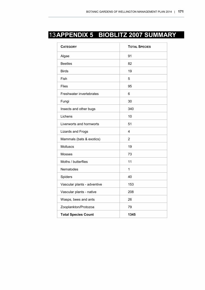
BOTANIC GARDENS OF WELLINGTON MANAGEMENT PLAN 2014 | 171
APPENDIX 5 BIOBLITZ 2007 SUMMARY 13
CATEGORY TOTAL SPECIES
Algae 91
Beetles 82
Birds 19
Fish 5
Flies 95
Freshwater invertebrates 6
Fungi 30
Insects and other bugs 340
Lichens 10
Liverworts and hornworts 51
Lizards and Frogs 4
Mammals (bats & exotics) 2
Molluscs 19
Mosses 73
Moths / butterflies 11
Nematodes 1
Spiders 40
Vascular plants - adventive 153
Vascular plants - native 208
Wasps, bees and ants 26
Zooplankton/Protozoa 79
Total Species Count 1345

172 | BOTANIC GARDENS OF WELLINGTON MANAGEMENT PLAN 2014
APPENDIX 6: IMPLEMENTATION PLAN 14
14.1 ACTION PLAN – FUNDED NOTE: may include reprioritisation of existing budgets.
General management framework
SECTION ACTION SHORT TERM: 1-3 YRS
MEDIUM TERM: 3-5 YRS
LONG TERM: 5-10 YRS
3.2, Education & awareness
Prepare interpretation plans for each Garden
Work with Botanic Gardens Australia Zealand to develop and fund a capacity building project with Pacific gardens
Web based plant collection information links available on and off site
On site apps
Investigate alternative forms of technology based advisory information with an emphasis on:
Participate in the Nature Connections Project
3.5, Marketing and Promotion
Develop a marketing strategy for the Gardens with a focus on adding value to garden visits by providing more opportunities for visitors to access education and conservation messages.
Focus on the national profile and role of Otari-Wilton’s Bush and regional role of Wellington Botanic Garden
Achieve Green Flag Award status for the Wellington Botanic Garden and Otari - Wilton’s Bush
Work with Zealandia and Wellington Zoo to showcase and promote Wellington as an eco–city
3.6, Partnerships
Develop a long-term sponsorship/fundraising strategy linked to the key projects in the Implementation Plan 3.6.3
Wellington Botanic Garden
SECTION ACTION SHORT TERM: 1-3 YRS
MEDIUM TERM: 3-5 YRS
LONG TERM: 5-10 YRS
4.1.1, Rose Garden sector
Extend the Herb Garden south towards Serpentine Way to develop a space suitable to hire out for special events including weddings
Commemorate the centenary of the First World War with appropriate planting on Remembrance Ridge.
4.1.2,Main Complete restoration of the dwarf conifer area

BOTANIC GARDENS OF WELLINGTON MANAGEMENT PLAN 2014 | 173
Garden sector and develop it into a major feature at the Glenmore Street entrance
Develop year round interest in the Camellia garden with new herbaceous plantings.
Develop interpretation for the Fern Forest Garden.
4.1.3, Treehouse Visitor Centre/ Children’s Garden sector
Review planting and interpretation in these garden areas to better articulate the messages around the pressure on plants and ecosystems
Done
Investigate the potential role and site for a Cacti house within the nursery area.
Review the wider landscape and plant collections between the Play Area and the duck pond to enhance it with attractive, inspiring, educational themed gardens.
4.1.4, Cable Car/Play Area
Develop a landscape concept plan (soft and hard landscape) for the Cable Car entrance to the Garden which recognises its status as a major entrance and ensures it encourages visitors to enter and explore.
Review the tree framework as part of the concept plan and open up the area by removing poorly performing pohutukawas and reviewing the future health and management of the bucket tree.
4.2, Education and Awareness
Develop the Treehouse as the major visitor centre providing changing exhibitions about conservation, environmental issues and gardening as well as meeting and community space.
Develop an integrated interpretive experience from the Cable Car entrance following the downhill to downtown path to the Play Area and onto the CBD.
4.3, Historic and Cultural Features
Complete an assessment of the Wellington Botanic Garden’s heritage values, including more recent cultural features such as artworks, shall be carried out and a descriptive list and location map of all the items considered to have historic or cultural value shall be prepared This shall be carried out as part of the asset management planning for the Garden. Assistance from local historians and Heritage New Zealand shall be sought in preparing the list.
The Council in conjunction with the Friends of the Wellington Botanic Gardens will organise an event to celebrate the 150th anniversary of the founding of the Garden.
Continue the five year Implementation Plan in the Tree Plan99 and review in year five.
Identify and work to restore sparse or absent plant species from the native forest.
Develop and implement a weed control programme that includes current and potential non- local native species
99 Tree Plan Wellington Botanic Garden (for amenity and framework trees) 2011 – note the plan includes Bolton Street Memorial Park

174 | BOTANIC GARDENS OF WELLINGTON MANAGEMENT PLAN 2014
Improve management of the Waipiro Slopes through narrowing of Serpentine Way where practicable and reduce run off of road gravel.
Establish and monitor permanent vegetation plots consistent with other plots in the WCC open space network.
4.4, Recreation and visitor use
Develop a landscape concept plan for the Cable Car entrance that emphasises the Garden’s relationship with the Cable Car precinct and Observatory Reserve.
Review toilet provision in the Play Area/Children’s Garden area and the feasibility of upgrading or replacing the existing facility. (N)
Develop a landscape concept plan for Magpie Lawn that considers the provision of public toilets, visitor shelter, barbecue and screening of the compost heaps.
The interpretation plan/ strategy being prepared (refer Education and Interpretation section), shall consider visitor circulation patterns and include improvements to the orientation and way finding signage.
Encourage use of the Botanic Garden as a pedestrian commuting route and assess the potential for improving interpretation on some of these major routes
Investigate the demand for additional event spaces and carry out a feasibility study on the area south of the Herb Garden.
4.5, Partnerships & community involvement
The Council will support and work with the Friends of the Botanic Gardens to raise the funds needed for the Children’s Garden. Link to 3.6.4.
Work with the Friends to increase the number of trained guides and hosts (E)
Work in partnership with Port Nicholson Block Settlement Trust to investigate the development of a Kumutoto Cultural Garden. (N)
Otari – Wilton’s Bush
SECTION ACTION SHORT TERM: 1-3 YRS
MEDIUM TERM: 3-5 YRS
LONG TERM: 5-10 YRS
5.2, Cockayne collections
Construct a central pathway through the collections with viewing points and links onto the Circular Walk and Nature Trail as proposed in the Landscape Development Plan.
Redevelop the taxonomic collections in the lower collections (below the Cockayne Lookout) around the proposed redeveloped pathways
Develop the garden around the Leonard Cockayne Centre to display a range of native species and to showcase natives as garden plants. Relocate the Phormium and Hebe cultivar collections into the garden. (Ex)
Investigate integrating the nursery and its

BOTANIC GARDENS OF WELLINGTON MANAGEMENT PLAN 2014 | 175
collections into the visitor experience (N)
Develop ‘up close and personal’ walks through Phormium ‘Goliath’, a lancewood forest ‘thicket’, and a divaricate tunnel.
Forest collections
Complete replanting of the Fernery and the replacement tree canopy
Continue to develop collection themes for the 38o garden with further plantings.
Continue to develop understory/ground cover amenity plantings in the tree fern garden.
Continue to manage existing plants in the former Carmichaelia collection, propagating to produce further accessions and iidentify opportunities for displaying Carmichaelia spp. more visibly throughout the wider collections areas.
Beech collections
Develop a circular walking circuit through the beech collection from the North Picnic Lawn. Investigate the construction of a lookout structure.
Investigate the construction of a lookout structure above the beech collection, with access from the new circular walking circuit identified above.
5.2.2 Education and Awareness
Develop and upgrade Te Marae o Tane as the main visitor centre
Refresh the interpretive displays in the Centre
Reconfigure the pedestrian entry from Wilton Road car park to the existing visitor Information Centre, Te Marae O Tane. (N)
Develop the Leonard Cockayne Centre as an education and resource centre. The surrounding garden will be developed as a showcase for using native plants in home gardens.
Continue to develop the Nature Trail and Treasure Trail as the main educational trail with interpretative signage, plant labelling of all common trees and curriculum based self-guiding material
Identify and test new interactive trails possibly using new technology. In particular a family trail and an ethno-botanical trail.
5.4.1 Cultural history
Facilitate the collation and publishing of a history of Otari-Wilton’s Bush.
5.4.3, Forest management
Prepare a long term forest management plan in conjunction with Greater Wellington.
Identify as part of the long term forest management plan plant species that could be considered sparse, or are now absent in the Otari forest, and set up monitoring of recruitment planting of these species, including
176 | BOTANIC GARDENS OF WELLINGTON MANAGEMENT PLAN 2014
Podocarpaceae members.
Consider reintroducing fauna known historically to have occurred in the Wellington Peninsula forests where possible in conjunction with Zealandia
Retain and manage the planted kauri, podocarp and native beech groves that are planted in the vicinity of the Red Trail and Flax Clearing.
5.4.3, Pest animal management
Sustain a possum and rodent control programme in collaboration with Greater Wellington Regional Council.
Sustain a mustelid control and monitoring programme with RAMBO.100
Control or removal of other pest species as required.
Monitor the population of eastern rosellas and their impacts on native biodiversity
Ensure the public land surrounding Otari has sufficient pest control to ensure safe habitat
5.4.3, Weed management
Control of priority ecological weeds including weeds along riparian margin.
A programme to remove young karaka seedlings to prevent further spread in the area Job Wilton initially fenced.
Monitoring the spread of non-local natives particularly Hoheria populnea and Pomaderris apetala, and Pittosporum ralphii and develop and implement a weed control programme that includes current and potential non- local native species.
Monitoring and surveying the current cover and distribution of Berberis darwinii and developing a long term programme to limit spread.
Co-ordinating weed control on adjacent Wellington City Council land
5.4.3, Project Kaiwharawhara
Restoration planting along riparian zones (the interface between land and a river or stream) will be encouraged in order to prevent degradation of stream banks and stream life; with the exception of the Troup Picnic Lawn.
5.4.3, Education and awareness
Promoting to neighbours how they can be ‘Otari friendly’ with regard to responsible pet ownership and creating wildlife friendly habitats in their gardens (N)
Work with Zealandia on a campaign to encourage the public to carry out predator control to create a safe buffer zone for native species around both areas. (N)
5.5, Recreation and Visitor Use
Continue to refresh and upgrade the edge along Wilton Road to include planting and a more coherent streetscape that provides hints of the qualities of Otari- Wilton’s Bush forest and gardens. (E)
100 Rat And Mustelid Blitzing at Otari.

BOTANIC GARDENS OF WELLINGTON MANAGEMENT PLAN 2014 | 177
Develop a furniture and finishes strategy (E)
Investigate improving transport and way finding to Otari-Wilton’s Bush. (N)
Investigate relocating the existing bus shelter to a more prominent position to the west along Wilton Road (N)
Investigate developing of a multi-purpose track naming and identification system that is better associated with the history and experiences of Otari, as part of the Interpretation and way finding strategy. (N)
Investigate linking Otari-Wilton’s Bush with the Te Araroa National Walkway.(N)
Continue providing advocacy and signage advising dog walkers of their responsibilities and mountain bikers that the area is closed to biking.(E)
5.6, Partnerships
The Trust and Council develop a joint approach to the development and delivery of a comprehensive education package at Otari Wilton’s Bush
Bolton Street Memorial Park
SECTION ACTION SHORT TERM: 1-3 YRS
MEDIUM TERM: 3-5 YRS
LONG TERM: 5-10 YRS
6.1, Identity and name
Change the name of Bolton Street Memorial Park to Bolton Street Cemetery
6.2, Landscape character
Continue the five year Implementation Plan in the Tree Plan101
6.2, Graves and monuments
Electronically locate all known grave sites and headstones and store them on the Council Geographic Information System, (GIS)
Redesign the landscape around the mass grave to discourage access and provide a suitable setting for this historic site.
6.3, Signage and wayfinding
Review and improve way finding between Bolton Street and the entrance into the Botanic Garden, Cemetery and Anderson Park off Kinross Street.
6.4, Partnerships
Work with the Archdiocese of Wellington to integrate administrative records and maintenance standards between the two historic cemeteries at Mount Street and Bolton Street.
Work with Port Nicholson Block Settlement Trust on interpretation that outlines the significance of the site and Cemetery to Māori.
101 Tree Plan Wellington Botanic Garden (for amenity and framework trees) 2011 – note the plan includes Bolton Street Memorial Park

178 | BOTANIC GARDENS OF WELLINGTON MANAGEMENT PLAN 2014
Truby King Park
SECTION ACTION SHORT TERM: 1-3 YRS
MEDIUM TERM: 3-5 YRS
LONG TERM: 5-10 YRS
7.3, Truby King Garden
Replace the large pine tree framework with a framework of smaller trees and open up the views from the house over Evans Bay
Increase the use of edible plant and tree species to emphasise the holistic nature of the garden
Open up the house’s views over Evans Bay
7.4, House Develop a long term plan to enable managed public access to significant parts of the house whilst retaining accommodation for management and security purposes
7.5, Recreation & use
Support the Trust and work with the community to encourage increased involvement and use of the Park by local residents. (Ex)
7.6, Visitation and access
Enhance pedestrian links to the park, and look at ways to encourage use of the Park as a feature on longer walking routes (Ex)
Examine ways to encourage increased use of public transport to access the Park. (N)
Action plan – unfunded projects
SECTION ACTION SHORT TERM 1-3 YRS
MEDIUM TERM 3-5 YRS
LONG TERM 5-10 YRS
ESTIMATED COSTS
Wellington Botanic Garden Children’s Garden / Treehouse Learning Hub
Develop the Children’s Garden with a single recurring theme of people’s dependence on plants for life across four principal plant services: food, fibre, construction and medicine.(N)
$1.8M Subject to Charles Plimmer
and private funding.
Increase the public role and profile of the nursery in conjunction with the development of the Children’s Garden and associated education programmes. (N)
Carry out a review of the Nursery/ Treehouse/Children’s Garden sector to improve pedestrian circulation and resolve conflicts with operational vehicle movements
Entrances and car parks
Investigate increased off street parking for the Garden along the Salamanca Road Frontage
Unfunded pending a wider review of cycling and parking.
Truby King Park House and Garden
Provide accessible access to the house
All of these are subject
to the outcome of Develop the house and surrounds as

BOTANIC GARDENS OF WELLINGTON MANAGEMENT PLAN 2014 | 179
the central interpretation centre for the Park
the study into the
future use of the house. Investigate increased parking at the
rear of the property for use by visitors to the Wellington Town Belt and Truby King Park.
Complete reconstruction of the hard landscape features particularly the walls and archways around the house