boulia area gravity survey, queensland, 1959 · the heights of stations were obtained by two paulin...
TRANSCRIPT

COMMONWEALTH OF AUSTRALIA
DEPARTMENT OF NATIONAL DEVELOPMENT
BUREAU OF MINERAL RESOURCES. GEOLOGY AND GEOPHYSICS
PETROLEUM SEARCH SUBSIDY ACTS
Publication No. 37
_BOULIA AREA GRAVITY SURVEY,QUEENSLAND, 1959
BY
THE PAPUAN APINAIPI PETROI-EUM COMPANY LIMITED
Issued under the Authority of Senator the Hon. W. H. Spooner,Minister for National Deyelopment
1962 ...

CoMMONWEAL11I OF AUSTRALIA
. . . -.--DEPARTMENT OF NATIONAL DEVELOPMENT
Minister: SENATOR 1111! HON. W. H. SPOONER, M.M.
Secretary: H. G. RAOOA1T, C.B.E.
BUREAU OF MINERAL RESOURCES, GEOLOGY AND GEOPHYSICS
Director: J. M. RAYNER
This Report was prepared for publication in the Geophysical Branch
Chief Geophysicist: R. F. THYER.
FOREWORD
In 1959 the Commonwealth Government enacted the Petroleum Search SubsidyAct 1959. This Act enables companies that drill for new stratigraphic information, or carryout geophysical or bore-hole surveys in search of petroleum, to be subsidized for the cost ofthe operation, provided the operation is approved by the Minister for National Development.
The Bureau of Mineral Resources, Geology and Geophysics is required, onbehalf of the Department of National Development, to examine the applications, maintainsurveillance of the operations, and in due course publish the results.
A gravity survey was carried out under the Petroleum Search Subsidy Act 1959over an area around Boulia in north-western Queensland by The Papuan Apinaipi PetroleumCompany Limited. This Publication deals with that survey and contains the informationfurnished by The Papuan Apinaipi Petroleum Company Limited and edited in the GeophysicalBranch of the Bureau of Mineral Resources. The final geophysical report was written byL.J. Starkey under the supervision of D.M. Traves, Chief Geologist, both of Mines Administration Pty Limited. The survey methods and the results obtained are presented in detail.

CONTENTS
ABSTRACT
1. INTRODUCTION
2. .FIELD WORK
3. CORRECTIONS TO DATA
4. ACCURACY OF DATA
5. GEOLOGY
6. RESULTS AND INTERPRETATION
(1) Regional(2) Middleton-Kynuna area(3) Springvale area(4) Boulia area(5) Glenormiston area(6) Duck Point area(7) Breadalbane area(8) Toko Range area
7. CONCLUSIONS
8. REFERENCES
ADDITIONAL DATA ON FILE
ILL USTRATIONS
Figure 1. Locality map
Figure 2. Table summarizing stratigraphy
Plate 1. Regional Bouguer gravity contours
Plate 2. Bouguer contours, Middleton-Kynuna area
Plate 3. Bouguer contours, Springvale area
Plate 4. Bouguer contours, Boulia area
Plate 5. Bouguer contours, Glenormiston area
Plate 6. Bouguer contours, Duck Point area
Plate 7. Bouguer contours, Breadalbane area
Page
1
2
2
3
3
3
7
7
1011
111212
1313
13
14
./ ... 14
Frontispiece
Page 4
At back of report
"
"""
"
"Plate 8. Bouguer contours, Toko Range area
Plate 9. Surface geology and structure contours at base of marineCretaceous
"
"

AUTHORITY TO PROSPECT 54 PShowing areas of Minad Gravity SurveYIl
40 20 0 qJ BC> mllo••' ...._ ............' ....................' .....!!!!!!"!!!!!!!"!!!!!!IIII'
14~
f/cal.;?OO 'HJOtMLS......_---
MAP
Scale
/2C f57P.A.P. 54P
L QUEENSLAND
PG\INlO\I
'"
LOCALITY
............._"'r...--JULIA CREEK~ _
• I1\'10,'.~
2/' !

ABSTRACT
A gravity survey was conducted by Mines Administration Pty Limited for ThePapuan Apinaipi Petroleum Company Limited between May and August 1959. The survey tookplace over seven separate areas within Authority to Prospect 54P in north-western Queensland.The areas surveyed are partly within the Georgina Basin and partly within the DiamantinaBasin. These Basins contain Palaeozoic sedimentary rocks. Sedimentary rocks of the GreatArtesian Basin overlap the whole of the Diamantina Basin and part of the Georgina Basin.
The survey results, together with data obtained previously by the Bureau ofMineral Resources, indicated four distinct zones of gravity "highs" which all trend northnorth-west. Most and perhaps all of these zones coincide in the north with structural featuresin the Proterozoic sediments. The gravity anomalies associated with these Proterozoicstructural features continue southward, where the Proterozoic rocks' are overlain by latersediments, with little or no decrease in absolute gravity. In some areas these Proterozoicstructural features have influenced structural development in the Palaeozoic and Cretaceoussediments. The four zones of gravity "highs" are therefore regarded as areas of structuralinterest that are worthy of further exploration.
1

1. INTRODUCTION
The Boulia area is situated in north-western Queensland, south of Cloncurry,with Boulia near its centre. It represents the land included in Authority to Prospect 54Pgranted by the Queensland Department of Development and Mines to The Papuan ApinaipiPetroleum Company Limited.
The Bureau of Mineral Resources in 1957 conducted a limited gravity survey inthe Boulia-Dajarra-Mount Isa area. During 1958 this survey was extended farther south andalso east as far as Winton. The work is described in two Bureau of Mineral ResourcesRecords (Neumann, 1959a, b). As a result of these surveys The Papuan Apinaipi PetroleumCompany Limited decided to conduct a semi-detailed gravity survey in specified areas on theGeorgina Basin, within Authority to Prospect 54P. The purpose of the survey was to delineatesub-surface structure within these specified areas.
The areas covered by this semi-detailed survey are:
(1) Middleton-Kynuna area.(2) Springvale area.(3) Boulia area.(4) Glenormiston area.(5) Duck Point area.(6) Breadalbane area.(7) Toko Range area.
These areas (see frontispiece), were selected by the Company because theywere ones in which interesting gravity anomalies were found by the Bureau of Mineral Resources. The present survey confirmed the existence of the anomalies and outlines them in moredetail.
2. FIE LD WORK
The present gravity survey was conducted by Mines Administration Pty Limitedfor The Papuan Apinaipi Petroleum Company Limited from May to August 1959. L.J. Starkey(geophysicist) was in charge of the survey and was assisted by A.C.M. Laing, L.C. Miller,and K. Bowen. Some 1,300 gravity stations were established.
The gravity values were obtained with Worden Gravity Meter No. 207 having asensitivity of 0.10135 mgal per scale division, determined by the manufacturer at the time ofmanufacture. On 15th September 1959, after the survey. this meter was checked againstcalibration stations in Brisbane. The stations used were Mines Administration Pty Limitedoffice basement and the trigonometrical station on Mount Coot-tha, and the measured differencewas 587.7 scale divisions(1). -
(1) . Footnote by Bureau of Mineral Resources:The gravity interval between the stations used for the calibration of Worden gravity meter
No. 207 was subsequently (January 1960) determined by the Bureau of Mineral Resources as59.15 mgal. The sensitivity based on this value would by 0.10064 mgal per scale division.
2

The heights of stations were obtained by two Paulin micro-altimeters Nos.KK1422N and KK1394N using the surveyed Bureau pegs as bases at which to check the altimeters. The moving base method of altimeter surveying was adopted throughout.
Positions of stations were obtained from airphotos and then plotted on Departmentof the Interior photo-mosaics at a scale of 1 in. = 1 mile, and adjusted to enlarged 4-milemilitary sheets. Latitudes and longitudes were obtained from astrofixes made by the Department of the Army. the Department of the Interior, and the Division of National Mapping.
3. CORRECTIONS TO DATA
Gravity meter readings were corrected for drift by repeat readings within 2 to3 hours. An observed value of 978,793.20 mgal for the Boulia pendulum station was used asdatum for the survey. Bouguer gravity values were obtained by correcting the observedgravity vaules first for closure, then for altitude using a correction factor of 0.06982 mgal/ft,and finally for latitude. The gravity corrections for the latitude of each station were readfrom tables based upon the International Ellipsoid formula.
Micro-altimeter readings were corrected for temperature (instrument calibratedo . .
at 50 F) and barometric diurnal variation to give the height above the datum plane. The baro-metric diurnal variation was obtained from a base micro-altimeterwhose readings had beencorrected for temperature. No corrections were applied for humidity as an average humiditycorrection is incorporated in the reading scale- of the micro-altimeter. Elevations arerelative to Mean Sea Level.
Gravity and levelling traverses were tied into all Bureau stations that werelocated. Differences in observed gravity and elevation at these tie-ins did not exceed 0.35 mgaland six feet respectively, except in the Glenormiston area where, in connecting from Bureaustations at Breadalbane through Duck Point to Glenormiston (approximately 100 miles ofsurveying (see Plate 1», differences of +17 ft in altitude and -1.47 mgal in observed gravitywere recorded.
4. ACCURACY OF DATA
The accuracy of the final Bouguer anomaly values is the root mean square of thefollowing terms expressed in milligals:
Accuracy of meter reading
Accuracy of altitude (± 6 ft)
± 0.05 mgal
± 0.42 mgal (density approx. 2 g/c.c.)
Accuracy of latitude determination ± 0.25 mgal;
the root mean square value of these three terms is ± 0.49 mgal.
5. GEOLOGY
The following summary of the geology of Authority to Prospect 54P is afterLaing (1960). A map showing surface geology and generalised structure contours at the base
3

WEST TOKO EAST TOKO BLACK MOUNTAIN SPRtNGVALE LUCK NOW WINTON
TERTIARY
TERTIARY LATE~i,1RhcE
PERMIAN
LOWERCRETACEOUS
??
WINTON ~ORMATIOOI
TAMBO EQUIVALENT
SANDSTONE WITH COAL
WINTON ~OP.MATlON
BLYTHESDALE EOUIVALENT BLyTHESDALE EQUIVALENTLONGSIGHT SANDSTONE
WI LGUN'lJY!..IL~~~1~ 1:. LSTAT TAMBO EOUIVALENT
I-M...:E:...M..:.B_E_R_~~: '1L~ZpA~,~1H~I-----------1----------l~ORMATION ROMA EOUIVALENT ROMA EOUIVALENT
LONG SIGHT SANDSTONE
W1LGUNGYA ~ORMATION
LONGSIGHT SANDSTONE
""ESOZOIC "'4ESAS {/J
TAIILTON FORMATION If.
en-t::0
~~ JURASSIC
~ TRIASSIC:z:(")
"''''\6...."~ -lvtJ
en CARBONIFTfOJ.:c:: g Dt.V~~IAN
N ~ SILURIANenoz
BLUE SHALE
CAMBRIAN
IDoCr:t>:t>::0rn:t>
MIDDLE T TORDOVICIAN TO K 0 T 0 K 0
1-------1 BEDS BEDS
LOWER r---""'........."""-"''''''~~~~MM"'''''~~_'''''"''''"''''~.:;i[''''~S''-·W'''·,'''~T .........F....OR ..._AvTvlO'''''''N'''-........Jf-0_R_OO_V_I_C_IA_N_+-N'1IN.:..M:.;;A;:.R.;,OOr-.I"'~,.;O .....R:,..M~A.;..Tl-'O~N~ NI NMAROO ~ORMA TION NI NMAROO ~ORMA TION
1II1 i [II1
CHATSWORTH LIMESTONE
GEORGINA LIMESTONE\<NO",N
SYLVESTER SANDSTONE SYLVE sTER SANDSTONE NO"'(
CHATSWORTH LIMESTONE
\<NO'llNNO'
~~5f=rROZOIC ~IELD RIVER BEDS
BASEMENT GRANITE METASEDIMENTS GRAN I TE (SUBSUR FACE) GRAN ITE (SUBSURFACE)
Footnote by the Bureau of Mineral Resources:
(/) Recent plant collections neor the type area in the Tarlfon Range have been given a probable Upper Triassic or Jurassic oge.

of marine Cretaceous is included in Plate 9.
About two-thirds of A.T.P. 54P is covered by the Mesozoic sediments of theGreat Artesian Basin; these reach a maximum thickness of about 3,500 it and include severalhundred feet of apparently non-marine sandstone beneath the marine Cretaceous sediments.However, the average thickness of the Mesozoic in A.T.P. 54P is about 1,000 ft.
Two pre-Mesozoic basins are partly, and one wholly, overlapped by the GreatArtesian Basin.
On the eastern side of A.T.P. 54P is the Diamantina Basin (2) which contalns anunknown thickness of Palaeozoic sediments. The Diamantina Basin is wholly overlapped bythe Great Artesian Basin.
The Diamantina Basin is separated from the Georgina Basin to the west by anarea of granite (granite in subsurface near Lucknow) directly beneath the Mesozoic sediments.The Georgina Basin contains about 6,000 it of limestone, marl, and dolomite of Cambrianand Ordovician age. It is partly overlapped from the south by the Great Artesian Bcasin. Thecarbol'.ate sediments of the Georgina Basin appear to thin southwards underneath the Mesozoicsediments. .
About 1,200 ft of Lower and Middle Ordovician, and possible younger, sedimentsare exposed in the Toko Syncline in the western part of A.T.P. 54P. The Toko Syncline isthinly overlapped by Mesozoic sediments in the south-west of A.T.P. 54P. Water-borerecords suggest that some of the limestones of the Georgina Bas'in and some of the clasticsediments of the Toko Syncline are permeable.
Figure 2 gives the stratigraphic succession at six places in the area. The majorstructural elements of A.T.P. 54P are as follows:
Georgina Basin
This Basin contains up to 6,000 ft of Middle Cambrian to Lower Ordovician carbonatesediments. Its present limits, including its southern limits under the Cretaceous rocks,are shown in the area of Cambrian to Ordovician limestone on Plate 9. It probablyextends westward from A.T.P. 54P towards Alice Springs. The thickest sediments inthe basin will probably be:
(a) In the graben-like feature (see Plate 9) with Black Mountain on its westernside and the Momedah anticline on its eastern side.
(b) North of Linda Downs, i.e., north of the Toko Syncline (Neumann, 1959a).
The beds in the Black Mountain graben feature are folded with dips up to 20 degrees, butoutside this locality, beds in the Georgina Basin are almost flat. The Black Mountain
(2) Footnote by Bureau of Mineral Resources:The existence of this basin is not yet recognized by the Bureau. Little is known of its
possible extent, or of the age and type of its sediments.
5

fault has a post-Ordovician up-throw to the west of approximately 2,000 ft (3). Thereare suspected monoclines under the Cretaceous rocks around Boulia. South-south-westof Glenormiston there are inliers of Lower Cambrian rocks within the regions occupiedby Cambrian limestone (Plate 9). A similar probable "high" extends south-west towardsthe Toko Syncline along the line of the Mungerebar structure (Plate 9).
The carbonate sequence thins eastward under the Cretaceous rocks onto the granitebasement (granite in subsurface near Lucknow) indicated by water bores parallel to,and about 16 miles west of the Mackunda fault (Plate 9).
Toko Syncline
oThe Toko Syncline is an asymmetrical fold with a gentle eastern limb (3 to 5 ) and ao ..steep western limb (60 ) in which 800 to 1,500 ft of Lower and Middle Ordovician,and possibly younger, clastic and carbonate sediments are exposed. An importantstructural feature in the Toko Syncline is the cross-faulting which in some placesoccurs together with small asymmetrical anticlinal noses.
Diamantina Basin
.This basin covers the eastern part of A.T.P. 54P east of the granite in subsurfacenear Lucknow. The Basin is wholly overlapped by Cretaceous rocks, so little is knownabout it. Aeromagnetic profiles suggest a thick sequence of sedimentary rocks eastof the granite in subsurface near Lucknow and extending south.
Great Artesian Basin
Part of the Great Artesian Basin covers most of A.T.P. 54P, partially overlapping theGeorgina Basin and wholly overlapping the Diamantina Basin. Most of A.T.P. 54P lieswithin the subdivision ofthe Great Artesian Basin known as the Boulia Shelf (Whitehouse,1954), but part lies within the Thomson Sub-basin (op. cit.).
Plate 9 shows structure contours on the base of the marine Cretaceous rocks;these contours suggest that there is a maximum thickness of about 3,000 ft on the easternedge of A.T.P. 54P. Off the Boulia Shelf (about the minus-1,200-ft contour on Plate 9), thicksandstone with coal probably of Jurassic age has been noted in water bores below the marineCretaceous sediments.
Three general structural features of this part of the Great Artesian Basin arenoted as follows:
(a)
sediments downbe a reflection
There appears to be a greater relief on the basement of the Cretaceousto the minus-300-ft contour than below that contour. This may, however,of the greater density of water bores in the shallower part of the basin.
(b) Certain anticlinal structures (e.g. round Boulia, Momedah, Springvale, andBlack Mountain) are reflections of pre-Cretaceous s~ructure.
(3) Footnote by Bureau of Mineral Resources:Bureau mapping shows the throw of this fault to be about 1,000 ft.
6

(c) Some faults (e.g. Black Mountain), appear to have moved after the Ordovician Period and then again after the Cretaceous Period. As in the Carpentaria SUb-basin(Laing, 1958), seismic surveying may show many post-Cretaceous faults of small throw.
6. RESULTS AND INTERPRETATION
The following is a list of the rock densities (obtained from Neumann, 1959a)used in the interpretation of results in this Publication:
South-eastern Georgina Basin and Great Artesian Basin
Type: Age/Locality: Density:
Greenstone Precambrian 2.92Dajarra
Limestone Ordovician 2.82Linda Downs
Limestone Cambrian 2.80Urandangi
Shale Precambrian 2.73Dajarra
Limestone Ordovician 2.72Linda Downs
Limestone Cambrian 2.63Dajarra
Sandstone Ordovician 2.12Toko Range
Weathered sand- Ordovician 1.6stone Toko Range
Sandstone, shale Winton Formation 1.82 (mean value)
(1) Regional
Plate 1 is the Regional Bouguer Gravity Map of A. T.P. 54P. Contours are basedon results of Bureau of Mineral Resources and Mines Administration Pty Limited gravitytraverses. Station positions and gravity values are not shown on this regional map but all areshown on the accompanying detailed maps and Bureau of Mineral Resources 4-mile maps.
The Bouguer gravity contours show a distinct north-north-west trend; this isgenerally parallel to the geological trends throughout the area. There is a series of gravity"highs" and "lows" with amplitudes averaging 35 mgal.
There are four distinct zones of gravity "highs" , all trending north-north-west:
7

(a) One zone extends through Glenormiston in the western part of the area.The maximum value along this zone is 25 mgal, north-west of Glenormiston. In the north this zone broadens south of Douglas Downs. In thesouth, the zone swings south-east and appears associated with a "high"near Breadalbane.
(b) A second, very prominent, zone extends from Dajarra to just west ofBoulia and east of Marion Downs. This zone reaches a maximum valueof 30 mgal both in the north, just south of Dajarra, and in the south, eastof Marion Downs.
(c) A third zone (4) extends as a broad feature from north of Chatsworth.This "high" has a maximum value of 45 mgal north of Warenda over theMomedah anticline. In the Springvale area the maximum value is 30 mgal.
(d) A fourth zone lies near Middleton in the eastern part of the area. Themaximum value over this "high" is 15 mgal. Extension of this "high" tothe south has not been determined, but is inferred.
On the eastern edge of the area the gravity trend seems to change to east-west.
The most outstanding feature of the gravity pattern is the fact that gravityanomalies that coincide with Protero zoic outcrops in the north of the area extend with little orno decrease in absolute gravity value to the south where Proterozoic rocks are overlain bylater sediments. The best example of this is the second gravity "high" zone ('b') which runsjust west of Boulia. Values along this "high" do not vary appreciably from Dajarra, on Proterozoic outcrop, to east of Marion Downs where the geological sequence is Mesozoic andPalaeozoic.
This gravity pattern indicates that the highly folded and faulted rocks of Precambrian age in the Cloncurry-Duchess area extend southwards under the Palaeozoic andMesozoic sediments and that variations in density associated with structural and otherfeatures in these older rocks are responsible for the major gravity anomalies in the centraland southern part of A.T.P. 54P.
The fact that the gravity values do not decrease appreciably over the area in theGeorgina Basin seems best explained by the presence of a dense limestone sequence above thePrecambrian rocks, thickening to the south-east as the depth to basement increases. This isborne out in the area of Black Mountain and the Momedah anticline, north-east of Boulia, wherethere is a regional gravity "high" where the Cambro-Ordovician limestones are considered tobe thickest (up to 6,000 ft; Laing,1960). Density determinations show that these limestoneshave similar densities to the rocks of Precambrian age and hence the delineation of areas inwhich there is limestone above Precambrian basement would be difficult.
The effect of the low-density Mesozoic rocks is not clearly seen on the gravitymap. In the Springvale area, and the area east of Middleton, a broadening of the gravity
(4) Footnote by Bureau of Mineral Resources:This broad zone contains gravity "highs" on two main axes; one on the. western side
extending from north of Noranside through Payton Downs to ,Springvale, and one on the easternside extending from north of Chatsworth to Hamilton Hotel (Plate 1).
8

anomalies occurs which would be due to the thickening of low-density Mesozoic rocks in theseareas. This is most apparent east of Middleton where gravity values fall appreciably to minus25 mgal in the far east of A.T.P. 54P. Up to 4,000 ft of Mesozoic rock is known in this partof the area. Four thousand feet of Mesozoic sediments instead of limestone of Precambrianbasement would account for a decrease of approximately 31 mgal.
North of the survey area and just east of Duchess, a fault in Precambrian rocks,up-thrown to the west, is associated with an extremely strong gravity gradient (N5umann,1959a). This gradient extends south into A.T.P. 54P at longitude approximately 140 E. Thefault has been mapped geologically as extending through Digby Peaks, BlackMountain, andSpringvale in A.T.P. 54P. The strong gravity gradient does not persist far into A.T.P. 54P,but broadens into a line of gravity "highs" that parallels the trace of the geological fault.
East of this fault trace, at Black Mountain, a closed gravity "high" coincides withthe Momedah anticline. Gravity closure is approximately 25 mgal and the maximum value isapproximately 50 mgal. A very steep gravity gradient along the western side of this "high"suggests faulting down-thrown to the west. This indicates a graben-type structure betweenBlack Mountain and the Momedah anticline.
East of the Momedah gravity "high", the gravity values decrease to form anelongate gravity "low" feature with a minimum value of minus 15 mgal. Water-bore logsin this area suggest a granite ridge (Laing, 1960) as shown on Plate 9. Thinning of the denseCambro-Ordovician limestone above this granite ridge could account for the decrease ingravity. However, the gravity minimum and the trace of the granite ridge do not coincide andit is considered that granite basement is farther east than shown on Plate 9.
The gravity "high" zone passing just west of Boulia closely parallels the anticlinalBoulia structure which has been mapped (Plate 9) as a well-defined south-plunging ridge some75 miles long in the structure contours at the base of the Cretaceous marine sediments(Laing,1960). Structural relief of about 2,000to 3,000 it at the Mesozoic-Cambro-Ordovicianhorizon, where there would be a density contrast of approximately 0.6 ri/c.c., could accountfor this gravity "high" zone. However, as the gravity "high" zone extends north onto Proterozoic outcrop, it seems it is caused principally by structure within the Proterozoic that extendssouth below the Georgina Basin. Steep gravity gradients on both flanks of this zone indicatefaulting; this faulting could have been persistent through Proterozoic to Mesozoic Eras asindicated in faults in the Black Mountain area (Laing, 1960).
At the northern end of the same zone the steep flank gradients are associatedwith major faults mapped ip. the Proterozoic rocks. It is considered that this zone is anexpression of an old horst-type structure that would have some expression in the Palaeozoicand Mesozoic sequence.
The gravity "high" trend west of Glenormiston appears similar in nature to theone just discussed. The gradient o,n the eastern flank is more gentle and faulting seems lesslikely. Near Glenormiston the gravity "high" trend follows the trend of the Glenormistonanticline (Laing, 1960), indicating that structure intheCambro-Ordovician sequence has someeffect on the gravity. However, as the size of the geological structure mapped is insufficientto account for the gravity anomaly, structure within Proterozoic basement must be responsiblefor the greater part of the anomaly.
9

West of the Gl'enormiston anticline the gravity contours form a small "high"over the outcropping area of the Toko Syncline; south of Glenormiston they form a pronounced"low" near Sylvester Creek where the Toko Syncline is covered by Mesozoic sediments.The "high" over the outcropping area of the Toko Syncline is most probably due to the effectof dense limestone at the surface. North of the outcropping Toko Syncline there are lowgravity values over an outcrop of Lower Ordovician Ninmaroo Formation. This could bedue to a granitic basement close to the surface.
A more detailed analysis of the gravity anomalies in the individual areas ofA.T.P. 54P is given below.
From a study ot the regional gravity map it is apparent that variations in densityin the Precambrian rocks are responsible for major gravity anomalies as seen in the northernpart of A.T.P. 54P and that these anomalies persist south into the Georgina Basin. It alsoappears that major structural features in the Precambrian rocks have had an influence onstructure in the Palaeozoic and Mesozoic sequence. It is therefore inferred that, to someextent, gravity anomalies over A.T.P. 54P can be related to structures in the Palaeozoic andMesozoic sequences.
(2) Middleton-Kynuna area
The Bouguer gravity map of this area is shown on Plate 2. The contours arebased on surveys by the Bureau of Mineral Resources and Mines Administration Pty Limited.On this map and other detailed maps in this report, Bureau of Mineral Resources stations areshown by double numbers (e.g. 58-7 or 58/7)while Mines Administration Pty Limited stationsare numbered by single numbers (e.g. 54). B.M.R. helicopter gravity stations are numberedB14, B15, etc.
The most prominent feature of this map is the gravity "high" extending throughStations 20-45 and 58-13. The maximum value, approximately 15 mgal, is at Station 20-45 onthe Boulia-Winton road. The western side ofthe "high" has a very steep gradient; the contoursalong this gradient have been drawn extending north onto Proterozoic outcrop where the gradientcould be related to faulting. However, no faulting along the line of this gradient has beenobserved in the Mesozoic sediments. It appears therefore that Precambrian structure isresponsible for the gravity "high" and that there is only a thin sequence of Mesozoic sedimentsin the region of the "high".
East of this gravity "high" the gravity decreases to form a small closed gravity"low" about Station 20-53 and then decreases again farther east to a minimum value of approximately minus 27 mgal at Station 57-5•. This is the lowest value observed in A.T.P. 54P andmust be due to the greater thickness o(Mesozoic sediments in that locality. Contours on thebase of the marine Cretaceous sediments show a trough in the area of the gravity "low" andthe depth to this horizon is approximately 3,000 it below sea level.
A gravity "high" to the southofthis "low" must be due to a basement variation asno structural "high" appears on the contours at the base of the marine Cretaceous rocks.
There is a broad areaof relatively high gravity values around Kynuna. Maximumvalues are approximately minus 4 mgal, a rise of 23 mgal from the area of low gravity to thesouth-east. The structure contours of Plate 9 also show a rise of approximately 2,000 it
10

north-westerly towards Kynuna. Such a thinning of low-density Mesozoic sediments overlimestone or basement (density contrast 0.6) would account for a rise of approximately 16 mgal;some change in basement type must account for the remaining 7 mgal.
(3) Springvale area
The Bouguer gravity map of this area is shown on Plate 3.
The area is one of relatively high gravity values; +11 mgal in the far north of thesheet is the lowest value recorded. Gradients throughout the area are more gentle than thoseobserved in most other parts of A.T.P. 54P. Several small gravity "highs" exist and form partof the gravity "high" zone discussed in the regional results (see previous footnote) and whichpasses through Noranside, north of Boulia.
A fault (up-thrown to the west), which is considered to be an extension of theBlack Mountain fault, has been mapped geologically passing through Springvale and ElizabethSprings as shown on Plate 9. Several small gravity "highs" mentioned above occur immediately west of this fault line and could be an expression of the up-thrown side of the fault. Nosteep gravity gradients appear along the fault trace. About seven miles south of Springvale agravity rise of approximately 5 mgal between Stations 467 and 463 could represent the gradientassociated with the fault. With either limestone or Proterozoic basement underlying theCretaceous rocks, a fault with a throw of approximately 650 ft would account for the 5-mgalrise.
The position of the fault is not clearly seen on the gravity map, but the east-westgradient just south of Elizabeth Springs could represent the fault in that vicinity.
It is suggested that the gradient through Stations 324 to 329 and 360 to 363, whichon the regional Bouguer gravity map is seen to continue north, represents a fault that extendsnorth-north-west to connect with the Black Mountain fault.
(4) Boulia area
The Bouguer gravitymapofthis area is shown on Plate 4. Two prominent gravity"highs" and one gravity "low" are indicated.
The most prominent feature is the gravity "high" centered about Stations 61 and231 on the Glenormiston and Bedourie roads respectively; this is part of the second zone ('b')discussed earlier in this chapter. Maximum reversal over this "high" is approximately 21mgal. The gravity gradients are very steep on both flanks close to the axis; this could indicatefaulting.
Immediately west of this "high", there is another closed gravity "high" with areversal of approximately 8 mgal. This "high" appears to be associated with the one justdiscussed, the two being separated by a small gravity "low" area centered about B.M.R.Station 5/4.
These two gravity "high" features coincide with geological structures mapped inthe Mesozoic rocks (Laing, 1960). However, the geological structures mapped are too small toaccount for the large gravity reversals observed. It must therefore be inferred that structure
11
within Proterozoic basement accounts for the greater part of the gravity anomalies. Largescale faulting in the Proterozoic rocks, indicated by the steep gravity gradients over the larger"high", could persist through Palaeozoic and Mesozoic sediments as seen at Black Mountain(Laing, 1960). It is impossible to isolate the gravity effect due to post-Palaeozoic structure.
The gravity "low" just east of Boulia reaches a minimum value of approximatelyminus 6 mgal at Stations 486 and 185. This "low" is part of a very prominent "low" which, onthe regional map (Plate 1) extends north onto Proterozoic outcrop and extends south to Coorabulka. It is most probably an expression of structure within the Proterozoic basement, but itcould also represent a greater thickness of Mesozoic sediments above the Cambro-Ordovicianlimestone.
(5) Glenormiston area
The Bouguer gravity map of this area is shown on Plate 5.
The main anomalous feature of the map is a large gravity "high" running southsouth-east from five miles south-west of Glenormiston. Three gravity maxima occur alongthis "high"; their maximum values are 12.6 mgal at Station 160, 14.4 mgal at Station 20 (nearTwenty Mile Bore) and 15.1 mgal at Station 49 in the south-east of the area.
Gravity closure of approximately 5 mgal has been established near Twenty MileBore. Closure for the maximum west of Glenormiston has been inferred from regional results.Gravity closure on the southern maximum is uncertain. Maximum reversal over the "high"is 12 mgal through Twenty' Mile Bore. Geological mapping has indicated an anticlinal structure- the Glenormiston anticline (Laing, 1960) - which. follows the axis of the gravity "high" fromwest of Glenormiston to Twenty Mile Bore. A south-south-eastern extension of this geologicalstructure is inferred from the gravity results. The Glenormiston anticline was mapped inCambrian Georgina Limestone with low flank dip (2 to 5 degrees) and indefinite closure. Thesize of the geological structure and the unlikely occurrence of a large density contrast within, orat the base of, the Cambrian rocks, make it necessary to Jnfer that structure within Proterozoicbasement is the major cause ofthe gravity anomaly. The coincidence of the gravity "high" andthe surface geological structure indicates that structures· on the Proterozoic rocks haveinfluenced structure in the Palaeozoic sediments.
South-west of the zone of gravity "high" the gravity falls continuously for approximately 15 miles towards the axis of the Toko Syncline.
A localised "high" in the south-western corner of the sheet could be due todense limestone such as that which crops out nearby.
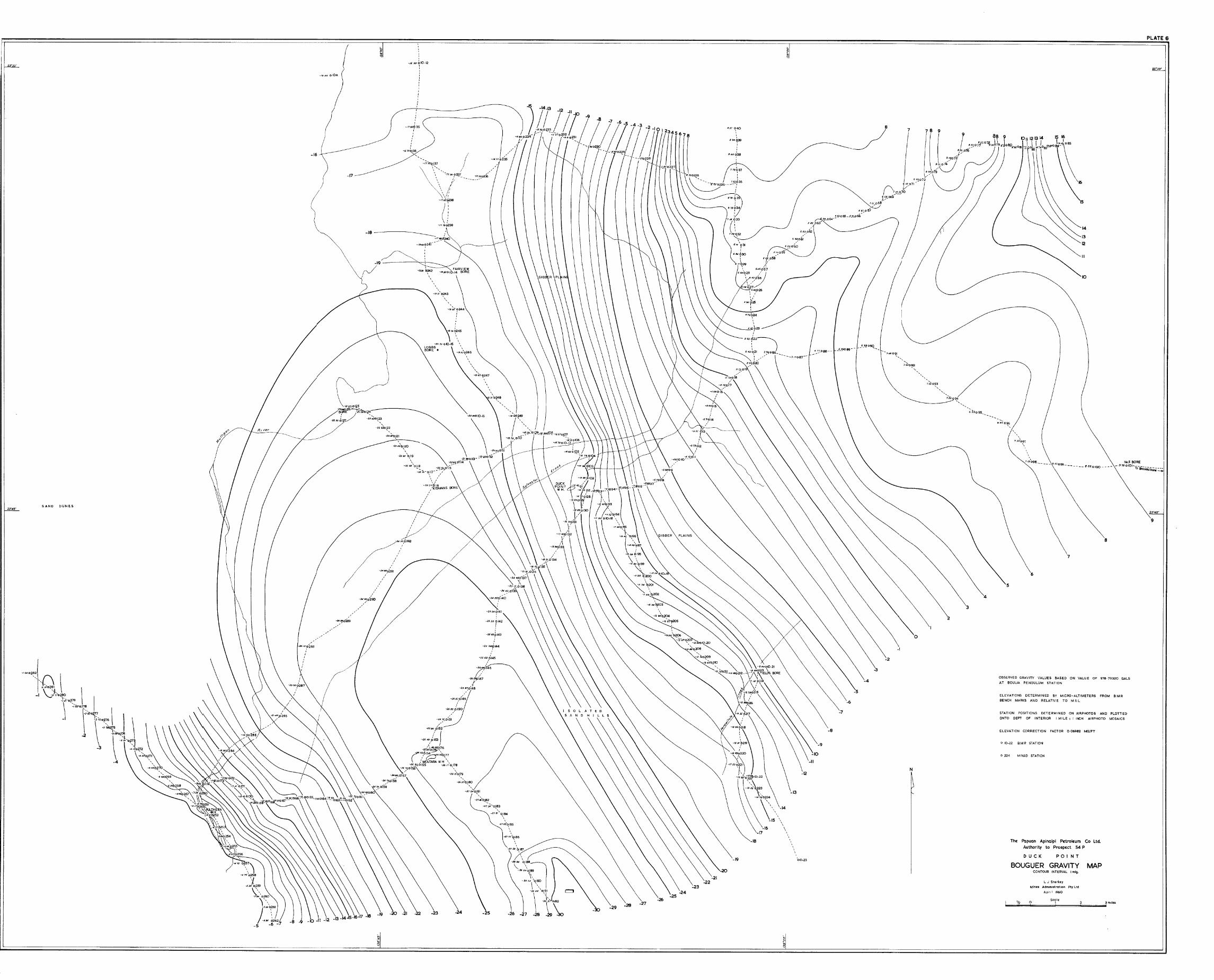
(6) Duck Point area
The Bouguer map of this area is shown in Plate 6.
The ;Bouguer contours show a continuous south-west gradient of approximately 2mgal/mile towards a broad low-gravity areawhich trends south-east thro'ugh Stations 291, 147and 155, and 192. Minimum values of approximately minus 30 mgal occur at the south-easternend of the "low". The "low" appears to be an expression of the south-eastern extension of theToko Syncline and indicates that the syncline is still plunging to the south-east below theCretaceous sediments in this area.
12

(7) Breadalbane area
The Bouguer gravity map of this area is shown on Plate 7. It shows a gravity"high" with a maximum value of+22.9 mgal at Station 355.
On the regional map (Plate 1), the Breadalbane gravity "high" appears to be on asouth-eastern extension of the gravity "high" trend that coincides with the Glenormiston anticline. If this is so, geological structure could be expected in the Cretaceous and underlyingPalaeozoic rocks at Breadalbane. However, estimates of the size of such structure cannot begiven with any certainty, owing to the likelihood of Proterozoic structure being responsible forpart of the anomaly.
(8) Toko Range area
The Bouguer gravity map of this area is shown on Plate 8.
The gravity rises approximately 11 mgal from east to west, and forms a "high"that has a closure of two or more milligals. The area of this gravity "high" is much greaterthan that of the surface geological structure - the "Netting Fence anticline" (Laing, 1960).Along the axis of the geological structure, as shown on the Bouguer gravity map, there aretwo small gravity "lows". These are most probably due to low-density Jurassic sedimentssurr.ounded by dense Ordovician limestones.
The size of the gravity "high" anomaly is possibly due to a bigger structure inthe basement.
The steep gravity gradient between Stations 1 and 2 indicates faulting up-thrownto the west.
7. CONCLUSIONS
The gravity survey has indicatedfour areas of structural interest that are worthyof further exploration. These areas extend along those parts of the four major gravity "high"zones that occur over the Georgina Basin and Great Artesian Basin sedimentary areas.
These zones are:-
(a) one through Glenormiston in the western part of the area;
(b) one extending from Dajarra to just west of Boulia;
(c) one extending as a broad feature from north of Chatsworth and Noransideto Springvale; and
(d) one near Middleton in the eastern part of the area.
The survey has shown that structura~ and physical features in the Proterozoicsediments in the north of the area continue south below the Georgina and Diamantina Basins andthat in some areas there Proterozoic structural features have influenced structural growth inthe Palaeozoic and Cretaceous sediments.
13

It has not been possible to isolate the gravity effect due to Palaeozoic andCretaceous structures from that due to the Proterozoic rocks. The reason for this is that thegravity anomalies over the Proterowic outcrop in the north of the area are not uniform andtherefore it is not possible to determine the anomaly arising from Proterozoic rocks undercover.
This survey has, however, confirmed the presence of previously suspected,important structural elements in the Palaeozoic and Cretaceous sequences of the Boulia area.
8. REFERENCES
LAING, A.C.M.
LAING, A.C.M.
NEUMANN, F.J.G.
NEUMANN, F.J.G.
WHITEHOUSE, F.W.
1958
1960
1959a
1959b
1954
Report on. Gulf of Carpentaria Authority to Prospect,A.A.O. 45P and A.F.O. 49P.Mines Administration Pty Limited, Report No.Q/45P-49P/56. (Unpubl.).
Geology and oil prospects of Boulia, Authority toProspect 54P.Mines Administration Pty Limited, Report No.Q/54P/76. (Unpubl.).
Preliminary report on a reconnaissance gravity surveyin the Georgina Basin area, Queensland.Bur.Min.Resour.Aust.Rec. 1959/8. (Unpubl.).
Preliminary report on a gravity survey in the TokoRange area, western Queensland.Bur.Min.Resour.Aust.Rec. 1959/51. (Unpubl.).
Artesian water supplies in Queensland; Appendix G The geology of the Queensland portion of the GreatAustralian Artesian Basin. Govt Printer, Brisbane.
ADDITIONAL DATA ON FILE
The folloWing additional data have been filed with the Bureau of Mineral Resourcesand are available for reference:-
(i) a complete set of gravity-meter and micro-altimeter field sheets;
(ii) a map showing gravity and altitude loop closures.
14

N
MAP COM PILED FROM SURVEYS BY BUREAU OFM1NERAL RESOURCES AND MINES ADMINISTRATIONPTY LTD. 1957, '58, '59
ALL STATION POSITIONS AND BOUGUER GRAVITYVALUES ARE SHOWN ON BUREAU OF MINERALRESOURCES 4 MILE MAPS AND MINES ADMINISTRATIONPlY LTD I MILE MAPS INCLUDED WITH THIS REPORT
~ MINAD SURVEYS
o BMA SURVEY
LEGEND
--10- 1509015
High anomaly
Low anomaly
MOln roads
Tracks
HomestEad
.pLATE I
\
~I
OBSERVED GRAVITY VALUES BASED ON VALUE OF978- 79320 GALS AT BOULlA PENDULUM STATION
ELEVATION CORRECTION FACTOR 006982 MG/FT
Th£ Papuan Apmaipl P£trol£um CO. Lld.
AUTHORITY TO PROSPECT 54 P
REGIONAL BOUGUER GRAVITY MAPCONTOUR INTERVAL 5mlllrgals
L J Stark~y
Mines AdmInIstration Pty LtdAprIl 1960
Scall!o e 16 24 miles....._-~---_ ....~~~....._-_...'

PLATE 2
2'"45'
58_7 B M R STATION
STATION POSITIONS DETERMI"ZED ON AIRPHOTOS AND PLOTTEDONTO DEPT OF INTERIOR I MILE:. I INCH AIRPHOTO MOSAICS
CONTOUR INTERVAL I mlg
L J Stork-ey
Mines AdminIstration pty Ltd
April 1960
Scale2 0 4 12mllcs
I
The Papuan Apinaipi Petroleu m Co. LtdAuthority to Prospect 54 P
MIDDLETON-KYNUNA AREA
50UGUER GRAVITY MAP
~--15
54 MINAD STATION
ELEVATIONS DETERMINED BY MICI?O~ ALTIMETERS FROM BM RBENCH MARKS AND RELATIVE TO M 5 L
ELEVATION CORRECTION FACTOR 0 06982 MG/FT
cesERVED GRAVITY VALUES BASED ON VALUE OF 97879320 GALSAT BOULlA PENDULUM STATION
o
::=~~~~~J~-18-19
-20
..... 657.6 ·23, .;)4
\ 25, .2f:J
c:;;'" ~~57.5 ,..:;--27
~-'/ -27
-10
2" O·
11i 23"'00'

PLATE 3
24
252470
0 B504
21
17
23
21
21
19
18
~
22
N
27
28
20
~
24
28
27
200008478
17
204008476
\
18.3008479
17
o
18
- -- - -- --- - ----{680046_4 -- - - ---- - ----- - - - - ------------------------1370 046_5
\
19
20
,18;(}0~:: _
229008475
/15.9008293
15
21
,:,
2.5.50 047-2I '
/ /~ ,
,:,
2223
0/,
,,,,,,,,,,
,,I,,
I,,,I,
,,iJ4 90 ,d47-1,
,I,
25
26
\
2.3.320462
;j,J 5!J 0458
27
23.JS0456
",2220 '0,,45-15
",
2347Q457
2790 oB 502
28
23:200460
~29
23
...._---
24
18
28610285
30.3008501
29.3/0348
.30670351
.314$0352
Ply ltd
31450353
Jf 9" 0354
2B2/0343
258006296
28920344
~~52B130346
2B290281S
28$.30347
27780 I
28 42 0342
" ..... " ...
26 ~CtO,,~5-7"
31·.380306
.32030305 0\ .32230304
32 32 .3203~3210302
..32 010301
JIBS 0300
309~
.3/ D9 0298 \
.3/.300297
29630296
29 70O:~0294
---.....--.30000293
30250292
.30760291
LJ Starkey
MJnll:5 Administration
April 1960
ScaleII
31
31~
o
BM R STATION
HELICOPTER STATIONBMR.
MINAD STATiON
30
29
22
.~
21
20
19
18
o 4~
o B 482
048_5
Co Ltd.. i Petroleum .Papuon Apinolp t 54 PThe Prospec
Authority to ARE A
PRINGVALE . MAP5 GRAVITY
BOUGUER TERVAL Iml.CONTOUR IN
2570 08289
978 79320 GALSON VALUE OFY VALUES BASEDOBSERVED GR~~~DULUM STATION
AT SOULlA ALTIMETERS FROM S M RBY MICRO-
NS DETERMINREE~ATIVE TO MS LELEVAT1~ARKS ANDBENCH
25
o 06982 MGI FTCORRECTION FACTORELEVATION
AND PLOTTEDON AIRPHOATO'R'PHOTO MOSAICS.
TERMINED HSTATIO!v POSITION~N::RIOR I MILE = I INCONTO DEPT OF
25
28
27
24
23
25
2
28
26
203 8008297
2~26266006500

- 7/0 06271
-/09008273
-0-20 0 9282
'2""'S'
" JOo B 277
\\\,
\,\\\\\\\\,,
\\\\\\\\\\,
\\\
\..2,\
\II
-3 \
\2.0~ti4
-2d4 0I71,-4 \
-2770170
\\-292p169
X-.3 OS 0 168..A
II
-,3 27 Ol67A\\
-5
-.6Jo~ -25\7~I66A
7 -}9~-J 80 0205 ol65A
1 \\-2~ ... 1
-.j18 02(4)(;/0
/
-P';'QI63A I-2SI OrrJ / 2
-'58 Ik / ./(.30196_2030°195 ().IO 06/3 6,0193 \0'94
/;/V / I
1/'( \ \-0777,.73
( X-165 7'74
-22/:5)-266l[76
/
-297d!n-3 I~ OI~2 " .5TRATHELBrSS
-260dI78,
""I-26'1' 179I,
I/
-0/40t}6/2
II
-5
\. II-.320 ~6-S
'.\
PLATE 4
"'0182
,/
/
//1
'SoO~/·~'/
~.... ,/4(0/
.....0/1
,/
/
'\""0'••-5\'.7
-0·$80186
\-599 -551
-6/90185 0184 0183
-5
t::!'
-~ 00 0 B 272
:tl,....,f,..,..'?;
~~lm,..,(f \,,,,,,,,\,., ~ .Ji ~ """.w", a-'i. ~ lE s
'\., J "1»/'?" I"""",'i • •
~~ I \,) i~( ...." , }
.~ "'"" ' ..."".f-, ."""'1 .(
4' '\
\ t~"-",,---r ~
/ i 1 \/ "-.,.,,,,,", \
/ \/ \
-540 °832>/ \~ ~ I \-\ \ I I \
'\ \ I I _.'" \ \ I\ \ \ I
\", \ \ \\ \ \ \\ \ \ \
\ \ \ \\ \ \ \
\ \ \ ~2008326\ \ \ \\\ \ \ \\\\\ \ \
\ \ \ \\\\ \ \ \
\ \ \ \\ \ \ \\ \ \ \\ \ \ \\ \ \ \ /
\ \ -6600{:'\ \ /\ \/\/\/\
\
~'4«t/'IIU"'"t; ..:f.I\l~I~
i ~"". I( ),rlff.IIIMIIJ'
% \\\"~"1 ~~"'4
\., l"U!II~"tP.''''\' <l
l'(~"f.."f.#l4"
'\ 'r.f'.f"fRb.;~/H"'''l ~'%
i I"r~\\\,..
1~tJIJh"l\UUllllotf'4f~,;~\~rl"""lq~.........,4'~"'"\
Cl ~\.M~""\.."..)\~rcjU(,~~,...,l
MARYVALE •
-I 83'o3fl\
\ .,J,'
-12$\37°\ "\ e·-I, \ ~
-/·21 ~6 P
,\
,\\\\\\,
\,\\\,
\\\\,
\\'\
\\
\\\\\\\\\
-2~\,
-/91 b40
\)-2 (U O\~9
8800B406
19300B405
10\.. 9.$60[51
f I ~74 0150
12" '\0 11 0149
1/-010148
\I~ 12J2 0147
14 _ ""15~'0146
14'\014/6720144
/29008328
WO\.......~...,~
~\.
20.6'°08329
22"4$'
o
II
----- ----- ------- - --- - - -- - --- -- 2Sl:lo20-J
23'00'
'7 N
/t'26 8/ 0528
·SEVEN MILE
8
9
ELEVATIONS DETERMINED BY MICRO - ALTI METERS FROM BM R,
BENCH MARKS AND RELATIVE TO MS L
STATiON POSITIONS DETERMINED ON AIRPHOT05 AND PLOTTED
ONTO DEPT OF INTERIOR I MILE = I INCH AIRPHOTO MOSAICS
OBSERVED GRAVITY VALUES BASED ON VALUE OF 97879320 GALS
AT BOUUA PENDULUM STATION
ELEVATION CORRECTION FACTOR 0·06982 MGI FT
11 51,..6244/
/1·96 0'
///
11 04p246
,110990'247//1/
IO}/48;.-
?~ 11/7024":'
~~~01([I 110
8 0250
I
0'.::1
,1~: \ I'\! 11·500251
'I.1
~lor~I.,"'I
r
I:r,iI1
7f050-7
rII
o
25
26
15
16
17
18
19
21
22
2,3",5'
050/6
o B 322
o 250
BM R STATION
B.M R HELICOPTER STATION
MINAD STATION
/.1 0$ 0257
The Papuan Apinaipl Petroleum Co. Ltd.
Authority to Prospect 54 P
BOULIA AREA
BOUGUER GRAVITY MAPCONTOUR INTERVAL I mlg
2j·/5'
,,\I
59bso_e\ 6I\
7 8 9
~I
10 11 12 13
IJ&I 0258
15 16
L.J Starkey
Mlnn Administration Ply Ltd
April 1960
I Seallt'! 12 9 ! f rmilu

- ~ ---- - ~ ~~ ~ ~ ~ ~~ ~~~- ~-
PLATE 5
2j-;S'
16008315
3
-----//
/
//
//
29006314
?
\
III
280 oB313 /
//
\\\\\
?
\\\\\
\\\\I10
\ ~ 12 /'1150~},\ /
10 80 6"" "--- /\: \ ----- 11
10IO~~41"'-- ~ //
9<10~40 /
I --'"III
\
"III
/
The Papuan Apinaipi Petroleum Co. Ltd.Authority to Prospect 54 P
GLENORMISTON AREA
BOUGUER GRAVITY MAP
?
LJ. Slarklty
Mines Administration Pty. Lld
April f9()Q
CONTOUR I NTERVAL I mlg
10"
" 9'\\
9
\\\\\\ )
\ /",,--- /-.............------
\\2
N
-7 -6 -5 -4 -3 -2 -I 0 I 2 3 456 7 8-16 -15 -14 -13 -12 -11 -10 -9 -8-17
-15
~/DID 913
-9S0~'4r-,OjOI5-1000016
I :'
\-/130035
'\~/2 '0,'136
-1260037
'~~/J 30 '038
",,;J-1270040
,-650~145,,
,,-6'50~145
,,\
-14
-16
, ,\ -sso...o~7
-5706466of°r$-
,-6-50644
\\-..\3
-700 0,42
-7 60 'b~\I,
-16
-910 0166
_15
-960 0169
-14
-9300170
-14 ~o 010 B
-14
-14
-7
o 154 MINAD STATION
STATION POSITIONS DETERMINED ON AIRPHOTO$ AND PLOTTED
ONTO DEPT OF INTERIOR I MILE: I INCH AtRPHOTO MOSto,rC5
o 10_1 BM R. STATION
o & 351 BM R HELICOPTER STATION
ELEVATIONS DETERMINED BY MICRO -ALTIMETERS FROM BM R
BENCH MARKS AND RELATIVE TO MS L
ELEVATION CORRECTION FACTOR 0069B2 MGfFT
05SE.RVEO GRAVITY VALUES BASED ON VALUE OF 978 79320 GALS
AT BOUUA PENDULUM STATION
_15
-15.40 alOe
-/« $0 oB 343
08351-SI 70
No.s BORE
- 974 0IOI-fo-ercQdQ1bonr:':;'
9
MAP
10
14
13
12
11
15
PO I N T
Scale:I
L J Starke:y
Minn Administration Pty Ltd
April 1960
o
DUCK
8.M R STATION
MtNAD STATION
,,7J2097
",,,
719098 -- --- 86.1099 6 C2.0100 _
6
7
8
BOUGUER GRAVITYCONTOUR INTERVAL I mlg.
5
Th. Papuan Apinaipi Petrol.um Co Ltd,Authority to Prosp.ct 54 P
o 10-22
PLATE 6'
2J"'JO'
0224
ELEVATION CORRECTION FACTOR 006982 MG/FT
ON VALUE OF 978·79320 GALSOBSERVED GRAVITY VALUES BASED
AT BOUUA PENDULUM STATION
RMINED BY MICRO-ALTIMETERS FROM BM RELEVATIONS DETE TO MS LBENCH MARKS AND RELATIVE
DETERMINED ON AIRPHOTOS AND PLOTTEDSTATION POSITIONS I MILE,: t INCH AIRPHOTO MOSAICSONTO DEP" OF INTERIOR
3
2
978
N
7
-2
6~072
610071
I'(\~-j,'~~"~06~
7-;'....06§
687,0'67
6&$065_~,"..!~662J_064---
582063-
-13
~72h24I,,
.112 ?23,
'~\22).e~o21 2.91 0 86__ _
\ .,... ----3/7087-
2...~~J~
-18
6~:..062
6;,0616C'~o'60
$7~059
',ppS.I ~46~/57
,u~2. y/I 6"':.056\.... ,'
~08027
I S·C6p26, ,,,'I,
SU?2S,I
,,,-19
g~l ~40
I
696~39I,,,
6 ..0038
,,,7 7~'137
,8700~6 ~
\ -----_~~___ "'036
\~225----;:I
"'0,:
67a ?34I
-2568?144
~25 69/0145
~2~~ 46
I?~.u~147
J-25 9~014B
-25~?149
~258~/~150
-2575,0151
,,,
~t760fI35
,I
,I,,
-''''0~36 '" /
-';"'0137
\S'!","rF------~:~'P2{'",,\ I
\' ,
t-f1710239
,-1& 50 ~ 10-12
I,,,,I,I
-2D 70 010_15LOBBSBORE·
I
:III
I
,-.:590 0152
-2S,~,i~ j1~~«:O176
-2.(~5~\
(O~f6C=J. 000{~7't-.«)UTARAWH "
-26 &! 0155 -2617 0,178-,:>s7"oTs6 ' \
• -~612'o.[79
-"">O~~~-27 ~O~~I
-27~'0!.82
-2;;'O~~~_~7 91 O\~84
....7~2\qlB5
o./?;77~,1186
-':>1S9 0\187,
-\$:::\~.. ,;\\~~ I
-26"., O~il,
\ "'" 01.2
-27 -28 ~\0
~I
-19
-18~"'!d~40-/8.q~24(
,,,
-17
\~~---W'I\lif6~1~~
:' ..- J -2C'~nt23-Z2$()OI~ "
-22.tJo~~
-:>2;''o~21
,,
j/
/~7
/ "-.u.tKI,0291,,
-:M IJJo290
.... ',/.
,/~':"!oiJJ.
-ftl.tO olOA
-16
-3
SAND DUNES2J"45'
2""'JO'
~I

PLATE 7
OMErN£.D GRAVITY VALUES BASED ON VALUE OF 978·79320 GALS AT OClULlA PENDULUM STATION.
ELEVATIONS DETERMINED BY MICRO-ALTIMETERS FROM B.M.R. BENCH MARKS AND RELATIVE TO M.S.L
STATION POSITIONS DETERMINED ON A1RPHOTOS AND PLOTTED ONTO OEPT OF INTERIOR I MILE: I INCHAIRP.HOTO MOSAICS.
ELEVATION CORRECTION FACTOR 0-06982 MG/FT.
o 50/16 S.M.R. STATI()N
o 8438 B.M.R. HELICOPTER STATION
o 316 MINAD STATION
15(;00'51:)/16
16
/ti-60 0372
~ 2J-4,5'
The Papuan Apinaipi Petroleum Co. Ltd. 'Authority to Prospect 54 P
BREADALBANE
BOUGUER GRAVITY MAP'CONTOOR INTERVAl. I mlg.
L.J.StorkcyMines Administration Pt~ Ltd.
April 1960
Scale~~'~12~""':;:0~~~~1~~~"",,~~~......;3miles
N
20-600378
20 20-300332 0333
16,80 0 316
18·S() 0328
21-00 0319 /-------............./ "
21·000320 ( "\
222()900 50/18\ \
22'000352
~JD03S3 \
22-soo354
'" 22-500355 \
'\ <> \\ I
\ I\ I\ /\ )\_/
RI·OO 0318
/9-100325
/9·300324
19·600323
.............17·220371 ----.-------....
"'° 0370............. .......
1~-7oo369 ~ ___
19-.)° 0 368 19-000373 ~~ --...
19~Oo367 ............... __
....... '- ' .............~ -1719_J)OO~:T~DA.lBANE 2OJO-'" 0_ 19-«)0366 ........................
"'700315 '9800363' 0364~~.5_____ IUOo374 '----..~"-. ....................... '-..
~ ,,'-.. " l7!Jo 08440
",,~ \ \2110 037. """ \ \
<0100377 "\ \ \
\ \ )",. 3\ \ I I"'00380 \ I / /
I I / i 17
;0 19 I /il / / / //
1// IIII / I / II / I / I/ / / / I /~/ / / / I /
/ / / I / /15
/ / / // / / / / / /14
/ / I / If I / / /13
/ / / / //// /1/ 1 / /1//2
I / I I I I I II / / /11
/ / / / I I I If / / K>
/ 1/ III I I I 1////7I / / If / I I I I I /1 If1/ I I I I
I I I II III II II19"'°32. ( / 1/ I I / I I I I / I I I I I I I I /
)
\. 20~51 / I I I I I"'., '20.....£0350 / / / I I I I / I 1'.008
432
a:l·~347 0348 / / /6-000B43;
,~:._~_.:J:'" // / // /// / / / //~/ /// /1 / I / I I l / l 9 8 I
/ 1716151413------------ ///
/'/
-----------18-00 0329-
IMO0342
/4-00 0344
/8-30 0343
17
2090 21-8{)19,40iO.SV0358 0357 0356
19..30 0359ItJ.!O 0361 0360
\1790
03\,/7-60 0338
\'.001'37
17-600336
1(1-40 033/~_.300334 050/191950 19'~OO330
19-40 0331
/7- 60 0345
17
17
16
16

N
-6·80 014
-6-60013
-6-90012
-6
The Papuan Apinaipl Petroleum Co. Ltd.Authority to Prospect 54 P
TOKO RANGE
BOUGUER GRAVITY MAPCONTOUR INTERVAL 0-5 mlg.
L.J. Stor1(<<y
Mines Administration Pty.Ltd.
April 1960
SCale.O! lmi'u
-5-5-4 -45-5
-3
-2-1·5
2
2·5063
064
obS
J30062
2'5
0400.5:3
!305 0·70 052
0-40051
2
066 OBSERVED GRAVITY VALUES BASED ON VALUE OF 978·79320 GALS AT eoULlA PENDULUM STATION.
ELEVATIONS DETERMINED BV MICRO -ALTIMETERS FROM B.M.R. BENCH MARKS AND RELATIVE TO M.S.L.
STATION POSITIONS DETERMINED ON AIRPHOTOS AND PLOTTED ONTO DEPT. OF r NTERfOR I MILE:; 1 INCH AIRPHOTO MOSAICS.
ELEVATION CORRECTION FACTOR 0'06982 MG/FT.
-6·5
-7·/0015
'\-7-/0016
~-7

PLATE 9
"-OD'
-IACC
-2200
"-/700
-2300
__--1900___--2OCJJ
__---2100
/''''011''' cnd M"Id/' Ordo.ml:icn r.:."o 6 rtJ"P c/cJf,,~ cnd ..... n!>,. J..""'Jo/gnll
M,d<:JI1l Com/Jrll:lfJ to Low.,. Ordoweion J..lmll~/onll Ille
lower LaT7fbrll~n jond~/olll1
o~omm0,-"""" """. "
COMPILED BY MJ.MAHONEY & AC M LAING
AUGUST 1959
8 0 Scale...E=........ ~_~.:..............J'6..............~~ rrulcs
~ ~ 1~ J
THE PAPUAN APINAIPI PETROLEUM CO. LTD
STRUCT AUTHORITY TO PROSPECT 54P .
AT r:~ ~~N:~~~EB~~~A~~U~EVEL
Inset Man h .,. 3 oWing dertVohon 01 dolo
~l-- ~
_300
L
--'-,
.......}t
.1.. j'
.. ,
2/~.JO'