brenkley lane - banks group · banks mining plant in operation ... oil 1% gas 43% nuclear 15% ......
TRANSCRIPT

Brenkley LaneSurface Mine ProposalsPlanning Application & Environmental Statement
Non Technical Summary • Update June 2009
BrenkleyVillageOverburden
MoundP
onte
land
Roa
d
MilkhopeCentre
BlagdonHall
SiteCompound
A1
Introduction
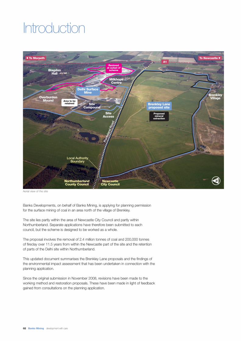
Banks Developments, on behalf of Banks Mining, is applying for planning permissionfor the surface mining of coal in an area north of the village of Brenkley.
The site lies partly within the area of Newcastle City Council and partly withinNorthumberland. Separate applications have therefore been submitted to each council, but the scheme is designed to be worked as a whole.
The proposal involves the removal of 2.4 million tonnes of coal and 200,000 tonnesof fireclay over 11.5 years from within the Newcastle part of the site and the retentionof parts of the Delhi site within Northumberland.
This updated document summarises the Brenkley Lane proposals and the findings ofthe environmental impact assessment that has been undertaken in connection with theplanning application.
Since the original submission in November 2008, revisions have been made to theworking method and restoration proposals. These have been made in light of feedbackgained from consultations on the planning application.
02 Banks Mining development with care
Aerial view of the site
Brenkley Laneproposed site
Site Access
Newcastle City Council
Northumberland County Council
To Morpeth To Newcastle
Local AuthorityBoundary
Proposed mineral
extraction
Restored at outset of
scheme
Area to beretained
Delhi SurfaceMine

The Banks Group was established in1976 and has a long and successfultrack record in delivering environmentallysensitive schemes in our key businessareas of surface mining, property development, renewable energy and waste management.
Since 1976 we have worked andrestored more than 100 surface minesacross the UK. Our ‘development withcare’ approach has been instrumental in our business success; ensuring we operate to the highest standards andwork with local residents to ensure projects are developed in an environmentally acceptable way and provide tangible benefits to the communities surrounding the site.
Community involvementTwo public exhibitions were held in June 2008, one in Stannington and one in Dinnington, to provide informationto the local community and listen to any feedback. The views that were receivedfrom the community consultation exercise have been fully considered aspart of the environmental assessment to ensure that local concerns have been listened to and addressed.
The Banks Group has operated a number of coal schemes in and aroundthe proposed Brenkley Lane site, andcurrently have an active involvement withthe local community. These existing tieswith local stakeholders have been usedto help formulate the Brenkley Lane proposals from an early stage.
Our involvement with the local community will be maintained throughoutthe life of the project through the employment of local people, the use of local suppliers and services, providingnew features as part of our restorationscheme and offering financial assistanceto voluntary groups and communityorganisations, through a community benefits fund.
Brenkley Lane Surface Mine Proposals 03
Banks Mining plant in operation
Banks Mining
Consulting with local communities Stannington Art Group has been supported by The Banks Community Fund

04 Banks Mining development with care
Why Brenkley Lane?
The need for coalApproximately one third of the electricitythat is generated in the UK is producedby burning coal (see chart opposite). In winter up to 50% of electricity is generated by coal fired power stations. Whilst the UK continues to develop alternative forms of renewable energy,such as wind power, coal will play animportant role in meeting the country’senergy needs for the foreseeable futureand the long term with the developmentof carbon capture and storage (CCS)technologies.
In order for CCS technologies to become a reality, firstly the technologyneeds to be viable and in place, but secondly there needs to be coal. Without an indigenous supply of coal,there will be no indigenous fuel for theCCS to use; instead the system wouldtake a step back by using imported coalwith its larger transport carbon footprint. The production of coal from the BrenkleyLane site would create a ready supplythat can be easily be used by a CCSoperating plant. The development ofCCS technologies at local and regionallevels can only be aided by a secure supply of indigenous coal.
A secure supplyMining indigenous coal helps to ensurethe country has a secure supply of energy. The UK currently imports 70% of the coal that it uses. If imports were to be restricted in any way it could leavethe UK vulnerable to a power shortage.By retaining control of our own energythe UK will be in a much more stableposition.
TimingThe Delhi site has been in operationsince 2002. The Brenkley Lane proposals involve the continued use of the site compound and the existing well-vegetated overburden mound atDelhi. The material taken from the initialBrenkley Lane box cut will be used to fillthe final void on the Delhi site, as part ofits restoration.
Working the site in this way, the visualimpact of recovering the coal within theBrenkley Lane site is minimised, avoidingthe need for a new overburden moundon the Brenkley site (which would bemore visually prominent and involve the loss of coal).
Hydro 1%
Other4.5%
Coal 34%(70% of
which areimports)
Oil 1%
Gas 43%
Nuclear 15%
ImportedElectricity
1.5%
This allows the coal reserves at BrenkleyLane to be worked in the most efficientway and to the highest environmentalstandards.
UK electricity production in 2007
Brown Hare found on the Delhi overburden mound Lapwing found on the Delhi overburden mound
Source: www.berr.gov.uk

Brenkley Lane Surface Mine Proposals 05
Benefits of the proposed scheme
Retaining jobs in the UKApproximately 5,600 people areemployed in the coal industry in the UK;continuing to mine coal in the UK willhelp to protect these jobs.
The development of the Brenkley Lanesite will provide continued employmentfor 40 site personnel and will assist in the maintenance of some 120 serviceand support personnel located at the company’s headquarters in the NorthEast.
Secure supply to important local and national usersThe coal produced from the BrenkleyLane site will go towards meeting theneeds of local coal users, such as Alcanat Lynemouth, Northumberland, as wellas meeting the needs of the major powerstations in the Aire Valley in Yorkshire.
FireclayHigh quality fireclay is available on theBrenkley Lane site and will be suitable for brick making. It is anticipated that theBrenkley Lane site will continue to supplymaterial to local and national brickworkswhich currently accept clays from theCompany’s existing Delhi site.
Community Benefits FundA Community Benefit Fund is in operation for the current Delhi site. This arrangement will continue for theduration of the Brenkley site. The fundwas established to give support toworthwhile projects in communitiesaround the site. A sub-committee of the Liaison Committee considers applications from local communitygroups and voluntary organisations.
Restoration: improved land qualityOver 50% of the current portion of theBrenkley Lane site south of PontelandRoad has been subject to piecemeal andpoorly managed opencast operationscarried out in the 1940’s, 50’s and 60’swhen restoration standards were muchlower. As a result, 56 hectares of thisland is of poor agricultural value, withseveral areas suffering from subsidenceand poor soil quality. The phased restoration proposals for Brenkley Lane,will remediate any degraded land, removing and stabilising areas of degradation and subsidence.
Restoration: ecological improvementsA series of ecological enhancements such as new wildlife corridors, hedgesand woods will be created through thephased restoration of the Brenkley Lanesite (see pages 10 - 11 for more details).
Restoration: improved public accessThe restoration of the site will provide7.1km of new and retained permissiveand statutory footpaths and bridleways(see pages 10 - 11 for more details).
Supply of household coalThe coal extracted from the BrenkleyLane site will be suitable for domesticuse and will be used to supply households locally and nationally.
Restored wetland at Banks Doe Hill site, Derbyshire
Footpaths open to the public
Stannington Bowling Group have been supported bythe Banks Community Fund

06 Banks Mining development with care
How the site would be workedThe extraction of coal would begin at the western end of the site,where the coal is shallowest, and then progress eastwards (seePhase1 on the plan opposite). The material taken from the initialextraction south of Ponteland Road will be placed in the final voidon the existing Delhi site. This will allow the final restoration works to be completed on most of the Delhi site (see plan opposite).
The existing Delhi overburden mound, compound and associatedtop soil and sub soil mounds will be retained for the duration of theproposed Brenkley Lane scheme. The workings would be phasedto leave land undisturbed for as long as possible whilst restoringworked out areas as soon as possible (see pages 8 - 9).
AccessThe existing Delhi access point on Ponteland Road and the existing Delhi compound will continue to be used. Material will betransported via an underpass beneath Ponteland Road that will link the Delhi compound with the proposed extraction areas; avoiding disruption to the surrounding road network.
TransportAll coal lorries from the site will use the same routes currently beingused by those servicing the Delhi site. lorries will leave the site alongPonteland Road, connecting with the old A1 and then joining eitherthe A189 to go to Alcan, Blyth or join the A1 to go south (see page 14).
June 2009 revisionsThe working method has been revised to allow the retention of an additional six trees north of Brenkley. This has been done inresponse to comments made requesting that the impacts of extraction in the south eastern corner are reduced.
Our proposals
Working method plan
Site boundary
Topsoil mound
Subsoil mound
Subsoil mounds over site working
Overburden mound
Increased mound height
Mound height
Fireclay stock
Phase areas/extent of excavation
Excavation depths
Wildlife corridor
Delhi final void
Auger mining inBusty seam
New fitting shed
Permissive footpath
Diverted footpath
Underpass
Trees to be retained
Ecological mitigationworks
Fields managed forGreat Crested Newts
Otter corridor
KEY FACTS
Site area 244 Hectares
Minerals 2,400,000 tonnes of Coal 200,000 tonnes of Fireclay
Working 7am to 10pm Mon - Fri
Hours 7am to 1pm Sat
9am to 4pm Sun*
*Plant maintenance requiring no engine start up only
Duration 11.5 years progressive working and restoration, (if no evening working). 10.5 years with evening working.
Jobs 40 - on site120 - service and support at company’s north east headquarters

Brenkley Lane Surface Mine Proposals 07

The photomontages and the chart on these pages provide an illustration of how the site will be worked in phases to minimise its impact and ensure that the area disturbed at any one time is minimised. The details shown are for illustrative purposes onlyand should not be relied upon for depicting detailed working method or the aesthetics of short term restoration.
Phasing of working and restoration
08 Banks Mining development with care
Phase 1 - Photomontage
Phase 1b - Photomontage
Position approximately2.5 years afterthe schemebegins.
Restored
Undisturbed
Undisturbed
Position approximately 1 year after the schemebegins.
Newlyplantedtrees
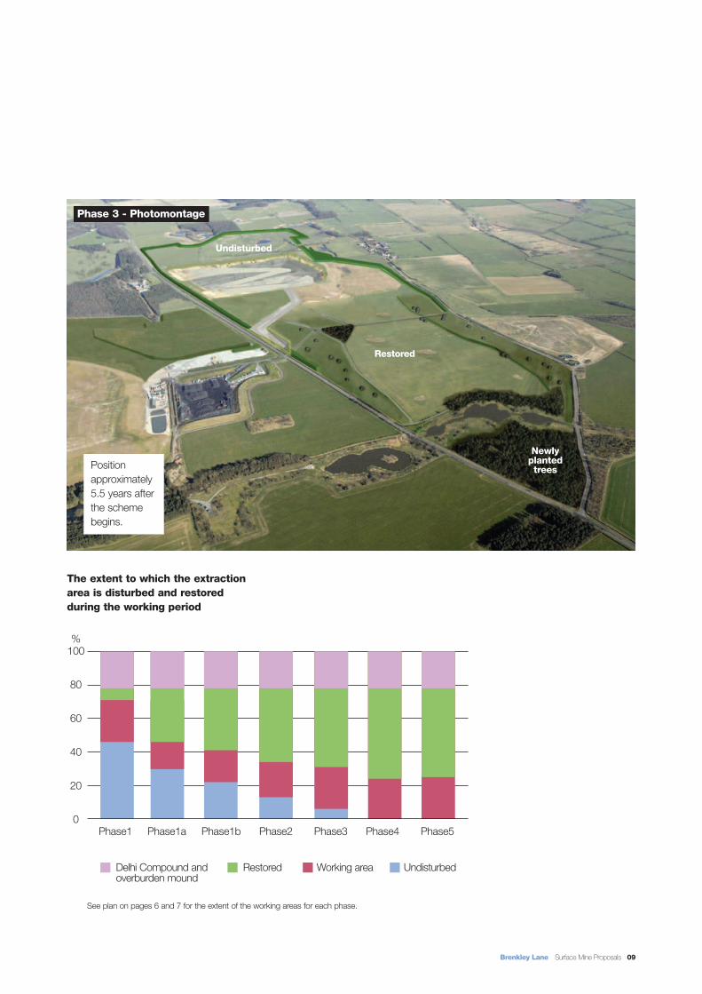
See plan on pages 6 and 7 for the extent of the working areas for each phase.
Brenkley Lane Surface Mine Proposals 09
Phase1 Phase1a Phase1b Phase2 Phase3 Phase4 Phase5
100
80
60
40
20
0
%
Phase 3 - Photomontage
Restored
Undisturbed
The extent to which the extraction area is disturbed and restored during the working period
Position approximately 5.5 years after the schemebegins.
Delhi Compound and Restored Working area Undisturbedoverburden mound
Newlyplantedtrees

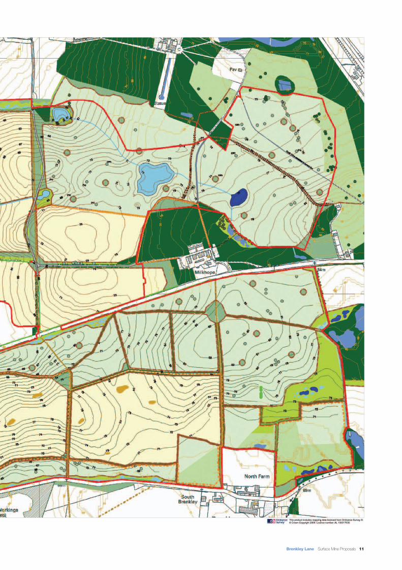
Restoration plan
Restoration
The restoration proposals include a wide range of measures that will contribute toward improving the landscape, ecological and amenity value of the site.
The design is the result of extensive discussions with keybodies including Newcastle City and NorthumberlandCounty Councils and local wildlife groups.
The currently approved restoration plan for the Delhi portionof the site includes:
• The restoration of historic parkland.
• Improved permissive access to Blagdon Park and adjacent areas.
• Works to the Serpentine Lake.
The restoration proposals for the Brenkley Lane extraction area have undergone considerable revisions following comments received on the planning application.
The improved restoration proposals now include:
• The creation of approximately 48ha of woodland, or parkland pasture, similar to that proposed on the Delhi site.
• 7.1km of permissive and statutory rights of way (see plan opposite).
• Creation of ‘wildlife islands’ within arable fields.
• 8.4ha of species rich grassland.
• A wide variety of wetland habitats, including open water, closed reed beds and open swales.
• Creating a link between the existing wetland habitats around Hoys Wood in the east and the Milkhope Burn inthe west.
10 Banks Mining development with care
Site boundary
Existing woodland
Undisturbed pasture managed to improve species content
Proposed woodland
Permanent pasture/wood pasture with skeletal underdrainage system
Arable fields with fullunder drainage system
Species rich grassland around wetland areas
Wildlife islands - areas of rough ground within arable fields left uncultivated (appox. 30 x 15m)
Existing trees retained
Individual trees
Tree groups
Existing hedgerows
Proposed hedgerows
Proposed fencing
Watercourses and open swales
Existing ponds retained
Proposed Great Crested Newt mitigation ponds
Proposed ponds
Tarmac access
Farm tracks
Public footpath
Permissive footpaths
Public bridleway
Permissive bridleway
Proposed contours at 1m intervals
Existing contours at 1m intervals
Brenkley Lane Surface Mine Proposals 11

12 Banks Mining development with care
Banks is a recognised as a leader in theinnovation of environmental controls. Wehave won a number of awards for ourwork on noise control and dust suppression from both the Coal Authorityand the Noise Abatement Society.
We have also adopted an environmentalpolicy which we apply to all our sites to ensure high standards of working at all times. Environmental monitoring and regular audits ensure that these standards are met.
To confirm our commitment to thesestandards all environmental monitoringresults are shown to the liaison committee, and the local authorities. The local community are also invited to take part in the audits.
A comprehensive draft environmentalmanagement plan has been prepared for the Brenkley Lane site which setsdown all of the environmental controlmeasures which will minimise potentialenvironmental impacts of the proposedmining operation. This includes the control and monitoring of noise, dust and vibration levels. Controls on waterdischarges from the site, the appearanceof the site at key views, and lorry movements, are all set down in the plan.
Water bowser fitted with rain guns used to controls dust
All lorries pass through a wheelwash Banks receives the Noise Abatement Society Awardfor Innovation
Environmental controls

Brenkley Lane Surface Mine Proposals 13
Environmental assessmentThe remainder of this document summarises the environmental assessments which have been made of the proposals.
EcologyIt considered that alongside successful adoption of mitigation proposals and theimplementation of a progressive restoration scheme the potential impacts of theproposed scheme could be significantly reduced or negated.
The longer term restoration proposals for the Brenkley Lane site will involve replacing intensively farmed fields with new agricultural areas. These will sit alongside a wide range of valuable high quality habitats, such as new wetland areas and hedgerows and small woodlands.
The longer term restoration will ensure the reduction of an intensively farmed landscape which will support a wider range of valuable high quality habitats.
Archaeology and cultural heritageThe archaeological and cultural heritage assessment indicates that there are noscheduled ancient monuments or listed buildings within the site.
Approximately 50% of the proposed extraction area has previously been workedby surface mines, and as such is devoid of any archaeological interest.
There are known prehistoric and medieval remains within the site and its surrounding areas. There is a high probability that the Brenkley Lane site contains archaeological remains dating to the prehistoric, medieval and post-medieval periods.
A programme of field walking has been completed alongside a geophysical survey, the reports into the first phases of which have been included in the planning application.
The results of the completed geophysical surveys and field walking will be used to inform a programme of targeted trial trenching before planning permission isgranted, to record any features of interest before working taking place.
Impact on Blagdon HallThe Brenkley Lane extraction area and the Delhi site compound are not inter-visiblewith Blagdon Hall. This means that any of the minerals activity proposed as part ofthe Brenkley Lane scheme would have no visually intrusive effect upon the settingof the Hall. Blagdon Hall is also included as a sensitive premises which ensuresthat any potential issues caused by noise, dust and vibration are constantly monitored.
Fishing at Milkhope Ponds
Archaeological investigations on a Banks surfacemine
Restored site at Gardener’s Houses

14 Banks Mining development with care
TransportA transport assessment of the Brenkley Lane scheme found that the roads thatform the haul routes for the minerals from the site are suitable for the large vehiclesinvolved. Lorries that have transferred minerals from the Delhi site have done sosince 2002. It is proposed that the vehicles serving the Brenkley Lane site will usethe same routes as those that have served the Delhi site for the last six years.
The Delhi site currently has permission for a maximum of 85 lorries to leave the siteeach day, however the average daily movements have been in the region of 35.The Brenkley Lane proposals seek to continue the same approved traffic flows.
Traffic route plan
Site location
Coal haulage route
(same as Delhi)

Brenkley Lane Surface Mine Proposals 15
Noise monitoring in progress Spray bars on plant suppress dust
Short term operationseg. soil stripping,
soil mound creation
Routine day time operations (7am-7pm)
eg. mineral extraction and overburden removal
Routine evening operations (7-10pm)
eg. all works below ground level
MPS2Criteria
PredictedNoise Levels
dB = Decibel
Predicted worse case noise levels taken from sensitive premises
MPS2Criteria
PredictedNoise Levels
MPS2Criteria
PredictedNoise Levels
70 dB 62 dB 55 dB 54 dB 55 dB 47 dB
Soils and agricultureAn assessment of soils and agriculturalland quality found that the majority ofland south of Ponteland Road wasGrade 3b (42 hectares - 32%) and Grade 4 (14 hectares - 11%) due to poorrestoration of previously worked parts ofthe site.
The design of the site includes provisionfor the separate lifting and storage of thevarious soil types, and this together witha soils handling strategy will minimise theimpact on the quality of the soils andenable the site to be restored to anappropriate after-use.
Blasting and vibrationExperience from working sites immediately adjacent to Brenkley Lanesuggests that the removal of overburdenwill need to involve the use of blasting,and accordingly a vibration assessmenthas been undertaken and is includedwithin the planning application.
The assessment found that due to theproximity of sensitive properties and utilities, blasting would need to be monitored and controlled closely.
The assessment noted that where proposed excavations are within closeproximity to residential buildings blastingwill need to be designed to ensure thatimpacts upon residents and their properties are controlled by restricting theblast size. Any blasting will be carried outat specific times of the day and monitored at sensitive premises.
The vibration assessment also considered the impact of blastingvibration upon the integrity of the twonearby landfill sites, Brenkley andMilkhope Bank. The assessment foundthat the use of blasting on Brenkley Laneshould not affect the stability and integrityof the adjacent waste disposal sites.
NoiseNoise monitoring has been carried out at thirteen of the premises closest to the site to provide background noise levels. These background levels are then compared to predicted noise levels when the site is operational.
The noise assessment for Brenkley Lane demonstrates that site working noise levels will not exceed the criteria set outin the relevant government guidance(Mineral Planning Statement 2 or MPS2,see table above)
DustA detailed dust assessment of the proposed operations has been carriedout and concludes that dust levels at aseries of representative receptors, surrounding the site would not exceedthe annual mean limit of 40 micro gramsper cubic metre, this is in compliancewith MPS2.
The draft Environmental ManagementPlan includes measures, such as watersprays on excavators and wheel washfacilities that will adequately mitigatepotential impacts of dust from the site.

16 Banks Mining development with care
Landscape and visual impact assessmentA landscape and visual impact assessment has been undertaken and concludes that the majority of views of the working site canbe screened with the use of peripheral screen mounding. There would not be views into the operating void, except for a shortstretch of highway over the proposed underpass. Furthermore, the assessment finds that the restoration scheme would enhance thelandscape character of the site and provide a greater diversity of habitats.
Photomontage - Phase 2
Existing View
Photomontage - Restoration landform
Viewpoint 1bView from Horton Grange/Ponteland Road looking east.
Viewpoint location
Edge of underpass Restored landform

Brenkley Lane Surface Mine Proposals 17
Existing View
Viewpoint 7aView from western edge of Brenkley looking north west.
Photomontage - Phase 1
Photomontage - Restoration landform
Viewpoint location
Subsoil mound

Restoration context plan
18 Banks Mining development with care
Brenkley Lane site boundary
Active operations
Restored sites
Proposed wetland habitats
Existing wetland habitats
Proposed woodland habitats
Cumulative impact

What happens next?Prior to making a decision on the planning application Newcastle City Council and Northumberland County Council will seek advice from English Heritage, theEnvironment Agency, Natural England, the local community and a range of otherconsultees. It is hoped that both councils will determine the proposals in 2009 and the site can start then, following the timetable indicated below.
Brenkley Lane Surface Mine Proposals 19
The Brenkley Lane site is located in anarea that has been historically associatedwith various forms of coal extraction.Potential cumulative impacts range fromtransport, landscape and visual to affectsupon amenity. The sites covered by thecumulative impact assessment are shown on the plan (opposite) and include both restored and active sites.
The landscape and visual assessmentfound that the working of the proposedsite will not lead to any unacceptableimpacts. The Brenkley Lane site would not be visible from the same areas thatcan currently view the operational Shottonsite. This is due to woodland belts thatvisually separate the two sites. This allowsthe two schemes to operate without having an unacceptable visual impactupon the wider landscape.
The ecology report notes that the restoration proposals for the site will link in with existing and proposed wildlife habitats that have been created or proposed from approved sites (see plan opposite).
Wetland habitats are formed through andadjacent to existing watercourses such asMilkhope Burn and the River Blyth. Atrestoration mineral sites on land adjacentto these watercourses have created wetland features that have been designedto link in with existing wetland habitats.The end result of this allows wildlife tospread through into new areas that mayotherwise been inaccessible before.
The proposed routes for the Brenkley Lanesite are the same as those currently usedby the Delhi scheme.
It has been accepted by the local highway authorities that lorries currentlyserving both the Delhi and Shotton sitescan be accommodated on the same road network. The Brenkley Land proposals are not proposing an increaseon the amount of vehicles that currentlyuse the Delhi site. Therefore the traffic generated by the proposed Brenkley Lane scheme can be accommodatedalong side the lorries using the Shottonsite.
A small number of premises that are located to the south and east of the Delhi site will also be potentially affected by the Brenkley Lane proposals. At all ofthe premises in question levels of noiseand dust are closely monitored to preventany unacceptable impacts (see page 15for details).

Copies of the planning application and environmental assessment to which this document refers can be viewed at the addresses below or may be purchased direct from Banks Developments at the address below priced at £50 for a hard copy or £5 for a CD version.
For further information about the Brenkley Lane project please contact Bob Swainson, Community Liaison Manager on the details below.
Planning DepartmentNorthumberland County CouncilCounty HallMorpethNorthumberlandNE61 2EF
Planning DepartmentNewcastle City CouncilCivic CentreBarras BridgeNewcastle upon TyneNE1 8PH
The Post OfficeChurch Street StanningtonNorthumberland
Dinnington LibraryMain RoadDinningtonNewcastle upon Tyne
Published June 2009.
This document is printed on paper from sustainable sources.
© The Banks Group 2008. All rights reserved.
Head Office
West Cornforth, Ferryhill,
County Durham,
DL17 9EU
T 01740 658 500
F 01740 658 520
W www.banksmining.com