brice prairie master plan master plans why master plan? comprehensive plan already has significant...
TRANSCRIPT

1
Brice Prairie Master Plan
Town of Onalaska
Community Meeting #1
Sand Lake Elementary School January 28, 20069 am – 11 am
Agenda
Background
What is a Master Plan?
Brice Prairie Capacity Reports
Starter Ideas
Table Sessions
Report Back
Next Steps

2
Background
Town Comprehensive Plan
was updated and adopted
in May, 2005
Covers all aspects of the
entire Town
In the Land Use analysis
and the future land use
map, the Town was
divided into Planning
Districts.
Town Comprehensive Plan
Planning Districts

3
Town Comprehensive Plan
Public participation
and debate
Preference for
“Growth with
Conservation”
Town Comprehensive Plan
Brice Prairie Planning District Goals & Objectives:
1. Promote conservation, agriculture, and limited conservation-based
development as preferred land uses.
2. Explore policies, programs, and compensation mechanisms that will allow
for alternatives to industrial uses for undeveloped properties with that
zoning definition.
3. Prohibit the rezoning of Exclusive Agricultural Zoning Districts.
4. Ensure zoning is consistent with the Land Use Plan designation.
5. Protect and enhance Brice Prairie’s status as a recreational gateway to the
Great River State Recreational Trail, Lake Onalaska, the Black River Bottoms
and other areas within the Upper Mississippi National Wildlife and Fish
Refuge.
6. Encourage redevelopment opportunities to focus land use on conservation
design principles.
4
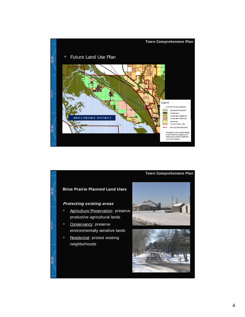
Town Comprehensive Plan
Future Land Use Plan
Town Comprehensive Plan
Brice Prairie Planned Land Uses
Protecting existing areas
Agriculture Preservation: preserve
productive agricultural lands
Conservancy: preserve
environmentally sensitive lands
Residential: protect existing
neighborhoods
5
Town Comprehensive Plan
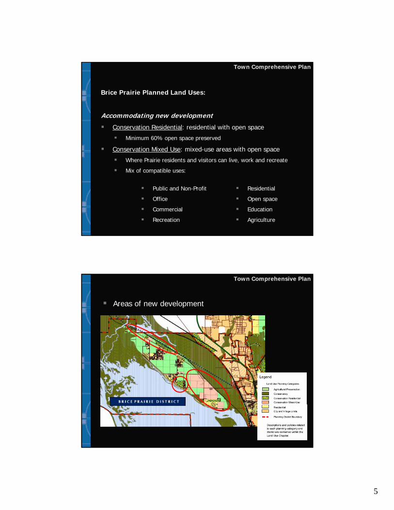
Brice Prairie Planned Land Uses:
Accommodating new development
Conservation Residential: residential with open space
Minimum 60% open space preserved
Conservation Mixed Use: mixed-use areas with open space
Where Prairie residents and visitors can live, work and recreate
Mix of compatible uses:
Public and Non-Profit
Office
Commercial
Recreation
Residential
Open space
Education
Agriculture
Town Comprehensive Plan
Areas of new development

6
Master Plans
Why Master Plan?
Comprehensive plan already has significant detail
Some areas need more attention to detailtown centers and other special areas
environmentally-sensitive areas
high growth areas and redevelopment areas
ComprehensiveComprehensivePlanPlan
Master PlanProcess
Master PlanMaster PlanProcessProcess
Zoning,Zoning,Subdivision Subdivision
Regulations, etc.Regulations, etc.
Town of Onalaska Master Plans
Town of Onalaska areas needing more detail
Brice Prairie
Halfway Creek
Brice Prairie
Halfway Creek

7
Brice Prairie is a Special Place
Spring 2004
Master Plans
Typical Master Plan Process
Collect & analyze data
Property owner & resident input
Identify opportunities &
constraints
Design alternative concept
plan(s)
Select desired plan(s)
Detailed plans, implementation
strategies

8
Master Plans
Typical Master Plan Process
Detailed plans, implementation strategies
Brice Prairie Master Plan
Capacity & Tipping Point
Capacity: reaching
limits/ends
Tipping Point: Point at
which major conditions
change and decisions
must be made about the
future
•• Town Hall, staff, servicesTown Hall, staff, services
•• Roads Roads –– safety, efficiencysafety, efficiency
•• Emergency Services Emergency Services –– response response time, facilitiestime, facilities
•• Schools Schools –– classes, buildingsclasses, buildings
•• Environment Environment –– water quality or water quality or water/sewer servicewater/sewer service
•• Economically viable businessesEconomically viable businesses
•• Character Character –– rural/suburbanrural/suburban

9
Brice Prairie Master Plan
Brice Prairie Capacity Analyses
Environmental capacityGround & surface water, wetlands
Habitat, impervious surfaces, shorelands
TransportationAccess, efficiency and congestion
Emergency services capacityFire/EMS & law enforcement
Environmental Capacity
Prepared by team of environmental experts
Describes the Prairie’s many environmental features
Additional residential and non-residential
development will further strain the Prairie’s
characteristic environmental features
Primary Limiting Resource: GroundwaterDependence of Prairie residents and businesses on
groundwater
Permeable Prairie soils that are particularly susceptible to
contamination
Contamination that has already occurred

10
Environmental Capacity
Transportation Capacity
Prairie’s current roadway network can
accommodate a moderate amount of additional
development
Neither a third roadway connection to STH 35 nor
a widening of CTH Z and CTH ZN are necessary
Key intersections may be congestedMeets minimal transportation standards
May not be acceptable to Prairie residents, business
owners, and emergency service providers
Additional roadway segments and connections on
the Prairie can ease congestion along the shoreline

11
Transportation Capacity
2 connections
limit growth
3rd road
connection: not
necessary for
transportation,
destructive for
environmental
Emergency Services Capacity
Fire/EMS: Village of Holmen Fire DepartmentSupplemented by Brice Prairie First Responders
(EMS only)
Police: La Crosse County Sheriff’s
Department
Current response times are adequate
Only 2 entrances points onto the Prairie,
occasionally blocked by trains
Further development: greater investments in
emergency services staffing and equipment
12
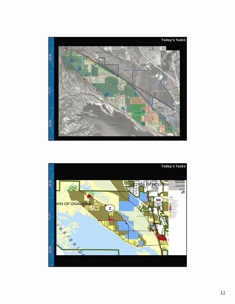
Today’s Tasks
Today’s Tasks

13
Today’s Discussion Issues
What type of development is appropriate for
the Prairie? Where should that development
be?
What types of open space should be
protected?
What does open space mean to you?
What are your priorities?
For preservation
For development
Starter Ideas
Conservancy and Ag Preservation
Purchase of Development Rights
Conservation Residential
Conservation subdivisions
Conservation Mixed Use
Crossroads communities or hamlets

14
Future Land Use Intents
Conservancy
Preserve
environmentally-sensitive
and archeological areas
Ag Preservation
Preserve productive
agricultural land.
Preserve productive
farms by preventing land
use conflicts between
incompatible uses.
Purchase of Development Rights
100% voluntary program – rights
are purchased at negotiated value,
land remains in private ownership
Landowners sell to governments
the development potential of their
property, which is then devoted to
conservation easements
Conservation easements
permanently protect open space
and valuable ag land by restricting
or prohibiting development

15
Purchase of Development Rights
Questions about: PDR
Is a PDR program right for Brice Prairie?
If so, what areas are priority for PDR?
Environmentally-sensitive land?
Agricultural areas?
Buffers to agricultural areas?
Other areas of Brice Prairie?
Future Land Use Intent
Conservation Residential
Balance of conservation & development
60% open space & 40% development
Maintain same number of lots, just smaller and
clustered
Comprehensive Plan states “generally maintain
60% open space”.
16
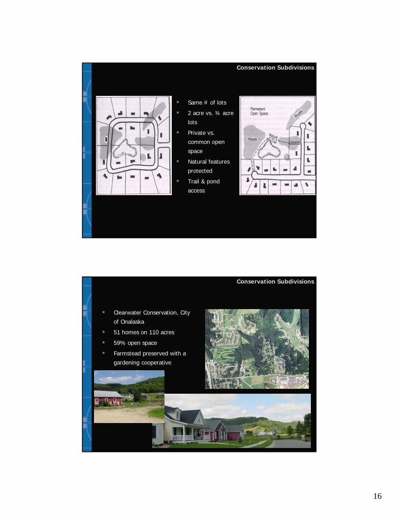
Same # of lots
2 acre vs. ¾ acre
lots
Private vs.
common open
space
Natural features
protected
Trail & pond
access
Conservation Subdivisions
Conservation Subdivisions
Clearwater Conservation, City
of Onalaska
51 homes on 110 acres
59% open space
Farmstead preserved with a
gardening cooperative

17
Conservation Subdivisions
The Preserve, Hunter’s Bay, WI
41 homes on 185 acres
65% open space (incl. 65 acres of
wetlands marshes)
Site includes 1-mile segment of
Ice Age National Scenic Trail
Conservation Subdivisions
Prairie Crossing, Gray’s Lake, IL
395 homes on 677 acres
69% open space (395 acres
permanently protected)
Organic farm and on-site public
charter school

18
Conservation Subdivisions
Questions about: Conservation Subdivisions
Are they right for Brice Prairie?
If so, where are they appropriate and where are
they not?
What should happen with the preserved open
space?
Private access for homeowners?
Public access?
Should open spaces from separate projects be
connected for wildlife and habitat?
Future Land Use Intent
Conservation Mixed UseWhere Prairie residents and visitors can live, work and recreate
Well-defined town centers that serve as both community
gathering places and commercial centers
Mix of compatible uses:
Alternative development option for the existing industrial-zoned
properties on Brice Prairie
Public and Non-
Profit
Office
Commercial
Recreation
Residential
Open space
Education
Agriculture

19
Crossroads Communities/”Hamlets”
Rural homes clustered around a
crossroads or small civic or
commercial area (e.g., a church
or neighborhood store) and
surrounded by a large expanse of
protected open space.
Development is clustered; 60%
open space.
A mini-village - mix of types and
sizes and can include residential,
office, retail and commercial
uses.
Walkable, community gathering
spot
Crossroads Communities/”Hamlets”
Some La Crosse County “hamlets”:
Midway: Town Hall, bar,
residential, bike trail
Mindoro (Town of Farmington):
Town Hall, school, convenience
store, farmers co-op, residential
St. Joseph’s Ridge (Town of
Greenfield): school, restaurant,
grocery store, monastery
Others: New Amsterdam,
Stevenstown, Burns, Middle Ridge
Barre Mills, and Newburg Corners
Mindoro
Town Hall in Midway

20
Crossroads Communities/”Hamlets”
Questions about: Hamlets
Are hamlets right for Brice Prairie?
If so, where are hamlets appropriate and where are
they not?
What types of land uses should be included in the
hamlet?
What could be role of US Fish and Wildlife center?
Possibilities: New Town Hall? Eco-tourism and
recreation-tourism?
What new connections are needed: walking, biking,
driving, boating?
US Fish and Wildlife Service
USFWS would like to
purchase 187 acres on
Brice Prairie from Mathy
Construction and Capitol
Air Systems
New USFWS regional
headquarters would be
on 12 acres; remaining
175 acres left as open
space
Land purchase not yet
finalized

21
Crossroads Communities/”Hamlets”
USFWS Ingersoll Wetlands Learning Center, Savanna District (IL)
Targeted
Your Turn
We need your input!
Table Sessions
1 hour
Facilitators at each table
with starter questions
Draw your ideas on the
basemap and write
down your thoughts
Elect a spokesperson
Report Back

22
Ground Rules
Argue with your pencils: write
down and draw your ideas
Respect different opinions
Give everyone a chance to add
their thoughts
Focus on issues, not people
Make comments concise – a lot
to cover in a little time
Next Steps
Community Meeting #1: TodayGetting input and ideas
Work back in our offices
Community Meeting #2: Discuss and critique draft Master Plan
Saturday, February 11, 2006, 9 am – 11am
Sand Lake Elementary School
Refinements to Master PlanDetailed plans, implementation strategies

23
Next Steps
La Crosse County Comprehensive Plan
“Setting a Regional Vision”
Sub-Area Group #4: Towns of Onalaska and
Holland and Village of Holmen
Monday March 27th, 7pm
Holmen Village Hall, 421 S Main St, Holmen
Brice Prairie Master Plan
Town of Onalaska
Community Meeting #1
Sand Lake Elementary School January 28, 20069 am – 11 am