bridge 3.1 sandpoint junction c project documents/5pw... · 2019. 3. 1. · bridge 3.1 will be 505...
TRANSCRIPT

REASONABLE NEEDS OF NAVIGATION ANALYSIS FOR BRIDGE 3.1
SANDPOINT JUNCTION CONNECTOR PROJECT
BNSF Montana Division, Kootenai River Subdivision, Line Segment 45, MP 2.9 +/- to 5.1+/-
Bonner County, Idaho November 2017
© Copyright 2017 Jacobs Engineering Group Inc. The concepts and information contained in this document are the property of Jacobs.
Limitation: This report has been prepared on behalf of, and for the exclusive use of Jacobs’ Client, and is subject to, and issued in accordance with, the provisions of the contract between Jacobs and the Client.
Prepared By:
Pierre Bordenave, Project Manager
Jacobs Engineering Group, Inc. Environmental Services 101 North Fourth Avenue, Suite 203 Sandpoint, ID 83864 T +1.208.263.9391 F +1.208.263.7013 www.jacobs.com
USCG0000482/28

Reasonable Needs of Navigation Analysis: BNSF Bridge 3.1
BNSF – Sandpoint Junction Connector Project – Navigation Evaluation Bridge 3.1 November 2017
2
Contents
1. Executive Summary .................................................................................................................................. 3
2. Existing Conditions .................................................................................................................................. 5
3. Proposed Action ..................................................................................................................................... 15
4. Navigation Evaluation ............................................................................................................................ 19
5. Mitigation ................................................................................................................................................. 21
6. Conclusion .............................................................................................................................................. 22
7. References ............................................................................................................................................... 23
FIGURES
1. SAND CREEK WATERSHED
2. ALBENI FALLS DAM LAKE ELEVATION MANAGEMENT SUMMARY
3. NAVIGATIONAL CHANNELS AT EXISTING BRIDGE 3.1
4. SUMMER ELEVATION OF EXISTING BRIDGE 3.1
5. WINTER ELEVATION OF EXISTING BRIDGE 3.1
6. AERIAL OVERVIEW OF EXISTING BRIDGE 3.1
7. VIEW OF EXISTING SANDPOINT MARINA DOCK, UPSTREAM OF EXISTING BRIDGE 3.1
8. AERIAL PHOTO COMPARISON OF SAND CREEK NAVIGATIONAL CHANNEL, SUMMER / WINTER
9. EXISTING BRIDGES ACROSS SAND CREEK
10. PLANS FOR PROPOSED BRIDGE 3.1 – TEMPORARY AND PERMANENT STRUCTURES
11. VIEW OF LOW-WATER NAVIGATIONAL CHANNEL OF SAND CREEK, BLOCKED BY DOCKS
USCG0000492/28

Reasonable Needs of Navigation Analysis: BNSF Bridge 3.1
BNSF – Sandpoint Junction Connector Project – Navigation Evaluation Bridge 3.1 November 2017
3
1. Executive Summary
1.1 Project Description
BNSF Railway Co. (BNSF) proposes to construct a second mainline track connection between its Algoma Siding track and the Sandpoint Junction, where BNSF and the Montana Rail Link (MRL) mainlines join. This action will consist of:
1. A new mainline track to the west of the existing BNSF mainline track;
2. Track, switch and signal upgrades;
3. A new bridge over Lake Pend Oreille (Br 3.9) adjacent to (west of) the existing rail bridge;
4. A new bridge over Sand Creek (Br 3.1) adjacent to (west of) the existing rail bridge;
5. A new bridge over Bridge Street (Br 3.0) adjacent to (west of) the existing rail bridge;
6. 0.88-acre of permanent and 0.38-acre of temporary nearshore fill below the jurisdictionalordinary high water mark (OHWM) of 2062.5 feet, associated with bridge abutments andthe south switch;
7. 0.28-acre of wetland fill in one location between the rail grade and the pedestrian pathsouth of the Sand Creek Br 3.1.
This technical report addresses the navigational evaluation and reasonable needs of navigation related to one of two over-water rail bridge applications associated with the BNSF Sandpoint Junction Connector Project as required in accordance with 33 U.S.C. 401, 491, 525‐533, 33 CFR 116.01, and the guidance in the USCG Bridge Program Reasonable Needs of Navigation White Paper (USCG 5 October 2012).
Bridge 3.1 will be 505 feet long, approximately 150 feet of which will be over / affecting navigable waters of Sand Creek, a tributary to Lake Pend Oreille. A temporary construction bridge is also part of this proposed action.
1.2 Project Purpose
The basic project purpose is to provide improvements for freight and passenger rail transportation to meet capacity needs.
The overall project purpose is to provide improved rail operations on the BNSF Kootenai River Subdivision Mainline by constructing a second mainline track connection between the BNSF Algoma Siding track south of Lake Pend Oreille, and the Sandpoint Junction, where BNSF and the Montana Rail Link (MRL) mainlines join just north of the Sandpoint Amtrak Station.
USCG0000502/28
Reasonable Needs of Navigation Analysis: BNSF Bridge 3.1
BNSF – Sandpoint Junction Connector Project – Navigation Evaluation Bridge 3.1 November 2017
4
1.3 Project Need
The project need is based on continued growth of freight rail service demands in the northern tier, high-volume traffic corridor between the Midwest (Chicago Terminus) and the West Coast. The single mainline and portions of the over-water rail bridges date from the early 1900s. Rail traffic volumes have risen steadily for the past three decades to the point that this section of the Main Line has become a constraint to interstate commerce. This project will relieve system congestion, back-up of rail traffic, and reduce hold times on sidings and wait times at grade crossings both locally and regionally.
USCG0000512/28

Reasonable Needs of Navigation Analysis: BNSF Bridge 3.1
BNSF – Sandpoint Junction Connector Project – Navigation Evaluation Bridge 3.1 November 2017
5
2. Existing Conditions
2.1 Setting
The Sand Creek watershed covers 38 square miles or 24,209 acres, and includes Jack Creek, Little Sand Creek, Swede Creek, and Schweitzer Creek northeast of Sandpoint. Sand Creek generally flows from north to south for approximately 16 miles and discharges into Lake Pend Oreille (LPO) within the City of Sandpoint.
Landownership is mostly private, with the remainder of the watershed held by the US Forest Service, Idaho Department of Lands (IDL), US Department of the Interior, Bureau of Land Management (BLM), and the City of Sandpoint which owns / controls most of the Little Sand Creek sub-basin. Most of the drinking water for the City of Sandpoint is withdrawn from Little Sand Creek. The primary land use is forestry, agriculture, and rural residential.
The upper one-third of the Sand Creek watershed is generally forested and sparse residential development, except for the Schweitzer Mountain Ski Resort, a large residential and commercial development located in the upper reaches of Schweitzer Creek, a tributary to Sand Creek. The middle-third of the watershed is forest, agriculture, and rural residential. The lower-third of the watershed is generally rural residential and agriculture with the last 4 miles of Sand Creek surrounded by more urban residential densities and commercial development within the cities of Sandpoint and Ponderay.
Figure 1. Sand Creek Watershed
USCG0000522/28

Reasonable Needs of Navigation Analysis: BNSF Bridge 3.1
BNSF – Sandpoint Junction Connector Project – Navigation Evaluation Bridge 3.1 November 2017
6
2.1.1 General Project Vicinity
The surface water elevations of Sand Creek for approximately two miles upstream from the Br 3.1 are regulated by the US Corps of Engineers, Civil Division’s management of the Albeni Falls Dam, constructed in 1955 near the Idaho/Washington border. (NAV 88) The primary channel substrate is silt and sand and the average gradient of Sand Creek is 1%.
The surface elevation of this portion of Sand Creek has a summer pool at 2062.5 feetfrom approximately mid-June through mid-September.
From late September to early November the water elevation typically draws down from2060 to 2051 feet.
From November to early April the elevation is typically maintained at 2051feet.
From early April through June 16 the water elevation typically draws up at irregularintervals, depending on water storage and flood potential conditions, from 2051 feet to2062.5 feet.
Figure 2. Albeni Falls Dam Lake Elevation Management Summary
USCG0000532/28

Reasonable Needs of Navigation Analysis: BNSF Bridge 3.1
BNSF – Sandpoint Junction Connector Project – Navigation Evaluation Bridge 3.1 November 2017
7
2.1.2 Immediate Project Area
There is an existing BNSF railroad bridge at the approximate mouth of Sand Creek in Sandpoint. The existing fixed bridge is 155 feet long with four concrete piers, two of which are abutments and two of which are fully within the navigable area of Sand Creek.
• The main navigable channel between the two piers has a clearance of 42 feet horizontal and 16.2 feet vertical during summer pool elevation of 2062.5. The water depth is 15.5 feet during summer pool elevation of 2062.5 and approximately 5 feet when the water is drawn down to 2051 in the winter.
• There are two small side channels between the bridge’s in-water piers and the abutments, with approximate clearances of 20-30 feet horizontal and 16 feet vertical in the summer. Depths range from approximately 10 foot adjacent to the in-water pier, sloping up to 1 foot or less along the rip rap shoreline edge during summer pool. There is no water between the abutments and piers in the winter.
Figure 3. Navigational channels, existing Br 3.1
USCG0000542/28
Reasonable Needs of Navigation Analysis: BNSF Bridge 3.1
BNSF – Sandpoint Junction Connector Project – Navigation Evaluation Bridge 3.1 November 2017
8
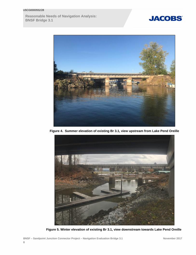
Figure 4. Summer elevation of existing Br 3.1, view upstream from Lake Pend Oreille
Figure 5. Winter elevation of existing Br 3.1, view downstream towards Lake Pend Oreille
USCG0000552/28

Reasonable Needs of Navigation Analysis: BNSF Bridge 3.1
BNSF – Sandpoint Junction Connector Project – Navigation Evaluation Bridge 3.1 November 2017
9
2.2 Existing Navigational Use
There is significant motor craft usage and passage under the BNSF and adjacent highway bridges near the mouth of Sand Creek. There are public and private marinas, both upstream and downstream of Br 3.1, within the general area. Other than the marinas, there are no known commercial operations, such as fishing or tour boats, upstream of Br 3.1. As identified in Section 2.1.1, the surface water elevations of Sand Creek, like Lake Pend Oreille in general, are seasonally regulated by the management of the Albeni Falls Dam. Thus, navigation upstream from Br 3.1 is also generally seasonal, May 1 to October 1, with the highest use between Memorial Day and Labor Day.
2.2.1 General Project Vicinity
Within 1 mile of Br 3.1:
The portion of Sand Creek downstream from Br 3.1 to the lake has a City owned marina, withboth all-season and day rental boat slips, boat launch ramps, day-use beaches and a largewaterfront park along the north – northeast side of the waterway. Along the south - southwestside of the waterway is the BNSF rail grade out to Br 3.9. No portion of the Br 3.1 impactsdownstream uses.
The area of Sand Creek between Br 3.1 and the Highway 2 / 200 bridge, approximately 1.25miles upstream in the City of Sandpoint, is heavily used in the summer by motor boats,kayaks, and paddleboards. There is a pedestrian path along the east side of the creek, and apublic boardwalk with boat mooring side ties along the west side of the creek, providing marineaccess to downtown, restaurants, and other day use activities. There is minimal use of thissection of the creek for swimming because of the boat traffic and the less desirable swimmingconditions than what can be found at the nearby City Beach Park.
There are approximately 50+/- public day use side ties on the city waterfront boardwalk (basedon an average boat length of 20 feet).
There are approximately 20+/- private boats dock / slips on the creek (visually counted in thesummer of 2017).
There are approximately 170+/- available rental covered boat slips and side ties at theSandpoint Marina.
2.2.2 Immediate Project Area
Within 500 feet of Br 3.1:
Immediately upstream (to the west) of Br 3.1, is the privately owned Sandpoint Marina, withboth fueling and bilge pumping stations and approximately 170 boat rental spaces.
Immediately downstream (to the east) of Br 3.1, is the City-owned marina, with a bilgepumping station and boat launching facilities. No passage under the Br 3.1 is required toaccess these facilities.
USCG0000562/28
Reasonable Needs of Navigation Analysis: BNSF Bridge 3.1
BNSF – Sandpoint Junction Connector Project – Navigation Evaluation Bridge 3.1 November 2017
10
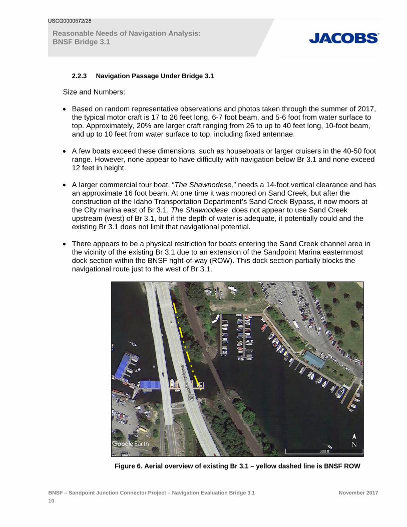
2.2.3 Navigation Passage Under Bridge 3.1
Size and Numbers:
Based on random representative observations and photos taken through the summer of 2017,the typical motor craft is 17 to 26 feet long, 6-7 foot beam, and 5-6 foot from water surface totop. Approximately, 20% are larger craft ranging from 26 to up to 40 feet long, 10-foot beam,and up to 10 feet from water surface to top, including fixed antennae.
A few boats exceed these dimensions, such as houseboats or larger cruisers in the 40-50 footrange. However, none appear to have difficulty with navigation below Br 3.1 and none exceed12 feet in height.
A larger commercial tour boat, “The Shawnodese,” needs a 14-foot vertical clearance and hasan approximate 16 foot beam. At one time it was moored on Sand Creek, but after theconstruction of the Idaho Transportation Department’s Sand Creek Bypass, it now moors atthe City marina east of Br 3.1. The Shawnodese does not appear to use Sand Creekupstream (west) of Br 3.1, but if the depth of water is adequate, it potentially could and theexisting Br 3.1 does not limit that navigational potential.
There appears to be a physical restriction for boats entering the Sand Creek channel area inthe vicinity of the existing Br 3.1 due to an extension of the Sandpoint Marina easternmostdock section within the BNSF right-of-way (ROW). This dock section partially blocks thenavigational route just to the west of Br 3.1.
Figure 6. Aerial overview of existing Br 3.1 – yellow dashed line is BNSF ROW
USCG0000572/28

Reasonable Needs of Navigation Analysis: BNSF Bridge 3.1
BNSF – Sandpoint Junction Connector Project – Navigation Evaluation Bridge 3.1 November 2017
11
Figure 7. The Sandpoint Marina dock within BNSF ROW, upstream of the existing Br 3.1
Based on random representative counts through the summer of 2017, and dependingon the day of the week, between 250 and 600+/- motor craft and 40-50 human poweredcraft use the Sand Creek passages below Br 3.1, with higher numbers occurring onweekends and summer holidays.
Usage drops off significantly to approximately 30% of summer usage from Labor Dayto mid-October, and from mid-April to near Memorial Day.
Other than an occasional non-motorized craft, there is essentially no motorizednavigational use upstream from Br 3.1 between mid-October and mid-April due to theshallow water depths of Sand Creek and because the open water channel flows underthe Sandpoint Marina docks, which block passage upstream.
USCG0000582/28

Reasonable Needs of Navigation Analysis: BNSF Bridge 3.1
BNSF – Sandpoint Junction Connector Project – Navigation Evaluation Bridge 3.1 November 2017
12
Figure 8. Aerial photo comparison of the Sand Creek navigational channel, summer / winter
USCG0000592/28

Reasonable Needs of Navigation Analysis: BNSF Bridge 3.1
BNSF – Sandpoint Junction Connector Project – Navigation Evaluation Bridge 3.1 November 2017
13
2.3 Limiting Structures
There are six overwater bridge structures, including BNSF’s Br 3.1, from the defined mouth of Sand Creek and the Highway 2 / 200 Bridge, which is the most limiting navigational structure with less than 6-feet of vertical clearance.
Figure 9. Existing bridges across Sand Creek
USCG0000602/28

Reasonable Needs of Navigation Analysis: BNSF Bridge 3.1
BNSF – Sandpoint Junction Connector Project – Navigation Evaluation Bridge 3.1 November 2017
14
2.3.1 BNSF Bridge 3.1
Br. 3.1 is near the mouth of Sand Creek’s outlet to Lake Pend Oreille. The main channel navigational span has clearances of 42 feet horizontal, and 16.2 feet vertical. Essentially all motor craft, other than occasional small personal water craft with shallow draft, use this main channel. Because of the channel’s variable sloping sides, not to mention existing large riprap rock embankment protection, the two side channels are typically only used by canoes, kayaks, paddle boards and only occasionally by personal water craft.
2.3.2 Highway 95 Bridges
The Highway 95 and off ramp bridges immediately to the east of Br 3.1 are essentially full span bridges with approximately 200-feet of horizontal clearance within the navigational channels of Sand Creek. There are two in-water concrete piers at the shallow north end of the Highway 95 Bridges across Sand Creek. Neither create navigational limitations. Both bridges have over 20-feet of vertical clearance.
2.3.3 Bridge Street Bridge
Bridge Street Bridge is a 5-span bridge with 4-in water steel piling piers. Three of the spans are navigable with approximate clearances of 50-feet horizontal and a minimum of 15.5-feet vertical.
2.3.4 Cedar Street Market Bridge
The Cedar Street Market Bridge is a converted street bridge to an over-water commercial market. It consists of 13 piers and 12 navigable spans with clearances of approximately 12-feet (average) horizontal clearances, and several spans with 16.5-feet of vertical clearance. Some spans have slightly lower vertical clearance due to infrastructure below the bridge.
2.3.5 BNSF Bridge 1402.6
The BNSF Kootenai River Subdivision mainline Bridge 1402.6 over Sand Creek has 8 spans (5 over water) and 6 piers (4 in-water) with clearances of approximately 50-feet horizontal, and 21-feet vertical.
2.3.6 Highway 2 / 200 Bridge
The Highway 2 / 200 Bridge is a single span over the main channel of Sand Creek and has clearances of approximately 24-feet horizontal and 6-feet, or less, vertical. This bridge limits boat traffic, both motorized and human powered, upstream from this point.
USCG0000612/28

Reasonable Needs of Navigation Analysis: BNSF Bridge 3.1
BNSF – Sandpoint Junction Connector Project – Navigation Evaluation Bridge 3.1 November 2017
15
3. Proposed Action
Actions associated with navigation are:
A new bridge over Sand Creek (Br 3.1) approximately 35 feet west of the existing rail bridge.
A temporary construction bridge adjacent to (west of) the proposed new railroad bridge.
A small (0.05 acre) temporary near shore fill along the north approximately 350 feet of thestructure to accommodate for safe access of workers and incidental fill during from theinstallation of the upland bridge pilings.
A small (0.01 acre) permanent nearshore fill at the south bridge abutment.
Note: An action not directly associated with navigation, and thus addressed under a Corps of Engineers 404 permit, is a permanent fill of 0.28 acres of wetlands south of the bridge and the permanent nearshore fill.
3.1 Structures
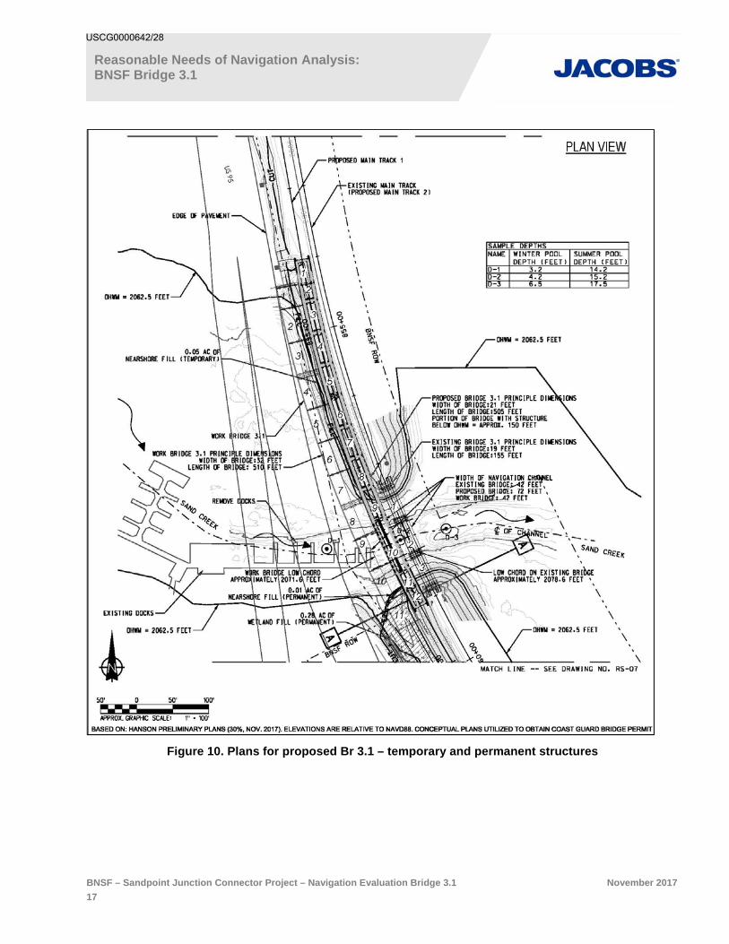
3.1.1 Temporary (Refer to Figure 10)
A temporary construction bridge to construct the new Bridge 3.1 consisting of 11 spans and 11 piers.
Spans 1-7 will be over shallow nearshore areas north if the existing bridge.
Span 11 will have a small corner portion over the shallow non navigable nearshore areaadjacent to the wetland fill.
Spans 8, 9, and 10 will be over the Sand Creek navigable channel and will have a verticalclearance of 9 feet during Summer Pool (elevation 2062.5) high water (ApproximatelyJune 15 through September) and a horizontal clearance of 42 feet.
If work on the new bridge is not completed during the low water period (October 15 toApril 15) spans 8, 9 and 10, as well as piers 8, 9, and 10, will be removed until the nextOctober 15th.
There will be 10 piers (#2-11) fully or partially within the jurisdictional 2062.5-foot OHWM. These will consist of:
Two piers with eight 24-inch-diameter steel pilings (Spans 4 and 8)
Eight piers with four 24-inch-diameter steel pilings (Span 2,3,5,6,7,9,10,11)
The navigation horizontal clearance between piers 8, 9, 10, and 11 (Spans 8, 9, and 10)will be 42 feet. However, as identified above, both spans and piers 8, 9, and 10 that arewithin or over the Navigation area of Sand Creek would be removed between April 15and October 15 to minimize navigation impacts.
The total number of temporary pilings below the OHWM will be between 30 and 40 toaccommodate minor adjustments in variable span support needs and site conditions.
USCG0000622/28

Reasonable Needs of Navigation Analysis: BNSF Bridge 3.1
BNSF – Sandpoint Junction Connector Project – Navigation Evaluation Bridge 3.1 November 2017
16
3.1.2 Permanent (Refer to Figure 10)
A new bridge adjacent to the existing BNSF over Sand Creek (Br 3.1). This bridge will be approximately 35 feet to the west of, and parallel to, the existing bridge, and will be 505 feet long (approximately 150 feet over navigable areas of Sand Creek) and 21 feet wide.
There will 12 spans:
One approximate 80-foot span over the creek channel; This new bridge centernavigational span (10) horizontal clearance will be 72 feet; as compared to the existingbridge center span (2) which has an approximate 42-foot horizontal clearance. Verticalclearance of the new bridge will be 17 feet, which is slightly higher that the verticalclearance of the existing bridge, which is 16.2 feet above the 2062.5-foot OWHM.
Seven approximate 45-foot spans(Spans 3, 4, 5, 6, 7, 8, 9); one (#9) will be over aportion of the creek during high water, and the rest being fully upland of the OHWM;
Three approximate 25-foot spans (#1,2,11); one of which (Span 11) will be over aportion of the creek during high water, and the other two (Spans 1,2) being fully uplandof the OHWM;
One approximate 31-foot transition span (Span12), which will not be over water.
There will be 11 piers associated with the new bridge:
Two piers (Spans 9 and 10), each consisting of eight 24-inch diameter steel pilings, all ofwhich will be within the navigable channel.
Seven piers (Spans 2-8), each consisting of six 24-inch-diameter steel pilings. Of theseven, one pier (Span 8) will have all, or a portion, of the piles just within the regulatedOHWM, and six piers (Spans 2-7) will be fully upland.
Two piers (Spans 1 and 11) consisting of three 24-inch-diameter steel pilings, bothwhich will be upland of the regulated OHWM.
The total number of pilings is projected to be 64; 22 of which will be below the regulated OHWM.
USCG0000632/28
Reasonable Needs of Navigation Analysis: BNSF Bridge 3.1
BNSF – Sandpoint Junction Connector Project – Navigation Evaluation Bridge 3.1 November 2017
17
Figure 10. Plans for proposed Br 3.1 – temporary and permanent structures
USCG0000642/28

Reasonable Needs of Navigation Analysis: BNSF Bridge 3.1
BNSF – Sandpoint Junction Connector Project – Navigation Evaluation Bridge 3.1 November 2017
18
3.2 Timing
3.2.1 Temporary
The temporary bridge will be constructed prior to starting the construction of the permanent bridge structure. The majority of the temporary bridge will be over very shallow (1 – 4 foot) nearshore areas north of the existing bridge. Spans 8, 9, and 10 will be over the main center navigable section of Sand Creek. Those three spans, and their associated piers that are within the navigable channel of Sand Creek (piers 8, 9 and 10), will be removed between April 15 and October 15 to minimize navigation impacts to watercraft moving between Sand Creek and Lake Pend Oreille. The remaining portion of the work bridge will be constructed and remain in place until the new permanent bridge is completed.
3.2.2 Permanent
Work on much of permanent bridge will occur at any time of the year due to the fact that the majority of the bridge piers and spans are upland of the regulated OHWM of Sand Creek or in near shore shallows with no navigational impact. Work on piers 9 and 10, and spans 9, 10, and 11 which are fully or partially within or over the navigational area of Sand Creek, will be limited to between October 15 and April 15, to minimize navigation impacts to watercraft moving between Sand Creek and Lake Pend Oreille.
USCG0000652/28

Reasonable Needs of Navigation Analysis: BNSF Bridge 3.1
BNSF – Sandpoint Junction Connector Project – Navigation Evaluation Bridge 3.1 November 2017
19
4. Navigation Evaluation
4.1 Navigational Effect of Proposed Structures
4.1.1 Temporary
Based on the self-imposed limitation of work on within the 150-foot wide navigation area of Sand Creek below and near the railroad bridge, the impacts to navigation are expected to be minimal.
Due to the fact that the water elevation drops dramatically at the end of September and typically remains low until early April, motor craft leave the upstream area of Sand Creek to avoid being stranded on the shallow waters / mud flats.
Although small craft such as canoes and kayaks may still be able to continue a short distance upstream from the Br 3.1 at that low water period, they also will be unable to pass more than a few hundred feet upstream because the Sandpoint Marina docks are located over the main low water channel and block further upstream movement of all water craft.
Figure 11. Views of low-water navigational channel of Sand Creek, blocked by docks
4.1.2 Permanent
Similar to the temporary bridge work, based on the self-imposed limitation of work on within the 150 foot wide navigation area of Sand Creek below and near the Br 3.1, the impacts to navigation are expected to be minimal.
When the bridge is finished, both the horizontal and vertical clearances will be greater than the existing span, thus no impact to exiting navigation is anticipated.
BNSF has identified that an extension of the easternmost dock of the Sandpoint Marina is on BNSF ROW and creates both an existing and potential future navigational blockage of upstream access to Sand Creek. BNSF will work with the owner of Sandpoint Marina to resolve this navigational limitation.
USCG0000662/28
Reasonable Needs of Navigation Analysis: BNSF Bridge 3.1
BNSF – Sandpoint Junction Connector Project – Navigation Evaluation Bridge 3.1 November 2017
20
4.2 Effect of Proposed Structures on Existing and Potential Foreseeable Navigation Needs
4.2.1 Temporary
During construction, there will be minor and temporary limits to both existing and foreseeable navigation during the low-water period of the year (October 15 – April 15). However, during that period, the water depth upstream from the Br 3.1 is either too shallow, or the entire channel is blocked by the marina docks, such that motor craft cannot navigate upstream, and human powered craft can only move a few hundred feet before they need to remove their craft from the water and portage several hundred feet to re-enter the creek. Additionally, during that low-water period, the low chord of the temporary bridge will be over 18-feet above the seasonal low water surface elevation. No foreseeable navigational impacts either short-term or long-term are anticipated from the temporary work.
4.2.2 Permanent
Upon the completion of the proposed new Br 3.1, both the horizontal and vertical clearances will be greater than the existing bridge span, thus there are no expected impacts to either existing or foreseeable future navigational uses of the passage under the bridge or the upstream area of Sand Creek. The existing side channel between the existing bridge and the shoreline / abutments will still be usable by canoes and kayaks, and paddle boards.
USCG0000672/28

Reasonable Needs of Navigation Analysis: BNSF Bridge 3.1
BNSF – Sandpoint Junction Connector Project – Navigation Evaluation Bridge 3.1 November 2017
21
5. Mitigation
As described in previous sections, work within the navigable channel of Sand Creek under and near Br 3.1 will be conducted during the low-water period of October 15 to April 15. This work period is defined to mitigate potential impacts to upstream navigational uses and access. The permanent Br 3.1 is also designed to provide greater vertical and horizontal clearances that the existing bridge, thus mitigating both existing and foreseeable future navigational impacts.
As previously identified, there is an extension of the easternmost dock of the Sandpoint Marina on BNSF ROW and creates both an existing and potential future navigational blockage of upstream access to Sand Creek. BNSF will work with the owner of Sandpoint Marina to resolve this navigational limitation.
USCG0000682/28

Reasonable Needs of Navigation Analysis: BNSF Bridge 3.1
BNSF – Sandpoint Junction Connector Project – Navigation Evaluation Bridge 3.1 November 2017
22
6. ConclusionThe Reasonable Needs of Navigation Criteria are met by the proposed new BNSF Bridge 3.1 over Sand Creek through:
Construction timing of the bridge to periods of minimal to no navigation upstream of Bridge 3.1.
Design of the bridge with a higher vertical clearance (low chord) and wider horizontal clearancethan the existing bridge and upstream bridges, such that it does not become the limitingnavigational structure on Sand Creek.
No existing, or likely foreseeable, water craft would be restricted on Sand Creek from thisstructure since it is not the navigational limiting structure on Sand Creek.
USCG0000692/28
Reasonable Needs of Navigation Analysis: BNSF Bridge 3.1
BNSF – Sandpoint Junction Connector Project – Navigation Evaluation Bridge 3.1 November 2017
23
7. References
Bonner County Sheriff Department, Marine Division, 2017. Pierre Bordenave personal communications regarding boat registrations on Lake Pend Oreille, Idaho.
Hanson Professional Service, Inc. “BNSF Sandpoint Junction Connector Project” 30% Design; November 2017.
Local Marinas, 2017. Pierre Bordenave, personal communications regarding owners of boats and boat slip use, seasonal and day-use.
US Army Corps of Engineers, Civil, Seattle Corps District; Albeni Falls Dam 148021 FAQ Sheet; http://www.nws.usace.army.mil/Missions/CivilWorks/LocksandDams/AlbeniFallsDam.aspx
US Coast Guard White Paper, BDTM.48 “Guidelines to Perform Navigational Studies.” Version 1.1; October 5, 2012.
US Coast Guard, Office of Bridge Programs, “Bridge Permit Application Guide,” COMPDTPUB P16591.3D, OMB Control Number: 1625-0015, 19 July 2016.
Fischer, Steven, 2017. US Coast Guard, Thirteenth District, Seattle, WA. Pierre Bordenave, personal communications/meetings regarding pre-application of Bridge Permit applications for BNSF Sandpoint Junction Connector new bridges (3.1 and 3.9)
USCG0000702/28