bridge # csah 6 over chippewa river - dot.state.mn.us€¦ · above the water surface to the...
TRANSCRIPT
2016 UNDERWATER
BRIDGE INSPECTION REPORT
BRIDGE #
DISTRICT: COUNTY: CITY/TOWNSHIP:
Date of Inspection:
Equipment Used:
Inspected By:
Report Written By:
Report Reviewed By:
Final Report Date:
76505
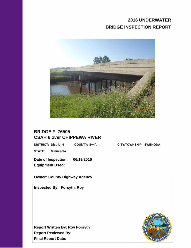
CSAH 6 over CHIPPEWA RIVER
District 4 Swift SWENODA
06/19/2016
Forsyth, Roy
Roy Forsyth
County Highway AgencyOwner:
MinnesotaSTATE:

UNDERWATER SUMMARY 3
UNDERWATER INSPECTION 4
UNDERWATER INSPECTION PROCEDURES 6
STRUCTURE INVENTORY 7
ELEMENTS 8
PICTURES 11
DRAWINGS 13
TABLE OF CONTENTS
PAGE NUMBER

Contractor:
(A) Reinspect the submerged substructure units at the normal maximum recommended (NBIS) interval of sixty (60) months.
Collins Engineers, Inc.
9687Contractor Job Number:
RECOMMENDATIONS
REPORT SUMMARY
UNDERWATER INSPECTION
The substructure units inspected at Bridge No. 76505, the East and West Piers, were found to be generally in good condition below water with no defects of structural significance observed. There was a 100 percent loss of paint coating from 5 foot above the water surface to the channel bottom with light surface corrosion. The channel bottom material typically consisted of 2 inch diameter cobbles with sand infill.
(A) There was a 100 percent loss of paint coating from 5 foot above the water surface to the channel bottom with light surface corrosion.
(B) The channel bottom material typically consisted of 12 inch diameter cobbles with sand infill.
INSPECTION FINDINGS
Page 3 of 14

Bottom of cap at the upstream nose of Pier 1.Water Level Reference:
WATERLINE DATUM
Waterline Elevation (feet):
The waterline was approximately 11.1 feet below the reference. Description:
1003.5
4.
East and West PiersSubstructure(s) Inspected:
SUBSTRUCTURE INSPECTION DATA
General Shape:
3.7Maximum Water Depth at Substructure(s) Inspected (feet):
Each pier consists of a pier cap supported on 7 steel piles.
Code:Item 62: Culvert:
7
Y 48 06/2016Code:Item 92B: Underwater Inspection:
Code:
(Minnesota specific codes are used for 92B and 113)
NBIS CODING INFORMATION5.
Item 60: Substructure:
Item 61: Channel and Channel Protection:
7Code:
District 4District:
CSAH 6
County:
The bridge consisted of 3 main spans of steel beam spans supporting a concrete cast in place deck. The substructure consisted of 2 reinforced concrete abutments founded on footing piles and 2 piers of CIP piles. The piers were the West and East piers from west to east respectively.
Bridge Description:
076 - Swift
Facility Carried:
BRIDGE DATA1.
UNDERWATER INSPECTION
Bridge #:
CHIPPEWA RIVERFeature Intersected:
76505
Underwater Visibility (feet):
Sunny, 80°FWeather Conditions:
0.5 ft.
3.
1.5 ft/sWaterway Velocity (ft/sec):
06/19/2016
Professional Engineer/Team Leader:
INSPECTION DATA2.
Roy A. Forsyth
Date of Underwater Inspection:
Roy A. ForsythInspection Diver:
Page 4 of 14

885 Scour 1 EA 1
STRUCTURAL ELEMENT CONDITION RATING
Conditions
6.
I
Bridge is scour critical because abutment or pier foundation is rated as unstable due to observed scour at bridge site.
Item 113: Scour Critical Bridge: Code:
No (Mark your selection with an X)Yes X
225
CS3 CS4
Steel Piling 1414 EA
CS2ELEM # Unit CS1Element Description Quantity
Page 5 of 14

The routine underwater inspection of Bridge 76505 (CSAH 6 over the Chippewa River) was completed on June, 19, 2016. The underwater inspection was conducted from shore. The inspection was conducted by a team consisting of a PE-Diver with a valid MnDOT Team leader certification, a backup diver and a dive tender. Due to waterway conditions at the time of inspection, the inspection could be accomplished by wading in accordance with OSHA regulations. Profiles were taken along the upstream and downstream faces of the bridge and around the periphery of substructure units to determine the presence, location and area of scour.
The bridge elements inspected consisted of 14 steel piles. According to the bridge inventory or design drawings, the East and West Piers were founded on steel piles. Inspection procedures followed FHWA guidance and the MnDOT Bridge and Structure Inspection Program Manual with channel bottom probing to search for bottom of foundations. The routine underwater inspection frequency is recommended to remain at a maximum of 60 months based on those findings and risk factors. Also, inspection procedures should continue to follow the above approach and standard guidance with 100% Level I and 10% Level II intensity efforts.
INSPECTION PROCEDURES
UNDERWATER INSPECTION
Page 6 of 14

Spec. Feat.Pier Foundation (Material/Type)
8 - CIPCantilever ID
+ W A T E R W A Y +Number of Spans Historic Status
4 - PILE BENT
Underwater YCulvert Type 3 - FTG PILE
Pinned Asbly. N
06/19/2016
Barrel Length
158.6 ft. Navigation Control
Waterway Opening (sf.) 1708Structure Length
ft. Year Painted
0 - No nav. control on waterwayDeck Width (Out-to-Out) 39.3
+ P A I N T +
APPR: 0 TOTAL:5 - Not eligible
MAIN: 3
Main Span Length 60.0 ft.Drainage Area (sq. mi.) 1730.0
B R I D G E D A T A +Main Span Detail
0 - SUBSTANDARD+ M I S C.
Appr. Span Type Structure Flared
GR Termini 0 - SUBSTANDARD
Appr. Guardrail
Main Span Type 4 - Steel Continuous Median Width On Bridge
ft. Bridge Railing 1 - MEETS STANDARDS
0 - SUBSTANDARD
Main Span Design 01 - Beam Span
ft. GR Transition
Skew 0
Y/N Freq Date
NAbutment Foundation (Material/Type)
1 - CONC Frac. Critical
4 - Bolted
D E P T H I N S P. +Appr. Span Design
0 - No flare+ I N
Appr. Span Detail Field Conn. ID
Parallel Structure N - No parallel structure
Pier Protection
0 - Not Required
Rating Date 6/18/20085705 sq. ft. Traffic
ft. 50B. Rt 0.00Sidewalk Width 50A. Lt 0.00
Roadway Area (Curb-to-Curb)
Posted Load 0 - Not Required
PostingStructure Area (Out-to-Out) 6233 sq. ft.
DBL:VEH: SEMI:
Rt 22 ARail Type Lt 22 C N - N/AN - N/A B N - N/A
N - Not Applicable Overweight Permit CodesCurb Height Lt
ft. Horizontal 0 - Not Required
0.25 ft. Vertical0.25 ft. Rt
Wear Surf Install Year
sq. ft. Nav. Vert. Lift Bridge Clear. (ft.)
I - LOW RISK Year 1998Primer Type MN Scour Code
Painted Area
Unsound Paint % Nav. Clr. (ft.)
_
Deck Material 1 - Concrete Cast-in-Place 0.0Wear Surf Type 1 - Monolithic Concrete
(concurrently placed with stru
Vert. 0.0 Horiz.
S I G N S +Operating Rating 2 - HS TRUCK
0 - None + B R I D G E
Inventory Rating 2 - HS TRUCK 23.0
38.0Deck Rebars Install Year
Deck Rebars
Finish TypeWear Course/Fill Depth 0.00 ft.
0 - None
Design Load 5 - HS 20
+ C A P A C I T Y R A T I N G S +Deck Membrane
45 ° 11
Inspector Name Forsyth, Roy
Latitude Control Section (TH Only) Status' 43.80 ''
2 - 2-way traffic
Routine Inspection Frequency 24
Sect., Twp., Range
0.3 MI W OF JCT CSAH 19 Level of Service 1 - MAINLINE
- 40W Roadway Type15 - 120N
Detour Length 4.0 mi.R A T I N G S +
Custodian 02 - County Highway Agency
Owner 02 - County Highway AgencyDeck 6 Unsound
Deck %
C O N D I T I O N° 40 '
A - Open
Longitude 95 017+00.040 + N B I 15.34 '' Reference Point
Crew
+ I N S P E C T I O N +
Agency Br. No. 116
District 04
Bridge Match ID (TIS) 0 Userkey
CSAH 6 over CHIPPEWA RIVER
Minnesota Structure Inventory Report
Bridge ID: 76505
+ G E N E R A L + + R O A D W A Y +
Date: 08/09/2016
Sufficiency Rating 97.0Roadway Name or Description
6
City
Routine Inspection Date 11/19/2015
Desc. Loc.
Township 76018 - SWENODA CSAH 6
Number
NRoadway O/U Key Route On StructureMaint. Area Structurally Deficient
NRoute Sys 04 - CSAHCounty 076 - Swift Functionally Obsolete
Lanes
Waterway Adequacy 7Max. Vert. Clear.
ft.Legislative District 20Aft.Potential ABC 2 - N/A ft.
ft.On - Off System Roadway Width 36.00 ft.
Vertical Clearance ft.1 - ON
Underclearances N
Service On 1 - Highway Appr. Surface Width+ S A F E T Y F E A T U R E S +
5 - Waterway Bridge Roadway Width 36.0
32.0 ft.
Service Under
ft.
ft. Approach Alignment 5Horizontal Clear.
ft.
ft.+ S T R U C T U R E + Lateral Clearance
HCADT ADTT7
Year Built 1980
MN Year Reconstructed Functional Class
%Channel 7
Substructure
0Superstructure 6
ON 2 UNDER
189 YEAR 2008BMU Agreement ADT
Structure Evaluation 6If Divided
D I M E N S I O N S +Bridge Plan Location 3 - COUNTY
Deck Geometry 8NB-EB SB-WBDate Opened to Traffic
+ R D W Y
FHWA Year Reconstructed
MN Temporary Status
07 - Rural - Major CollectorCulvert N
A P P R A I S A L R A T I N G S ++ N B I
Page 7 of 14

County:
City:
Township:
Township:Section: Range:
Span Type:
NBI Deck: Super: Sub: Chan: Culv:
Appraisal Ratings - Approach: Waterway:
Required Bridge Signs - Load Posting:
Horizntal:
Traffic:
Vertical:
MN Scour Code:
Open, Posted, Closed:
Location:
Route:
Control Section:
Local Agency Bridge Nbr.:
Ref. Pt.:
Maint. Area:
Length:
Deck Width:
Rdwy. Area/ Pct. Unsnd:
Paint Area/ Pct. Unsnd:
Culvert:
Swift
76018 - SWENODA
120N15 40W
4 - Steel Continuous 2 -Stringer/Multi-beam or Girder
6 6 7 7 N
5 7
0 - Not Required
0 - Not Required
0 - Not Required
N - Not Applicable
I - LOW RISK
0.3 MI W OF JCT CSAH 19
04 - CSAH 6 017+00.040
158.6
39.3
5705 sq. ft. / %
sq. ft. / %
N/A
A - Open
ft.
ft.
Postings:List:
MINNESOTA BRIDGE INSPECTION REPORT
09/12/2016
Inspector: CO Bridge
BRIDGE 76505 CSAH 6 OVER CHIPPEWA RIVER
Unofficial Structurally Deficient N
NUnofficial Functionally Obsolete
Unofficial Sufficiency Rating 97.0
ELEMNBR ELEMENT NAME INSP. DATE QUANTITY
QTYCS 1
QTYCS 2
QTYCS 3
QTYCS 4REPORT TYPE
Reinforced Concrete Deck 06/19/2016 6233 SF 6233 0 0 012 Underwater
6233 SF 6233 0 0 0Migrated Values
Notes: Cracks showing through - white efflorescence present. 11-19-15
510 - Wearing Surfaces 5705 SF 5591 0 114 0
Notes: Top of Concrete Deck with Uncoated Rebar Notes: Minor deck cracking randomly throughout. 11-19-15
Underwater 06/19/2016
5705 SF 5591 0 114 0Migrated Values
Steel Open Girder/Beam 06/19/2016 633 LF 133 500 0 0107 Underwater
633 LF 133 500 0 0Migrated Values
515 - Steel Protective Coating 999 SF 210 0 789 0
Notes: [2016] Migrator assumed quantity of 999 SF and estimated the condition states.
Underwater 06/19/2016
999 SF 210 0 789 0Migrated Values
Reinforced Concrete Abutment 06/19/2016 119 LF 0 119 0 0215 Underwater
119 LF 0 119 0 0Migrated Values
Notes: [2016] Migrator added 40 LF to abutment quantity to account for wingwalls (CS1:0 CS2:40 CS3:0 CS4:0).1 crack in the middle of East abutment. Cracking on diaphragms on both abutments. Settlement under bridge. Bottom of East abutmentexposed. Concerns about settlement continuing. 11-19-15
Wingwall notes: 1 crack in Southeast wingwall, and Northeast wingwall has settlement around it. 11-19-15
Steel Pile 06/19/2016 14 EA 0 14 0 0225 Underwater
14 EA 0 14 0 0Migrated Values
515 - Steel Protective Coating 160 SF 0 60 100 0
Notes: [2016] Underwater Inspection - There was a 100 percent loss of paint coating from 5 foot above the water surface to the channel bottomwith light surface corrosion on all piles.
Underwater 06/19/2016
999 SF 999 0 0 0Migrated Values
Reinforced Concrete Pier Cap 06/19/2016 79 LF 0 79 0 0234 Underwater
79 LF 0 79 0 0Migrated Values
Movable Bearing 06/19/2016 8 EA 0 8 0 0311 Underwater
8 EA 0 8 0 0Migrated Values
Page 8 of 14

Fixed Bearing 06/19/2016 8 EA 0 8 0 0313 Underwater
8 EA 0 8 0 0Migrated Values
Reinforced Concrete Bridge Railing 06/19/2016 315 LF 0 315 0 0331 Underwater
315 LF 0 315 0 0Migrated Values
Notes: Minor cracking on both rails. Rails painted in 2001. Could use repainting again. 11-19-15
Critical Deficiencies or Safety Hazards 06/19/2016 1 EA 1 0 0 0800 Underwater
1 EA 1 0 0 0Migrated Values
Notes: NO CRITICAL FINDINGS OBSERVED DURING THE LAST INSPECTION.
Concrete Decks - Cracking & Sealing 06/19/2016 0 LF 0 0 0 0810 Underwater
0 LF 0 0 0 0Migrated Values
Bituminous Approach Roadway 06/19/2016 1 EA 1 0 0 0822 Underwater
1 EA 1 0 0 0Migrated Values
Notes: Bituminous has been periodically patched to correct the ride behind abutments, due to settlement. 11-19-15
Concrete Shear Cracking 06/19/2016 1 EA 1 0 0 0883 Underwater
1 EA 1 0 0 0Migrated Values
Notes: Use this element to monitor the presence of shear cracking on concrete elements. Pay particular attention to the concrete pier caps.
Scour 06/19/2016 1 EA 1 0 0 0885 Underwater
Other Bridge Signing 06/19/2016 1 EA 1 0 0 0891 Underwater
1 EA 1 0 0 0Migrated Values
Notes: Markers in-place. 11-19-15
Slopes & Slope Protection 06/19/2016 1 EA 1 0 0 0892 Underwater
1 EA 1 0 0 0Migrated Values
Notes: Brush trimmed since last inspection. 11-19-15
Deck & Approach Drainage 06/19/2016 1 EA 0 1 0 0894 Underwater
1 EA 0 1 0 0Migrated Values
Protected Species 06/19/2016 1 EA 1 0 0 0900 Underwater
1 EA 1 0 0 0Migrated Values
Notes: Use this element to track the presence of protected species living on this structure.
General Notes: 2' of water in channel. No visible scour. 11-19-15
58. Deck NBI:
36A. Brdg Railings NBI:
36B. Transitions NBI:
36C. Appr Guardrail NBI:
36D. Appr GuardrailTerminal NBI:
ELEMNBR ELEMENT NAME INSP. DATE QUANTITY
QTYCS 1
QTYCS 2
QTYCS 3
QTYCS 4
BRIDGE 76505 CSAH 6 OVER CHIPPEWA RIVER
REPORT TYPE
Page 9 of 14

ELEMNBR ELEMENT NAME INSP. DATE QUANTITY
QTYCS 1
QTYCS 2
QTYCS 3
QTYCS 4
BRIDGE 76505 CSAH 6 OVER CHIPPEWA RIVER
REPORT TYPE
Inspector's Signature Reviewer's Signature
Roy Forsyth
Inventory Notes:
36D. Appr GuardrailTerminal NBI:
59. Superstructure NBI:
60. Substructure NBI:
61. Channel NBI:
62. Culvert NBI:
71. Waterway Adeq NBI:
72. Appr RoadwayAlignment NBI:
Approaches and bridge have vertical grade change, horizontal curves, and settlement behind abutments requiring periodicpatching.
Page 10 of 14

Photo 2 - View of East Abutment, looking east.
Photo 3 - View of the West Abutment, looking west.
Pictures
Page 11 of 14

Pictures
Photo 4 - View of Pier 1, looking east.
Photo 5 - View of Pier 2, looking west.
Page 12 of 14

Page 13 of 14

Page 14 of 14