brill - old.buckscc.gov.ukold.buckscc.gov.uk/media/1621007/brill-final-report.pdf · report...
TRANSCRIPT

Brill
Buckinghamshire Historic Towns Assessment Report
Aerial view of Brill Common looking northwest from the High Street
2
The Buckinghamshire Historic Towns Project was carried out between 2008 and 2012 by Buckinghamshire County Council with the sponsorship of English Heritage and the support of Aylesbury Vale District Council © Buckinghamshire County Council and English Heritage 2012 Report produced by Marian Miller, David Green and Mike Farley All the mapping contained in this report is based upon the Ordnance Survey mapping with the permission of the Controller of Her Majesty's Stationary Office © Crown copyright. All rights reserved 100021529 (2012) All historic mapping contained in this report © Intermap Technologies Ltd unless otherwise stated All Historic Photographs are reproduced courtesy of the Centre for Buckinghamshire Studies unless otherwise stated. Copies of this report and further information can be obtained from: Buckinghamshire County Council Planning Advisory and Compliance Service, Place Service, Buckinghamshire County Council County Hall Aylesbury Bucks HP20 1UY Tel: 01296 382656 Email: [email protected]

Contents Summary .................................................................................................................................................. 5 I DESCRIPTION ................................................................................................................................... 9 1 Introduction ...................................................................................................................................... 9
1.1 Project Background and Purpose ............................................................................................ 9 1.2 Aims ......................................................................................................................................... 9
2 Setting ............................................................................................................................................. 10 2.1 Location, Topography & Geology .......................................................................................... 10 2.2 Wider Landscape ................................................................................................................... 10
3 Evidence .......................................................................................................................................... 17 3.1 Historic Maps .......................................................................................................................... 17 3.2 Documentary Evidence .......................................................................................................... 17 3.3 Built Heritage .......................................................................................................................... 17 3.4 Archaeological Investigations ................................................................................................. 22 3.5 Environmental Evidence ........................................................................................................ 28
4 Archaeological & Historical Development ................................................................................... 30 4.1 Prehistoric period (c.10,000 BC – AD 43) .............................................................................. 30 4.2 Roman period (AD 43 – 410) ................................................................................................. 30 4.3 Saxon period (AD 410 – 1066)............................................................................................... 32 4.4 Medieval period (1066-1536) ................................................................................................. 36 4.5 Post medieval period (1536-1800) ......................................................................................... 48 4.6 Modern Period (1800-Present) ............................................................................................... 58
II ASSESSMENT ................................................................................................................................. 68 5 Designations ................................................................................................................................... 68
5.1 Conservation Areas (CA) ....................................................................................................... 68 5.2 Registered Parks and Gardens .............................................................................................. 68 5.3 Archaeological Notification Areas .......................................................................................... 68 5.4 Scheduled Monuments .......................................................................................................... 68
6 Historic Urban Zones ..................................................................................................................... 69 6.1 Introduction ............................................................................................................................. 69 6.2 Historic Urban Zones ............................................................................................................. 69 6.3 Archaeological Assessment ................................................................................................... 69 6.4 Heritage Values ...................................................................................................................... 72 6.5 Historic Settlement ................................................................................................................. 74 6.6 Modern Settlement ................................................................................................................. 84
III RECOMMENTATIONS ................................................................................................................. 86 7 Management Recommendations .................................................................................................. 86
7.1 Conservation Area Appraisals ................................................................................................ 86 7.2 Registered Parks and Gardens .............................................................................................. 86 7.3 Archaeological Notification Areas .......................................................................................... 86 7.4 Scheduled Monuments .......................................................................................................... 86
8 Research Agenda ........................................................................................................................... 88 9 Bibliography ................................................................................................................................... 90 10 Addresses ................................................................................................................................... 95 1 Appendix: Chronology & Glossary of Terms .............................................................................. 96
1.1 Chronology (taken from Unlocking Buckinghamshire’s Past Website) .................................. 96 1.2 Glossary of Terms .................................................................................................................. 97
2 Appendix: HER Records ................................................................................................................ 98 2.1 Monuments HER Report ........................................................................................................ 98 2.2 Landscapes HER Reports .................................................................................................... 101 2.3 Find Spots ............................................................................................................................ 101 2.4 Listed Buildings .................................................................................................................... 102
3 Appendix: Trade Listings and Population Data ........................................................................ 104 4 Appendix: Historical Consultancy Report ................................................................................. 106

4
List of Illustrations
Figure 1: Urban Character Zones for Brill ................................................................................................. 7 Figure 2: Brill in location .......................................................................................................................... 12 Figure 3: Geology of town (BGS) ............................................................................................................ 13 Figure 4: Diagram of Connections from Brill (representational only) ...................................................... 14 Figure 5: Town in the wider historic landscape using routes and Bucks HLC ........................................ 15 Figure 6: Historic settlement pattern around Brill .................................................................................... 16 Figure 7: Listed Buildings by century ...................................................................................................... 18 Figure 8: Historic maps: ........................................................................................................................... 20 Figure 9: Image of Listed Buildings by century. ...................................................................................... 21 Figure 10: Location and extent of events within the town ....................................................................... 29 Figure 11: evidence Prehistoric and Roman period ................................................................................ 31 Figure 12: Bernwood Forest .................................................................................................................... 34 Figure 13: Conjectural extent of Brill in the late Saxon period (11th century AD) .................................... 35 Figure 14: Above: Earthwork from the air to the north of the church. Below: an indication of the its scale ................................................................................................................................................................. 37 Figure 15: Left: Medieval Brill kiln pottery. Right: Baluster type jugs from the Ashmolean museum ...... 43 Figure 16: All Saints Church Brill ............................................................................................................. 44 Figure 17: Possible extent of the town in the medieval period ................................................................ 47 Figure 18: Estimated population - Brill parish c.1522-1851 (Broad 1997 p.82) ...................................... 48 Figure 19: Brill Windmill ........................................................................................................................... 50 Figure 20: Temple Street kiln site ............................................................................................................ 52 Figure 21: (L) 55-57 Temple Street & (R) Rose Cottage ........................................................................ 55 Figure 22: Probable extent of the late post medieval town ..................................................................... 57 Figure 23: Graph showing population changes in Brill 1801-2001 (excluding 1941 & 1981) ................. 58 Figure 24: Brill brickworks c. 1900 .......................................................................................................... 59 Figure 25: United Reformed Chapel, High Street.................................................................................... 61 Figure 26: Brill Church of England Combined School ............................................................................. 63 Figure 27: Brill in the 1880s to 1920s ...................................................................................................... 65 Figure 28: Brill in the post war to modern period ..................................................................................... 66 Figure 29: Urban Character ..................................................................................................................... 67 Figure 30: Diagram showing the processes involved in the creation of the urban character zones ....... 70 Figure 31: Historic Character Zones for Brill ........................................................................................... 73 Figure 32: Conservation areas and scheduled ancient monuments in Brill ............................................ 87
Table 1: Checklist for town ........................................................................................................................ 8 Table 2: Cruck buildings in Brill (Source: Vernacular Architecture Group) ............................................. 17 Table 3: Summary of trade in Brill 1830-1935 (method adapted from Broad, 1992) .............................. 58

5
Summary
This report written as part of the Buckinghamshire Historic Towns Project is intended to summarise the archaeological, topographical, historical and architectural evidence relating to the development of Brill in order to provide an informed basis for conservation, research and the management of change within the urban environment. Emphasis is placed on identifying a research agenda formalised method for classifying local townscape character. The Historic Towns methodology complements the well-established process of conservation area appraisal by its complete coverage, greater consideration of time-depth and emphasis on research potential. Each Buckinghamshire Historic Towns Project report includes a summary of information for the town including key dates and facts (Table 1). The project forms part of an extensive historic and natural environment characterisation programme by Buckinghamshire County Council.
Brill is a village and parish about 12 miles from Aylesbury and a similar distance from Oxford. The village has a commanding position perched on top of a hill with panoramic views over the countryside of Buckinghamshire and Oxfordshire. The combination of its location, unique and complex geology and the presence of springs must have made this an attractive place for early settlement. The parish church may well lie within an Iron Age hillfort. The name “Brill” is itself of historic importance since it is one of the few places in the county to have retained a name with a Celtic element – “bre” meaning hill. To this the Anglo-Saxons added their own word for hill. It is not clear exactly when Brill became a settlement but the Domesday Book of 1086 records that Brill had been a royal manor, owned by Edward the Confessor. The king had a hunting lodge, most probably a timber building which stood west of the present church.
After the conquest the Norman kings continued to use the royal lodge – palace is probably too grandiose a term. However King Henry II preferred his new palace at Woodstock and increasingly Brill became merely a stopping-off point and in 1337 Brill ceased to be a royal manor. A map of 1591 has “Castell Hill” marked just to the west of the church but this is the only indication that a castle may have existed at Brill.
By the middle of the 13th century Brill had a market and annual fair, and was being recorded as a borough. Throughout the medieval period it was the administrative centre of Bernwood Forest. Forests were areas subject to forest law and not forests in the modern sense. Their prime purpose was to provide venison so they were well-wooded, but with areas of arable land and pasture too. The mixed economy of medieval forests generally made them attractive places to live.
Brill failed to develop as a town probably because its market was unable to compete with those at Aylesbury or Long Crendon. But it remained a busy place. Its unique geology had blessed it with potting-clay and Brill already had a busy industry making pottery which was despatched to markets in Oxford and throughout the Midlands. Remains of several medieval, and later, pottery kilns have been found during archaeological investigations. Brick and tile making was to take over from pottery as Brill’s chief industry in the post-medieval period.
By the start of the 17th century parts of Bernwood forest had already been enclosed and the forest was officially “disafforested” in 1632. The importance of Brill’s clay-based industries was recognised by the allocation of 48 acres set aside for Brill’s clay-workers.

6
This is the area which still forms Brill Common. Today it bears the scars of pits, the legacy of several centuries of digging to extract clay, sand, lime and stone.
Brill was hit hard in the 17th century by the disafforestation, which left many of its residents without land to grow food for their families, but then by the Civil War during which the village was garrisoned first by Royalists and then by the Parliamentarians. The population of Brill was to fall quite dramatically during this time, only recovering during the 18th century.
The lack of farming opportunities meant that the residents turned to trade and, for its size, Brill seems to have had an unusually busy service economy. In the 19th and early 20th centuries the village was particularly well served by shops of several kinds and even today Brill has managed to keep two shops, including a Post Office, and two pubs.
In the 1800s Sir John Aubrey became Lord of the Manor, as well as lay rector of the church. The Aubrey-Fletchers remain lords of the manor today. Brill’s parish church originated as a royal chapel, but for centuries was only a chapel of ease to the mother church at Oakley. Brill’s population continued to rise until the middle of the 19th century. The church was enlarged and much restored and finally Brill became a parish in its own right in 1878.
The population again declined until the mid 20th century. The period of Brill’s greatest housing growth has been since the end of World War II with the building of many more houses, including two council estates. Despite this the medieval plan-form has persisted well.
The historic, architectural and archaeological importance of Brill has been recognised in several designations. Apart from the scheduled earthworks near the church the site of a medieval pottery kiln near Temple Farm has also been scheduled. There are 54 listed buildings in the village and much of it comes within the Brill Conservation Area. Archaeological notification areas also cover most of the village and certain extensions are recommended in this report. This report has also concluded that there may be potential for the conservation area to be enlarged.
Brill clearly has high archaeological potential, chiefly arising from its regionally important pottery industry. Its stock of surviving historic buildings has been little researched and also has potential to provide valuable information on the history of Brill’s development.
The culmination of this report is the production of a series of historic urban zones that can be used to indicate areas of known archaeological potential; areas that may benefit from more detailed archaeological or documentary research and areas with limited known archaeological potential.

7
Figure 1: Urban Character Zones for Brill

8
Period Brill
Saxon (410-1066)
Mint No
Minster No
Royal Manor Royal Lodge
Burh status No
Saxon Reference 1072 Abingdon Cartulary
Domesday (1086)
Domesday Reference Yes
Number of Manors 1
Mill 1
Domesday population (recorded households)
19 villagers; 13 smallholders; 2 slaves
Settlement type Royal Manor
Medieval (1066-1536)
Borough status 1227. 1241 Eyre Roll (12 burgesses)
Burgage plots Yes (13th century)
Guild house/fraternity No
Castle Uncertain
Civic structures 1160 Prison house
Fair Charter 1252 (prescriptive) Lord of the manor 1357 (grant) John de Moleyns
Church All Saints Church (12th century)
Market Charter 1227 (prescriptive) Lord of the manor
Market House No
Monastic presence No
Manorial records Yes
Routeway connections No significant connections
Inns/taverns (presence of) No reference
Windmills/watermills Domesday reference to mill (water); 13th century first reference to windmill
Industry Pottery, brick and tile
Settlement type Small market town
Post Medieval (1536-1800)
Industry Pottery, brick & tile making
1577 Return of Vintners 1 inn holder; 2 alehouse keepers
Market Charter No
Market house No
Fair Charter No
Inns The Swan; Red Lion (17th century)
Windmills/watermills Watermill & Windmills
Enclosure Some early private enclosure; disafforestation in 1632
Proximity to turnpike No
Population (1801) 859
Settlement type Village
Modern (Post 1800)
Railway station 1871 Metropolitan & Great Central joint tramway (closed 1935)
Modern development Yes
Canal Wharf No
Industry Brick and tile manufacture
Population (2001) 1190
Settlement type Village
HER No. 0855100000
Table 1: Checklist for town

9
I DESCRIPTION
1 Introduction
1.1 Project Background and Purpose
The Buckinghamshire Historic Towns Project forms part of a national programme of projects funded by English Heritage (EH) based on the archaeology, topography and historic buildings of England’s historic towns and cities.
This Historic Settlement Assessment Report for Winslow has been prepared by the Buckinghamshire County Archaeological Service as part of the Buckinghamshire Historic Towns Project to inform and advise the planning process. This report has been compiled using a number of sources, including the Buckinghamshire Historic Environment Record (HER), the List of Buildings of Architectural and Historical Interest and selected historical cartographic and documentary records. Site visits were also made to classify the character of the built environment. The preparation of this report has involved the addition of information to the database and the digitising of spatial data onto a Geographic Information System (GIS). In addition, this report presents proposals for the management of the historic settlement archaeological resource.
1.2 Aims
The overall aim of the project is to inform management of the historic environment within Buckinghamshire’s urban areas. Specifically, it will:
Improve the quality and environmental sensitivity of development by enhancing the consistency, efficiency and effectiveness of the application of national planning policy covering the historic environment and archaeology respectively.
Inform the preparation and review of conservation area appraisals.
Where appropriate, assist with the development of Town Schemes and urban regeneration projects.
Inform Local Development Frameworks, especially in the recognition of historic townscape character.
Act as a vehicle for engaging local communities by promoting civic pride and participation in local research and conservation projects.
Build upon the original Historic Landscape Characterisation (HLC) for Buckinghamshire (completed in 2005) through the addition of more detailed characterisation of the urban environment.
Address an agenda recognised in the Solent Thames Research Frameworks for Buckinghamshire (2006) regarding a lack of knowledge of the built environment and in particular the need for research into land-use continuity and internal planning within Buckinghamshire’s early towns.

10
2 Setting
2.1 Location, Topography & Geology
Brill is a village and parish in the Aylesbury Vale District of Buckinghamshire close to Oxfordshire which is on the western side of the parish boundary. Brill is as close to Oxford as it is to Aylesbury, about 12 miles away.
As Pocock (1926, 92) notes “The picturesque little town of Brill stands on the well-marked plateau formed by the Ironsands of the second outlier of Shotover [now termed Whitchurch] which owes its level summit to the cementation of the sands into tabular concretions of ferruginous grit in the uppermost remaining beds of the group. This little plateau is deeply indented on all sides by short steep-sided coombes or valleys, excavated by the springs which well out from the Ironsands or from the underlying pervious Portland strata resting upon the Kimmeridge Clay.”
(It may be noted that one of the springs due south of the centre of the village, becomes a stream able to power a mill east of Oakley and Little London. The stream, which runs on towards Ixhill, is depicted on a map of 1591.)
Beneath the sand are Purbeck beds of interbedded limestone, marl and clay, then Portland Beds of sand and limestone - the same beds which in Dorset produce the famous Portland building stone. In many areas immediately below the sands are clays and it is these which seem to have been utilised by the medieval potters. The Portland deposits in turn rest on sands and clays of the Kimmeridge Clay formation. Much of the land surrounding the hill is on clay. A similar sequence accounts for the prominent Muswell Hill a short distance to the north-west. The varied geology of Brill led to the extensive pits to be seen on Brill Common. Clay-based industries, which will be noted further on, account for most of these but the pits also produced limestone for building, lime burning and roadstone, and sand was also dug here. Limestone from the pits can be seen in the walls of local buildings as can ironstone which has also been used for grave markers in the churchyard.
At about 185 metres Ordnance Datum (OD) Brill overlooks the surrounding countryside of Buckinghamshire and Oxfordshire and is a vantage point which, historically, would surely have made it a strategically important location. Nowadays it is a popular place for those who come to enjoy the panoramic views, walk on the Common or visit the windmill which has become the symbol of “breezy Brill”.
2.2 Wider Landscape
Transport and Communications
Brill is not on any major roads. The A41 between Aylesbury and Bicester is about four miles away and the B4011 from Thame to Bicester, formerly a turnpike road, passes through Oakley nearly two miles away at the foot of the hill. However Brill’s historic importance is reflected in the number of roads, tracks and footpaths which radiate from it to nearby villages.
There has been no rail connection to Brill since the Brill Tramway closed in 1935. The Chiltern line passes about two miles away to the east with the nearest stations at Haddenham Parkway and Bicester.
Rural Landscape
Brill lay within the Forest of Bernwood and for centuries its economy was closely tied to a wood-pasture economy. It was a royal forest and for a period the king had a hunting lodge at Brill. The adjacent village of Boarstall included an important house which was the home of the king’s forester.
In the medieval period, as in other mid and north Buckinghamshire parishes, Brill had an open-field system of agriculture (the manor had 17 ploughs at Domesday), but open fields had disappeared by 1590 (Broad and Hoyle, 43). Slight evidence for their earlier presence adjoining the village will be noted further on.
From an early date there was continual pressure to enclose (assart) parts of the forest for agricultural use, both grazing and cultivation, but also in order to protect areas of coppice from browsing deer. By the late sixteenth-century the former area of ‘forest’ (or more particularly the area subject to forest law) which once extended at least fifteen miles north of Brill, had been reduced to the parishes of Brill,

11
Boarstall and Oakley. Eventually, in 1632, formal assent was given for the enclosure of most of Bernwood. Crown lands, which by that date were much diminished in extent, were sold off. This led to rapid enclosure of the remaining forest and its common land by the new landowners. Right of common had previously been very important to the villagers of Brill and surrounding villages; enclosure had a substantial impact on their way of life. The process is described in detail in Broad and Hoyle (1997). Much of the evidence for enclosure around the village that survives today is likely to relate to this period.
The extent of common land that has survived enclosure is a significant feature of the village today.

12
Figure 2: Brill in location

13
Figure 3: Geology of town (BGS)

14
Figure 4: Diagram of Connections from Brill (representational only)
15
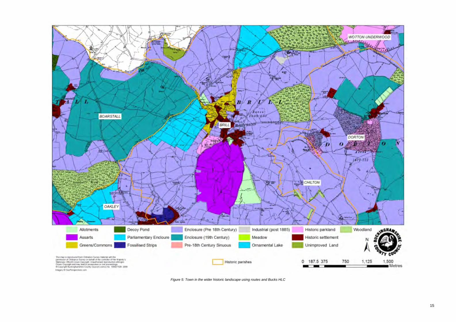
Figure 5: Town in the wider historic landscape using routes and Bucks HLC

16
Figure 6: Historic settlement pattern around Brill

Brill Historic Town Assessment
17
3 Evidence
3.1 Historic Maps
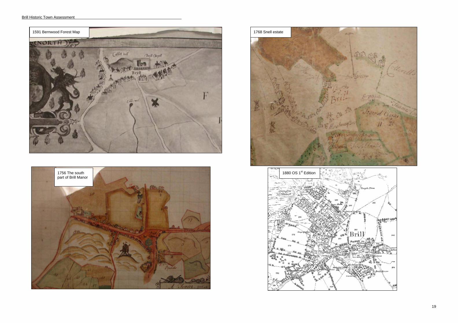
Characterisation for this project was primarily undertaken using the Ordnance Survey series of maps, from the OS 2” Surveyors drawing of 1813-18 to the current Mastermap data. Also used were the county maps of Jefferys (surveyed 1766-68) and Bryant (surveyed 1824), and the 1910 Valuation Survey map. There are a number of good quality maps illustrating Brill and Bernwood dating from the 16th century including a1590 map drawn as a part of a lawsuit to establish the glebe and tithes in Brill, Oakley and Boarstall due to the parish of Brill (Bendall S, 1993). Several 18th century maps of Brill Manor also survive, plus the tithe map of 1853.
3.2 Documentary Evidence
A full report on available documentary evidence, by Dr M Page of the University of Leicester, is included in Appendix 4. A summary of the evidence relating to the medieval landscape and society of Bernwood Forest has previously been produced by Dr Page (2002) as part of the Bernwood Ancient Hunting Forest Project. Much use has also been made of the Victoria County History for Buckinghamshire and a number of other printed works on the county. Broad and Hoyle’s paper on Bernwood is an invaluable secondary source on Brill in the context of Bernwood Forest. A couple of recently published histories devoted to Brill have been written by local people, Brillennium and A Portrait of Brill. The latter has been particularly useful in compiling the building history sections of this report. All the sources consulted for this report are mentioned in the Bibliography (see section 9).
3.3 Built Heritage
There are 54 listed buildings in the village of Brill including three Grade II* buildings. The earliest surviving building is the Grade II* All Saints Church, originally a private chapel whose earliest features date from the 12th century. Brill windmill dates to the 17th century and is also Grade II*. The meal beam in the mill has been dated to c.1685 using dendrochronology, although there have been several phases of alteration and restoration. The final Grade II* building is the 18th century Manor House on Oakley Road. The majority of the buildings (39) are listed with 17th and 18th century dates, but it should be borne in mind that all but recent listings are generally based on cursory inspection and surveys might show that such buildings contain earlier fabric.
Cruck construction usually denotes an early building. There are two buildings in Brill which have been identified as containing crucks (see Table 2) but, again, surveys might reveal more.
Address Cruck type Source 20 Temple Street True cruck C Lewis (BCC) 5 High Street True cruck C Lewis (BCC)
Table 2: Cruck buildings in Brill (Source: Vernacular Architecture Group)
The bar chart in Figure 8 shows the numbers of listed buildings by century, based on their list descriptions, and it is clear that the highest number are 17th century. This is common in north Buckinghamshire and not surprising since this was the period of the so-called “Great Rebuilding” of England when open-hall medieval houses were pulled down, or altered. Detailed measured surveys and/or dendrochronological dating are often required to establish if any early fabric has survived. The chart for Brill also shows a high number of 18th century buildings. This was a period when all-brick, rather than timber-framed, construction was coming in. There may be social and economic reasons for an apparent building boom in the 18th century but the ready supply of local bricks at Brill is also a likely factor. Further investigation by way of building surveys and documentary research is required.

Brill Historic Town Assessment
18
0
5
10
15
20
25
12th
Centur
y
16th
Centur
y
17th
Centur
y
18th
Centur
y
19th
Centur
y
20th
Centur
y
Figure 7: Listed Buildings by century
Brill Historic Town Assessment
19
1880 OS 1st Edition
1591 Bernwood Forest Map
1756 The south part of Brill Manor
1768 Snell estate

Brill Historic Town Assessment
20
Figure 8: Historic maps:
1853 Tithe Map
1760s Jefferys
1910 Valuation Survey

Brill Historic Town Assessment
21
Figure 9: Image of Listed Buildings by century.

Brill Historic Town Assessment
22
3.4 Archaeological Investigations
Owing to the importance of the village as a pottery and brick and tile production centre and its historic connections as a royal manor, there have been a number of archaeological investigations in Brill. Few of these have been formal excavations; most have been small-scale watching briefs, carried out on account of private developments within the village. These are listed below in date order of investigation.
Some of the headings in the accompanying table are self-explanatory but it may be noted that a distinction is made between those archaeological features identified which were originally simply ‘cut’ into the ground, for example ditches, as against ‘positive features’ such as a kiln which may have been set within a ‘cut’ but which were constructed (‘built’).
In almost all of the investigations the presence of sand or silty sand, occasionally with ironstone, was recorded immediately below the topsoil.
Some of the references cited (e.g. Jope 1953), are to readily-available printed works; others are limited-circulation reports, otherwise unpublished, which are available for consultation at the Historic Environment Record (HER).
BR1: Temple Farm NGR (Jope E, 1953) HER 04394 Finds Negative features (cut only) Environmental evidence
Large quantities of discarded pottery (Brill Ware)
None None Above ground structures None Positive features (above natural) Four medieval kilns (recorded as kilns A-D)
Circumstances of investigation Conclusion Preliminary report on excavations carried out in 1953. Source: Published article in Records of Buckinghamshire Journal Archive:
Four medieval kilns were recorded during the excavation at Temple Farm; three were superimposed on top of each other while a fourth was located a short distance away. All four kilns had two stoke holes. The earliest kiln appears to date to the late 13th century; two later kilns on the same site operated during the 13th and 14th centuries. The fourth kiln a short distance from the others was in operation in the mid 14th century.
BR:2 40 Windmill Street NGR (Farley M, 1979) HER 02129 Finds Negative features (cut only) Environmental evidence
Large quantities of discarded pottery (Brill Ware) Kiln furniture
Above ground structures None Positive features (above natural) post medieval kiln
Circumstances of investigation Conclusion Report by M Farley of salvage excavation of a post-medieval pottery kiln at 40 Windmill Street. Source: Published article in Post -Medieval Archaeology Journal Archive:
During redevelopment of land adjacent to 40 Windmill Street, a pottery kiln was identified. Restricted salvage excavation by BCMAS was later conducted on the site. Brick-built kiln identified as being c. 2.3m by 2m internally and comprising four flues. Approximate dating based on single piece of clay pipe stem suggested that kiln could not be earlier that late 16th century, however, the latter is now thought to be intrusive and the kiln is probably of late fifteenth-early sixteenth century date, see BR 30 below.
BR3: 75 Temple Street NGR (Farley M, 1979) HER 02235 Finds Negative features (cut only) Environmental evidence
Large quantities of discarded pottery (Brill Ware post- medieval to modern). Kiln furniture
None None Above ground structures None Positive features (above natural) 2 x 17th century possible kilns 1 x 19th century kiln
Circumstances of investigation Conclusion Report by M Farley of salvage Redevelopment of site uncovered large quantities of 17th century

Brill Historic Town Assessment
23
excavation of a post- medieval pottery kiln site at 75 Windmill Street. Source: Published article in journal Post Medieval Archaeology Archive:
pottery in two locations indicative of kilns or kiln stoke-holes with evidence of in -situ burning. The 19th century kiln comprised a circular brick-built kiln. Documentary sources indicate that the kiln (Thomas Hubbocks) continued to operate until the early 1860s while the buildings themselves survived into the early 20th century.
BR4: Prosser’s Yard NGR 6548 1405 (Cocroft W, 1987) HER 02153 Finds Negative features (cut only) Environmental evidence
Kiln furniture 17th century tile, some brick 2483 sherds Brill pottery (post-medieval) 1 coin (dated 1612)
Above ground structures None Positive features (above natural) 2 x18th century pottery kilns
Circumstances of investigation Conclusion Rescue excavations carried out in 1977 at Prosser’s Yard, Brill Source: Published article in Records of Buckinghamshire Journal Archive:
Two 17th century pottery kilns recorded during salvage excavations at Prosser’s Yard. A kiln site had been previously recorded here by the then owner in 1974. Both kilns were brick-built. Kiln 1 was a large structure and although only one flue was identified, it is possible there were more. Kiln 2 fired using a circular single flue system with no supports – this kiln was only partially excavated.
BR5: Temple Farm NGR (Ivens R, 1981; Ivens R, 1982) HER 04394 Finds Negative features (cut only) Environmental evidence
Large quantities of discarded pottery (Brill Ware)
Kiln F (robbed out remains only)
Above ground structures None Positive features (above natural) Kiln E
Circumstances of investigation Conclusion Preliminary report on excavations carried out in 1978 on kiln E. Source: Published article in journal Records of Buckinghamshire Archive:
Excavation intended to locate and re-excavate kiln E previously recorded in excavations in 1961. Geophysics on the same site also identified a number of other kilns in the area in addition to those already excavated. Kiln E: identified. It is suggested that it was covered by wattle and daub. Dating was confirmed as being between 1300-1350 AD. Kiln F: located in close proximity to kiln E, recorded as being largely robbed out. Thought to be on a similar alignment as kiln E. No evidence of workshops relating to the pottery sites has so far been found.
BR6: Temple Street NGR SP 6554 1412 (Yeoman P, 1988) HER 05293 Finds Negative features (cut only) Environmental evidence
124.46kg pottery sherds (Brill type ware) 84.62kg saggar sherds iron fragments
Kiln 1 Features: linear cut (undated), pottery dump Kiln 2 Features: 6 pits, 1 post hole. Other: 18th century pit
611g animal bone Above ground structures None Positive features (above natural) 2 fired clamp bases 2 kilns
Circumstances of investigation Conclusion
Report on excavations carried out in 1983 on a site on Temple Street. Source: Published article in Records of Buckinghamshire Journal Archive:
The earlier kiln (Kiln 1) was a brick built double-flue pottery kiln similar to those discovered at Temple Farm, the second kiln was a rectangular three-flue kiln that partially replaced Kiln 1. Site now The Lawns development
BR7: Brill Sports Club NGR SP 6561 1392 (Farley M, 1987) HER 00106 Finds Negative features (cut only) Environmental evidence
1 sherd pottery (Iron Age) Partial ditch (?Iron Age) Above ground structures None Positive features (above natural) None
Circumstances of investigation Conclusion Source: Published article in Records of Buckinghamshire Journal Archive: County Museum
Watching brief at sports pavilion near scheduled ancient monument, revealed a single sherd of Iron Age pottery in the fill of a ditch associated with the earthwork. Report includes a summary of other Iron Age pottery found in the immediate vicinity. Report suggests the

Brill Historic Town Assessment
24
earthwork might be an Iron Age hillfort. BR8: Magistrates Court , Temple Street NGR SP 6560 1408 (Farley, M, 1990: excavator A.Hunn) HER 05712
Finds Negative features (cut only) Environmental evidence pottery sherds (medieval)
ha-ha ditch (18th century) Above ground structures None Positive features (above natural) medieval tile kiln pottery kiln
Circumstances of investigation Conclusion Source: Records of Buckinghamshire 32: Archaeological Notes p. 149. Interim note only. Archive: County Museum
Trial trenching revealed part of a medieval tile kiln and an opposed flue pottery kiln, both dating to the 14th century. An 18th century ha-ha ditch belonging to Brill House (Thomas Saunders) was also revealed. Site now Godfrey’s Close
BR9: Land to the rear of the Sun Hotel NGR SP 6540 1401 (Murray J, 2001) HER 11647 Finds Negative features (cut only) Environmental evidence
664 sherds (late Brill- type ware ) 1 sherd tin glazed ware 16th-18th century) 1 sherd (possibly Potterspury 17th century) 1 sherd London stoneware (17th-19th century) tile & brick copper-alloy fragments slag fragments
Quarry pit (?for sand) including large deposit of waste pots, some inverted and stacked inside each other, ring stilt, slipware, 17-18th cent. Dump of blue-grey clay and charcoal
animal bone, shell, charcoal Above ground structures None Positive features (above natural) Drystone platform
Circumstances of investigation Conclusion Source: Unpublished archaeological document Archive: County Museum
Trial trenching. Finds from one trench indicate an as yet unlocated post-medieval kiln site in the immediate area.
BR11: 6 Highland Close NGR SP 65458 14046 (Mumford J, 2001) HER 06761 Finds Negative features (cut only) Environmental evidence
9 sherds ceramic building material (post- medieval) 6 pottery sherds (post-medieval)
Large pit or quarry (post-medieval)
Above ground structures None Positive features (above natural) None
Circumstances of investigation Conclusion Source: Unpublished archaeological document Archive: County Museum
Watching brief carried out in advance of redevelopment of site revealed evidence of a post- medieval pit or quarry as well as post- medieval pottery.
BR12: 28 Temple Street NGR SP 6553 1401 (Ford S, 2004) HER 08480 Finds Negative features (cut only) Environmental evidence
20 sherds pottery (medieval Brill type ware)
1 pit (early post- medieval) 2 pits (late post medieval)
Above ground structures None Positive features (above natural) None
Circumstances of investigation Conclusion Source: Unpublished archaeological document Archive: County Museum
Limited results from watching brief within area of known archaeological interest for medieval to modern pottery production. Pits were not intended as pottery dumps however and may result from extraction.
BR13: The Pheasant, Windmill Street NGR SP 6532 1409 (Moore J, 2005) HER 8532 Finds Negative features (cut only) Environmental evidence
4 sherds Brill type ware (13th-17th century) 1 sherd red earthenware (17th century) 3 sherds white earthenware (18th-20th century) 38 fragments ceramic building material
3 quarry pits (late medieval or Tudor), one with lumps of white clay
Above ground structures None Positive features (above natural) None

Brill Historic Town Assessment
25
Circumstances of investigation Conclusion Source: Unpublished archaeological document Archive: County Museum
Based on finds evidence the pits are thought to be medieval or Tudor in date and predate the quarry site. The function of the pits remains unclear but it is likely they were associated with the medieval pottery industry. The site was subsequently quarried for sand effectively destroying much of the evidence from the site.
BR14: Brill Social and sports club NGR SP 6560 1392 (Gilbert D, 2005) HER 00106 Finds Negative features (cut only) Environmental evidence
1 sherd prehistoric pottery 20 sherds Brill-type ware (13th-17th century) 17 sherds post medieval pottery (15th-17th century) 1 sherd late post medieval type ware (18th-20th century) clay pipe stems (post medieval) modern ceramic building material glass iron fragments copper alloy cast-pellet bell (post -medieval)
Possible course of ditch
Above ground structures None Positive features (above natural) None
Circumstances of investigation Conclusion Source: Unpublished archaeological document Archive: County Museum
Excavations at this site were limited due to access and space restricting the potential to date the Scheduled Ancient Monument. Archaeological results included limited prehistoric finds with more substantial medieval and post-medieval evidence.
BR18: Brill Windmill NGR SP 651 141 (Bonwick L, 2006) HER 02583 Finds Negative features (cut only) Environmental evidence
1 pit (modern) Above ground structures None Positive features (above natural) None
Circumstances of investigation Conclusion Source: Unpublished archaeological document Archive: County Museum
Suggested chronology for the post-mill. First built around 1685, rebuilt in the early 18th century and then again in the late 18th century. Minor alterations in the 1760s and in the mid 19th century. Dendrochronological dating undertaken as part of this survey suggests that the meal beam (core beam within the body of the mill) was made from a tree felled in 1685-86. Other beams within the main body date to the early half of the 18th century.
BR21: 48 Temple Street NGR SP 65603 14125 (Gilbert D, 2007) HER 09536 Finds Negative features (cut only) Environmental evidence
1 sherd Brill type ware (13th-17th century) 6 sherds post medieval pottery (17th-18th century) 2 sherds Rhenish type ware (15th century and later)
Above ground structures None Positive features (above natural) None
Circumstances of investigation Conclusion Source: Unpublished archaeological document Archive: County Museum
No archaeological features were recorded during the course of the watching brief; however some medieval and post-medieval pottery was recovered. See also in this report medieval sherds recovered from examination of an open trench a little to the east.
BR22: Recreation ground, Brill NGR SP (Gilbert D, 2007) HER **** Finds Negative features (cut only) Environmental evidence
7 sherds Brill type ware (13th century)
Above ground structures None Positive features (above natural)
Brill Historic Town Assessment
26
Brick & stone floor (19th century) 2 parallel wall foundations (19th century) 1 brick feature (19th century)
Circumstances of investigation Conclusion Source: Unpublished archaeological document Archive: County Museum
Whilst works were being carried out at BR21, an open trench was recorded in the neighbouring recreation ground. A rapid survey of the site revealed that at least two deposits had already been impacted on to such an extent that their function was undetermined. Both deposits contained pottery.
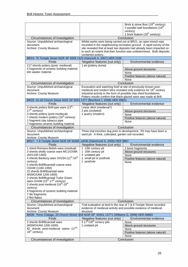
BR24: 75 Temple Street NGR SP 6559 1423 (Hancock A, 2007) HER 2235 Finds Negative features (cut only) Environmental evidence
117 sherds pottery (post- medieval) 5 fragments of ceramic building material kiln waster material
1 pit (pottery dump) Above ground structures None Positive features (above natural) None
Circumstances of investigation Conclusion Source: Unpublished archaeological document Archive: County Museum
Excavation and watching brief at site of previously known post -medieval and modern kilns revealed only evidence for 19th century industrial activity in the form of possible clay shed foundations. Pottery results confirm that black-glazed ware was made at Brill.
BR25: 16-18 Church Street NGR SP 6553 1377 (Mumford J, 2008) HER 09601 Finds Negative features (cut only) Environmental evidence
3 sherds pottery Brill-type ware (13th-17th century) 3 sherds pottery (post medieval) 7 sherds modern pottery (19th century) 1 fragment clay tobacco pipe 7 fragments ceramic building material
Linear ditch (medieval?) 2 pits (undated) 1 quarry (modern)
Above ground structures None Positive features (above natural) None
Circumstances of investigation Conclusion Source: Unpublished archaeological document Archive: County Museum
Three trial trenches dug prior to development. Pit may have been a sand pit. A thick, cultivated, garden soil recorded.
BR27: 7-9 Temple Street NGR SP 65465 14030 (Hammond S, 2009) HER 9887 Finds Negative features (cut only) Environmental evidence
1 sherd Romano-British ware (residual) 3 sherds shelly coarse ware MC1/OXBK (AD1100-1400) 4 sherds Banbury ware OX234 (11th-14th century) 5 sherds Brill/Boarstall coarse ware OXAW (1180-1350) 22 sherds Brill/Boarstall ware MS9/OXAM 1200-1600) 2 sherds Brill/Boarstall Tudor Green ware OXAM (15th-17th century) 2 sherds post medieval (16th-19th century) 5 fragments of ceramic building material 7 tile fragments 2 flint flakes
1 13th century pit 1 15th century pit 3 undated pits 1 small pit or posthole 1 posthole
2 bone fragments Above ground structures None Positive features (above natural) None
Circumstances of investigation Conclusion Source: Unpublished archaeological document Archive: County Museum
Trial evaluation at land to the rear of 7 & 9 Temple Street recorded evidence of medieval activity and possible evidence of medieval structure.
BR28: Penn Cottage, 20 Church Street, Brill NGR SP 65551 13771 (Williams G, 2009) HER 09893 Finds Negative features (cut only) Environmental evidence
2 sherds Brill/Boarstall ware (MS9/OXAM 1200-1600) 82 sherds post-medieval wares (17th-18th century)
3 17th/18th century pits 1 undated pit
None Above ground structures None Positive features (above natural) None
Circumstances of investigation Conclusion

Brill Historic Town Assessment
27
Source: Unpublished archaeological document Archive: County Museum
Pottery assemblage indicates a well-to-do household in the vicinity in the seventeenth and eighteenth centuries using some local ceramic but the majority non-local.
BR30: 7-9 Temple Street NGR SP 65465 14030 (Williams G, 2010) HER 9887 Finds Negative features (cut only) Environmental evidence
3 ?Neolithic flint flakes. Sherds: 3 shelly coarseware (OXBK), 1 Potterspury (MS6), 469 Brill/Boarstall (OXAM), 2 Sandy/shelly (NSC1), 4 Banbury ((OX234), 62 Brill/Boarstall Tudor Green (TLMS17), 3 trailed slip (PM5), 47 red earthenware ( OXDR), 11 Cistercian (PM15), 3 White earthenware (PM25), I Stoneware (PM28). Ceramic building material.
1 medieval pit and posthole, 3x 15c pits and 7 postholes, 7x 17c pits many intercutting, 3x 19c pits.
None Above ground structures None Positive features (above natural) None
Circumstances of investigation Conclusion Source: Unpublished archaeological document Archive: County Museum
An excavation at 7 & 9 Temple Street adjacent to the site of known pottery kilns followed an evaluation (BR 27 above). A number of pits were located many of which contained kiln waste of the 15th and 16th centuries including ‘saggars’ in which small glazed (Cistercian ware) cups were fired. Evidence for a simple workshop was also found.
BR 31: 15, The Green, Brill NGR SP 65725 13804 ( Fitzsimons, E 20****) HER 11642 Finds Negative features (cut only) Environmental evidence
Sherds: PM8 – 10 (17-18c); PM25 –2 (late 18-19c)
Undated pit; undated ditch 0.6m wide. Footings of early modern privy
None Above ground structures
None Positive features (above
natural) None
Circumstances of investigation Conclusion Watching brief on extension footings and drain. Source: Unpublished Archaeological Document Archive:
Unpublished archaeological document.
BR 33: Land at rear of Brae Hill. NGR SP 6528 1405 ( Havard , T 2008) HER 09943
Finds Negative features (cut only) Environmental evidence 4 sherds Brill-Boarstall medieval ceramic, 21 sherds post-medieval (mainly 19cent), animal bone, 1 ?worked flint, 2 pieces glass post-medieval
Two ditches (undated), one? clay pit medieval or later), one pit (post-medieval), stake holes (undated), foundation robber trench of former boundary.
None Above ground structures
None Positive features (above
natural) None
Circumstances of investigation Conclusion Source: Unpublished Archaeological Document Archive:
Three phases of investigation: a desk-based assessment, geophysical survey and trial trenches. Cottages mapped on site not located; a probable clay pit identified.

Brill Historic Town Assessment
28
Several archaeological investigations within the historic settlement listed below did not find any significant archaeological features, probably due to either the extent of modern redevelopment in the area, or to the limited nature of the archaeological activity.
Code Activity type Address NGR Date Summary
BR10 Watching Brief
18, The Lawns (Temple Street)
SP 6545 1420
July 2001 Negative – modern disturbance (Bashford R)
BR15 Watching Brief
Coronation Cottage, 20 The Green
SP 65680 13791
November 2005
Negative – no archaeological evidence (Pine J)
BR16 Watching Brief
Church of England Combined School
SP 6576 1407
February 2006
Negative – no archaeological evidence (Jacobs Babtie)
BR17 Watching Brief
4 The Manor House, Oakley Road
SP 65324 13732
July 2006 Negative – ground-works did not penetrate beyond modern disturbance (Taylor, A)
BR19 Watching Brief
Chapmans Lane & Tram Hill Rising Main
SP 6547 1495
August 2006 Negative – no archaeological evidence (Moore, J)
BR20 Watching Brief
Kings Ride Cottage, The Square
SP 6541 1383
November 2006
Negative – no archaeological evidence (Wallis S & Milbank D)
BR23 Watching Brief
52 Temple Street SP 6562 1414
May 2007 Negative – no archaeological evidence (Pine J & Mundin A)
BR26 Geophysics Brae Hill Road SP 6528 1405
March 2008 Negative – neither Gradiometry nor resistivity surveys resulted in any identifiable archaeological remains. However waterlogging of the site combined with modern debris reduced the effectiveness of the survey (Bunn D)
BR29 Watching brief
Kings Ride House SP 65385 13839
September 2009
Negative -
BR 32 Watching brief
Stable House, The Green
SP 6565 1373
October 2011 Negative – no archaeological evidence (Riccoboni, P)
3.5 Environmental Evidence
In assessing the potential for the survival of environmental remains, it should be remembered that an urban environment can provide extremes in preservation. On the one hand proximity to the groundwater table within a historic core may lead to anoxic conditions and therefore good preservation potential for organic materials whereas on the other hand frequent ground disturbance as a result of redevelopment and construction combined with modern pollution can also lead to extremely poor preservation of organic materials (French, 2003).
A number of archaeological observations within the village (noted above) have recorded a substratum of sand. This free-draining aerobic material is not a good medium for preservation of organic remains such as bone, and only small amounts have been recovered. Deeper-cut features that penetrate to the underlying clay, such as wells, would almost certainly be more productive. No formal sampling of archaeological deposits for environmental remains, such as seeds, has yet been undertaken in the village. A few cereal grains (undated) were recovered many years ago by Ian Rodger, a local resident, from a grave cut in the churchyard (see on).

Brill Historic Town Assessment
29
Figure 10: Location and extent of events within the town
Brill Historic Town Assessment
30
4 Archaeological & Historical Development
4.1 Prehistoric period (c.10,000 BC – AD 43)
It is likely that the prominent position of Brill, its free-draining easily-cultivatable soils and its nearby springs, will have attracted early use, but direct evidence for this is sparse and consists only of a few pieces of worked flint, all noted during the course of archaeological recording or by those with an archaeological background. Three locations within the village envelope have produced worked flint. This amounts in total to only eleven pieces but unusually the number includes five blades or blade fragments and a blade core (HER 2053, 2478, and 9887). This hints at a Mesolithic presence. The subsequent few thousand years are marked only by a single antiquarian find from the parish as a whole, a bronze palstave of middle-late Bronze Age date (HER 0528) whose findspot is not known.
It is not until the Iron Age that there is clear evidence of occupation within the village. All of this comes from close to the church and consists of finds of pottery, six pieces of which have been illustrated elsewhere. The pottery can probably be dated to around the fourth century BC. A tentative suggestion has been made (Farley, 1989) that there could be a link between the pottery and the earthwork (a scheduled ancient monument) which is prominent on the northern boundary of the churchyard in the playing field, and which could, perhaps, be part of a hillfort. However, there are a number of other possible interpretations and some of these are discussed further on. From a grave cut in the churchyard about four feet down, many years ago Ian Rodger retrieved burnt grain, identified as bread wheat. This was not dated but could conceivably have lain within an Iron Age feature.
The place name Brill, almost certainly originated in the pre-Roman period since it is an abbreviation of a name made up of the Celtic element “bre” and Old English “hyll”, one of only a handful of surviving words with a Celtic element in the county.
4.2 Roman period (AD 43 – 410)
At present the only direct evidence for any kind of Roman-period presence in or immediately around the village, are finds of coins. Of these only two fourth-century coins come from within the village envelope (HER 5216). Metal detector rallies held on fields east and north-east of the village, where the land slopes away abruptly, recorded a further six late-Roman coins but this is the kind of density which would be expected in land under cultivation at this period rather than being directly associated with settlement. The nearest firm evidence for settlement is between one and two kilometres distant from the village, and the nearest substantial Roman settlement is Alcester, south of Bicester, on Akeman Street, about eleven kilometres distant. However, there are two reasons why Brill could have been of interest during the Roman period; as a potential source of ironstone, which in the adjacent Boarstall parish appears to have been smelted at this time, and because of the springs, which on evidence from elsewhere during the Roman period and earlier, could occasionally become a focus for cult activity.

Brill Historic Town Assessment
31
Figure 11: evidence Prehistoric and Roman period

Brill Historic Town Assessment
32
4.3 Saxon period (AD 410 – 1066)
Evidence for the existence of Brill in the early and middle Saxon period is almost non-existent. Its Old English name ‘hill’ provides no indication of any kind of settlement here which might otherwise have been indicated, for instance, by a settlement suffix-element such as tun, present in Dorton and Chilton.
An interesting find made during a metal detector rally (referred to above) is, however, of the early Saxon period. This is part of a gilded copper-alloy saucer brooch dating to the late fifth or sixth century. From the same general area came a pair of tweezers possibly of similar date, now in private possession. A possible association between the two would be of interest (information from PAS).
Brill’s existence is first noted in AD 1066 (in Domesday, AD 1086) when it was in royal hands. By that date it was already a flourishing settlement. In order to have achieved this position it is likely to have been growing as a settlement since at least the early tenth century. An indirect clue as to its existence and status is that the adjacent parish of Wotton Underwood had its boundaries defined by a charter in the mid ninth-century (Gelling 1979). It has been argued that such a charter was necessary since Brill was a substantial royal estate (as it was in 1086) and that individual landholdings were being detached from it (Reed in Gelling 1979, 184, and Baines 1993). By the late Saxon period Brill would also have had an open-field system (see on). As previously noted, Brill lay at the heart of the royal forest of Bernwood. As late as the 14th century Brill was still owed services and renders by surrounding villages in a manner also considered to be characteristic of the caput of an ancient estate (Harvey, 1997).
‘Hundreds’ were important administrative units in the Late Saxon and early medieval periods. Brill lay within the Hundred of Ixhill, a hundred which at Domesday also contained fourteen other settlements. Four of these were in an area detached from the main hundred. Brill lay towards the northern boundary of the hundred. Although not a particularly significant place in other respects, Ixhill, some distance south of Brill, was obviously regarded as a readily identifiable and convenient centre for villagers to assemble for communal business from surrounding settlements.
The Forest
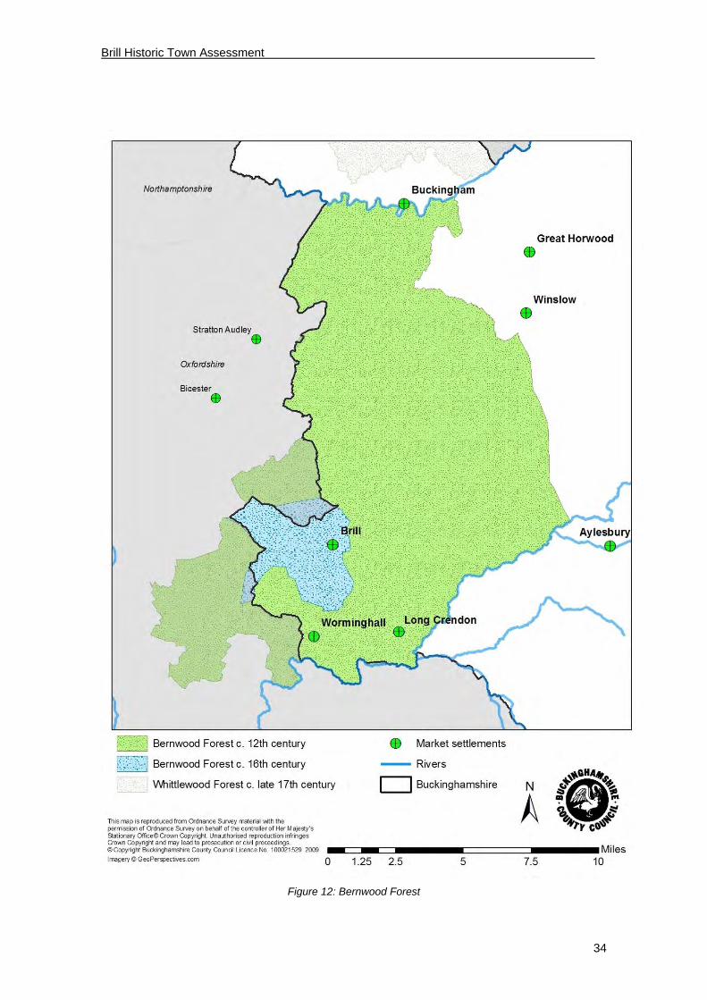
The earliest mention of Bernwood occurs in AD 921 in the Anglo-Saxon Chronicle, although the area recognised as forest must have existed for a considerable time previously. A perambulation of c.1219-1220 claimed that Henry II extended the bounds of Bernwood (the area subject to forest law) as far as the Great Ouse (Harvey 1997, 3, Map 3). At that time it would apparently have covered a vast area that extended east to the Padbury Brook, south to the River Thame and west to the River Ray. A perambulation in 1228 (VCH, II, 132) indicates that the extent had already been reduced, and another of 1298 (VCH II, 132), shows that the area subject to forest law had again shrunk considerably to an area not much larger than that known in the 16th century, composed principally of the parishes of Brill, Oakley and Boarstall.
The ‘forest’ would never have consisted entirely of dense tree cover but would have always included a number of villages, open fields, moors (marshy grassland) and ‘lawns’ (rough grazing land). Brill remained the chief settlement in Bernwood until disafforestation in the 17th century and a number of the villages within the former ancient forest area continued to offer services to it (Harvey 1997). The king’s forester was based at Boarstall with which Brill is intimately associated.
Edward the Confessor’s Hunting Lodge
Domesday contains no reference to a king’s house at Brill (see on), but since Late-Saxon and medieval kings were itinerant and as Domesday records that in 1066 the manor belonged to Edward the Confessor, it is entirely likely that there was a structure of some kind here in which Edward and his travelling companions could have stayed. The only, rather indirect, evidence for this, which must be treated with caution, is contained in versions of The Life of King Edward who rests at Westminster (Barlow 1962), a work dedicated to describing his saintly and pious character:

Brill Historic Town Assessment
33
“The glorious king ordered a royal palace to be built at Brill, whereupon a great crowd of rustics poured into the wood with axes…” A young man lost his sight during this process and in seeking a cure visited eighty churches before his sight was finally restored by the saintly king’s touch, nineteen years later at Windsor.
The Brill residence of Edward and subsequent kings is sometimes locally referred to as a ‘palace’. This is likely to be a rather grandiose description of what was a significant, but probably relatively modest, group of timber buildings, which served on the one hand as a base for hunting in Bernwood Forest, but perhaps as importantly, as a temporary resting place on a journey elsewhere. As later accounts clearly show, kings who did stop here did not linger and were often passing through from Windsor to the greater delights of Woodstock. Pinpointing the location of these Late-Saxon buildings would be of considerable importance in understanding the topography of Brill. A locally-planned geophysical survey could be most helpful in this respect. This subject of the kings’ house is returned to further on.
Brill Historic Town Assessment
34
Figure 12: Bernwood Forest

Brill Historic Town Assessment
35
Figure 13: Conjectural extent of Brill in the late Saxon period (11th century AD)

Brill Historic Town Assessment
36
4.4 Medieval period (1066-1536)
The Domesday reference
The Domesday survey of landholdings in England commenced in 1085 and was completed in 1086. It describes who held land before the Norman Conquest and who subsequently held it under King William. The Brill entry is as follows:
“Land of the king.
Brill was a manor of King Edward’s. It always answered for 20 hides. Land for 25 ploughs; in lordship 3. 19 villagers with 13 smallholders have 17 ploughs; a further 5 possible. 2 slaves; 1 mill at 10s; meadow for 20 ploughs; woodland 200 pigs. In total it pays £38 a year in white silver, and for the Forest £12 assayed and weighed; before 1066 it paid £18 at face value.”
So, King Edward’s Late-Saxon manor continued in royal hands. The revenue from the Norman estate (£38 pounds in white silver) was considerable. By comparison Aylesbury produced £66, Buckingham (including the church) £22, and Wendover £38.
The Domesday entry, in common with most Buckinghamshire entries, provides no information about a church or any other buildings.
The King’s House or hunting lodge
It is a reasonable presumption that the Norman and Angevin kings’ houses would have been on the same site as any Edwardian predecessor although they may perhaps have incorporated or replaced it. It is fortunate that a number of national records survive for works on kings’ houses. These have been assembled in Allen Brown and Colvin (1963) and have been used locally in publications by Bateson (1966) and Waghorn (in Croydon 1999).
The earliest record of a building relating to the manor is c.1155 when the existence of a barn 50 foot long by 30 foot broad, is noted (Fowler 1925). Other records indicate that building work was in progress in 1179-81 when a king’s chamber was being constructed and shortly afterwards the newly-erected chamber was being surrounded by a bank and ditch. In 1193-4 iron was being brought from Gloucester to repair the king’s houses. There are a number of references to visits by the king to Brill, to oaks being required for repairs here and elsewhere and to wine being brought from Southampton in anticipation of the king’s visit. In association with the king’s house there was a chapel (later to become Brill parish church), and there are references to a prison principally used for trespassers in the forest (VCH II, 136). The latter was of less significance than the goal at Aylesbury.
Work is intermittently recorded on buildings at Brill until 1337, when the king granted the estate to John de Moleyns.
The king’s house and its attendant buildings would clearly have been a focal point for the village. Determining the site of these would obviously be of considerable importance in determining the village layout as a whole. This brings us back to the surviving scheduled earthwork adjacent to the church, noted previously in the section on prehistory.
As noted above there is a references to the king’s chamber being enclosed within a bank and ditch and this provides a possible context for the earthwork. However, the current length of the surviving earthwork, or traces of it, are about 230m long which seems excessive for this function alone since the surviving earthwork clearly only forms the northern side of an enclosure for which there must have been a corresponding earthwork to the south. The present church, which contains Norman work within its structure and must have originated as the king’s chapel, would have also lain within this enclosure and presumably have been fairly close to the king’s house.

Brill Historic Town Assessment
37
Figure 14: Above: Earthwork from the air to the north of the church. Below: an indication of the its scale
Many years ago, Bateson (1966) drew attention to a map of 1591 depicting the village with ‘Bryll Chapel’ marked, and adjoining it to the west, a mound labelled ‘Castell hill’ (see Figure 9) around which houses were shown, forming a curve around the mound on the west and south side. The same curve is obvious on all later maps. The 1591 map is schematic and no documentary reference has been found to a castle of any kind at Brill, but nor are there references to a number of other known Buckinghamshire earthwork castles that were apparently thrown up in the twelfth and thirteenth centuries. A second possibility for the earthwork, therefore, is that it was once part of the bailey of a motte and bailey castle, of which the latter would be likely to have encompassed the kings’ houses. However, there is a third and later possible explanation for the earthwork (see on).
Brill Historic Town Assessment
38
The only other piece of evidence available at present relating to the location of the kings’ house is provided by Lipscomb (1847, 104) who, after noting the presence of ‘the embankments north and west of the church, says that the field adjacent to the church is “still called the Kings field, though scarcely remembered under that name”, but he appears to be the only authority for this since it is later known as Church Close (Sheahan 1862).
The Forest
The early history of the forest and of its rapid reduction in extent has been briefly noted above. The area of Bernwood around Boarstall, and the enclosures which were made there, has been extensively discussed by Harvey (in Broad and Hoyle 1997) but there has been no such detailed study of the enclosures close to Brill in the medieval period.
Enclosing areas of forest required the lord’s consent. For example, in 1256 Henry III gave permission to the prior and canons of Chetwode to enclose an area of arable land in Brill on account of the damage being done to crops by deer (Harvey 1997, 5). The process of enclosure is intimately linked to taking in previously uncultivated land from the forest for cultivation (or better management), but also for the transfer of land previously communally cultivated into the hands of a single landowner. The enclosure process is closely connected to the demise of the Late-Saxon and early medieval open-field system of agriculture.
Agriculture
In the medieval period, Brill, as other mid and north Buckinghamshire parishes, had an open-field system of agriculture; the manor had in total 42 available ploughs at Domesday.
Harvey (in Broad 1997) has tentatively mapped the open fields around Boarstall. Hoyle (in Broad 1997, 43) notes that “the evidence for open fields in Brill comes entirely from medieval sources which speak of virgates and offer the names of furlongs”, for example in an extent of the manor of 1252 (Salter 1930, 199-205). A study of Brill’s open fields is beyond this project but it may be noted that the same 1252 reference records that the manor had about 180 acres of arable. A slightly earlier mid-twelfth century account notes the storage of wheat, barley and oats in the manorial barn (Fowler 1925).
Fortunately it is not only documents which provide evidence for open fields. The strips resulting from this method of farming often still survive as individual ridges within the ‘ridge and furrow’ visible today in fields around villages in central and north Buckinghamshire. They can be particularly obvious on aerial photographs. Survival is much affected by later ploughing. Some isolated patches of ridge and furrow are visible around Brill, on the south-east and south-west sides, but two areas have also tentatively been identified within the town. The first derives from map evidence and is discussed below in connection with burgages (see on). It was suspected that the level area extending north and north-east towards Temple Farm would be a likely area for medieval arable cultivation and this seems to be confirmed by aerial photographs of the area now occupied by the cricket field (e.g. BCC HER ref 22090, and verticals of 2003 by UK Perspectives held by BCC). These appear to show strips aligned roughly north-south extending as far south as the cricket field earthwork although unfortunately the relationship between the two cannot be determined. By 1590 open fields had disappeared from around Brill (Harvey op cit, 43).
A persistent feature on maps of the eighteenth century (mainly those relating to the Snell estate), is the depiction of a streamside belt of land running south from the village from ‘Lids Wel’ (1591 map) towards Ixhill, which was clearly valuable pasture land. This is likely to have been an important resource in the medieval period.

Brill Historic Town Assessment
39
Brill as a borough
The Victoria County History has the following:
“There seems no doubt that a royal borough at one time existed at Brill, but by the mid-13th century it had been merged with the manor. At the eyre of 1241 the borough of Brill came by twelve men, and the town (villata) made fine of 20s before judgement….As late as 1316 Brill and Boarstall were returned as royal boroughs. These indications are strengthened by the 13th century extents which show half-acre and acre plots of ‘land built upon’ (terra edificata) which may represent the early burgages. The growth of the borough was arrested early.” (VCH IV, 15)
Harvey (in Broad 1997, 10-14) has discussed the decline of the borough by the fourteenth century. He notes a particular downturn apparently arising from the Black Death. A rental of 1353, five years after the arrival of the Black Death, shows 49 acres & four holdings vacant indicating probably about nine missing households.
Burgesses, who held land in boroughs, enjoyed a degree of independence from their manorial lords by paying money rent rather than giving services. Evidence for the former existence of a borough is often indicated in town plans by the presence of regularly-shaped blocks of land, such as the acre and half acre plots noted above. At nearby Thame where a ‘new town’ was created between the late twelfth and early thirteenth centuries, plots of about an acre in extent occur south of Cornmarket (Spavold and Gilman 2002, 43). Such plots can also be seen in Buckinghamshire towns, for example at Olney (Beresford 1967, 107). Where burgage plots were created, either for ‘new towns’ or as additions to existing settlements, the allocated plots often simply utilised the boundaries of former open-field strips, resulting in plots which in turn have a slightly sinuous outline. Typically strips could have a length of a furlong (220 yards). An acre was 220 x 22 yards.
The earliest Ordnance maps of 1813 and 1818 (in manuscript), and the tithe map of Brill of 1853, show only one place where a coherent boundary occurs lying even approximately a furlong (220 yards) distant from a street frontage. This was a hedge that ran roughly north-south for a distance of c.300m and enclosed a block of land which terminated just short of Windmill Street on the north-east side and fronted the High Street and part of The Square (see Fig ***) on the east. Its distance from the High Street varied between about 240 yards (220m) and 275 yards (252m). Within it the nineteenth century OS 25-inch maps show five long strip-shaped blocks (one curving on the later larger scale tithe map). The blocks are defined by boundaries about 25 yards (23m) wide, suggesting the former presence of arable open-field strips here. On the western perimeter the OS maps show part of a track accompanying the boundary which might once have been a baulk or headland (a plough-turning area). It seems likely that these units could well have been the framework of the twelfth to thirteenth century land allotment noted in the VCH. The buildings of the burgesses would have occupied the street frontage on the west side of Temple Street. A small part of the southern length of the western perimeter boundary still survives at South Hills, but the housing estate built between 1946-8 around Brae Hill Road (Brill Society 2003, 115), now occupies most of the former site of these probable strips.
There are other boundaries in the village which continue along the rear of more than one property and probably indicate early subdivision of a larger landholding, but none is as much as a half-furlong from the nearest road, so they probably do not date to the period of borough formation.
Markets and Fairs
Markets and fairs are closely associated with significant towns, particularly boroughs. VCH notes: “The tolls of a market and fair held at Brill at the beginning of August were accounted for by John Norton about 1317.” Presumably in recognition of an existing state of affairs, at a later date (1347), John de Moleyns was authorised to “hold a fair at his manor of Brill on the eve, day and morrow of the Translation of St Thomas the Martyr (7th July)”. Lysons (1813, 523) noted that a fair “is still held (though it scarcely deserves the name of a fair) on the Wednesday after Old Michaelmass-day”. It appears that the fair ceased shortly after Lysons’ reference since Lewis (1840, 326) says that the fair “has been revived within the last four years”.

Brill Historic Town Assessment
40
The 1591 map shows a cross on a stepped plinth, in the open area at the foot of the High Street now known as The Square. Hey (1996) suggests of such crosses that “Some are probably the remnants of those set up at the time of a grant of a market charter in the Middle Ages”. Taken with the possible evidence for burgage plots on the High Street, this indicates a likely place for Brill’s medieval market.
A fair would generally require more space and perhaps Brill’s medieval fairs were held on The Green, like their modern counterparts.
Manors
The following summary is taken primarily from the Victoria County History. A catalogue of the available documentary evidence relating to medieval manors is now available online via the National Archives Manorial Documents Registry produced in 2008 by the Centre for Buckinghamshire Studies and the National Archives. There is a note of those available for Brill Manor in Appendix 4.
The principal manor of Brill was the property of the Crown from before the Conquest until the 14th century when Edward II granted it to John de Moleyns. Brill thereafter descended with the Moleyns estate of Stoke Poges. During the king’s ownership the manor had a number of important custodians and was frequently linked with Boarstall. In 1544 the manor was sold to Thomas Dynham and formerly joined to Boarstall, both manors subsequently being linked with the Aubrey-Fletchers.
In addition to the Brill manor a Rectory Manor was recorded in 1276, and between 1362-1527 there was a separate or sub-manor based on Cleresplace near Ludgershall, possibly Clearfield Estate shown on a map of 1745 (CBS: BAS maps 22).
In the sixteenth century the abbot of Notley Abbey held considerable property in Brill (he occasionally received royal grants of wood from the forest), and for a period in the twelfth century land was held by the brothers of the hospital of Santingfield (Picardy).
Manor Houses
Commonly, but not inevitably, manorial holdings were accompanied by a manor house, and it is helpful from the point of view of village topography to know where these were sited. During the king’s tenure of the manor, his principal residence would have been near the church, as previously discussed, although the precise site has yet to be determined.
It has been presumed, that ‘The Manor House’ in Oakley Road, on grounds of the antiquity of the building, was the site of the manor house of the later principal manor. Sheahan (1862, 341) for instance notes the existence of “The ancient residence at the south end of the village, called the Manor House”. RCHM (1913, 64) records that it contains structural evidence of sixteenth century or earlier date, and VCH (4, 15) notes that the house may have developed from a “half-timber house of the late fifteenth century”. Although it would seem a likely candidate to be the principal house after the manor’s alienation from the crown, there is some evidence that this may not initially have been the case.
The Victoria County History (IV,16) notes that:
“In 1563 there was a capital messuage on the lands called Harehill, Halehill, or Hall Hill. The site of the manor and lands were sold by John Dynham to William Belson in 1587, and he and his heirs had a capital messuage here in the 17th century”.
A map of 1713 depicts lands in Brill owned by a Belson. It shows a group of buildings contained within a walled boundary listed as “The House and Garden”, which are sited roughly where Waterloo House now stands. Snell later acquired the Belson land; Sheahan (1862, 341) states that the transaction took place in 1756. Snell made a copy of the 1713 map in 1756. In the same area as shown on the 1713 map he marks “Here stood the late Mr Belson’s house now West’s by purchase” and outside the area is a note (presumably added later) “and since bought by W. Snell”. The 1756 Terrier gives the area of this site as 1a 2r 10p and states that this was part of the estate of the late Maurice Belson not bought by Thomas Snell as part of the purchase from Belson’s son, Jonathan. An attached trapezoidal piece of land shown on the

Brill Historic Town Assessment
41
1713 map (later Summer House Orchard) is still evident on modern maps and can be used to locate the plot. The present Manor House is shown and then named on the later Snell map (although not on the earlier one) as “Snell’s House”.
One possibility is that is that the 1713 ‘house and garden’, later identified as Belson’s, had been the site of Brill’s principal manor house but that it had fallen into disuse or proved unsuitable, and that Belson’s successor (Snell or his predecessor), had simply moved across the road to the present Manor House, a house itself of some antiquity. As a Belson had acquired the site from Dynham in 1563, the manorial status of the 1713 site can possibly be directly linked to the grant by Edward II to John de Moleyns, who (see ‘Manors’ above) had sold the land to the Dynhams. The original owner of what is today called ‘The Manor House’ has not been determined. Further research on this subject would be necessary to test this hypothesis.
This suggestion is, nevertheless, complicated by the fact that the only significant building shown on the 1591 map of Brill and Oakley (albeit not necessarily accurate) is not on the site of Waterloo House (the Belson house site), but slightly further to the east. The building, a double-gabled house, fronts the green but is shown immediately east of the Thame road. The 1713 map also shows a building here in a similar location. However, Snell’s ‘actual survey’ of 1768 (whose accuracy may be open to question) shows no building here, but instead shows one (with two chimneys) on the opposite (west) side of Thame Lane, also fronting the green, and a short distance from Waterloo House, labelled ‘Gander Hall’. These could all indicate the same structure but the house/houses do appear to be distinct from the Belson property previously noted. The manorial affinities, if any, of this other building/buildings, are not known.
There has been a watching brief (BR 28) and an evaluation (BR25) in Church Street, in the general area of the possible houses. The former located three pits (unexcavated) of seventeenth-eighteenth century date. Pottery finds from superficial deposits are “typical of a fairly well-to-do household” of the date and pre-date the cottages. It seems likely that the pits relate to one of the buildings noted above.
Finally, the 1713 map shows one other building which might have some early significance. This is a house which is set back from the east side of the present Temple Street at the north end, roughly in the vicinity of the present Temple Farm. The unnamed building apparently has quite a large piece of land attached to it called “Eles home close”. On the 1768 map the house is named as “Eeles Hame”. Although ‘close’ field names are common, ‘home close’ names are frequently commonly associated with locally significant buildings.
Brill Historic Town Assessment
42
The Brill/Boarstall medieval pottery industry
The existence of a medieval pottery industry in Brill is evident in 1210-1220 from the personal names Sampson le Poter and Walterus le Poter. The existence of kilns was first established by Jope (1953) who excavated several near Temple Farm. Other work in the locality has shown that nearby Boarstall was also, for a period, an important production area, hence the revised type-name for the ware which now also appears to have been produced at Ludgershall.
Since Jope’s pioneering study, his kilns have been re-examined and the results published more fully (Ivens 1982). Part of a kiln, probably late medieval, has also been discovered in Temple Street (Yeoman 1988). A further example, dating to the end of the medieval period (the late fifteenth century) or the beginning of the post-medieval period, has been discovered in Windmill Street (Farley 1979). The walls of the latter were of brick. An innovation here was the potter’s use of ‘saggars’ to protect small glazed vessels, such as cups, from the flame. More recent work in Temple Street located pits which contained much similar waster material indicating the presence of a further kiln of the period in the vicinity. Finally, part of a tile kiln and part of an opposed-flue pottery kiln, provisionally dated to the fourteenth century (BR 8), were discovered in an evaluation but no final report is available.
The discovery of sherds of pottery alone is, of course, insufficient, to demonstrate the presence of kilns. Additional evidence is required, such as sherds being stuck together through a misfiring (so-called wasters). Two further locations within the village have produced medieval wasters, one not far away from Jope’s kilns at The Walks [HER 0676] and another, a single waster from a field adjoining Jope’s kilns on the east. Waster material from the allotments at the south end of the village [HER 2478] is, so far, the only indication of medieval kilns beyond the north end.
Excavations in and around Oxford have shown how successful the industry was in supplying its wares to the city, from the thirteenth-century onwards. This work has also shown the full range of products made in the Brill-Boarstall kilns and has helped to refine its dating (Mellor 1994). The earliest Brill-Boarstall products to be found in Oxford certainly pre-date 1231 but, as noted above, the industry certainly commenced earlier than this, and possibly in the late twelfth century.
The most impressive products are thin-walled finely glazed jugs, but considerable numbers of cooking pots, bowls, skillets etc, were also produced, as well as unusual pieces such as aquamanile (animal-shaped liquid containers). Many complete vessels made in the Brill area are in the Ashmolean Museum and others in the County Museum, Aylesbury, having been recovered from medieval rubbish pits, wells etc. in the town as well as from villages in the Vale and farther afield. Mellor (1994, p.114) suggests that the inspiration for the potters came from French ceramic. She also notes that France could have been the source of the copper oxide used beneath the lead glaze, which in turn must have been traded from a considerable distance.

Brill Historic Town Assessment
43
Figure 15: Left: Medieval Brill kiln pottery. Right: Baluster type jugs from the Ashmolean museum
The quantity of vessels produced was enormous. Jope calculated that there were the remains of about 20,000 pots from the waster material around his kilns and that represents only spoiled pots. The actual production total from his kilns, he suggested, could be “something approaching a quarter of a million” (Jope 1953, 40).
The medieval pottery industry developed in Brill owing to a combination of factors; accessible wood, good potting clay and, probably, indirect royal patronage. Of these the suitability and accessibility of the clay may be the most important. Sources of good potting clay which needs little treatment are not common and Brill is fortunate that variable beds of Purbeck clay (see 2.1) outcrop just below the crest of the hill. Plentiful clay was observed, for instance, during a recent housing development adjacent to Brae Hill.
It is most unlikely that the discoveries noted above represent the total number of medieval kilns originally sited around the village. Predicting the location of others is not easy, but as noted above, discoveries so far suggest that it was the clay nearest to the summit of the hill that was most sought after. Further distant there appears to have been another suitable source at Ludgershall (Blinkhorn and Saunders 2002/3) and certainly another at Boarstall (Farley1982).
Pottery kilns of later periods will be noted further on.
Brick and tile manufacture
The production of bricks and tiles in the medieval period has been less well documented than the products of the pottery industry, although Pike (1995, 16) notes that in 1465/6 two loads of bricks were supplied from Brill to Tackley’s Inn, Oxford. Bricks, of a kind, were, however, used in one of Jope’s thirteenth-fourteenth century kilns and certainly in the later medieval Windmill Street kiln. A greater range of clays can be used for making bricks and tiles than for making pots. The extensive outcrops of Kimmeridge Clays would be quite suitable for the former.
An excavated brick/tile kiln of the early sixteenth-century will be noted further on.
Other trade, mills and industry
One mill was recorded at Domesday in Brill. All of the mills at this period were watermills; windmills were not introduced into England until the twelfth century. Field names and other evidence indicate the location of a watermill on Mill Brook, south of the village not far from Little London. The stream which fed the mill is depicted on the map of 1591 previously noted. This may be the site of the Domesday mill.
By 1252, Brill certainly had also had one windmill on the manor (Harvey in Broad 1997, 3). One is shown on the 1591 map south-east of the village. Its location is confirmed by field names on a later Snell map. This is a likely candidate for the medieval mill; however, later there were two mills on the Common (see post-medieval synthesis).

Brill Historic Town Assessment
44
Inns and Taverns
No references to any medieval inns or taverns have been found. Brill was not on any major thoroughfare but as the administrative centre of the Bernwood Forest it would need places for visitors to lodge and take food and drink.
Church
Brill’s church, dedicated to All Saints, was not a parish church during the medieval period. There is no doubt that it commenced life as a royal chapel attached to the king’s house complex. The Prior of Chetwode, for instance, had to supply a chaplain for the king’s chapel at Brill in 1251 (VCH IV, 18). In the 12th century both King Stephen and Queen Maud gave the chapel to St. Frideswide’s Priory, Oxford which also owned the church at Oakley. Oakley was the mother church to Brill and Boarstall, and whilst the chapel at Brill was a royal chapel presumably the residents of Brill had to worship at Oakley. St. Frideswide’s continued to hold the chapel at Brill, and appoint its curates or chaplains, until the Dissolution of the Monasteries.
The early chapel is likely to have been made of timber. The present stone church was built around 1120 and consisted of a nave and chancel. The tower was added early in the 15th century (RCHME). The church was to remain aisleless until the 19th century.
Figure 16: All Saints Church Brill

Brill Historic Town Assessment
45
Secular Buildings
No secular buildings in Brill are listed as being of definite medieval date but there has been insufficient survey work or research to establish if any of the standing buildings contain pre-1500 fabric. The most likely candidates appear to be The Manor House and those buildings known to contain cruck trusses – 20 Temple Street and 1-5 High Street. Several buildings are said to be 17th century but might well be found, on close inspection, to contain earlier fabric. Many timber-framed houses have been re-fronted or re-cased in brick, Brill’s ubiquitous building material. Measured surveys, supported by dendrochronological dating, would be welcome.
The Green
Discussion of The Green has been left until this late stage since it relates most clearly to the subsequent section on the development of the village’s plan. Brill’s green appears to have been first labelled as such on Snell’s map of 1768.
Although greens are presumed to be an important common-land component of villages, not all villages have them and the date and method by which they emerged seems to be very variable. Some village ‘greens’ in Milton Keynes, for instance, have earthworks upon them, indicating former occupation.
The earliest useful map of the village, of 1591, does not really indicate a distinct ‘green’, but rather a broad thoroughfare leading from what came to be called The Square and narrowing as it passes the church and heads out of the village towards Dorton.
Initially, the green was probably not a completely enclosed space, rather just a piece of common land adjacent to the town. Its shape is likely to have been influenced by the presence of the royal site and chapel on the north side (accompanied by the southern section of the associated earthwork enclosure which has not, to date, been located on the ground). The road through towards Dorton would have needed to skirt the south side of the royal enclosure (whatever form it took). The east end of the green area would probably not initially have been closed off. At some point, probably late in its history, the Dorton road seems to have been diverted north, probably owing to an enclosure which contained a building (see for example the Tithe Map).
A few significant houses located near the Thame road which leads off the south side of The Green have previously been discussed under ‘Manor Houses’, one of which shown on the 1713 map is on the southern side of the green, fronting Thame Road. On the same map there is a house in the south-east corner, and one in the north-east corner of the green, but with plenty of space between them. That Brill House with its stables fronting the south side of the green and with a fine view to the south, could be constructed in 1770 with generous grounds (see on), may indicate that medieval settlement was not dense here although there may have been more than one large house in the vicinity (see earlier section).
The Tithe map of 1853 (see Figure 9) shows what are clearly encroachments onto The Green. For example, the block occupied by the Red Lion; a group of buildings on the east-south-east side, and others to the south-east of the church, none of which is a substantial property. The church may also have extended its graveyard in the same direction. These encroachments may largely be of post-medieval date.
Town layout
The elements to be taken into account in considering the possible layout of the medieval settlement have now been outlined. These include: the proximity of open fields; the presence of the king’s house and chapel; the location of burgage plots; the possibility of a significant house near The Square; and the existence of clay-based industries, certainly to the north and probably to the south.
The earliest available maps of the sixteenth century are of course schematic. The more detailed maps of the eighteenth century give some clues to the extent of the built-up area of the town at that time, but even these reflect the particular interests of those who commissioned them. For example, a map of 1756 shows housing along both sides of Temple Street for some

Brill Historic Town Assessment
46
distance north past Windmill Street, but a later map of 1768 shows very few houses extending past Windmill Street. Nevertheless, the village outline depicted on the sixteenth-century map is very close to that shown on eighteenth-century maps; there is little evidence for substantial change over the centuries, suggesting stability in the plan.
The area occupied by the kings’ houses and probably the associated earthwork (whatever its character), must have formed the nucleus of the Saxo-Norman village. The present curve of the building line around the southern part of the High Street and Church Street seems likely to have had a strong relationship to the royal structures and any associated earthwork. However, there is good reason to doubt that what is apparent today is a precise match since the projected trajectory of the existing earthwork (presuming that it was in existence) indicates that the buildings which form the curve would have been built upon its line, rather than being contained within it. In addition, the arc defined by the present buildings and the street would, at the east end, run through the middle of the church itself, whereas the church clearly must have lain within any enclosure in use in the medieval period. There is just one piece of map evidence that contradicts the apparent curvilinear nature of the earthwork; the first edition 1” OS map (c1834) depicts an L-shaped form west of the church (not a building), possibly indicating two sides of a rectilinear moat. This feature deserves serious consideration but the same map also shows a double row of buildings apparently in the middle of the High Street, an arrangement which is not shown on any other map so its accuracy does seem to be in question.
Finally, the apparent presence of medieval or earlier open fields (strip fields) on the land immediately adjacent to the earthwork on the north side may be noted.
The road that was later to become the present High Street was clearly a key feature of the medieval town. It is likely to have been on the exterior of the royal precinct. If the suggestion that there were initially strip fields on the west side of the High Street that were later turned into burgage plots (see above) is correct, then obviously in the early development of the village, perhaps in the twelfth century, there must have been open land on the High Street’s west side.
Once buildings were in place the future form of the village would be established and probably at the same time, a clearer area would have been defined for the market (the triangular shape of The Square is reminiscent of the market at Olney). The erection of the market cross would indicate official approval. The Square’s south side, it has been argued, may have eventually become the site of a manor house. Further east some building may have been established at the commencement of Thame Road, but the rest of ‘The Green’ with the Dorton road going through it was probably open common land.
To the west of The Square, occupation seems to have terminated with what was subsequently called ‘The Manor House’ on the Oakley Road. The Manor Farm, further down the road, is likely to have been created later.
The High Street continues north into what is now Temple Street. The presence of a possibly significant building in the Temple Farm area has previously been noted. By the 1713 map both sides of the road seem to have been built up, but at present there is no indication of the date of this occupation. However, it may be noted that at least a dozen properties on the east side share a common rear boundary. This may indicate construction on one block of land at a similar time, possibly in the post-medieval period. The north side is not far from medieval kilns and clay pits which may have constrained development a little. There are a number of similar blocks of land in Brill adjacent to the High Street and Temple Street which could indicate particular development phases, probably from the village’s former open fields.
The final road to consider is Windmill Street which leads out onto the common (and of course the windmills). The probable existence of a block of medieval open-fields south of Windmill Street and west of the High Street has previously been noted. The earliest map showing the street (1713) indicates houses only on the north side. In the late medieval period there was at least one kiln on the north side so there may not have been any domestic housing. It is not clear whether buildings (possibly later) on the south side of Windmill Street would have butted up against the boundary of one of the possible burgage plots previously suggested, or whether they themselves encroached on a single east-west open-field strip abutting those plots on the north side.

Brill Historic Town Assessment
47
Figure 17: Possible extent of the town in the medieval period

Brill Historic Town Assessment
48
4.5 Post medieval period (1536-1800)
The final stages of enclosure - disafforestation
The process of enclosure has been studied in some detail by Hoyle (in Broad 1997). The forest was being enclosed both for coppicing and pasture.
“From the middle of the sixteenth century onwards there is copious evidence that the wooded area was being nibbled away”. Of over 6,500 acres of forest about three-quarters was in private hands.
Finally in 1632 “The forest as a legal entity was ended…its staff were compensated, the remaining crown lands sold. The timber cover had largely gone by 1635”.
The presence of a separate ‘park’ less than a kilometre south east of the town at Parkpale Farm is worth noting. This is almost certainly the park shown as ‘Phillipenhe Park’ on the 1590 Forest of Bernwood map, abutting the Forest boundary east of Brill and west of Dorton and Chilton. Hoyle in Broad (1997, 41) notes that the common waste of Phippenhoe had been enclosed and made into a park by John Croke in 1552-4.
Hoyle notes that in 1585, in comparison with Boarstall and Oakley, Brill had a much higher ratio of cottagers to landowners “suggesting that cottage building had been tolerated if not actually encouraged by the Brill landowners”. This is likely to have had an effect on the later appearance of the village itself.
Town layout
Figure 18: Estimated population - Brill parish c.1522-1851 (Broad 1997 p.82)
The above chart is based on figures estimated by John Broad from various sources from the 1522 Military Survey onwards – details of his sources are given in page 82 of Broad & Hoyle, 1997. Since they are for the parish they will cover a wider area than that studied for this report. The population clearly doubled over the course of the 16th century and fell, almost as dramatically, in the 17th century when it levelled before rising even more steeply through the 18th century.
The reasons for these fluctuations and whether they were unusual for the region are matters beyond the scope of this study. Broad makes the point that “forest landscapes have been seen as areas of buoyant population growth, sustained by a combination of early marriage and relatively high fertility made possible by a high level of available agricultural resources, particularly common rights, and a tendency to attract migration from less favoured areas.”
Population
0
200
400
600
800
1000
1200
1400
1522 1586 1603 1622 1662/71 1676 1706/12 1801 1851

Brill Historic Town Assessment
49
(Broad, 1997, 82). The natural corollary seems to be that the disafforestation, in effect enclosure, would be a factor in the fall in population seen between 1622 and 1662. However this also happened to coincide with the Civil War, which hit Brill hard (see on).
For the purposes of this report these figures beg several questions relating to the built environment and the layout of the town. Where were the extra people housed during the population booms of the 16th and 18th centuries and what happened to surplus accommodation during the population decline of the 17th century? Whilst the relatively high number of 18th century listed buildings is understandable in the light of these population swings, how can the preponderance of listed buildings with 17th century dates be explained? The accident of survival is one factor to be considered but analysis, informed by detailed survey of the present building stock, is required for a proper consideration of these questions.
The elements influencing the layout of the medieval village have been discussed above. The documentary evidence for this period depends on estate maps prepared for the Snell family, who clearly became major landowners in Brill during the 18th century. Estate maps are, by definition, selective so their completeness, as well as the standard of mapmaking, is questionable.
The location of surviving buildings of this period seems to correspond fairly closely to that presumed for the medieval development indicated on the map of 1591. It is likely that the number of isolated brick and tile kilns operating on the Common to the north and west of the town will have increased during this period. The absence of Windmill Street from the 1591 map has already been discussed. The extent of its buildings is not clear during the medieval period but this road would undoubtedly have assumed greater importance as the brick and tile making industry developed on the Common. A few surviving buildings on the Common itself appear to date from this period. Other new developments from the sixteenth to eighteenth centuries may have included development around the Green, including the establishment of larger houses such as Brill House and a certain amount of encroachment upon it. Elsewhere infilling may reflect the range of occupations established here (see on). At the north end of the village the landscape around Temple Street would have been much affected by the construction of another ‘Brill House’, now demolished (see on).
Trade, mills and industry
Broad (in Broad 1997, 84), notes that in the late eighteenth-century Brill had “the greatest range of occupations in Ashendon hundred…only slightly fewer than more obviously urban communities such as Great Missenden and Wendover.” Late eighteenth-century occupations are conveniently listed in the Posse Comitatus (Beckett 1985). Most of these could have been conducted from ordinary houses and would leave little archaeological trace. The exceptions, requiring special premises, would be the six blacksmiths, a maltster, a currier, two millers, the governor of a workhouse, one potter and four brickmakers (see on for the two latter).
As only two millers were listed in the Posse Comitatus and two windmills of this date are known, it is likely that the watermill, previously noted in the Medieval section, was no longer functioning. Both of the windmills shown on the 1768 estate map are on the Common and are post-mills. There are a number of photographs and drawings of these mills which were still standing in the nineteenth century and one of which has been recently restored (e.g.http://www.buckscc.gov.uk/bcc/museum/ea_buckinghamshire_photos.page?: ph Brill 14; Croydon 1999 and Bonwick 2010). The surviving mill was probably constructed in 1768 (Bonwick 2010, 80). The Snell map of that date refers to “a mill – W.S. (presumably William Snell) bt. of millwright & rebuilt”. Stanley Freese oversaw restoration work in the 1940s and the current roundhouse was built in 1948 (Portrait of Brill, 82).
A third windmill (previously noted in the Medieval section) was depicted on the 1591 map a short distance down the Thame Road. It was clearly present at the beginning of this period but by the time of Snell’s map of 1768 its site is indicated only by the field names Mill Piece and Mill Dean.
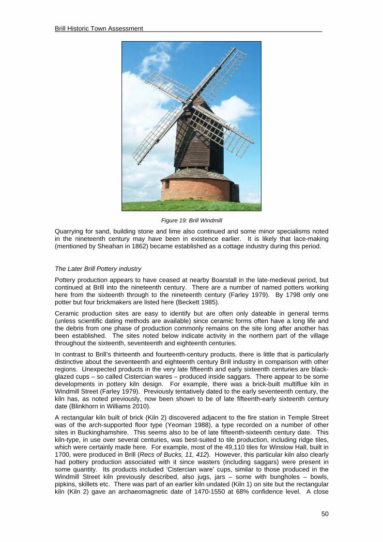
Brill Historic Town Assessment
50
Figure 19: Brill Windmill
Quarrying for sand, building stone and lime also continued and some minor specialisms noted in the nineteenth century may have been in existence earlier. It is likely that lace-making (mentioned by Sheahan in 1862) became established as a cottage industry during this period.
The Later Brill Pottery industry
Pottery production appears to have ceased at nearby Boarstall in the late-medieval period, but continued at Brill into the nineteenth century. There are a number of named potters working here from the sixteenth through to the nineteenth century (Farley 1979). By 1798 only one potter but four brickmakers are listed here (Beckett 1985).
Ceramic production sites are easy to identify but are often only dateable in general terms (unless scientific dating methods are available) since ceramic forms often have a long life and the debris from one phase of production commonly remains on the site long after another has been established. The sites noted below indicate activity in the northern part of the village throughout the sixteenth, seventeenth and eighteenth centuries.
In contrast to Brill’s thirteenth and fourteenth-century products, there is little that is particularly distinctive about the seventeenth and eighteenth century Brill industry in comparison with other regions. Unexpected products in the very late fifteenth and early sixteenth centuries are black-glazed cups – so called Cistercian wares – produced inside saggars. There appear to be some developments in pottery kiln design. For example, there was a brick-built multiflue kiln in Windmill Street (Farley 1979). Previously tentatively dated to the early seventeenth century, the kiln has, as noted previously, now been shown to be of late fifteenth-early sixteenth century date (Blinkhorn in Williams 2010).
A rectangular kiln built of brick (Kiln 2) discovered adjacent to the fire station in Temple Street was of the arch-supported floor type (Yeoman 1988), a type recorded on a number of other sites in Buckinghamshire. This seems also to be of late fifteenth-sixteenth century date. This kiln-type, in use over several centuries, was best-suited to tile production, including ridge tiles, which were certainly made here. For example, most of the 49,110 tiles for Winslow Hall, built in 1700, were produced in Brill (Recs of Bucks, 11, 412). However, this particular kiln also clearly had pottery production associated with it since wasters (including saggars) were present in some quantity. Its products included ‘Cistercian ware’ cups, similar to those produced in the Windmill Street kiln previously described, also jugs, jars – some with bungholes – bowls, pipkins, skillets etc. There was part of an earlier kiln undated (Kiln 1) on site but the rectangular kiln (Kiln 2) gave an archaeomagnetic date of 1470-1550 at 68% confidence level. A close

Brill Historic Town Assessment
51
association between tile manufacture and pottery making has also been seen in a kiln at Ley Hill near Chesham. The picture is complicated by the presence here of part of a slightly earlier kiln on the site.
On the west side of Temple Street and south of the brick kiln noted above, another kiln turned up in a deep trench during construction of houses in what was formerly Prosser’s Yard. This partially-investigated rectangular brick-built kiln (Cocroft 1985) was unusual in that its base was 2.5m below ground level. It appears to have been superseded by a circular kiln. Saggars and other kinds of kiln furniture were present. The ceramic has been dated late seventeenth to eighteenth century although it has been suggested that an earlier date is likely. A third kiln was reported by Eric Prosser to have been previously discovered in the yard.
A very short distance to the south on another part of Prosser’s Yard, a small excavation following an evaluation (BR 30) on a house-construction site produced a workshop and a number of pits containing kiln waste including two dumps of saggars probably dating to the early sixteenth century. Pottery from the site as a whole suggested that ‘the site was lightly occupied from not long after the Norman Conquest until the thirteenth century, and then abandoned until it became utilized for potting in the 15th century’ (Blinkhorn in Williams 2010). It is likely to be part of the same pottery complex above.
Finally, on the south side of Windmill Street (BR 9) a substantial amount of kiln waste, including pots stacked one inside the other, many being slip-decorated, was found; the whole probably dates to the eighteenth century. The location shows the group must be from a kiln site separate from those previously identified.
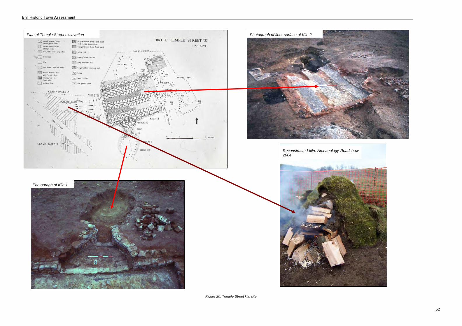
Brill Historic Town Assessment
52
Figure 20: Temple Street kiln site
Plan of Temple Street excavation Photograph of floor surface of Kiln 2
Photograph of Kiln 1
Reconstructed kiln, Archaeology Roadshow 2004
Brill Historic Town Assessment
53
Roads & Turnpikes
None of the local roads was turnpiked in this period; indeed Brill was never on a turnpike road.
Church
After the dissolution Henry VIII endowed his college at Oxford (formerly Cardinal College, and later to become Christchurch) with the churches at Brill and Boarstall. It is not altogether clear when Brill became a parish in its own right. In 1680 it was recorded that there was neither house nor glebe belonging to the Minister (Lipscomb, 109). There were disputes about payment of tithes. By 1708 Sir John Aubrey had become the lay rector and his lessee took proceedings to recover tithes saying that Brill and Oakley were distinct parishes; Aubrey himself took further proceedings in 1784.
During this period the parish church would have looked quite different from its present appearance. By 1800 the church was still aisleless and the external roof of the chancel was higher than that of the nave, so the top of the tower stood considerably higher than the nave roof. In the 18th century galleries were added inside and there was a rather curious arrangement with an external stone staircase by the side of the south porch giving access to the gallery at the west end through a window opening!
Sir John Aubrey remedied the lack of a parsonage house when he built The Old Vicarage (3 The Square) in 1773 (Pevsner, 191). It is puzzling that Sheahan, writing in 1862, records ‘There is no Parsonage House’. According to Brillennium (page17) it was built on the site of an old Church House.
Inns and Taverns
“The first record of ale being sold in what is now the Red Lion is in 1731” (Brillennium, 50) although records of the property are said to date back to 1587. It was then called “The Pointer”. Today The Red Lion is one of Brill’s two remaining pubs. The building at The Old Swan (18 The Green) is said to date to about 1585 (Brillennium, 50) but there is no record as to when either of these two first became inns or alehouses. The Swan ceased trading in 1920. The several other pubs or beerhouses recorded in Brill may have only opened in the 19th century.
Hospitals & Schools
According to Lipscomb John Pym granted a rentcharge of £10 per annum payable out of Muswell Farm by a deed dated 1637. The lands bought for the school were called Span-Closes and later the security for the payment was transferred to Austin’s Closes. Lipscomb’s footnote assumes that this was John Pym the Parliamentarian but his entry in the Oxford Dictionary of National Biography shows no connection with Brill so further investigation would be welcome. It is not known where Pym’s charity school was held. By the 18th century 25 boys were attending Pym’s free school (Brillennium, 101).
In 1591 Alice Carter endowed a charity which established almshouses for four widows on the village green. These were rebuilt in 1842 (Sheahan 1862, 345) and replaced in 1963 by the present 33 and 34 The Green. The previous buildings can be seen on historic photographs on the County Council website.
The governor of a workhouse was noted in the Posse Comitatus of 1798 (Beckett 1985).
Manors
The descent of the manor and possible associated manor houses of the post-medieval period have been described in the medieval section above. The Aubreys, like the Dynhams before them, were based at Boarstall. After 1770 their principal residence was at Dorton so their houses, farms and landholdings in Brill would have been let to tenants. The 18th century rise of the Snells has already been noted and the land tax returns of 1798 showed that in Brill there were four or five large landowners, with the Aubreys ranked third (Broad 1997, 84). Most of

Brill Historic Town Assessment
54
these large owners were non-resident, but presumably one of the Snells occupied the Manor House.
The Civil War
“In 1644 Brill was selected as the winter quarters for a thousand Parliamentarian foot soldiers. A strong rampart and ditch north of the church and another line of defence further down the hill were probably constructed at this time” (per VCH 1925, 15). The suggestion that the bank and ditch north of the church were part of a Civil War fortification provides a third possible date for this earthwork which has previously been discussed. The proposal is accepted by Bateson (1966) who has the fullest available published discussion on this period at Brill. There is also a good account by Porter (1984) of activities, including a siege, at Boarstall House and an unpublished degree project by Jelley (1990).
Brill was, in effect, on the frontier between the Royalist forces (in Oxford) and Parliamentarians (in Aylesbury). It was in a position to either guard, or raid, the road between Oxford and Aylesbury. A number of sources clearly show that there was initially a Royalist garrison at Brill (1642) and Prince Rupert is said to have used Brill as a base on several occasions (Jelley). The Royalists were expected to supply themselves from nearby Parliamentary territory and the garrison at Brill was used for the gathering of animals taken on raids. There was an abortive Parliamentarian attack by Colonel Goodwin in January 1643 (the so-called Battle of Brill) but Brill was superseded by Boarstall as the main Royalist garrison and the Royalist troops left in 1644. By late 1644-5 Brill was occupied by Parliamentary forces. The defences must have been flattened by the departing soldiers since Jelley says there is evidence in the Calendar of State Papers (CSPD20, 141) that the Committee ordered them to be rebuilt. Bateson also records that, ‘the entry into Brill up Tram Hill is said to have been fortified at this time.’ RCHM 1913, 67) also asserts the existence of a second defensive line on the hill to the north of the main earthwork. In recent years this has not been identified on the ground.
It is indeed possible that the church earthwork is of Civil War date but it is not typical in form, nor is it well sited for defensive purposes being set back some distance from the break of slope of the hill to the north. Ultimately probably only archaeological excavation would finally resolve this issue.
How the Civil War may have affected Brill in other ways is not known. Presumably there was some property damage and the Civil War seems a likely factor in Brill’s spectacular population fall during that period (see Broad, 1997, 83).
Secular Buildings
The 18th century maps show that several substantial buildings were lost either during or after this period. These include Belson’s mansion (discussed earlier and located near or at the site of Waterloo House), Cubbidges near the church and Gander Hall on the west side of The Green. We have no evidence of how these buildings may have looked.
A substantial house built during this period was demolished in 1828. “‘A handsome mansion called Brill House, was built in 1770 at the north end of the village, by Thomas Saunders…In 1828 the house was taken down, and nothing remains of it except the kitchen-garden walls and a long range of buildings formerly the stables which have been converted into a farm residence etc, now called Grove House”. (Sheahan 1862, 342). Its location is shown on Jefferys map of 1770 with the name Saunders against it. This, first, Brill House occupied substantial grounds north-east of Windmill Street and west of Temple Street. The grounds are those coloured in on Bryant’s map of 1825. Sheahan (1862) refers to carriage drives and walks and notes that Lipscomb refers to an arch in the grounds made of material from Notley Abbey (Lipscomb 1847, notes the arch but doesn’t actually mention Notley). The mound on which the prospect arch stood remains in The Walks, and gives fine views over the house and grounds at Wotton Underwood and towards Waddesdon Manor. The Lawns was built over part of the grounds in the 1980s-90s but mature trees remain in The Walks, an area open to the public, and accessible from Tram Walk and North Hills. The brick walls of the former kitchen garden also survive, as does Grove House, now 23-27 Temple Street.

Brill Historic Town Assessment
55
Thomas Saunders, who had old local connections, had been an administrator with the East India Company. His son Thomas, Sheriff of Buckinghamshire, sparked a riot in 1785 when he was given permission to divert the course of Temple Street. His house was on the west side of Temple Street and from the plan attached to the Quarter Sessions document it looks as though he also owned land on the east side and wanted to change the road which must have run directly past his house in an arc to the east, so enlarging his forecourt. The local histories record that the Curate even took part in the ensuing destruction of Saunders’ shrubberies! Perhaps this event prompted Saunders to vacate the house since there is an 1813 monument in the church to “Laver Oliver Esq. of Brill House”. The Duke of Buckingham later acquired the land and had the house demolished in 1828, but whether this was because he resented being overlooked at Wotton we shall probably never know. Lipscomb records hatchments of the Saunders family in Brill church (page113).
This demolition left a gap in Temple Street clearly shown on the Tithe Map, not only on the west side, the site of Saunders’ mansion, but on the east side too. Presumably Saunders senior had demolished buildings on the east side to build and gain access to his house and Saunders junior had improved his view by some demolition on the eastern side.
Another substantial house and landholding has also been mentioned earlier, “Eeles” or “Home Close”, where Temple Farm is now located. The rather odd, almost star-shaped, close of some 14 acres is still evident today in modern maps and aerial photographs. The house on the 18th century maps appears to face north, so is end-on to Temple Street, with other buildings facing into the yard to the north of the house. Benjamin Eeles is recorded as a maltster in the 1798 Posse – so might there have been a maltings here? The farm buildings at Temple Farm were demolished in the 1980s. The Old Farmhouse (nos. 56-58) remains, seemingly on the same spot and aligned similarly to Eeles house. It has clearly been much altered from the time it was described in the RCHME volume of 1912. Further research is needed to establish the origins and development of this building.
The Saunders mansion should not be confused with the present Brill House: “Sir John Aubrey built a commodious house called Brill Farm….This house (which commands most delightful and extensive views) is now called Brill House, and is the residence of Emanuel Dodwell. Esq. There is but little land attached to it” (Sheahan 1862, 341). This building still stands on the south side of The Green and is said to have an 18th century ha-ha in the grounds (Portrait of Brill, 52). The materials are distinctive – vitrified headers with red brick dressings and strips of red brick, looking rather like pilasters – making it similar to The Old Vicarage (3 The Square) built by Aubrey in 1773, Bernwode House (24 High Street) and Rose Cottage (3 The Green). Ormonde House (55-57 Temple Street) which has a similar appearance was re-faced around the same time. Might there be an Aubrey connection between all these buildings?
Figure 21: (L) 55-57 Temple Street & (R) Rose Cottage

Brill Historic Town Assessment
56
Another fine 18th century brick building is 40 Windmill Street. Apart from the weather vane, dated 1734, it appears to be earlier than the “Aubrey” examples. It is generally less “polite” looking, asymmetrical and built in a mix of red, brown and vitrified bricks lacking the ornamental brick strips.
Brick and clay tile are ubiquitous in Brill; unusually for the Vale and north Buckinghamshire there are no thatched roofs. The mellow shades of red and brown are an overwhelming characteristic of the townscape, and vitrified bricks are commonly seen as a form of decoration. Apart from the attractive colour variation they also glint in the sun, and reflect moonlight too (an early form of street-lighting perhaps?) The scale of brick and tile making in Brill may mean that these materials were used for local buildings at an earlier date than elsewhere. The “Aubrey” houses of the 18th century would have been built with all-brick walls. Much of the historic building stock of Brill was just re-cased in brick, giving the buildings a fashionable facelift and hiding the “old-fashioned” timber frames.
Stone is also seen in some buildings, although not often for a whole building, but usually as a plinth or only as one wall, or incorporated in a boundary wall. For example The Old Swan, 18 The Green, has a lower storey of stone and upper storey of brick. This stone is a local material (see the Geology section – 2.1) and likely to indicate an early date before brick became such a common, and cheap, building material.
The 17th century is regarded as the period of the “Great Rebuilding” of England, though how far the high number of buildings of this date is owed to the accident of survival is debated. Of Brill’s listed houses (excluding other listed structures) around one-third are listed as 17th century. Bearing in mind the apparent decline in Brill’s population around the middle of the 17th century it seems unlikely that much, if any new building would be required. It may be that the ravages of the Civil War necessitated some rebuilding and repair but, according to Broad’s estimates (see Figure 17) the population did not start to revive until the 18th century. It must be borne in mind that until very recently listed building descriptions were generally based on a cursory external inspection and buildings listed as 17th century may contain earlier fabric. More documentary research and measure surveys, preferably supported by dendrochronological dating, are required to gain a better understanding of Brill’s surviving stock of historic buildings.

Brill Historic Town Assessment
57
Figure 22: Probable extent of the late post medieval town

Brill Historic Town Assessment
58
4.6 Modern Period (1800-Present)
Population
0
200
400
600
800
1000
1200
1400
1600
1801
1811
1821
1831
1841
1851
1861
1871
1881
1891
1901
1911
1921
1931
1941
1951
1961
1971
1981
1991
2001
Figure 23: Graph showing population changes in Brill 1801-2001 (excluding 1941 & 1981)
The population of Brill parish increased from 859 in 1801 to 1,311 in 1851. Such a large increase does not appear out of line with other places in the north of the county. This was followed by a decrease in the latter half of the 19th century, normally attributable to the nationwide agricultural depression. However the decline at Brill up to 1901 is not particularly marked and this may be because it was no longer a community dependent on agriculture, but, as previously noted, with a strong service economy.
Trade and Industry in the 19th Century (see Appendix 3 for details)
1853 1864 1877 1883 1895 1903 1911 1920 1935
Artisans/trades 3 5 9 6 6 4 3 2 1
Merchant/dealer 11 11 16 15 11 14 16 15 13
Agric/General 15 6 23 20 17 12 13 13 13
Professional 3 4 2 2 3 2 2 0 2
Service/Provision 26 27 32 27 25 29 25 18 16
Table 3: Summary of trade in Brill 1830-1935 (method adapted from Broad, 1992)

Brill Historic Town Assessment
59
It should be borne in mind that the figures in this table and Appendix 3 are based on entries in trade directories. These were self-selecting and many businesses never appeared in directories. In particular they do not reflect the numbers engaged in cottages industries, such as lace-making, for which the ten-yearly censuses are a more reliable source.
As previously noted, Brill had a considerable range of occupations in the late eighteenth-century. For the nineteenth century there are some specific references to occupations, for instance it was noted that “there is a manufactory for earthenware, which at present affords employment for only a few individuals” (Lewis 1840, 325-6). Lipscomb (1847, 107) expands by saying “the condition of the roads, increasing price of fuel, and expenses of carriage, having co-operated to its disadvantage”. The last working pottery kiln, that of Henry Hubbocks, was exposed in house footings in 1974. (Farley 1979)
In contrast to the decline of the pottery industry, Sheahan (1862, 339) notes that ‘brick and tile making are carried on extensively’ and Pike (1995) records the location of six brickyards operating close to the village in the eighteenth and nineteenth centuries, together with others not precisely locatable. Beyond the village a large works ‘The Brill Brick and Tile Company Co. Ltd’ was established in the late nineteenth century near Rids Hill, adjacent to Wotton Road, with a spur to the Brill Tramway. The tramway was also developed for passenger traffic (see on).
Large scale maps of the village (e.g. the 25-inch map of Brill 1899) show many ‘Old Clay Pits’ as well as working kilns on the north and west side of what had then become Brill Common. In addition an area of what was then shown as woodland near The Walks, can be seen to be former pits. Presumably, as they were under woodland, they were yet older workings, probably subsumed by the grounds of Brill House in the late 18th century.
Because of the character of the geology, (see Introduction), stone was also still being quarried (Lewis 1840, 325-6) and associated with this was lime-burning (Sheahan 1862, 339). A sideline was ochre extraction (Lewis 1840, 325-6). Sheahan also records three malt kilns and Lewis that “Lace making is carried out to a considerable degree”. (Lewis 1840, 325-6).
These occupations are not well reflected in the slightly later directory entries (see Appendix 3).
The Parsons family, apart from owning one of the mills on the Common, ran a brewery in High Street, behind the Red House (Brillennium, 50 & Portrait of Brill, 28).
Figure 24: Brill brickworks c. 1900

Brill Historic Town Assessment
60
Disafforestation, as with enclosure in north Buckinghamshire and the Vale generally, had led to a change from arable farming to grazing. The surrounding land was, in 1847, described as “nearly all in pasture”. (Kelly’s Directory).
Disafforestation had created a large class of landless residents in Brill who evidently turned to trade to make a living. This is evident from the 1798 Posse and the large number of shops. These have been mapped in Brillennium (pp. 42-49) for 1900 and 1945. A comparative study involving other villages of similar size in the county would be helpful to find out if Brill was unusual. Was its hilly location a factor in persuading residents to shop locally perhaps? Brill is unusual today in having retained two village shops and pubs.
The nature of Brill’s economy, which appears to have relied on a strong service sector, would benefit from further comparative study.
Transport
In 1833 a turnpike from Bicester to Thame was approved. This is now the B4011 which passes through Oakley, about two miles to the south of Brill. The accessibility of Brill in the medieval period as the hub of routes radiating to other villages has already been mentioned. However it is impossible to travel to the centre of Brill without climbing a steep hill and the lack of a decent road must have made access difficult, particularly in poor weather. As mentioned above, Lipscomb cited the condition of the roads as a factor in the decline of the pottery industry.
The railways, whilst improving transport links generally, were never able to surmount the particular problem of Brill’s summit-top location. The Aylesbury and Buckingham Railway had a station at Quainton Road, about seven miles away. This was opened in 1868 and in 1897 through services to London started running from Quainton Road, followed in 1900 by services to the north via the Great Central Railway. From 1910 trains to Paddington and Birmingham ran from Brill and Ludgershall station on the Great Western Railway, but the name was rather misleading since the station was much closer to Ludgershall and about three miles away from Brill village. Wotton station also provided a link to Marylebone. So commuting became a possibility for Brill residents provided they had the transport to take them from Brill to the various stations.
A railway, of sorts, came closer to Brill in 1872 with the advent of the Brill Tramway, the brainchild of the Duke of Buckingham. Although originally intended for transporting dairy produce one passenger car was provided. The horse-drawn tram service, which terminated north of the village at the foot of what is now Tram Hill, originally took 90 minutes to get to Quainton Road. The introduction of special lightweight steam locomotives reduced the journey time but the service was never an economic proposition and closed down in 1935. Much of the old route can be followed today on public footpaths.
The area was badly hit by the Beeching closures of the 1960s and rail-commuting only became feasible again with the opening of the Chiltern railway station at Haddenham-Parkway in 1987. However reaching the station requires independent transport. There is no daily bus service through Brill and the necessity for cars is apparent in the village streets. All but recent houses were built without garages, and the old village houses were also built hard-up to the street with no front gardens. As a result long stretches of the roads in Brill are lined with parked cars, especially at evenings and weekends.
The building of the M40 with an interchange about eight miles away has also made long-distance commuting easier from the village. The motorway is closer, as the crow flies, and traffic noise is carried to Brill on the prevailing westerly wind.
The Dorton Chalybeate Spa
Brill enjoyed a brief spell as a spa resort in the mid 19th century. Charles Spencer Ricketts, whose wife owned Dorton House, sought to make capital out of the iron-rich spring there and had a pump room, and baths built, from Brill bricks, of course. The Dorton Chalybeate Spa opened in the 1830s and was reached by a tree-lined driveway starting at the east end of The Green. The Dorton Spa Hotel was built at the end of The Green, later Hampden House and since demolished, and a three-storey boarding house was added to The Sun in the High Street. The Pheasant in Windmill Street also built an extra storey to house the expected influx of

Brill Historic Town Assessment
61
visitors. Regrettably for Ricketts, and Brill, the venture was not a great success and only lasted about 30 years.
The parish church and non-conformist chapels
There were considerable alterations to the parish church and churchyard during this period. In 1794 the churchyard only covered about ½ acre. Its present area is about 1½ acres. The church guide book describes the various churchyard enlargements, the first being an extension to the south taking in the lane which had continued the line of Church Street eastwards passing just north of the barn at Rose Cottage. The back wall of that barn now runs along part of the southern boundary of the churchyard. Further extensions were made to the east in 1882, to the west in 1908 and to the north in 1950.
In 1800 the church could accommodate only 243 and had become cluttered with galleries and private pews. Extra space was needed for Brill’s growing population and in 1835 a north aisle was added and the roof was raised, by public subscription, according to Sheahan. John Oldrid-Scott executed a more thorough programme of works in 1888/9, when a south aisle was built. A clerestorey was added, and the raising of the nave roof has unfortunately deprived the tower of its former prominence.
In 1868 the Incumbents of Brill were raised from the status of perpetual curate to vicar and Brill finally became an independent parish.
A Congregational Chapel was built in High Street in 1839. A handsome building of red and vitrified brick in a chequer pattern, part of it had to be rebuilt after wartime bomb damage. A porch was added in the 20th century in non-matching materials. This became the United Reformed Church in 1977 and was listed Grade II in 1985.
The Congregationalists also had a Sunday School in Windmill Street. The building survives, but converted to a house. It has two date stones, one “1848” and the other “TSA 1892”, the date it was extended by gift of Thomas Anstiss.
Another non-conformist chapel was built for the Wesleyans on the west side of The Green in 1841 and extended in 1896. The last services were held around 1960 and the building was only converted to a house in 1980. It still bears the plaque “Wesleyan Chapel 1851”.
)
Figure 25: United Reformed Chapel, High Street
Civic buildings
A serious fire in High Street in 1926, which required attendance by the nearest fire brigade from Thame, prompted the creation of an independent fire service in Brill. The present purpose-built

Brill Historic Town Assessment
62
fire station was built in Temple Street in 1941 and altered in the 1990s (Portrait of Brill, 98). The fire-station tower is something of a landmark. The telephone exchange building is behind the fire station.
In 1871 the “Old Gaol” and Magistrates Court opened in Temple Street and was later extended in stages. It closed in 1982 and has been converted to three dwellings (Portrait of Brill, 108).
The Post Office, as in many villages, has been housed in several different buildings in Brill. It is currently in the Brill Stores at 1 Temple Street.

Brill Historic Town Assessment
63
Inns
There were eight public houses in Brill during this period: The Swan (now 18 The Green), the Red Lion (Church Street), the Rose and Crown (now 1 Church Street), the Sun (on the corner of Windmill Street and High Street), the Chandos (Windmill Street – demolished), the Brickmakers Arms (facing The Common - demolished) and the Pheasant (now 35 Windmill Street). Only the Red Lion and the Pheasant are still in business.
Hospitals & Schools pre 1945
There is no record of a hospital at Brill. In the early 20th century the local doctor lived at Waterloo House. A doctor’s surgery has also been housed in a small outbuilding at Nashville House and was then moved to outbuildings at King’s Ride House. There is now a purpose-built surgery on the edge of the village at 22 Thame Road.
Sir John Aubrey endowed a national school in 1826. The boys’ school was built at the eastern end of the Green, near The Swan. A drawing of c.1832 (reproduced in Brillennium, 102) shows a single story building in Gothic style with castellated turrets at either end. A girls’ school was built in 1858 (Sheahan, 345). This was on the west side of the Green, roughly where Carsons Cottages now stand. The Gothic structure was replaced by a much plainer single-storey building, without turrets. In 1907 the school was considerably enlarged (presumably now a combined boys and girls school) and became a three-storey structure dominating the Green (Portrait of Brill, 45). The schoolmaster lived at 5 The Green.
Sheahan mentions a British School which closed in 1858 (p.345). National Schools were the forerunners of Church of England Schools, whilst British Schools were based on non-sectarian principals. National and British schools were frequently rival organisations.
Between 1857 and 1881 Miss Bernard ran The St. John’s Orphanage and Industrial School for Girls at Grove House, the former stables of the demolished Brill House, and now 23-27 Temple Street (Sheahan, 346 & Portrait of Brill, 97).
The Dorton Spa Hotel became the Hampden House School for Girls run by the Misses Clarke in the early 20th century. The building was demolished after bomb damage in World War II.
During World War II nuns were billeted at the Manor House with the task of teaching Roman Catholic children evacuated to Brill (Brillennium, 153).
Hospitals & Schools post 1945
Brill’s present school, Brill Church of England Combined School, opened in 1974 at The Firs. It was designed by local resident, Graham Whitlock (Portrait of Brill 63). The school on The Green was demolished in 1979.
Figure 26: Brill Church of England Combined School

Brill Historic Town Assessment
64
Secular Buildings
There was a considerable amount of new non-residential building in the 19th century. Hampden House, the National School and the Sun’s new boarding house in High Street have already been mentioned. These were tall buildings by Brill standards – three-storeys high. A third storey was added at The Pheasant and another three-storey building in High Street, Bank House, dominates the scene in old photographs. Bank House has been demolished and replaced by a row of two-storey houses. The remaining taller buildings give a more urban character to the streetscene.
The population of Brill rose steeply in the early 19th century. It seems likely that many would have been accommodated by sub-dividing existing properties. Several buildings in Brill show signs of changes in window and door-openings where houses have been split-up and later consolidated in more affluent times. Documentary research in the censuses and 1910 Valuation Survey would show the number of inhabitants and rooms. Some Victorian terraces remain, particularly in Windmill Street and Temple Street.
The lack of Edwardian or Arts and Crafts style houses is noticeable, reflecting the decline in population during the first half of the 20th century.
Brill has grown considerably since the end of World War II. Mark Waghorn calculated that eight separate housing developments in the 20th century, totalling 224 houses, amounted to a 62% increase in the village’s housing capacity (Brillennium, 38). His figures are set out below:
Name of development Number of houses
Brae Hill Road 53
The Firs 60
Brae Hill Close 22
Highland Close 7
Clarkes Field Close 26
The Lawns 49
Carson Cottages 3
Spa Close 4
Of these, both Brae Hill developments and The Firs were built on “green field” sites. The others are on “brownfield” land. Brae Hill filled the gap between High Street and the Common but The Firs estate formed a considerable extension to the village envelope. Most of these developments originated as municipal housing. The earlier developments tend to have little or no reference to local character, for example the 1940s houses at Brae Hill have rendered rather than brick walls.
Apart from these estate developments, smaller groupings or ‘one-off’ houses have been built in the 20th century on The Common and as infill, notably on Windmill Street and Temple Street. Again most are in a “Modern General” style. Some are neo-Georgian, for example terraces in High Street and Windmill Street, presumably influenced by conservation area status.
There have been some conversions of unlisted historic buildings such as the Wesleyan Chapel, the Congregational Sunday School, the Brill House stables in Temple Street, former Magistrates’ Court and Lay’s Yard (former stables to 40 Windmill Street. The Grade II* listed Manor House has been converted to six flats, and The Sun has also been converted to dwellings.
Many historic houses in Brill were formerly used, at least in part, as shops, pubs or for other trades. The building’s history is evident where former shop windows have been kept, and these buildings have clearly proved adaptable.
There are no overtly modernist buildings in Brill.

Brill Historic Town Assessment Draft Report
65
Figure 27: Brill in the 1880s to 1920s

Brill Historic Town Assessment Draft Report
66
Figure 28: Brill in the post war to modern period

Brill Historic Town Assessment Draft Report
67
Figure 29: Urban Character

Brill Historic Town Assessment Draft Report
68
II ASSESSMENT
5 Designations
5.1 Conservation Areas (CA)
Brill conservation area was first designated on 16th July1980. There is no up to date conservation area appraisal, but there is a summary on the AVDC website.
5.2 Registered Parks and Gardens
There are no registered parks and gardens in Brill itself but the grounds of nearby Wotton House, which is in the parish of Brill, are designated grade II* in the register of parks and gardens.
5.3 Archaeological Notification Areas
Although not offering statutory protection, archaeological notification areas are a helpful tool for planning control as they highlight areas that are of known or suspected archaeological potential to planning control officers at a district and county council level. The present archaeological notification areas cover most of the village of Brill.
5.4 Scheduled Monuments
There are two scheduled monuments in Brill:
Brill Earthworks [SAM 143], first designated in 1986. These earthworks are west of the parish church.
Pottery Kilns [SAM 144], first designated in 1986 following excavation of possible medieval pottery kilns in the area. This is north of Temple Farm.

Brill Historic Town Assessment Draft Report
69
6 Historic Urban Zones
6.1 Introduction
The process of characterising and analysing Buckinghamshire towns produces a large quantity of information at a ‘fine-grained scale’ e.g. the character of particular buildings, town plan forms and location of archaeological data. This multitude of information can be hard to assimilate. In order to distil this information into an understandable form, the project will define larger areas or Historic Urban Zones (HUZs) for each town; these zones provide a framework for summarising information in a spatially and written form (see diagram below). Each zone contains several sections including:
A summary of the zone including reasons for the demarcation of the zone.
An assessment of the known and potential archaeological interest for pre 20th century areas only.
An assessment of existing built character.
6.2 Historic Urban Zones
The creation of these zones begins with several discrete data sets including historical cartography and documentary sources; known archaeological work; buildings evidence (whether listed or not) and the modern urban character (see diagram below). From this, a picture can be drawn of the changes that have occurred to the built character within a given area over a given period. Discrete areas of the town that then show broad similarities can be grouped as one zone.
After the survey results have been mapped into GIS the resulting data is analysed to discern any larger, distinctive patterns; principally build periods, urban types, styles or other distinctive attributes of buildings. Zone boundaries are defined based around areas of homogenous townscape, although occasionally there may be more diversity as a result of piecemeal change. Other considerations for defining these zones can be made from the other attribute data, including time depth and degree of preservation.
Several different datasets will feed into the creation process for urban zones under two broad headings; historical and topographical modelling and built character.
Historical and topographical modelling covers a variety of sources including:
Historical maps and documentary research – historical consultancy work, an analysis of historic routes and an analysis of manorial holdings where available.
Archaeological and environmental evidence – data stored in the HER, geological and soils databases provided by the BGS and Cranfield University and an analysis of the distribution of pottery fabrics for the Saxon and medieval periods.
The Built Character heading incorporates the following sources:
Built environment – English Heritage listed buildings and historic map research.
An analysis of the modern urban form – the historic urban character database produced for this project and designations such as Conservation Areas and Registered Parks and Gardens.
6.3 Archaeological Assessment
The second part of the analysis examines the significance and potential of towns from an archaeological perspective. This assessment is undertaken by the analysis of archaeological and historical sources. Unlike the built environment, the focus of investigation is limited to the historic cores of settlements, where most archaeological evidence exists and the likelihood of archaeological discovery is at its greatest. The assessment includes consideration of the archaeological interest of above-ground buildings and structures, which may contain hidden elements, which are earlier than their nominal date based on visible architectural details.

Brill Historic Town Assessment Draft Report
70
The method for evaluating archaeological significance is an adaptation of English Heritage’s Monuments Protection Plan for urban areas (English Heritage 1992). For the character zones within the historic core an evaluation is made of particular attributes, these are: Period; Survival; Potential; Group Value and Diversity.
Figure 30: Diagram showing the processes involved in the creation of the urban character zones
Period
Assessment of the time-depth of archaeological remains likely to be present. As a general rule urban deposits with greater time-depth will tend to be of more archaeological interest.
Early Medieval foundations 1000 -1100 and/or with possible proto or pre urban antecedents. Potential for remains with a very wide date range of a thousand years or more.
Medieval Foundations of 1100 -1536 with remains relating to Medieval and Post Medieval establishment and change.
Post 1536 - establishment and change occurring after 1536. Post-medieval remains only.
Historic Urban Zones
Historical and topographical
modelling
Built Character
Historical maps and
documentary research
Archaeological & Environmental
evidence
Buildings information
Modern Urban form
Historical consultancy work/ doc. evidence
Database: Routes
Historic Environment
Record
Geology & Soils
English Heritage
Listed Buildings
Historic Maps
research
Historic Urban
Character
Conservation areas and Registered
Parks & Gardens

Brill Historic Town Assessment Draft Report
71
Post 1800 – modern development.
Survival
This section focuses on the visible or documented survival of historical elements. For example buildings will have a bias towards post medieval although some medieval forms (churches) will exist. In terms of deposits assessment will often be based upon documented investigations and it should be recognised that some parts of towns cannot be assessed until further data becomes available.
High = Documented survival of extensive significant remains
Medium = Documented survival of significant remains
Low = Documented extensive destruction/loss/absence of remains
Uncertain = Insufficient information for reliable judgment
Potential
This section relates to the likelihood of preservation of structural, artefactual and ecofactual evidence and will be a summary based in part on known archaeological and environmental evidence and in part on predictive preservation and therefore should be treated with caution. Potential preservation is based upon ground conditions whether wet or dry, the topography and the quality of archaeological evidence. The relationship between subsurface deposits and standing buildings is also of relevance. Evidence for buildings potential lies in determining the preservation of older building structures or fabrics hidden behind later builds and facades. The principal nature of remains predicted will be indicated. This will also refer to the potential for environmental finds, although this can only be a general statement.
High – Areas predicted to contain stratified or waterlogged buried deposits or early structural elements within standing buildings. High potential for environmental finds such as anoxic environments with pH of over 7 (peats, waterlogged deposits).
Medium – Areas predicted to contain significant buried deposits and/or potential for hidden structural elements. Potential for environmental finds can be varied, covers a wide range of soil types.
Low Areas – predicted to have limited survival of archaeological deposits e.g. due to destruction of subsurface deposits by modern development. Low potential for environmental finds such as oxic environments with a neutral pH (brown earths).
Uncertain – Areas with insufficient data to make any meaningful prediction.
Group Value
The identification of adjacent buildings where concentrations of types occur forming a distinct character. For the majority the group value will be not applicable but can include Commercial clusters, Ecclesiastical clusters or Industrial clusters.
Diversity
This criterion seeks to measure the phases of change to a given area through time. The diversity reflects the range of features, components and monuments that can be recorded within the zone or across a wider range of zones. Equally this could also apply to the diversity of the built environment. This will also examine the survival of buildings within the historic core using English Heritage listed buildings data to assess the range and diversity of dates and architectural style within the zone.
High – 3 or more phases
Medium – 2 major phases
Low – Single phase
Unknown

Brill Historic Town Assessment Draft Report
72
6.4 Heritage Values
The assessment has also adopted the methodology outlined in the English Heritage document Conservation Principles, Policies and Guidance (2007). This is intended to help ensure consistency when carrying out assessments on the historic environment by proposing an integrated approach to making decisions, based on a common process.
Although acknowledging the importance of existing heritage designations, the Conservation Principles promotes an holistic approach to the various inter-related heritage values that might be attached to a place. The high level values range from evidential, which is dependent on the inherited fabric of the place, through historical and aesthetic, to communal values, which derive from people’s identification with the place.
Evidential: The potential of a place to yield evidence about past human activity e.g. through study of buried archaeological remains or historic buildings.
Historical: Derives from the ways in which past people and events and aspects of live can be connected through a place to the present. It tends to be either illustrative of particular activities or process or associative with famous people or events.
Aesthetic: Derives the ways in which people draw sensory and intellectual stimulation from a place. It can reflect deliberate design (e.g. architecture) or the fortuitous coming together of features to create a ‘patina’ of age.
Communal Value: Derives from the meanings of a place for the people who relate to it, or for whom it figures in their collective experience or memory. Communal values can be closely bound up with historical (particularly associative) and aesthetic values, but tend to have additional and specific aspects manifesting as symbolic, commemorative, social or spiritual values.

Brill Historic Town Assessment Draft Report
73
Figure 31: Historic Character Zones for Brill

Brill Historic Town Assessment Draft Report
74
6.5 Historic Settlement
Zone 1: Common Summary: This zone forms the north-western part of Brill and comprises The Common and The Walks. The Common is split into two parts by the continuation of Windmill Street which leads to Muswell Hill – historically called Muzzle Lane – with North Hill to the north of that lane, and South Hills to the south. Tram Hill forms the eastern boundary of North Hill. The landscape is dramatically undulating, thanks to the scars left by the numerous pits dug here for the clay industries. This zone is sparsely populated with isolated houses or small groups of houses, with the largest concentration which are concentrated on South Hills where gardens now back onto those in Brae Hill Close. There is a mix of historic and modern buildings and no cohesive style or layout. This reflects the piecemeal nature of development, probably where houses have been built where there were once buildings associated with the clay industries. Brill Windmill is the focal point for this zone. It is open to the public and the Common is a popular place for visitors who walk the network of tracks across the Common, fly kites or simply come to enjoy the panoramic views. Grazing cattle have recently been reintroduced to parts of The Common. This zone includes The Walks, formerly part of the designed landscape of 18th century Brill House (demolished), also accessible by the public. There is one listed building in this zone, the windmill, listed at grade II*. None of this zone is currently in the Brill Conservation Area. This zone does not include the buildings along the northern edge of the Common (Springfield Farm etc) or Hartwell Barn on the western edge. Historical: The Common is a result of the disafforestation, in effect enclosure, of Bernwood Forest, finally achieved by a decree of 1632. 48 acres of the Brill hills were set aside “for the benefit of the craftsmen, cottagers and the poorer sort of inhabitants of the forest town of Brill who received employment by making bricks, tiles, pots and the digging of lime.” Of these, 18 acres were taken from the Crown lands and the remaining 38 acres from Sir John Dynham. The remaining mill, Nixey’s mill, last ground flour in 1919, after which it made animal feed until sold in 1928. Major Aubrey Fletcher bought the mill and later gave it to the County Council. The meal beam has been dated to 1685, but the mill was rebuilt in 1757 and has been restored on more than one occasion since. It is said to be the third oldest post-mill in the country. Parsons’ Mill, which stood on North Hill, was demolished in 1906 after storm damage. As pottery making declined brick and tile making took over on the Common and material used in such important buildings as Winslow Hall and Waddesdon Manor was made here. However the small manufacturers on the Common were unable to compete with the larger firms such as the Brill Brick and Tile Works, which opened in 1895 on Wotton Road with a link to the Brill tramway. This firm made bricks by the Fletton process but was itself forced to close in 1911 owing to competition from the large brickworks at Calvert, with a main line rail connection. Some small-scale brick making continued on the Common until 1926. (Brillennium). As to The Walks, Thomas Saunders, son of the builder of Brill House and Sheriff of the County, had embellished the gardens, which included a prospect arch overlooking Wotton House. The mound on which the arch stood remains, as do mature trees from the designed landscape which is accessible to the public and now called The Walks. Evidential: The evidence of old pits is obvious on the Common, as well as pits and kilns shown on 19th century maps. This zone is clearly of high potential for providing further evidence of the pottery, brick and tile-making industries in Brill, apart from that already found from survey and excavation. At The Walks there is potential for evidence of the designed landscape at Brill House. Although none, apart from the Windmill, is listed some of the buildings on the Common are clearly historic. . Aesthetic: Brill is famous for its picturesque windmill and far-reaching views from the Common. Brill’s industrial history is evident from the scars on the Common itself which contribute to its aesthetic appeal. Communal: This zone’s strong communal value is self-evident from the name of The Common. Since disafforestation the status of the common has been jealously guarded by the people of Brill. Now that industrial use has finished the emphasis is now on the benefits of the Common as a space for all to enjoy and for its ecological value. The Common is managed by Brill Parish Council and the Friends of Brill Common have regular scrub-clearing parties. Cattle-grazing by a community owned herd has recently been introduced. Archaeological Assessment Built Character (general characteristics) Period: Medieval foundations Survival: High Group Value: N/A Diversity: Medium (buildings) Potential: High
Morphology: Greens/Common Density: Low Character Types: Rural historic
Windmill Historic extractive
Open: Greens/Commons Historic parkland
Architecture Vernacular Victorian Georgian
Modern: general
Heritage Values Plan Form Rural cottages Wide frontage 1600-1900 Modern: semi-detached
Modern: detached Modern: bungalow
Evidential Value: High Historical Value: High Aesthetic Value: High Communal Value: High
Build Materials: Stone Brick: handmade red Brick: machined red
Brick: rendered Timber cladding
Roof Materials: Tile: clay handmade Tile: clay machined
Tile: concrete Slate

Brill Historic Town Assessment Draft Report
75
Zone 2: Borough Summary: This zone comprises the whole of High Street and the southern end of Temple Street (nos. 1-19 on the west side and nos. 2-34 on the east side). It also includes numbers1 and 3 Windmill Street, which were once part of the former Sun Hotel. Although now mainly residential, this remains the most urban zone in character with the two surviving village shops (including the Post Office), the United Reformed Chapel, and some three storey buildings, all close to the road, creating a feeling of enclosure. The building stock is diverse ranging in age from at least the 16th to the late 20th century. The whole of this zone lies within the Brill Conservation Area and contains 13 listed buildings. Historical: Brill was never incorporated as a borough by charter but, as has been described in section 4.4 of this report, a prescriptive borough is recorded in the 13th century, and the boundaries shown on old maps suggest that burgage plots were laid out west of High Street. This was once the commercial heart of Brill with several shops, tradesmen, a bank, hotel and a pub, a brewery, magistrates’ court, telephone exchange (then labour exchange) and a butcher’s with a slaughter house, builder’s yard and coal merchants. Brill, for its size, seems to have had a remarkable number of shops even into the mid-20th century (see Brillennium, chapter 7) and it would be interesting to investigate why this was and how it compared with other villages in the area. Brill’s brief period as a spa-resort in the 1830s brought visitors to the town and promoted the building of a new three-storey hotel (now a shop and flats at 6-8 High Street). A barometer built into the wall of Bernwode House commemorates the service of Sir Edmund Verney as county councillor for Brill. Evidential: Archaeological investigations have revealed evidence of medieval and post-medieval pottery making in this zone. There is potential for more evidence of medieval activity. According to their list descriptions the listed buildings in this zone range in date from the 17th to the 19th century suggesting considerable rebuilding after the medieval period. However one, 5 High Street, has a cruck frame which may suggest an earlier date. Building surveys are required to ascertain whether any medieval fabric remains in the standing buildings. . Aesthetic: This zone is a fine mix of vernacular and more polite architecture, reflecting the history of Brill. The use of red and vitrified bricks in combination is particularly visually pleasing as are more ornamental touches like the Doric porch at 2 Temple Street. Communal: Communal facilities are much reduced but two shops remain open in this zone – the only two left in Brill (as at February 2012). Archaeological Assessment Built Character (general characteristics)Period: Medieval foundations Survival: High Group Value: N/A Diversity: High Potential: High
Morphology: Winding roads Linear
Open market Density: High
Character Types: Burgage type plots Merchant housing 1536-1800 Private housing (modern) Inns/taverns (historic) School (historic)
Narrow plots Victorian villas Non-conformist chapel Legal (converted)
Architecture Vernacular Georgian: principal & revival
Victorian Modern: General
Heritage Values Plan Form Medieval: narrow frontage 1600-1900 Wide frontage
Medieval: wide frontage Urban cottages
Evidential Value: High Historical Value: High Aesthetic Value: High Communal Value: Medium
Build Materials: Brick: handmade red Brick: handmade coloured Stone Brick: rendered
Box frame & brick Cruck frame & brick Roughcast Brick: painted
Roof Materials: Tile: clay handmade Tile: clay machined
Slate
Brill Historic Town Assessment Draft Report
76
Zone 3: Windmill Street Summary: This zone comprises nos. 14-66 on the east side of Windmill Street and on the west side nos. 11-37A, The Pheasant, nos. 1-2 & Ochre House in South Hills, Primrose Terrace and West Wind and Colly Close in Brae Hill Road. Apart from the pub at The Pheasant this zone is now wholly residential and contains a mixture of historic and modern development. This zone has three listed buildings and most of it comes within the Brill Conservation Area. Historical: Windmill Street is the route to Muswell Hill and so is likely to be of ancient origin. When it became built-up is not clear. It is not shown on the 1590 map, but that map is representational and in any event stops just north of the location of Windmill Street. The 18th century maps show Windmill Street with buildings either side more-or-less as far south as present development. Historically this was a busy street with shops, as many as four pubs, a smithy, workshops and Highland Farm. The Pheasant is the only remaining pub; in the 1830s an extra storey was added to accommodate visitors to the Dorton Chalybeate Spa. 10 Windmill Street was built in 1848 as the Sunday School for the Congregational Chapel. It is said that Brill was the inspiration for J.R.R. Tolkien’s village of Bree and that he may have lived for a short while in one of the cottage’s in Lay’s Yard. These cottages were formed from the stable block of the 18th century house, Verona, 40 Windmill Street. Evidential: A brief description of the two archaeological investigations in this zone is given in section 3.4. There was evidence of a pottery kiln, possibly late-medieval/early modern, and of pits of unknown purpose. It is evident that there has been considerable development in this zone, from the 18th century onwards, which may well have affected the potential for finding more evidence of the pottery making industry. Some of the buildings themselves will have evidential value, and may contain earlier fabric than their outward appearance suggests. . Aesthetic: Windmill Street has no cohesive plot-layout or consistent rhythms, which is part of its charm since some buildings are hidden away from the main street frontage. Communal: The popular Pheasant pub/restaurant is in this zone. Windmill Street is the gateway to The Common. Archaeological Assessment Built Character (general characteristics)Period: Medieval foundations (probably) Survival: Medium Group Value: N/A Diversity: High Potential: Medium
Morphology: Linear Density: Medium/High Character Types: Irregular plots( post
medieval) Victorian terraces Private housing(modern)
Narrow plots (post-medieval) Merchant housing Inns/taverns (historic) School (historic)
Architecture Vernacular Georgian: principal & revival
Victorian Modern General
Heritage Values Plan Form 1600-1900 wide frontage 1600-1900 narrow frontage 1600-1900 Terraces
Modern conversions Modern Terraces Modern Bungalow Modern detached
Evidential Value: Medium Historical Value: Medium Aesthetic Value: Medium Communal Value: Medium
Build Materials: Brick: handmade red Brick: handmade coloured Box frame & brick
Brick: machined red Brick painted Brick rendered Stone
Roof Materials: Tile: clay handmade Tile: clay machined
Slate
Brill Historic Town Assessment Draft Report
77
Zone 4: The Church Summary: This zone comprises the parish church of All Saints, a field to the west, and the cricket ground of the Brill Sports and Social Club. The only buildings are the church, sports club, a stable in the field, and 30 Temple Street. This zone has just one listed building, the Grade II* parish church of All Saints. It also contains a scheduled ancient monument. Only part of the zone is within the Brill Conservation Area. Historical: Apart from the church’s important historical associations this part of Brill is of the highest significance historically for its Royal associations, assuming the Royal hunting lodge was next to the church (see earlier discussion in section 4.4). Evidential: As already discussed, archaeological excavation would be required to solve the enigma of the scheduled earthworks, for whose origins several theories have been propounded. The church building itself evidently has fabric from around 1100 onwards. The eastern part of the cricket field appears to be part of the odd shaped piece of land marked “Home Ground or Eeles Home Close” on the 1756 map measuring some 15 acres which stretches north to Temple Street and includes buildings where Temple Farm now stands, and pictures of trees, perhaps indicating some landscaped gardens east of Temple Street. A Benjamin Eeles is recorded in the 1798 Posse as a maltster, and references in Lipscomb to a church memorial to Robert Eeles, died 1791, and a seat in the church for Robert Eeles “a relative of the founder”. The 1756 map shows this close bordered by a hedge and an aerial photograph of the cricket ground. The shape of this close can still be seen on the 1910 Valuation Map, and its western boundary which crosses the cricket field from north to south can be made out in an aerial photograph. This close, possibly the largest in Brill, was clearly of some significance. . Aesthetic: There is great aesthetic appeal owing to the beauty of the church and churchyard as well as the rural setting. Communal: is high because of the presence of the church, churchyard and the sports and social club. The Bernwood Jubilee Way, a 61 mile trail of the ancient Bernwood Forest, begins near the sports club. Archaeological Assessment Built Character (general characteristics)Period: Early medieval foundations Survival: High Group Value: N/A Diversity: Unknown Potential: High
Morphology: Green/common edge Density: Low Character Types: Church (parish)
Enclosure: irregular Recreation: sports & fitness Residential: Inter-war?
Architecture Gothic Modern (general) Heritage Values Plan Form Modern detached Evidential Value: High Historical Value: High Aesthetic Value: High Communal Value: High
Build Materials: Stone Timber
Brick: painted Brick: red
Roof Materials: Tile: clay handmade
Tile: clay machined

Brill Historic Town Assessment Draft Report
78
Zone 5: The Square Summary: This zone comprises properties in The Square, nos. 1-15, 27-37, King’s Ride Cottage and King’s Ride House, and properties in Church Street, nos. 1-17on the north side and 2-18 on the south. The War Memorial and red (K6) telephone kiosk stand on a grassed area in the middle of the junction, making this the heart of the village. Apart from these features, the zone is now wholly residential. The historical and architectural significance of this zone is evident from the number of listed buildings, 17, and it is wholly within the Brill Conservation Area. Historical: Although called The Square, this space, probably the ancient market place of Brill, is more triangular in shape. It seems to be the natural place for Brill’s historic market formed at the junction of the road from Oakley with the north-south route from Thame to Ludgershall. Such open market places are often found in places that had a focal point, such as an abbey or church. In the case of Brill the focus may have been the royal hunting lodge, or something that occupied Castell Hill marked on the 1590 map. Perhaps market stalls were set out against the boundary of whatever occupied the space which has made that distinctive curve between Church Street and The Square. Brill never received a market charter but had a prescriptive market, recorded in an extent of 1252 and again in 1317. How long the market survived is not known but its decline may be linked with the decline of the borough in the 14th century. It may have been out-competed by other markets at Aylesbury, Oxford and, closer to home, Long Crendon, Haddenham and Worminghall. In the past there was a variety of uses. The Old Vicarage at 3 The Square is said to have been built on the site of an old church house (Portrait of Brill) and there were several shops here (see chapter 7 of Brillennium), the Rose and Crown pub as well as Rolfe’s garage at 14 Church Street. The doctor’s surgery was next to King’s Ride Cottage. Evidential: The buildings in this zone have considerable potential and surveys and documentary research would be welcome. There has been limited archaeological investigation. A watching brief at King’s Ride Cottage found negative evidence and trial-trenching at 16-18 Church Street found pottery and other features including two undated pits. The north-eastern part of this zone backs onto the “Castell Hill” marked on the 1590 map and excavation would be required to resolve the questions concerning the former uses of that site and the continuation of the earthworks in zone 4. . Aesthetic: This is a picturesque part of Brill with a variety of historic buildings grouped around the square. Communal: The war memorial and telephone box are in this zone. Archaeological Assessment Built Character (general characteristics)Period: Medieval foundations Survival: High Group Value: N/A Diversity: Medium Potential: Medium/High (buildings)
Morphology: Market Open Density: High Character Types: Burgage type plots
Merchant housing (post medieval)
Narrow plots Irregular plots
Architecture Vernacular Georgian Victorian Modern: General
Heritage Values Plan Form Evidential Value: Medium/High (buildings) Historical Value: High Aesthetic Value: High Communal Value: Medium
Build Materials: Brick: handmade red Brick: handmade coloured Stone
Box frame & brick Brick rendered Brick painted
Roof Materials: Tile: clay handmade Slate
Tile: clay machined Tile: concrete

Brill Historic Town Assessment Draft Report
79
Zone 6: The Green Summary: This zone comprises the village green, Brill Memorial Hall, 25 Church Street, 1 The Green, Carson Cottages, Clarkesfield Close, 28-34 The Green, 20-30 Church Street and the allotment gardens. This is a zone of mixed use with the pub, village hall and allotments. With the conversion of the old Methodist Chapel all other buildings are now residential. This zone marks the entrance to Brill on the approach from Thame where the road suddenly enters the more open space of The Green. There are four listed buildings in this zone and part of it lies within the Brill Conservation Area. Historical: The origins of the Green at Brill have been discussed earlier (see section 4.4) It has already been suggested that the Square, was the most likely situation for Brill’s medieval market place. We know that Brill had a fair too in the 13th and 14th centuries. Medieval fairs were large gatherings requiring plenty of space and may have been held on The Green. Sheahan (1962) records that “an ancient fair (for cattle and hiring servants) was revived some years ago and is held on the Wednesday after Old Michaelmas Day.” It seems likely that The Green would be the only space large enough to accommodate such an event. The 1768 map shows a maypole on The Green and nowadays the funfair is held on The Green. A poignant photograph from 1914 shows a gathering of horses on The Green ready for inspection and sale for war service. The green was probably also grazed by animals. Does the name Pound Cottage indicate an animal pound? Encroachments on The Green may have started with the Almshouses endowed by Alice Carter in 1591 (replaced in 1963 by 32/34 The Green). The triangle of land containing the Red Lion must be an encroachment. The present building is listed as 18th century with a 17th century wing. The 1768 Snell map shows a building in the road, possibly in this location. It has no chimney – might it have been Brill’s lock-up? Carson Cottages are modern houses built on the site of Brill’s first National School. The Wesleyan Chapel was built in 1841 and closed for worship in 1960 (now converted to a house). There used to be shops in this zone (see Brillennium & Portrait of Brill). Evidential: The Green presumably originated as common land, but was it part of the royal enclosure? This zone appears to have had civic and communal functions. It retains some – the parish council meets in the Memorial Hall – but the emphasis shifted northwards with the building of the police station and court in Temple Street in the 19th century, followed by the fire station and telephone exchange. Brill had a gaol in the medieval period which might have been in this zone. The site of the possible manor house and the finds of pottery associated with a well-to-do household were discussed earlier (see section 4.4); the finds resulted from an excavation at 20 Church Street. There may be potential to find out more about the “scite of mansion” and “Gander Hall” shown on the maps. Building surveys and documentary research might help elucidate questions over dating of buildings on and around The Green, and what buildings may have existed before those now standing. The map evidence appears conflicting (see the Manor House discussion in section 4.4). What was “Gander Hall”? A large house called “Cubbidges” is shown on the 1768 Snell Map, roughly where the Memorial Hall now stands, but the name of the tenants is not clear. A Charles Cubbidge is listed as a labourer in the 1798 Posse. Is the Memorial Hall an 1830 building as listed or has it been re-fronted? The roof has been altered since an old postcard showed it as having a flat-roofed façade. . Aesthetic: The openness of this zone contrasts with the enclosed character of much of Brill. This zone with vernacular buildings in mellow local brick around the green makes a picturesque entrance to the village. Clarkes Field Close and the allotments are at the edge of the village with fine views over countryside to the south-west. Communal: The Red Lion pub, Memorial Hall (which includes the Parish Council office) and allotments are all in this zone. Benches on the Green make it a pleasant spot simply to sit. The fair and local festivities are held on The Green. Archaeological Assessment Built Character (general characteristics)Period: Medieval foundations Survival: Medium (buildings) Group Value: N/A Diversity: Medium Potential: Medium (buildings)
Morphology: Greens/commons Looped network
Density: Medium/High
Character Types: Narrow plots (post-medieval) Irregular plots (post-medieval) Inns/taverns (historic)
Social housing 1945-1980 Middle class housing 1919-45 Non-conformist chapel
Architecture Vernacular Victorian
Georgian Arts & crafts Modern general
Heritage Values Plan Form Wide frontage Terraces 1600-1900
Narrow frontage Modern bungalow Modern terraces
Evidential Value: Medium/High Historical Value: High Aesthetic Value: High Communal Value: High
Build Materials: Brick: handmade red Brick: handmade coloured Stone
Brick: machined red Brick rendered Box frame & render
Roof Materials: Tile: clay handmade Tile: clay machined

Brill Historic Town Assessment Draft Report
80
Zone 7: Hampden HouseSummary: This zone comprises the east end of the Green (numbers 3 to 10 and 13-21), 10-12 The Firs and the whole of Spa Close. This is another zone which had mixed uses in the past and would have been a busy part of the village. Now it is completely residential. The morphology is irregular with no consistency in plot sizes or rhythms. Houses in The Green are historic, whilst those in The Firs and Spa Close are late 20th century. The overall character is semi-rural. Part of this zone is within the Brill Conservation Area and it contains four listed buildings. Historical: The Green was originally common land and the route from Brill westwards to Dorton. A road is shown here on the 1590 map, together with some buildings. This part of the Green looked quite different until as recently as 1979, when the 1870 school building, which stood in front of nos. 13 and 14, was demolished. This 3-storey structure dominated the view when looking down from Church Street. The schoolhouse was at no. 5 (The Old Schoolhouse). The Old Swan (no. 18) closed as a pub in 1920. The inn sign appears on the map of 1768 and records of the Swan Inn date back to 1592 (Portrait of Brill, 49). The site of the old village well can still be seen in the field to the east of Brill House and the villagers would have traipsed along the Green to fetch their drinking water. The opening of the Dorton Chalybeate Spa in the 1830s would have brought traffic along the Green following the track down the hill to Dorton and the Dorton Spa Hotel was built in what is now Spa Close. Brill’s reincarnation as a spa town was not to last long, and the spa closed in the 1860s. The Hotel closed, the building was renamed Hampden House and the Wesleyan minister lived here in the 1880s -1890s. It then became a girls’ school. Following war damage by a doodlebug in 1944 it was demolished. A bungalow was built on the site, which was in turn redeveloped as Spa Close for detached houses in the 1990s. Research is needed to show how far this zone was connected with the Aubrey-Fletcher estate. Rose Cottage is of about the same age as Brill House, Bernwode House and the Old Vicarage and of similar materials. Evidential: A watching brief at 20 The Green proved negative whilst another at 15 The Green found some pottery sherds (17th-19th century) and an undated pit. Mesolithic flint flakes were found by chance in the garden of 17 The Green (HER0205300000), and late-medieval pottery sherds, and possibly wasters, in Well Close, the field to the east of this zone. The morphology is interesting since the buildings make the village green funnel into the Firs, and so appear to be encroachments on the common land. Archaeological investigation, building surveys and documentary search would be required to establish the dating of development and perhaps whether this was ever part of the royal enclosure, and uses of the buildings. . Aesthetic: There are some particularly picturesque cottages around the Green and distant views over the fields to the east and south-east. Communal: Although there are no communal facilities in this zone its position next to the village green and parish church places it at the heart of village life. Archaeological Assessment Built Character (general characteristics)Period: Medieval foundations Survival: Medium (buildings) Group Value: N/A Diversity: Medium/High (buildings) Potential: Medium/High (buildings)
Morphology: Green/Commons Density: Medium Character Types: Rural historic (post
medieval) Detached villas 1900-1919
Irregular plots Private housing (modern)
Architecture Vernacular Georgian Victorian
Modern: general
Heritage Values Plan Form Wide frontage Modern: detached
Rural cottages Modern: semi-detached
Evidential Value: Medium Historical Value: Medium Aesthetic Value: High Communal Value: Low/medium
Build Materials: Brick: handmade red
Brick: handmade coloured
Brick: machined red Stone Brick: painted
Roof Materials: Tile: clay handmade Tiled: clay machined

Brill Historic Town Assessment Draft Report
81
Zone 8: Brill House Summary: The only buildings in this zone are Brill House and buildings once associated with it and the Aubrey-Fletcher estate. Stable House (25 The Green) was created from a conversion and extension of the stable block and Corner House, 27 The Green, was the home of the Aubrey-Fletchers’ estate manager. Brill House is listed Grade II and this zone lies within the Brill Conservation Area, apart from the fields to the east and south of Brill House. Historical: Sheahan describes how “the manorial estate, together with certain forest lands in Brill” were bought from the Dormer family in 1783 by Sir John Aubrey. Aubrey built a “commodious house called Brill Farm, on part of the before-mentioned forest lands, contiguous to the village of Brill.” Sir John Aubrey, sixth baronet (1739-1826) was a politician and local landowner, lord of the manors of Boarstall, Brill, Dorton and Chilton, as well as patron of the living at Brill. In 1777 he moved his main residence to Dorton, having demolished his house at Boarstall following the death there of his only son. Lipscomb says Sir John gave a life interest in Brill Farm to his steward. Presumably Brill Farm became “Brill House” after 1828 when the first Brill House in Temple Street was demolished. Sheahan says the house was then (1862) the home of Emanuel Dodwell, whether as tenant or his steward is not clear.
In the early 20th century Brill House is associated with the Weatherbys, a famous race-horsing family who moved here from the Manor House (Brillennium, 126). The artist Richard ‘Seal’ Weatherby (1881-1953), one of the Newlyn colony of artists, returned to the family home shortly before his death.
Sir John’s building of Brill House appears to be part of a process of consolidating his interests in Brill. He asserted his right to collect the tithes, built a vicarage and endowed the school.
27 The Green is said to have been built in 1880 (Portrait of Brill). Consent for conversion and extension of the stables to create Stable House was given in 1975.
Evidential: A watching brief (BR32) at Stable House found no archaeological evidence. The investigation was limited but this part of Brill is away from the kiln sites found further north in the village. There have been no other archaeological investigations in this zone. The New College map of 1591 shows a large house at the south-west corner of The Green – roughly where 27 The Green stands now. Since it is the largest house shown in Brill on that map perhaps it was intended to depict the manor house. Of course the map may be purely representational but further investigations would be welcome to identify whether there were earlier buildings in this zone, or whether earlier fabric remains in any of the standing buildings. The 18th and 19th century buildings also have evidential value, as do the grounds of Brill House which is said to have an 18th century ha-ha. Aesthetic: Brill House and its associated buildings are handsome examples of 18th-19th century architecture. Brill House itself can only be glimpsed but the assemblage of estate buildings, with the boundary wall, in a prominent position are a picturesque feature next to the village green and make a considerable contribution to the historic and aesthetic character of this zone. There are distant views to the Chiltern hills from Brill House and the field to the east. Communal: There are no communal facilities in this zone. Archaeological Assessment Built Character (general characteristics)Period: Post 1536 Survival: Medium/High (buildings) Group Value: Yes (manorial/estate) Diversity: Medium Potential: Medium
Morphology: Green/common edge Density: Low Character Types: Mansion (post medieval) Residential 1700-1900:
estates farm/housing Architecture Georgian – principal &
revival Victorian Wide
frontage Heritage Values Plan Form 1600-1900 Mansions Modern conversions Evidential Value: Medium Historical Value: Medium/High Aesthetic Value: High Communal Value: Low
Build Materials: Brick: handmade red
Brick: handmade coloured
Brick: machined red
Roof Materials: Tile: clay handmade Tile: clay machined
Brill Historic Town Assessment Draft Report
82
Zone 9: Temple Street Summary: This zone comprises, on the east side of Temple Street, nos. 54-58 and Temple Farm, and on the west side, nos. 53-65 and no. 75. It lies at the northern edge of Brill, on the break in the slope of the road to Ludgershall before it descends more steeply to form Tram Hill. Now a residential area its uses were once more varied, with a farm, some shops and a coach business/garage at no. 53. There are four listed buildings in this zone. A scheduled ancient monument is just to the north of Temple Farm. A small part of this zone on the western side of Temple Street lies within the Brill Conservation Area. Historical: The street presumably takes its name from Earl Temple, later Duke of Buckingham, owner of nearby Wotton, who bought Brill House in Temple Street and had it demolished (Sheahan). It has not been ascertained for this report if he bought Temple Farm, or any other properties in the street. The farmbuildings have been demolished and some of its materials used to build the present 1-3 Temple Farm. The former farmhouse remains as 56-58 Temple Street. The RCHME of 1912 describes Temple Farm as a 17th century gabled building with timber-framing exposed on the upper storey. Assuming this is the same building it has been considerably altered and is not listed. Temple Farm appears to have been the site of Eeles’s Yard and Garden shown on the 1756-63 map and terrier. This shows a large house end on to the road which may be 56-58. Eeles Farm is again mentioned as part of the Snell (formerly Belson) estate on the 1768-1812 map, with Edward Shirley as tenant. The building of Brill House in 1770 probably affected this zone. Perhaps buildings were occupied by servants at Brill House? Nos. 55 and 57 seem to have had a facelift around the time Brill House was built. Evidential: The presence of medieval pottery kilns just north of this zone suggests strong potential (BR1). 75 Temple Street is a 1970s house and excavations prior to its development found a 19th century kiln and two others, possibly 17th century. There is documentary evidence that this was Thomas Hubbocks kiln (BR3). Some of his pottery is in the County Museum. Further investigations here found more evidence of 19th century industrial activity (BR24). The Tithe Map of 1853 shows a considerable gap between this zone and the rest of the Temple Street buildings, suggesting this was a rather isolated part of Brill. But this could be accounted for by the demolition of Brill House on the west side and by Thomas Saunders having already having demolished more buildings on the east side to improve the gardens of Brill House in connection with his unsuccessful attempt to divert Temple Street. The 1756/63 map does show buildings in these gaps. The old farmhouse has already been mentioned as a building which is hiding its true age and this also applies to the buildings on the west side of the street. . Aesthetic: The row of buildings on the west side of Temple Street looks particularly interesting. There are distant views out of this zone including of Wotton Underwood, Waddesdon Manor. Communal: There are no communal facilities in this zone. Archaeological Assessment Built Character (general characteristics)Period: Medieval foundations Survival: High Group Value: N/A Diversity: High Potential: High
Morphology: Winding roads Density: Medium Character Types: Narrow plots Rural historic Architecture Vernacular Modern General
Heritage Values Plan Form Wide frontage Modern detached Evidential Value: High Historical Value: Medium/High Aesthetic Value: High Communal Value: Low
Build Materials: Brick: handmade red Brick: handmade coloured
Box frame & brick & pebbledash
Roof Materials: Tile: clay handmade Tile: clay machined

Brill Historic Town Assessment Draft Report
83
Zone 10: Manor Summary: This is a sparsely populated zone which comprises Waterloo House and Old Stables in The Square, and a block of land on the west side of Oakley Road which includes Manor Cottages, Manor House, Manor Lodge, Manor Farm House, Manor Farm Cottage and the Old Stables at Manor Farm, as well as 17-19 South Hills. It marks the entrance to Brill from Oakley and Little London, a hamlet to the south. The prevailing character is that of a rural village. The historic and architectural value of this zone is evident from the relatively high number of listed buildings – six. Part of the zone lies within the Brill Conservation Area. Historical: There has been some discussion earlier about the location of the manor house in section 4.4, but it is evident that this zone has been associated with large landowners in Brill for several centuries. The “scite of mansion” on the east side of Oakley Road, where, according to the 1756/63 map Belson’s house stood, is now occupied by Waterloo House, presumably built shortly after the Battle of 1815, and the Square was, for a time, known as Waterloo Square. For many years this was the home of Brill’s doctor. The Old Stables is now a house, converted from the Waterloo House stables. The Manor House, shown as Snell’s House on the 1756/63 map (and he had bought the estate from Belson) was marked Harte’s house on the 1768 map. Manor Cottages and the 17-18 South Hills were built for staff working at the Manor House. The Manor Farm House was also part of the Snell estate, and perhaps built when the Manor House was altered in the 17th century. In the early 20th century the Manor House was associated with the Weatherby family (see Brill House – zone 8). Evidential: The Manor House has been converted into six flats and Manor House Farm is clearly much altered so the potential of these buildings for providing evidence of their origins, and connection with the manor may have been reduced. However survey combined with documentary research – there is a collection of Snell deeds at the CBS – would be welcome. A watching brief at 4 The Manor House proved negative because of the limits of the investigation (BR17). Potential for evidence of connection with the clay industries would probably be greater towards the South Hills part of this zone. A pond called Carters Pond used to stand in front of Waterloo House. . Aesthetic: This is a most picturesque entrance to the village, for its buildings but also the gardens, associated buildings and boundary structures – walls and gates, some of which are also listed. There is an area of mature private woodland between the Manor House and South Hills and distant views from Manor Farm House. Communal: There are no communal facilities in this zone but a footpath leads down the side of Manor Cottages to Brae Hill and/or South Hills. Archaeological Assessment Built Character (general characteristics)Period: Medieval foundations Survival: Medium/High (buildings) Group Value: N/A Diversity: Medium Potential: Medium/High (buildings)
Morphology: Winding roads
Greens/commons Density: Low
Character Types: Manorial (medieval?) Rural historic 1536-1800 Estates farm/housing (1600-1900)
Villa (early 19C) Private housing (modern)
Architecture Tudor Georgian Vernacular
Victorian Modern general
Heritage Values Plan Form Wide frontage Rural cottage Modern bungalow
Evidential Value: Medium/High (buildings) Historical Value: High Aesthetic Value: High Communal Value: Low
Build Materials: Brick: handmade red Brick: handmade coloured Brick rendered Roughcast
Brick: machined red Box frame & brick Stone Tile hanging
Roof Materials: Tile: clay handmade Tile: clay machined
Slate

Brill Historic Town Assessment Draft Report
84
6.6 Modern Settlement
Zone 11:Brae Hill Summary: This zone is an area of post-World War II housing south of Windmill Street comprising Brae Hill, Brae Hill Close, and Harris Close. There are no listed buildings in this zone and none of it lies within the Brill Conservation Area. However this entire zone is an archaeological notification area. Historical: The medieval synthesis in this report (see section 4.4) suggests that the medieval burgage plots were carved out of an area west of High Street and south of Windmill Street, previously part of the open fields of Brill. These plots had houses fronting High Street and by the time of the Tithe Map of 1853 had been split up into smaller plots. This zone forms the western side of those (suggested) burgage plots. Brae Hill and the eastern end of Brae Hill Close were developed for council housing in 1946-8. The semi-detached houses, and a few semi-detached bungalows, were built by local builder, John Prosser. Harris Close is a row of four municipal bungalows accessed by footpaths from Brae Hill and Oakley Road. The footpath from Oakley Road carries on to the South Hills part of the Common and was shown on the Tithe Map OF 1853. The western extension of Brae Hill Close has later private houses and bungalows. More housing development is currently underway (February 2012) to the west of Brae Hill. Evidential: Geophysics in 2008 found negative evidence (see BR26 in Archaeological Evidence) but there were some finds and a probable clay pit was identified during subsequent evaluation trial trenching (see BR33 in Archaeological Evidence). This zone has archaeological potential relating to Brill’s medieval settlement and clay industries. Aesthetic: Parts of this zone have far-reaching views over the Common and countryside to the west. As usual with council housing of this era gardens are fairly large. Communal: There are no communal facilities in this zone. Heritage Values Built Character (general characteristics)Evidential Value: Medium Historical Value: Low Aesthetic Value: Low Communal Value: Low
Morphology: Looped network Density: Medium Character Types: Residential
Modern 1945-1980:Social housing (modern)
Residential Modern 1945-1980; Private housing (modern)
Architecture Modern municipal (post war)
Modern general
Plan Form styles: Modern detached Modern semi-detached
Modern bungalow
Build Materials: Render Brick Roof Materials: Tile: clay machined Tile: concrete

Brill Historic Town Assessment Draft Report
85
Zone 12:Temple Street, Modern Summary: This large zone comprises the rest of Brill and is an area of almost completely 20th century development. It exhibits a variety of uses and building types and has strong communal value. To the east of Temple Street is an expansive area with Brill Church of England Combined School, the Scout Headquarters, football field, and The Firs, a council estate built in 1961 by the local firm of Jennings & Prosser. These were all built on land previously undeveloped. The former Brill Estate Yard was between The Green and the Firs and is now the site of an individually designed house, Lime Tree House built in 1980, and a single-storey light industrial/office unit. In Temple Street itself this zone includes numbers 36-52 on the east side and, on the west side, numbers 21-31, 37-45 and 67-73, the fire station and the telephone exchange. The only pre-1900 buildings in this zone are 23-27 Temple Street. Godfrey Close and The Lawns are modern developments off Temple Street. The site of Highland Farm in Windmill Street has been redeveloped and numbers 22 and 26, 28 & 32 Windmill Street are also included in this zone. There are no listed buildings in this zone and a small part of it, in Temple Street, is within the Brill Conservation Area. Historical: The Temple Street part of this zone is associated with Brill House, a mansion built in 1770 by Thomas Saunders (1712-1775). Saunders was an administrator in India and a major figure in the East India Company. His son Captain Thomas Saunders, Sheriff of the county, provoked a riot in Brill in 1785 when he attempted to divert Temple Street to the east, further away from Brill House. It is said that the Saunders family had ancient connections with the area – they were Lords of Pitchcott – and both Saunders are buried in Brill church. From map evidence it seems that the Saunders family must have demolished buildings on both sides of Temple Street; indeed the order diverting the road mentions two cottages which had recently been demolished. The Duke of Buckingham later bought Brill House and demolished it in 1828. No evidence has been found to show how Brill House might have looked. The only survivals from Brill House are the kitchen garden wall and the oldest surviving buildings in this zone, 23-27 Temple Street, formerly called Grove House, which are said to have been the stables for Brill House. In the 19th century Grove House became the St. John’s Orphanage and Industrial School for Girls and is now three cottages. There is an Edward VII postbox in the wall in front of 50 Temple Street. Evidential: Modern development in this zone has provided opportunities for several archaeological investigations. 14th century tile and pottery kilns were revealed at Godfrey Close (BR8) whilst a post-medieval pit or quarry and post-medieval pottery were found in a watching brief in Highland Close (BR11). Two pottery kilns were found at The Lawns (BR6). There was negative evidence from watching briefs at the school (BR16) and 52 Temple Street (BR23). Archaeological deposits are less likely to have been disturbed in the unbuilt area east of Temple Street. An 18th century ha-ha belonging to the grounds of Brill House (which extended onto the east side of Temple Street) was also discovered at Godfrey Close and there may a chance of finding other elements of this designed landscape. Although the walls of Brill House’s garden are a significant survival there is little evidential value in the buildings of this zone. The former stables have been converted. Early municipal housing and the fire station in Temple Street have been modernised and other buildings date from the 1960s onwards. Aesthetic: There are fine views over surrounding countryside from parts of this zone. Communal: Communal value is high thanks to the presence of the school, scout HQ, football field, and fire station. Heritage Values Built Character (general characteristics)Evidential Value: High Historical Value: Low/medium Aesthetic Value: Low Communal Value: High
Morphology: Winding road Looped network Density: Medium/high Character Types: School (post 1944)
Sports & fitness
Industrial unit
Social housing 1945-80
Private housing 1945-80 & 1980-current
Social housing (inter war)
Estate buildings (converted)
Architecture Modern municipal (inter war & post war)
Modern general Georgian
Plan Form styles: Modern: detached
Modern: terraces Modern; conversions
Modern: semi-detached
Modern: bungalow
Build Materials: Brick machined red
Pebbledash
Tile-hanging
Brick rendered
Timber
Roof Materials: Tile: clay machined
Slate Tile: concrete

Brill Historic Town Assessment Draft Report
86
III RECOMMENTATIONS
7 Management Recommendations
7.1 Conservation Area Appraisals
There is potential for some extension of the conservation area to recognise the special historic, and archaeological, interest of the Common, the Walks and the cricket field (at present the boundary runs through part of the earthworks). It is recommended that the buildings on South Hills historically associated with the Manor House, and the land between them and the Manor House, together with the former farmhouse at Temple Farm, be further investigated since they may have some potential for inclusion. The southern boundary of the conservation area at Brill House does not seem to follow the modern boundary of the property. It is recommended that the extent of the present curtilage be checked. Some extension of the current boundary to the south of Brill House would in any event help recognise, and protect, the importance of the setting of the house and garden.
7.2 Registered Parks and Gardens
It seems unlikely that there are any which merit registration but it is recommended that The Walks and the grounds of the present Brill House be investigated.
7.3 Archaeological Notification Areas
The existing Notification area is satisfactory except for two areas. It should be extended on the south to include the trapezoidal-shaped field extending south from the Waterloo House area which was the ‘Summer House Orchard’ attached to the ‘Scite of mansion’ on a map of 1756. On the north-east, the area of known medieval kilns (Jope’s) should be extended east to join with the isolated potential kiln area already defined on these maps.
7.4 Scheduled Monuments
On available evidence, the existing scheduling reflects the known area of regionally and nationally significant features.

Brill Historic Town Assessment Draft Report
87
Figure 32: Conservation areas and scheduled ancient monuments in Brill
Brill Historic Town Assessment Draft Report
88
8 Research Agenda
The Archaeological Research Framework for Buckinghamshire (Thorpe 2009) provides valuable summaries of the current state of knowledge and research on the county. On available evidence Brill has the potential to contribute to future understanding of the county’s past in a number of periods and subject areas.
8.1 Prehistory
The limited evidence so far recovered for early prehistoric activity here, is unlikely to reflect the true position since Brill’s prominent topography and readily available freshwater supplies will always have been an attraction. There has been no fieldwalking in the vicinity of Brill nor are the soils conducive to the location of cropmark sites during aerial photography.
There clearly was settlement close to the area of the church during the Iron Age and it would be regionally of some importance to determine whether this was associated with a hillfort or not. It would be important to determine the extent of the undated earthwork and some work towards this end is being planned.
8.2 Roman period
At present no significant Roman-period occupation has been located within the village but the presence of ironstone here together with the fact that it was apparently worked and smelted at this period in the vicinity, means that the Brill resource could potentially also have been utilised.
8.3 Early-Middle Saxon period
There is no early-middle Saxon evidence from the village itself. The local discovery of a couple of artefacts of the period during metal detecting could indicate a presence, but the local “tun” villages may prove of more significance.
It has been suggested by Baines (1993) that Brill may have been an early estate focus. At present there is no archaeological evidence to back this suggestion. Bernwood Forest is first recorded in 921 when Aylesbury is also mentioned. At this date ‘forest’ is more likely to have literally meant woodland than an area subject to forest law. Place names such as Woodham, Grendon Underwood etc, suggest that that there is likely to have been as much woodland here as in the Chilterns, so at this period settlement around Brill may have been less dense than in some other areas of Buckinghamshire. It may be worth seeking opportunities to explore through pollen analysis the structure of this woodland.
That said the distribution of otherwise undocumented early-Saxon settlement can be unpredictable, and topography is in Brill’s favour so a pre-late Saxon settlement here cannot be ruled out.
8.4 Late Saxon period
By the Late Saxon period, Brill, a royal manor, was clearly of considerable significance. Few royal buildings of this period have been examined nationally, and despite the presence of the built-up area of Brill, the area near the church which is likely to contain buildings of the manor, clearly has research potential. Any buildings of this period are likely to be of timber. A late Saxon date for the origins of the chapel here is certainly worth considering and any ground disturbance works within it should be closely monitored archaeologically.
Easily overlooked as not a central part of this project, is the adjacent village of Oakley which almost certainly had a Late Saxon church since Brill was a dependent chapel. The Domesday entry for Oakley also shows its significance although it is not obvious what factors led to its importance.
8.5 The Royal buildings and earthworks
There are only two documented king’s houses in Buckinghamshire, Brill and Fulmer, the latter of which has been partly investigated. The general location of the royal buildings is reasonably clear but what is not clear is their link to the surviving earthwork; for instance whether the earthworks originally or subsequently were those of a motte and bailey castle, or of an earlier earthwork, of an embanked moated site, or indeed are later in date. Closely linked to this is the history of the adjacent chapel. There is scope for further documentary research on these

Brill Historic Town Assessment Draft Report
89
subjects but every opportunity should be taken to elucidate these outstanding issues on the ground, since resolving them is also important in understanding the village’s development.
8.6 Burgage type plots
There are likely to be few opportunities in the field for confirming the tentative identification of burgage plots as the buildings on the High Street are in most areas closely packed on the frontage. It is also known that some High Street buildings have cellars. A study of the surviving buildings in more detail than has previously been possible by exterior examination alone might however prove helpful.
8.7 Manorial buildings
Several questions have been posed over the location of manor buildings in the village subsequent to the king’s sale of the manor. Continued archaeological monitoring of developments in areas of potential is important, plus more documentary research. The CBS holds archives of the Snell and Aubrey-Fletcher families.
8.8 Bernwood Forest and the disafforestation
A major contribution has been made by Broad et al (1997) through a study of documentary resources, towards gaining a better understanding of the management of the forest and its resources and of the process of enclosure. There remains much more which could be done, in particular the conversion of documentary references to enclosures and structures within the forest onto a map base. Page has listed some of the resources available.
8.9 Brill in the Civil War
If the church earthwork turns out to be of Civil War date, then an understanding of the work’s true extent and character could make a significant contribution to Civil War studies, particularly taking into account the frontier nature of Brill and the well-documented Boarstall sieges. It is thought that despite the useful contribution made by Bateson there is much more scope for interpretation of the surviving documentation and relating it to Brill’s topography. What was the effect of the civil war on Brill and was it a factor in the fall in Brill’s population.
8.10 The pottery industry
The regional importance of the medieval Brill-Boarstall pottery industry is recognised but many other kilns of the period remain undiscovered. In addition, previous discoveries have shown the productive continuation of the industry for a century or so into the post-medieval era when there may be more opportunity for finding documentary evidence of the industry.
8.11 Historic buildings
Brill’s stock of surviving historic buildings is under-researched. A study beginning with targeted measured surveys, supported by dendrochronological dating where possible, and documentary research. This could help provide information to answer several questions: for example: on dating – is there surviving medieval fabric? Are buildings listed as 17th century really from that date? Are there stylistic features peculiar to the area? How far can the buildings be dated stylistically? Are there more cruck frames to be discovered? Why do several 18th century buildings have similar brick detailing? Were they all built by Sir John Aubrey? Is it possible to identify where/by whom particular Brill bricks were made? Can a brick typology be established?
8.12 Trade in Brill
A theme has emerged that Brill was unusual in having so many different trades and shop-businesses. Further research could help explain if this was so, compared with other places, and if so, why. Family history techniques would be useful for this research. Study of buildings, many of which had business, or mixed residential and business, use could also provide some evidence.

Brill Historic Town Assessment Draft Report
90
9 Bibliography
Map Sources
CBS = Centre for Buckinghamshire Studies, Aylesbury.
BOD = Bodleian Library, Oxford.
BAS (Buckinghamshire Archaeological Society) 2000. Buckinghamshire in the 1760s and 1820s: the county maps of Jefferys and Bryant.
Bernwood Forest 1590 CBS: MaR/5/1-5.T
Boarstall Manor 1697 CBS: D/AF/26.6
Brill, south part of manor 1713 BOD: MS C17:15 (15)
Brill, south part of the manor 1756 CBS: Ma/27/4.T
Plan of the estate of Brill 1768 CBS: Ma/27/1.T
Plan re Temple St. diversion 18th August 1785 CBS: Q-H-120
OS 2” Surveyor’s drawings 1813 & 1818 British Library website & HER
OS 1” map . 1822 with addits BAS Library
Plan of Park Pale Farm on Deed of Release dated 13th June 1829 CBS: D/AF/19/9B
Brill Tithe map 1853 CBS: 63
Books and articles
Allen Brown, R. & Colvin, H. M. 1963. The History of The Kings Works Vol. 1: The Middle Ages.
Anon, undated. All Saints Church Brill guide book
Aylesbury Vale District Council. Conservation Area Management Plan, District Wide Strategy (May 2009)
Bailey, K. 2006. Economy & Society in Medieval Buckinghamshire – The Hundred Rolls 1254-1280. Buckinghamshire Papers No.7. Buckinghamshire Archaeological Society.
Bailey, K. 2003. The Church in Anglo-Saxon Buckinghamshire c.650-c.1100. Records of Buckinghamshire, vol.43, 61-76.
Baines, Arnold H.J., 1993. Bernwood: continuity and survival on a Romano-British estate. Records of Buckinghamshire, 35, 19-30
Bashford, R., 2001. 18 The Lawns, Brill, Buckinghamshire: Archaeological watching brief report. Oxford Archaeological Unit. Unpublished Report. CAS 5293.
Bateson, F.W., 1966. Brill: a short history. Pamphlet Pub. The Brill Society
Beckett, I.W., 1985. The Buckinghamshire Posse Comitatus. Buckinghamshire Record Society, Vol. 22.
Bendall, S., 1993. ‘Interpreting maps of the rural landscape: an example from late 16th century Buckinghamshire’. Rural History 4: 2: 107-121.
Beresford, M., 1967. New Towns of the Middle Ages; Town Plantation in England, Wales & Gascony. London. Lutterworth Press.
Blinkhorn, P. & Saunders, M.J., 2002/3. A late 15th-century manufactory of the Brill/Boarstall pottery industry at Ludgershall, Buckinghamshire. Medieval Ceramics Vols 26 & 27, 131-141
Bonwick, L., 2006. Brill Windmill: Archaeological Buildings Survey Report. Bonwick Milling Heritage Consultancy. Unpublished Report. CAS 2583.

Brill Historic Town Assessment Draft Report
91
Brill Society, The, 2003. A Portrait of Brill
Broad, J & Hoyle, R., 1997. Bernwood. The Life and Afterlife of a Forest. Harris Papers 2. University of Central Lancaster.
Bunn, D., 2008. Geophysical Survey: Land at the rear of Brae Hill Road, Brill. Pre-Construct Geophysics. Unpublished Report. CAS 2623.
Camp, J. 1972. Portrait of Buckinghamshire. London, Robert Hale.
Cocroft, W., 1987. Two post medieval pottery kilns and associated products from Prosser’s Yard, Brill, Buckinghamshire. Records of Buckinghamshire 27: 72-94
Croydon, D., ed., 1999 Brillennium. 1000 years in the life of a Buckinghamshire village. Hilltop Publishing, Brill.
English Heritage. 2002. Environmental Archaeology: a guide to the theory and practice of methods from sampling and recovery to post-excavation. Centre for Archaeology Guidelines. London: English Heritage
Farley, M., 1979. Pottery and pottery kilns of the post medieval period at Brill, Buckinghamshire. Post Medieval Archaeology, 13, 127-152.
Farley, M., 1989. An Iron Age hillfort at Brill? Records of Buckinghamshire, 31, 27-33.
Farley, M. 1990. Archaeological Notes from Buckinghamshire County Museum. Records of Buckinghamshire, 32, 149.
Farley, M., 1982. A medieval pottery industry at Boarstall, Buckinghamshire. Records of Buckinghamshire, 24, 104-7.
Farley, M., ed., 2010. An Illustrated History of Early Buckinghamshire. Aylesbury. Buckinghamshire Archaeological Society.
Farley, M., Legg, E. & Venn, J. 2007. The Watermill of Buckinghamshire – A 1930s account by Stanley Freese. Buckinghamshire Papers no.12. Buckinghamshire Archaeological Society.
Fitzsimons, E., 20*** 15, The Green, Brill. John Moore Heritage Services
Ford, S. 2004. 28 Temple Street, Brill: An Archaeological Watching Brief. Thames Valley Archaeological Services. Unpublished Report. CAS 8480.
Fowler, G. Herbert, 1926. Extent of the Royal Manors of Aylesbury and Brill, circa 1155. Records of Buckinghamshire, 11, 401-5.
Gelling, M., 1979. The early charters of the Thames Valley. Leicester University Press.
Gelling, M, & Cole, A., 2000. The Landscape of Place-Names. Stamford. Shaun Tyas.
Gilbert D. 2005. An Archaeological Excavation at Brill Sports and Social Club, Church Street, Brill. John Moore Heritage Services. Unpublished Report. CAS 0106.
Gilbert D. 2007. An archaeological watching brief at 48 Temple Street, Brill, Buckinghamshire. John Moore Heritage Services. Unpublished Report. CAS 9536.
Hammond, S., 2009. An archaeological evaluation on land to the rear of 7 & 9 Temple Street, Brill. Thames Valley Archaeological Services. Unpublished Report. CAS 9887
Hancock, A., 2007. Archaeological excavation and watching brief: 75 Temple Street, Brill. Unpublished Report. CAS 2235.
Harvard, T., 2008. Land at the rear of Brae Hill Road, Brill. An archaeological evaluation 2008. Cotswold Archaeology.
Harvey, I.M.W., 1997. Bernwood in the Middle Ages. In Broad & Hoyle, Bernwood. The Life and Afterlife of a Forest. Harris Papers 2. University of Central Lancaster, 1997, pp.1-18.
Hey D ed. 1996. The Oxford Companion to Local and Family History. Oxford University Press.
Ivens R., 1981. Medieval pottery kilns at Brill, Buckinghamshire. Records of Buckinghamshire 23, 102-107.

Brill Historic Town Assessment Draft Report
92
Ivens R., 1982. Medieval pottery from the 1978 excavations at Temple Farm, Brill. Records of Buckinghamshire 24, 44-171.
Jacobs Babtie. 2006. Brill Church of England Combined School: Archaeological Watching Brief Report. Unpublished Report. CAS 2623.
Jelley, Philip, 1990. ‘The Dogs of War’: Forts and Garrisons in Buckinghamshire 1642-6. Unpublished University of Essex BA Hons. History Degree Project 1989-90 at CBS.
Jope, E., 1953. Medieval pottery kilns at Brill. Records of Buckinghamshire, 16 (1), 39-43.
Lewis, S., 1840. A Topographical Dictionary of England. Vol. 1.
Lipscomb, G., 1847. The History and Antiquities of the County of Buckingham Vol.1. London.
Lysons, D & Lysons, S., 1813. Magna Britannia, Vol. 1, Part 3. Buckinghamshire. London.
Mawer, A & Stenton, F., 1925. The Place names of Buckinghamshire. Cambridge: Cambridge University Press.
Mellor, M., 1995. A synthesis of middle and late Saxon, medieval and early post-medieval pottery in the Oxford region. Oxoniensia 59, 16-217.
Mills, A.D., 1998. Oxford Dictionary of Place-Names. Oxford University Press.
Morris, J., ed. 1978. Domesday Book (1066). Chichester: Phillimore.
Moore, J., 2005. An Archaeological Field Evaluation of Land Adjacent to the Pheasant, Windmill Street, Brill. John Moore Heritage Services. Unpublished Report. CAS 8532.
Moore, J., 2006. An Archaeological Watching Brief for Chapmans Lane Rising Main: Chapmans Lane and Tram Hill, Brill. John Moore Heritage Services. Unpublished Report. CAS 2623.
Mumford, J., 2001. 6 Highland Close, Brill: Archaeological watching brief. Oxford Archaeology. Unpublished Report. CAS 6761.
Mumford, J., 2008. 16-18 Church Street, Brill: Archaeological evaluation report. Oxford Archaeology. Unpublished Report. CAS 9601.
Murray, J., 2001. Land to the rear of the Sun Hotel, Brill, Buckinghamshire: an archaeological evaluation. Hertfordshire Archaeological Trust. Unpublished Report. CAS 11647.
Norton, Revd., May, 1929. The Chronology of Brill (with special reference to the church). Typescript notes at CBS.
O’Connor, T & Evans, J., 1999. Environmental Archaeology: Principles and Methods. Stroud: Sutton Publishing.
Page, M., 2002. Bernwood Ancient Hunting Forest Project. Centre for English Local History. Leicester: University of Leicester.
Pevsner, N. & Williamson, E., 1994. The Buildings of England – Buckinghamshire. London: Penguin
Pike, A., 1995. Gazetteer of Buckinghamshire brickyards. Buckinghamshire County Museum
Pine, J., 2005. Coronation Cottage, 20 The Green, Brill: An Archaeological Watching Brief. Thames Valley Archaeological Services. Unpublished Report. CAS 2623.
Pine, J. & Mundin, A., 2007. 52 Temple Street, Brill: An Archaeological Watching Brief. Thames Valley Archaeological Services. Unpublished Report. CAS 2623.
Porter, S., 1984. The Civil War destruction of Boarstall. Records of Buckinghamshire, 26, 86-9.
Riccoboni, P., 2011. An archaeological watching brief at Stable House, The Green, Brill, Buckinghamshire HP18 9RU. Unpublished report. CAS ****
Reed, M., 1993. A History of Buckinghamshire. Chichester. Phillimore.
Reed, M., 1979. The Buckinghamshire Landscape. London. Hodder & Stoughton.
Reed, M. ed., 1986. The English Town in Decline 1350-1800. Worthing Papers No.1. Centre for Urban History: University of Leicester.

Brill Historic Town Assessment Draft Report
93
Royal Commission on the Historical Monuments of England (RCHME). 1986. Nonconformist Chapels and Meeting-Houses – Buckinghamshire. London. HMSO.
Royal Commission on the Historical Monuments of England (RCHME). 1912. The Monuments of England, Buckinghamshire. London.
Salter, H.E. 1930. The Boarstall Cartulary. Oxford Historical Society.
Sheahan, J.J., 1862. History and Topography of Buckinghamshire. London. Longman, Green, Longman & Roberts.
Taylor, A., 2006. The Manor House, Oakley Road, Brill: An Archaeological Watching Brief. Thames Valley Archaeological Services. Unpublished Report. CAS 2196.
Taylor-Moore, K. and Dyer, C., 2009. Medieval Buckinghamshire (1066-1540). In Thorpe D, ed. An archaeological Research Framework for Buckinghamshire; collected papers from the Solent-Thames Research Framework. Buckinghamshire Papers No 15. 2009. Bucks Arch Soc.
Yeoman, P., 1988. Excavation of an early post medieval kiln at Temple Street, Brill, 1983. Records of Buckinghamshire, 30: 123-156.
Wallis, S. & Milbank, D., 2006. Kings Ride Cottage, The Square, Brill: An Archaeological Watching Brief. Thames Valley Archaeological Services. Unpublished Report. CAS 2623.
Williams, G., 2009. An archaeological watching brief at Penn Cottage, 20 Church Street, Brill. Thames Valley Archaeological Services. Unpublished Report CAS 9893
Williams, G., 2010. Excavation of a Late Medieval workshop and pits adjacent to Prosser’s Yard, 7 & 9 Temple Street, Brill, Buckinghamshire. (John Moore Heritage Services). Unpublished Report. CAS 9887.
.
.

Brill Historic Town Assessment Draft Report
94
Websites
The Buckinghamshire Historic Environment Record can be accessed online at:
https://ubp.buckscc.gov.uk/
or through the Heritage Gateway which also gives access to the National Heritage List and other relevant websites.
http://www.heritagegateway.org.uk/gateway/
PAS: Portable Antiquities Scheme at www.finds.org.uk
The County Museum’s collection of photographs of old Buckinghamshire http://www.buckscc.gov.uk/bcc/museum/ea_buckinghamshire_photos.page
Cranfield University; National Soil Resources Institute: http://www.cranfield.ac.uk/sas/nsri/
Brill village website:
http://www.brillvillage.co.uk/history/history.php
Vernacular Architecture Group cruck database:
http://archaeologydataservice.ac.uk/archives/view/vag_cruck/
Vernacular Architecture Group dendrochronology database:
http://archaeologydataservice.ac.uk/archives/view/vag_dendro/
Brill Tramway:
http://districtdave.proboards.com/index.cgi?board=History&action=display&thread=17784 accessed 14th February 2012
http://en.wikipedia.org/wiki/Brill_Tramway
Accessed 14th February 2012
The Mills Archive:
http://www.millarchive.com/1about/millsonline.aspx
Bernwood Forest:
http://apps.buckscc.gov.uk/eforms/medieval_life/history4.htm
Accessed 14th February 2012
Thomas Saunders – builder of Brill House (demolished)
G. J. Bryant, ‘Saunders, Thomas (1712/13–1775)’, Oxford Dictionary of National Biography, Oxford University Press, 2004; online edn, Jan 2008 [http://www.oxforddnb.com/view/article/69063, accessed 10 March 2012]
Roland Thorne, ‘Aubrey, Sir John, sixth baronet (1739–1826)’, Oxford Dictionary of National Biography, Oxford University Press, 2004; online edn, May 2009 [http://www.oxforddnb.com/view/article/64109, accessed 12 March 2012]
Conrad Russell, ‘Pym, John (1584–1643)’, Oxford Dictionary of National Biography, Oxford University Press, 2004; online edn, May 2009 [http://www.oxforddnb.com/view/article/22926, accessed 12 March 2012]
Gazetteer of Markets & Fairs up to 1516 – Centre for Metropolitan History:
http://www.history.ac.uk/cmh/gaz/gazweb2.html
Richard ‘Seal’ Weatherby:
http://www.thelamornasociety.org.uk/Pages/RichardWeatherby.htm accessed 17th March 2012
http://cornwallartists.org/cornwall-artists/seal-weatherby accessed 17th March 2012
Brill Boarstall pottery on Pot Web: http://www.potweb.org/PotABCs9.html
Brill Historic Town Assessment Draft Report
95
Abbreviations
BGS British Geological Survey
CBS Centre for Buckinghamshire Studies
GIS Geographic Information Systems
HLC Historic Landscape Characterisation
OD Ordnance Datum
OS Ordnance Survey
PAS Portable Antiquities Scheme
10 Addresses
Name Address Contact Details
Buckinghamshire County Archaeological Service.
Countryside and Heritage, Buckinghamshire County Council, Annexe A, County Hall, Bucks, HP22 1UY
Tel. 01296-382927
English Heritage South East Region
English Heritage, Eastgate Court, 195-205 High Street, GUILDFORD, Surrey GU1 3EH
Tel. 01483 252000
Buckinghamshire Archaeological Society
Buckinghamshire Archaeological Society County Museum, Church Street Aylesbury, HP20 2QP
Website: www.bucksas.org.uk
Aylesbury Vale District Council
AVDC, 66 High Street Aylesbury, Bucks HP20 1SD
Tel. 01296 585858
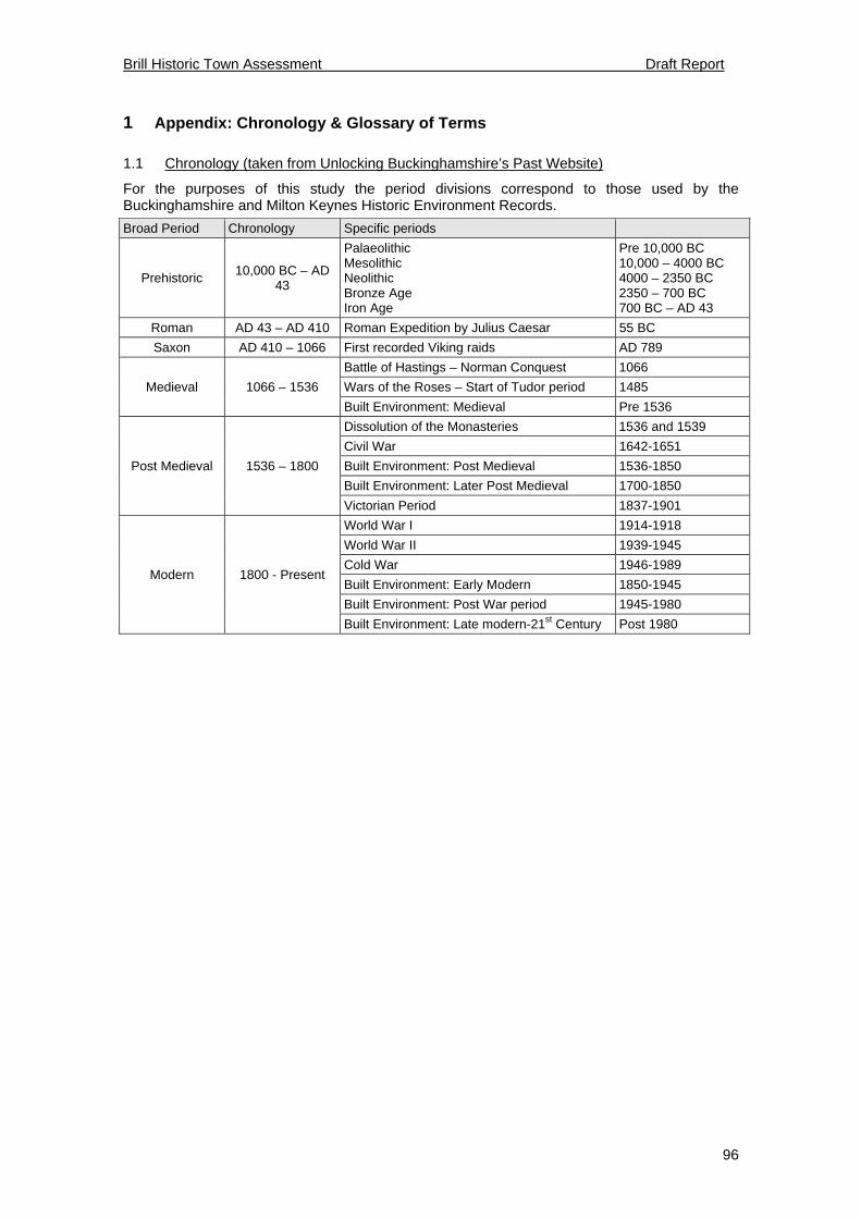
Brill Historic Town Assessment Draft Report
96
1 Appendix: Chronology & Glossary of Terms
1.1 Chronology (taken from Unlocking Buckinghamshire’s Past Website)
For the purposes of this study the period divisions correspond to those used by the Buckinghamshire and Milton Keynes Historic Environment Records.
Broad Period Chronology Specific periods
Prehistoric 10,000 BC – AD
43
Palaeolithic Mesolithic Neolithic Bronze Age Iron Age
Pre 10,000 BC 10,000 – 4000 BC 4000 – 2350 BC 2350 – 700 BC 700 BC – AD 43
Roman AD 43 – AD 410 Roman Expedition by Julius Caesar 55 BC
Saxon AD 410 – 1066 First recorded Viking raids AD 789
Medieval 1066 – 1536
Battle of Hastings – Norman Conquest 1066
Wars of the Roses – Start of Tudor period 1485
Built Environment: Medieval Pre 1536
Post Medieval 1536 – 1800
Dissolution of the Monasteries 1536 and 1539
Civil War 1642-1651
Built Environment: Post Medieval 1536-1850
Built Environment: Later Post Medieval 1700-1850
Victorian Period 1837-1901
Modern 1800 - Present
World War I 1914-1918
World War II 1939-1945
Cold War 1946-1989
Built Environment: Early Modern 1850-1945
Built Environment: Post War period 1945-1980
Built Environment: Late modern-21st Century Post 1980

Brill Historic Town Assessment Draft Report
97
1.2 Glossary of Terms
Terms Definition Borough Medieval town that was granted some level of self government during the medieval
period. Charter (market) Official charter granted by the sovereign to legitimise a corporate body such as a
borough or to grant rights to a percentage of the revenue from a market or fair to a private individual
Conservation Area
An area of special architectural or historic interest the character or appearance of which it is desirable to preserve or enhance (Planning Act 1990)
Enclosure Award Acts of Parliament were introduced to enclose (erect fencing) open fields and commons. Main period of enclosure by Act was 1750-1860, carried out on a parish basis.
Evaluation Archaeological evaluation is made up of a number of different techniques that are tailored to assess the archaeological potential of a site, often before planning permission is given. Evaluation usually involves one or more processes from the following: desk based assessment, test-pitting, fieldwalking, geophysical survey, topographical survey or trial trenching,
Excavation Archaeological investigation whereby below ground deposits are uncovered, recorded and either removed or preserved in situ. Ultimately destructive.
Find spot Location where a specific artefact was found Manor An official manor is based around a unit of jurisdiction rather than a geographical area
and can include small sections of land spread across a parish, or several parishes. Typically a manor requires a lordship in possession of a coat of arms and who must hold a court for the manor. Can date from Saxon to modern period.
Manor [Reputed] Unofficial manor held as freehold by someone not in possession of a coat of arms (i.e. does not have a title) and who does not have the authority to hold a manorial court. Usually date to medieval period or later.
Mint Mints were places for the production of coinage and were only granted by the monarchy. Mints were used from Roman times onwards but most commonly in the Saxon and medieval periods.
Posse Comitatus Record of all able bodied men within a given unit of land for the purposes of military service.
Prescriptive charter (market)
Prescriptive charters were granted to towns that had historically held a market for an extended period of time without an official charter from the monarchy. The given dates then mark the date of the charter rather than the date of the inception of the market.
Trial Trenching Trial-trenching refers to the archaeological sampling of a site by machine-dug trenches to determine the presence, date extent and condition of any buried archaeological remains in order to decide whether preservation is justified or if further archaeological investigation needs to happen prior to development.
Turnpike Trust Essentially the privatisation of stretches of roads by Act of Parliament whereby the Trust was charged with the proper maintenance and repair of their allotted road and in return they constructed toll gates and houses along the route to charge travellers.
Watching Brief A watching brief is the term applied to the task of monitoring non-archaeological work (construction/demolition/quarrying) in order to record and/or preserve any archaeological remains that may be disturbed

Brill Historic Town Assessment Draft Report
98
2 Appendix: HER Records
2.1 Monuments HER Report
HER No. Name NGR Period Summary
0010600000 Brill SP 6560 1390 Undated BANK (EARTHWORK) 0010600002 Brill Sports and Social Club SP 65606 13924 Undated DITCH 0010601000 All Saints Church SP 6559 1390 Iron Age HILLFORT? 0010602000 All Saints Church SP 6559 1390 410-1539? PALACE? 0010603000 All Saints Church SP 6559 1390 Medieval CASTLE? 0010604000 All Saints Church SP 6559 1390 Medieval MOAT? 0010605000 All Saints Church SP 6559 1390 Civil War 1640-1649 FIELDWORK? 0015900000 The Wilderness SP 6416 1551 Roman ENCLOSURE 0048700000 Hurcumdean Manor SP 6625 1226 Roman VILLA? 0052800000 Brill SP 65500 13900 Medieval MOUND 0057100000 Muswell Hill SP 64040 15350 Roman VILLA? 0057600000 North of village SP 6566 1428 13th-14th Century POTTERY KILN 0057600001 North of village SP 6563 1430 13th Century CLAY PIT 0057600002 North of village SP 6565 1428 13th Century IRON WORKING SITE? 0057601000 North of village SP 6565 1428 13th-14th Century POTTERY KILN (POTTERY KILN SITE) 0057602000 North of village SP 6565 1428 14th Century POTTERY KILN (POTTERY KILN SITE) 0058100000 Brill Common SP 65200 14310 17th Century- Modern POST MILL 0071900000 Brill Common SP 65500 14400 Medieval-Post Medieval CLAY PIT 0073800000 SSE of Church SP 65760 13060 17th-18th Century POST MILL 0079600000 Brill Common SP 65020 14320 19th Century-Modern BRICKWORKS 0079700000 Brill Common SP 65300 14300 19th Century POST MILL 0079701000 Brill Common SP 65300 14300 19th Century WINDMILL 0196600000 Little Addingrove Farm SP 6654 1169 Medieval-Post Medieval FARMSTEAD 0212900000 40 Windmill St SP 65380 14070 17th Century POTTERY KILN 0215300000 Prossers Yard SP 65480 14050 18th Century POTTERY KILN 0215301000 Prossers Yard SP 65480 14050 18th Century POTTERY KILN 0215302000 Prossers Yard SP 65480 14050 18th Century POTTERY KILN 0215303000 Prossers Yard SP 65480 14050 18th Century POTTERY KILN 0219600001 Oakley Road SP 65330 13720 DOVECOTE 0221300000 Muswell Hill SP 64300 15500 Medieval HERMITAGE 0221301000 Muswell Hill SP 64300 15500 Medieval CHAPEL 0221302000 Muswell Hill SP 64300 15500 Medieval HERMITAGE 0221303000 Muswell Hill SP 64300 15500 Medieval HERMITAGE 0221303002 Muswell Hill SP 64300 15500 Undated BUILDING FOUNDATIONS 0223500000 Tram Hill SP 65590 14230 Post Medieval POTTERY KILN

Brill Historic Town Assessment Draft Report
99
HER No. Name NGR Period Summary
0223501000 Tram Hill SP 65590 14230 19th Century POTTERY KILN 0223502000 Tram Hill SP 65590 14230 19th Century INDUSTRIAL SITE 0223503000 Tram Hill SP 65590 14230 19th Century POTTERY KILN 0223504000 Tram Hill SP 65590 14230 19th Century INDUSTRIAL SITE 0223505000 Tram Hill SP 65590 14230 17th Century POTTERY KILN 0225700000 The Grove SP 6552 1418 18th-19th Century COUNTRY HOUSE 0231000000 BRILL SP 65500 14000 11th-14th Century MANOR 0231001000 BRILL SP 65500 14000 11th-14th Century PALACE? 0231002000 BRILL SP 65500 14000 11th-13th Century HUNTING LODGE 0231003000 BRILL SP 65500 14000 Medieval CHAPEL 0247800000 Allotments, Brill SP 6549 1372 14th-15th Century POTTERY KILN 0249700000 North Hills SP 6530 1426 18th-19th Century BRICK KILN 0249800000 Brill Common SP 6543 1436 19th Century BRICKWORKS 0249900000 Well Close SP 65830 13750 19th Century WELL HOUSE 0249900001 Well Close SP 65830 13750 16th-17th Century POTTERY KILN 0262301000 BRILL SP 65500 14000 Medieval-Post Medieval WINDMILL 0262302000 BRILL SP 65500 14000 13th-19th Century POTTERY KILN 0285300000 NW side of Lake SP 6765 1690 19th Century WATERMILL 0416000000 Brill Tramway SP 6987 1657 19th Century-Modern RAILWAY 0416200000 Brill Station, terminus of Tram SP 65680 15290 19th Century-Modern RAILWAY STATION 0416201000 Terminus of Brill Tramway SP 65680 15290 19th Century RAILWAY 0417600000 S of Rushbeds Wood SP 6651 1522 19th Century-Modern BRICKWORKS 0419100000 THE SQUARE, BRILL SP 65400 13800 Medieval-Post Medieval MARKET CROSS 0419200000 Brill SP 6553 1488 Medieval-Post Medieval BRICKWORKS 0424800000 NW of Nashway Farm SP 64700 13300 18th-19th Century WINDMILL 0439400000 North of Temple Farm SP 6566 1428 14th Century POTTERY KILN 0439402000 North of Temple Farm SP 6565 1429 14th Century POTTERY KILN 0448000000 Sails Cottage SP 65200 14040 18th Century POTTERY KILN 0465100000 Brill Common SP 6528 1437 19th Century BRICKWORKS 0465200000 100m E of Windmill SP 6533 1416 Post Medieval BRICKWORKS 0465300000 Crossroads north of Brill SP 65620 14870 20th Century-Modern BRICKWORKS 0465400000 Brill Common SP 65140 14340 19th Century LIME KILN 0514100000 SW of Nuthook Farm SP 650 119 11th Century (Former Type) WATERMILL 0525300000 Muswell Hill SP 64150 15300 Medieval-Post Medieval WINDMILL 0526300000 S of Chinkwell Wood SP 66600 14000 19th Century BRICKWORKS 0526400000 Parkpale Farm SP 66196 13460 Post Medieval WELL 0526500000 Parkpale Farm SP 66230 13850 Post Medieval WELL HOUSE 0526501000 Parkpale Farm SP 66260 13780 Post Medieval PUMP HOUSE 0526600000 The Square SP 65430 13750 19th Century PRISON 0529300000 Temple Street SP 6550 1412 14th-18th Century BRICKWORKS

Brill Historic Town Assessment Draft Report
100
HER No. Name NGR Period Summary
0529301000 Temple Street SP 65520 14130 15th Century POTTERY KILN 0529302000 Temple Street SP 65520 14130 15th-16th Century POTTERY KILN 0529303000 Temple Street SP 66520 14130 Medieval PIT 0529304000 Temple Street SP 65520 14130 14th Century KILN 0567800000 Temple Farm SP 6564 1417 14th-15th Century POTTERY KILN 0567801000 Temple Farm SP 65644 14170 18th Century BUILDING FOUNDATIONS 0567802000 Temple Farm SP 65644 14170 Medieval SAND PIT 0568100000 Pond Walk Field SP 6556 1427 Medieval POTTERY KILN 0571200000 Nr Ex Magistrates Court SP 65596 14066 14th Century POTTERY KILN 0574500000 Nr Timber Yard SP 67010 15140 Medieval MOAT? 0577900000 Aisses (Nashway) SP 646 129 11th Century VILL 0676000000 W of Ludgershall Road SP 6555 1425 Post Medieval POTTERY KILN 0676100000 6 Highland Close SP 65458 14046 17th-19th Century QUARRY? 0847900000 S of war memorial SP 6543 1380 19th Century-Modern (Former Type) WATER PUMP 0848000000 28 Temple Street SP 65553 14024 17th Century PIT 0853200000 Land adj to The Pheasant SP 65326 14100 15th-16th Century PIT 0855100000 Brill village SP 654 138 Medieval-Modern SETTLEMENT 0904800000 Brillbury Farm SP 64634 14805 19th Century (Former Type) SAND PIT 0904900000 SE of the Wrens SP 65108 13326 19th Century (Former Type) GRAVEL PIT 0905000000 South Hills SP 65113 13870 19th Century (Former Type) CLAY PIT 0905100000 South Hills SP 65097 13935 19th Century (Former Type) CLAY PIT 0905200000 E of Temple Farm SP 65772 14257 19th Century-Modern (Former Type) CLAY PIT 0905300000 North Hills SP 65191 14301 19th Century-Modern (Former Type) CLAY PIT 0905400000 E of the Windmill SP 65223 14152 19th Century-Modern (Former Type) CLAY PIT 0905500000 Temple Manor House SP 65388 14195 19th Century-Modern (Former Type) CLAY PIT 0905600000 North Lodge SP 65555 14866 19th Century-Modern (Former Type) CLAY PIT 0905700000 E of Spa Close SP 66012 13816 19th Century-Modern (Former Type) GRAVEL PIT 0905800000 NW of Parkpale Farm SP 66081 13190 19th Century (Former Type) GRAVEL PIT 0941300000 N boundary of Rushbeds Wood SP 66630 15802 Medieval BOUNDARY BANK 0941400000 E boundary of Rushbeds Wood SP 67194 15686 9th Century BOUNDARY MARKER 0941500000 W boundary of Rushbeds Wood SP 66371 15587 Post Medieval BOUNDARY DITCH 0960100000 16-18 Church Street SP 65535 13773 15th-19th Century QUARRY 0979000000 Site of Wesleyan Chapel SP 65600 13700 19th Century (Former Type) WESLEYAN CHAPEL? 0983900000 Brill medieval market and 2 fairs SP 65700 13800 14th Century (Former Type) FAIR 1164701000 Sun Hotel SP 6540 1400 18th Century POTTERY WORKS? 1167301000 2 Temple Street SP 65480 13963 Post Medieval WELL 1167302000 2 Temple Street SP 65480 13963 Post Medieval CISTERN

Brill Historic Town Assessment Draft Report
101
2.2 Landscapes HER Reports
HER No. Name NGR Period Summary
01164401000 Brill House SP 6572 1370 19th Century to 21st Century
First recorded by Sheahan (1862), the 1st edition 6" OS map records the house in the grounds in 1880. The modern 1980 1:10000 map shows major alterations to the layout, unknown when the changes took place.
00225701000 The Grove SP 6553 1418 Post-Medieval to Modern
First recorded evidence of this garden is on the 1st edition 6" OS map, however the house dates to post-medieval times (post 1500). The 1980 1:10000 OS map shows that the gardens have now been destroyed
2.3 Find Spots
HER Grid Ref Period Details 0010400003 SP 6415 1405 Roman Small Roman or medieval lead object found whilst metal-detecting 0010400004 SP 6415 1405 Roman Romano-British pottery and coin found whilst metal-detecting 0010600001 SP 6560 1390 Iron Age to Medieval Pottery and post-medieval artefacts found during levelling of earthworks. 0048701000 SP 66240 12250 Roman Large amount of Roman pottery found on the surface 0048701001 SP 66240 12250 Saxon, Medieval Saxon and medieval pottery found in surface scatter 0048702000 SP 66240 12210 Roman Fragments of Roman roof-tile found by chance 0052900000 SP 66000 14000 Middle-Late Bronze Age Antiquarian find of a Middle to Late Bronze Age axe 0057100001 SP 64040 15350 12th Century Ordnance Survey investigators found twelfth century pottery on the surface 0057101000 SP 64040 15350 Roman Ordnance Survey investigators found Roman pottery on the surface 0057102000 SP 64040 15350 Roman Ordnance Survey investigators found Roman pottery and tile 0057103000 SP 64040 15350 Roman Early Roman metalwork found probably by chance 0057104000 SP 64400 15400 Roman Ordnance Survey investigators found Roman iron-working slag on the surface 0057105000 SP 64040 15350 Roman Roman coins found. 0057601001 SP 6565 1428 13th Century Dump of early thirteenth century pottery found in excavation under earliest pottery kiln 0057603000 SP 6565 1428 Medieval Thirteenth and fourteenth century pottery waste from the kilns found in excavation 0058200000 SP 65600 13800 Roman Approximate location of Roman coins found by chance 0058201000 SP 65600 13800 Roman Roman metalwork found in Brill 0079600001 SP 65020 14320 Modern Chance finds of modern floor tiles 0205300000 SP 65710 13790 Mesolithic Five Mesolithic flint blades found by chance 0212901000 SP 65380 14070 17th Century Seventeenth century pottery kiln waste found during excavation 0215304000 SP 65480 14050 18th Century Lots of eighteenth century pottery kiln furniture was found in excavation 0215305000 SP 65480 14050 18th Century Field walking and excavation uncovered many sherds of eighteenth century pottery 0219500000 SP 65500 13900 13th Century Sherds of thirteenth century pottery found by chance 0221303001 SP 64300 15500 Undated Ordnance Survey investigators found some undated human remains 0223500001 SP 65590 14230 18th-19th Century Eighteenth and nineteenth century pottery found in Brill 0223501001 SP 65590 14230 19th Century Nineteenth century pottery found in excavation 0223501002 SP 65590 14230 19th Century Nineteenth century dump of pottery kiln furniture found in excavation 0223505002 SP 65590 14230 17th Century Possible seventeenth century pottery kiln furniture found in excavation
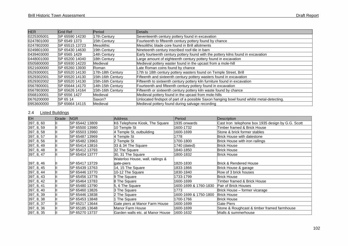
Brill Historic Town Assessment Draft Report
102
HER Grid Ref Period Details 0225305001 SP 65590 14230 17th Century Seventeenth century pottery found in excavation 0247801000 SP 6549 1373 15th Century Fourteenth to fifteenth century pottery found by chance 0247802000 SP 65515 13723 Mesolithic Mesolithic blade core found in Brill allotments 0249801000 SP 65430 14630 19th Century Nineteenth century inscribed roof-tile in barn 0439403000 SP 6565 1429 14th Century Early fourteenth century pottery found with the pottery kilns found in excavation 0448001000 SP 65200 14040 18th Century Large amount of eighteenth century pottery found in excavation 0505800000 SP 65930 14220 Medieval Medieval pottery waster found in the upcast from a mole-hill 0521600000 SP 65260 13930 Roman Late Roman coins found by chance 0529300001 SP 65520 14130 17th-18th Century 17th to 18th century pottery wasters found on Temple Street, Brill 0529302001 SP 65520 14130 15th-16th Century Fifteenth and sixteenth century pottery wasters found in excavation 0529302002 SP 65520 14130 15th-16th Century Fifteenth to sixteenth century pottery kiln furniture found in excavation 0567800001 SP 65644 14170 14th-15th Century Fourteenth and fifteenth century pottery found in excavation 0567803000 SP 65626 14164 15th-16th Century Fifteenth or sixteenth century pottery kiln waste found by chance 0568100001 SP 6556 1427 Medieval Medieval pottery found in the upcast from mole-hills 0676200000 SP 65 14 Saxon? Unlocated findspot of part of a possible Saxon hanging bowl found whilst metal-detecting. 0953600000 SP 65664 14115 Medieval Medieval pottery found during salvage recording
2.4 Listed Buildings
EH Grade NGR Address Period Description 397, 8, 60 II SP 65442 13809 K6 Telephone Kiosk, The Square 1935 onwards Cast Iron telephone box 1935 design by G.G. Scott 397, 8, 59 II SP 65500 13980 10 Temple St 1600-1732 Timber framed & Brick House 397, 8, 58 II SP 65503 13960 4 Temple St, outbuilding 1600-1699 Stone & brick former stables 397, 8, 57 II SP 65487 13969 4 Temple St 1778 Brick House with datestone 397, 8, 56 II SP 65482 13963 2 Temple St 1700-1800 Brick House with iron railings 397, 8, 49 II SP 65414 13816 33 & 34 The Square 1740 (dated) Brick House 397, 8, 48 II SP 65412 13793 32 The Square 1840-1850 Brick House 397, 8, 47 II SP 65404 13777 30, 31 The Square 1800-1832 Brick House
397, 8, 46 II SP 65417 13729 Waterloo House, wall, railings & gate-piers 1820-1830 Brick & Rendered House
397, 8, 45 II SP 65439 13763 14, 15 The Square 1833-1866 Brick House & garage 397, 8, 44 II SP 65446 13770 10-12 The Square 1830-1840 Row of 3 brick houses 397, 8, 43 II SP 65456 13778 9 The Square 1733-1799 Brick House 397, 8, 42 II SP 65464 13783 8 The Square 1600-1699 Timber framed & Brick House 397, 8, 41 II SP 65480 13790 5, 6 The Square 1600-1699 & 1760-1830 Pair of Brick Houses 397, 8, 40 II SP 65460 13826 3 The Square 1773 Brick House – former vicarage 397, 8, 39 II SP 65446 13838 2 The Square 1600-1699 & 1750-1800 Brick House 397, 8, 38 II SP 65453 13848 1 The Square 1700-1766 Brick House 397, 8, 37 II SP 65217 13644 Gate piers at Manor Farm House 1600-1699 Gate Piers 397, 8, 36 II SP 65185 13648 Manor Farm House 1600-1699 Stone & Roughcast & timber framed farmhouse 397, 8, 35 II SP 65270 13737 Garden walls etc. at Manor House 1600-1632 Walls & summerhouse

Brill Historic Town Assessment Draft Report
103
EH Grade NGR Address Period Description 397, 8, 34 II SP 65351 13744 Manor Farm, Stables 1667-1732 Brick stables 397, 8, 33 II* SP 65330 13718 Manor House 1500-1650 Brick & timber framed house now 6 flats 397, 8, 10001 II SP 65436 13815 War Memorial c.1920 War Memorial of Portland stone 397, 6, 66 II* SP 65198 14146 Windmill 1680s Post Mill 397, 6, 65 II SP 65338 14079 Old Plough, 35 Windmill Street 1767-1832 Brick & stone house 397, 6, 64 II SP 65380 14078 40 Windmill Street 1734 (dated) Brick House 397, 6, 63 II SP 65433 14019 18 Windmill Street 1667-1732 Timber framed & Brick House 397, 6, 61 II SP 65533 14012 20 Temple Street 1400-1700 Cruck frame & Brick House 397, 6, 60 II SP 65524 14005 The Manse, 18 Temple Street 1600-1699 Brick House 397, 6, 55 II SP 65599 14168 63, 65 Temple St 1567-1699 Timber framed & Brick/pebbledash House 397, 6, 54 II SP 65594 14159 61 Temple St 1800-1866 Brick House 397, 6, 53 II SP 65585 14152 59 Temple St 1733-1799 Brick House 397, 6, 52 II SP 65580 14140 55, 57 Temple St 1500-1699 Timber framed & Brick House 397, 6, 51 II SP 65513 14030 15, 17 Temple St 1500-1599 Timber framed & Brick House 397, 6, 50 II SP 65607 14241 5 Temple St 1767-1832 Brick House -548715 II SP 65417 13860 Kings Ride House 1600-1699 Brick House -548716 II SP 65419 13895 Bernwode House, 24 High Street 1770-1780 Brick House -548717 II SP 65419 13928 United Reformed Church, High St. c.1839 United Reformed Chapel -548718 II SP 65450 13964 The Old Inn (formerly Sun Hotel) 1700-1732 Brick public house -548719 II SP 65449 13909 9, 11, 15 High St 1600-1699 Brick Houses -548720 II SP 65465 13944 1, 5 High St 1600-1699 Timber framed cruck house -548721 II SP 65725 13705 Brill House, The Green 1780s Brick House -548722 II SP 65706 13792 Old Swan, 18 The Green 1667-1699 Brick House -548723 II SP 65725 13800 15-17 The Green 1700-1832 Brick & stone House -548724 II SP 65691 13843 5 The Green 1767-1832 Brick House -548725 II SP 65656 13826 Rose Cottage, 3 The Green c.1770 Brick House -548726 II SP 65565 13764 28, 30 Church St 1767-1832 Brick Houses -548727 II SP 65561 13769 22-26 Church St 1600-1732 Brick Houses -548728 II SP 65539 13782 12 Church St 1600-1699 Timber framed house -548729 II SP 65486 13794 2 Church St 1700-1799 Brick House -548730 II SP 65566 13804 Red Lion, Church Street 1600-1832 Brick public house -548731 II* SP 65628 13854 Church of All Saints, The Green 1100-1900 Parish Church -548732 II SP 65542 13821 Brill Memorial Hall, Church Street c.1830 Brick village hall with attached 1979 hall -548733 II SP 65533 13819 17 Church St 1600-1920 Brick House

Brill Historic Town Report Draft Report
104
3 Appendix: Trade Listings and Population Data
Trade Directories
Artisan/trades 1853 1864 1877 1883 1895 1903 1911 1920 1935 Basket maker 1 Currier 1 Milliner/peroke 4 Shoe/boot maker 3 1 4 3 3 3 3 2 1 Tailor 4 1 3 2 TOTAL 3 5 9 6 6 4 3 2 1 Merchant/Dealer 1853 1864 1877 1883 1895 1903 1911 1920 1935 Brewery 1 Chemist 1 1 1 Dealer 6 2 7 4 1 2 4 4 4 Dealer (animals) 1 1 1 Dealer (china) 1 1 1 Dealer (Corn/coal) 1 1 2 2 3 3 2 Dealer (cycle/car) 1 1 Dealer (timber) 1 Draper 2 2 3 1 2 2 4 3 Fruitier 2 Grocer 2 4 4 7 5 4 2 3 2 Ironmonger 1 1 1 Marine Store 1 1 Nurserymen 1 Wine Merchant 1 TOTAL 11 11 16 15 11 14 16 15 13 Agric/General 1853 1864 1877 1883 1895 1903 1911 1920 1935 Agric Engineer 1 1 Farmer 15 5 23 20 17 12 13 12 12 Vet 1 TOTAL 15 6 23 20 17 12 13 13 13 Professional 1853 1864 1877 1883 1895 1903 1911 1920 1935 Auctioneer 1 1 2 1 1 Banker 1 1 Solicitor 1 Surgeon/physician 2 2 1 1 2 2 1 TOTAL 3 4 2 2 3 2 2 0 2 Service/Provisions 1853 1864 1877 1883 1895 1903 1911 1920 1935 Baker 2 3 4 5 4 4 3 3 2 Beer Retailer 1 1 2 2 1 2 2 2 Blacksmith 1 1 1 1 1 1 1 1 1 Bricklayer/builder 1 2 3 1 2 2 3 3 1 Brick/tile maker 2 3 7 1 2 3 1 Butcher 1 1 2 2 1 1 2 1 2 Carpenter 4 2 1 1 1 1 1 Carrier 6 1 1 1 3 2 2 Cooper 1 1 1 1 Gardener 1 1 Hairdresser 1 1 Hotel/Inn 1 1 1 2 Ins Agent 3 1 Mason 1 Miller 2 2 1 1 1 1 1 1 Plumber/electrician 1 1 1 2 1 1

Brill Historic Town Report Draft Report
105
Pub 4 4 4 4 3 3 3 2 1 Saddler 1 1 1 1 1 1 1 School 2 1 2 2 4 3 2 1 1 Watchmaker 1 Wheelwright 2 3 1 1 TOTAL 26 27 32 27 25 29 25 18 16
Population Figures
Date 1801 1811 1821 1831 1841 1851 1861 1871 1881 1891 1901
Population 859 864 1060 1283 1449 1311 1432 1353 1289 1251 1206
Date 1911 1921 1931 1941 1951 1961 1971 1981 1991 2001
Population 1121 1019 946 NA 877 905 1023 NA NA 1190
Population Figures taken from the following sources:
http://www.genuki.org.uk/ for 1801-1901
Pevsner for 1921; 1951
http://www.visionofbritain.org.uk for 1911; 1931; 1961; 1971
http://www.buckscc.gov.uk/bcc/ for 2001

Brill Historic Town Report Draft Report
106
4 Appendix: Historical Consultancy Report
Medieval Records (to 1500)
Brill was mentioned in Domesday Book (1086) when it was a wholly rural settlement with no apparent urban characteristics, such as a market or burgesses. There were 34 tenant households, headed by 19 villani, 13 lower‐status bordars, and 2 slaves.1 In the Middle Ages Brill’s church was a dependent chapel of neighbouring Oakley, though the manor’s status as a royal residence from the 11th century ensured that the Norman church was quite sizeable and may have served as a royal chapel.2 The manor belonged to the Crown from the 11th century to the 14th, during which period Brill acquired the status of a royal borough.3 There can be little doubt that from the 13th century (and possibly earlier) Brill was a small market town serving the surrounding settlements in Bernwood Forest.4
A market and fair worth £1 16s. a year were mentioned in 1252, and the same document records small plots of ‘land built upon’ (terra edificata) held by tenants with occupational surnames including carpenter, draper, soutar (shoemaker), smith, tinker, and turner, which probably refer to burgage plots held by craftsmen and traders.5 In 1315 the keeper of the manor received 7s. from 13 acres of ‘land built upon’, while in 1353 tenants paid 4d. stallage for each market‐stall held.6 Brill also supported medieval pottery and tilemaking industries, its wares supplying Oxford and a wide surrounding area in Oxfordshire and Buckinghamshire.7
Brill’s ownership by the Crown and its location within Bernwood Forest together ensure a relatively plentiful survival of manorial and forest records which can be used to examine its urban and industrial character.
Account rolls
TNA: PRO, SC 6/759/28 (1250‐1), SC 6/759/29 (late 13th century), SC 6/1089/6‐7 (1275‐6), SC 6/759/30 (1278‐9), SC 6/1089/16 (1278‐80), SC 6/759/31 (1279‐82), SC 6/1089/17 (1280), SC 6/1089/18 (1281), SC 6/1120/9‐10 (1340), SC 6/1120/11 (1341‐2), SC 6/1120/12 (1342‐5), SC 6/761/3 (1440‐1).
Court rolls
Huntington Library, San Marino, California, MSS Ham Box 59/7 (1348‐9), Box 59/8 (1432), Box 59/9 (1454), Box 59/11‐12 (1491‐3).
New College, Oxford, NCA 3264, extracts 1370‐1421 in 17th‐century copy.
Forest records
TNA: PRO, E 32/2 (1255), E 32/137 (1272), C 47/11/3/22 (1280), E 32/292 (1290), E 32/3 (1342), E 32/4 (1363), E 32/293 (1362), E 32/294 (1364), E 32/295 (1365), E 32/296 (1371), E 32/297 (1372), E 32/344 (1376), E 146/1/10 (1489).8
Medieval taxation returns naming individuals from Brill include E 179/35/1 (1294), E 179/239/250 (1313), E 179/242/64 (1327), E 179/362/19 pt. ii (1332), E 179/77/9 (1340), E 179/35/12 (1380). However, Brill is not included in the 1279 Hundred Rolls.
In 1337 Edward III granted the manor of Brill to John de Moleyns, lord of Stoke Poges, whose successors held Brill for the rest of the Middle Ages.9 In 1347 Moleyns was granted an annual fair at Brill to be held in July, although from the mid 14th century Brill probably began to decline as a market town, partly because late medieval kings no longer visited the place, but more importantly because of competition
Brill Historic Town Report Draft Report
107
from larger towns such as Aylesbury and Oxford in the more difficult economic conditions of the post‐Black Death era.10 By 1500, apart from the pottery industry (also in decline), Brill showed few urban characteristics.11
Early Modern Records (1500‐1800)
Brill’s status as a market town is uncertain throughout this period. The manor remained in lay hands, and from 1554 was held with the manor of Boarstall.12 Manorial records were still kept, which may shed light on any residual urban character retained by the settlement, although they are less plentiful than for the Middle Ages, and some are not easily accessible.
Court rolls
Rousham, Oxfordshire (private archive), 1705 (enquiries to The National Archives, National Advisory Services).
Thame, Oxfordshire (private archive), 1652‐1826 (listed in old Manorial Documents Register card index but not in new online version).
Rentals, surveys and terriers
Berkshire Record Office, rent receipts 1555‐78.
TNA: PRO, E 367/1926 (1651 rental), E 317/Bucks/16 (1651 survey), E 367/2370 (1658 terrier), E 367/2548 (1658 terrier).
Surviving deeds and charters mostly relate to Brill’s farms and agriculture, but numerous references may also be found to traders and craftsmen, including brickmakers, carpenters, potters and tailors, and this period saw the development, too, of the (probably) late medieval hamlet of Little London, south of the village, where a tailor lived in 1667 (CBS, D‐HO/6). Relevant collections include CBS, D‐HO (Hobbs collection, 17th and 18th century) and CBS, D 77 (Snell estate, 17th and 18th century). Other 18th‐century deeds include British Library, e.g. Ch. 2376, 2382, and Bodleian, MS Top. Oxon. d 385.
Brill and Little London are both shown on a map of 1591 belonging to New College, Oxford.13 At Brill rows of houses surround the triangular market place (complete with market cross) at the junction of the Ludgershall—Oakley road with the lane to the parish church. A cross is also shown at Little London where a few houses line the Ludgershall—Oakley road at the junction with the road to Long Crendon. Other maps of the parish from 1590 and the 17th century also survive at New College, Oxford, and 18th‐century plans are kept at CBS, Ma 27/4 and at Bodleian, MS C17:15(15).
Individual taxpayers from Brill are named in numerous lay subsidy rolls and hearth tax returns dated 1523 to 1662 at the National Archives, including:
E 179/78/96, 98 (1523‐5)
E 179/78/118 (1540)
E 179/78/124 (1542)
E 179/78/133 (1543)
E 179/78/141 (1545)
E 179/78/147 (1546)
E 179/78/150 (1547)

Brill Historic Town Report Draft Report
108
E 179/79/163 (1549)
E 179/79/164 (1550)
E 179/79/165 (1551)
E 179/79/185 (1559)
E 179/79/191 (1563)
E 179/79/193 (1566)
E 179/79/207 (1594)
E 179/79/232 (1599)
E 179/79/206 (1600)
E 179/79/266 (1611)
E 179/79/270 (1622)
E 179/79/275 (1625)
E 179/80/358 (1628)
E 179/244/2 (1637)
E 179/244/9 (1647)
E 179/80/333 pt. ii (1661)
E 179/80/354 (1662)
In 1800 Brill supported a diverse range of occupations, including bakers, blacksmiths, brickmakers, butchers, carpenters, cordwainers, tailors, and wheelwrights. However, about 30 per cent of its inhabitants were labourers, a further 11 per cent were servants, and many craftsmen probably depended directly on farm work for their livelihoods.14
Modern Records (Post 1800)
According to the census of 1811, 166 (72 per cent) of Brill’s 230 resident families were employed in agriculture and only 50 (22 per cent) in trade, manufactures or handicraft. The occupational structure of the parish in the 19th century can most fully be analysed using the census enumerators’ books held at the National Archives. Those for Brill are:
HO 107/38 (1841)
HO 107/1726 (1851)
RG 9/887 (1861)
RG 10/1432 (1871)
RG 11/1494 (1881)
RG 12/1161 (1891)
RG 13/1374 (1901)
The population of Brill increased from 859 in 1801 to 1,449 in 1841 before falling to 1,206 in 1901, presumably as a result of agricultural depression. From 1894 Brill lay within Long Crendon Rural District Council (incorporated into Aylesbury Rural District in 1934) whose records (CBS, DC 1) include poor rate and sanitary rate books, valuation lists, and accounts of special expenses. In 1915 Brill was described as a
Brill Historic Town Report Draft Report
109
‘large village’ when about 40 shops, public houses, and other businesses were based there.15 Research papers by a local historian on the modern history of Brill are kept at CBS, D 215.
Key issues and recommendations for further study
Brill is a good example of a small medieval market town which failed to develop as an urban centre in the 16th century and later. Although far from unique, Brill offers the potential to explore further the nature of late‐medieval urban decline in Buckinghamshire. In particular, a study of the development and decline of the pottery, tilemaking and brickmaking industries would provide an opportunity to combine archaeological and documentary research. Other key questions include the origins, development and functions of Little London and its relationship to Brill. The growth of a new settlement within the parish may have had important economic and social implications for Brill and its inhabitants.
Notes
1 VCH Bucks. I, 232.
2 VCH Bucks. IV, 18; Pevsner, Bucks. 190.
3 VCH Bucks. IV, 15; M. Beresford and H.P.R. Finberg, English Medieval Boroughs: A Handlist (1973), 70.
4 I.M.W. Harvey, ‘Bernwood in the Middle Ages’, in J. Broad and R. Hoyle (eds), Bernwood: The Life and Afterlife of a Forest (1997), 10‐12.
5 H.E. Salter (ed.), The Boarstall Cartulary (Oxford Historical Society, 88, 1930), no. 608; VCH Bucks. IV, 15.
6 Boarstall Cartulary, nos. 573, 609.
7 VCH Bucks. IV, 15; M. Reed, ‘Decline and recovery in a provincial urban network: Buckinghamshire towns, 1350‐1800’, in M. Reed (ed.), English Towns in Decline 1350 to 1800 (1986), 7, 21; M. Mellor et al, ‘A synthesis of middle and late Saxon, medieval and early post‐medieval pottery in the Oxford region’, Oxoniensia 59 (1994), 117, 138‐40.
8 For selected translations, see M. Page, ‘Bernwood Ancient Hunting Forest Project’ (unpublished report for Buckinghamshire County Council, 2002).
9 VCH Bucks. IV, 16.
10 S. Letters et al., Gazetteer of Markets and Fairs in England and Wales to 1516 (2003), I, 60; Reed, ‘Decline and recovery’, 13‐14; Harvey, ‘Bernwood in the Middle Ages’, 12‐14.
11 Reed, ‘Decline and recovery’, 21, 35‐7.
12 VCH Bucks. IV, 12‐13, 16.
13 Reproduced in Broad and Hoyle, Bernwood, 68.
14 Posse Comitatus 1798 (BRS 22), 71‐3.
15 Kelly’s Dir. Bucks. (1915 edn).