british columbia coal industry overview 2014 · british columbia coal industry overview 2014 ......
TRANSCRIPT

British Columbia Coal Industry Overview 2014
Ministry of Energy and Mines, British Columbia Geological SurveyInformation Circular 2015-03
British Columbia Geological SurveyMinistry of Energy and Mineswww.em.gov.bc.ca/geology
British Columbia Coal Industry Overview 2014
Ministry of Energy and Mines British Columbia Geological Survey
Information Circular 2015-03
Ministry of Energy and Mines Mines and Mineral Resources Division British Columbia Geological Survey
Front Cover: Folded coal seam-bearing strata in the lower part of the Gething Formation, Brule Mine (Walter Energy, Inc) Northeast Region. Hammer lower right for scale. Photo by Paul Jago.
Back Cover: Mining coking coal from the Gates Formation at the Perry Creek (Wolverine) operation (Walter Energy, Inc). Photo by Paul Jago. This publication is available, free of charge, from the British Columbia Geological Survey website: www.em.gov.bc.ca/geology
Victoria British Columbia
Canada
January 2015
iiBritish Columbia Ministry of Energy and Mines, British Columbia Geological Survey Information Circular 2015-03
British Columbia Coal Industry Overview 2014
British Columbia Geological SurveyMinistry of Energy and Mines
IntroductionIn 2014, the number of operating coal mines in the province
dropped from nine to six as operations at three mines in the Peace River Coalfi eld were suspended. However, production at the fi ve coal mines in the southeastern part of the province remained steady, and total coal production dipped only slightly from 2013 levels. Coal is currently produced from six mines in two regions. Five mines in the southeastern part of the province produce mainly coking and PCI (pulverized coal injection) coal, whereas the Quinsam mine on Vancouver Island produces thermal coal. Major markets for British Columbia coal include Asian countries, especially Japan, China, South Korea and India, and countries in South America and Europe.
This pamphlet provides a snapshot of the provincial coal industry. It describes British Columbia’s coal regions, industry trends, coal transportation infrastructure, and summarizes mining and exploration activities for the past year. It also describes the tenure system, and lists sources of information and contacts. This publication complements more detailed British Columbia Geological Survey annual publications (see Information Sources below).
British Columbia coal industry trends in 2014Global coal prices continued to fall in 2014. Premium hard
coking coal (HCC) dropped to $121 from $155 in 2013, PCI coal to $107 from $125, and thermal coal to $82 from $95. (All prices are per tonne, in $US, Estimated, West Coast port price.) Three metallurgical/PCI coal mines in northeast British Columbia suspended production and the Quinsam thermal coal mine on Vancouver Island reduced its workforce and production. Coal production for British Columbia is forecast to be about 29 million tonnes for 2014, down from about 31 million tonnes in 2013. Coal exploration in mine expansion areas remained busy, but grassroots exploration was less active in 2014 relative to the past three years.
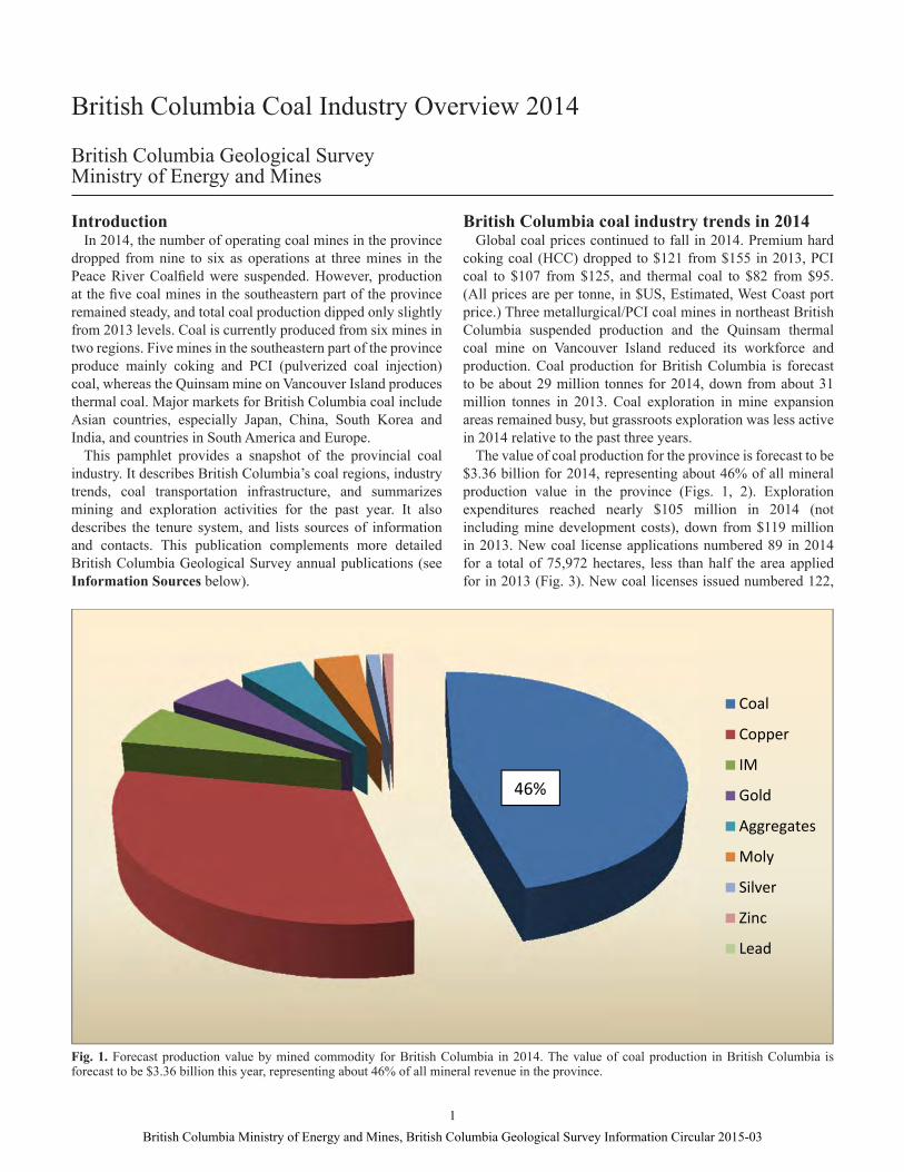
The value of coal production for the province is forecast to be $3.36 billion for 2014, representing about 46% of all mineral production value in the province (Figs. 1, 2). Exploration expenditures reached nearly $105 million in 2014 (not including mine development costs), down from $119 million in 2013. New coal license applications numbered 89 in 2014 for a total of 75,972 hectares, less than half the area applied for in 2013 (Fig. 3). New coal licenses issued numbered 122,
Coal
Copper
IM
Gold
Aggregates
Moly
Silver
Zinc
Lead
46%
Fig. 1. Forecast production value by mined commodity for British Columbia in 2014. The value of coal production in British Columbia is forecast to be $3.36 billion this year, representing about 46% of all mineral revenue in the province.
1British Columbia Ministry of Energy and Mines, British Columbia Geological Survey Information Circular 2015-03
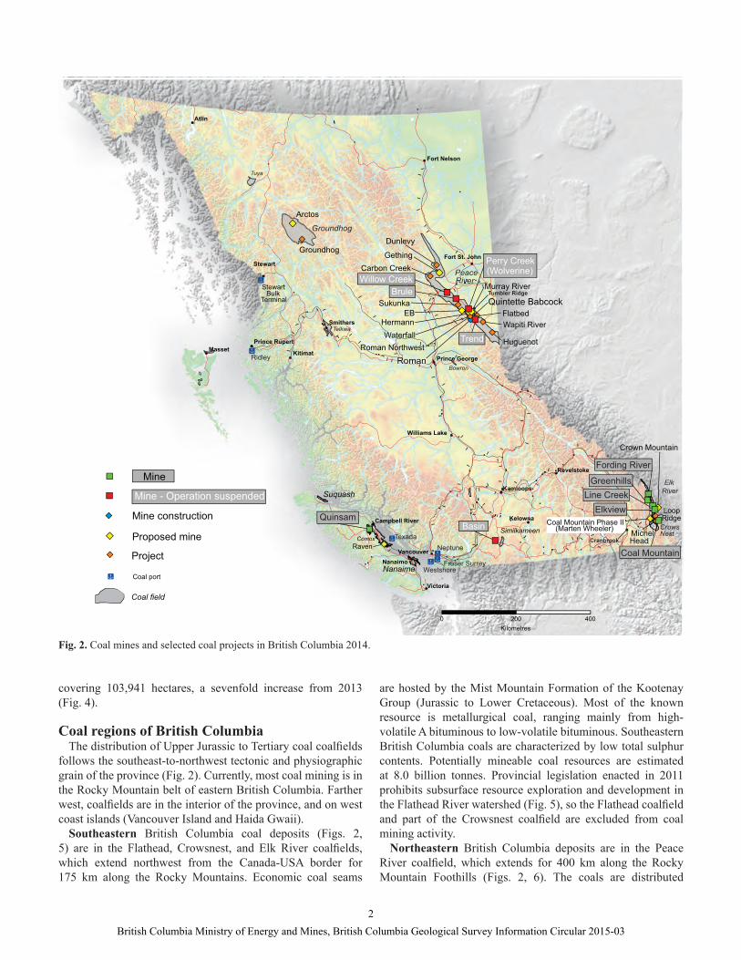
Fig. 2. Coal mines and selected coal projects in British Columbia 2014.
covering 103,941 hectares, a sevenfold increase from 2013 (Fig. 4).
Coal regions of British ColumbiaThe distribution of Upper Jurassic to Tertiary coal coalfi elds
follows the southeast-to-northwest tectonic and physiographic grain of the province (Fig. 2). Currently, most coal mining is in the Rocky Mountain belt of eastern British Columbia. Farther west, coalfi elds are in the interior of the province, and on west coast islands (Vancouver Island and Haida Gwaii).
Southeastern British Columbia coal deposits (Figs. 2, 5) are in the Flathead, Crowsnest, and Elk River coalfi elds, which extend northwest from the Canada-USA border for 175 km along the Rocky Mountains. Economic coal seams
are hosted by the Mist Mountain Formation of the Kootenay Group (Jurassic to Lower Cretaceous). Most of the known resource is metallurgical coal, ranging mainly from high-volatile A bituminous to low-volatile bituminous. Southeastern British Columbia coals are characterized by low total sulphur contents. Potentially mineable coal resources are estimated at 8.0 billion tonnes. Provincial legislation enacted in 2011 prohibits subsurface resource exploration and development in the Flathead River watershed (Fig. 5), so the Flathead coalfi eld and part of the Crowsnest coalfi eld are excluded from coal mining activity.
Northeastern British Columbia deposits are in the Peace River coalfi eld, which extends for 400 km along the Rocky Mountain Foothills (Figs. 2, 6). The coals are distributed
2British Columbia Ministry of Energy and Mines, British Columbia Geological Survey Information Circular 2015-03
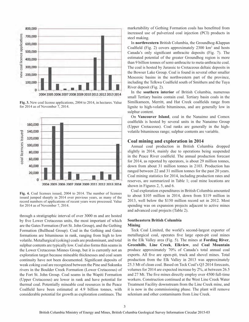
Fig. 3. New coal license applications, 2004 to 2014, in hectares. Value for 2014 as of November 7, 2014.
Fig. 4. Coal licenses issued, 2004 to 2014. The number of licenses issued jumped sharply in 2014 over previous years, as many of the record numbers of applications of recent years were processed. Value for 2014 as of November 7, 2014.
through a stratigraphic interval of over 3000 m and are hosted by fi ve Lower Cretaceous units, the most important of which are the Gates Formation (Fort St. John Group), and the Gething Formation (Bullhead Group). Coal in the Gething and Gates formations are bituminous in rank, ranging from high to low volatile. Metallurgical (coking) coals are predominant, and total sulphur contents are typically low. Coal also forms thin seams in the Lower Cretaceous Minnes Group, but it is currently not an exploration target because mineable thicknesses and coal seam continuity have not been documented. Signifi cant deposits of weak coking coal are recognized between the Pine and Sukunka rivers in the Boulder Creek Formation (Lower Cretaceous) of the Fort St. John Group. Coal seams in the Wapiti Formation (Upper Cretaceous) are lower in rank and have potential for thermal coal. Potentially mineable coal resources in the Peace Coalfi eld have been estimated at 4.9 billion tonnes, with considerable potential for growth as exploration continues. The
marketability of Gething Formation coals has benefi tted from increased use of pulverized coal injection (PCI) products in steel making.
In northwestern British Columbia, the Groundhog-Klappan Coalfi eld (Fig. 2) covers approximately 2300 km2 and hosts Canada’s only signifi cant anthracite deposits (Fig. 7). The estimated potential of the greater Groundhog region is more than 9 billion tonnes of semi-anthracite to meta-anthracite coal. The coal is hosted by Jurassic to Cretaceous deltaic deposits in the Bowser Lake Group. Coal is found in several other smaller Mesozoic basins in the northwestern part of the province, including the Telkwa Coalfi eld south of Smithers and the Tuya River deposit (Fig. 2).
In the southern interior of British Columbia, numerous small Tertiary basins contain coal. Tertiary basin coals in the Similkameen, Merritt, and Hat Creek coalfi elds range from lignite to high-volatile bituminous, and are generally low in sulphur content.
On Vancouver Island, coal in the Nanaimo and Comox coalfi elds is hosted by several units in the Nanaimo Group (Upper Cretaceous). Coal ranks are generally in the high-volatile bituminous range; sulphur contents are variable.
Coal mining and exploration in 2014Annual coal production in British Columbia dropped
slightly in 2014, mainly due to operations being suspended in the Peace River coalfi eld. The annual production forecast for 2014, as reported by operators, is about 29 million tonnes, down from about 31 million tonnes in 2103. Production has ranged between 22 and 31 million tonnes for the past 20 years. Coal mining statistics for 2014, including production rates and reserves, are summarized in Table 1; coal mine locations are shown in Figures 2, 5, and 6.
Coal exploration expenditures in British Columbia amounted to about $105 million in 2014, down from $119 million in 2013, well below the $150 million record set in 2012. Most spending was on expansion projects adjacent to active mines and advanced coal projects (Table 2).
Southeastern British Columbia Mining
Teck Coal Limited, the world’s second-largest exporter of metallurgical coal, operates fi ve large open-pit coal mines in the Elk Valley area (Fig. 5). The mines at Fording River, Greenhills, Line Creek, Elkview, and Coal Mountain produce approximately 70% of Canada’s total annual coal exports. All fi ve are open-pit, truck and shovel mines. Total production from the Elk Valley in 2013 was approximately 25.3 Mt of clean coal. Based on Teck Coal’s Q3 2014 forecasts, volumes for 2014 are expected increase by 2%, at between 26.5 and 27 Mt. The fi ve mines directly employ over 4500 full-time workers. Construction continued at the West Line Creek Water Treatment Facility downstream from the Line Creek mine, and it is now in the commissioning phase. The plant will remove selenium and other contaminants from Line Creek.
3British Columbia Ministry of Energy and Mines, British Columbia Geological Survey Information Circular 2015-03
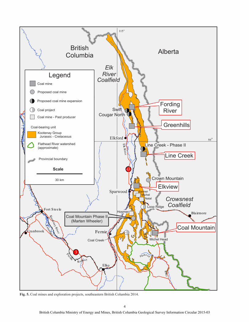
Fig. 5. Coal mines and exploration projects, southeastern British Columbia 2014.
4British Columbia Ministry of Energy and Mines, British Columbia Geological Survey Information Circular 2015-03
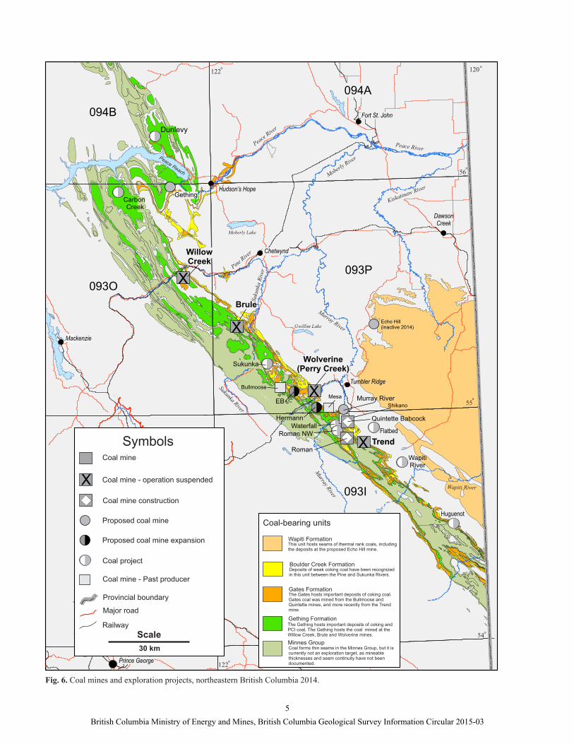
Fig. 6. Coal mines and exploration projects, northeastern British Columbia 2014.
5British Columbia Ministry of Energy and Mines, British Columbia Geological Survey Information Circular 2015-03

Table 1. Production and reserve estimates for coal producers in British Columbia, 2014.
The Elk Valley Coalfi eld is in the Alexander Creek and Greenhills synclines (Fig. 8), and includes the Fording River, Greenhills and Line Creek operations. The Crowsnest Coalfi eld lies in the Fernie Basin, a broad north-trending synclinorium that hosts the current Elkview and Coal Mountain operations. Pulverized Coal Injection (PCI) coal is the main product shipped from Coal Mountain.
ExplorationIn the southeast, $36 million was spent on coal exploration
in 2014 (Fig. 5), mainly on mine lease and mine evaluation drilling. All fi ve Teck operations have expansion projects in the exploration, permitting, or development stage (Table 2). Spending on grassroots exploration projects was lower than in previous years.
Fording River Operations conducted exploration drilling in the active Eagle, Turnbull and Henretta pits. The Swift project continued work on meeting requirements of the pre-application stage of the Environmental Assessment process. It is west of
the Fording River, and partly encompasses previous Fording River Mine pits on the Greenhills Range. The project is along strike, and directly north of, the Greenhills Cougar North project. When joined, the two projects, will be referred to as the Swift. At the Greenhills Operation, drilling was focused on the active Cougar pit. Baseline studies continued for the pre-application phase for the Cougar Pit Extension.
At the Line Creek mine, drilling was done at the Burnt Ridge Extension project as it entered the pre-application phase. Pre-stripping was carried out at Mount Michael and Burnt Ridge North.
At Elkview mine, the Baldy Ridge extension entered the pre-application stage of the Environmental Assessment process in June. Exploration drilling continued in the active pits and expansion areas at Baldy Ridge and Natal Ridge. Teck also continued exploration drilling in active pits 6 and 37 at their Coal Mountain property. At Crown Mountain, Jameson Resources Limited completed a pre-feasibility study in August. The project has now entered the pre-application phase of the
Mine Operator Deposit Type/Commodity
Forecast 2014 Production
Reserves as of Dec 31, 2013
Brule Walter Energy, Inc ULV PCI coal 1.02 Mt 17.5 million tonnes
Coal Mountain Teck Coal Limited PCI and thermal coal 2.54 Mt9.5 million tonnes PCI
0.7 million tonnes thermal
Elkview Teck Coal Limited HCC 5.45 Mt 176.3 million tonnes HCC
Fording River Teck Coal Limited HCC and thermal coal 8.97 Mt628.6 million tonnes HCC
4.6 million tonnes thermal
Greenhills Teck Coal Limited HCC, PCI and thermal coal 5.15 Mt
53.3 million tonnes HCC
3.04 million tonnes PCI
0.96 million tonnes thermal
Line Creek Teck Coal Limited HCC, PCI and thermal coal 3.40 Mt
55.7 million tonnes HCC
3.4 million tonnes PCI
8.3 million tonnes thermal
Quinsam & 7 South
Hillsborough Resources Limited Thermal coal 220 000 t washed
coal not available
Trend Anglo American plc HCC 1.71 Mt washed coal 12.8 Mt
Willow Creek Walter Energy, Inc HCC and ULV PCI 0 t (Production suspended in 2013) 18.6 Mt
Wolverine (Perry Creek) Walter Energy, Inc HCC 564 000 t 9.4 Mt
HCC = hard coking coal; PCI = pulverized coal injection; ULV = ultra low volatile
6British Columbia Ministry of Energy and Mines, British Columbia Geological Survey Information Circular 2015-03
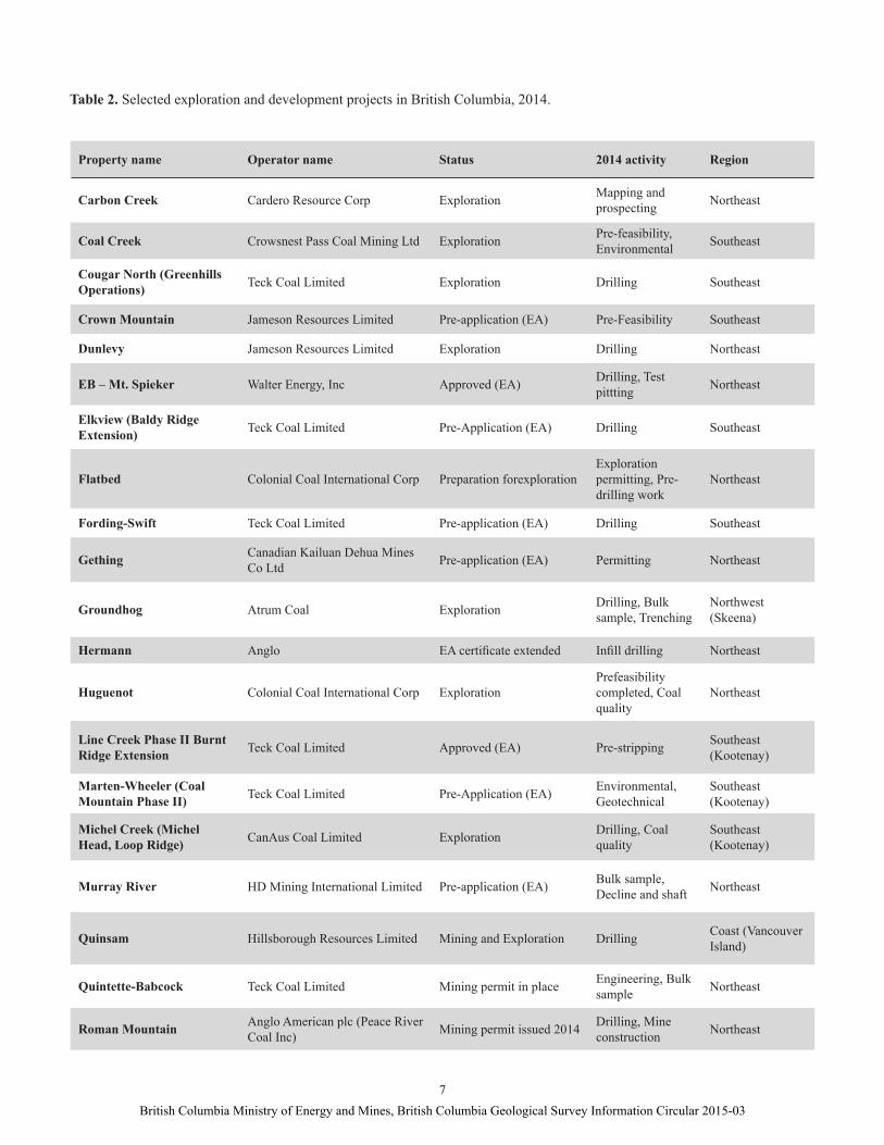
Table 2. Selected exploration and development projects in British Columbia, 2014.
Property name Operator name Status 2014 activity Region
Carbon Creek Cardero Resource Corp Exploration Mapping and prospecting Northeast
Coal Creek Crowsnest Pass Coal Mining Ltd Exploration Pre-feasibility, Environmental Southeast
Cougar North (Greenhills Operations) Teck Coal Limited Exploration Drilling Southeast
Crown Mountain Jameson Resources Limited Pre-application (EA) Pre-Feasibility Southeast
Dunlevy Jameson Resources Limited Exploration Drilling Northeast
EB – Mt. Spieker Walter Energy, Inc Approved (EA) Drilling, Test pittting Northeast
Elkview (Baldy Ridge Extension) Teck Coal Limited Pre-Application (EA) Drilling Southeast
Flatbed Colonial Coal International Corp Preparation forexplorationExploration permitting, Pre-drilling work
Northeast
Fording-Swift Teck Coal Limited Pre-application (EA) Drilling Southeast
Gething Canadian Kailuan Dehua Mines Co Ltd Pre-application (EA) Permitting Northeast
Groundhog Atrum Coal Exploration Drilling, Bulk sample, Trenching
Northwest (Skeena)
Hermann Anglo EA certifi cate extended Infi ll drilling Northeast
Huguenot Colonial Coal International Corp ExplorationPrefeasibility completed, Coal quality
Northeast
Line Creek Phase II Burnt Ridge Extension Teck Coal Limited Approved (EA) Pre-stripping Southeast
(Kootenay)
Marten-Wheeler (Coal Mountain Phase II) Teck Coal Limited Pre-Application (EA) Environmental,
GeotechnicalSoutheast (Kootenay)
Michel Creek (Michel Head, Loop Ridge) CanAus Coal Limited Exploration Drilling, Coal
qualitySoutheast (Kootenay)
Murray River HD Mining International Limited Pre-application (EA) Bulk sample, Decline and shaft Northeast
Quinsam Hillsborough Resources Limited Mining and Exploration Drilling Coast (Vancouver Island)
Quintette-Babcock Teck Coal Limited Mining permit in place Engineering, Bulk sample Northeast
Roman Mountain Anglo American plc (Peace River Coal Inc) Mining permit issued 2014 Drilling, Mine
construction Northeast
7British Columbia Ministry of Energy and Mines, British Columbia Geological Survey Information Circular 2015-03
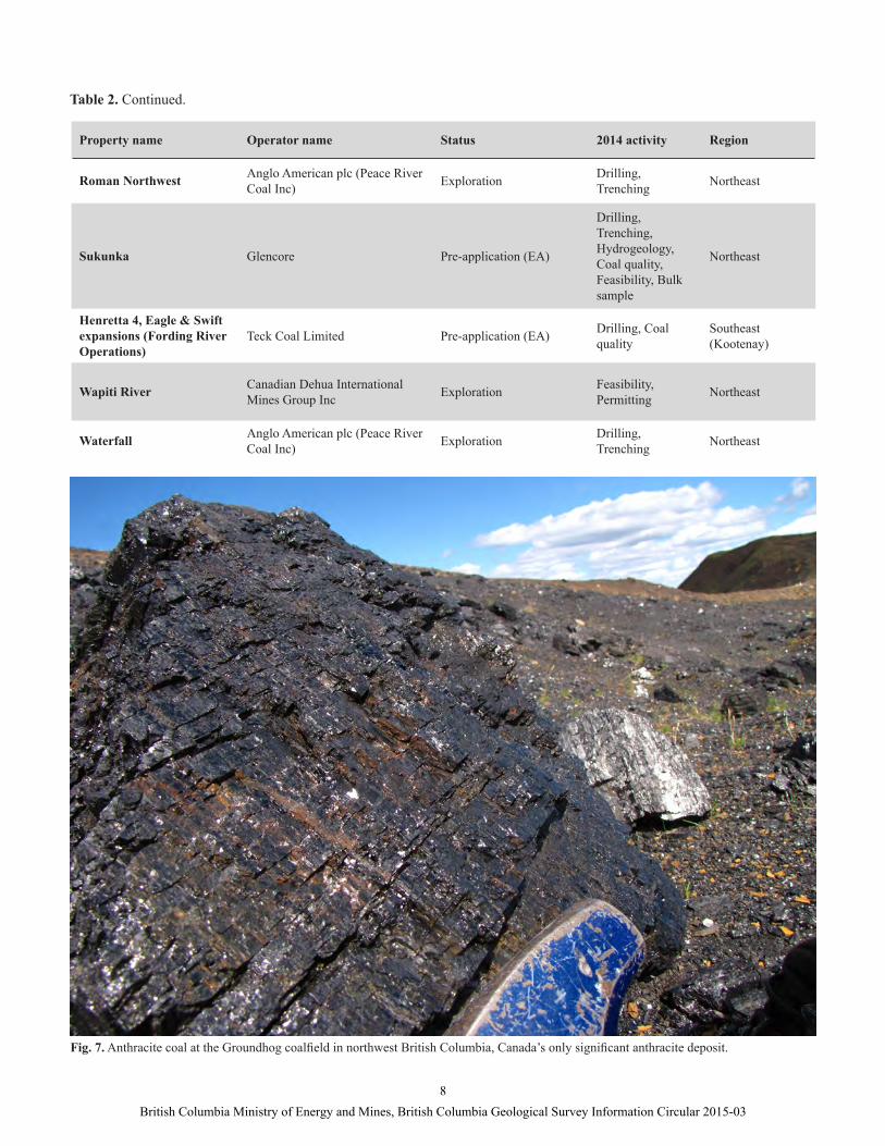
Fig. 7. Anthracite coal at the Groundhog coalfi eld in northwest British Columbia, Canada’s only signifi cant anthracite deposit.
Table 2. Continued.
Property name Operator name Status 2014 activity Region
Roman Northwest Anglo American plc (Peace River Coal Inc) Exploration Drilling,
Trenching Northeast
Sukunka Glencore Pre-application (EA)
Drilling, Trenching, Hydrogeology, Coal quality, Feasibility, Bulk sample
Northeast
Henretta 4, Eagle & Swift expansions (Fording River Operations)
Teck Coal Limited Pre-application (EA) Drilling, Coal quality
Southeast (Kootenay)
Wapiti River Canadian Dehua International Mines Group Inc Exploration Feasibility,
Permitting Northeast
Waterfall Anglo American plc (Peace River Coal Inc) Exploration Drilling,
Trenching Northeast
8British Columbia Ministry of Energy and Mines, British Columbia Geological Survey Information Circular 2015-03
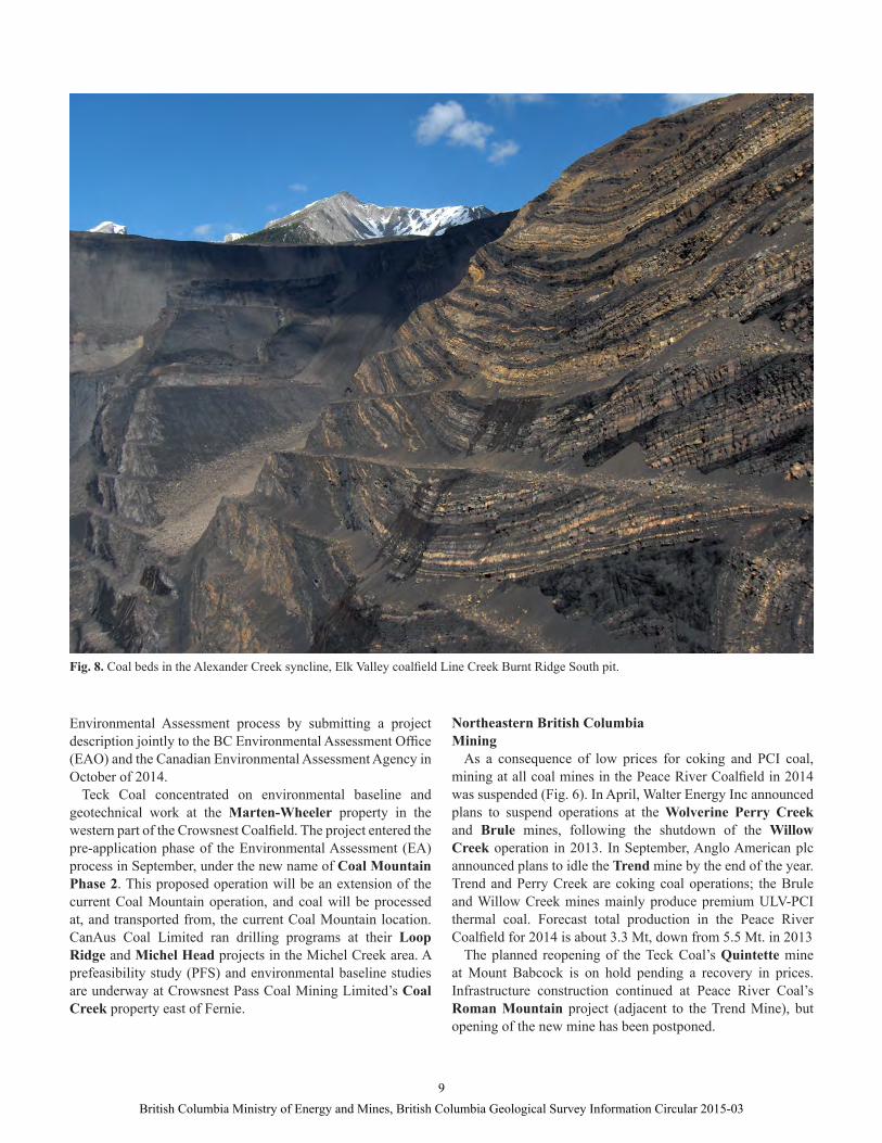
Fig. 8. Coal beds in the Alexander Creek syncline, Elk Valley coalfi eld Line Creek Burnt Ridge South pit.
Environmental Assessment process by submitting a project description jointly to the BC Environmental Assessment Offi ce (EAO) and the Canadian Environmental Assessment Agency in October of 2014.
Teck Coal concentrated on environmental baseline and geotechnical work at the Marten-Wheeler property in the western part of the Crowsnest Coalfi eld. The project entered the pre-application phase of the Environmental Assessment (EA) process in September, under the new name of Coal Mountain Phase 2. This proposed operation will be an extension of the current Coal Mountain operation, and coal will be processed at, and transported from, the current Coal Mountain location. CanAus Coal Limited ran drilling programs at their Loop Ridge and Michel Head projects in the Michel Creek area. A prefeasibility study (PFS) and environmental baseline studies are underway at Crowsnest Pass Coal Mining Limited’s Coal Creek property east of Fernie.
Northeastern British ColumbiaMining
As a consequence of low prices for coking and PCI coal, mining at all coal mines in the Peace River Coalfi eld in 2014 was suspended (Fig. 6). In April, Walter Energy Inc announced plans to suspend operations at the Wolverine Perry Creek and Brule mines, following the shutdown of the Willow Creek operation in 2013. In September, Anglo American plc announced plans to idle the Trend mine by the end of the year. Trend and Perry Creek are coking coal operations; the Brule and Willow Creek mines mainly produce premium ULV-PCI thermal coal. Forecast total production in the Peace River Coalfi eld for 2014 is about 3.3 Mt, down from 5.5 Mt. in 2013
The planned reopening of the Teck Coal’s Quintette mine at Mount Babcock is on hold pending a recovery in prices. Infrastructure construction continued at Peace River Coal’s Roman Mountain project (adjacent to the Trend Mine), but opening of the new mine has been postponed.
9British Columbia Ministry of Energy and Mines, British Columbia Geological Survey Information Circular 2015-03
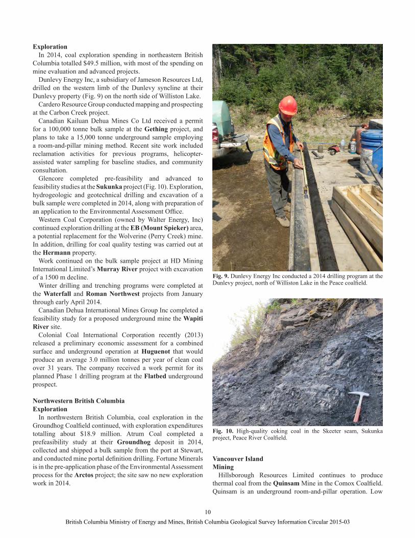
Fig. 9. Dunlevy Energy Inc conducted a 2014 drilling program at the Dunlevy project, north of Williston Lake in the Peace coalfi eld.
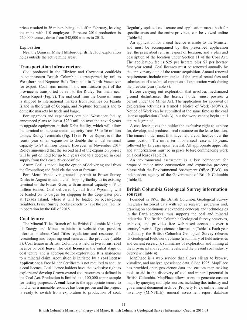
Fig. 10. High-quality coking coal in the Skeeter seam, Sukunka project, Peace River Coalfi eld.
ExplorationIn 2014, coal exploration spending in northeastern British
Columbia totalled $49.5 million, with most of the spending on mine evaluation and advanced projects.
Dunlevy Energy Inc, a subsidiary of Jameson Resources Ltd, drilled on the western limb of the Dunlevy syncline at their Dunlevy property (Fig. 9) on the north side of Williston Lake.
Cardero Resource Group conducted mapping and prospecting at the Carbon Creek project.
Canadian Kailuan Dehua Mines Co Ltd received a permit for a 100,000 tonne bulk sample at the Gething project, and plans to take a 15,000 tonne underground sample employing a room-and-pillar mining method. Recent site work included reclamation activities for previous programs, helicopter-assisted water sampling for baseline studies, and community consultation.
Glencore completed pre-feasibility and advanced to feasibility studies at the Sukunka project (Fig. 10). Exploration, hydrogeologic and geotechnical drilling and excavation of a bulk sample were completed in 2014, along with preparation of an application to the Environmental Assessment Offi ce.
Western Coal Corporation (owned by Walter Energy, Inc) continued exploration drilling at the EB (Mount Spieker) area, a potential replacement for the Wolverine (Perry Creek) mine. In addition, drilling for coal quality testing was carried out at the Hermann property.
Work continued on the bulk sample project at HD Mining International Limited’s Murray River project with excavation of a 1500 m decline.
Winter drilling and trenching programs were completed at the Waterfall and Roman Northwest projects from January through early April 2014.
Canadian Dehua International Mines Group Inc completed a feasibility study for a proposed underground mine the Wapiti River site.
Colonial Coal International Corporation recently (2013) released a preliminary economic assessment for a combined surface and underground operation at Huguenot that would produce an average 3.0 million tonnes per year of clean coal over 31 years. The company received a work permit for its planned Phase 1 drilling program at the Flatbed underground prospect.
Northwestern British ColumbiaExploration
In northwestern British Columbia, coal exploration in the Groundhog Coalfi eld continued, with exploration expenditures totalling about $18.9 million. Atrum Coal completed a prefeasibility study at their Groundhog deposit in 2014, collected and shipped a bulk sample from the port at Stewart, and conducted mine portal defi nition drilling. Fortune Minerals is in the pre-application phase of the Environmental Assessment process for the Arctos project; the site saw no new exploration work in 2014.
Vancouver Island Mining
Hillsborough Resources Limited continues to produce thermal coal from the Quinsam Mine in the Comox Coalfi eld. Quinsam is an underground room-and-pillar operation. Low
10British Columbia Ministry of Energy and Mines, British Columbia Geological Survey Information Circular 2015-03
prices resulted in 36 miners being laid off in February, leaving the mine with 110 employees. Forecast 2014 production is 220,000 tonnes, down from 348,000 tonnes in 2013.
ExplorationNear the Quinsam Mine, Hillsborough drilled four exploration
holes outside the active mine areas.
Transportation infrastructureCoal produced in the Elkview and Crowsnest coalfi elds
in southeastern British Columbia is transported by rail to Westshore and Neptune Bulk Terminals in North Vancouver for export. Coal from mines in the northeastern part of the province is transported by rail to the Ridley Terminals near Prince Rupert (Fig. 2). Thermal coal from the Quinsam mine is shipped to international markets from facilities on Texada Island in the Strait of Georgia, and Neptune Terminals and to domestic markets by truck and barge.
Port upgrades and expansions continue. Westshore facility announced plans to invest $230 million over the next 5 years to upgrade equipment at their Delta facility, which will allow the terminal to increase annual capacity from 33 to 36 million tonnes. Ridley Terminals (Fig. 11) in Prince Rupert is in the fourth year of an expansion to double the annual terminal capacity to 24 million tonnes. However, in November 2014 Ridley announced that the second half of the expansion project will be put on hold for up to 5 years due to a decrease in coal supply from the Peace River coalfi eld.
Atrum Coal is modelling the option of delivering coal from the Groundhog coalfi eld via the port at Stewart.
Port Metro Vancouver granted a permit to Fraser Surrey Docks in August to add a coal shipping facility to its existing terminal on the Fraser River, with an annual capacity of four million tonnes. Coal delivered by rail from Wyoming will be loaded on to barges for shipping to the deep-water port at Texada Island, where it will be loaded on ocean-going freighters. Fraser Surrey Docks expects to have the coal facility in operation by the fall of 2015.
Coal tenureThe Mineral Titles Branch of the British Columbia Ministry
of Energy and Mines maintains a website that provides information about Coal Titles regulations and resources for researching and acquiring coal tenures in the province (Table 3). Coal tenure in British Columbia is held in two forms: coal licence or coal lease. The coal licence is the initial stage of coal tenure, and is appropriate for exploration. It is analogous to a mineral claim. Acquisition is initiated by a coal license application; a Free Miner Certifi cate is not required to acquire a coal licence. Coal licence holders have the exclusive right to explore and develop Crown-owned coal resources as defi ned in the Coal Act. Production is limited to a 100,000-tonne sample for testing purposes. A coal lease is the appropriate tenure to hold when a mineable resource has been proven and the project is ready to switch from exploration to production of coal.
Regularly updated coal tenure and application maps, both for specifi c areas and the entire province, can be viewed online (Table 3.)
An application for a coal licence is made to the Minister and must be accompanied by: the prescribed application fee; the prescribed rent in respect of location; and a plan and description of the location under Section 11 of the Coal Act. The application fee is $25 per hectare plus $7 per hectare fi rst year rental. Coal licenses must be renewed annually by the anniversary date of the tenure acquisition. Annual renewal requirements include remittance of the annual rental fees and submission of a technical report on all exploration work during the previous year (Table 3).
Before carrying out exploration that involves mechanized ground disturbance, the licence holder must possess a permit under the Mines Act. The application for approval of exploration activities is termed a Notice of Work (NOW). A Notice of Work can be submitted at the same time as the coal license application (Table 3), but the work cannot begin until tenure is granted.
A coal lease gives the holder the exclusive right to explore for, develop, and produce a coal resource on the lease location. The tenure holder must fi rst have held a coal licence over the same location. The initial term for a coal lease is 30 years, followed by 15 years upon renewal. All appropriate approvals and authorizations must be in place before commencing work on a coal lease (Table 3).
An environmental assessment is a key component for proposed major mine construction and expansion projects; please visit the Environmental Assessment Offi ce (EAO), an independent agency of the Government of British Columbia (Table 3).
British Columbia Geological Survey information sources
Founded in 1895, the British Columbia Geological Survey integrates historical data with active research programs and, drawing on continuously advancing concepts and technologies in the Earth sciences, thus supports the coal and mineral industries. The British Columbia Geological Survey preserves, archives, and provides free web-based access to over a century’s worth of geoscience information (Table 4). Each year in January, the British Columbia Geological Survey releases its Geological Fieldwork volume (a summary of fi eld activities and current research), summaries of exploration and mining at the provincial and regional levels, and the present coal industry overview (Table 4).
MapPlace is a web service that allows clients to browse, visualize, and analyze geoscience data. Since 1995, MapPlace has provided open geoscience data and custom map-making tools to aid in the discovery of coal and mineral potential in British Columbia. MapPlace allows users to generate custom maps by querying multiple sources, including the: industry and government document archive (Property File); online mineral inventory (MINFILE); mineral assessment report database
11British Columbia Ministry of Energy and Mines, British Columbia Geological Survey Information Circular 2015-03

To access Click
Coal titles http://www.empr.gov.bc.ca/Titles/MineralTitles/Coal/Pages/default.aspx
Coal tenure and application maps http://www.empr.gov.bc.ca/Titles/MineralTitles/Pub/Coal/Pages/Maps.aspx
Existing coal tenures http://www.empr.gov.bc.ca/Titles/MineralTitles/Coal/Pages/Search.aspx
Coal licence application and other forms http://www.empr.gov.bc.ca/Titles/MineralTitles/Pub/Coal/Pages/Forms.aspx
Annual renewal and technical report requirements http://www.empr.gov.bc.ca/Mining/Geoscience/Coal/Pages/Reporting_Information.aspx
Notice of Work (FrontCounter BC) http://www.frontcounterbc.ca/apps/now.html
Coal leases http://www.empr.gov.bc.ca/Mining/Permitting-Reclamation/Pages/default.aspx
Environmental Assessment Offi ce http://www.eao.gov.bc.ca/ea_process.html
Table 3. Websites to access coal tenure information.
Table 4. Websites to access British Columbia Geological Survey publications, maps, and databases, at no charge.
To access Click
British Columbia Geological Survey publication catalogue
http://www.empr.gov.bc.ca/MINING/GEOSCIENCE/PUBLICATIONSCATALOGUE/Pages/default.aspx
British Columbia coal industry overview 2014 (this volume)
http://www.empr.gov.bc.ca/Mining/Geoscience/PublicationsCatalogue/InformationCirculars/Pages/IC2015-3.aspx
British Columbia Geological Survey geological fi eldwork
http://www.empr.gov.bc.ca/Mining/Geoscience/PublicationsCatalogue/Fieldwork/Pages/default.aspx
British Columbia Geological Survey coal geology page http://www.empr.gov.bc.ca/Mining/Geoscience/Coal/Pages/default.aspx
Provincial Overview of Mines and Mineral Exploration
http://www.empr.gov.bc.ca/Mining/Geoscience/PublicationsCatalogue/InformationCirculars/Pages/IC2015-1.aspx
Exploration and Mining in British Columbia http://www.empr.gov.bc.ca/Mining/Geoscience/PublicationsCatalogue/InformationCirculars/Pages/IC2015-2.aspx
Table of British Columbia coal resources (British Columbia Geological Survey GeoFile 2010-11, by B. Northcote)
http://www.empr.gov.bc.ca/Mining/Geoscience/PublicationsCatalogue/GeoFiles/Pages/2010-11.aspx
British Columbia coal assessment reports and COALFILE
http://www.empr.gov.bc.ca/Mining/Geoscience/Coal/CoalBC/Pages/CoalDataReports.aspx
MINFILE http://www.empr.gov.bc.ca/MINING/GEOSCIENCE/MINFILE/Pages/default.aspx
MapPlace(requires Autodesk MapGuide Viewer)
http://www.mapplace.cahttp://webmap.em.gov.bc.ca/mapplace/minpot/coal.cfm
12British Columbia Ministry of Energy and Mines, British Columbia Geological Survey Information Circular 2015-03
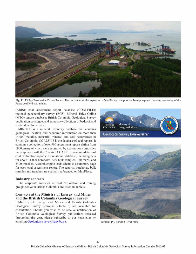
Fig. 11. Ridley Terminal at Prince Rupert. The remainder of the expansion of the Ridley coal port has been postponed pending reopening of the Peace coalfi eld coal mines.
Turnbull Pit, Fording River mine.
(ARIS); coal assessment report database (COALFILE); regional geochemistry survey (RGS); Mineral Titles Online (MTO) tenure database; British Columbia Geological Survey publication catalogue, and extensive collections of bedrock and surfi cial geology maps.
MINFILE is a mineral inventory database that contains geological, location, and economic information on more than 14,000 metallic, industrial mineral, and coal occurrences in British Columbia. COALFILE is the database of coal reports. It contains a collection of over 900 assessment reports dating from 1900, many of which were submitted by exploration companies in compliance with the Coal Act. COALFILE contains details of coal exploration reports in a relational database, including data for about 11,000 boreholes, 500 bulk samples, 950 maps, and 3400 trenches. A search engine leads clients to a summary page for each coal assessment report. The reports, boreholes, bulk samples and trenches are spatially referenced on MapPlace.
Industry contactsThe corporate websites of coal exploration and mining
groups active in British Columbia are listed in Table 5.
Contacts at the Ministry of Energy and Mines and the British Columbia Geological Survey
Ministry of Energy and Mines and British Columbia Geological Survey personnel (Table 6) are available for consultation. Should you wish to be receive notifi cation of British Columbia Geological Survey publications released throughout the year, please subscribe to our newsletter by emailing [email protected].
13British Columbia Ministry of Energy and Mines, British Columbia Geological Survey Information Circular 2015-03
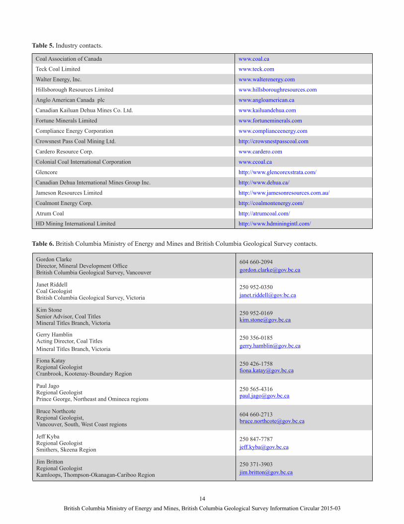
Table 5. Industry contacts.
Table 6. British Columbia Ministry of Energy and Mines and British Columbia Geological Survey contacts.
Coal Association of Canada www.coal.ca
Teck Coal Limited www.teck.com
Walter Energy, Inc. www.walterenergy.com
Hillsborough Resources Limited www.hillsboroughresources.com
Anglo American Canada plc www.angloamerican.ca
Canadian Kailuan Dehua Mines Co. Ltd. www.kailuandehua.com
Fortune Minerals Limited www.fortuneminerals.com
Compliance Energy Corporation www.complianceenergy.com
Crowsnest Pass Coal Mining Ltd. http://crowsnestpasscoal.com
Cardero Resource Corp. www.cardero.com
Colonial Coal International Corporation www.ccoal.ca
Glencore http://www.glencorexstrata.com/
Canadian Dehua International Mines Group Inc. http://www.dehua.ca/
Jameson Resources Limited http://www.jamesonresources.com.au/
Coalmont Energy Corp. http://coalmontenergy.com/
Atrum Coal http://atrumcoal.com/
HD Mining International Limited http://www.hdminingintl.com/
Gordon ClarkeDirector, Mineral Development Offi ceBritish Columbia Geological Survey, Vancouver
Janet RiddellCoal GeologistBritish Columbia Geological Survey, Victoria
Kim StoneSenior Advisor, Coal TitlesMineral Titles Branch, Victoria
Gerry HamblinActing Director, Coal TitlesMineral Titles Branch, Victoria
Fiona KatayRegional Geologist Cranbrook, Kootenay-Boundary Region
250 426-1758fi [email protected]
Paul JagoRegional GeologistPrince George, Northeast and Omineca regions
Bruce NorthcoteRegional Geologist,Vancouver, South, West Coast regions
Jeff KybaRegional GeologistSmithers, Skeena Region
Jim Britton Regional GeologistKamloops, Thompson-Okanagan-Cariboo Region
14British Columbia Ministry of Energy and Mines, British Columbia Geological Survey Information Circular 2015-03