british columbia nts 104jj2 coal liegnsesc,3904-3913 1x1. · shield volcanoes such as level...
TRANSCRIPT

I .
I -, .I
-.. _~ ; _: :
~ ‘$ ,_. ,- ,_ ‘\
-,, ‘~~ ..,., ,~ .I
:i . !
., /_’
/
,.~ :: '<:~.,,,$mJ~,++ MAPPING OF '.k TUYA RIVER PROPERTY, ,..
BRITISH COLUMBIA
NTS 104Jj2
Coal Liegnsesc,3904-3913 1x1.
Br,uce D. Vincent, P. Gebl.'.:, .,'~.j Esso Minerals Canada ,! Xoal Department Calgary, Alberta
sci
i
SUMMARY
The geological mapping and coal sampling program of
<he combined Tuya River coal licences of W.E. Kleinhout and Esso
iinerals Canada was conducted from June l'to June 23, 1979. The
field work allowed division of the Lower Tertiary Sustut Group
5nto a fine-grained, coal-bearing Lower Member, a coarser-grained,
coal-bearing Middle Member, and an Upper Member consisting of
interbedded conglomerate and basalt flows. The stratigraphic
relationships between the units and their area1 extent is not
well defined. The structural geology his moderately complex main-
ly consisting of northerly-trending open folds and minor faults.
The coal is estimated to be high volatile C bituminous
+I rank. Reserves were not estimated due to insufficient data.
'l!he Lower'Member coals are in two seams up to 4 metres thick
each with the best potential being~west of the property. The
Middle Member coals are in a zone exposed on the east side of
the prop,erty with individual seams up to 2 m&tres thick.
The Tuya River property has the potential of holding
coal reserves of the size and quality to be of interest to Esso
Minerals. Therefore, it is recommended Esso Minerals retain the
option on W.E. Kleinhout's coal licences and continue active ex-
pioration. A six-hole diamond drilling program is proposed for
the spring of 1980.
,. /
! ! I
7 I
i

INDEX
SUMMARY i Index ii List of Figures and Tables iii
1. INTRODUCTION 1 1.1 Objective 1 1.2 Location and Access 1 1.3 Geography 3 1.4 Previous Work 3 1.5 Land Status 4 1.6 Other Features 4
2. REGIONAL GEOLOGY 8
3. PROPERTY GEOLOGY 11 3.1 Stratigraphy 11 3.2 Structural Geology 15 3.3 Coal Occurrences 18
4. COAL QUALITY 21
5. COAL.RESERVES 22
6. CONCLUSIONS 24
7. RECOMMENDATIONS AND PROPOSALS 25
REFERENCES 28
STATEMENTS OF QUALIFICATIONS 29
APPENDIX I : 1979 Exploration Procedures and Costs
APPENDIX II : Graphic Logs of Coal Seams
ii

LIST OF FIGURES AND TABLES
FIGURE
1. Regional location map
2. Coal licence area
3. Regional correlation chart
4. Property stratigraphic column
5. Geological map
6. Structural cross-section
7. Proposed drill hole locations
TABLE
1. Coal licence and application descriptions b
PAGE
2
5
10
12
in pocket
in pocket
27
iii

1. INTRODUCTION
1.1 Objective
As part of the obligations of the option agreement be-
tween Esso !linerals Canada and Mr. W.E. Kleinhout, a geological
mapping program was conducted over Mr. Kleinhout's Tuya River
coal licences in June, 1979. The mapping was planned to collect
information on the stratigraphy, structural geology, and 31 ---
geology o_n_.and a:% the.licences. This report documents the -, ---- ---
findings of the mapping program, provides an interpretation, and _ - ,
assesses,the economic potential of the property.
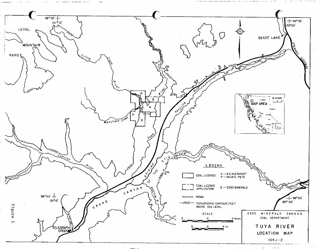
1.2 Location and Access
The Tuya River property is situated in northwestern
British Columbia covering portions of NTS map sheets 1045!2 and
104517. The approximate center of the property is 46 kilometres
southwest and 44 kilometres northeast of the communities of Dease
Lake and Telegraph Creek respectively. (See Figure 1.) A gravel
road joins those two communities and passes within 1.5 kilometres
of the southeastern boundary of the coal licences. An unused
trail connects the road and the property. No other vehicular
access is present. Airstrips are maintained at both Telegraph
Creek and Dease Lake.
The area is 260 kilometres north of Stewart. From Dease
Lake, B.C. Highway 37 travels north to Cassair and connects with
the Alaska Highway in the Yukon. Southvzrd it joins Highway 16
-l-

I._-
f
\

u
I.
,‘L,
at Terrace and a second road from Stewart joins at Neziadin Junction
The road distance form Dease Lake to Stewart is 340 kilometres.
1.3 Geography
The project area lies within the Stikine Plateau, an area
of subdued topography rising into the northeast to the Cassair Moun-
tains and to the southwest into the Coast Mountains. Elevations in
the map area range from 490 metres above sea level in the deeply-
incised river valleys to over 820 metres on the plateau surface.
Tuya River and its tributaries flow southerly into Stikine
River which flows into the Pacific Ocean. At the mouth of the Tuya,
the Stikine flows rapidly through the steep gorge known as the Grand
Canyon of the Stikine. Tuya and Little Tuya Rivers are also swiftly-
flowing rix+x, entrenchtid in valleys up to 200 metres deep. On the
plateau surface, drainage is very poor with many areas of swamp. The ,
rest is covered by coniferous to mixed forests.
1.4 Previous Work
One of the first recorded examinations of the Tuya River
coal occurrences was by R.D. Featherstonhaugh in 1904 (Dowling, 1915)
for the Atlin - Tuya Coal Prospecting Syndicate. A Dr. hT. Smither-
ingale re-examined the coal in 1953 (Dolmage Canpell and Associates,
1975) while the first of the more recent geological maps of the re-
gion was published in 1957 (GSC, 1957). Subsequently, Gabrielse
and Souther (1962), Souther (1972), and the GSC (1974) have updated
the geological interpretation of that portion of S.C. Little work
-3-

ci
I
$2 I
has been done on the coal-bearing sedimentsin the Tuya River area
in particular but they have been correlated to formations to the
southeast studied by Eisbacher (1974).
1.5 Land Status
Mr. W.E. Kleinhout was granted ten coal licences total-
ling 2590.hectares in the Tuya River area on June 23, 1978. The
numbers and locations are listed in Table 1 and their locations
shown on Figure 2. On May 4, 1979,Mr. Kleinhout and Esso Minerels
Canada signed an agreement in which Esso received an option to pur-
chase the coal licences from Mr. Kleinhout and, in return, agreed
to pay the licence rental costs and fulfil1 the exploration obli-
gations as required by the British Columbia Government.
In addition, Esso-~has applied for four coal licences,
approximately 1100 hectares, to the north of Mr. Kleinhout's li-
cences. The descriptions of these are also included in Table 1.
Pacific Petroleums of Calgary had fourteen coal licences
to the west of Kleinhout's and Esso's licence area, granted June 23,
1978, and has recently applied for three more licences. Their li-
cence and application area is approximately 11.5 kilometres in
length from north to south and 5 kilometres in width for a total
area of approximately 3900 hecrares. There are no other coal li-
cences or leases in the area.
1.6 Other Features
The only mining operation in the region is that of Cassiaz

COAL DIVISION
COAL LICENSE LOCATIONS NTS 104J/2

Coal licenses of W. E. Kleinhout within the Tuya River Area, Cassair Land District, B.C.:
License Number Surface Lot Nmbei-
3904 2899 3905 2900 3906 2901 3907 2902 3908 2903 3909 2904 3910 2905 3911 2906 3912 2907 3913 2908
Coal license applications of Esso Minerals Canada within the Tuya River Area, B.C.:
Within NTS Xa.p 104517: Block B: Portions of Units 25 and 26 riot included in coal licenses
3904 and 3905, all of Units 35 and 36. Portions of Units 27 and 28 not included in coal licenses 3904 and 3905, all of Units 37 and 38. Portions of Units 29 and 30 not included in coal licenses 3904 and 3905, all of Units 39 and 40.
Block C: Portions of Units 21 and 22 not included in coal license 3911, all of Units 31 and 32.
Table I. Descriptions of Coal Licenses and Coal License Applications Controlled by
Esso Minerals Canada in the Tuya River Area, British Columbia.
-6-

i
Asbestos at Cassiar, north of Dease Lake. -There are no other large
industrial employers in the area. Electricity is generated locally
in diesel-fired units. However, B.C. Hydro has a large crew along
the Stikine this summer studying its suitability for a hydro-electric
project.
Cassair Asbestos trucks its product to tidewater at
stewart. No rail transportation is available, however, Dease Lake
was to be the terminus for a British Columbia Railroad line from
Prince George. This project has been postponed indefinitely since
the .summer of 1977.
-7-

2. REGIONAL GEOLOGY
The Stikine Plateau lies within the Intermontane Belt
of the Cordillera, an area underlain mainly by Paleozoic and Mes-
ozoicsedimentary and volcanic rocks and Elanked by the Coast and
Cassair-Gmineca Crystalline Complexes. Within the belt are rema- .
nents of Late Cretaceous to Early Tertiary sedimentary rocks, such
as those at Tuya River, which lie unconformably on deformed Pale-
ozoic and Mesozoic strata. From the Late Tertiary to the Recent,
predominantly basic igneous rocks were extruded as plateau basalts,
shield volcanoes such as Level Mountain, and complex composite vol-
canoes such as Mount Edziza (Souther and Armstrong, 1966).
The deformation of the Paleozoic strata ranges from slight
to intense with some areas exhibiting more than a single phase of
deformation. The Mesozoic rocks are characterized by folding and
a multitude of faults. The Tertiary-aged elastic rocks have been
faulted, tilted, and folded into generally open folds. No folds
have been observed in the Tertiary-Quaternary volcanics, however,
faults have offset some Pliestocene and younger lava flows (Gabrieise
and Souther, 1962; Souther, 1972). In the Telegraph Creek map area,
south of the Tuya River area, the major fault zones are oriented north-
south. Souther (1972) believes the system may have been established
as early as Late Jurassic and some remained active into the Quarternary.
The coal-bearing Tertiary rocks at Tuya River have been cor-
related with the Upper Cretaceous to Eocene Sustut Group, the main area
of which lies southeast of Tuya River. The Sustut Group was deposited
-8-

into a non-marine s~cces.s~r basin which was formed during the final
phases of the Cretaceous-Tertiary erogenic activity which caused the
intrusion and subsequent uplift of the Coast Crystalline Complex and
the contemporaneous deformation (Eisbacher, 1574'~). Figure 3 shows
the regional correlation of Tertiary and C!uaternary units of north-
western British Columbia.
The Sustut Group in Sustut Basin proper consists of a
lower Tango Creek Formation and an upper Brothers Peak Formation.
The Tango Creek Formation is a sandstone-mudstone sequence grading
up into the Brothers Peak Formation which consists of pebbly sand-
stones to coarse conglomerates interbedded with ash-fall tuffs and
mudstones (Eisbacher, 1974a).
-9-

DEASE LAKE TELEGRAPH CREEK ISKUT RIVER SUSTUT BASIN (Gabrielse & Souther, 19621 (Souther. 19721 (GSC. 1974) (Eisbacher. 1974)
RECENT A A
WARTERNARY Olivinc baralt,
A flows. tuffr ha%!!
PLIESTOCENE barali. divine barah, minor
PLIOCENE MTN OP. ,baraltl V
PEAKS OP. hacbyte. rhwlite)
Karlberg granodioriter
2 MIOCENE
V 4
5 OLIGOCENE
;ti SLOKO GROUP
Early biofite andesite
7 flowi and Silk hEROTHERS PEAK FM. “BROTHERS PEAK FM.
EOCENE A SLOKO GROUP
biotite L.acustrine IeucogranitiC SKUKUM GROUP landerite. balalli randrtane. liltstonel, i”,r”$io”s ,
PALEOCENE conglomerates, tuff, and coal congkmerate, randrtonc. Ihale TANGO C”EEK FM.
V SVSTVT GROUP aNkite conglomerate, l.3ntlstone. shale
UPPER CRETACEOUS TANGO CREEK FM. V
V
Triassic and Jurassic sedimentary

3. PROPERTY GEOLOGY
3.1 Stratigraphy
The elastic and volcanic rocks on the Tuya River prop-
erty have been correlated with the Upper Cretaceous-Lower Tertiary
Sustut Group (GSC, 1974) as defined by Eisbacher (1974). The Sustut .
Group of the Tuya River area have been tentatively subdivided into
three inform1 "members" based upon lithologic differences. The
characteristics of and the relationships between these members are
summarized in Figure 4 and discussed below. The lower contact of
the sequence on or near the property is thought to be an unconfor-
mity over Triassic-Jurassic sedimentary and volcanic rocks. un-
consolidated Quaternary sediments lie unconformably on the Sustut
Group.
The basal or Lower Member is a fining-upward sequence of
mudstone, siltstone, sandstone, and coal. A five metre thick basalt
flow is present near the middle of the unit. Characteristic of this
member in comparison with the higher members is the lack of sedimen-
tary rocks with a grain size larger than coarse grained sandstone.
The coal seams of this member appear to be the thickest and to have
the least number of partings in the area; the coal occurrences will
be discussed further in Section 3.3. The upper contact of the mem-
ber was placed at the base of the first conglomerate above a siltstone-
mudstone sequence. Over the property, the contact is probably grad-
ational. The lower contact was not identified being west of the
property.
-ll-

Unconsolidated glacial and fluvial deposits; till, varved clays, river gravels
QUATXFJWRY Claciofluvial and glaciolacustrine
JPPER CRETACEOUS
Upper Member: basalt-cobble conglomerate, basalt, minor sandstone
iliddle Member:
SUSTUT GROUP coal, basalt
.~,, / Lower Member:
sandstone, siltstone, /
mudstone, coal, basalt
? ?
Figure 4. Stratigraphic Column for the Tuya River Property Showing Informal
Members of the Sustut Group. No Vertical Scale or Geographic
Location Implied.
-l?-

0
0
I u
The Lower Member was identified only along Mansfield
Creek, a tributary of Little Tuya River. A siltstone-mudstone-
coal sequence, located along Little Tuya River, 4 kilometres
north of Mansfield Creek, is tentatively correlated with the
Lower Member. (See Figure 5.)
The Middle Member consists of chert-pebble conglomerate,
sandstone, siltstone, mudstone, and coal. The top of the member is
dominantly conglomerate and sandstone grading downward into a mix-
ture of all lithologies with conglomerate still totalling about
50% of the outcrop areas.
The conglomerates are one to seven metres thick and char-
acteristically consist of chert-pebbles with clastsof other lith-
ologies totalling up to 5%. The elastic rocks commonly show re-
peated fining-upward sequences one to fifteen metres thick. The
coal seams may best be described as zones with numerous partings.
The Middle Member-Upper Member contact is gradational,
chosen where conglomerate clasts become dominantly basalt cobbles.
The thickness is thought to increase from west to east. The Mid-
dle Member may be in part laterally equivalent to the Upper and/or
Lower Members.
The Upper Member consists of basalt, basalt cobble to
boulder conglomerate, and sandstone. The basalt occurs generally
as single flows about 10 metres thick. Columnar jointing is comi~lon
and the upper surfaces are generally vesicular and quartz filled.
Occasionally there is a 0.5 to 1.0 metre thick paleosol beneath
a flow. The conglomerate clasts are predominantly basalt cobbles
to boulders and the matrix is a sandy, black-chert-pebble conglon-
crates similar to the conglomerates of the Xiddle ;Xe13ber. Sandstones
-13-

cj
cj
up to one metre thick, are present within the conglomerates. A
single coal seam was found in the area of the gradational contact
between the Niddle and Upper Members along Little Tuya River.
The Upper Member is found over the northern and western
portions of the property. Its thickness and number of basalt flows
probably vary over the property.
The top of the Upper Member is an unconformity on which
lie erratic but widespread glacio-fluvial sediments of rusty-brown
and grey sands and gravels, 0 to 8 metres thick. In a single out-
crop, additional 10 metres of glacio fluvial and glacio lacustrine
sediments are present and consist of brown sands and gravels and
buff varved clays. Superimposed over the whole property is a 1.5
to 20 metres sequence of glacial till and varved clays along with
fluvial deposits.
The Sustut Group regionally is a totally non-marine se-
quence. At Tuya River, a preliminary interpretation of the sequence
coincides with the regional paleogeography. The Lower Member could
be a meandering or braided fluvial deposit grading upward into a
gravel-dominated, braided stream environment in the Middle Member.
The Upper Member probably represents alluvial fan deposits ante---
poranous with nearby basic volcanic eruptions.
Regional geological maps (Gabrielse and Souther, 1962;
GSC, 1974) date the Sustut Group as Upper Cretaceous to Lower Ter-
tiary and any basalt flows as Upper Tertiary to Recent. No dating
has been done on the Tuya River Sustut Group but if its upper limit
is Eocene, the basalts in the Sustut Group indicate volcanic activlij
-14-

L,
v
began in the Lower Tertiary as opposed to the Upper Tertiary. A
logical source of the volcanic rocks would be the Level Nountzin
Complex located 35 kilometres to the northwest of the Tuya River
property.
3.2 Structural Geology
The structural geology of the Tuya River property appears
to be moderately complex. The dip of bedding surfaces range from
horizontal to 80 degrees, generally being toward the east or north-
east at 25 to 35 degrees. Some folding and faulting was observed
and more hypothesized.
(a) Tuya River shear zone - The position of Tuya River
appears to be controlled by a zone of fracturing or shearing which
strikes approximately north-south, roughly parallel with the orien-
tation of the river valley. Where the Sustut rocks are exposed
along bends of the river, they are highly fractured with displace-
ment of less than one metre to a few metres along several fracture
planes. Quartz and calcite veining or vug filling is founded near
the fracture planes. Overall displacement along the shear zone is
probably in the order of 10 metres; similar lithologies are present
on both sides of the assumed trace of the zone.
Two examples of the shear zone, represented by numerous
minor faults, are at the southern boundary of Lot 2903 and along
the major bend in the river in Lots 2901 and 2902. (See Figure 5.)
The fracturing is most intensive in the coal seams and mud-
stones. The coals have been highly jointed and frectured. The

u
cj
mudstones exhibit both brittle and ductile deformation along
the shear planes. In the mre competent lithologies of con-
glomerate and sandstone, the shear zone appears as an area of
jointing more intense than in adjacent strata
(b) Mansfield Creek folds and fault - Along Mansfield
Creek, at the western boundary of lot 2908, a normal fault zone
dipping 55' southeast was observed in the Lower Piember sandstone-
siltstone sequence. The fault is poorly exposed but thought to
consist of several planes .some of which have been filled with
quartz viens a few centimetres thick. Above the fault is an
easterly-dipping basalt flow and below, the sandstone-siltstone
sequence is folded into a gentle open anticline, possibly a re-
sult of the faulting. One half kilometre west is a syncline with
a 200 metre wavelength. In the syncline is a basalt correlative
to the flow in the hanging wall of the fault. This structure is
shown in Figure 6.
(c) Little Tuya River folds - A sequence of syncline-
anticline-syncline was interpreted to be present along the easterly-
flowing portion of Little Tuya River. These open folds may be used
to tie the geology of the eastern and western parts of the property
together. Their trend is approximately north-south, however there
are no exposures which verify the existance of these folds or their
orientation.
(d) Other tectonic deformation - The linearity of Little
Tuya River, Hansfield Creek.and some tributary streax suggest they
also may be controlled by some type of tectonic deformation. The
-16-

trends are generally east-west or north-south, plus or minus 15'.
A number of other minor faults striking north or northeast were
observed along Tuya and Little Tuya Rivers.
The hypothesis of a north-south trending, Tuya River
shear zone and tectonic controls on the Little Tuya River are
reinforced by the existance of regional northerly-striking faults
in the Telegraph Creek map area inmediately south of Tuya River
(Souther, 1972). These faults found to the south were active from
the Jurassic into the Quaternary, a situation which could have been
duplicated in the Tuya River area.
(e) Glacial thrusting - In an outcrop two kilometres up
Little Tuya River from the northern boundary of Lot 2907, a coal
seam has been thrust over itself during a phase of glaciation.
A single ~failure plane dips'gently to the west and displacement was
in the order of a few tens of metres from west to east. Drag fold-
,ing extends vertically for about one metre below the fault plane.
To the east where the displaced seam is not present, the
surface of the in-place seam is broken and crenulated at its con-
tact with the overlying till indicating previous contact with the
glacial ice.
(f) Surficial deformation - A large number of rotational
landslides or slumps are present along the valleys of Tuya and Little
Tuya Rivers. (See Figure 4.) The slumps are from small to large
and commonly are imbricate (multiple).
One of the best examples is the large slump on the west
bank of Tuya River which ~cwers large portions of Lots 2900 and 2901.
-17-

Combined with the slumps on the east side of the river, the out-
crops of the area must be viewed with some suspicion.
3.3 Coal Occurrences
The coal seams outcropping in the Tuya River map area
can be grouped according to stratigraphic position and geographic
location and the following discussion is so arranged. Graphic
logs of the seams examined in detail are included in Appendix II.
Lower Member coals:
Along Mansfield Creek, some of the best coal in the area
is exposed oti the western boundary of Lot 2908 and west of that on
Pacific Petroleums' property. There are seams present above and
below a basalt flow (Ithe flow correlated across the fault zone).
These seams were not examined in detail and thicknesses are only
approximate. The seam below~the basalt seems to vary from 2 metres
thick with partings in outcrop B53 to 3 metres thick in outcrop
B54. It was also observed in outcrops B55 and B56. Above the basalt
flow, the upper seam is thoughtto be 4 to 5 metres thick.
At outcrop B62 in the northwest corner of the map area,
two seams are separated by 1.15 metres of dark grey mudstone. The
upper one is 1.5 metres thick with one parting of 5 centimetres of
shaley coal, is dominantly attrital coal, and has numerous globular
masses of resin up to 1 centimetre in diameter. The lower seam
floor is brown-grey mudstone in sharp contact with 20 centimetres
of sideritic coal. .The main seam above that is 1.45 metres thick
with minor iron staining on the joints.
Middle Member coals:
In the lower part of the Middle >lernber along Eiensfield
-18-

Creek, coal is present only as lenses a few centimetres thick.
In outcrop W28 on Little Tuya River near its confluence
with the Tuya, 10 centimetre and 30 centimetre thick coal seam
are separated by 20 centimetres of brown coaly mudstone.
South of the Little Tuya along 'Tuya River, outcrops
Y33and B38 contain coal seams. A total of three seams of coal
and/or shaley coal were observed but not measured in detail. The
thickness of each is about 1 metre and the two which are exposed
in one outcrop are about 3 metres apart stratigraphically. Slump-
ing and faulting make the relative positions of these seams in-
determinate.
Further north on the Tuya, at the common corner of Lots
2899, 2900, 2901, and 2912 are the greatest concentration of coal
outcrops in the map area. The faulting and the large scale slump-
ing has made seam correlation over the area nearly impossible and the
outcrops unreliable.
In outcrop B24, there is a sequence of coal and mudstone
which could be properly called a coal zone. At the south end and
base of the outcrop are four seams of 10 to 30 centimetres thick-
ness over 1.7 metres. Five to 10 metres stratigraphically above
that is a 40 centimetre seam, a 10 centimetre parting and a 1.0
metre seam. Two to four metres above that are 4 seams, 20 to
40 centimetres thick over 1.8 metres. The coal is 20% to 100%
vitrain with very little to no fusain. The joint surfaces in
the vitrain is commonly faceted to produce circular surfaces termed
"eye coal" (Schopf, 1960). Iron staining on the joints in the coal
-19-

is common and calcite less common. These ;eams a& thought to
correlate with seams in outcrop W23 on the west side of the river.
Outcrop B25 just to the south of B24 contains a seam 2.15
metres thick which includes a 0.1 and a 0;2 metre thick parting.
Three additional thin seams are present below that. On the same
side of the river outcrops B26, B27, and B28 all include coal seams
but all are poorly exposed and each individual seam is less than
1 metre thick.
On the west side of the river a 6 metre sequence in out-
crop W23 contains numerous coal seams of 0.1 to 0.7 metres thickness.
These seams generally appear dirty with shale partings and iron stain-
ing on the joint surfaces.
To the south in outcrop W24, 4 seams, 0.5 to 0.7 metres
thick, total 2.35 metres of coal over 3.6 metres of section. The
coal components again are vitrain and attrital coal with iron stain-
ing on the joint surfaces. An additional 0.6 metre seam is present
in outcrop W26 further south.
Upper Member coals:
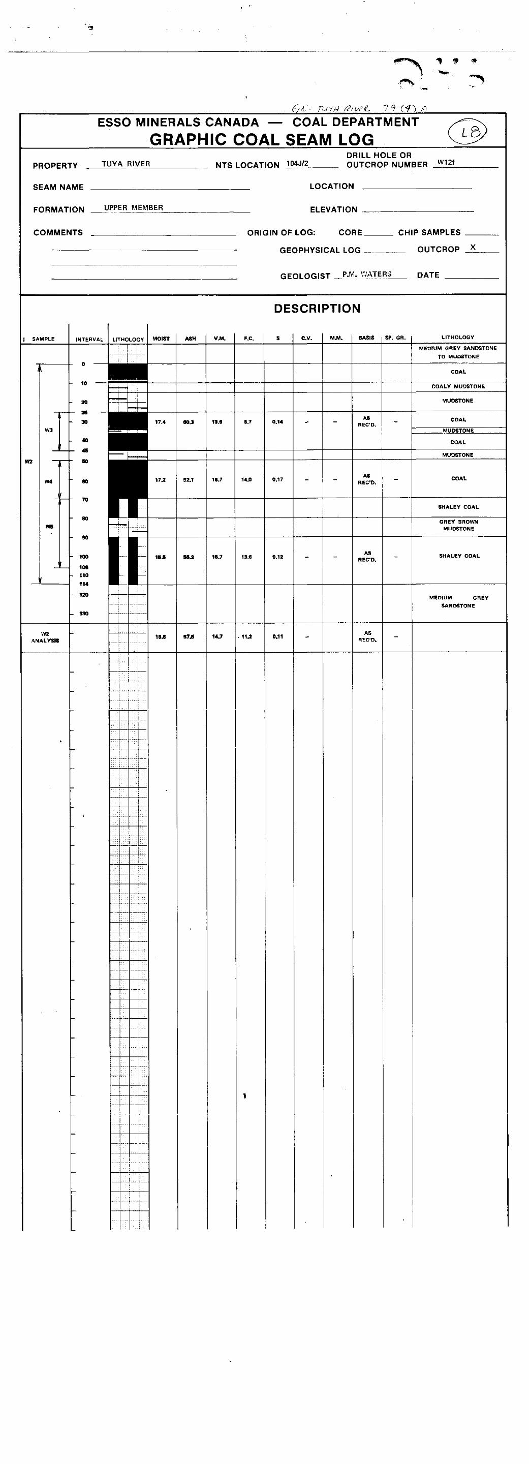
The only coal seam found in rocks assigned to the Upper
Member was in outcrop W12f. Over 1.1 metres of section there is
a sequence of coal (.total of 0.5 m),shaley coal, and mudstone.
The amount of ,fusain in the coal is much higher in this seam than
others in the area.
-2O-

cj ADDENDUM TO STRATIGRAPHY
c,
The Paleontology Division of Esso Resources Production
Research Department has separated and identified pollen from the Tuya River coals. Small portions of a few coal channel samples were submitted for palynological examination and all contained
abundant and well-preserved pollen and all proved to be of Early Eocene age.
The sample numbers, outcrop of origin, and characteristics are listed below.
1. Samples W3 and W4, outcrop WlZf, Upper Member:
characterized by common small tricolporate
pollen, comon 6smunda and taxodoids.
2. Samples W8 and W9, outcrop W23, Middle Member: characterized by abundant medium-sized bisaceates, small older pollen.
3. Sample W25, outcrop B26, Middle Member: characterized by abundant laevigatosporites
and moderate fungi, rare metasequoia pollen. 4. Sample W28 and W29, outcrop B24, Middle Member:
similar to sample W25.
REFERENCE: Memo from Frank L. Staplin to B.D. Vincent entitled "Tuya River Property Coals", August 28, 1979.

4. COAL QUALITY
Channel samples were taken of selected coal seam out-
crops during the mapping program but as yet have not been analyzed.
The analyses and interpretations will form another report later
this year.
The only analyses available for Tuya River date from
1904 and 1953 and are as follow on an "as received" basis:
Peatherstonhaugh, 1904 @owling, 19~15)
Moisture 11.35% Ash 9.92% Volatile Matter 28.36% Fixed Carbon 49.22% Sulphur 1.15% Calorific Valve 11,401 BTU/lb
Smitheringale, 1953 (Dolma&e Campbell
and Assoc, 1975) 16.9%
5.1% 35.6% 42.4%
0~. 9% 9680~ BTU/lb
Using the standard Parr formulas for computations, the
moist, mineral-matter free calorific values in BTU/lb for the 1904
and 1953 analyses are 12,704 and 10,250 respectively. The firsr
indicates a rank of high volatile C bituminous and the second sub-
bituminous B.
The value of these analyses are limited. An optimistic
estimate of the rank is high volatile C bituminous. This will de-
crease with the amount of ash included from partings. The raw
coal quality may be 10 to 15% moisture, 5 to 10% ash, 0.9 to 1.2%
sulphur, and 10,000 to 11,000 BTU/lb. Again, these figures will
vary with the amount or number of partings included in a sample
-21-

5. COAL RESERVES
Insufficient control on the positions, thicknesses, and
lateral continuity of the coal seams and on the structural geology
of the Tuya River property was obtained during the mapping program
due to the lack of outcrops to calculate even speculative coal re-
serves. However, a few comments may be made on the reserve potential.
The coal seems in the Lower Member, as exposed along i%ns-
field Creek, appear to dip rapidly to depths of 600 metres under the
surface of the Tuya River property. Assuming constant stratigraphic
thicknesses, the Lower Member seams are laterally continuous, and
the structural interpretation of Figure 6 is true, the minimum cover
over the Lower Member coal seams would be between 200 and 300 metres.
These seams have their best potential west of Mr. Kleinhout's coal
licences on Pacific Petroleums' property where they should be nearer
surface, possibly surface mineable.
These Lower Member seams could be nearer surface on the
Tuya River property if faulting as opposed to folding is present
between the Little Tuya and Tuya Rivers. Other possibilities are
that the stratigraphic thicknesses could vary or the members later-
ally interfinger with each other. These situations could cause the
coal seams to be at unexpected elevations, pinch out, or laterally
grade into the coals of the Middle Member.
Along Tuya River, the Middle Member coal zone or zones is
in the northern third of the property. Eecause of the presence of
the shear zone and the large sluinps in the valley walls, the corre-
lation of seams, their orientation, and their laterel continuity

0
0
cannot be estimated. Assuming the seams are in their approximately
true location at river level, they are about 200 metres below the
surface of the surrounding plateau. No estinate can be made on
where the seams intersect the plateau surface if they do at all.
It is possible the Middle Member seams coalesce into thick-
er seams or, alternatively, their lateral extent may be limited by
lateral facies changes. The Middle Members' seams exposed on Tuya
River at the south end of the property may thicken and become more
attractive. Presently, any extension of Middle Member seams appears
to lie within the Tuya River property.
Overall, the property could hold substantial in-place re-
serves of subbituminous to high volatile bituminous coal. Further ,(
definition of the reserves is possible only with additional explor-
ation.
-2:-

i L,
. ci
6. CONCLUSIONS
The combined Tuya River coal properties of 14.E. Kleinhout
and Essp Minerals Canada have the potential of holding substantial
in-place coal reserves. The coal is estimated to be high volatile
C in rank with 5 to 10% ash, 0.9 to 1.2% sulphur, and 10,000 to
11,000 BTU/lb.
Outcrops of the area are insufficient to estimate the num-
ber or extent of coal seams. However, the Lower Member coals appear
to be nearest surface to the west of Kleinhout's licences in the
area controlled by Pacific Petroleums. The Middle Member coal zone
have their best potential in the area held between Kleinhout and Esso
Minerals.
It is concluded that the Tuya River property contains coal
of suitable quality and sufficient thickness to warrant further ex-
ploration.
-24-

7. RECOMMENDATIONS AND PROPOSAL
It is recommended Esso Minerals Canada retain the option
on W. E. Kleinhout's Tuya River coal licenses, fulfil1 the obliga-
tions, and maintain in good standing any other licenses granted to
Esso in the area. Additional exploration, which will meet the fol-
lowing objectives, should be conducted over the Tuya River property:
1. Stratigraphic unit identification should be verified
and thicknesses, lithologies, and distributions must be better defined.
2. True coal seam thicknesses must be determined along with
seam correlations and their area1 extent. Coal samples must be ob-
tained which will provide more accurate analyses than will outcrop
samples.
3. Information must be gained in order to more accurately
interpret the structural geology.
4. Exploration must be done prior to June 23, 1980 in
order to meet the British Columbia Government's work obligation.
The following proposal will meet the above objectives.
Six drill holes, located as shown in Figure 7, with coring and geo-
physical logging would be sufficient for a preliminary phase of
exploration.
Mr. 0. D. Gorgichuk has recommend& the drilling to be
done by diamond drilling and continuous coring. The drilling rig
would be moved by helicopter; drilling would total 1500 metres or
250 metres per hole; and downhole geophysical logging with gamma,
density, and resistivity tools would be done. Accommodations muld
be in a hotel. Mr. Gorgichuk's estimated costs for such a progran
-25-

best conducted in July, August, or September; September being the
best.
are : Drilling $100,000 57: ‘/
Helicopter 45,000
Logging 16,000
Room and Board 4,000
Mobilization and Dembilization 5,000
Miscellaneous 8,000
TOTAL = $178,000
He estimates the program would last 21 days and would be
-26-

7 c
,1, ..I I
. .
LH
N
t
,. ,.. . ._ . - 1045/Z

0 REFERENCES
; 0
0
Dolmage Campbell and Associates 1975: "Thermal Coal Resources of British
Columbia, Volume 17, Northern coal- fields of the Interior Belt of Brit- ish Columbia", p. 27.
Dowling, D.B. 1915: "Coal Fields of British Columbia",
GSC Memoir 69, p. 350.
Eisbacher, G.H. 1974a:
1974b:
"Sedimentary History and Tectonic Evolution of the Sustut and Sifton Basins, North-Central British Co- lumbia"; GSC Paper 73-31, p. 57.
"Evolution of Successor Basins in the Canadian Cordillera"; in Dott, R.H., Jr., and Shaver, R.HT-(Eds.), "Modern and Ancient Geosynclinal Sedimentation"; SEPM Spec. Pub. 19, pp. 274-291.
Gabrielse, H. and Souther, J.G. 1962: "Dease Lake, British Columbia",
GSC Map 21-1962.
Geological Survey of Canada 1957: "Operation Stikine: Stikine River
Area, British Columbia"; GSC Map 9-1957.
1974:
Schopf, J.M. 1960:
"Iskut River"; Open File 1!214.
"Field Description and Sampling of Coal Beds"; U.S.G.S. Bull. 1111-B, p. 70.
Souther, J.G. 1972: "Telegraph Creek Map-area,,:British
Columbia" GSC Paper 7-44, p.38 with GSC Map 11-1971.
Souther, J.G. and Armstrong, J.E. 1966: "North Central Belt of th? Ccr-
dillera of British Columbia" in "Tectonic His:ory and :,lineral De- '/*. posits of the Vestern Cordillera"; c1m1 Spec. Publ. Vol. e, pp. 171-154.
-28-

STATEIIENT OF QUALIFICATIONS
Bruce D. Vincent
This is to certify that I obtained a Bachelor of Science Degree
in Geology from the University of New Brunswick in 1974 and a%aster of
Science Degree in Geology at the University of Alberta in 1974.
I am registered with the Association of Professional Engineers,
Geologists, and Geophysicists of Alberta as a Professional Geologist.
My experience was gained during university by geological mapping
in New Brunswick and Alberta. Since 1977, I have been employed as a coal
geologist with Esso Minerals Canada and have been actively engaged in coal
exploration during that period.
Bruce D. Vincent, P. Gal.
June 30, 1979

STATEMENT OF QUALIFICATIONS
Peter M. Waters
This is to certify that I obtained a Bachelor of~science
Degree in Geology from the University of Alberta in 1978 and I am
presently enrolled in a Master of Science program at the same university.
My relevant expe,rience has included geological mapping in
Newfoundland, Quebec, and various parts of British Columbia.
30

APPENDIX I
1979 EXPLORATION PROCEDIJRES AND COSTS

i cj 1979 EXPLORATION PROCEDURES
u
0
The geological mapping program over the Tuya River
property was conducted from June 1 to June 23, 1979. The map-
ping party consisted of Peter M. Waters (Party Chief), Jme C.
Broatch (Senior Assistant), and Roberta I,. Donald (Junior Assis-
tant) , all geology students along with staff member James J.
Lehtinen (Junior Assistant). Direct supervision was by Bruce
D. Vincent (Project Geologist).
The field party was based at Tenajon Cater, Eddon-
tenajon Lake. Transportation to and from the field each was sup-
plied by an Associated Helicopters Bell 206B contracted to Esso
?linerals. Daily work consisted of standard geological mapping of
all outcrops and detailed measurement and sampling of nest coal
seams or coal-bearing zones. Traverses were plotted in the field
on approximately 1:30,000 air photos and were transferred to a
l:lO,OOO topographic base map.
The outcrops are strictly limited to the river valleys
which in turn restricts the amount of structural and stratigraphic
information available. Otherwise field conditions were fairly good.
Three and one-half days were lost due to bad weather. The rivers
were very high at the beginning of the program and additional out-
crops were exposed late in the mapping. The snow cover was gone
from the area by the first of May.
1979 EXPLORATION COSTS
The following is a list of cosfs incurred during the 1979
exploration program as compiled by Brian E. Kor?ak.
T-l

On-Property costs
Salaries, Wages, and Benefits Professional Staff
Field Base Costs Tenajon Motel, Iskut Helicopter Fuel
Supplies
Transportation Truck rental Helicopter charter
Travel Expenditures To and from field
$ 6,281.76
$ 5,352.92 996.33 I
147.98
850.00 10,888.29 li
2,475.1? 2 * CT
Subtotal $26,992.45
Off-Property costs
Logistics and field support 1,437.Ol
Report preparation 1,683.71
Total Expenditures $30,113.21
I,-2

,
APPENDIX II
’ 0 GRAPHIC LOGS OF
COAL SEAMS

w2
u
0
10
w4
w5
Channel Samples 4.
outcrop Ir'12f; Upper Member; Page l/l
Medium grey mudstone to medium grain sandstone.
COAL -- 90% vitrain, 10% attrital; bright thick vitrain bands.
Coaly mudstone. Mudstone.
COAL - 50% vitrain, 10% fusain, 40% attrital, iron stain on joints.
Mudstone. COAL - 10% vitrain, 90% fusain; iron stain on joints
in fusain.
COAL - 10% vitrain, 50% fusain, 40% attrital; moderately thickly banded vitrain, moderately bright; fusain and attrital coal silky and iron stained.
Shaley COAL.
Grey brown mudstone.
COAL with abundant mudstone partings.
Medium grey mudstone.

Outcrop W23, Middle Member; Page l/2
cj
Medium grey mudstone with sideritic nodules.
ChXl*el Sample c"
COAL - 100% attrital, yellow staining.
i.
i iJ
10 ii Brown mudstone.
20 COAL - 50% attrital, 35% vitrain, 15% mudstone; iron-
staining on cleats.
~ Brown mudstone.
~ COAL - 10% vitrain, 80% attrital, 10% mudstone; iron and sulphur staining on cleats; presence of resin.
Brown mudstone.
COAL - 5% vitrain, 85% attrital, 10% ironstone (xxx); iron- stain on joints.
Brown mudstone.
~ COAL - 30% vitrain, 50% attrital, 20% shale; iron and sulphur staining on joints.
3oi-l Brown mudstqne.
COAL - 10% vitrain, 90% attrital
50
t I Brown mudstone.
; iron staining on cleats.
COAL - 50% vitrain, 50% attrital; iron stained joints.
W8 Brown grey mudstone.
IT-2

Outcrop W23; Middle Member; Page 212
COAL - 5% vitrain, 85% attrital,,5% mudsfone; resin
steined joints;
30 Brown mudstone
50 COAL - 100% attrital; iron stained cleats
60
70 i-l
Brown mudstone
COAL - lo-20% vitrain; 80-90% attrital; iron stained cleats
Grey'brom mudstone 300
1Ok I orange brown sideritic mudstone
COAL - 20% vitrain, 80% attrital
Interbedded brown-grey mudstone and orange brown sideritic mudstone. Ii-on nodules at about 430 cm.
COAL - 35% vitrain (eye coal), 55% attrital, 10% sideritic sandstone (xxx); iron stained joints
Brown to grey brown mudstone
:
50
60 COAL - 20% vitrain (eye coal), 80% attrital
70
80
90
600-F-1 Brown grey mudstone
Ii-?

0
’ 0
I
r 80 -
t- 2001
Outcrop W24; Middle Member; ?age l/2
Orange to brown grey mudstone, moderately soft
COAL - 50% vitrain (eye coal), 50% attrital; iron stained joints, calcite on joints
Brown mudstone
COAL - 40% vitrain, 60% attrital, iron stained on joints
Brown mudstone; moderately soft
COAL - 20% vitrain, 80% attrital
Grey brown to orange brown mudstone
Siderite noduks
II-4

Outcrop W4; Middle Member; Page Z/2
COAL - 50% vitrain (eye coal), 50% attriml
Brown mudstone
Brown grey mudstone; 0.9 m + thick; moderately soft
II-5

Channel Sample Wll
80
Outcrop W26; Middle Member, Page l/l
Medium grey mudstone, moderately hard; plant debris
100% vitrain; iron stained joints; massive and blocky
20% vitrain, 80% attrital; not strongly weathered
massive and blocky,
~ Medium grey to brown grey mudstone and silty mudstone; 3 metres + thick; moderately soft.
II-6

Channel Sample w30
Outcrop B24b; Middle Member; Page l/l d
COVERED B24b is 5 to 10 metres above B24a.
Brown to dark brown coaly mudstone; 20% vitrain as 1 to 3 cn leIlS=ZS
-
COAL - 100% vitrain (eye coal); very massive and tough; calcite on joints
,...
Channel Sample w31
Rustbrown sideritic mudstone; very hard /
COAL - 20% vitrain, 80% attrital; poorly exposed, possibly some parting not observed
COVERED
II-9

Outcrop B24a; Middle Member; Page l/l
cm Light brown sideritic mudstone; 10 to 15.cm. exposed; hard
COAL - 10% vitrain, 90% attrital; iron stained joints
Br0Wl.l mudstone, soft
70
Cl Brown to dark brown coaly mudstone
10% vitrain as 1 to 3 cm bands or lenses 80
Channel Sample
w29
COAL - 80% vitrain, 20% attrital; iron stain and calcite on joints.~~
Brown to dark brown coaly mudstone
30
40
50
60
Rustbrown coaly mudstone
COAL - 80% attrital, 20% mudstone; ironstain on joints
Brown to dark brown coaly mudstone
COAL - 20% vitrain, 80% attrital; iron and white stain on joints
70
i--l
Light grey-brown sandy mudstone; one metre exposed; soft
II-E

c,
0 w36
1532
- 6C r 70
8C
w35
-
Outcrop B24c; Middle Member; Page l/l
B24c is 2 to 4 metres above B24b.
COVERED
Brown coaly mudstone
COAL - 20% vitrain, 50% attrital, 30% mudstone
Dark brown mudstone
COAL - 20% vitrain, 60% attrital, 10% mudstone; iron stain on joints
Medium to dark brown mudstone; 20% vitrain as 1 cm. bands .~.
COAL - 10% vitrain, 90% attrital coal; iron stain on joints
Dark brown coaly mudstone interbedded with very shaly coal; 30% vitrain as 1 to 2 cm. lenses
! 2
3
4
5
6 di
COAL - 40% vitrain, 60% attrital
COVERED, probably dark brown coals mudstone
II-10

Outcrop B25; Middle Member; Page l/l
u COVERED by river
COAL - 80-90% vitrain; resin
Lj 10 Siltstone
20
30 COAL
40
60 Siltstone
80
ci 10
215
80
Siltstone
COAL Siltstone COAL Siltstone
COAL
Siltstone
Hand Sample B4

Wzt
(i
20
30
40
50
60
i
70 W24
80
90
-I
w25 100
10 Channel
Samples 20
30
40
50
-
-
-
-
-
-
-
-
-
Outcrop B26a; Middle Member; Page l/l; 10 m + west of B26b
Dark brawn coaly mudstone, 0.3 m exposed, moderately soft
COAL - 60% vitrain, 20% attrital, 20% shale
Dark brown coaly mudstone, 20% vitrain as 0.5 to 3.0 cm thick bands and lenses
COAL - 20% vitrain, 80% attrital
Dark brown coaly mudstone, 10% vitrain as 1 mm lenses
COAL - 100% attrital
Dark brown coaly mudstone, 10% vitrain as 3 mm lenses
Dark brown coaly sideriric mudstone
II-12

Channel SE3rr.Pk
ki27
Outcrou B26b: Middle Member: Pace l/l: 10 + metres east of B26b
Dark brown coalv~mudstone, 10 cm thick; soft
COAL - 10% vitrain, 80% attrial, 10% shale; iron stain on joints and bedding planes
-
COAL - 80% vitrain, 20% attrital; vitrain predominantly eye coal; trace of iron stain on joints
COAL - 20% vitrain, 60% attrital, 20% shale; iron stain on joints and some bedding planes
COVERED
TIP13

1
0
W22
0
119 I 70
80
90
100
10
20
30
40
50
60
70
80
90
Outcrou B27: Middle Xember: Paw l/l
Grev to brown erev mudstone: soft
COAL - 90% vitrain. 10% attrital
Brown grey mudstone with 1 cm vitrain lenses which make up to 10% of unit
Dark brown coaly mudstone; 30% vitrain in lenses up to 2 cm thick
COAL - 10% vitrain, 80% attrital, 10% mudstone; trace calcite on joints
Dark brown coaly mudstone, 20% vitrain and attrital coal in.lenses up to 3 cm thick; calcite on joints
COAL - 10% vitrain, 80% attrital, 10% mudstone; calcite and trace of iron stain on joints
Dark brown coaly mudstone
COAL - 10% vitrain, 60% attrital, 30% shale
Dark brown coaly mudstone, soft, 0.4 metres
. Fault Light grey mudstone
II-14

!
c3
Outcrop 328; Middle Member; Page l/l
Brown grey to grey mudstone; 3-m thick; soft
COAL - 20% vitrain, 70% attrital, 10% shale; iron stain on joints
Dark brown coaly mudstone, moderately soft
~ COAL - 30% vitrain, 70% attrital; some vitrain shows eyes on joints; iron stain on joints
.
1 Brown grey mudstone and dark brown coaly mudstone; soft COAL - 10% vitrain, 80% attrital, 10% mudstone; iron stain on joints Rustbrown sideritic mudstone, very hard Dark brown coaly mudstone COAL - 80% vitrain, 20% attrital I 1 $16
- c 8o Channel 90 Grey to brown grey mudstone interbedded with dark brown coaly
Samples mudstone and medium grey sandstone; 4 metres thick; moderately 100 soft
0. ..,~
II-15

I
u
Channel Sample B6
0
Outcrop B62; Lower Member; Page l/2
Till - Thrust Fault - Glacial
COAL - 20% vitrain as 1 cm bands, 80% attrital
-
COAL - 5% vitrain: 75% attrital. 20% mudstone
Trace iron staining on joints
COAL - 5% vitrain. 95% attrital
Shaley Coal,
COAL - 5% vitrain, 95% attrital; trace of white mineral on joints
Whole seam has abundant (0.5% of total seam) resin in globular masses up to 1 cm in diameter
Dark brown shaley coal
II-16

Channel Sample
B7
Outcrop ~62; Lower Member; Page 212
Dark g'rey mudstone, in part sideritic; moderately soft to hard
COAL - 100% attrital with high vitrain component; trace iron staining on joints
Sideritic coal /
COAL - 100% attrital / t
Brown grey mudstone, 2 metres thick, moderately soft
II-17

Channel Sample
w12
Outcrop W28b; Middle Member, Page l/l
Brown coaly mudstone, moderately soft
COAL - 30% vitrain (eye coal), 50% attrital, 20% sideritic; iron stained cleats
Brown coaly mudstone, moderately hard
COAL - 50% vitrain (eye coal), 45% attrital, 5% mudstone; iron stained cleats; hard and blocky.
Brown coaly mudstone, 0.7 m thick; lower contact gradational to medium grained sandstone
TT-7


COAL
Coal
OUTCROP SAMPLE ANALYSES,
TUYA RIVER PROPERTY,
BRITISH COLUMBIA
NTS 10&T/2
Licences 3904-3913 1~1.
Bruce D. Vincent, P. Geol. Esso Minerals Canada Coal Department Cakarv. Alberta - _. September, 1979
0024-b (2.)

ABSTRACT
Thirty-nine outcrop channel samples from the Tuya River
cod property (NTS 1045/2) were submitted for coal analyses
including moisture content, proximate analysis, calorific value,
and specific gravity. A thickness-weighted average of 19% moisture
was assumed to be representative of the seams. The other analytical
results were then prorated to a 19% moisture basis; weighted averages
were found and are ash 21.5%, volatile matter 29.4%, fixed carbon
30.1%, calorific value 16159 kJ/kg (6950 BTU!lb), sulphur 0.46%.
The average mineral matter was found to be 23.5% on a 19% moisture
basis and specific gravity 1.57 on an air-dried basis. The moist
(19% moisture) mineral matter-free calorific value is 9828 BTU/lb
(22850 kJ/kg) which determines the coal rank is subbituminous B.

TABLE OF CONTENTS
m
1. INTRODUCTION 1
1.1 Purpose 1,
1.2 Location 1
1.3 Sampling and Analyses 1
2. ANALYTICAL RESULTS AND CALCULATIONS ~5
2.1 Introduction 5
2.2 Moisture Content 5
2.3 Proximate Analyses 5
2.4 Sulphur 7
2.5 Calorific Value and Coal Rank 7
2.6 Specific Gravity 11
3. DISCUSSION OF RESULTS 12
3.1 Quality of Results 12
3.2 Ash Versus Mineral Matter 12
4. SUMMAXY 14
5. REFERENCES 15
APPENDIX I - Laboratory Repot-t
APPENDIX II - Graphic Logs of Coal Seams and Analyses

List of Figures
m
1. Regional Location Map 2
2. Locations of Sampled Outc,rops 3
3. Graph of Calorific Value Versus Ash 9
4. Graph of Calorific Value Versus Mineral Matter 10
i 0
(iii)

1. INTRODUCTION
1.1 Purpose
During the geological mapping of the Tuya River coal
propeyty conducted in June of 1979, most of the outcrops of coal
seams were sampled for laboratory coal analysis. This report
contains the results of the analytical work and discussion of
the results.
1.2 Location
The Tuya River coal licenses are situated in north-
western British Columbia with their cater approximately equi-
distant from the communities of Dease Lake and Telegraph Creek
as shown in Figure 1. For a further discussion on the region,
its geology, and the property geology, the reader is referred
to the exploration report by Vincent (1979).
The locations of the outcrops from which the samples
were taken are shown in Figure 2. More detailed locations are
shown on the property geological map contained in the exploration
report mentioned above.
1.3 Sampling and Analyses
During geological mapping all coal seams encountered
were noted and described. Near the end of the program, the most
representative seams were chosen for sampling and were revisited.

LOCATION MAP
104J-2

XJJNDARY
ES50 MINERALS CANADA COAL DEPARTMENT I

,
u
0
1.3 Sampling and Analyses (Cont'd)
The outcrops were prepared for sampling by removing a
section of coal and overburden, by pick and shovel, up to 0.3
metres wide perpendicular to the seam top and bottom from the seam
top to bottom if at all possible. The purposes of this were to
get as clean and unoxidized a sample as possible and to obtain
as accurate a seam thickness as possible.
The coal seam was then examined and described in detail
which included estimations of coal constituents. If possible, the
seam was subdivided into portions based on varying constituent
proportions or by the presence or absence of mudstone partings.
Continuous channel samples of each of the subdivisions
of the seam were then taken by chipping off a small portion of the
exposed face. Care was takento remove roughly equal portions from
all parts of the seam for an equal representation. These were
immediately placed in plastic bags and labelled in the field and
packed in metal cans upon return to base for shipment.
After the samples were shipped to Calgary, small portions
of a few sam@les were removed for palynological analyses and then
resealed and all were sent to Birtley Coal and Minerals Testing of
Calgary for analyses. Birtley performed the standard analyses for
moisture, proximate analysis, total sulphur, calorific value, and
specific gravity on the samples.

2. ANALYTICAL RESULTS AND CALCULATIONS
2.1 Introduction
The results as received from Birtley Coal and Minerals
Testings form Appendix I of this report. The results are also
displayed along with graphic logs of the coal seams in Appendix 2.
2.2 Moisture Content
The moisture content of the Tuya River samples were
analysed on an as-received basis. That is, the total water content
of the sample when initially analysed. As no other analytical work
was done on moisture content, the as-received moisture was assumed
to be an approximation of the natural moisture of the seams. It
is only an approximation since the samples were taken frdm outcrops,
a location which may increase or decrease the natural bed moisture.
The moisture contents of the samples ranged from 13.9 to
25.4 weight percent. The weighted average for the samples is 19%
and this value is assumed to be the average for the property.
2.3 Proximate Analyses
The determination of the ash, volatile matter and fixed
carbon content of thirty-nine samples was done and reported on an
as-received basis and also reported on a dry basis. In addition,
seven samples were composited into 3 additional samples and analysed.
The results are presented in Appendices I and II.
In order to determine an average for the property, the
ash and volatile matter were recalculated for an average moisture
content of 19% by the following formulas:

u 2.3 Proximate Analyses (Cont'd)
and
0
where A19 = ash at 19% moisture,
AD = ash on dry basis,
M = moisture = 19%,
VMl9 = volatile matter at 19% moisture,
and VMD = volatile matter on dry basis.
Fixed carbon was calculated by difference. The results of these
calculations are included in Appendix II.
In addition, the mineral matter content of the samples
was calculated by the Parr formula.
94 = 1.08A + 0.55 S
where ?.I =
mineral matter,
A = ash,
and I; = total sulphur
with the ash and sulphur contents having been reported on the same
basis. The calculation of the mineral matter contents and use of
them instead of ash contents makes corrections necessary due to
losses of ash and sulphur during the analytical process. The mineral
matter content was calculated for each sample on as-received and
dry bases and for 19% moisture.

2.3 Proximate Analyses (Cont'd)
The weighted averages of the ash, volatile matter, and
mineral matter were calculated using the seam thickness from which
representative samples or composite samples were taken. The
average fixed carbon was calculated by difference. The weighted
averages at 19% moisture are:
Ash 21.5%
Volatile Matter 29.4%
Fixed Carbon 30.1%
(Mineral Matter 23.52%)
2.4 Sulphur
The total sulphur content of each sample and composite
sample processed in the proximate analyses was found and reported
on an as-received and a dry basis. The as-received values ranged
from 0.11% to 0.92%. The sulphur content was also calculated for
19% moisture and the range was between 0.26% and 0.87%. The
weighted average sulphur content was determined to be 0.46%.
2.5 Calorific Value and Coal Rank
Calorific values for 34 samples and 3 composite samples
were founded and reported as BTU/lb on as-received and dry bases.
These have been converted to the standard SI unit of kiloJoules per
kilogram (k.J/kg). The values were prorated from a dry basis to a
19% moisture basis by the following formula:
-7-

I
0 2.5 Calorific Value and Coal Rank (Cont'd)
cv19 = CVD(l.O - 1oo 4
where CV19 = calorific value at 19% moisture
cvD = dry calorific value,
and .M = moisture = 19%
In order to determine an average calorific value least-
squares linear regression was done for calorific value versus ash
and calorific value versus mineral matter (Figures 3 and 4). These
graphs were possible by plotting the values previously calculated
to a 19% moisture basis.
The regression line of the plot of calorific value versus
ash (Figure 3) is described by the formula with the format
Y = mx + b
where m is the slope and b is the y-intercept which in this case
becomes
*19 = (-0.0075)CVlg + 73.38
where A19 =
ash content at 19% moisture
CV19 = calorif~ic value at 19% moisture
The calorific value corresponding to the weighted-average ash
content at 19% moisture of 21.5% was determined to be 16,159 kJ/kg
(6950 BTU/lb). The calorific value at 0% ash is 22771 kJ/kg
(9794 BRIJ/lb). The correlation coefficient of the plot of calorific
value versus ash content is -0.982.

40
35
25
1 \ \
\ \ -\
\
\
* ‘\ \
0 ‘\ \ \
\ \ \ 9
Best fit line for
ash versus colorific value
t I 1 1 3000 4000 5Co0 6000 7i
‘? J\
j c
/
00
ESSO MINERALS CANADA COAL DEPARTMENT
TUYA RIVER PROPERTY
GRAPH OF ASH ‘VERSUS CALORI FIC VALUE
SEPTEMBER, 1979
104J-2
\ \ ‘0 ,-22,850 kJ/kg(982B BTU/lb)
16,159 kJ/kg ’ (6950 BTU/lb1
Moist,mineral matter-free calorific value
0 B&O 9obo lOdo I& BTU/lb r I t I I I I I I I I I I I
IO I2 14 I6 I8 20 22 24 kJoules/kg x103
CALORIFIC VALUE AT I9 O/o MOISTURE

r
4c
35
25
15
IO
5
a
ESSO MINERALS CANADA COAL DEPARTMENT
TUYA RIVER PROPERTY
GRAPH OF Ml.NERAL MATTER VERSUS CALORIFIC VALUE
SEPTEMBER.1979
104J-2
,calorific value
22,850 kJ/kg (9626 BTU/lb) Moist.mineral matter -free colorific value ,
I I I I I I I 3000
I 4000 5ax 6000 7000 8000 9oco 10000 IIDOO BTU/lb
I I I I I I I I I I I I IO 12
I I 14 16 I8 20 22 24 kJoules/kg xl03
CALORIFIC VALUE AT I9 O/o MOISTURE

2.5 Calorific Value and Coal Rank (Cont'd)
For the plot of calorific value versus mineral matter
content at 19i moisture (Figure 4) the regression line may be described
as
Mm19 = (-O.OOSl)CV,Y + 79.57.
For the weight-average mineral matter content of 23.5% calculated
above, the corresponding calorific value was found to be 16,043 kJ/kg
(6900 BTU/lb). At 0% mineral matter, the calorific value is 22850 kJ/kg
(9828 BTU/lb). 'This is better termed moist, mineral matter-free
calorific value. The correlation coefficient of this plot is -0.981.
The American Society for Testing and Material has subdivided
low-rank coal on the basis of moist, mineral matter-free calorific
value. At 19% moisture, the moist, mineral matter-free calorific
value of the Tuya River samples is 9823 BTU/lb which is in the range
of values for coal with a subbituminous B rank.
2.6 Specific Gravity
The air-dried specific gravity was reported for 3 composite
samples and their: individual portions. The weighted-average was
found to be 1.57 for the samples. This value may be assumed to be
the average for the field while remembering it is reported on an
air-dried basis while the other averages are reported on a 19%
moisture basis.
-ll-

3. DISCUSSION~OF RESULTS
3.1 Quality of the Results
From the fact that all of the Tuya River samples are
from outcrop exposures of coal seams and associated strata, it
can be assumed all of the samples have been oxidized and the com-
ponents altered to,some degree. This is true even though the
outcrops were cleaned to expose as fresh a face as possible. But,
the results of the analyses are of use and thought to be a close
representation of the actual coal quality. Points in favour of
this assumption are the small range of values fork moisture content
and the close correlations between calorific value and each of
mineral matter and ash.
Any further analytical work using drill core samples
would probably increase the coal quality by reducing the ash
content and thereby increasing the calorific value. It is unlikely
the increase would be dramatic. It is also unlikely the rank of
the coal would change and if it did, probably only up to subbituminous
A.
3.2 Ash Versus Mineral Matter
The mineral matter content of coal is the inorganic
constituents of coal and is composed primarily of clayey materials
(aluminum silicates and silica), pyrite, and calcite. The ash is
the non-combustible residue left after the ashing of coal. This
residue originates from extraneous mineral matter and inorganic
material combined with the organic fraction of the coal. The ash
value is always less than the mineral matter value because, dui-ing
ashing, some of the inorganic material is altered. The most common

3.2 Ash Versus Mineral Matter (cont'd)
reactions are the loss of water of hydration from clay minerals and
the oxidation of pyrite and calcite. These reactions are compensated
for in the Parr formula for determining mineral matter (Rees, 1966).
In thj~s report, the mineral matter values are used to
determine them rank of the coal with the weighted-average value for
mineral matter used as a constituent of the coal. The average calorific
value of the samples was derived from the calorific value versus ash
plot and reported with the weighted-average ash value since that calorific
value is the one actually achieved upon burning as opposed to one
derived from the average mineral matter. Both plots and regression
lines are included here because of the two distinct uses of the data.
-1.3-

LJ 4. SUMMARY-
From the laboratory analyses of outcrop channel samples, agood
approximationoffheunoxidized coalquality &$iY& of the Tuya River
coal seams has been obtained.
The average quality, using thickness-weighted averages,
for the property is
Moisture 19.0%
Ash 21.5
Volatile Matter 29.4
Fixed Carbon 30.1
Total Sulphur 0.46
0
Calorific value 16159 kiloJqule/kilogram
(6950 BTU/lb)
Mineral Matter 23.5%
Specific gravity,
air-dried basis 1.57
The coal rank was determined to be subbituminous B from
a moist (19% moisture), mineral matter-free calorific value of
9828 BTU/lb (22850 kJ/kg). This is within the range of values
defined to be that of subbituminous B cool of 9500 to 10,500 BTU/lb.

5. REFERENCES
Rees, O.W. (1966) "Chemistry, Uses, and Limitations of Coal Analyses"; Illinois State Geol. Surv. Rept. Inv. 220, 55~.
Vincent, 13.D. (1979) "Geological Mapping of the Tuya River Property, British Columbia, NTS 1045/Z"; Unpublished internal report for Esso Minerals Canada, Coal Department, 30~.

APPENDIX I
Coal Analyses Laboratory Report

. . . , >p
Birtley Coal - RECEIVED
,& Minerals Testing A DlYlSlONOF‘REATHESTSTLELlNOUSTRlESLTD.
August 31, 1979
Mr. Bruce Vincent Esso Minerals Canada Coal Department 500 - 6 Avenue SW Calgary, Alberta T2P OS1
Dear Mr. Vincent:
Re: TUYA RIVER 104J/2
Please find enclosed the analyses requested in your letter dated August I, 1979 on samples identified as "Tuya River Outcrop Channel Samples".
Yours truly,
BIRTLEY COAL AND MINERALS TESTING
,
General Manager
cas Encl.
505 - SOlh Avenue S. E.. P. 0. Box5488, Station “A “, Cal@vy. Alberta T2H IX9 Telephone 1403) 253-8273

8: b X G :kii,p I E f!
3200
WlZF,WZ
3201
WlZF,W3
3202,
W12F,W4
.3203
.WlZF,W5
3 .~. _.-..
3204
W23,W6
3205
W23,W7
3206
w23,wa
3207
W23,WY
3208
W23,WlO
ASH%
57.5 ,__~____
68.9
52.1
62.9
55.2
65.3
~5~8.
32.5 _-_----
23.0
30.6
----.- .-~---
&_37
0.46
0241
0.52
I -__--
Birtley Coal & h4inerals Testing .“1\1\111~,,1 <,“,.,~,,,<I,,, ,.“,~111b1,,0

hapIe #
3209
w26,wll
3210
W28b,Wl2
3211
G2b ,wza
.-3212
i?24a,~2Y
&;,l
i24b,wjo
3214 'B g24b,W31
3215
B24c,W32
3216
B24c,W33
3217
B24c,W34
14.0
21.2
16.2
16.4 _--_.----~
17.6 ___--_ ---_
20.1
la.4
20.3
24.2
20.1 _--- -__-
24.1
41.9
50.9.
22.6
28.2
_---~-~
__15e.5-5___ 19.0 _--__---
-_- -
S.%
0.71
0.83
0.74
o.yc .---. \
0.45
0.58
0.74
0.88
B.T.U
8602
0054 ._---_
7437
9065
--..-
c.ar _
9397 _
;543 _-_-_.
3191 _---_.
7ara
)586 _-----
--~
,I
AIRDRIED BASIS S.G.
-_-
-__
-_-
-__
___ _--_-..----_ ---
_-_
-_-
~-~_1-.33-_~~ -__ .
---_-__
1.57
-__ __-___---_-
---__- ---
---
-__
-_-
__-
-__
tley Coal

, CI~II~II~: I rso I~II:I.P,'I s L/~.!!!*!)A
l'ROJI:cT: 'TUYA RIVI:R NUICHOI Cli/'.::ICIIL
RI:cEIVED AxUST 3, 1979
!..?b # & Smple #
3218
B24c,W35
3219
B24c,W36
3220
B26a,W23
EASIS S.G. HOISTURE% ASH%
- - 15~.& _
. ..18.8...
S.%
0.3E
0.4j
B.T.U.
-..a3-....
----l----------i ---.-- .._~.~._
21.7 __-------_ 0.35
0.45
4154
6070
20.3
24.2
30.1
35.9
16.1
0.92
1.08
..3221
B26a,W24
14.9
14.4 ____------ 3.64
3.75
arb ----------
db ----------
_, I 1 1
I T_
___
- ___
___
___
___
____
--- __-_-_-____
--- _---____--_
___ __-_--__--_ --- __----___-_
1.69
3.84
;025 _---_-_
7308
3223
B26a,W26
3224
B26b,W27
39.0 .------_
--.-.-__
20.1 __-- __--- _
1. -4z 1,5.5
3225
B27,Wl8
14 8 _ _ _ _.- - - - -
,3226
B27,WlY
L6_1_ j.72
'291 !
1541 ---I

i
“.I &J ~~_
I.c?b # G %mp 1 e #
3227
B27,W20
3228
B27,WZl
3229
'B27,W22
- -828.. '-3230 WI3
Wl4,Wl5,
862,B6
3232
862,87
3233
B62,88
S.%
0.57
0.66
0.43
0.52
.Q .is
0.51
0.31
0.39 _---.
0:45.
0.58
B.T.U.
.[oq3_ _ _
8234
7072 _---_-_
4849
5845
6602
8807
___
---.--.~ -_-
---
-__
--_
---
--_
_ 1.53
arb
db
arb
db
arb _---_-_- db
arb
db _-- __-__.
--ache_-.
- dh - - - _.
Birtley Coal & ~4inerais Testing .“I\,\,~I\<Il <..,r,r ,,I, 111, ,./1t.>.s ,111 Y

d .zb 8 G ;si;>ple #
w7
wa
w30
w31,
Wl3,14
15,16
‘. 17
-.B7
I-iOISTURE%
21.7 .--_- -__-. -
17.1
-_-__--~-
.22.5
23.8
ASH%
25.0 .__-.-_- 31.9~
10.5.
12.6
16.9
21.7
20.1
26.4
COMPOSITES
VOL.% F.C.%
27.7 25.6 _._--_._--..~ .--_ --
35.4 32.7 ____ ---_.-...--_----
39.5 47.9 ____ --___-- ._-_----
l
.-__--. _I-.----- _--___-_-_- -------. L / ._----_---_ ----- --.
---7--------
i--------
S.%
0.5c
0.64
0.36
0.44 .__-,
0.61
p.r.3
0.37
0.45
.---.
--
B3.U.
5856
7476
8610
10387
6399
.a396
---~
---.
AIRDRIED t?ASlS S.G.
__- __-_--- _--_
___
1.46 _--_---_--_ ___
- _-- __-_ -_---. __-
1.60
--__-
__-_-----_. - _---------.
__--__- ----
___--_- _-_. __-------__

APPENDIX II
! 0 Coal Analyses on
Graphic Logs

cj
0
Moist.
V.M.
F.C.
S
C.V.
M.M.
Sp.Gr.
As rec'd
Abbreviations used on graphic logs:
moisture
volatile matter
fixed carbon
sulphur
calorific value
mineral matter
specific gravity
As received basis
19% mpist 19% moisture basis
Notes:
All values except calorific value are given as a percentage.'
Calorific value is stated as kiloJoules per kilogram where
1 kJ/kg = 2.325 BTU/lb.
All interval values are given in centimetres.


COAL OUTCROP SAMPLE ANALYSES,
TDYA RIVER PROPERTY,
BRITISH COLUMBIA
NTS 1045/2
Coal Licences 3903-3913 1x1.
Bruce D. Vincent, P. Geol. Esso Minerals Canada Coal Department Calgary, Alberta September, 1979

ABSTRACT
Thirty-nine outcrop channeLsamples from the Tuya River
coal property (NTS 1045/2) were submitted for coal analyses
including moisture content, proximate analysis, calorific value,
and specific gravity. A thickness-weighted average of 19% moisture
was assumed to be representative of the seams. The other analytical
results were then prorated to a 19% moisture basis; weighted averages
were found and are ash 21.5%, volatile matter 29.4%, fixed carbon
30.1%, calorific value 16159 kJ/kg (6950 BTU/lb), sulphur 0.46%.
The average mineral matter was found to be 23.5% on a 19% moisture
basis and specific gravity 1.57 on an air-dried basis. The moist
(19% moisture) mineral matter-free calorific value is 9828 BTU/lb
(22850 kJ/kg) which determines the coal rank is subbituminous B.

TABLE OF CONTENTS
1. INTRODUCTION
1.1 Purpose 1.2 Location 1.3 Sampling and Analyses
2. ANALY'IICAL RESULTS AND CALCULATIONS
2.1 Introduction 2.2 Moisture Content 2.3 Proximate Analyses 2.4 Sulphur 2.5 Calorific Value and Coal Rank 2.6 Specific Gravity
3. DISCUSSION OF RESULTS
3.1 Quality of Results 3.2 Ash Versus Mineral Matter
4. S LIMMARY
5. REFERENCES
m
1
1 1
1
5
5 5 5 7 7
11
12
12 12
14
15
APPENDIX I - Laboratory Report
APPENDIX II - Graphic Logs of Coal Seams and Analyses
(ii)

List of Figures
m 1. Regional Location Map 2
2. Locations of Sampled Outcrops 3
3. Graph of Calorific Value Versus Ash 9
4. Graph of Calorific Value Versus Mineral Matter 10
(iii)

1. INTRODUCTION -
1.1 Purpose
During the geological mapping of the Tuya River coal
property conducted in June of 1979, most of the outcrops of coal
seams were sampled for laboratory coal analysis. This report
contains the results of the analytical work and discussion of
the results.
1.2 Location
The Tuya River coal licenses are situated in north-
western British Columbia with their cater approximately equi-
distant from the communities of Dease Lake and Telegraph Creek
as shown in Figure 1. For a further discussion &the region,
its geology, and the property geology, the reader is referred
to the explorat,ion report by Vincent (1979).
The locations of the outcrops from which the samples
were taken are shown in Figure 2. More detailed locations are
shown on the property geological map contained in the exploration
report mentioned above.
1.3 Sampling and Analyses
During geological mapping all coal seams encountered
were noted and described. Near the end of the program, the most
representative seams were chosen for sampling and were revisited.
-l-
RANGE
TUYA RIVER LOCATION MAP
104J-2

,
/,’
1. I

1.3 Sampling and Analyses (Cont'd)
The outcrops were prepared for sampling by removing a
section of coal and overburden, by pick and shovel, up to 0.3
metres wide perpendicular to the seam top and bottom from the seam
top to bottom if at all possible. The purposes of this were to
get as clean and unoxidized a sample as possible and to obtain
as accurate a seam thickness as possible.
The coal seam was then examined and described in detail
which included estimations of coal constituents. If possible, the
seam was subdivided into portions based on varying constituent
proportions or by the presence or absence of,mudstone partings.
Continuous channel samples of each of,the subdivisions
of the seam were then taken by chipping off a small portion of the
exposed face. Care was takentoremoveroughlyequal portions from
all parts of the seam for an equal representation. These were
immediately placed in plastic bags and labelled in the field and
packed in metal cans upon return to base for shipment.
After the samples were shipped to Calgary, small portions
of a few samples were removed for palynological analyses and then
resealed and all were sent to Birtley Coal and Minerals Testing of
Calgary for analyses. Birtley performed the standard analyses for
moisture, proximate analysis, total sulphur, calorific value, and
specific gravity on the samples.
-4-

2. ANALYTICAL RESULTS AND CALCULATIONS
2.1 Introduction
The results as received from Birtley Coal and Minerals
Testings form Appendix I of this report. The results are also
displayed along with graphic logs of the coal seams in Appendix 2.
2.2 Moisture Content
The moisture content of the Tuya River samples were
analysed on an as-received basis. That is, the total water content
of the sample when initially analysed. As no other analytical work
was done on moisture content, the as-received moisture was assumed
to,be an approximation of the natural moisture of the seams. It
is only an approximation since the samples were taken from outcrops,
a location which may increase or decrease the natural bed moisture.
The moisture contents of the samples ranged from 13.9 to
25.4 weight percent. The weighted average for the samples is 19%
and this value is assumed to be the average for the property.
2.3 Proximate Analyses
The determination of the ash, volatile matter and fixed
'carbon content of thirty-nine samples was done and reported on an
as-received basis and also reported on a dry basis. In addition,
seven samples were composited into 3 additional saniples and analysed.
The results are presented in Appendices I and II.
In order to determinqan average for the property, the
ash and volatile matter were recalculated for an average moisture
content of 19% by the following formulas:

2.3 Proximate Analyses (Cont'd)
and
where A19 =
ash at 19% moisture,
a = ash on dry basis,
M = moisture = 19%,
VMlg = volatile matter at 19% moisture,
and 7% =
volatile matter on dry basis.
Fixed carbon was calculated by difference. The results of these
calculations are included in Appendix II.
In addition, the mineral matter content of the samples
was calculated by the Parr formula.
74 = 1.08A + 0.55 s
where s = mineral matter,
A = ash,
and s = total sulphur
with the ash and sulphur contents having been reported on the same
basis. The calculation of the mineral matter contents and use of
them instead of ash contents makes corrections necessary due to
losses af ash and sulphur during the analytical process. The mineral
matter content was calculated for each sample on as-received and
dry bases and for 19% moisture.
-h-

2.3 Proximate Analyses (Cont'd)
The weighted averages of the ash, volatile matter, and
mineral matter were calculated using the seam thickness from which
representative samples or composite samples were taken. The
average fixed cnrbon was calculated by difference. The weighted
averages at 19% moisture are:
Ash 21.5%
Volatile Matter 29.4%
Fixed Carbon 30.1%
(Mineral Matter 23.52%)
2.4 Sulphur
The total sulphur content of each sample and composite
sample processed in the proximate analyses was found and reported
on an as-received and a dry basis. The as-received values ranged
from 0.11% to 0.92%. The sulphur content ,was also calculated for
19% moisture and the range was between 0.26% and 0.87%. The
weighted average sulphur content was determined to be 0.46%.
2.5 Calorific Value and Coal Rank
Calorific values for 34 samples and 3 composite samples
were founded and reported as BTU/lb on as-received and dry bases.
These have been converted to the standard SI unit of kiloJoules per
kilogram (k.J/kg). The values were prorated from a dry basis to a
19% moisture basis by the following formula:
-7-

2.5 Calorific Value and Coal Rank (Cont'd)
cv19 = CVD(l.O - 1oo 4
where CVIV = calorific value at 19% moisture
cvIl = dry calorific value,
and M = moisture = 19%
In order to determine an average calorific value least-
squares linear regression'was done for calorific value versus ash
and calorific value versus mineral matter (Figures 3 and 4). These
graphs were.possible by plotting the values previously calculated
to a 19% moisture basis.
The regression line of the plot of calorific value versus
ash (Figure 3) is described by the formula with the format
Y = mx+b
where m is the slope and b is the y-intercept which in this case
becomes
*19 = (-o.oo75)cvlq + 73.38
where A = 19
ash content at 19% moisture
CVIV = calorific value at 19% moisture
The calorific value corresponding to the weighted-average ash
content at 19% moisture of 21.5% was determined to be 16,159 kJ/kg
(6950 BTU/lb), The calorific value at 0% ash is 22771 kJ/kg
(9794 BRIJ/lb). The correlation coefficient of the plot of calorific
value versus ash content is -0.982.

41
3:
3c
2:
2(
IE
IO
5
(
ESSO MINERALS CANADA COAL DEPARTMENT
TUYA RIVER PROPERTY
GRAPH OF ASH -VERSUS CALORI FIC VALUE .
Best fit line for
ash versus calwific value
SEPTEMBER, 1979
1045-Z
I I I I 3000 4000 5Ko 6000 71
\ Best fit line for mineral matter versus calorific value
0 BOO3 9000 10000 IIOCO BTU/lb I I I I I I I I I I I I
IO I2 I4 I6 If3 20 22 24 kJoules/kg x103
CALORIFIC VALUE AT I9 % MOISTURE

-
c
-
ESSO MINERALS CANADA COAL DEPARTMENT
TUYA RIVER PROPERTY
GRAPH OF MINERAL MATTER VERSUS CALORIFIC VALUE
SEPTEMBER.1979
104J-2
Besf fit line for ash versus calorific value
,colorific value
22,850 kJ/kg (9828 BTU/lb1 Moist,minerol matter -free Colorific value
I~ I I I I I I I I 3000 4000 5030 6000 7occl BOO0 go00 IOQOO IQ00 BTU/lb
I I I I I I I I I I I I I I IO I2 I4 I6 I8 20 22 24 k Joules/ kg xl03
CALORIFIC VALUE AT I9 % MOISTURE

2.5 Calorific Value and Coal Rank (Cont'd)
For the plot of calorific value versus mineral matter
content at 19% moisture (Figure 4) the regression line may be described
as
I99 = (-0.0081)CVlq + 79.57.
For the weight-average mineral matter content of 23.5% calculated
above, the corresponding calorific value was found to be 16,043 kJ/kg
(6900 BTU/lb). At 0% mineral matter, the calorific value is 22850 k.l/kg
(9828 BTU/lb). This is better termed moist, mineral matter-free
calorific value. The correlation coefficient of this plot is -0.981.
The American Society for Testing and Material has subdivided
low-rank coal on the basis of moist, mineral matter-free calorific
value. At 19% moisture, the moist, mineral matter-free calorific
value of the Tuya River samples is 9823 BTU/lb which is in the range
of values for coal with a subbituminous B rank.
2.6 Specific Gravity
The air-dried specific gravity was reported for 3 composite
samples and their individual portions. The weighted-average was
found to be.1.57 for the samples. This value may be assumed to be
the average for the field while remembering it is reported on an
air-dried basis while the other averages are reported on a 19%
moisture basis.
-ll-

3. DISCUSSION OF RESULTS
3.1 Quality of the Results
(/glJ
-,,.-..&e fact that all of the Tuya River samples are from but-
crop exposures of coal seams and associated strata, it can be assumed
all of the samples have been oxidized and the components altered to
some degree. This is true even though the outcrops were cleaned to
expose as fresh B face as possible. mas
- ->e he results of the analyses are of use and thought
to be a close representation of the actual coal quality. Points in
favour of this assumption are the small range of values for moisture
content and the close correlations between calorific value and each
of mineral matter and ash.
Any fu,rther analytical work using drill core samples would
probably increase the coal quality by reducing the ash content and
thereby increasing the calorific value. It is unlikely the increase
would be dramatic. It is also unlikely the rank of the coal would
change and if it did, probably only up to subbituminous A.
3.2 Ash Versus Mineral Matter
The mineral matter content of coal is the inorganic'
constituents of coal and is composed primarily of clayey materials
(aluminum silicates and silica), pyrite, and calcite. The ash is
the non-combustible residue left after the ashing of coal. This
residue originates from extraneous mineral matter and inorganic
material combined with the organic fraction of the coal. The ash
value is always less than the mineral matter value because, during
ashing, sc~me of the inorganic material is altered. The most common
-12-

3.2 Ash Versus Mineral Matter (Cont'd)
reactions are the loss of water of hydration from clay minerals
and the oxidation of pyrite and calcite. These reactions are
compensated for in the Parr formula for determining mineral matter
(Rees, 1966). are
In this report, the miner w iJ
1 matter values waws B
ed to value 2% c m,nCmbi WMrPL
determine the rank of the coal a.& the wei hted-average4M used
/ras b+& a constituent of the coal. a
' Th e average calorific
value of the samples was derived from the calorific value versus
ash plot and reported with the weighted-average ash value since that dl
calorifi&value is the one actually achieved upon bur-ng as opposed
to One 4 rived from the average mineral matter. Both plots and
regression lines are included here because of the two distinct uses
of the data.
-13.

From the laboratory analyses of outcrop channel samples, unoxiciizad
a good approximation of thencoal quality and rank of the Tuya River
coal seams has been obtained.
The average quality, using thickness-weighted averages,
for the property is
Moisture 19.0%
Ash 21.5
Volatile Matter 29.4
Fixed Carbon 30.1
Total Sulphur 0.46
Calorific value
Mineral Matter
Specific gravity,
air-dried basis
16159 kiloJoule/kilogram
(6950 BTU/lb)
23.5%
1.57
The coal rank was determined to be subbituminous B from
a moist (19% moisture), mineral matter-free calorific value of
9828 BTU/lb (22850 kJ/kg). This is within the range of values
defined to be that of subbituminous B coal of 9500 to 10,500 BTU/lb.
-14-

5. REFERENCES
Rees, O.W. (1966) "Chemistry, Uses, and Limitations of Coal Analyses"; Illinois State Gal. Sum. Rept. Inv. 220, 55p.
Vincent, B.D. (1979) "Geological Mapping of the Tuya River Property, British Columbia, NTS 1045/Z"; Unpublished internal report for Esso Minerals Canada, Coal Department, 30~.

2.5 Calorific Value and Coal Rank (Cont'd)
For the plot of calorific value versus mineral matter
content at 19% moisture (Figure 4) the regression line may be described
as
99 = (-O.OOSl)CV,, + 79.57.
For the weight-average mineral matter content of 23.5% calculated
above, the corresponding calorific value was found to be 16,043 k.J/kg
(6900 BTU/lb). At 0% mineral matter, the calorific value is 22850 k.J/kg
(9828 BTU/lb). This is better termed moist, mineral matter-free
calorific value. The correlation coefficient of this plot is -0.981.
The American Society for Testing and Material has subdivided
low-rank coal on the basis of moist, mineral matter-free calorific
value. At 19% moisture, the moist, mineral matter-free calorific
value of the Tuya River samples is 9823 BTU/lb which is in the range
of values for coal with a subbituminous B rank.
2.6 Specific Gravity
The air-dried specific gravity was reported for 3 composite
samples and their individual portions. The weighted-average was
found to be 1.57 for the samples. This value may be assumed to be
the average for the field while remembering it is reported on an
air-dried basis while the other averages are reported on a 19%
moisture basis.
-ll-

3. DISCUSSION OF RESULTS
3.1 Quality of the Results
From the fact that all of the Tuya River samples are
from outcrop exposures of coal seams and associated strata, it
can be assumed all of the samples have been oxidized and the com-
ponents altered to some degree. This is true even though the
outcrops were cleaned to expose as fresh a face as possible. But,
the results of the analyses are of use and thought to be a close
representation of the actual coal quality. Points in favour of
this assumption are the small range of values for moisture content
and the close correlations between calorific value and each of
mineral matter and ash.
Any further analytical work using drill core samples
would probably increase the coal quality by reducing the ash
content and thereby increasing the calorific value, It is unlikely
the increase would be dramatic. It is also unlikely the rank of
the coal would change and if it did, probably only up to subbituminous
A.
3.2 Ash Versus Mineral Matter
The mineral matter content of coal is the inorganic
constituents of coal and is composed primarily of clayey materials
(aluminum silicates and silica), pyrite, and calcite. The ash is
the non-combustible residue left after the ashing of coal. This
residue originates from extraneous mineral matter and inorganic
material combined with the organic fraction of the coal. The ash
value is always less than the mineral matter value because, during
ashing, some of the inorganic material is altered. The most ccmmon

3.2 Ash Versus Mineral Matter (cont'd)
reactions are the loss of water of hydration from clay minerals and
the oxidation of pyrite and calcite. These reactions are compensated
for in the Parr formula for determining mineral matter (Rees, 1966).
In this report, the mineral matter values are used to
determine the rank of the coal with the weighted-average value for
mineral matter used as a constituent of the coal. The average calorific
value of the samples was derived from the calorific value versus ash
plot and reported with the weighted-average ash value since that calorific
value is the one actually achieved upon burning as opposed to one
derived from the average mineral matter. Both plots and regression
lines are included here because of the two distinct uses of the data.
-13-

4. SUMMARY
From the laboratory analyses of outcrop channel samples, agood
approximationoftheunoxidized coalquality and rank of the Tuya River
coal seams has been obtained.
The average quality, using thickness-weighted averages,
for the property is
Moisture 19 .O%
Ash 21.5
Volatile Matter 29.4
Fixed Carbon 30.1
Total Sulphur 0.46
Calorific value 16159 kiloJoule/kilogram
(6950 BTU/lb)
Mineral Matter 23.5%
Specific gravity,
air-dried basis 1.57
The coal rank was determined to be subbituminous B from
a moist (19% moisture), mineral matter-free calorific value of
9828 BTU/lb (22850 kJ/kg). 'This is within the range of values
defined to be'that of subbituminous B coal of 9500 to 10,500 BTU/lb.
-14-

5. REFERENCE2
Rees, O.W. (1966) "Chemistry, Uses, and Limitations of
Coal Analyses"; Illinois State Geol. Surv.
Rept. Inv. 220, 55p.
Vincent, B.D. (1979) "Geological Mapping of, the Tuya River Property, British Columbia, NTS 104J/2"; Unpublished internal report for Esso Minerals Canada, Coal Department, 30~.

APPENDIX I
Coal Analyses Laboratory Report

a .Birtley Coal
I Q
& Minerals Testing A D,“,*,ONOF GREAT WEST STEEL INDlJS~RIE!‘LTD.
August 31, 1979
Mr. Bruce Vince~nt Esso Minerals Canada~ Coal Department 500 - 6 Avenue SW Calgary, Alberta T2P OS1
Dear Mr. Vincent:
Re: TUYA RIVER 104J/2
Please find enclosed the analyses requested in your letter dated August 1, 1979 on samples identified as "Tuya River Outcrop Channel Samples".
Yours truly.
BIRTLEY COAL AND MINERALS TESTING
.
General Manager
cas Encl.
505 - 50ihAvenueS.E.. P.O. Box5488, Slofion “‘A’: Calgary, Alberlo T.?H 1X9 Telephone (403) 253-8273
!

-
2. X &
I;ii,pl e t
3200
WlZF,WZ
3201
WlZF,W3
3202,
WlZF,W4
3203
WlZF,W5
kzib-.. ..,
~23.~6
3205
W23,W7
3206
W23,Wa
3207
w23 ,w3
3208
W23,WlO
l.iO I STUKE$
16.6
17.2
15.5
20.7
25.0
21.4
52.1
62.9
55.2
65.3
----
25.8 __---_-,
._3&5__.
-----. 23.b
30.6
--
.i-J,4!
0.52
AIRDRIED BASIS S.G.
___
___
___
___ _--__-----.
--.____ ___
___
___
_--
___
__.__-
---LSD---. -_-
____ ___
__-
__-
___
__-
Rirtley Coal

3210
W28b,Wl2
3214
:24b,W31
3215
B24i,W32
3216
B24c,W33
3217
B24c,W34
;_- __-
S.%
0.71
0.83
0.74
0.90 \
0.45
0.58
0.74
0.88
.?. ._2-7
0.32
--
0.74
0.92
---
0.43 ..---
0.53 _---
-.-~ -..
B.T.U.
8602
0054
7437
3065
7028
1561
-__.
;543 _-----
3191
'818
)586
__-
AIRDRIED BASIS S.G.
__-
___
___
___
___
___
___
.-_~._1-.39__-- ___
1.57 _-___----_--
___-_-------
-__- _-_
-_- __-_--__----
_--
___
_-_
Birtley Coal
CALC. ,FACTORS
--.-~-..
__ach_-- db
-_.--..- -
arb
db
arb
db
-
arb
db
arb
db __---_--.
arb
db

IL;Ib f: & Smple #
3218
B24c,W35
3219
B24c,W36
3220
B26a,W23
..322 1'
B26a,W24
+;.- .~~
~26a,w25
--.-~~~~----. 3223
B26a.W26
3224
B26b,W27
3225
B27,Wl8
3226
B27,WlY
II- -- __-
CI.It:llT: Ii550 IIIl!l:RAI S C/.!!hDA
PROJECT: ~ruyA RIVI:R 9u~rcRoP clil:::I~FL smPi.Es
RECEIVED Ai!‘.;LJS’T 3, 1379
S.%
0.3t
0.4j
0.64
0.75
.q.-6_9 0.84
0.61
0.72
AIRDRIED EASIS S.G.
___
___
-__
--_
_-_
-__
.~~~~-~--- ___
-__
___
-__ _
- -__
-__
_--
_--
-__
-__
___
-__ ___-__---__.
-__--
Birtley Coal & A4inerals Testing

.’ Cl.II:llT: I:',0 l'ii!:ERAl 5 CAII!<DA
PROJI:CT: ~ruyii RIVI:R wrci(oP ciw:t:El. w;Pl~i:s
KlICElVtD /;KL!S’I 3, 1979
l~?b ; G S;;,,ple #
3227 B27,WZO
3228
a27,W21
3229 a27,w22
~B28'- '-3230 WI3
Wl4,Wl5,
lj!-6,w!7-.
3231 Bb2,86
3232 a62,87
3233 Bb2,88
3234
B62,ay
-_.-._
S.%
0.57
0.66
.o L43
0.51 \
0.43
0.52
0,30
0.40
0_,38
0.51
0.31
0.39 _-_-
014_5
0.58 ____
.~
CRLC. FACTORS
_----
arb
db
arb
db
arb
db
-_-__. arb
db
Birtley Coal

J/i
c I. I i: II r : I.550 IIII:LRAI~S CAIXDA
PROJiiCT: TUYA RIVI:R OUICROP CM'!!IEl. !xI<PI.FS
~RIICEIVED ALKUST 3, 1979
COMPOSITES
S.%
0.50 ..---.
0.64
0.36
0.44
0.,61
0.79
0.37
0.49
~-
.----
____
B.T.U.
5856
7476
8610
10387
6399
8396
AIHDRICD @AS18 S.G.
___ _---____---
___
1.46
___
___
1.60
-
I-i0 I STlJRE%
21.7
ASH% VOL.% F.C.%
25.0 27.7 25.6
31.9 3~5.4 32.7
10.5
12.6
32.8 -.i--_-_--~
39.5
20.1
26.4
27.0 29.1
35.5 38.1
__----.-.
__-_--.-.
-
___-----
_-----.~-
_------
_------
17.1
w13,14
15,16
', 17
22.5
23.8
Birtley Coal

APPENDIX II
Coal Analyses on Graphic Logs

Abbreviations used 0x1 graphic logs:
Moist. moisture
V.M.
F.C.
S
C.V.
M.M.
Sp.Gr.
As rec'd
19% moist
volatile matter
fixed carbon
sulphur
cal'orific value
mineral matter
specific gravity
WAS received basis
19% moisture basis
Notes:
All values except calorific value are given as a percentage.
Calorific value is stated as kiloJoules per kilogram where
1 kJ/kg = 2.325 'BTU/lb.
All interval values are given in centimetres.


