british geological survey · 2012. 8. 10. · e-mail: sales @bgs.ac.uk bgs internet shop: murchison...
TRANSCRIPT

BRITISH GEOLOGICAL SURVEY
TECHNICAL REPORT WF/98/6 Mineral Resources Series Mineral Resource Information for Development Plans: Phase One Shropshire: Resources and Constraints (including Telford & Wrekin)
A. J. Bloodworth, D. G. Cameron, D. J. Harrison, D. E. Highley, S. Holloway, E. Hough & G. Warrington Planning Consultant: J. F. Cowley Mineral & Resource Planning Associates
This report accompanies the 1:100 000 scale maps: Shropshire Mineral Resources
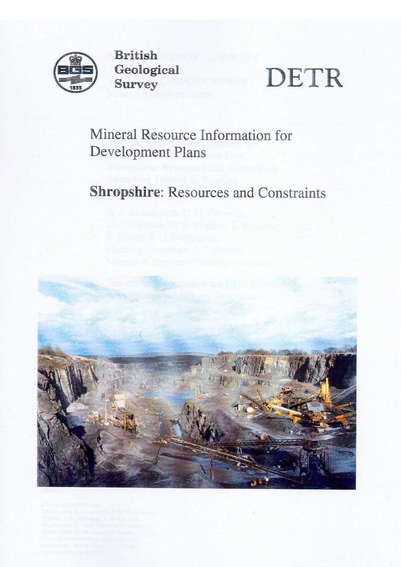
Cover photograph Bayston Hill quarry near Shrewsbury. Produces high-quality road surfacing aggregate from a Precambrian sandstone. © Crown Copyright 1998 Copyright in the typographical arrangement and design vests in the Crown Published for the Department of Environment, Transport and the Regions under licence from the Controller of Her Majesty’s Stationary Office Applications for reproduction should be made in writing to The Copyright Unit, Office of Public Services, Her Majesty’s Stationary Office, St Clements House, 1-16 Colegate, Norwich NR3 1BQ
This report is prepared for the Department of the Environment, Transport and the Regions. (Contract MP0624)
Bibliographic Reference Bloodworth, A J, Cameron, D G, Harrison, D J, Highley, D E, Holloway, S, Hough, E & Warrington, G. 1998. Mineral Resource Information for Development Plans: Phase One Shropshire: Resources and constraints. British Geological Survey Technical Report WF/98/6

BRITISH GEOLOGICAL SURVEY The full range of Survey publications is available from the BGS Sales Desk at the Survey headquarters, Keyworth, Nottingham. The more popular maps and books may be purchased from BGS-approved stockists and agents and over the counter at the Bookshop, Gallery 37, Natural History Museum (Earth Galleries), Cromwell Road, London. Sales desks are also located at the BGS London Information Office, and at Murchison House, Edinburgh. The London Information Office maintains a reference collection of BGS publications including maps for consultation. Some BGS books and reports may also be obtained from the Stationery Office Publications Centre or from the Stationery Office bookshops and agents. The Survey publishes an annual catalogue of maps, which lists published material and contains index maps for several of the BGS series. The British Geological Survey carries out the geological survey of Great Britain and Northern Ireland (the latter as an agency service for the government of Northern Ireland), and of the surrounding continental shelf, as well as its basic research projects. It also undertakes programmes of British technical aid in geology in developing countries as arranged by the Department for International Development and other agencies. The British Geological Survey is a component body of the Natural Environment Research Council.
British Geological Survey Offices Keyworth, Nottingham NG12 5GG
0115–936 3100 Fax 0115–936 3200 e-mail: sales @bgs.ac.uk www.bgs.ac.uk BGS Internet Shop: www.british-geological-survey.co.uk Murchison House, West Mains Road, Edinburgh EH9 3LA
0131–667 1000 Fax 0131–668 2683 London Information Office at the Natural History Museum (Earth Galleries), Exhibition Road, South Kensington, London SW7 2DE
020–7589 4090 Fax 020–7584 8270 020–7942 5344/45
19 Grange Terrace, Edinburgh EH9 2LF
0131-667 1000 St Just, 30 Pennsylvania Road, Exeter EX4 6BX
01392 - 78312 Geological Survey of Northern Ireland, 20 College Gardens, Belfast BT9 6BS
028–9066 6595 Fax 028–9066 2835 Maclean Building, Crowmarsh Gifford, Wallingford, Oxfordshire OX10 8BB
01491–838800 Fax 01491–692345 Parent Body Natural Environment Research Council Polaris House, North Star Avenue, Swindon, Wiltshire SN2 1EU
01793–411500 Fax 01793–411501
ISBN 0 85272 321 0
Shropshire Mineral Resources and Constraints
0
CONTENTS
SUMMARY 1
INTRODUCTION 3 Minerals planning 4 Mineral resource classification 6 Mineral workings and planning permissions 7 Environmental designations 8
MINERAL RESOURCES 10 Overview 10 Coal 11 Clay and shale 17 Fireclay 19 Sand and gravel 20 Sandstone 24 Igneous rocks 26 Limestone 29 Hydrocarbons 30 Salt and gypsum 33 Secondary aggregates 34 Metalliferous vein minerals 35
MINERAL RESOURCES AND PLANNING CONSTRAINTS 37
SELECTED BIBLIOGRAPHY 39
British Geological Survey geological map sheets 39 British Geological Survey sheet memoirs 39 British Geological Survey reports and other publications 39
ACKNOWLEDGEMENTS 42
APPENDICES 44 APPENDIX 1: Mineral workings in Shropshire 44 APPENDIX 2: Contact addresses for further enquiries 45 APPENDIX 3: Methodology 47

Shropshire Mineral Resources and Constraints
0
Shropshire Mineral Resources and Constraints
1
SUMMARY
This report is one of a series prepared by the British Geological Survey for various administrative areas in England and Wales for Phase One of the Department of the Environment, Transport and the Regions Research Project Mineral Resource Information for Development Plans. The report and accompanying maps relate to the area of the Mineral Planning Authorities of Shropshire and Telford & Wrekin. The report and maps delineate and describe the mineral resources of current, or potential, economic interest in the area and relate these to national planning designations which may represent constraints on the extraction of minerals. Three major elements of information are presented and described: • the geological distribution and importance of mineral resources
• the extent of mineral planning permissions and the location of current mineral workings
• the extent of selected planning constraints (national statutory designations)
This wide range of information, much of which is scattered and not always available in a consistent and convenient form, is presented on two digitally-generated summary maps. For reasons of clarity, sand and gravel resources are separated from all other mineral resources. The maps are produced at 1:100 000 scale, which is convenient for overall display and allows for a legible topographic base on which to depict the information. In addition, as the data are held digitally using a Geographical Information System (GIS), easy revision, updating and customisation are possible, including presentation of subsets of the data at larger scales. Basic mineral resource information is essential to support mineral exploration and development activities, for resource management and land-use planning, and to establish baseline data for environmental impact studies and environmental guidelines. It also enables a more sustainable pattern and standard of development to be achieved by valuing mineral resources as national assets. The purpose of the work is to assist all interested parties involved in the preparation and review of development plans, both in relation to the extraction of minerals and the protection of mineral resources from sterilisation, by providing a knowledge base on the nature and extent of mineral resources and the environmental constraints which may affect their extraction. However, it is anticipated that the maps and report will also provide valuable data for a much wider audience, including the minerals industry, the Planning Inspectorate,
Shropshire Mineral Resources and Constraints
2
the Environment Agency, the Countryside Commission, other agencies and government bodies, environmental interests and the general public. The mineral resource information has been produced by the collation and interpretation of data principally held by the British Geological Survey. The methodology for the collection and display of the data is described and a range of sources of information and further contacts is presented. The mineral resources covered are coal, crushed-rock aggregate, comprising limestone, sandstone and igneous rock, sand and gravel, clay and shale, fireclay, hydrocarbons, salt, secondary aggregates and metalliferous minerals.
Shropshire Mineral Resources and Constraints
3
INTRODUCTION
‘........ it will become increasingly important to have reliable information about the nature, quantity and location of mineral resources as workable reserves in environmentally acceptable areas become scarcer.’ Sustainable Development: The UK Strategy. The UK Government’s response to the Rio Earth Summit. This report is one of a series that has been prepared by the British Geological Survey for various administrative areas in England and Wales as part of the Department of the Environment, Transport and the Regions research project Mineral Resource Information for Development Plans. The report relates to the administrative county of Shropshire and should be used in conjunction with the two mineral resources maps of the county which accompany this report. This area includes Telford & Wrekin Council, which became a unitary authority on 1 April 1998. All references to ‘Shropshire’ or ‘the county’ made in this report should be taken to also include the area covered by Telford & Wrekin Council. The report and its associated maps delineate and describe the mineral resources of current or potential economic interest in Shropshire and relate these to national planning designations which may represent constraints on the extraction of minerals. The purpose of the work is to assist all interested parties involved in the preparation and review of development plans, both in relation to the extraction of minerals and the protection of mineral resources from sterilisation, by providing a knowledge base, in a consistent format, on the nature and extent of mineral resources and the environmental constraints which may affect their extraction. An important objective is to provide baseline data for the long term. The results may also provide a starting point for discussions on specific planning proposals for mineral extraction or on proposals which may sterilise resources.
All the data are held in digital form which can be readily revised on a regular basis. This also provides scope for producing customised maps of selected information, including the display of part of an administrative area in greater detail or a grouping of administrative areas to provide a broader picture. The mineral resource maps are at 1:100,000 which is a convenient scale for overall display and to show the information on a legible topographic base. For reasons of clarity, sand and gravel resources are separated from all other mineral resources. The report and maps represents the situation at 1st January 1998.
Shropshire Mineral Resources and Constraints
4
Mineral resources are valuable national assets and their extraction and use makes a major contribution to wealth creation, the infrastructure of our society and quality of life of individuals. However, minerals can only be worked where they occur and their extraction, particularly in the densely populated landmass of Britain, causes conflicts with other desirable aims of society, either by loss or change to valued landscapes, habitats or features of historical and archaeological interest, or due to amenity impact. Basic mineral resource information is essential to support mineral exploration and development activities. In the wider context of sustainable development, mineral resource data are required for resource management and land-use planning. These data also contribute to the baseline information needed for environmental impact studies and environmental guidelines. Moreover, knowledge of the extent and quality of mineral resources, and their rate of extraction, can help value them as national assets. This ensures that the capital they represent is managed properly and rates of depletion monitored.
MINERALS PLANNING It is the function of the planning system through the development plan and individual decisions to achieve a balance between competing objectives. Achieving that balance requires adequate data on the relevant competing objectives, including the extent and details of mineral resources. As the development of workable resources in environmentally acceptable areas is becoming more difficult, it will become increasingly important in the policy development process to have comparative and reliable data on the distribution and quality of such resources. The ‘development plan’ includes structure plans, which contain strategic planning policies, and local plans, containing detailed policies and proposals, or unitary development plans, which combine both functions. In addition, relevant authorities must produce local plans on minerals and/or waste. Development plans set out the main considerations on which planning applications are determined and form the essential framework of the planning system. The importance of the development plan system in planning decisions is emphasised by Section 54A of the Town and Country Planning Act 1990, which requires that planning applications and appeals be determined in accordance with the development plan, unless material considerations indicate otherwise. The planning system is, therefore, a plan-led system. Development plans are produced through an extensive process of consultation with prospective developers and the general public. Development plan preparation must take account of Government guidance. This is primarily set out in Planning Policy Guidance notes (PPGs), Mineral Planning Guidance notes (MPGs) and Regional Planning Guidance
Shropshire Mineral Resources and Constraints
5
notes (RPGs). These provide advice on a range of general and specific issues. The Planning and Compensation Act 1991 introduced a mandatory requirement that all Mineral Planning Authorities (MPAs) in England and Wales prepare either a local plan or a unitary development plan which set out the policies and proposals against which planning applications and appeals are determined. Mineral local plans are intended to provide a clear guide to mineral operators and the public where mineral extraction is likely in principle to be acceptable and where not. They cover a period of at least 10 years and are reviewed periodically to take account of new information and changing circumstances. MPAs are, therefore, required to undertake regular assessments of the existing resources in their areas and of the reserves for which planning permissions have been granted. The key elements of a minerals local plan or of the mineral policies of a unitary development plan are: • to balance through its policies the essential need for minerals
against protection of the environment and local amenity
• to make an appropriate provision for the supply of minerals and provide an effective framework within which the minerals industry may make planning applications
• to identify areas of possible future mineral working
• to prevent unnecessary sterilisation of resources by the use of safeguarding policies, including defining mineral consultation areas
It follows from the above that information on the extent, quality and, if possible, quantity of mineral resources is an essential prerequisite for the production of mineral local plans, both in the context of identifying areas of future mineral working and the longer term objective of the protection of important mineral resources against sterilisation. Such data should be available to all parties to assist them in their contribution to the development plan process, both to protect mineral resources from sterilisation and to provide for sufficient resources to meet the needs of society. This work is intended to assist that process. Three major elements of information are presented and described:
• the geological distribution and importance of mineral resources
• the extent of mineral planning permissions and the location of current mineral workings
Shropshire Mineral Resources and Constraints
6
• the extent of selected planning constraints (national statutory designations)
The maps bring together a wide range of information, much of which is scattered and not always available in a consistent and convenient form. The data are held digitally using a Geographical Information System (GIS), which allows for easy revision, updating and customisation, including presentation of subsets of the data at larger scales. It is anticipated that the maps and report will also provide valuable background data for a much wider audience, including the different sectors of the minerals industry, other agencies and authorities (e.g. The Planning Inspectorate Agency, the Environment Agency, the Countryside Commission and English Nature), environmental interests and the general public.
MINERAL RESOURCE CLASSIFICATION Mineral resources are natural concentrations of minerals, or bodies of rock, that are or may become of potential economic interest as a basis for the extraction of a commodity. They will exhibit physical and/or chemical properties and be present in sufficient quantity to be of intrinsic economic interest. Mineral resources are thus economic as well as physical entities. The identification and delineation of mineral resources is inevitably somewhat imprecise as it is limited not only by the quantity and quality of data currently available but also involves predicting what might, or might not, become economic to work in the future. The assessment of mineral resources is, therefore, a dynamic process which must take into account a range of factors. These include geological reinterpretation as additional data becomes available, as well as the continually evolving demand for minerals, or specific qualities of minerals, due to changing economic, technical and environmental factors. Consequently areas that are of potential economic interest as sources of minerals may change with time. Criteria used to define resources, for example in terms of mineral to waste ratios, also change with location and time. Thus a mineral deposit with a high proportion of waste may be viable if located in close proximity to a major market, but uneconomic if located further away. The criteria used to delineate mineral resources are outlined in the relevant commodity section of the report. These criteria vary depending on the quality of the information available. The maps of Shropshire mainly show the extent of inferred mineral resources, that is those mineral resources that can be defined from available geological information. They have neither been evaluated by drilling or other sampling methods, nor had their technical properties characterised, on any systematic basis. Mineral resources defined on the map delineate areas within which potentially workable minerals may occur. These areas are not of uniform potential, nor do they take account of planning constraints which
Shropshire Mineral Resources and Constraints
7
may limit their working. The economic potential of specific sites can only be proved by a detailed evaluation programme. Such an investigation is an essential precursor to submitting a planning application for mineral working. The individual merits of the site must then be judged against other land-use planning issues. That part of a mineral resource which has been fully evaluated and is commercially viable to work is called a reserve or mineral reserve. The relationship between measured, indicated and inferred resources and evaluated commercial deposits (reserves) is described in more detail in Appendix 3. In the context of land-use planning, however, the term mineral reserve should strictly be further limited to those minerals for which a valid planning permission for extraction exists (i.e. permitted reserves). Without a valid planning consent, no mineral working can take place and consequently the inherent economic value of the mineral resource cannot be released and resulting wealth created. The maps have been produced by the collation and interpretation of data principally held by the British Geological Survey. The geological lines are taken, with some generalisations, from available BGS 1:25 000, 1:50 000 scale and 1:63 630 scale maps. These published maps are based on 1:10 560 or 1:10 000 scale surveys, which cover most of the county. In general, the more recent the survey the more detailed it is likely to be. Where sand and gravel assessment studies have been undertaken by the British Geological Survey, sufficient information may be available to define mineral resources at the indicated resource level. The sand and gravel resources of the north Shropshire plain and the Shrewsbury area fall into this category. The linework is based on the 1:25 000 scale mineral assessment maps, where these are available.
MINERAL WORKINGS AND PLANNING PERMISSIONS The location and name of mineral workings that are currently active or temporarily inactive, together with the main mineral commodities produced, are shown on the map and in Appendix 1. The extent of all known mineral planning permissions (other than coal) is also shown on the Mineral Resources Maps. They include all permissions granted since 1st July 1948 and all IDO permissions, whatever their subsequent status in relation to legislation relating to the Planning and Compensation Act 1991 and the Environment Act 1995. Planning permissions cover active mineral workings, former mineral workings and, occasionally, unworked deposits. They represent areas where a commercial decision to work minerals has been taken in the past and where the permitted mineral reserve may have been depleted to a greater or lesser extent. Within the overall
Shropshire Mineral Resources and Constraints
8
site, there may be a number of individual planning permissions at various stages of development and restoration. All planning permissions data were obtained from Shropshire County Council. The present physical and legal status of individual permissions is not qualified on the maps or in the report. The areas shown may, therefore, include inactive sites, where the permission has expired due to the terms of the permission, i.e. a time limit, and inactive (dormant) sites where the permission is still valid. Sites which have been restored have not been separately identified. A planning permission may extend beyond the mapped resource as it may make provision for operational land, including plant, overburden tips and landscaping, or it may extend to an easily identified or ownership boundary. Information on the precise status and extent of individual planning permissions should be sought from the appropriate Mineral Planning Authority (Appendix 2).
ENVIRONMENTAL DESIGNATIONS The maps show the extent of selected, nationally-designated planning constraints as defined for the purposes of this study. These are defined on a common national basis and therefore represent a consistent degree of constraint across the country. No interpretation should be made from the map with regard to the relative importance of the constraints, either in relation to mineral development proposals or in relation to each other. Users should consult policy guidelines issued by the relevant Government department, statutory agency or local authority. The constraints shown on the map are:
• Areas of Outstanding Natural Beauty (AONB)
• National Nature Reserves (NNR)
• Sites of Special Scientific Interest (SSSI)
• Scheduled Monuments Mineral development may also be constrained by other factors not shown on the maps including local landscape designations, considerations relating to the protection of other resources, such as groundwater, and local amenity or environmental concerns such as noise, traffic and visual impact. These have been excluded because the constraint is not defined on a national basis or the information is not generally available. The extent or degree of relevance of such constraints can be ascertained from the relevant statutory agency or the appropriate Mineral Planning Authority (Appendix 2). AONBs have been digitised from maps obtained from the Countryside Commission and English Nature provided digital data on SSSIs and NNRs. Information on the location of Scheduled

Shropshire Mineral Resources and Constraints
9
Monuments has been obtained in digital form from English Heritage. The areas shown as NNRs and SSSIs may also be subject to international designations reflecting their wider ecological importance. They may include Ramsar sites (wetlands of international importance as listed in accordance with the Ramsar Convention), or proposed Special Protection Areas (SPAs) and Special Areas of Conservation (SACs) as identified in accordance with EC Directives on wild birds and natural habitats, respectively.
Shropshire Mineral Resources and Constraints
10
MINERAL RESOURCES
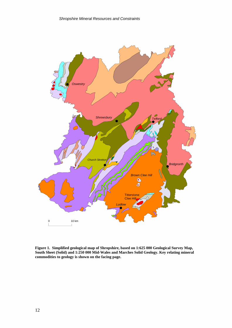
OVERVIEW Shropshire has a great variety of rock types reflecting a long geological history. Older sedimentary and metamorphic rocks occur in the south and west of the county, whilst younger sedimentary rocks predominate in the north and east. Igneous rocks occur sporadically within the older rocks, and also within some of the Carboniferous sediments in the east. A map relating mineral resources to geology is given in Figure 1. In the past, coal derived from Carboniferous sediments has been of considerable economic importance in the county. The impetus for this was the use of coke, rather than increasingly-scarce charcoal, as the reductant in iron-smelting. This process was developed by Abraham Darby in 1709. Coal from the Coalbrookdale coalfield was found to be particularly suitable for coke production. The new iron-smelting technology led to the rapid growth of Britain’s coal and iron industries and formed the basis of the Industrial Revolution. In the Coalbrookdale coalfield, the close association of coal, ironstone and refractory fireclays contributed to the industrial development of the area, as did the proximity of limestone suitable for flux and the River Severn as a transport artery. As a result, the Coalbrookdale coalfield has been the site of some of the most intensively-worked mineral-bearing ground in Britain. Coal mining in the county reached its peak in the 19th Century. Extraction has now declined considerably, with only a few opencast sites remaining. Carboniferous sediments also provide an important source of brick clay in the county. Some of the coal-bearing strata occurring within the county has relatively high prospectivity for coalbed methane. Relatively thick sedimentary rocks of the geological structure known as the Cheshire Basin extend into the north of the county. These are considered to be prospective for conventional hydrocarbons. Igneous rocks, metasediments and limestones form the basis of the crushed-rock aggregate industry in Shropshire. Dolerites and Precambrian volcanic rocks are quarried primarily for roadstone, as are Precambrian and Ordovician sandstones. The Silurian limestones of the Wenlock area form a considerable resource of aggregate suitable for less-demanding applications. In contrast, the Lower Carboniferous limestones in the north-west of the county represent an important resource of high-quality aggregate. Extensive resources of aggregate also exist in the form of sand and gravel. Glacially-derived sand and gravel predominates in the north of the county, whilst economically-important material is also associated with the valleys cut by rivers such as the Severn, Teme, Tern and Onny.
Shropshire Mineral Resources and Constraints
11
The Ordovician sediments of the Shelve area of western Shropshire host lead, zinc and baryte mineralisation which gave rise to a thriving mining industry in the 19th and early 20th Century. This orefield is no longer worked. The Triassic Mercia Mudstone Group underlying the northern part of the county hosts extensive halite (rock salt) deposits. This sequence forms the southern part of the Cheshire basin. Salt is mined conventionally and by brine-pumping north of the county boundary in Cheshire. Peat was formally worked from Wixall Moss in the extreme north of the county. Opencast coal extraction from the resources remaining in the Coalbrookdale Coalfield is likely to continue as a major minerals planning issue in the area now covered by the Telford & Wrekin minerals planning authority. Elsewhere in Shropshire, pressure to develop hard-rock and sand and gravel aggregates within, or close to, areas of high landscape amenity value is likely to be the major minerals planning issue. COAL Coal-bearing strata occur at several locations in Shropshire. Commercial interest in these deposits is likely to be confined to those suitable for opencast extraction. Economically the most important is the Coalbrookdale Coalfield, located on either side of the Ironbridge Gorge and covering about 6500 ha. This coalfield is discussed more fully below. The only other area to have been worked recently is the small Clee Coalfield which forms part of the Clee Hills outlier of Carboniferous rocks to the east of Ludlow. The Coal Measures are intruded by a dolerite sill which itself is an important source of aggregate. Between 1988 and 1992, 322 000 tonnes of saleable coal was produced as part of an operation to shift 2.5 million m3 of overburden from the dolerite (Crump & Donnelly, 1994). Coal extraction has now ceased, although extensive reserves of dolerite remain. The southern part of the Denbighshire Coalfield extends into north-west Shropshire in the Oswestry area. Although formerly worked on a small-scale by deep mining, the area has not been the subject of any opencast activities. Glacial deposits mask the coalfield and the quality of the coal seams is believed to be poor. Resource potential is believed to be low. In the Shrewsbury coalfields (Hanwood, Leebotwood and Dryton) three coals seams with a total thickness of about 2 m occur in some 70 m of strata within the Upper Coal Measures (Coed-yr-Allt Group). Mining ceased during the
Shropshire Mineral Resources and Constraints
12
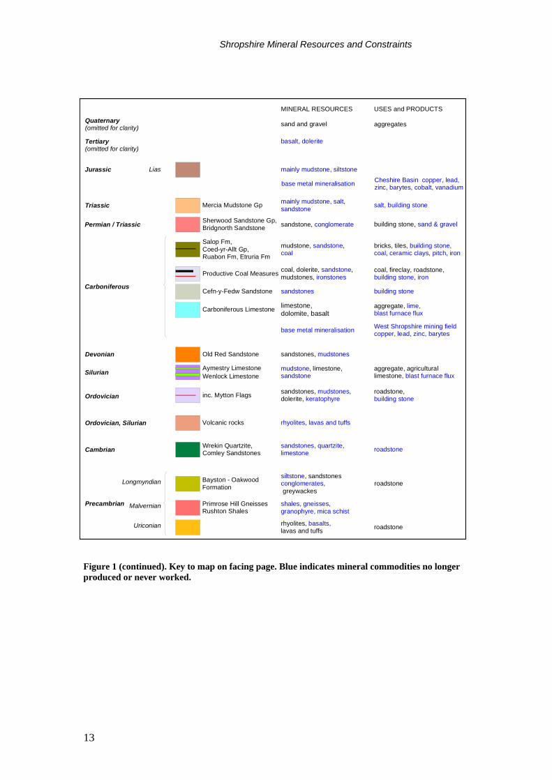
Figure 1. Simplified geological map of Shropshire, based on 1:625 000 Geological Survey Map, South Sheet (Solid) and 1:250 000 Mid-Wales and Marches Solid Geology. Key relating mineral commodities to geology is shown on the facing page.
Oswestry
Shrewsbury Telford
BridgnorthChurch Stretton
Brown Clee Hill
TitterstoneClee Hill
Ludlow
0 10 km
Shropshire Mineral Resources and Constraints
13
Figure 1 (continued). Key to map on facing page. Blue indicates mineral commodities no longer produced or never worked.
Sherwood Sandstone Gp,Bridgnorth Sandstone
Old Red Sandstone
Precambrian
rhyolites, lavas and tuffs
Permian / Triassic
LiasJurassic mainly mudstone, siltstone
sandstone, conglomerate
Devonian sandstones, mudstones
Quaternary (omitted for clarity) aggregates
building stone, sand & gravel
Mercia Mudstone GpTriassic mainly mudstone, salt,sandstone salt, building stone
aggregate, agriculturallimestone, blast furnace flux
mudstone, limestone,sandstone
sandstones, mudstones,dolerite, keratophyreOrdovician
sandstones, quartzite,limestone
Carboniferous
Silurian
Cambrian Wrekin Quartzite,Comley Sandstones
Ordovician, Silurian
roadstone
Tertiary(omitted for clarity)
basalt, dolerite
Cheshire Basin copper, lead,zinc, barytes, cobalt, vanadium
sand and gravel
Aymestry LimestoneWenlock Limestone
Volcanic rocks
Longmyndian
Uriconian
Malvernian
Salop Fm,Coed-yr-Allt Gp,Ruabon Fm, Etruria Fm
limestone,dolomite, basalt
Productive Coal Measures
mudstone, sandstone,coal
coal, dolerite, sandstone,mudstones, ironstones
bricks, tiles, building stone,coal, ceramic clays, pitch, iron
coal, fireclay, roadstone,building stone, iron
sandstones building stoneCefn-y-Fedw Sandstone
Carboniferous Limestone aggregate, lime, blast furnace flux
base metal mineralisation West Shropshire mining fieldcopper, lead, zinc, barytes
rhyolites, basalts,lavas and tuffs
shales, gneisses,granophyre, mica schist
siltstone, sandstonesconglomerates, greywackes
roadstone
Primrose Hill GneissesRushton Shales
roadstone
Bayston - OakwoodFormation
inc. Mytton Flags roadstone,building stone
MINERAL RESOURCES USES and PRODUCTS
base metal mineralisation
Shropshire Mineral Resources and Constraints
14
1940s. The small number of thin coal seams within a relatively thick sequence of barren strata suggests that any opencast potential is very low. Deep mining operations in the Wyre Forest Coalfield ceased with closure of the Highley Mine in 1969. The Shrewsbury and Wyre Forest Coalfields have not attracted opencast interest and are not therefore shown on the mineral resources map.
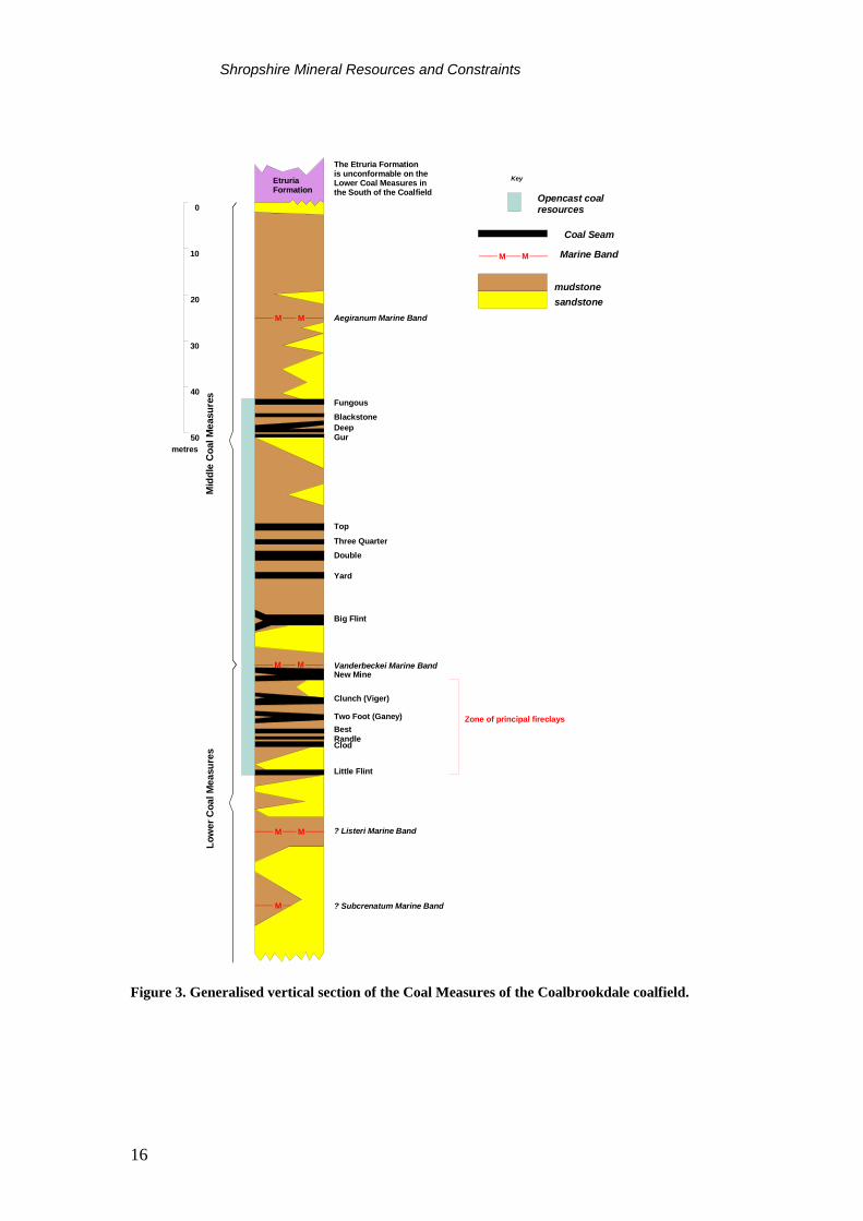
Coalbrookdale Coalfield The Coalbrookdale Coalfield has been the principal source of coal in the county. Records show that coal has been worked in the area since Roman times, but reached a peak during the latter part of the 19th Century, when 60 mines were producing a total of over 1.0 million tonnes a year. By the turn of the century, underground mining was in decline, and this trend continued until 1979 when the last deep mine, Granville Colliery, closed. Opencast coal mining began during the Second World War and has continued to the present day. The development of Telford New Town in the 1970s provided the impetus to combine opencast operations with an extensive programme of land reclamation. In the last decade, a number of new sites have been developed mainly within the north-western part of the coalfield. Some have been for the associated production of fireclay. The coalfield was one of the first to be worked intensively by opencast methods and resources are now largely depleted with only a few potential sites remaining. Recent opencast coal production is shown in Figure 2. Current opencast activity is confined to the extreme southern part of the coalfield. Economically workable coals occur in both the Lower and Middle Coal Measures, which crop out widely in an area to the north of the Ironbridge Gorge, and in two smaller areas to the south. An outlier of coal-bearing strata occurs to the north-east of the main coalfield, near Donnington. The distribution of the outcrops is controlled by three north-east-trending synclines, which plunge north-eastwards, and step down to the south-east. The exposed coalfield terminates to the north-west against the Boundary Fault, while its eastern limit is defined over much of the area by the Lightmoor Fault. The Coal Measures are succeeded by a sequence dominated by red beds. These occur locally as a thin cover within the main area of the coalfield but thicken appreciably to the east of the Lightmoor Fault. About 6o per cent of the coalfield is covered by glacial drift, which is up to 17 m thick in the district. Opencast activity within the district has taken place mainly within the exposed coalfield where the strata dip at low angles (<6o) to the east, and the coal-bearing strata is repeated by faulting, maintaining coals (and fireclays) at relatively shallow depth. The main workable coals occur in three groups of closely spaced seams; one in the upper part of the Lower Coal Measures and two within the Middle Coal Measures (Figure 3). In total, sixteen seams have been worked by opencast methods. Few of these are over 1.2 m thick, and many are split into
Shropshire Mineral Resources and Constraints
15
leaves, or are laterally discontinuous. The coals are mostly bituminous and dull, with a high ash component
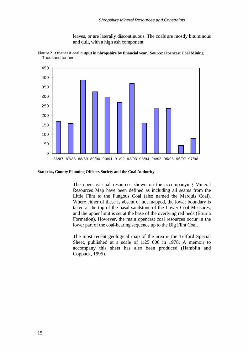
Figure 2. Opencast coal output in Shropshire by financial year. Source: Opencast Coal Mining
Statistics, County Planning Officers Society and the Coal Authority
The opencast coal resources shown on the accompanying Mineral Resources Map have been defined as including all seams from the Little Flint to the Fungous Coal (also named the Marquis Coal). Where either of these is absent or not mapped, the lower boundary is taken at the top of the basal sandstone of the Lower Coal Measures, and the upper limit is set at the base of the overlying red beds (Etruria Formation). However, the main opencast coal resources occur in the lower part of the coal-bearing sequence up to the Big Flint Coal. The most recent geological map of the area is the Telford Special Sheet, published at a scale of 1:25 000 in 1978. A memoir to accompany this sheet has also been produced (Hamblin and Coppack, 1995).
0
50
100
150
200
250
300
350
400
450
86/87 87/88 88/89 89/90 90/91 91/92 92/93 93/94 94/95 95/96 96/97 97/98
Thousand tonnes
Shropshire Mineral Resources and Constraints
16
The Etruria Formationis unconformable on theLower Coal Measures inthe South of the Coalfield
mudstonesandstone
Key
Marine Band
MM Aegiranum Marine Band
Vanderbeckei Marine Band
? Listeri Marine Band
? Subcrenatum Marine Band
Fungous
BlackstoneDeepGur
Top
Three QuarterDouble
Yard
Big Flint
New Mine
Clunch (Viger)
Two Foot (Ganey)BestRandleClod
Little Flint
0
10
20
30
40
50metres
MM
MM
M
EtruriaFormation
Low
er C
oal M
easu
res
Mid
dle
Coa
l Mea
sure
s
MM
Opencast coalresources
Coal Seam
Zone of principal fireclays
Figure 3. Generalised vertical section of the Coal Measures of the Coalbrookdale coalfield.
Shropshire Mineral Resources and Constraints
17
Areas of opencast coal extraction The Coal Authority is a non-departmental public body which was established by the Coal Industry Act 1994. On 31st October 1994 it assumed responsibility for all the interests previously vested in British Coal in respect of unworked coal and coal mines and for the liabilities associated with past coal mining and unworked coal. The main functions of the Authority are to manage the coal resources under its control, encourage economically viable operations to work these resources, grant licences for coal exploration and extraction, provide effective management of subsidence damage claims, and provide information on past, present and proposed future coal mining activities. For active sites, the extent of the licence area for coal extraction issued by the Coal Authority is shown. All licences in Shropshire are opencast licences. Areas of extracted opencast coal are shown on the map, although these data may not be completely up-to-date. The Coal Authority’s mining reports database contains information on past opencast coal mining activity, which is an aggregate of information derived from a number of sources. The areas shown on the map mainly reflect the limits of coal extraction. However, the recent entries into the mining reports database principally reflect site boundaries. More detailed information on specific sites may be obtained from the Coal Authority.
CLAY AND SHALE Clay and shale are used mainly in the manufacture of structural clay products, such as facing and engineering bricks, pavers, clay tiles and vitrified clay pipes. Brick manufacture is the largest tonnage use. Clays may also be used as a source of constructional fill and for lining and sealing landfill sites. The suitability of a clay for the manufacture of structural clay products depends principally on its behaviour during shaping, drying and, most importantly, firing. This behaviour will dictate the final properties of the fired brick, including its strength, porosity (water absorption), durability and aesthetic qualities. Small brickworks mainly producing 'common' bricks from locally won raw materials were formerly a common feature in many industrial areas of Britain. However, in the last two or three decades there has been a major rationalisation of the brick industry which is now based on a small number of plants operated by a limited number of companies. With the demise of the 'common' brick, the main products are now high-quality facing bricks, engineering bricks and related products such as clay pavers. Modern brickmaking technology is highly automated and requires high capital investment. It is increasingly dependent, therefore, on raw materials with predictable and consistent firing characteristics in order to achieve high yields of saleable products, and to reduce waste both in the quarry and plant.
Shropshire Mineral Resources and Constraints
18
Blending different clays to achieve improved durability and to provide a range of fired colours and aesthetic qualities is an increasingly common feature of the brick industry. Continuity of supply of consistent raw materials is of paramount importance. In Shropshire, both clay and shale, and fireclay are produced for brick manufacture. The Etruria Formation (formerly the Hadley Formation) is the principal brick clay resource in Shropshire and crops out on the periphery of the Coalbrookdale Coalfield. The extent of the Etruria Formation is shown on the accompanying Mineral Resources Map. Large parts of the resource have been sterilised by urban development, but the formation is currently worked for brick clay at two sites near Telford. At New Hadley, the clay is used in the manufacture of facing bricks and pavers on site. The Etruria Formation is also worked for buff brick manufacture in the southern part of the coalfield at Caughley. At Donnington and Caughley there are no brick plants and blended clays are transported to other brick factories beyond the Shropshire county boundary. The Etruria Formation consists of a sequence of mudstones and siltstones, characterised by a predominantly reddish colour. The red-bed character of the Etruria Formation indicates that the formation has experienced oxidising conditions. This has resulted in the oxidation of impurities such as carbon and sulphur. These are present in very low levels compared with the grey mudstones of the Coal Measures. The presence of both carbon and sulphur may lead to firing problems in brick manufacture (black coring) and sulphur may also give unacceptable emission levels. The mudstones of the Etruria Formation are generally unbedded, blocky, and veined and mottled in various shades of purple, red, chocolate brown, green, yellow and grey. Lenticular sandstones (known as ‘espleys’) also occur in proportions that vary throughout the coalfield. The formation varies in thickness from 10 m to over 90 m and mainly lies unconformably on the grey beds of the Productive Coal Measures (see Figure 3). It is thickest in the north near Donnington and thins southwards in which direction the proportion of sandstones also increases. Mudstones within the Alveley Member of the Salop Formation (formerly Keele Formation) are worked at Knowlesands near Bridgnorth at the site of a former brickworks. The clay is utilised as a blend at brickworks outside the county. These mudstones tend to be calcareous and their overall suitability for brickmaking is largely unknown. For this reason their extent, and that of other mudstone-bearing formations, has not been shown on the Mineral Resources Map. The Ruabon Marl (a local equivalent of the Etruria Formation) has a very limited outcrop in Shropshire. It was formerly worked for brickmaking in the early part of the century at the Sweeney clay pit south of Oswestry.
Shropshire Mineral Resources and Constraints
19
FIRECLAYS Fireclays typically occur as the seatearths (or fossils soils) immediately beneath coal seams and thus resources are mainly confined to coal-bearing strata. They consist of comparatively thin (usually <1.5 m), unbedded mudstones with rootlets. Fireclays may be sandy or silty, with variable amounts of carbonaceous matter and ironstone present as impurities. The term ‘fireclay’ is now used to describe seatearths which are of economic importance. Originally fireclays were valued as refractory raw materials, because of their relatively high alumina contents. Demand for fireclay for refractory use has, however, declined markedly since the late 1950s. This is mainly due to changing technology in the iron and steel industry where more severe operating conditions now require much higher quality refractories. However, some fireclays have relatively low iron contents compared with other brickmaking clays and they are now valued for the production of buff-coloured facing bricks and pavers. The close association of fireclay and coal means that they are usually recovered as a by-product of opencast coal operations. However, only a small proportion of opencast coal operations produce fireclays. It may be that the fireclays concerned are not of commercial quality, or may be a result of operational restrictions. The Coalbrookdale Coalfield has historically been an important source of fireclay and it continues to be one of the main centres of fireclay production in Britain today. Production is mainly dependent on the level of opencast coal mining activity, but fireclay continues to be supplied from stockpiles and is transported to the Midlands and Lancashire for brick manufacture. Fireclay and coal are currently produced from a site at Caughley, in the southern part of the coalfield. Fireclays of economic interest occur in some 20 m of strata in the upper part of the Lower Coal Measures, between the Little Flint and the New Mine Coals (Figure 3). The Lower Coal Measures crop out widely in the west of the coalfield from Lawley to Little Wenlock and Ironbridge, north of the Severn, and in the Broseley area in the south-western part of the coalfield, south of the River Severn. To the north-east and east in the deeper, concealed parts of the coalfield, the fireclays become impersistent. The fireclays show considerable lateral variation in both thickness and quality and contain between 23 to 33 per cent Al2O3 (uncalcined), but become more siliceous in the east. Fireclays are named from their associated coal. Important fireclays are in ascending stratigraphical order, Clod, Randle, Ganey (Two Foot), Clunch and New Mine Clay (or Upper Clunch). With the principal use for fireclays now being in brick manufacture, quality is assessed on the basis of fired colour, mainly a reflection of iron content, rather than refractoriness. Fireclay resources are generally coincident with the opencast coal resource as shown on the map, but extensive areas have been worked out.
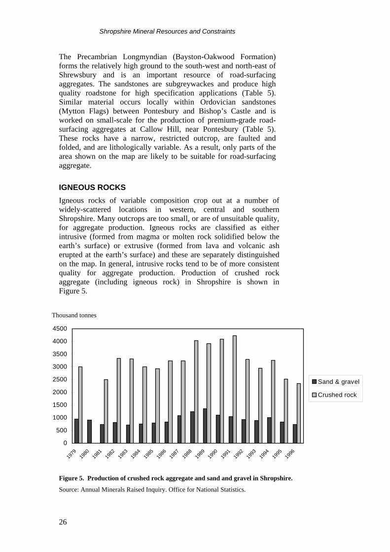
Shropshire Mineral Resources and Constraints
20
SAND AND GRAVEL Shropshire produced more than 700 000 tonnes of sand and gravel in 1996. Production since 1979 is shown in Figure 5. Sand and gravel resources are divided into two broad categories: • Superficial or ‘drift’ deposits of Quaternary age, subdivided for
practical purposes into ‘glacial sand and gravel’, and ‘river sand and gravel’
• Bedrock or ‘solid’ deposits comprising pebbly sandstones within
the Triassic Sherwood Sandstone Group. For clarity, the distribution of sand and gravel resources is shown on a separate map. The variability of sand and gravel deposits together with their possible concealment within or beneath till (boulder clay), means that, in comparison with other bulk minerals, it is more difficult to infer the location and likely extent of potentially workable resources from geological maps. The properties which influence the economic potential of a sand and gravel deposit include: • sand to gravel ratio • proportion of fines and oversize material • presence of deleterious rock types (such as coal or mudstone) • thickness of deposit and overburden ratio • position of the water table • possible presence of unwanted interbedded material • the ease with which material can be processed to produce a
saleable product (clay fines are more difficult to remove than silt) • location relative to demand As stated in the previous Mineral Resource Classification section, the distribution of sand and gravel shown on the map can generally be considered as being at the inferred resource level. Various BGS sand and gravel assessment surveys in the north of the county have upgraded the data in these areas to the level of ‘indicated’ resources, as does the University of Liverpool study in the Condover area. These areas are clearly delineated and include the category ‘concealed glacial sand and gravel’ which is not shown elsewhere on the map. It should be noted that the physical criteria used by BGS and Liverpool University to define indicated sand and gravel resources are somewhat different. The criteria used are set out in Table 1.
Shropshire Mineral Resources and Constraints
21
BGS Mineral assessment
reports University of Liverpool report
Deposit thickness >1 m >2.5 m Overburden : sand & gravel ration 3:1 1:1 Proportion of fines (<63μm) <40 % <10 % Proximity of deposit to surface 25 m 25 m
Table 1. Physical criteria used by BGS and University of Liverpool surveys to define ‘indicated’ resources of sand and gravel in Shropshire. Sources: Cannell & Harries, 1981, Liverpool University 1985.
Superficial deposits Superficial deposits comprise all those sediments laid down during the last two million years. For the purposes of this report, these materials have been divided up into two groups, ‘river sand and gravel’ and ‘glacial sand and gravel’.
River sand and gravel Post-glacial river terrace and alluvial deposits are extensively developed along the major river valleys in Shropshire, including those of the Severn, Teme, Tern and Onny. River terrace deposits occur at various elevations above the present day level of the alluvial flood plain. They represent the eroded remnants of formerly more extensive, relatively gravel-rich alluvial deposits. Also included in the ‘river sand and gravel category’ are glaciofluvial deposits. They are included in this category as they tend to occur beneath river terraces, as well as underlying flood plain deposits (alluvium) and may be undifferentiated on some older published maps. Sand and gravel quarrying operations based in river valleys will generally work both alluvial and underlying glaciofluvial deposits where present. River sand and gravel is quarried from several locations in the Severn valley, it is also quarried from the Onny/Teme valleys west of Ludlow. Grading data for river sand and gravels in the Severn valley in the Shrewsbury area are given in Table 2. The gravel-rich nature of the fluvial deposits is clear when compared to the glacial sand and gravel data in Table 3. Terrace deposits of the Severn near Shrewsbury are up to 5 m thick. Alluvium in the same area is up to 8 m thick (Cannel, 1982).
Shropshire Mineral Resources and Constraints
22
Deposit type Fines % Sand % Gravel %
Alluvium 8 37 55
Terrace deposits 9 39 53
Glaciofluvial deposits
11 27 62
Table 2. Mean grading data for river sand and gravel samples taken from the Severn valley in the Shrewsbury area. Source: Cannel, 1982
The boundaries between fines (that is clay and silt fractions) and sand, and between sand and gravel are placed at 63µm and 4 mm respectively.
Glacial sand and gravel Deposits of glacial sand and gravel are ice-contact sediments, laid down by streams flowing on the top, within and beneath ice sheets. These deposits are commonly associated with till (boulder clay) and commonly occur as lenses either within or beneath till. They can be chaotic and/or grade directly into high-fines materials such as till. As a result of these factors, they are less predictable in geographic extent than river sand and gravel and may be more extensive than shown on geological maps. They generally show a more variable particle-size distribution, although sand-grade material tends to predominate. Their thickness can vary markedly over short distances and they are difficult to predict without geophysical or borehole information. Despite the variable nature of these materials, they form a valuable resource and are of particular importance in Shropshire. Detailed sand and gravel surveys carried out in the north of the county and around Shrewsbury by BGS in the 1970s and 1980s reveal considerable thicknesses of glacial sand and gravel (Cannell & Harries, 1981; Cannell, 1982; James, 1983; Anon., 1982). Deposits in the area around Prees (south of Whitchurch) and Wem are in excess of 25 m thick. The grading of these deposits is variable but tends to be sand-dominated (see Table 3). Glacial deposits in the Condover area (south of Shrewsbury) are also sand dominated (Liverpool University, 1985). Physical properties of gravel aggregates derived from the deposits in the area around Prees are summarised in Table 4.
Shropshire Mineral Resources and Constraints
23
Area Fines Sand Gravel
Wem district1 11 61 28
Prees district2 7 85 8
Welshampton district3 9 79 14
Whitchurch district4 10 76 14
Shrewsbury district5 11 74 15
Condover district6 8 67 25
Table 3. Mean grading data for glacial sand and gravel in those parts of Shropshire covered by BGS and other resource surveys. Sources: 1Cannell & Harries, 1981; 2James, 1983; 3Anon., 1982; 4Jackson et al., 1983; 5Cannel1, 1982; 6Liverpool University 1985
Borehole Aggregate impact value
10% fines value (kN)
Relative density (oven-dried)
Relative density (surface-dried)
Water absorption (% of dry mass)
SJ53/NE42 22 250 2.6 2.6 1.3
SJ53/NE45 24 230 2.8 2.8 1.7
Table 4. Physical properties of gravel aggregates from representative boreholes in glacial sand and gravel in the district around Prees.
Source: James, 1983 Bedrock deposits Potential bedrock deposits of sand and gravel are confined to the Chester Pebble Beds Formation (in northern Shropshire) and the Kidderminster Formation (in eastern Shropshire). These formations are part of the Sherwood Sandstone Group (formerly ‘Bunter Pebble Beds’). In the adjacent county of Staffordshire, loosely bound, sandy pebble beds (conglomerates) within the Sherwood Sandstone are a very important source of aggregate. However, where devoid of pebbles the Sherwood Sandstone is of limited value as a resource. Quantitative information on the pebble content of the Chester Pebble Beds and Kidderminster formations in Shropshire is scant. The sandstones are variously described as containing ‘scattered pebbles’, as ‘pebbly sandstones’ and locally as being ‘very conglomeratic’. The formations are not currently worked within the county for sand and gravel. Extensive parts of the outcrops of these formations, and particularly the Chester Pebble Beds Formation, are concealed beneath superficial deposits of variable thickness, including those containing glacial sand and gravel. Only exposed areas of the pebble-bearing formations are shown on the sand and
Shropshire Mineral Resources and Constraints
24
gravel resource map. Concealed material is not shown on the map, although details are held in the database.
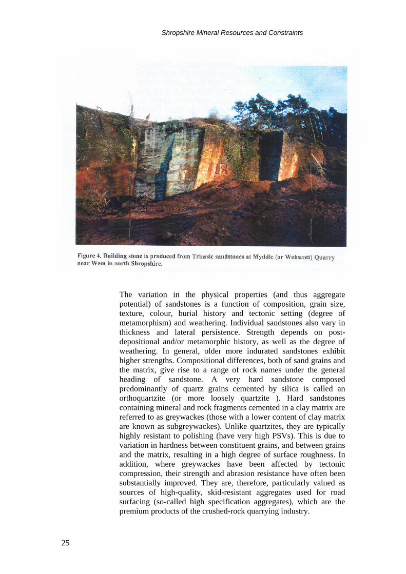
SANDSTONE Sandstones are accumulations of sand-sized particles composed predominantly of quartz, with variable amounts of feldspar and rock fragments set in a fine-grained matrix or cementing material. Many sandstones are very variable in quality and are often interbedded with mudstones or siltstones, or are weakly-cemented. Relatively few sandstones form resources of construction raw material. Sandstones were traditionally valued as a source of building stone, and very small amounts are still produced for this purpose in Shropshire. However, they are now valued principally as a source of aggregates and this is by far their largest tonnage use, both nationally and within the county. Production of crushed rock aggregate (including sandstone) in Shropshire is shown in Figure 5. The suitability of a sandstone for building stone depends not only on strength and durability, but also on aesthetic qualities and textural consistency, and the size of the blocks that can be produced. Thinly-bedded sandstones may be suitable for the production of flagstones and roofing slates. A continuing supply of building stone for new building work and for restoration is important to maintain local vernacular architecture. Quarries are usually small and are often based on resources of only local significance. Triassic sandstones of the Sherwood Sandstone Group are quarried on a small-scale for building stone at two quarries near Wem in north Shropshire. The sandstones may be yellow, brown, red and white in colour, fine-grained in texture and massively bedded (Figure 4). The sandstone is up to 50 m thick in this area and has been used in the construction of many buildings in the Shrewsbury area. The suitability of a sandstone for aggregate use is principally a function of strength and durability. Many sandstones are too weak and porous to be used other than as a source of constructional fill. However, more indurated and higher strength sandstones are suitable for more demanding aggregate uses, such as for concrete aggregate and roadstone.
Shropshire Mineral Resources and Constraints
25
The variation in the physical properties (and thus aggregate potential) of sandstones is a function of composition, grain size, texture, colour, burial history and tectonic setting (degree of metamorphism) and weathering. Individual sandstones also vary in thickness and lateral persistence. Strength depends on post-depositional and/or metamorphic history, as well as the degree of weathering. In general, older more indurated sandstones exhibit higher strengths. Compositional differences, both of sand grains and the matrix, give rise to a range of rock names under the general heading of sandstone. A very hard sandstone composed predominantly of quartz grains cemented by silica is called an orthoquartzite (or more loosely quartzite ). Hard sandstones containing mineral and rock fragments cemented in a clay matrix are referred to as greywackes (those with a lower content of clay matrix are known as subgreywackes). Unlike quartzites, they are typically highly resistant to polishing (have very high PSVs). This is due to variation in hardness between constituent grains, and between grains and the matrix, resulting in a high degree of surface roughness. In addition, where greywackes have been affected by tectonic compression, their strength and abrasion resistance have often been substantially improved. They are, therefore, particularly valued as sources of high-quality, skid-resistant aggregates used for road surfacing (so-called high specification aggregates), which are the premium products of the crushed-rock quarrying industry.
Shropshire Mineral Resources and Constraints
26
The Precambrian Longmyndian (Bayston-Oakwood Formation) forms the relatively high ground to the south-west and north-east of Shrewsbury and is an important resource of road-surfacing aggregates. The sandstones are subgreywackes and produce high quality roadstone for high specification applications (Table 5). Similar material occurs locally within Ordovician sandstones (Mytton Flags) between Pontesbury and Bishop’s Castle and is worked on small-scale for the production of premium-grade road-surfacing aggregates at Callow Hill, near Pontesbury (Table 5). These rocks have a narrow, restricted outcrop, are faulted and folded, and are lithologically variable. As a result, only parts of the area shown on the map are likely to be suitable for road-surfacing aggregate.
IGNEOUS ROCKS Igneous rocks of variable composition crop out at a number of widely-scattered locations in western, central and southern Shropshire. Many outcrops are too small, or are of unsuitable quality, for aggregate production. Igneous rocks are classified as either intrusive (formed from magma or molten rock solidified below the earth’s surface) or extrusive (formed from lava and volcanic ash erupted at the earth’s surface) and these are separately distinguished on the map. In general, intrusive rocks tend to be of more consistent quality for aggregate production. Production of crushed rock aggregate (including igneous rock) in Shropshire is shown in Figure 5.
Figure 5. Production of crushed rock aggregate and sand and gravel in Shropshire.
Source: Annual Minerals Raised Inquiry. Office for National Statistics.
0
500
1000
1500
2000
2500
3000
3500
4000
4500
1979
1980
1981
1982
1983
1984
1985
1986
1987
1988
1989
1990
1991
1992
1993
1994
1995
1996
Sand & gravel
Crushed rock
Thousand tonnes
Shropshire Mineral Resources and Constraints
27
Production of igneous rocks makes a significant contribution to local crushed rock aggregates supply. Igneous rocks are sometimes capable of producing high quality aggregates suitable for road surfacing as they can meet the required abrasion and polish resistance specifications. They are, however, not generally capable of producing premium grade road surfacing materials which are usually sourced from greywacke/gritstone quarries. Together with the production from the sandstones at Bayston Hill and Callow Hill quarries, they form an important source of aggregates for the West Midlands Region. The Precambrian rocks of Shropshire contain lavas of basic (basalt), intermediate (andesite, dacite) and acid (rhyolite) compositional types with associated tuffs and intrusions of basic (dolerite) and acid (granophyre) rocks. These so-called Uriconian rocks are of varying lithology, but are mostly hard and resistant and form the well known hills of the Wrekin, Caer Caradoc, the Lawley and Pontesford Hill. Volcanic rocks with associated intrusions also occur in Carboniferous rocks in the east of Shropshire near Telford and on the Clee Hills. These basaltic lavas are for the most part relatively thin, soft and partially weathered and are therefore generally unsuitable for quarrying. However, thick (60 m) jointed intrusive sills of dolerite occur on Brown Clee Hill and, particularly, on Titterstone Clee Hill where it has been extensively quarried for roadstone. The dolerite produces a consistent aggregate ideally suited for roadstone. It has a typical PSV of 52, too low to be suitable as premium grade surfacing material, but is otherwise a very strong and durable roadstone (Table 5). The dolerite from Clee Hill is also used to manufacture insulation materials (rockwool) at a plant in Bridgend, South Wales.
Intrusions of dolerite also occur within Ordovician sandstones (Mytton Flags) at Callow Hill near Pontesbury and here both rock types are quarried for roadstone aggregates, although the dolerite is only suitable for sub-base roadstone (Table 5). Elsewhere, in the Ordovician rocks of the Shelve district, intrusions of dolerite and picrite (an ultrabasic rock) form the prominence of Corndon Hill and adjacent intrusions of andesitic composition form the hills of Todleth and Roundton. Intrusive igneous rocks also occur in Ordovician strata west of Oswestry. Here several large masses of keratophyre (a type of mostly fine-grained rock of intermediate chemical composition) occur in association with brecciated rocks. Locally, the keratophyre is sufficiently massive and uniform to form a good quality aggregate material which was quarried at Blodwel (Table 5). The quarry is currently inactive.
Shropshire Mineral Resources and Constraints
28
Rock type Locality AIV ACV AAV LAAV PSV Relative
density Water absorption (%)
Carboniferous limestone - limestone
Llynclys, Oswestry 24 22 6.1 25 48 2.64 0.9
Carboniferous limestone -dolomite
Llynclys, Oswestry 25 24 7.2 2.78 0.9
Silurian Wenlock Limestone
Much Wenlock 28 27 16.5 31 50 2.6 1.8
Keratophyre Blodwel, Oswestry 11 12 4.6 13 2.63 1.3 Dolerite Pontesbury 13 13 4.2 16 2.79 1.0 Dolerite Clee Hill, Ludlow 14 12 3.1 14 52 2.82 0.9 Ordovician Stiperstones quartzite
Pontesbury
21 20 2.1 23 2.58 1.1
Ordovician Mytton Flags Callow Hill, Pontesbury
14 15 5.3 16 68 2.64 1.2
Precambrian Longmyndian sandstones
Shrewsbury 11 10 3.4 13 65 2.78 0.8
Table 5. Aggregate properties of some limestones, sandstones and igneous rocks from Shropshire.
Source: British Geological Survey. Definitions: Los Angeles Abrasion Value (LAAV): Resistance of an aggregate to abrasion by attrition and impact
as measured in the Los Angeles abrasion test. The smaller the value the more resistant the rock is to abrasion. Abrasion resistance is particularly important for road surfacing materials.
Aggregate Crushing Value (ACV): Resistance of an aggregate to crushing when subjected to a crushing force as measured by the aggregate crushing test. The smaller the value, the more resistant the rock is to crushing.
Aggregate Impact Value (AIV): Resistance of an aggregate to repeated impact as measured by the aggregate impact test. The smaller the value, the more resistant the rock is to impact.
Polished Stone Value (PSV): Resistance of an aggregate to polishing as measured in the accelerated polishing test. A measurement of skid resistance on road surfaces. The larger the value the more resistant the rock is to polishing.
Shropshire Mineral Resources and Constraints
29
LIMESTONE Limestone resources in Shropshire occur principally on the well-wooded scarp and slopes of Wenlock Edge and on the hills and ridges west of Oswestry. The former occur as limestone formations within Silurian strata and the latter are limestone and dolomites of Carboniferous age at the southern extremity of the extensive outcrop of North Wales. Small areas of Carboniferous limestone also occur near Telford and Newport and on the flanks of Titterstone Clee Hill. Production of crushed rock aggregate (including limestone) in Shropshire is shown in Figure 5. Silurian limestones occur in two main formations, the Wenlock and Aymestry limestones. Along Wenlock Edge, the Wenlock Limestone is approximately 30 m thick and is quarried at two sites for aggregate materials. The bulk of the formation consists of well bedded, mid-grey, fine-grained limestones interbedded with thin siltstones and mudstones which predominate in the basal part of the formation. The upper part of the Wenlock Limestone contains masses of relatively pure reef limestones (‘ballstones’) within the bedded limestones. The ‘ballstones’ are flat bottomed lenses of massive calcite mudstone (a type of fine-grained limestone) which may be up to 24 m thick. The Wenlock Limestone is generally impure and the chemical quality of the deposit is highly variable due to the silty and muddy character of the beds. The presence of variable amounts of mudstones within the limestone also affects the aggregate resource quality of the Wenlock Limestone and may constrain resource development. Mudstone beds within the limestones tend to reduce the bulk strength of the deposit in dipping strata and quarrying may result in local stability problems. Extraction is mainly for aggregates and agricultural use. Aggregate properties of the Wenlock Limestone are given in Table 5. The Wenlock Limestone is overlain by a thick sequence of mudstones which are, in turn, overlain by a second limestone formation, the Aymestry Limestone. This is about 60 m thick but is generally more muddy and silty than the Wenlock Limestone, and consists of a variable group of muddy, nodular limestones and calcareous mudstones with local developments of massive limestones. The Aymestry Limestone is not currently quarried due to its variable and impure nature. Carboniferous Limestone in the north-west of the county near Oswestry is a thick (>300 m) sequence of limestones which is irregularly dolomitised in southern parts of the outcrop. The limestones are predominantly pale grey, massive or well-bedded. They are similar to those found in the Vale of Clwyd area. The lower part of the sequence are mostly high in calcium carbonate, although variable degrees of dolomitisation and iron staining affect the quality of the deposits. The Carboniferous limestones are also capable of producing strong, low porosity aggregates which are suitable for a range of constructional uses (excluding road surfacing materials). They are
Shropshire Mineral Resources and Constraints
30
currently extracted for aggregates and agricultural use at one quarry south of Oswestry. Aggregate properties of limestone and dolomite from this deposit are given in Table 5. Carboniferous Limestone also occurs in three small inliers in the east of Shropshire. Around 46 m of limestones and mudstones crop out on the sides of Titterstone Clee Hill and the small outcrops at Lilleshall and near Ironbridge contain mixed sequences of limestones, shales, sandstones and basalts with a total thickness of around 80 m. These limestone resources are relatively insignificant due to their limited outcrop and their thin and variable character.
HYDROCARBONS Coalbed methane In Shropshire, coal seams occur within the Upper, Middle and Lower Coal Measures. Coals found in the Upper Coal Measures in Britain tend to have very low methane contents and are not prospective for coalbed methane. In contrast, coal seams in the Lower and Middle Coal Measures may have coalbed methane potential. This potential is greatest at depths greater than 200 m. Coal found at shallower depths tends to have a reduced gas content because the methane is able to desorb from the coal. Prospectivity is also reduced in coals which occur close to the basal Permian unconformity (Creedy; 1983, 1988, 1991).
Oswestry and Denbighshire Coalfields The Coal Measures at mineable depths in the extreme north-western part of the county, in the area north of Oswestry, form the southernmost part of the Denbighshire coalfield. These coal-bearing rocks extend southwards, through an area where there has been no mining, to the small Oswestry coalfield south and west of Oswestry. The accompanying map shows that Middle and Lower Coal Measures occur in the subsurface to the east of this outcrop. They are folded into a syncline (Smith et al., 1995), part of which lies beneath Upper Coal Measures and part beneath both Upper Coal Measures and Permo-Triassic strata of the Cheshire Basin. Much of this syncline of Lower and Middle Coal Measures is licensed to Concord Gas Ltd (EXL 281). The Middle Coal Measures vary between around 290 m and 175 m in thickness. They contain up to seven significant coals. The thickness of the coal seams varies from place to place. Five seams are commonly more than a metre thick. Mean methane values for the coals in North Wales as a whole are 7.1 m3/tonne (Creedy, 1991). This gas content is high enough to be of interest to the coalbed methane industry. However, the exact values in the southern end of the Denbighshire coalfield are not in the public domain. The permeability of the coals in the Middle and Lower Coal
Shropshire Mineral Resources and Constraints
31
Measures in this area is not known, nor is it known whether the coals are saturated with methane. Economic coalbed methane production could not be established in the trial borehole drilled by Evergreen Resources (UK) Ltd at Sealand, near Chester, on the western margin of the Cheshire Basin in the Flintshire coalfield. On the basis of currently available data, it seems unlikely that coalbed methane production will be established in the southern end of the Denbighshire Coalfield, although any appraisal drilling in the area may alter perceptions of the prospectivity. The coals in the Lower and Middle Coal Measures have their greatest coalbed methane potential where buried between depths of approximately 200 and 1200 m. The limits of this area are poorly known, but a ‘best guess’ is shown on one of the maps associated with this report. Prospectivity is likely to be reduced along the subcrop of the Lower and Middle Coal Measures beneath the Permo-Triassic strata. A further area of Lower and Middle Coal Measures occurs around the Prees 1 well. However, the coals here are too deep to be of interest for coalbed methane production.
Coalbrookdale, Madeley and Wyre Forest Coalfields The Coalbrookdale and Madeley Coalfields, in the area around Telford, probably have little coalbed methane potential as they are heavily faulted and have been extensively mined. These two coalfields are north-east-trending synclines of productive Lower and Middle Coal Measures partially separated by the north-east-trending Stirchley anticline. A third syncline, in the south of the Madeley Coalfield (the Coalport syncline) also contains productive coal measures. The southern limit of this area of productive coal measures is the Sutton Maddock Anticline, on which the Coalport G1 and G2 boreholes were drilled. The down dip (eastward) continuations of the Coalbrookdale and Madeley coalfields, beyond the limit of mining, could have some coalbed methane potential. However, the gas content, permeability and methane saturation of the coals in this area are not known. Boreholes in the area south and south-east of the Madeley and Coalbrookdale coalfields and north of the Wyre Forest Coalfield either terminate in Permo-Triassic strata or, where Lower and Middle Coal Measures are present, such as in the Claverly boring, contain little coal. This area is therefore considered to be unprospective for coalbed methane. The extreme westernmost parts of this area, around Albrighton and west of Bridgnorth, are licensed to coalbed methane companies; Octagon (CBM) Ltd (EXL 283) and Evergreen Resources (UK) Ltd.
Shropshire Mineral Resources and Constraints
32
(EXL 208). The Codsall borehole, in EXL 283, proved Upper Coal Measures resting on Silurian rocks, the Lower and Middle Coal Measures being absent. The part of EXL 208 which is in Shropshire does not appear to be very prospective. It contains the Claverley borehole which, in the Lower and Middle Coal Measures, proved only a few very thin seams of coal, the thickest being approximately 0.3 m. Middle and Lower Coal Measures occur in the Wyre Forest Coalfield, in the Kinlet area in the south-east of the county. The coal seams occur at depths of more than 200 m in the western part of the concealed coalfield. However, the best seam, the Brooch Coal, has been worked out over much of the subsurface.
Conventional hydrocarbons There are indications that oil and gas have been generated in the west, and probably the north, of Shropshire. As such, further exploration wells may be drilled in these areas even though no discoveries have been made in the eight wells drilled to date. In the east of the county, some encouragement is provided by the presence of oil seeps (such as the famous Coalport tar tunnel) in Carboniferous strata (Selley, 1992). It is likely that this oil was generated from cannel coals or other source rocks in the Westphalian Coal Measures. Five wells; Coalport G1, G2 and G3, Edgmond and Codsall, have been drilled to test the oil and gas potential in this area. The potential reservoirs are Westphalian and late Namurian (Carboniferous) sandstones similar to those which form the oil reservoirs in the East Midlands oil fields. Two wells (Ternhill and Stoke on Tern) have been drilled on the Market Drayton Horst. These wells were drilled to test Carboniferous sandstones. In the north-west of the county, mature Carboniferous source rocks, may occur at depth beneath the Permo-Triassic strata of the Cheshire Basin. Any oil or gas generated from these strata could have accumulated in either Carboniferous sandstones or Permo-Triassic sandstones (Smith et al., 1995). Carboniferous sandstones make poorer reservoirs than the Permo-Triassic sandstones as their porosity and permeability are generally lower. Although no discoveries have been made to date, the Cheshire Basin has many similarities to the East Irish Sea Basin, which contains large gas and oil fields. The only well drilled in the Shropshire part of the Cheshire Basin is Prees 1, but no discoveries were made. As of 1 October 1997, an area of Shropshire north of Prees ( part of EXL 254) was licensed to Brabant Petroleum.
Shropshire Mineral Resources and Constraints
33
SALT AND GYPSUM Halite (sodium chloride, NaCl), or ‘rock salt’, underlies about 240 km2 of north Shropshire. The resource comprises two salt-bearing formations which occur in the Triassic Mercia Mudstone Group of the southern part of the Cheshire Basin. The lower and upper salt-bearing formations are known as the Northwich Halite and Wilkesley Halite respectively. The salt is concealed by younger, mostly superficial deposits. Salt-bearing strata do not crop out at the surface, because of solution by groundwater, but have a concealed crop, or ‘wet rock-head’, which is masked by collapsed beds (Taylor et al. 1963). The salt resource is known principally from boreholes; the main record within the county being the Prees Borehole [SJ 5572 3447] which was drilled for hydrocarbon exploration. No core was taken from the halite formations in this borehole but their thickness and character can be interpreted from borehole geophysical logs (Evans et al. 1993). At the Prees site, the Northwich Halite Formation is 182 m thick and its top is at a depth of 1353 m. The Wilkesley Halite is about 350 m thick and its top is at a depth of 850 m. The very large rock salt resources of the Cheshire Basin have only been worked in Cheshire. Parts of the Northwich Halite are worked by mining and controlled brine pumping, mainly around Northwich and Winsford. The Wilkesley Halite was formerly worked on a minor scale. In Shropshire salt was formerly extracted from weak natural brine springs but production ceased prior to the end of the 18th Century. There has been no rock salt or brine extraction in the county since that time. Gypsum (CaSO4.2H2O) and anhydrite (CaSO4) are naturally-occurring forms of calcium sulphate which occur in nodular masses and beds up to a few metres in thickness. Gypsum is formed by the hydration of anhydrite at or near surface, and passes into anhydrite at depth. Gypsum/anhydrite occur in the upper part of the Mercia Mudstone Group of the Cheshire Basin at levels comparable to those worked in Staffordshire and the East Midlands. However, there is no information on the thickness of the beds present in Shropshire.
SECONDARY AGGREGATES The term ‘secondary aggregates’ is used to describe a range of materials which may be used as alternatives to primary aggregates (subject to considerations of quality and contamination), but which
Shropshire Mineral Resources and Constraints
34
arise as wastes from a variety of activities. These may be considered under three main headings: • Naturally-occurring materials arising from mineral extraction and
processing operations, such as colliery spoil, overburden and quarry/processing waste
• Materials arising from industrial processes, such as slags and ash,
which may be of variable composition • Construction and demolition wastes which may be either in a
natural or manufactured state and include asphalt planings, road sub-base, concrete rubble and masonry. These materials are excluded from this study as their arisings are highly variable in location, type and duration.
Utilising the aggregate potential of such materials may have the advantage of both reducing the demand for primary aggregates and thus land for extraction, and the problems of disposing of waste. In general, however, secondary aggregates are only suitable for less demanding aggregate applications, and their production and use may not always be environmentally or economically desirable. There are very limited resources of secondary aggregates in Shropshire.
Ash All coal contains inorganic mineral matter consisting mainly of silica and alumina derived from the mudstones and siltstones associated with coal seams. Coal-fired power stations burn pulverised coal and the main residue is a fine-grained powder composed of spherical glassy particles called Pulverised Fuel Ash (PFA), which is collected by electrostatic precipitators. Typically PFA accounts for most of the ash produced at power stations. The remainder is produced by the agglomeration of hot ash particles which fall to the bottom of the furnace where they are collected. This material is know as Furnace Bottom Ash (FBA) and is much coarser than PFA. The only operational coal-fired power station in Shropshire is Ironbridge operated by Eastern Generation Ltd which has a capacity of 1000 MW. The total amount of ash produced depends on how much coal is burned but typically ash production amounts to some 150,000 t/y. About 20 per cent is FBA which is sold as a graded aggregate for lightweight concrete block manufacture and for use as hardcore. PFA is primarily used as a structural fill in civil engineering applications but sales are dependent on the availability of suitable contracts. Some is used as an additive in concrete products and also for grouting old mine workings. The benefits of processed PFA in concrete are due to its chemical reaction with
Shropshire Mineral Resources and Constraints
35
cement, its spherical shape and its particle size which ranges from 150 μm to sub-micron size.
Other materials Colliery spoil is the waste from mining and processing coal. It consists mainly of mudstone and siltstone. In Shropshire, former tips have largely been reclaimed/restored and are not now available as a source of secondary aggregate. Waste tips from former lead-zinc mining operations occur in the Shelve district. Calcite has been recovered in the past. The waste is largely unsuitable for use as secondary aggregate because of its variable composition and the presence of sulphides, which present a potential pollution risk if disturbed.
METALLIFEROUS VEIN MINERALS The west Shropshire mining field in the Shelve and Breidden Hills area was formerly extensively worked for lead, zinc, barytes and calcite. The deposits were worked by the Romans, but operations were at their most productive during the 19th Century and rapidly declined during the early part of the 20th Century. However, barytes production continued until the 1940s and calcite has been produced more recently. Veins of lead-zinc are hosted mainly by Ordovician rocks, whilst Precambrian rocks host baryte veins. The mineralisation is thought to be Devonian or Carboniferous in age. 235 650 tonnes of lead ore were produced from the Shelve area between 1845 and 1913, along with 18 994 tonnes of zinc ore and 271 397 tonnes of baryte. A further 295 108 tonnes of baryte was produced between 1914 and 1944. Copper mineralisation hosted in the Triassic Helsby Sandstone occurs near Grinshill (north of Shrewsbury) and at Eardiston (between Shrewsbury and Oswestry). Small mines worked copper carbonate ore in these areas until the 19th Century. The British Geological Survey has undertaken some exploration activity in Shropshire, mainly through the Mineral Reconnaissance Programme (MRP) funded by the Department of Trade and Industry (DTI). This work included investigation of geophysical and geochemical anomalies in the Berwyn Dome, part of which covered north-western Shropshire; investigation of localised copper, lead and cobalt mineralisation associated with Triassic rocks of the Cheshire Basin, and investigation of the mineralisation in the Shelve area. In addition, between 1972 and 1984 the DTI provided financial assistance to industry for mineral exploration in Great Britain through the Mineral Exploration and Investment Grants Act 1972 (MEIGA). Only one company was active in Shropshire during this period, carrying out exploration for lead and zinc around the village
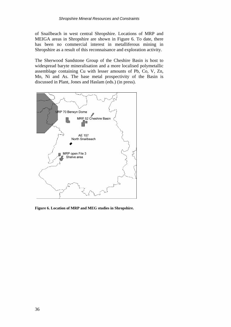
Shropshire Mineral Resources and Constraints
36
of Snailbeach in west central Shropshire. Locations of MRP and MEIGA areas in Shropshire are shown in Figure 6. To date, there has been no commercial interest in metalliferous mining in Shropshire as a result of this reconnaisance and exploration activity. The Sherwood Sandstone Group of the Cheshire Basin is host to widespread baryte mineralisation and a more localised polymetallic assemblage containing Cu with lesser amounts of Pb, Co, V, Zn, Mn, Ni and As. The base metal prospectivity of the Basin is discussed in Plant, Jones and Haslam (eds.) (in press).
Figure 6. Location of MRP and MEG studies in Shropshire.
Shropshire Mineral Resources and Constraints
37
MINERAL RESOURCES AND PLANNING CONSTRAINTS
The landscape character of Shropshire reflects the nature and structure of the underlying rocks, the erosive forces to which they have been subjected and the soil and vegetation that they support. This character is constantly changing due to economic and social pressures in the short-term and to geomorphological processes in the long-term. Mineral extraction can cause irrevocable, but not necessarily harmful, change to a locality over a relatively short timescale. In order to ensure that such changes are sustainable and do not harm the environment the most valuable landscapes and habitats (National Parks, AONB, SSSIs etc.) are given a greater degree of protection from mineral working. The need for mineral workings in such areas has to be justified by a most rigorous examination of the merits of the proposal. This examination considers the wider public interest in the development of the resource and the social and economic issues as well as the need to protect the environment.
Mineral extraction in areas designated as SPAs or SACs may be acceptable if there are no alternatives and if there are imperative reasons of overriding public interest which support the development. For certain priority SACs development can only be considered to be acceptable if there are overriding reasons of public health or safety or due to beneficial environmental consequences. Whilst the requirement to assess the acceptability or mineral working in such designated areas is therefore stringent, there is no total prohibition on working minerals in such areas.
The resolution of conflicts between mineral resource development and other considerations is undertaken through the development plan framework and the development control system with a balanced appraisal of the issues raised. The two Mineral Resource Maps of Shropshire provide a syntheses of available information which can be revised and updated as additional data becomes available. Additional constraint information can be incorporated as required. It is hoped that these maps and the associated report will assist local and national government, the minerals industry and other interests in the consideration and production of policies in development plans.
The diversity of the underlying geology of Shropshire has created a highly varied topography and ground cover. Significant parts of the area and the underlying mineral resources are therefore within areas designated as of importance for landscape and conservation. Of major importance is the Shropshire Hills AONB in the south-west of the area which contains significant parts of the outcrops of the Pre-Cambrian and Ordovician greywackes, the Silurian limestones and the dolerite of Clee Hill. The sand and gravel resources lie mainly outside the AONB.

Shropshire Mineral Resources and Constraints
38
The designated nature conservation areas are also mainly concentrated within or adjoining the AONB with an extensive SSSI and NNR located on and adjoining the greywackes around Church Stretton and with other SSSIs on the limestone between Craven Arms and Much Wenlock and around the Ercall. Isolated SSSIs are located outside the area of the AONB and may impinge on sand and gravel resources.
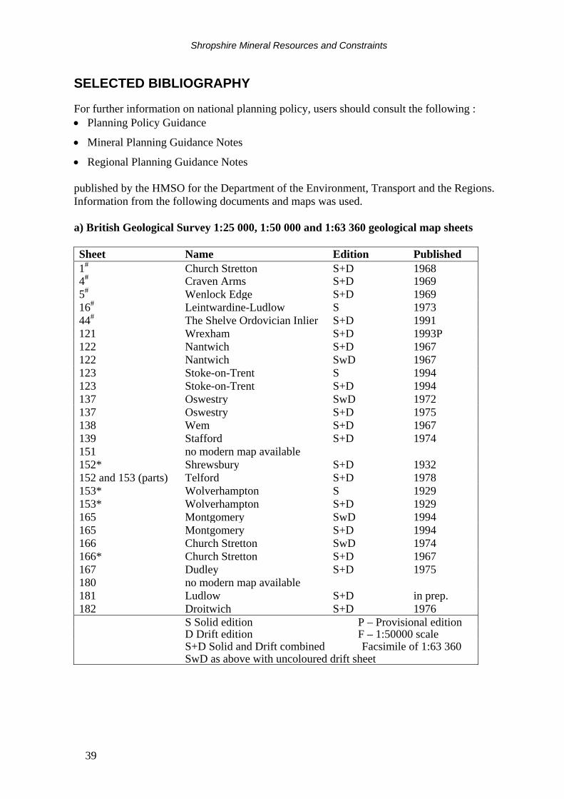
Shropshire Mineral Resources and Constraints
39
SELECTED BIBLIOGRAPHY
For further information on national planning policy, users should consult the following : • Planning Policy Guidance
• Mineral Planning Guidance Notes
• Regional Planning Guidance Notes published by the HMSO for the Department of the Environment, Transport and the Regions. Information from the following documents and maps was used. a) British Geological Survey 1:25 000, 1:50 000 and 1:63 360 geological map sheets Sheet Name Edition Published 1# Church Stretton S+D 1968 4# Craven Arms S+D 1969 5# Wenlock Edge S+D 1969 16# Leintwardine-Ludlow S 1973 44# The Shelve Ordovician Inlier S+D 1991 121 Wrexham S+D 1993P 122 Nantwich S+D 1967 122 Nantwich SwD 1967 123 Stoke-on-Trent S 1994 123 Stoke-on-Trent S+D 1994 137 Oswestry SwD 1972 137 Oswestry S+D 1975 138 Wem S+D 1967 139 Stafford S+D 1974 151 no modern map available 152* Shrewsbury S+D 1932 152 and 153 (parts) Telford S+D 1978 153* Wolverhampton S 1929 153* Wolverhampton S+D 1929 165 Montgomery SwD 1994 165 Montgomery S+D 1994 166 Church Stretton SwD 1974 166* Church Stretton S+D 1967 167 Dudley S+D 1975 180 no modern map available 181 Ludlow S+D in prep. 182 Droitwich S+D 1976 S Solid edition P – Provisional edition D Drift edition F – 1:50000 scale S+D Solid and Drift combined Facsimile of 1:63 360 SwD as above with uncoloured drift sheet
Shropshire Mineral Resources and Constraints
40
b) British Geological Survey Sheet Memoirs
GREIG, D C, WRIGHT, J E, HAINS, B A and MITCHELL, G H. 1968. Geology of the country around Church Stretton, Craven Arms, Wenloch Edge and Brown Clee. Memoirs of the Geological Survey of Great Britain. Sheet 166 (England and Wales). HAMBLIN, R J O and COPPACK, B C. 1995. Geology of Telford and the Coalbrookdale Coalfield. Memoir of the British Geological Survey. Parts of sheet 152 and 153 (England and Wales). POCOCK, R W and WRAY, D A. 1925. The geology of the country around Wem. Memoirs of the Geological Survey of Great Britain. Sheet 138 (England and Wales). POCOCK, R W, WHITEHEAD, T H, WEBB, C B and ROBERTSON, T. 1938. Shrewsbury District, including the Hanwood Coalfield. Memoirs of the Geological Survey of Great Britain. Sheet 152 (England and Wales). POOLE, E G and WHITEMAN, A J. 1966. Geology of the country around Nantwich and Whitchurch. Memoirs of the Geological Survey of Great Britain. Sheet 122 (England and Wales). TAYLOR, B J, PRICE, R H. and TROTTER, F M. 1963. Geology of the country around Stockport and Knutsford. Memoirs of the Geological Survey of Great Britain. Sheet 98 (England & Wales). WEBB, C B, SMITH, B, KING, W B R and WRAY, D A. 1929. The Country around Oswestry. Memoirs of the British Geological Survey. Sheet 137. (England and Wales). WHITEHEAD, T H, DIXON, E E L, POCOCK, R W, ROBERTSON, T and CANTRILL, T C. 1927. The country between Stafford and Market Drayton. Memoirs of the Geological Survey of Great Britain. Sheet 139 (England and Wales). WHITEHEAD, T H and POCOCK, R W. 1947. Dudley and Bridgnorth. Memoirs of the Geological Survey of Great Britain. Sheet 167 (England and Wales).
c) British Geological Survey Reports and other publications ANON. 1982. The sand and gravel resources of the Welshampton area, Shropshire and Clwyd. British Geological Survey Mineral Assessment Report 105. BALL, D F. 1978. Desk study of the sand and gravel resources of the country around Hereford, Oswestry and Whitchurch. Internal Report. CANNELL, B. 1982. The sand and gravel resources of the country around Shrewsbury. British Geological Survey Mineral Assessment Report 90.
Shropshire Mineral Resources and Constraints
41
CANNELL, B & HARRIES, W J R. 1981. The sand and gravel resources of the country around Wem, Shropshire. British Geological Survey Mineral Assessment Report 86. COLMAN, T B. 1990. Exploration for metalliferous minerals in Britain: A guide. (Keyworth, Nottingham: British Geological Survey). CREEDY, D P. 1983. Seam gas-content database aids firedamp prediction. The Mining Engineer, 143, August, 79-82. CREEDY, D P. 1988. Geological controls on the formation and distribution of gas in British Coal Measures strata. International Journal of Coal Geology, 10, 1-31. CREEDY, D P. 1991. An introduction to geological aspects of methane occurrence and control in British deep coal mines. Quarterly Journal of Engineering Geology, 24, 209-220. CRUMP, L .A. & DONNELLY, R. 1994. Opencast coal mining: A unique opportunity for Clee Hill Quarry. In: Whateley, M.K.G. & Harvey, P.K. (eds.) Mineral Resource Evaluation II: Methods and Case Histories. Geological Society Special Publication 79, 219-232. EVANS, D J., REES, J G. & HOLLOWAY, S. 1993. The Permian to Jurassic stratigraphy and structural evolution of the central Cheshire Basin. Journal of the Geological Society 150, 857-870. GLOVER, B W, HOLLOWAY & YOUNG, S R. 1993. An evaluation of coalbed methane potential in Britain. British Geological Survey Technical Report WA/93/24. HIGHLEY, D E. 1982. Fireclay. Mineral Dossier, Mineral Resources Consultative Committee, No. 24. JACKSON, I, LOWE, D J, MORIGI, A N and MATHERS, S J. 1983. The sand and gravel resources of the country around Whitchurch and Malpas, Clwyd, Cheshire and Shropshire. British Geological Survey Mineral Assessment Report 136. JAMES, J W C. 1983. The sand and gravel resources of the country around Prees, Shropshire. British Geological Survey Mineral Assessment Report 134. LEAKE, R C & SMITH, K. 1983. Data arising from investigations in the Shelve Area, Shropshire. British Geological Survey Mineral Reconnaissance Programme, Open File Data Release No. 3. Liverpool University. 1985. Assessment of the sand and gravel resources to the south of Shrewsbury. Dept. Earth Sciences, University of Liverpool.
MCKELVEY, V E. 1972. Mineral resource estimates and public policy. American Scientist, Vol. 60, No. 1, 32-40.
Shropshire Mineral Resources and Constraints
42
PLANT, J A, JONES, D G and HASLAM, H W. In press. The Cheshire Basin. Basin evolution, fluid movement and mineral resources in a Permo-Trias rift setting. British Geological Survey. SELLEY, R C. 1992. Petroleum seepages and impregnations in Great Britain. Marine and Petroleum Geology, 9, 226-244. SHROPSHIRE MINERALS LOCAL PLAN 1996-2006: Deposit draft. April 1996. Shropshire County Council. SMITH, N J P, CHADWICK, R A, WARRINGTON, G, KIRBY, G A & JONES, D G. 1995. The hydrocarbon prospectivity of the Cheshire basin and surrounding areas. British Geological Survey Technical Report No. WA/94/95C. THOMPSON, A, GREIG, J and SHAW, J. 1993. High specification aggregates for road surfacing materials: Technical Report. Department of the Environment, London. Travers Morgan Ltd, East Grinstead.
ACKNOWLEDGEMENTS This trial study has greatly benefited from the co-operation of many organisations and individuals who provided information and advice, and their assistance is gratefully acknowledged. Particular thanks are due to the Steering Group at the Department of the Environment Transport and the Regions, Shropshire County Council, English Heritage and English Nature. The authors would also like to thank their colleagues in BGS for their help, and in particular C Simpson and R J Parnaby, Cartographic Services, Dr A Brandon, Central England and Wales Group and R White and other colleagues in the Minerals Group.
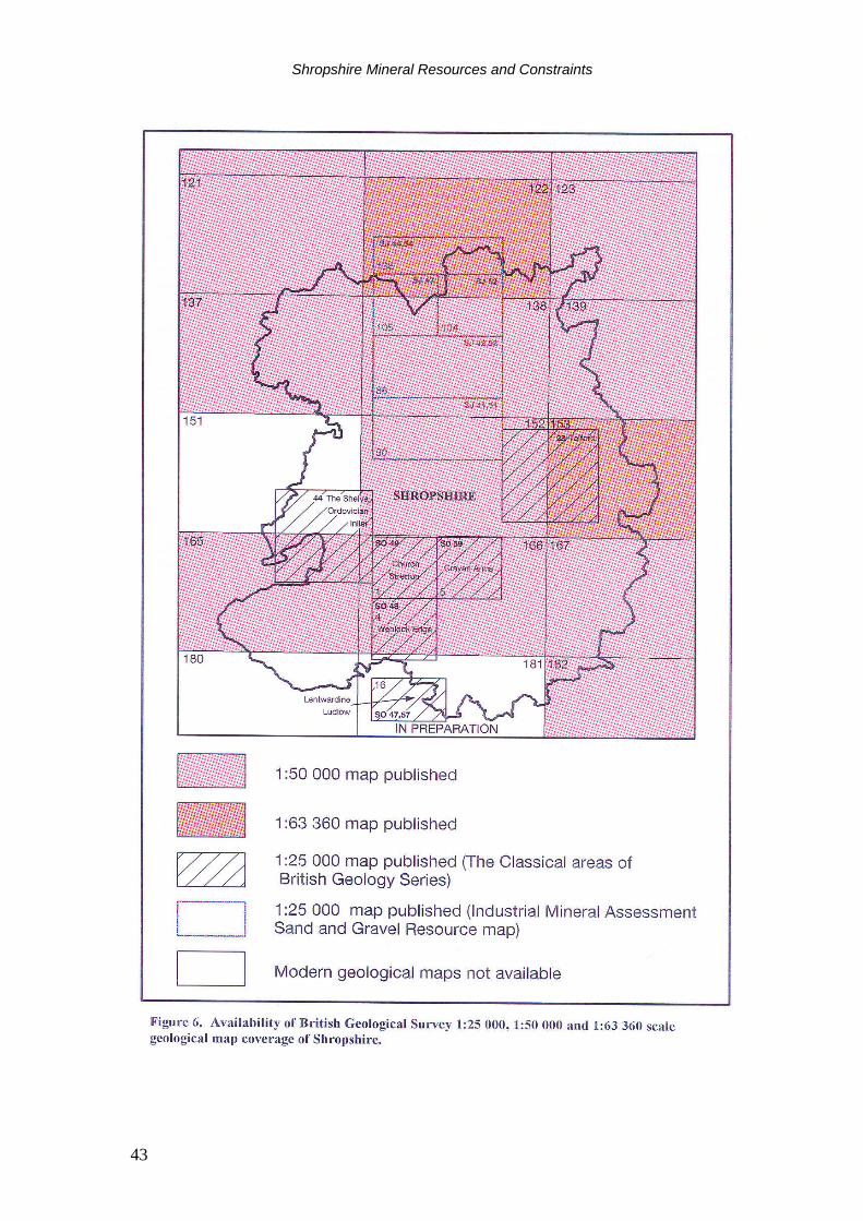
Shropshire Mineral Resources and Constraints
43
Shropshire Mineral Resources and Constraints
44
APPENDIX 1 MINERAL WORKINGS IN SHROPSHIRE (1998) OPERATOR NAME OF WORKING COMMODITY ARC - Central Clee Hill Igneous & Metamorphic Rock ARC - Central Condover Sand & Gravel Bardon Aggregates Northern, Midlands Region Lea/Coates Limestone Berwyn Granite Ltd Leaton Igneous & Metamorphic Rock Blockley’s plc New Hadley Common Clay & Shale Bromfield Sand & Gravel Co Ltd Bromfield Sand & Gravel CAMAS Building Materials Grinshill Sandstone CAMAS Building Materials Myddle (Webscott) Sandstone Coal Contractors Ltd Windmill Lane OCCS Coal, Opencast H Evason & Co Dorrington Sand & Gravel Ibstock Building Products Ltd Bridgnorth (Knowlesands) Common Clay & Shale Ibstock Building Products Ltd Caughley Fireclay Ibstock Building Products Ltd Donnington Brickworks Common Clay & Shale Harry Price Buildwas Sand & Gravel Lafarge Redland Aggregates Llynclys Limestone Lafarge Redland Aggregates Shadwell Limestone RMC - Western Aggregates Tern Hill Sand & Gravel Salop Sand & Gravel Supply Co Ltd Gonsal Sand & Gravel Tarmac Quarry Products West Midlands Bayston Hill Sandstone Tarmac Quarry Products West Midlands Callow Hill Sandstone Tudor Griffiths Group - Ellesmere Sand & Gravel Wood Lane Sand & Gravel

Shropshire Mineral Resources and Constraints
45
APPENDIX 2 CONTACT ADDRESSES FOR FURTHER ENQUIRIES
Shropshire County Council Environment Department The Shirehall Abbey Foregate Shrewsbury Shropshire SY2 6ND Tel: 01743 251000 Fax: 01743 360315
North Shropshire District Council Edinburgh House New Street Wem SY4 5DB Tel: 01939 232771 Fax: 01939 238404
Telford & Wrekin Council PO Box 212 Civic Offices Town Centre Telford TF3 4LD Tel: 01952 202100 Fax: 01952 291060
Shrewsbury & Atcham Borough Council The Guildhall Dogpole Shrewsbury Shropshire SY1 1ER Tel: 01743 232255 Fax: 01743 271594
Oswestry Borough Council Castle View Oswestry SY11 1JR Tel: 01691 671111 Fax: 01691 677348
Bridgnorth District Council Westgate Bridgnorth WV16 5AA Tel: 01746 713100 Fax: 01746 761860
South Shropshire District Council Stone House Corve Street Ludlow SY8 1DG Tel: 01584 874941 Fax: 01584 872971
Countryside Commission John Dower House Crescent Place Cheltenham Gloucestershire GL50 3RA Tel: 01242 521381 Fax: 01242 584270
English Nature Northminster House Northminster Peterborough PE1 1UA Tel: 01733 340345 Fax: 01733 68845
English Heritage Fortress House Savile Row London SW1X 1AB Tel: 0171 973 3000 Fax: 0171 973 3001
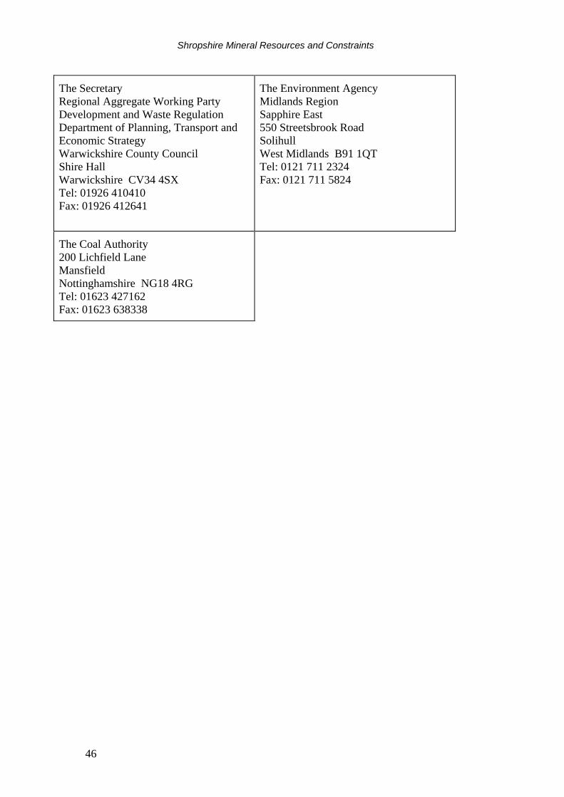
Shropshire Mineral Resources and Constraints
46
The Secretary Regional Aggregate Working Party Development and Waste Regulation Department of Planning, Transport and Economic Strategy Warwickshire County Council Shire Hall Warwickshire CV34 4SX Tel: 01926 410410 Fax: 01926 412641
The Environment Agency Midlands Region Sapphire East 550 Streetsbrook Road Solihull West Midlands B91 1QT Tel: 0121 711 2324 Fax: 0121 711 5824
The Coal Authority 200 Lichfield Lane Mansfield Nottinghamshire NG18 4RG Tel: 01623 427162 Fax: 01623 638338
Shropshire Mineral Resources and Constraints
47
APPENDIX 3: METHODOLOGY
The British Geological Survey (BGS) was commissioned in 1993 by the Department of the Environment to prepare, on a trial basis, a set of concise statements mainly in map form, to show the broad distribution of mineral resources in selected counties and to relate these to selected, nationally-designated planning constraints. The trial study developed a methodology for the collection and display of data in a consistent and comparable format for four Mineral Planning Authority (MPA) areas - Bedfordshire, Derbyshire, Staffordshire and the Peak District National Park. The concept developed by the BGS for the trial study is now being extended to some twenty mineral planning authorities in England and Wales through a further phase of the project which started in 1996.
The main element of the trial study was the production of maps, with accompanying interpretative reports, for each MPA area. All mineral resource and planning constraint information has been collated digitally on a PC-based system using Intergraph Microstation to produce a cartographic database. Data has been captured as a series of files, structured on separate levels so that they can be viewed either independently or in various combinations, as required. Most of the information has been taken digitally from hard copy maps, mainly with scales between 1:50 000 and 1:10 000. Other material was obtained in a variety of digital formats which have had to be converted for use by the Intergraph Microstation System. The structure of the information will allow the data to be transferred in digital form to the BGS MINGOL (MINerals GIS On-Line) system. MINGOL is being developed to provide a decision-support system for the rapid solution of minerals-related problems to aid corporate and public mineral resource management. It applies a state-of-the art GIS to relate the nature and distribution of mineral resources to other information such as planning and environmental constraints, and mineral exploration, borehole and commodity statistics datasets.
As the data are held digitally, map output can be on any scale but 1:100 000 has been found to be a convenient size to summarise the information for individual MPAs. This provides a legible topographic base which enables both the broad implications of the information, and sufficiently accurate detail, to be shown. The particular advantage of holding all the information in digital form is that it is comparatively easy to update and revise as additional information becomes available, and also provides scope for producing customised maps of selected information or areas on request.
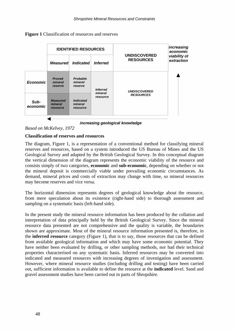
Shropshire Mineral Resources and Constraints
48
Figure 1 Classification of resources and reserves
UNDISCOVEREDRESOURCES
IDENTIFIED RESOURCES
UNDISCOVEREDRESOURCES
Measured InferredIndicated
Economic
Sub-economic
Provedmineralreserve
Probablemineralreserve
Inferredmineralresource
Measuredmineralresource
Indicatedmineralresource
increasing geological knowledge
increasingeconomicviability ofextraction
Based on McKelvey, 1972
Classification of reserves and resources The diagram, Figure 1, is a representation of a conventional method for classifying mineral reserves and resources, based on a system introduced the US Bureau of Mines and the US Geological Survey and adapted by the British Geological Survey. In this conceptual diagram the vertical dimension of the diagram represents the economic viability of the resource and consists simply of two categories, economic and sub-economic, depending on whether or not the mineral deposit is commercially viable under prevailing economic circumstances. As demand, mineral prices and costs of extraction may change with time, so mineral resources may become reserves and vice versa. The horizontal dimension represents degrees of geological knowledge about the resource, from mere speculation about its existence (right-hand side) to thorough assessment and sampling on a systematic basis (left-hand side). In the present study the mineral resource information has been produced by the collation and interpretation of data principally held by the British Geological Survey. Since the mineral resource data presented are not comprehensive and the quality is variable, the boundaries shown are approximate. Most of the mineral resource information presented is, therefore, in the inferred resource category (Figure 1), that is to say, those resources that can be defined from available geological information and which may have some economic potential. They have neither been evaluated by drilling, or other sampling methods, nor had their technical properties characterised on any systematic basis. Inferred resources may be converted into indicated and measured resources with increasing degrees of investigation and assessment. However, where mineral resource studies (including drilling and testing) have been carried out, sufficient information is available to define the resource at the indicated level. Sand and gravel assessment studies have been carried out in parts of Shropshire.
Shropshire Mineral Resources and Constraints
49
A mineral resource is not confirmed as economic until it is proved by a relatively expensive evaluation programme. This usually involves a detailed measurement of the material available for extraction together with an evaluation of the quality of the material, its market suitability, the revenues generated by its sale and, ultimately, the viability of the deposit. This activity is an essential precursor to submitting a planning application for mineral extraction. That part of a resource that is both ‘measured’ and ‘economic’, i.e. that has been fully evaluated and is commercially viable to work, is called a reserve or mineral reserve. It is customary to distinguish proved and probable reserves, which correspond to the economic parts of measured and indicated resources respectively (Figure 1). It is invariably the case that there is a significant reduction in area or volume estimates as resources are further investigated to prove reserves. The reasons for this is that it is impossible to apply initially all the various constraints that working procedures and environmental issues may impose. This is particularly the case with extensive deposits like sand and gravel where physical constraints imposed by roads, railways and urban development may drastically reduce the potential area available for extraction, even before factors such as quality and mineral thickness are taken into consideration. In the context of land-use planning the term reserve should strictly be further limited to those minerals for which a valid planning permission for extraction exists, i.e. permitted reserves. The extent of mineral planning permissions (other than coal) is shown on the Mineral Resources Maps. These cover both active mineral workings and inactive mineral workings. Some mineral planning permissions may have remained unworked, and others may have become uneconomic prior to being worked out. In many cases the areas involved are likely to have been worked to some extent in the past, and may now be restored. In addition, parts of the resource areas may have been fully evaluated by the minerals industry, but either have not been subject to a planning application or have been refused permission for extraction. These areas are not depicted on the map. A landbank is a stock of planning permissions and is commonly quoted for aggregates. It is composed of the sum of all permitted reserves at active and inactive sites at a given point of time, and for a given area, with the following provisos: • it includes the estimated quantity of reserves with valid planning permission at dormant or currently non-working sites;
• it includes all reserves with valid planning permission irrespective of the size of the reserves and production capacity of particular sites;
• it does not include estimated quantities of material allocated in development plans but not having the benefit of planning permission; and
• it does not include any estimate for the contribution that could be made by marine dredged, imported or secondary materials.
Shropshire Mineral Resources and Constraints
50
It is important to recognise, however, that some of the permitted reserves contained within landbanks have not been fully evaluated with the degree of precision normally associated with the strict use of the term reserves, indeed some may not have been evaluated at all.
Mineral workings and planning permissions The locations and names of mineral workings in Shropshire are shown on the maps. The information is derived from the British Geological Survey's Mines and Quarries Database, updated as appropriate from Shropshire County Council’s records. Letters (e.g. Sg = sand and gravel) are used to show the main mineral commodity produced. The extent of the planning permissions shown on the Mineral Resources Map cover active mineral workings, former mineral workings and, occasionally, unworked deposits. The present physical and legal status of the planning permissions is not qualified on the map. The areas shown may, therefore, included inactive sites, where the permission has expired due to the terms of the permission, i.e. a time limit, and inactive (dormant) sites where the permission still exists. Sites which have been restored are not separately identified. Under the provisions of the 1995 Environment Act, after 1 November 1997, sites that are classified as dormant may no longer be worked until full modern planning conditions have been approved by the Mineral Planning Authority. A ‘dormant site’ is defined as a site where no mineral development has taken place to any substantial extent in the period 23 February 1982 and ending 6 June 1995. Information on the precise status and extent of individual planning permissions should be sought from Shropshire County Council or Telford & Wrekin Council.
Most planning permissions appear on a mapped mineral resource area and thus the underlying resource colour identifies the mineral type. Planning permissions may fall outside resource areas for the following reasons:
• permissions shown partly off resource areas may extend to ownership, or other easily defined boundaries, or to include ground for ancillary facilities such as processing plants, roads and overburden tipping
• isolated workings occurring outside defined resource areas may reflect very local or specific situations, such as a borrow pit, not applicable to the full extent of the underlying rock type: The latest data available for the total areas of planning permissions in Shropshire, collected for the Department of Environment Minerals Survey of 1994, is shown in Table 1. This information is updated at intervals.
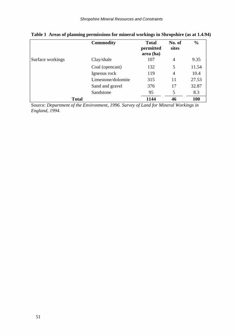
Shropshire Mineral Resources and Constraints
51
Table 1 Areas of planning permissions for mineral workings in Shropshire (as at 1.4.94)
Commodity Total permitted area (ha)
No. of sites
%
Surface workings Clay/shale 107 4 9.35 Coal (opencast) 132 5 11.54 Igneous rock 119 4 10.4 Limestone/dolomite 315 11 27.53 Sand and gravel 376 17 32.87 Sandstone 95 5 8.3 Total 1144 46 100 Source: Department of the Environment, 1996. Survey of Land for Mineral Workings in England, 1994.