brown, green and blue water fleets; the influence of geography on naval_warfare 1861 to the present
TRANSCRIPT
Brown-, Green-
and Blue-
Water Fleets The Influence of Geography on Naval
Warfare, 1861 to the Present
Michael Lindberg and Daniel Todd
PRAEGER Westport, Connecticut London

Library of Congress Cataloging-in-Publication Data
Lindberg, Michael. Brown-, green- and blue-water fleets : the influence of geography on naval warfare,
1861 to the present / Michael Lindberg and Daniel Todd. p. cm.
Includes bibliographical references and index. ISBN 0-275-96486-8 (alk. paper) 1. Naval art and science—Effect of geography on—History—19th century. 2. Naval art
and science—Effect of geography on—History—20th century. I. Todd, Daniel. II. Title. V51.L55 2002 359.4 ,09 ,034—dc21 2001034617
British Library Cataloguing in Publication Data is available.
Copyright © 2002 by Michael Lindberg and Daniel Todd
All rights reserved. No portion of this book may be reproduced, by any process or technique, without the express written consent of the publisher.
Library of Congress Catalog Card Number: 2001034617 ISBN: 0-275-96486-8
First published in 2002
Praeger Publishers, 88 Post Road West, Westport, CT 06881 An imprint of Greenwood Publishing Group, Inc. www.praeger.com
Printed in the United States of America
The paper used in this book complies with the Permanent Paper Standard issued by the National Information Standards Organization (Z39.48-1984).
10 9 8 7 6 5 4 3 2 1
Contents
AcknowledgmentsV VVvii
1. Introduction 1
2. Prelude: Land versus Sea Warfare 13
3. Theoretical Background: Classical and Modern Geostrategy 23
4. The Naval Warfare Environment 59
5. Naval Warfare on the High Seas V71
6. Naval Warfare in the Littorals 145
7. Riverine Warfare 169
8. The Influence of Geography on Navies 195
9. Conclusion 223
Selected Bibliography 229
Index 237

This page intentionally left blank

Acknowledgments
We would like to thank several people for their support in the preparation of this book. For their masterful cartographic skills, we thank Douglas Fast, University of Manitoba Geography Department, and Susan Lindberg, Elmhurst College Biology Department. We would like to extend a further thank-you to Susan for her monumental efforts involved in proofreading, formatting and typesetting of the manuscript. Her diligence and attention to detail are much appreciated. Special thanks to Greenwood Publishing Group and especially Dr. Heather Ruland Staines, senior editor of the History and Military Studies section at Greenwood, for heading up the editing of this book.

This page intentionally left blank

1
Introduction
An outsider, blissfully ignorant of the preoccupations of academic geography, would likely express both surprise and amusement when apprised of the tortured explanations given by advocates of the discipline in its justification. In the first place, he or she would be bemused by the patent lack of agreement among the defenders of the discipline as to what it actually entails. Surely, the curious seeker after truth asks, there can be no mystery about the purpose of a subject that is elaborately defined in every dictionary of repute. Oxford and Webster's are in unison in seeing it as a description of the earth's surface and what goes on upon that plane. While emphasizing its inclination to dwell on the configuration of physical features—sea as well as land—they see geography essentially as the science of distribution, describing where things are and accounting for why they are where they are.1 The devil, however, lies in the details, as the percipient observer soon realizes. A smattering of science is all that it takes to prompt him or her to ask how it is possible to make sense of the welter of data thrown up in the course of describing any phenomenon as it occurs on the earth's surface. At the very least, complicated exercises in classification are called for, suggesting that geography must attend to this basic, but quite indispensable, branch of scientific inquiry. Without good classification, the sheer quantity of information threatens to overwhelm the observer, consigning him or her to the proverbial, unenviable position of not being able to see the forest for the trees. If a searching inquiry of a single phenomenon more often than not results in frustration, the observer will not be disposed to linger over the business of explaining the distribution of several phenomena, the trumpeted prime purpose of the academic discipline of geography. The likelihood of anyone's being able to come to grips with associations of phenomena so as to disentangle the multiplicity of possible relations existing
2 Brown-, Green- and Blue-Water Fleets
between them is slender at the best of times, but the task borders on the impossible when an effective preliminary classification has been skimped. These issues presented the discipline with serious stumbling blocks that even now have not been resolved to everyone's satisfaction. Information overload effectively limited geography to description through much of its history, description that materialized as the delimiting of patterns of phenomena, the boundaries of which were subject to endless revision. For its pains it received precious few thanks from other provisional academic disciplines. Despite some brilliant forays into the classification arena—as perhaps best exemplified by the grid maps of Ptolemy— geographers, in consequence of the disparagement meted out by others, tended to pitch an apologetic line, defending the discipline more for its potential scientific worth than for its actual value. The upsurge in scientific interest in the nineteenth century and the scramble to carve out disciplinary boundaries spawned by it offered geographers their best opportunity yet to stake a claim. Inspired by Ritter, Ratzel, Darwin, and other giants of the intellectual firmament, they put much effort into the minting of theories that were designed to show how human populations and the societal structures attending them ultimately depended on the juxtaposition of physical features and climate. The concept of the region was the practical manifestation of this effort. At once a means of classification and explanation, the region bridged the gap between the physical and human worlds, combining attributes from both. Each region was sufficiently general to slot into a "type" or class but was accorded uniqueness through features, both natural and human, subtly distinct from those of all other members of its class and profoundly different from those of members of all other classes.2
The sweeping nature of the theoretical paradigm coined at that time, so comprehensive in its scope that it purports to explain the reasons for human occupancy of every patch of the planet, that the modern observer finds simply breathtaking. Equally striking—and jarring to the modern mind—was the faith reposed in linear causality. Beginning with climate, the "terrestrial unity" was enforced through a causal chain that molded landform and vegetation, then impinged on animal evolution (ecology) before culminating with the disposition of humankind.3 The grand effort subsequently failed, overreaching itself in its insistence on determinism, on the one hand, and its inability to formulate tools rigorous enough to substantiate its heroic claims, on the other.4 Thrown into disarray and at a loss to come up with an adequate replacement, geographers scrambled to justify their continued existence as creditable scientists. Sir Halford Mackinder, a name to conjure with in academic geography and one to which we will have cause to return, attempted to find a solution at the very close of his career.5 True to form, he advocated the sea as the unifying force, arguing that the "hydrosphere," through the "water-cycle" of evaporation, not only accounted for the processes endemic to physical geography but, in touching all continents, also strongly marked the world's commerce and politics, the essence of human geography. Such enlightened views would doubtless strike responsive chords in modern naval strategists; at the time, however, among academicians they fell on
Introduction 3
deaf ears. What fell out of the debate and the various pleas on behalf of the discipline were some useful remnants that, when dusted off and refined, provided modern geography with a valid conceptual foundation. These had to do with distance and the interplay between distance and time. A brief insight into the contemporary workings of the discipline is all that it takes to establish their credibility.
Denied an overarching mechanism of explanation, geographers in the second half of the twentieth century were still confronted with the task of describing places preparatory to furnishing an account of why the characteristics so unearthed were, or were not, of significance. Each place, let it be remembered, boasted a distinct location, a composite of its absolute position fixed on the earth's surface, and its relative location, that is, its bearing with respect to other places.6 The latter was to prove more fruitful in setting the reborn discipline on its feet, an eventuality impossible without manipulation of the notion of distance. Distance, like location, has both absolute and relative aspects. Absolute distance reduces to the number of kilometers or miles, read from a map or chart, that separates the place of immediate interest from another place of less direct interest. Relative distance, however, is theoretically and practically much more important, for it allows one to get a measure of the difficulties incurred in overcoming that mileage.
Cost in financial outlay looms large among these difficulties, but cost in terms of time legitimately taken in accomplishing the trip or misspent in delaying it can contribute as much or more to the problems that have to be overcome. The former is hardly a matter of contention, since movement—the actual operation of overcoming distance—invariably extracts a cost from the vehicle doing the moving. Ships are the vehicles generally called upon by navies to undertake movement, and, as all navies are quick to concede, ship operation cannot be contemplated without regard to financial outlay. Besides covering the fuel cost of a vessel plying between two places, this outlay entails other operating costs (such as crewing and depreciation) and, in the final analysis, the nonrecurring costs of vessel procurement. Cost in terms of time taken in achieving the voyage, the "time-distance" of geographers, is equally uncontroversial. Everyone accepts that society attaches a value to time and that time spent in traveling is time denied more productive uses. Journey time depends on the absolute distance separating the place of origin from the place of destination, but it is also a function of the mode of movement and its embodied technology, together with the characteristics of the surface over which movement occurs. All these have connotations instantly recognized by the naval strategist. The mode generally refers to the kind of transport vehicle—ship, train, truck, aircraft—but in this special frame of reference it would acquire a more focused meaning, reducing to ship type: merchant or combatant, oil tanker or destroyer, or a host of other possibilities. Modal technology would likely focus on the means of propulsion—gas turbine or diesel, say—and the speed of passage and vessel endurance that stems from it.7
Characteristics refer to the environautical milesent confronted by the ship in
4 Brown-, Green- and Blue-Water Fleets
voyaging, for example, the likelihood of meeting rough or calm seas, shallow or deep waters, and navigational hazards, both natural and human.
This cost imposed by time, while easy to grasp, is tougher to systematize. Central to it is the idea of opportunity costs. As economists understand them, opportunity costs are the benefits sacrificed by deliberately choosing one course of action over another. They frequently come into play when budgetary decisions have to be made. For example, only some of the ships desired by a navy can be afforded; so, in granting priority to one type over another, there is a cost to be borne in terms of capabilities forgone. Thus, in opting to, say, build a force of ballistic missile-firing nuclear submarines (SSBNs) rather than a batch of aircraft carriers, a navy is intentionally giving up the power-projection benefits that would have accrued to it from the possession of such surface ships.8 Opportunity costs provide a reckoning of the forfeited benefits, a reckoning that, when marginal, can be used to justify persevering with the SSBN program but, when substantial, can be adduced for reversing policy in favor of the carriers.
The concept of opportunity costs, as stated, can also be used to good advantage in dealing with time costs. This becomes apparent in time budgeting, the intricate process of making the most effective use of the assets at one's disposal in the time available. The process, while replete with uncertainty, is best accomplished through calculating the risks associated with particular courses of action and ensuring that the course finally selected is compatible with the least risk. Risk, in this instance, implies the problems that may arise during a certain period of time as a result of ignoring all courses of action apart from the preferred one. Consider the business of sending a vessel on patrol, a task that in reality, transforms a navy's time budgeting into an exercise in space-time budgeting. Should it be sent along route A between the two places constituting its origin and destination, then the vessel forfeits the opportunity to participate in any events that might arise along route B, route C, or any other possible traverse between the two places. The vessel's power to intervene is annulled for the time that elapses while it remains committed to route A. Covering distance, therefore, incurs a time cost, for any vessel on passage between two given places can most emphatically not be anywhere else, succoring other places; nor, for that matter, can it be easily switched from one routing to another between the given places without aggravating the time cost. The absence of a vessel from places where its presence might have been decisive could prove downright disastrous. The elements of the disaster, duly computed, constitute the most extreme opportunity costs in space-time budgeting.
Costs, whether of the plain financial kind or of the subtle time brand, clearly impact on distance, impeding the overcoming of it. Geographers have recognized regularity in that impact and, accordingly, have formulated mathematical models with the object of specifying the regularity. Two are of particular relevance to the naval context, namely, the gravity model and the concept of time-space convergence. The first takes its inspiration from Newton's gravitational law, although the terms of reference are granted a terrestrial bearing rather than a celestial one.9 Arguing that flows between two places conform remarkably closely

Introduction 5
to the product of the strengths of importance of the places (denoted by their population size or ability to generate economic activity) as tempered by the distance separating them, geographers have conceived their own gravity model along the following lines:
Iij = Mi.Mj/djjfi
where Iy measures the volume of interaction (say, trade cargoes carried in merchant bottoms) between the two places, designated / andy. As for the right-hand side of the formula, the M symbols capture the importance of the said places (respective port throughput, for instance), while the denominator term is a metric of relative distance, that is, one that weights the absolute distance between / andy by the "frictional" effect of cost. Cost, of course, is a composite of fiscal and time-distance considerations, and the higher it becomes, the greater is the deterring effect of distance on interaction. The size of the exponent ̂ ? in the denominator term faithfully reflects the degree of impedance, rising, for example, when fuel costs increase and falling when, among other things, fuel costs decline, the latter perhaps the yield from the application of new technology to ship operations.10 Any submarine commander, intent on interdicting this trade, need only apply the gravity model to derive an estimate of the number of merchant ships—his potential prey— that would need to be pressed into service to convey it.11
The gravity model is nothing if not versatile, displaying infinite possibilities for application. A variant of it, designed to demarcate the terrestrial hinterland or trade area of a port, stands ready to serve a naval purpose, namely, to discern the sphere of influence of a naval base.12 Such ports, of course, are indispensable to the operations of navies, providing, in general, the shore facilities from which patrols can be mounted and, in particular, through the medium of forward bases, the anchorages from which blue-water navies can function in distant waters. A respecified model permits the naval strategist to come to grips with the geographical reach of the base, that is, the seas over which warships range from the base given that their radius of action is inversely related to distance. It could assume the following form:
Iij = k(M/dif)
where the left-hand term now represents the interaction occurring between our subject naval base, /, and a maritime position, y, of interest to us, say a contested choke point, sea-lane, port, or island. This interaction could be usefully expressed in the number of ship visits dispatched from / toy in a given period. The constant of proportionality, k, ensures that the degree of interaction that the model estimates is not out of line with either the number of patrol assets stationed at our base or the level of activity to which it is accustomed. Mj, for its part, is a measure of the importance ofy for example, the number of hostile warships habitually found there. Finally, the denominator explicitly measures the difficulty of overcoming distance

6 Brown-, Green- and Blue-Water Fleets
and is a compound of physical distance and the various cost factors. The model can be repeated to produce a multitude of calibrations, depending on how many maritime positions (/') are of interest to us. Once plotted, the Iy can be converted into a map, complete with isarithms, that not only show the aerial extent over which power can be projected from our base, /, but give substance to the tendency of that influence to decline with distance from the base.
On a grander scale, this by-product of the gravity model can be used to lend credence to the "loss-of-power gradient," a device offered as a means of classifying navies. Classification, as we have already remarked, posed problems for geographers as they painstakingly set about dividing portions of the earth's surface into types of regions. Classification has also proved to be problematical for naval professionals, for navies are so diverse in purpose and force structure as to defy straightforward pigeonholing. One suggestion advanced to break the impasse is to concentrate on the geographical reach of navies, distinguishing between them on the basis of how far from home they can effectively operate.13 The force of this argument for classification rests on the presumption that the navies with the longest reach—those with the greatest geographical power-projection capability—are in possession of not just the most sophisticated fleets but the most elaborate infrastructures to boot. Without the latter facilities, both shore-based and afloat, their fleets practically would be next to useless. Navies with modest geographical reach, by comparison, have very limited fleets and backup facilities. Thus, gradations in reach, once plotted as a negatively sloping line called the "loss-of-power gradient," are tantamount to divisions between types of navies. Since distance rates special attention as the regulator of reach, the classification is effected by resort to gravity-style modeling.
Distance or, more precisely, time-distance also features significantly in space-time budgeting, the pragmatic means of coming to grips with opportunity costs. Distance, as we have seen, is amenable to relativity, and time-distance is particularly so. Mariners have always encountered difficulties in crossing the seas, difficulties thrown up by weather, basin configuration, coastal topography, and other natural phenomena that have all conspired to aggravate the time spent en route. The major factor accounting for journey time, however, was the technology invested in the mode of movement, the ship, and at the heart of that technology was propulsion. Propulsion was at the bottom of time-distance because it determined speed: fast sailors, in short, quickened voyages, permitting other uses for the time so conserved. Such was the desire to gain this added flexibility in time use that societies intermittently have devoted prodigious efforts to improving the technology conducive to fast passage. They have addressed the ship directly, innovating forms of marine propulsion that answer the purpose: sails succumbing to steam stands as the cardinal example. Alternatively, they have tackled the issue indirectly, vastly improving the infrastructure of movement rather than (or in combination with) the technology of the vehicle itself. The rationale for the great isthmian canals of Suez and Panama fall into this category. Completion of the former in 1869, for instance, was instrumental in cutting absolute distances from
Introduction 7
London to Bombay, the port gateway to Britain's Indian empire, by 42 percent, that is, from 10,700 nautical miles via the Cape of Good Hope, to 6,200 nautical miles via the canal.14 Impressive though these distance savings were, the savings in time had the greater implications. Shortened transits not only allowed individual ships to have a greater presence "out East"—more time on station—in a given commission but ultimately persuaded the British Admiralty to countenance small forces for control of distant seas. The Admiralty judged that any major threat to a distant theater could be countered in good time—the result of abbreviated transits—by the detachments of units from the home-based "strategic reserve" embodied in the concentrated main fleet. Dispensing with a large force on station in the distant seas, deemed vital before the breakthrough in time-distance, was of immense benefit, for it enabled the navy to put the funds so released to uses more in keeping with the strengthening of the main home fleet.
At this juncture it is appropriate to refer to time-space convergence, the second of the mathematical models inherited from modern geography that are germane to naval studies. The inspiration for it was the shrinking of journey time occasioned by innovations in transport technology. Vivid displays of their effects were seized upon. For example, onetime doyen of American geography Ellsworth Huntington remarked on the compression of distance-time involved in moving overland from Portland, Maine, to San Diego, California.15 A sixteenth-century traveler could not have accomplished the journey on foot in under two years; his successor a century later would have been able to cut the traveling time to eight months with the aid of horses. Horsepower combined with suitable roadways enabled travelers in 1840 to avail themselves of stagecoaches and, in so doing, reduce their trip time to four months. That progress paled in comparison with the speed rendered possible by the railroad, already making its presence felt by 1840. At its peak, in 1910, the train whisked the traveler between the two places in four days. Inception of regular airline services, firmly established by 1950, whittled down trip time to just 10 hours. Using the three miles per hour walking speed of human beings as a benchmark, the time associated with traveling the 2,600 miles from Portland to San Diego in 1950 was equal to what, in 1550, needed budgeting to cover barely 30 miles, that is, the achievement of a good day's march.
Donald Janelle studied comparable British data with a view to systematizing the rate of shrinkage in traveling time. He concocted the time-space convergence formula as a means of calculating to a nicety the rate of savings in time that technological innovation could render for covering a fixed distance.16 Of simple ratio structure—the numerator took the difference in travel times between two places in the initial year and a later year, whereas the denominator measured the absolute difference between the two years in question—the formula told Janelle that the rate of time-space convergence between 1776 and 1966 for the terrestrial route from London to Edinburgh registered 29.4 minutes per year. This rate was an average value, smoothing out the sharp drops in travel time caused by the introduction of new transport technologies: fast stages, trains, and then aircraft. Similar rates can be derived for sea routings, although if one focused solely on the
8 Brown-, Green- and Blue-Water Fleets
ship mode, the convergence rates would appear far less striking than their equivalents for on- and above-land journeys (after all, the typical 14 knots cruising speed of a bulk carrier today is not so drastically different from the 10 knots contrived by a tramp steamer of a century ago). In practice, though, movement relevant to naval operations is not limited to the passage of ships but is intermodal, encompassing naval aviation as well. The inclusion of shipborne aircraft with their vastly superior properties of speed and mobility forces the observer to look at the matter of maritime time-space convergence in a wholly different light.
The entire thrust of the discussion so far has demonstrated the importance of distance to modern geography in general and naval operations in particular. However, we are not yet done with the concept, since distance has now been called upon to underpin the new political geography. Concerned with the way that power is manifested geographically, Patrick O'Sullivan has devised a model that maintains that its effective deployment from core areas (the heartlands of nation-states) diminishes with distance from those centers. The model has not been given a rigorous mathematical foundation and does not pretend to give the last word on power projection. Its intention is rather to give the basic limits, incontestably geographical, to the wielding of power—and not least, military force—by the states set on using it. To be sure, O' Sullivan's model is reminiscent of the "loss-of-power gradient" in claiming that power succumbs to the "friction" of distance, but it differs in expressly comparing the competition between states for spheres of influence to the actions of rival firms, each resolved to carve out as big a market area as possible at the expense of the other party.17 Power, conceivably exercised through fleets as well as armies, is most acutely strained at the margins, that is, the overlapping areas at some remove from the centers of power where the interests of states directly clash. The cost of overcoming distance from the centers to these margins drives a wedge between state aims and actual outcomes, creating uncertainty and tension. Regarded from a global vantage, such margins could literally occur on the far side of the world from the core areas.
States, in consequence, may be tempted to avoid distant confrontations, preferring instead to consolidate their interests (hold on territory, control of the sea) closer to home. Only when states are prepared to invest seriously in sea power— which has the undoubted advantage of lower transport costs of delivery than land power—does it become practicable to operate with any degree of success at the global margins. Opportunity costs now make their appearance, for the states must decide whether the returns from exerting influence in such distant areas justify both the "terminal" costs of fleet building in the first place and the "line-haul" costs of far-flung ship deployment in the second. Of course, as with anything touched by the military, technology enters into the model. Allowance is made for technology to grant an edge to one side, encouraging it to push the boundaries of the margins. The inception of the ship as gun platform in the fifteenth century is one such instance, permitting European inroads into the Asian and Pacific realms soon thereafter. Nuclear missile technology and other airborne weapon systems, while accelerating time-space convergence at an unprecedented rate, do not detract from
Introduction 9
the force of O'Sullivan's argument so much as they complicate its outcomes. They do this by compelling rival states with comparable technologies to consider very carefully force deployments not just in the margins but across the geographic spectrum.
O'Sullivan's model attests yet again to the suitability of the distance concept for naval contexts. In fact, the critical importance of distance has long been recognized by students of military affairs and power projection regardless of the preoccupations of geographers. The first to acknowledge its worth in war-fighting—and to acknowledge it in full measure—was Sun Tzu.18 This somewhat shadowy figure, a contemporary of Confucius and a participant in the interminable wars besetting the China of his day, held that five fundamental factors governed land warfare: politics, weather, terrain, the caliber of the commanders, and the nature of the doctrines to which they subscribed. Weather and terrain are inherently geographical, but in the latter distance came into its own. Distances to be covered, both in gaining an advantageous position prior to engagement and in achieving mobility on the battlefield and in the chase succeeding the clash of arms, assume pivotal importance in devising war-winning plans. Furthermore, mobility and accessibility join forces in Sun's concept of "focal ground," a strategically important lump of territory that must be quickly seized and denied to the enemy at the outset of hostilities. This territory, by virtue of its standing as a road junction or "choke point," acts as the cynosure of the theater in that it offers minimum-distance routes to other desirable places. Its possession becomes the commander's prime object in the opening campaign. Once its control has been assured, lengthened lines of communication thwart the enemy by aggravating the "friction" incurred in positioning its retaliatory units.
Distance, as the regulator of mobility and the agent granting heightened value to certain strategically located places, has universal validity, as relevant to fighting at sea as on land and equally cogent in our times as in Sun's day. Carl von Clausewitz, the fountainhead of military science in the aftermath of the Napoleonic Wars, also saw great virtue in an appreciation of ground and the distance element implicit in it. Distance imposed limits on commanders' choices, constituting, along with timing, chance, and human frailty, the "friction" that, as Clausewitz pains to point out, is the chief determinant of battle outcomes.19 Distance, in his view, was also intimately involved in the means of supply, the logistics without which armed forces waging war are helpless. Clausewitz's example fired other thinkers to enlarge on military strategy in the nineteenth century, and that spirit infused naval affairs.20 Naval strategy, stimulated by Mahan, flowered at the end of the nineteenth century and the beginning of the twentieth century. Its proponents likewise regarded distance as the factor at the bottom of much of their teaching. Their views and how they evolved in the light of unfolding events warrant a lengthier treatment than this brief airing; accordingly, they are left for the next chapter.
10 Brown-, Green- and Blue-Water Fleets
NOTES
1. Webster's explicitly incorporates the sea as a subject for geography's descriptive function. Oxford is content with geography as a description of the earth's surface, leaving implied the oceanography. See Webster's Third New International Dictionary (Springfield: G. and C. Merriam, 1976) and Oxford English Dictionary, 2nd edition (Oxford: Clarendon Press, 1989).
2. Geography's evolution and the importance of the regional concept to it receive a cogent airing in S.W. Wooldridge and W.G. East, The Spirit and Purpose of Geography (London: Hutchinson, 1951).
3. Vidal de la Blache provided a masterly exposition of this approach. See his Principles of Human Geography (London: Constable, 1926).
4. Reasons for the downfall are recounted in R. Minshull. The Changing Nature of Geography (London: Hutchinson, 1970).
5. H.J. Mackinder, "Geography, an Art and a Philosophy," Geography, vol. 27, 1942, 122-130 and "The Development of Geography: Global Geography," Geography, vol. 28, 1943, pp. 69-71.
6. In the terminology of the profession, modern geography is conducted so as to be forthcoming with answers concerning "spatial relationships"—the linkages occurring between places—and "spatial processes," or the forces creating and maintaining those linkages. A typical introduction to the discipline is J.D. Fellmann, A. Getis, and J. Getis, Human Geography: Landscapes of Human Activities, 6th edition (Boston: McGraw-Hill, 1998).
7. Modern frigates and destroyers frequently combine the two forms of propulsion, resorting to gas turbines for "spurt" speeds while retaining diesels for cruising. Other surface vessels are generally denied the luxury of choice, making do with a single propulsion type. This issue receives airing later in Chapter 8.
8. This hypothetical example is not far-fetched: the conscious choice of the French navy and its masters to develop an SSBN force independently of U.S. technology imposed huge costs on the surface fleet in terms of capabilities forgone. See J. Cable, Gunboat Diplomacy: Political Applications of Limited Naval Force (London: Chatto and Windus, 1971), 118— 120.
9. The ninth chapter of J.C. Lowe and S. Moryadas, The Geography of Movement (Boston: Houghton Mifflin, 1975) provides a readable account of such models.
10. Newton, when formulating his law of gravity, felt that the square of distance captured the appropriate frictional effect. Geographers have found that the power to which distance can be raised—the^ in the equation—varies immensely when fitting the gravity model to empirical, terrestrial situations.
11. In practice, the commander would first need to adjust the predicted trade flow by a suitable scalar. The purpose of this constant is to reduce the Iy estimate to a reasonable level that is not out of line with historical flows of ships between the ports in question. It can best be interpreted as the average propensity of the two ports to engage in trade, that is, the typical point-to-point flow of goods between all members in the port range, irrespective of distance.
12. The original form of the model, earmarked for distinguishing trade areas, is discussed in M.G. Bradford, and W.A. Kent, Human Geography: Theories and Their Applications (New York: Oxford University Press, 1992).

Introduction 11
13. The notion is mentioned in K. Booth, Navies and Foreign Policy (New York: Holmes and Meier, 1979), 120.
14. The implications of this are considered at length in D.A. Farnie, East and West of Suez: The Suez Canal in History 1854-1956 (Oxford: Clarendon, 1969).
15. E. Huntington, "Geography and Aviation," in G. Taylor (ed.), Geography in the Twentieth Century (London: Methuen, 1957), 528-542.
16. D.G. Janelle, "Spatial Reorganization: A Model and Concept," Annals of the Association of American Geographers, 59, 1969, pp. 348-364.
17. The model is detailed in the "Distance and Power" chapter of P. O'Sullivan, Geopolitics (London: Croom Helm, 1986). A synthesis of market-area analysis is found in D.M. Smith, Industrial Location, 2nd edition (New York: John Wiley, 1981), pp. 68-107.
18. Norman Stone provides a thoughtful foreword to a recent, succinct version of the masterpiece, namely, Sun Tzu, The Art of War (London: Wordsworth Editions, 1993).
19. Carl von Clausewitz, On War (Baltimore: Penguin Books, 1968). This edition is singled out because of the thoughtful introduction offered by Anatol Rapoport.
20. Sir Julian Corbett, a leading light among the naval thinkers, was especially concerned to find parallels to the principles of land warfare devised by Clausewitz and his less well regarded contemporary, the Baron de Jomini. The latter is remembered for differentiating between two kinds of war: geographical, in which the limited aim of territorial advance prevails, and destructive, in which only outright destruction of the enemy's forces, if necessary in his heartland, suffices. Corbett rates special consideration in the next chapter.

This page intentionally left blank
2
Prelude: Land versus Sea Warfare
THE SHARED SETTING
Warfare, whether on land, at sea, or in the air, has common call on certain aspects of geography, and it is as well to be aware of these before we go on to stress how the various branches of warfare impose different demands on geography. It is self-evident that common to all ways of waging war is concern for the relative locations of places and for the weather patterns endemic to operating areas. Destruction of the enemy's forces, regardless of their composition, necessitates an exercise in location, and that, in turn, calls for knowledge of the geographical setting sheltering the enemy and an appreciation of the distance that needs to be covered in order to engage him. Locating the enemy and discerning his intentions depend on preliminary surveillance, for in many instances he may have a wide choice of places at his disposal from which to mount operations. The classic cruiser conjures up visions of scouting—searching out the enemy's position—at sea, but parallels are readily apparent in land warfare (think of the armored scout car) and in aerial combat (with the Lockheed U-2 as the most striking reminder), where numerous devices have been deployed with the express purpose of finding an elusive opponent. The space-based satellite can be held up as the ultimate device for locating targets over great distances, and it is highly regarded by all branches of the armed services precisely on account of this attribute.
Distance, it will be recalled, goes beyond a measurement of the mileage separating one force from another to encompass what geographers call relative distance. This is really another way of grasping accessibility, since it sets out to take stock of the difficulties encountered in closing the absolute distance between the two forces. Difficulties vary in intensity but naturally attend the movement to the place of engagement. Intensely geographical, they occur as weather restraints— for the elements buffet all means of projecting armed might, as storm-tossed ships

14 Brown-, Green- and Blue-Water Fleets
and turbulence-damaged aircraft vividly attest—and as problems in determining optimum routes (time-space budgeting). The latter is of particular concern because battle outcomes are frequently incumbent on seizing the initiative and making the best use of time.1 Time-distance, then, is at the forefront of the strategists' thinking both when planning a campaign and when implementing it, influencing their choice of technological assets for accomplishing movement. In amphibious operations, for example, swift aircraft may be used in the initial assault, delivering paratroops directly to key sites, while slower but much more capacious ships may be used to deliver the main punch once the preliminary assault has borne fruit. Amphibious operations, of course, constitute the great hybrid, the interface between land and sea warfare, which evidently benefits from the infusion of an aerial element as well. Yet purely naval operations of the deep-sea, "blue-water" variety have not been loath to invite an aerial contribution when conditions allow. Indeed, the climactic naval actions in the Pacific during World War II are even more instructive endorsements of the significance of time-distance. In them, carrier-based aircraft first searched out and found the enemy from a virtual infinity of locations that may have contained him, whereupon they, rather than the ponderous, gun-armed surface ships, administered the blows that settled the battle outcomes.
Movement brings the two contending forces to the point of confrontation (provided the weaker, perceiving his weakness, does not slip away), but the location of the impending clash poses a fresh crop of geographical considerations for the commanders to take into account. These considerations can be summed up in the word "vulnerability."2 Wherever possible, the location sheltering the enemy is the result of careful selection, its setting offering some defensive advantage that militates against its vulnerability. This desirable location can exist in many ways. The officer commanding the enemy's naval forces, for example, sets a premium on an anchorage that has good ground for moorings while being sheltered from the fury of gales when he sets about finding a temporary home for his squadron.3 His army counterpart, presented with a camouflaged holding area complete with billets and workshops, would be strongly tempted to contemplate a more lasting stay. An air force commander, for his part, would be prepared to consider as a permanent home an airfield so long as it boasted a long, concrete runway and paved taxiways and aprons, together with hangars and a full assortment of approach and directional radars. Each location after a fashion is capable of undertaking limited self-defense: for example, the anchorage may be encircled by antisubmarine nets, the garrison base may be ringed by minefields and strong points, the airfield may retain a flight of interceptors on scramble alert, and all may be studded with towers holding antiaircraft guns. None of these measures, however, are immune to an attack in force, leaving all such locations vulnerable to contingencies of that kind. Vulnerability is not limited to the formation on the receiving end, but it is liable to afflict the attacker as well. Routing an attack to the enemy's location invites retaliatory action, perhaps in the form of an ambush of the attacking force. Determining the optimum routing for the attacking force, then, requires consideration of something more than time-distance, in fact, it requires a

Prelude 15
calculation of the time-distance benefits of particular routes and the risks of interception attending them, the resultant trade-off signaling the preferred course of action. The amalgam of measures of time-distance, accessibility, and vulnerability has outcomes of widely different significance for the three armed services. These outcomes differ in no small part because the separate services have contrasting approaches to technology, the practical means for imposing order in warfare. It is not amiss to enlarge on this issue.
SETTINGS AT VARIANCE
On the whole, military historians have acquitted themselves well in conveying the impression of land warfare. Principal among them is John Keegan, and we can profit from reviewing what he sees as the chief characteristic distinguishing land fighting from its sea counterpart.4 In his view, an overriding feature of the latter that is much more subdued in the former is technology, particularly the technology embodied in the fighting instrument. Weapons systems, both the platforms and the armaments mounted on them, are leading determinants of battle outcomes in naval actions. Naval warfare, in other words, has long been a mechanized endeavor: witness the sailing man-of-war of the pre-industrial age, in its day the paramount machine produced by society. Naval warfare persists in its leaning to mechanization (and its offshoot, automation) to this day, as the nuclear-powered aircraft carrier (CVN) and the SSBN clearly attest. Learning to operate the machine—to navigate and fight the warship in an effective manner—requires both a company of machinists, people whose mission is to perform all the "subsystem" tasks necessary for the entire ship entity to function as a unit, and a commander who not only appreciates their respective contributions but can draw them together in a united enterprise. Army formations, by comparison, have traditionally eschewed mechanization, priding themselves instead on their ability to accomplish the goals set them through coordinated manpower manipulation. Such manipulation is notoriously difficult on the field of battle where soldiers, unlike spatially concentrated sailors, are widely dispersed. Personal arms aside, weapons systems were rarely crucial in establishing the outcome of clashes between field armies. Even World War I, the quintessential artillery war, was finally decided by massed infantry formations, the ultimate in labor-intensive force deployments. Only with the inception of blitzkrieg tactics by Hitler's armies—which, in any event, were unworkable without the aerial element—could it be said that technology made a difference in land warfare between powers that were otherwise evenly matched. However, technology, provided it was controlled by commanders of merit, always proved critically important at sea. The rise of the European sea powers and their penetration of distant waters, sweeping all before them, demonstrably underline the point. By the same token, when sea power and land power were at odds with each other, as they were on a monumental scale at the beginning of the nineteenth century, the differences in the technological orientation of their force structures were glaring. Consider the standoff between Britain and France at that time, the
16 Brown-, Green- and Blue-Water Fleets
former representing the pinnacle of sea power in the sailing era, the product of combining a large battlefleet with an immense mercantile marine, while the latter stood for military perfection, the outcome of molding mass citizen armies. The contrast between the weight of firepower contained in the floating batteries of Nelson's ships and that deployed on land by Napoleon's field artillery attests vividly to the technological difference driving a wedge between the two armed services. The admiral commanded six times as many guns as the emperor and, what is more, had at his beck and call weapons that were individually much more powerful and, thanks to the sailing platforms mounting them, could be repositioned "at one-fifth of the logistic cost and five times the speed" of his land-based opponent.5
GEOGRAPHICAL FUNDAMENTALS
But how does geography come into play when considering this fundamental difference between the two traditional forms of warfare? The answer lies in establishing the grounds for the technological bias inherent in naval warfare, that is, in discerning why navies attach so much value to technology. As we shall see, technology and geography are inextricably linked, for the latter sets the operational context of navies. This context is so circumscribed by difficulties that navies can aspire to control it only with the aid of technology. Land warfare, free of such restraints, can afford to be much more cavalier in its treatment of technology. Other than stressing the geographical scale difference between sea and land warfare—the former operating over vast distances, leaving the latter to play out in aerial pockets like the "Cockpit of Europe"—Keegan forbore to enlarge on how geography bore on the two kinds of warfare.6 However, a wealth of ideas on the subject is scattered through other sources, and these ideas are well worth the airing.
Bernard Brodie, writing like an earlier and more celebrated advocate, Alfred Thayer Mahan, with the object of enlightening the public on the desirability of sea power, visualized it as an enabling capability, a means toward an end. In his estimation, it went beyond a fixation with technology to fuse "weapons, installations, and geographical circumstances which enable a nation to control transportation over the seas during wartime."7 Seaborne transportation, in turn, offers strategic reach, allowing a country to materially sustain overseas allies—and, in so doing, endorsing the importance of protecting merchant fleets—while granting a degree of geographical flexibility unknown in land warfare. The economic advantage afforded by having transport at one's disposal is reinforced by another prime attribute of sea power, namely, properly wielded, it allows seaborne forces to strike at will wherever the enemy is weakest. To resort to the terminology of O'Sullivan, introduced earlier, it allows a country to operate effectively at the margins of the enemy's power gradient, the geographical area, that is, where he is most disadvantaged. This point, of course, emphasizes the difference in geographical scales confronting sea forces as opposed to land forces, a point noted by Keegan.
Prelude 17
It is important not to be misled by the fact that such operations frequently occur on the geographical fringes of theaters of war. Geographical remoteness does not, of itself, render them inconsequential. On the contrary, properly executed, their effects may be particularly telling. As Brodie recounts, these engagements serve not only to weaken the enemy militarily by seizing his far-flung bases but to deny him access to vital raw materials (perhaps the chief reason for his presence in the margins in the first place), which, simultaneously, frustrates his home economy while securing additional raw material supplies for one's own. Blockade of his home ports will aggravate this deprivation, to the extent even of compelling him to seek terms of surrender. Striking at the enemy's outposts has long precedents: after all, Sir Francis Drake made his reputation in the sixteenth century sacking Spanish commercial and military centers in the New World in an arc extending from St. Augustine in Florida to Cartagena in modern-day Colombia.8 The blockade was practically undertaken much closer to home for logistics reasons. To the British, blockade fulfilled two purposes: the aforementioned economic one and the purely naval one of preventing the concentration of enemy fleets. It was something to be undertaken, for the most part, in the "narrow" seas separating them from France, Spain, and, later, Germany. The United States knows it best through its application in the Civil War against the Confederacy, but it cannot forget that it was on the receiving end of blockade in the wars of 1776 and 1812 with Britain. Where circumstances dictated, however, blockade could be enforced much farther afield, as the British showed in the sailing age by applying it to close American ports and those of France and Spain in the Mediterranean. Much later, the United States resorted to long-distance blockade, implemented by submarines, in order to undermine the Japanese economy. In these instances, as in all others of consequence, instituting blockade in distant waters required use of forward bases, a point not lost on Brodie.
Forward bases by definition denote relative proximity to the scene of operations. Brodie concedes that such bases can provoke counterattacks by virtue of their proximity to the enemy—thus invalidating the security or sanctuary aspect of bases proper—but he maintains that they are worth keeping nonetheless because of the advantage that they offer to reconnaissance forces. In fact, this vulnerability may not be bad thing, for, provided the forward base lies "astride some focal area or terminal area" judged important by the enemy, its very existence may force him to try to eliminate it.9 This urge by the enemy to neutralize the forward base adds a degree of predictability to his movements, an invaluable pointer in anticipating where he will concentrate his forces. References to forward positions and convergence zones recur constantly in the literature dealing with naval warfare just as, in a somewhat different manifestation, they preoccupy military strategists. On land, they respectively connote forward observation posts at coigns of vantage and base areas behind the lines where troops and equipment can be assembled preparatory to attacking. At sea, they give rise to other considerations. Mahan, for example, recognized that a weaker naval power blessed with bases thrusting into the terminal area containing the key trade routes of a superior power could
18 Brown-, Green- and Blue-Water Fleets
effectively retaliate by recourse to guerre de course}0 The nearness of the bases to the shipping convergence zone not only afforded the commerce raiders a high probability of interception of their prey but granted them the protection of a low probability of retribution by the stronger power's naval units owing to the short transit times to and from the zone. This proximity factor served to differentiate the latent Soviet submarine threat of the Cold War from the actual U-boat threat posed by Germany in World War II. The former, denied forward bases athwart the North Atlantic Treaty Organization's (NATO) convergence zones, could contemplate commerce raiding only at great distances—1,000 miles and more—from home ports, thus incurring long transit times and the attendant risks of detection and destruction. The U-boats, by contrast, could operate from the Brittany Peninsula jutting out into the Bay of Biscay and the sea-lanes approaching Britain, gaining an incalculable geographical advantage in consequence that was translated into brief transit times, high rates of interception, and (at least, initially) a high degree of survivability.11
As Mahan remarked, naval operations tend to spread over a very broad canvas, penetrating during the course of a long war into most, if not all, of the proverbial Seven Seas. Thus, the occurrence of convergence zones, by definition limited in geographical extent, comes as something of a godsend to naval strategists. Not only do they permit a degree of concentration of naval forces, but they offer the strong likelihood of the presence of hostile shipping (both naval and commercial), the two in conjunction promising successful interception. The configuration of the land is practically the principal determinant of the location of convergence zones, for it narrows routing choices, forcing shipping lanes to pass through straits, channels, and isthmian canals. These constricted routings, vital to the state maintaining them, are prone to interruption, their very indispensability serving as a compelling reason for an opponent to attempt to block passage through them. Sea lines of communications, indeed, may become so important to the survival of a warring state that a contender may be encouraged to attempt to disrupt them even in conditions adverse to such action. The shipping lane stretching 150 miles from Istanbul through the Bosporus Straits and along the Black Sea coast to the Anatolian port of Zonguldak is a case in point. Coal, originating near the latter, could be delivered only by sea to the former on account of totally inadequate land links. Heightening its value was the fact that the coalfield in question was the only one available to the Ottoman Empire in World War I and therefore the sole fuel source for the Turkish navy. Repeated attacks by the Russian navy interfered greatly with the carriage of coal to the extent, in fact, of compromising Turkey's war-fighting ability.12
Concern for the area to be scoured in locating an enemy at sea—whether in a convergence zone or in the vastness of the ocean—reminds us of the linked issues of transport and mobility, the underlying preoccupations of naval warfare. Seaborne transport, of course, furnishes in wartime the means by which force is projected across the empty spaces separating the contestants. Raiding an enemy's coastline in force or invading it with the intent of occupying his territory cannot be

Prelude 19
undertaken without substantial bodies of troops, as countless amphibious operations in World War II, climaxing with the Normandy invasion of 1944, unequivocally bear testimony. But the soldiers must be carried to the scene of action—a role fulfilled by troopships and supply vessels—and they must be carried in safely, to which end they have recourse to naval protection. More elemental yet, seaborne transport can be pressed into service to relieve beleaguered states, offering a maritime way of lifting the siege by carrying supplies along "lifelines" kept open as a result of naval force. Convoys pushed through the Mediterranean at great cost alike to the crews of merchant and naval ships so as to relieve the British defenders of Malta in 1941 and 1942 graphically illustrate this purpose. The record, however, is replete with numerous other, less vivid examples, many coalescing to constitute the desperate Atlantic battles of the world wars.
Transport is merely an operational branch of mobility or motion, and in the memorable words of Sokol: "Power implies motion; without motion there is no power."13 However, seaborne transport is rather more privileged than other modes of transportation for not only is the sea virtually ubiquitous and readily accessible—Mahan's "great common"—but the costs of carrying cargo by sea are lower than those incurred in carrying it on land or overland.14 Only in the minority case, the interiors of continental land masses not easily penetrated from the sea, does it defer to a more competitive mode namely, the railway. This special case gave rise, as we shall see, to the school of geopolitics a group that not only cautioned against the wilder claims of the sea-power advocates but took the view that railroads married to bountiful supplies of natural resources could grant land power an antidote to sea power. For the most part, however, sea carriage prevails as the preferred mode of transportation. Two phenomena combine to form a set of circumstances calculated to accord it an overwhelming edge in efficiency. The first arises from the physical nature of the sea medium: its relatively even surface devoid of obstructions comparable to the varied terrain thrown up on land conspires to reduce to moderate proportions the frictional drag interfering with the ship's passage. That property markedly cuts fuel burn, enhancing in consequence both range and payload. The innate ability of ships to accommodate boosted payloads is the second contributory phenomenon. Since the volume of a ship devoted to carrying cargo, its carrying capacity, constitutes much more of the ship's entire volume than the parts given over to crew accommodation, machinery, and fuel, the vessel is perfectly adapted to enlargement. Cargo-carrying capacity can be substantially boosted without anything remotely like a proportionate increase in the capacity devoted to propulsion and crewing. The upshot of this enlargement is the achievement of economies of scale unequaled by any other transport vehicle.15
Where the geographical setting is such as to place the land subordinate to the sea—the condition characteristic of islands, peninsulas, and extensive deltas and estuarine areas—accessibility is greatly enhanced, for seaborne transport can be brought to bear on all aspects of a country's economic existence. Mineral deposits and flow resources like agricultural and forest commodities are placed in
20 Brown-, Green- and Blue-Water Fleets
reasonable proximity to tidewater, gaining immeasurably from the cost advantages forthcoming from sea carriage. Britain's dominance of the global coal trade in the nineteenth century reflects perfectly this fortuitous combination, resting as it did on coastal coalfields barely a stone's throw from ports that, in turn, opened a vista on market opportunities worldwide. In short, resource development is greatly facilitated by propinquity to the sea, and this trade inducing circumstance fosters economic growth and maritime-mindedness in the players actively participating in it. Trade and the prosperity vested in it create their own dynamic, one consequence of which is to accentuate the importance of securing their well-being by naval means. Justification of a navy on the score of trade protection follows in short order.16 Resources locked up in the ore bodies, forests, and grasslands of the interior regions of continents are handicapped by the sheer difficulty of extracting them from their fastnesses—the opening up of the American Great Plains stands as an ample testament to the difficulties involved—losing value in direct proportion to the trouble taken to overcome these barriers to trade. This seemingly peripheral question of resource location relative to the sea is pregnant with grave implications for naval warfare. Indeed, it was pondered by all the great thinkers on sea power, as we subsequently reveal. Before we attend to that matter, however, it is appropriate to sound a cautionary note.
While geography grants to the sea domain advantages in transportation and mobility, we should not lose sight of the fact that it dispenses disadvantages as well. At the aggregate level, geographical position may prove singularly unhelpful. Mahan, commenting on the negative turn of events afflicting Russia in the 1904-1905 war with Japan, observed that the former's fatal mistake was to divide its battlefleet between the Baltic and the Yellow Seas.17 He was gracious enough to concede, though, that Russia was placed on the horns of a dilemma: in asserting its influence, it had no choice but to deploy forces at both ends of the Eurasian landmass, a circumstance imposing unsustainable demands on logistics. Not surprisingly, it became something of a platitude in Cold War days to partly discount the Soviet navy's strength simply because geographical factors combined to steal much of its thunder. First and foremost, the country's shape and expanse interfered with the way that the navy could be disposed. Being compelled to maintain four fleets in four seas—each separated by vast distances from the others—compromised any serious attempt at force concentration and, on that account, placed individual Soviet fleets at permanent disadvantage relative to contenders spared such dilemmas. Secondly and to add insult to injury, as it were, all the seas on the Soviet Union's flanks were susceptible to closure, the product either of narrow exit points (the Danish and Turkish Straits or the island barrier rimming the Sea of Japan) or of polar environments inimical to navigation (the channels leading out of the Barents, Okhotsk, and Bering Seas).
Perversely, however, a geographical position normally showering advantages on a country can, in adverse circumstances, threaten its very survival. Both Britain and Japan, held up in no uncertain terms by geographers and naval writers alike as exponents of geographical advantage, found that the island setting from which they
Prelude 21
reaped the strategic benefits of position left them no choice but to rely on sea transport for their sustenance.18 That reliance became a liability when an opponent displayed a flair for commerce raiding, exposing without any shadow of doubt their vulnerability to economic disruption. Only by vigilant defense in peacetime and spirited offense in wartime, both made manifest through sea power, could this vulnerability be effaced. The same remedy was invoked to prevent seaborne invasion, that other threat to which island states are prone. However, it is wise to remember that coastlines and beaches that may become the target of an invasion force are not confined to those found on islands; rather, they occur in all states bordering on seas. Deterring amphibious invasion thus becomes a concern of all states possessing shorelines, for all shorelines are, to some extent or other, vulnerable to penetration of this kind. In deliberating this point, we have come full circle, since invasion by sea is nothing but the interface of land and sea warfare. How this interface and, indeed, naval warfare as a whole, have been perceived by the classic proponents of sea power is addressed in the sections that follow.
NOTES
1. Basil Liddell Hart's assertion that successful strategy resides in being able to counter the enemy with a combination of movement and surprise is a fitting buttress to this point. Its inherent geographical foundation has been noted in P. O'Sullivan, and J.W. Miller, The Geography of Warfare (London: Croom Helm, 1983), pp. 81-83.
2. Peltier and Pearcy explicitly recognize accessibility and vulnerability as the chief geographical factors influencing land warfare. See L.C. Peltier, and G.E. Pearcy, Military Geography (Princeton, NJ: Van Nostrand, 1966), p. 54. However, they implicitly concede their importance in sea and air warfare, too.
3. It stands to reason that general factors granting desirability to a location need to be complemented by particular site factors. For example, Brodie maintains that, besides being defensible from all-around attacks, a naval anchorage should be 13-14 meters deep to accommodate the (then) largest ships, possess more than one, albeit narrow (for easy closure to enemy submarines) opening, and have provision for transferring fuel and supplies. See B. Brodie, A Layman's Guide to Naval Strategy (London: Oxford University Press, 1943), pp. 119-120.
4. J. Keegan, The Face of Battle (New York: Penguin Books, 1978), pp. 26-27. 5. A point made in Keegan's The Price of Admiralty: The Evolution of Naval Warfare
(New York: Viking Penguin, 1988), p. 47. 6. Keegan, of course, was not the first to recognize the scale difference. Mahan observes
that General William Tecumseh Sherman, famous for his push through Georgia to the sea in 1864, professed to be astonished when made aware of the geographical scale upon which naval operations were conducted. His land campaign paled in comparison with the distances involved in the latter. See A.T. Mahan, Naval Strategy (Boston: Little, Brown, 1911), p. 124.
7. Brodie, p. 2. 8. For a masterly account of Drake's career, see Sir Julian Corbett's two-volume work
Drake and the Tudor Navy (New York: Longmans, Green, 1899). 9. Brodie, p. 65.

22 Brown-, Green- and Blue-Water Fleets
10. A succinct overview of Mahan's views on this and other matters is found in A. Westcott (ed.), Mahan on Naval Warfare: Selections from the Writings of Rear Admiral Alfred T Mahan (Boston: Little, Brown, 1918), pp. 24-25. In the final analysis, however, Mahan disparaged commerce raiding or "cruiser warfare" for serious naval powers, believing that it diverted scarce resources away from the battlefleet. See W.E. Livezey, Mahan on Sea Power (Norman: University of Oklahoma Press, 1947), p. 69.
11. The importance of geographical position in this context was first articulated by Michael MccGwire. Refer to M. MccGwire, Soviet Naval Policy: Objectives and Constraints (New York: Praeger, 1975).
12. Sokol attaches great importance to Russian interdiction of this trade, crediting it with nudging Turkey to contemplate surrender by 1918. Note A.E. Sokol, Seapower in the Nuclear Age (Washington, DC: Public Affairs Press, 1961), p. 115.
13. Ibid. p. 39. 14. This truth was widely acknowledged in the sailing-ship era, when motive power was
supplied gratis by the wind, whereas land carriage not only incurred fuel costs but also incurred steep costs because of the appalling conditions of the roads. Yet, even in this age of mechanized transportation, sea carriage continues to enjoy lower real costs than the other modes. For a discussion on how transport costs are constituted, refer to E.M. Hoover, The Location of Economic Activity (New York: McGraw-Hill, 1948).
15. The efficiency advantages of increasing ship size are recounted in M. Stopford, Maritime Economics (London: Unwin Lyman, 1988), pp. 102-104, 277.
16. Although, as Till cautions, the connection between trade and its naval guarantor can assume a two-way relationship. Naval expansion may stimulate trade in its own right; for example, naval requirements for timber and forest products in the wooden warship age prompted British trade in the Baltic countries and Canada, encouraging naval incursions into these regions. See G. Till, Maritime Strategy and the Nuclear Age (London: Macmillan, 1982), p. 79.
17. Mahan, pp. 115-116. 18. The respected French geographer Albert Demangeon was typical in eulogizing the
benefits that Britain garnered from its geographical position. It occupied the east part of the North Sea Basin, covering the approaches to Europe's great trading arteries, the Seine, Schelde, and Rhine. It lay in the path of the prevailing south westerlies, winds facilitating the passage of sailing ships from the Americas. Its position granted it year-round, ice-free ports and, to cap it all, its ports were blessed with tides capable of floating ships of all drafts. See A. Demangeon, The British Isles, 3rd edition (London: Heinemann, 1952).

3
Theoretical Background: Classical and Modern Geostrategy
MAHAN: THE PROPHET OF SEA POWER
Mahan is acclaimed for his advocacy role, convincing influential circles in his own country and elsewhere of the merits of sea power. The U.S. Navy holds for him an esteem that borders on reverence, ascribing to his works its transition, no less, from a brown-water navy to a blue-water organization. An older generation of British naval officers was almost as eager to venerate his memory, maintaining that the Royal Navy was reinvigorated at a critical time in its history, in large part, because of Mahan's benign publicity. Others, it must be said, are more qualified in their approbation, seeing Mahan's influence in more of a malign light. By this reckoning, his insidious propagation of the view that sea power was indispensable to national well-being encouraged unbridled naval expansion—not least in such touchy neophytes as Wilhelm II's Germany and Meiji Japan—which fueled a global arms race and sparked a devastating war. Mahan's efforts on behalf of sea power would not have borne much fruit in the absence of solid and sustained scholarship in justification of its creation and application. Accordingly, Mahan dedicated much of his life to the furtherance of that scholarship, forfeiting (willingly, it would appear) many of the rewards that might otherwise have been his lot as a serving naval officer. He inclined to the view that history properly sifted, was replete with object lessons for contemporary statesmen, and he made it his business to ensure that they were alerted to them. Not least, he believed that principles, timeless in cogency, could be distilled from a study of naval history, and that it was to these principles that naval staffs should turn when devising contemporary naval strategy. Like his professor father before him, Mahan was

24 Brown-, Green- and Blue-Water Fleets
inspired to adopt this approach by the example of Antoine Henri Jomini, the Swiss military theorist and onetime general in the armies of Napoleonic France.1 Jomini's writings have been eclipsed nowadays by those of Clausewitz, but this half-forgotten figure was highly respected in the nineteenth century. He was admired not just for his interpretation of Napoleon's campaigns but for his refinement of them into a set of prescriptive strategies for land warfare. Mahan took this message to heart, resolving both to derive elements in naval strategy that would defy time specificity and to formulate conditions consistent with the accomplishment of that strategy. He ordained further that these conditions, if replicated faithfully, would do nothing less than lay down the foundations upon which dominant sea power could arise. Mahan's example, in turn, gave heart to other historians of naval warfare with visionary outlook, the most outstanding of whom was Sir Julian Corbett. Like all prophets, Mahan aroused his share of derision and skepticism, provoking even in his own day a number of counterprophets. One of their number, ironically a staunch believer in sea power, came to be regarded by some at the time and afterward as a more percipient sage. That man was Sir Halford Mackinder, and we give him his due at the appropriate juncture. To begin with, however, we must present the gist of Mahan's concept of sea power. Our object is not to delve into his work in great depth but to highlight both the salient points that he raised and the grounds that he advanced for them. Given our bent, we remark on the geographical underpinnings for the views that he adopted, assessing their validity in the light of subsequent events. We return to this approach of beginning with an exposition of the key issues and recommendations formulated by the worthy and following it with an appraisal of the geographical foundations of these positions in our treatment of two of Mahan's successors: Corbett and Mackinder.
PROPOSALS IN AID OF SEA POWER
Mahan imputed a country's greatness to its inclination to use sea power. To his mind, no state could become a force to be reckoned with far beyond its frontiers without availing itself of the mobility provided by sea carriage. Nor is this the full measure of sea power, for the very prosperity of a state, its economic well-being, rested on trade conducted beyond its borders, especially that conveyed by ships in distant waters. The sea was somehow redolent of enterprise, tempting traders, farmers, miners, industrialists, and statesmen to embark on it to the ultimate benefit of the maritime community that spawned them. As these remarks intimate, sea power connotes something much grander than mere naval power. The latter is simply an expression of military power afloat, power that may have no bearing on a country's willingness to use the sea for its livelihood; indeed, naval power may be no more than the fruits of a country's ability to unlock continental riches unconnected with maritime trade, the bonus, that is, that flows from energies directed inland. Mahan, while emphasizing the links between naval power and sea power, was always at pains to stress the broader sweep of sea power. In his view, as nations came to realize the benefits that could be derived from seagoing trade and
Theoretical Background 25
to profit from it, so, too, did they discover the corollary of naval strength, at one and the same time guaranteeing trade, and going beyond it into the realm of power projection and political gain. No country could enter into possession of overseas markets without a functioning carrying trade and that, as a matter of course, made insistent the creation of an effective navy to offer it protection. By this reckoning, naval power was initially the dependent variable, governed by the exigencies of maritime trade. Later, more of a reciprocal relationship emerged, since naval strength vastly improved the opportunity for conducting profitable commerce through eliminating political obstacles strewn in its path. A natural symbiosis arose between the two, which, with careful stewardship, became the key to great power standing.
Mahan declared that all countries aspiring to be great must cultivate sea power proper, not naval power alone. Upon so declaiming, he then largely ignored the broader canvas to concentrate on the creation, maintenance, and disposition of naval force. Not just any navy would suffice for the serious aspirant. With British examples very much in evidence, Mahan maintained that safeguarding one's position as a great power required nothing less than a battlefleet second to none, that is, a fleet capable, if called upon, of wresting "command of the sea" from all contenders. He urged the United States, in particular, to heed this message, believing that it was high time that it asserted itself in the maritime domain. Anything less than an imposing battlefleet was frankly an admission of inferiority, a signal to all and sundry that the country was perfectly willing to defer to the wishes of another at sea. In modern terms the situation could be likened to a zero-sum game in which the winner—the country boasting the largest battlefleet—takes all for in war possession of the dominant fleet and its concentration in such a manner as to block the egress of a rival fleet into deep waters almost automatically granted one control of all the sea-lanes that mattered. The lesser naval power, limited to local superiority at best, forfeited its right to freedom of action on the high seas and, in so doing, allowed its carrying trade to become a hostage to the whims of the greater naval power, to say nothing of the restrictions in which it thereby acquiesced in with respect to its own political maneuverability.
Since the sea was a boundless, isotropic surface allowing passage into all its extremities, command of the sea was tantamount to a gift of accessibility to all corners of the world. Command thus encouraged the opening up of trade in all directions. It went further than that, however, for the trade so fostered, by necessity widely dispersed, called for the presence of warships to ensure its protection. Shepherding merchant shipping away from perils, actual and latent, positively invited the establishment of bases along the trade routes for sustaining the warships allocated to this task. Navies, in consequence, grew to embrace two functions. The first and chief one was to build a main fleet tasked with striving for mastery of the sea and concentrated in those waters washing against the shores of the contending powers. The second and lesser (because it was nullified by failure in the first) was to commit detached squadrons to trade protection across the sea-lanes of the world. Bases, both at home for accommodating battlefleets and overseas for succoring the
26 Brown-, Green- and Blue-Water Fleets
trade protection force, were essential to the mission of navies. Their importance was out of all proportion to their number (and their number was necessarily small, since the capital sunk in them absorbed funds that would otherwise have come to fruition as warships), and that importance derived, in large part, from their location. In other words, they assumed an importance from their geographical position relative either to the bases of a rival power or to the sea lines of communication, the latter of which could variously serve as the arteries of peaceful trade or the sinews of war.
Having gone to the trouble of founding overseas bases and become reconciled to their upkeep, Mahan reasoned that it might be opportune for a country to extend the hold on territory adjoining the base by taking it firmly under its wing. Although primarily regarded as a defensive safeguard for the base, this course of action promises economic gain. Not only might an overseas market for one's own producers be consolidated by such means, but new sources of raw materials, valued by the home market, might be usefully secured. Bases, then, conceivably could be a prelude to colonial possessions, elevating the power into a maritime empire. Consistent with this thinking, Mahan strongly supported the initiatives of the U.S. government in the Caribbean and Pacific that were aimed at acquiring bases, applauding the agreements that gave the U.S. Navy access to the likes of Pearl Harbor (1898) and Guantanamo (1903). He was also insistent that the Panama Canal, indispensable to the linking of bases divided between the two oceans, should be in American hands. To be sure, he had mixed feelings about America's venture into formal imperialism, signaled by the acquisition of the Philippines, but in the final analysis he was prepared to make the best of the matter, justifying it—as he was apt to do with British imperialism—in the name of naval strategy.2
SEA POWER PREREQUISITES AND THEIR GEOGRAPHICAL UNDERPINNINGS
Underlying true sea power was a set of preconditions calculated to be mutually supportive, a set that collectively prompted a nation into embarking on sea power and that gave it good grounds for supposing that it would succeed in reaping considerable economic and political advantage from persevering in that course. These conditions have a familiar ring to them today, for they were listed in the preamble to Mahan's seminal 1890 treatise on sea power, gaining wide currency then and forever afterward.3 Pride of place was assigned to geographical position— whether a country sat athwart vital maritime zones—and its microgeographical accessory, physical conformation. The latter referred to the stock of natural resources endowed on a country, not least its natural harbors, which could be turned to good use when married to maritime trade and war. Territorial extent, also inherently geographical, constituted a third precondition, since larger states in all likelihood would enjoy more bountiful resources and thus would be better placed to find the bulk cargoes so conducive to the economies of sea carriage (assuming, of course, that all parts of the enlarged area were accessible to coasts or rivers).
Theoretical Background 27
Similarly, territorial extent held out the prospect of greater national wealth, the upshot of this resource development, which promised better funding for naval forces. Far from declining in importance as development took hold, resources assumed heightened significance, the consequence of their ability to unlock the unparalleled benefits of industrialization. Therefore, states acceded to a condition of increasing dependence on resources as development progressed, resorting in many instances to rising volumes of imports with the depletion of domestic sources. This import reliance was not lost on navies, for it enhanced the potency of blockade and commerce raiding in their mission profile.
While these three conditions owe their provenance to physical geography, the remaining three are social in their leaning. At the head of these is the existence of a numerous population, both as a source of economic strength and as a reserve to draw on for military contingencies. Possession of a sizable population can equally be construed as an asset in terms of manning the fleet, but more important than sheer numbers is a population committed to nautical livelihoods, for from their ranks a navy can recruit people inured to maritime tasks. In essence, a significant fraction of a national population accustomed to the sea constitutes an invaluable pool of skilled labor that is, a reserve of trained, seafaring folk who need little adjustment when directed to fulfilling the particular requirements of a navy. Being habituated to the sea in consequence of earning one's living on it is a key fallout of the condition referred to by Mahan as the "character of the people," but it is not all that he had in mind when he coined the expression. Mahan is driving at much more than seafarers when he invokes this condition, envisioning it as embracing all segments of the population with an interest in the sea. Subsumed within it is a business class that makes its living by the sea rather than on it. This class comprises a group of entrepreneurs who, while earning their bread from banking, trade, and industry, readily concede the dependence of their pursuits on seaborne commerce. The final condition bears on the character of government and is something of a truism. Mahan maintains that the polity—the governing class and its executive arm—must be acutely aware of the advantages gained from sea power and, perhaps even more importantly, endorse that appreciation through a keen resolve to do all that they are able to sustain sea power.
Mahan had scarcely uttered his pronouncements on naval strategy when they became the subject of a barrage of criticism. The immutability that he claimed for his leading principles was especially singled out, and he was taken roundly to task for his purported failure to keep abreast of modern technology and to anticipate how that technology would affect the grand aim of command at sea. Admiral Sir Herbert Richmond, writing two decades after Mahan's death, was typical in his condemnation.4 Richmond admonished the prophet for failing to discern the tactical value of torpedo boats despite their demonstrations of it in action in 1891, 1894— 1895 and 1904-1905. Moreover, torpedo-armed flotilla ships—small combatants neither battleships nor cruisers—acquired an offensive capability that, apart from being unprecedented in naval history, was out of all proportion to their size so much so, in fact, that they threatened to overthrow many cherished notions of

28 Brown-, Green- and Blue-Water Fleets
battleship supremacy in naval strategy. Mahan was again taken to task for his timid acceptance of the submarine: correct in visualizing it as a coastal defense weapon but remiss in ignoring its utility in commerce raiding. Nor was Mahan spared with respect to that final breakthrough innovation of his times, the aircraft. Just as he failed to appreciate the enormity of the strategic upset brought about by the torpedo boat, he fell short of the mark in seeing how the torpedo could accord aircraft an offensive role in naval warfare. Finally, Mahan was faulted for not anticipating cost growth in warship new construction, the upshot of increased technology embodied into succeeding classes. The burden of rising unit costs forced navies to make do with fewer capital ships, a contingency overlooked by Mahan and one likely to throw all his calculations concerning battlefleet dispositions into disarray.
We have more to say about these criticisms later, but the point that we wish to stress here concerns the conditions espoused by Mahan as underwriting sea power. Unlike his normative prescriptions on naval strategy, these have largely escaped censure. In other words, it was much more difficult for critics to take issue with the arguments marshaled by Mahan to explain the rise of British sea power and the conditions that he generalized from that experience to guide the plans of powers wishing to emulate Britain. Criticisms of them there have been, but most have been directed at the fallacy of presumption, that is, assuming, as Mahan did, that what served for Britain would be equally applicable for other countries.5 Those conditions, recounted earlier, are heavily charged with both physical and economic geography—for the maritime aptitude of a nation is intimately bound up with the latter—and while economic conditions may undergo perceptible changes, the same cannot be claimed with any degree of confidence for physical factors. The advantages and disadvantages granted by physical geography tend to be extremely long-standing. For instance, Mahan was keenly alive to the fact that geographical position could bestow insurmountable strategic advantage. Thus, Britain's position lying off the narrow seas of Northwest Europe, besides affording a platform for commercial and political penetration of distant seas unmatched by any rival states, was permanently almost unassailable provided the island maintained an efficient navy. Seizure of Gibraltar reinforced the advantages of position enjoyed by the home islands, since it allowed Britain to threaten the "soft underbelly" of Europe by outflanking the opponents that it fronted on the Atlantic. So long as the weight of economic and military power resided in Europe, the Royal Navy could aspire to, and achieve, control of the Eurasian balance of power.6 That aim was furthered in the Royal Navy's heyday by the most elemental aspect of physical geography from which maritime power owed its mobility, the pattern of wind circulation. Above all, prevailing winds gifted the British navy with the weather gauge in the Western Approaches and Channel, an advantage indispensable to the job of outmaneuvering continental fleets and the threat of invasion reposing in them.7
Similarly, his views regarding trade routes and the need to oversee them from strategic points constituting a chain of farflung bases conformed to both historical precedent and the dictates of geography. Predictably, these bases clustered around both chokepoints (or focal areas, as styled by classical navalists)—the waters
Theoretical Background 29
through which shipping must pass in order to negotiate straits and channels—and the terminal areas leading to and from the great commercial ports that bore the greatest concentration of vessel movements. As such, they bespoke the interaction of physical conformation of landmasses and sea lines of communication, the latter representing the most convenient routes for effecting trade between ports. Convenience in this instance arose from the balancing of accessibility with distance minimization two interlinked phenomena fundamental to theoretical geography.8
Such sea lines of communication, of course, merely reflected the patterns of global commerce, the physical expression of the exchange process so essential to the working of economic geography.9 As remarked earlier, geography is concerned with describing the patterns of location of various phenomena preparatory to explaining the processes responsible for these patterns. Economic geography simply focuses on phenomena that are either economic activities or essential to their well-being. The former are directly concerned with production and consumption; the latter deal with the exchange or circulation of the items produced for distribution. By these lights, then, trade routes, rendering effective the transport links between economic activities, constitute a legitimate field for economic geography, as do the forces accounting for the emergence of trade in the first place and its flourishing subsequently.
Intrinsic to the founding and development of trade is an awareness of the behavior of economic actors: those people sanctioned with choosing the locations of enterprises and ensuring that links are established between them. So, unwittingly, Mahan was invoking much that was inherently economically geographical in nature when he proposed the three conditions devoid of a physical geography stamp. Besides having an obvious bearing on trade networks, economic geography infuses both the question of population size and the question as to the leaning of that population toward particular pursuits. To the economic geographer they are, by and large, the products of resource endowment that is, the means by which fertile land, minerals, forests, and animal stocks all combine to set the limits on what the territory can sustain in terms of population size. The complexion of the resource endowment directly flavors the occupational bias of that population, regulating, for example, whether society will be predominantly agrarian in its outlook or more influenced by the vicissitudes of mining. However, the job-creation and, hence, population-inducing role of resources extends far beyond the primary sector for, in the mind of the economic geographer, the services living off trade and the livelihoods associated with manufacturing are equally dependent on the stimulus afforded by resources. Resources underpin maritime trade by encouraging commodity movements by sea, the most efficient way to transfer bulk cargoes. Trade after this fashion could be forthcoming with export earnings, but industry is likely to spring up at home in order to add value to the raw materials, boosting the stream of export earnings while creating an industrial society into the bargain. While an industrial society has far-reaching consequences for a navy, a point rather neglected by Mahan, a resource-based society has immediate benefits. He attached great value to the fact that waterborne carriage in conjunction with the
30 Brown-, Green- and Blue-Water Fleets
exploitation of an offshore fishery directly stimulated the growth of a seafaring population, the reserve from which a navy could draw its personnel.10 A people's character molded by the sea, in turn, gives rise to a government not only appreciative of society's dependence on that medium but determined to safeguard its sea interests by prosecuting appropriate naval as well as commercial policies.
While the logic of this chain of cause-and-effect is irrefutable, it is not predetermined to come to pass in all circumstances. As countless observers have noted, propinquity to the sea does not in itself make a sea power. Physical geography alone, as Mahan most assuredly recognized, is a necessary, but not a sufficient, cause for sustained effort at sea. It must be complemented by the economic factor; indeed, the economic factor plays the deciding part in the sea-power equation. The economic factor, moreover, is notoriously difficult to comprehend, particularly where predictions of its outcomes are concerned. It is perplexing even in its bearing on Britain, the case extolled by Mahan. That country, despite its insular character, showed little inclination to adopt seafaring before the Viking incursions. Even then, English sea orientation was less than overwhelming, since in medieval times the country was content to see its trade fall into the hands of Hanseatic and Dutch merchants. Only the upsurge of enterprise characterizing the Elizabethan age set Britain on the course that earned Mahan's approval, for it was then, and not before, that English merchants, seamen, and statesmen collectively braced themselves to challenge all the other contenders for maritime supremacy. The fact remains, however, that a "benign economic geography," regardless of how it manifests itself, is indispensable to any sea power. Without it, long-term naval power loses much of its justification. Mahan was convinced that this was a self-evident truth, and one would be hard-pressed to disagree with him, for subsequent events have confirmed, rather than controverted, its validity. To be sure, Mahan can be found wanting in his grasp of the complexity of economic realities—and not least in his failure to explore the relationships that arise between territorial extent and resource endowment—but he cannot be faulted for penetrating to the bottom of sea power and finding there an economic prerequisite.
CORBETT: THE PROVIDER OF INTELLECTUAL FINESSE
Sir Julian Corbett shared with Mahan the characteristic of being a privileged "outsider," namely, a man operating from within the charmed circle of a naval establishment while, at the same time, rejecting much of the received wisdom and conformity of that establishment. Each man used his position as a naval college lecturer to disseminate his views to influential parties both within the service and beyond, and while Corbett lacked the respect attending naval rank that came naturally to Mahan from his service peers, the Englishman enjoyed the patronage of "Jackie" Fisher, first sea lord from 1904 to 1910 and, by virtue of it, the most powerful officer of all. Working from the Royal Naval College at Greenwich, Corbett established his reputation as a historian and then, on the strength of it, went on to make his mark, not without controversy, on naval planning.11 Corbett, like

Theoretical Background 31
Mahan, attempted to infer guidelines for contemporary navies from history in general and British history in particular. However, he was much less dogmatic than Mahan, regarding theory of warfare, naval strategy not accepted, as a very imprecise science. Rather than offering tried-and-true prescriptions after the fashion of Mahan, he was more interested in studying historical cases for their insight into the ways that past masters of naval strategy had made the best use of circumstances. Where the underlying conditions persisted unchanged or changed in semblance rather than substance, situations emerged from which a consistent set of creditable options had been drawn, and these were pounced on by Corbett to constitute his generalizations about naval warfare. Partly on account of their differing philosophical dispositions, Corbett and Mahan were at variance with respect to the recommendations that they each advanced for the uses of navies. Corbett saw much more merit in amphibious operations (or combined operations, as he preferred to style them) and correspondingly less in battlefleet activities than Mahan was willing to concede. Furthermore, Mahan was apt to focus exclusively on the naval side of history, whereas Corbett was more inclined to view warfare as a combined exercise in arms.
INTEGRATION OF SEA AND LAND OPERATIONS
To Corbett's way of thinking, the navy acting in isolation could not hope to score the same level of success as it could working in conjunction with the army.12
Undoubtedly, Corbett's thinking in this respect was influenced by the Colomb brothers, Philip (who attained his flag and was the author of an 1891 work entitled Naval Warfare) and John (a politician and former marine who championed service matters). Sir John Colomb, in particular, persisted in voicing the view that command of the sea was especially useful in allowing the army to operate at will, nipping trouble in the bud anywhere around the world through the quick insertion from the sea of small striking forces.13 Corbett broadened and deepened this theme, elevating it to a place among the chief precepts of naval strategy while adducing historical antecedents in favor of it. He was not content to rest there, however, and his efforts were crowned in 1911 with an intellectual treatise on naval strategy. In it, Corbett weighed all naval operations equally and (to his mind) impartially, relating them to land parallels expounded by Clausewitz and Jomini.14 The issues raised in this book are worth pondering, for they were offered, at least in part, as a rebuttal to the claims of the big battlefleet advocates, the most eminent of whom was Mahan himself.15
Corbett began in a deceptively simple fashion, arguing that maritime strategy was merely a subset of war in which the economic goal ultimately took precedence. In other words, naval forces allowed one to exert pressure on the opponent's economic well-being from the outset, an object achievable by land forces only after a decisive victory has been won. By their nature, sea power's mills grind exceedingly slow, for it usually takes some time before a major opponent feels the effects of economic blockade, but at the end of the day they grind sure. Sea power,
32 Brown-, Green- and Blue-Water Fleets
then, is particularly suited to what Clausewitz and Jomini regard as limited wars; it is much less suited to the absolute, unlimited conflicts in which economic concerns are trampled underfoot in the desire to win at all costs. Limited wars agree with naval operations in another respect, too. As hinted in Jomini's alternative term for them, geographical or territorial wars, hostilities of this kind have objectives that can be expressed practically as the gaining of limited geographical positions that is, the capture of territory that can be effectively isolated from the enemy's main mass prior to its occupation. Loss of such territory, while painful to the enemy, is not of such significance as to force him to exert himself to the utmost so as to regain it. Unlimited wars, by contrast, climax only with the occupation of the enemy's heartland, compelling him to resort to desperate measures in order to avert that eventuality. Navies, operating in pursuance of limited-war aims and rejoicing in sea command, can find territorial opportunities on the flanks of the enemy's bastions, seizing them through amphibious landings and subsequently succoring them from the sea. To drive home the point, Corbett instanced the taking by Britain of Canada and Havana in the Seven Years' War and the occupation of Cuba by the United States in the Spanish-American War. The territories at issue were completely isolated by the sea from the power holding sovereignty over them. However, Corbett insisted that the strategy was perfectly tenable even in cases where the incumbent power had land links (albeit tenuous ones) to the territory targeted for occupation. He cited in corroboration the seizure by Britain and France of the Crimea from Russia in 1854-1855 and Japan's securing of Korea against Russian inroads in 1904-1905. Sufficient isolation, in short, serves the purposes of sea powers determined to descend on the flanks of a land power. Flanking military operations combined with economic blockade should prove effectual in forcing the land power to seek terms. As Gray has repeatedly affirmed, the overriding benefit to a sea power of a war conducted along these lines lies in the fact that the country stands an excellent chance of avoiding the bloodletting that accompanies a "continental" commitment (one entailing a direct assault on the enemy's bastions).16 Because Britain's supremacy at sea was chronic throughout the eighteenth and nineteenth centuries, it invariably resorted to strategies of this kind, strategies branded by Corbett as the "British way" of conducting warfare.17
While we have represented Corbett as being a proponent of amphibious operations in the so-called British way of conducting warfare, it has not been our intention to represent him as being obsessed with this aspect of naval warfare to the exclusion of all others. He stressed, time and time again, that the principal purpose of naval warfare is to control maritime communications. This is essential both to give our side freedom to prosecute combined operations and to ensure that the enemy cannot answer our economic blockade with an attack on our economic lifelines. Issues of sea command and trade protection spring from the question of communications and gave Corbett much food for thought. In his judgment, command of the sea was worthwhile only insofar as it permitted unrestricted movement, enabling our side to use sea communications to the full. Decisive clashes between battlefleets were only a means to that end and not, as Mahan-
Theoretical Background 33
inspired navalists chose to believe, an end in themselves. Attempts to force an enemy to enter into a major showdown could be unavailing if he preferred not to oblige for, as Corbett wryly noted, sea warfare differed greatly from land warfare in offering the enemy the chance to refuse an engagement by staying safely in port. Yet the fact that the enemy retained a "fleet in being" could not be ignored by our side, since we would be compelled to maintain a guard on his ports of refuge, a watch on his movements that diverted our assets from possibly more productive uses.18
At any rate, once command was assured—either the result of a decisive battle or the outcome of immobilizing the enemy fleet through blockade—successful naval strategy depended on the methods adopted in exercising that command. Properly construed, these would provide an inviolate defense against invasion of one's homeland, sweep the enemy's commerce from the seas, prevent him from preying on one's own shipping, and grant one's own military a free hand in raiding or occupying any of his outposts or detached territories. A balance would have to be struck between the ships earmarked for battlefleet activities and those tasked with trade protection. Cruiser deployment, in particular, called for wise planning, since this type of vessel could be employed usefully in both contingencies. Above all, however, there must be ample provision of what were called flotilla ships: small combatants not equipped to serve in the battle line but perfectly suited to trade protection (to say nothing of amphibious operations and coastal defense). An adequate number of flotilla ships to protect the bulk of one's merchant shipping, operating in the capacity either of convoy escorts or of free-ranging hunter units, is a sine qua non for the proper exercise of sea command.19
GEOGRAPHICAL UNDERTONES
Geography infused Corbett's thinking, albeit in a more subtle manner than it had underwritten Mahan's precepts. As history was valuable in showing how hostilities developed, so geography was invaluable in showing how they could be turned to one's advantage as a sea power. Navies and the statesmen controlling them must always be alive to the geostrategic stage on which they operated, since it not only determined the scope for combined operations but highlighted the chokepoints in need of attention. Touching first on combined operations, these were the preferred instruments of a sea power confronting a foe that was primarily a land power. They worked best on the flanks of the continental power's bastion, its heavily defended area. Flanking or marginal locations offered several advantages for conducting combined operations. To begin with, they were not easily supported from the land power's heartland, its chief source of strength. Second and partly in consequence of the first, the land power devoted to them relatively small fractions of its military resources. Third the farther that they lay from the land power's bastion, the greater the chance of catching the defenders unprepared to sustain prolonged resistance. This last contingency arose from the land power's unwillingness to tolerate long sea lines of communication that were vulnerable to interdiction by a superior naval
34 Brown-, Green- and Blue-Water Fleets
force. Flanking operations executed by the sea power, accordingly, would know virtually no distance bounds, extending across the globe to mop up every remote military detachment and trading post. Little resistance, either naval or military, was likely to be encountered in many of these expeditions, an obvious cause of satisfaction to the sea power. Equally, the psychological value of extinguishing the enemy's presence everywhere beyond the reach of his home-based land power is not to be underrated. Geographically, let us put some flesh on the bones of this favorite strategy. Phrased in modern terminology, the kind bruited about by O'Sullivan, what Corbett was really advocating was the application of naval force at the margins of the enemy's power gradient, the geographical areas corresponding with his weakest military dispositions. The margins, of course, varied according to the enemy, but for choice they lay outside Europe. Since the other continents historically had presented Europe with easy pickings, these pickings, repackaged as colonial possessions, became the pawns in European conflicts. Invariably, these colonial holdings were accessible from the sea, typically consisting of a gateway port and, when not situated on an island of modest size, an ill-defined hinterland.20
Small wonder, therefore, that the better-organized sea power among the contenders generally prevailed, collecting them as the bounty of sea command.
Global reach, then, is very much in evidence in Corbett's thinking concerning the merits of sea power. In the classic days of the Anglo-French Wars global reach could come to fruition in Britain's acquisition from France and its allies of insular possessions as far removed from each other as Malta and the Ionian Islands in the Mediterranean, Ceylon (Sri Lanka), Mauritius, and the Seychelles in the Indian Ocean, and Trinidad and Grenada in the Caribbean. Combined operations directed against dispersed continental targets netted territories that would blossom into Canada, South Africa, and India. Amphibious operations designed to counter enemy incursions rather than result in territorial gain were likewise plentiful during that epoch. They came thick and fast in the decade following war's outbreak in 1793, with the more notable raids being mounted on Toulon and Flanders (1793), Corsica (1794), and Quiberon (1795) on the immediate margins of the French bastion, not to mention Acre (1799) in the Levant. The later tendency to favor distant targets, illustrated by the Acre venture, is brought home by the example of Egypt, where a major expeditionary force was landed in 1801.21 This last served as a prelude to the much more celebrated campaign in the Iberian Peninsula, fought on a considerable scale from 1808 to 1814. In truth, not all such ventures were successful (the British descents on Buenos Aires in 1807 and New Orleans in 1815 were among the more noteworthy rebuffs), but they proved a point that Corbett seized upon namely, that a power rejoicing in command of the sea can undertake them wherever and whenever it pleased.
This geostrategic flexibility Corbett regarded as incontestable. What perplexed him, however, was the suspicion that it might be slipping out of the grasp of the leading sea powers. His misgivings arose less in respect of a loss in faith in the desirability of geostrategic outreach afforded by sea power and more in what he feared was a significant erosion of that reach, the upshot of inevitable technological
Theoretical Background 35
change. In the late sailing era, symbolized by the Napoleonic Wars, the endurance of single ships or fleets of ships was not unlimited—for ships needed replenishing at regular intervals while their crews benefited from resting—but their time at sea was prodigious nonetheless. True, pinning down an enemy's whereabouts, to say nothing of overcoming the difficulties attending replenishing at sea, tended to restrict full battlefleet operations to fairly short forays from base, but time on station for squadrons conducting blockade duties more than made amends. Blockading squadrons could remain in the coastal waters of the Atlantic or Mediterranean, for months on end without returning to base (e.g., line-of-battleships were regularly stored to sustain their 850-man complements for four months). More impressive still, individual vessels or small squadrons could be dispatched to the East Indies and proceed there without making land, except to water or exchange mails at such South Atlantic wayports as St. Helena and Capetown. This flexibility, almost in contempt of the geographer's belief of distance imposing frictional effects, began to be challenged by the innovations embodied in ship design around the middle of the nineteenth century. With the inception of steam propulsion and the conversion of ships to coal burning (with oil impending by Corbett's time), previous feats of endurance, once almost taken for granted by the better navies, could no longer be approached. Range was compromised for speed and, above all, size in ships. Yet, even on enlarged dimensions, no amount of bunker capacity in the steel warships of Corbett's day could give them either the range or endurance to match that enjoyed by their wooden, sailing predecessors.
Corbett's notions regarding trade protection and the effectiveness of convoys were also thrown into limbo by these technical innovations. He thought that steamships in convoys would be more prone to interception because range limitations compelled them to adhere to routes that, by holding distances to a minimum, became all the more predictable. Predictability translated into vulnerability, thus defeating the object of convoys. Allowing vessels to proceed independently would, in accordance with the laws of probability, permit most of them to slip past any waiting raider. Far better to suffer a few losses through chance interceptions of ships proceeding alone than to have all vessels succumb to ambush—as they would in convoy formation. In the light of this reasoning, it is somewhat disconcerting to discover that elsewhere Corbett argued that steamships benefited from a flexibility superior to that enjoyed by their sailing forebears. Precisely because they were not tied to the predictable routes of the trade winds, steamships gloried in the boon of being able to maneuver out of the path of suspected commerce raiders.22 On the one hand, then, Corbett's views are inimical to convoys, but, on the other, they can be used to buttress convoy validity, for there is nothing to stop steam-driven merchant ships from gathering together with their escorts to outmaneuver anticipated attackers.23
This potential inconsistency had no adverse effect on Corbett's reputation, indeed, quite the reverse. It was overlooked owing to the fact that, among his contemporaries, the weight of expert opinion inclined to a dismissive view of
36 Brown-, Green- and Blue-Water Fleets
convoys. Besides, the experts of the day were more interested in what he had to say about chokepoints. These, as stated, constituted the links in the chain, the confined focal areas through which all the great maritime trade routes were channeled. It was absolutely imperative in trade protection that they be covered by appropriate forces. Received wisdom about 1900 had it that cruisers should be stationed in them, preferably on hand at all times to deter anyone tempted to interfere with the crowd of shipping passing through them. Unsaid but clearly implied was the feeling that the cruiser patrols would be significantly enhanced if the ports abutting on the chokepoints were in our hands, a feeling clearly in keeping with the arguments advanced by Mahan to justify the occupation of forward bases.
Corbett clearly gave much thought to trade protection, regarding it as one of the prime functions of navies. Unlike armies, which had no direct role in fostering trade, navies were charged with safeguarding both the arteries of commerce and the agents of commerce. They undertook the first responsibility by establishing and manning the waystations cropping up at regular intervals along the shipping routes. They discharged the second responsibility by accompanying the merchant ships themselves, resorting to convoy practices when the physical safety of merchantmen was at stake. Navies, therefore, were a contributing factor in the cultivation of a healthy economy. They could accomplish this task, however, only against a global backdrop so they were inherently concerned with geography. Thus, while geographical conditions were subordinate in the final analysis to those regulating the economy, the latter could be effectively harnessed only when the former had been successfully attended to. The object of maritime strategy was to deal with the geographical conditions so as to allow the economic ones to thrive. This fundamental relationship was not lost on Mackinder, the third of our seminal thinkers. In other respects, though, Mackinder's thinking radically departed from what we have considered hitherto, as the following discussion testifies.
MACKINDER: THE ACADEMIC MASTERMIND
Sir Halford Mackinder, like Mahan and Corbett, was a product of the Victorian age, and, like them, he took its values for granted. Accordingly, he has been excoriated after the fact for condoning imperialism (although, paradoxically, he was also held culpable for much anti-Soviet sentiment in spite of his opposition to Soviet empire building) and for somehow masterminding Nazi expansionism.24 If nothing else, the gravity of the charges hint at the breadth of the man's influence and, given that criticism is an inverted form of flattery, provide us with an idea of how seriously his widely circulated ideas were taken. Of course, the most pronounced feature distinguishing Mackinder from Mahan and Corbett was his career. An academic throughout his long life, he also served stints as university administrator (director of the London School of Economics, for instance), backbench politician (member of Parliament in the conservative interest), bureaucrat, and diplomat. Most assuredly, however, he had no formal connection with the Royal Navy or its civilian administration. Indeed, the closest he came to
Theoretical Background 37
the latter was to serve a long spell as chairman of a joint government-industry committee tasked with advising on imperial ports and shipping. Thus, rather than gaining an understanding of the employment of sea power from the inside, he acquired an acute appreciation of it from applying an outsider's dispassionate perspective, one given to dissecting his country's best interests rationally and holistically.
The momentous consequences of Mackinder's percipience have already been intimated, but they could scarcely have been foreseen by the man himself given the goals he set out to achieve early in life.25 Born in 1861, he embarked on an academic career when he came of age, attending Oxford, where he displayed a flair for what would come to be called ecology. Fired by an enthusiasm for geography, he next displayed great energy in presenting it through the medium of night classes up and down the country. His mission was to promote geography as a subject meriting serious study at the university level. His tireless efforts on behalf of the "new" discipline paid off, gaining him a national reputation that was reflected in academic appointments at Reading, Oxford, and London. Just prior to his move to a professorship at the London School of Economics, he came to the notice of people influential in government circles and knowledgeable about the navy. What sparked the interest was his presentation in 1904 of a paper to the Royal Geographical Society in which he outlined his views on the global geostrategic situation. These views expressed in preliminary form the concepts from which his fame later sprang, concepts that such bywords as "pivot area" and "heartland" bowdlerized. His credentials as an academic firmly established, he was now poised to gain recognition as a strategic thinker, a man with words of wisdom for the ears of those who crafted state policy.
To be sure, Mackinder had conceived many of the ideas contained in the 1904 paper beforehand, but they had failed to attract any attention outside strictly academic circles. In particular, he had already established to his own satisfaction the connection between economic well-being and sea power. Referring to the British case, he was prepared to concede that the navy had played a vital role in guarding the trade routes upon which the country's prosperity had initially rested; indeed, he stressed the reciprocal relationship wherein the navy both protected the wealth-generating commerce so critical to the nation's well-being and benefited from that commerce to the extent of gaining preponderance among all navies. Nevertheless, he was convinced that the Royal Navy's days of supremacy were numbered on account of the country's limited resource endowment, which, correspondingly, circumscribed its industrial base.26 Other countries, either already stirring as naval powers or merely promising to do so, escaped such constraints simply by virtue of having huge landmasses to exploit. Territorial breadth, as noted by Mahan, raised the probability of the existence of bountiful resources. Exploitation of those resources not only encouraged trade but invited industrialization, the edifice upon which modern state power depended. The conditions ripe for exploitation of landlocked resources were coming to a head— the upshot of the completion of railroad networks—and the global situation in
38 Brown-, Green- and Blue-Water Fleets
which Britain found itself was about to undergo a complete change. On this point that Mackinder parted company with Mahan, for in essence he argued that sea power was a useless prop to support a state unless it, the state, and its navy had the backing of economic resources of semicontinental proportions. Britain, in short, was bound to be overtaken as the chief naval power by countries of larger territorial extent once they had implemented economic development and invested the fruits of it in naval expansion. Britain was not alone in having to confront the restraints imposed by limited size, for all Western Europe was fated to come up against resource restrictions, but it was the most gravely affected because of its obligation to defend a sprawling, extra-European empire, one larger and farther-flung than any'other. In fact, Mackinder was already forecasting the end of Europe's dominance on the world stage despite the supplements to its resource stocks provided by colonial possessions.27 Widely scattered colonies strung across the oceans of the world, the object of partial development at best, were no substitute for centralized polities marshaling the resources of contiguous half continents.
GEOSTRATEGIC CONSIDERATIONS
These ideas were to be revived with a vengeance when Mackinder entered the political limelight, but first, as a direct result of the 1904 paper, he became celebrated for his notion of the pivot area (or heartland, as it was later restyled).28
This, the core of the Eurasian landmass encapsulating Russia, was so placed as to afford geographical advantages—interior lines of communication—to any peoples occupying it, advantages that allowed them to spill over (or what amounted to the same thing, threaten to do so) into the adjoining marginal areas of Europe, the Middle East, South Asia, and East Asia. These margins, subdivided into an inner and outer crescent, strove to deny access to the peoples of the pivotal area. In the margins sea power resided, for not only did their inhabitants directly front the sea there, but they became adept at discovering the cost-effectiveness of waterborne carriage.29 The pivotal state, denied ready access to the oceans and blessed with a cornucopia of resources, cultivated land power and chose self-sufficiency in economic development (of which ranching and herding, so conducive to mobile land warfare in the cavalry age, were important constituents). Historically, the only drawback preventing the pivotal state from tapping its treasure trove of resources to the full was the difficulty of overcoming vast distances. This impediment to economic development also served to check the pivotal state's incursions into the crescent. However, it was removed at a stroke by the railway. For the first time the cost-effectiveness of land transportation approached that of sea carriage, promising at one fell swoop to release for development previously inaccessible resources and, in consequence, greatly boost the revenues of the pivotal state. Furthermore, from the military standpoint, the existence of a railroad network in the pivotal area would work wonders in mobilizing and positioning armies, as the Prussians had graphically demonstrated in their wars with Austria in 1866 and France in 1870-1871. The crescent sea powers now faced a fundamental structural disadvantage

Theoretical Background 39
relative to the pivotal state, one that they would be unable to overcome. Mackinder claimed that the end of the Columbian epoch, the period during which the sea powers had exercised their communications advantages to gain dispersed empires, was already in sight. A new era was dawning in which continental states, led by the Eurasian pivot, would each make use of railways to capitalize on its enormous domestic resource base. From this endowment all else flowed: it would enable the continental states to outproduce the sea powers on all economic measures and overtake them on all power index.30 The continental states would likely be disposed to outbuild them in the naval arena as well, challenging the right, long cherished by the crescent powers, to command of the sea. This last prospect caused a stir among the navalists in Britain, exciting debate at precisely the time when the atmosphere was becoming charged with the issue that would materialize in the Anglo-German naval race.
Henceforth, the tendency in Mackinder's writings was for Germany and Russia, alternately or together, to adopt the mantle of the pivotal state, the power most likely to contest Britain's sea dominance. Britain, the conspicuous sea power of the outer crescent, was ordained to vie with the chief land power in Eurasia, this conflated Germany-Russia, in a long-running match to decide which of the two would hold the whip hand in global affairs. Bountiful resources gave the edge to the continental power, but Mackinder maintained an open mind regarding outcomes. Germany had not been content to remain the world's principal land power but had began to dispute Britain's command of the sea even as Mackinder was raising the specter of such a challenger issuing from Eurasia in his 1904 paper. Mackinder quickly adjusted his thinking to accommodate the German threat, urging his motherland to respond in kind. The elimination of Germany in 1918 did not allay Mackinder's apprehension. He firmly believed that a successor state could emerge from a Eurasia abounding in resources, one able to combine land and naval power as Germany had so recently done. Not only did this looming power have the potential to build a mighty fleet from scratch, but it had the military muscle to reach overland into the marginal areas, invalidating at a stroke the security of the chain of naval bases maintained in them by the maritime powers. His jaundiced view of the new, hostile Soviet Union cannot be understood outside this context, especially as he envisioned its uniting with disaffected German elements.
He was especially attentive to the perils besetting his own country. It had been forced to take on the trappings of a major land power in World War I, primarily to contain Germany in Western Europe but also to defend its strategic interests on the fringes of the pivotal area, rebuffing thrusts directed through the Levant at its position in Egypt (jeopardizing its hold on the Suez Canal) and, via the Persian Gulf, at India (threatening the cornerstone of its empire). As a result, it had lost the economic advantage of sea power—the ability to exert influence without drawing much on the nation's manpower reserve—extolled by Corbett and Mackinder alike, setting a grave precedent for future international relations. What is more, the insularity that had underwritten its sea power and long granted comfort to its inhabitants had been violated, with both the submarine and the bomber exposing its
40 Brown-, Green- and Blue-Water Fleets
various weaknesses. In any case, since Britain had not dared to entertain the use of combined operations in the Baltic and had failed miserably when resorting to them in an attempt to penetrate into the Black Sea, the war had forcibly brought home the limitations of sea power. This called for a corresponding geographical adjustment that accommodated territory previously thought to be sensitive to sea power but now regarded as immune to it. In the light of this object lesson, Mackinder revisited his pivotal area, enlarging it into a Eurasian heartland embracing all of the landmass from the eastern borderlands of Germany to the wastes of Siberia.31 But in the light of sea power's successes, vividly exemplified through the blockade and the eradication of Germany's presence in the outer crescent, Mackinder was prepared to acknowledge its continued relevance. Moreover, it had undergone reinvigoration, the upshot of its chief proponent, Britain, having a new coequal, the United States. Mackinder had rationalized the emergence of American naval power as early as 1906, seeing it as an inevitable accompaniment of the industrial upheaval gripping the country. By 1919 he was positively welcoming in his attitude toward it, pressing the United States to join forces with Britain to act as a counterweight to impending heartland power.
GEOGRAPHY AND NATURAL RESOURCES
Resources and the want of them swayed much of Mackinder's thinking.32 They prompted him in 1919 to hatch one of the more memorable aphorisms of the twentieth century, namely, that whoever ruled Eastern Europe commanded the heartland whoever commanded the heartland controlled the World Island (all of Eurasia plus Africa) and whoever controlled the World Island inevitably came to control the world. This prediction, while breathtaking in its implications, was subject to major qualifications. As Mackinder was quick to assert, it was achievable only if the polity seeking such control could exert a firm grip on the heartland and successfully exploit the multiplicity of resources occurring there, the two essentially working in tandem. Plentiful resources justified population growth, industrialization, and scale economies in production; all of which combined to foment state power, including a flourishing navy.33 Resources, for their part, tended to occur in direct proportion to the size of territory, the "space in depth" at the beck and call of the state. Organizational efficiency was promoted when the extremities of that territory could be accessed from the center through interior lines of communication, primarily through networks of railroads but, as Mackinder was ready to point out in 1919, also by introduction of airways.
Advanced industrial states of limited geographical extent, such as Britain and neophyte Japan, had to cope with the consequences of an inadequate domestic resource base. In other words, they had to accustom themselves to a condition of inordinate dependence on imports of both minerals to feed their factories and foodstuffs to feed the "manpower" (a noun invented by Mackinder) operating the factories. Throughout the Industrial Revolution, for example, Britain had enjoyed the inestimable benefit of self-sufficiency in the minerals that counted. Besides

Theoretical Background 41
holding the title of the chief coal producer, it led the world in the mining of iron, copper, lead, and tin.34 By 1913 it had been overtaken by the United States in coal production but still retained massive reserves of that mineral. However, this was of small comfort to its navy, busily employed in switching to another fossil fuel, oil. Britain was totally devoid of oil; by contrast, the United States, befitting its status as a state of continental proportions, produced 64 percent of the world's oil. As for the base metals, Britain's former position had been completely overturned, since exhaustion of its lead and tin mines had occurred in the 1870s, and its copper mines had followed suit in the 1880s. That decade had also seen the peak in its iron ore extraction, leaving its vitally important ferrous industries (of which shipbuilding figured prominently) increasingly reliant on imports. These were totaling 7.6 million long tons a year by 1913, or what amounted to 31 percent of its needs.35
Of course, it did not escape Mackinder's notice that these insular states were sea powers to be reckoned with and so better equipped than most to organize the transportation of resources by sea. However, their increasing dependence on commodity imports raised the importance of trade protection to new heights, burdening their navies with the obligation to protect them from any prospective counterblockade posed by land powers. Failure to ensure the safe passage of just one strategic mineral might fatally compromise the industrial performance of the nation. Thus, the vulnerability of the sea lines of communication seriously weakened the sea powers' strategy of turning to their colonial possessions to make good resource deficiencies at home. Britain, in particular, was caught on the horns of a dilemma when taking stock after World War I: it could maintain its industrial economy, its preferred course of action, but only through tapping replacement sources of commodities in its colonies; yet in order to guarantee security of supply from those colonies it would have to enlarge its navy beyond its means. In the event, it endorsed the policy of using the empire to replace home sources of commodities but neglected to attend fully to the naval adjustments that such a move demanded.36 The most disquieting feature for the Royal Navy of this import reliance on the empire was the length of haul required, since mineral supplies increasingly came from farther afield. Moderate hauls across the Atlantic sufficed to obtain bauxite, the ore of aluminium, from British Guiana (Guyana), to say nothing of iron ore from Newfoundland and copper and nickel ores from Canada. The vital ferro-alloy ores, however, incurred much longer voyages: chromium and cobalt from southern Africa, manganese from India, and tungsten from Burma (Myanmar). Even some of the base metal ores, once widely distributed at home, had to be brought long distances, as the examples of copper from Northern Rhodesia (Zambia), zinc and lead from Australia, and tin from Malaya (peninsular Malaysia) bear witness.
In one of the great ironic twists of history, Germany, the quintessential land power, found itself in 1914 deficient in many of the resources critical to its impending war effort. Despite a commanding position in Central Europe, its territory did not extend into what Mackinder had come to call the heartland. As a result, it was barred (until late in the war) from the resource wealth residing there.
42 Brown-, Green- and Blue-Water Fleets
Some of its voids could be filled from the few neutral states conveniently located to evade the British blockade: Sweden, for example, shipped high-grade iron ore (Kiruna magnetite) across the Baltic. Similarly, its vaunted technological expertise could be enjoined to either contrive substitutes (e.g., synthetic nitrates, the feedstock for explosives, rather than mineral nitrates from Chile) or eke out the value extracted from inferior grades of ore found on its home turf (as was the case with manganese, a necessary ingredient in high-quality steels). The fact remains, though, that Germany's economy operated under restraint throughout the war on account of resource shortages. No amount of technical ingenuity could make up for the loss of the wolfram (ore of tungsten) source in British Burma, a loss hampering Germany's production of machine tools; nor could it compensate for the lack of tin, vital as a solder, once the stockpiles of Bolivian ores gave out. The lesson of these shortages was taken to heart after the war by people determined to rebuild Germany along stronger lines. One such group attacked the problem from a theoretical perspective, clothing themselves in academic respectability as the school of geopolitics.
Mackinder's view of resource endowment was basically sound; its implications for state development were irrefutable. However, the geopoliticians stole much of Mackinder's thunder on the matter in the aftermath of the Great War, arguing for outcomes far more radical than those posited by the English geographer. As we have stated, the geopolitical school was of German provenance, but its origins predated the late conflict. Its seed was sown by Friedrich Ratzel, professor of geography at Leipzig from 1886 until his death in 1904.37 In two works, Politische Geographie (1897) and Der Lebensraum (1901), Ratzel first established the relationship between state power and geographical size before going on to claim that the economic growth of a state could be ensured only through the possession of ample land. Land in abundance was a prerequisite to growth because it contained in and below the soil a profusion of resources. Karl Haushofer, onetime major general of artillery in the kaiser's army and later a geography professor at Munich, concocted a hybrid geostrategic outlook that combined Ratzel's attention to land with Mackinder's belief in a world divided between heartland and marginal areas. This, the core of geopolitics, germinated in the 1920s with the aim of neutralizing the sea powers (or at least the Anglo-American manifestation of them so welcomed by Mackinder) in order to give Germany, in alliance with the Soviet Union and Japan, a free hand in the World Island. Apart from advocating a much more offensive role for a future German fleet, Haushofer, like Mackinder, was content to leave naval strategy to the admirals.38
The consequences of Haushofer's doctrines for Nazi policy do not concern us here, save for noting that much of what he claimed regarding the standoff between continental land power and crescent-based sea power was demonstrably put to the test in the war breaking out in 1939. As it was, the attempts of the Haushofer school to manipulate Mackinder's musing to their own ends, that of hegemony over the World Island, gave rise to contrary academic schools determined to oppose them. Championing this reaction was Nicholas Spykman, professor of international
Theoretical Background 43
relations at Yale, who set out to turn Haushofer's declared outcome of heartland dominance on its head. Inspired by Mahan but imbued with the geographical model of Mackinder, he was convinced that, collectively, the sea powers occupying the crescent (retitled the rimland) were of sufficient strength to counter any bid by the heartland for global supremacy.39 Thus, he differed from Mackinder, who, while conceding (and hoping) that the sea powers would do all within their means to blunt the hegemonic expansion of the heartland, was not prepared to predict the outcome with any degree of confidence. Mackinder never wavered in his conviction that the "big battalions," the continental powers, held all the long-term advantages. Yet he was prepared to concede that the accession of the United States to the crescent side granted the latter the best of both worlds: on the one hand, it possessed the global reach incidental to sea communications; on the other, it had access to a continent-sized resource base from which scale economies could be exacted. Spykman, by contrast, was not plagued by doubts, giving intellectual substance to the American policy of heartland containment adopted to deal with the Soviet Union after 1945. However, it is worth remembering that Mackinder had anticipated him even on this issue, proposing a NATO-like structure as early as 1924.40 Mackinder's advice, founded on deep insight, was always level-headed and, in matters of geostrategy, almost always correct.
ETERNAL VERITIES AND MODERN DAY UPSETS
When all is said and done, Mahan and Corbett were really holding true to a "law" discovered as long ago as the sixteenth century by the likes of Francis Bacon and Sir Walter Raleigh namely, that trade and sea power fed off each other. Mackinder, far from disputing this relationship, simply added a codicil to its economic rationale to the effect that resource endowment, besides furnishing the grounds for trade, also provides the foundation of national power, naval included. Geographical underpinning was implicit. Given the eternal verities stemming from fixed geographical position—those concerning distances to be overcome—it comes as no surprise to find that our aforementioned thinkers were generally of like mind regarding the importance of trade and the need for navies to protect it. After all, distance is merely the medium by which accessibility and communications, the two fundamentals of trade, are played out. The force of their convictions drove our three sages to claim that the maritime environment was particularly conducive to communications, especially over extended distances, and that some societies, favorably placed to make use of them, would set such a high value on trade as to become genuine sea powers. This common ground extended to the treatment of resources, since they fueled trade and thereby justified navies. Besides, resources were the lifeblood of a healthy economic system and thus essential to the adequate funding of a fleet. True, the opinions of Mahan, Corbett, and Mackinder were divided as to whether sea power or land power was the more telling factor in statecraft, but their differences were not so great as to demolish the case for naval expansion. It is undeniable that Mackinder differed profoundly from the other two
44 Brown-, Green- and Blue-Water Fleets
on naval strategy, for he largely ignored it. However, Mackinder's was a sin of omission rather than commission, the product of a background that left him singularly ill equipped to comment on the matter. The other two, beneficiaries of the enlightenment that arose from professional naval links, could afford to devote much more of their energies to the minutiae of naval strategy. Not surprisingly, then, the Mahan-Corbett views of naval strategy have been subjected to the closest scrutiny. We have had cause to remark on some of the views that did not meet with the approval of later writers. It does not go amiss to revisit the issue here, before we extend the inquiry into such divergent paths as the aerial element and the intensifying importance of resources.
Much of the criticism, spawned in the aftermath of World War I and matured with the hindsight of a second global conflict, centered around the masters' neglect of the submarine and the new lease on life that the type granted to commerce raiding. Mahan and Corbett were censured for their cavalier treatment of the submarine in the first place and condemned for not being more adamant in their support for convoys in the second. Richmond was particularly harsh in castigating them for this oversight, correctly pointing out that Britain was almost brought down in 1917 as a result of a failure in naval doctrine.41 Blame for the disappointing performance of battleships and the battlefleets within which they operated was also partly laid at Mahan's door, and again the root cause was his purported less-than-thorough appreciation of technical change. These bones of contention are interesting in their own right but did not call into question the basic geographical truths underpinning naval operations. This is brought home even in the vexed issue of convoy. As Richmond—echoing Corbett—opined, the number of warships (he had in mind cruisers) needed to defend a convoy had nothing to do with the number of raiders available to an enemy but everything to do with the number of places (focal areas) through which convoys would ply.42 In other words, geography rather than the magnitude of an opposing navy set the limits on the size of naval force needed to ensure trade protection for geography defined the sea lines of communication together with their points of vulnerability. The geographical backdrop remained essentially unchanged at the macroscale of a world discernible as two divisions, a heartland and a crescent or rimland, and at the meso- and microscales circumscribed by the relative costs of overcoming distance. The only breakthrough promising to upset this backdrop was the inception of aviation.
AIRPOWER
Only in the aerial element was time-distance seriously affected, a reality recognized by the more perceptive navalists from the time of the Kitty Hawk incident staged by the Wright brothers. The enthusiasm of these farsighted navalists for aviation was necessarily curbed by the technical limitations patently evident through World War I. Yet that war demonstrated to many the latent worth of what was already being referred to as airpower. Navies had not been backward in finding uses for aviation despite its inchoate character. It should not be forgotten, for
Theoretical Background 45
instance, that the air service of the Royal Navy bequeathed to the new Royal Air Force on 1 April 1918 no fewer than 67,000 personnel, 3,000 aircraft, and 126 air stations. Indeed, one of the more positive by-products of the naval war was an appreciation in some naval circles of the promise of airpower married to sea power (an appreciation matched, it must be said, by considerable unease in other naval circles). It was on this account that so much importance was attached to the aircraft carrier in the Washington naval conferences of 1921-1922, even though the type existed only in prototype guise in the late war. Significant sections of the American and Japanese navies, obliged to operate in the vast expanses of the Pacific, immediately took to aviation, believing from the outset in its time-space convergence properties.43
Established naval thinkers were more concerned at first to grapple with the implications of airpower for blockade, one of the two pillars upon which battlefleets were founded (the other being decisive battle with other battlefleets). In the absence of concrete example, speculation ruled. Even such an astute thinker as Richmond was forced to resort to pronouncements little better than acts of faith. Claiming that the shipborne torpedo carried by destroyer or submarine had not demolished the essence of blockade, merely amended it to the "distant" variety, he averred that the airborne torpedo was destined to have a comparable effect. Countermeasures would somehow arise to prevent airpower from unduly interfering with ships on blockade duty.44 Significantly, Richmond forbore to enlarge on the details of the countermeasures. To be sure, the turn of events since 1934 have, by and large, vindicated Richmond, but only at the expense of costly lessons that tried naval forces almost beyond measure. The advocates of airpower, much to their credit, were far less reticent in outlining the difficulties that navies were likely to encounter in handling the new threat. Take, for example, Sir Sefton Brancker, a British air marshal prominent in aviation during and immediately after the Great War. He had no hesitation in voicing views adverse to the naval status quo. In the early 1920s he went on record as offering two scenarios for sea power, a worse case and a sanguine case.45 The former maintained unreservedly that bombers had rendered obsolescent all surface combatants, including battleships. Only submarines offered any hopes of evading them; so navies should use them to good advantage in commerce raiding and relinquish battlefleet activities altogether. It followed that blockade, even the "distant" variety lately mounted against Germany, was no longer tenable because the bases necessary for sustaining it all fell within bombing range of aircraft now on the drawing boards. Other traditional naval tasks were also better performed from the air for aircraft, as antisubmarine warfare platforms, could master the escort duties involved in trade protection and the dispatch of expeditionary forces in troopships. To cap it all, vigilant air patrols of bombers and fighters would guard the shores of the homeland against invasion, thus relieving the navy of its most basic mission. Turning in dismay from this synopsis, navy well-wishers could find some comfort in the alternative proffered by Brancker. This assumed that naval aviation had been fully incorporated into the fleet and that fleets still functioned in the customary manner. To begin with, fleets

46 Brown-, Green- and Blue-Water Fleets
would be smaller, for the reconnaissance capability of aircraft would remove the need for many scouting ships. Investment in this capability, however, would be amply rewarded by better information, more accurate gun-laying, and greater probability of hits. This, together with attacks from carrier-borne aircraft accompanying the fleet, would result in battles much more destructive than those characterizing the late war. Torpedo bombers, in particular, promised to make good the deficiency in numbers of ships experienced by an inferior fleet contesting the command enjoyed by a larger one.
Given such circumstances, naval staffs throughout the interwar years were constantly on the defensive. They generally adopted an ambivalent attitude toward naval aviation, welcoming it to a degree while remaining guarded in their pronouncements about its contribution to naval war. They were compelled to assume this course in order to justify the continued well-being of their prized battlefleet, the subject of attacks, both metaphorical and actual, from such well-known enthusiasts for airpower as Mitchell, Douhet, and Trenchard.46 An out-and-out admission of the upheaval in naval doctrine likely to be occasioned by aviation's quantum leap in mobility threatened to subvert naval claims to defense funds. Naval hierarchies, in short, were perfectly willing to avail themselves of the advantages of aviation, but only on two conditions. In the first place, aviation would not be allowed to subordinate navy rights to those of the army (or independent air force), and, in the second, once in the fleet, a situation in which it attempted to divert too much funding from battleships would not be tolerated. The advantages of aviation were there for all to see, but so were the disadvantages. The former revolved round speed and mobility; the latter, equally self-evident, centered on low carrying capacity in relation to weight and poor fuel efficiency, hence short range. As Sokol remarks, naval aviation approaches an optimum state when the aircraft's speed and mobility are combined with the ship's long-range staying power, and that takes material form in the aircraft carrier.47 The problem was that the aircraft carrier in the 1930s was not only untried in war but an expensive weapon system, and in the meantime navies had to justify their claim to scarce defense moneys.
As a result of compelling arguments such as those advanced by Brancker, the future of navies hung in the balance after 1918. In a foretaste of the "naval strategy is dead" school popular in the first rounds of the Cold War, a belief arose among the governing classes of the Western democracies that airpower had largely usurped sea power.48 It gained momentum in the 1930s, culminating in the blueprint of what became the strategic bombing offensive of World War II.49 Its logic ran along these lines: since naval strategy, whether applied to blockade or trade protection, took time to take effect, it would prove worthless when the alternative was to subject the enemy's homeland to aerial bombardment. Bombing, if carried out with sufficient determination, would quickly bring about a favorable settlement. Far better, then, to ignore naval needs and concentrate instead on offensive airpower and its concomitant, home air defenses (to deter the enemy from entertaining a pre-emptive air strike of his own).50 Naval staffs, busy fending off
Theoretical Background 47
this pernicious onslaught on their very reason for existing, found themselves facing a predicament of mammoth proportions. On the one hand, they could not be seen to embrace naval aviation too eagerly without appearing to concede that airpower had superseded sea power. On the other hand, they could not afford to belittle aviation too much lest they should encourage governments to deny their fleets the time-distance benefits granted by aircraft carriers. Fortunately, World War II intervened to at least temporarily resolve the impasse, demonstrating the continuing value of traditional naval tasks of blockade and trade protection as well as revealing the awesome capabilities of the new task of carrier-borne power projection.
World War II was equally instructive in reasserting the direct importance of geography in naval warfare, especially where it imposed strenuous tasks of overcoming distance. Resupply across the North Atlantic in preparation for D-Day is an obvious example, albeit one dwarfed by the situation obtaining in the Pacific. Pearl Harbor was more than 1,350 nautical miles away from the main bases of the Japanese adversary, a distance greater than any faced by contending navies in previous wars; but Hawaii was merely the forward base for American effort, itself separated from the homeland by over 1,700 nautical miles of sea. In turn, it spawned other forward bases in places such as the Marshall Islands, 1,730 nautical miles away, and Australia, some 4,375 nautical miles distant. Of necessity sparsely equipped, these bases forced fleets to look to other means of support, with at-sea replenishment becoming indispensable to their operations. Thus was invoked a fleet train fully in compliance with the scale of the job demanded of it. The limited wars prevalent after 1945 drew heavily on the expertise learned in the Pacific. Widely dispersed around the rim of a heartland inimical to Western sea power, these trouble spots required the latter to mount maritime operations from Greece to Korea. Not only were the Western navies aided in these operations by at-sea replenishment, but they made full use of the distance-defying quality of naval aviation. The Pacific had unambiguously demonstrated the over-the-horizon strike capability of carrier-borne aircraft: after all, the initial Japanese attack on Pearl Harbor had been flown off about 170 nautical miles from target, and this range came to typify Midway and other climactic actions. Distances of this magnitude proved perfectly adequate for the "containment" wars prosecuted after 1945, wars much more concerned with projecting power ashore than with countering enemy ships. For example, "Yankee" station during the Vietnam conflict had carriers positioned in the Gulf of Tonkin about 80 nautical miles from the coast at DaNang, whereas "Dixie" station saw them operating about 105 nautical miles southeast of Cam Ranh Bay.
By then, though, the projection of floating power inland had assumed a new significance for navies, allowing them to participate in strategic deterrence and, on that account, to buttress their raison d'etre. Interested observers went about minting concepts to accommodate the changed reality, concepts that were inelegant blends of the new and old. By one reckoning the mix of submarines, aircraft, and missiles had elevated land bombardment, once of secondary concern to navies, to prime importance. Submarines as well as surface combatants could launch missiles at
48 Brown-, Green- and Blue-Water Fleets
targets far inland while aircraft from carriers could either carry out sustained attacks on comparable "strategic" targets or devote themselves to such tactical missions as the eradication of roaming guerrilla bands. Battlefleet activities were largely redundant owing, in the main, to the vulnerability of large surface ships to the attentions of submarines, bombers, and missiles.51 However, the absence of anything resembling a battlefleet in the opponent's camp also did much to undermine the U.S. Navy's case for retaining one. Nevertheless, the long-standing advantage of sea power remained unsullied. This advantage could be summed up in the word "flexibility" and was expressed in three interlocking ways. First, sea power still allowed its wielder to assert his influence on distant places. Second it offered unbeatable cost advantages over airlift in terms of logistics (the latter's costs were at least a factor of five higher, even when using the large C-5A Galaxy transport). Third it provided a loitering capability, an ability to "hover off the scene of action or prospective action for prolonged periods," unmatched by land power or airpower, singly or in unison.52 The last, subsumed in endurance, had received a great fillip from the harnessing of nuclear energy to ship propulsion.
Given the overriding importance attached by many to airpower, speculation on the future of sea power knew no bounds. This speculation, however, did not amount to much where the geographical divisions of the world were concerned. To be sure, aviation had not gone unnoticed by Mackinder when he promulgated his most celebrated two-part division in 1919, but in confining his attention to the communications aspect, he grasped only the shadow of its power-projection capability rather than the substance. It remained for another geographer, George Renner, to first give full measure to airpower's impact on this dichotomous world. In 1942 he suggested that the United States (and Canada) had effectively merged with the classic Eurasian core area to form an enlarged heartland, pivoting on the Arctic. Air lanes across the polar region constituted the binding links, granting the two-continent heartland the boon of interior lines of communication.53 Mackinder, despite great age taxing his strength, made a point in 1943 of revising his own geostrategic outlook. Like Renner, he was inspired by moves afoot in aviation. Yet he was also disturbed by the impending greatness of the Soviet Union, a concern prompting him to arrive at markedly different outcomes from those fancied by Renner.54 While his original heartland, by and large, remained sacrosanct, it was now enveloped by a zone extending from Morocco through the Middle East, China, and far eastern Siberia to leap the Bering Strait and incorporate Canada. Mackinder envisaged this girdle acting as a buffer zone between the heartland proper and the Midland Ocean Basin, an assemblage of Western Europe and the United States. Airpower in conjunction with land power largely set the limits to the buffer zone separating the two rival blocs, a buffer zone that occupied three-fourths of the shores of the Arctic Ocean. These frigid seas had captured Mackinder's attention before: he had reminded everyone as early as 1924 that the shortest route between most of North America and northern Eurasia was by way of the North Pole.55
Mackinder and Renner had in common this heightened significance of the Arctic Ocean, but their views diverged elsewhere. At the end of the day, Mackinder
Theoretical Background 49
insisted on the Midland Ocean Basin contesting the heartland for global dominance; Renner, for his part, saw one enlarged heartland triumphing. Moreover, in Mackinder's scheme of things the combination of airpower and sea power gave coherence to the Midland Ocean Basin, affording it a bastion in the form of the United States complete with a resource endowment approaching that of the traditional heartland. That bastion was impotent without sea power, for it relied on control of the intervening Atlantic to sustain its "forward bases" in Europe. In Mackinder's considered opinion, then, sea power (aided, it must be said, by air power) was thus vital to the survival of the Western democracies.
Subsequent thinkers have appreciated the force of Mackinder's argument, viewing sea power in a new light namely, one embodying subsurface, surface of the sea, and aerial dimensions. As World War II repeatedly drove home, sea power could not work well without at least local air superiority, and so, as a matter of course, undisputed air control became a crucial appendage of sea control. By the same token, though, airlift consistently fell short of expectations on major undertakings, proving that it was no substitute for sealift except in special circumstances. Used offensively, sealift permitted the pressing home of amphibious landings from Normandy to Okinawa, operations judged decisive in the winning of the war. Such operations had showed the purely airborne assaults, like those undertaken in Sicily and the Netherlands, in a less than favorable light. Sealift, besides, had shouldered the Allied logistics burden, securing supply lines across the world. The resort to airlift for logistics purposes, perhaps best exemplified by the effort undertaken to fly critical supplies from India into China, had produced paltry results by comparison. Gray quotes with satisfaction a point made in 1947 by W. D. Puleston to the effect that airpower could never hope to equal sea power until it could compete, in cost-efficiency terms, with merchant ships in the carrying of cargoes.56 That possibility was remote then; it is no closer to fruition now.57 The sea side, therefore, remains the senior partner in the airpower-sea power consortium. The provision of effective communications is sea power's strong point. What is more, the importance of such communications steadily rose throughout the twentieth century, vindicating, rather than vilifying, points emphasized long ago by Mahan and Corbett. In large part, that importance stems from the issue of resource exploitation and distribution, the subject of the discussion that follows.
THE STRATEGIC ASPECT OF RESOURCES
Resources, it will be recollected, underwrite naval forces in two respects. In the first place, they serve navies in an enabling role; that is, their presence in a country facilitates its development, whereupon it is provided with the wherewithal to invest in the construction of a navy. Naval power can thus emerge without the country's first having to acquire that symbol of maritime trade, a formidable merchant navy. In the second—and contradictory—place, resources provide the cargoes for merchant bottoms, and owing to the fact that they are almost invariably bulky commodities occupying large volumes, they commandeer the greater part of the
50 Brown-, Green- and Blue-Water Fleets
carrying capacity of the mercantile marine. The demands of a substantial carrying trade in resources can be met only by a large merchant fleet, an outcome justifying the formation of a correspondingly large navy for the purposes of trade protection. This conception accounts for sea power as opposed to mere naval power. The preceding reasoning, having much to recommend it, smacks of the commonplace. But of equal significance to navies is the reasoning in reverse, and this is sometimes overlooked.
Thus, to take the first point, the absence of resources can prejudice the development prospects of a country, hindering the growth of its navy. Many of the so-called developing countries today find their naval aspirations frustrated through the lack of a tradable resource base to pay for them. Historically, the Ottoman Turks (like their Byzantine predecessors) saw their long and respectable naval power ebb away for want of domestic resources.58 As for the second point, its obverse can be manifested in two ways. First, if resource exploitation utilizes transportation modes other than sea carriage—as would be the case if railroads or pipelines handled mineral movement—there is little stimulus for the growth of a merchant fleet, blighting the prospects for naval expansion. Second if a sizable merchant fleet were to have arisen to service commodity trades only to see those trades subsequently wither because of resource exhaustion, there is every possibility that the mercantile marine would enter a period of decline, undermining its naval adjunct as it does so. The United States stands as a classic example of the first manifestation, since its take off to growth after the middle years of the nineteenth century owed much to the opening up of the interior by the railroad but little to the extraction of value from coastal resources.59 Spain and Britain offer insights into the second. The merchant shipping of the former virtually disappeared at the end of the eighteenth century after the Spanish convoys of precious metals from the Americas stopped running. The merchant fleet of the latter waned in the 1930s with the run-down of the country's coal export trade. However, Britain's merchant fleet was at length able to restore its fortunes by switching to other commodity trades, not least the importation of oil. Indeed, as the twentieth century unfolded, the rapid growth in resource imports came to characterize the seaborne trade not just of Britain but of all the developed states of Mackinder's crescent. The upshot, evident in our own time, is the existence of enormous merchant fleets expressly geared to servicing those trades, and while much of this shipping is registered in "tax havens," all of it ultimately depends on some kind of naval protection.
As we remarked in the previous section, all the signs and portents of this state of affairs were already there to be read on the eve of World War II. By then it was apparent to everyone that industrial economies were absolutely dependent on three minerals that needed to be consumed in hefty quantities: oil, coal (important both in power generation and in metal smelting), and iron ore. They were equally reliant on other minerals, although in smaller quantities. Besides its voracious appetite for coking coal and iron ore, the iron and steel industry insistently clamors for ores of chromium, manganese, nickel, and tungsten in order to turn out special steels
Theoretical Background 51
highly valued by defense contractors. The defense industry, too, was incorporating significant quantities of electrical equipment in its products, stimulating the market for the ores of copper. The airframe manufacturers, increasingly coming to dominate defense industry, could not function without aluminium, so boosting bauxite mining. Such minerals, vital to the prosecuting of war, acquired heightened importance as "strategic minerals" whenever they were either unavailable from domestic mines or available in inadequate amounts.60 The United States had moved to designate minerals falling into this category as early as 1932 and continued thereafter to monitor their availability for U.S. industrial consumers. Britain, Germany, and Japan were doing likewise. The first, as we have seen, had to resort to overseas sources for most of its supplies. Nevertheless, Britain could take some comfort from the fact that, along with American interests, it controlled three-fourths of the global reserves of key minerals. Germany and Japan, by contrast, faced supply constraints. They controlled only 6 percent of the global iron ore production base and, despite Japan's 1931 annexation of Manchuria and its subsequent inroads into China proper, less than 1 percent of the petroleum base available in the world.61
Access to resources became a major consideration in the war plans of these two powers. Here several alternatives presented themselves, such as indulging in preemptive strikes to prevent their exclusion from overseas sources and targeting particular resource regions for capture from continental enemies. Fitting into the first mold were the German invasion of Norway in 1940 to secure the iron ore supply line from Sweden and the Japanese assault on Southeast Asia in 1941-1942 to seize reserves of oil, bauxite, nickel, tungsten, and tin.62 Conforming to the second was Germany's drive to acquire the Azerbaijan oil fields. To an extent, these efforts succeeded: the share of iron ore controlled by the Axis soared to 46 percent by early 1942, while its perilous oil position had ameliorated as a result of a 7 percent holding in that mineral. Dramatic improvements were also registered for manganese (from 2 to 30 percent of the world's reserves), chromium (from 3 to 30 percent), and tungsten (from 6 to 60 percent).63 In the event, of course, these gains from conquest proved fleeting. Japan's inept shipping defense left it with scarcely any oil to fuel its navy by 1945. Moreover, its attempts to feed domestic steel mills with Manchurian ores were totally unavailing, the conspicuous victim of the blockade imposed by the U.S. Navy.64
After 1945 the importance of strategic minerals did not diminish; on the contrary, oil assumed rising significance as a result of its replacing coal as the chief fossil fuel and because of the discomfort arising in the United States at the prospect of increasing reliance on imports. In 1950 oil accounted for 42 percent of all of the primary energy consumed in America, a share that was to remain roughly constant for the next 30 years. Oil's share of consumption in Western Europe and Japan at that time amounted to only 15 and 7 percent, respectively, a divergence underlining the early American reliance on oil. In 1950 the United States produced 53 percent of the world's oil, but by 1980 the proportion had dropped to 16 percent. The Middle East, in contrast, saw its share nearly double over those years, rising from
52 Brown-, Green- and Blue-Water Fleets
16 percent to 30 percent. Thus, the commanding position of the United States was steadily eroded despite the country's valiant efforts to remain a leading oil producer. Indicative of this relative decline was the United States' diminishing share of proved recoverable reserves of crude oil, the wellspring from which future production can be sustained. In 1993 these reserves stood at 3,900 million tonnes, barely 2.8 percent of the world total. The Middle East, by comparison, boasted 62.6 percent of the world reserves.65 As domestic consumption of oil climbed to exceed domestic production, the United States had to look to imports to make good the shortfall and had to countenance supplies from the Middle East. The situation was just as grave for many metallic ores. The United States had become totally reliant on imports for supplies of manganese and very dependent on them for supplies of aluminium (97 percent derived from imports), cobalt (95 percent), chromium (73 percent), tin (72 percent), zinc (69 percent), and nickel and tungsten (both 68 percent). Almost one-quarter of iron ore requirements were also imported.66
Like the British before them, Americans have been compelled to reconcile themselves to long-distance supply lines in order to satisfy many of their import needs. Oil carried from the Persian Gulf in big, cost-efficient tankers had to travel 11,900 nautical miles via the Cape of Good Hope to reach the U.S. East Coast. Ferro-alloy needs could be met only by hauling manganese, cobalt, and chromium up to 7,000 nautical miles from ports in southern Africa. Bauxite mined in Australia had to be transported nearly the same distance across the Pacific. Southeast Asian suppliers of tin had to overcome voyage lengths of over 7,000 nautical miles to discharge in U.S. West Coast ports. These trends soon became of some concern to the U.S. government, to the extent, indeed, of inducing it to entertain stockpiling of key minerals (a move endorsed by the Paley Report of 1952). It also stirred interest in the American and other Western navies charged with ensuring that the sea-lanes remained open in the face of a persistently hostile Soviet heartland and an intermittently antagonistic Third World. The discovery of offshore oil and gas deposits, to say nothing of the 1977 International Conference on the Law of the Sea. which formalized exclusive economic zones, merely underscored the factor of natural resources in the consciousness of naval staffs.67
Mackinder, in raising the specter of resource distribution and accessibility, would not be surprised by this turn of events.
NOTES
1. Dennis Hart Mahan, Alfred's father, disseminated the ideas of Jomini to his students at West Point. See J.B. Hattendorf, "Alfred Thayer Mahan and his Strategic Thought," in J.B. Hattendorf, and R.S. Jordan (eds.), Maritime Strategy and the Balance of Power (New York: St. Martin's Press, 1989), pp. 83-94. The actual spur to Mahan's enterprise was a paper revealing to him the utility of history to navies. Entitled "The Scientific Study of Naval History," it was presented by John Knox Laughton to the Royal United Service Institution in 1874 and later published. Once enlightened, "Mahan plunged deeply into the study of

Theoretical Background 53
history" with momentous results. This point is made by G.S. Graham, The Politics of Naval Supremacy (Cambridge: Cambridge University Press, 1965), p. 4.
2. Benjamin Franklin Tracey, secretary of the navy from 1889 to 1893, was instrumental in pushing for overseas bases, with Samoa being the first recipient of his attention. By all accounts, his convictions on this score owed much to Mahan. See W.R. Herrick, Jr., The American Naval Revolution (Baton Rouge: Louisiana State University Press, 1966), pp. 88-93.
3. First enunciated in A.T. Mahan, The Influence of Sea Power upon History, 1660-1783 (Boston: Little, Brown, 1890), they were to crop up in manifold guises elsewhere in the author's writings.
4. H. Richmond, Sea Power in the Modern World (London: G. Bell and Sons, 1934), pp. 2-8.
5. Richmond, for instance, found fault with Mahan's idea that a navy needs to be "rooted" in a viable merchant fleet. Pointing to the United States and Japan, he noted that their recent rise to prominence as naval powers occurred despite paltry mercantile marines. See Richmond, p. 131. Mahan himself, while commenting on the naval needs of Russia and the United States, recognized the inconsistency in his prescriptions but pleaded particular grounds for the emergence of these naval powers. Note A.T. Mahan, Naval Strategy (Boston: Little, Brown, 1911), pp. 445-446.
6. A point acknowledged in P. O'Sullivan and J.W. Miller, The Geography of Warfare (London: Croom Helm, 1983), p. 93.
7. Although, to be sure, contrary winds thwarted the Royal Navy in 1688, allowing William of Orange to land and seize the throne. This rare episode of an invasion's succeeding, however, owed more to naval disaffection with the predecessor regime than it did to loss of command of the sea. Refer to R. Harding, The Evolution of the Sailing Navy, 1509-1815 (New York: St. Martin's Press, 1995), pp. 100-101.
8. The costs exacted by distance on grand strategy were not overlooked by Mahan. He carped at what he perceived as American failure to press ahead vigorously with the construction of the Panama Canal, arguing that, in its absence, the 14,000-mile voyage from San Francisco to the East Coast presented the U.S. Navy with an impossible task in arranging fleet dispositions. The problems that it posed for American trade with East Asia were not lost on him, either. See W.E. Livezey, Mahan on Sea Power (Norman: University of Oklahoms Press, 1947), p. 148.
9. The importance of trade to the distribution of bases cannot be gainsaid. British priorities concerning overseas bases faithfully reflected the value of trade undertaken in their vicinity. Refer to D.M. Schurman, "Mahan Revisited" in Hattendorf and Jordan, pp. 95-109.
10. Before 1939, for example, the North Sea fishery employed 75,000 British fishermen directly but gave gainful employment to an additional 250,000 people engaged in fish processing and the construction and repair of fishing vessels. Refer to Demangeon, p. 63.
11. Corbett's historical work still commands praise today. Reference to his book on Drake and the Elizabethan navy was made earlier in this chapter.
12. The point applied in reverse, as Corbett acknowledged. See P.M. Kennedy, The Rise and Fall of British Naval Mastery (New York: Charles Scribner's Sons, 1976), p. 329. Also valuable is Bryan Ranft's commentary in Till, pp. 39-43.
13. A summary of the Colomb brothers' contribution to naval strategy is provided in Till, pp. 24-27.
14. J.S. Corbett, Some Principles of Maritime Strategy (London: Longmans, Green, 1911).
54 Brown-, Green- and Blue-Water Fleets
15. A point made in B.D. Hunt, "The Strategic Thought of Sir Julian S. Corbett," in Hattendorf and Jordan, pp. 110-135.
16. C.S. Gray, The Leverage of Sea Power: The Strategic Advantage of Navies in War (New York: Free Press, 1992), pp. 42-59.
17. The "British way" united diplomacy, military, and naval strategies. Diplomacy had to ensure that Britain had continental allies prepared to shoulder the burden (perhaps with the aid of British subsidies) of land campaigning, leaving Britain a free hand to implement combined operations. Corbett, like Clausewitz, thus viewed diplomacy and warfare as two sides of the same coin.
18. To revert to modern terminology, introduced earlier, it invoked a serious exercise in opportunity costs.
19. Corbett has been taken to task for seemingly making light of the perils likely to occur when ships are allowed to proceed outside convoys. His doubts on the usefulness of convoys arose, in part, because he thought that they had been invalidated by technical innovations occurring since the Napoleonic Wars. He supposed that telegraphic communications and the extra turn of speed granted by steam propulsion would soon reveal the whereabouts of convoys to the enemy, compromising their safety. See B. Ranft (ed.), Ironclad to Trident: 100 Years of Defence Commentary, Brassey's 1886-1986 (London: Brassey's Defence, 1986), p. 43. We address the convoy issue later in the main body of the text.
20. Gateway ports are simply seaports that open up the adjoining interior or hinterland to outside influences. Apart from handling imports and exports, they act as conduits for immigration, investment flows, and ideas, frequently housing the administrative functions of port and hinterland alike. Note J. Bird, "Seaports as a Subset of Gateway for a Region: A Research Survey," Progress in Human Geography, vol. 4, no. 3, 1980, pp. 360-370.
21. Recounted in Keegan, 1988, p. 41. 22. Moreover, the raiders would be disadvantaged in comparison with their sailing
ancestors. The latter, stored for six months, could loiter almost indefinitely at likely interception points; steam raiders, by contrast, had much less endurance. See Corbett, p. 272.
23. Corbett cannot be criticized for failing to keep abreast of technical innovations. He believed passionately, for example, that the traditional division between battleships and flotilla vessels had been put in a totally different light as a result of the inception of the workable torpedo. For the first time in centuries small combatants could pose realistic threats to larger ones. See Corbett, pp. 120-121.
24. The censure from Soviet supporters derives from his role as the British representative to Anton Denikin's White Russian army. For a brief spell in 1919-1920 Mackinder visited Russia, the Royal Navy landing him at Novorossiysk only to extricate him a short time later from Odessa after conditions sharply deteriorated. See W.H. Parker, Mackinder: Geography as an Aid to Statecraft (Oxford: Clarendon Press, 1982), p. 48.
25. Biographical details are ably presented in B.W. Blouet, Halford Mackinder: A Biography (College Station: Texas A&M University Press, 1987).
26. Comments gleaned from the mass of material dealing with economic geography is found in H.J. Mackinder, Britain and the British Seas (New York: D. Appleton, 1902).
27. Mackinder was not original in foretelling Europe's relative decline, as Alexis de Tocqueville and Sir John Seeley had both visited the topic before him. See Kennedy, pp. 184-185. The German geographer Friedrich Ratzel, coeval to Mackinder, had also made a case for the future dominance of countries, such as the United States, that occupied extensive territory.
28. H.J. Mackinder, "The Geographical Pivot of History," Geographical Journal, vol. 23, no. 4, 1904, pp. 421-437. Leo Amery, the politician and navalist, strongly endorsed
Theoretical Background 55
Mackinder's presentation his commentary being published as an addendum. In it, Amery not only insisted that navies were incumbent on the health of industrial economies but raised the notion that aviation, then at the incipient stage, would further diminish the communications disadvantages afflicting large continental states.
29. Maps illustrating Mackinder's original concept of a pivotal area versus an inner and outer crescent and its successor—the heartland and its appendages—are found in S.B. Cohen, Geography and Politics in a World Divided, 2nd edition (New York: Oxford University Press, 1973), pp. 41, 43.
30. Mahan foretold the emergence of Russia as a key power before Mackinder's views were publicized. Its strength derived from the fact that it was almost unassailable from the sea. However, Mahan was much less sanguine about its ability to overturn communications problems, believing that land transport was inherently inefficient in comparison with sea transport. He anticipated the formation of a coalition of sea powers (he had the United States, Britain, Japan and Germany in mind) struck expressly to prevent Russia (and China) from exerting too much influence. Note A.T. Mahan, The Problem of Asia and Its Effects upon International Policies (Boston: Little, Brown, 1900).
31. The revisions saw the light of day in H.J. Mackinder, Democratic Ideals and Reality (New York: Holt, 1919).
32. Undoubtedly, Mackinder's idea of what constituted a resource coincided with the "broader" definition prevailing today that is, a physical material that in whole or in part has acquired an economic value and is subject to the attention of the extractive industries. It is not to be confused with the "narrow" view which distinguishes between minerals on the grounds of their accessibility and profitability (where they equate with reserves) or lack thereof (where they equal resources). Note J. Blunden, Mineral Resources and their Management (London: Longman, 1985) and D.G. Brookins, Minerals and Energy Resources: Occurrence, Exploitation and Environmental Impact (Columbus, OH: Merrill, 1990).
33. Naval dependence on the wealth created by resources had extremely long antecedents. The Greek city-states, fighting desperately to stem Persian invasion, won the Battle of Salamis in 480 B.C. largely on account of the presence of Athenian ships. These ships, in turn, owed their existence to the wealth engendered by the silver mines at Laurium. See Gray, p. 97.
34. J.B. Richardson, Metal Mining (London: Allen Lane, 1974), pp. 1-12. 35. A.E. Eckes, The United States and the Global Struggle for Minerals (Austin:
University of Texas Press, 1979), pp. 8-10. 36. Mackinder, as chairman of the Imperial Shipping Committee from 1920 to 1945,
gained a keen understanding of what these trends implied for both the economies of shipping and the organization of trade protection. See Blouet, pp. 182-185.
37. The term was actually coined by Rudolf Kjellen, a Swedish political scientist. See Parker, pp. 147-148. In-depth analysis is found in A. Dorpalen, The World of General Haushofer: Geopolitics in Action (New York: Farrar and Rinehart, 1942) and W.D. Smith, "Friedrich Ratzel and the Origins of Lebensraum," German Studies Review, vol. 3,1980, pp. 51-68.
38. He was less than impressed with the performance of the High Seas Fleet in the late war, dismissing its "fleet in being" role as largely irrelevant. In his opinion, it should have been used much more in commerce raiding, regardless of losses. Refer to Dorpalen, pp. 294-295.
39. N. Spykman, The Geography of Peace (New York: Harcourt, Brace, 1944). 40. Blouet, p. 168.

56 Brown-, Green- and Blue-Water Fleets
41. Richmond, p. 3. 42. Ibid. p. 58. 43. Although the absence of independent air forces in both countries removed an obstacle
to budding naval aviation that the British were not spared. Refer to N. Brown, The Future of Air Power (New York: Holmes and Meier, 1986), p. 6.
44. Richmond, pp. 101-102. 45. S.W. Brancker, "1921-22: Air Power and Sea Power," in Ranft, pp. 132-138. 46. R. Higham, Air Power: A Concise History (New York: St. Martin's Press, 1972). 47. Sokol, pp. 42-48. 48. Realized fully after 1950 in John Foster Dulles' overarching "massive retaliation"
strategy. This threatened the enemy with wholesale destruction by nuclear weapons should his behavior infringe any of the standards set by our side. Refer to E. Grove, and G. Till, "Anglo-American Maritime Strategy in the Era of Massive Retaliation, 1945-1960," in Hattendorf and Jordan, pp. 271-303.
49. It accounted for the Royal Air Force's taking precedence over the Royal Navy in Britain's 1939-1945 war effort. See C.S. Gray, The Navy in the Post-Cold War World (University Park: Pennsylvania State University Press, 1994), p. 47.
50. In Roskill's opinion, one of the more misguided views taken up in Britain prior to World War II. See S.W. Roskill, The Strategy of Sea Power: Its Development and Application (London: Collins, 1962), pp. 150, 180.
51. L.W. Martin, The Sea in Modern Strategy (New York: Praeger, 1967), p. 10. 52. Ibid. 167. 53. G.T. Renner, Human Geography in the Air-Age (New York: Macmillan, 1942). 54. H.J. Mackinder, "The Round World and the Winning of the Peace," Foreign Affairs,
vol. 21, no. 4, 1943, pp. 595-605. 55. Parker, p. 223. These waters, of course, assumed "front line" status in the Cold War a
reality vividly demonstrated in 1958, when the American nuclear-powered submarine Nautilus passed under the pole, and in 1959, when the SSN Skate surfaced at the pole.
56. Gray, 1994, pp. 59-60. 57. In fact, the cost-efficiency differential favoring shipping has widened, the
consequence of economies of scale achieved in tankships and dry bulk carriers. For an explanation of the square/cube rule, a prime determinant of such economies, see R.J. Gardiner and A. Couper (eds.), The Shipping Revolution: The Modern Merchant Ship (London: Conway Maritime Press, 1992), pp. 65-66.
58. On the checkered career of the Turkish, Spanish and other navies see C.G. Reynolds, Command of the Sea: The History and Strategy of Maritime Empires (New York: William Morrow, 1974).
59. By providing a cost-effective way of moving commodities to markets, the railway made possible settlement of the American interior. It has been calculated, for example, that the costs of moving grain from the Great Plains would have been double their actual freights in 1890 if the railroad had not usurped wagon and waterway. Note R.W. Fogel, Railroads and American Economic Growth: Essays in Econometric History (Baltimore: Johns Hopkins University Press, 1964).
60. Eckes, pp. 42-43. "Critical minerals" were either minerals in short, but still adequate, supply or minerals that were desirable in defense production but that could be replaced if necessary.
61. Ironically, Japan's sensitivity to mineral imports had been accentuated in 1917, when the United States denied it supplies of iron ore. It subsequently looked to China to offset the vulnerability. This episode was a foreshadow of the better-known U.S. oil embargo of 1940.
Theoretical Background 57
SeeN. Tracy, Attack on Maritime Trade (Toronto: University of Toronto Press, 1991), pp. 181-182.
62. Germany had imported 5.5 million long tons of iron ore from Sweden in 1938; by the winter of 1939-1940 it was taking 9 million tons, and Sweden was meeting 70 percent of its import requirements. See R. Natkiel and A. Preston, Atlas of Maritime History (New York: Facts on File, 1986), p. 180.
63. Eckes, p. 84. 64. Japan's iron ore imports stood at 6.1 million tonnes in 1940, but only 0.34 million
tonnes in 1945. Note Sokol, p. 143, and Tracy, p. 191. 65. Middle Eastern countries, together with their 1993 percentage share of world oil
reserves, are listed as Saudi Arabia (25.3), Iraq (9.5), Kuwait (9.4), Iran (9.0), United Arab Emirates (8.7), Oman (0.4), and Yemen (0.3). Original data are presented in World Resources Institute, World Resources 1996-1997 (New York: Oxford University Press, 1996).
66. Brookins, p. 90. 67. J.R. Hill, Maritime Strategy for Medium Powers (London: Croom Helm, 1986), pp.
33-34.

This page intentionally left blank
4
The Naval Warfare Environment
At first glance, the ocean appears to be a fairly uniform, featureless environment. Water, water everywhere. Vast expanses of open ocean, occasionally interrupted by an island or reef but essentially an uncomplicated and uncluttered environment, especially when compared with the terrestrial portions of the earth. In reality, nothing could be further from the truth. The marine environment is an extremely complex one and presents those engaging in naval operations with many challenges. In order to fully understand the impact of geography on naval warfare, it is essential that one have a firm grasp on the physical realities of the marine environment. To this end, we present an overall description of this environment's physical geographic characteristics as well as a detailed examination of its three specific areas: the high seas, marginal seas, and littorals. The special environment that inland waterways constitutes is also addressed. Some mention of the influence that these physical geographic characteristics have on naval warfare is presented, but we confine most of our comments to the physical nature of these characteristics and deal with the specifics of their influence in more detail elsewhere in the book.
From a global perspective, the ocean is a single body of water, the so-called world ocean. Covering nearly 71 percent (a staggering 139 million square miles) of the earth's surface, it constitutes the single largest environment on the planet. It is true that when we look at a map of the world, we see many different oceans and seas, but these are largely artificial partitions. In reality, there is only one vast, interconnected body of water.1 While the continents separate the various ocean basins from each other, they do not isolate or cut off any of them from one another. They do not prevent the exchange of water from one area to another via surface and subsurface currents, nor do they prohibit the movement of marine life or shipping on a global basis. Barring technological restrictions, there is no place on the planet that is covered by this body of water or borders on it that a vessel cannot access. In addition, the connection between the world ocean and various inland waterway
60 Brown-, Green- and Blue-Water Fleets
systems provides access even into the interior of some continents. Such global access has made the marine environment a major theater for military operations through the ages. For some locations it has conveyed upon them a level of importance all out of proportion to their size, wealth, or population. For others it has substantially increased their vulnerability to threats emanating from near and far. It has provided naval forces with a global thoroughfare for transporting troops and material. Power projection by naval forces onto the land is made possible by the global access that the world ocean provides.
PHYSICAL CHARACTERISTICS OF THE MARINE ENVIRONMENT
Since the marine environment is essentially a three-dimensional one (possessing area and depth), its specific physical geographic characteristics can be divided between those occurring at its surface and those found beneath the surface. While there is a certain level of interplay between these two areas, and, as such, there is some possible overlap between some of these characteristics, they are placed in their respective areas by virtue of their predominance in one over the other. Included among the surface characteristics are location, distance, physical configuration, surface conditions, tides, and currents. Depth, bottom topography, seawater properties, and marine life are those characteristics that pertain mainly to the subsurface area. These physical geographic characteristics exert direct influence upon naval strategy, tactics, logistics, weaponry, force structure development, and ship design. The degree of applicability and magnitude of influence that each characteristic wields differs based upon the specific aspect of naval operations involved (logistics, ASW, convoys, etc.) as well as the specific geographic area of the marine environment (high seas, marginal seas, littoral, inland waterways) in which these operations are being conducted. This last point is given special attention at the end of this chapter.
The characteristics assigned to the surface category or those that are present throughout the surface areas of the world ocean are readily identifiable as such. Unlike those assigned to the subsurface category, the surface characteristics influence all types and aspects of naval warfare. From actual naval combat, to logistics, and from ship design, to force structure determination, surface characteristics serve to guide naval planning and operations. The first of these surface characteristics, geographic location, obviously refers to the position of something or someplace on the surface of the earth. Where something, someone, or someplace is located is the basic concept in most people's minds when it comes to geography. Location, however, is more complex than simply a dot on a map. It can be expressed as absolute location and in terms of relative location. The former refers to a place's precise position on the surface of the earth. We generally utilize the locational measurement system of latitude and longitude to determine and designate a place's absolute location. All absolute locations are unique and distinct from all others. No two places can have the same absolute location. Apart from the specific latitude and longitude coordinates, geographers generally divide the globe
The Naval Warfare Environment 61
into three distinct latitudinal regions, including an equatorial region or low latitudes (north and south from the equator to the Tropics of Cancer and Capricorn—23 degrees), a midlatitude region (from 23 degrees north and south to the Arctic and Antarctic Circles—66 degrees north/south), and a high-latitude or polar region (north or south of 66 degrees to the poles). Each of these regions has different climate, surface, and water conditions, will influence many of the physical geographic characteristics being discussed. Thus, one would logically expect that the conditions must be considered for conducting naval operations in the Baltic Sea in November to be different from those in the Caribbean during July.
Relative location, unlike absolute location, has no precise position and instead refers to the location of one place in relation to any other. This relationship not only refers to the distance and direction of one place from another but also implies that there are substantive physical and cultural differences between places in the world as a result of their location. In the grand scheme of things, relative location often determines the importance of a place. If a place is centrally located in the world, sits astride an important waterway or strategic straight, is adjacent to a major regional power, or has a vital navigable river flowing through its territory, it is generally accorded a level of importance not granted those that occupy a less favorable relative location. In fact, a favorable relative location can convey upon a place a degree of importance all out of proportion to that place's territorial size, population, or political, economic, or military power. For example, Oman, Denmark, Singapore, and Morocco are what they are culturally, politically, economically, and so on, but their relative locations on strategic choke points within the world ocean make them of such interest to naval practitioners around the world. With reference to naval operations, relative location is vital in determining time-space convergence and the costs of overcoming distance. It is also useful in strategic planning and in assessing the urgency of threats from enemies who are nearby versus those more distant. Ultimately, relative location determines whether naval forces can be brought to bear upon an area or not.
Directly related to location (especially relative location) is the second surface physical geographic characteristic: distance. Distance is simply the space between two locations and can be measured in various linear increments such as miles or kilometers. For example, the distance between Great Britain and the Falkland Islands is approximately 8,800 miles. But just as location was not as simple as one would be given to believe at first glance, neither is distance. Apart from linear (or absolute) distance, distance can also be assessed in terms of time. We can measure distance by the time that it takes to get from one location to another. When we consider both spatial distance and time distance, we move into the realm of both timespace convergence and the concept of distance decay. The former is described in the Introduction, so we turn instead to the latter concept here. This rather straightforward concept states that everything is related to everything else (relative location), but relationships are stronger (and more likely to occur at all) when things are near one another and weaken as distance increases.2 For this reason, at least in part, most navies are designed to operate close to home, and as you go up

62 Brown-, Green- and Blue-Water Fleets
the distance scale to regional operations and then to those on a global scale, the number of navies interested in such operations decreases proportionately.
By the term "physical configuration," we refer to the geographic arrangement of the various portions of the world ocean, be they the broad areas of the marine environment (high seas, marginal seas, littoral) or specific regions such as the North Atlantic, Baltic Sea, or Red Sea. Included in this configuration is the presence of islands, archipelagos, choke points, anchorages, harbors, and other coastal features. In addition, the actual area covered by the specific region is of concern, as is its overall morphology. The qualities of a region's physical configuration obviously have a bearing on its relative location, distances involved, and, in some cases, other surface and subsurface physical geographic characteristics. Consideration of physical configuration must also include an assessment of accessibility. Does the region afford ready access to the greater world ocean, or are its connection and, hence, access restricted through one of the many strategic straits or choke points that link various marginal seas to the rest of the world ocean? Likewise, are the harbors, anchorages, and other coastal features affronting the open ocean, or is their accessibility more restricted?
The term "surface conditions" as used here refers to the state of the surface layer of water in the ocean as well as the nature of the atmosphere above the water's surface in any given area and at any given time. Surface conditions are a result of a complex mix of climatological, weather, sea state,3 latitudinal, and seasonal factors. In addition, both natural and man-made navigational hazards add to the complex set of surface conditions found in many parts of the world ocean. The calm physical state of the surface of the ocean is disturbed primarily by wind-generated waves. Surface currents and tidal currents also contribute to surface conditions but to a lesser degree and are discussed in due course. Wind-generated waves are, of course, a direct result of weather conditions in a particular area. The occurrence of storms and atmospheric pressure variations that generate these winds, which, in turn, generate waves, are dependent upon the climatological and weather conditions of a particular region, latitude, and season. In the open ocean, the size (wave length and height) and hence the disruptive capability of these waves are dependent upon three factors, namely, wind speed, duration, and fetch.4 An increase in any or all of these factors causes the sea state to deteriorate and thus negatively impacts the operational capabilities of most types of ships.5 As the depth of the water decreases, the bottom also affects the size of the waves. Thus, the dynamics of wind-generated waves is somewhat different in the shallow waters of many marginal seas and in the littorals.
Surface currents which are driven by wind friction and thermal expansion result in the horizontal movement of large masses of water on a global scale. These surface currents have a set pattern of movement and generally fluctuate in speed only modestly. They influence global climate patterns as well as local climates due to the different water temperatures involved (warm water currents versus cold water currents). While of critical importance to ships in the age of sail, modern naval operations are much less affected by surface currents, although they are of
The Naval Warfare Environment 63
indirect importance to navigation and because of their effect on weather and climate conditions. Tides, which are periodic, short-term changes in the height of the ocean surface, can greatly influence modern-day naval operations, especially those in the littorals. Depending on the physical configuration of a particular littoral area, tidal ranges and currents can be significant and thus affect the depth of water as well as the presence of surface navigational hazards to a great degree. The most dramatic changes in local surface conditions are experienced in coastal areas that are narrow or enclosed, such as bays, inlets, and harbors. In these areas, tidal currents (flood and ebb) can have very high velocities, and tidal ranges can be measured in tens of feet. Thus, at low tide, large areas of the bottom and many additional hazards to navigation can be exposed.
The other component to surface conditions is hazards to navigation. These hazards can be divided into two categories, those that are of a physical nature and those that are the result of specific climatological/weather conditions. Regardless of their type, these hazards present a danger to the movement of surface vessels wherever they are found. In some cases they may completely block navigation, while in other instances they only restrict or slow the pace of a vessel's movement. While more common and numerous in the littorals, these hazards can occur anywhere in the world ocean. Included among the physical hazards to navigation are various natural and man-made obstacles that lie just beneath the surface or protrude above it. Rocks, reefs, sandbars, and sunken vessels are among the most common of these obstacles. Some are a constant hazard, while others warrant concern only at low tide. In more northerly latitudes, ice is another physical hazard to navigation. Ice floes, pack ice, and especially icebergs must be taken into account when conducting operations in these northern waters, especially during the winter months. The other category of hazards to navigation is climatological/ weather phenomena that decrease visibility. Fog is the most common of these phenomena, although decreased visibility also can be experienced during periods of heavy precipitation or squalls associated with heavy sea states. Depending on specific air and water temperatures, fog can form over either land or water. Fog that forms over land often moves out over coastal waters. Fog that forms over open water generally occurs during spring and summer when the air temperature is warmer than that of the water. In either case, visibility can be reduced to less than a mile or even to nearly zero.
As was stated previously, subsurface characteristics of the marine environment include depth, bottom topography, seawater properties, and marine life. While listed separately here, the reality of the matter is that all of these characteristics are intimately linked in a complex interrelationship involving chemistry, physics, biology, geology, and geomorphology. Of paramount concern is how these subsurface characteristics affect submarine operations and the efforts to thwart them (ASW). Therefore, central to our discussion is how these subsurface characteristics influence the transmission of sound waves in the ocean.
The chemical and physical properties of seawater are a complex relationship between temperature, salinity, density, depth, and latitudinal location. The
64 Brown-, Green- and Blue-Water Fleets
temperature of seawater is determined by the amount of solar energy absorbed. Accordingly, there are variations corresponding with latitudinal location, season, and depth. The warmest water in the ocean is at the surface in low latitudes, while the coldest is found in the deep ocean (below 6,000 feet) and in high latitudes. The greatest variations in surface water temperature are found in the midlatitudes, which are characterized by seasonal changes in the amount of solar radiation. Salinity (the amount of dissolved solids in seawater) is determined by a complex set of local factors including the discharge of freshwater from the land, levels of precipitation and evaporation, and the physical configuration of a specific area of the ocean. For example, semienclosed marginal seas such as the Red Sea and Persian Gulf that experience low levels of precipitation, high rates of evaporation due to large amounts of solar radiation, and little or no discharge of freshwater from the adjacent land surfaces have the highest salinity levels in the world ocean. Lower levels of salinity are generally found in most coastal areas due to the influx of freshwater discharge from the land. Beyond salinity's effect on density are its influences on the heat capacity of water (decreases it), freezing point of seawater (decreases it), evaporation rates of seawater (slows them), and osmotic pressure exerted on marine organisms (increases it). The density of seawater is largely determined by temperature and salinity. The relationship between density and temperature is an inverse one: as the latter increases, the former decreases. Thus, the densest water is found in the deep ocean and at high latitudes. Salinity's influence upon density of seawater is a positive one: as salinity levels increase, so, too, does density. Accordingly, areas with high salinity levels also experience higher density levels.
Owing to the variations in temperature, salinity, and density, seawater tends to form into fairly stable, systematic layers. In most areas of the world ocean there are three layers: the surface layer, a layer of rapidly changing conditions, and the deep-sea layer. The surface layer extends to a depth of approximately 650 feet. In this layer the greatest variations in temperature, salinity, and density are found depending on latitudinal location. The deep-sea layer, below 3,000 feet, has the most consistent levels of temperature (uniformly cold), salinity (high), and density (high). The stability and uniformity of conditions in this environment are due, in large part, to the lack of any influence of solar radiation. The middle layer (650 feet to 3,000 feet) is the most variable of the three and is not present in high latitudes, and its presence fluctuates seasonally in midlatitudes, disappearing in winter only to reappear in spring and summer months.6 When and where present, in this layer that rapid changes occur in all three properties of seawater. In the thermocline, temperature drops off rapidly as depth decreases, in the halocine, salinity increases rapidly with depth, and in the pycnocline, density increases rapidly with depth. This layering of seawater has a major affect upon the transmission of sound waves in the ocean. For example, sound waves will generally slow down in cold water, but in the deep-sea layer where density is highest, they will speed up again. Likewise, in the warmer surface layer, sound waves travel at their fastest rates. In other circumstances, if temperature, salinity, and density conditions are just right, a
The Naval Warfare Environment 65
shadow zone may be formed that completely deflects sound waves, thus creating a "blind" zone for surface ships and a hiding place for submarines. The transmission of sound through seawater involves more than just speed. Frequency, scattering, and absorption are also factors that either enhance or detract from such transmissions. The frequency of a sound wave greatly influences its absorption rate. Higher frequencies are absorbed more quickly. Sound waves are also absorbed and scattered as they come in contact with the bottom, marine life, and other objects. Thus, sound waves are scattered and absorbed more rapidly in shallow coastal waters than in deep, open ocean areas.
Having discussed the relationship between seawater properties and depth, it remains only to mention just a few additional points about depth as a subsurface characteristic. The depth of the world ocean varies greatly from a maximum of 37,198 feet in the Mariana Trench to an average of less than 600 feet in many areas of the littoral and in some marginal seas. To a great degree, depth is a major determining factor in the classification of the kind of ocean environment in which naval operations occur. The distinction between "shallow water" areas and "deep water," however, is not clear. The cutoff depth between these areas is approximate at best and is generally open to a considerable amount of subjectivity. However, shallow water areas generally correspond with the littoral and most semienclosed marginal seas, while deepwater areas are generally agreed to be synonymous with the high seas.
In these shallow water areas that bottom topography becomes most relevant to naval operations. We have already touched upon the influence of the bottom on the transmission of sound underwater, and in very shallow littoral areas, bottom features may constitute hazards to navigation. Notwithstanding what was once believed, the bottom of the ocean basins has a great deal of topography. Landforms of great variety exist in shallow and deepwater areas alike. Sea mounts, guyotes, the midoceanic ridge, reefs, submarine canyons, and marine trenches are just some of the features that give the abyssal plains and continental shelves their diverse topographic configuration. Having a clear picture of the subsurface bottom topography is essential in conducting submarine and ASW operations (bottom "clutter") in all areas of the ocean, and such information is equally vital to all types of naval operations in shallow water areas.
The final subsurface characteristic that influences naval operations is the presence of marine life. The ability to distinguish between marine life of various types and a submarine is a basic skill that all sonar operators must learn. Whales, large fish and even schools offish, can all constitute erroneous contacts in ASW operations. The shear abundance of marine life, particularly in littoral areas, can create significant problems in such operations. In addition to the mere presence of these creatures, the panoply of noises that they emit further complicates the efforts of passive sonar operations. The presence of marine life in any particular area of the ocean is, like so many other subsurface characteristics, dependent upon depth, temperature (availability of solar radiation), salinity, density, availability of nutrients, and even the season of the year. Human factors such as pollution,

66 Brown-, Green- and Blue-Water Fleets
resource exploitation, recreation, fishing, and maritime traffic can also influence the abundance or lack, of marine life in an area. While few areas of the world ocean are totally bereft of life, certain areas possess the characteristics necessary to support life in greater abundance. For most marine life, the two factors that are most essential are solar energy (light and heat) and nutrients. The production of these basic elements within the marine food chain is largely dependent on these two factors. Where they exist, there is more marine life than where they do not exist. In the shallow waters of the littorals and marginal seas these conditions are most abundant, and, thus, life is most plentiful. This "neritic province" of the marine environment supports vast numbers of both nekton and benthic species of marine life.7 Thus, in these areas marine life can have the greatest impact upon naval operations.
NAVAL WARFARE ENVIRONMENTS
The marine environment can be divided into three areas namely, the high seas, the marginal seas, and the littoral. In addition, we discuss the area landward of the littoral that can be accessed from the world ocean, generally referred to as inland waterways. Each of these areas has its own set of specifics regarding the physical geographic characteristics discussed earlier, and these are addressed in due course. First, however, the geographic extent of each must be established. The littoral extends outward from the shoreline (which varies with the tide), to a point that marks the farthest extent of the continental shelf.8 The width of this submerged extension of the continent can vary from less than 100 miles along the Pacific coast of both North and South America, to nearly 800 miles out from the Arctic coasts of North America and Eurasia. Most areas average between 200 and 500 miles. There are similar variations in water depth on these shelf areas, but the average is 250 feet and generally does not exceed a maximum of 500 to 600 feet. The littoral accounts for approximately 16 percent of the world ocean's area. The marginal seas are those bodies of water adjacent to the continents that, owing to their physical geographic configuration, are semienclosed by land and have varying degrees of restriction in the circulation (and access) that exists between them and the open ocean.9 In many instances, these marginal seas are connected to the rest of the world ocean through narrow, strategic straits or passages between islands. There are approximately 35 of these marginal seas, and, all told, they account for approximately 8 percent of the world ocean's area. There is a great variation in the depth of these marginal seas. All contain some shallow water littoral areas, but the interior areas of many marginal seas such as the Caribbean, South China, and Bering Seas exceed 20,000 feet. The remaining 76 percent of the world ocean is included in the high seas portion of the marine environment. These are the expansive open ocean areas of the world ocean, which contain the vast majority of the planet's water and whose depths average in excess of 12,000 feet and max out in the various marine trenches that mark the boundaries of major lithospheric plates. Inland waterways are the rivers and lakes found on the landward side of the

The Naval Warfare Environment 67
continental coastlines. For our purpose of analyzing geography's influence on naval warfare, only those inland waterways that are navigable and accessible from the open ocean, are considered. Thus, our attention and case studies are confined to naval operations on such major rivers as the Mississippi, Nile, Mekong, Yangtze, Tigris, and Euphrates and their associated tributary systems.
The overall influence of geography on naval operations in each of the marine environments discussed here depends, to a large degree, on the specific physical geographic characteristics, both surface and subsurface, that are relevant to each. Tables 4.1 and 4.2 list the specific surface and subsurface physical geographic characteristics of each marine environment, respectively. The applicability and importance of each characteristic are listed for the various marine environments. The specific influences that these physical geographic characteristics have on various types of naval operations in the different marine environments, are addressed in the next chapter.
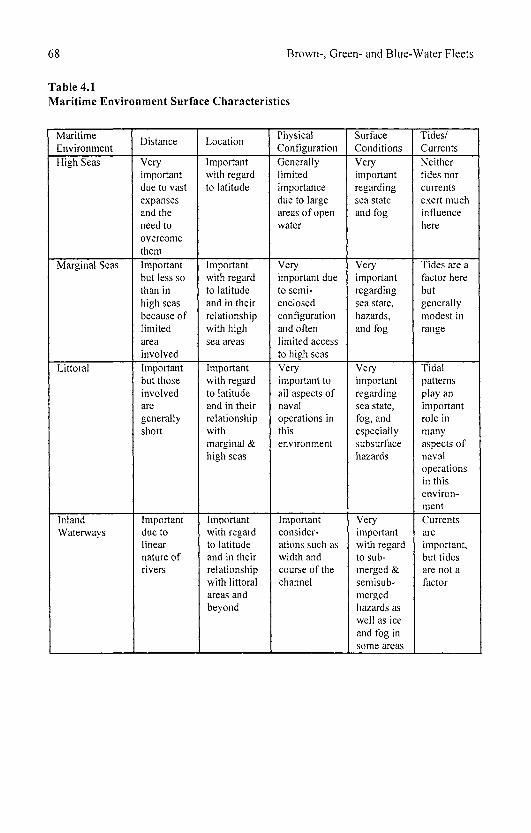
68 Brown-, Green- and Blue-Water Fleets
Table 4.1 Maritime Environment Surface Characteristics
Maritime Environment High Seas
Marginal Seas
Littoral
Inland Waterways
Distance
Very important due to vast expanses and the need to overcome them Important but less so than in high seas because of limited area involved Important but those involved are generally short
Important due to linear nature of rivers
Location
Important with regard to latitude
Important with regard to latitude and in their relationship with high sea areas
Important with regard to latitude and in their relationship with marginal & high seas
Important with regard to latitude and in their relationship with littoral areas and beyond
Physical Configuration Generally limited importance due to large areas of open water
Very important due to semi-enclosed configuration and often limited access to high seas Very important to all aspects of naval operations in this environment
Important considerations such as width and course of the channel
Surface Conditions Very important regarding sea state and fog
Very important regarding sea state, hazards, and fog
Very important regarding sea state, fog, and especially subsurface hazards
Very important with regard to submerged & semisub-merged hazards as well as ice and fog in some areas
Tides/ Currents Neither tides nor currents exert much influence here
Tides are a factor here but generally modest in range
Tidal patterns play an important role in many aspects of naval operations in this environment Currents are important, but tides are not a factor
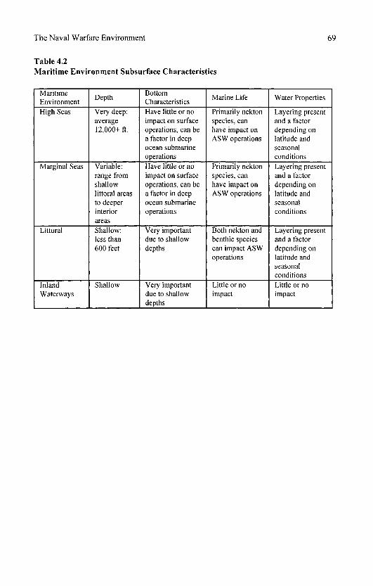
The Naval Warfare Environment 69
Table 4.2 Maritime Environment Subsurface Characteristics
Maritime Environment High Seas
Marginal Seas
Littoral
Inland Waterways
Depth
Very deep: average 12,000+ ft.
Variable: range from shallow littoral areas to deeper interior areas Shallow: less than 600 feet
Shallow
Bottom Characteristics Have little or no impact on surface operations, can be a factor in deep ocean submarine operations Have little or no impact on surface operations, can be a factor in deep ocean submarine operations
Very important due to shallow depths
Very important due to shallow depths
Marine Life
Primarily nekton species, can have impact on ASW operations
Primarily nekton species, can have impact on ASW operations
Both nekton and benthic species can impact ASW operations
Little or no impact
Water Properties
Layering present and a factor depending on latitude and seasonal conditions Layering present and a factor depending on latitude and seasonal conditions
Layering present and a factor depending on latitude and seasonal conditions Little or no impact
70 Brown-, Green- and Blue-Water Fleets
NOTES
1. There is a geologic basis for the existence of separate ocean basins. The massive midoceanic ridge system separates the deep ocean areas into different abyssal plain areas, which are identified as separate ocean basins. In addition, from a geopolitical standpoint, it is useful to label the different areas of the world ocean.
2. A. Getis, J. Getis and J. Fellmann, Introduction to Geography, 5th edition (London: Wm. C. Brown, 1996), pp. 8-9, 276-277.
3. The concept of sea state is derived from the Beaufort Wind Scale, which relates wind speed with the physical appearance of the surface of the sea. See H.V. Thurman, Introductory Oceanography, 8th edition (Upper Saddle River, NJ: Prentice-Hall, 1997), p. 238.
4. Fetch refers to the distance over which the wind blows, unobstructed so its velocity and direction remain fairly constant. This is a major factor in the development of wind-generated waves.
5. Heavy seas can adversely affect the performance of a ship's weaponry, sensors, aircraft, and crew. For a complete description of the adverse impacts of heavy seas on naval operations, refer to: M.S. Lindberg, Geographical Impact on Coastal Defense Navies: The Entwining of Force Structure, Technology and Operational Environment (London: Macmillan, 1998), p. 41-45.
6. When referring to the middle layer where temperature drops off quickly, the term "thermocline" is used. "Halocine" refers to the middle layer where there is a high rate of salinity change. With reference to density, this middle layer of rapid change is called the pycnocline.
7. The term "neritic" refers to the portion of the marine biologic environment from the shoreline to a depth of approximately 650 feet, generally corresponding with the area over the continental shelf. Nekton species can propel themselves by swimming, while benthic species live on the ocean bottom.
8. The coastal zone generally includes both an area landward and an area seaward from the shoreline in which marine influences have an influence. For the purposes of this work, however, the littoral refers only to the seaward extent of the coastal zone.
9. Thurman, p. 327.
5
Naval Warfare on the High Seas
When people think of the long historical tradition of naval warfare, they generally conjure up images of ships-of-the-line battling it out in line-ahead formations or lines of battleships attempting to "cross the T," or perhaps, more recently, carrier task groups ranging far and wide across great ocean expanses seeking one another in order that their groups of winged warriors could swoop down and dispatch these flattops with lightning strikes. Truth be told, however, much of what has constituted naval warfare over the past 150 years bears little resemblance to these romantic images. Apart from the Battle of Jutland in World War I and a handful of fleet actions in the Pacific during World War II, such fleet engagements have been the exception in naval warfare, not the rule, and while carrier-to-carrier battles raged throughout the Pacific during the latter conflict, the last 50 years have seen no such engagements on the high seas. So why do these images, however isolated in history, dominate our perception and study of naval warfare? Perhaps, apart from their obvious appeal for naval enthusiasts, it is because they represent the personification of naval power. In these fleet-to-fleet engagements navies seem to have their greatest impact upon one another. This may be true, but navies do not exist solely to impact one another. Instead, they are part of a larger picture, a greater cause.
To be sure, naval warfare is not conducted in a vacuum. It is not separate from larger strategic considerations that are always centered on land and involve, ultimately, military campaigns on land. Almost never have naval operations been conducted independently of, and without regard to, land operations or objectives. Even those operations that take place entirely at sea, and involve only naval forces are still being waged in connection with some land-oriented objective. Many of the naval operations that are undertaken to project power ashore do not constitute naval warfare in the traditional sense. That is, they do not involve fleet-to-fleet engagements on the high seas. For instance,

72 Brown-, Green- and Blue-Water Fleets
amphibious landings, transport of supplies and troops from one shore area to another, naval gunfire support, and naval air strikes against land targets and commando raids, while all emanating from the sea, remain concentrated in the littoral and are oriented toward the shore and do not constitute traditional naval warfare on the high seas. So what, then, does constitute naval warfare on the high seas, and to what purpose is it conducted?
Ultimately, for navies to influence military campaigns on land, they must gain and maintain access to the seaward approaches and littorals of continental areas. To facilitate this access, they must secure the sea lines of communication (SLOC) that link all of the world's continents to one another. The geography of the world ocean provides an unbroken thoroughfare that makes movement at sea continuous and allows for the projection of naval power ashore virtually anywhere on the globe. Ocean continuity links staging areas with objectives and targets. It also ties maritime allies together, providing for the solidification of grand maritime alliances with all of their offensive, war-making potential. Oceanic continuity means that sea control confers a global mobility and agility with which shore-based or even air transportable land power cannot compete.1
Conversely, however, the ocean can constitute a major division between such allies if sea control is not maintained over the relevant SLOC. Therefore, SLOC must be secured through the exertion of sea control over areas where the needed SLOC pass. It is because of the efforts of states to exert such sea control—and the inevitable counter to it, sea denial—that naval warfare on the high seas occurs at all. What, then, are the specific types of naval warfare that occur on the high seas as a result of the struggle between sea control and sea denial in order to secure SLOC? Included are fleet-to-fleet engagements, commerce raiding (guerre de course), shipping defense (convoy escort), and ASW.
Naval warfare on the high seas, in all its forms, depends on the mobility and sustainability of naval forces. Likewise, sea control and the projection of naval power ashore are ultimately made possible by these two factors. Mobility is a strategic concept that allows naval forces to move great distances in a timely fashion in order to achieve sea control, project power ashore, or both. It also facilitates the concentration of forces in order to deliver massive offensive first strikes against enemy targets at an appropriate location and time. The ability of naval forces to achieve both tactical and strategic surprise is greatly enhanced by effective mobility and can mean the difference between victory or defeat at sea.2
The very nature of the maritime environment gives the advantage of achieving surprise to naval forces over their counterparts on land since at sea there are no obvious routes into which naval forces are canalized.3 Where exactly ships move and ultimately strike from is a mystery that large-scale land forces cannot create. All of the advantages that mobility confers on naval forces would be lost, however, unless they have a reasonable level of sustainability, that is, the ability to maintain station, forward deployed for extended periods of time often in the face of enemy sea denial efforts. It does little good if a naval force reaches its operational objective area and then must simply turn around and return to port in order to resupply or refuel. Both sustainability and mobility are made possible by the availability of sufficient logistical support. This logistical support can be
Naval Warfare on the High Seas 73
provided in several ways, including the establishment of a network of geographically dispersed, forward bases located near enough to operational areas but not so close as to be overly vulnerable to enemy attack. A mobile fleet support force (a fleet train) that can either operate alongside forward-deployed units or rendezvous with them periodically to deliver needed supplies has become the primary method for ensuring sustainability by modern naval forces. A combination of the two methods has also been employed.
GEOGRAPHICAL FACTORS
It has already been mentioned that geographical factors are not as numerous or complex in the highs seas environment as in the littoral-however, three such factors have a bearing on naval warfare on the high seas. First and foremost, distance is the major geographic factor that naval forces operating on the high seas must consider. Much of what navies do here is designed to overcome the constraints and challenges of distance. On the high seas, consideration must be given to the distance between bases and objectives as well as the often expansive operational areas encompassed by high seas naval warfare. Global conflict and peacetime commitments necessitate the exercise of sea control over vast areas of the ocean in order to secure extended SLOC. Distance ultimately dictates what types of ships are required and the logistical support that is necessary, including forward-basing needs and the time frame of naval operations. As distances increase, the operational capability of smaller navies is inhibited (to a point beyond which they will not be able to operate), while ever greater demands are exerted on larger ones.
Mobility and its facilitator, logistical support, are the primary means by which navies are able to mitigate the obstacle of distance. Technological advances in ship design, marine propulsion systems, and logistics have done much to improve the mobility of naval forces and bring about a time-space convergence in naval warfare over the past 150 years. The capability of fleet units to move vast distances relatively quickly greatly enhances their strategic and tactical leverage. Furthermore, the establishment of advanced bases that can be moved ever closer to objectives as strategic and tactical conditions change has greatly increased the effectiveness of naval forces operating on the high seas. This was certainly proven by American operations in the Pacific theater during World War II. Likewise, the advent of the mobile fleet train has made it possible for naval forces to operate for extended periods of time over vast areas of open ocean. Such advances in mobility and logistics, when coupled with the ever-increasing range of weapons and sensors, have both enhanced the combat effectiveness of naval forces over expanded distances and enlarged the size of the operational areas involved in naval warfare.
The second geographical factor that must be considered in naval warfare on the high seas is location, both absolute and relative. The basic considerations of location are threefold:
74 Brown-, Green- and Blue-Water Fleets
l.The location of land objectives (harking back to the basic concept that all naval warfare is ultimately connected to operations on land).
2. The location of all enemy forces in relation to one's own naval and air forces and their associated bases, both fixed and mobile.
3. The location of one's own forces to one another (this has to do with the issue of dispersal and concentration of forces).
Stemming from these considerations is the basic truth that naval forces achieve both strategic and tactical success by obtaining a favorable location in relation to both their objectives and enemy forces. In this sense, "favorable" alludes to the ability of one's own naval forces to attain either strategic or tactical (or both) surprise coupled with a concentration of maximum deliverable force against the enemy. A related goal here is, of course, to do it before one's enemy can. Thus, attaining such a favorable location in a timely fashion is often essential. The attainment of such a favorable location by naval forces is accomplished through mobility at the strategic level and maneuver at the tactical level.4 From these statements it is clear that the realization of a favorable location is directly related to the ability to overcome distance in naval warfare on the high seas.
Owing to the inherent mobility (and maneuverability) of naval forces, their positions on, above, and under the surface of the ocean are not fixed. In fact, since opposing naval and air forces execute simultaneous movement, the location of such forces in relation to one another is constantly changing.5
Therefore, it would seem that relative location would be more important than absolute location in naval warfare on the high seas. While this may be true at the tactical level, the latter ultimately determines the strategic framework of naval warfare. It dictates the "geostrategic centers of gravity"6 in a conflict at sea, which, in turn, determines where and how command of the sea must be secured in order to achieve strategic objectives. At an even more fundamental level, absolute location determines whether a state is likely to be a maritime power or not. History is replete with examples of states that, by virtue of their location to the world ocean, have amassed powerful fleets and looked seaward to exert their power and influence on the world. Great Britain in the eighteenth, nineteenth and first half of the twentieth centuries and the United States in the latter half of the twentieth century as well as today are the best examples of this. Meanwhile, Imperial and Nazi Germany, Imperial and Soviet Russia, and even Imperial Japan are all examples of states that, owing to their respective locations, looked landward for their greatness and relegated their navies to a secondary position, thus asserting their status as continental, not maritime, powers. It should be noted, however, that such a favorable absolute location leads to success in naval warfare only if the state has the requisite naval forces to take advantage of it. For example, although Nazi Germany's own absolute location was not favorable, through its occupation of Norway and France it greatly enhanced it, but due to a lack of U-boats during the critical early stages of the war, it was unable to truly capitalize on these positions.

Naval Warfare on the High Seas 75
Absolute location confers upon some states an inherent vulnerability to sea power. For those states that lack sufficient naval power to exert effective sea denial, exposed coastal areas can simply become so many points of access to a state capable of projecting power ashore. Likewise, states whose land possessions are separated by ocean can have a real problem exerting control and security over these areas when faced with mobile naval and air forces that achieve sea control over the intervening SLOC. For evidence of this, one need only consider the difficulty that Japan had maintaining its defensive perimeter of widely scattered island bastions in the Pacific during World War II or similar difficulties experienced by Argentina during the Falklands War of 1982 once they lost control of the SLOC between the mainland and the islands. Other states whose absolute location provides limited access to the world ocean also are at a disadvantage. Russia/Soviet Union is the classic example. A northerly latitudinal position restricts use of much of this state's extensive coastline during much of the year, and its access to the open ocean is further restricted by various chokepoints controlled by states other than itself. Russia's historically geographically disadvantaged status stems largely from its absolute location.
What, then, of relative location and naval warfare? As stated previously, relative location appears to have more of a bearing on naval warfare at the tactical level. As naval forces maneuver to attain a favorable position from which to strike, their relative location as well as their range and bearing to one another are in constant flux. Thus, it becomes essential to know the location of one's own forces as well as that of enemy forces at sea. This makes reconnaissance, surveillance, and intelligence gathering integral components of warfare at sea, especially on the high seas. Furthermore, relative location at the tactical level impinges heavily upon fleet engagements. Relative location is not without relevance at the strategic level of naval warfare, however. The relative location of states engaged in conflict, in most cases, determines the strategic deployment of naval forces. For example, two warring states that share a coastline or that are separated by only a few dozen miles, such as Israel and its Arab neighbors or India and Pakistan, employ a strategy at sea that is quite different from that employed by two states that are separated by thousands of miles, as was the case with Argentina and Great Britain during the Falklands conflict. In the former situations, quick, short-range strikes by coastal naval forces and land-based aircraft played a major role, while carrier-based aircraft and blue-water naval forces were more important in the latter scenario.7
Surface conditions, as described in Chapter 4, constitute the final geographical factor that influences naval warfare on the high seas. Weather conditions, including temperature, precipitation, icing, fog, and wind, determine the condition of an environment in which naval operations are being conducted. As sea state deteriorates (increases on the Beaufort Scale), the ability of ships, aircraft, sensors, weapon systems, and humans to operate effectively is diminished. The overall seaworthiness of a ship is determined by several basic components of its design, including hull shape and size, weight, volume, and the centers of gravity and flotation. While certain types of hull design are better than others when it comes to seaworthiness, all ships will suffer the consequences of
76 Brown-, Green- and Blue-Water Fleets
heavy seas, including surging, yaw, pitch, roll, sway, and heaving. All of these can compromise the stability of ships and always force them to reduce speed, which, in turn, decreases both their mobility and maneuverability. Further, vibrations and the impact of waves on a ship's hull, superstructure, and deck fittings (including weapons and sensors) can cause physical damage as well as adversely affect the alignment of weapons and sensors to the point where they cannot be used. High waves generally scatter electronic signals and often result in false echoes on radar screens. Aviation operations, under-way replenishment, and close formation convoy operations all become difficult, if not impossible, in sea state 5 or above. Such sea states also adversely impact ASW operations as well, making the deployment and recovery of towed-array sonars difficult. Finally, the impact of these challenging surface conditions on shipboard personnel is perhaps the greatest impediment to effective naval operations on the high seas. Their ability to perform their duties effectively decreases as sea state increases. Seasickness, and impaired mental capabilities, including attention to detail and motor coordination, prevent crewmen from performing even relatively simple tasks both above decks and belowdecks. Movement throughout a ship becomes hazardous and may result in casualties. It is no wonder that, during periods of heavy seas or conditions of extremely cold temperatures, dense fog, intense precipitation, or heavy icing, naval operations on the high seas are much curtailed.
We now turn to a series of historical case studies that illustrate the different types of naval warfare on the high seas as introduced in the preceding section. Also discussed is the role of logistical support that in each case made the operations in question possible. Since our case studies span a period from the late nineteenth Century to the latter decades of the twentieth Century, changes in technology, logistical capabilities, and tactics are significant in many cases and are mentioned. However, the basic influence that the geographical factors mentioned earlier have on naval warfare on the high seas has remained relatively constant over this time period.
SINO-JAPANESE AND RUSSO-JAPANESE WARS
Mahan, speculating on the friction that crops up between land and sea power, all but predicted the Russo-Japanese War. Japan had suffered a dramatic reversal of fortune since 1895, the result of astute diplomatic maneuvering on Russia's part. After trouncing China in 1895, Japan had found itself enjoying sea control around the shores of Northeast Asia. Less than a decade later it found itself completely outflanked by Russia, the latter having overturned its gains in Manchuria and Korea. In the war that followed, Russia, primarily a land power, was unable to use its naval assets effectively. Japan, by contrast, not only outfought Russia at sea but forced it to a stalemate on land a remarkable showing for a country disparaged by many in the West. To Mahan's way of thinking, both countries were conforming to type. In his view, Russia was destined by geography to expand overland, invariably coming up against Japanese interests in the North Pacific. Nevertheless, it was alive to the benefits
Naval Warfare on the High Seas 77
of sea commerce and determined to grab coastal regions wherever it could. Since commerce by sea promised far higher returns than that prosecuted inland, it followed that Russia's best interest required it "not merely to reach the sea at more points but to acquire, by possession or by control, the usufruct of other [in addition to those already in its possession] and extensive maritime regions, the returns from which shall redound to the general prosperity of the entire empire."8 Compounding this urge to seize coastal regions was the need to overcome the handicap incident to a northern position namely, the closure, icebound, of those ports that it had, the victims of severe winters. Korea and Manchuria afforded it the prospect of relief from this disadvantage, a prospect, that besides boosting commercial activity, offered to vastly improve the operational tempo of its naval forces. Japan, meanwhile, was credited by Mahan as being a natural sea power. As a result, it was inclined to side with Britain and the United States in opposing Russian advances.
On the face of it, then, the Russo-Japanese War pitted a major land power against an assertive sea power much as the Napoleonic conflict had matched France against Britain. Unlike that bout of hostilities, however, this one was not global in scope but confined to a narrow corner of Asia. Only one aspect of it was of truly global proportions, and that concerned the fleet dispatched by Russia from the Baltic to reinforce its battered naval squadrons in Northeast Asia. Poignant because it culminated in the climactic battle of Tsushima, that reinforcement effort entailed a 15,650-nautical-mile voyage prosecuted over seven months (16 October 1904 to 27 May 1905), which tested to the limit refueling notions, including novel at-sea practices. Coaling stations, inevitably improvised, sprang up to support this fleet, ranging all around the coast of Africa (Tangier, Dakar, Gabon, Great Fish Bay, Angra Pequina) to Madagascar (Nossi Be), whereupon a lengthy trip of 3,900 nautical miles was undertaken to Vietnam in which all coaling was accomplished at sea.9 This unprecedented feat in logistics makes the war memorable, as do the fleet engagements, which first vividly demonstrated the destructive power of armored ships. These lessons, together with instances of imaginative use of mines and torpedoes, were taken seriously by the other powers, not least by Britain, which had a vested interest in Japan's performance. Indeed, Japan, true to the spirit actuating a Mahan-approved sea power, had singled out Britain as its chief mentor. The implications of that arrangement need exploring before a description of the naval war is warranted, and that is the purpose of the digression that follows.
BACKGROUND
The British connection, though subtle, proved advantageous—not to say, crucial—to Japan. The formal Anglo-Japanese Treaty, revealed in January 1902, rendered the geostrategic situation favorable for not only did Britain "hold the ring," promising to intervene on Japan's behalf if France or any other power openly backed Russia, but, in lending its weight to Turkey's insistence on the closure of the Dardanelles to belligerents' warships, it effectively neutralized the Russian Black Sea Fleet. Geography combined with British resolve bottled up a

78 Brown-, Green- and Blue-Water Fleets
sizable fraction of the Russian navy, much to the relief of Japan. As Ballard pithily put it, the Russian naval establishment associated with that sea was a downright bad bargain, scarcely justifying its keep, "for although a battleship in the Black Sea cost just as much as a battleship in the Baltic, her general value was much less to national defence."10 Britain's influence ran much deeper than this explicit defensive alliance, however. Both the Imperial Japanese Navy (UN) and the industrial base upon which it relied were strongly influenced by British practices. Shortly after 1868 and the Meiji restoration, the banner year from which Japan counts its emergence as a modern state, moves were initiated to tap British naval expertise. Japan soon became beholden to the principal naval power on several fronts. Beginning in 1869, the waters around its coasts were surveyed with British help. From 1870 the Royal Navy furnished the instructors for the new naval training school (or college, as it soon was to become). At the same time Japan arranged for bright cadets to attend training institutions in England, the most notable of the 1871 batch being Togo Heihachiro, the future hero of Tsushima.11
However, Japan was determined to avoid anything that could be construed as a position of dependency, for it viewed it with anathema, seeing client status as merely a prelude to colonial annexation. Consequently, it expeditiously pressed ahead with the learning process, dispensing with foreign advisers whenever conditions allowed. By century's end, it had practically eliminated all foreign input into its naval affairs. In the meantime, though, it seized on British know-how with great avidity and was not slow in putting it to use. Japan's first application of naval power in the modern era, a punitive expedition to Taiwan in 1874, demonstrated that it had at least mastered the rudiments of combined operations. Some 3,000 troops were transported from Nagasaki to the unruly island, where they effected an unopposed landing at its southern tip. Despite fulminations from China, the island's owner, the expedition bludgeoned the supposedly errant tribesmen into submission and exacted reparations from China before sailing home to a festive welcome.12 If nothing else, it convinced the government and people of the benefits attendant on the possession of a navy.
The British also left their mark on shipbuilding and ship repair, not to mention the supply of steam coal essential for naval operations. The important Mitsubishi shipbuilding enterprise, later to figure prominently in the production of major combatants, owed its genesis to British (and Dutch) shipwrights operating at Nagasaki in the 1850s and 1860s.13 The Onohama Dockyard, upon which the Kure naval shipyard was later built, was founded by an Englishman named Kirby in 1883. Another countryman, Hunter by name, set up the Osaka Iron Works in 1881, an undertaking that blossomed in later years into the shipbuilding giant Hitachi Zosen.14 Thomas Glover, a participant in the early shipbuilding industry at Nagasaki, was also instrumental after 1868 in organizing the mining of steam coal on Takeshima Island, nine nautical miles from that city. Apart from serving as a useful export in the form of bunker fuel, it supplemented best-quality Welsh coal as the fuel of choice for the UN. By the onset of the new century, this investment of know-how and capital had borne fruit: Japan was able to operate a fleet very satisfactorily, with many of the units
Naval Warfare on the High Seas 79
in that fleet emanating from its own yards. Its infant marine-industrial base had not flourished sufficiently, however, to meet the UN's needs for heavy units, the vessels vital to a creditable battlefleet. Japan's Admiralty had to accept the harsh fact that, despite frenzied expansion, its yards were simply not equipped to construct battleships and armored cruisers. For instance, all six of the battleships that bore the brunt of the fighting in the war with Russia derived from British yards (a seventh unit, built in Germany in the early 1880s and captured from China in 1895, was obsolete and kept out of the battle line). Of the nine armored cruisers which that Japan deployed in that war, five came from British builders, two from Italian builders, and one apiece from yards in France and Germany.15
Japanese yards contributed significantly to the force of lesser ships, constructing several protected and unprotected cruisers and, in particular, numbers of flotilla units—torpedo-boat destroyers and smaller torpedo boats—that had been designed in Britain, France, Germany, and, later, Japan itself. The UN reposed great trust in its flotilla, numbering 99 on the eve of war with Russia, in part because it had performed reasonably well in the recent war with China. That war is deserving of a brief aside, for not only did it occur in the same waters as the later conflict with Russia, but it taught the UN salutary lessons that were certainly not forgotten in the larger affair of 1904-1905.
PRELUDE TO THE SHOWDOWN
The Sino-Japanese War, starting in July 1894 and concluding nine months later, served as a watershed for the UN. Before it, the Japanese navy was little more than a coastal defense force; on its conclusion, the navy began to assume blue-water capabilities. Prior to 1894 the UN subscribed to one of the two doctrines typical of minor naval powers: it elected to build up a force of torpedo boats that, in compliance with the design promulgated by the French jeune ecole, could be let loose to prey on an enemy's shipping while scrupulously avoiding his warships. A smaller force of light cruisers would complement the "mosquito" craft, providing the range and endurance of true commerce raiders. Thus, Japan eschewed the other option open to lesser navies, that of a "fleet in being" strategy, believing that the cost of even an embryo squadron of battleships was beyond its means. In the event, Japan's doctrine held water only if the enemy, first of all, gratuitously furnished a helpless mercantile marine for attacking and, second, abstained from operating a battlefleet capable of winning sea control. Neither condition appeared to apply to China in the early 1890s, for its carrying trade was in the hands of foreigners and thereby immune from depredations, while its navy, far from settling for a coastguard force, was showing signs of battlefleet ambitions. The latter was intimated as early as 1885 by the delivery from Germany of two armored turret ships, optimistically regarded as battleships by the Chinese.
China's navy, after receiving a drubbing from the French, had been rebuilt in the later 1880s with British and German assistance. Nevertheless, lacking unified command, it continued to operate as geographically detached, largely self-contained fleets, the most prominent of which was the Peiyang or Northern.
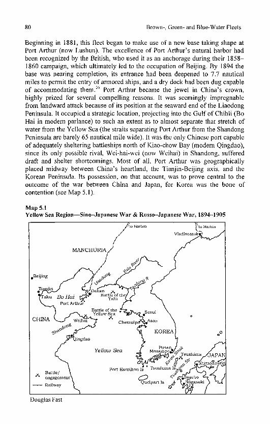
80 Brown-, Green- and Blue-Water Fleets
Beginning in 1881, this fleet began to make use of a new base taking shape at Port Arthur (now Lushun). The excellence of Port Arthur's natural harbor had been recognized by the British, who used it as an anchorage during their 1858-1860 campaign, which ultimately led to the occupation of Beijing. By 1894 the base was nearing completion, its entrance had been deepened to 7.7 nautical miles to permit the entry of armored ships, and a dry dock had been dug capable of accommodating them.16 Port Arthur became the jewel in China's crown, highly prized for several compelling reasons. It was seemingly impregnable from landward attack because of its position at the seaward end of the Liaodong Peninsula. It occupied a strategic location, projecting into the Gulf of Chihli (Bo Hai in modern parlance) to such an extent as to almost separate that stretch of water from the Yellow Sea (the straits separating Port Arthur from the Shandong Peninsula are barely 65 nautical mile wide). It was the only Chinese port capable of adequately sheltering battleships north of Kiao-chow Bay (modern Qingdao), since its only possible rival, Wei-hai-wei (now Weihai) in Shandong, suffered draft and shelter shortcomings. Most of all, Port Arthur was geographically placed midway between China's heartland, the Tianjin-Beijing axis, and the Korean Peninsula. Its possession, on that account, was to prove central to the outcome of the war between China and Japan, for Korea was the bone of contention (see Map 5.1).
Map 5.1 Yellow Sea Region—Sino-Japanese War & Russo-Japanese War, 1894-1905

Naval Warfare on the High Seas 81
Japan was sensitive to events in Korea, regarding the peninsula as a potential jumping-off point for invaders much as Britain viewed the Low Countries. The Koreans had thrown off loose Chinese control, forcing Beijing to retaliate. Japan challenged China's right to settle Korean affairs, leading to hostilities between the two. Both dispatched seaborne forces to the vicinity of Seoul, the Chinese voyaging from Weihai to Asan and the Japanese putting into Chemulpo (now Inchon). Sea lines of communication were crucial to both for Japan, as an insular state, could not wage war in Korea without them, while China, theoretically gifted with a land route through Manchuria, practically discovered that the road was almost impassable. Defending sea lines, therefore, became the chief object of naval forces on both sides. Japan at the outset was content to stay within the bounds of a limited war, focusing its efforts on Korea but fully prepared to secure the margins round the Yellow Sea so as to neutralize the Northern Fleet. In short, Japan took the offensive in the sea war in spite of its inferiority in major warships. Its cruisers interrupted the Chinese supply line to Asan, as witness Captain Togo's interception and subsequent sinking of the chartered British steamer Kowshing, loaded with 1,200 Chinese troops. Causing a stir at the time, a more detached view holds that the episode was noteworthy "as being the very first occasion on which a troop transport was ever sunk by a Whitehead torpedo, thus affording unmistakable proof that a new danger threatened the movement of armies by sea."17
Forced to turn to convoying, the Chinese navy escorted transports from Taku (Tanggu) to the estuary of the Yalu, the river forming the boundary between Manchuria and Korea. To counter this landward thrust from China, the IJN shepherded troopships to the Taedong estuary preparatory to moving north to catch the unsuspecting Chinese fleet at anchor. Insinuating itself between the Chinese and their base at Port Arthur, the IJN left the latter no choice but to engage in the Battle of the Yalu (17 September 1894). Despite the possession of a couple of battleships, the Chinese were decidedly worsted by the IJN's cruisers in the running fight that ensued. Fearful of attacks from torpedo boats, the Northern Fleet retired into its fortified base, conceding sea control to the Japanese. Thereupon the Northern Fleet acted out a makeshift "fleet in being" strategy, ultimately forcing Japan's hand. Their army having prevailed at Pyongyang, the Japanese now determined to secure Port Arthur and the fleet ensconced within it before carrying the war into Manchuria. Accordingly, they mounted an amphibious landing on the Liaodong Peninsula, which was uncontested by the Chinese. With Port Arthur's fall imminent, the Northern Fleet slipped out and found refuge in Weihai, 74 nautical miles away on the north coast of Shandong. Weihai's anchorage is shallower and more open than Port Arthur's, but the port, being fortified, presented the Japanese with a serious obstacle. Bombardment from the sea could not induce the Chinese ships to come out and fight. Resolved more than ever to eradicate China's latent threat to their sea communications, the Japanese landed 30,000 troops near the Shandong Promontory in January 1895 and set out to reduce Weihai. This they succeeded in doing, aided in no small way by attacks pressed home by torpedo boats on the moored Chinese vessels. The Treaty of Shimonoseki, signed in April 1895,

82 Brown-, Green- and Blue-Water Fleets
awarded Japan all that it desired: transfer of territory and a free hand in Korea, to say nothing of a huge indemnity (which the IJN spent in Britain, buying battleships) and the pick of what remained of the Northern Fleet as prizes. The territories gained at China's expense were, on the one hand, Port Arthur together with its hinterland in Liaodong and, on the other, Taiwan and the neighboring Pescadores (Penghu Islands), the last seized by the IJN in the dying days of the war. At a stroke Japan had eliminated China as a naval rival, for Port Arthur gave it the best naval base in the Yellow Sea, while Taiwan and the Pescadores granted it a geographical stranglehold on the waters of the China Seas. Japan now irrevocably committed itself to commissioning a blue-water navy complete with a battlefleet.
Much to its chagrin, Japan was immediately denied some of the fruits of victory, most notably Port Arthur. Russia, with the connivance of France and Germany, threatened dire consequences if Japan were to retain this base and the foothold in Manchuria. Russia had designs of its own on the region. In 1896 it began construction of a railroad across Manchuria (the 1,510-kilometer Chinese Eastern Railway), designed to "short cut" the longer, stalled, all-Russian route to Vladivostok, which constituted the final leg of the 9,200-kilometer Trans Siberian Railway (TSR). Russia was eager to follow it up with territorial concessions from China, with the rail venture constituting an expedient for the acquisition of ice-free ports. Its desires were fulfilled with the transfer on lease of Port Arthur and Dalian (Delny to the Russians, Dairen to the Japanese), the two ice-free ports on the Liaodong Peninsula, along with the right to build a 772-kilometer rail link from these ports to Harbin on the main line.18 Thus, in three short years the Russians had replaced the Japanese in the principal naval base in north China and had seen them ejected, bag and baggage, from Manchuria, a region rich in minerals (iron ore and coal), forests, and agricultural (soybean) resources. Smarting from this reverse, Japan could not even console itself with a free hand in Korea. Russia, keen to acquire Korean ports since the 1880s, pressed its claims yet more vigorously.19 Its possession of Port Arthur, some 950 nautical miles from Vladivostok, now made acquisition of an intermediate coaling port in Korea imperative, for otherwise warships would not be able to switch easily from the latter to the former on the approach of winter. In 1896 Russian marines landed at Inchon, marched to Seoul, and took the king of Korea into their custody, fatally undermining Japanese influence. Japan's subsequent appeals for a compromise settlement in Korea fell on deaf ears in Moscow.20 Japan felt itself placed in an invidious position: it could resign itself to an outflanking Russian naval buildup centered on Port Arthur and Vladivostok, which was bad for the IJN, or watch as Korea was absorbed and Russia concentrated its forces directly opposite the Japanese home islands, which was worse. In the event, Japan was not prepared to tolerate either prospect, choosing instead to strike at Russia when opportunity beckoned. Japan, more than ever, looked to the IJN to safeguard its future, but the IJN, while immersed in acquiring all the trappings of a blue-water navy, still fell short of Russia on several important counts.
Naval Warfare on the High Seas 83
THE UNFOLDING OF EVENTS
Of utmost importance was Russia's numerical superiority in battleships, both in theater and in reserve. The former, based in Port Arthur, numbered seven, albeit of differing types and some of questionable worth.21 The latter, embracing active ships in the Baltic (but discounting those bottled up in the Black Sea) as well as units under construction there, totaled 16 modern vessels. Of course, getting these ships to the Far East posed difficulties, although Admiral Stepan Makarov had been pressing for the establishment of a resupply route through Arctic waters, a route promising distance savings over the Europe-to-China link via the Suez Canal. Development of the northern route was not persevered with, forcing Russia to resort to the extremely long voyage from the Baltic, mentioned earlier. For men and munitions, the TSR, single-tracked throughout, was available (its Manchurian section completed in 1903), but severe limits on the line (to say nothing of an incomplete stretch near Lake Baikal) prevented its use for heavy ordnance. Japan, by way of comparison, fielded six modern battleships but had no modern vessels in reserve. None of its shipyards were capable of furnishing more (although the navy yards at Kure and Yokosuka were gearing up to build one apiece), and while it had a program to build two in British yards, neither was due to be completed before 1906. In compensation, however, its navy yards were close at hand and versed in damage repair and refitting. Furthermore, its six ships were well designed and, unlike their Russian counterparts, shipped standardized weaponry, allowing them to operate as a homogeneous unit. They formed a compact force under Admiral Togo, who, operating off the home islands, was charged with securing command of the Yellow Sea. Japan's object at the outset was to prosecute a strictly limited war. In Corbett's words, it hoped to "practically isolate Korea by naval action" pending the occupation of that territory by its armies.22
Aiming to catch Russia off-guard, Japan, without bothering to announce a state of war, simultaneously unleashed its torpedo boats on Port Arthur on 8 February 1904 and its cruisers on Inchon. The first scored hits on Russian battleships, but a follow-up bombardment by Togo's heavy ships failed to inflict lasting damage. The second, a smaller affair, resulted in the loss of a Russian cruiser and gunboat as a prelude to the Japanese occupation of Seoul. Japan immediately launched a land offensive in Korea to forestall any moves by Russia to occupy the peninsula. Korea would then serve as a springboard for a Japanese invasion of Manchuria. Togo proceeded to blockade Port Arthur, preventing the Russian battlefleet from interfering with the Korean campaign. His newly appointed opposite number, Makarov, died in April, when his battleship struck a mine while attempting to break the blockade. But mines proved to be indiscriminate weapons, for Togo lost two of his battleships—one-third of his battle line—to them shortly afterward. Russia's three armored cruisers at Vladivostok, hoping to circumvent Togo, raided Japan's coast but were unable to interrupt their enemy's sea lines of communication to Korea. Resolved to bring matters to a head, Japan landed one army on the Liaodong Peninsula, while another pushed across the Yalu River to penetrate Manchuria
84 Brown-, Green- and Blue-Water Fleets
proper. The former aimed at capturing Port Arthur and the vessels sheltering within it before naval reinforcements could arrive from Europe. It thus abided by the grand strategy of destroying the larger Russian navy in detail before its widely dispersed fleets could concentrate in the Yellow Sea. This army soon seized Dalian and sealed off Port Arthur, a relieving force falling foul of the second army, which had crossed the Yalu.
The Russian squadron broke out of Port Arthur only to collide with Togo's force at the Battle of the Yellow Sea (10 August 1904). The Russian force of six battleships, four light cruisers, and eight destroyers was totally outclassed by a Japanese force of four battleships, three armored cruisers, and some smaller ships. It was ignominiously chased back into Port Arthur, badly bruised. At the same time, the Russian armored cruisers had left Vladivostok, raiding Japanese lines of communication in the Korea Strait on their way to a rendezvous with the Port Arthur squadron. Caught before this could be effected, they were driven off after a severe mauling in which one of their number was sunk. The siege of Port Arthur then commenced in earnest, the base and its badly knocked-about squadron falling to Japanese troops on 2 January 1905 after holding out for 154 days. A relieving force, the Second Pacific Squadron of 45 vessels (including eight battleships) under Admiral Zinovy Petrovich Rozshestvensky, had failed to arrive on time, delayed by the troublesome circumstances attending its assembly in the Baltic and journey to the theater of operations (the latter of which has already been remarked on). Japan's fleet, rested and rearmed, was lying in the anchorage at Masampo on the southern tip of Korea. Togo had correctly anticipated Rozshestvensky's course, and he moved out his ships to intercept the Russians upon receipt of a message radioed from a unit of his patrol line that had sighted the enemy near Tsushima Island. The resulting battle of Tsushima (27 May 1905) was one of the most decisive in naval history, rivaling Trafalgar in its one-sidedness. At the end of the fighting, two days later, the Russian force had disappeared, all its major units sunk or captured and no fewer than 4,830 men killed as compared with a mere 110 Japanese.
This outcome, together with the stalemate on land following its reversal at the battle of Mukden (Shenyang), convinced Russia of the futility of pursuing the war. It became desperate to bring hostilities to a close. True, the TSR, in spite of its makeshift operation, had proved more than adequate for bringing large numbers of troops to the Manchurian front (thus vindicating Mackinder's view of the geostrategic importance of railways). However, its capacity was strained to the breaking point (justifying Mahan's view that railroads were no substitute for ships when large-scale, long-haul transportation was called for), casting a shadow over Russia's ability to sustain its armies in the field. The option of transporting supplies from Europe to the Far East had been irrevocably closed to Russia as a consequence of the battle of Tsushima. All told, the war had cost Russia 14 battleships, three coastal defense battleships, five armored cruisers, six other cruisers, and a host of smaller ships. The force left to it outside the Black Sea, a couple of battleships and a pair of armored cruisers, was grossly outnumbered by the Japanese. Accordingly, Russia agreed to an offer made by President Theodore Roosevelt to broker a peace deal. Formalized in September

Naval Warfare on the High Seas 85
at Portsmouth, New Hampshire, this granted Japan all its demands. Port Arthur and the Liaodong Peninsula reverted to its control. Japan was acknowledged as preponderant in Korea. Russia also agreed to evacuate Manchuria and to relinquish to Japan the southern half of the island of Sakhalin. In retrieving the latter, Japan extinguished Russian control of one of the choke points regulating entry to Vladivostok, namely, the La Perouse Strait (Soya Kaikyo), linking the Seas of Japan and Okhotsk. Its naval position was correspondingly buttressed at Russia's expense.
Yet, in the final analysis, the naval war had been a contest for local sea command, for worldwide command had never been in contention. It had mixed combined operations and coastal bombardment with cruiser and battlefleet engagements at sea but had seen little in the way of guerre de course. It was a war in which battleships reigned supreme but in which their freedom of action was, to some extent, curtailed by torpedo-armed flotilla ships (not to say mines sowed by both flotilla ships and cruisers). In short, it bore some resemblance to the much larger naval conflict that was to engulf the world in 1914 yet did not shed much light on future sea warfare because of its localized character. Nevertheless, echoes of its most distinctive aspect, the time-distance problem confronted by Rozshestvensky, could be discerned in some of the episodes stamping World War 1, as the next section attests.
WORLD WAR I
Germany, the upstart naval power that intentionally provoked Britain, the long-established leading sea power in 1914, issued its challenge despite holding the inferior geographical position. In fact, the Imperial German Navy (IGN) and its masters, seemingly blind to the consequences of adverse maritime geography, thumbed their collective noses at the fundamental disadvantage that relative location had dealt them. Of overriding importance was the fact that the British Isles sat athwart their access routes to great waters, channeling their sea lines of communication through either the 17-nautical-mile-wide Straits of Dover or the gap of 195 nautical miles existing between Norway and the Shetland Islands. The Royal Navy, in operating from its own country, was consequently gifted with the perfect platform for mounting a blockade on Germany. Indeed, the strategic geography was reminiscent of the situation obtained in the mid-seventeenth century, when, in its formative era, the British navy fought a series of fierce battles with the Dutch navy, throttling the trade of its adversary's countrymen in the process. Germany, it is true, was no sea power of the Dutch mold, but like the Netherlands of earlier days it aspired to world-power status. The IGN was, in large part, an expression of that ambition, at once intensely local in its orientation so as to beard the Royal Navy in its own den but, at the same time, global in outlook so as to be worthy of a navy charged with looking after Germany's recently acquired colonial empire in Africa and the Pacific. Clearly, the strategic geography of 1914 was, so far as Britain and Germany were concerned, little different from that confronting Britain and France in the heady days of the eighteenth and early nineteenth centuries.23 In short, whoever
86 Brown-, Green- and Blue-Water Fleets
controlled the Western Approaches to Northwest Europe essentially had command of an indivisible sea stretching from the Atlantic to the far reaches of the Pacific, where New Guinea and the Marshall Islands represented the uttermost limit to German colonial writ.24 Practically, should Britain contrive to frustrate Germany's bid for naval mastery, it would succeed to Germany's colonial empire, since the latter, denied naval support, was ripe for plucking. Confined to its continental bastion, Germany would also be compelled to fall back on natural resources found either within its own borders or within the grasp of its army bent on a land offensive for, undoubtedly, a British stranglehold of its sea approaches would exact a toll on its ability to wage war. Of course, the reverse of the coin had dire consequences for Britain. Just as the Royal Navy's worsting by Napoleon's navy would have opened the prospect of a French invasion and Britain's inevitable overthrow by a superior land power, defeat of the Royal Navy by the IGN invited a German invasion and the certain vanquishment of its land forces at the hands of the mighty German army. At all costs, then, the British felt obliged to meet the challenge presented by the IGN, and what is more, they were driven to meet it at its source in the North Sea.
Geography's influence was not confined to location, however. In its economic geography manifestation it worked in a more subtle, albeit still critical, fashion. In fact, the forces exciting the attention of Mackinder were making their presence felt. Above all, industrialization, then rampant among the world's great powers, had drawn attention to the importance of economic strength. Industrialization and economic strength were inextricably linked, the two feeding off each other. More to the point, industrialization and the technological prowess firing it furnished the means for outfitting a modern navy (and, by the same token, voids in a country's industrial plant made it inordinately dependent on a benign supplier—an uncomfortable fact not lost on Japan, which, as we have recounted, had recourse to Britain for the capital ships that it deployed against Russia). Industrialization also went hand in hand with national economic growth, the latter providing both the motive and the wherewithal for naval expansion. It was precisely because the United States and Germany had just undergone the throes of an extensive and rapid industrialization that each could afford to indulge its fancies by building a large battlefleet from scratch. Between 1906 and the end of 1914, for instance, the U.S. Navy laid down and completed 10 dreadnought battleships.25 The IGN, for its part, commissioned 14 battleships and five battle cruisers, all of the dreadnought type. Not to be outdone, during this time the Royal Navy brought into service 21 battleships and 10 battle cruisers, all fashioned after the original Dreadnought, laid down in 1905.26
Britain, however, was hard-pushed to maintain this lead, given that it was well past its peak performance in industrial development. Japan, alive to the example set by America and Germany, was determined to follow in their footsteps. Its rulers had promised that the sacrifices attending forced industrialization would at length translate into great-power status. They were as good as their word, rushing in the later 1900s to design and build a battlefleet from barely completed facilities. It is true that Japan managed to commission only two dreadnought-like
Naval Warfare on the High Seas 87
vessels (both large battle cruisers) before the end of 1914, but its yards were poised to turn out many more.27
Industrialization did not occur in a vacuum but called for the intensive utilization of raw materials. One of the most disquieting features of this spurt in resource use was the heightened competition for commodities from diverse sources around the world. The United States, for example, began to look to Mexico and South America for supplementary supplies of oil and base metals; Germany, too, invested heavily in Latin American ventures such as Chilean nitrates; while Japan hungrily eyed the rich iron ore and coal reserves of Manchuria and the Yangtze Valley of China. Transportation of materials assumed increasing importance, aided by the recent embedding of railway networks in the landlocked states after the fashion outlined by Mackinder. Sea carriage of resources also rose dramatically, not least because the traditional sea powers of Western Europe, Britain most of all, found themselves perilously short of domestic supplies. While we have earlier enlarged on Britain's sharply increased reliance on mineral imports to fuel its industries, the issue bears repeating. Not to put too fine a point on it, Britain in 1914 was, of all the powers the one most dependent on foreign trade; indeed, it exhibited a dangerous dependence.28 Not only did one-fifth of its wealth derive from exports, but most of those exports (to say nothing of products destined for domestic consumption) embodied raw materials imported from abroad. In short, its entire economy was vulnerable to outside interference, in particular, to operations directed against its shipping. Compounding its difficulties was the fact that, unlike some of its naval rivals, it was unable to gain all the benefits intrinsic to railroads. True, railways brought about an efficient internal market by linking ports to hinterlands, but Britain was too small for them to release all their potential (since railways are most cost-effective in hauling heavy, nonstopping trains of bulk commodities over distances of several hundred kilometers, conditions scarcely applicable in Britain). Britain was left to watch semicontinental states like Russia and the United States reap the greater benefits of railroad operation.
Of course, the circumstances inimical to Britain's continued great-power standing did conjure up something akin to a corrective. That took the form of an unparalleled knowledge of the world's seas in conjunction with an almost ubiquitous presence in them. As Mahan so percipiently remarked, Britain controlled virtually all of the strategic chokepoints across the globe; its chain of bases, bunker ports, and cable stations, unmatched by any other power, granted it an unbeatable grip on all the sea-lanes necessary to seaborne commerce. This combination of know-how and geographical presence was turned to good advantage by Britain in the 1914-1918 war, but it was subjected to severe strains all the same, as the following account makes clear. Indeed, Britain's economic strength had been so tested by the end of that war that it had to implicitly concede parity in naval power with the United States, an outcome formalized in the Washington conferences of 1921-1922.

88 Brown-, Green- and Blue-Water Fleets
NAVAL CONTEXT
In the maritime war between 1914 and 1918 two battlefleets, those of Britain and Germany, featured significantly, but the overriding object of surface control of the sea was no longer the sole arbiter of sea command. For the first time command came to embrace an undersea dimension as well as the traditional surface element. As it happened, the undersea menace assumed its most potent form in the guise of guerre de course prosecuted by submarines, but the threat posed by undersea weapons—the mine as well as the torpedo-armed submarine—to the battlefleets of the belligerent navies had a profound influence on how they conducted their naval operations. Indeed, the question of how to deal with weapons thrown up by the technological and industrial changes of the later nineteenth century had discomfited admiralties for several decades, and it is fair to say that an aura of uncertainty infused naval strategy right up to the brink of the world war. True, the big guns and the battleship platforms mounting them had triumphed in the Russo-Japanese War, but that episode had also revealed the uncomfortable fact that armored ships were far from invulnerable to mines and small, unarmored, but nimble, torpedo boats. The perfection of the Whitehead torpedo in the 1870s had rendered possible what hitherto had been regarded as impossible, namely, the ability of flotilla vessels—provided they shipped torpedoes—to engage and actually cripple battleships. Naval axioms, distilled from long experience, immediately succumbed to doubt. Arising to fill the void was the jeune ecole, which persuasively argued that navies composed of nothing more than swarms of small torpedo boats could not only face up to those built around battleships but plausibly hope to beat them in battle. This philosophy originated in France and quickly gained currency worldwide, especially among countries disinclined to spend the vast sums required to build up battlefleets.
Even Britain, the past master of battlefleet tactics, was beset by second thoughts as to their continued validity. The need for battleships became an open question, its deliberation much inflamed by a succession of so-called invasion scares. These scares cropped up at regular intervals and were, in part, a product of intense interservice rivalry. They served, as their proponents intended, to cast a shadow on the usefulness of the Royal Navy itself. Their proponents foresaw a situation arising where, preparatory to the actual landing of an enemy army in England, two eventualities might occur at sea. In the first place, fast raiders shepherding an invasion force would slip past a lumbering, protective battlefleet, effecting a landing while avoiding interception. This scenario, in not so many words, was invoking space-time convergence, since steam propulsion had eliminated the delays attending wind-driven ships. In the second, the torpedo boat would come into its own, destroying the same lumbering battlefleet and leaving the coast clear for penetration. By implication and regardless of scenario favored, the navy could not be trusted to provide an effective shield against invasion; instead, the army must be enlarged and committed to wide-ranging anti-invasion duties. The champions of this way of thinking, designated the "Bolt from the Blue" school, managed to attract quite a following sufficient, at
Naval Warfare on the High Seas 89
any rate, to compel the British government to lay out considerable sums on coastal defense forts. Supporters of the Royal Navy in general and battlefleets in particular rose to the challenge, led by the likes of the Colomb brothers. These, the "Blue-Water" school, eventually prevailed, gaining for the navy a massive increase in ships through the Naval Defence Act of 1889.29 In that year Britain, alarmed by naval construction under way in Russia and France, formally adopted the two-power standard. This stipulated that the Royal Navy's battleship strength must at least equal the combined strength of its two leading naval rivals. Yet, besides overseeing the acquisition of a strengthened battlefleet (manifested through eight battleships armed with 343mm guns) and a vastly expanded cruiser force (38 additional units) for duties with the fleet or for trade protection, this measure implicitly acknowledged the danger presented by the torpedo, for it provided the Royal Navy with funds to procure fast, torpedo-carrying gunboats.
Subsequent scares merely contrived to reaffirm Britain's commitment to a battlefleet-centered navy, its resolve strengthened after 1890 by the "lessons" emanating from the pen of Mahan. Nothing was permitted to prejudice the supremacy of the battlefleet. Henceforth, all signs of naval building by other countries were seized upon with great avidity to justify its own battlefleet expansion. For instance, the impending alliance between France and Russia induced Britain to redouble its efforts. The resultant Spencer program of 1893 authorized the construction of the Majestic class of nine ships, the class setting the standard for all battleships until the advent of Dreadnought in 1906. It also gave impetus to an antidote to the torpedo boat that is, the aptly named torpedo-boat destroyer. This ship type, when transmuted into the destroyer, was to shoulder much of the navy's burden in the two world wars of the looming century. Scarcely had the Franco-Russian challenge been overcome when a new and far more daunting rival emerged to confront Britain at sea. That rival, of course, was an economically vibrant Germany intent on becoming a naval power to be reckoned with. Indicative of the alarm aroused in Britain by German naval initiatives was the decision taken in 1903 to sanction the construction of a naval base and dockyard at Rosyth in Scotland. Anxiety at the prospect of a surprise German descent on the exposed North Sea coast—for Britain had no full-fledged naval bases on that coast north of the Thames estuary—triggered this move (although, in practice, it took an inordinately long time to bring it to fruition, since the base was scarcely ready for fleet use in 1914). Of greater significance in the long run was the fact that German provocations led to a new round of interservice bickering, more spirited than anything that had gone before. Central to the dispute was the question of Britain's chief role in a war with Germany, namely, should it persevere with its traditional maritime strategy, Corbett's "British way" of conducting war, or should it incline more to supporting France in a land campaign aimed at overthrowing Germany? Britain had usually looked askance on major land commitments with their requirement of large armies, but the "continentalist" school argued that, in an industrial age, mass armies were now indispensable to a great power. The "blue-water" school, faithful to its navy roots, upheld the supremacy of sea power.30 In the end

90 Brown-, Green- and Blue-Water Fleets
something resembling a compromise emerged: the "continentalists" won to the extent of having Britain commit itself to helping France with a major (by British standards) expeditionary army; the maritime advocates prevailed in reaffirming the need to keep the navy very strong as the first line of defense. There is something incongruous in the fact that the champions of the Royal Navy were aided immeasurably in their endeavors by the menacing moves under way in Germany to dramatically increase that country's naval strength.
Why Germany decided on this course is not altogether clear. Certainly, Wilhelm II exhibited an amateur's delight in all things naval and made no secret of his jealousy of the British navy, but it would not have occurred to him to explain why his country's statecraft was bettered through possession of a powerful battlefleet. Nevertheless, the kaiser first appointed Rear Admiral Alfred von Tirpitz to the head of the IGN and then encouraged him to oversee its rapid expansion. Perhaps Wilhelm was motivated by a combination of pride in the display incident to warship operations and conviction that industrial supremacy required a global presence, the latter of which could not be accomplished without a respectable navy. Perhaps, as Keegan has suggested, Germany's leaders were captivated by the writings of Mahan, persuaded by him into believing that a blue-water navy built around a battlefleet was indispensable to any country bent on securing dominant world power.31 Whatever the cause, Tirpitz was not long in conceiving a rationale for growth, introducing his deep-laid scheme and coining the term "risk theory" to account for it. To be sure, the German navy's fortunes were at a low ebb when Tirpitz assumed office as navy secretary in 1897, giving him definite grounds for subjecting the service to a thorough shake-up. However, what Tirpitz proposed—and in short order disposed—was much more than organizational reform; on the contrary, it was positively revolutionary. The IGN at that juncture was little more than an inflated coastal defense force, albeit one in possession of a formidable array of ships. Most of these were torpedo boats for, as befitted its interest in the doctrines of the jeune ecole, the IGN had paid particular attention to the torpedo (and had exhibited more than passing interest in the mine, a weapon that could be conveniently laid by torpedo boats). Ironically, in the light of his subsequent predilection for the big-gun battleship, Tirpitz had cut his teeth on torpedoes, succeeding to the inspectorship of the navy's torpedo branch before moving on to greater things. He was thus a typical product of the IGN as it existed from the 1870s until well into the 1890s. Despite this leaning, the IGN had not ignored the battleship and was fielding a sizable number: 21 were officially on strength by 1895. However, the numbers belied the quality, for the diversity of classes and the longevity of many of the ships undermined their fighting capacity. In fact, Germany, in keeping with its newfound colonial responsibilities, had begun to build seagoing battleships only in 1890 and had completed only five on Tirpitz's inauguration as navy secretary.
Matters were not to rest there for much longer, however. With risk theory as his blueprint, Tirpitz had calculated to a nicety how far the German battlefleet had to grow to neutralize the Royal Navy. His theory rested on the presumed behavior of his chief protagonist. So long as the Royal Navy measured itself

Naval Warfare on the High Seas 91
against just two principal potential foes, the French and Russian navies, it would do its utmost to keep ahead of their expansion programs and could expect to succeed in these endeavors. However, this state of affairs was manageable—or so Tirpitz reasoned—only if no third power joined the fray and embarked on battlefleet expansion. Britain would not be able to cope with three serious rivals, for the necessary defense appropriations would be beyond its means. Tirpitz arrogated to Germany this "third force" function and, accordingly, planned to expand the IGN by a margin sufficient to strain British resources to the breaking point. He gambled that the Royal Navy would take all necessary measures to avoid an engagement with the IGN, afraid that such a clash would put it in an inferior position against a Franco-Russian combined fleet. To Tirpitz's way of thinking, the British would not risk a naval war with Germany lest their battle-bruised fleet should fall prey to the untouched navies of its two long-standing opponents. A stalemate was bound to arise in which Germany would be in a position to dictate terms to Britain. For good measure, Tirpitz held in reserve an alternative rationale for his risk theory. This was geographical in inspiration. By Tirpitz's lights, geography had dealt the British an impossible hand: their naval supremacy in practice was nonexistent, being squandered on small squadrons dispersed hither and thither across the globe. Concentration of those squadrons into a home-based battlefleet was precluded so long as Britain had imperial responsibilities in the various quarters of the earth that it could not shirk. In essence, Tirpitz was counting on the burgeoning navies of Japan and the United States to keep the British navy preoccupied in distant waters, having astutely grasped that the global geostrategic balance had been permanently upset by the rise of the two extra-European industrial powers. Germany did not have to build a battlefleet equal in numbers to that of Britain; rather, it could rest content with one that merely matched the number of battleships that the Royal Navy could spare from overseas commitments for service in the North Sea.
Tirpitz had one more ace up his sleeve, and that concerned the battleships themselves. Fitted up in accordance with the most recent technological developments, his battleships would be superior to those of Britain. This was because Germany, unlike Britain, could afford to invest lavishly in individual units. Britain, hard-pressed by its far greater global responsibilities, had no choice but to be sparing in the costly technology embodied into each of its admittedly more numerous ships, leaving them at a decided disadvantage in a one-to-one contest with their German peers. Masterly though his planning undoubtedly was, Tirpitz initially encountered difficulties in convincing German parliamentarians of the merits of naval power. Nevertheless, with the connivance of the kaiser and the assistance of his own keen political senses, Tirpitz consistently maneuvered them into granting all his funding requests. Beginning with the First Naval Law of 1898, the IGN was to be the recipient of a flood of new ships, including 19 battleships and 12 armored cruisers. By this authorization Tirpitz was well on his way to achieving the battlefleet—40 battleships and 20 large cruisers were the targeted numbers— he judged necessary to give credence to his risk theory. Interestingly, the heavier units were supplemented by 30 light cruisers, a type innovated in Germany and

92 Brown-, Green- and Blue-Water Fleets
evolved from the torpedo gunboat for scouting duties with the fleet (duties that, among other things, entailed fending off the attacks of British torpedo-boat destroyers). In short order, an additional Naval Law of 1900 disclosed to the world a glimmering of the truth behind Germany's naval ambitions, since it made clear the IGN's intention to commission 38 battleships, 14 armored cruisers, 34 light cruisers, and 96 large torpedo boats over the next two decades. This program was adhered to, apart from occasional lapses to calm the anxiety of the now thoroughly aroused British, until the introduction of the truly outstanding dreadnought-type battleship by the Royal Navy in 1906 threw all Tirpitz's plans into disarray. At one fell swoop the British turned the tables on Tirpitz, destroying his carefully calculated expansion program by the simple expedient of rendering obsolete all the heavy units that he was painstakingly aggregating. Now is not the place to dilate on the technological breakthroughs incorporated into the dreadnought type; that is the preserve of a later chapter. Let it suffice to say that the resultant battleship was so patently better than anything that had gone before that Tirpitz was compelled to stop his construction program in its tracks, completely revamp it, and contrive a much more costly substitute that hastily embraced the lessons learned from the British. A flurry of amendments, incidentally including provision for the widening of the Kiel Canal and the enlarging of the dimensions of German navy yards, served to refocus IGN growth around dreadnoughts. Despite this setback, Tirpitz was more determined than ever to rise to the occasion. He took heart from the fact that Britain was also virtually starting out from scratch in the race to build battleships, for, by its own act, it too, had been forced to write off much of its inherited battlefleet. Dreadnought had not just removed the credibility of the IGN's battleships; it had reduced to second-line status its own navy's large force of predreadnoughts (no fewer than 53 had been built following the Naval Defence Act).
We remarked earlier on the results of that competition: the Royal Navy maintained a clear and decisive lead in dreadnoughts until the onset of war. What we have left unsaid, however, is the nature of the disposition of the amassed units. Here, geography enters into the reckoning once more, and here the British contrived to outsmart Tirpitz yet again. On the accession of Admiral Sir John Fisher as first sea lord in 1904, Britain's warship disposition had a familiar ring to it. While 23 battleships lingered in home waters, no fewer than 22 were disposed about the world. In keeping with traditional patterns, the Mediterranean was favored for overseas deployment, accounting for 14 battleships. However, 5 were to be found on the China station and 2 in the Atlantic Fleet at Gibraltar, and a single vessel acted as guardship at Bermuda. The force of large armored and protected cruisers was marked by an even wider distribution the 10 ships in home waters being counterbalanced by 7 at Gibraltar, 6 at Hong Kong, 5 on the North America and West Indies station, 4 at Malta, and 1 each in Australian and South African waters. Smaller cruisers and flotilla vessels were the most geographically scattered, operating from ports dotted around the coasts of Africa, Asia, and South America as well as those housing the more established fleets. Such deployments reflected the spread of British
Naval Warfare on the High Seas 93
commercial and imperial interests that had undergone a prolonged period of expansion in the nineteenth century. The Anglo-Japanese Treaty of 1902, mentioned earlier, had afforded the navy some scope for retrenchment in the Far East, but not such as to significantly bolster home forces. This seeming inability to withdraw from extended commitments had not gone unnoticed by Tirpitz, who, accordingly, proceeded with his plan to lock horns with the British, secure in the knowledge that geography was on his side.
Fisher immediately saw the matter in a different light. Rather than scattering warships to the four corners of the world, where they would be ineffectual against a concentrated opponent, he summoned the political courage to institute an about-face in policy. He accomplished this in two stages, the first of which was to impose his concept of concentration on ship dispositions worldwide. Fisher, alive to geographical realities, regarded it as imperative that Britain maintain its stranglehold on the world's sea-lanes. To do this, he made much of the bases overlooking the chief shipping convergence zones, his five "strategic keys to lock up the world" of Singapore, Capetown, Alexandria, Gibraltar, and Dover.32 He intended to use them as rallying points for concentrating fleets in times of tension. All units spread thinly from Aden to Weihai would coalesce on the first to constitute a scratch Eastern Fleet. Peacetime squadrons in the Caribbean, off West Africa, and off the Plate would fall back on the Cape of Good Hope. Alexandria, besides guarding the entry to the Suez Canal, would offer a secure Mediterranean backstop to Malta. Gibraltar would be home port to the Atlantic Fleet, a force ready to intervene in great waters or the middle sea at a moment's notice. Dover, for its part, would accommodate a new home fleet (styled the Channel Fleet), at once able to close the narrow English Channel to a hostile fleet seeking egress from the North Sea and intercept any invasion mounted by an enemy occupying the shores of the Low Countries. Once concentration had been accepted in principle, Fisher's second stage was to bring it to its logical conclusion, that is, to group ships in one cluster and one only, so as to form a single, overwhelming battlefleet. Correctly perceiving Germany as the impending foe, he judged that the struggle for sea command would be fought against a backdrop of its choosing, the North Sea. Acting on that premise—and materially helped by the understanding concluded between Britain and France— he took steps to ensure that the Royal Navy enjoyed a decided numerical advantage in these waters. Fisher's energy knew no bounds. His tenure as head of the navy (1904-1910) was characterized by a wholesale transformation of naval organization and materiel. He ruthlessly rationalized overseas stations, called home effective ships from distant deployments, and scrapped others either languishing in second-line duties at British ports or employed on coastguard missions overseas. In both cases, the ships had failed the test of usefulness for home defense and therefore were declared unworthy of their keep. The crews released from the discarded ships were recycled to man the revolutionary new ships—such as dreadnought battleships and battle cruisers—that he set about building in order to gain the edge over the force that Tirpitz was crystallizing into the High Seas Fleet. Within two years he had collected 31 battleships in home waters, leaving a sufficient margin (eight at Gibraltar and another eight at
94 Brown-, Green- and Blue-Water Fleets
Malta) to hold sway in the Mediterranean. Large cruisers would shoulder the burden of protecting British interests in distant waters: no fewer than eight apiece were assigned to Gibraltar and the Western Hemisphere, six were off China, four in the Mediterranean, and one at the Cape of Good Hope. That left only seven to reinforce the battleships at home.
These trends were just a portent of things to come. By 1914 Britain had come to rely implicitly on France to guard its interests in the Mediterranean and Japan to watch over its turf in East Asia so much so, indeed, that it had contracted the habit of keeping almost all of its newly built fighting ships in home waters so as to augment the more effective older units. At the outbreak of war in August, Britain had 64 capital ships based in home ports (composed of 20 dreadnought battleships, five battle cruisers, and 39 predreadnought battleships). The tiny residual not at home was divided in usage between station flagships (a battle cruiser for the North American station and a predreadnought apiece for China and the East Indies) and a rapid-reaction force in the Mediterranean (three battle cruisers). Even the force of large cruisers reserved for overseas duties had not escaped attention, for it was raided to buttress home defense. Thirty-eight were on hand to join the justly styled Grand Fleet on its mobilization at the start of hostilities. A mere 13 were available for service elsewhere: 4 each in North American and Mediterranean waters, 3 at Gibraltar and 2 at Hong Kong. Tirpitz, much dismayed by this geographical rearrangement, could not hope to match these numbers despite inaugurating a spurt in new construction for the IGN in 1912. The High Seas Fleet in August 1914 had resorted to 13 dreadnought battleships, three battle cruisers (another was in the Mediterranean), and 22 predreadnoughts. It also had 11 large cruisers at its disposal (the IGN's remaining pair constituting the fighting core of the East Asiatic Squadron at Qingdao). To all appearances, then, the Royal Navy enjoyed numerical superiority—by a significant margin—in all categories of heavy warships in the waters that mattered, the narrow seas off Northwest Europe. This superiority was to tell as soon as hostilities commenced. It was to tell not in a Mahan-like clash of battlefleets, at least not immediately, but in the geographical confinement of the bulk of the IGN to the seas washing the shores of its homeland. How the events associated with this contest unfolded in the four years that followed is outlined next.
OVERRIDING OBJECTIVES
The Royal Navy was confronted with two pressing tasks. In the first place, it had to contain the High Seas Fleet within the waters immediately adjoining German bases, preventing that force from living up to its name and breaking out to run amok in distant waters. In the second, it had to sweep up German commerce raiders that had already escaped the pen and were at large in the world's oceans. A third task, a corollary of the other two, required it to cooperate with land forces in seizing German possessions beyond the reach of troops stationed in the heartland of the Central Powers (Germany, Austro-Hungary, and, at length, Turkey). These objectives were not unlike those that the
Naval Warfare on the High Seas 95
Royal Navy had striven to accomplish in previous wars waged against continental enemies.
True to that tradition, the navy was equally eager to undertake activities strongly reminiscent of Corbett's prescription for combined operations. These amphibious ventures, constituting a fourth task, preoccupied naval planners both before and immediately after the onset of hostilities. They revolved round the practicalities of assaulting from the sea places supposed to be weak spots in the enemy's continental bastion. As such, they went right to the heart of sea power's vaunted ability to contribute decisively to the outcome of war. They rate attention not so much for what they achieved, which was disappointing at best and downright disastrous at worst, but for the controversy that they engendered among the naval staff.
Before outlining the train of events characterizing the naval war, it is necessary to make intelligible to the reader the context of each of the tasks facing the British navy. To begin with, we examine the circumstances obtaining for battlefleet operations, those that would settle the outcome of command of the sea.
EVOLVING BATTLEFLEET OPERATIONS
Everything hinged on successful accomplishment of the first task. Winston Churchill, who had assumed political leadership of the Admiralty in 1912 as first lord, quickly dispatched ships to their war stations in August 1914. The dreadnoughts went to Scapa Flow in the Orkney Islands so as to close the northern exit, whereas most of the predreadnoughts were assigned to Portland to cover the Straits of Dover and the southern exit. Light forces consisting of light cruisers, destroyers, and submarines were based on the east coast of Britain at Harwich, Rosyth, and Cromarty in order to counter German "hit and run" raids. The main fleet, in northern waters, henceforth known as the Grand Fleet, was given to Admiral Sir John Jellicoe. Its scouting force of battle cruisers was commanded by Vice Admiral Sir David Beatty. Much to Tirpitz's surprise and consternation, the British eschewed close blockade, opting instead for distant blockade. In fact, calm reflection had convinced the British in 1912 that close blockade was impracticable, for the hazards of mines, torpedo boats, and submarines rendered forward deployment of battlefleets rash in the extreme. The Japanese had lost two of their newest battleships to Russian mines off Port Arthur when they had enforced close blockade. Yet German mines were immensely superior to those used in the Russo-Japanese War. German torpedoes, too, presented a formidable challenge, boasting effective ranges several times greater than those of their predecessors of 1904-1905, and, what is more, they were now deployed in submarines, a vessel of unknown quality but fearsome potential. Events quickly justified the British wariness, for mines and torpedoes soon exacted their toll. The loss of the brand-new dreadnought Audacious to a mine sown by a German raider off Lough Swilly on 27 October brought the hazards home with a vengeance. Ironically, alarmed at the lack of submarine defenses at Scapa Flow, Jellicoe had sought refuge at the northern

96 Brown-, Green- and Blue-Water Fleets
Irish anchorage from which the battleship was operating. Less than a month before, three armored cruisers and 1,459 of their crew had been sent to the bottom of the southern North Sea, the victims of torpedoes fired by a single submarine (U-21). Antisubmarine defenses of the Grand Fleet's war stations had been neglected before hostilities broke out partly for monetary reasons—ships, rather than bases, were given priority in peacetime budgets—and partly because the Admiralty had judged Scapa Flow, at more than 400 nautical miles from Heligoland, to be outside the range of German submarines. Their lordships were quickly disabused of the latter notion, since U-boats made their appearance around the Orkney Islands in the first week of war. Indeed, many classes of U-boat boasted ranges under surface propulsion comfortably in excess of 2,000 nautical miles (the U-19 type, for instance, was credited with a range of 7,600 nautical miles).
Denied the opportunity of defeating the Grand Fleet in detail by either luring detached blockading squadrons onto minefields or cutting them off to be sunk piecemeal by gunfire or torpedo onslaughts, the High Seas Fleet drew in its horns. Its prime mission remained the defense of Germany's North Sea littoral, especially the waters within the Heligoland Bight. This zone already benefited from fixed defenses in the form of minefields, and the IGN continued to live in hopes that British warships, albeit light forces, could be tempted to transgress into it, there to succumb to mines or fall prey to torpedoes fired from vessels on or below the surface of the sea. The High Seas Fleet itself would exercise caution both in "coming out" to face the British in the North Sea beyond the protected zone and in its forays in the Baltic. Its role in the latter sea was twofold: to cover the ore traffic from Sweden and guard the army's flanks on the Eastern Front against Russia/3 This defensive maritime strategy unfortunately bred passivity, a tendency that ultimately sapped the battleworthiness of the High Seas Fleet's crews. It did not preclude intermittent bursts of activity, however, and these frequently caught the British off-guard.34 In fact, the British, as the dominant navy, were placed in the invidious position of waiting on the appearance of a navy that, notwithstanding its becoming quality of professionalism, chose not to put itself in harm's way save in exceptional circumstances.35 The Royal Navy in consequence was frequently frustrated in not being able to come to grips with the enemy despite undertaking many sweeps and patrols. It was a problem that dogged the footsteps of the Grand Fleet through almost two years of war. It was put to rest, at least temporarily, by the Battle of Jutland, paradoxically a clash that turned out to be a Pyrrhic victory for the High Seas Fleet and a strategic vindication of the Grand Fleet.
Several attempts at executing entrapment were tried by both sides before the battlefleets in their entirety were galvanized into action. The first occurred on 28 August 1914, when Beatty's battle cruisers in conjunction with light forces from Harwich surprised a German patrol in the Heligoland Bight. Although the British sank three light cruisers and a torpedo boat, they failed to tempt out heavier units of the High Seas Fleet to chase them. For their part, the Germans aimed at provoking the Grand Fleet into rash deployments by subjecting the English coast to hit-and-run attacks. Once in hot pursuit, the Grand Fleet would

Naval Warfare on the High Seas 97
be decoyed to positions where its units could be ambushed by U-boats or, alternatively, caught on belts of mines known only to the Germans. Accordingly, the High Seas Fleet's battle cruisers, led by Admiral Franz von Hipper, bombarded several English ports on successive occasions, hoping to goad his counterpart, Beatty, into precipitate action. As it happened, British signals intelligence had provided Beatty with advance warning of Hipper's movements, allowing him to spring a trap of his own. This came to a head in the Dogger Bank Battle of 24 January 1915, noteworthy in that the British battle cruisers chased their opposite numbers at speeds of up to 28 knots while firing on them at ranges of 20,000m. Before breaking off the action for fear of submarine attacks, Beatty's forces sank Hipper's weakest heavy unit, Blitcher, and smashed his flagship, Seydlitz.
Sobered by this action, the High Seas Fleet held tight to its bases, content to function as a "fleet in being." Jellicoe, too, was satisfied with maintaining a distant blockade, although he sanctioned a bombardment of the island of Sylt in March 1916. A new commander, Reinhard Scheer, attempted both to instill greater vigor in the High Seas Fleet and to break the stalemate at sea. He revived hit-and-run raids on the English coast in April but refused to be drawn when Jellicoe's forces, in retaliation, again bombarded Sylt. Nevertheless, Scheer took the bold decision to take his entire fleet into the Skagerrak between Denmark and Norway, there to molest British merchant ships and destroy units of the Grand Fleet sent to their assistance. The Grand Fleet, aware of something afoot, responded in kind. The scene was now set for Jellicoe to lock horns with Scheer for the crown as Nelson's successor. The resultant clash of 31 May-1 June, first of battle cruiser squadrons, then of battleship squadrons, and throughout of lighter forces, was designated the Battle of Jutland. Much has been written about this battle, for it is not without controversy. Advocates from both sides have marshaled arguments to explain the sins of commission and omission of all the principal actors. None have had the temerity, however, to compare either of the two chief protagonists to Togo, much less Nelson.36 Our object is not to join forces with one side or the other; rather, it is simply to outline the immediate and long-term consequences of the battle (albeit with a salute to Jellicoe for his grasp of geostrategy). The former were stark enough. In terms of ships, the British came off worse, losing three battle cruisers, three armored cruisers, and eight destroyers. The Germans lost a battle cruiser, a predreadnought battleship, four light cruisers and five torpedo boats. The British killed numbered 6,097 out of the 60,000 serving in the ships present; the German dead amounted to 2,551 out of 45,000. The higher British casualty list corresponded to the Grand Fleet's more severe losses of heavy units, for each battle cruiser exploded, with cataclysmic consequences for its crew. At the end of the day, however, the Germans had peremptorily fled, seeking safety behind the minefields guarding their bases. With the danger of torpedo attacks very much in evidence, Jellicoe refused to follow them. Crucially, he left the scene with his battlefleet intact, thereby preserving for the duration of the war his command of the sea. The High Seas Fleet, after licking its wounds, remained largely inactive, encouraged in its quiescence by the subsequent reinforcement of the Grand Fleet with seven new

98 Brown-, Green- and Blue-Water Fleets
dreadnoughts, to say nothing of six American battleships. A few halfhearted sorties were attempted, but the High Seas Fleet consistently shied away from another clash with the Grand Fleet. In the end, it ignominiously surrendered, its will to fight subverted by mutinies.
PROTECTING SHIPPING FROM SURFACE RAIDERS
On the face of it, commerce protection seemed a relatively simple task for the British, since it could be reduced to eliminating the few German raiders dispersed about the world's oceans. So long as the Royal Navy kept the IGN confined to Germany's own coasts and remained vigilant elsewhere, the raiders at large would receive few, if any, reinforcements while being progressively hunted down. Submarines were not regarded by anyone, least of all Tirpitz, as effective commerce raiders at this early stage (a conviction fortified by the U-boats' meager score of British merchant shipping in 1914, some 3,000 gross tons). In practice, the British encountered difficulties in accomplishing the eradication mission, difficulties that occasionally showed the Royal Navy in a less than favorable light. The Royal Navy's prime object was to catch German raiders already at large before they could inflict damage on Britain's widely scattered shipping. Accordingly, it mustered cruisers (including auxiliary or armed merchant cruisers) at all choke points and focal areas of trade likely to draw the raiders. However, conditions of service varied enormously between the different focal areas, and the forces available were often ill suited for the task at hand. This became apparent in the Mediterranean where, despite numerically strong British forces (including a battle cruiser squadron), a pair of German warships—the battle cruiser Goeben and the light cruiser Breslau—was able to slip out of the Austro-Hungarian port of Pula in the northern Adriatic, bombard with impunity French ports in North Africa, and fetch up in Turkey, all the while outmaneuvering pursuing British ships. To make matters worse, Germany presented the ships to Turkey in compensation for the vessels (including two dreadnoughts) completing in British yards and seized by Churchill. This gift went a long way to strengthening Turkey in its resolve to declare war on the Allies on 30 October (whereupon the ships were put to good use attacking Russian positions in the Black Sea).
The Mediterranean debacle was only the first of two incidents in close succession that shook the confidence of the British public. The second derived from the activities of the East Asiatic Squadron. Normally stationed at Tsingtao (Qingdao), this force of two armored and four light cruisers was at Ponape in the German-owned Caroline Islands at the outbreak of war. Reluctant to return to the China coast owing to an impending Anglo-Japanese attack on its home port, Vice Admiral Maximilian von Spee elected to head for the west coast of South America, there to disrupt British shipping engaged in the nitrate and copper trades. At the same time he detached a light cruiser and sent it west into the Indian Ocean to wreak havoc among British shipping there. This vessel, the Emden, accounted for 68,000 gross tons in the three months that it was on the loose. Its foray was terminated at the Cocos Islands when she was caught by an
Naval Warfare on the High Seas 99
Australian cruiser. In the meantime, Spee's main squadron steamed across the Pacific, refueling from waiting colliers at the remote island of Mas Afuera, one of the Juan Fernandez group. The British response was to order all available focal-area patrol units to the vicinity. One such force, assembled for covering the River Plate trade convergence zone, was hastily reinforced to intercept Spee. It proceeded from the Falkland Islands round Cape Horn, searching the long and complex coastline of Chile as it went. The fateful interception occurred off Coronel on 1 November. The British squadron was completely overwhelmed: two old armored cruisers were lost, together with about 1,600 of their crew. A light cruiser and an auxiliary cruiser managed to avoid destruction by flight. Spee was without restraint. He could continue to destroy shipping along the Pacific coast before either heading north and falling on the West Indies (after negotiating the newly opened Panama Canal) or turning south, doubling the Horn, and disconcerting trade off the River Plate. In the event, he chose the latter. The British, anxious to nip his career in the bud before he could execute further damage, reacted with dispatch. Two battle cruisers, rushed from home waters, contrived to catch him just as he was preparing to bombard the radio station and coal depot on East Falkland Island. The resultant action turned the tables on Spee; he went down on 8 December with 2,200 of his crewmen. All his force apart from a light cruiser and a collier was destroyed (the cruiser escapee was subsequently backtracked to Mas Afuera and sunk; the collier sought sanctuary in Argentina).
What of the other German raiders? Nine had initially been outfitted for such work—five auxiliary and four light cruisers—and all but one were loose in great waters at war's outbreak. The Berlin, one of the auxiliary cruisers, quickly scored a resounding success, albeit of a naval, rather than a commercial, stamp, sowing the mine that sank the dreadnought Audacious in October 1914. Karlsruhe, the most successful of the light cruisers, destroyed 76,609 gross tons of shipping in the Caribbean before succumbing to an internal explosion in November. Its record was exceeded by the converted banana carrier Mowe. Not commissioned until November 1915, it accomplished two sorties in which it sank 182,785 gross tons of merchantmen. For the most part, however, the scourge of surface raiders had been eliminated by January 1915. By then they had destroyed 215,000 gross tons of shipping as opposed to the 58,000 that had fallen prey to submarines. They were thus responsible for destroying no more than 2 percent of the shipping available to Britain at the beginning of the war. Their future depredation, amounting to 227,000 gross tons, was to pale in comparison with that administered by U-boats (more than 6.5 million tons).38
While the material damage that they caused was of little consequence, the economic cost was not. Their activities spread panic through the market, deterring many ships from voyaging while raising appreciably the insurance on those that persisted in going about their business. Moreover, they delayed the transportation of troops from Australasia and India. The British navy, too, was put to much trouble, deploying ships hither and thither across the globe that could have been better used reinforcing fleet concentrations. The fact remains, though, that the British had essentially eradicated guerre de course within six
100 Brown-, Green- and Blue-Water Fleets
months. It was to return with a vengeance before too many more months had elapsed, this time in the hands of U-boat commanders.
Operations to eradicate scattered German raiders joined and made common cause with those directed at securing German colonial possessions. A pressing reason for acquiring them was naval in genesis; namely, their capture eliminated harbors of refuge, which, being widely distributed across the Atlantic, Indian, and Pacific Oceans, proved indispensable for coaling enemy raiders. Thus, the light cruiser Konigsberg, after a brief raiding career in the Indian Ocean, returned for safety and succor to Dar es Salaam in German East Africa (now Tanzania). That port was immediately attacked by the Royal Navy. Retiring to the Rufiji River south of Dar es Salaam in October 1914, the German cruiser was baited in its upstream den by British monitors, finally sinking nine months later. The Royal Navy had also actively participated in the land campaign to conquer German East Africa and, in a disquieting parallel to Gallipoli, gave a poor account of itself.39 An amphibious operation, mounted in November 1914 with 6,000 troops dispatched from India, aimed to capture the port of Tanga. Careful to avoid mined approaches (in the event, non-existent), the navy landed the troops in a barely passable swamp on a peninsula near the port. The troops, victims of the navy's inadequate coastal survey, were badly cut up by a much smaller band of defenders. In the teeth of all opposition the Germans continued to hold parts of the territory until war's end (a phenomenon repeated in Cameroon). On the whole, however, the colonies were hostages to sea power and, in the absence of the IGN, quickly lost their ports to Allied forces regardless of the level of opposition that sometimes persisted inland. The swift Anglo-Japanese descent on Qingdao and the Japanese snapping up of the island groups of Palau, the Marshalls, Marianas, and Carolines forced Spee's hand, driving him to initiate the chain of events that culminated disastrously for him with the Battle of the Falkland Islands. The Australians acquired German New Guinea and the Bismarck Archipelago after the same fashion, while the New Zealanders grabbed Western Samoa. The African colonies of Togo and Cameroon fell to Anglo-French expeditions, leaving Southwest Africa (Namibia) to succumb to the South Africans. These expeditions, makeshift affairs in the main, provided a foretaste of combined operations. Much bigger by far was the amphibious undertaking spawned by the Dardanelles project, an operation brimful of dire consequences, as we see in the next chapter.
REVOLUTIONARY COMMERCE WARFARE
Casting around for an alternative to the surface raider, effectively vanquished by the British, the Germans decided that the submarine offered great promise as a weapon against commerce. Accordingly, they elected to take a chance with the U-boats of the High Seas Fleet, switching them to hunting merchantmen rather than warships. These U-boats got into their stride in 1915, after Germany declared the waters around Britain to be a war zone in which ships would be sunk without warning. By year's end 749,000 gross tons of British shipping had fallen prey to U-boats, a volume far exceeding the 106,000 tons accounted for

Naval Warfare on the High Seas 101
by all other means. The effectiveness of this new form of commerce raiding was most vividly demonstrated by the sinking of the liner Lusitania. Not surprisingly, these losses began to tell on the British, compelling them to countenance the costs of rerouting traffic away from the focal areas favored by the U-boats. In the event, they were helpless to do anything about the biggest convergence zone of all, the English Channel and its Atlantic approaches, but by March 1916 matters had become so serious in the Mediterranean as to induce the Admiralty to ban through passage by merchantmen. The U-boat commanders had reason to be proud of their efforts, having forced the British to absorb the vastly increased ton-mileage associated with routing traffic to India, Australia, and the Far East around the Cape of Good Hope. Distances and corresponding voyage costs from London to Bombay increased 41 percent, and those from London to Singapore rose by 29 percent, while those incurred in passage from London to Hong Kong climbed by 26 percent. Opportunity costs were severe, too. The Orient trades were now much more demanding in terms of time-distances, and, since each voyage took longer under the new routing, there was much less time available in a given period to program the vessels so engaged for other, equally vital duties on completion of their voyages.
The Royal Navy's reaction to the U-boats was influenced as much by its inability to markedly counter them as by its concern for the loss of merchant tonnage. Rejecting the convoy solution for the reasons aired by Corbett and Mahan, the unreconstructed Admiralty insisted that a combination of patrolling by warships and resistance by armed merchant ships challenged by surfaced U-boats would suffice to contain this kind of commerce warfare. A naval staff conditioned to give priority to base security for its battlefleet also put great faith in static defense, believing that antisubmarine nets across key shipping lanes (such as the Dover Straits)—preferably with mine belts in support—would contrive to trap many U-boats (see Map 5.2). Acting on these notions, vast programs were implemented in which guns were fitted to merchant ships, patrol vessels were commissioned, and net and mine barrages were laid. Sloops, P-boats, and admiralty trawlers were conceived specifically for antisubmarine patrol duties, and efforts to produce destroyers (effective both as gun platforms for firing on surfaced U-boats and as the repositories of the system of hydrophones and depth charges used in tackling submerged ones) were redoubled.40 Yet the nub of the problem—the elusiveness of the submarine— remained inviolate in spite of all these prodigious efforts. The U-boat loss rate testified to the predicament confronting the defenders. In all of 1914-1915 only 25 were lost. German yards, however, had built 61, leaving the IGN with 58 boats to deploy at the beginning of 1916. The abbreviated submarine campaign of 1916 (aborted after scathing American protests), which cost the British dearly, was conducted at remarkably little expense to the Germans. U-boat losses amounted to seven. Over the same period the IGN had been stiffened by the commissioning of 34 new boats.
As 1917 dawned, the eagerness of the U-boat service remained undiminished. Only fear of arousing American animosity caused the German Admiralty to refrain from all-out submarine warfare. Events on land prejudicial to German

Map 5.2 The Strait of Dover Barrage
Douglas Fast
Naval Warfare on the High Seas 103
success eventually forced its hand, however, and the resolution was made to break the Allied will to fight at almost any cost. From 1 February unrestricted submarine raiding was resumed with the object of starving Britain into submission. It was calculated that the sinking of 600,000 tons of Allied shipping a month over a span of five months, together with the scaring off of 1.2 million tons of neutral shipping, would do the trick. Once in full flood, the campaign came perilously close to succeeding. The figures speak for themselves: sinkings surpassed the target threshold in April and June while only just falling short of it in March and May. For all of 1917 British losses alone of merchant shipping to U-boats totaled 3.33 million gross tons, a huge increase on the 889,000 tons recorded for 1916. Losses of this magnitude far outstripped the capability of the domestic shipbuilding industry to provide replacements, since it could furnish only 1.16 million tons of newly constructed merchantmen in 1917. All this damage was wreaked by no more than 163 U-boats (the average number in commission per month), only 60 more than the force responsible for the 1916 campaign.
Seemingly at their wits' end, the British resorted to convoy, a recourse that soon turned the tide in their favor.41 Not only was it effective in countering submarine attacks, but it proved to be an antidote for mines. This came about because convoyed ships were shepherded away from known or suspected minefields by their naval escorts.42 Convoy had been hesitantly applied in the Mediterranean since the Dardanelles operation, to say nothing of its consistent use in such high-value activities as transporting troops to Britain from the far reaches of the empire and transferring coal to France from Britain. Andrew Cunningham, the outstanding commander of the British Mediterranean Fleet in the next world war, spent much of 1917 in a destroyer escorting Mediterranean convoys, an experience in which he recalled never losing a ship.4j However, only with the wholesale adoption of convoy on the Atlantic routes did relief arrive. The changeover was rapidly vindicated: after a tentative beginning in May, just 5 ships were lost of 800 convoyed in July and August. By the end of the year more than half of Britain's seaborne traffic was moving in convoy, a proportion that rose to 90 percent by war's end. Shipping losses declined correspondingly, from nearly 5 percent of the sailings incurred in Britain's deep-sea trades in April 1917 to under one-half of a percent by the last month of hostilities. In frustration, the U-boats increasingly focused on vessels proceeding independently, and these accounted for the lion's share of their later kills. Shipping losses in 1918 altogether amounted to 1.67 million gross tons, but by then the Allied shipbuilders (especially with the American contribution) could readily replace them.
Since in drawing submarines to their targets they were also bringing them within range of antisubmarine escorts, convoys provided the Allies with another form of offensive warfare to supplement patrols. The menace posed by convoys to attacking submarines, so prevalent a generation later in the Battle of the Atlantic, was foreshadowed by the inauguration of aerial escorting. In 1918 airplanes and airships regularly undertook patrols over convoys, and, while not responsible for any U-boat sinkings (their bomb loads were woefully
104 Brown-, Green- and Blue-Water Fleets
inadequate), nevertheless they managed to frighten away submarines on interception courses.44 Equally significant was the time-distance cost that they imposed on the Germans for, to avoid aircraft operating from shore bases, U-boats were compelled to undergo longer voyages to their new operating areas well into the Western Approaches. The greater the time in transit, the less the time on station for hunting Allied merchant ships. All the same, ships— especially those equipped with depth charges—remained the chief mobile instrument for doling out destruction to the U-boats. Of the 172 U-boats typically deployed in 1918, losses totaled 69 (in comparison with 63 in 1917 and 21 in 1916). Some 21 succumbed to depth charges, as against 8 in the entire period up to 1918.45 No stone was left unturned, however, in the effort to counter U-boats, and other methods, more exotic than hunting patrols or escort duties, were not overlooked. These included a laborious project to lay vast submarine minefields (often at American insistence), attempts at aerial bombing of U-boat pens, and risky projects for raiding them from the sea. The spectacular Zeebrugge raid of April 1918 (and its less memorable twin, the attack on Ostend) falls into the last category. It was conceived with the idea of eliminating the IGN's best-placed forward U-boat base, which saved the boats stationed there close to 300 nautical miles in the voyage out to their operational areas. Mounted so as to seal off the occupied Belgian port from the sea, the raid entailed a valiant, but ultimately ineffectual, attack by blockships and flotilla craft.46 Failures notwithstanding, the net result of these antisubmarine initiatives was convincing: the German attempt to drive Britain out of the war through commerce raiding had failed dismally. Marder voices the consensual view that Germany could never have prevailed so long as it failed to find a means of overcoming the convoy system, and no number of new U-boats would have served to dislodge this obstacle confronting it.47
CONCLUSION
Between August 1914 and November 1918 the Royal Navy had its work cut out for itself in standing up to the German naval challenge. Its chief strategy of distant blockade held throughout, aided in no small part by the locational advantage that geography afforded Britain. While the strategy was successful, opinion remains divided as to whether the blockade lived up to expectations. Revisionists argue that it contributed less to the food shortages experienced in Germany than the combined effects of misguided policies that the Germans inflicted on themselves. Their government's poorly conceived food production and distribution measures, their military's indifference to civilian needs (as evidenced by the army's commandeering the pick of the foodstuffs), and, again, their military's insistence on conscripting rural workers (displaying an indifference to farm labor requirements) are all adduced to diminish the impact of blockade.48 Against these and other contributions to economic dislocation must be set certain causes directly attributable to blockade. Britain's denial of key raw materials to Germany is one—as we earlier remarked—and this had
Naval Warfare on the High Seas 105
discernible negative effects on Germany's industrial production, including its production of war materiel. Perhaps of greater importance was the sheer demoralization endemic to the population by 1918, the result of food and clothing shortages invoked through the curtailing of fodder, fiber, and fertilizer imports. Demoralization was exacerbated by the blockade's patent success in stopping contraband, for the workforce was confronted with "the closing of factories or the reduction in their working hours on account of the lack of raw materials and replacement machinery."49 These effects were only beginning to tell by 1918, the corollary of the slow working of blockade (as Corbett had foretold). Alone, blockade did not bring Germany to its knees—it took much bloodletting in many land battles to convince it that defeat was inevitable—but it played an important, albeit insidious, secondary role. Ironically, the distress occasioned by a crippled economy extended to the victors as well as the vanquished. The war exhausted Britain to such an extent, indeed, as to impair its ability to maintain a dominant fleet on its expiry. The United States and Japan, spared the worst excesses, emerged with strengthened economies and were better placed in consequence to buttress their fleets at war's end.
The other tasks that the Royal Navy set out to achieve were all brought to a successful conclusion. This generalization extends to combined operations, the least auspicious of the navy's undertakings, for even the rash project to force the Dardanelles was satisfactorily concluded after a fashion. More creditably, the navy presided over the elimination of enemy influence outside the homelands of the Central Powers. Surface raiders were driven off the seas, and parties were sent to seize colonies. Sea power permitted Britain and France to gain a stranglehold of the Middle East. Encroachments by armies on Turkish positions in Syria, Palestine, and Mesopotamia (Iraq) would have been impossible without Allied preeminence at sea. Turkey's attempt to interfere with the Suez Canal had been the most annoying and not the least alarming feature of the situation obtaining in the Middle East, prompting a major effort on Britain's part to dislodge it from the region altogether. The security of Britain's sea-lanes to the Far East was clearly at stake. However, the significance of access to oil reserves—of vital concern to navies since the switch from burning coal—should not be overlooked. The Middle East had beckoned as an alternative to America as a source of oil, a fact not lost on the British. In fact, Churchill had coaxed the British government into buying a controlling interest in the Anglo-Persian Oil Company in 1914 so as to guarantee the Royal Navy's oil supply.50 At war's end Iran and Iraq offered a future bright with promise as oil suppliers, enticing further British interest in the region. That interest was heightened following the collapse of Russia and the loss to the West of the immensely important Caspian oil fields of Azerbaijan.
Above all, the navy triumphed in overcoming Germany's attempt to impose a counterblockade by submarine. This victory came as a belated sequel to the one won by the Grand Fleet. The latter, of course, conformed to the traditional mold: the outcome of a struggle for supremacy conducted by opposing battlefleets. Jutland confirmed Britain's edge, granting almost undisputed command of the sea thereafter. The submarine onslaught, however, should be

106 Brown-, Green- and Blue-Water Fleets
looked at in a wholly different light, since it was an imaginative use of a novel weapon system to wrestle sea control of critical trade focal areas from the British. Rather than heavy armored ships vying with each other in the grand manner, it was the flotilla—destroyers and sloops on the one side, submersibles on the other—which shouldered the burden of determining whether ships carrying vital cargoes should have right of passage. In the final analysis this reduced to economic warfare every bit as crucial as that which saw battlefleets sparring with each other to establish which side should prevail in dictating surface blockade. While the U-boat failed in its bid to destroy Britain's lifelines, no one, and least of all the British, could harbor doubts about its effectiveness as a weapon of war. Much more ambiguity surrounded the future of naval aviation. Unlike its counterpart supporting armies, it could claim no great tactical masterstrokes. In truth, it had proved very useful in escorting convoys and shown promise in "over the horizon" gunnery spotting (at the Dardanelles). The fact remained, however, that its offensive capability in 1918 was more of semblance than substance. Torpedo dropping had been tried during the Dardanelles operation, and bombing of coastal targets in Northwest Europe by land-based naval aircraft had become almost routine. Unfortunately, the results, for the most part, had fallen far short of being decisive. Still, operations by seaborne aircraft—either from foreshortened platforms on battleships and cruisers or from dedicated "carrier" ships—were already a reality, hinting at an impending revolution in space-time convergence for navies.
WORLD WAR II
It is not our intention, nor does space allow us, to chronicle all aspects of the naval portion of World War II. Instead, we concentrate on specific events from this period that best highlight the influence of geographical factors upon the various types of high seas naval warfare discussed herein. As Gray points out, Allied sea power was the engine of strategic possibility in both the Atlantic and Pacific theaters, but in the latter where sea power (with a strong airpower adjunct) was the actual instrument by which Japan was ultimately defeated.51
Germany, being a continental power, had to be defeated on land. In both theaters, the securing of extended SLOC was essential for Allied power to be projected and sustained. These SLOC bound together maritime alliances, and through the projection of sea power this was accomplished. In the end, the failure of Germany and Japan to execute an effective sea denial strategy to prevent the Allies from gaining the necessary sea control over areas through which these SLOC passed lost the war for them.
While there were certain similarities between the Pacific and Atlantic-Mediterranean theaters, the differences between them are of significance to our geographic analysis and lead us here to emphasize the former. Among these important differences were:
1. Distances involved in the Pacific were much greater on average.
Naval Warfare on the High Seas 107
2. Land-based airpower, while not unimportant in the Pacific, was much less critical to Allied success than carrier airpower, which was relatively unimportant in the Atlantic theater (other than in ASW operations).
3. Amphibious assaults were carried out over much greater distances in the Pacific.
4. Operations in the Pacific were carried out against a maritime bastion, while those in the Atlantic were directed against a continental power.
5. Germany could never challenge the Allies directly at sea, but the Japanese could and did.
6. Logistical support of both Allied and Axis forces was easier in the Atlantic-Mediterranean than in the Pacific because distances were shorter and bases were more readily available. Thus, developments in logistics were more critical to the success of the Pacific campaign.
THE GEOGRAPHICAL SETTING
What follows is a description of the geographical setting in which the War in the Pacific took place. It emphasizes the distances involved, locations of the belligerents and their objectives, and the environmental conditions of the theater. Special attention is paid to the respective geographical positions of the Japanese and Americans at the outset of the war.
When examining the strategies of Japan and the United States in the Pacific during World War II geography is of great importance. A central consideration to both sides was the geographical vastness of the Pacific theater of operations (see Map 5.3). Characterized by large areas of open ocean dotted with numerous, mainly small islands and atolls, the Pacific presented both Japanese and American strategists with a set of formidable challenges. The Pacific is the biggest and deepest body of water on earth. With a total area of 68,634,000 square miles, it is twice as large as the Atlantic and covers more than one-third of the surface of the entire globe.52 Measuring 12,500 miles east to west (maximum) and 9,500 miles north to south (maximum), distance was a major factor in planning both offensive and defensive operations. Lines of communication, both sea and air, stretched across many miles of open ocean and were connected only by a series of small island outposts.
The three most important theaters of operation within the Pacific—Central, North, and South-Southwest—were characterized by very different geographical and climatic conditions. The Central Pacific was made up of vast stretches of open ocean dotted with groups of small islands and coral atolls. The South-Southwest Pacific was dominated by large land areas such as Australia, New Guinea, and the Indies, separated by small inland seas and numerous straits. The North Pacific was dominated by two large island chains, the Aleutians and Kuriles. The Central Pacific possessed the most ideal weather conditions for military operations, although typhoons often interrupted this tranquility. The South-Southwest area must be described as the most inhospitable to human activity in the Pacific. Monsoon rains, stifling heat, and erratic tide conditions often constituted a more formidable enemy than any human opponent. While the South-Southwest Pacific was the toughest on personnel, the North Pacific neutralized many advantages

Map 5.3 Pacific Theater 1941-1945
Susan Lindberg
Naval Warfare on the High Seas 109
given the two sides by modern military hardware. Periods of nonstop rain, snow, cold temperatures, fog, and high winds made conducting sustained air and sea operations nearly impossible and as a result relegated this area of secondary importance to both sides throughout the war.
The land areas of the Pacific are divided into five distinguishable regions: Australia, Indonesia, Micronesia, Melanesia, and Polynesia. The largest of these in land area is Australia. A continental landmass approximately the size of the United States, it lies some 7,000 miles distant from San Francisco and nearly 2,000 miles from Tokyo. Its sheer size and remoteness serve as a formidable defense. To the northwest of Australia lie the nearly 6,000 islands of Indonesia. It is the largest archipelago in the world and contains many natural resources. The largest and most important of the Indies include Borneo, Java, Sumatra, and Celebes. Stretching for nearly 3,000 miles from east to west, the Indies separate the Pacific and Indian Oceans and provide a barrier between the two oceans as well as between Australia and the Asian mainland. Thus, lying between two continents and two oceans, Indonesia is the key to the control of the lines of communication in one of the most strategic areas in the world.5 J
Micronesia and Melanesia are the two island groups that constituted the two major theaters of operation in the Pacific War. Micronesia, consisting of the Bonins, Marianas, Carolines, Palaus, Marshalls, and Gilberts, covers an area larger than that of the United States, yet contains only about 1,260 square miles of land area. Most of these islands are small, and many are simple coral atolls. Melanesia, on the other hand, is made up of much larger islands and covers a much smaller area of ocean. New Guinea dominates this area and forms the western extreme of Melanesia. It also separates Australia from the vast expanse of ocean to the north and from the Philippines. The islands of Melanesia extend east from New Guinea to the Admiralties through the Bismarck Archipelago, New Ireland, and New Britain, to the Solomons, Santa Cruz, New Hebrides, New Caledonia, and finally to Fiji. All of these islands are characterized by tropical jungles and form a barrier between Australia and the rest of the Pacific.
Polynesia encompasses the large area collectively known during the war as the Eastern and Southeastern Pacific Ocean. While this area did not see much direct military activity, it was of vital importance to the United States and its Australian and New Zealand allies. The major lines of communication between the United States and the Pacific Dominions ran through this vast area. Its many small islands constituted vital outposts along this route. Running from New Zealand in the south, northeastward through Samoa, the Cook, Society, Phoenix, and Line Islands to Hawaii and Midway, Polynesia encompasses an area nearly 4,000 miles from east to west.
In the extreme Western Pacific several islands or groups of islands were of vital importance to both sides during the war but do not fit into any of the three major Pacific island groups. These are the Philippines, Ryukus, and Formosa (Taiwan). Stretching south from the Japanese Home Islands, the Ryukus separate the East China Sea from the Pacific and constitute a chain linking Japan and Formosa. Lying about 100 miles from the Asian mainland, Formosa is a large island, approximately 13,887 square miles in area, that provides a stepping-stone between
110 Brown-, Green- and Blue-Water Fleets
the Ryukus and the Philippines. Bordered on the west by the South China Sea and on the east by the islands of Micronesia are the Philippines. Stretching nearly 1,150 miles north to south, the Philippine Islands (all 7,100 of them) straddle the sea lines of communication between Japan, Indochina, and Indonesia. They also served as the terminus of U.S. lines of communication with mainland China. In theory, there was not a more strategically located spot in the Pacific.
Situated on opposite sides of the vast Pacific were the United States and the empire of Japan. Separated by nearly 5,700 miles of open ocean, these two nations were very different geographically, politically, socially, and militarily in 1941. Both, however, were considered Pacific powers, and neither could tolerate the other's gaining a superior position in either the Pacific itself or the land areas in and around it. Their interests, while somewhat different, were in direct conflict throughout the region, and their militaries, particularly their navies, were maintained, in large part, to protect these interests.
Obviously, a major geographic difference between Japan and the United States was their relative size. Consisting of four main islands, Hokkaido, Honshu, Shikoku, and Kyushu, plus many smaller islands, the Japanese Archipelago extended in a 1,250-mile-long arch from the North Pacific to the East China Sea. With a total land area of only 147,000 square miles, the Japanese Home Islands were tiny in comparison with the vast continental United States. Only 20 percent of Japan's land was arable, with much of the remainder being volcanic and mountainous. Although lacking in land area and most vital resources, Japan had a vital asset in its people. Industrious, devoted, and tireless, they had made Japan the only industrial nation in Asia. Despite this, the lack of natural resources needed to feed its people, industries, and military was a major handicap with which Japan had to cope. In many ways it would dictate its course of action politically and militarily in the Pacific War.
Throughout the 1920s and 1930s, the Japanese relied on imports of raw materials and food from the Western powers, namely, the United States, Britain, France, and the Netherlands. As time passed, Japan's reliance on imports increasingly became a source of weakness (or at least was perceived as such). Turning to the Asian mainland (China and Manchuria) to meet its needs and relieve some of its dependence on Western imports, Japan's interests came increasingly into direct conflict with those of the Western Powers, especially the United States. Eventually, Japan's search for a secure source of natural resources would lead it to expand southward into Southeast Asia and the South Pacific and into direct conflict with the Western powers. More is said about this later.
The United States, on the other hand, was well endowed with natural resources, arable land, an industrious population, and a strong industrial base. Unlike Japan, it did not have to rely on imports of vital materials or food. In fact, it was a major exporter of many commodities, including several relied upon by Japan. Geographically the United States had one problem with which Japan did not have to concern itself, namely, two major, exposed coastlines. The United States was not only a Pacific power but an Atlantic power as well, or at least it claimed to be. Its interests lay not only in Asia but also in Europe. The U.S. Navy was, in many ways, the instrument of these commitments, and its strength had to be divided

Naval Warfare on the High Seas 111
between the two great oceans. The issue concerning the weight of commitment given to these two oceans would prove to be a major consideration prior to and throughout World War II. Japan, on the other hand, could, at least in the beginning, consolidate its naval strength in one area. The fact that it did not always do so does not belie the fact that it had the opportunity.
Another geographical/geopolitical difference between Japan and the United States was that Japan appeared to be surrounded by unfriendly powers (at least it perceived them as unfriendly). To the north was the Soviet Union, with which Japan had fought a brief, but bloody, conflict in 1939 over Manchuria. The Soviets were a constant source of worry for the Japanese, particularly to the land strategy-oriented Japanese army. The Soviet Union bordered Japan's conquered territories in Manchuria, China, and also the northern Home Islands. Throughout the Pacific War, Japan would have to maintain large numbers of troops and aircraft in these areas to guard against possible Soviet attacks. On the Asian mainland Japan was also facing a hostile China. Japan's involvement in China had haunted them from its beginning in the 1930s and would continue to do so right up to the end of the war.
To the south and southwest were the British, French, and Dutch as well as the Americans in the Philippines. These colonial powers controlled many of the resources for which Japan ultimately went to war. Once the war in Europe began and proceeded badly for these nations, Japan saw the opportunity to relieve them of their Asiatic colonial possessions. Farther to the east lay the giant United States and its naval power based in Hawaii. This was seen by the Japanese as the only obstacle between it and the conquest of the Pacific.
Geographically, Japan was in a better position to operate in the Pacific in 1941 than was the United States or its allies. First of all, Japan was much closer to its objectives in Southeast Asia and the Pacific than was the United States. The Philippines was nearly 7,000 miles from San Francisco and 1,315 miles from Hawaii while 1,375 miles from Japan but only 578 miles from Japanese bases on Formosa. Likewise, the Dutch East Indies (Indonesia) was 7,430 miles from the United States and 5,630 miles from Japan but only 1,170 miles from Japanese-held bases in Indochina. In addition, Japan's lines of communication to its forces in Indochina, Manchuria, China, and the Indies were interior, while those of the United States between Australia, New Zealand, and the Philippines were exterior. In theory, the Japanese position was the easier to maintain and defend while that of the United States was exposed and vulnerable to interdiction.
JAPANESE AND AMERICAN PREWAR POSITIONS
With this said, let us review the respective geographic positions of Japan and the United States on the eve of the attack on Pearl Harbor. Japan had been consolidating its position throughout the Pacific since the early 1920s. After World War I, it had been granted a mandate by the League of Nations over the former colonial possessions of Germany in the Pacific; namely, the Marianas, Carolines, and Marshalls. Although Japan was forbidden to fortify these islands, it did so clandestinely anyway over a long period of time. In addition to these

112 Brown-, Green- and Blue-Water Fleets
possessions in the Central Pacific, Japan had carved out a substantial empire on the Asian mainland prior to hostilities with the West. During the 1930s, it had campaigned in China and Manchuria. It gained basing concessions in northern Thailand and in French Indochina at Saigon, Haiphong, and Camrahn Bay after France fell to the Germans in 1940. Included among Japan's other possessions were the island of Hainan in the South China Sea, Formosa, the Ryukus, Korea, the Bonins, Sakhalin, the Pescadores, Spratly and Palau Islands, and Marcus Island roughly 900 miles northwest of Wake Island. All of these were gradually fortified and strengthened prior to the war. They provided an omnidirectional offensive and defensive network with relation to all of Japan's potential enemies in the Pacific. These positions provided Japan with the necessary staging areas and jumping-off points for its planned offensive in December 1941. Positions in Indochina provided bases from which to strike the Philippines, Burma, Malaya, the Dutch East Indies, and Borneo and into the Indian Ocean. Air bases on Formosa proved decisive in the attack on the Philippines, while bases in China allowed for a swift move on Hong Kong and Burma. The various Pacific mandated islands provided air and naval bases from which to seize other islands in the Central and South Pacific, such as Wake, the Gilbert, and Ellice Islands, and to threaten Hawaii. The Japanese position in Asia and the Pacific was strong and militarily secure in 1941. With its interior lines of communication, dominant position on the Asian mainland, and reaching out into the Central Pacific some 3,000 miles, Japan was in a good position geographically to strike at its enemies in a south and eastward direction.
The American position in the Pacific was much less secure and nowhere near as dominating in the fall of 1941. The decision to utilize Hawaii as the main base of the Pacific Fleet had been made in mid-1940. While the facilities at Pearl Harbor and on Oahu were formidable, they were some 5,300 miles from America's next major Pacific possession, the Philippines. The decision to base the U.S. Pacific Fleet in Hawaii was designed to serve as a warning to Japan not to go too far in the Pacific, a kind of forward-positioned deterrent force. In reality, it probably made little difference to Japan's perception of the threat posed by the U.S. fleet whether it was based in Hawaii or on the West Coast. The Philippines was America's one and only possession in Asia. Its political importance far outweighed its military importance. Consisting of naval bases at Cavite, Subic Bay and Davao, an army garrison at Corregidor designed to safeguard Manila Bay, and numerous airfields on Luzon, the Philippine defenses were impressive on paper but in reality proved to be undermanned, undersupplied, and vulnerable to Japanese air and naval attacks.
In between Hawaii and the Philippines the United States possessed only three island outposts: Midway Island, Wake Island, and Guam. None of these had been fortified prior to the war. Small garrisons existed on Midway and Wake, but on Guam, which was the largest and most important of the three, preparations for its defense were nearly nonexistent. At the outbreak of hostilities there was only a small garrison force on Guam, and at the naval base there were only one old minesweeper and two yard patrol vessels. Of the three islands mentioned, Guam would have been the most advantageous to fortify before the war. It would

Naval Warfare on the High Seas 113
safeguard the trade routes from the Indies and the approaches to the Philippines and Hawaii. The failure to fortify Guam, like the refusal to strengthen the Philippines, reveals strikingly the dilemma of America's position in the Pacific and Far East. National policy dictated the defense of an insular position that, in the opinion of military planners, could not be defended with existing forces.54
Other U.S. positions in the Pacific included Johnston Island just to the west of Hawaii, Palmyra and Jarvis Islands to the south of Hawaii, Canton Island in the Phoenix group, Howland and Baker Islands just east of the Gilberts, and American Samoa to the north of New Zealand. These islands were situated on the vital sea lines of communication between the United States and New Zealand/Australia but prior to the war had been virtually ignored in regard to military fortification. What little upgrading these outposts received occurred too late and was too little to constitute a real threat to the Japanese advance. In addition, there were minor U.S. bases in the Aleutians at Dutch Harbor and Unalaska. All of these positions were seen, at least politically, as a means of deterring Japanese aggression. However, the military strength needed to back up this deterrence was lacking from all except Hawaii.
To summarize, Japan's geographic position in the Pacific in December 1941 was far superior to that of the United States. Its control and subsequent fortification of the Marianas, Marshalls, Palaus, and Carolines gave Japan an interior position while virtually cutting off the poorly defended American positions in the Philippines and Guam. Japan's network of positions in the Far East and Pacific gave it a series of jumping-off points from which to strike at U.S., British, French, and Dutch possessions throughout the region and the bases needed to support such operations. The American position was strung out over vast expanses of ocean controlled mainly by Japan. Its tiny garrisons proved nothing more than points of weakness from Hawaii westward to the Philippines.
FLEET ENGAGEMENTS
Both Japan and the United States based much of their naval strategy and thinking during the interwar years on concepts concerning the decisive battle philosophy laid down by Mahan's famous work The Influence of Sea Power Upon History. The United States relied on its battle line of battleships just as much as the other world naval powers. The backbone of its defensive strategy in the Pacific lay in the belief that this battle line would be able to move out across the vast Pacific from Hawaii and rescue the Philippines by doing battle with the Japanese fleet. Because of this philosophy, when eight battleships were destroyed at Pearl Harbor on December 7, 1941, the U.S. Navy felt that it had been dealt a severe blow. It was, however, the Japanese who truly embraced Mahan's principles and based their naval strategy upon them prior to and throughout the war years. Japan's naval history, at least during the late nineteenth and early twentieth centuries, seemed to bear out Mahan's principle of the decisive battle. Mahan's emphasis on the climactic battle for command of the seas seemed confirmed for the Japanese by their own experiences in the wars with China and Russia.55 Their victories in the Sino-Japanese War and Russo-Japanese War were perceived to be
114 Brown-, Green- and Blue-Water Fleets
a direct result of the success of their battlefleet. The battle of Tsushima slotted into the "big battle" concept beloved by all strategists before 1914. This concept was the linchpin of Japanese strategy in the interwar period and was what the Imperial Navy sought desperately in the period 1942—1944.56 From Pearl Harbor to Surigao Strait, the Japanese tried in vain to engage the U.S. Pacific Fleet in an-all out decisive battle that would decide the outcome of the Pacific War.
The reality of all-gun surface engagements in World War II was very modest indeed, and those involving battleships against battleships even more so.57 When they did occur, they were never on a large scale, nor were any of these engagements decisive in a strategic sense. What emerged as the true fleet engagement of World War II were the battles involving aircraft carriers against other aircraft carriers. There were five major carrier-against-carrier battles in the Pacific, including Coral Sea, Midway, Eastern Solomons, Santa Cruz, and the Philippine Sea.58 In each of these battles, carriers were able to maneuver into a relative location to one another from which they could launch successful air strikes. In none of these battles, however, did the opposing carrier groups move to within visual range of each other. This situation was a major differentiating point between surface gun actions and carrier air engagements.
The dynamics of carrier-versus-carrier battles involved the ranges of their aircraft, which for most of the war were pretty much the same (200-250 nautical miles) and the inherent mobility of the carrier task groups. The extended range over which opposing naval forces could engage one another resulted in a significant increase in the size of the operational area of these forces. This, in turn, increased the need for effective reconnaissance, scouting, and intelligence gathering in order to locate the enemy's carriers. Both the Japanese and Americans employed a variety of means to achieve the goal of locating the other first. Carrier-based aircraft, scout planes from battleships, and cruisers as well as land-based aircraft were the most widely utilized instruments of reconnaissance. Submarines, surface ships, and coast watchers were also used periodically. Active and passive intelligence gathering, especially cryptology, was perhaps the greatest advantage that the United States had over Japan. The widespread employment of radar must also be considered an inherent advantage for the Americans. Whatever method was used, the ability of one side to successfully locate the other first conveyed upon it several important advantages. First, with the knowledge of their enemy's location, carrier commanders could maneuver their forces into a favorable relative location from which to launch a decisive first strike. In the battles of the Coral Sea, Midway, and the Eastern Solomons, accomplishing this goal, hitting first with a strong blow, proved to be imperative in achieving successful results.59 At the Battle of the Philippine Sea in June 1944, the Americans conceded the first strike to the Japanese but were prepared with a very strong defense to meet it, and thus the Japanese gained virtually nothing from striking first. In the ensuing American counterattack, a Japanese carrier and two oilers were sunk, and a large carrier, seaplane carrier, battleship, and cruiser were damaged.60 More importantly, however, 416 out of Japan's 450 carrier aircraft were lost (the Marianas Turkey Shoot). This, more than the loss of its carriers, dealt a death blow to Japan's offensive naval power.
Naval Warfare on the High Seas 115
The inherent mobility of the carrier groups gave them great strategic and tactical potential and flexibility. Their speed and sustainability (as a result of efficient logistical support) permitted them to rapidly overcome great distances often without the enemy's knowledge and to strike from unpredictable locations and directions. The mobility of America's multiple-carrier task groups (from 1944 on) permitted them to prepare island objectives for amphibious assault throughout the Central Pacific, then to support those landings while simultaneously engaging the Japanese fleet when and where necessary in order to protect these landing forces. While the number of American naval forces was certainly a facilitating factor in all this, the fact that the position of these forces could be shifted rapidly gave the Americans a significant strategic and tactical advantage over the Japanese foes, who by this point in the war (mid-1944 on) were relying almost exclusively on statically positioned, land-based airpower. The mobility of carriers also allowed them to be dispersed and then brought together at the appropriate time in order to concentrate their aircraft and so deliver a decisive blow. In the early part of the war, this dispersal applied to individual carriers while after late 1943 carrier task groups, each containing several carriers, were dispersed over a geographic area. It is important to note, however, that even when the Americans dispersed their carriers, they were generally close enough to provide support to one another in short order if need be. The Japanese, on the other hand, often dispersed their carriers over much greater distances, negating their ability to assist one another or to coordinate and concentrate their offensive or defensive force.61
Ultimately, the few all-gun surface actions that did occur and the various carrier-versus-carrier engagements resulted in the demise of the Japanese navy's ability to maintain the empire's overextended defensive perimeter and allowed the Americans to pursue their two-pronged advance across the Pacific toward the Japanese Home Islands. The Japanese were unable to counter the mobile strike capability of the American carrier task groups coupled with land-based bombers that were unleashed on the Home Islands beginning in early 1945. While the kamikaze threat was of great concern to the Americans and resulted in their heaviest casualties during the war, these suicide weapons (the forerunner to modern guided missiles) were unable to execute an effective sea denial strategy anymore than the Japanese navy could throughout the Pacific War. In spite of changes in naval warfare and technology that occurred between 1941 and 1944, the pervasive influence of Mahan's decisive battle philosophy dominated Japanese strategy up until the very end of the conflict. Even when it became apparent that a decisive surface action between battleships seemed less and less likely, and the carrier-versus-carrier engagements had assumed a dominant position in naval warfare, the Japanese simply shifted their reliance from the offensive of the big guns, to one based on massed dive-bombers and torpedo planes. This was reflected by the composition of their carrier air groups, which emphasized bomber and torpedo planes at a time when the Americans had realized the value of defensive fighter planes and had adjusted their carrier's aircraft complements accordingly.62
116 Brown-, Green- and Blue-Water Fleets
The few fleet engagements that took place either in the Atlantic-Mediterranean or Pacific theaters were fought largely as a result of the Allies need to project power ashore. Their outcome certainly had an impact on land operations in both areas, but in and of themselves, even in the Pacific, they did not ultimately result in the direct defeat of either Japan or Germany. The projection of naval power against land objectives, again especially in the Pacific, and the successful exercise of sea control over important SLOC had a much greater influence on the outcome of World War II.
WAR AGAINST THE MERCHANTMEN
Commerce warfare {guerre de course) was a major element of the war at sea in all operational theaters during World War II. While the toll taken by surface raiders and aircraft was not insignificant, the submarine constituted the primary threat to merchant shipping in all areas of the world ocean. In this struggle between submarines and merchant ships and their escorts that geography played perhaps its most central role in naval warfare during the war. There are several reasons for this. First, unlike the movement of warships, that of merchantmen was often predictable. Traffic patterns of merchantmen in nearly all theaters were well known to naval planners on all sides.6j The necessity of merchantmen to haul cargo between specific points was, in most cases, obvious. Add to this the fact that many SLOC had to pass through specific choke points (straits), and focal points for submarine activity became all too clear. Examples of this include the SLOC between Britain and Archangel, which passed through the restricted waters off Norway's North Cape, the connection between the Atlantic and Mediterranean through the Strait of Gibraltar, and the SLOC connecting Japan with its resource areas in Southeast Asia and the East Indies, which ran through the South and East China Seas as well as the Formosa (Taiwan) and Luzon Straits. The ability of submarines to concentrate their efforts in such choke points and along heavily used SLOC often resulted in high loss rates among the merchantmen plying these waters. In addition, in those cases where merchantmen could be rerouted to avoid such vulnerable areas, they were, but, as was the case in World War I, this increased the time-distance costs of these ships. The exploitation of such prime target areas was, however, not without its risks and costs to the submarines. Just as it was easy for them to concentrate their offensive efforts in such areas, it was equally opportune for the protectors of merchantmen to exert their greatest efforts against prowling submarines here as well. An examination of U-boat losses in the areas to the east and west of Gibraltar and in the North Cape area illustrates this all too clearly.64
A second geographical factor that greatly influenced the submarine war against merchantmen was the location of their bases. The basic fact was that the closer that submarines were to their operational areas, the greater their efficiency and effectiveness. As the time that they spent transiting to their operational areas decreased, the tonnage sunk per day on patrol increased, as did the time spent on combat stations. The Germans were able to increase the efficiency of their U-boats measurably in World War II over that of their World War I counterparts
Naval Warfare on the High Seas 117
by locating their bases on the Norwegian and French coasts, thereby avoiding the North Sea blockade, which had presented such a problem for them in the earlier conflict. These positions significantly decreased the transit time involved for U-boats to reach their operational areas in the North Atlantic as well as the waters off the United States, the Caribbean, and Great Britain itself.65 This fact, coupled with the longer-range boats, greatly increased the overall impact of the U-boat threat to the Allies over what it had been in the first war.66 An additional advantage to the bases in Norway was that it put U-boats in a position directly astride the SLOC between Britain and the Soviet Union. As this quote from Admiral Doenitz's memoirs reveals, the possession of bases in France was of immeasurable value to Germany's campaign against Allied shipping:
If the army succeeded in defeating France we should be given the advantage of having bases on the Channel and Biscay coasts for our naval operation as against Britain. This would indeed be a sudden realization of our hopes for an improvement in our strategically unfavorable geographical position vis-a-vis Britain. Moreover, with bases on the Atlantic the distance which the U-boats would have to cover in order to reach the main British trade routes would be materially shortened, and even the small 250 ton Type II boats would then be able to operate in the Atlantic. In addition new repair yards would become available to us, the dockyards at home would be relieved of the burden of overhauling existing boats and they would concentrate on the building of new vessels. All in all, possession of the Biscay coast was of the greatest possible significance in the U-boat campaign.67
A further illustration that geographical location often was a double-edged sword was the situation that the U-boats operating out of bases along the French Biscay coast had to face. Beginning in March 1943, the Allies began their "Biscay Offensive," in which bombers stationed in southern England would, in conjunction with surface ASW units, locate U-boats (using microwave radar) that were transiting to and from their bases on the French coast. Not only did these coordinated attacks take a heavy toll on the U-boats,68 but they also forced them to make their transit trips through these waters at night and submerged, which significantly increased their transit time and thus lessened their time on station. Allied ASW efforts in other heavily traveled areas such as the North and Central Atlantic zones forced U-boats to shift operations into more distant areas such as the waters off West and South Africa and the Indian Ocean. This again, resulted in longer transit times for the U-boats and increased their fuel consumption, which ultimately led to less time on station.
Two other aspects of the U-boat war against Allied merchantmen warrant mention because of their geographical relevance. While the Allies realized very early on (largely as a result of preliminary evidence gained during World War I) that aircraft were the best counterweapon against submarines, their ability to provide air cover for merchantmen on the high seas was limited. This limitation was attributable to a shortage of suitable long-range aircraft (at least in the early stages of the war) and the unwillingness of certain quarters both within and outside the militaries of Britain and the United States to assign large numbers of air force aircraft to ASW missions. The other limitation was geographic. The
118 Brown-, Green- and Blue-Water Fleets
SLOC across the North and Central Atlantic were of such distances that certain areas through which the merchantmen had to sail were beyond the effective operational radius of Allied land-based aircraft in Newfoundland, Iceland, Greenland, and the British Isles.69 This fact created three "air gaps" in the Atlantic: the Greenland gap, south-southeast of that island, another around the Azores, and yet another west of the Canary Islands. The Germans concentrated their attacks on Allied merchantmen in these areas, and the latter two also served as relatively safe rendezvous points for U-boats and both surface supply ships and the "milchcows." The Allies were eventually able to close these gaps through the deployment of large numbers of escort carriers and the introduction of sufficient numbers of "very long-range" Liberator aircraft. These small carriers, each capable of carrying approximately 25 aircraft, sailed initially in the company of convoys but later operated in "hunter-killer" ASW groups, which proved to be much more efficient in thwarting the U-boats. In addition, the Portuguese government finally gave the Allies permission to base ASW aircraft in the Azores beginning in October 1943. The end result of these combined measures was that by late 1943 Doenitz withdrew all U-boats from the North Atlantic, and wolf-pack operations throughout the Atlantic ended by January 1944. Also from this point on, the Battle of the Atlantic turned decisively in favor of the Allies and against the German U-boats.70
The U-boat campaign against Allied merchant shipping in the Mediterranean is the other topic that bears some mention for its unique geographical considerations. At Hitler's insistence U-boats were first sent into the Mediterranean in September 1941 to help alleviate pressure that was being exerted against Axis convoys to North Africa and to attack those merchantmen that were supplying British forces there. By May 1944 Germany had dispatched a total of 62 U-boats to the Mediterranean. These boats were based at Toulon, La Spezio, and Salamis. The geography of the Mediterranean presented the U-boats with many challenges. First, it was not an easy task even getting into the theater via the Strait of Gibraltar. Owing to the restricted nature of this area, Allied ASW forces were plentiful on either side of the strait and within it. As a result, U-boats had to transit the strait submerged.71 Even with this precaution no fewer than seven boats were lost trying to transit the strait. Furthermore, owing to the strong current flowing into the Mediterranean from the Atlantic, the U-boats could not transit back out through the strait. Thus, once committed to this theater, they were lost to all others even if they survived.
Upon successfully entering the Mediterranean, the U-boats faced almost unrelenting pressure from Allied ASW forces. As Admiral Doenitz states in his memoirs: "In the narrow waters of the Mediterranean the enemy was able to give air cover to the whole of his sea traffic. Shipping from the Suez Canal and Alexandria to Tobruk and Malta, from Gibraltar to North Africa and Malta sailed the whole time in immediate proximity to the coast. It was therefore easy to protect it from the land. Thus, from the very outset the U-boats in the Mediterranean found themselves confronted with very strong defensive forces."72

Naval Warfare on the High Seas 119
What is more, the generally shallow, clear, and calm waters of this sea made it very difficult for U-boats to escape or hide once detected, and conducting "surprise" attacks was nearly impossible. As a consequence, the boats spent most of their time submerged, which put added stress on both boats and crews. Clearly, geography gave the Allies the advantage in the Mediterranean. From their base at Malta as well as those in North Africa and latter in Italy, they were able to limit the U-boat success rate while exacting a heavy toll on them.73
Virtually all of the boats that made it into the Mediterranean were either sunk, bombed at their bases, or scuttled. None survived the war.
In the Pacific, the Americans increased the effectiveness of their submarines by continuously moving their bases forward as their offensive across the Pacific progressed. While the primary submarine bases throughout the war were at Pearl Harbor, and at Brisbane and Fremantle, Australia, a series of bases was established at various islands in the South and Central Pacific between 1943 and 1945.74 These bases were generally built around one of the U.S. Navy's many submarine tenders that were an essential component of the American's mobile basing system. As a result of the establishment of these forward bases, the transit times of American submarines to Japanese shipping lanes in the Western Pacific were progressively reduced as the war went on.
THE PACIFIC THEATER
It is a well-known fact that the primary reason that Japan went to war in 1941 was to secure sources of vital natural resources that it lacked at home. Southeast Asia, China, and the Dutch East Indies were the main areas from which Japan received much of the oil, rubber, rice, and minerals needed to sustain the empire and its war effort. The establishment of the geographically expansive island defensive perimeter across the Pacific was designed largely to ensure the safety of these areas and the SLOC running from them to Japan. Map 5.4 shows the SLOC (with approximate distances) connecting Japan to Southeast Asia, China, and the Dutch East Indies and those linking the Home Islands with defensive positions in the Bonin, Marianas, Palau, Gilbert, Marshall, and Solomon Islands. The former were used by merchant shipping engaged in transporting natural resources to Japan, while the latter routes are how the Japanese supplied their defensive perimeter positions. Owing to the Japanese Naval High Command's reluctance to employ convoys and its lack of adequate numbers of escorts, merchant ships sailed independently along these SLOC up until 1943. By then, American submarines had taken a great enough toll that the admirals were forced into accepting the need for convoys. Even then, however, they were employed mainly on the routes between Southeast Asia and Japan and Truk and Japan. Ships continued to sail independently to and from mainland Asia across the Yellow Sea and Sea of Japan as well as to the South Pacific areas.75 Japan began the war with just under 6.5 million tons of merchant shipping. While this was marginally adequate to ensure a steady flow of resources coming into Japan and going out to its forces in the field, it was not enough to absorb the kinds of
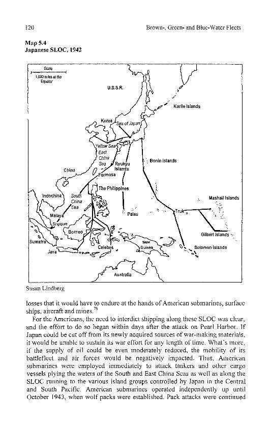
120 Brown-, Green- and Blue-Water Fleets
Map 5.4 Japanese SLOC, 1942
Susan Lindberg
losses that it would have to endure at the hands of American submarines, surface ships, aircraft and mines.76
For the Americans, the need to interdict shipping along these SLOC was clear, and the effort to do so began within days after the attack on Pearl Harbor. If Japan could be cut off from its newly acquired sources of war-making materials, it would be unable to sustain its war effort for any length of time. What's more, if the supply of oil could be even moderately reduced, the mobility of its battlefleet and air forces would be negatively impacted. Thus, American submarines were employed immediately to attack tankers and other cargo vessels plying the waters of the South and East China Seas as well as along the SLOC running to the various island groups controlled by Japan in the Central and South Pacific. American submarines operated independently up until October 1943, when wolf packs were established. Pack attacks were continued
Naval Warfare on the High Seas 121
against Japanese shipping right up until the end of the war. As already mentioned, the geographical configuration of Japan's SLOC presented several choke points that became focal points of American submarine activity. The most notable of these was the 200-mile-wide Luzon Strait separating Luzon, the northernmost island in the Philippines, from Formosa. Although tested by several American submarine captains in 1942, the U.S. Navy's submarine command did not formally decide to concentrate a major effort against shipping in this area until the fall of 1943. Once the offensive was begun, however, the success rate of U.S. submarines there was substantial. Japanese convoys were attacked by individual boats as well as packs. As Parillo states,
That summer (1944) they (U.S. submarines) turned it into a graveyard for Japanese merchantmen. In one two-week period US submarines sank 100,000 tons of shipping in the straits, plus three coast defense vessels, two destroyers, and an escort carrier. These phenomenal results instilled an unshakable dread of the place in Japanese merchant seaman. Convoys began traversing the strait only in daylight and only by hugging the coast of Luzon; the merchantmen hoped the twin dangers of sunlight and shallow water would discourage the American predators. But waiting for daylight and picking a way through the coastal waters took time, further reducing the efficiency of the shrinking cargo fleet.77
By the fall of 1944, as the Americans moved up through the Philippines archipelago and constructed or reoccupied airfields there, aircraft joined the submarines attacking shipping in the Luzon Strait. With the fall of Luzon in early 1945, the SLOC between Japan and Southeast Asia were all but completely severed. Meanwhile, the Americans had also eliminated the SLOC to Japan's remaining island positions beyond the Bonins by this time. The remaining outposts that had been bypassed in the "island-hopping" offensive were supplied by Japanese submarines. By the spring of 1945 the Americans had succeeded in reducing Japanese merchant shipping to slightly over 2 million tons. Most of this was confined to the SLOC running between Japan and mainland Asia through the Yellow Sea and Sea of Japan and to the waters immediately adjacent to the Home Islands and south to the Ryukyu Islands. There was also a minor SLOC that still connected Japan with the Kurile Islands to the northeast. Beginning in April 1945, a full-scale blockade was instituted by the Allies (Britain now having joined in the final push on Japan). Submarine activity was directed against the few remaining merchant and naval targets in these areas around Japan as part of this initiative.78 From a geographical standpoint, the most challenging of these areas was the Sea of Japan, which is virtually a landlocked body of water to the west of Japan. The distance across it from Korea to Japan is a mere 550 miles. For much of the war shipping in the Sea of Japan was believed to have been relatively safe from submarine attack. The numerous airfields in the Home Islands theoretically presented a formidable ASW threat, and any submarine wishing to attack ships therein would have to transit through one of several narrow straits connecting it with the Pacific.79
Each of these was shallow and presumed to be heavily patrolled and even mined. If a submarine made it past these defenses, it would surely face even

122 Brown-, Green- and Blue-Water Fleets
stiffer opposition on the trip out. In spite of these challenges, several American submarines were sent into the Sea of Japan in the summer of 1943. Through a combination of diversionary tactics and by following Russian ships through the La Perouse Strait, these submarines were able to successfully enter the sea and sink a total of 10 ships (29,000 tons). All of these boats managed to escape back through the strait to safety. The results of this foray were deemed disappointing and not worth the risk, so no more American submarines ventured into this area again until the last three months of the war. Between May and July 1945 American submarines managed to sink 39 ships (86,282 tons) in the Sea of Japan.80 These were the last significant losses inflicted on the Japanese merchant marine in World War II.
The war against Japan's merchant shipping was a major component of the Allied strategy in the Pacific during World War II. A major determining factor in the outcome of this conflict was the ability of the Allies to gain sea control over the areas through which Japan's vital SLOC passed, and conversely, Japan's failure to do so with respect to Allied SLOC. Through a combined effort by Allied aircraft, surface ships, submarines, and mines, Japan's SLOC, which totaled in excess of 18,000 route miles throughout the Pacific, was reduced to less than 5,000 by war's end. Likewise, of the 47 officially designated convoy routes only 12 remained partially open by August 1945.81 As mentioned previously, Japan began the war with approximately 6.4 million tons of merchant shipping. By mid-August 1945, that total had been cut to just under 1.5 million, a reduction of approximately 77 percent. Of the losses inflicted on Japan's merchant marine, Allied submarines accounted for approximately 59.5 percent of the total.82 The geographical configuration of the Western Pacific coupled with the distances involved worked against Japan in all respects and ultimately sealed its fate in the face of overwhelming Allied (mainly American) military and naval power.
LOGISTICS AND NAVAL WARFARE IN WORLD WAR II
As already mentioned, logistical support is the key to the mobility and sustainability of naval forces operating on the high seas. In no conflict was this more the case than World War II, especially in regard to the Pacific theater. Duncan Ballantine, the renowned chronicler of U.S. Navy logistics in World War II, points out a fundamental geographical truth when he states that "the distinguishing quality of the environment in which naval warfare is carried on is its lack of any of the resources required to sustain a naval force."8j As a consequence of this condition, naval forces must rely on external sources for logistical support on the high seas. Logistical requirements are determined by a set of complex, interrelated factors that include the geographical configuration of the operational area involved, and the relative and absolute locations of belligerents, bases, and objectives, as well as the types of naval, air, and ground forces involved in the conflict. Issues of economics and quantity also have a bearing on logistical needs. Specific logistical needs of naval forces are numerous, ranging from provisions, spare parts, medical supplies, ammunition,
Naval Warfare on the High Seas 123
communications equipment, and replacements of equipment and personnel lost through operational and combat causes. Fuel, however, constitutes the primary logistical need of modern naval forces. It is the lifeblood of modern warships, and without it, such forces are useless. The advent of steam-powered warships brought about the need for forward bases to provide first coal and then oil. Throughout World War II, the need for fuel to keep the huge fleets of the combatant nations operational was a preoccupying factor and was a constant regulator of operational activities.
While both the Atlantic and Pacific theaters presented logistical challenges to the Americans, these challenges were far more daunting in the latter. First, the length of the SLOC between the United States and Great Britain was considerably shorter than what the former faced in the Pacific. For example, the distance between New York and Liverpool was 2,893 nautical miles, but that separating San Francisco and Sydney was 6,971 nautical miles. Likewise, the SLOC linking the U.S. Navy's main naval base at Pearl Harbor with operational areas in the Western and South Pacific averaged in excess of 3,000 nautical miles. These distances resulted in much higher time-distance ratios and in higher fuel requirements. Second, in the Atlantic American naval forces had well-established, relatively secure bases in both the United States and Great Britain upon which to rely. Additional bases in Iceland, the Caribbean, and, after 1942, Brazil and North Africa further enhanced the logistical infrastructure of the Allies in this theater. Meanwhile, from the outset of the conflict, the Pacific presented the Americans with few sizable or truly secure anchorages, let alone bases between Pearl Harbor and Australia-New Zealand. Again quoting Ballantine, "the measure of our effective operating range was now our ability to project supporting elements outward into an area which offered no resources but widely scattered fleet anchorages and unprepared positions."84 Third, already lengthy SLOC were rapidly and continuously extended as the American offensive across the Pacific progressed. Thus, as time went on, American forward-deployed forces pulled farther and farther away from their primary base of support at Pearl Harbor. For example, between the Gilbert Islands campaign in November 1943 and that against the Marianas in mid-1944, the SLOC from Pearl Harbor was extended by 1,150 nautical miles to over 3,300 nautical miles. Fourth, the sheer magnitude of logistical requirements for the war being waged in the Pacific exceeded all prewar estimates. The size of the fleet and the number of air and ground assets involved necessitated a monumental logistical effort in terms of both materials needed and ships to transport them. The logistical requirements to sustain the support forces themselves exceeded those of all U.S. naval forces operating in the Atlantic. Finally, the ever-pressing need to increase the sustainability of U.S. naval forces in the Pacific so that they could maintain pressure on Japan and exploit its weaknesses created a very unique set of logistical challenges. The pattern that the American offensive took on beginning in early 1944, where preparations such as carrier air strikes and preinvasion bombardments would take place while other units were finishing up the previous operation, necessitated simultaneous logistical support of forces in geographically separate areas. This, more than any other factor, resulted in the

124 Brown-, Green- and Blue-Water Fleets
development of a revolutionary logistical system by the United States that would contribute to the ultimate defeat of Japan as much as any battle or innovation in warship design.
This system combined two elements that not only met the substantial logistical requirements of American forces throughout the Pacific but also greatly increased the mobility and sustainability of those forces. The first element was a series of mobile afloat logistical bases consisting of various types of auxiliary and service vessels such as repair and salvage tenders, storage ships, station tankers, hospital ships, barracks ships, tugs, and floating dry docks. These bases required a reasonably sized anchorage capable of accommodating both the support vessels and the warships utilizing them. Requirements for solid ground were limited to area for an airstrip and certain shore-based activities such as recreation, administration, and some repair activities. The numerous small atolls and coral islands of the Pacific were ideal to support these afloat bases. The key to the success of these bases, however, was their mobility. They were designed to move forward along with the fleet. As the offensive moved farther westward across the Central Pacific, old positions were abandoned, and the afloat service units would be moved to a new location closer to the next objective. This system began with the creation of Service Squadron Four in October 1943 which was stationed at Funafuti in the Ellice Islands to support operations against the Gilbert and Marshall Islands. Once these objectives were secured, the mobile afloat base was moved to Majuro in the Gilberts (February 1944) and then to Eniwetok (June 1944).85 By October 1944 the squadron had been moved again to Ulithi, a further 1,350 nautical miles to the west. In January 1945, with the capture of Leyte, a second mobile afloat base was established to service the growing fleet then moving against Iwo Jima. A separate base was established at Kerama Retto in March 1945 to support the landings on Okinawa. Once secured, the base was moved to Buckner Bay on the eastern side of the island. Table 5.1 shows the distance of each of these mobile afloat bases from Pearl Harbor and how each significantly increased the mobility of U.S. naval forces.
The second element was the institution of large-scale at-sea replenishment of fleet units in or very near forward operational areas. Underway replenishment had been developed by the U.S. Navy during World War I, but had been used only to a limited extent in the interwar years. With the advent of the Central Pacific offensive in late 1943, the ability to refuel large numbers of warships so that they could remain engaged with the enemy in forward areas became necessary. Even with the mobile afloat bases located much closer to these operational areas, the time required for fleet units to withdraw to them to refuel was counterproductive. Underway refueling of carriers, battleships, and cruisers became the norm by late 1943. Service Squadron Six was established in November 1944 to operate alongside the American fleet pushing across the Pacific. Fleet units would rendezvous with auxiliary units to refuel and resupply every three to five days. Smaller fleet units such as destroyers would then be refueled from these larger warships. The importance of both the mobile afloat bases and the underway replenishment groups is illustrated by the substantial

Naval Warfare on the High Seas 125
Table 5.1 Mobile Afloat Bases in the Pacific During World War II
Base Location Nautical Miles from Pearl Harbor Funafuti, Ellice Island 2,260 Majuro, Gilbert Island 1,975 Eniwetok, Marshall Island 2,350 Ulithi 3,700 Leyte, Philippine Island 4,500 Buckner Bay, Okinawa 4,430
increase in the number of auxiliary and service vessels added to the U.S. Navy during the war. In 1940 there were approximately 50 such vessels (all types) in the U.S. fleet. By the end of the war, this number had grown to nearly 400. Of particular significance was the addition of nearly 60 oilers, 40 ammunition and stores ships, and nearly 150 repair ships and tenders of various types.
It is worth our while here to briefly summarize the benefits that the U.S. Navy gained through the existence of this impressive logistical system. First, the increase in mobility and sustainability that fleet units gained is obvious. These gains significantly enhanced their strategic and tactical capabilities and allowed the United States to project naval and military power far beyond the reaches of its shores and major forward base at Pearl Harbor. Second, this system allowed fleet units to avoid having to interrupt offensive operations in order to return to base for refueling and reprovisioning. The best example of this is the fact that after 1943, American carrier groups never had to return to Pearl Harbor and remained forward-deployed until the end of the war.86 Third, the proximity of mobile afloat bases aided in the survivability of damaged ships. By reducing the distances that they needed to travel, either under their own power or towed, to receive emergency repairs greatly increased the likelihood that they would survive and return to combat in short order. Turnaround times for repairs were surely reduced because of the services provided by forward-deployed auxiliary units. Fourth, the time involved in refueling and resupplying fleet units was significantly reduced in terms of both transit times to and from supply points, and how long it took to get the job done. Reducing the latter decreased the vulnerability of both fleet and service units involved to enemy attack while conducting such operations. Finally, the ability of American fleet units, especially carriers, to remain not only forward-deployed but also fully supplied with fuel, ammunition and other vital provisions allowed for unrelenting pressure to be exerted against Japan throughout the Pacific theater. This pressure kept Japan constantly off-balance and always simply reacting to each new American initiative rather than planning strategically sound countermovements. Recovery time both materially and psychologically was a luxury that the Japanese lacked as a result of the Americans' ability to keep its forces forward-deployed from 1943 onward.
126 Brown-, Green- and Blue-Water Fleets
SUMMARY AND CONCLUSIONS
Many factors influenced the development and conduct of American and Japanese strategies during World War II. Political objectives, economic capabilities, weapons technology, leadership assets, manpower availability, and, last but not least, geography all played a part in determining how the belligerents employed their armies, navies, and air forces to achieve specific goals against one another in the Pacific. These factors did not remain constant throughout the war, and, as a result, neither did the strategies that they molded. Ever-changing conditions brought on by increases and decreases in capabilities resulted in major shifts in strategy and tactics on a grand scale as well as on the sublevels of land, sea, and air. For the Americans, most of these changes, such as advances in electronics and weapons technology, logistics, ship design, and industrial production, were positive, and for the Japanese less so, thus providing a possible explanation for the ultimate outcome of the Pacific War.
The grand strategies of Japan and the United States differed greatly during the war. From the outset, Japan's strategy was one of limited objectives achieved through a limited war. Its strategy never envisioned the total defeat of the United States. By swiftly gaining its initial limited, although vast, territorial objectives and establishing a strong defensive perimeter around them, Japan felt that it could quickly bring about a negotiated peace with the United States. As a result of this belief, Japan's grand strategy was geared more toward conducting a short campaign against the Americans as opposed to a total war of extended duration. Japan was neither prepared nor equipped to conduct such a war. Its initial lack of resources, production capability, reserve strengths of airpower, personnel, and shipping only increased as the war progressed. Wartime production was inadequate to meet virtually any of Japan's military needs.
Japan's reliance on an extended defense perimeter was inherently defensive from the beginning. Other than its initial offensive, aimed at gaining control of Southeast Asia and the Indies, Japan lacked an offensive strategy to actively move against the Americans. This was due to its aforementioned faith in the defensive perimeter and its ability to dissuade the Americans from making an attempt to regain their prewar positions in the Pacific. Once the Americans took up this challenge, Japan was without an effective offensive strategy to counter their advances. What was worse, by establishing such a geographically expansive perimeter, Japan could never hope to defend it adequately with the resources that it had available. Like the Allies in their initial defensive strategy in the South Pacific in December 1941, by trying to defend everywhere, they ended up defending nowhere. Japan had overreached itself, with disastrous results.87 By the time that the Japanese had decreased the extent of this defensive perimeter, by necessity to the Ultimate National Defense Sphere, it was too late. This perimeter became the point of contact at which the balance of forces finally and decisively shifted against the Japanese to an extent that moral and psychological factors could no longer offset them.88
American grand strategy, while being somewhat defensive at the outset, quickly shifted to one of all-out offensive warfare against Japan. Although committed to
Naval Warfare on the High Seas 127
the concept of defeating Germany first, the United States sought to establish an offensive momentum against Japan nearly from the start. This idea of an unrelenting advance against Japan was critical in not allowing its forces to regroup or revitalize themselves. Once the decision had been made to settle for nothing less than unconditional surrender, America's offensive in the Pacific was geared toward the total defeat of Japan. This advance was based upon a steady move westward across the Central Pacific as envisioned in the prewar Plan Orange. This main effort was supplemented by an equally strong push north from Australia through the islands of the South Pacific. The two-pronged offensive strategy proved decisive against Japan due to its inability to defend adequately more than one point at a time.
As can be seen from this brief description of the two nations' grand strategies, one was an offensive strategy developed out of an initial position of inferiority, while the other was a defensive strategy coming from an initially superior position that quickly degenerated into one of desperate inferiority. Due to their relative strategic positions, there was a great disparity between the two in their abilities to make mistakes and recover from them. Owing greatly to its vast material superiority, particularly after 1943, the United States could afford to make mistakes and not be adversely affected, yet it made few of them. The Japanese on the other hand, due mainly to their material inferiority, could ill afford mistakes yet made many.
In addition to its grand strategies, each side also conducted distinct land, sea, and air substrategies. These were affected by many of the same factors that affected the grand strategies, including geography. For the most part, American land strategy in the Pacific revolved around the capture of small, strongly held island positions. During the first two years or so of the war the land offensive in the South Pacific was one of advancing step by step through the Solomons and New Guinea. Japanese strongholds were captured through direct assault. This process was slow and very costly. As the war progressed, the Americans began targeting points of Japanese weakness while bypassing their strongholds such as Rabaul. This strategy of leapfrogging or island-hopping was used throughout the Central Pacific as well. By cutting off and isolating large contingents of Japanese forces in this way, the Americans not only conserved their own forces but made it necessary for the Japanese either to abandon their troops or undertake costly operations to resupply or evacuate them.
With the development of the bypassing strategy, the American advance in the Pacific gained momentum and progressed relatively quickly. The overall advance became the main focus as opposed to individual island objectives. Many factors were involved in making this strategy possible, including the development of the fast carrier task groups to provide air cover when land-based air cover was unavailable, the mobile sea train to supply these rapidly paced operations, and the amphibious forces with their numerous specialized landing vessels and troop transports.
128 Brown-, Green- and Blue-Water Fleets
Japan's land strategy was centered around attempting to adequately defend its many island possessions that made up the defensive perimeter. By establishing heavily fortified positions supported by local-land based airpower, Japan hoped to make the perimeter impregnable. In reality, these strongholds became so many points of weakness that were difficult to maintain and easily cut off and bypassed or neutralized from the air by the Americans. As the Americans closed in on Japan's inner ring of defenses, Japan's strategy became one of buying time for the Home Islands by making intense, well-organized ground defense efforts supported by massive airpower, usually kamikazes. These operations were carried out to the last man, and, while not stopping the American advance toward Japan, they did succeed in slowing it down.
At sea a major objective of America's strategy was keeping its extended lines of communication open with Hawaii, Australia, New Zealand, and its advancing forces both in the Central and South Pacific. At the same time, a campaign was carried out to cut Japan's lines of communication with its supply of resources in the Indies and Southeast Asia and with its many island outposts. The American strategic concept of obtaining command of the sea was a multifaceted one involving a coordinated effort by sea, land, and air. In many cases command of the seas was, if not obtained by, at least retained through air superiority. This, in turn, was often made possible by land forces' securing suitable sites for airfields. While not relying solely on the presence of large naval forces to ensure command of all sea areas, the U.S. Navy could be more flexible in meeting other objectives.
Japan's strategy of command of the sea was built almost exclusively on the concept of the decisive battle. In its view, the best way to obtain control over the Pacific Ocean was to defeat the U.S. fleet in a massive engagement reminiscent of Jutland. Throughout the war, the Japanese sought every opportunity to force just such an encounter. Yet, when opportunities arose, such as at Midway and at Leyte Gulf, instead of consolidating their naval forces in order to meet strength with strength, they divided their forces in elaborate and complex maneuvers. Japan's failure to obtain control of the sea not only resulted in its having many of its advanced island outposts cut off and isolated but also made it impossible to adequately secure its lines of communication. Instead of expending its naval forces in fruitless attempts at defeating a superior enemy, perhaps Japan should have placed a greater effort on securing these lines of communication, which would have aided its war effort much more than defeating an American naval force that could be rapidly rebuilt anyway.
America's air strategy in the Pacific was based on gaining local air superiority by any means possible. Initially, this was dependent upon establishing a series of advanced airfields both in the South and Central Pacific. The lack of carriers and the initial reluctance to use them made this strategy sound. However, as more carriers came on line and as the advance in the Central Pacific moved rapidly out in front of land-based air cover, carrier airpower became the primary method of establishing air superiority over an area. This mobility of airpower allowed the Americans to concentrate their air strength rapidly and where needed most. As
Naval Warfare on the High Seas 129
stated previously, this flexible air superiority also aided in establishing command of the sea often far in advance of naval surface units.
Strategic bombing also figured prominently in the American air strategy, especially during 1944 and 1945. With the advent of the long-range B-29 and airfields in the Marianas from which to fly them, strategic bombing became a viable option as a means to strike the industrial centers of Japan. Not since the small-scale Doolittle Raid had U.S. aircraft bombed the Home Islands, and with B-29s the effects were devastating. Strategic bombing became a major element in bringing Japan to total defeat. Many military planners believed that an invasion of the Home Islands would not be necessary due to the success of the bombing campaign. This notion is probably not true. Despite the claims of similar proponents of strategic airpower in Europe, Germany was able to carry on a stubborn campaign in defense of its home territory for quite some time after most of its industry had been destroyed by Allied bombers. Japan would have been no less likely to do the same.
Like its grand strategy, Japan's air strategy was basically defensive. Airpower figured prominently in Japan's ability to defend its perimeter. Land-based airpower was to strike out from the perimeter to destroy American naval forces before they reached the island strongholds. Repeatedly, the Japanese attempted to turn back American invasion forces with massed air attacks. In no case were these efforts successful. Japan's initial advantages in the air were quickly diminished due to heavy losses of planes and pilots at Midway and in the South Pacific. Its inability to replace these air resources as the war progressed made it virtually impossible for Japan to gain air superiority against ever-increasing American airpower.
Unlike American airpower, which was based on mobility, Japan's airpower, by and large, was static. After the loss of much of its carrier airpower in 1942, Japan relied on its so-called unsinkable carriers on the Central Pacific Islands to provide air cover for defensive operations. This land-based airpower became an easy target for the mobile American carrier task groups. Unable to maneuver away from advancing American forces, these units were bypassed and then neutralized by the very air forces that they were designed to defeat. In this way Japanese strongholds such as Rabaul and Truk were eliminated not only as bastions of airpower but also as major naval facilities.
Distance was by far the most critical geographic factor affecting both sides in the Pacific. The vast expanses of open ocean presented a formidable obstacle to success for both Japan and the United States. The success of the latter in the Pacific War was due largely to its ability to overcome the effects of this obstacle. For the Americans, the distance factor meant maintaining lines of communication stretching for thousands of miles across open ocean. This effort was most demanding of its time and resources during the first year or so of the war. After that, maintaining these lines became somewhat easier because of Japan's lack of interest in cutting them. Nonetheless, throughout the war, maintaining secure lines
130 Brown-, Green- and Blue-Water Fleets
of communication with its forces in the Pacific was of vital concern to the United States.
Distance between objectives and basing facilities was also a major geographical factor affecting American strategy in the Pacific. As objectives became further removed from the major American bases in Hawaii and Australia, a whole new set of problems developed. This was particularly true in the Central Pacific where great distances between objectives and rear bastion bases were the norm. The key to the Central Pacific, campaign was mobility. American military planners could not allow their rapid advance to be slowed because of a necessity to wait for new bases to be built after each operation. To overcome this problem, mobile sea trains were developed to support the fast carrier and amphibious groups while mobile forward bases were established periodically to provide intermediate support facilities to all American forces. Problems of distance in regard to air cover also needed to be overcome and were overcome by increased reliance upon carrier aircraft and the development of new types of long-range bombers such as the B-29.
A major factor of distance affecting the Japanese in the Pacific was their defensive perimeter. Its very size made it virtually impossible to defend. Encompassing such a vast area widely separated from the Home Islands made its supply and reinforcement a major effort. Adequate forces were available neither to defend the perimeter itself nor to protect those forces trying to resupply it. The distance between Japan and its fuel supplies in the Indies, combined with its inability to keep the sea lines of communication open between the two, also created serious problems for Japan. The Combined Fleet was unable to maintain its presence in home waters or in the Western Pacific due to a lack of fuel. The fleet had to be moved back closer to its fuel supply in the Indies. As a result, it was not centrally located in the Western Pacific, which would have provided a better position from which to respond to American advances across the Central Pacific.
Many differences between the South and Central Pacific areas resulted in the development of strategies unique to each area. The waters surrounding the islands of the South Pacific were much more restricted than those of the Central Pacific. Those of the latter facilitated operations by large naval forces, while those of the former were better suited for operations by submarines and small naval forces such as destroyers and PT boats. As already alluded, distances between objectives were much greater in the Central Pacific than in the South Pacific. Forces operating in the South and Southwest Pacific were never that far from large bastion bases in Australia. Just the reverse was true in the Central Pacific, where the nearest bastion base was seldom less than 3,000 miles or more away. In the South Pacific, forces were seldom out of the range of either friendly or enemy land-based airpower, while in the Central Pacific land-based airpower was often not a major factor in operations.
Overall, the Central Pacific was an environment conducive to naval operations, while the South Pacific was a more land-oriented theater. This is reflected in the decision to select an admiral to command the former and a general to command
Naval Warfare on the High Seas 131
the latter. The U.S. Navy and Marine Corps dominated operations in the Central Pacific, while the U.S. Army and its subordinate Air Corps took the lead in the South and Southwest Pacific. Of course, this is not to say that both services did not contribute significantly to the other's main theater of operations but simply that a majority of forces employed in each and the tactics used favored one or the other.
One final aspect of the relative geographic positions of the two adversaries in the Pacific that should be touched upon is interior versus exterior position. From the beginning Japan occupied the interior position, while the Americans were clearly coming from an exterior position. From a naval standpoint the interior position should be the more advantageous. The movement of forces and the security of one's lines of communication are usually easier to ensure when occupying an interior position. For the Japanese, however, this was not the case. As we have seen, the penetration of these interior lines by American submarines and long-range bombers negated much of the advantage of interior lines. Also Japan discovered that it is difficult for a country acting on interior lines to force a decision, the chief reason being that the farther you push your enemy back, the more difficult it is to surround and destroy him.89 This is precisely what happened to the Japanese. They were able to push the Americans back out of the Western and Southern Pacific at the beginning of the war but were unable to destroy their
* forces.
The United States was ideally situated for operating from the exterior position. The vast open ocean areas allowed it to take advantage of its superior mobility and naval strength. After the first year or so of the war, the distances involved in this exterior position no longer posed a major problem for the Americans. In fact, it allowed them to strike at the Japanese across a wide front and at many different points, thus throwing them off-balance. America's material superiority, coupled with Japan's inability to strike at the normally exposed lines of communication of an exterior position, allowed the United States to turn a generally inferior position into one of superiority.
FALKLANDS/MALVINAS WAR
We now jump forward in time some 37 years to 1982 to examine the best example of naval warfare on the high seas in the post-World War II period. The location is a remote corner of the South Atlantic, although one that has been no stranger to conflict. Twice before, once during World War I and again in World War II, the Falkland Islands were the scene of naval engagements on the high seas. In April 1982 Argentina, wishing to enforce its long-standing claim to the islands (which it called the Malvinas), launched a combined amphibious and air invasion. In addition to occupying the Falklands, it landed troops on South Georgia Island. Great Britain, which had occupied both island groups since 1833, responded quickly and dramatically. A sizable naval task force that included an amphibious landing force of some 7,000 Royal Marines and army personnel, supported by numerous Royal Fleet Auxiliary ships as well as merchant "ships taken up from trade," headed for the South Atlantic to regain

132 Brown-, Green- and Blue-Water Fleets
control of the islands by force. Set to meet this armada was the well-equipped, sizable Argentine air force and navy, which included modern aircraft (both carrier and land-based) capable of maritime strike operations (with bombs and Exocet missiles), an aircraft carrier, submarines, and numerous surface warships including a light cruiser, destroyers, and frigates.
The stage was set then for what would likely be the first major fleet-to-fleet engagement on the high seas since 1944-1945. The task facing Britain's Royal Navy (and Air Force) was formidable, to say the least. Operating along SLOC that stretched some 6,800 nautical miles, the final several hundred miles of which were likely threatened by Argentine submarines, sustainability was a major challenge (see Map 5.5). Logistics, as we see shortly, would play a major role in enabling Britain to wage a successful campaign. Apart from getting the naval, air, and ground assets to the area safely and quickly, Britain had to secure sea control around the islands before it could launch an amphibious invasion. In order to accomplish this, it would have to draw out and defeat the Argentine fleet, neutralize the submarine threat, and protect the landing force from air attack. Then, it would have to land an invasion force very possibly in the face of strong enemy opposition and support it once ashore. No small task for any navy, let alone one that was operating so far from home. In addition, it would be imperative for Britain to cut Argentine sea and air lines of communication connecting the islands with the mainland. They were successful in cutting the former but much less so in the case of the latter.
Argentina, on the other hand, after having landed and reinforced an invasion force of nearly 13,000 troops, would have to keep them supplied and offer some degree of protection from the British offensive. The distances involved for Argentina were much less daunting than those of its adversary, averaging between 380 and 800 nautical miles from the nearest air bases and port facilities on the mainland.90 However, this still necessitated midair refueling for most of its aircraft flying to the islands, and the SLOC would have to be protected against possible British submarine activity as well as air and surface attacks. Furthermore, once the British task force was in the region, attacks on the Argentine mainland were theoretically possible, a prospect that the former never had to consider.91
Many of the operations carried out by the British during this conflict do not qualify as, or truly constitute, naval warfare on the high seas. Instead, they fall more within the domain of littoral-type operations, as discussed in Chapter 6 (amphibious landings, naval gunfire support, and air support of ground forces). Here we focus on those aspects of the Falklands conflict that fit the description of naval warfare on the high seas as presented in this chapter. The potential for commerce warfare was slight, at best, in this conflict. Neither side ever contemplated targeting the merchant shipping of the other on a global or even regional basis. Argentina, in reality, had a very limited capability even to threaten shipping within the war zone, let alone beyond it. Britain's strategic goals focused on recapturing the islands and not on conducting a general war against Argentine interests beyond the immediate war zone. As a consequence of these facts, the protection of shipping (apart from normal fleet defensive

Naval Warfare on the High Seas 133
Map 5.5 Falkland/Malvenas War
Susan Lindberg

134 Brown-, Green- and Blue-Water Fleets
operations and Britain's defense of its landing and support forces) was not an issue either. Thus, that leaves us with fleet engagements and ASW as they relate to attempts by both sides to achieve sea control and sea denial. As a first step to achieve sea control, both sides declared a 200-nautical-mile exclusion war zone around the Falklands. Britain would eventually extend this zone all the way up to the edge of Argentina's territorial waters. In effect, by doing this, Britain established a blockade of the islands that effectively halted nearly all efforts by Argentina to support its positions by sea for much of the conflict. The initial enforcers of this blockade were three Royal Navy SSNs. These were the only ships in Britain's inventory with the sustainability to maintain this blockade almost indefinitely, and they proved very effective in this role. While Argentina lacked large numbers of submarines (none of which were nuclear-powered), they did have the advantage of a favorable relative location to their bases and could have rotated surface and subsurface units in order to maintain their declared exclusion zone.92 However, as we shall see, events did not play out in such a way as to permit them to do so.
FLEET ENGAGEMENTS
From the beginning of the Falklands conflict, it was clear that regardless of the role that Argentina's navy would have in thwarting Britain's attempts at regaining control of the islands, a significant role would have to be played by its air force. This force, both in numbers and types of aircraft, was much better equipped for conducting air attacks against British naval and ground forces. The surface strike capability of the lone Argentine carrier consisted of only eight A-4B Skyhawk aircraft.93 Thus, from the initial stages of the conflict Argentine air force aircraft were involved in maritime strike missions against the British task force. The aircraft were based at several different airfields both on the Falkland Islands and on the Argentine mainland.94 In general, these mainland airfields were within 380 to 450 nautical miles from the islands, which meant that multiple air strikes could be launched each day from them. Owing to media publicity as well as declarations from the British government, it was no secret that a sizable Royal Navy force was heading for the Falklands.95 Thus, when the main British task force arrived on May 1, Argentine naval and air forces were deployed to meet it.
On 2 May came the prospect of the largest fleet-to-fleet engagement since World War II. Before dawn, the British task force, which included two carriers equipped with Sea Harrier aircraft, was positioned 80-nautical-miles northeast of Port Stanley and was streaming to the southeast (away from the main Argentine naval force). Its picket screen was extended out another 60 miles toward the northwest. In addition, two Royal Navy SSNs were stationed to the north and northwest of the task force. A normal combat air patrol was deployed to protect the fleet. The Argentine fleet was deployed in four task groups. Task groups 79.1 (one carrier and two Exocet-equipped destroyers) and 79.2 (two Exocet-equipped destroyers) were positioned to the northwest of the British task force, while a third, TG 79.4 (three Exocet-equipped frigates), was located directly to
Naval Warfare on the High Seas 135
the north of these groups. The fourth task group (79.4), which included the cruiser General Belgrano and two Exocet-equipped destroyers, was south of the Falklands just outside the British 200-nautical-mile exclusion zone heading north. This last task group was being tailed by the Royal Navy (RN) SSN Conqueror. The British were in full anticipation of a dawn attack. The Argentine commander's plan was to execute a dawn air strike against the British task force using his carrier-based Skyhawks and air force aircraft flying from mainland air bases. This would be followed by a surface attack by the destroyers and frigates launching their Exocets. Coordination between the two service branches on this day, however, was not good, and the latter had scheduled only a limited number of sorties.
By dawn the Argentine task groups were 180 miles northwest of the British task force and were ready to launch the initial carrier air strike, but Mother Nature failed to cooperate. Nearly calm winds prevented the Skyhawks from being launched.96 Owing to a combination of the heavy munitions load carried by the aircraft for their strike mission, the distance from their targets and the lack of wind, it was impractical to launch from their position at dawn. The Argentines waited throughout the morning for the wind conditions to improve, but to no avail. By noon all three task groups located to the northwest withdrew to the west to await improvements in wind conditions later in the day. The British maintained their high state of readiness throughout the day, but by late evening when no dusk attack occurred either, they realized that the day's historic prospect of a fleet-to-fleet engagement would not materialize. Meanwhile, another encounter was taking place that would ensure that no such engagement would ever be included in the 1982 Falklands War.
Throughout the day as the carrier groups maneuvered to the north of the Falklands, Argentine task group 74.3 continued to maintain its position to the south of the islands. By evening, the Belgrano and its two escorts were located approximately 100 miles east of Isla de los Estados off Tierra Del Fuego and were actually steaming to the west away from the Falklands. However, the British did not know for certain what the cruiser's intentions were. It was feared that during the night it would change course and either head north toward the Falklands and the British task force or perhaps make a run for South Georgia (which had been retaken by a British commando strike on 25 April), which would be all but defenseless since the British carrier force was still preoccupied with the main Argentine fleet. Permission had been secured earlier in the day from the British government to attack the Belgrano and accordingly, the Conqueror positioned itself for the first torpedo attack by a Royal Navy submarine since April 1945. Two of three torpedoes struck the cruiser, sank within an hour. The Argentine destroyers responded by dropping depth charges, but to no avail, as the Conqueror had quickly left the scene. Apart from quickly quelling any hopes of a negotiated settlement of the conflict, the sinking of the Belgrano had an immediate impact on the Argentine High Command's strategic plans. Notwithstanding the fact that the bulk of its navy had not yet engaged the British, the decision was made on 3 May to withdraw all three remaining Argentine task groups from their forward-deployed positions and into coastal
136 Brown-, Green- and Blue-Water Fleets
waters off the mainland. This decision reflected the High Command's fear of the Royal Navy's SSNs as well as a lack of confidence in the navy's ASW capability. It also highlighted the very real fear of the political fallout from any further losses of Argentina's major naval assets, especially its single carrier. Although the British could not be certain that the Argentine fleet would not sortie again, it did appear to be a distant possibility in light of its rapid withdrawal. This, of course, meant that the British had all but established sea control around the Falklands without suffering any losses. The only real challenge that they would face from this point on was from Argentine air attacks. While these attacks came, taking their toll on the British ships covering the amphibious landings that took place at San Carlos Water, they failed to successfully strike the British carrier task force at any point in the conflict. Thus, just as Japan had failed to successfully execute a strategy of sea denial using only aircraft in 1945 off their Home Islands, so, too, did Argentina fail in its attempt to do the same around the Falklands 37 years later.
Thus, we are left with a great what-might-have-been regarding the post-World War II era's best shot at a fleet-to-fleet engagement worthy of adding to the annals of naval history. Ironically, a combination of geographical and environmental factors precluded this from occurring (as well as a lack of will on the part of the Argentine leaders to try again). If the wind had cooperated, or if the British task force closed the distance between it and the Argentine task groups, the chronology of naval events in this conflict could have been very different, as could, perhaps, its final outcome. Owing to the great distances from British air bases, the loss of even one of its carriers would have severely jeopardized Britain's ability to maintain any level of air defense, let alone superiority over the Falklands.
SUBMARINE OPERATIONS
Apart from the success of the Conqueror, the role played by submarines on both sides in the Falklands conflict was somewhat disappointing. As already mentioned, Britain had a total of three SSNs operating in the Falklands in early May.97 In fact, the first British warships in the area were these three boats. However, neither of the SSNs that were stationed to the north-northwest of the British task force on May 1-2 was able to make contact with the Argentine fleet. In addition, because of their size, they were unable to conduct attacks on Argentine vessels in the shallow and geographically cluttered coastal waters off the mainland. The Royal Navy submarines remained in theater throughout the conflict but failed to execute any more attacks on Argentine shipping of any kind. Furthermore, these boats proved to be of limited value as surveillance platforms despite efforts to use them to provide early warning to the task force of incoming air attacks. Since the Argentine fleet failed to sortie again after the aborted engagement of May 1-2, the SSNs were not tested in their role of providing long-range surveillance against surface raids to the task force. At the same time, though, credit must be given to these SSNs for their deterrence
Naval Warfare on the High Seas 137
presence, which effectively convinced the Argentinean leaders to keep their navy in home waters after 2 May.
The performance of Argentina's submarine force was even more disappointing. To begin with, one of its three boats did not even deploy during the conflict due to mechanical problems. A second boat, the Santa Fe, was put out of action prior to the arrival of the main British task force when it was caught on the surface near South Georgia on 25 April and attacked by British Lynx helicopters operating from two RN frigates. The remaining Argentine submarine, the San Luis, was able to give the British some minor problems. Forward-deployed in the vicinity of the Falklands from early April, the San Luis was able to shadow the British fleet for much of the first two weeks that it was in theater. The knowledge that at least one Argentine submarine was on the loose caused the British task force to remain ever vigilant against possible attack. This vigilance paid off on 1 May, when two Royal Navy frigates detected the San Luis attempting to close in on the main task force from the northwest. A coordinated attack by Sea King helicopters and the frigate's ASW weapons was successful in driving the submarine off. On only one occasion did the San Luis actually come within close enough range (and remain undetected) of any British ships to actually launch a torpedo attack. On its last day on station northeast of East Falkland Island, 11 May, the submarine was able to fire a single, wire-guided torpedo at two Royal Navy frigates that were returning to the main task force after having engaged an Argentine supply ship off West Falkland Island.98
The guidance wire broke, but the torpedo continued on its course, striking the towed torpedo decoy deployed by one of the frigates. The San Luis was unable to position itself in time to make a second attack, and the British ships (which were unaware that they had even been under attack) continued on their course eastward. Shortly after this engagement, the submarine returned to Argentina, thus leaving the Falkland Islands and especially the approaches to Falkland Sound unpatrolled for the remainder of the conflict, including at the time of the British amphibious assault.
LOGISTICAL SUPPORT OPERATIONS
We cannot complete our discussion of the Falklands War without highlighting the role that logistical support played. Relative location would appear to have given the Argentineans the advantage in providing logistical support to its forces in the Falklands, but this proved to be partially true. Although Argentinean that this fact conferred upon them. Once the British task force had arrived in the region, nearly all Argentinean seaborne shipments of supplies to the islands ceased and the task of supplying the Argentine army and air force units defending the Falklands was undertaken by seven air force C-130 cargo planes.99 These planes flew in and out of the Port Stanley airfield on many occasions during the conflict and, although harassed by British aircraft (but only infrequently), were able to keep the Argentinean forces fairly well provisioned.
From the outset, the British knew that their efforts to regain the Falklands would hinge upon their ability to provide adequate logistical support to their
138 Brown-, Green- and Blue-Water Fleets
forces operating so far from home. Owing to the geographical remoteness of the Falklands from the British Isles, virtually all direct logistical support of British forces would have to be by sea, at least until the airfield at Port Stanley was retaken. The logistical challenge facing the British was daunting, to say the least. A massive effort was required to support the nearly 50 warships, 10 merchant troop transports, 28,000 men, and dozens of aircraft sent to the South Atlantic during the spring and early summer months of 1982. The anticipated minimum deployment period was three months, and the task force's initial logistical necessities were planned around this time frame. The SLOC over which this effort took place stretched for nearly 6,800 nautical miles, and possible midpoint way stations were few and far between. Ascension Island, located roughly midway between Britain and the Falklands, quickly became the major forward base for the British. Although only 34 square miles in size, this volcanic rock became a major staging area for transfer and distribution of personnel and materials bound for the South Atlantic. A 10,000-foot-long runway could easily handle aircraft in size all the way up to the Royal Air Force (RAF) Lockheed Hercules transports, which carried in excess of 6,500 tons of stores to the island over the duration of the conflict. As an anchorage, however, Ascension left much to be desired. Having only a small stone jetty, ships had to anchor between a quarter and a half mile offshore. While anchored, they were susceptible to heavy swells created by strong westerly winds, thus making operations using small boats between ships difficult. As a result, helicopters were the preferred method of transferring personnel and supplies from the island and between ships. The only other forward base available to the British was South Georgia Island (760 nautical miles east of Port Stanley), which was recaptured on 25 April. This barren, windblown speck of land provided only modest facilities for ships to anchor and no airfield. Throughout the conflict, it served primarily as a place for ships to transfer personnel and equipment.
The main British logistical support effort was carried out using 22 Royal Fleet Auxiliary (RFA) vessels and 30-some "taken-up-from-trade" merchant ships. Included among this latter group were various stores and repair ships, hospital ships, tugs and tankers. Underway replenishment was provided by 10 oilers and five fleet replenishment ships of the RFA. All told, these ships transported and distributed over 100,000 tons of supplies to the British forces. Like the fleet train that supported the U.S. Navy in the Pacific during World War II, this logistical force allowed British naval and air forces to remain forward-deployed in order to apply continuous pressure on their enemy for an extended period of time without having to return to remote bases to resupply. Sustainability was the single most important advantage that the British had over Argentina in this conflict. It allowed them not only to mount a strong effort to achieve sea control but also to maintain this control for the duration of the conflict.
CONCLUSIONS
The Falklands/Malvinas War was, first and foremost, a maritime conflict. Naval forces played a central role and proved once again that naval warfare,
Naval Warfare on the High Seas 139
even on the high seas, is still a reality of modern conflict in the modern age. Equally true is the fact that geographical factors exert great influence upon such warfare and must be dealt with at both the strategic and tactical levels. Several interesting conclusions about naval warfare on the high seas and the role of geography on it in the modern age can be grasped from this case study. First, distance remains the primary consideration of navies involved in warfare on the high seas. The ability of the British to overcome the challenges of distance in this conflict cannot be stressed enough as the key to their ultimate victory. Obviously, logistical support makes this possible and always spells the difference between effective blue-water, power-projection navies and all the rest. Second, nuclear-powered vessels, in this case SSNs, provide an added component of flexibility to the projection of naval power. Owing to their inherent speed and independence from regular logistical support, they have a level of sustainability that is unmatched by conventionally powered vessels. Third, gaining local sea control remains a prerequisite for projecting power ashore. Had Britain been unable to secure such control, there is little chance that it would have been able to regain the Falklands. Likewise, if Argentina had been able to seriously challenge the British capability to maintain this control once they had landed at San Carlos Water, their land campaign may have been seriously jeopardized.
The remaining points about the Falklands/Malvinas War have to do with the contrast between sea power and airpower and land-based and carrier-based airpower in naval warfare on the high seas. Aircraft, even with air-to-air refueling support, do not have the same level of sustainability that ships possess. Specifically, as the Argentine air force discovered, aircraft lack the sustainability needed to achieve and maintain sea control. Furthermore, while they can certainly inflict serious damage on ships engaged in sea control operations, aircraft were unsuccessful in this conflict just as they were in World War II to effectively execute a strategy of sea denial. As to the issue of land-based aircraft versus carrier-based, once again this conflict showcased the advantages that the latter gained (both offensively and defensively) from their inherent mobility and maneuverability. It should be noted that Argentina's failure to utilize the airfield at Port Stanley as a major forward base for its air force deprived it of perhaps the one opportunity to successfully employ aircraft in the sea denial role. As Frank Uhlig Jr. aptly points out, in comparing this situation with that on Guadalcanal in 1942,
Had the Argentine high command, which had an uncontested month in which to act, chosen to do as the Americans did forty years beforehand and made preparation of Port Stanley's field the focus of their logistical effort, and had they then used it to extend the reach of their scouting, fighter and attack aircraft, that field might have played the decisive role Henderson Field had over four decades before, and the Falklands might have stayed the Malvinas.100

140 Brown-, Green- and Blue-Water Fleets
NOTES
l.Gray, 1992, p. 286. 2. Unlike in land warfare, where forces can more easily sustain and recover from
losses, naval forces can be eliminated swiftly through massed surprise attacks. If the first strike is successful, there may well be no opportunity for a retaliatory strike. This is particularly applicable to attacks made by aircraft, missiles, or submarines.
3. The one obvious exception to this, is strategic straits through which ships are sometimes forced to travel.
4. As defined by Hughes, maneuver is "tactical speed and agility." 5. Fixed positions in naval warfare generally do not hold the same advantage as they
do in land warfare. As was illustrated in the Pacific during World War II, Japanese island strongholds were isolated, bypassed, and neutralized by mobile American forces time and again. American carrier-based airpower, by virtue of its mobility, consistently outmaneuvered Japanese land-based air forces. American carriers, again owing to their mobility, were always more difficult to locate and target than Japan's island airfields.
6. See Gray, p. 21, for an explanation of this concept. 7. See G. Kemp, and Robert E. Harkavy, Strategic Geography and the Changing
Middle East (Washington, DC: Brookings Institute Press, 1997), p. 186. 8. Mahan, 1900, pp. 44-45. 9. The Russian fleet resorted to midocean coaling five times on this leg of the voyage.
See R. Hough, The Fleet That Had to Die (London: Hamish Hamilton, 1958). 10. G.A. Ballard, The Influence of the Sea on the Political History of Japan (Westport,
CT: Greenwood Press, 1972), p. 194. (A reprint of the original edition published in 1921).
11. G. Fox, Britain and Japan, 1858-1883 (Oxford: Clarendon Press, 1969), pp. 250-273.
12. The troops were carried aboard British and American steamers specifically chartered (by a Briton in Japanese service) for the mission. The war arose in retaliation for treatment meted out to Ryukyu islanders (over which Japan claimed suzerainty) by Taiwanese aborigines. As a result of British mediation, a treaty was patched up between China and Japan, resolving the issue.
13. Fox, p. 333. 14. Not that the English had it all their way. The stranglehold was broken by the
French, who, by virtue of the tireless efforts of Francis Verny, created the Yokohama Dock Company and the Yokosuka naval shipyard. Note D. Todd, and M. Lindberg, Navies and Shipbuilding Industries: The Strained Symbiosis (Westport, CT: Praeger, 1996), p. 127.
15. Information extracted from R. Gardiner, ed. All the World's Fighting Ships 1860-1905 (London: Conway Maritime Press, 1979), pp. 216-239.
16. J.L. Rawlinson, China's Struggle for Naval Development, 1839-1895 (Cambridge: Harvard University Press, 1967), p. 147.
17. Ballard, pp. 142-143. 18. The commercial importance of the Liaodong ports, superior in many respects to
Vladivostok, is brought out in D. Todd, and Zhang Lei, "Political and Technical Factors Impinging on Port Operations: The Case of Manchuria," GeoJournal, vol. 30, no. 4, 1993, pp. 441-454.
19. Russia had attempted to acquire the port of Wonsan (in modern North Korea) during the 1880s, prompting the British to occupy an island (Port Hamilton) off the southern tip of the archipelago until it desisted.

Naval Warfare on the High Seas 141
20. Events detailed in I. Nish, The Origins of the Russo-Japanese War (New York: Longman, 1985).
21. After the war, questions were raised about the quality of Russian battleships. Note J.N. Westwood, Russian Naval Construction, 1905-45 (London: Macmillan, 1994), p. 4.
22. Corbett, 1911, p. 75. 23. To be sure, the overall strategic geography had drastically changed, since the rise
of the United States and Japan as serious naval powers had nullified the age-old maxim that held that control of European waters led automatically to global sea command. Therefore, even if Germany had prevailed against Britain, Germany would not have assumed global sea command as a matter of course. This point is made in Gray, 1994, pp. 65-66.
24. On first appearances, the maritime containment of Germany presented Britain with an easier task than the one that it had to face when opposing France. The latter always had the option of using the Mediterranean to outflank the British navy, disposing squadrons based there either to reinforce its Atlantic fleet and threaten to overwhelm Britain's Channel Fleet or to break out into great waters and wreak havoc on Britain's far-flung colonies and shipping lanes. Britain, in response, had been forced to divide its fleet, keeping powerful squadrons in the Mediterranean as well as in home waters. Germany's Mediterranean equivalent, the Baltic, was a deadend, easily closed by the same blockading forces used by Britain to contain German activity in the North Sea.
25. Elicited from Gardiner, 1985. 26. The Royal Navy also took over in August 1914 two dreadnought battleships just
completed in British yards for foreign customers. A third, still under construction, was inducted into the Grand Fleet on completion in 1915.
27. Between 1906 and 1914 the IJN did acquire six new battleships, but they were inferior to the dreadnought type.
28. This fact was raised by Paul Kennedy and repeated by Michael Hobkirk. See M.D. Hobkirk, Land, Sea or Air? Military Priorities, Historical Choices (London: Macmillan, 1992), p. 123.
29. The tussle between the two schools is told in A. Saunders, Fortress Britain: Artillery Fortifications in the British Isles and Ireland (London: Liphook, Hants Beaufort, 1989), pp. 190-192.
30. A.J. Marder, From the Dreadnought to Scapa Flow: The Royal Navy in the Fisher Era, 1904-1919, vol. J: The Road to War, 1904-1914 (New York: Oxford University Press, 1961), pp. 344-357.
31. Keegan, 1988, p. 101. 32. Marder, 1961, pp. 40-41. 33. A.J. Marder, From the Dreadnought to Scapa Flow: The Royal Navy in the Fisher
Era, 1904-1919. vol. 2: The War Years: To the Eve of Jutland (New York: Oxford University Press, 1965), p. 45.
34. Although the British enjoyed superb signals intelligence, reading German naval signals traffic with relative ease. The problem was less in breaking German codes and more in coordinating effective responses on the strength of the information so revealed. See R. Hough, The Great War at Sea, 1914-1918 (New York: Oxford University Press, 1983), pp. 123-124.
35. Let it also be borne in mind that coastal geography imposed a marked disadvantage on High Seas Fleet operations. This came about as a result of the sandbars lying off the Elbe and Weser estuaries, shoal waters that hindered passage of deep-draft warships. Indeed, the battlefleet needed two consecutive high tides to fully clear these obstacles, a requirement that was bound to delay its response to British initiatives. The point is noted in Marder, 1961, p. 427.

142 Brown-, Green- and Blue-Water Fleets
36. For a vivid, but balanced, account, refer to Keegan, 1988, pp. 122-155. 37. The U.S. battleships attached to the Grand Fleet in 1917 constituted its Sixth Battle
Squadron. Another two American battleships were stationed at Bantry Bay in Ireland. 38. Marder, 1965, p. 127. 39. The campaign in general is ably covered in C. Miller, Battle for the Bundu: The
First World War in East Africa (New York: Macmillan, 1974). Naval contributions are covered in H. Newbolt, History of the Great War: Naval Operations, vol. 4 (New York: Longmans, Green, 1928), pp. 80-87. For Qingdao and the Japanese Pacific conquests, see E. Dane, British Campaigns in Africa and the Pacific, 1914-1918 (New York: Hodder and Stoughton, 1919), pp. 188-206.
40. Resort was also had to the Q-ship, a small warship disguised as a merchant ship that decoyed a surfaced U-boat within range of its hidden guns. The ruse was initially successful, but in due course the U-boats, warned off, chose to attack from submerged positions. Q-ships accounted for 11 U-boats but at a disproportionately high cost to themselves, losing 31 of their own number. Note Marder, 1965, pp. 355-356.
41. Interestingly, the theory of convoy protection was not clearly understood at this time. The Admiralty preferred to run small convoys, unaware (until 1943) of the statistically valid point that the probability of discovering shipping increases in inverse proportion to the size of the convoy containing it. See A.J. Marder, From the Dreadnought to Scapa Flow: The Royal Navy in the Fisher Era, 1904-1919, vol. 5: Victory and Aftermath (New York: Oxford University Press, 1970), pp. 99-100.
42. Ibid. p. 79. 43. Cited in O. Warner, Admiral of the Fleet: Cunningham of Hyndhope (Athens: Ohio
University Press, 1967), p. 33. 44. This is not to say that aircraft never managed to sink submarines. In 1915 the
French lost a boat in the Adriatic, the victim of Austrian aircraft while in September 1917 an aircraft of the Royal Navy caught a U-boat in the English Channel and sank it. See P. Kemp, U-boats Destroyed: German Submarine Losses in the World Wars (London: Arms and Armor Press, 1997), p. 35.
45. Mines were the biggest single cause of U-boat losses over the full 1914-1918 period, accounting for 61 of the 178 that sank.
46. See Hough, 1983, pp. 314-316. 47. Marder, 1970, p. 96. 48. See Grove, p. 7. 49. Marder, 1970, p. 299. 50. Oil was discovered in Iran—then known as Persia—in 1908, leading to the
formation of the Anglo-Persian Oil Company (now British Petroleum) in 1909. After 1911 oil was fed by a 210-km-long pipeline to Abadan on the coast (where a refinery came on stream in 1913). See Farnie, pp. 520-521.
51. Gray, 1992, p. 238. 52. L. Morton, U.S. Army in World War Two, vol. 2, part 15: The War in the Pacific:
Strategy and Command: The First Two Years (Washington, DC: U.S. Government Printing Office, 1961), p. 5.
53. Ibid, p. 7. 54. Ibid. p. 43. 55. Ronald H. Spector, Eagle against the Sun: The American War with Japan (New
York: Vintage Books, 1985), p. 43. 56. H.P. Willmott, Empires in the Balance: Japanese and Allied Pacific Strategies to
April 1942 (Annapolis, MD: Naval Institute Press, 1982), p. 5. 57. Batteship-against-battleship engagements included the duel between the HMS
Hood and Bismark, the pursuit and sinking of the Bismark, the second Battle of
Naval Warfare on the High Seas 143
Guadalcanal, the duel between the Scharnhorst and HMS Duke of York in the Barents Sea, the battle off Calabria and the Battle of Matapan in the Mediterranean, the duel between the USS Massachusetts and the immobile French battleship Jean Bart at Or an, and the Battle of Surigao Strait. The result of these battles was rather unimpressive; only four battleships (if one counts the HMS Hood, which was actually classified as a battle cruiser) were sunk either solely or in part by other battleships (the Japanese Kirishima and Yamishiro, the German Bismark and HMS Hood).
58. The Battle of Leyte Gulf also involved both American and Japanese carriers (four), but those of the latter were engaged mainly as decoys and carried few aircraft (100 or so); thus, they presented little real threat to the U.S. carriers.
59. At Santa Cruz, the American and Japanese strikes occurred simultaneously and resulted in one U.S. carrier being sunk and two Japanese carriers being heavily damaged.
60. Two other Japanese carriers were sunk by American submarines during this battle. 61. The classic example of this was in the Midway campaign when they sent two of
their available carriers north to assault the Aleutians. 62. By the time of the Battle of the Philippine Sea, American carrier aircraft
complements consisted of 65 percent fighters and 35 percent dive-bombers and torpedo planes, while Japanese carriers still carried twice as many of the latter types as fighters.
63. This was particularly true of Japanese shipping routes in the Pacific and convoy routes in the Atlantic.
64. Twenty-seven U-boats were lost in the North Cape area, while 15 met their fate in the vicinity of Gibraltar. Owing to Japan's scarce ASW resources and flawed ASW tactics, there were not corresponding losses of American submarines in these choke point areas in the Pacific.
65. The possession of France also offered the Germans the opportunity to strike at merchant shipping in English waters from the air. Luckily for the Allies, they never took advantage of this owing to Goering's unwillingness to employ his Luftwaffe in such operations.
66. The development of refueling at sea by the so-called milch cows also increased the operational effectiveness of German U-boats. See John F. White, U-boat Tankers: 1941-1945: Submarine Suppliers to Atlantic Wolf Packs (Annapolis, MD: Naval Institute Press, 1998).
67. Doenitz, Karl, Memoirs: Ten Years and Twenty Days (New York: World, 1958), p. 110.
68. A total of 65 U-boats were lost in the Bay of Biscay, nicknamed the "Valley of Death" by U-boat sailors.
69. The effective radius of most Allied maritime patrol aircraft was 450 miles although the maximum radius of the Liberator was 900 miles.
70. It should be noted that other developments, especially those involving radar and ASW weaponry, contributed to the defeat of the U-boats, but elimination of the air gaps was preeminent in permanently altering the activities and effectiveness of the U-boats.
71. Transiting the strait on the surface during the day was clearly not an option, and there were not enough hours of darkness to allow for safe passage on the surface at night either.
72. Doenitz, p. 365. 73. U-boats sank 95 Allied merchantmen (449,206 tons) in the Mediterranean as well
as 24 major RN warships, including one battleship, two carriers, four cruisers, and 12 destroyers. Overall, U-boat successes in the Mediterranean were low compared to those in the Atlantic, and losses were disproportionately high.
144 Brown-, Green- and Blue-Water Fleets
74. These bases included Midway, Majuro, Kwajalein, Guam, Saipan, and Subic Bay in the Central Pacific and Manus, Milne Bay, and Mios Woendi (Biak) in the South Pacific.
75. By the spring of 1945, convoys were used even in the Sea of Japan. 76. See Mark P. Parillo, The Japanese Merchant Marine in World War II (Annapolis,
MD: U.S. Naval Institute Press, 1993), chapter 4. 77. Ibid. p. 142. 78. Patrols by Allied submarines continued in the East and South China Seas until the
end of the war, but few targets were found. 79. These included the Tsushima (Korean), Tsugaru, and La Perouse Straits. 80. These submarines managed to safely transit the straits using FM sonar to avoid
mines. For a detailed description of these operations and FM sonar, see, Clay Blair, Jr., Silent Victory (New York: J.B. Lippincott, 1975), pp. 857-865.
81. Parilllo, p. 144. 82. Combat losses totaling 8,018,122 gross tons of which submarines accounted for
4,765,600 or 59.4percent. See ibid. pp. 243-244. 83. Duncan S. Ballantine, "US Naval Logistics in the Second World War," Naval War
College Logistics Leadership Series, book 4, 1998, p. 8. (Original edition, Princeton University Press, 1947.)
84. Ibid. pp. 26-27. 85. Service Squadron Four was absorbed into Service Squadron Ten in
February/March 1944. 86. Individual ships were sent back periodically for refits and repair work but no
longer simply to be refueled or resupplied. 87. Dull, p. 260. 88. Willmott,p. 433. 89. Burn, p. 85. 90. The distance to South Georgia extended an additional 760 nautical miles beyond
the Falklands. 91. Apart from a few minor clandestine commando raids, Britain launched no attacks
on the Argentine mainland during the conflict. 92. The Argentine navy also operated one oiler that was capable of underway
refueling. 93. It did have a substantial ASW capability that included 4 S-2E Tracker aircraft and
3 SH-3D Sea King helicopters. 94. The nearest mainland airfields included those at San Julian, Santa Cruz, Rio
Gallegos, and Rio Grande. 95. Ultimately, the British naval force in the Falklands region would include 44
warships, 22 Royal Fleet Auxiliary ships, and 45 merchant ships. 96. As Brown explains, "The carrier's own speed and the catapult together could give
the attack aircraft about 100 knots, the Skyhawk needed at least 25 knots of natural wind as well." See David Brown, The Royal Navy and the Falklands War (London: Leo Cooper, 1987), p. 133.
97. A fourth SSN and an SS would eventually join the British forces in the Falklands. 98. The HMS Alacrity and Arrow had sunk the Argentine transport Isla de los Estados
with gunfire. 99. Argentinean commercial aircraft also made several logistical flights to the islands. 100. Frank Uhlig, Jr., How Navies Fight: The U.S. Navy and Its Allies (Annapolis,
MD: U.S. Naval Institute Press, 1994), p. 374.
6
Naval Warfare in the Littorals
Acknowledging the fact that virtually all naval operations are ultimately conducted to influence events on land, it is not surprising that much of the history of naval warfare centers on operations in the littoral areas of the world. The nature of these littoral or coastal operations is considerably different from those conducted on the high seas. While distance (and the ability to overcome it) and location (absolute and relative) are the primary geographic concerns impinging on naval operations on the high seas, the full range of physical environmental characteristics discussed in Chapter 4 comes into play in the littoral and marginal sea areas of the world ocean. In many ways, naval warfare in the littoral is more akin to that on land than on the high seas.1
Unlike the physical environment of the high seas, the world's littoral regions and many of its marginal seas are much more than simply a flat, featureless expanse of open water. Instead, both the surface and subsurface physical environmental conditions are complex and present real challenges for offensive and defensive naval operations alike. Distances are often much shorter here, and time to react to the movement of an adversary is greatly reduced. Intricate coastal configurations may significantly constrain, constrict, or even prohibit the movement and maneuverability of naval forces, especially larger vessels. Offshore islands and archipelagos are also typical in many coastal areas of the world. These present a much more complicated environment for naval operations than do coasts that are relatively straight and have few offshore features that can often be used to conceal and shelter defensive forces. The presence of surface and subsurface obstacles, both natural and man-made, can present serious impediments and hazards to all types of naval operations here. In some cases, they can completely block access to a coastal area, while, in other instances, they may force vessels into specific, restricted areas. Large tidal ranges will add to these hazards by exposing additional obstructions

146 Brown-, Green- and Blue-Water Fleets
during periods of low tide to the point of actually making some areas inaccessible except during high tide. Such tidal patterns can significantly influence amphibious operations. Likewise, surface currents can challenge the ability of some smaller landing craft in their access to certain coastal areas. Fog, which is quite common along many of the world's coastlines, hamper all naval operations in littoral areas.
Since the vast majority of the world's marginal seas and littoral regions are characterized by shallow depths, bottom topography and its influence, on sound wave transmission can greatly influence in a negative fashion, ASW and mine countermeasure operations. In addition, marine life is much more abundant in shallow coastal waters and presents a further complication to such operations. The physical and chemical characteristics of seawater in these shallow littoral areas also tend to be more variable, unpredictable and subject to change from continental influences, thus further complicating naval operations here. Navigation by deep-draft vessels significantly restricted by shallow depths, and the risk of running aground or worse, which is presented to such vessels by bottom topography, is considerable in many littoral areas. The ability of defenders to construct underwater hazards and barriers along coastal areas only adds to the threats presented by shallow water to a naval force attempting to project power ashore.
Like the complex topographic and environmental conditions that exist on land, those in the littoral areas of the world generally favor the defender as opposed to the aggressor. Most of the physical characteristics described here facilitate coastal defense and sea denial operations, which have historically been designed to keep major maritime states from projecting naval power ashore in order to influence events there. Whether it is concealment of small coastal defense units in and around coastal features such as inlets, islands, or archipelagoes, the construction of obstructions, the laying of ground-influence mines in shallow waters to protect beaches or having small, diesel-powered coastal defense submarines taking advantage of the often tricky subsurface conditions of coastal areas, it has generally been the defender that has been able to take greatest advantage of various physical geographic conditions from both a strategic and especially tactical perspective. The defender is "at home" in the littoral adjacent to his land territory and accordingly can create a defensive barrier that makes an aggressor "pay dearly" for any advances made against the shore. The other obvious advantage that geography confers upon the defender is interior lines of communication. Coastal naval forces always operate within a relatively short distance of their bases, making the elaborate at-sea logistical support that underpins blue-water navies unnecessary.
An additional link between the physical geography of the littoral and the unique character of naval warfare therein is the role that shore-based defensive assets play. In this coastal environment land warfare and naval warfare come together. From the defensive standpoint, an effective coastal defense strategy combines both land-based and sea-based weapon, sensor, and targeting systems and units.2 As a consequence, aggressors must take into consideration both naval assets that they may encounter while conducting operations in the littoral, and also land-based coastal defense assets such as shore batteries (both gun and missile), specially
Naval Warfare in the Littorals 147
trained anti-invasion troops, land mines, and even shore-controlled offshore minefields. When combined, such an array of land and sea forces can create a layered, defense-in-depth coastal defense that challenges an aggressor not only at the water's edge but well out to sea.3
Naval operations in the littoral, to a great degree, center on the attempt by naval forces to project power ashore and the attempts by coastal states to prevent such moves. Thus, amphibious warfare and coastal defense must figure prominently into any discussion of naval warfare in the littoral. Historically, the most invasive of these power-projection operations has been amphibious assault against a coastal area. The landing of ground forces from the sea has been used throughout history as a means by which a maritime power can directly challenge and dislodge a continental power along a continental periphery or from an island possession. At the same time, the elaborate coastal defense systems that many littoral states have constructed are ultimately designed to the best-case scenario, to prevent such assaults and, in the event that deterrence fails, to defeat an amphibious landing on the beach.
Using traditional naval terminology, the major goal of a power conducting an amphibious assault is to attain "sea control" over the waters adjacent to the coastal area to be assaulted. Meanwhile, the defender attempts to thwart this by utilizing a strategy of "sea denial." By establishing sea control, aggressors ensure that they will be able to approach, insert forces ashore, and maintain those forces without significant interference from enemy naval and air forces operating in the waters adjacent to the coastal objective. In order to establish sea control, they have to neutralize any and all enemy naval units (including submarines, and major and minor combatants) in the immediate area as well as guard against attacks from such units emanating from more distant locations. This requires that both close-in and distant covering forces, both naval and air, would be provided. For much of the twentieth century, sea control also meant establishing air superiority or at least being able to adequately defend one's own forces operating close to shore from concerted efforts by enemy air units to disrupt coastal power-projection operations. Whether such threats emanate from land-based or carrier-based aircraft, the side attempting to project power ashore must possess adequate air resources, again either land-or carrier-based, to neutralize such threats. This can be done by either hitting enemy air assets at their points of origin (preinvasion strikes against enemy airfields and carriers as were conducted by U.S. forces in World War I) or providing a formidable air defense (fighter cover combined with area and point antiaircraft weapons) over their forces operating off a coastal area.
Mines present a special obstacle to the establishment of sea control and ultimately to the success or even feasibility of amphibious operations. Often referred to as "the weapons that wait" or the "poor man's deterrent," mines, whether surface-contact or the more sophisticated bottom-influence types, present a serious threat to naval operations of all types in coastal areas.4 The littoral is the natural environment for mines. Effective down to depths of approximately 180 feet, mines greatly complicate planning of amphibious assault operations. The mere

148 Brown-, Green- and Blue-Water Fleets
threat of mines, in some cases, presents enough of a hazard to preclude an amphibious assault altogether (the case during the Gulf War). In other situations, their presence creates such an obstacle that an assault is significantly delayed, as was the case at Wonsan during the Korean War.5 Mines not only constitute a physical barrier to coastal operations but can actually dictate the direction in which such operations proceed, often tunneling enemy units into areas where they become vulnerable targets for other coastal defense assets such as submarines, coastal batteries, or fast attack craft. Compounding the physical and psychological threat presented by mines is the difficult task of countering them. In order to obtain sea control to mount an amphibious assault, mines must be cleared, or at least channels leading from the embarkation areas to the beach must be made safe. Minesweeping and more recent mine-hunting operations are hazardous even under the best of conditions, but when conducted under fire, as was the case at Gallipoli, for example, they can be nearly impossible. In addition, efforts to neutralize mines are time-and resource-intensive.
From the defender's point of view, sea denial simply means preventing an aggressor from establishing effective sea control over the waters adjacent to its coast. This can be accomplished by presenting such a formidable array of coastal defense forces that an enemy does not risk moving into the coastal area for fear of heavy losses (example: the Allies opting not to mount an amphibious assault on the Iraqi-Kuwaiti coast during the Gulf War), interdicting the enemy assault force prior to its arrival off your coast, or, once an enemy assault has been launched, conducting attacks aimed at disrupting landing operations, forcing supporting naval units to withdraw or preventing the supplying of forces ashore. As stated previously, such coastal defense efforts are most effective when they utilize a combination of naval, air and shore-based forces that exploit to the fullest the defensive advantages presented by the littoral's physical geography.
The remainder of this chapter consists of historical case studies that serve as examples of the influence of geography upon naval operations in the littorals. Since coastal defense and amphibious warfare go hand in hand, the case studies that we present here serve to illustrate elements of both.
WORLD WAR I: THE DARDANELLES-GALLIPOLI CAMPAIGN
In comparison with World War II, amphibious operations did not play a major role in World War I. In fact, the only actual large-scale assault landings were those of the Gallipoli campaign, which we have chosen as our first case study. There were, however, a number of minor amphibious landings outside the European theater, including those made by the Japanese in their successful effort to capture Germany's Chinese enclave at Tsingtao as well as the operations by Japan, Australia, and New Zealand to seize Germany's Pacific island colonial possessions. Likewise, in Africa amphibious landings were made as part of France and Britain's efforts to strip Germany of its colonies in West, Southwest, and East Africa. It is not surprising that all of these amphibious efforts occurred either on the periphery
Naval Warfare in the Littorals 149
of the main European theater or in areas far removed from it, for only in these areas could superior Allied naval power be brought to bear with any hope of success against the continentally based Central Powers. Each of these operations revolved around the practicalities of striking from the sea places supposed to be weak spots in the enemy's continental bastion. As such, from Britain's point of view, they went right to the heart of sea power's vaunted ability to contribute to the outcome of the war. In reality, they rate attention not so much for what they achieved, which was disappointing at best and downright disastrous at worst, but for the controversy that they engendered among Britain's naval staff. This was especially true of the Gallipoli campaign, which was a tangible expression of sea-based land power.6
The decision to strike at the Central Powers in the eastern Mediterranean was a long, drawn-out affair. In fact, initial discussions on the matter did not center on this region at all, but rather much closer to the main theater of the war in Western Europe. Opinion was divided as to whether Germany was more susceptible to attacks on its North Sea or Baltic coasts. Admiral Sir John Fisher, an inveterate opponent of the "continental" school, which sought to commit British troops to fighting alongside their French allies, was prominent among those advocating such attacks. Both in office and in retirement (from 1910 to 1914), he pushed successively for the adoption of a number of schemes. Indeed, after recall for war duties, he was to tender his final resignation over irreconcilable differences with Winston Churchill as to which scheme to favor. At various times he or his cohorts drew up plans to inflict punishment on the Germans through attacking their fleet at its bases (as Nelson had attacked the Danish fleet at Copenhagen in 1801). At others, he proposed tying down large numbers of German troops on coast-watch duties, defending against raids from the sea (one proposal anticipated forcing passage of the Elbe at Cuxhaven to threaten Hamburg). These diversionary attacks would succeed in drawing German armies away from France. This, in Fisher's view, would be a far better use of British troops than having them participate in a French-led continental campaign.7 As a prelude, seizure of an advanced base was deemed desirable, and the islands of Borkum, Heligoland, and Sylt off the 240-kilometer-long North Sea coast of Germany were investigated to determine their suitability for this purpose. Besides using them to marshal forces for mounting raids, their proximity to the German coast made them ideal for exercising close blockade.8
Eventually, Fisher elevated one scheme to prime importance namely, an attack directed at Pomerania on Germany's Baltic coast. Not only would this venture, heavily reinforced with Russian troops, relieve France on the Western Front, but it would cut Germany's links with Sweden, depriving it of vital supplies of iron ore. On mature reflection, however, Fisher's scheme was dismissed. It was judged impractical to command the Baltic without first eliminating the High Seas Fleet in the North Sea (or, short of that, grabbing the Kiel Canal to deny the High Seas Fleet access to the Baltic).9 Moreover, grave reservations were expressed about the supposed remoteness of the Baltic coast, barely 150 kilometers from Berlin. The railway was invoked—and here we can detect the force of Mackinder's argument—
150 Brown-, Green- and Blue-Water Fleets
to squash any notion that the Germans would have difficulty in rushing troops to the area. Large numbers of troops would be entrained and carried into Pomerania before the Allies could consolidate a beach-head.10 Churchill, never disposed to linger on hopeless ventures, sought—and found—a better venue for an attack from the sea. Writing off the Baltic (and, in due course, Fisher), he turned to the Mediterranean, throwing his weight behind the attempt to force the Dardanelles.
Churchill's enthusiasm for the Dardanelles venture knew no bounds, for he saw it as the perfect way to accomplish several important goals. First, it would relieve the pressure being placed on Russia by a Turkish offensive in the Caucasus and hopefully free up Russian forces that would reinvigorate its push against Germany on the Eastern Front. Second, it would open up the sea lines of communication to the Black Sea, allowing the Western Allies to supply Russia with much-needed munitions via Odessa. Third, if all went well, the forcing of the straits would open the way for the Allies to directly threaten Constantinople, capital of the Ottoman Empire, whereupon the Turks would see the error of their ways and withdraw from the war. This, in turn, would remove any threat from that quarter to Egypt, the Suez Canal, and the Persian Gulf oil fields, all of which were considered to be quite real as long as Turkey remained an active belligerent. Fourth, by eliminating Turkey as an ally of Germany-Austria-Hungary, it would leave their southern flank dangerously exposed. The prospect of an Allied offensive through the Balkans was not a prospect that the remaining Central Powers would welcome. Last, but not least, Churchill saw the Dardanelles initiative as a way for the Royal Navy to make a visible contribution to the war effort, something that it had not really done up to that point.
In this instance, however, Churchill's determination to execute grand strategy was not equaled by his grasp of the limits of naval power. Owing to the refusal of Kitchener to divert any troops away from efforts on the Western Front, any move against the Dardanelles would have to be a strictly naval affair. While this did not seem to trouble Churchill, there were plenty of grave precedents to such an operation. An attempt by the Royal Navy to do something very similar in 1807 had resulted in a sharp rebuff.11 The lesson had not been lost on Mahan, inducing him to adopt a healthy skepticism about the usefulness of warships bombarding coastal forts.12 Not only were ships unsteady gun platforms (it was actually necessary for ships to anchor for accurate and deliberate long-range fire, which presented obvious dangers when within range of concealed shore batteries),13 but they were conspicuous targets: the very opposite of the conditions obtained with forts. Ships, besides, were vulnerable to a single hit in their vitals, perhaps being disabled in consequence. Forts, by contrast, could withstand many hits before losing their effectiveness. In addition, the effects of flat trajectory naval guns on land targets were overestimated, whereas difficulties of spotting and fire control were underestimated.14 Fisher thoroughly endorsed such misgivings. After all, he had commanded a battleship bombarding the forts at Alexandria during the British offensive against Egypt in 1882 and had come away dismayed at the poor results of naval gunnery.
Naval Warfare in the Littorals 151
Despite the doubters, Churchill pressed on. A combined British-French force composed of one superdreadnought, a battle cruiser, 14 predreadnoughts, one seaplane carrier (whose aircraft were to provide spotting information), five cruisers, 16 destroyers, 10 submarines, and a mass of smaller vessels, including 14 converted fishing trawlers equipped as minesweepers, gathered at Mudros Bay on the island of Lemnos (conveniently loaned by the Greeks) just 45 nautical miles from the entrance to the Dardanelles. The Allied plan called for a three-phase attack on the Turkish defensive positions guarding the Dardanelles. Intended to silence the forts protecting the entrance to the Dardanelles, the first phase involved the largest battleships of the Allied fleet firing from beyond the range of Turkish guns (12,000 yards). The second phase was a medium-range bombardment involving much more of the Allied force, while the third phase was a close-in bombardment utilizing the guns of virtually all available Allied vessels. The initial phase commenced on 19 February 1915 and was a success.
The Turkish coastal defense network in the Dardanelles was formidable and well laid out. Apart from the four forts covering the two sides of the entrance to the straits, the Turks had in place a combination of nearly 200 fixed and mobile guns, fixed torpedo tubes, submarine nets, and a series of minefields laid out in a series of 10 lines stretched across the strait and concentrated near and in the area between Kilid Bahr and Chanak known as the Narrows (which is less than a mile wide for much of its length). Each of the minefields was covered by minefield batteries that were designed to prevent the sweeping of the mines (a task that they more than successfully accomplished). In addition, after 8 March, a small minefield was in position just off the Asiatic coast of the straits between Eren Keui Bay and Kephez Bay (this field that extracted the greatest toll on the Allied fleet). The large-caliber fixed guns of the forts protected the minefield batteries by keeping the battleships at a distance, while the mobile howitzers kept the Allied ships on the move, thus complicating their efforts to conduct accurate bombardments.15 Once the Allied ships ventured into the restricted waters of the straits, their progress was abruptly halted. The minefields proved to be the major impediment (see Map 6.1). All efforts to sweep them were unsuccessful not only due to the effective Turkish defenses, which included searchlights that ensured that darkness would provide no security to the minesweepers, but also because of the swift, 4-knot current, which severely challenged the slow trawlers. In the end, the concerns of Mahan and others about a purely naval campaign against forts and coastal defense positions were validated by the failure of the Allied fleet to force the Dardanelles.16 After the loss of three battleships and the crippling of a battle cruiser, it was decided that an amphibious assault on the Gallipoli Peninsula supported by naval bombardment would be the only way to take the Dardanelles.
The objective of the Gallipoli landings was to occupy the peninsula, destroy the Turkish guns, thus clearing the way for the minesweepers to eliminate the mine threat, and allow the Allied battleships to proceed on to Constantinople. Beginning in March 1915 and continuing up to the landing date of 25 April, the Allies assembled a landing force that consisted of the British 29th Division, a Royal Naval

Map 6.1 Gallipoli-Dardanelles Operation
Douglas Fast
Naval Warfare in the Littorals 153
division, the 1 st Australian Division, a combined Australian-New Zealand Division (ANZAC), and a French division (Corps expeditionnaire d'Orient) at Mudros Bay. In addition, hundreds of small boats that would serve as makeshift landing craft to be towed to the beaches from Mudros were gathered together. The British 29th Division was to be the primary assault force landing on five separate beaches on Cape Helles, while the ANZAC divisions landed on a beach several miles north at Ari Burnu, which would forever be known as ANZAC Cove. Meanwhile, the French division was to make a diversionary landing on the Asiatic side of the strait at Kum Kale. These landings were supported by naval gunfire from a beefed-up Allied task force. In addition to the coastal defense positions already described, the Turks had in place on the Gallipoli Peninsula only a single division totaling some 15,000 troops dispersed along some 150 miles of coastline in small detachments, often of only company or platoon size.17 The beach areas were strewn with land mines, and barbed wire entanglements, while the heights above them were fortified with trenches and gun pits.
The landings met with a mixed degree of resistance. The British met little or no resistance at three out of the five beaches on Cape Helles, while the French encountered a similar situation at Kum Kale. At the two beaches near Sedd el-Bahr on the southern tip of Cape Helles, however, the story was very different. Stiff Turkish resistance and a strong current that gave the small landing boats a tough go made for a nearly catastrophic situation for the British troops trying to get ashore. One unit alone, the Lancashire Fusiliers, suffered over 500 casualties out of a total strength of 950. Meanwhile, the ANZAC divisions encountered similar staunch Turkish resistance, resulting in nearly 2,000 casualties during the initial landings. The ANZAC landings were also complicated by a stiff offshore current that resulted in many of the landing boats touching shore nearly a mile north of their intended landing zone. This area faced a steep slope from which Turkish troops had a clear field of fire. By the end of the day, however, the Allies had established a foothold on the peninsula. Over the next 259 days, nearly a half million Allied troops would be landed on Gallipoli, including a second large-scale amphibious assault at Sulva Bay (7 August), and nearly half of them would become casualties. For their efforts, the Allies never advanced more than five miles inland and never came close to clearing the peninsula of Turkish forces. To make matters worse for the troops ashore, after the British battleship Triumph was torpedoed and sunk by a German U-boat in May 1915, virtually all naval gunfire support ceased as the fleet was withdrawn to the safety of the Greek islands.
By August 1915, both the Allies and the Turks had approximately 14 divisions each in place on Gallipoli. A kind of stalemate similar to that on the Western Front set in. The ultimate decision to withdraw the Allied troops hopelessly entangled on Gallipoli was precipitated by several factors apart from the overall lack of progress and the appalling losses. The entry of Bulgaria on the side of the Central Powers in September followed by a combined Bulgarian-Austro-Hungarian offensive against Serbia opened a new front in Macedonia and altered the geostrategic situation in the Balkans. The Allies feared that the fall of Serbia would open up a direct rail

154 Brown-, Green- and Blue-Water Fleets
link between Germany and Turkey thus providing an almost unlimited flow of munitions to the latter from the former. This possibility made the prospect of future advances on Gallipoli even more unlikely than before. In addition, the thought of facing an entire winter with the Allied troops still stuck on the beaches and having to be supplied by sea in the face of often fierce storms was more than the new commander of the expeditionary force, General Sir Charles Munro, who favored initiatives on the Western Front anyway, could stand. The withdrawal of the Allied expeditionary force on Gallipoli went off flawlessly, with the troops at ANZAC Cove and Sulva being withdrawn on 19-20 December and those at Cape Helles on 8-9 January.
There are many reasons for the Allied failure at Gallapoli. They include poor leadership, inadequate and inaccurate intelligence information about Turkish troops' strengths and defenses, and a naval bombardment that was largely ineffective, and in the case of the preinvasion bombardment, too brief. There was also a significant time lag between the end of the naval campaign and the amphibious landings, which allowed the Turks to increase their defensive strength in and around Gallipoli and the Germans to dispatch U-boats to the area. The landing boats improvised by the Allies proved to be inadequate for the task of landing troops on a contested beach. The tactic of towing them part of the way to their objective while they rowed to the beach or disembarked their troops to wade ashore (in some cases, up to 300 yards) seriously exposed the troops to enemy fire over an extended distance and period of time. In addition to these problems, several geographic factors worked against the Allies during the Dardanelles/Gallipoli campaign. First, the naval operations in the Dardanelles were handicapped by the restricted waters of the straits. The ability of the Allied warships to maneuver was very limited, thus putting them at great risk from the Turkish batteries and minefields. Second, as we have already mentioned, the swift currents in the Dardanelles and off Gallipoli interfered with both minesweeping efforts and the landing boats. Third, the landing beaches were all relatively small in size and rather narrow. This resulted in troops' being crowded and easily pinned down by Turkish fire. In addition, each of the beaches faced slopes of varying gradients that led to heights that loomed over them, providing a distinct defensive advantage to the Turks. Allied intelligence about the terrain beyond the beaches of Gallipoli was poor to nonexistent. For example, incorrect, but convenient, assumptions were made about the topography of the ground behind Cape Helles, which was not flat but instead dissected by a series of gullies and broken ridges. While the initial amphibious assault landings were a success, the inability of the Allies to move off the beaches into clear avenues of advance inland was a major reason for the failure of this campaign. It would take more than 25 years and another war for military and naval professionals to overcome the negative conclusions drawn from Gallipoli about the utility of amphibious warfare.
Naval Warfare in the Littorals 155
AMPHIBIOUS WARFARE AND COASTAL DEFENSE OPERATIONS OF WORLD WAR II: A GENERAL OVERVIEW
Of all the wars included within the time period of this book, World War II had more amphibious operations than any other. Including river crossings, raids, and both small-and large-scale assaults, there were approximately 600.18 These operations played a major role in shaping Allied strategy, tactics, training practices, industrial production, and ship design. In the European theater, amphibious assault allowed the Allied maritime coalition to directly challenge and ultimately defeat the continental power of Germany. Hitler's "Festung Europa" had to be assaulted from the sea. In the Pacific, the Allied strategy was predicated entirely upon the ability to successfully conduct amphibious operations. In order to roll back Japan's maritime empire and cut it off from its vital supplies of raw materials in Southeast Asia and the East Indies and ultimately reach the Home Islands, the many island strongpoints that made up Japan's defensive perimeter had to be seized through amphibious assault.
With each amphibious operation, the Allies were presented with a unique set of geographic conditions and challenges. Although, as we have already described, certain common geographic factors were present in all littoral areas, the specifics of these factors varied with each new objective. Just as there was a "learning curve" regarding tactics, hardware requirements, and training for amphibious warfare that began with the initial American landings at Tulagi and Guadalcanal and continued all the way up to Okinawa, so, too was there a series of adjustments that were made over time to deal with the geographic challenges presented by each new operation. By 1945 there was more or less a set of "standard operating procedures" in place that greatly increased the efficiency of amphibious operations. Many of these procedures were influenced by geographic-environmental considerations. Whether dealing with methods of traversing reefs, attaining the most direct approach route to the beach, determining the level of trajectory for naval bombardment based upon the elevation of an island, or accommodating often unpredictable tidal ranges, geography was seldom off the minds of Allied military leaders in their operational planning.
At the same time as the Allies were devising ever more effective methods of amphibious warfare, the Axis powers were attempting to devise the most daunting and formidable coastal defense strategies possible to thwart these Allied efforts. For the Germans, who knew that an Allied landing in Western Europe was only a matter of time, the job was one of determining where such a landing would occur. The prospect of fortifying the French, Belgian, Dutch, and Norwegian coasts was a daunting task indeed. While the Germans made efforts of varying degrees to do so in each area, the French coast opposite Britain received the lion's share of their coastal defense efforts. German coastal defense along the Normandy coast relied primarily upon land-based defensive emplacements, positions, troops, and obstacles (both onshore and offshore, including mines) along the beaches backed up by land and air forces based farther inland. While Rommel, who devised much of this "Atlantic Wall," would have preferred to stop the invaders before they reached the
156 Brown-, Green- and Blue-Water Fleets
beaches, the fact was, that by this point in the war, the Germans lacked the necessary naval and air assets to accomplish this. Thus, the best that the Germans could hope for was to stop the invasion on the beaches and throw them back into the sea. While the Allied assault troops encountered a formidable coastal defense effort on D-Day, the German preparations were incomplete, and the degree of opposition and obstacles varied from one beach to another. Time had simply run out for Rommel, and his coastal defense preparations were incomplete. Had the Germans been able to complete these land-based defenses and couple them with significant naval and air attacks against the Allied landing forces, the results of D-Day could have been very different.
In general, German coastal defense strategy throughout the war, whether in North Africa, Sicily, Italy, Normandy, or southern France, consisted of mounting as strong a defense of the landing areas as possible. The concept of allowing the Allies to land unopposed and draw them inland to engage them there was not their first choice. This is not to say, that once Allied forces broke out from their beachheads, that the Germans did not continue to mount a vigorous defense, but from a coastal defense standpoint, they failed in virtually every instance to accomplish their primary goal of driving the enemy off the beaches.
As we shall see, Japanese coastal defense strategy underwent a major evolutionary development and change during the course of the War in the Pacific. Up through the Marianas campaign, their strategy was similar to that of their German counterparts namely, to resist the invaders on the beaches, fighting them for every foot gained. Beginning with the landings on Palau in September 1944, the Japanese defenders forfeited the beaches and moved instead inland to fortified positions that included elaborate underground emplacements, tunnels, and caves. In part, the rationale behind this change was to lessen the advantages of American naval gunfire support provided to assault troops on and near the beaches. In addition, by moving inland, the Japanese defenders were able to make optimum use of the defensive advantages provided by the often-difficult physical geographic landscapes on islands such as Palau, Leyte, and Okinawa. In addition to land-based coastal defense forces (whether stationed behind the beaches or farther inland), Japanese defensive strategies against amphibious assault almost always included air and naval forces as well as offshore minefields. They relied almost entirely on land-based aviation to strike at the American invaders. Whether emanating from airfields on the island being assaulted or from those on distant Japanese possessions (or both), air attacks on Allied naval forces, including transport and amphibious landing forces, were often quite heavy. Japanese naval opposition (apart from naval air assets) to the various amphibious assaults during the Pacific War wase sporadic at best and generally ineffectual when it did occur. In no operation were the landings disrupted or foiled by attacks from Japanese navy surface or submarine forces. Mines, on the other hand, consistently constituted an obstacle to Allied amphibious landings. Luckily, the Japanese never utilized the bottom-influence-type mines that plagued Allied forces off German-defended beaches in Europe. However, traditional contact-type mines took their toll on
Naval Warfare in the Littorals 157
Allied naval vessels operating off many Pacific island beaches. Allied efforts to neutralize the mine threat became a necessary and integral component of the preinvasion phase of all amphibious operations in the Pacific.
TARAWA AND OKINAWA: A COMPARISON OF AMPHIBIOUS WARFARE AND COASTAL DEFENSE OPERATIONS IN WORLD WAR II
We could have selected virtually any of the dozens of island offensives conducted by the United States and its allies in the Pacific during World War II to illustrate how geography influenced both amphibious and coastal defense operations, but Tarawa and Okinawa were chosen as examples for several important reasons. First, Tarawa was one of the earliest American amphibious operations in the Pacific War, while Okinawa was the last, and many changes in preliminary preparations and operational tactics involving geographic considerations took place during the one and a half years that separated the two. Second, geography was a major determining factor in the selection of both island objectives. Third, the two islands possess distinct physical geographic characteristics that resulted in very different tactics being employed in both the American amphibious assaults and Japan's coastal defense efforts. Finally, while these two operations were quite different in many respects, they also illustrate certain elements of continuity on behalf of both the Americans and Japanese in conducting the Pacific War.
American grand strategy in the Pacific during World War II was greatly influenced by geography. The decision to conduct a two-pronged offensive against Japan was designed to take advantage of its geographically expansive and thus vulnerable defensive perimeter, which stretched from the Aleutians southward through the many island groups of Polynesia, Micronesia, and Melanesia, to Southeast Asia. By striking at multiple locations in both the Central and South Pacific, the Americans forced Japan to disperse its forces, thus diluting any advantage that they may have gained through a concentration of naval and air assets. This dispersal of forces also greatly complicated Japan's logistical efforts throughout the Pacific. Geography also significantly influenced the selection of specific island objectives. The relative location of various island groups to each other often dictated whether they would have to be captured or if they could be bypassed as part of Admiral Nimitz's "island-hopping" or "leapfrogging" strategy. The Allied offensives in both the Central and South-Southwest Pacific were collectively aimed at the ultimate objective of reaching the Japanese Home Islands, but the specific geographic progression of these campaigns was largely dictated by how the seizure of each Japanese island possession would facilitate the capture of successive objectives. Other geographic considerations such as how individual Japanese strongpoints threatened Allied sea lines of communication and forward bases also helped to determine specific objectives.
Both Tarawa and Okinawa were heavily fortified Japanese possessions that threatened further American advances in the Pacific. Tarawa in the Gilbert Islands
158 Brown-, Green- and Blue-Water Fleets
was the first objective in the American Central Pacific campaign and had the only operational airfield in that group of islands in late 1943. Aircraft from this field threatened American sea lines of communication between Pearl Harbor and the South Pacific. In addition, the Gilberts lie some 450 miles southeast of the Marshall Islands, which were the next objective in the American Central Pacific campaign. By seizing positions in the Gilberts, especially Tarawa, they would have a staging area for the subsequent Marshalls operation from which they could launch air reconnaissance missions. In anticipation of the Gilberts operations, the Americans had occupied Funafuti, some 750 miles south-southeast in the Ellice Islands as a convenient staging area. The relative location of Tarawa played a central role in each of these points just mentioned regarding the rationale behind its selection as the prime objective in the Gilberts operation.19 Okinawa was the last objective in the American's Central Pacific campaign, and its relative location to Japan, only 350 miles south-southwest, made it a prime candidate as a staging area for the anticipated invasion of Japan itself.20 Not only did Okinawa's physical geography provide an ideal platform for multiple airfields, but on the east side of the island two large, semiprotected bays would serve as anchorages for the Allied fleets preparing to mount and support the invasion of Japan.21 Moreover, by occupying Okinawa, Japan's sea lines of communication with its possessions in the Southwest Pacific and Southeast Asia would be severed. For Japan, Okinawa served as a defensive bastion whose many airfields covered the approaches to the Home Islands, and its loss would certainly open them up to full-scale invasion by the Allies. For this reason, the Japanese planned a formidable, all-out defensive strategy.
As was mentioned previously, the physical geography of these two islands was quite different. Tarawa is a triangular coral atoll consisting of approximately 35 islands, each fringed by reefs. These islands make up the southern and eastern sections of the triangle while the western side consists solely of an extensive coral reef. There is an entrance to the lagoon through a break in this reef. The initial American landings were made on Betio, which was the westernmost island in the atoll (it occupied the southwest corner of the triangle). This island, which contained the airfield, is approximately 291 acres in size, and no part of it was more than 300 yards from the coast. It stretches in an east-west direction for approximately 3,800 yards and is about 600 yards wide at its midpoint. All of the islands in this atoll, including Betio, lie only a few feet above sea level, and their landscapes were relatively barren. Only a couple of villages supporting a small native population existed on the atoll at the time of the invasion. Okinawa, on the other hand, was the main island in the Okinawa Gunto one of three groups of islands that make up the Ryukyu Islands, which lie to the south-southwest of Japan. Comprising limestone, Okinawa is 55 miles long, running in a southwest to northeast direction, and is 15 miles wide at its widest point. The northern portion of the island is rugged and rises to an elevation of 1,650 feet, while the southern section is lower in elevation and is not so topographically challenging. Its landscape is a combination of limestone hills covered with forests, farm fields, and several small towns and villages. At the
Naval Warfare in the Littorals 159
time of the invasion, there were upward of a half million Okinawan civilians on the island. Much, but not all, of the island, including the area directly off the landing beaches, was fringed with reefs. In addition to Okinawa itself, the Gunto included several smaller islands, including Kerama Retto, Ie Shima, and Keise Shima.22
The physical geography and relative location of both Tarawa and Okinawa presented advantages as well as disadvantages to invader and defender alike. At Tarawa, the Americans were faced with several geographically related challenges. First, information about tides in the Gilberts was incomplete at best and, at worst, nonexistent. What was known was that Tarawa atoll often experienced what is called a "dodging tidal pattern," in which there is an irregular neap tide that ebbs and flows several times a day at unpredictable intervals and maintains a constant level for hours on end.23 As a result, trying to coordinate the landings with high tide was problematic at best. A second geographic factor, that combined with the dodging tide, proved to be a major problem for the Americans was the reef (500-600 yards offshore), which all but completely surrounded Betio. On the morning of the landing, the tide was at a low point, exposing the reef and making it impossible for the American landing craft (LCVP) to cross it.24 Only the amphtracs (LVTs) could traverse the reef, and of the six initial assault waves only the first three were so equipped. Troops in the LCVPs had to disembark on the reef and wade through waist-high water some 500-600 yards to make it to the beaches, all the time exposed to heavy enemy fire. The landing beaches on Betio were on the lagoon side of the island, which was advantageous, on the one hand, since the Japanese did not anticipate landings there and had only minimal offshore obstacles in place and no mines. The negative aspect of landing on that side of the island was that the assault forces had to make a rather complex and lengthy approach to the beaches. The transport and assault boat rendezvous areas were located northwest of the island some 12 and 7 miles, respectively. Once assembled, the landing craft had to travel approximately 3.5-4 miles through the entrance of the lagoon to a line of departure, make a 75 degree turn, and travel another 3 miles to the beaches.25 As it turned out, due to a combination of factors, including a miscalculation of the actual distance from the line of departure to the beaches, misalignment of a guide vessel, miscommunication between the flagship and landing units, and a strong westerly wind that reduced the speed of the amphtracs, the landing came off behind schedule, and many of the landing craft were off their designated landing points. Luckily, the landings caught the Japanese by surprise, and the American landing craft were not brought under fire throughout their entire approach to the beaches. Finally, the relatively flat topography of Betio had a negative effect upon the American preinvasion naval bombardment. Three battleships, four cruisers, and a number of destroyers subjected the island to two and half hours of naval gunfire, but owing to the trajectory of many of the shells, they had little effect upon the island defenses. Another problem was that much of the fire hit the interior of the island, not the beach area.26
Neither the tides nor reefs presented much of a problem to the Americans at Okinawa. The landings were conducted at high tide (early morning on 1 April), so
160 Brown-, Green- and Blue-Water Fleets
all landing craft could navigate unimpeded across low points on the reefs. In addition, the number of amphtracs available for this operation was much greater than for the Tarawa operation, thus making the reefs even less of an obstacle. As was the case on Betio, the American landings on Okinawa were made on multiple beaches, although the beach frontage extended considerably farther than on Betio.27
The Hagushi Beaches, as they were collectively referred to, were on the west side of the southern half of the island. This position allowed for a straight-in approach and avoided a repeat of the complex and potentially hazardous approach that had been experienced at Betio. This area was selected for several reasons. First, two of the island's airfields were located just inland of the beaches, and it was a primary objective to secure them as quickly as possible in order that U.S. aircraft could begin air support operations from them. Second, the two bays that were intended to be made into anchorages for American ships were located directly across the island from the landing beaches. A third reason was that these beaches faced two smaller island groups located directly to the west that were occupied by the Americans prior to the landings on Okinawa. The larger of the two, Kerama Retto, was assaulted on 26 March and secured on the 28th. Although not suited for airfields, this island group did afford the Americans a naval anchorage with two entrances that could accommodate as many as 75 vessels in waters up to 35 fathoms deep and was a mere 20 miles from the Hagushi Beaches. This advanced base proved to be invaluable to the Americans throughout the Okinawa operation. In addition to providing a resupply base for all types of ships, it served as a base for the numerous mine clearance and survey vessels operating around Okinawa, a landing craft base, small boat pool and a seaplane base for each, and patrol operations. The other island group, Keise Shima, lay even closer to Okinawa and was occupied after Kerama Retto in order to provide a base for U.S. Army 155mm artillery, which would provide gunfire support to U.S. troops operating in the southern part of Okinawa around the main town of Naha. The assault on these two island groups took the Japanese by complete surprise, and thus resistance was light.
Okinawa's location presented several serious challenges to the Americans; namely, it was too close to Japanese territory, and too far from U.S. territory and it occupies a position often referred to as the "Typhoon Crossroads" of the Pacific. Within a 350-mile radius of Okinawa were located no fewer than 130 Japanese airfields supporting an estimated 2,000-3,000 aircraft, all of which could (and more or less were) sent against Allied forces operating around Okinawa.28 In order to counter this threat, American and British fast carriers mounted prolonged, large-scale air raids on many of these distant locations prior to the landings as well as throughout the Okinawa operation.29 The nearest American possession that could be used as a staging area for large troop formations was Leyte, some 940 miles southward. The nearest mobile fleet base was located at Ulithi, nearly 1,200 miles distant, and Pearl Harbor was just over 4,000 miles to the east of Okinawa. While the capture of Kerama Retto alleviated this problem to a degree, the distant relative location of Okinawa to American bases meant that, more so than any previous American operation, this one would have to rely very heavily on at-sea
Naval Warfare in the Littorals 161
replenishment.30 Another consequence of Okinawa's location was that it was often buffeted by typhoons. American planners were particularly wary of this danger after a typhoon in December 1944 had caused severe damage to Task Force 38, including the loss of three destroyers. Operations on Okinawa were, in fact, interrupted in early June by a typhoon, which resulted in the damage of 36 ships and the loss of some 75 aircraft.
The Japanese defense of Tarawa largely fell to the troops and aircraft already stationed there. Since they did not anticipate an invasion of the Gilberts, the Japanese had almost no forces in position with which to supplement the defense of Tarawa. At the time of the American assault, the Japanese fleet was divided between home waters, the southwest Pacific, and Truk, some 1,200 miles to the west. No Japanese surface ships threatened the American assault on the Gilberts. Several Japanese submarines were dispatched from Truk and Eniwetok in the Marshalls, but they did not arrive in the Gilberts until two days after the initial landings. Most would eventually be sunk by American ASW forces, although one American CVE was sunk by 1-175. As for Japanese air defenses, there were only 46 aircraft stationed in the entire Gilberts-Marshalls area. Many of these were destroyed by American air raids, and the only air attack on American forces of any consequence occurred on the evening of 20 November, initial assault day. It was quickly broken up by combat air patrols from the American carriers supporting the landings, and the only success scored by the Japanese was the torpedoing of the light carrier Independence. There were approximately 4,500 Japanese troops on Betio. Numerous defensive emplacements had been constructed on the island, but owing to the flat topography, they were aboveground. There was an elaborate set of obstacles in place off the beaches: a three-to five-foot-high log barricade behind the beaches, machine-gun emplacements, and trenches. In addition, there were 14 coastal defense guns ranging in size from 5.5-to 8-inch. These were supplemented by 25 additional 37 and 75mm field guns, several immobile tanks with 37mm guns, and a few antiaircraft guns. Command and control of these defenses were exercised from several fortified command bunkers inland away from the beaches. All of these defensive positions existed ultimately to protect the airfield, which took up much of the central interior portion of the island. The Japanese defense of Betio was directed at stopping the invaders on the beaches. The island was too small in area to mount any type of defense-in-depth strategy. Although Japanese forces eventually withdrew to more interior positions, where they were ultimately destroyed, once the Americans established a beachhead and moved inland, the Japanese defense had failed.31
Unlike on the Gilberts, the invasion of Okinawa did not take the Japanese by surprise. As a result, they had a formidable array of assets in place to mount an all-out defense of the island. On Okinawa itself there were in excess of 100,000 troops.32 These troops were supported by a wide array of artillery, mortars, antiaircraft guns, and heavy-caliber machine guns. Several coastal defense guns were deployed on the island, and they had some success (two ships sunk and five damaged) prior to being silenced. The few obstacles and mines that had been
162 Brown-, Green- and Blue-Water Fleets
constructed off the Hagushi Beaches were eliminated by UDTs and minesweepers prior to the invasion. The Japanese defensive strategy on Okinawa was quite different from that employed at Tarawa. Owing to the more substantial physical geography of Okinawa, an intricate system of subterranean strongpoints and defensive barriers was constructed on the southern and northern portions of the island, leaving the beaches all but defenseless. In fact, the American landings were virtually unopposed, and the capture of the advance inland, including two airfields and bays, was accomplished way ahead of schedule. The Japanese had learned from previous American amphibious assaults that there was little point in mounting a full-scale defense of the beaches. Preliminary naval bombardment of beach-oriented coastal defense positions and obstacles had become so effective and heavy that most of these defenses were destroyed long before the landings actually occurred. As a comparison, the preinvasion naval bombardment of Betio lasted two and a half hours, while that for Okinawa began eight days prior to L-Day. The limestone structure of the island offered numerous caves that formed the core of many Japanese defensive positions, most of which offered mutually supporting fields of fire. The primary Japanese defensive position was the Shuri Line, which stretched across the southern part of the island north of Naha. The Japanese were able to utilize the rugged natural topography in this area to construct an elaborate system of caves connected by tunnels in a series of rings to which they could successively fall back. By exploiting this advantageous defensive topography, the Japanese were able to hold out on Okinawa for three months and exert a heavy toll on American troops.33
Apart from the island defenders, the Japanese defense consisted of upward of 3,000 aircraft, many of them employed as kamikazes, suicide boats based on Kerama Retto and the Okinawa, and mines. The suicide boats had very limited success, sinking only one ship and damaging four others. The mine threat was slightly more successful, sinking three and damaging another American ship, but owing to the mine clearance efforts of Task Group 52.2, they never seriously threatened the American landings on Okinawa. By this point in the war, only a few major combatants of the Japanese fleet remained afloat, and apart from the unsuccessful sortie by the giant battleship Yamato, the Japanese surface ships did not threaten the Allied ships operating around Okinawa. The Japanese submarine effort mounted against the Okinawa assault force was even smaller and less successful than that associated with the Gilberts operation. By far, the greatest threat to Allied naval forces during the Okinawa operation came from Japanese air attacks. As has already been mentioned, the number of aircraft available to defend Okinawa was significant. These were employed in a combination of conventional bombing and torpedo attacks with kamikaze strikes. Throughout Japan's defensive efforts against the Allied forces operating around Okinawa, large-scale formations of aircraft were deployed, including 10 "Kikusui" attacks, which consisted of between 45 and 355 kamikazes. In all about 1,900 kamikaze sorties were flown against Allied forces during the Okinawa operation, resulting in the greatest loss of ships and personnel in any naval operation of the war.
Naval Warfare in the Littorals 163
By virtue of the fact that these two operations occurred a year and a half apart, many lessons were learned, and many tactical-operational changes were made by both sides. It is not within the purview of this book to examine them all, but we can take a moment to make some observations about those upon which geography had some influence.
In both the Gilberts and Okinawa operations the distances from major bases involved for the Americans were great, although more so in the latter instance. In both cases reliance upon a mobile fleet supply train was essential. In neither operation could the naval forces involved have relied totally upon rear-area support bases and still have been able to maintain the sustainability required of both assault and naval gunfire and air support forces. It is no exaggeration to say that the primary strategic mission of the United States throughout the Pacific War was to overcome the vast distances involved between its objectives and primary support bases. It is equally none too boastful to state that its ability to do so was due, in large part, to the development and deployment of the mobile fleet train support force. While Tarawa was the first American operation to rely heavily on such support, it was a small-scale affair when compared to the Okinawa operation.34
Great distances from land bases also meant that the Americans would have to rely on carrier air cover and support for both of these operations, at least until airfields on the island objectives could be secured. Fast carrier task groups were used in both cases to provide preinvasion air strikes against island defensive positions as well as targeting more distant Japanese forces that could threaten the landings. Escort carriers provided close-air support for the landings and continued supporting troops throughout the island battles. While the fight for Tarawa was relatively brief, thus quickly releasing the fast carriers of Task Force 50, in the case of the Okinawa operation, the fast carriers of Task Force 58 were required to maintain their presence in the area in order to support the nearly three-month-long land battle. This exposed them to enemy attack to a far greater degree and over a longer period than was the case in the Gilberts. Damage inflicted upon Task Force 58 as compared to 50 reflects this fact.
Another change made between the two operations on the part of the Americans was the duration and nature of preinvasion naval bombardment and air strike operations. As has already been discussed, the preinvasion bombardment of Tarawa was very brief, and had limited effectiveness owing to problems with trajectory of the gunfire as compared with the low relief of the islands, and the air strikes were equally ineffective largely due to pilot inexperience in providing close air support of ground troops. By the time of Okinawa, the Americans had learned that beach defenses had to be targeted directly and for extended periods of time prior to any landings. Likewise, as Japanese defensive strategies changed, interior positions were targeted, mainly because the Japanese had abandoned the idea of repelling landings on the beaches.
One final point that bears mentioning is the fact that the scope of both the Gilberts and Okinawa campaigns necessitated the Americans' utilizing a wide range of geographically separated staging points to assemble the forces required for
164 Brown-, Green- and Blue-Water Fleets
the execution and support of these amphibious assault operations. This fact necessitated a high level of coordination between the various elements of the American naval, air, and ground forces involved. The Gilberts operation, which actually involved landings at both Tarawa and Makin, included naval, air, and ground forces totaling approximately 200 ships, 27,600 assault troops, 76,000 garrison troops, and several hundred aircraft. These forces were assembled at six different locations, including New Zealand, Pearl Harbor, Efate in the New Hebrides, Noumea in the Ellice Islands, Samoa, and Wallis. In comparison, the force assembled for the Okinawa operation was gigantic, consisting of over 1,500 ships, 182,000 assault troops, and well over 1,500 aircraft. A force of such proportions required a vast array of assembly and staging areas, which were spread out over nearly the entire Pacific. From the West Coast of the U.S., Pearl Harbor, New Caledonia, Espiritu Santo, the Solomons, the Philippines, and the Marianas they came ultimately to Ulithi, Saipan, and Leyte before proceeding to Okinawa. Throughout the assemblage and movement of these scattered forces the Allies had to keep secure the sea lines of communication, which often stretched for thousands of miles—no small task in itself.
SUMMARY AND CONCLUSIONS
Coastal defense warfare and its direct challenger, amphibious warfare, came of age during the twentieth century, culminating in the large-scale operations of the World War II. The influence of geography upon these operations was pervasive and has ,more often than not, dictated the strategy, tactics, material and personnel requirements, and technological innovations involved with both types of warfare. The development of what can be described as standard operating procedures in both areas includes geographic considerations. From preinvasion staging, to logistical and strike operations, to beach assault and landing actions and the eventual move inland, amphibious warfare has taken on a kind of uniformity that was fashioned out of lessons learned from Gallipoli to Okinawa. As a result, the amphibious operations that have taken place since 1945 have a kind of familiarity about them that alleviates the need for us to chronicle any postwar operation in detail.35 The only real changes to amphibious warfare practices have been technological (air-cushioned landing craft, helicopter assault supplementing landings, etc.), but the ultimate goal of projecting sea power onshore remains largely unchanged. The situation with coastal defense warfare is much the same, with technological changes in weaponry (surface-to-surface missiles now supplement shore batteries, and ground-influence mines have replaced contact mines), but again, the goal remains unchanged of, keeping the aggressor from projecting power across one's shoreline.
In the twenty-first century, some military and naval professionals have raised familiar questions regarding the future utility of amphibious warfare as well as the effectiveness of many traditional coastal defense activities. They question whether either type of naval warfare has a future in the high-tech environment of today's

Naval Warfare in the Littorals 165
modern warfare. Ironically, many of the questions being raised and their ultimate conclusion that these two forms of naval warfare are relics of the past seem to be revisited periodically with the same results: both are unavoidably enduring. Neither is likely to lose its utility in accomplishing vital objectives of naval strategy for major and minor powers alike. The emphasis placed on littoral warfare by the U.S. Navy since the end of the Cold War is a clear indication that the world's leading naval power still recognizes the importance and vitality of both amphibious and coastal defense warfare. Accordingly, an understanding of the influence of geography on each remains relevant and essential.
As we have illustrated thus far, as navies draw closer into shore, their consideration of geographical factors increases. When the move is made from seaward of the coastline to landward, such considerations loom even larger, as we see in turning our attention to the unique form of naval action that is riverine warfare.
NOTES
1. Lindberg, p. 45. 2. This of course, would include surface, subsurface, and airborne assets. For a more
detailed description of coastal defense, see Ibid, and B. Sandstroem, and S. Fagrell, Xoastal Defense of the Future," Warship 1986 International Symposium on Coastal Defense and Assault Vessels and Systems (London: Royal Institution of Naval Architects, 1986).
3. This is even more pertinent since the advent of the various offshore jurisdictional zones that were created by the United Nations (UN) Conference on the Law of the Sea (UNCLOS III) in 1982. Of most relevance here is the Exclusive Economic Zone (EEZ), which extends out to a maximum distance of 200 nautical miles.
4. For a comprehensive description and analysis of mine warfare see Gregory K. Hartman, and Scott C. Truver, Weapons That Wait: Mine Warfare in the U.S. Navy (Annapolis, MD: Naval Institute Press, 1991).
5. The naval commander for the landings at Wonsan during the UN intervention in Korea complained in a historic message that his force had lost command of the sea to a nation without a navy using weapons that were obsolete in WWI laid by vessels of a type that were in service in the time of Jesus Christ. Albeit somewhat exaggerated, this chagrined statement remains an eloquent summation of both the offensive and defensive potential of mine warfare. From Hartman and Truver, p. 464.
6. Gray, 1992, p. 204. 7. R.F. Mackay, Fisher of Kilverstone (Oxford: Clarendon Press, 1973), pp. 368-370. 8. Interestingly, the Japanese precedent of seizing the Elliot Islands (Changshan Dao) off
the Liaodong Peninsula from which to mount torpedo-boat attacks on Port Arthur in 1904 was adduced to support the plan to secure a German island. Disinterested critics were quick to point out, however, that the islands in the Yellow Sea, unlike their counterparts in the North Sea, were neither fortified nor in close contact with the shore (Ibid. pp. 455-456). Moreover, the critics stressed that it was one thing to seize an island close to a hostile coast and quite another to hold it when ships had to run the gauntlet of enemy counterattacks. This sensible riposte destroyed the credibility of the island-occupation plans.
9. However, the impregnable Baltic was breached by British submarines from October 1915. They proved to be much more successful than their Russian sisters in attacking
166 Brown-, Green- and Blue-Water Fleets
German ore traffic from Sweden. See J. Rohwer, "The Russians as Naval Opponents in Two World Wars," in M.G. Saunders (ed.), The Soviet Navy (London: Weidenfeld andNicolson, 1959), pp. 44-74.
10. Marder, 1961, pp. 385-387. 11. Then the object had been to coerce Turkey into making peace with Russia by
threatening to bombard Constantinople. Duckworth's fleet had advanced to the city but was cut off from behind and forced to beat a hasty retreat. Note Roskill, 1962, p. 83.
12. Marder cites Mahan's Naval Strategy on this point. See Marder, 1965, p. 215. 13. Paul G. Halpern, A Naval History of World War I (Annapolis, MD: Naval Institute
Press, 1994), p. 112. 14. Ibid. p. 111. 15. Hough, 1983, p. 155. 16. British submarines were able to penetrate the straits and enter the Sea of Marmara,
where they succeeded in sinking two Turkish battleships and a host of smaller vessels. 17. The positions that these troops occupied were so good from a defensive perspective
that as few as 200 Turks were able to inflict heavy casualties on the superior Allied landing forces. See John Keegan, The First World War (New York: Vintage Books, 1998), p. 246.
18. James L. George, History of Warships: From Ancient Times to the Twenty-First Century (Annapolis, MD: Naval Institute Press, 1998), p. 206.
19. Makin was the other objective seized by amphibious assault in the Gilberts. A Japanese seaplane base became operational there in June 1942.
20. At the time that the Okinawa operation—Operation Iceberg—was being planned, the American high command had not decided whether the invasion of Japan would be launched through China, or Formosa or directly from the Pacific. Regardless of where the invasion came from, it was felt that in light of Okinawa's central location, it would be an ideal staging and support position.
21. Of these two bays, Kimmu Wan and Nakagusuku Wan, the latter would be developed as the primary American anchorage in Okinawa and would be renamed Buckner Bay.
22. Each of these islands and a few other smaller ones were occupied by the Americans as part of the Okinawa operation.
23. Samuel Eliot Morison, History of United States Naval Operations in World War II, vol. 7: Aleutians, Gilberts and Marshalls, June 1942-April 1944 (Boston: Little, Brown, 1975), p. 151.
24. The landings began at 0915 (45 minutes late), and the tide did not rise until afternoon, resulting in a serious crowding situation for the LCVPs off the reef. Many of these boats were hit by enemy fire while waiting to disembark their troops and equipment at the reefs edge.
25. Morison, vol. 7, 1975, pp. 151, 160. 26. Another problem concerning the preinvasion bombardment that was brought out in
postoperational assessments was that two and half hours was an insufficient time to really be effective. Subsequent operations would receive much heavier and longer naval bombardments. For a discussion of the naval bombardment issue, see Morison, vol. 7,1975, pp. 157-158, Norman Polmar and Peter B. Mersky, Amphibious Warfare: An Illustrated History (London: Blandford Press, 1988), pp. 103-106.
27. The beach front on Betio stretched for approximately 2,000 yards, while on Okinawa it extended for some five miles.
28. These included airfields on Amami Gunto, Sakishima Gunto, Formosa, and Kyushu as well as Okinawa itself.
Naval Warfare in the Littorals 167
29. American and British air strikes were conducted on Japanese airfields throughout the area beginning in mid-March 1945. In addition to strikes from the carrier task groups, American B-29s flying from the Marianas and later from Iwo Jima struck targets on Kyushu. See Morison, vol. 14, 1975, pp. 87-88, 94-107.
30. Two special logistical groups operated in support of the Okinawa operations, Service Squadrons Six and Ten. Even with these forces, however, only the fast carrier task groups were replenished at sea all of the time. Other units such as the covering forces and landing forces utilized Kerama Retto as much as possible. Ulithi, Guam, Saipan, and Tinian all served as distant logistical support bases.
31. It took the Americans until the afternoon of 23 November to secure Betio. By that point, all but 17 of the Japanese defenders had been killed. American casualties (navy and marine) totaled 1,009 killed or died of wounds and 2,101 wounded.
32. Reports of Japanese troop strengths vary depending on source, but they were somewhere between 100,000 and 140,000.
33. Organized resistance ended on 21 June, and the operation was declared over on 2 July 1945. American army and Marine Corps casualties on Okinawa totaled 7,613 killed or missing in action, and 31,807 wounded, while casualties among the sailors, marines, and coastguardsmen serving in the fleet were 4,900 killed or missing and 4,824 wounded, the highest in any naval operation of the war.
34. As a comparison, for the Okinawa operation Service Squadron Six, which provided at-sea replenishment to the American fleet, included 148 supply and support ships covered by 38 escorts, while Service Squadron Ten, which constituted the forward base unit at Ulithi and Guam as well as Kerama Retto, included 91 auxiliary and service vessels as well as 218 small craft. For the Tarawa operation, Service Squadron Eight, the at-sea replenishment group, consisted of 15 ships and an escort of 7 while Service Squadron Four totaled 17 auxiliaries and five escorts. See Morison, vol. 7, 1975, pp. 340-341; vol. 14, 1975, pp. 386-388.
35. The history of postwar amphibious operations includes the Korean War, the Suez Crises, Lebonnon (1958 and 1982), the French Indochina War, the Vietnam War, the Falklands, Granada, and the Arab-Israeli Wars. See Polmar and Mersky.

This page intentionally left blank
7
Riverine Warfare
THE ANTECEDENTS
Riverine warfare and gunboats go together like two peas in a pod and have been so perceived in the public mind since Victorian times. Many trouble spots, occupying the media front and center, have blended images of military intervention "up-country" with fire support from attendant river gunboats the two coining to epitomize foreign adventurism. Geography comes to bear on riverine warfare with an immediacy not evident in other forms of naval warfare, not excepting coastal operations. While the river may dominate its landscape, especially if it is of Nile or Mississippi proportions, the landscape—the flat alluvial plain, succession of gorges, or marshy delta of a myriad channels—sets the tone for naval activities. The naval presence, in other words, is intrusive, scarcely within its element, hesitant to penetrate channels of limited breadth prone to blockage. Adding to the reluctance of naval commanders to venture far inland is the uncertainty attaching to depths of water upon which their vessels float, for shallow waters, endemic to rivers, threaten to compound the difficulties of maneuver and so severely circumscribe freedom of action. Most naval vessels, designed as a matter of course for offshore operations, draw too much water for unfettered usage in riverine campaigns. Operations of that nature are most effectively prosecuted by vessels expressly developed to counter the shallows, uneven bottoms, and meanders characteristic of rivers. Singularly unsuited for operations in any seaway, such vessels evolved into the distinct river gunboat type. Such river warships, as we shall see, have often consisted of makeshift or improvised vessels. In other instances, a more conscious effort to meet the unique requirements of this operational environment resulted in the development of a wide range of specially designed river gunboats and other types of riverine craft.
170 Brown-, Green- and Blue-Water Fleets
We begin our survey of riverine warfare with a brief review of the important events that unfolded on America's inland waterways during the Civil War that was waged between the North and South from 1861 to 1865. We also examine another riverine campaign that occurred at the same time, but a world away, in the Yangtze Delta of China. Attention then shifts to the Anglo-Egyptian reconquest of the Sudan at the very end of the nineteenth century, a campaign that speaks even more eloquently to the ability of naval power to penetrate inland. Another imperial venture, in this instance a much larger-scale affair, forms the third topic for contemplation namely, the British campaign in Mesopotamia (modern-day Iraq), part and parcel of the Allied effort against the Ottoman empire in World War I. Again brought to successful conclusion, this case study not only sheds light on the conditions, both environmental and military, likely to favor the application of river gunboats but also elicits circumstances likely to hinder their usefulness. The chapter is brought to a close with a commentary on the continuing relevance of riverine warfare.
THE AMERICAN CIVIL WAR
Naval warfare in the American Civil War is generally divided between that which took place in coastal waters from Virginia to Texas as part of the North's attempt to institute a total blockade of southern ports and the northern riverine campaign that was centered on the Mississippi River and its tributaries. The Confederacy was ill prepared to counter either northern effort, and both were eventually successful. The blockade was clearly strategic in its conduct and outcome. The same can be said of the riverine campaign. This fact sets the riverine campaign in the American Civil War apart from similar actions in other conflicts that were carried out mainly for their contributions at a tactical level.1 The North's riverine effort had much higher goals than simply providing an added dimension to the army's land campaign. This campaign became the linchpin of the North's entire effort to defeat the Confederacy in the western theatre. Beyond this, however, there were significant strategic implications stemming from the successful execution of this riverine campaign that reached far beyond the banks of the Mississippi.
The geography of the Confederacy lent itself to the strategic use of riverine warfare by the North. Not only was the Confederacy split in two by the Mississippi River, but it also was crisscrossed by several other major rivers, which, owing to the South's inability to maintain control of them, became just so many avenues of vulnerability to be exploited by the North. The Tennessee River provided a route into western Tennessee and northern Alabama, while the Cumberland flowed through Kentucky and into Northern Tennessee. Other small rivers, such as the Potomac, Rappahanock, and James, invited forays by Union naval forces into the interior of Virginia, while the Red River provided similar access to much of Louisiana and southwest Arkansas (see Map 7.1). These river thoroughfares allowed the North to penetrate deep into Confederate territory, thus isolating, cutting off, and eventually forcing the South to abandon large sections of several

Riverine Warfare
Map 7.1 American Civil War, Western Theater
Susan Lindberg
western states. Their possession by the North also facilitated the large-scale strategic movement of Union armies across the entire Confederacy. As if the threat from northern riverine forces sailing southward upon these rivers was not enough,

172 Brown-, Green- and Blue-Water Fleets
the fact that several rivers flowed directly into the Atlantic Ocean or Gulf of Mexico permitted further infiltration of southern territory by Union green-and blue-water naval forces.
The strategic consequences (and goals) of the North's successful riverine campaign waged upon the Mississippi and its tributaries can be summed up as follows.
• Union control of the Mississippi (eventually from Cairo, Illinois, to the Gulf) cut the eastern Confederacy (and its largest armies) off from the western states of Texas, Arkansas, and Louisiana, which provided vital supplies of manpower, food, and other materials to the Confederate was effort.
• By gaining control of the Cumberland and Tennessee Rivers, the North was able to force the South to abandon western Tennessee (including Nashville) and Kentucky, plus penetrate into northern Alabama.
• Union control of the major western rivers prevented the Confederates from using these rivers as supply routes. Commerce raiding on these rivers was an important part of the Union riverine campaign.
• The capture of Memphis not only robbed the South of its most important port on the Mississippi but also disrupted much of its rail transportation system since the city was the junction of four rail lines used to move supplies and men to nearly every corner of the Confederacy.2
THE NORTHERN RIVERINE CAMPAIGN IN THE WESTERN THEATER
The Confederate defense of the Mississippi River south of Cairo was well as the Cumberland and Tennessee Rivers consisted of a series of forts and fortified port cities along their course. The North's task was clear in light of this fact: eliminate these forts and capture the ports, and the Mississippi and its tributaries would be theirs. To carry out this mission, the Union navy assembled a force of paddlewheelers, ironclad and timberclad gunboats, and mortar boats. In the early stages of the war, many of the North's riverine warships were conversions and improvised designs, but before long, specialized vessels designed especially for the often treacherously shallow and intricate waters of the Mississippi were being turned out. The Union riverine fleet would later be joined by units of the blue-water navy steaming upstream from the Gulf of Mexico. Against this formidable combined force, the Confederates were able to muster an assortment of improvised ironclads and wooden gunboats, paddlewheelers, rams, and floating batteries that while making a good showing of themselves on several occasions, were ill supported, organized, and directed.3 Apart from a number of small-scale engagements between the Union riverine force and their Confederate counterparts, only two events could be classified as fleet-to-fleet battles during the entire Mississippi campaign.4
The initial phase of the Union river offensive was to secure the Cumberland and Tennessee Rivers, which flowed into the Ohio River just to the east of Cairo. Two
Riverine Warfare 173
Confederate forts, Henry on the Tennessee and Donaldson on the Cumberland, stood as formidable obstacles to the Union's desire to secure Kentucky and push the southerners out of northern Tennessee by capturing Nashville (also situated on the Cumberland). As the Union gunboats proceeded up the Tennessee toward Fort Henry, their progress was slowed significantly by a river that was in flood stage. Buffeted by all manner of flotsam, the Union ships actually had to delay their assault on the fort for more than a day. Although intended to be a joint land-water assault, General Grant's troops were unable to advance over roads made nearly impassable by heavy rains fast enough to take part in the attach. Admiral Foote's flotilla engaged the fort in a brief, but spirited, duel in which several of the Confederate fort's batteries were silenced, thus bringing about their surrender. This action marked the first and only time in the war that a fort would succumb solely to the efforts of naval forces unsupported by a land assault. This victory was quickly followed by a successful combined naval and army assault on Fort Donaldson, which thereafter brought about the abandonment of Nashville in order to spare that city a similar naval bombardment.
With the fall of Forts Henry and Donaldson and the securing of the Tennessee and Cumberland Rivers, the North's attention turned to its major objective in the western theater, the Mississippi. The initial prize to be had on its upper course was Memphis, apart from Vicksburg, the most important port on the river. Before they could move directly against Memphis, the Union would have to eliminate two Confederate strongholds, Island Number 10 and Fort Pillow. The former was, as the name states, an island, which was located in a bend in the river just above the New Madrid, Missouri. It was heavily fortified with numerous gun emplacements that were further supplemented by similar emplacements on the east bank of the river directly across from the island. This geographical configuration, combined with the well-fortified positions occupied by the southerners, made a direct assault by the Union gunboats all but impossible. Furthermore, the fact that the northerners were coming from upstream and thus with the current, meant that any ships that were disabled would be at the mercy of the current to carry them down into teeth of the island's guns. To avoid this fate, Admiral Foote positioned his gunboats and mortar boats to the north of the island, around the bend just out of range of the Confederate guns but still close enough to lob projectiles over the interceding land area. This tactic, combined with a cleverly executed, commando-type raid on several of the gun emplacements, followed up by an overland assault, finally forced the Confederate defenders of Island Number 10 to surrender. A similar joint operation was in the works to capture Fort Pillow when it was outflanked by a Union army advancing into northern Mississippi.
Following the evacuation of Fort Pillow, the Union's path to Memphis was open. With no more forts or major land fortifications to offer up a defense for the city, the only assent on which the Confederacy had to draw was its small river defence fleet. Despite a valiant effort in two major river engagements with the Union fleet, the Confederates were unable to stem the tide of defeat. With the loss of its riverine fleet, the South also lost Memphis with its valuable port facilities and rail terminals.
174 Brown-, Green- and Blue-Water Fleets
The loss of this city was truly a disaster for the Confederacy, for now the Mississippi lay open all the way south to Vicksburg. Compounding this situation was the fact that, in the meantime, the Union had sent part of its blue-water navy up the Mississippi to attack New Orleans and Baton Rouge. While obviously not designed to operate on shallow inland waterways, these large wooden warships performed admirable against the enemy fortifications in each of these locations and had, in conjunction with army troops, succeeded in clearing the lower Mississippi all the way north to Natchez. The hope was to link the two Union naval forces for the final assault on Vicksburg, which would complete the North's effort to gain control of the entire Mississippi and thus split the Confederacy in two.
The South was well aware of what was at stake at Vicksburg and vowed not to allow a repeat of what had occurred at Memphis. Fortification of the city and the surrounding area was intense, and geography favored the defenders. As Coombe states, "the city sat atop a bluff 200 feet high. Vicksburg itself was on a promontory that was a part of the Walnut Hills escarpment and contained the Chickasaw Bluffs. To the east of the bluffs was high ground guarded from approach by rifle pits and gun batteries. To the north, the Yazoo delta's low land spread out toward the Mississippi and formed a crescent containing a morass of swamps, sluggish streams, stale bayou lakes and nearly impassable swamps."5 In addition to the gun emplacements defending the city there were 14,000 southern troops on hand. The Union plan of attack called for a massive, two-pronged naval and land assault that involved all the classic elements that would typify such combined operations from that point onward, including naval bombardment in advance of an amphibious assault, the transport and landing of army troops against an enemy-defended shore, gunfire support of troops ashore, and logistical support of those same troops. In the end, however, all of these efforts did not force the fall of Vicksburg; it took a full-scale, drawn-out siege by both land and naval forces to accomplish that. With the Union victory at Vicksburg came the opening up of the Mississippi to northern traffic from the Gulf northward. The Confederacy had lost its bid to remain a united entity in the face of ever-increasing Union strength and although the war could continue for nearly two more years, the South could not recover from the losses that it had incurred as a result of the North's successful riverine campaign.
YANGTZE DELTA, 1863-1864
The subject of our first inquiry is irregular in more ways than one. In the first place, it was largely conducted by irregular forces: rebels on the one side, mercenaries representing duly constituted authority on the other. Second, it was irregular in that its outcome can be directly ascribed to the guidance forthcoming from one man—and a downright unconventional one at that. Third, it was irregular in that it fuzed waterborne and siege operations into a new and effectual means of waging a land offensive. Resort to waterborne communication overcame impediments to movement over land, thus implicitly serving to bolster time-space convergence as it came to bear on a military campaign. Since the string of events
Riverine Warfare 175
leading to the situation obtaining in the Yangtze Delta at the beginning of the 1860s is long and complicated, it need not detain us here.6 Suffice it to say that the rebel Taiping army had seized Nanking (Nanjing), the ancient capital of China sitting astride the lower Yangtze, and had sent detachments down the river to the East China Sea (see Map 7.2). Their presence posed a threat to the Western merchants in the raw, but vitally important, treaty port of Shanghai, a threat made manifest by a brief occupation in 1854-1855 and an attempted reoccupation in August 1860. Ejected on the first occasion by a scratch force headed by a French naval contingent and frustrated on the second by a force that included two Royal Navy gunboats, the Taiping rebels retired to the outskirts of the port, contenting themselves with securing the principal market towns of the Yangtze Delta. For their part, the Shanghai westerners, alarmed as their trading interests hung in the balance, increasingly made common cause with residual imperial authorities.
Then, as now, a zone of critical importance to China's economy, the Yangtze Delta stretches from Shanghai, positioned on a tributary of the Yangtze, the Huangpu, in the east to Wuxi and Soochow (modern Suzhou) in the west, where it merges into the Taihu Lake. Flat and low-lying like all delta areas, the zone boasted a level of agricultural prosperity—the upshot of grain, cotton, oilseed, and silkworm cultivation—second to none in the China of I860.7 It thus served as a neighborhood of immense economic value to Shanghai, fully complementing the port's extended hinterland in the wider Yangtze basin. Fertile land was conducive to dense settlement, and the delta was crisscrossed by a web of canals and studded with villages and towns. Each of the latter was confined within a defensive wall, assuming the standing of a strongpoint as and when it fell under the sway of one side or the other. Much of the delta, however, constituted a "debatable" land, sometimes falling under the sway of imperial forces but more often succumbing to the inroad of warlords owing allegiance to the heavenly king. Since control was fluid as the rebels frequently withdrew their occupying forces at harvestime, and Imperial troops melted away when payment fell into arrears, the Shanghai merchants took measures to safeguard their city by raising a mercenary band, the Ever Victorious Army (EVA). Capable on occasion of outstanding feats of valor, this prosaically styled force frequently relapsed into torpor and ill discipline.8 Death or ineptness having removed its first batch of American and British commanders, the EVA in March 1863 found itself in the hands of Charles George Gordon, a British army major on secondment who would quickly show that he could wield it to perfection.
THE DELTA CAMPAIGN
Gordon's EVA lay at Soong-Kiong, 50 kilometers west of Shanghai and 80 kilometers removed from Soochow, the headquarters of the local Taiping army. The local Taiping commander followed orders relayed to him from Nanking, 160 kilometers to the west (see Map 7.3). Gordon, alerted as a result of his surveying

Map 7.2 Yangtze Delta, 1863-1864
Douglas Fast
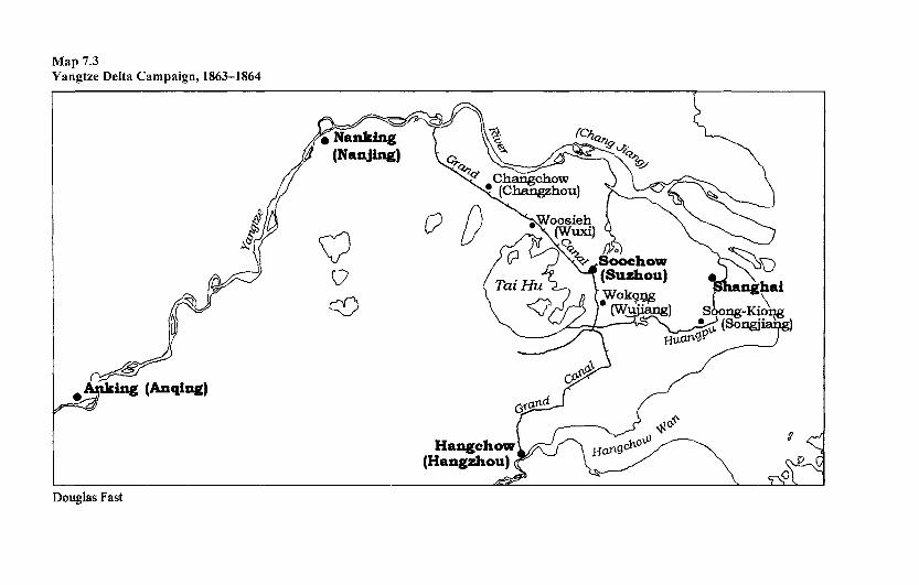
Map 7.3 Yangtze Delta Campaign, 1863-1864
Douglas Fast
178 Brown-, Green- and Blue-Water Fleets
and mapmaking work to the fact that canals branched in all directions from his base, was aware that this network of waterways eventually connected with the Grand Canal, which wound its way through Soochow.9 He also realized that the enemy attached little value to the mesh of linked canals, rivers, and lakes. He quickly determined to act on the enemy's failing, appreciating that the capture of Soochow would give him control of all waterways between the Yangtze and Hangchow (Hangzhou) Bay. With the waterways in his hands, the entire region would revert to imperial authority. In order to bring Soochow to heel, Gordon advanced a compelling argument for reducing key towns on the waterway network, towns encircling Soochow, which would culminate with the seizure of the rebel headquarters in that city. This argument found favor in imperial circles, dovetailing neatly with the grand strategy formulated by Tseng Kuo-fan and his deputy, Li Hung-Chan. The former, operating from Anking (Anqing) upriver from Nanking, resolved to strike downstream at the rebel capital at the same time as Li led an attack upstream from Shanghai.10 Li was perfectly willing to acquiesce in Gordon's plan, allowing the EVA to spearhead his drive westward.
That drive began in earnest in April 1863, when the EVA descended on Chanzu after first securing Fushan on the Yangtze, 16 kilometers away. Chanzu, 50 kilometers from Soochow, guarded the northern approaches to that center along the Grand Canal.11 A feint in the form of gunfire emanating from steam launches distracted the defenders while troops scaled the town walls and seized the place. Later that month Taitsan received the full attention of the EVA, capitulating after siege artillery, brought up by boat, breached the wall to permit the entry of assault troops. These early ventures bore witness to the usefulness of combined arms, but the Quinsan campaign of late May and early June brought home to Gordon the real potential of river warfare. More particularly, the splendid part played by an iron-sheeted gunboat, the Hyson (a former pleasure steamer whose name commemorated a variety of tea), enlightened him.
Quinsan was the key that unlocked the door to all the territory to the east of Soochow. Its capture would serve to unseat the Taipings from their position of dominance over the fortunes of Shanghai. Gordon's plan of attack was nothing short of a stroke of genius, pivoting on the use of the newly joined Hyson to sow confusion among the rebels by cutting off their retreat from the rear. This was accomplished by having it undertake a circuitous, 30-kilometer trip to come up behind Quinsan from the direction of Soochow. In the event, as it steamed up the canal on the final leg—that running alongside the causeway retaining the only road connecting Quinsan to Soochow—the gunboat managed to batter the rebel forces around Chunye into submission. Foiled in its attempt to break through the obstacle created by the Hyson at Chunye, the Quinsan garrison gave up. For a loss of two men killed, Gordon's force destroyed between 4,000 and 5,000 rebels and contrived to capture over 2,000 more. The steamer, in particular, had given a good account of itself. As Butler exulted: "This singular action, an armed steamer with a crew of some forty men all told against many thousand men, was perhaps the most strikingly representative feat of Gordon's peculiar genius for war."12
Riverine Warfare 179
Acme of the campaign it may have been, but the pattern in which furious gunboat attacks preceded land assaults was to be applied by Gordon over and over again in the remainder of the war. Late July saw the fall of two strongpoints on the Grand Canal: Wokong, 24 kilometers west of the rebel headquarters (HQ), and Woosieh, 50 kilometers to the northwest. Their seizure completed the reduction of the "outer ring" surrounding Soochow. In October it was the turn of the "inner ring" strongpoints. Gordon tightened his grip on them in a sequential fashion, relentlessly bringing the front line closer and closer to the gates of Soochow. The engagement at Petachiao on the Grand Canal was especially emblematic of this phase. In it, the Hyson and an armed launch were used to spring a surprise attack that the rebels could not rebuff. Soochow itself was invested on 29 November, succumbing to a joint force of EVA and Imperial troops on 5 December. After a brief hiatus, the drive westward resumed in the spring of 1864. It culminated in June with the conquest of Changchow (Changzhou), northwest of Wuxi, and the dispersal of its garrison of 25,000 rebels. Changchow was a prelude to the final act in the drama, the fall of Nanking in July. By then, though, Gordon had discreetly withdrawn, content to let Tseng and Li reap the ultimate honors. However, Gordon does not disappear from our story; for his subsequent career had lingering effects that overshadowed the campaign that concerns us next, the reconquest of the Sudan.
CHURCHILL'S "RIVER WAR"
The war undertaken at the end of the nineteenth century to bring Sudan under British (officially, Anglo-Egyptian) control is forever associated with the firsthand experience of a young Winston Churchill, published shortly after the occasion in an acclaimed book.13 No later study has managed to make much headway against the story laid down by Churchill, but, fortunately for posterity, Churchill's account is not without merit. In particular, he is perspicacious enough to appreciate the crucial importance of combined operations in the overall effort and is noble enough— despite his army background—to grant the river gunboats their due credit. Much more than this, however, Churchill, secure in the knowledge that waterways guaranteed accessibility, felt that the seizure of the Nile Valley was a worthwhile enterprise. He waxed eloquent on the matter, claiming that the "policy of acquiring large waterways, which has been pursued deliberately or unconsciously by British statesmen for three centuries, has been carried one step further" with the pacification of the Sudan. Aided in places by the railway, the Nile would now be used to promote trade, the medium of exchange alike for European finished goods and African commodities, and all the countries lying along its banks and denied access to the sea other than by its means would prosper accordingly.14 Churchill, of course, is a past master at rendering complex affairs intelligible to the reader; to be sure, his clear-sighted treatment shows how the campaign unfolded in a systematic, almost copybook fashion. We can do no better than attempt to follow his example, highlighting the turn of events since the fall of Khartoum and the death of Gordon
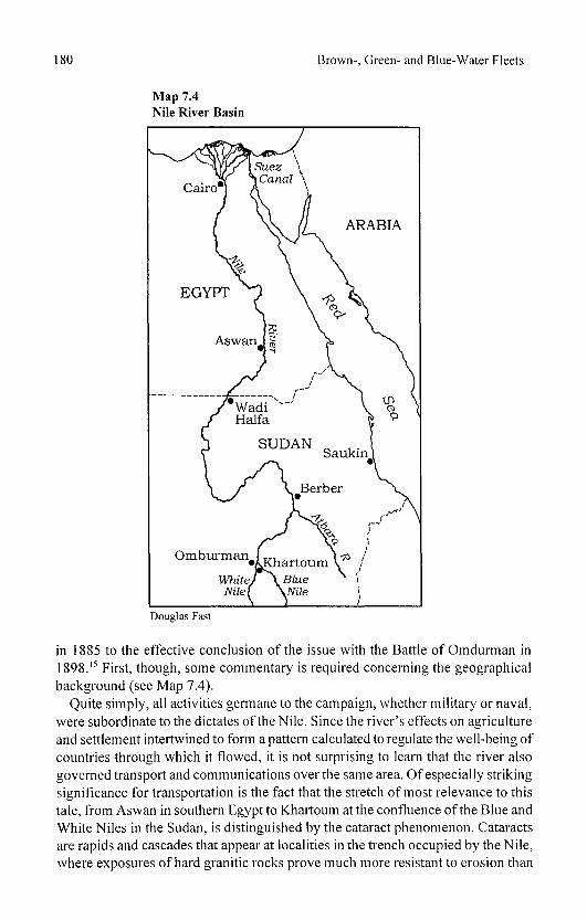
180 Brown-, Green- and Blue-Water Fleets
Map 7.4 Nile River Basin
Douglas Fast
in 1885 to the effective conclusion of the issue with the Battle of Omdurman in 1898.15 First, though, some commentary is required concerning the geographical background (see Map 7.4).
Quite simply, all activities germane to the campaign, whether military or naval, were subordinate to the dictates of the Nile. Since the river's effects on agriculture and settlement intertwined to form a pattern calculated to regulate the well-being of countries through which it flowed, it is not surprising to learn that the river also governed transport and communications over the same area. Of especially striking significance for transportation is the fact that the stretch of most relevance to this tale, from Aswan in southern Egypt to Khartoum at the confluence of the Blue and White Niles in the Sudan, is distinguished by the cataract phenomenon. Cataracts are rapids and cascades that appear at localities in the trench occupied by the Nile, where exposures of hard granitic rocks prove much more resistant to erosion than
Riverine Warfare 181
the typical sandstone. They invariably disrupt river navigation, frequently to the extent of stopping traffic altogether.16 The traveler, aspiring to enter the Sudan, is confronted by the first cataracts, the "Door to the South," barely 8 kilometers south of Aswan. Cataracts apart, the entire stretch is subject to seasonal variation in water depth that can also conspire to gravely hinder river communication. Interruption is at its worst in upper Egypt in May and June, the season of minimum water level. Maximum flood level is reached in September; at Aswan, for instance, floodwaters add from 6.4 to 1 Ometers to the low-water mark. Beyond a width of 2 kilometers or so, the valley deteriorates into an arid zone, the Nubian Desert. Forbidding and totally unsuitable for cultivation, this zone presents a barrier to interaction between the populated areas of lower Egypt and their Sudan counterparts in the vicinity of Khartoum. Traversing it overland taxes the strength even of camels, so traders wishing to travel between Cairo and Khartoum traditionally have looked to the Nile. The difficulties facing such traders are still far from over, for not only must they contemplate a long journey in both absolute (in excess of 2,500 kilometers) and time-distance terms, but they must also take pains in deciding when to effect it. Journeys undertaken in the summer benefit from high water—thus easing passage through the cataracts—but suffer from excessive heat; conversely, those embarked on between October and March gain from more moderate temperatures but risk grounding when attempting the cataracts.
These constraints were equally compelling to military commanders, dictating to a nicety their route of entry to, and exit from, the Sudanese heartland. The British, since 1882 the de facto rulers of Egypt, were fully aware of the adverse terrain, for their ignominious attempt to reach Khartoum in 1885 and rescue Gordon had faltered mainly on account of the delays incurred in overcoming distance.17
Smarting from that failure, the British bided their time, determined to conquer the Sudan when circumstances allowed. Conditions were not judged opportune until 1896, when Herbert Kitchener was authorized to take an expeditionary force across the border into the Sudan. Kitchener, recognizing the need to exercise caution in such a harsh environment, chose to master the logistics problems before tackling the forces in his path. As a military engineer he set a high value on efficient lines of communication, perceiving the advantage of an integrated transport system that married railroads to Nile navigation. Any defects in that system he set about remedying. Worked on with feverish intensity, the transport link began to take shape within a year. It rested on the railway for the first 540 kilometers from Cairo before switching to river navigation for the next 330 kilometers. At Aswan it reverted to rail for a short 10 kilometers so as to circumvent the first cataract. Another waterborne leg (of 360 kilometers) then intervened, carrying troops and supplies to Wadi Haifa. At this juncture the route abandoned the river, veering off for about 400 kilometers across the desert to regain the Nile near Abu Hamed. The laying of this railway, overseen by seasoned engineers, is the most vivid testament to Kitchener's determination to conquer the environment as well as the enemy, but it should not blind us to the fact that he transformed the waterborne component at the same time. An important part of his waterborne assets, indeed a remnant from

182 Brown-, Green- and Blue-Water Fleets
the Gordon relief expedition, was a squadron of four gunboats used to patrol the frontier area from Aswan to Wadi Haifa. Kitchener was quick to appreciate that this floating combatant force gave his expedition a punch out of all proportion to its size. Before it could come into its own, however, it had to brave the cataracts. Most noteworthy were the efforts of two famous future flag officers, Lieutenants David Beatty and Horace Hood, who set out to negotiate the difficult and protracted passage of the fourth cataract, a barrier that had to be overcome in order to reach the Abu Hamed-Berber stretch of the river.18 The former, in fact, was lucky to survive the capsizing of his command, the gunboat El Teb. After a number of tribulations these junior naval officers succeeded in blazing the way, enabling the rest of the flotilla to work its way safely to Abu Hamed. By then (August 1897), however, the campaign was well under way, as we now relate.
A THUMBNAIL SKETCH OF THE RECONQUEST
All that has been said touching on the severity of the environment in the theater applies with equal force to the human adversary: the Dervishes were brave, cruel, and numerous, combining aspects of Western field armies (e.g., some attention, to musketry and artillery) with the mobility, independence of fixed lines of communication, and the ability to live off the land more typical of irregular formations. In short, they posed a formidable challenge for Kitchener. Undaunted, he resolved to get the better of them in a systematic fashion. First, he would advance on Dongola (secured in 1896 after one season of campaigning). That accomplished, he would seek permission to penetrate farther south. In the event, he required two more years to finish the job: 1897 was taken up with the capture of Berber and the push upriver to the confluence of the Atbara; 1898 saw his forces beat the enemy at Atbara and press on to Omdurman, defeating their main force before that city. Our purpose is not to examine these land operations; rather, it is to single out the part played in them by the naval component. That requires us to focus on the activities of the gunboats.
At the outset Kitchener had encountered difficulties in mustering an adequate gunboat flotilla, but in this issue, as in all others, he showed himself equal to the emergency. Needing to augment the four 1885 stern-wheelers that he had inherited, he ordered several new gunboats in Britain. Besides mounting a powerful armament, the new gunboats were expressly designed for shallow waters, drawing only a meter. They also shipped a searchlight battery apiece. While this feature was an undoubted advantage, permitting night fighting (a prized capability that came into its own on the eve of the Battle of Omdurman, when the gunboats frustrated a Dervish night assault), the shallow-draft aspect proved to be a mixed blessing. True, it eased passage through the rapids and swamp districts of the Sudd, but it rendered the vessels unsuitable for employment in towing supply barges. The chief drawback of the latter failing was the delay that it imposed on troop readiness. Flaws notwithstanding, Kitchener was keen to get his hands on the gunboats, and the first three, the Zafir class, were rushed out to Koshen on the Nile for final
Riverine Warfare 183
assembly. Until they were ready, he had to make do with his vintage craft.19
Unfortunately, they got off to a less than auspicious start. In prosecuting the Dongola offensive, Kitchener's troops had been held up at the Hafir rapids, and gunfire from the gunboats failed to dislodge the entrenched enemy. However, the first of the new vessels now joined. The Zafir's promise was immediately revealed just prior to the fall of Dongola on 23 September 1896, for its accurate fire succeeded in thoroughly dismaying enemy troops. After surmounting the tricky obstacles thrown up by the fourth cataract—as recounted earlier—the gunboats were applied in earnest to fire-support duties in the 1897 campaign (see Map 7.5). Their most conspicuous occasion in that year was the shelling of Metemmeh, a foray intended to "soften up" a clutch of Dervish artillery forts. This spirited action, executed in October before the Nile waters began to fall, saw the three new vessels (under Commander Keppel) engage the enemy at a range of 3,700meters. Dervish losses amounted to at least 500 for the loss of one man aboard the gunboats.
The flotilla came into its own in the third year of operations; indeed, so crucial had the gunboats become that Kitchener considered it necessary to pause for nearly four months after his April 1898 victory at the Atbara so as to allow the river waters to rise to float them. In other words, he would not countenance an advance on the twin cities of Omdurman-Khartoum, the heartland of the Dervish state, until the Nile was again navigable for both his transport craft and his fire-support flotilla. His faith was richly rewarded, for on 1 September a detached force of gunboats, led by Beatty, knocked out the forts on Tuti Island, which protected the approaches to Omdurman. The gunboats, reinforced with army artillery, then turned their attention to Omdurman itself, subjecting it to a furious bombardment. So incensed was the Kalifa at this affront that he ordered his army away from the city to confront Kitchener's forces on the plain. This forcing of the Kalifa's hand worked very much in Kitchener's favor, allowing him to deploy his troops to best advantage.20 In instigating such a response, the flotilla more than justified its existence, for the Dervishes were roundly beaten in the resultant pitched battle of 2 September. However, the bombardment and its fallout were not the only contributions of the gunboats to the Battle of Omdurman: for good measure they had provided covering fire at a critical moment, enabling the Camel Corps to extricate itself from a threatening pincer movement.
The foregoing account does not, by any means, give the full measure of gunboat activities, but it does suffice to give the flavor of them. Clearly, without the support of the gunboats—not least at the climactic battle—Kitchener would have found the task of overcoming the Dervishes a much more taxing proposition. Without river navigation, he would not have been able to mount the invasion at all. Circumstances reminiscent of the Nile campaigns, albeit on a vastly different scale, beset the British in Mesopotamia a generation later. Their handling of that situation is the subject of our next section.
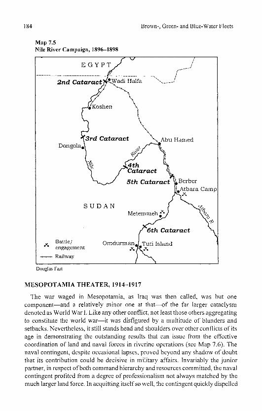
184 Brown-, Green- and Blue-Water Fleets
Map 7.5 Nile River Campaign, 1896-1898
Douglas Fast
MESOPOTAMIA THEATER, 1914-1917
The war waged in Mesopotamia, as Iraq was then called, was but one component—and a relatively minor one at that—of the far larger cataclysm denoted as World War I. Like any other conflict, not least those others aggregating to constitute the world war—it was disfigured by a multitude of blunders and setbacks. Nevertheless, it still stands head and shoulders over other conflicts of its age in demonstrating the outstanding results that can issue from the effective coordination of land and naval forces in riverine operations (see Map 7.6). The naval contingent, despite occasional lapses, proved beyond any shadow of doubt that its contribution could be decisive in military affairs. Invariably the junior partner, in respect of both command hierarchy and resources committed, the naval contingent profited from a degree of professionalism not always matched by the much larger land force. In acquitting itself so well, the contingent quickly dispelled
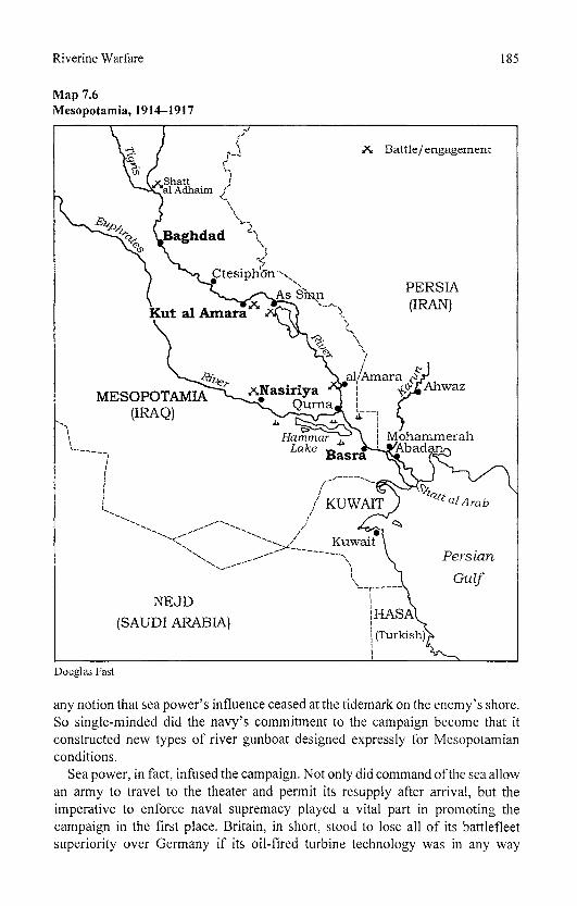
Riverine Warfare 185
Map 7.6 Mesopotamia, 1914-1917
Douglas Fast
any notion that sea power's influence ceased at the tidemark on the enemy's shore. So single-minded did the navy's commitment to the campaign become that it constructed new types of river gunboat designed expressly for Mesopotamian conditions.
Sea power, in fact, infused the campaign. Not only did command of the sea allow an army to travel to the theater and permit its resupply after arrival, but the imperative to enforce naval supremacy played a vital part in promoting the campaign in the first place. Britain, in short, stood to lose all of its battlefleet superiority over Germany if its oil-fired turbine technology was in any way

186 Brown-, Green- and Blue-Water Fleets
compromised. Interruption of oil supply in no uncertain terms would prejudice this superiority. The Mesopotamian campaign owes its genesis, in large measure, to this simple fact: rightly or wrongly, British authorities viewed with alarm the possibility that Turkish forces would interfere with the Royal Navy's oil supply. They believed passionately that the oil source at the head of the Persian Gulf must be safeguarded at all costs.21 While the oil factor might be credited with being the prime cause prompting British action, it was not the only one. Another pressing reason derived from the geostrategic consideration, the fact that Mesopotamia lay astride a short-distance route—second only to that via Suez—between Europe and India. After 1882 Britain had managed to wrest Suez and its canal from Turkish control, but its efforts to do the same with the river routes through Mesopotamia had not met with comparable success. True, it had wrung from the Turks visiting rights to Basra for its warships and even mediated the boundary between the Ottoman and Persian empires (forcibly, in Persia's case, after mounting an amphibious operation well up the Shatt al Arab in 1856). However, Britain was dismayed to discover that it was about to be unseated from its position of influence in Mesopotamia by Germany, the result of the latter's investment in an impending railway running from Constantinople to Basra. This fixed link promised to remove all difficulties involved in moving armies—and German armies into the bargain— to the Gulf and so posed a threat to the security of India. Worse still, it constituted a danger to the mother country itself, for it would force Britain to retaliate by shifting naval forces to the region, undermining its policy of concentrating them against Germany in home waters. That act would weaken the Grand Fleet at a time of heightened rivalry with the High Seas Fleet. Turkey's decision to openly side with Germany at the beginning of November 1914 thus gave Britain just cause for nipping this alarming development in the bud by the expedient of opening a front against the Ottoman empire from this quarter.
Before embarking on a description of the campaign that followed, it is necessary to shed some light on the region's geography. The "land of rivers" is a fitting epithet, for the Tigris and Euphrates debouch on Mesopotamia from the Armenian highlands, bringing that country almost all its moisture and establishing the limits to its fertile plain.22 The rivers join in exhibiting annual regimes that are at their lowest in September and October while peaking in April and May. They part company, though, in terms of the volume of water that each carries. The Euphrates, carrying the more modest volume, displays an even flow in its middle and lower reaches. The Tigris, channeling far more, rises by leaps and bounds to generate flash floods. Small wonder, then, that the region on which it abuts is often inundated, losing all traces of previous surface features. Much more perplexing for the navigator is the frequent change in riverbed. Uncertain depths and shifting channels combine to render perilous any passage of the Tigris, particularly the section from Kut al Amara to the sea. The river's lower reaches, in conjunction with the equivalent portion of the Euphrates, spread out to occupy a triangle linking Basra with Amara and Nasiriya. This can be likened to a vast shallow lake,
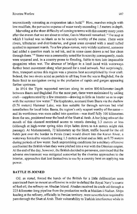
Riverine Warfare 187
intermittently retreating as evaporation takes hold.23 Here, marshes mingle with low mudflats, the pervasive expanse of water rarely exceeding 1.5 meters in depth.
Marveling at the sheer difficulty of coming to terms with this country many years after the events that we are about to relate, Gavin Maxwell remarked: "The map at which I looked was so blank as to be scarcely worthy of the name. There were rivers, tributaries and distributaries, and great areas covered with a small tufted symbol to represent marsh. To a few place-names, very widely scattered, someone had added a question mark in red ink, and in some cases drawn a red line clean through them."24 Stone was a commodity noted for its scarcity; consequently, roads were unpaved and, in a country prone to flooding, liable to turn into impassable quagmires when wet. The absence of bridges in a land laced with waterways further beset movement along what passed for a road network. Not surprisingly, then, transport across this region was a process best accomplished by river craft. Indeed, the two rivers acted as portals to all Iraq from the sea to Baghdad, the de facto limit to navigation owing to the profusion of rapids and gorges appearing farther upstream.
In 1914 the Tigris supported services along its entire 800-kilometer-length between Basra and Baghdad. For the most part, these were maintained by sailing craft—supplemented by a few steamers—drawing as little as 1 meter so as to cope with the summer low water.25 The Euphrates, accessed from Basra via the shallow (0.76 meters) Hammar Lake, was less suitable for through services but vital nonetheless for local links. Basra, the region's only seaport worthy of the name— and its worthiness was soon called into question—was itself fully 100 kilometers from the sea, positioned near the head of the Shatt al Arab. A bar lying athwart the mouth of this channel restricted access to vessels drawing 3.3 meters or less (although at high-water spring tides ships laden down to 6.6 meters might risk passage). At Mohammerah, 72 kilometers up the Shatt, traffic bound for the oil fields just over the border in Persia (Iran) would divert into the Karun River, a waterway limited to vessels drawing 1.5 meters at best and as little as 0.75 meters during periods of low water. Such unpromising conditions for a military offensive confronted the British when they were pitched into a war with the Ottoman empire. At the end of the day, however, the British decided to persevere, convinced that the adverse environment was mitigated somewhat by the riverine approaches to the interior, approaches that lent themselves to use by a country bent on applying sea power.
BATTLE IS JOINED
Oil, as stated, forced the hands of the British for a little deliberation soon convinced them to mount an offensive in order to defend the Royal Navy's source of fuel oil, the refinery on Abadan Island. Abadan received its crude oil through a 225-kilometer-long pipeline from the production wells at Maidan-i-Naftun. Ships loading at the refinery, officially in Persian territory, were nevertheless required to pass through the Shatt al Arab. Their vulnerability to Turkish interference while in

188 Brown-, Green- and Blue-Water Fleets
transit did not escape the notice of the Admiralty. Consequently, at Admiralty insistence, the military authorities in India assembled a division (Force D) and charged it with the object of occupying Basra and the surrounding area. While the navy urged on the army, it took immediate steps to stabilize the situation, dispatching two sloops to the Shatt in aid of a third already lying at Abadan. These ships soon made their presence felt, bombarding Turkish forts, clearing the waters of inshore craft, and scouting for the land-force commander. The anticipated stiff opposition from the Turks failed to materialize, and the sole enemy warship of any stature, the gunboat Marmaris, retired upriver, leaving the coast clear for the British landing.26 By 23 November 1914 Basra had been secured, permitting Anglo-Indian troops to push on and, aided by the spirited fire support provided by the sloops spearheading the advance, occupy Qurna at the confluence of the Euphrates and Tigris.
However, there matters rested for a spell, for the Turks began to bolster their forces. Moreover, they attempted a diversionary venture, threatening to cut the pipeline serving the refinery at Abadan. While successfully foiling this move, the British expedition to Ahwaz in January 1915 also contrived to expose a glaring weakness namely, the strictures surrounding the deployment of sloops displacing 1,070 tons and drawing 3.42 meters. The acute shortage of shallow-draft craft in the British flotilla simply had to be remedied. Recourse was immediately had to Nile stem-wheelers and Irrawaddy (Burma) side-paddlers, which were hastily converted into gunboats. It took time both for these reinforcements to arrive and for the army to expand to corps size in order to consolidate its hold over the Shatt area and countenance an offensive against a much strengthened enemy. Consequently, not until the end of May did the force, naval contingent in the van, leave Qurna with the object of driving up the Tigris to Amara. The flotilla went to great lengths to disrupt enemy supply lines, crippling the Marmaris and capturing lighters laden with troops. Its actions materially assisted the army in the seizure of the town. At the same time, a pincer movement was effected against Nasiriya on the Euphrates, but this initiative was attended with less success, and the town fell only after hard fighting in late July. Interestingly, one of the participants in the Nasiriya attack, the stem-wheeler Shushan, boasted a provenance extending back to the Gordon relief expedition (although since 1891 it had been at work on the Karun). It distinguished itself in the closely contested engagement. To quote Sir Arnold Wilson: "At a critical moment in the battle Captain Nunn laid the aged Shushan close alongside the Turkish trenches, blazed into them at point-blank range, and pushing on with the Medjidieh pursued the flying Turks right into Nasiriya."27 The Euphrates initiative had first to surmount the hurdle presented by geography, since access to Nasiriya not only required transit of the shallow 24-kilometer-long Hammar Lake but called for negotiation of the 40-kilometer-long Hakika Channel, a tortuous waterway little more than 15 meters wide and 0.9 meters deep. The commanders on the spot resorted to constructing dams in order to raise the water to an acceptable 1.2 meters and scour out a channel 46 meters wide, a process invariably occasioning delays. Despite such prodigious efforts the first British ship to enter the
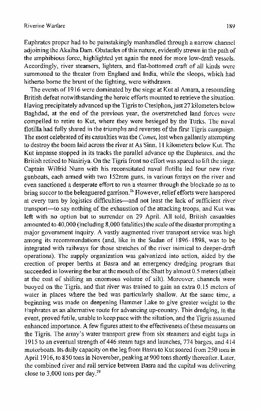
Riverine Warfare 189
Euphrates proper had to be painstakingly manhandled through a narrow channel adjoining the Akaiba Dam. Obstacles of this nature, evidently strewn in the path of the amphibious force, highlighted yet again the need for more low-draft vessels. Accordingly, river steamers, lighters, and flat-bottomed craft of all kinds were summoned to the theater from England and India, while the sloops, which had hitherto borne the brunt of the fighting, were withdrawn.
The events of 1916 were dominated by the siege at Kut al Amara, a resounding British defeat notwithstanding the heroic efforts mounted to retrieve the situation. Having precipitately advanced up the Tigris to Ctesiphon, just 27 kilometers below Baghdad, at the end of the previous year, the overstretched land forces were compelled to retire to Kut, where they were besieged by the Turks. The naval flotilla had fully shared in the triumphs and reverses of the first Tigris campaign. The most celebrated of its casualties was the Comet, lost when gallantly attempting to destroy the boom laid across the river at As Sinn, 11 kilometers below Kut. The Kut impasse stopped in its tracks the parallel advance up the Euphrates, and the British retired to Nasiriya. On the Tigris front no effort was spared to lift the siege. Captain Wilfrid Nunn with his reconstituted naval flotilla led four new river gunboats, each armed with two 152mm guns, in various forays on the river and even sanctioned a desperate effort to run a steamer through the blockade so as to bring succor to the beleaguered garrison.28 However, relief efforts were hampered at every turn by logistics difficulties—and not least the lack of sufficient river transport—to say nothing of the exhaustion of the attacking troops, and Kut was left with no option but to surrender on 29 April. All told, British casualties amounted to 40,000 (including 8,000 fatalities) the scale of the disaster prompting a major government inquiry. A vastly augmented river transport service was high among its recommendations (and, like in the Sudan of 1896-1898, was to be integrated with railways for those stretches of the river inimical to deeper-draft operations). The supply organization was galvanized into action, aided by the erection of proper berths at Basra and an emergency dredging program that succeeded in lowering the bar at the mouth of the Shatt by almost 0.5 meters (albeit at the cost of shifting an enormous volume of silt). Moreover, channels were buoyed on the Tigris, and that river was trained to gain an extra 0.15 meters of water in places where the bed was particularly shallow. At the same time, a beginning was made on deepening Hammer Lake to give greater weight to the Euphrates as an alternative route for advancing up-country. This dredging, in the event, proved futile, unable to keep pace with the siltation, and the Tigris assumed enhanced importance. A few figures attest to the effectiveness of these measures on the Tigris. The army's water transport grew from six steamers and eight tugs in 1915 to an eventual strength of 446 steam tugs and launches, 774 barges, and 414 motorboats. Its daily capacity on the leg from Basra to Kut soared from 250 tons in April 1916, to 850 tons in November, peaking at 900 tons shortly thereafter. Later, the combined river and rail service between Basra and the capital was delivering close to 3,000 tons per day.29

190 Brown-, Green- and Blue-Water Fleets
Once these riverine improvements had been effected, the campaign could be prosecuted on an unprecedented scale. Determined to expunge the humiliation of Kut, the British set their sights on Baghdad and would settle for nothing less. A much enlarged land force under Lieutenant General Stanley Maude quickly locked horns with the Turks, driving them out of Baghdad by March 1917. These events, overwhelmingly military in nature, need not concern us unduly. Nevertheless, the role of the Royal Navy's gunboat force in this episode, now numbering six modern combatants, should not be forgotten. Among its more conspicuous actions was a hot engagement extending over several days in February that saw the flotilla successively capture Kut, beat a number of Turkish vessels arrayed against it, and put the rest of the enemy flotilla to flight. The fall of Baghdad, to all intents and purposes, brought the gunboat phase of the war to a close. Before bowing out altogether, however, the gunboats contrived to push as far upriver as their drafts would reasonably allow, participating in the Battle of the Shatt al Adhaim in April.
CONCLUSION
Riverine warfare and the gunboats detailed to carry it out came of age in Iraq in World War I. The flotillas serving on the Tigris and Euphrates executed the biggest and most significant river campaign in that war, and although disparaged by many at the time as a "sideshow," the events leading to the ejection of the Turks had momentous consequences for the entire region (and the world, as the occurrences in the Persian Gulf at the beginning of the 1990s remind us) in the years that followed. Iraq, however, was not alone in witnessing the activities of river combatants. The British, in eradicating the scourge of commerce raiders, had found their regular "blue-water" warships singularly illsuited for the littoral conditions of East Africa. The Konigsberg, briefly mentioned in another context, had gone to ground at the head of the Rufiji delta in mid-October 1914 after eluding chasing British cruisers in the Indian Ocean. Creeping as close inshore as they dared—to 3 kilometers off the river mouth—the pursuers tried in vain to cripple the trapped German. For its part, the Konigsberg simply proceeded farther upriver, using its radically lightened state to move beyond the 13,400-meter maximum range of the pursuers' 152mm guns. The frustrated British, unable to find locally any vessel remotely able to both navigate the 1.8-meter channel leading to the German and overwhelmingly once in contact, hit upon an ingenious solution: fetch from Britain two river monitors, each armed with a brace of 152mm guns (outgunning the German raider's 105mm) but drawing only 1.46 meters. These vessels, designed for Brazil with the object of policing the Amazon, had been commandeered by the Royal Navy from their British builders on the outbreak of war. They succeeded where the cruisers had failed, transforming the German raider into a battered wreck. News of the eclipse of the Konigsberg, released in July 1915, not only electrified flagging Allied morale but focused attention on the importance of shallow-draft operations an attention soon reinforced by the activities of Commander Spicer-Simson on Lake Tanganyika.30

Riverine Warfare 191
It is not going too far to claim that World War I represented the high point of riverine warfare, for the swift adoption of airpower in its aftermath eroded much of the effectiveness of river gunboats (as, ironically, was demonstrated in Iraq in the 1920s, when the British, perturbed at the cost of ground-based "pacification" forces, substituted air patrols).31 In the right sphere, however, river gunboats unsullied by airpower continued to prevail, imposing order in what now would be termed "low-intensity" conflicts. Nowhere was this more apparent than in China, where the halcyon days of the river gunboat were yet to come. Richard McKenna's thinly disguised fictional account of the travails of an American gunboat attempting to keep the peace "upriver" in Hunan Province vividly captures the lawless atmosphere of China in the mid-1920s.32 But even here the inherent weakness of the river gunboat in the face of aerial opposition was brought home when the Japanese turned against the Western powers: after Pearl Harbor all the British and American gunboats stolidly plying China's rivers either quickly fell victim to air assaults or were forced to flee far upstream out of range of Japanese aircraft. Oddly enough, by a quirk of fate, river gunboats—albeit craft of a markedly different stamp from that of their Nile, Mesopotamia, and China predecessors—gained a new lease of life during the Vietnam conflict of the 1960s. Total mastery of the air allowed the commanders of American vessels patrolling the Mekong and its delta to behave in a fashion reminiscent of the days preceding airpower. In consequence, the U.S. Navy took full advantage of the mobility afforded by fast, light craft in an environment otherwise inimical to surface transportation. Generously armed and (in some cases) armored, these new-model river gunboats fought an unrelenting fight to stem guerrilla incursions of the far south of the country. At its height, the river force numbered in excess of 500 vessels, the chief of which were specially designed for combat in shallow waters. Just how environmental factors influenced the design of such vessels is a matter requiring some elaboration; indeed, the larger issue of how warships are designed with geographical considerations in mind deserves an airing. We present our thoughts on this subject within a framework that examines the whole question of geographical influences on navies.
NOTES
1. These operations involved the tactical movement of troops as well as provided fire support and logistical support to ground units. While this was certainly done during the Civil War, it was not the primary focus or outcome of the North's riverine campaign.
2. Memphis was the terminus point for the Memphis & Little Rock, Memphis & Charleston, Memphis & Ohio Railroads, and the Mississippi & Tennessee Railroads. Further connections were made with the Chattanooga & Atlanta line and the Georgia Railroad.
3. The Confederate River Defense Fleet was subordinated and under the direction of the army throughout the war.
4. These were the battles of Plum Point in May 1862 and the river battle associated with the capture of Memphis on June 6, 1862, in which the Confederate Defense Fleet was

192 Brown-, Green- and Blue-Water Fleets
largely destroyed. See J.D. Coombe, Thunder along the Mississippi: The River Battles That Split the Confederacy (New York: Bantam Books, 1996).
5. Ibid. p. 187. 6. Bizarrely, the original rebel leader, Li Yuan-fa, had been influenced by American
Methodist missionaries. In 1849, choosing to regard a rice famine in his native Hunan Province as a divine message, he declared his Heaven and Earth Society (Tien Ti Hui) to be in a state of war with the Manchu emperor. Joined by other semi-Christianized enthusiasts led by Hung HsiuOchen, the movement adopted the title Tai Ping Tien Kuo (Heavenly Kingdom of Great Peace) in 1851. Under Hung, styled the heavenly king, the "Taipings" went on to defeat numerouslimperial forces, securing Nanking for their capital in 1853. Their offensive took them to within a whisker (160 kilometers) of Beijing in October 1854, but thereafter it faltered, and a stalemate ensued. With Taiping power centered on the middle and lower reaches of the Yangtze, desultory campaigning became endemic to the region. In the meantime British incursions in China were continuing. Hostilities known as the Second Opium War had occurred in 1857-1858, and, as a result of a severe drubbing that it had received at the hands of the British, the Imperial government had been compelled to concede several more treaty ports to the Westerners, including Nanking. Thus, Britain had a keen concern for resolution of the internecine conflict in China: besides protecting its vested interest in Shanghai, peace would allow it to take up its concession in Nanking and profit from the trade engendered there. Further details on these circumstances can be found in R. MacGregor-Hastie, Never to Be Taken Alive: A Biography of General Gordon (London: Sidgwick and Jackson, 1985), pp. 52-61.
7. Its preeminence in agricultural well-being persists to this day, although industrial development has vastly outstripped that of agriculture. Note Li Wenyau, and Lu Dadao, Industrial Geography of China (New York and Beijing: Science Press, 1995), pp. 486-488.
8. In one of its more illustrious early ventures—the capture of Kahding effected in October 1862—the multinational band had received assistance from a British naval "brigade" (armed shore party) drawn from a sloop, a gun vessel, and four gunboats commanded by Captain Roderick Drew, RN. See A. Preston, and J. Major, Send a Gunboat! A Study of the Gunboat and Its Role in British Policy, 1854-1904 (London: Longmans, Green, 1967), pp. 61-63.
9. The Grand Canal, built in the Sui dynasty (581-617), ran from near Hangzhou north across the Yangtze and Yellow Rivers to terminate near Beijing. It had been used to carry tribute rice from south to north, but by Gordon's time much of it had fallen into disrepair. Nevertheless, the stretch across the delta was cut 37 meters wide and could take vessels drawing 1.4 to 1.8 meters. Refer to C. Hadfield, World Canals: Inland Navigation Past and Present (New York: Facts on File, 1986).
10. Both Tseng and Li were imposing personages. Tseng adopted river warfare in 1853 as part and parcel of his campaign to rid Hunan Province of rebels. He was responsible for establishing an arsenal and shipyard at Anking, which succeeded in launching the first all-Chinese steamer (albeit a modest 8.92m long) in January 1863. His protege, Li, was later instrumental in establishing an ordnance factory at Soochow before going on to found the modern Chinese mercantile marine (China Merchants' Steam Navigation Company, created in 1872). See Rawlinson, 1967; G.R.G. Worcester, "The Coming of the Chinese Steamer," The Mariner's Mirror, vol. 38, no. 2, May 1952, pp. 132-141; H.W. Dick, and S.A. Kentwell, Beancaker to Boxboat: Steamship Companies in Chinese Waters (Canberra: Nautical Association of Australia, 1988).

Riverine Warfare 193
11. Details of Gordon's battles are recorded in two biographies: W.F. Butler, Charles George Gordon (London: Macmillan, 1920) (originally published in 1889) and J.H. Waller, Gordon of Khartoum: The Saga of a Victorian Hero (New York: Atheneum, 1988).
12. Ibid, p. 62. 13. W.S. Churchill, The River War: An Account of the Reconquest of the Sudan (London:
Eyre and Spottiswoode, 1933) (originally published in 1899). 14. Ibid. p. 364. 15. Gordon's fortunes increasingly were bound up with those of the Sudan. Egypt had
invaded that country in 1821 and by the 1870s was tenuously holding it with a garrison of 40,000 men. Slavery and corruption were rife, resulting in endemic unrest among the Sudanese. Mohammed Ahmed-Ibn-el-Sayed-Abdullah, better known as the Mahdi, arose to lead the opposition to this misrule. From 1881 he made his presence felt, aided by his claims to be restoring the true faith. His followers, the Ansar (or "Dervishes") swept all before them. Gordon, who had spent much of the 1870s vainly attempting to introduce enlightened, modern rule to the Sudan, was sent by the British to extricate the Egyptian administration from Khartoum. Upon arrival in Khartoum, Gordon refused to budge, unwilling to leave its inhabitants to the retribution of the Ansar. The Mahdi seized Khartoum in early 1885 before an Anglo-Egyptian column could relieve the city, and Gordon paid for his obduracy with his life. At once poignant and dramatic, the events surrounding Gordon's death left a marked impression on the public of the day. Ironically, the Mahdi died in June, less than four months after Gordon, and was succeeded by Kalifa Abdulla Abd Allah, Kitchener's antagonist 11 years later. See R. Neillands, The Dervish Wars: Gordon and Kitchener in the Sudan, 1880-1898 (London: John Murray, 1996).
16. The physical geography of the Nile Valley is recounted in W.B. Fisher, The Middle East: A Physical, Social and Regional Geography (London: Methuen, 1978), pp. 506-511. A more descriptive account is provided in B. Brander, The River Nile (Washington, DC: National Geographic Society, 1968).
17. The "quick" overland route from the British Red Sea foothold of Suakin to Berber on the Nile, of great importance to the relief expedition, became impracticable in subsequent years, the victim of the threats of hostile tribes to poison the desert wells necessary for watering the camel trains.
18. Beatty led the battle cruiser force at Jutland in 1916 before assuming command of the entire Grand Fleet later that year. Hood, tragically, was lost at Jutland when his battle cruiser, Invincible, blew up.
19. The inherited vessels shipped one 12-pounder, quick-firing gun and two Maxim machine guns. The Zafir class supplemented the 12-pounder with two 6-pounders and four machine guns. Their successors, the three Sultan class screw gunboats of 1898, added a 102mm howitzer to this battery.
20. A point noted in P. Ziegler, Omdurman (London: Collins, 1973), p. 93. 21. The Admiralty's anxiety over oil supply is referenced in the first volume of the
official history of the campaign. See F.J. Moberly, The Campaign in Mesopotamia, 1914-1918 (London: His Majesty's Stationery Office, 1923), p. 80.
22. Fisher, pp. 363-370. 23. Details of the 52,000-kilometer area are found in S.M. Salim, Marsh Dwellers of the
Euphrates Delta (London: Athlone Press, 1962). 24. G. Maxwell, A Reed Shaken by the Wind (New York: Longmans, Green, 1957), pp.
15-16. 25. Water depths fluctuated widely in practice, depending on locality and season. The
deepest stretch, the 74 kilometers from Basra to Qurna, recorded average low-water depths

194 Brown-, Green- and Blue-Water Fleets
of 3 meters but 13.5 meters under high-water conditions. The 45-kilometer-long "Narrows" from Ezra's Tomb to Qala Salih, by contrast, averaged only 1.5 meters at low water and 3.9 meters at high water.
26. Marmaris was a French-built vessel of 531 tons, drawing 3.6 meters and armed with a main battery of four nine-pounder guns. It presided over a large flotilla of armed launches. On its demise, the flotilla was stiffened with a number of converted river steamers.
27. A.T. Wilson, Loyalties: Mesopotamia, 1914-1917(London: Oxford University Press, 1930), p. 60.
28. Details of the attempt of 24-25 April by the Julnar to run the gauntlet, carrying 270 tons at six knots, are presented in Newbolt, vol. 4, 1928, pp. 190-191.
29. Wilson, pp. 193-198. 30. Spicer-Simson had helped manhandle two armed motor launches across the Belgian
Congo in order to challenge German mastery of the lake. See Miller, pp. 197-211. 31. Although, in truth, the air element could actively assist gunboat operations, as World
War I had proved. It is often forgotten that naval commanders involved in both the Rufiji episode and the Mesopotamia campaign made good use of spotter aircraft.
32. R. McKenna, The Sand Pebbles (New York: Harper and Row, 1962). McKenna actually served from 1939 to 1941 aboard the Luzon, whose beat was the Yangtze from Shanghai to Wuhan.
8
The Influence of Geography on Navies
As we have shown thus far, geography's influence upon naval warfare is pervasive. Naval strategy and tactics are directly impacted by a multitude of geographical factors. Therefore, it is logical to assume that since naval forces are the instrument of naval power employed in naval warfare, geography also must influence those forces. Exactly how this influence manifests itself is the substance of this chapter. Apart from how geographical factors direct the use of naval forces (both collectively and individually) in war, they also exert an influence on the types of navies that states deploy, the force structure composition of those navies, and the design of their ships. We deal briefly with the first two areas and spend the bulk of our time here on the third since in this area that geographical factors wield the most influence. It is imperative for the reader to note from the outset, however, that in no way do we mean to imply that geography is the only or even primary determining factor in any of these three areas. Rather, it is one of an often long list of factors that civilian and military planners and policymakers must consider when creating, developing, and maintaining naval forces. In fact, it is frequently not unusual for other factors such as politics (both domestic and international), economics or cultural-social concerns to supersede sound decision making in these matters based upon the often more obvious dictates of geographical reality.
GEOGRAPHICAL INFLUENCE ON NAVAL CLASSIFICATION
The type of navy that a state possesses is dependent upon many different factors including economics, threat perceptions, alliance affiliation, tradition, politics, and geography. We are interested in the last factor. Mahan's principles as laid out in
196 Brown-, Green- and Blue-Water Fleets
his seminal work The Influence ofSeapower upon History, illustrate a clear link between the geography of a state and its proclivity toward possessing both a merchant and naval fleet. He does not specify precisely, however, what form or type of naval force that a state will field in light of its geographical circumstances. There is, however, an undeniable connection between a state's geography and the type of navy that it creates and maintains. While this connection is not borne out uniformly in every case, there is enough of a pattern to allow for a certain degree of generalization about the different types of navies that exist in the world today. In other words, it has proven to be useful to classify navies in such a way as to make clear this link between geography and naval type.
Naval literature is replete with examples of naval classification systems. Some have much greater utility and practical relevance than others, but all make the attempt to shed light on the fact that there are distinct differences between the world's naval forces. In general, the classification of the different types of naval forces relies on a combination of criteria that attempt to reflect the often complex, but vital, relationship among missions, capabilities, and operational environment. All three have a geographical component, although the latter is the most obviously geographic. Dealing with mission orientation and capability first, we can identify three primary types of navies: power projection, coastal or territorial defense, and constabulary (coast guard law enforcement). While each of the higher classified naval types encompasses the mission capability of its less capable cousins, the primary mission emphasis of each specific types is revealed by its label.
The general pattern of naval classification turns to linking geography with these mission types. Specifically, the geographical criteria can be divided into two categories namely, operational environment and what is commonly referred to as "reach," the distance from home that a navy can effectively operate.1 Operational environment can be broken down into the broad categories of "blue water" and "non-blue water." The latter category can be broken down further into "green water" and "brown water," the former referring to offshore, coastal waters and the latter to the waters of inland rivers. The norm is to associate power-projection navies with blue water, coastal and territorial defense navies with either green or brown water, and constabulary navies with green water. To further clarify the geographical classification of navies, the concept of reach is used. Based upon the geographical theory of decay of distance, a loss-of-power gradient is offered to illustrate the fact that the mission capability of most navies declines as they operate at ever greater distances from their home base. Consequently, it can be rightly assumed that blue-water, power-projection navies have much greater reach and therefore possess much greater capabilities than green-water, coastal defense or constabulary navies. Thus, gradations in reach, once plotted as a negatively sloping line called the "loss-of-power gradient," are tantamount to divisions between types of navies. These divisions yield several additional distance-specific types of blue-water navies, including global-reach, limited global-reach, and regional power-projection navies. This division also adds to the clarity of green-water navies with regional offshore and inshore coastal defense and constabulary navies.2
The Influence of Geography on Navies 197
Through the classification of navies into different types, it is possible to ascertain not only their primary mission, but also their relationship to the environment in which they must operate. Classification based, in part, on operational environment and reach provides further insight into the sustainability capability of different navies and their commensurate logistical support requirements. Naval classification, as often pointed out, is not an exact science and does not produce perfect descriptions of the true capabilities of navies, but naval classification as explained here does serve to illustrate the important influence that geography has on naval development. Furthermore, the variety of naval types that exist in the world is evidence that the concept of "one size fits all" is no more applicable to the navies of today than it is in reference to their force structure composition, as will be seen in the next section.
GEOGRAPHICAL INFLUENCES ON THE FORCE STRUCTURE OF FLEETS
There is an obvious relationship between naval type and force structure. Thus, there is a surprising degree of uniformity in the ship types that comprise the force structures of navies at both the general categorization level of blue-and non-blue-water navies and the more specific levels of mission and geographical classification. For example, blue-water, power-projection navies of all types frequently are characterized by the possession of varying numbers of large warships such as carriers, cruisers, destroyers, and frigates, as well as amphibious warfare vessels and underway replenishment-capable support ships. Meanwhile, the force structures of green-water coastal defense navies tend to be dominated by smaller frigates, corvettes, fast attack craft, and mine warfare vessels, while constabulary navies rely on patrol vessels of varying size. Brown-water navies are, in many ways, the most specialized in their force structure composition, fielding a myriad of unique vessels especially designed to meet the requirements of inland waterways.
When it comes to numbers, size, and specific class of ships included in a navy's force structure, there is less uniformity among types. While mission requirements may be the most important factor in determining the number of ships in a fleets' inventory, operational environment (i.e., geography) likely plays an important role in the size and class of ships therein. The number of ships in a navy's force structure is directly related to the level of flexibility that it requires based upon its primary mission emphasis. Flexibility, which refers to the ability of a navy to conduct a variety of missions and operations often simultaneously and in different geographic areas, is primarily a function of surplus. Surplus, as defined here, refers to the total number of ships and aircraft of specific types and classes that a navy possesses. It is therefore safe to assume that navies with larger force structures have greater flexibility than do those that field more modestly sized fleets. Concurrently, the navies with the most demanding mission requirements, thus necessitating more flexibility, have the largest force structures. While this relationship is not always

198 Brown-, Green- and Blue-Water Fleets
true (as in the case of present-day China, which has, in total numbers, the largest navy in the world but whose primary mission remains coastal defense), it is generally applicable.
The specific issue of the influence of geography on force structure composition is an interesting one. Under ideal conditions, there should be a clear relationship between a navy's operational environment and the ships that it includes in its force structure. However, while that may seem like a logically obvious statement, reality often belies this. There are many examples, past and present, of navies whose force structure was ill suited at best and downright inappropriate at worst for the operational environment in which it found itself. The explanation for this seemingly incompatible situation harks back to what we stated previously, that there are always considerations other than geography at work in the decision-making process of naval development and acquisition. The results of this fact range from understandable situations where states are unable to economically afford the naval assets best suited to meet the demands of their operational environments, to more inexcusable and often unexplainable decisions made by political and military leaders. Included in the latter are cases of leaders' selecting ships based not on their suitability for either their mission or operational environment but instead on the basis of the vessels' "prestige factor." Whatever the reason for ignoring the geographical realities facing naval forces when selecting force structure assets, the results are often quite serious. Apart from simply being inefficient and a waste of resources (both economic and naval), such mismatches in assets and operational environments also can prohibit a navy (and thus the state) from successfully utilizing naval power to accomplish its goals. At worst, lives as well as engagements, both on land and at sea, can be unnecessarily lost.
While geographical considerations are important in determining a navy's general force structure composition, their influence on the design and construction of naval vessels is even more pervasive. It is to this topic in our discussion of how geography influences navies that we turn next.
GEOGRAPHICAL CONSIDERATIONS IN SHIP DESIGN
After reviewing the effects of geography on the structure of navies, it is appropriate to say something about its influence on that most essential of all naval units, the warship. On the face of it, what we say has a bearing on ship design or naval architecture, a discipline grounded in scientific principles and replete with its own professional adherents. However, we must make clear, before these adherents call us into account, that our observations make no claim to challenge the scientific foundation of naval architecture; on the contrary, they merely point to the ways in which that foundation rests on geographical fundamentals. We attach particular importance to the fundamental of distance, reminding the reader that we have construed geography as not only invoking distance in its various manifestations but being preoccupied with the means of overcoming it. Interaction, or movement across the spatial plane, is the hallmark of geographical analysis, transcending all
The Influence of Geography on Navies 199
local considerations to assume a truly global relevance. Ships, first and foremost, are designed with the object of moving across a significant part of the earth's surface, Mackinder's hydrosphere or water-dominated part. Thus, any person pretending to a serious interest in ships who fails to adequately gauge the importance of their range and endurance capacities stands to lose all appreciation of their distance-reducing quality, a quality at least as important as their abilities in actual combat.3 The tendency of the naval professional to overlook this critical fact, preferring instead to focus on the war-fighting potential of ships, profits no one, least of all the naval profession.
Elevating distance to a position of prime importance does not by itself make a new paradigm of ship design or confer a comprehensive coverage of geography's influence on warships. Returning the distance element to center stage, where it justly belongs, does, however, serve to underscore the mobility function of navies, a point made much earlier in this work and one on which we set a premium. As for geography's remaining influences, they make their presence felt in more local situations. Local conditions—those specific to a particular coast, river, or sea— feature prominently in naval lore, regulating the tactics most suitable to the occasion, yet, paradoxically, they have persistently been underrated and made light of by supreme commanders more worried about matters of geostrategy. The overriding concerns of such "supremos" have frequently blinded them to the fact that operating conditions for their fleets and flotillas can differ profoundly, the upshot of the "detail" that is at the heart of regional geography. The naval commanders subordinate to them and operating in situ cannot afford to hold such cavalier attitudes, for a mismatch between ship capabilities and environmental conditions can blight the success of any mission. Prominent among the local conditions are variations in water depths, which have obvious implications for all displacement vessels. The discussion on littoral and riverine warfare bore witness to the importance of shallows and the need to employ vessels drawing little water. Big ships, committed to blue-water functions, are under no such restraint, but that is not to say that their designers can set about conceiving them oblivious of local geographical factors. The existence of strategic isthmian waterways like the Panama and Kiel Canals, limited in their width and depth parameters, imposes corresponding restrictions on the dimensions of ships caring to pass through them. Naval architects engaged in designing capital ships cannot make light of these limits, since failure to conform to them would debar their ships from the canals and drastically curtail their usefulness by aggravating the time-distance cost associated with ship deployments. The consequences for ship design of local conditions—both general, like the endemic problems of dealing with shallows, and particular, such as the need to accommodate to the strictures of the Kiel Canal—are enlarged upon in what follows. To begin with, though, it is necessary to ponder how the configuration of ships is affected by that aspect of geography common to all parts of the world, the issue of distance.
200 Brown-, Green- and Blue-Water Fleets
DISTANCE: THE ULTIMATE ARBITER OF SHIP DESIGN
Consider the archetypal environment in which a warship belonging to a blue-water navy may be found operating. In all probability it falls in the higher latitudes, where the weather is bracing, not to say harsh, and sea conditions are demanding, typically of the order of sea state 5 and frequently higher.4 The warship, in consequence, would be hard-pressed to function normally. In the first place, its speed would be severely constrained, the result of the greater resistance to motion consuming more of the power output of the vessel's engines. In addition, though, the ship's ability to activate its bow sonar while in the throes of seas apt to induce pitching, rolling, and slamming is questionable. Worse yet, its chances of being able either to take on fuel at sea or to launch a helicopter are, for all practical purposes, nonexistent. By one reckoning, frigates (given as ships averaging 12 meters in length) would barely suffice under such conditions, while destroyers (of 150 meters) would be only tolerably adequate.5 Size, in other words, governs the ship's ability to come to terms with sea conditions, its sea-keeping capability; but size also happens to be a vital consideration in determining how far the ship can operate away from base. Size, in short, helps regulate a vessel's distance-countering property.
This situation arises because the power incident to an engine is largely determined by the sheer size of the generating plant packed into the ship's engine room. Small engine rooms, unavoidable in small ships, are forthcoming with limited power ratings; large vessels, however, need be under no such restraint. A large vessel complete with a large engine plant or, correspondingly, a smaller vessel containing an engine room disproportionately large, is in possession of a major source of mechanical power. A large power rating does not by itself make a fast ship or confer the hallmark of mobility on a fleet of such ships, but it has the tendency to work toward those ends. Speed is not only enhanced when greater mechanical power is brought to bear but markedly affected by the vessel's lines, its design configuration. A longer vessel is better able to mitigate the effects of pitching and slamming than a shorter vessel and, consequently, is inherently superior for maintaining higher speeds in all but the most benign sea conditions. Small ships are best suited to calm waters and short patrols, for they stand to lose all the advantages of compactness (economy in build and operation, "lower visibility," and hence less vulnerability to attack) when blue-water conditions prevail. Large ships, by contrast, have sea-keeping qualities to match harsher environments; that is, they can sustain better speeds over much greater distances (and their size usually affords them a useful fuel-storage capability) than their smaller counterparts. In sum, they enjoy a decided advantage in time-distance terms over all smaller ships, including those outfitted with disproportionately large engine sets.
The Influence of Geography on Navies 201
THE RUDIMENTS OF SHIP DESIGN
Ship size in general and length in particular invoke questions of ship design. While ship design in all its complexity is beyond the scope of this book, a brief appraisal of its cardinal rules does not go amiss. The intent is to show the reader the hold that distance has on one of the chief products of ship design, the warship. Distance comes to bear not directly but via the mission specifications that the naval architects have to take into account in the conception of their designs. To aid them in this task, they resort to a set of basic principles or rules. They must juggle these rules in order to arrive at a package that best fits the missions envisioned for the particular ship or ship class. The resultant design aims to give the best solution possible without compromising the ship's integrity either as a weapon system or as a floating vessel driven by a prime mover.
To paraphrase Hind, the ship designers cannot apply their trade until the customer—in this instance the navy—has decided the main features to which the finished product must conform, features stipulating the purpose of the vessel and the equipment likely to be shipped by it.6 Speed and range figure prominently in these features, determining the means of propulsion as well as the dimensions and lines of the ship. Completing the hull specifications are those that address requirements bearing on operational area, including concerns of port access (draft limits) and ability to pass through canals or locks (length and beam limits). Since procurement budgets invariably fall short of the largesse deemed necessary by admiralties, customers all along are actuated by the wish to obtain their product for the least outlay consistent with effective design.7 Mindful of the fact that parsimonious governments are reluctant to sanction replacement ships for many years to come, customers are particularly exercised by the prospect of low lifetime costs in the products that have been authorized. Moreover, the likelihood of being obliged to keep a ship for 30 years compels customers to anticipate changes over the long term in the operational uses of that vessel, and on that account, they may incline to build flexibility into the hull specifications.
Size, especially hull length, allows for a high degree of flexibility. Indeed, provided money is forthcoming, the tendency is to play it safe by lengthening a ship design on the premise that a larger ship more easily accommodates mission requirements than a smaller one. A longer hull does not endow a vessel with all the virtues of a fighting ship, but it certainly goes a long way. The extra length provides the vessel with the range consistent with distance reduction while, at the same time, grants it a degree of immunity from the disruptions attending operations in high seas. Besides proving so valuable in withstanding the buffeting of the elements, size gives rise to economies of scale. Consider, for example, fuel burn. It has been remarked that an aircraft carrier of the Forrestal class requires engines only 3.7 times more powerful than a destroyer of the Forrest Sherman class, and yet the former is 19 times heavier than the latter (and their respective overall lengths are 316.8 meters and 127.6 meters). Steaming at 33 knots, the carrier consumes less than four times the amount of fuel of the destroyer proceeding at the same speed but packs vastly more firepower. Just how much firepower is contained
202 Brown-, Green- and Blue-Water Fleets
within the dimensions of a Forrestal hull, conceived in the 1950s, becomes evident when it is contrasted with that embodied in an Essex, the standard attack carrier of World War II. The older vessels, 272.7 meters long and displacing (after postwar rebuilding) 43,000 tons fully loaded, were clearly smaller than their successors, which, besides being 44 meters longer, displaced 78,000 tons. The size shortfall of the Essex carriers proved costly, for their complement of attack aircraft was only half that of the Forrestals and their ordnance stocks were barely a third. To make matters worse, they were severely disadvantaged in operational terms. Rather than being able to function in harsh sea environments for 345 days a year like the 1950s-conceived carriers, they could boast an endurance in comparable seas of only 220 days a year.8 Economies of scale can be reckoned to work in favor of a 50,000-ton carrier over a 35,000-ton carrier to the extent of furnishing it with twice the aircraft complement for only a quarter more in building and operational costs.9 Cost, however, remains the main stumbling block to extra size, for, economies of scale notwithstanding, larger ships tend to incur greater first and operational costs than vessels of markedly smaller proportions. All navies, especially those subjected to the most straitened budgets, are tempted to settle for several smaller hulls rather than one or two large ships, conspicuous by their expense.
The size issue has led us to stray slightly from the path followed by the ship designer, so let us return to the point at which the design office receives the ship specifications. Armed with these preliminaries, the designer refers to a catalog of empirical data—previous designs for ships with similar functions—in order to gain a head start on the task at hand. Those empirical data effectively blend hull form characteristics with varying operational requirements. Thus, the designer of a destroyer, for instance, can elicit the fact that destroyers, typically, exhibit block, midsection, prismatic, and waterline coefficients of 0.521,0.833,0.625 and 0.740, respectively, to say nothing of length-to-beam and length-to-draft ratios of 9.82 and 32.75. By way of contrast, a conventional cargo liner records a length-to-beam ratio of scarcely two-thirds the magnitude applying to the destroyer and a length-to-draft ratio of just one-half. The coefficients relevant to the cargo ship also register as significantly different from those obtaining for the destroyer.10 The former, for example, is likely to have an appreciably higher prismatic coefficient than the latter, the result of its possession of a substantial parallel middle body (where the transverse section below the waterline, centered about midships, is constant and identical in shape). Parallel middle bodies are not characteristic of destroyers (or, for that matter, most types of warships), for their purpose is not to transport large quantities of cargo. The hull lines of destroyers, like many warship types, are much finer than the hull lines of cargo-carrying merchant ships. Destroyers eschew the boxlike broad beams and deep, capacious holds that vividly portray the tanker or bulk carrier, espousing instead a hull configuration that begins with a raked stem and flared bows, and continues through a sharp "entrance" and well-rounded "run," before going on to describe a truncated or transom stern.11 Besides granting an adequate level of seaworthiness, the fine lines of the warship add to, rather than detract from, the vessel's ability to make speed.

The Influence of Geography on Navies 203
It is patently obvious that speed and maneuverability are very desirable virtues in warships. It comes as no surprise, then, to learn that naval architects have invested a great deal of time and effort in formulating hull forms conducive to either or both of them.12 To that end, whole new configurations have been devised. The slender displacement hull incident to cruisers, destroyers, and frigates is confronted by practical limits regarding speed, the consequence of wave-making resistance. Beyond about 30 knots, this resistance becomes so formidable as to require prodigious amounts of power for every extra knot gained. Only designers who are prepared to set aside disproportionate volumes of hull space for propulsion machinery can contemplate driving displacement vessels at speeds in excess of 30 knots, and, correspondingly, only customers who set a high premium on speed can countenance fast-ship designs. Hull space taken up with engine installations means volume not available for revenue-earning carrying capacity, a consideration of sufficient gravity to deter most owners of commercial shipping from even toying with such designs. Large power plants invariably lead to high rates of fuel consumption, and this, too, serves to dissuade merchant shipowners from entertaining fast ships. The upshot is that only navies welcome fast displacement vessels because they alone are in a position to forfeit the advantages of generous deadweight capacity and economical fuel bum that attend slower displacement vessels. Yet even navies are reluctant to pursue speed in displacement ships at any cost, preferring to seek redress in such solutions as semiplaning and planing-hulled craft, to say nothing of hydrofoils.
The semiplaning hull, by virtue of its V-shaped bow and shallow, concave stern, produces a wave crest that lifts the stern, and this allows the use of water jets rather than conventional propellers. Without propellers, the problem of cavitation disappears, permitting the vessel to achieve faster speeds. Planing-hulled craft advance the lift principle, for the broad, flat undersurfaces special to the craft allow them to adopt a more inclined position relative to the water surface. Increasing the speed acts to raise the hull at an angle from the water, and the effect is to diminish the wave resistance in direct proportion to the reduction in the hull's wetted surface. Hydrofoils succeed in clearing the hull from the water surface altogether, since the hull's hydrofoil attachments operate in a similar fashion to that of aircraft wings. Unfortunately, the power required to lift hydrofoil hulls of any size is so immense as to prevent their enlargement to anything remotely approaching frigate size.13 Since the power requirements of hulls of semiplaning and planing form prove almost equally demanding—the outcome of their functioning most effectively (in terms of hull stability) at speed—they are also subject to size limits. They thus forgo the endurance benefits of large hulls, benefits that derive from the greater ability of such hulls to hold bunkers and stores. In the final analysis, navies wishing to deploy warships over great distances must reconcile themselves to displacement hulls of moderate speeds. Fast craft, despite their maneuverability advantages, are really practicable only in low-endurance contexts where the limited fuel-carrying capacity of small hulls is no handicap.14 However, this handicap is keenly felt by the major navies. Endurance has assumed increasing relevance in

204 Brown-, Green- and Blue-Water Fleets
recent decades its importance so compelling that blue-water fleets have largely spurned small hulls in favor of larger, wide-ranging vessels. To be sure, these larger ships, needed after 1949 to fulfill the NATO mission of keeping open the North Atlantic sea-lanes, were required to be reasonably fast, but the overriding concern was less about speed and more about seaworthiness. That, in turn, called for hull designs stressing high freeboards and greater scantlings, requirements decidedly at odds with the hulls associated with smaller, faster craft.15 If the advocates of the latter were left feeling uncomfortable by the large-ship preoccupation of the chief navies, they could take solace from the appearance of numerous coastal defense navies with their concomitant demand for swarms of small, fast craft.
MARINE PROPULSION
Marine propulsion, as the foregoing discussion amply demonstrates, is a topic worthy of careful consideration by ship designer and customer alike. Speed and endurance are strongly influenced by the type of marine propulsion employed in the hull. The choice of such machinery, therefore, directly impinges on the ship's ability to overcome distance. Speed depends on the ship's lines, its hull form, and its means of propulsion. The crucial importance of hull form in counteracting the residual resistance of wave making can be gauged from another ratio much employed by naval architects, that of speed to length (S/L). Speed has been shown to be a function of the square root of hull length; accordingly, a "balanced" ship demonstrates an S/L ratio of unity.16 Let us consider battleships, the ship type that most impressed on the public the essence of sea power, to elicit the implications of this empirical finding. A battleship designed to attain 33 knots is expected to have a hull 1,089 feet (335 meters) long. On the other hand, a hull of 576 feet (177 meters) would suffice for one designed for a more modest 24 knots. Should designers succeed in achieving such speeds on hulls shorter than these lengths, they have pushed the S/L ratio beyond unity, creating a far more nimble ship. The Iowa class, perhaps the most celebrated battleships of World War II, managed to accomplish 33 knots on hulls of 887.25 feet overall, corresponding to an S/L ratio of 1.11. The ships of the Queen Elizabeth class, emblematic of battleship excellence in the earlier world war, were exceptional in being able to make 24 knots, but they needed hulls of 639.75 feet overall (S/L ratio of 0.94) in order to do so. The difference, in large part, can be ascribed to the advances in marine propulsion that had occurred between the 1910s and the 1940s, advances that permitted the marine engineer to pack more power into the confines of ahull.17 The power generated per unit of volume is governed by the technology embodied in the engines, and that technology had undergone a complete change shortly after the turn of the twentieth century. In essence, the classic steam reciprocating engine— by the early 1900s amounting to quadruple expansion—had been weighed in the balance and found wanting. Ironically, the most popular variant of the classic steam engine, the triple expansion (from which the quadruple was spawned), had, on its

The Influence of Geography on Navies 205
inception in 1881, brought advantages that were judged totally compelling by the designers of the day. At a stroke, the triple-expansion engine transformed the distance-overcoming capability of steamships. In the commercial arena this technology opened the Australian trade to steamships clearing English ports; previously, the trade had been the preserve of sailing vessels, for steamers plying the route contrived to consume so much coal as to make their employment ruinous to their sponsors. The British Admiralty, dismayed at losing the range and endurance incident to sailing warships, viewed the triple expansion as something of a godsend. Its reluctance to dispense altogether with sails and trust entirely to steam—a reluctance maintained so long as the simple and then the compound engine represented the epitome of steam technology—was soon forgotten, and the Royal Navy quickly embraced the new technology. Not only were all battleships built in the 20 years after 1885 powered by triples, but their availability proved crucial in persuading the more forward-looking designers to press ahead with truly fast flotilla vessels, torpedo-boat destroyers attaining 26 knots and more.18 In the event, the triple-expansion engine had only a relatively brief reign as the prime mover of warships, as its replacement, the steam turbine, came to totally eclipse it.
The steam turbine ushered in the modern age in marine propulsion, its introduction in big warships vividly revealed to the world in the publicity surrounding the birth of the battleship Dreadnought of 1906.19 At the onset of World War I, some 53 percent of the installed power in British warships derived from turbine sets; by 1939 the share had climbed to 98 percent.20 Not only had turbines demonstrated their superiority over other kinds of prime movers in the years intervening between 1914 and 1939, but the distinct advantages attaching to them had been reinforced as a result of technical advances. They had progressed from the direct-drive type pioneered by Charles Parsons in the Turbinia of 1896 to incorporate gearing (thanks, in large part, to the work of George Westinghouse) that by the 1930s was of the double-reduction kind.21
A searching inquiry into the merits of steam turbines is not necessary in order to appreciate why they eclipsed other engine types. Instead, their strong points can be summarized under the headings first identified by Parsons himself; namely, they offered distinct advantages over triples or quads in terms of speed, vibration suppression, weight saving, space saving (thereby releasing space for other uses), fuel consumption at high power rates, and the costs of upkeep. Besides making for a more stable ship, the positioning of turbines lower down in the hull than was feasible with reciprocating engines gave rise to a much more survivable combatant. This followed from the fact that a turbine-powered ship was much less vulnerable to gunfire than a ship powered by reciprocating engines.22 All this should not blind us to their faults. Prior to the introduction of gearing, for instance, turbines were liable to generate an excess of cavitation, imposing efficiency penalties. Nor was the remedy of reduction gearing free of blemishes, since the weight saving previously championed by turbine advocates was largely nullified. All the same, the advantages of turbine propulsion were esteemed so highly as to blunt the challenge posed by the diesel engine as it matured in the twentieth century. Unlike
206 Brown-, Green- and Blue-Water Fleets
in merchant ships, where it progressively became the preferred mode of propulsion, in the naval arena the diesel experienced a much more checkered career.
In default of a viable gasoline engine, the diesel found early favor in submarines, but its application in surface combatants was patchy at best.23 In part, navies were put off by protracted teething troubles; indeed, for some years diesels were regarded as being so temperamental as to require tending by additional, skilled engine-room personnel. Eventually—and especially after World War II—these problems were eliminated, the upshot being an engine with matchless qualities of low-cost upkeep. In time, too, economies in diesel-engine manufacture bore fruit in the form of appreciably lower production costs per unit of rated power than those associated with the manufacture of geared turbines (the gearing, in particular, proving difficult to produce in volume). The fact remains, though, that for several decades the burden of extra labor and maintenance costs tended to deter navies from countenancing diesels. At the same time, they adopted a dismissive attitude toward the chief virtue of the technology, its fuel efficiency. The Germans proved to be the exceptions to the rule, embracing all-diesel propulsion for the 1930s "pocket-battleships" earmarked for commerce raiding. On the face of it, the 12,000 nautical-mile-radius of action of these ships—the outcome of moderate fuel consumption—was outstanding, and yet this advantage of diesels masked a litany of handicaps. Much to the dismay of the Kriegsmarine, the machinery was found to be inordinately space-consuming, excessively noisy (scarcely desirable in vessels seeking to operate in a stealthy fashion), and liable to immoderate vibration (so much so that the gun directors were thrown off-target).24
The failings concerning noise and vibration impressed on the U.S. Navy (USN) the unsuitability of diesels for warships devoted to ASW tasks. By its lights, all-diesel ASW combatants would be tolerated only in a time of emergency, when the onus is on getting as many platforms to sea as possible. Rapid construction of hulls and the propulsion machinery necessary to power them—the latter possible with diesel plant but impossible with turbines—compensate for less than ideal platforms. To demonstrate the feasibility of this strategy, the U.S. Navy conceived the Claude Jones class of 1957 as a diesel alternative to the contemporary, turbine-powered ASW platforms. In the event, the diesel ships proved disappointing on all counts, reaffirming the U.S. Navy's prejudice against the mode of propulsion. The space occupied by the machinery far exceeded that required by the turbine plant of equal rating. To add insult to injury, it was capable of driving the ship at only a modest 22 knots while, at the other extreme of idling, it was downright troublesome.25
Even the endurance of the class, a supposed strong suit of diesel-powered ships, was, in practice, only marginally better than in turbine vessels (the Dealey class) built on the same dimensions namely, 7,000 nautical miles at 12 knots as against 6,000 nautical miles. The British also tried diesels as a substitute for turbines in frigate-sized combatants, but the results of their efforts were no more creditable. Besides formulating an anti-air warfare escort in the early 1950s, the Type 41 or Leopard class, they reworked the design into a unit dedicated to relaying strike aircraft onto their targets, the Type 61 or Salisbury class. To curtail costs, both
The Influence of Geography on Navies 207
classes employed a diesel plant modified from that applied in submarines. No fewer than a dozen sets of submarine plant (eight serving as prime movers, four to generate electrical power) were installed in each hull, occupying a hefty 29 percent of its internal volume. Both classes boasted ranges of 7,500 nautical miles at 16 knots but were limited to top speeds of 25 knots. They were, in consequence, barely adequate for keeping up with battle groups.26
Experiences such as these suggested that diesels and larger warships would be unhappy bedfellows. Subsequently—despite their endurance qualities and moderate running costs—diesels were treated cavalierly by the major navies, becoming by default the preserve of the smaller navies, especially those content to field smaller combatants such as Fast Attach Craft (FAC) and corvettes. Diesels, in truth, were not spumed entirely by the major navies, for, besides their continued use in conventional submarines, they found a place in the combination machinery that became popular after the adoption of gas turbines.27 Diesels coupled with gas turbines in the CODOG arrangement fulfill the combatant's cruise function, leaving the turbines to provide the boost for higher speed.28 The superiority of gas turbines (like steam turbines before them) over diesels on the ground of speed was judged particularly noteworthy by its early proponents. Seeking to perpetuate the steam turbine's advantages in speed and noise suppression while dispensing with its disadvantages of high maintenance costs and wasteful space consumption (the latter the upshot of the need to install a boiler plant), these champions turned to spin-offs of the aeroengine breakthrough of World War II. The first tangible results were expressed in a Royal Navy fast patrol boat (MGB 2009) fitted with a modified aeroengine in 1948. Two FACs followed in 1951 that combined gas turbines with diesel propulsion, and these paved the way for the installation of gas turbines in larger warships.29
In sharp contrast to their lack of enthusiasm for diesels, the Americans and British embraced the new propulsion technology with gusto. A bewildering permutation of machinery arrangements evolved (including the aforementioned CODOG), all hoping to capitalize on the strengths inherent in the gas turbine. These strengths can be listed under the following captions: its high power-to-weight ratio (releasing vital space for other uses); its relative quietness and thus suitability for ASW tasks30; its high reliability and availability (the second deriving from its modular assembly and the ease of substituting replacement parts); its limited call on maintenance personnel (resulting in smaller ship complements and hence reduced labor costs); and, last but not least, its moderate first costs by comparison with alternative modes of propulsion. There were only one or two clouds on the horizon so far as its potential went, but these caused some navies to approach its adoption with caution. One defect, which has assumed greater significance with the rising importance of stealth techniques, is that the hot gases emanating from the plant provide a signature susceptible to infrared detection, rendering the ship vulnerable to attack by heat-seeking missiles. Another—and this with distance implications—arises from the fact that gas turbines are woefully inefficient in fuel consumption when compared with diesels. Various attempts to
208 Brown-, Green- and Blue-Water Fleets
remedy the latter have thrown up such plant sets as CODAG and COGAG/COGOG (the last two referring to gas turbines dedicated either to cruising or sprinting), but only at-sea replenishment can really answer for range deficiencies in ships fitted with gas turbines.
At the end of the day any navy wishing to assure itself of endurance at almost any cost need not be disposed to linger over gas turbine or even diesel propulsion; instead, it can contemplate the adoption of nuclear technology. The word "contemplate" is deliberately insinuated in the last sentence because opinion is divided as to whether the benefits of nuclear propulsion, particularly the unequaled distance-overcoming benefits, can ever compensate for the difficulties incurred in its adoption. Above all, there is some doubt as to whether the capability gained by ships as a result of nuclear propulsion is sufficiently superior to that stemming from alternative propulsion systems as to defray the huge fiscal cost attendant on the building and operation of those ships. One navy with blue-water aspirations, that of India, has been pressing its government to fund indigenous production of nuclear submarines. With costs for a single boat put at $1 billion, to say nothing of infrastructure costs of the order of $2.3 billion, the Indian government's commitment has been characterized as lackluster.31 Despite barriers to entry of this magnitude, a select group of navies—the American and Russian in particular—has gone ahead and commissioned sizable numbers of nuclear-powered ships. In the light of their experience, accumulated since the 1950s, it would appear that only aircraft carriers, ballistic missile-firing submarines, and hunter-killer submarines justify the high costs. The technology produces a low power-to-weight ratio for all but the largest ship sizes, and vessels of cruiser size seem to fall below the threshold of acceptability.32 Nuclear power is definitely ruled out for surface combatants smaller than cruisers, as so much of the hull would be taken up with the reactor, steam-turbine plant and shielding as to leave comparatively little space for other purposes. The fact remains, however, that the nuclear-powered carrier reigns supreme as the chief surface combatant its supremacy residing in its immense endurance capabilities. A carrier of the Nimitz class, for example, is theoretically capable of steaming between 800,000 and 1 million miles before refueling a far cry from the 8,000-mile range (at 20 knots) of the John F. Kennedy, the last of the carriers reliant solely on steam turbines (or, for that matter, the 5,000 miles at 18 knots associated with the British Invincible class, powered by gas turbines).
LOCAL CONDITIONS
Carriers and submarines, nuclear-powered or otherwise, are designed to give a good account of themselves at considerable distances from their home ports.33
Along with cruisers, destroyers, and frigates, they are symbolic of the units deployed by those navies that extol the virtues of range and endurance. Supplemented by auxiliaries dedicated to at-sea replenishment, they furnish the distance-reducing assets of navies of that mettle. But what of their ability to come to grips with local conditions? Blue-water operations are not proof against
The Influence of Geography on Navies 209
terrestrial obstacles when those obstacles take the form of isthmuses that have been penetrated by canals. The navy profits immensely from the artificial waterway, gaining advantages in ship deployments from shortened distances and transit times. All the same, the canals are disfigured in naval eyes by the physical limits that attend them. The limits were necessarily imposed on the canal builders so as to contain construction costs. They nevertheless translate into restrictions on ships. These restrictions are manifested in terms of draft, breadth, and displacement parameters. Fortunately, in their modem guise the major canals are of such generous proportions as to have little practical effect on warship design, but this was not always the case.
Currently, the Suez Canal can accommodate vessels drawing up to 56 feet (17.23 meters), more than adequate for all but the largest bulk carriers and tankers, the VLCCs, surpassing 200,000 dwt. Even giant American aircraft carriers, the largest warships built to date (with drafts of 11.3 meters), can proceed without undue hindrance through the 162.5-kilometer length of the canal. Indeed, most warships of every age since the canal's inception in 1869 have been able to pass through it without too much trouble, provided that the political complexion of the navies owning them met with the approval of the polity governing the canal authority (which, practically, meant the British through to the 1950s).34 For many years, however, the principal capital ships risked being denied access on account of their drafts exceeding acceptable limits. Before 1900 the maximum draft permitted was 6.76 meters, conforming with a merchant ship of about 7,000 dwt.35 Between 1900 and 1914 the canal was progressively deepened, first to 7.8 meters, then to 8.53 meters, and finally to 8.84 meters. These improvements allowed passage of vessels of 10,000 dwt and then of 16,000 dwt. There matters stood for two decades until in 1935 the canal was dredged to take ships with drafts of 10.06 meters (compatible with 28,000 dwt). This limit remained constant to 1954, when 10.67 meters became the new standard. Thereafter, a succession of programs was implemented, enlarging draft limits to 11.28 meters in 1961 and 11.58 meters in 1964. The latter was soon found inadequate by the operators of "supertankers," and so a major effort was started that, despite lapses occasioned by Arab-Israeli conflict, came to fruition in 1980 with accommodation for vessels drawing 16.16 meters (approximating to 150,000 dwt).36 Dredging effected since 1980 has marginally improved accessibility, raising the draft limits to the level stated earlier. As we recount later, in line with its history as the blue-water navy with the greatest vested interest in the canal, the Royal Navy was compelled to adjust some of its warship designs to these limits.
Overriding political constraints also obtained for the two other canals of great geostrategic significance, since the Americans determined who could use the Panama Canal, and the Germans dictated rights of passage through what was really one of their inland waterways, the Kiel Canal. Physical limits incident to these waterways, while understated, played a part in ship design every bit as critical as those associated with the Suez Canal. They were sufficient, at any rate, to provide the American and German navies with pressing reasons for modifying their
210 Brown-, Green- and Blue-Water Fleets
battleship designs. Battleships, of course, were not only the leading exponents of the power of the navies owning them but, by virtue of their size, were the ships most likely to probe the fixed limits of the canals. When opened in 1914, the Panama Canal was equipped with locks 1,000 feet (307.7 meters) in length with widths of 110 feet (33.8 meters) and depths over the sills of 40 feet (12.3 meters), and these lock dimensions imposed the limits on the ships seeking transit. Difficult terrain encountered in cutting through the Continental Divide had necessitated the construction of three sets of twin locks in the course of 51.2 miles (82 kilometers), the locks effecting the vertical raising and lowering of ships to the amount of 85 feet (26.15 meters).37 The Kiel (originally dubbed "Kaiser Wilhelm") Canal, strategic in conception, avoided the need to confront hilly relief but could not escape the need for locks at each end of its 97-kilometer course. Initially (as built in 1895), these were built to operational dimensions of 120 meter lengths by 22 meter widths, with a maximum permissible depth at Brunsbtittel (North Sea end) of 6 meters and a corresponding depth at Kiel (Baltic end) of 7 meters. Later (in 1914)—as a result of urgent injunctions from the IGN—these restraints were moderated when two pairs of new locks supplemented the original twin locks installed at both ends. Ship limits were raised to conform with their enlarged dimensions: 310 meter lengths, 42 meter widths, and 9.5 meters permitted depths.
Just how the main blue-water navies set about balancing the needs of their fleet dispositions while taking into account canal-imposed limits on their capital ships is considered later. Before addressing that topic, however, it is appropriate to recollect that navies must undertake a task that smacks of the very opposite characteristics of their blue-water preoccupation. The task in question requires them to safeguard their access to shallow waters in general and estuaries and rivers in particular. They set about accomplishing this task through the development and deployment of low-draft small ships. We remark on aspects of these ships following the commentary on battleships.
CANALS AND BATTLESHIP DESIGN
The intent here is not to present a primer on battleship design; rather, the object is to show how the existence of canals infringed on that design. Nevertheless, a thumbnail sketch of the battleship's evolution from its advent as an armored warship in 1860 does not go amiss. It shows to good advantage how the need to balance improvements in weapon carrying capabilities, protection, and propulsion led to enlargement in hull dimensions, enlargement that eventually threatened to fall afoul of canal dimensions. The root cause of all these changes was the use of artillery shells by the Russians in the Crimean War. Makeshift responses— pontoon-shaped, shore-bombardment craft protected by a 4.5-inch (0.114 meters) cladding of rolled armor—inspired the French designer Dupuy de Lome to conceive and construct the first all-purpose-built ironclad in 1859. In every way a prototype, the Gloire was a wooden capital ship protected from exploding shells by a skin of wrought-iron plates. The British thought it markedly deficient in range,

The Influence of Geography on Navies 211
while its sea keeping qualities left something to be desired.38 Despite such shortcomings, it succeeded in setting its stamp on future battleship design by virtue of mounting its main armament on a single deck in order to compensate for the weight of metal worked into it. Grafting of the turret innovation (formulated independently by Cowper Coles in Britain and John Ericsson in his celebrated Monitor) on the center line of the single gun deck sparked the battleship proper, but not before a series of incremental steps had intervened.39 These focused on the mounting of guns in a central battery, the substitution of all-metal hulls, incorporation of improved prime movers, and adoption of increasingly effective armor plate.
The British reaction to the French challenge, the much superior Warrior class designed by Isaac Watts, heralded in 1860 the all-metal age.40 Its wrought-iron hulls invited compartmentalizing, which, at a stroke, enormously boosted ship survivability. Mild steel replaced wrought iron as the hull material with the Colossus class of 1879, a class also noteworthy for introducing compound armor (iron plates faced with steel).41 In the meantime, propulsion was not neglected, for single-expansion engines had given way to compound, which, in turn, were soon to give ground to that marvel of fuel efficiency, the triple. The marriage of steel and improved propulsion opened up range and endurance prospects. That precursor to the light cruiser, the Royal Navy's Iris class of 1875, united for the first time steel hulls with compound engines and twin screws. The combination was forthcoming with a vessel enjoying a radius of action of 6,400 kilometers, appreciably greater than that of any other steam-powered warship. For cruising vessels in general, endurance rose from 4,500 kilometers, very respectable in 1868, to a far more impressive 40,000 kilometers by 1895. Battleships, more circumscribed than cruisers owing to their greater weight of armament and armor, accomplished more modest strides in distance-reducing capabilities. True, the 3,400-kilometer (at 11 knots) endurance of the Warrior had been drastically eclipsed within a decade by the mastless turret ships (registering 9,200 kilometers at 10 knots), but subsequent classes paid a price in endurance for their enhanced gunpower, speed, and protection.42 The Royal Sovereign class of 1889, for instance, was designed with 8,500 kilometers at 10 knots in mind. The inception of the dreadnought battleships meant greatly expanded ranges, the original of the type being designed for 12,270 kilometers (6,620 nautical miles) at 10 knots. However, advances in gun caliber and pressing demands for speed restrained, for a time, further marked improvements in endurance. The admirable Queen Elizabeth class, for example, registered only 8,340 kilometers (4,500 nautical miles) at 10 knots.
These dreadnoughts were insistent, though, in demanding much-enlarged hull dimensions, the product of their vastly augmented gunpower. The Dreadnought itself, at 160.6 meters overall, was 25.4 meters longer than the last predreadnought, and, more to the point, drew 9.4 meters of water as against the 7.9 meters of its immediate predecessor. Yet long before it appeared, the Admiralty's naval architects had been exercised by the need to comply with the draft limits of the Suez Canal. The Spencer program of 1892, part of the belated British response to
212 Brown-, Green- and Blue-Water Fleets
the rise of rival navies, sanctioned the Renown, a general improvement on the Royal Sovereigns but drawing only 8.15 meters (as opposed to 8.38 meters) so as to be able to transit the canal when lightened. It had been anticipated by the smaller Centurion class of 1890, two vessels built on full-loaded drafts of 1.71 meters with a view to accessing the Yangtze. At any rate, concern for reduced drafts so as to navigate the canal was paramount in two other classes of the 1890s: the six-strong Canopus class of battleships (with full-load drafts of 7.98 meters) and the eight-member Diadem class of protected cruisers. Displacing 11,000 tons and drawing 7.77 meters fully loaded, the latter were truncated versions of the preceding Powerful class, which displaced 14,200 tons and drew 8.31 meters. Of course, draft restrictions became less burdensome with the commencement of canal deepening after 1900. Indeed, by 1914 even the mighty Queen Elizabeth would have been faced with few encumbrances should policy have dictated its passage of the canal.
The Kiel and Panama Canals presented Germany and America with thornier problems, interposing their influence on the strategies so dear to the hearts of the leaders of the IGN and the U.S. Navy namely, those designed to overcome the conundrum of having to defend two seas with a single battlefleet. The Kiel Canal had been invoked in order to facilitate the rapid deployment of fleet units between the North Sea and the Baltic, but its backers had failed to envision the leap in ship dimensions that would accompany the dreadnought innovation. As a result, a high priority was accorded canal enlargement, the government holding the view that no effort should be spared in making it suitable for the new breed of warship. All the same, the IGN tended to err on the side of caution, taking extraordinary pains over designing battleships on hulls of moderate lengths. For example, the first German dreadnoughts, the Nassaus, were only 146.1 meters overall, scarcely larger than British predreadnoughts, mounting just one-third of their main armament.43 Even the two Bayems, the largest German battleships built prior to the Nazi era, measured only 179.8 meters, fully 17 meters shorter than the Queen Elizabeth.
Beams, rather than lengths, came to preoccupy American ship designers. While enjoined by Mahan and others to build a canal through the isthmus and so avoid the excessive distances between the Atlantic and the Pacific stations, the U.S. Navy still clung to its belief in long-range battleships. The designers of the New York class, commissioned in the same year as the canal's opening, illustrate this point to a nicety. They had intentionally spurned turbine machinery in favor of triples simply because, by so doing, the ships gained a range, at 10 knots, of 13,080 kilometers (7,060 nautical miles), instead of the 10,390 kilometers (5,605 nautical miles) that would have obtained with the more modern form of propulsion. An increasing leaning toward Pacific affairs reaffirmed this predilection: the North Carolina class of 1937, for instance, was capable of 32,355 kilometers (17,450 nautical miles) at 15 knots.44 The fact remained that this class, like all others conceived after the New York, had been designed to conform with the 108-foot (32.9 meters) maximum beam and 34-foot (10.4 meters) maximum draft restrictions maintained by the canal. Such restrictions had played no small part in inducing the Americans to promote the Washington meetings of 1921-1922, which
The Influence of Geography on Navies 213
succeeded in curtailing the impending battleship race among the major powers. Alarmed by the Japanese plan to build battlecruisers of 47,500 tons armed with eight 18-inch (457mm) guns, the Americans found any effective response on their part frustrated by the need to take into account the canal's limits.45 The best to which they could aspire the South Dakota battleships and Lexington battlecruisers (both abandoned as a result of the Washington Conference) could manage no more than 16-inch (406mm) guns on their 32.3-meter and 32.1-meter beams. Calculations showed that any new "Panamax" design mounting 18-inch weapons would have to pay an unacceptable price in forfeited speed and armor.46
Fortunately, the size limits imposed at the conference on the few new battleships authorized were sufficient to avert another design crisis for American naval architects until the outbreak of World War II. At that juncture it became imperative to design a successor to the Iowa class (still constrained in the beam), and the opportunity was taken of cutting the Gordian knot by proposing a ship of greater than Panamax width. So convincing was the navy in arguing for such ships that the government declared itself willing to fund a new set of locks wide enough for them to pass through. The ships at issue, the five-member Montana class, would have assumed lengths of 925 feet (281.94 meters) on beams of 121 feet (36.88 meters) and drafts of 36.7 feet (11.17 meters). In the event, they and their attendant locks were not proceeded with, falling prey to more urgent defense programs.
RIVER GUNBOATS
While canals compel designers to pay close attention to ships' drafts, rivers force them to become obsessive about water depths beneath the keels of their vessels. Our earlier reviews of actions in China, Sudan, and Iraq show that entire campaigns can hang in the balance until river passage is assured. Furthermore, those reviews demonstrate that the securing of the rivers was largely accomplished through the application of tailor-made vessels. The fact remains, though, that the ancestry of the river gunboat, the type invariably associated with the great rivers of the East, can be traced back not to a riverine campaign but to one forced to come to grips with the exigencies of operating inshore. The campaign in question, the rather inappropriately named Crimean War, involved operations in the Baltic as well as the Black Sea (to say nothing of an abortive attack on Petropavlovsk in the Russian Far East). Raids along the coasts in both theaters called for shallow-draft craft, exposing the Royal Navy's neglect of this warship niche. Making good the deficit led to a vast program for constructing gunboats and gun vessels, many designed to float in 2 meters of water.47 War's end released many of these vessels for service elsewhere, and from 1857 they became a permanent feature of the China Station.48
Accordingly, they were present when the offensives and counteroffensives of the Taiping rebellion were running their course in the vicinity of Shanghai. They were endemic on the coast throughout the chronic British attempt to stamp out piracy, and what is more, they played a not insignificant part in the Western incursion into China's interior by means of its great rivers. The rigors of the station led to
214 Brown-, Green- and Blue-Water Fleets
incremental improvements in succeeding gunboat classes, to the extent, indeed, of compromising their shallow-draft property. By the 1870s they were typically displacing more than 500 tons and drawing 3.1 meters of water. These drafts were perfectly adequate for the lower and middle reaches of the Yangtze, which allowed vessels drawing 3. lm to reach Wuhan even during low-water winter conditions.49
However, they would prove problematical when circumstances arose that required Western navies to push their vessels farther upstream. In the meantime, this family of gunboats had accustomed the navy to traits that would later figure prominently in river gunboats proper namely, the mounting of a powerful armament on a low-freeboard hull of modest dimensions.
Before matters came to a head in China, forces at work elsewhere had conspired to produce a type of vessel that would germinate into the distinctive river gunboat. The stimulus and challenge came from Africa, while the response came from the Admiralty, in particular, one of its contractors. The African cause was Kitchener's Nile expedition, and the contractor who rose to the occasion by supplying the necessary gunboats was Alfred Yarrow. Yarrow's interest had been kindled long before the events of 1896, for a dozen years earlier he had designed the stern-wheelers for the ill-favored Gordon relief effort. The early 1890s found him supplying the Admiralty with a pair of gunboats for suppressing slavery around the shores of Lake Nyasa (Malawi). In the light of experience, Yarrow formulated a model vessel. Its template was etched along the following lines: it was comparatively short, mounting guns fore and aft; it was of shallow draft with a low freeboard; and it was driven by a propeller housed in a tunnel that, in order to annul the vacuum effect, was equipped with a hinged flap. Best of all, it was designed to be built in prefabricated sections, permitting it to be taken in completely knocked-down form to the scene of operations and there reassembled. Two vessels, Sultan and Sheikh, were built to this pattern by Yarrow and shipped out to Kitchener; a further six with comparable features were provided by other builders.50 Since the contribution of these ships to the Sudan campaign has been dealt with in its proper context, we do not linger over their careers here. Suffice it to say that they set the standard in river gunboat capabilities until World War I when the conditions peculiar to the Mesopotamian theater argued in favor of a new, lighter class.
Drawing a mere two feet (0.6 meters) the Fly class displaced only 98 tons. Nevertheless, members of the class could steam at 9.5 knots and packed a powerful punch for their diminutive size: one 102mm, one 76mm, and at least seven other smaller-caliber guns. Sixteen were sent out by Yarrow for reerection at Abadan. It was not unknown for these vessels to proceed across flooded marshlands with their Arab pilots walking waist-deep ahead of them.51 While the Fly class represented the compact, utilitarian end of the river gunboat spectrum, the Insect class epitomized the big, wellfounded end. The prospect of fighting the Austro-Hungarian Danube flotilla mandated much heavier-built craft (displacing 645 tons) with a greater rate of speed (14 knots) than those pitted against the Turks. Moreover, the Danube's channels, permitting ships of 4,000 tons to access them, presented fewer obstacles to navigation than those of the Tigris and Euphrates, inviting naval architects to
The Influence of Geography on Navies 215
amplify their designs. In the event, their planned use on the Danube did not materialize—the victim of the failed Dardanelles venture—and new employment had to be found for the dozen vessels ordered in 1915.52 Their heavy armament of two 152mm guns, together with low drafts of four feet (1.2 meters), recommended them highly to the naval commanders in the Mesopotamian theater, and four of them served there with distinction. Another four were to compose part of the Allied force sent to the Baltic to counter the Germans and Bolsheviks. Reminiscent of their distant ancestors of the 1850s, they undertook coastal operations and forays into the Dvina River in Latvia. The rest were occupied guarding the inshore approaches to the Suez Canal or the seaports of the English coast. Styled "China gunboats" on their advent in order to confuse the enemy as to their intended use, the Insects were to spend most of their peacetime lives on that station.
Their central role in Chinese river waters did not go unnoticed, for a number of imitators sprang up. However, their dimensions were not suited to all conditions, necessitating the maintenance of a host of smaller units. River depth was the chief factor limiting Western naval incursions into China's interior, but designers also had to be mindful of acute bends in meandering streams, to say nothing of the gorges and rapids encountered in the upper reaches. The difficulties confronting vessels venturing beyond Yichang into the upper reaches of the Yangtze became the stuff of legend: massive seasonal variation in water levels compounded by steep-sided gorges made tight maneuvering the order of the day. The first American gunboats designed to tackle this stretch of the river, the two-ship, 190-ton Monocacy class of 1914, were closely modeled on British vessels already plying those waters.53 This pair was also assigned to Changsha when the Siang River (a tributary of the Yangtze running into Tung Ting Lake) dropped too low to accommodate larger vessels. Their successors were bigger (albeit smaller than the Insects) and altogether more capable craft. Built in three two-ship batches from 1926, their drafts varied from five feet (1.55 meters) to just over six feet (1.83 meters), while their displacements extended from 370 tons to 560 tons. The last pair {Luzon class), however, came in for considerable criticism, the substance of which was contained within the belief of seasoned sailors that, at 210.75 feet (64.24 meters), they had grown too long to effect the tight maneuvering imposed by the upper Yangtze.54
Reflecting on an "ideal" gunboat, the American commander on the spot was anxious to obtain a stubbier vessel drawing less water (four feet was judged more suitable). His wish was not granted, since events became mired in the uncertainty of Sino-Japanese hostilities, and replacement programs were thrown into disarray. Other parties were more successful in pressing for new gunboats. In the 1920s and 1930s the British devised a series of classes, manifested in eight vessels, that climaxed with the Dragonfly class of 1938.55 With standard displacements of 625 tons on lengths of 196.5 feet (59.89 meters) and drafts of 5 feet (1.52 meters), these ships (four were completed) represented the crowning achievement in river gunboat design, inferior to the original Insects only in respect of gunpower (102mm rather than 152mm). They were capable of steaming at 17 knots, fully 3 knots faster than

216 Brown-, Green- and Blue-Water Fleets
their 1915 predecessors and 1 knot better than the speediest of their American counterparts. In practice, their theoretical qualities availed them little, for the two in Eastern waters on the outbreak of war were caught and sunk by Japanese aircraft near Singapore. Japan, the temporary victor in Chinese waters, also continued to build river gunboats up to 1940. Its most creditable effort, the Fushimi class, erred on the side of compact lines (48.5-meter length) and modest draft (1.26 meters). However, the two units of the class carried just one 76mm gun apiece, a fact that detracted somewhat from their usefulness. Ironically, the Japanese outfitted captured Allied units—most notably two American ships of the 1926 program and one British Insect—-to augment their slender river gunboat assets. Despite the virtual extinction of the river gunboat in the years following 1945, its spirit lives on in the form of numerous shallow-draft patrol and attack craft, the cornerstones of most of the world's minor navies.
CONCLUSION
The two examples dwelt on earlier are, by and large, obsolete warship conceptions. Nevertheless, they illustrate the salience of broad geographical influences on ship design. Geography, invested by modern theorists with a distance focus, continues to play a prominent, admittedly largely implicit role in the formulation of modern warships. Despite the radical shrinkage in time-distance— and corresponding boost in space-time convergence—brought about by the incorporation of aircraft (especially helicopters) in an array of warship types, ship endurance is a goal that continues to tax naval architects, forcing them to exercise their ingenuity to the full. The elusive search for a "common" frigate for the NATO partners has borne little fruit so far, but the attempt has had the merit of shedding light on what is regarded as a desirable range for ships serving in the North Atlantic. A typical frigate so committed should be capable of at least 4,000 nautical miles at 18 knots.56 Since frigates are the work horses of the more significant navies, this specification appears to denote the benchmark for blue-water operations.
The few more powerful surface combatants, aircraft carriers in particular, must be more attentive to endurance. For example, the new French aircraft carrier Charles de Gaulle is designed to spend 45 days at sea, with the possibility of its endurance stretching another 30 days to accommodate emergency situations. Its reach is strengthened by the 400-nautical-mile radius of action of its complement of combat aircraft.57 This carrier relies on nuclear propulsion and, as a result, enjoys the inestimable benefit of range enhancement. Submarines similarly powered are endowed with comparable distance-defying capabilities. However, since they exact an enormous, almost crippling burden on defense budgets—the 28 SSNs building, or expected to be built, between 1997 and 2006 are priced at a staggering $42.9 billion58—their adoption outside the chief powers is likely to be very limited indeed. The influence of nuclear propulsion on surface warships has been even

The Influence of Geography on Navies 217
more muted, for the reasons outlined earlier. Overcoming distance, then, continues to present navies with a stiff challenge.
NOTES
1. The notion is outlined in Booth, 1979, p. 120. 2. This classification system and these labels are drawn from D. Todd, D. and M.
Lindberg, pp. 56-57. 3. A colorful, but apt, illustration of the importance of the distance-reducing quality of
ships can be elicited from the work of Herbert George Wells, the English novelist and scientific visionary. Commenting on the history of American settlement, he remarked that California in the age of sailing ships would have been more conveniently governed from Peking than from Washington, D.C. Only with the inception of the railroad could effective administration be imposed overland, guaranteeing California a future in the American union. Wells' point, of course, is distilled from the lessons that he had learned from coeval naval strategists. The source of his musing is H.G. Wells, A Short History of the World (London: Collins, 1928), p. 332.
4. Sea state 5 implies wave heights of the order of 2.5-4 meters and sustained winds in the range of 22-27 knots. See P.J. Gates, and N.M. Lynn, Ships, Submarines and the Sea (London: Brassey's, 1990), p. 65.
5. For example, frigates engaged on ASW missions in the northern North Atlantic in winter would likely be able to use their bow sonars and helicopters for only a mere 15 percent of the time. See Ibid. pp. 80-81.
6.J.A. Hind, Background to Ship Design and Shipbuilding Production (London: Temple, 1965), pp. 3-5. Hind was primarily concerned with the design of merchant ships. Put succinctly, the difference between the two types of ship design lies in the divergent approaches to handling loading stresses. In warships most of the weight is placed on the decks, the result of the positioning of the weapon systems, and is transmitted through the sides and the bulkheads. In merchant ships the cargo is placed directly on the bottom, reducing the importance of the sides and bulkheads as transmitters of weight. The point is pursued in W. Hovgaard, Structural Design of Warships, 2nd edition (Annapolis, MD: U.S. Naval Institute, 1940), pp. 270-271.
7. Only in wartime proper or, perhaps, in the "cold war" preparatory to it, is lavish fund aid available. Paradoxically, however, the gravity of the situation usually works against design embellishment (which slows up the production process) in weapon platforms like warships. Commanders, in consequence, must make do with standard equipment even in conditions singularly unsuited for it.
8. These points were raised in N. Brown, pp. 202-203. 9. Martin, p. 70. 10. The importance of the coefficients and ratios receives an airing in T.C. Gillmer,
Modern Ship Design (Annapolis, MD: U.S. Naval Institute, 1970), pp. 35-41. 11. The "entrance" represents that portion of the hull extending from the stem aft to the
section of greatest breadth (often midships), leaving the "run" to embrace the portion continuing from the widest section to the stern. See Gillmer for further explanation of the terminology.
12. A cautionary note, however, is in order. George points out that 1940s destroyers were perfectly capable of steaming at 35 knots, whereas many destroyers in service today can scarcely make 30. He attributes the decline to the need to contain costs. See J.L. George,
218 Brown-, Green- and Blue-Water Fleets
History of Warships: From Ancient Times to the Twenty-First Century (London: Constable, 1999), p. 257.
13. This constraint, the cube-square law for hydrofoils, does not apply to hovercraft. Thus, air-cushion craft can grow to a considerable size, as some that are used to transport passengers and cars across the English Channel testify. Navies, however, prefer to keep them to modest dimensions, utilizing their amphibious capability and rough-ground maneuverability to good effect in the landing of troops.
14. Small, twin-hulled catamarans, also known as surface effect ships, can also fulfill the coastal mission. The 270-ton Norwegian Skjold fast patrol boat, for instance, has an extremely low-resistance hull form capable of attaining 45 knots at relatively modest levels of installed power. The craft is designed to function without crew degradation in conditions of sea state 5. See D. Foxwell, "Skjold Class Comes in from the Cold," Jane's Navy International, vol. 104, no. 6, 1999, pp. 14-20.
15. The trend is highlighted in N. Friedman, Modern Warship: Design and Development (London: Conway, 1979), pp. 63-65.
16. Ibid. 67-68. 17. These advances were particularly critical for large-displacement ships like battleships
and carriers. Ships of smaller displacement tended to be designed for agility, and their S/L ratios were apt to exceed unity by a wide margin. For example, the largest British cruisers laid down in World War I, the Cavendish class, could make 31 knots on 605 feet, a relationship commensurate with an S/L ratio of 1.26. The Baltimores, the standard U.S. heavy cruiser of World War II, were capable of 33 knots on hulls of 675 feet, conforming to a ratio of 1.27. The typical U.S. "flush-deck" destroyer of 1918 boasted a ratio of no less than 1.97, while its Fletcher counterpart of 1942 registered 1.91.
18. K.T. Rowland, Steam at Sea: A History of Steam Navigation (New York: Praeger, 1970), pp. 152-155. The two Victoria-class battleships of 1885 were the precursors of 54 others built with triples for the Royal Navy. The first torpedo-boat destroyers, formulated by Yarrow and Thornycroft, were laid down in 1892. They owed their speed to the combination of triple-expansion engines and water-tube boilers.
19. The first warships to have Parsons' direct-drive turbines installed were the experimental torpedo-boat destroyers Cobra and Viper of 1899.
20. J.F. Clarke, Building Ships on the North East Coast, Part 2 (Whitley Bay, England: Bewick Press, 1997), pp. 70-71.
21. The first warships equipped with gearing (of Parsons' single-reduction type) were the destroyers Badger and Beaver, commissioned into the Royal Navy in 1912.
22. Rowland, pp. 172-184. 23. Diesels, despite registering a poor power-to-weight ratio, provide the propulsion of
conventional submarines when surfaced. In World War I steam turbines were tried—most notably in the British "K" class—but the high surface speed that they offered could not compensate for two accompanying shortcomings: first, a multiplicity of openings in the pressure hull, posing a diving hazard; and second, protracted starting and securing times, affecting the readiness of the boats. Note N. Friedman, Submarine Design and Development (Annapolis, MD: Naval Institute Press, 1984), p. 24.
24. The class with all its failings is described in B. Ireland, Jane's Battleships of the 20th Century (New York: HarperCollins, 1996), p. 42.
25. Friedman, 1979, pp. 76-77. 26. R. Fry, "Big Cats and Cathedrals," Ships Monthly, vol. 30, no. 3, 1995, pp. 34-36. By
comparison, the contemporary Type 12, dedicated to ASW, was powered by steam turbines. The frigate boasted a top speed of 29 knots and a range of 4,500 nautical miles at 12 knots.

The Influence of Geography on Navies 219
27. Representative classes are the French Georges Leygues destroyers, the Italian Maestrale frigates, the Dutch Kortenaer frigates, and the German Bremen frigates.
28. Diesels, even of the high-speed variety, are practically limited to speeds of 43 knots. Attempts to exceed that speed require such a mass of plant as to make the vessel seriously uneconomic. Nevertheless, diesels are more economic than gas turbines in the lower power ranges (about 46 percent as opposed to 30 percent). See "Gas Turbines vs. Diesel Engines," Fairplay Solutions, no. 36, September 1999, p. 20; "Diesel or Gas?," Shipping World & Shipbuilder, vol. 200, no. 4152, April 1999, pp. 14-16.
29. The first British frigates with gas turbines, the Type 81 class designed in the late 1950s, adopted the more conservative COSAG combination of steam and gas turbines on the same shaft. With a top speed of 24 knots, these ships were too slow to pursue SSNs. Ships of the contemporary County class, also housing COSAG machinery, were able to reach 30 knots, perhaps justifying their destroyer appellation. The first all-gas destroyers were the Soviet Kashin ships of 1962.
30. In an attempt to blend propulsion technologies to optimize ASW performance, the British devised the Type 23 frigate. It combines diesel-electric and gas turbine (CODLAG) systems, the former for quietness and endurance, and the latter to permit the ship to travel at high speed between operational areas. See "Type 23," Navy International, vol. 91, no. 4, April 1986, pp. 201-216.
31. The costs are cited in P. Mann, "Subcontinent Poised for Nuke Deployment," Aviation Week and Space Technology, vol. 149, no. 5, August 1998, pp. 24-26.
32. Submarines also usually fall below the threshold size, but nuclear propulsion is justified in their case by the high speeds (as well as the endurance), that it engenders. Even so, the machinery may occupy up to half of the hull volume of the boat.
33. Friedman, 1984, pp. 27-32, recounts in fascinating detail the attempts of the Germans in two world wars to extend the patrol ranges of their submarines. The imperative throughout was to strike a reasonable balance between time in the patrol area and time taken up overcoming distance in order to gain entry into the patrol area. This conundrum had far reaching implications for U-boat design.
34. In law (as stipulated in the Treaty of Constantinople, 1888), the Suez Canal is open to all vessels except in time of war, but judgment as to what constitutes war resides in the polity ruling Egypt.
35. The decision to deepen the canal in 1900 was commercial in inspiration, triggered by a desire to match the newly deepened ports of Liverpool, Antwerp, and New York. See Farnie, p. 468.
36. M. Ratcliffe, Liquid Gold Ships: A History of the Tanker, 1859-1984 (London: Lloyd's of London Press, 1985), pp. 123-124.
37. P.J. Cuny, Lloyd's Nautical Year Book 1994 (Colchester: Lloyd's of London Press, 1993), pp. 128-130.
38 . G.A. Ballard, "Some Observations on Professor Baxter's Book on the Introduction of the Ironclad Warship," The Mariner's Mirror, vol. 19, no. 4, 1933, pp. 404-416.
39 . The turret gave rise to the barbette, a pedestal upon which the turret revolves and through which the shells and propellant are hoisted from their stores below. See G.A. Ballard, "The Fighting Ship from 1860 to 1890," The Mariner's Mirror, vol. 38, no. 1, 1952, pp. 23-33 and J.A. Arnold, "Naval Developments in the Late 19th Century," in E.B. Potter (ed.), Sea Power: A Naval History (Englewood Cliffs, NJ: Prentice-Hall, 1960), pp. 328-345.
40. D.K. Brown, A Century of Naval Construction (London: Conway Maritime Press, 1983), pp. 36-37.
220 Brown-, Green- and Blue-Water Fleets
41. D.K. Brown, Warrior to Dreadnought: Warship Development, 1860-1905 (London: Chatham, 1997).
42. Armor progressed from the compound type of the late 1870s through the Schneider nickel-steel type of 1889 and the Harvey cemented plate of 1891 (which was twice as strong as wrought-iron armor and 150 percent stronger than compound) to culminate in the Krupp type of the turn of the century. An alloy steel containing 1.3 percent chromium and 3.5 percent nickel, Krupp was 25 percent lighter than its predecessors but significantly stronger. Note J.R. Lischka, "Armor Plate: Nickel and Steel, Monopoly and Profit." In B.F. Cooling (ed.), War, Business and American Society: Historical Perspectives on the Military-Industrial Complex (New York: Kennikat, 1977), pp. 43-58.
43. Ironically, the Kiel Canal did not constrain the beams of IGN ships. After the widening of building berths in 1905 German battleships were constructed with broader beams than were their British contemporaries, rendering them more stable gun platforms and allowing better armor disposition. See G.E. Weir, Building the Kaiser's Navy: The Imperial Navy Office and German Industry in the von Tirpitz Era 1890-1919 (Annapolis, MD: Naval Institute Press, 1992), p. 83.
44. Less concerned with Pacific affairs, the British stipulated more modest endurance. For example, the contemporary King George V class was designed for 14,000 nautical miles at 10 knots.
45. Of course, the inchoate Japanese design was never built. However, the Yamato class of 1937 which actually mounted nine 18.1-inch guns, bore beams of 36.9 meters.
46. Ireland, pp. 156-157. 47. D.K. Brown, Before the Ironclad: Development of Ship Design, Propulsion and
Armament in the Royal Navy, 1815-60 (London: Conway Maritime Press, 1990), pp. 145— 152. Some—the Clown class—had drafts as low as four feet (1.22 meters).
48. Preston and Major, p. 42. 49. Despite much improvement to the river in recent years, Wuhan continues to
experience dramatic fluctuations in water depths. According to Cuny, p. 140, the river there rises to 25.3 meters in the spring and falls to 11.3 meters in the winter. River fluctuations notwithstanding, large warships found little difficulty in navigating the lower reaches. As late as 1949, for example, the British maintained a guard ship at Nanjing of destroyer or even cruiser size.
50. A. Borthwick, Yarrow and Company Limited 1865-1977 (Glasgow: Yarrows, 1977), pp. 14-19.
51. Ibid. p. 47. 52. Although two ended up policing that river between November 1918 and March 1922.
See Gardiner, 1985, pp. 99-100. 53. The U.S. Navy had inherited a number of gunboats from Spain, the spoils of war in
the Philippines. Some of these were pressed into service in China but, despite lengthy service, were, for the most part, found wanting.
54. K. Tolley, Yangtze Patrol: The U.S. Navy in China (Annapolis, MD: Naval Institute Press, 1971), pp. 178-180. Their length, incidentally, still fell short of the 72.4 meters applying to the Insects.
55. Two classes, each comprising just one unit, were developed for service in very shallow waters. Sandpiper (built by Thornycroft) drew 0.6 meters, whereas Robin (built by Yarrow) drew 1 meter.
56. The target, in fact, of the new German F124 class. NoteR. Scott, "Forging ahead with F124," Jane's Navy International, vol. 103, no. 5, 1998, pp. 35-45. The older F122

The Influence of Geography on Navies 221
(Bremen) class, the remnant of a previous attempt to derive a standard frigate, was also designed to these specifications.
57. R. Scott, "Charles de Gaulle Prepares to Cast Its Lines," Jane's Navy International, vol. 103, no. 8, 1998, pp. 43-53.
58. See "Naval Market Analysis," Naval Forces, vol. 18, no. 1, 1997, pp. 86-90.

This page intentionally left blank
9
Conclusion
Generally, it is viewed as appropriate that in the concluding chapter of a book such as this, reference be given to the future of the topic at hand. We attempt to do so without engaging in excessive prognostication. Many books available today address the future of naval warfare, and their specific conclusions are as varied and numerous as are the books themselves. One point, however, upon which they all more or less agree is that naval warfare will remain an integral part of military operations. The idea that navies and the application of naval power by states is obsolete is generally not subscribed to any longer despite attempts by some authors and military professionals to resurrect the theories of Alexander DeSeversky, Billy Mitchell, and Glenn Curtis regarding the superiority of airpower (and now space power) over sea power. The basic concept that most states must and do interact with the world ocean and therefore need some type of navy also continues to hold true. The initial questions regarding the future of navies and naval warfare tend to focus on what changes will occur in their tools (ships and weapons) and doctrine (strategy and tactics). Also of interest are questions relating to the future missions and roles of navies and naval power. Of corresponding concern are questions that address the future operational environments in which naval warfare is likely to take place. We briefly consider all of these questions.
Navies have undergone significant technological, policy, strategic, tactical, and operational changes over the past 150 years. Muzzle-loading cannons have given way to guided missiles and smart bombs. Small, ironclad ships have faded into history, to be replaced by massive dreadnoughts and then sleek, nuclear-powered cruisers and carriers. The SSBNs that cruise the world ocean today with their frighteningly destructive capability hardly resemble their tiny, submersible predecessors. Likewise, the strategy and tactics of naval warfare have undergone many important changes over this same time period. Engagements of ships-of-the-line battling it out in close quarters gave way to

224 Brown-, Green- and Blue-Water Fleets
small numbers of ironclads pounding one another in a contest of wills and structural endurance. Then came the large-scale operations involving hundreds of ships of all different types that virtually never caught sight of one another and yet had 10 times the capability to damage their foes. When it comes to the ships, weapons, tactics, and strategies employed, change has been, and probably will continue to be, a constant companion to navies. What has remained largely unchanged, however, and will probably remain so are the basic missions and utility of naval forces and naval power. Sea control, sea denial, securing SLOC, the strategic and tactical movement of ground forces, the protection of merchant shipping, providing support to troops ashore, and the overall projection of naval power continue to be central to the role of navies just as they have been for the past century and a half. The mechanics of how navies do what they do have changed, but the basics of what they do (and why) have not.
The operational environments in which navies must conduct their activities have also not changed very much over this time period. The national interests of states continue to necessitate the presence of naval forces on inland waterways, in the littorals, and on the high seas. The utility of naval power's being applied to and from each of these environments has been a common thread connecting all eras covered by this study. It is likely that this fact will continue to hold true in the twenty-first century. Thus, the need for brown-, green- and blue-water navies, each with a specific set of force structure, ship design, and operational doctrine characteristics, will continue to dominate the development of navies and naval policy worldwide. The contention that any of these types of navies will become obsolescent any time soon is surely an ill-conceived notion.
In light of the facts stated here—that navies and warships have changed, but their missions and operational environments have not—the question can be asked, What about the influence of geography on navies and naval warfare in the future? Does geography still matter? We attempt to get at the truth of this all-encompassing question by addressing several specific, related questions. First, will the geographical factors laid out in this book continue to present challenges to navies, and naval operations? Second, will the basic requirements needed to master (or at least adapt to) these geographical challenges still hold true for navies? Third, what of the role of technological advances in the relationship between geography, navies and naval warfare? Does modem technology negate the influence of geographical factors on navies and naval warfare?
In addressing the first of these questions, it can be said with confidence that geography will continue to provide the spatial context in which naval warfare takes place. Therefore, the surface characteristics described in Chapter 4 (location, distance, physical configuration, surface conditions, tide, and currents) will continue to serve as challenges to navies and their operations. Physical configurations of the world ocean and the continents are, of course, unchanging, while, at the same time, surface conditions are constantly changing. Thus, these two factors are relatively easy to anticipate and plan for. Technological improvements in ship design and adhering to appropriate force structure development are the primary means by which navies deal with the latter factor. As to the consideration of physical configuration, apart from the obvious

Conclusion 225
implications of this for strategic planning, it will continue to have a major bearing on the accessibility of naval forces to various areas of the world ocean. As international trade increases in the post-Cold War era of globalization, the necessity to ensure the freedom of navigation through choke points that lead to and from the marginal seas will likely occupy the time not only of local green-water navies but of regional and global blue-water navies as well for some time to come.
Another obvious condition of the ocean environment is that the chemical and physical properties of seawater will continue to exert their influence on navies and naval warfare. Ship, aircraft, and system design, maintenance, operational employment, and capabilities are all affected by the various properties of seawater. These influences apply to both surface and subsurface operations and units. In reference to the latter, subsurface conditions will doubtlessly continue to exert a major influence on submarine and ASW operations. The ocean remains largely nontransparent despite technological advances in satellite imagery, sonar, and other sensors. Submarine detection still involves many of the same principles of physics that it always has, and the dynamics of seawater, sound transmission, and the diffusion of light underwater will continue to complicate ASW and provide submarines with a modicum of safety and the ability to elude the hunters. While ASW weaponry continues to evolve and become more sophisticated and deadly, the Royal Navy's experience in the Falklands War proved again that a modem navy must still expend a substantial effort in time and munitions to safeguard itself from submarines. Even then, these efforts may have very modest results.1 Likewise, the environment in which submarines operate, especially in the shallow waters of the littoral, will continue to present not only operational challenge, but threats to the safety of these vessels as well. If anything, subsurface topography (especially man-made) will become even more cluttered than in the past.
Location (both absolute and relative) and distance are the geographical factors that have had the greatest influence on naval warfare historically and will certainly continue to do so well into the future. Location will continue to exert a major influence upon strategic planning. Geostrategic centers of gravity will always be determined, in large part, by location. The vital interests of states as well as the deployment of military and naval forces to support these interests will continue to be closely linked to their relative location vis-a-vis these geostrategic centers of gravity. Despite the advances in communications, sensor, and weapons technology, it still matters where one is in relation to objectives, adversaries, and allies. The naval force that is able to attain a favorable location vis-a-vis an opposing force and deliver the first strike still possesses an important tactical advantage.
Of all the geographical factors that influence naval warfare, distance always has been and always will be the one that presents the greatest challenges. Distance presents a fundamental challenge to all human activity. The decay-of-distance concept still holds true today in spite of technological advances in transportation and communications. Granted, these technological innovations may make the challenge less daunting, but humans in general and navies in

226 Brown-, Green- and Blue-Water Fleets
particular must continue to exert time, resources, and capital to overcome it. The basic truth is that in order for a state to project naval power outward from its shores, the challenge of distance must be dealt with. The navy that can mitigate this challenge most efficiently and rapidly will, in almost all cases, accomplish the paramount task of attaining a favorable location in relation to its objectives and enemies.
Having established that most, if not all, of the geographical factors mentioned here will continue to have an impact on navies and naval warfare, what of the requirements to overcome them? Will they remain the same? In a word, yes. The basic need to overcome or adapt to the challenges of geography will continue to influence navies and naval warfare. The need to overcome distance and its related requirement of achieving sustainability will certainly remain central to the very existence of blue-water, power-projection navies. Additionally, with the ever-increasing importance of the 200-nautical-mile EEZ that many states now must administer and monitor, sustainability as it facilitates maritime patrol is relevant to green-water coastal defense and constabulary navies as well. The long-standing truth that logistical challenges multiply in direct proportion to the distances involved will continue to dictate what missions and objectives navies will and will not be able to undertake. Naval professional and state leaders alike must still recognize that there remains an intimate relationship between logistics, distance and sustainability. These facts are borne out by the efforts currently under way in several states with blue-water, power-projection aspirations to develop at least an elementary at-sea replenishment capability.
Mobility will continue to constitute the primary strategic quality/advantage of naval forces. As has always been the case, this mobility stems directly from the ability of naval forces to overcome distance quickly and efficiently. The old adage about "he who arrives first with the most" remains the hallmark of a successful naval strategy. Mobility's tactical counterpart, maneuverability, which also flows from the ability to overcome distance (and thus change position in relation to an opposing force) in a timely fashion, will only increase in importance with future advances in the lethality and speed of weapons systems.
As the scope and complexity of future threats to the national interest of states increases, the need to project naval power into diverse and sometimes unfamiliar operational environments will also increase. This will likely necessitate some significant adjustments to the force structures and strategic/tactical doctrine of navies. The long-held view that navies whose force structures are designed to meet the demands of a particular operational environment generally don't perform as well elsewhere will likely give way to an ever-increasing realization that flexibility in hardware will allow for greater operational alternatives. Thus, the tendency of governments to strictly adhere to past force structure recipes for specific types of navies is also likely to change. In the future, force structure selections will reflect the desire to increase levels of flexibility, sustainability, mobility, and maneuverability in order to accommodate the widest possible range of operational environments.
Conclusion 227
It is not uncommon to hear periodically claims heralding the decline of sea power, navies, and naval warfare or, at least, the announcement that this or that ship type has become obsolete. In some instances these proclamations are based upon changes in the geopolitical landscape following a major war or political event such as the Cold War. In other cases it is a marked shift in the balance of power in the world and the resulting change in threat perceptions. More often than not, however, these predictions coincide with the development of some new technology. The technological imperative, which is a natural evolutionary process akin to those described by Charles Darwin, has always been a phenomenon that navies have had to live with. This is no surprise at all. Navies and naval warfare have always been inseparably linked to technology. In fact, a strong case can be made that they have been driven by technological advances. Thus, the assertion that technological innovation is the harbinger of the end of navies and naval warfare is inappropriate at best and downright absurd at worst. A more accurate statement about the impact of technological change on navies is that they must adapt to these new technologies by adjusting current strategies, tactics, and logistical support parameters. It does not take a great deal of research to realize that naval professionals are constantly doing this, although admittedly sometimes quite reluctantly.
Accompanying these dire pronouncements are often similar accusations about the continued relevance of geography to navies and naval warfare in light of changes in technology. This seems somewhat paradoxical considering the fact that many of these new technologies are designed either to operate in, or address the challenges of, specific operational environments. In other words, geography provides the framework in which these new technological innovations are developed and deployed. Examples such as area-air defense systems, a continental missile defense shield, coastal defense weapons and sensors, and even space-based systems all testify to this geographical context. Furthermore, adjustments in strategy, tactics, logistical support, and deployments as a result of these technological advances are quite often predicated on the geographical factors present in specific operational environments. To say that any single technology or combination of technologies negates the influence of geography on navies and naval warfare is to imply that those technologies somehow operate independently of the spatial reality that governs the earth. The correct statement regarding the influence of technology on geography's relationship to navies and naval warfare is not that it undoes it but rather that, through such continuous change the relationship is inherently strengthened.
While affecting certain aspects of navies and naval warfare over the past 140 years, technological, political, economic, and social changes have failed to make geography irrelevant. Furthermore, over this same time period, these changes have likewise failed to alter the basic truth that naval warfare (like all forms of warfare) is conducted within the spatial context of an operational environment characterized by specific geographical realities that can be ignored only at the risk to soldier, sailor, and statesman alike.

228 Brown-, Green- and Blue-Water Fleets
NOTE
1. The British task force expended large amounts of ASW munitions during the Falklands conflict but failed to eliminate Argentina's lone operational submarine.

Selected Bibliography
Arnold, J.A. "Naval Developments in the Late 19th Century." In E.B. Potter (ed.), Sea Power: A Naval History. Englewood Cliffs, NJ: Prentice-Hall, 1960, pp. 328-345.
Aviation Week& Space Technology, vol. 149, no. 5, August 1998, pp. 24-26. Ballantine, Duncan S. US Naval Logistics in the Second World War. Naval War College
Logistics Leadership Series. Newport: Naval War College Press, Book 4, 1998. (Original edition, Princeton University Press, 1947.)
Ballard, G.A. "Some Observations on Professor Baxter's Book on the Introduction of the Ironclad Warship." The Mariner's Mirror, vol. 19, no. 4, 1933, pp. 404-416.
Ballard, G.A. "The Fighting Ship from 1860 to 1890." The Mariner's Mirror, vol. 38, no. 1, 1952, pp. 23-33.
Ballard, G.A. The Influence of the Sea on the Political History of Japan. Westport, CT: Greenwood Press, 1972. (A reprint of the original edition published in 1921.)
Bird, J. "Seaports as a Subset of Gateway for a Region: A Research Survey." Progress in Human Geography, vol. 4, no. 3, 1980, pp. 360-370.
Blache, Vidal de la. Principles of Human Geography. London: Constable, 1926. Blair, Clay, Jr. Silent Victory. New York: J.B. Lippincott, 1975. Blouet, B.W. Halford Mackinder: A Biography. College Station: Texas A&M University
Press, 1987. Blunden, J. Mineral Resources and Their Management. London: Longman, 1985. Booth, K. Navies and Foreign Policy. New York: Holmes and Meier, 1979. Borthwick, A. Yarrow and Company Limited 1865-1977. Glasgow: Yarrows, 1977. Bradford, M.G., and W.A. Kent. Human Geography: Theories and Their Applications.
New York: Oxford University Press, 1992. Brancker, S.W. "1921-22: Air Power and Sea Power." In B. Ranft (ed.), Ironclad to
Trident: 100 Years of Defense Commentary, Brassey's 1886-1986. London: Brassey's Defense, 1986, pp. 132-138.
Brander, B. The River Nile. Washington, DC: National Geographic Society, 1968. Brodie, B. A Layman's Guide to Naval Strategy. London: Oxford University Press, 1943. Brookins, D.G. Minerals and Energy Resources: Occurrence, Exploitation and
Environmental Impact. Columbus, OH: Merrill, 1990. Brown, D.K. A Century of Naval Construction. London: Conway Maritime Press, 1983. Brown, D. The Royal Navy and the Falklands War. London: Leo Cooper, 1987. Brown, D.K. Before the Ironclad: Development of Ship Design, Propulsion and
Armament in the Royal Navy, 1815-60. London: Conway Maritime Press, 1990.

230 Selected Bibliography
Brown, D.K. Warrior to Dreadnought: Warship Development, 1860-1905. London: Chatham, 1997.
Brown, N. The Future of Air Power. New York: Holmes and Meier, 1986. Butler, W.F. Charles George Gordon. London: Macmillan, 1920. (Originally published
in 1889.) Cable, J. Gunboat Diplomacy: Political Applications of Limited Naval Force. London:
Chatto and Windus, 1971. Churchill, W.S. The River War: An Account of the Reconquest of the Sudan. London:
Eyre and Spottiswoode, 1933. (Originally published in 1899.) Clarke, J.F. Building Ships on the North East Coast, Part 2. Whitley Bay: Bewick Press,
1997. Clausewitz, Carl von. On War. Baltimore: Penguin Books, 1968. Cohen, S.B. Geography and Politics in a World Divided. 2nd Edition. New York: Oxford
University Press, 1973. Collins, J.M. Military Geography for Professionals and the Public. London: Brassey's,
1998. Corbett, J.S. Drake and the Tudor Navy. New York: Longmans, Green, 1899. Corbett, J.S. Some Principles of Maritime Strategy. London: Longmans, Green, 1911. Cuny, P.J. Lloyd's Nautical Year Book 1994. Colchester: Lloyd's of London Press, 1993. Dane, E. British Campaigns in Africa and the Pacific, 1914-1918. New York: Hodder
and Stoughton, 1919. Demangeon, A. The British Isles. 3rd Edition. London: Heinemann, 1952. Dick, H.W., and S.A. Kentwell. Beancaker to Boxboat: Steamship Companies in Chinese
Waters. Canberra: Nautical Association of Australia, 1988. "Diesel or Gas?" Shipping World & Shipbuilder, vol. 200, no. 4152, April 1999, pp. 14-
16. Dixon, W.M. The British Navy at War. Boston: Houghton Mifflin, 1917. Doenitz, Karl. Memoirs: Ten Years and Twenty Days. New York: World, 1958. Dorpalen, A. The World of General Haushofer: Geopolitics in Action. New York: Farrar
andRinehart, 1942. Eckes, A.E. The United States and the Global Struggle for Minerals. Austin: University
of Texas Press, 1979. Farnie, D.A. East and West of Suez: The Suez Canal in History 1854-1956. Oxford:
Clarendon Press, 1969. Fellmann, J.D., A. Getis, and J. Getis. Human Geography: Landscapes of Human
Activities. 6th Edition. Boston: McGraw-Hill, 1998. Fisher, W.B. The Middle East: A Physical, Social and Regional Geography. London:
Methuen, 1978. Fogel, R.W. Railroads and American Economic Growth: Essays in Economic History.
Baltimore: Johns Hopkins Press, 1964. Fox, G. Britain and Japan, 1858-1883. Oxford: Clarendon Press, 1969. Foxwell, D. "Skjold Class Comes in from the Cold." Jane's Navy International, vol. 104,
no. 6, 1999, pp. 14-20. Frank, B.M. Okinawa: The Great Island Battle. New York: Elsevier-Dutton, 1978. Friedman, N. Modern Warship: Design and Development. London: Conway, 1979. Friedman, N. Submarine Design and Development. Annapolis, MD: Naval Institute
Press, 1984. Fry, R. "Big Cats and Cathedrals." Ships Monthly, vol. 30, no. 3, 1995, pp. 34-36. Gardiner, R.J. (ed.). All the World's Fighting Ships, 1906-1921. London: Conway
Maritime Press, 1985.

Selected Bibliography 231
Gardiner, R.J., and A. Couper (eds.). The Shipping Revolution: The Modern Merchant Ship. London: Conway Maritime Press, 1992.
Garrison, T. Oceanography: An Introduction to Marine Science. 2nd Edition. Belmont, CA: Wadsworth, 1996.
"Gas Turbines vs. Diesel Engines." Fairplay Solutions, no. 36, September 1999, p. 20. Gates, P.J., and N.M. Lynn. Ships, Submarines and the Sea. London: Brassey's, 1990. George, J.L. History of Warships: From Ancient Times to the Twenty-First Century.
Annapolis, MD: Naval Institute Press, 1998. Getis, A., J. Getis, and J. Fellmann. Introduction to Geography. 5th Edition. London:
Wm. C. Brown, 1996. Gillmer, T.C. Modern Ship Design. Annapolis, MD: U.S. Naval Institute, 1970. Graham, G.S. The Politics of Naval Supremacy. Cambridge: Cambridge University Press,
1965. Gray, C.S. The Leverage of Sea Power: The Strategic Advantage of Navies in War. New
York: Free Press, 1992. Gray, C.S. The Navy in the Post-Cold War World. University Park: Pennsylvania State
University Press, 1994. Grove, E. The Future of Sea Power. Annapolis: Naval Institute Press, 1990. Grove, E., and G. Till. "Anglo-American Maritime Strategy in the Era of Massive
Retaliation, 1945-1960." In J.B. Hattendorf and R.S. Jordan (eds.), Maritime Strategy and the Balance of Power: Britain and America in the Twentieth Century. New York: St. Martin's Press, 1989, pp. 271-303.
Hadfield, C. World Canals: Inland Navigation Past and Present. New York: Facts on File, 1986.
Halpern, Paul G. A Naval History of World War I. Annapolis, MD: Naval Institute Press, 1994.
Harding, R. The Evolution of the Sailing Navy, 1509-1815. New York: St. Martin's Press, 1995.
Hartman, Gregory K., and Scott C. Truver. Weapons That Wait: Mine Warfare in the U.S. Navy. Annapolis, MD: Naval Institute Press, 1991.
Hattendorf, J.B. and R.S. Jordan (eds). Maritime Strategy and the Balance of Power. New York: St. Martin's Press, 1989.
Herrick, W.R., Jr. The American Naval Revolution. Baton Rouge: Louisiana State University Press, 1966.
Higham, R. Air Power: A Concise History. New York: St. Martin's Press, 1972. Hill, J.R. Maritime Strategy for Medium Powers. London: Croom Helm, 1986. Hind, J.A. Background to Ship Design and Shipbuilding Production. London: Temple,
1965. Hobkirk, M.D. Land, Sea or Air? Military Priorities, Historical Choices. London:
Macmillan, 1992. Hoover, E.M. The Location of Economic Activity. New York: McGraw-Hill, 1948. Hough, R. The Fleet That Had to Die. London: Hamish Hamilton, 1958. Hough, R. The Great War at Sea, 1914-1918. New York: Oxford University Press, 1983. Hovgaard, W. Structural Design of Warships. 2nd Edition. Annapolis, MD: U.S. Naval
Institute, 1940. Hughes, W.P., Jr. Fleet Tactics: Theory and Practice. Annapolis, MD: Naval Institute
Press, 1986. Huntington, E. "Geography and Aviation." In G. Taylor (ed.), Geography in the
Twentieth Century. London: Methuen, 1957, pp. 528-542. Ireland, B. Jane's Battleships of the 20th Century. New York: HarperCollins, 1996. Jane's Navy International, vol. 104, no. 6, 1999, pp. 14-20.

232 Selected Bibliography
Janelle, D.G. "Spatial Reorganization: A Model and Concept." Annals of the Association of American Geographers, vol. 59, 1969, pp. 348-364.
Keegen, J. The Face of Battle. New York: Penguin Books, 1978. Keegen, J. The Price of Admiralty: The Evolution of Naval Warfare. New York: Viking
Penguin, 1988. Keegan, J. The First World War. New York: Vintage Books, 1998. Kemp G., and Robert E. Harkavy. Strategic Geography and the Changing Middle East.
Washington, DC: Brookings Institute Press, 1997. Kemp, P. U-Boats Destroyed: German Submarine Losses in the World Wars. London:
Arms and Armor Press, 1997. Kennedy, P.M. The Rise and Fall of British Naval Mastery. New York: Charles
Scribner's Sons, 1976. Lindberg, M.S. Geographical Impact on Coastal Defense Navies: The Entwining of
Force Structure, Technology and Operational Environment. London: Macmillan, 1998.
Lischka, J.R. "Armor Plate: Nickel and Steel, Monopoly and Profit." In B.F. Cooling (ed.), War, Business and American Society: Historical Perspectives on the Military-Industrial Complex. New York: Kennikat, 1977, pp. 43-58.
Livezey, W.E. Mahan on Sea Power. Norman: University of Oklahoma Press, 1947. Lowe, J.C., and S. Moryadas. The Geography of Movement. Boston: Houghton Mifflin,
1975. Macgregor-Hastie, R. Never to Be Taken Alive: A Biography of General Gordon.
London: Sidgwick and Jackson, 1985. Mackay, R.F. Fisher ofKilverstone. Oxford: Clarendon Press, 1973. Mackinder, H.J. Britain and the British Seas. New York: D. Appleton, 1902. Mackinder, H.J. "The Geographical Pivot of History." Geographical Journal, vol. 23, no.
4, 1904, pp. 421-437. Mackinder, H.J. Democratic Ideals and Reality. New York: Holt, 1919. Mackinder, H.J. "Geography, an Art and a Philosophy." Geography, vol. 27, 1942, pp.
122-130. Mackinder, H.J. "The Development of Geography: Global Geography." Geography, vol.
28, 1943, pp. 69-71. Mackinder, H.J. "The Round World and the Winning of the Peace." Foreign Affairs, vol.
21, no. 4, 1943, pp. 595-605. Mahan, A.T. The Influence of Sea Power upon History, 1660-1783. Boston: Little,
Brown, 1890. Mahan, A.T. The Problem of Asia and Its Effects upon International Policies. Boston:
Little, Brown, 1900. Mahan, A.T. Naval Strategy. Boston: Little, Brown, 1911. Mann, P. "Subcontinent Poised for Nuke Deployment." Aviation Week and Space
Technology, vol. 149, no. 5, August 1998, pp. 24-26. Marder, A.J. From the Dreadnought to Scapa Flow: The Royal Navy in the Fisher Era,
1904-1919. Vol. 1: The Road to War, 1904-1914. New York: Oxford University Press, 1961.
Marder, A.J. From the Dreadnought to Scapa Flow: The Royal Navy in the Fisher Era, 1904-1919, Vol. 2: The War Years: To the Eve of Jutland. New York: Oxford University Press, 1965.
Marder, A.J. From the Dreadnought to Scapa Flow: The Royal Navy in the Fisher Era, 1904-1919. Vol. 5: Victory And Aftermath. New York: Oxford University Press, 1970.
Martin, L.W. The Sea in Modern Strategy. New York: Praeger, 1967.

Selected Bibliography 233
Maxwell, G. A Reed Shaken by the Wind. New York: Longmans, Green, 1957. MccGwire, M. Soviet Naval Policy: Objectives and Constraints. New York: Praeger,
1975. McKenna, R. The Sand Pebbles. New York: Harper and Row, 1962. Miller, C. Battle for the Bundu: The First World War in East Africa. New York:
Macmillan, 1974. Minshull, R. The Changing Nature of Geography. London: Hutchinson, 1970. Moberly, F.J. The Campaign in Mesopotamia, 1914-1918. London: His Majesty's
Stationery Office, 1923. Moorehead, A. Gallipoli. New York: Ballantine Books, 1956. Morison, S.E. The Two-Ocean War: A Short History of the United States Navy in the
Second World War. New York: Galahad Books, 1963. Morison, Samuel Eliot. History of United States Naval Operations in World War II. Vols.
1-14. Boston: Little, Brown, 1975. Morton, Louis. "U.S. Army in World War II." The War in the Pacific: Strategy and
Command: The First Two Years. Vol. 2, Part 15. Washington, DC: U.S. Government Printing Office, 1961, p. 5.
Natkiel, R., and A. Preston. Atlas of Maritime History. New York: Facts on File, 1986. "Naval Market Analysis." Naval Forces, vol. 18, no. 1, 1997, pp. 86-90. Navy International, vol. 91, no. 4, April 1986, pp. 201-216. Neillands, R. The Dervish Wars: Gordon And Kitchener in the Sudan, 1880-1898.
London: John Murray, 1996. Newbolt, H. History of the Great War: Naval Operation. Vol. 4. New York: Longmans,
Green. 1928. Nish, I. The Origins of the Russo-Japanese War. New York: Longman, 1985. O'Sullivan, P. "Distance and Power." Geopolitics. London: Croom Helm, 1986, pp. 53-
76. O'Sullivan, P., and J.W. Miller. The Geography of Warfare. London: Croom Helm, 1983. Oxford English Dictionary. 2nd Edition. Oxford: Clarendon Press, 1989. Padfield, P. War beneath the Sea: Submarine Conflict during World War II. New York:
John Wiley and Sons, 1995. Parillo, Mark P. The Japanese Merchant Marine in World War II. Annapolis, MD: U.S.
Naval Institute Press, 1993, Chapter 4. Parker, W.H. Mackinder: Geography as an Aid to Statecraft. Oxford: Clarendon Press,
1982. Peltier, L.C, and G.E. Pearcy. Military Geography. Princeton, NJ: Van Nostrand, 1966. Polmar, Norman, and Peter B. Mersky. Amphibious Warfare: An Illustrated History.
London: Blandford Press, 1988. Preston, A., and J. Major. Send a Gunboat! A Study of the Gunboat and Its Role in British
Policy, 1854-1904. London: Longmans, Green, 1967. Ranft, B. (ed.). Ironclad to Trident: 100 Years of Defence Commentary, Brassey's 1886-
1986. London: Brassey's Defence, 1986. Ratcliffe, M. Liquid Gold Ships: A History of the Tanker, 1859-1984. London: Lloyd's
of London Press, 1985. Rawlinson, J.L. China's Struggle for Naval Development, 1839-1895. Cambridge:
Harvard University Press, 1967. Renner, G.T. Human Geography in the Air-Age. New York: Macmillan, 1942. Reynolds, C.G. Command of the Sea: The History and Strategy of Maritime Empires.
New York: William Morrow, 1974. Richardson, J.B. Metal Mining. London: Allen Lane, 1974. Richmond, H. Sea Power in the Modern World. London: G. Bell and Sons, 1934.

234 Selected Bibliography
Rohwer, J. "The Russians as Naval Opponents in Two World Wars." In M.G. Saunders (ed.), The Soviet Navy. London: Weidenfeld and Nicolson, 1959, pp. 44-74.
Roskill, S.W. The War at Sea: 1939-1945. Vol. 2: The Period of Balance. London: Her Majesty's Stationery Office, 1956.
Roskill, S.W. The Strategy of Sea Power: Its Development and Application. London: Collins, 1962.
Rowland, K.T. Steam at Sea: A History of Steam Navigation. New York: Praeger, 1970. Salim, S.M. Marsh Dwellers of the Euphrates Delta. London: Athlone Press, 1962. Sandstroem, B., and S. Fagrell. "Coastal Defense of the Future." Warship 1986
International Symposium on Coastal Defense and Assault Vessels and Systems. London: Royal Institution of Naval Architects, 1986.
Saunders, A. Fortress Britain: Artillery Fortifications in the British Isles and Ireland. London: Liphook, Hants Beaufort, 1989.
Scott, R. "Charles de Gaulle Prepares to Cast Its Lines." Jane's Navy International, vol. 103, no. 8, 1998, pp. 43-53.
Scott, R. "Forging Ahead with F124." Jane's Navy International, vol. 103, no. 5, 1998, pp. 35-45.
Smith, D.M. Industrial Location. 2nd Edition. New York: John Wiley, 1981. Smith, W.D. "Friedrich Ratzel and the Origins of Lebensraum." German Studies Review,
vol.3, 1980, pp. 51-68. Sokol, A.E. Seapower in the Nuclear Age. Washington, DC: Public Affairs Press, 1961. Spector, Ronald H. Eagle against the Sun: The American War with Japan. New York:
Vintage Books, 1985. Spykman, N. The Geography of Peace. New York: Harcourt, Brace, 1944. Stopford, M. Maritime Economics. London: Unwin Lyman, 1988. Thurman, H.V. Introductory Oceanography. 8th Edition. Upper Saddle River, NJ:
Prentice-Hall, 1997. Till, G. Maritime Strategy and the Nuclear Age. London: Macmillan, 1982. Todd, D., and M. Lindberg. Navies and Shipbuilding Industries: The Strained Symbiosis.
Westport, CT: Praeger, 1996. Todd, D., and Zhang Lei. "Political and Technical Factors Impinging on Port Operations:
The Case of Manchuria." GeoJournal, vol. 30, no. 4, 1993, pp. 441-454. Tolley, K. Yangtze Patrol: The U.S. Navy in China. Annapolis, MD: Naval Institute
Press, 1971. Tracy, N. Attack on Maritime Trade. Toronto: University of Toronto Press, 1991. "Type 23." Navy International, vol. 91, no. 4, April 1986, pp. 201-216. Tzu, Sun. The Art of War. London: Wordsworth Editions, 1993. Uhlig, Frank, Jr. How Navies Fight: The U.S. Navy and Its Allies. Annapolis, MD: U.S.
Naval Institute Press, 1994. Waller, J.H. Gordon of Khartoum: The Saga of a Victorian Hero. New York: Atheneum,
1988. Warner, O. Admiral of the Fleet: Cunningham of Hyndhope. Athens: Ohio University
Press, 1967. Webster's Third New International Dictionary. Springfield, MA: G. and C. Merriam,
1976. Weir, G.E. Building the Kaiser's Navy: The Imperial Navy Office and German Industry
in the von Tirpitz Era 1890-1919. Annapolis, MD: Naval Institute Press, 1992. Wells, H. G. A Short History of the World. London: Collins, 1928. Wenyau, Li, and Lu Dadao. Industrial Geography of China. New York and Beijing:
Science Press, 1995.

Selected Bibliography 235
Wescott, A. (ed.). Mahan on Naval Warfare: Selections from the Writings of Rear Admiral Alfred T. Mahan. Boston: Little, Brown , 1918.
Westwood, J.N. Russian Naval Construction, 1905-45. London: Macmillan, 1994. White, John F. U-Boat Tankers: 1941-45: Submarine Suppliers to Atlantic Wolf Packs.
Annapolis, MD: Naval Institute Press, 1998. Willmott, H.P. Empires in the Balance: Japanese and Allied Pacific Strategies to April
1942. Annapolis, MD: Naval Institute Press, 1982. Wilson, A.T. Loyalties: Mesopotamia, 1914-1917. London: Oxford University Press,
1930. Woolridge, S.W., and W.G. East. The Spirit and Purpose of Geography. London:
Hutchinson, 1951. Worcester, G.R.G. "The Coming of the Chinese Steamer." The Mariner's Mirror, vol.
38, no. 2, May 1952, pp. 132-141. World Resources Institute. World Resources 1996-97. New York: Oxford University
Press, 1996. Ziegler, P. Omdurman. London: Collins, 1973.

This page intentionally left blank

Index
absolute location/position, 3, 60, 61, 74, 75, 122, 225
Abu Hamed, 181, 182 Africa, 40, 41, 53, 148, 156,213 air power, 44-46, 48, 49, 107, 115,
126, 128-30,139, 190, 191,223 air support, 160, 169 Aleutian Islands, 157 Alexandria, 150 amphibious assault/invasion, 21, 32,
49,72,81, 115,131,132,136,137, 147, 148, 151, 153-57, 162, 164, 174
amphibious warfare/operations, 14, 18, 31-34, 100, 146-48, 154, 155, 157, 164, 186, 197
Anglo-Japanese Treaty, 77, 93 Anking (Anqing), 178 anti-submarine warfare (ASW), 45, 63,
65,72,76, 107, 117, 118, 121, 134, 136, 137, 146, 161,206,207,225
Archipelagoes, 62, 100, 109, 110, 121, 145, 146
Argentina, 75, 99, 131, 132, 134, 136-39
Asan, 81 Aswan, 180-82 Atbara, 182, 183 atoll, 107, 109, 124, 158, 159 Australia, 41, 47, 53, 101, 107, 109,
111, 113, 119, 123, 127, 128, 130, 148
Austria, 38 Austria-Hungary, 150
Bacon, Francis, 43 Ballard, G.A., 78 Baltic Sea, 20, 40, 42, 61, 62, 149, 210,
212-14 barriers, 20, 146, 148, 162, 181, 182,
208 Basra, 186-89 Bay of Biscay, 18, 117 beaches, 21, 146, 153-57, 159-64 Beatty, Sir David, 95-97, 182, 183 Beijing, 80, 81 Bering Sea, 20, 66 Berlin, 99, 149 Bermuda, 92 Betio Island, 158-62 Black Sea, 18, 40, 77, 78, 83, 84, 98,
150,213 blockade, 17, 27, 31-33, 35, 40, 42,
45-47,51,83,85,95,97, 104-6, 117, 121, 134, 149, 170, 189
Borkum Island, 149 Bosporus Straits, 18 bottom topography, 60, 63, 65, 146 Brancker, Sir Sefton, 45, 46 Britain, 6, 15, 17-20, 28, 30, 32, 34,
38-41, 44, 50, 51, 61, 74, 75, 77-79, 81, 82, 85-95, 98-100, 103-6, 109, 110, 116, 117, 121, 123, 131, 132, 134, 136, 138, 139, 148, 149, 155, 182, 185, 186, 190,210
Brodie, Bernard, 16, 17 Bulgaria, 153 Burma/Myanmar, 41, 112, 188

238 Index
Cairo, 172, 181 Cam Ranh Bay, 47 Cameroon, 100 Canada, 32,34,41,48 Cape Helles, 153, 154 Cape Horn, 99 Cape of Good Hope, 6, 93, 94, 101 Capetown, 93 Caribbean Sea, 26, 34, 93, 99, 117, 123 Caroline Islands, 98, 100, 109, 111,
113 Central Pacific, 107, 112, 115, 119,
124, 127-31,158 Central Powers, 94, 105, 148-50, 153 Ceylon (Sri Lanka), 34 Chanak, 151 Chanzu, 178 Chile, 42, 99 China, 9, 48, 49, 51, 76, 78-83, 87, 92,
94,98, 109-113, 119, 170, 175, 190, 191, 197,213-15
Churchill, Sir Winston, 95, 98, 105, 149, 150, 179
Civil War, 17, 170 Clausewitz, Carl von, 9, 24, 31, 32 coastal batteries, 148 coastal defense, 28, 33, 79, 84, 89, 90,
146-48, 151, 153, 155-57, 161, 162, 164, 165, 196-98,204,226
coastal forts, 150 coastal operations, 145, 148, 169, 214 Cocos Islands, 98 Cold War, 18,20,46, 165,227 Coles, Cowper, 210 Colomb, Sir John, 31,89 Constantinople/Istanbul, 18, 150, 151,
186 Copenhagen, 149 Corbett, Sir Julian, 24, 30-36, 39, 43,
44,49,83,89,95,101,105 Corsica, 34 Cuba, 32
Da Nang, 47 Dakar, 77 Dalian (Delny, Dairen), 82, 84 Dardanelles, 77, 100, 103, 105, 106,
148-51, 154,214 Dar-es-Salaam, 100 Darwin, Charles, 2, 227 D-Day, 47, 156
Denmark, 61, 97 Dogger Bank Battle, 97 Dongola, 182, 183 Douhet, Giulio, 46 Dover, 85, 93, 95, 101 dreadnought, 86, 92-95, 97-99, 150,
211,212,223
East Indies, 94, 111, 112, 116, 119, 155 Edinburgh, 7 Efate Island, 163 Egypt, 34, 39, 150,180, 181 Elbe Island, 149 Ellice Islands, 112, 124, 125, 158, 164 England, 78, 88, 117, 188 English Channel, 93, 101,217 Eniwetok Island, 161, 124, 125 Eren Keui Bay, 151 Espiritu Santo, 164 Euphrates River, 186-90
Falkland Islands/Malvinas, 61, 75, 99, 100, 131, 132, 134-39
Falklands War, 75, 131, 133, 135-39, 225
FarEast, 83, 84,93, 101, 105, 113,213 Festung Europa, 155 Fisher, Sir John, 30, 92, 93, 149 Flanders, 34 France, 15, 17, 24, 32, 34, 38, 74, 77,
79, 82, 85, 88-90, 93, 94, 103, 105, 110, 112, 117, 148, 149, 156
Fushan, 178
Gabon, 77 Gallipoli, 100, 148, 149, 151, 153, 154,
164 geostrategy, 23, 43, 97, 199 Germany, 17, 18, 23, 39-42, 45, 51,
88-94, 96, 98, 100, 104-7, 111,116-18, 127, 129, 148-50, 154, 155, 185, 186,212
Gibraltar, 28, 92-94, 116, 118 Gilbert Islands, 109, 112, 113, 119,
123-25, 157-59, 161-64 Glover, Thomas, 78 Gordon, Charles George, 175, 178,
179, 181, 182, 188,214 Grand Canal, 178, 179 Grand Fleet, 94-98, 105, 186 Grenada, 34

Index 239
Guadalcanal, 139, 155 Guantanamo, 26 guerre de course, 17, 72, 85, 88, 99,
116 GulfofChihli(BoHai), 80 Gulf of Mexico, 172, 174 Gulf of Tonkin, 47 Gulf War, 147, 148
Hagushi Beach, 160, 161 Hakika Channel, 188 Hamburg, 149 Hammer Lake, 189 Harwich, 95, 96 Haushofer, Karl, 42, 43 hazards to navigation, 62, 63, 65, 146 Heihachiro, Toto, 78 Heligoland Island, 96, 149 high seas, 25, 59, 60, 62, 65-68, 71-76,
106, 117, 122, 131, 132, 139, 145, 201, 224
High Seas Fleet, 93, 94, 96-98, 100, 149, 186
Hipper, Franz von, 97 Hitachi Zosen, 78 Hong Kong, 92, 94, 101, 112 Huangpu River, 175 Hung-Chan, Li, 178 Huntington, Ellsworth, 7
Ie Shima, 159 Inchon, 81-83 India, 34, 39, 41, 49, 75, 99, 100, 101,
186-88,208 Indian Ocean, 34, 98, 100, 109, 112,
117, 190 Industrial Revolution, 40 inland waterways, 59, 60, 66, 68, 69,
170, 174, 197,209,224 Iraq, 105, 170, 184, 187, 190,213 Iwo Jima, 124
Janelle, Donald, 7 Japan, 20, 23, 32, 40, 42, 51, 74-88,
94, 105, 106,109-14, 116, 119-31, 136, 148, 155-58,215
Jellicoe, Sir John, 95, 97 Jomini, Antoine Henri, 24, 31, 32 Jutland, battle of, 71, 96, 97, 105, 128
Keegan, John, 15, 16
Keise Shima, 159, 160 Kephez Bay, 151 Kerama Retto, 124, 159, 160, 162, 167 Khartoum, 179-81, 183 Kiao-Chow Bay (Oingdao), 80 Kiel Canal, 92, 199 Kikusu, 162 KilidBahr, 151 Kitchener, Herbert, 150, 182, 183, 214 Korea, 32, 47, 76, 77, 80-85, 112, 121 Korean War, 148 Kum Kale, 153 Kure, 78, 83 Kut al Amara, 186, 189, 190
La Perouse Strait (Soya Kaikyo), 85, 122
Lemnos Islands, 150 Levant, 34 Leyte, 124, 125, 128, 156, 160, 164 Leyte Gulf, 128 Liaodong Peninsula, 80-83, 85 littorals, 59, 62, 63, 66, 72, 73, 96, 132,
145-48,155,165,224,225 logistical support, 72, 73, 76, 107, 115,
122, 123, 137-39, 146, 174, 197 London, 6, 7, 37, 101 Lough Swilly, 95
Mackinder, Sir Halford, 2, 24, 36-44, 48,49,84,86,87, 149, 199
Madagascar, 77 Mahan, Alfred Thayer, 9, 16-20, 23-
33, 36-38, 43, 44, 49, 76, 77, 84, 87, 89,90,94, 101, 113, 115, 150, 151, 195,212
Maidan-I-Naftun, 187 Majuro Island, 124, 125 Makarov, Stepan, 83 Makin Island, 164 Malaya, 41, 112 Malta, 19,34,92-94, 118, 119 Manchuria, 51, 76, 77, 81-85, 87, 110-
12 Marianas Islands, 100, 109, 111, 113,
114, 119, 123, 129, 156, 164 Marshall Islands, 86, 100, 109, 111,
113, 119, 124, 125, 158, 161 Mas Afuera, 99 Masampo, 84 Mauritius, 34

240 Index
Mediterranean Sea, 17, 19, 34, 35, 92-94,98, 101, 103, 106, 107, 116, 118, 119, 149
Meiji, 78 Mekong River, 66 Melanesia, 109, 157 Mesopotamia, 105, 170, 183-86, 191 Mexico, 87, 172 Micronesia, 109, 110, 157 Middle East, 38,48, 51,52, 105 Midway Island, 47, 109, 112, 114, 128,
129 mine countermeasures, 146 mine hunting, 148 minefields, 14, 96, 97, 103, 104, 147,
151, 154, 156 minesweeping, 148, 154 Mississippi River, 66, 169, 170, 172-
74 Mitsubishi, 78 Mohammerah, 187 Morocco, 48, 61 Mukden, battle of, 84
Nagasaki, 78 Naha Island, 160, 162 Namibia, 100 Nanking (Nanjing), 175, 178, 179 Napoleon, 9, 16,24 naval warfare, 15-18, 20, 21, 24, 28,
31,32,46,59,60,66,71-76, 106, 115, 116, 122, 131, 132, 138, 139, 145-47, 164, 165, 169, 170, 195, 227
Nelson, Lord Horatio, 16, 97, 149 New Caledonia, 109, 164 New Guinea, 86, 100, 107, 109, 127 New Hebrides, 109, 164 New Orleans, 34, 174 New Zealand, 109, 111, 113, 123, 128,
148, 153, 164 Nile, 66, 169, 179-84, 188, 191 Nimitz, Chester, 157 Normandy, 18,49, 155, 156 North Atlantic, 62, 117, 118,203,216 North Atlantic Treaty Organization
(NATO), 18,43,203,216 North Sea, 86, 89, 91, 93, 96, 117, 149,
210,212 Northeast Asia, 76, 77 Norway, 51,74, 85, 97, 116, 117 Noumea Island, 164
Odessa, 150 Okinawa, 49, 124, 125, 155-64 Oman, 61 Omdurman, battle of, 180, 182, 183 Orkney Islands, 95, 96 Osaka Iron Works, 78 Ottoman Empire, 18, 150, 170, 186,
187 Oxford, 37
Pacific War, 109-11, 114, 115, 126, 129, 156, 157, 163
Pakistan, 75 Palau Island, 100, 109, 112, 113, 119,
156 Palestine, 105 Paley Report, 53 Panama Canal, 6, 26, 99, 199, 209, 212 Pearl Harbor, 26, 47, 111-14, 119, 120,
123-25, 158, 160, 164 Peiyang, 79 Persian Gulf, 39, 52, 64, 150, 186, 190 Pescadores Islands, 82, 112 Petachiao, 179 Philippines, 26, 109-14, 121, 125, 164 Polynesia, 109, 157 Pomerania, 149 Ponape Island, 98 Port Arthur (Lushan), 80-85, 95 power projection, 8, 9, 60, 196 Puleston, W.D., 49 Pyongyang, 81
Quiberon, 34
Raleigh, Sir Walter, 43 Ratzel, Friedrich, 2, 42 Red Sea, 62, 64 reef, 59, 63, 65, 155, 158-60 relative location, 3, 11, 60-62, 74, 75,
85, 114, 134, 137, 157-60,225 Renner, George, 48, 49 replenishment, at sea/underway, 47, 76,
124, 138, 197,226 Richmond, Sir Herbert, 27, 44, 45 Ritter, Carl, 2 riverine warfare, 165, 169-74, 184,
187, 189, 190, 199,213 Rommel, Erwin, 155, 156 Roosevelt, Theodore, 84 Rosyth, 89, 95
Index 241
Royal Navy, 23, 28, 36, 37, 41, 45, 78, 85,86,88-96,98, 100, 101, 104, 105, 132, 134-37, 150, 175, 186, 187, 189, 190,205,207,209,211, 213,225
Rufiji River, 100, 190 Russia, 20, 32, 38, 39, 74-77, 79, 82-
87,89,96, 105, 113, 150 Russo-Japanese War, 76, 77, 80, 88,
95, 113 Ryukyu Islands, 109, 110, 112, 121,
158
Saipan Island, 164 Sakhalin Islands, 85, 112 Samoa, 100, 109, 113, 164 Scapa Flow, 95, 96 Scheer, Reinhard, 97 Scotland, 89 sea control, 72, 73, 75, 79, 81, 106,
116, 122, 132, 134, 136, 138, 139, 147, 148,224
sea denial, 72, 75, 106, 134, 136, 139, 146-48,224
sea lines of communication (SLOC), 18, 26, 29, 33, 41, 44, 72, 81, 83, 85, 113, 130, 132, 150, 157, 158, 164, 224
Sea of Japan, 20, 119, 121, 122 seawater, 60, 63-65, 146, 225 Sedd el-Bahron, 153 Seoul, 81-83 Serbia, 153 Seven Years War, 32 Seychelles, 34 Shatt al Arab, 186-90 Shetland Islands, 85 Siberia, 40, 48 Sicily, 49, 156 Singapore, 61,93, 101,215 Sino-Japanese War, 76, 79, 80, 113 Skagerrak, 97 Sokol, A.E., 19,46 Solomon Islands, 109, 114, 119, 127,
164 sonar, 65, 76, 200, 225 Soochow (Suzhow), 175, 178, 179 Soong-Kiong, 175 South Africa, 34, 117 South America, 66, 87, 92, 98 South Asia, 38
South China Sea, 66, 110, 112 South Pacific, 110, 112, 119, 120, 123,
126-30, 157, 158 Southeast Asia, 51,53, 110, 111, 116,
119, 121, 126, 128, 155, 157, 158 Southern France, 156 Spain, 17, 50 Spanish-American War, 32 Spee, Maximilian von, 98-100 Spykman, Nicholas, 42, 43 subsurface characteristics, 63, 65, 225 Sudan, 170, 179-81, 189 Suez Canal, 6, 39, 83, 93, 105, 118,
150, 186,209,211,214 SulvaBay, 153, 154 surface conditions, 60, 62, 63, 67, 75,
76, 146,224 surface currents, 59, 62 sustainability, 72, 73, 115, 122-25,
132, 134, 138, 139, 162, 197,226 Sweden, 42, 51,96, 149 Sylt Island, 149 Syria, 105
Taedong, 81 Taiping Army, 175, 178 Taitsan, 178 Takeshima Island, 78 Taku (Tanggu), 81 Tangier, 77 Tanzania, 100 Tarawa Island, 157-64 Thames River, 89 Tianjin-Beijing axis, 80 Tigris, 186-90 Tirpitz, Alfred von, 90-95, 98 Togo (Admiral), 78, 81, 83, 84, 97, 100 Toulon, 34, 118 Trafalgar, 84 Trans Siberia Railway, 82, 83 Treaty of Shimonoseki, 81 Trenchard, Sir Hugh, 46 Trinidad, 34 Truk Island, 119, 129, 161 Tsingtao Oingado, 98, 148 Tsushima, battle of, 77, 78, 84, 114 Tulagi Island, 155 Turkey, 18, 77, 94, 98, 105, 114, 150,
154, 186 Tzu, Sun, 9

242 Index
Ulithi Island, 124, 125, 160, 164 United States, 17, 25, 32, 40, 41, 43,
48-52, 74, 77, 86, 87, 91, 105, 107, 109-14, 117, 123-27, 129-31, 157, 163
U.S. Navy, 23, 26, 48, 51,86, 110, 113, 119, 121-25, 128, 131, 138, 165, 191,206,212
Vietnam, 47, 77, 191 Vladivostok, 82-85
Wadi Haifa, 181, 182 Wallis Island, 164 West Indies, 92, 99 Western Allies (Allies), 98, 103, 106,
107, 116-19, 121-23, 126, 148, 150, 151, 153-56,158,164,170
Western Europe, 39, 48, 51, 87, 149, 155
Western Samoa, 180
White Nile River, 180 Wilhelm II, Kaiser, 23, 90 Wonsan, 148 World War I, 15, 18, 39, 41, 44, 71, 85,
111, 116, 117, 124, 131, 147, 148, 170, 184, 190,205,214
World War II, 14, 18, 46, 47, 49, 50, 73,75, 106, 107, 111, 114, 116, 122, 123, 125, 126, 131, 134, 136, 138, 139, 148, 155, 157, 164,202,204, 206,207,212
Wuxi, 175, 179
Yalu River, 81, 83, 84 Yangtze River, 87, 170, 174, 175, 178,
211,213,215 Yarrow, Alfred, 214 Yellow Sea, 20, 80-84, 119, 121 Yokosuka, 83
Zambia, 41 Zeebrugge raid, 104
About the Authors
MICHAEL LINDBERG is an Assistant Professor of Geography at Elmhurst College in Elmhurst, Illinois. He is the coauthor of Navies and ShipbuildingIndustries (Praeger, 1996) and author of several articles in naval journals.
DANIEL TODD is Professor in the Department of Geography at the University of Manitoba in Winnipeg, Canada. He is the coauthor of Navies and Shipbuilding Industries (Praeger, 1996) and The World Aircraft Industry (Auburn House, 1986).
es