bryce resort lake laura lake management plan
TRANSCRIPT
Bryce Resort
Lake Laura
Lake Management Plan
February 2017
Version 3.0

Lake Laura Management Plan January 2017
ii Bryce Resort
Lake Laura Management Plan
Version 3-0
This Page Left Blank
Lake Laura Management Plan January 2017
iii Bryce Resort
Lake Laura Management Plan
Version 3-0
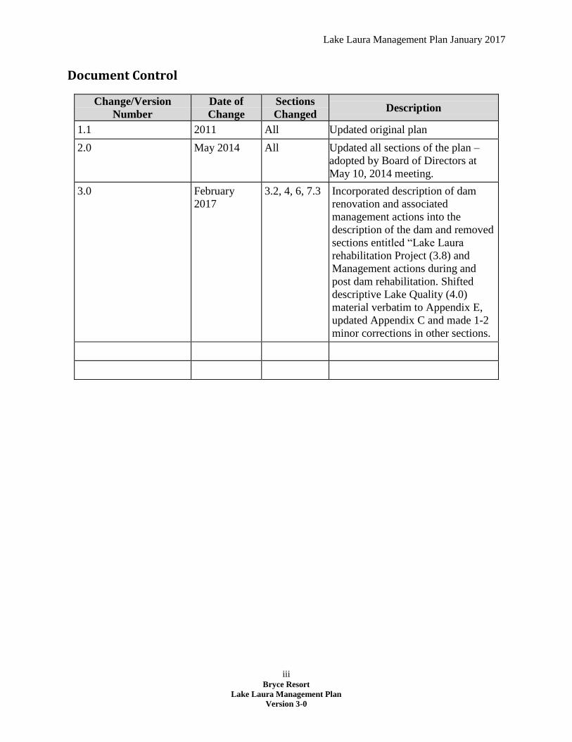
Document Control
Change/Version
Number
Date of
Change
Sections
Changed Description
1.1 2011 All Updated original plan
2.0 May 2014 All Updated all sections of the plan –
adopted by Board of Directors at
May 10, 2014 meeting.
3.0 February
2017
3.2, 4, 6, 7.3 Incorporated description of dam
renovation and associated
management actions into the
description of the dam and removed
sections entitled “Lake Laura
rehabilitation Project (3.8) and
Management actions during and
post dam rehabilitation. Shifted
descriptive Lake Quality (4.0)
material verbatim to Appendix E,
updated Appendix C and made 1-2
minor corrections in other sections.

Lake Laura Management Plan January 2017

Lake Laura Management Plan January 2017
v Bryce Resort
Lake Laura Management Plan
Version 3.0
Table of Contents
Purpose of Document ................................................................................................................................... 1
1. Bryce Resort Lake Laura Committee ..................................................................................................... 2
2. Lake Laura ............................................................................................................................................. 3
2.1. Background Information ............................................................................................................... 3
2.2. Lake Watershed ............................................................................................................................ 3
2.3. Watershed Soils ............................................................................................................................ 5
2.4. Climate .......................................................................................................................................... 5
2.5. Watershed Land Uses ................................................................................................................... 6
3. Lake Laura Dam ..................................................................................................................................... 6
3.1. Background Information ............................................................................................................... 6
3.2. Dam Description............................................................................................................................ 7
3.3. Dam Owner ................................................................................................................................... 9
3.4. Dam Operator ............................................................................................................................... 9
3.5. Flood Control ................................................................................................................................ 9
3.6. Flood Control Strategies ............................................................................................................. 10
3.7. Maintenance of the Dam ............................................................................................................ 10
4. Lake Water Quality ............................................................................................................................. 11
4.1. Sedimentation Control ................................................................................................................ 11
4.2. Nutrient Control Strategies ......................................................................................................... 11
4.3. Control of Biological Agents (Bacteria) ....................................................................................... 12
4.4. Aquatic Vegetation Control ........................................................................................................ 13
5. Lake Recreation ................................................................................................................................... 15
5.1. Beach Area .................................................................................................................................. 15
5.2. Fishing ......................................................................................................................................... 15
5.3. Private Boating ............................................................................................................................ 16
5.4. Hiking .......................................................................................................................................... 16
6. Lake Laura – Landowners Adjacent to Bryce Resort Property ............................................................ 16
7. Goals, Objectives and Actions for the Management of Lake Laura .................................................... 17
7.1. Goals ........................................................................................................................................... 17
7.2. Objectives.................................................................................................................................... 17
7.3. Actions ........................................................................................................................................ 18
Lake Laura Management Plan January 2017
vi Bryce Resort
Lake Laura Management Plan
Version 3.0
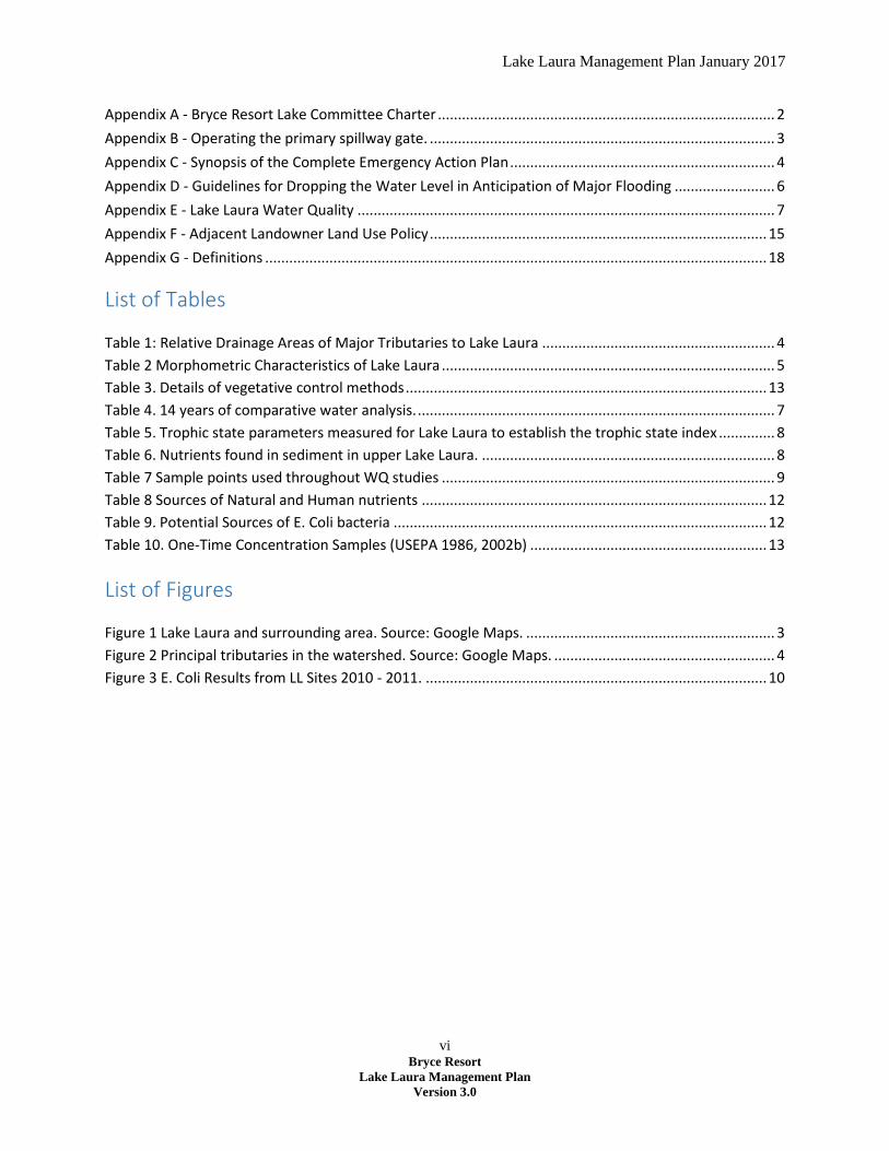
Appendix A - Bryce Resort Lake Committee Charter .................................................................................... 2
Appendix B - Operating the primary spillway gate. ...................................................................................... 3
Appendix C - Synopsis of the Complete Emergency Action Plan .................................................................. 4
Appendix D - Guidelines for Dropping the Water Level in Anticipation of Major Flooding ......................... 6
Appendix E - Lake Laura Water Quality ........................................................................................................ 7
Appendix F - Adjacent Landowner Land Use Policy .................................................................................... 15
Appendix G - Definitions ............................................................................................................................. 18
List of Tables
Table 1: Relative Drainage Areas of Major Tributaries to Lake Laura .......................................................... 4
Table 2 Morphometric Characteristics of Lake Laura ................................................................................... 5
Table 3. Details of vegetative control methods .......................................................................................... 13
Table 4. 14 years of comparative water analysis. ......................................................................................... 7
Table 5. Trophic state parameters measured for Lake Laura to establish the trophic state index .............. 8
Table 6. Nutrients found in sediment in upper Lake Laura. ......................................................................... 8
Table 7 Sample points used throughout WQ studies ................................................................................... 9
Table 8 Sources of Natural and Human nutrients ...................................................................................... 12
Table 9. Potential Sources of E. Coli bacteria ............................................................................................. 12
Table 10. One-Time Concentration Samples (USEPA 1986, 2002b) ........................................................... 13
List of Figures
Figure 1 Lake Laura and surrounding area. Source: Google Maps. .............................................................. 3
Figure 2 Principal tributaries in the watershed. Source: Google Maps. ....................................................... 4
Figure 3 E. Coli Results from LL Sites 2010 - 2011. ..................................................................................... 10
Lake Laura Management Plan, January 2017
1 Bryce Resort
Lake Laura Management Plan
Version 3.0
Purpose of Document
Bryce Resort recognizes Lake Laura as a key strategic asset essential to its business operations for skiing,
golfing and other recreational operations. The Bryce Resort Lake Laura Management Plan identifies the
management strategies required for the safe and enjoyable operation of the lake.
The Resort has a Lake Committee that serves in an advisory role to the GM and the Board of Directors
assisting in developing these management strategies. This plan focuses on the goals and objectives in
the key areas of the lake’s management to include:
Operating the dam’s flood controls
Dam maintenance
Bryce Resort profit-driven recreational activities
Fishing and boating, water quality management
Lake area property owners’ responsibilities
This document is divided into 8 sections.
Section 1 details the Bryce Resort Lake Laura Committee
Section 2 describes the Lake, its morphometric characteristics, and provides an overview of the
lake’s watershed
Section 3 addresses the Lake Laura Dam, ownership, maintenance, emergency flood control
operations and the anticipated upgrades to the dam
Section 4 discusses the Lake’s water quality, issues impacting the water quality and management
techniques available to the Resort to maintain water quality
Section 5 provides an overview of the recreational activities on the lake
Section 6 discusses the Lake Laura Adjacent Landowner Policy
Section 7 details the Goals, Objectives and Actions for the Management of Lake Laura
Section 8 provides an overview of what can be expected during and following the rehabilitation of
Lake

Lake Laura Management Plan January 2017
2 Bryce Resort
Lake Laura Management Plan
Version 3.0
1. Bryce Resort Lake Laura Committee
Bryce Resort chartered the Lake Laura Committee in October of 1999 to serve as an advisory body to
recommend policies and procedures required to maintain and enhance the quality of the lake as a
recreational facility of the Resort.
The Lake Laura Committee is strictly an advisory body. It reports to the Chief Operating Officer
(COO)/General Manager (GM). The committee’s authority does not extend beyond submitting
recommendations to the COO/GM.
Neither the Lake Laura Committee nor its chairman has the authority to advise or instruct the COO/GM
or department heads in the timeliness or manner in which they carry out their duties.
The Committee duties with the COO/GM include establishing the rules required for the safe and
enjoyable operation of the lake. The committee chairman is also delegated the responsibility to make
emergency evacuation decisions as “dam operator” and “rainfall gauge observer” in accordance with
the Lake Laura Emergency Evacuation Plan. (See Appendix A – Lake Committee Charter and Appendix C
– Lake Laura Emergency Plan)
Lake Laura Management Plan January 2017
3 Bryce Resort
Lake Laura Management Plan
Version 3.0
2. Lake Laura
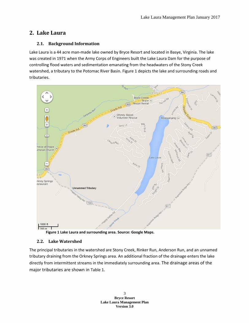
2.1. Background Information
Lake Laura is a 44 acre man-made lake owned by Bryce Resort and located in Basye, Virginia. The lake
was created in 1971 when the Army Corps of Engineers built the Lake Laura Dam for the purpose of
controlling flood waters and sedimentation emanating from the headwaters of the Stony Creek
watershed, a tributary to the Potomac River Basin. Figure 1 depicts the lake and surrounding roads and
tributaries.
Figure 1 Lake Laura and surrounding area. Source: Google Maps.
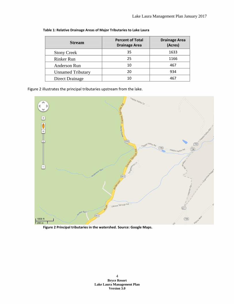
2.2. Lake Watershed
The principal tributaries in the watershed are Stony Creek, Rinker Run, Anderson Run, and an unnamed
tributary draining from the Orkney Springs area. An additional fraction of the drainage enters the lake
directly from intermittent streams in the immediately surrounding area. The drainage areas of the
major tributaries are shown in Table 1.
Lake Laura Management Plan January 2017
4 Bryce Resort
Lake Laura Management Plan
Version 3.0
Table 1: Relative Drainage Areas of Major Tributaries to Lake Laura
Stream Percent of Total Drainage Area
Drainage Area (Acres)
Stony Creek 35 1633
Rinker Run 25 1166
Anderson Run 10 467
Unnamed Tributary 20 934
Direct Drainage 10 467
Figure 2 illustrates the principal tributaries upstream from the lake.
Figure 2 Principal tributaries in the watershed. Source: Google Maps.

Lake Laura Management Plan January 2017
5 Bryce Resort
Lake Laura Management Plan
Version 3.0
Specific characteristics of the lake and its tributary watershed are shown in Table 2.1
Table 2 Morphometric Characteristics of Lake Laura
Shoreline, ft. 9600
Surface Area, acres (recreation pool) 44
Surface Area, acres (flood control pool) 94
Volume, acre-feet (recreation pool) 649
Volume, acre-feet (flood control pool) 1702
Maximum Depth, ft. 37
Mean Depth, ft. 15
Drainage Area, acres 4670
Stony Creek is the outlet stream from the lake. Bryce Resort owns the land under the lake and a strip of
land around the circumference of the lake that averages about 25 feet in width.
The Lake Laura watershed is underlain with sedimentary rocks of Silurian and Devonian age. The
structure is quite complex with a large syncline or fold with many minor folds. North Mountain and
Supinlick Mountain contain the lake’s watershed.2
2.3. Watershed Soils
The Lake Laura Watershed has two main soil areas:3
1. Weikert, Muskingum, Lehew, and Dekalb Association: The main soils which form this association
are: Weikert, Calvin, Muskingum, Dekalb, Leetonia and Lehew with inclusions of Jefferson, Laidig,
Allen and Leadvale. They are generally cobbly or Stony phases. They have developed from acid
shales, sandstones and interbedding of shale and sandstone. The Weikert soils are the most
extensive in this area. They are shallow, drouthy shale soils on slopes ranging from 6 to 60 percent.
Runoff is rapid.
2. Pope, Hungtingon, Sequatchie Association: This soil association occurs on the flood plain. The
main soils are Pope, Huntington and Sequatchie. Holston, Waynesboro and Monongahela occupy
some of the better drained terraces. Atkins and Tyler are poorly drained soils found in the area.
These are derivatives of colluvial material from surrounding uplands. These soils are subject to
runoff and seepage hazards from surrounding upland. These flood plain soils, when not subjected to
flooding, are among the most productive in the watershed.
2.4. Climate
1 Dr. Thomas J. Grizzard, P.E., A Limnological Survey of Lake Laura, Executive Summary. (Grizzard, January, 1987) p.2 2 Lord Fairfax Soil and Water Conservation District (LFSWCD), “Watershed Work Plan, Stony Creek Watershed. A Portion of the Potomac River Basin, Shenandoah County, Virginia.” (Lord Fairfax Soil and Water Conservation District, March 1969) p.3 3 Ibid., p. 3-4

Lake Laura Management Plan January 2017
6 Bryce Resort
Lake Laura Management Plan
Version 3.0
The average rainfall is about 40 inches. Most of the storms which cause flooding occur during the
growing season. However, floods have been recorded in all months. The average frost free season is 150
to 160 days – from early May to late October.4
2.5. Watershed Land Uses
The watershed basin consists principally of agricultural, forest, and modest amounts of urban land uses.
Forest lands constitute the major land use, comprising almost 60 percent of the total area; agricultural
lands are next with approximately 35 percent of the total area; and the remaining 5 percent is devoted
to modest levels of urban land uses. The agricultural areas of the basin are concentrated along Stony
Creek. Agricultural activities include timber harvesting, livestock operations (turkey and cattle), and
other farming related activities.
The urban land uses in the basin consist of some residential homes, a hotel, and various roadway
surfaces. Over 300 homes are located in the basin, with the majority concentrated in and around the
town of Orkney Springs. The town residential areas and the hotel are sewered, and are served by the
Stony Creek Sanitation District.
Until recently, the town was served by the Shrine Mont, Inc. sewage treatment plant. The plant had a
Virginia Dept. of Environmental Quality Permit to discharge effluent into the tributary that flowed into
the lake. In 2012 the Shrine Mont, Inc. sewage treatment plant was taken offline and the town was
switched over to the Stony Creek Sanitation District.
Bryce Resort uses water from Lake Laura for snowmaking and golf course irrigation, and the local
community also benefits from the lake. A number of homes border the lake, and Bryce operates a
recreational area that provides boating, fishing, and swimming. The lake and the surrounding area
provide ground water recharge and a haven for wildlife.
3. Lake Laura Dam
3.1. Background Information
Flow in Stony Creek and its tributaries is very irregular. Quite often during long dry spells there is little or
no flow in the smaller tributaries and only a very small flow in the main channel. By contrast, after heavy
thunderstorms or hurricane-like storms which occur rather frequently in summer and early autumn, and
after prolonged rainfalls, stream flows of six to ten feet above bank full have been recorded. Flooding
blocks roads and bridges and damages those structures as well.5
Erosion of the upland has been a very serious problem in the watershed. Sheet erosion on the uplands,
in road cuts and fills and areas being developed for nonagricultural uses, are the chief sources of
sediment.6
4 Op. Cit., LFSWCD, p.4 5 Op. Cit. LFSWCD, p.8 6 Ibid. p.8

Lake Laura Management Plan January 2017
7 Bryce Resort
Lake Laura Management Plan
Version 3.0
In the 1960s, the LFSWCD developed an overall watershed management plan for the Stony Creek
Watershed to address frequent flooding issues that caused widespread damage and erosion of bottom
lands. A series of treatment measures were initiated to alleviate the problems, one of which was the
construction of Lake Laura Dam.
3.2. Dam Description
The original earthen dam was built in 1971 at a cost of $239,506. The primary purpose for the
construction of the dam was to control flood waters in the headwaters of the Stony Creek watershed
and trap sediment run-off from the lake’s watershed.
Secondary to flood and erosion control, the dam provides water for irrigation and snowmaking for Bryce
Resort. Additional benefits obtained from the dam and the lake include recreation activities at the Bryce
Resort Beach, fishing, boating, wildlife habitat and a unique view-shed for nearby landowners.
The original earthen dam was 78.5 feet high by 705 feet long, with a Normal Pool area of 44 acres and
watershed of 4,700 acres. It was designed to store all the water that would run off the watershed in a
100-year, 24-hour storm (6.5 inches in 24 hours). This water would be slowly released through the
principal spillway in the concrete riser. The large grassy area at the side of the dam was the emergency,
or auxiliary, spillway. When a storm event produces more runoff than could be stored by the dam, the
excess water would flow through the emergency spillway rather than overtopping the dam. Water
flowing through the emergency spillway would be directed away from the side of the dam by an earthen
wall called a training dike. In 2006 LFSWCD contracted for engineering services to analyze the integrity
of the emergency spillway using the NRCS SITES computer program. The study cost $33,600 and
disclosed that failure during the design flood could occur through the emergency spillway.
In Virginia dams are classified as: high hazard; moderate hazard; and low hazard. The area that would be
under water in the event of a dam failure is called the Inundation Zone. Dams that have people living in
the Inundation Zone are classified as high hazard dams. Lake Laura dam has always been a high hazard
dam. Engineering studies in 2009 and 2010 resulted in maps that show the area of downstream flooding
under various scenarios. There are approximately 212 homes, businesses or other buildings in the
Inundation Zone and there could be an estimated 1,400 people at risk, along with potential
infrastructure disruption to utilities, 17 roads and an airport. At the time, it was built, the dam met all
safety standards.
Since September 2008, Virginia’s Impounding Structures Regulation has required that high hazard dams
such as Lake Laura safely convey a Probable Maximum Flood (PMF).
The PMF is defined as a flooding event resulting from a Probable Maximum Precipitation (PMP) event.
The PMP is the theoretically greatest amount of precipitation for a given duration (6, 12, or 24 hour
periods must be analyzed in accordance with Virginia’s impounding regulations) that is meteorologically
possible over a given size storm area at a particular geographic location. In such an event, there would
have been 26 to 38 inches of rain. This is substantially greater than the 100 year storm that the original
Lake Laura Management Plan January 2017
8 Bryce Resort
Lake Laura Management Plan
Version 3.0
earthen dam was designed to withstand therefore there could be excessive flooding both above and
below the dam, if the such a storm were to occur.
Though professionals differ on the precise number, one engineer calculated that the Lake Laura Dam
would withstand only 76% of the PMF. Consequently, LFSWCD initiated discussions with both the
federal and State governments to explore possible engineering solutions and to obtain improvement
funds. Fortunately, the State Legislature authorized a $20 million bond issue to fund improvements to
dams throughout the State to meet the more stringent standards.
Lake Laura was among the first five on the list for improvement, and the Department of Conservation
and Recreation (DCR) Design and Construction (DAC) selected Schnabel Dam Engineering, Inc. as the
architect/engineer (A/E) to evaluate alternatives, select and design needed upgrades to the dam and
oversee construction. Bryce Resort was a major supporter of the LFSWCD efforts to upgrade the dam.
Timeline:
In September 2013, the Lord Fairfax Soil and Water Conservation District presented an update
to the project underway to rehabilitate Lake Laura Dam and Bird Haven Dam.
In October of 2014 the project was advertised to potential bidders to perform work
In April 2015 construction contract was awarded
In August 2015 Lake Laura was drained for construction and refilled in May 2016
In October 2016 construction was complete and control returned to the dam owner
Description of Project:
The upgraded design for Lake Laura Dam includes the replacement of the existing drain gate
located at the upstream face and bottom of the riser and the installation of a second gate at a
higher elevation to release water for snowmaking and irrigation activities at the Ski Bryce
Resort.
The Lake Laura Dam crest was raised approximately 2 feet.
The existing auxiliary spillway was closed with earth fill and the crest of the dam was extended.
The flat portion of the existing auxiliary spillway on the downstream side of the dam is available
for Bryce Resort to use for whatever purposes it wishes.
The new auxiliary spillway is located at the center of the dam and aligned with Stony Creek.
The new spillway is a stepped concrete spillway that is covered with soil and vegetated with
grass.
A continuous walkway traverses the top of the dam, allowing for the existing contiguous lake
trail to remain in place.
Removal of sediment to the South end of Lake Laura:
The rehabilitation design focused on the dam and its hydraulic structures (riser tower, spillways, etc.).
Dredging the upper end of the lake and removing accumulate sediment were not authorize as part of
Lake Laura Management Plan January 2017
9 Bryce Resort
Lake Laura Management Plan
Version 3.0
the LFSWCD work. Although deepening the upper end of the lake increases the lake storage capacity
somewhat it does not significantly increase the dam’s hydraulic capacity and flood control function.
However, Bryce Resort did take the opportunity, while the lake was drained, to dredge and remove 5000
cubic yards of silt and sediment materials from the upper end of the lake. This restored about 2 feet of
water depth and reduced the impact of excessive vegetative growth. The project cost approximately
$100,000. Half of the cost was authorized by Bryce Resort and the balance was funded through
donations from property owners, resort members and supportive members of the public. The Friends of
Lake Laura were instrumental in initiating this funding drive.
3.3. Dam Owner
The Lord Fairfax Soil and Water Conservation District (LFSWCD) is the Dam Owner. LFSWCD owns,
maintains, and operates the Lake Laura Dam. According to law Bryce Resort, as owner of the land, is
also owner of the dam.
3.4. Dam Operator
The Dam Owner is responsible for operation and maintenance of Lake Laura Dam.
Bryce Resort, through an agreement with the LFSWCD, acts as “dam operator”. The Alternate Dam
Operator is a designee of the LFSWCD.
As “dam operator”, the Resort has the authority to operate the release gate located in the dam riser
that controls water flow out of the lake through the release structure. See Appendix B - Operating the
primary spillway gate.
The Dam Owner may order for the release of water from the dam. The Resort has the authority to
release water through the release structure for a number of management activities, which include:
water releases for irrigation and snow making needs; and water releases for lake management activities.
Releases of water through the use of the release structure should be conducted in a controlled manner
and monitored.
3.5. Flood Control
The Dam Owner is responsible for operation and maintenance of Lake Laura Dam. Bryce Resort has an
agreement with the LFSWCD to serve as the “rainfall gauge observer”. The Resort also has the
responsibility to make emergency evacuation decisions in accordance with the Lake Laura Emergency
Evacuation Plan (EAP).
The purpose of the EAP is to safeguard the lives and reduce damage to the property of the citizens of
Shenandoah County living or working along Stony Creek in the event of a failure of Stony Creek Dam #9,
Inventory Number 17101, also known as Lake Laura Dam.7
7 LFWSCD, Emergency Action Plan for Stony Creek Dam #9, aka Lake Laura. (LFSWCD, August 5, 2011) p.9
Lake Laura Management Plan January 2017
10 Bryce Resort
Lake Laura Management Plan
Version 3.0
Uncontrolled releases of impounded water may threaten lives in the flow area downstream and may
damage homes, roads, bridges and other infrastructure. An uncontrolled release occurs when the dam
or a part of the dam breaks and water in the impoundment rushes out.8
The dam operator and the staff rainfall gauge observer are responsible for monitoring conditions at the
dam and notifying the Emergency Services Coordinator (ESC) when emergency stage conditions are
activated.
The dam owner may initiate the EAP based on the issuance of a flood warning in the area or when
conditions at the dam indicate that the reservoir will continue to rise which will result in flows through
the emergency spillway.
A synopsis of the EAP is found in Appendix C. LFSWCD maintains the current Emergency Action Plan for
the Dam. In cooperation with the State and Shenandoah County Emergency Services, the EAP is revised
annually and regular drills and exercises are conducted to ensure that the plan is current.
The Dam Operator and the dam rainfall gauge observer shall have copies of the EAP.
3.6. Flood Control Strategies
Bryce Resort has an agreement with the LFSWCD to act as “dam operator” and “rainfall gauge
observer”. The Resort also has the responsibility to make emergency evacuation decisions in accordance
with the Lake Laura Emergency Evacuation Plan.
Current Control Strategies:
Always keep the secondary spillway gate open at least 1 inch (to maintain Stony Creek flow)
Implement Emergency Action Plan. (See Appendix C)
Draw lake down if hurricane is forecast to hit our area. (See Appendix D)
Work with Lord Fairfax Soil and Water District to help maintain the dam
3.7. Maintenance of the Dam
Bryce Resort, through an agreement with LFSWCD, is responsible for the general maintenance activities
of the dam. LFSWCD is responsible for major maintenance activities.
General Maintenance:
It is important to keep the inlet tower clear of debris and to keep the earthen spillway clear of any
structures such as fences and buildings. Disrupting the flow of the spillway could result in dam failure.
General maintenance activities include:
mowing of grass on the dam itself and in the emergency spillway
debris removal from the base of the dam
maintaining access roads
8 Ibid., p.9

Lake Laura Management Plan January 2017
11 Bryce Resort
Lake Laura Management Plan
Version 3.0
4. Lake Water Quality
As discussed previously, Lake Laura was formed when the impoundment structure (the Lake Laura dam)
was constructed at the north end of the lake. The dam was primarily built to trap sediment and control
flood waters in the Stony Creek Watershed. Agricultural activities in the watershed generate nutrients,
sediments and biologic agents that feed into the lake. These agents contribute to the lake’s overall
water quality.
Over the years, the Resort has commissioned several scientific surveys of Lake Laura. In addition, the
advice of several biologists has been sought. The conclusions are very similar. The water quality in Lake
Laura is good but the lake is rich in nutrients. Most of the nutrients come from farm activities.
The Virginia Department of Environmental Quality (DEQ) has stated on several occasions that the lake is
in good condition. The Virginia Department of Game and Inland Fisheries (DGIF) recently declared Lake
Laura as one of the best bass fisheries in the state.
Appendix E provides a fuller description of Lake Laura’s sedimentation, nutrients, biological agents and
aquatic vegetation, and provides water quality sampling results through the history of Lake Laura. The
paragraphs below focus on control methods to address these factors.
4.1. Sedimentation Control
Mechanical removal of sediment from the lake is the only practical means of sediment control. While it
is the only practical means, it also can be an expensive operation.
If the lake is drained, dry-land excavation machinery such as bulldozers can be used. Although digging
and removing bottom sediments by hand is hard work, it represents a simple, economical, and efficient
alternative to mechanical dredging. The dredge spoils should be moved below the pond basin to prevent
soil runoff back into the pond.
Control strategies available:
Remove pond bottom sediments when lake is lowered and the bottom is exposed and dry, and
then build steep lake bank slopes (3:1 slope). Relocate spoils below lake.
Remove sediment buildup every 10 years when possible.
4.2. Nutrient Control Strategies
The Resort has limited alternatives available to it to control nutrients entering into the lake and
removing them once they are there.
Current Control Strategies:
Hypolimnetic discharge of lake waters – a hypolimnetic discharge of water from the lake
involves opening the release structure on the riser and allowing the hypolimnetic water to leave
the lake and remove nutrients. Two scenarios for using hypolimnetic discharge are available:
Lake Laura Management Plan January 2017
12 Bryce Resort
Lake Laura Management Plan
Version 3.0
o Hypolimnetic discharge during a heavy rainfall event – this is the process of discharging
water during heavy rainfall events at a rate equivalent to the increased water flow into
the lake during major rain events. This discharge cycles out nutrients.
o Hypolimnetic discharge of lake during summer – this is the process of releasing
hypolimnetic waters during the summer. This scenario has the potential of degrading
downstream water quality if only hypolimnetic water is released as is now the situation
at Lake Laura.
Implement Best Management Practices (BMPs) on Resort owned property – this includes
activities in the Resort owned pasture south of Lake Laura. These practices involve a series of
steps to possibly include:
o fencing off water from livestock to prevent manure from entering into streams,
o installing water tanks to prevent livestock entering water to drink,
o installing water bars or berms on roads to stabilize against erosion,
o planting grass on highly erodible surfaces
Attempt to work with private landowners in the lake’s watershed to implement BMPs that will
control nutrient flow from livestock and agricultural activities.
4.3. Control of Biological Agents (Bacteria)
Bacteria will flow into the lake despite all efforts to prevent it from doing so. However, the
implementation of Best Management Practices Methods in agricultural activities in the watershed above
the lake can help reduce bacteria from entering into streams in the watershed.
According to water sampling surveying conducted by Bryce Resort and currently by other organizations,
bacteria loads are generally very low most of the time. Appendix E contains historical results of sampling
that has been conducted over the years by the Resort and other organizations. During significant rain
events, bacteria adhere to sediment and flows into the lake in higher than normal numbers; water
sampling during significant rain events does reflect significantly higher numbers.
Prior to 2012, the Sanitation Treatment Plant (STP) in Orkney Springs was permitted to discharge
effluent in to the tributary that feeds into Lake Laura. In 2012, the STP was shutdown and Orkney
Springs was placed on the Stony Creek Sanitation District Water Treatment System. This action has
removed a potential source of bacteria. However, abundant wildlife in the Lake Laura Watershed, along
with cattle and poultry farming activities, continue to contribute to the bacteria flow into the lake.
Control Strategies available:
Implement agricultural or other BMPs for any Resort sponsored activity in the watershed. This
includes the activities in the land adjacent to Stony Creek and south of the lake.
Work with private landowners in the watershed to implement BMPs to improve agricultural
activities that help reduce bacteria flow into streams.
Lake Laura Management Plan January 2017
13 Bryce Resort
Lake Laura Management Plan
Version 3.0
Monitoring of bacteria – water sampling for E. coli levels should conducted to determine if a
situation is occurring that is out of the norm for the lake that will give the Resort the ability to
make informed management decisions.
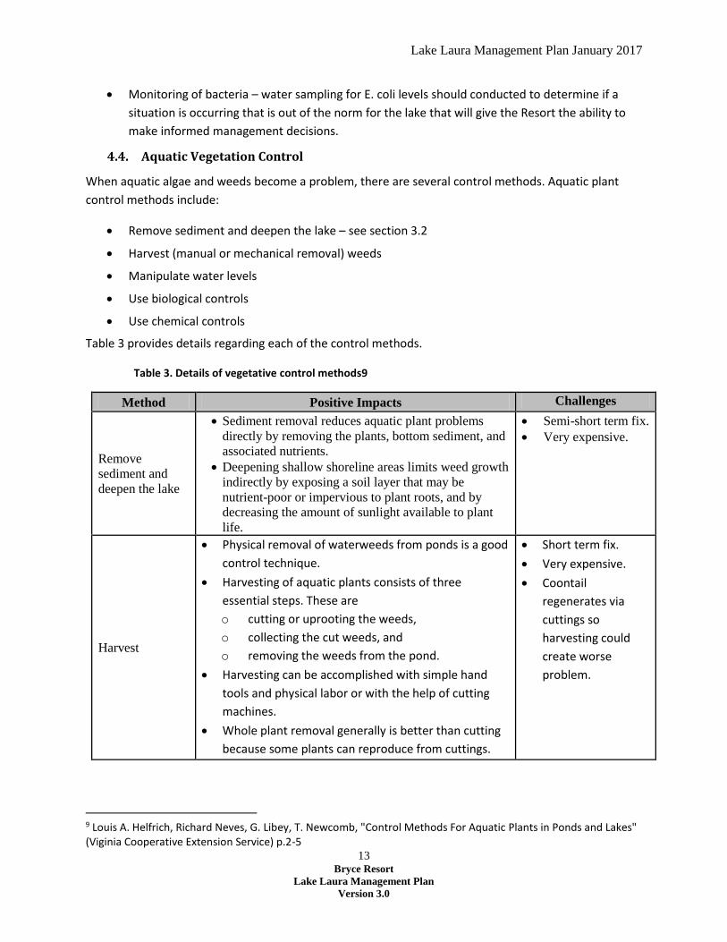
4.4. Aquatic Vegetation Control
When aquatic algae and weeds become a problem, there are several control methods. Aquatic plant
control methods include:
Remove sediment and deepen the lake – see section 3.2
Harvest (manual or mechanical removal) weeds
Manipulate water levels
Use biological controls
Use chemical controls
Table 3 provides details regarding each of the control methods.
Table 3. Details of vegetative control methods9
Method Positive Impacts Challenges
Remove
sediment and
deepen the lake
Sediment removal reduces aquatic plant problems
directly by removing the plants, bottom sediment, and
associated nutrients.
Deepening shallow shoreline areas limits weed growth
indirectly by exposing a soil layer that may be
nutrient-poor or impervious to plant roots, and by
decreasing the amount of sunlight available to plant
life.
Semi-short term fix.
Very expensive.
Harvest
Physical removal of waterweeds from ponds is a good
control technique.
Harvesting of aquatic plants consists of three
essential steps. These are
o cutting or uprooting the weeds,
o collecting the cut weeds, and
o removing the weeds from the pond.
Harvesting can be accomplished with simple hand
tools and physical labor or with the help of cutting
machines.
Whole plant removal generally is better than cutting
because some plants can reproduce from cuttings.
Short term fix.
Very expensive.
Coontail
regenerates via
cuttings so
harvesting could
create worse
problem.
9 Louis A. Helfrich, Richard Neves, G. Libey, T. Newcomb, "Control Methods For Aquatic Plants in Ponds and Lakes" (Viginia Cooperative Extension Service) p.2-5
Lake Laura Management Plan January 2017
14 Bryce Resort
Lake Laura Management Plan
Version 3.0
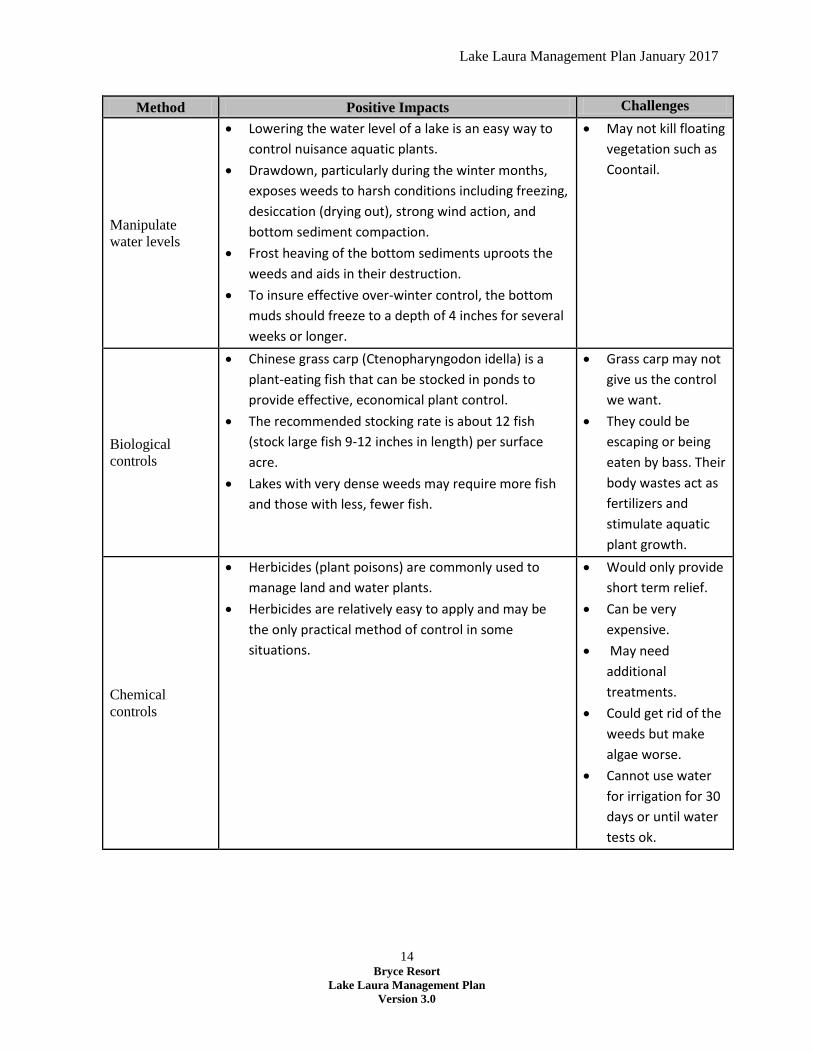
Method Positive Impacts Challenges
Manipulate
water levels
Lowering the water level of a lake is an easy way to
control nuisance aquatic plants.
Drawdown, particularly during the winter months,
exposes weeds to harsh conditions including freezing,
desiccation (drying out), strong wind action, and
bottom sediment compaction.
Frost heaving of the bottom sediments uproots the
weeds and aids in their destruction.
To insure effective over-winter control, the bottom
muds should freeze to a depth of 4 inches for several
weeks or longer.
May not kill floating
vegetation such as
Coontail.
Biological
controls
Chinese grass carp (Ctenopharyngodon idella) is a
plant-eating fish that can be stocked in ponds to
provide effective, economical plant control.
The recommended stocking rate is about 12 fish
(stock large fish 9-12 inches in length) per surface
acre.
Lakes with very dense weeds may require more fish
and those with less, fewer fish.
Grass carp may not
give us the control
we want.
They could be
escaping or being
eaten by bass. Their
body wastes act as
fertilizers and
stimulate aquatic
plant growth.
Chemical
controls
Herbicides (plant poisons) are commonly used to
manage land and water plants.
Herbicides are relatively easy to apply and may be
the only practical method of control in some
situations.
Would only provide
short term relief.
Can be very
expensive.
May need
additional
treatments.
Could get rid of the
weeds but make
algae worse.
Cannot use water
for irrigation for 30
days or until water
tests ok.
Lake Laura Management Plan January 2017
15 Bryce Resort
Lake Laura Management Plan
Version 3.0
5. Lake Recreation
Bryce Resort owns Lake Laura; this includes the land under and, with some exceptions, the land
immediately surrounding Lake Laura.
Public access to the lake for recreational purposes was encouraged through development of a trail
system circumventing the lake, a public beach area on the northeast side of the lake and a boat ramp
access on the southwest side used primarily by fishermen. The beach area and boat landing have posted
hours of access and rules for use.
Bryce Resort welcomes homeowners and the public to enjoy access to the lake from any point along the
Resort owned property. The resort permits adjacent property owners to access the Resort property
immediately from their property. The public and homeowners whose property is not adjacent to Resort
property access the lakefront from the dam/beach area or the boat launch, rather than by traversing the
property of adjacent landowners, unless authorized by the adjacent landowner.
5.1. Beach Area
Bryce Resort operates a private fenced in beach area at Lake Laura which is open to the public for a fee.
There is a sandy beach play area and floating docks. The fenced area contains grassy areas exposed to
the sun or shaded by trees. The Resort maintains attendants at the lake for sales and managing the area.
The Resort does not have lifeguards on duty at the area.
Paddle Boards, paddleboats and canoes are available for rent at the beach area. The Resort rents out
this equipment at hourly rates.
The Resort sells snacks, soft drinks and offers the rental of life jackets. Pets, alcoholic beverages and
grills are not permitted.
Parking for the lake area is located at the base of Lake Laura dam; the walk to the beach area includes a
large uphill section.
The resort maintains a Porta-Potty at the beach area.
5.2. Fishing
Fishing on the lake is open to the public. The Virginia Department of Game and Inland Fisheries
Department (DGIF) regulates fishing and stocks bass, walleye, channel catfish, and bream.
DGIF manages the fisheries in Lake Laura through a cooperative agreement established between the
DGIF and Bryce Resort in 1991. Through this agreement the DGIF agrees to be responsible for:
the fish management in the lake including population adjustments,
fishing regulations,
habitat improvements,
Lake Laura Management Plan January 2017
16 Bryce Resort
Lake Laura Management Plan
Version 3.0
fisherman-use assessments and
supplemental stockings.
In return, the Resort agrees to maintain Lake Laura as available for use by the public. This agreement
remains in effect unless terminated by either the Resort or the DGIF.
5.3. Private Boating
Private boats10 are permitted on Lake Laura throughout the year. Only electric motors are allowed.
Boats stored on Resort property require a valid permit. An annual fee is charged to store boats on resort
property. Boats are allowed for fishing with the restriction that, if powered, only electric motors are
allowed.
A public boat launch is maintained at the south end of the lake. Access to the boat launch is controlled
by the Resort to restrict access to specific hours. A gate controlled by the Resort controls access.
5.4. Hiking
Bryce Resort maintains two hiking trails at the lake; the Lake Laura Trail and the Nature Trail.
Lake Laura Trail Bryce Resort maintains the Lake Laura Trail. Accessible any time of year, this trail takes approximately
one-and-a-half to two hours to walk. It is a moderately easy hike or bike (but not handicap accessible).
Access points include the Lake Laura Beach Area, the parking lot at the base of the dam, or the boat
launch parking lot on the southern end of the lake. Hikers are asked to stay on the trail so as not to
disturb local residents, flora and wildlife. The Resort’s policy is that hikers should respect a policy of
“take nothing, leave nothing” ensuring that any trash is deposited in trash receptacles at trail entrances.
Bikes are permitted on the Lake Laura trail for free.
Nature Trail This public park area is adjacent to Stony Creek between Arnold Road and the Public Pool which is
located on The Hill Road. Signage identifying various plant life is located along the trail. The nature trail
is an easy walk and suitable for young children. The Nature Trail is accessible from the parking lot at the
base of the Lake Laura dam and from the Public Pool parking lot.
6. Lake Laura – Landowners Adjacent to Bryce Resort Property
As previously stated, Bryce Resort owns most of the land directly bordering the lake. Immediately
adjacent to the Resort owned land is land privately owned in the form of residential lots.
In the 1960’s, the area on the east side of the Lake was developed for residential use, the plotting and
residential development of Section 11 on the east side of the lake included a considerable number of
lots directly facing the lake above the Bryce-owned property.
10 “Boats” is defined to include all watercraft, including but not limited to: rowboats, canoes, kayaks, paddleboards, surfboards, windsurfers, sailboats and paddle boats.

Lake Laura Management Plan January 2017
17 Bryce Resort
Lake Laura Management Plan
Version 3.0
Over the years, an informal agreement was granted to these property owners by the Resort to keep a
boat alongside the lake. Eventually the Resort implemented a registration and permit system with a fee
for keeping a boat on the property. These property owners were allowed to build a modest boat dock,
provided it was removable.
In recent years, in the absence of a written policy governing use of Bryce Resort lakefront property,
there has been some increase in construction on and use of Bryce property adjacent to the lake for
personal use. With an increase in the number of homes built on the east side of the lake, there are some
properties with steps down to the lake, both above and below the lake-side path. Some homeowners
have cleared or pruned trees on Bryce property to improve their views. More permanent (non-
moveable) docks have been built and ground cover has been removed. In the past some homeowners
have kept three or more boats at the lakefront.
To ensure that the Lake Laura lakefront retains a natural character for the benefit of both adjacent
homeowners and the public, the Resort has established a policy for property owners of land
immediately adjacent to Resort owned land. The overarching principle of this policy is to ensure that
both homeowners and the public enjoy the natural aesthetic properties of the lake and lakefront. See
Appendix F for the policy.
7. Goals, Objectives and Actions for the Management of Lake Laura
Bryce Resort has identified a set of goals, objectives and actions for managing Lake Laura.
7.1. Goals
Over the long term, Bryce Resort wishes to accomplish the following goals for Lake Laura.
1. Protect and manage the lake as a strategic asset for the Resort in order to maintain its resources
for its operational needs.
2. Protect and improve the lake’s overall water quality.
3. Maintain the lake and adjacent resort-owned property so that it continues to provide
recreational benefits to include swimming, fishing, boating, hiking, while maintaining its natural
aesthetic qualities.
7.2. Objectives
In order to achieve the goals established for the lake, the Resort hopes to accomplish the following in
the near term for Lake Laura.
1. Continue the Resort’s ongoing cooperation with LFSWCD in maintaining the dam, acting as the
dam operator, and acting as “rain-gauge” observer.
2. Work with LFSWCD in the effort to rehabilitate the Lake Laura Dam until that effort is completed
(estimated to be completed in 2015).
3. Continue working with DGIF to maintain the best fisheries possible for Lake Laura.
Lake Laura Management Plan January 2017
18 Bryce Resort
Lake Laura Management Plan
Version 3.0
4. Remove sediment from the lake when deemed necessary.
5. Continue to control the lake’s vegetation and prevent it from reaching nuisance stage.
7.3. Actions
In order to achieve the objectives established for the lake, the Resort hopes to accomplish the following
steps in managing Lake Laura:
1. Ensure the Resort’s Board of Directors recognizes the lake as a key strategic asset through
recognition in the Resort’s Strategic Plan.
2. Ensure that lake operations and adjacent land owners respect the goals of the Lake Laura as
stated in the introduction to the Lake Management Plan
3. Maintain the dam and riser in cooperation with LFSWCD
4. Implement the EAP when government authorities require
5. Implement BMPs in the pasture south of the lake owned by the resort for any agricultural or
livestock operations
6. Stock grass carp to control vegetation, especially floating vegetation such as Coontail.
7. Conduct a winter drawdown every year to control rooted vegetation.
8. During heavy rainfall discharge hypolimnetic water from the riser’s secondary gate.
9. Always keep the secondary spillway gate open at least 1 inch (to maintain Stony Creek flow)
10. Draw lake down as directed by authorities if a significant rain event is forecast to hit our area.
11. Conduct a general water analysis once a year in September.
12. Test the water for E. coli during the swimming season.
13. Maintain the highest possible water level during the summer to control weeds.
14. Remove sediment from the shallow area approximately every 10 years.
15. Evaluate the effectiveness of weed control measures to determine if additional action is
necessary.
16. Find means to work with private landowners in the watershed to reduce the impact of
agricultural activities on nutrient and bacterial flows into the lake.
17. Host an annual lake clean up day to remove debris and trash from around the lake prior to
Memorial Day.
Lake Laura Management Plan January 2017
2 Bryce Resort
Lake Laura Management Plan
Version 3.0
Appendix A - Bryce Resort Lake Committee Charter
The Lake Laura committee shall consist of at least five, but not more than nine members, including the
chairman. The committee shall meet at the call of the chairman, as determined to be necessary by the
chairman and/or the COO/GM. Three committee members shall constitute a quorum. Minutes will be
maintained for all meetings and will be presented to the COO/GM in a timely fashion.
This committee, as with all committees of Bryce Resort, is strictly an advisory body. It reports to the
COO/GM. The committee authority will not extend beyond submitting recommendations to the
COO/GM. Recommendations to the COO/GM must include the opinion of the appropriate department
head, but in no way does this charter give this committee or its chairman the authority to advise or
instruct the COO/GM or department heads in the timeliness or manner in which they carry out their
duties.
The duties of the Lake Laura committee chairman will be as follows:
1. The chairman will become familiar with the provisions of the Lake Laura Emergency Evacuation
plan. The chairman will make decisions as "dam operator" and "rainfall gauge observer" under
this plan.
2. The chairman will interface with the COO/GM or his/her representative in regard to the flow of
water through the release pipe, ensuring that there is enough water released for snow making
and irrigation of the golf course.
3. The chairman will appoint a co-chairman who will be a member of the committee and who shall
assume the above duties in the absence of the Lake committee chairman. The name of the co-
chairman will be provided to the COO/GM.
The duties of the Lake Laura committee will be as follows:
1. Recommend to the COO/GM all policies and procedures required to maintain and enhance the
quality of Lake Laura as a recreational facility of the Resort.
2. Review capital improvements needed to enhance Lake Laura with the COO/GM. Make
recommendations to COO/GM on all capital improvements.
3. Establish with the COO/GM the rules required for safe and enjoyable operation of the Lake
Laura facilities.
The committee will, in addition to its other duties, review, recommend and put into effect other projects
assigned to the committee by the COO/GM.
The committee may, at the discretion of the chairman, establish subcommittees as needed.
Lake Laura Management Plan January 2017
3 Bryce Resort
Lake Laura Management Plan
Version 3.0
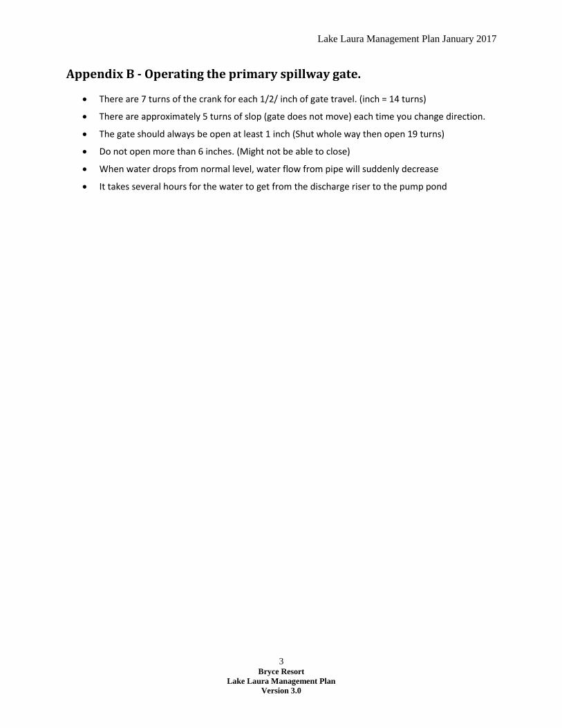
Appendix B - Operating the primary spillway gate.
There are 7 turns of the crank for each 1/2/ inch of gate travel. (inch = 14 turns)
There are approximately 5 turns of slop (gate does not move) each time you change direction.
The gate should always be open at least 1 inch (Shut whole way then open 19 turns)
Do not open more than 6 inches. (Might not be able to close)
When water drops from normal level, water flow from pipe will suddenly decrease
It takes several hours for the water to get from the discharge riser to the pump pond
Lake Laura Management Plan January 2017
4 Bryce Resort
Lake Laura Management Plan
Version 3.0
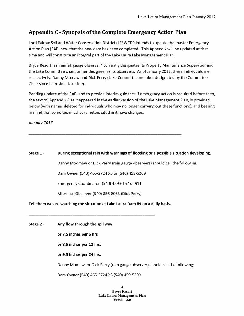
Appendix C - Synopsis of the Complete Emergency Action Plan
Lord Fairfax Soil and Water Conservation District (LFSWCD0 intends to update the master Emergency
Action Plan (EAP) now that the new dam has been completed. This Appendix will be updated at that
time and will constitute an integral part of the Lake Laura Lake Management Plan.
Bryce Resort, as ‘rainfall gauge observer,’ currently designates its Property Maintenance Supervisor and
the Lake Committee chair, or her designee, as its observers. As of January 2017, these individuals are
respectively: Danny Mumaw and Dick Perry (Lake Committee member designated by the Committee
Chair since he resides lakeside).
Pending update of the EAP, and to provide interim guidance if emergency action is required before then,
the text of Appendix C as it appeared in the earlier version of the Lake Management Plan, is provided
below (with names deleted for individuals who may no longer carrying out these functions), and bearing
in mind that some technical parameters cited in it have changed.
January 2017
______________________________________________________________________
Stage 1 - During exceptional rain with warnings of flooding or a possible situation developing.
Danny Moomaw or Dick Perry (rain gauge observers) should call the following:
Dam Owner (540) 465-2724 X3 or (540) 459-5209
Emergency Coordinator (540) 459-6167 or 911
Alternate Observer (540) 856-8063 (Dick Perry)
Tell them we are watching the situation at Lake Laura Dam #9 on a daily basis.
__________________________________________________________
Stage 2 - Any flow through the spillway
or 7.5 inches per 6 hrs
or 8.5 inches per 12 hrs.
or 9.5 inches per 24 hrs.
Danny Mumaw or Dick Perry (rain gauge observer) should call the following:
Dam Owner (540) 465-2724 X3 (540) 459-5209

Lake Laura Management Plan January 2017
5 Bryce Resort
Lake Laura Management Plan
Version 3.0
Emergency Coordinator (540) 459-6167 or 911
Alternate Observer (540) 856-8063 (Dick Perry)
Tell them we are watching the lake and that the conditions for a stage 2 alert exists. Tell them they
should mobilize personnel in case an evacuation is necessary. We will continue to observe the
spillway at least twice per day.
__________________________________________________________
Stage 3 - Flow through the spillway at the 2 foot level.
or
8.5 inches per 6 hrs
9.5 inches per 12 hrs
10.5 inches per 24 hrs
Danny Mumaw or Dick Perry (rain gauge observer) should call the following:
Dam Owner (540) 465-2724 (540) 459-5209
Emergency Coordinator (540) 459-6167 or 911
Alternate Observer (540) 856-8063 (Dick Perry)
Tell them you are at the dam and the water is flowing over the spillway at the 2 foot or more level.
Please alert your personnel to evacuate the people listed in the EAP and close the roads downstream
from the dam. We will remain at the dam until the dam breaks or the water level recedes to safe
levels.
Lake Laura Management Plan January 2017
6 Bryce Resort
Lake Laura Management Plan
Version 3.0
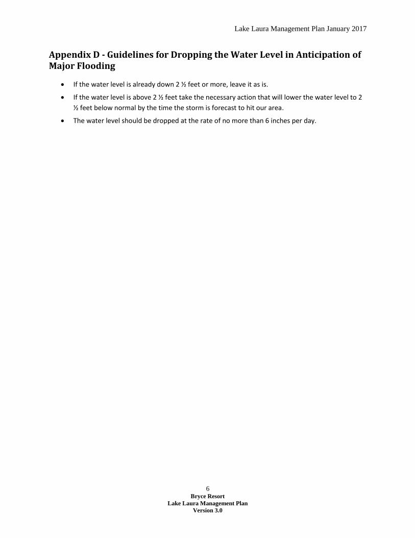
Appendix D - Guidelines for Dropping the Water Level in Anticipation of Major Flooding
If the water level is already down 2 ½ feet or more, leave it as is.
If the water level is above 2 ½ feet take the necessary action that will lower the water level to 2
½ feet below normal by the time the storm is forecast to hit our area.
The water level should be dropped at the rate of no more than 6 inches per day.
Lake Laura Management Plan January 2017
7 Bryce Resort
Lake Laura Management Plan
Version 3.0
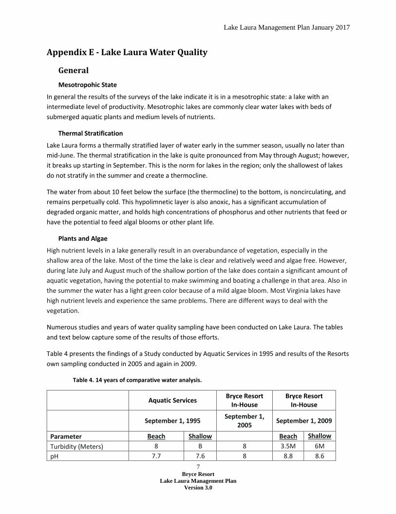
Appendix E - Lake Laura Water Quality
General
Mesotropohic State
In general the results of the surveys of the lake indicate it is in a mesotrophic state: a lake with an
intermediate level of productivity. Mesotrophic lakes are commonly clear water lakes with beds of
submerged aquatic plants and medium levels of nutrients.
Thermal Stratification
Lake Laura forms a thermally stratified layer of water early in the summer season, usually no later than
mid-June. The thermal stratification in the lake is quite pronounced from May through August; however,
it breaks up starting in September. This is the norm for lakes in the region; only the shallowest of lakes
do not stratify in the summer and create a thermocline.
The water from about 10 feet below the surface (the thermocline) to the bottom, is noncirculating, and
remains perpetually cold. This hypolimnetic layer is also anoxic, has a significant accumulation of
degraded organic matter, and holds high concentrations of phosphorus and other nutrients that feed or
have the potential to feed algal blooms or other plant life.
Plants and Algae
High nutrient levels in a lake generally result in an overabundance of vegetation, especially in the
shallow area of the lake. Most of the time the lake is clear and relatively weed and algae free. However,
during late July and August much of the shallow portion of the lake does contain a significant amount of
aquatic vegetation, having the potential to make swimming and boating a challenge in that area. Also in
the summer the water has a light green color because of a mild algae bloom. Most Virginia lakes have
high nutrient levels and experience the same problems. There are different ways to deal with the
vegetation.
Numerous studies and years of water quality sampling have been conducted on Lake Laura. The tables
and text below capture some of the results of those efforts.
Table 4 presents the findings of a Study conducted by Aquatic Services in 1995 and results of the Resorts
own sampling conducted in 2005 and again in 2009.
Table 4. 14 years of comparative water analysis.
Aquatic Services
Bryce Resort In-House
Bryce Resort In-House
September 1, 1995
September 1, 2005
September 1, 2009
Parameter Beach Shallow Beach Shallow Shallow Turbidity (Meters) 8 B 8 3.5M 6M
pH 7.7 7.6 8 8.8 8.6

Lake Laura Management Plan January 2017
8 Bryce Resort
Lake Laura Management Plan
Version 3.0
Tot Alkalinity(mgll) 45 80 49 51 45
Tot Hardness(mg/l) 68 68 58 52 48
Ammonia(mgll) 0.9 0.7 0.2 <0.2 <0.2
Nitrate (mg/l) <0.05 0.13 <0.05 <0.50 <0.50
Orthophosphate(mg/l) <0.05 <0.05 0.01 <0.05 <0.05
Fecal Coliform (colonies/100 ml )
<1 2
In 2010 a James Madison Study was conducted. On May 28, 2010, water quality samples of the lake and
tributaries feeding it were sampled. The results are as follows.
Table 5. Trophic state parameters measured for Lake Laura to establish the trophic state index
Chlorophyll a Phosphorus Ammonia Nitrate Location ppb P ppb N-NH3 ppm N-NO3 ppm
LLSC Upper - 27 0.055 0.244 LL West - 27 0.037 0.176 LL Upper 2.5 112 0.087 ND LL Middle 4.0 16 0.090 0.002 LL Riser 4.2 12 0.085 0.003
LLSC Lower - 18 0.077 0.037 May 28, 2010.
Also sampled during the JMU study was the lake bottom sediments. Sediment samples collected in the
upper reaches of the lake were found to contain all three primary nutrients in significant amounts. Table
10 details the results of the samples.
Table 6. Nutrients found in sediment in upper Lake Laura.
Location Phosphorus Ammonia Nitrate P ppm N ppm N ppm
Upper
30.5
21.3
25.7
East 14.9 34.3 3.8 Middle 17.2 40.1 3.6 West 13.8 16.2 25.3
Average 19.1 27.9 14.6
Beginning in the spring of 2011, the Friends of the North Fork of the Shenandoah (FNFSR) began
conducting a long term comprehensive water quality study of the tributaries feeding into Lake Laura and
Lake Laura. The study is anticipated to conclude in 2014. When it is complete, additional results from
that study will be included in this Appendix. The following tables and graphs show some of the results to
date.
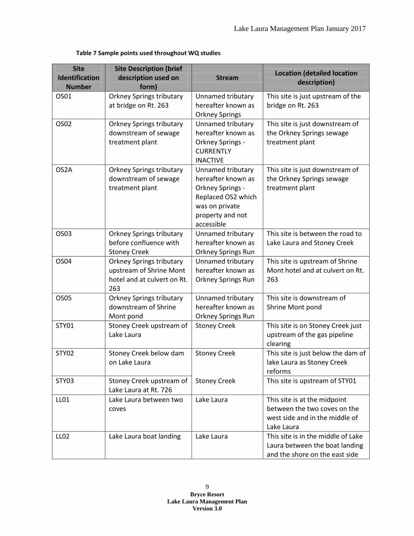
For the FNFSR, Table 7 lists the sample points that were used throughout the study.
Lake Laura Management Plan January 2017
9 Bryce Resort
Lake Laura Management Plan
Version 3.0
Table 7 Sample points used throughout WQ studies
Site Identification
Number
Site Description (brief description used on
form) Stream
Location (detailed location description)
OS01 Orkney Springs tributary at bridge on Rt. 263
Unnamed tributary hereafter known as Orkney Springs
This site is just upstream of the bridge on Rt. 263
OS02 Orkney Springs tributary downstream of sewage treatment plant
Unnamed tributary hereafter known as Orkney Springs - CURRENTLY INACTIVE
This site is just downstream of the Orkney Springs sewage treatment plant
OS2A Orkney Springs tributary downstream of sewage treatment plant
Unnamed tributary hereafter known as Orkney Springs - Replaced OS2 which was on private property and not accessible
This site is just downstream of the Orkney Springs sewage treatment plant
OS03 Orkney Springs tributary before confluence with Stoney Creek
Unnamed tributary hereafter known as Orkney Springs Run
This site is between the road to Lake Laura and Stoney Creek
OS04 Orkney Springs tributary upstream of Shrine Mont hotel and at culvert on Rt. 263
Unnamed tributary hereafter known as Orkney Springs Run
This site is upstream of Shrine Mont hotel and at culvert on Rt. 263
OS05 Orkney Springs tributary downstream of Shrine Mont pond
Unnamed tributary hereafter known as Orkney Springs Run
This site is downstream of Shrine Mont pond
STY01 Stoney Creek upstream of Lake Laura
Stoney Creek This site is on Stoney Creek just upstream of the gas pipeline clearing
STY02 Stoney Creek below dam on Lake Laura
Stoney Creek This site is just below the dam of lake Laura as Stoney Creek reforms
STY03 Stoney Creek upstream of Lake Laura at Rt. 726
Stoney Creek This site is upstream of STY01
LL01 Lake Laura between two coves
Lake Laura This site is at the midpoint between the two coves on the west side and in the middle of Lake Laura
LL02 Lake Laura boat landing Lake Laura This site is in the middle of Lake Laura between the boat landing and the shore on the east side
Lake Laura Management Plan January 2017
10 Bryce Resort
Lake Laura Management Plan
Version 3.0
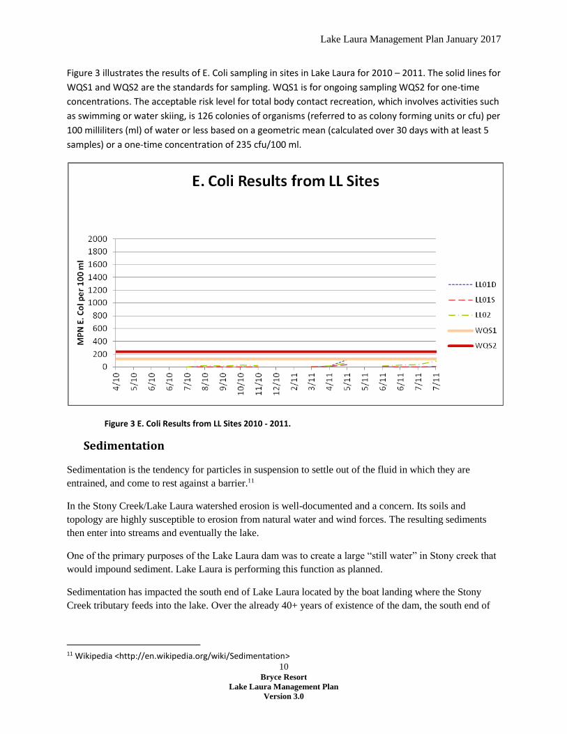
Figure 3 illustrates the results of E. Coli sampling in sites in Lake Laura for 2010 – 2011. The solid lines for
WQS1 and WQS2 are the standards for sampling. WQS1 is for ongoing sampling WQS2 for one-time
concentrations. The acceptable risk level for total body contact recreation, which involves activities such
as swimming or water skiing, is 126 colonies of organisms (referred to as colony forming units or cfu) per
100 milliliters (ml) of water or less based on a geometric mean (calculated over 30 days with at least 5
samples) or a one-time concentration of 235 cfu/100 ml.
Figure 3 E. Coli Results from LL Sites 2010 - 2011.
Sedimentation
Sedimentation is the tendency for particles in suspension to settle out of the fluid in which they are
entrained, and come to rest against a barrier.11
In the Stony Creek/Lake Laura watershed erosion is well-documented and a concern. Its soils and
topology are highly susceptible to erosion from natural water and wind forces. The resulting sediments
then enter into streams and eventually the lake.
One of the primary purposes of the Lake Laura dam was to create a large “still water” in Stony creek that
would impound sediment. Lake Laura is performing this function as planned.
Sedimentation has impacted the south end of Lake Laura located by the boat landing where the Stony
Creek tributary feeds into the lake. Over the already 40+ years of existence of the dam, the south end of
11 Wikipedia <http://en.wikipedia.org/wiki/Sedimentation>

Lake Laura Management Plan January 2017
11 Bryce Resort
Lake Laura Management Plan
Version 3.0
the lake has become shallower. This has in turn improved conditions for aquatic vegetation and algae to
grow in the south end of the lake during the summer season.
Because the watershed’s soils and topography are highly conducive to erosion, there is little opportunity
to prevent erosion from occurring in the watershed; it is a natural process and sediment will always flow
into the lake.
Until the period of the dam renovation, the Resort had removed sediment from the shallow area twice in
the lake’s history, once in 1991 and again in 2001.
Nutrients
Nutrients are chemicals that organisms need to live and grow or a substance used in an organism's
metabolism which must be taken in from its environment.12 Nutrients in lakes serve the same basic
functions as nutrients in a garden. They are essential for growth. In a garden, growth and productivity
are considered beneficial, but this is not necessarily so in a lake. The additional algae and other plant
growth allowed by the nutrients may be beneficial up to a point, but may easily become a nuisance.13
The term eutrophication refers to the natural and artificial addition of nutrients to lake waters and the
effects of these added nutrients. Eutrophication is an aspect of lake aging; it is a process that increases
the rate at which lakes disappear or become unsuitable for human use.
Nutrients in lakes come from two kinds of sources; point sources and non-point sources:
Point-sources are those which enter the lake concentrated at a specific location such as
upstream sewage treatment plants, feedlots, and storm drains. These sources readily are
identified, concentrated, and, therefore, easier to treat.
Non-point sources are those which originate as nutrient-rich runoff from agricultural fields and
pastures, fertilized lawns and gardens, leaf litter, and groundwater or rainfall, and seepage from
septic tank systems – all high in nutrients. These diffuse sources are much more difficult to
pinpoint and to treat.14
Excess nutrients such as nitrogen and phosphorus can accelerate eutrophication in surface waters, often
resulting in excessive plant growth, declining oxygen levels and changes in the aquatic community.
Often, phosphorus is the nutrient in the shortest supply relative to the organisms’ needs in fresh water
systems, and even a modest increase in phosphorus can set off a chain of undesirable events. This
includes accelerated plant growth, algae blooms, low dissolved oxygen, and the death of certain fish,
invertebrates, and other aquatic animals. Sources of nutrients can be both natural and human. Table 8
lists the sources of natural and human nutrients in the lake.
12 Elanor Whitney and Sharon Rolfes. Understanding Nutrition, 10th edition, (Thomson-Wadsworth, 2005) p 6. 13 Joy P. Michaud, A Citizen's Guide to Understanding & Monitoring Lakes and Streams. (Washington State Department of Ecology, 1994) p. 14
14 Louis A. Helfrich, James Parkhurst and Richard Neves, "Guide to Understanding and Managing Lakes: Part I (Physical Measurements)" (Viginia Cooperative Extension Service) p.2

Lake Laura Management Plan January 2017
12 Bryce Resort
Lake Laura Management Plan
Version 3.0
Table 8 Sources of Natural and Human nutrients
Natural sources include:
decaying soil and rocks
decaying plant material
Human sources include:
discharge from wastewater treatment plants,
runoff from fertilized lawns and cropland,
failing septic systems,
animal manure inputs, storm water runoff, and
disturbed land areas.
Biological Agents (Bacteria)
Biological agents also have a potential to impact lake water quality. Bacteria are the most prevalent
form of these agents that are of primary concern to the Resort. Bacteria are microscopic, single-celled
organisms that are the most numerous organisms on earth. Bacteria can live in numerous environments
and perform many complex actions, some of which are beneficial and some harmful. Bacteria that are
disease producing are referred to as pathogenic. Viruses and some protozoans can also be pathogenic.15
Coliform bacteria are part of the Enterobacteriaceae family and individual cells cannot be seen with the
naked eye due to their small size (but colonies can be seen.) While some coliform bacteria can be
naturally found in soil, the type of coliform bacteria that lives in the intestinal tract of warm-blooded
animals and originates from animal and human waste is called fecal coliform bacteria.16
Escherichia coli (E. coli) is one subgroup of fecal coliform bacteria. Even within this species, there are
numerous different strains, some of which can be harmful. However, the release of these naturally-
occurring organisms into the environment is generally not a cause for alarm. But, other disease causing
bacteria, which can include some pathogenic strains of E. coli, or viruses, may also be present in these
wastes and pose a health threat.17
Bacteria in water can originate from the intestinal tracts of both humans and other warm-blooded
animals, such as pets, livestock and wildlife. Table 9 lists potential sources of bacteria.
Table 9. Potential Sources of E. Coli bacteria
Human sources include:
failing septic tanks,
leaking sewer lines,
wastewater treatment plants, and
sewer overflows
15 Op. Cit., Michaud, p.7 16 Ibid., p.7 17 Ibid., p.7
Lake Laura Management Plan January 2017
13 Bryce Resort
Lake Laura Management Plan
Version 3.0
Animal sources include:
manure spread on land,
livestock in runoff or in streams,
improperly disposed farm animal wastes,
wildlife (deer, elk, raccoons, etc.), and
birds (geese, pigeons, ducks, gulls, etc.)18
E. coli bacteria enter into Lake Laura via Stony Creek by water runoff from the land. Fecal material is
transported to waterways through the runoff. How quickly these materials are transported partially
depends on the type of land use. Non-developed lands including grasses and other vegetation tend to soak
up rainfall, thereby increasing infiltration into the ground and reducing runoff to waterways. Lands that
support domesticated animals, such as cattle or horses can also be a source of bacteria, particularly if
animals enter the water for drinking or if heavy rains wash manure from the land into receiving waters.19
The Resort is concerned about the risk that bacteria may pose to human health. When numbers are above
health standards, people exposed to water that contain bacteria may exhibit fever, diarrhea and abdominal
cramps, chest pain, or hepatitis. While E. coli by itself is not generally a cause for alarm, other pathogens
of fecal origin that are health threats include Salmonella, Shigella, and Psuedomonas aeruginosa. Criteria
for concentrations of indicator bacteria in recreational waters have been developed by the US
Environmental Protection Agency, and the presence of E. coli is used as the primary indicator in
freshwater recreational areas.20
The acceptable risk level for total body contact recreation, which involves activities such as swimming or
water skiing, is 126 colonies of organisms (referred to as colony forming units or cfu) per 100 milliliters
(ml) of water or less based on a geometric mean (calculated over 30 days with at least 5 samples) or a
one-time concentration of 235 cfu/100 ml. The risk of getting sick increases as total numbers of colonies
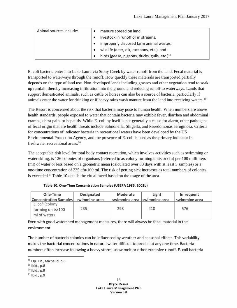
is exceeded.21 Table 10 details the cfu allowed based on the usage of the area.
Table 10. One-Time Concentration Samples (USEPA 1986, 2002b)
One-Time Concentration Samples
Designated swimming area
Moderate swimming area
Light swimming area
Infrequent swimming area
E. coli (colony
forming units/100
ml of water)
235
298
410
576
Even with good watershed management measures, there will always be fecal material in the
environment.
The number of bacteria colonies can be influenced by weather and seasonal effects. This variability
makes the bacterial concentrations in natural water difficult to predict at any one time. Bacteria
numbers often increase following a heavy storm, snow melt or other excessive runoff. E. coli bacteria
18 Op. Cit., Michaud, p.8 19 Ibid., p.8 20 Ibid., p.9 21 Ibid., p.9

Lake Laura Management Plan January 2017
14 Bryce Resort
Lake Laura Management Plan
Version 3.0
are often more prevalent in turbid waters because they live in soil and can attach to sediment particles.
Bacteria can also remain in streambed sediments for long periods of time. If the streambed has been
stirred up by increased flow or rainfall, samples could have elevated bacteria levels.
A number of other weather influences may affect bacteria levels in the stream. Higher E. coli counts may
be found in warmer waters because they survive more easily in these waters. (E. coli are used to living in
the warm environment of the intestines of warm-blooded animals). Ultraviolet rays of sunlight,
however, can also kill bacteria, so a warm sunny day may produce numbers lower than expected.
Aquatic Vegetation
The Resort and landowners living adjacent to the lake are concerned over the level of aquatic plant
growth in the lake. Several water quality studies commissioned by the Resort note numerous types of
aquatic algae and weeds present in the lake. A slight phytoplankton bloom is sometimes evident in the
lake as apparent by the light green color of the water. As identified in section 3.1, sediment build-up in
the south end of the lake has exacerbated this issue.
Aquatic algae and weed growth in the lake in itself is not bad. It actually is an important part of a lake’s
ecology. This growth provides cover for small fish, takes up nutrients, and produces oxygen during
photosynthesis.
In the 1995 study, the most abundant nuisance aquatic weed noted was Elodea (Elodea canadensis).
Small mats of filamentous algae were seen floating near the shoreline and inter-dispersed with and
growing on Elodea. The Study also identified a number of other submersed aquatic plants; Chara (Chara
spp.), Leafy-Pondweed (Potamogeton foliosus), and Floatingleaf Pondweed (Potamogeton natans).22
More recently Coontail (Ceratophyllum demersu) has become prevalent in the lake. This is a free-
floating submerged plant that does not root into the lake bottom. Because it is free-floating, it can
migrate around the lake, making it a nuisance.
Anything over 20-25% coverage of the lake can be considered a nuisance infestation. Not only is this a
problem from an aesthetic and recreational standpoint (not being able to get a boat out on the lake),
but it can eventually cause a lake to die. Dense growths of plants can cause night time oxygen depletion
and fish will suffocate if there is not sufficient oxygen in the water column.
22 Aquatic Services, “Bryce Resort Lake Evaluation,” (Aquatic Services. September 21, 1995) p.5
Lake Laura Management Plan January 2017
15 Bryce Resort
Lake Laura Management Plan
Version 3.0
Appendix F - Adjacent Landowner Land Use Policy
Why is Bryce Resort Issuing This Policy?
The overarching principle of this policy is to ensure that both homeowners and the public enjoy the
natural aesthetic properties of the lake and lakefront. In order to ensure that the Lake Laura lakefront
retains a natural character for the benefit of both homeowners and the public, the Resort has
established an Adjacent Landowner Land Use Policy.
Limitations on this Policy
Bryce Resort is the owner of Lake Laura including most of the land directly bordering the Lake. For the
few property owner’s whose property extends to the water’s edge, only the portions of this policy
regarding the lake itself strictly apply. To achieve the overarching principles described above, it is
requested that all property owners, including those for whom this policy doesn’t strictly apply,
participate voluntarily to the full extent of this policy. Prior to recommending or taking any corrective
actions for possible violations of this policy, Bryce Resort will take great care to validate property
ownership assertions. Any property owners who deems that their property is exempt from the policy
are welcome to inform the Resort, providing validation of property boundaries.
Background on Adjacent land and Resort Land use
Immediately adjacent to the Resort owned property is land privately owned in the form of residential
lots. Over the years, an informal agreement was granted to these property owners by the Resort to
keep a boat alongside the lake. Eventually the Resort implemented a registration and permit system
with a fee for keeping a boat on Resort Property. Additionally, some property owners were allowed to
build a modest boat dock provided it was removable.
In recent years there has been some increase in construction on and use of Bryce property adjacent to
the lake for personal use. With an increase in the number of homes built on the east side of the lake,
there are some properties with steps down to the lake, both above and below the lake-side path. Some
homeowners have cleared or pruned trees on Bryce property to improve their views. More permanent
(non moveable) docks have been built and ground cover has been removed.
Bryce Resort Lake Laura Land Use Policy
Adjacent Landowners Access to Lake Laura
1. Bryce Resort Property located adjacent to a landowner’s property is not to be considered for use
as an extension of their personal property or to create their personal beachfront for other
recreational purposes.
2. Bryce Resort does not permit the construction, modification or alteration of Resort owned
Property by anyone including landowners who own property immediately adjacent to Resort
owned property.

Lake Laura Management Plan January 2017
16 Bryce Resort
Lake Laura Management Plan
Version 3.0
3. Bryce Resort permits homeowners immediately adjacent to Resort property around the lake
direct access to the lake [for purposes of accessing the lake] for boating, swimming or other
recreational purposes via the Bryce Resort owned property that borders the lake. Adjacent
property owners may access Resort property directly from their property. The public and
homeowners whose land is not adjacent to Bryce property should use the public access points--
the beach/dam or boat launch, rather than by traversing adjacent landowners property, unless
so authorized by the adjacent property owners.
Special Permission to Modify Bryce Lake Property
1. A landowner owning property immediately adjacent to Resort Property may petition the
Resort’s Board of Directors for permission to perform construction, modification or alteration of
Resort owned Property. Petitions should be forwarded to the Bryce Resort General Manager for
submission to the Board of Directors. The General Manager may request clarifications from the
petitioner or require the petitioner to solicit agreements on the proposal from neighboring
landowners.
2. Petitioning for construction upon and/or alteration or modification of Resort Property. The
Resort may permit an adjacent landowner to construct upon and/or alter or modify Resort
Property if it meets the criteria listed below plus any additional criteria as a condition of
approval by the Bryce Resort Board of Directors:
a. Is not permanent
b. Is accessible and open to the public for use
c. Is at the lakefront that as close as possible to the homeowner’s property
d. Minimizes or avoids excavation or alteration of lakefront
e. Must be maintained in good repair and safe condition
3. Structures built on Bryce Resort property will normally be limited to:
a. Steps that provide for safe descent down steep slopes
b. Removable docks designed for ease of accessing boats or the lake
c. Rack to hold up to two suitable boats
4. Land cover: No trees may be felled or pruned without permission of the Bryce Resort General
Manager. Clearing of brush when constructing steps or a dock should be minimized. Shrubs and
brush may not be removed, particularly along the lakefront.
5. Privately owned boats23 placed on the lake by landowners owning property immediately
adjacent to the lake. The following criteria must be met for the placement of boats on the lake:
a. All boats must be registered annually and an annual fee paid.
23 “Boats” is defined to include all watercraft, including but not limited to: rowboats, canoes, kayaks, paddleboards, surfboards, windsurfers, sailboats and paddle boats.
Lake Laura Management Plan January 2017
17 Bryce Resort
Lake Laura Management Plan
Version 3.0
b. Homeowners may store up to two boats on Bryce Resort property at their own risk.
Boats should be placed to be as inconspicuous as possible, for example behind shrubs
and above the path.
c. Boats are not allowed to be permanently moored in the lake itself.
d. Homeowners are welcome to keep additional boats beyond the two allowed at lakeside
at the boat storage area adjacent to the beach.
The Bryce Resort General Manager at his/her sole discretion retains authority to require removal of any
structure, beach equipment, furniture, and any other personal property in violation of the criteria cited
above.
Lake Laura Management Plan January 2017
18 Bryce Resort
Lake Laura Management Plan
Version 3.0
Appendix G - Definitions
Anoxic waters - Areas of sea water, fresh water or groundwater that are depleted of dissolved oxygen.
This condition is generally found in areas that have restricted water exchange.
Dissolved Oxygen - (DO) relative measure of the amount of oxygen that is dissolved or carried in a given
medium. The standard unit is milligrams per litre (mg/l) or parts per million (ppm).
Epilimnion - The top-most layer in a thermally stratified lake, occurring above the deeper hypolimnion.
It is warmer and typically has a higher pH and higher dissolved oxygen concentration than the
hypolimnion.
Eutrophic - A eutrophic body of water, commonly a lake or pond, has high biological productivity. Due to
excessive nutrients, especially nitrogen and phosphorus, these water bodies are able to support an
abundance of aquatic plants. Usually the water body will be dominated either by aquatic plants or algae.
When aquatic plants dominate the water tends to be clear. When algae dominate the water it tends to
be darker. The algae engage in photosynthesis which supplies oxygen to the fish and biota which inhabit
these waters. Occasionally an excessive algae bloom will occur and can ultimately result in fish kills due
to respiration by algae and bottom living bacteria. The process of eutrophication can occur naturally and
by human impact on the environment.
Hypolimnion - The dense, bottom layer of water in a thermally-stratified lake. It is the layer that lies
below the thermocline.
Mesotrophic - Lakes with an intermediate level of productivity. These lakes are commonly clear water
lakes and ponds with beds of submerged aquatic plants and medium levels of nutrients.
Morphometric - Refers to the quantitative analysis of form, a concept that encompasses size and shape.
Oligotrophic - Lake with low primary productivity, the result of low nutrient content. These lakes have
low algal production, and consequently, often have very clear waters, with high drinking-water quality.
The bottom waters of such lakes typically have ample oxygen; thus, such lakes often support many fish
species, like lake trout, which require cold, well-oxygenated waters. The oxygen content is likely to be
higher in deep lakes, owing to their larger hypolimnetic volume.