bsc geography fine - university of madras, institute of distance
TRANSCRIPT

2
D:rainbow\B.A.\Tamil\less 1,2,5,12,17proof.pmd
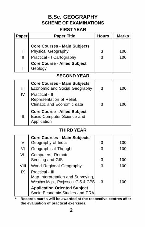
B.Sc. GEOGRAPHYSCHEME OF EXAMINATIONS
FIRST YEARPaper Paper Title Hours Marks
Core Courses - Main SubjectsI Physical Geography 3 100II Practical - I Cartography 3 100
Core Course - Allied SubjectI Geology
SECOND YEARCore Courses - Main Subjects
III Economic and Social Geography 3 100IV Practical - II
Representation of Relief,Climatic and Economic data 3 100
Core Course - Allied SubjectII Basic Computer Science and
Application
THIRD YEARCore Courses - Main Subjects
V Geography of India 3 100VI Geographical Thought 3 100VII Computers, Remote
Sensing and GIS 3 100VIII World Regional Geography 3 100IX Practical - III
Map Interpretation and Surveying,Weather Maps, Projection, GIS & GPS 3 100Application Oriented SubjectSocio-Economic Studies and PRA
* Records marks will be awarded at the respective centres afterthe evaluation of practical exercises.

3
INSTITUTE OF DISTANCE EDUCATIONB.Sc. DEGREE COURSE IN
GEOGRAPHY
SYLLABUSFIRST YEAR
PAPER I - PHYSICAL GEOGRAPHY
Part – A Geomorphology
Unit I : Rocks : types and classification – Igneous,sedimentary and metamorphic rocks, folding,faulting, earth quake and volcanoes
Unit II : Forces of gradation and weathering – mechanicaland chemical weathering, mass wasting andmass movement
Unit III : Agents of Gradation – Fluvial processes, erosion,transportation, deposition, resultant topography,glacio fluvial action – erosion and depositionalwork at the glaciers - resultant topography
Unit IV : Aeolian landscape – erosion – depositional workof the wind – resultant topography, wave action– erosive work of the waves, depositional workof the waves – shorelines of submergence andemergence.

4
D:rainbow\B.A.\Tamil\less 1,2,5,12,17proof.pmd
Unit V : Underground water – water table – spring andtheir types, karst topography, normal cycle oferosion – Davis, Penk.
Part – B Climatology
Unit VI : Definition – weather, climate, climatic elements– surface composition and structure of theatmosphere – Insolation, Horizontal and verticaldistribution of Temperature, Range ofTemperature
Unit VII : Atmospheric Pressure – winds – horizontaldistribution of pressure, planetary – periodic andlocal winds. Atmospheric moisture -condensation, Forms of precipitation – types
Unit VIII : Airmasses and fronts – concepts – classification– cyclones – tropical – anti cyclones – climaticclassification – Koppen’s – Basic of classificationand types
Part – C Oceanography
Unit IX : Surface configuration of the ocean floor –continental shelf, slope, deep, sea plain anddeeps – distribution of salinity in the seas andoceans
Unit X : Circulation of oceanic water – waves, tides andcurrents – currents of the Atlantic, pacific andIndian Ocean – Coral reefs – types
REFERENCES
1. Worcester, 1965, Text book of Geomorphology.
2. Arthur L. Boom, 1978 – Geomorphology.
3. Monkhouse F.J. Principles of physical geography.

5
4. Wollridge and Morgan – An outline of Geomorphology.5. Das Gupta and Kapur, 1955 – Physical Geography.6. Phillip Lake – Physical Geography.7. Richand, H. (1954): Tropical Meteorological, McGraw
Hill Book Co., Ltd., New York.8. Garbell, M.A., (1947): Tropical and Equatorial
Meterology, Bitman Publishing Corporation, New York.9. Trewartha, G.T. (1968): An Introduction to climate,
McGraw Hill Book, Co. New York.10. Das, P.K. (1968). The Monsoon, Edward Arnold Ltd.,
London.11. John F. Griffith, Climate and Environment, London.12. P.K.Das, Monsoon climate.13. J.E.Hobbs, Applied Climatology, Butterworths, London.
PAPER II – PRACTICAL – I - CARTOGRAPHYUnit I : Definition – Nature and Scope of cartography –
Maps, classification and uses – development ofcartography – use of Thematic cartography.
Unit II : The earth as a cartographic problem – shape,size and dimension – co-ordinate systems; Plane,spherical and rectangular – map projection –choice of projection.
Unit III : Maps : definition of a map – Types of maps –representation of scale on the map: statementscale – graphic scale – Representative Fraction;Comparative scale – pace scale – time scale –diagonal scale.
Unit IV : Map scale – determination of map scales –enlargement and reduction – direction

6
D:rainbow\B.A.\Tamil\less 1,2,5,12,17proof.pmd
Unit V : Measurement of distances on maps : Latitudesand longitudes. Instrumental method – threadmethod; measurement of areas : graphicalmethod – instrumental method.
Unit VI : Map data : Collection and classification –compilation and genralization of map information– compilation processes – principles ofgeneralization
Unit VII : Map symbolization – point , line, and areasymbols – qualitative and quantitative method.
Unit VIII : Enlargement and reduction of maps – squaremethod and similar triangle – reduction bypantograph – combination of maps of differentscales;
Unit IX : Representation of direction on maps : true north,grid magnetic north – magnetic declination –bearings – true bearing and magnetic bearing –map setting in the field – map reading.
Unit X : Representation of relief on maps : spot heights,bench mark, triangulation station, layer colouring,hachures, hill shading and contours –interpolation of contours; contour exercises:section drawing.
REFERENCES
1. Robinson, H. Elements of cartography Students friend,Allahabad, 4th Ed. John Wiley, New York
2. Misra, R.P. and Ramesh A., Fundamentals ofCartography, Heritage co., Delhi.
3. Monkhouse, F.J. and Wilkinson, H.R. Maps andDiagram, Meuthun & Co., London.
7
4. Ragunandhan Singh, Practical Geography
5. Singh R.L. and Dutt, P.K., Elements of PracticalGeography
6. Bygott, Practical Geography
7. Johnson and Ormsby, Surveying and Map reading
SECOND YEARPAPER III - ECONOMIC AND SOCIAL
GEOGRAPHYPart - A Economic Geography
Unit I : Scope and content of economic geography –basic concepts – nature of resources
Unit II : Farming in the world – shifting - subsistancecommercial and plantation farming – mixedfarming – horticulture – market gardening –production and distribution of rice, wheat,sugarcane, coffee, tea, cotton and jute – majorforest types and distribution, conservation offorests.
Unit III : Animal husbandry in the world – cattle – sheepand goats – dairy and wood regions of the world– fisheries – types – inland and marine locationand favourable conditions for major fishingactivities – problem in fishing and conservationmeasures.
Unit IV : World minerals mining – Iron ore – bauxite –manganese – copper – power resources coal,petroleum, natural gas, atomic minerals – major
8
D:rainbow\B.A.\Tamil\less 1,2,5,12,17proof.pmd
region of hydel power generation – conservationof power resources – manufacturing industriesof the world – localisation factor – Iron and steel– textiles – chemicals – automobiles – shipbuilding.
Unit V : Transport system – road – rail – air ways – waterways – major ports and airports of the world –international trade routes of the world – trade –national – international trade – modern tradedevelopment.
Part – B Population Geography
Unit VI : Nature and Scope of population Geography andits significance – development of populationstudies in India. Source of Population Data –problems relating to reliability and comparabilityof data.
Unit VII : Factors influencing the distribution and densityof population – growth of world population –factors affecting the growth of population in theworld – birth and death rates population explosion– population cycle
Unit VIII : Movement of population – migrations – types –national and international, rural to urban – causesand consequences of migration.
Part - C Settlement Geography
Unit IX : Introduction : Rural settlement – siting factors ofrural settlement, rural settlement types andpattern – houses and house types – rurallandscape of India.
9
Unit X : Urban Settlement : Factors – Classificationaccording to size and functions – Nelsons, HarrisClassification.
REFERENCES
1. Economic Geography – J.L. Guha and Pr.Chatterjee
2. Economic and Commercial Geography – R.N.Dubeyand L.R. Singh
3. Economic Geography, S.K. Sadhukon
4. Economic Geography – Dr.M.R.Chandhran
5. Economic and Commercial Geography – K.K. Khannaand V.I. Gupta
6. Nelsons, Harris Classification
7. Bougue Donald, J. 1969 Principles of Demography,John Wiley and Sons, New York.
8. Clarke, J.I. (1972). Population Geography, SecondEdition, Pergamon Press Ltd., Oxford
9. Clark, J. I. (ed.). 1984. Geography and Population:Approaches, Pergamon Press, Oxford.
10. Chandha, R.C. (1986). A Geography of Population :Concepts, Determination and Patterns, KalyaniPublishers, New Delhi.
11. Wilson, M.G.A. (1968). Population Geography, ThomasNelson, London
12. Trewartha, G.T. (1969). Geography of Population:World Patterns, John Wiley and Sons, New York.

10
D:rainbow\B.A.\Tamil\less 1,2,5,12,17proof.pmd
13. Demko, G.J. Rose, H.M., 1970. Population Geographyand Schnell, G.A. McGraw Hill Book Co., New York.
14. Wegi, B.S. (1991). Rural Geography Kedar Nath RamNath, College, Road, Meerut
15. Northern R.K. Urban Geography, John Wiley and Sons,New York
16. Misra M.P. (1978). Million cities of India, VikasPublishing
PAPER IV - PRACTICAL-II-PRESENTATION OFRELIEF, CLIMATIC AND ECONOMIC DATA
Part - A : Representation of Relief Data
Unit I : Contour Diagrams
Unit II : Profiles
Unit III : Spot Height and Interpolation of Contour
Unit IV : Slope Maps and Slope Analysis
Part – B : Representation of Climatic Data
Unit V : Diagrammatic representation of climatic data –climatic diagrams – Hythergraph – Climograph– Ergograph – Wind Roses
Unit VI : Study of Weather reports and Weather mapInterpretation
Unit VII : Representation of economic and population data– line graph – bar diagram – pie diagram –spheres – block piles.

11
Unit VIII : Located diagrams – bars – climatic graphs – dotmaps and pie maps – Isopleth, Choropleth –Stendigeer and Stilgenbauer, Pyramidal andpictorial diagrams
Part – C : Representation of Economic Data
Unit IX : Quantitative methods – histogram – frequencypolygon, frequency curve – scatter diagram –mean, median and mode – standard deviation
Unit X : Correlation : Pearson’s Prdouct MomentCorrelation – Rank Correlation.
REFERENCES
1. Monkhouse, F.J. Maps and Diagrams, Mutheun & Co.,Ltd., London, 1984
2. Hugh Mathew & Ian Foster, Geographical Data :Sources, Presentation, Oxford University Press, Oxford,1989
3. Mecullah, Quantitative Techniques in Geography4. Rahunathan Singh, Practical Geography5. Singh, R.L. & Dutt, Practical Geography
THIRD YEARPAPER V - GEOGRAPHY OF INDIA
Unit I : India as geographical Unit – India’s location –Physical contrasts – Physiography – relief, coastsand islands – water resources of India : Rivers –distribution and development of irrigation; tanks,canals, wells and tube wells – major irrigationand multipurpose river valley projects.
12
D:rainbow\B.A.\Tamil\less 1,2,5,12,17proof.pmd
Unit II : Climate : seasons – temperature and rainfall –Indian monsoon – climate regions.
Unit III : Soils – types and distribution – Soil erosion andconservation – natural vegetation – forests ; types– forest as a resource : Agriculture : major foodcrops and regions – rice, wheat and millets,plantation agriculture – sugarcane, tobacco, jute,cotton, groundnut, castor and mustard –agricultural regions
Unit IV : Problems of Indian Agriculture – livestock wealthof India – Indian fisheries.
Unit V : Mineral resources : Iron Maganese, Bauxite,Limestone, Copper, Zinc and Gold – distributionand production – power resources : Coal, oil,hydro-electricity, Thermal and atomic powerdevelopment – distribution and production,Industries : Agro-based industries – textiles –cotton, jute, woollen – sugar ;
Unit VI : Metallurigical industries: Iron and Steel,aluminium, engineering and machine tools,automobiles and locomotives, ship building,chemical industries, paper and fertilizer
Unit VII : Transport : roadways – railways and airways –trade : Inland and foreign – export and import.
Unit VIII : Population : distribution and density – rural andurban growth – migration.
Unit IX : Tamilnadu : Physiography – climate – drainage– soil and natural vegetation – agriculture ;distribution of paddy, sugarcane and millets –plantation agriculture.
Unit X : Distribution of minerals and industries –population ; distribution density and growth.
13
REFERENCES
1. Gopal Singh, 1970. Geography of India, Atma Ram NadSols.
2. Singh, R.L. India, A Regional Geogrpahy, UBSPublishers and Distributiors Ltd., Seena Publication
3. Spate, O.H.K. India and Pakistan4. Sharma, Economic Geography of India5. Singh and Memoria, Geography of India6. Memoria, Agricultural Geography of India7. Dubey, R.N. 1971, Economic Geography of India
PAPER VI - GEOGRAPHICAL THOUGHT
Unit I : Geographical Thought – Definition – sources ofdata for ancient people – Travel in ancient times– purposes of travel. Pre-historical westerngeographical thought – Greeks: GreekContribution to Physical geography, HumanGeography, Cartography, MathematicalGeography.
Unit II : Contribution of Homer, Aristotile, Heradoters,Eueateslhenes, Alexander the Great, Hecataeus,Role of Pheonians.
Unit III : Contribution of Romans : Strabe Ptolomy,Porubonius mela, Lfirmanus. Ancient IndianGeographical Thought : Sources of information– Contribution of Indians to Information regarding– geography of India, Dwipas, Seasons – earthand sun, earth quakes etc.
14
D:rainbow\B.A.\Tamil\less 1,2,5,12,17proof.pmd
Unit IV : Contributions of Kalidasa, Aryabhatta,Brahamgupta. Arab contribution to geography :Contribution to physical geography, regionalgeography, human geography, contributions ofAlmasudi, Albirumi, Al Balakhi, Ibn-Frttenrta
Unit V : Major exploitations and discoveries : Contributionof Megallan, Vascodagama, Hume Cook,Christopher Columbus.
Unit VI : Contribution of modern geographers varenius,Immanual Kant, Alexander Von Humbold, CarlRitter.
Unit VII : Determinism,Possibilism and New determinism.
Unit VIII : Contributions of Radzel, Ellensemple, LaBlackehn, Ellsworth Huntington, Griffith Taylor.
Unit IX : Evolution of Man : Pethuneseman, Javaman,Neandartalman, Cromagnonman, Jaboth andNeolithic age.
UNIT X : Races of Mankind : Characteristics of racialfeatures – distribution of races, race as a mith.
REFERENCES
1. Ali, Geography of Peranas : Peoples publishing house,Delhi
2. Evolution of geographical thought : Masjit Hussain,Rawat Publication
3. Majumdar, Canningham’s ancient geography of India,Calcutta
4. Harvey, Explanations in Geography, London

15
PAPER VII - COMPUTERS, REMOTESENSING AND GIS
Unit I : Map Design and layout : components of mapdesign – constraints in map design.
Unit II : Typography and lettering of the map; elementsof typographic design – methods of lettering –geographical names and others.
Unit III : Map reproduction, printing and non-printingprocesses – limited copy methods – xerography– diffusion transfer – photographic print- singlesensitized layer – multiple senitized layers –Interpol systems. Digital original – Hard copy –soft copy – methods for many copies.
Unit IV : Thematic and complex mapping problem; Atlasmapping, National Atlas of India – topographicmapping
Unit V : Remote Sensing – Definition – electromagneticspectrum – sensors – processing of remotesensing data – development of aerialphotographs – photo mosaic – photo maps –satellite imageries in cartography.
Unit VI : Introduction : Geography and computerapplications : Purpose, interacting with computer,Storing information, network and datacommunications -Computer Software : Theoperating System, Word Processing, and Desktop publishing, Spread Sheet concepts

16
D:rainbow\B.A.\Tamil\less 1,2,5,12,17proof.pmd
Unit VII : Database : Definition, over view, components ofdata base, data base applications - Data baseand Management System ; Data base andInformation Systems ; Cartographic Data basesand GIS
Unit VIII : Remote Sensing : Scope and Advantages –Types of Environmental Remote Sensing –Satellite Remote Sensing – Remote SensingApplications
Unit IX : GIS – Concept of GIS – Components of GIS –GIS data types – GIS and Map Design layout.
Unit X : GIS analysis – GIS software and Hardware – GISapplications
REFERENCES
1. A.H. Robinson, Elements of Cartography, 6th Edition,John Wiley, New York.
2. Misra, R.P. and Ramesh, A. Fundamentals ofCartography, Heritage Co., Delhi.
3. Monkhouse F.J. and Wilkinson, H.P Maps and Diagram,Muthen & Co., Ltd., London.
4. Peter Nortons (1995). “Introduction to Computers”,Published by Gelncoe, New York.
5. Arthur H. Robinson, Joel L.Morrison, PhillipC.Muehrcke, A.Jon Kimerbling – Elements ofCartography, 6th Ed. John Wiley and Sons, New York.
6. George Bokorte, The GIS Book, 5th Ed. Onward Press
7. Paul J.Currian, Principles of Remote Sensing, ELBS.
17
PAPER VIII - WORLD REGIONAL GEOGRAPHY
Unit I : Definition of region – Physical elements – Spacerelationships – Weather and climate – landforms– hydrology.
Unit II : Natural vegetation – Forest, Grasslands, Desert.
Unit III : The Associated animal life – Salient features oftheir adaptation.
Unit IV : Soil – human elements – population – economicactivities – cultural features
Unit V : World Regions : Major climatic Regions of theworld.
Unit VI : Location and characteristics features EquatorialRegion: Highland and low land regions , Tropicalregion; Monsoon, Tropical Grassland andTropical deserts
Unit VII : Warm Temperate Regions : Mediterranean,Temperate Grasslands, China type. CoolTemperate Regions
Unit VIII : British type of Marine West Coasts, Siberian Typeand Laurentian type.
Unit IX : Polar Regions : Highland or Ice Cap type,Lowland or Tundra type.
Unit X : Regions – Development of Regional Concept –Formal and Functional regions – RegionalHierarchy
18
D:rainbow\B.A.\Tamil\less 1,2,5,12,17proof.pmd
REFERENCES
1. Oliver, H. Heintzelman, Richard M. Highsmith, J.R.(1965). World Regional Geography – Printice Hall ofIndia (P) Ltd. New Delhi.
2. Roger Minshull (1967). Regional Geography : Theoryand Practice, Hutchinson University Library, London
PAPER IX - PRACTICAL III – MAPINTERPRETATION AND SURVEY, MAPS,
PROJECTIONS, GIS AND GPS
Part – A
Unit I : Signs and symbols used in topographicalmaps,Topographical maps and their referencingby quarter inch, half inch and one inch maps ofsurvey of India.
Unit II : Cartographic description of Survey ofIndia,Cartographic description of ordinancesurvey, United States Geological Maps.
Unit III : Interpretation of 1:50,000 topographical mapsof survey of India (maps highlighting of typicallandforms including drainage and coastal areasand cultural features should be done) a minimumof 6 exercise.
Unit IV : Simple methods of surveying: surveying withchain – open and closed traverse, Prismaticcompass – Recalculation of bearing – Bowditchmethod of correction of closing error.

19
Unit V : Plane table survey: Open and closed traverses– Resection by two point and three point method,Abney level – Indian Clinometer – heightdetermination by accessible and inaccessible,Aerial Photo interpretation.
Part – B
Unit VI : Study of weather symbols, weather data andcodes – station model, Study and interpretationof Indian Weather Reports Interpretation ofWeather reports according to seasons – studyof cyclonic tracks.
Unit VII : Cylindrical Projection: equidistant, equal area andMercator’s Projection ; Conical Projection; Onestandard and Two standard parallels – Bonne’sProjection and Polyconic Projection.
Unit VIII : Conventional (Whole World) Projections –Sinusoidal and Mollwids Projections – theirinterrupted types, Choice of map projections.
Unit IX : Definition of map projection – purpose of mapprojections, Graphical construction andproperties of the map projection, Zenithalprojection – equidistant, equal area, gnomonicand stereographic or orthomorphic projections.
Unit X : GIS – Raster Encoding, GPS – Location andRouting.
20
D:rainbow\B.A.\Tamil\less 1,2,5,12,17proof.pmd
REFERENCES
1. Raghunandan Singh, Practical Geography
2. Kentkar, Elements of Surveying
3. Austin Miller, Skin of the Earth
4. Monkhouse, F.J. Maps and Diagrams
5. Her Majesty Publications, Map Reading.
6. Johnson and Ormsby, Surveying and Map Reading
7. Singh and Dutt, Practical Geography
8. Monkhouse, Maps and Diagram
CANDIDATES OFFERING GEOGRAPHYSHALL OFFER ANY ONE OF THE FOLLOWING
APPLICATION ORIENTED SUBJECTS INTHIRD YEAR
1. Demographic Studies 2.Geography of Tourism
3. Medical Geography 4. Socio-economic studies and PRA
1. DEMOGRAPHIC STUDIES
Unit I : Demography – Scope, contents and trends,relevance of Demographic studies
Unit II : Demographic Studies and its applications
Unit III : Population Information – Census and Samplesurveys – Fertility Services – Household surveys

21
Unit IV : Study of Demographic structure – Populationdistribution and structure - Age-sex variation
Unit V : Ethnicity – literacy structure – occupationdifferences- Income variation.
Unit VI : Growth dynamics – Growth estimation – Impactsof death and birth growth
Unit VII : Population movements – rural-urbanmovements, intra - national and internationalmigrations- migration and growth
Unit VIII : Population dynamics – Demographic transition– mortality factors- Population changes
Unit IX : Demographic Planning and problems:Population Problems- Planning in Developedand Developing countries.
Unit X : Demographic studies: Policies – populationresources - Population geography in the 21st
century.
REFERENCES
1. Clark. I., (1984). Geography of Population: Approachesand Applications. Pergamon Press. Oxford, UK.
2. Chandna, R.C. (1984). A Geography of Population,Kalyani Publishers, New Delhi.

22
D:rainbow\B.A.\Tamil\less 1,2,5,12,17proof.pmd
2. GEOGRAPHY OF TOURISM
Unit I : Tourism – Definition – Development of tourism– Model of Tourism : Origins, Destinations,Transit – Factors of tourism
Unit II : Physical, Historical, Socio-Cultural, Economic,Environmental, Education, Political,Recreational, Natural Wonders.
Unit III : Types of tourism : Cultural toursim, Eco Tourism,adventure tourism, Heritage tourism,Pilgrimages – Measurement of tourismPhenomena
Unit IV : The need for measurement – Problems ofmeasurement – Method of measurement –tourist statistics
Unit V : Components of tourism industry – travel,hospitality, visitors services – distance, modes,cost – culture and hospitality – food, beverages– stay and accommodation.
Unit VI : Accommodation – types of accommodation,Chain accommodation, time sharing – tours,tour operators – private and public tourismdevelopment corporations.
Unit VII : Tourism promotion – Role of advertising andpublicity, audio-visual, photographs, posters,information offices – Role of handicrafts, fairs,festival, Exhibition
Unit VIII : World Tourism Organizations – WTO, IATA,PATA, IUOTO – International tourists flows
23
Unit IX : Indian Tourism, major types - India as a paradisefor tourists -Importance of tourism in IndianEconomy
Unit X : Consultant of tourism development – Measureof promoting tourism – Tourism Developmentin Tamil Nadu.
REFERENCE
1. Maneet Kumar (1992). “Tourism Today “ , KanishkaPublishing House, Delhi
2. Michael M.Coltman (1989) “ Tourism Marketing”, VanNostrand Reintold, New York
3. Fodder Hoddles, Fodder’s Guide of India, Hoden andStrongton
4. Rosemary Burton (1995). Travel Geography, PitmanPublishing, London.
3. MEDICAL GEOGRAPHY
Unit I : Medical Geography – Introduction – Scope –Contents – components of medical geography
Unit II : Environment and diseases – water bornediseases – air borne diseases – mineralenrichment and deficiencies – diseases
Unit III : Culture and Health – food habits, family andcommunity life, traditional outlook,
Unit IV : Food and health:, habits, Food habits, familyand community life, traditional outlook, religionand health

24
D:rainbow\B.A.\Tamil\less 1,2,5,12,17proof.pmd
Unit V : Society and Health – Sanitation, modernization,Western way of living and emerging healthissues
Unit VI : Ecology and diseases – diseases epidemics –communicable and contagious diseases
Unit VII : Disease mapping : disease related data –disease mapping – disease analysis
Unit VIII : Natural hazards – disasters calamities andhealth problems
Unit IX : Health Planning – Health Care Centers andplanning- Family and community health planning
Unit X : Health and health care systems in Tamil Nadu
REFERENCES
1. Learmonth, Andrew (1978). Patterns of Disease andHunger – A Study in Medical Geography, David andCharles, London.
2. Misra, R.P. (1969). Medical Geography of India, N.B.T.,New Delhi
3. Howe, M. and Loraine (Eds.) Environmental Medicine(2nd Edition), William Jeinemanu.
4. Pyle, G.F. (1979). Applied Medical Geography, W.H.Winston-Sons, Washington D.C.

25
4. SOCIO-ECONOMIC STUDIES AND PRA
Unit I : Socio-economic studies – Introduction - need -scope and limitations
Unit II : Socio economic studies and its applications.
Unit III : Social groups: social groups and culture - Villageand Urban community
Unit IV : Religious and cultural groups- religiouscommunities – ethnic societies
Unit V : Assessment, Approaches and Integrated studyfor Planning and Development
Unit VI : PRA – Definition- scope - importance of thestudy
Unit VII : PRA - Conceptual understanding – Principlesof PRA – Advantages of PRA
Unit VIII : PRA methods – space related social andresource maps – transact – participatory census
Unit IX : PRA and Time : Trend analysis – seasonaldiagrams – activity schedules
Unit X : PRA and relational methods - Network andimportant diagrams – matrix and Venn diagrams
REFERENCES
1 . Somesh Kumar, Methods for Community participation.Vistar Publication, New Delhi.