building a national archive of standardized geologic …//ngmdb.usgs.gov building a national archive...
TRANSCRIPT

http://ngmdb.usgs.gov
Building a National
Archive of
standardized
geologic maps and
related geoscience
information
Dave Soller National Geologic Map Database

http://ngmdb.usgs.gov

http://ngmdb.usgs.gov

http://ngmdb.usgs.gov
We stand on the shoulders of giants
“…the maps are designed not so much for the specialist as for the people, who justly look to the official geologist for a classification, nomenclature, and system of convention so simple and expressive as to render his work immediately [understandable]…”
– USGS Director J.W. Powell,
3RD IGC (Berlin, 1885)

http://ngmdb.usgs.gov
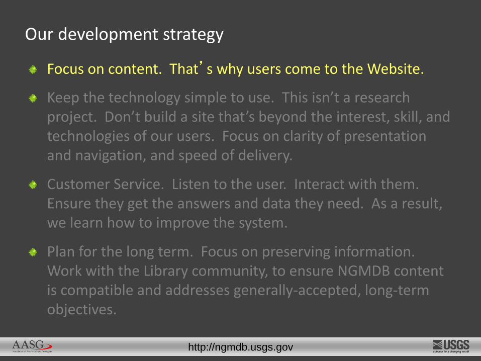
Focus on content. That’s why users come to the Website.
Keep the technology simple to use. This isn’t a research project. Don’t build a site that’s beyond the interest, skill, and technologies of our users. Focus on clarity of presentation and navigation, and speed of delivery.
Customer Service. Listen to the user. Interact with them. Ensure they get the answers and data they need. As a result, we learn how to improve the system.
Plan for the long term. Focus on preserving information. Work with the Library community, to ensure NGMDB content is compatible and addresses generally-accepted, long-term objectives.
Our development strategy
http://ngmdb.usgs.gov
Focus on content. That’s why users come to the Website.
Keep the technology simple to use. This isn’t a research project. Don’t build a site that’s beyond the interest, skill, and technologies of our users. Focus on clarity of presentation and navigation, and speed of delivery.
Customer Service. Listen to the user. Interact with them. Ensure they get the answers and data they need. As a result, we learn how to improve the system.
Plan for the long term. Focus on preserving information. Work with the Library community, to ensure NGMDB content is compatible and addresses generally-accepted, long-term objectives.
Our development strategy

http://ngmdb.usgs.gov
85,000+ users make 270,000+ visits / month (~ 9,000 visits / day)

http://ngmdb.usgs.gov
Focus on content. That’s why users come to the Website.
Keep the technology simple to use. This isn’t a research project. Don’t build a site that’s beyond the interest, skill, and technologies of our users. Focus on clarity of presentation and navigation, and speed of delivery.
Customer Service. Listen to the user. Interact with them. Ensure they get the answers and data they need. As a result, we learn how to improve the system.
Plan for the long term. Focus on preserving information. Work with the Library community, to ensure NGMDB content is compatible and addresses generally-accepted, long-term objectives.
Our development strategy

http://ngmdb.usgs.gov
Maps
Reports
Unpublished notes, data
GIS files
Metadata
Images

http://ngmdb.usgs.gov
Text here

http://ngmdb.usgs.gov
1996 – NGMDB Website opened 1996-2010 – Content, content, content… 2010-2012 – Website redesign 2012- 2017 – Infrastructure overhaul 2017-2018 – Return to Website redesign, add functionality (and content ! ) 1997- present – Standards development
Timeline

http://ngmdb.usgs.gov
NGMDB hardware USGS “Cloud” Red Hat CentOS Oracle PostgreSQL Older codebase Modern codebase Single Public/Dev environment Multiple dev servers with git repository …evolving IT security requirements…
Infrastructure overhaul

http://ngmdb.usgs.gov
Public servers (USGS “Cloud”, in Denver) – 7 VMs with 40 TB (includes .tif files of State GS images shown in Catalog and mapView) Development servers (NGMDB hardware, in Reston) – includes 64 TB storage, for file backup (including topoView) Tertiary backup, and image-processing computer Offsite tape backup
Infrastructure

http://ngmdb.usgs.gov
Adding images to the NGMDB Catalog and mapView

http://ngmdb.usgs.gov
101,600+ publications
650+ publishers
66,000+ are “digital”
25,000 are geologic maps
37,000 are resource-related
11,000 are hazards-related
We provide bibliographies and links to where you can buy or download these publications.
Geoscience Map Catalog

http://ngmdb.usgs.gov

http://ngmdb.usgs.gov
mapView

http://ngmdb.usgs.gov
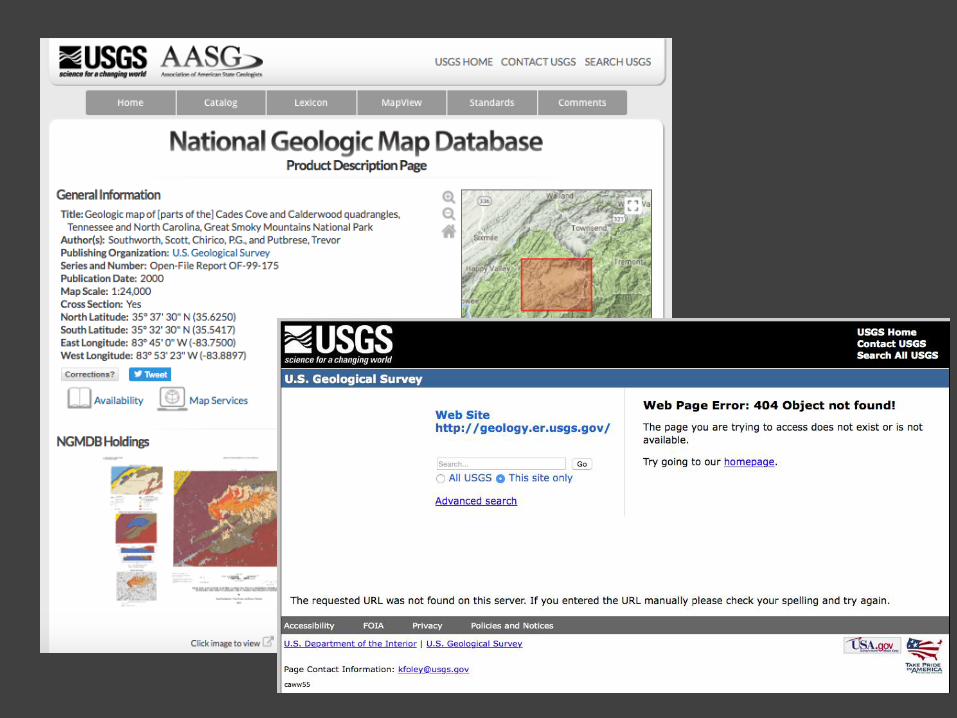
“It’s online.”
Contract scan of USGS Monograph, for Internet Archive. Resolution is adequate only for text pages

http://ngmdb.usgs.gov
Another group found a paper copy, and rescanned the plate. But it’s not linked with the Internet Archive site.

http://ngmdb.usgs.gov
Foldouts weren’t included in the Google scanning contracts…

http://ngmdb.usgs.gov
USGS PP-527 – No QC on this contract-scanned map. The error was found years later, by a user,
so the NGMDB
rescanned it.…

http://ngmdb.usgs.gov
USGS B-1157 – The maps weren’t scanned…

http://ngmdb.usgs.gov
For each ”part” of a publication, who has the best, or the authoritative, scan?

http://ngmdb.usgs.gov
Each agency/publisher needs a scan-status list that includes Who, What, When for every “part” or object in a publication.
•What is the object? (e.g., text, plate, figure, foldout)
•Who scanned it? When? What specs? Where does the best version of each “part” reside?

http://ngmdb.usgs.gov
Standards and guidelines…


http://ngmdb.usgs.gov
Available in the following formats:
Paper
Postscript (EPS)
ESRI ArcGIS 10
Free copies available…
http://ngmdb.usgs.gov/fgdc_gds/
FGDC Geologic Map Symbolization Standard

http://ngmdb.usgs.gov

http://ngmdb.usgs.gov
How many geologic maps are there? (24-250k)
~24,000 listed in the NGMDB Map Catalog (plus an additional ~9000 tagged as having geologic map content)
550 USGS maps in GIS format
343 USGS GIS files are >10 yrs old
47 USGS are >20 yrs old

http://ngmdb.usgs.gov
Born digital GIS files of geologic
maps (24-250k only):
In past 10 years, >2000 GIS maps by States and USGS
How many data formats were used?

http://ngmdb.usgs.gov
Can the GIS file be opened, and migrated? If not, does a scale-stable plot exist? If there’s a plot, then re-digitize the map.
Many examples of this, resulting in multiple versions – which is authoritative?
If no plot, then permanent loss of a taxpayer-funded map publication

http://ngmdb.usgs.gov
http://ngmdb.usgs.gov

http://ngmdb.usgs.gov
Surficial geology of Indiana (USGS, 1993)
Available only on floppy disk

http://ngmdb.usgs.gov
Geology of Puerto Rico (USGS, 1998)
No useable geologic map graphic

http://ngmdb.usgs.gov
Geology of Puerto Rico (USGS, 1998)
FMATN=MapUnitCode

http://ngmdb.usgs.gov
Migration of mid-1990’s GIS files:
Technical issues, cost of migration…

http://ngmdb.usgs.gov
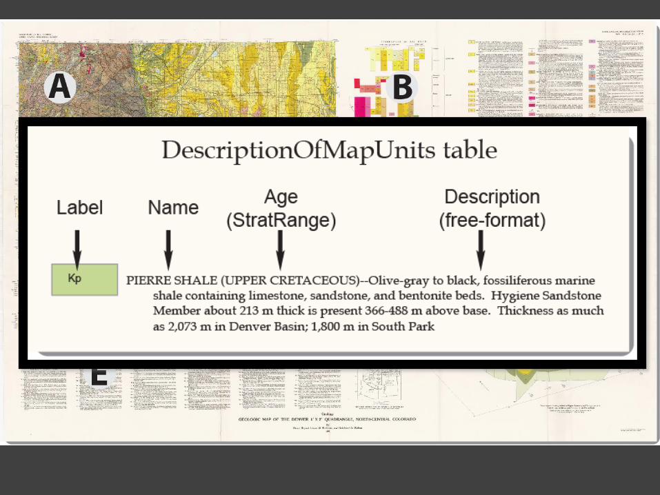
A database that contains all aspects of a traditional geologic map
Geologic Map
Description of Map Units
Correlation of Map Units
Cross Sections
Discussion section
References
Geologic Terms, Symbols, Colors
http://ngmdb.usgs.gov/Info/standards/NCGMP09/
GeMS (NCGMP09 v.2) standard map schema

http://ngmdb.usgs.gov
Professional
users
Research
General
interest
NCGMP09
ESRI GMT
GeoSciML-Lite
NGMDB-FULL
(NADM)
NGMDB-LITE
“5 friendly fields”
Content
Publication
Corporate database
(archive)
Web portal
Variations on a single schema

http://ngmdb.usgs.gov

http://ngmdb.usgs.gov
http://ngmdb.usgs.gov

http://ngmdb.usgs.gov
Summary of AASG-USGS collaboration on geologic map database standards
• Geologic Data Model Working Group (formed August, 1996, at the meeting in St. Louis, Missouri). Published a database design (“v.4.3”) in 1999.
• North American Data Model Steering Committee (formed in 1998). Published the "NADM" multi-map, enterprise-level design in 2004.
http://ngmdb.usgs.gov/www-nadm/prd/Model43a.pdf
http://pubs.usgs.gov/of/2004/1334/

http://ngmdb.usgs.gov
Summary of AASG-USGS collaboration on geologic map database standards, cont.
• In 2008, NCGMP requested development of a single-map database design. That design (NCGMP09) was presented at DMT'09, and published later that year.
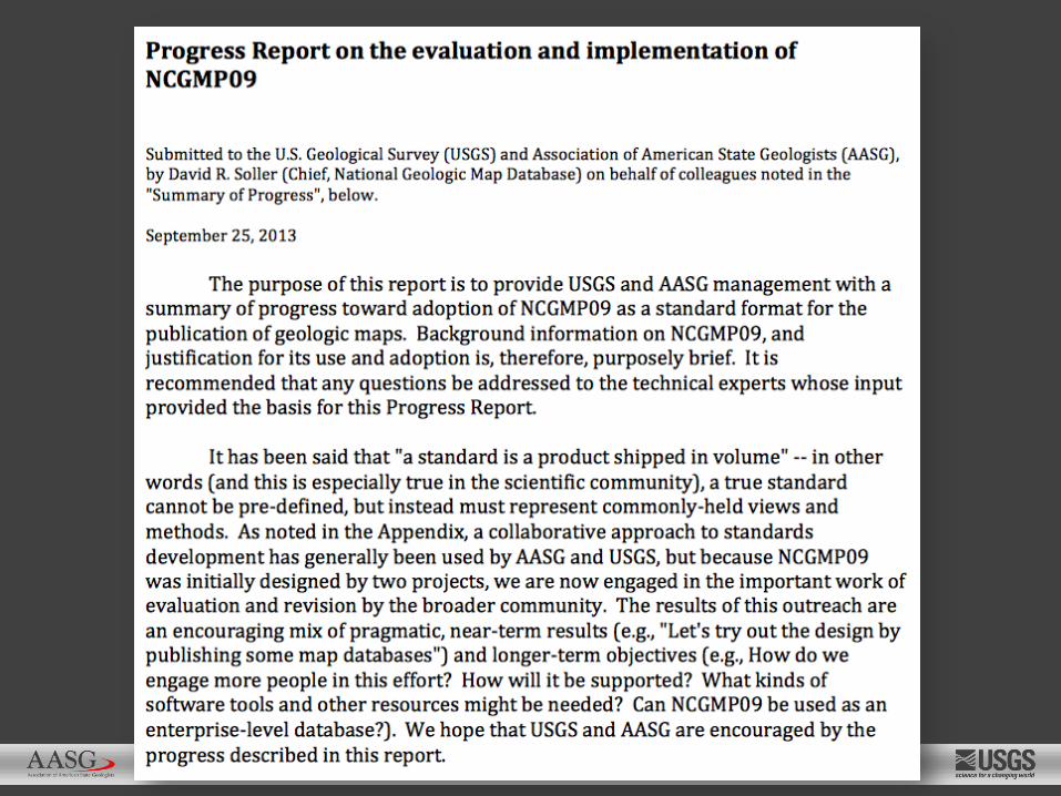
• in 2013, based on discussions at DMT'13, a Progress Report on NCGMP09 implementation was released.
• in 2014-2016, revisions to NCGMP09 were systematically debated among a large group of AASG and USGS staff. Version 2 (renamed “GeMS”) will be released in 2017.
http://pubs.usgs.gov/of/2010/1335/pdf/usgs_of2010-1335_NCGMP09.pdf
http://ngmdb.usgs.gov/Info/standards/NCGMP09/docs/NCGMP09_ProgressReport_Sept2013.pdf
http://ngmdb.usgs.gov

http://ngmdb.usgs.gov
Potential Obstacles to widespread adoption of NCGMP09, and some recommendations (from 2013 Progress Report):
1. Complexity of design
2. Legacy versus new mapping
3. Must we use NCGMP09 for a new map, from start to finish?
4. Software requirements
5. Standard terms and definitions
6. Software tools
7. Communication and collaboration
8. Agency commitment.

http://ngmdb.usgs.gov
Participants in review process (late 2014 - 2016)
• Steering Committee (set the general course)
• State and USGS telecons (discussed each topic, made recommendations)
• Working Group (decided on revisions to NCGMP09 design and documentation)
• NCGMP09 Listserve (kept informed of revisions, to provide additional comment)

http://ngmdb.usgs.gov
What aspects of design and documentation needed to be revised? We used the empirical approach – these issues were most commonly noted:
• Which fields should remain as mandatory, which should be optional, or deleted?
• Null values – how should they be encoded?
• GeneralLithology
• LocationConfidenceMeters
• Can NCGMP09 serve as an "Enterprise" or multi-map database?
• Stack-unit mapping
• Workflow

http://ngmdb.usgs.gov
• Based on that review process, the schema and documentation were modified.
• NCGMP09 v. 2 (renamed as Geologic Map Schema, or GeMS) then was submitted to the Working Group for comment, in early 2017.

http://ngmdb.usgs.gov
• Working Group and Peer Review comments have been addressed.
• Submitted in Sept., 2017, for USGS publication.
• GeMS will be posted to the GeMS (formerly NCGMP09) website, accompanied by various resources (e.g., tools, workflows).

http://ngmdb.usgs.gov
• After publication, this schema will be formally proposed as the FGDC Standard for geologic map databases.