building advanced spatial thinking capacity into ... · building advanced spatial thinking capacity...
TRANSCRIPT
TS 14 – Curriculum Development 1/15 Jonathan D. Regehr, Garreth Rempel, Björn Rådström, Rafael Murillo M., Jorge Arango, and Jeannette Montufar Building Advanced Spatial Thinking Capacity into Transportation Engineering Education and Research Coastal Areas and Land Administration – Building the Capacity 6th FIG Regional Conference 2007 San José, Costa Rica 12-15 November 2007
Building Advanced Spatial Thinking Capacity into Transportation Engineering Education and Research
Jonathan D. REGEHR, Garreth REMPEL and Björn RÅDSTRÖM, Canada
Rafael MURILLO M., Costa Rica, Jorge ARANGO, Colombia and Jeannette MONTUFAR, Canada
Key words: spatial thinking, transportation engineering education, capacity building, curriculum SUMMARY This paper outlines four principles that we have developed for building advanced spatial thinking capacity into transportation engineering education and research programs: – Transportation engineering students need and use knowledge about the evolution of
spatial thinking within transportation engineering, from classical surveying to modern geomatics engineering.
– Understanding basic geospatial theory provides the foundation for the application of geospatial technologies and software for transportation engineering.
– It is important to build the capacity to use and evaluate a variety of geospatial technologies and software to solve transportation engineering problems.
– Visualization capabilities increasingly drive transportation engineering analysis, design, and decision-making processes.
These principles are aimed at building the spatial thinking capacity of transportation engineering students. This capacity extends to the educational institution and to the many transportation agencies that eventually employ these students. Transportation engineers need spatial thinking skills – and related technological capabilities – to conceptualize new ways of solving increasingly complex transportation problems.
TS 14 – Curriculum Development 2/15 Jonathan D. Regehr, Garreth Rempel, Björn Rådström, Rafael Murillo M., Jorge Arango, and Jeannette Montufar Building Advanced Spatial Thinking Capacity into Transportation Engineering Education and Research Coastal Areas and Land Administration – Building the Capacity 6th FIG Regional Conference 2007 San José, Costa Rica 12-15 November 2007
Building Advanced Spatial Thinking Capacity into Transportation Engineering Education and Research
Jonathan D. REGEHR, Garreth REMPEL and Björn RÅDSTRÖM, Canada
Rafael MURILLO M., Costa Rica, Jorge ARANGO, Colombia and Jeannette MONTUFAR, Canada
1. PURPOSE AND APPROACH
This paper outlines four principles that we have developed for building advanced spatial thinking capacity into transportation engineering education and research programs: – Transportation engineering students need and use knowledge about the evolution of
spatial thinking within transportation engineering, from classical surveying to modern geomatics engineering.
– Understanding basic geospatial theory provides the foundation for the application of
geospatial technologies and software for transportation engineering. – It is important to build the capacity to use and evaluate a variety of geospatial
technologies and software to solve transportation engineering problems. – Visualization capabilities increasingly drive transportation engineering analysis, design,
and decision-making processes. The four principles are illustrated here by: (1) describing pedagogical approaches we use to build the spatial thinking capacity of transportation engineering students; and (2) presenting some examples of spatial thinking applications that demonstrate spatial learning by transportation engineering students at different educational levels for a variety of problems. Our intent is not to explain technical details of the spatial thinking concepts or specific transportation engineering issues, but rather to provide guidance on how the principles can be taught and applied in transportation engineering education and research, and ultimately, practice. The principles are based on our experiences in the transportation engineering and planning program in the Department of Civil Engineering at the University of Manitoba in Winnipeg, Canada. These experiences involve: (1) building students’ spatial thinking capacity by incorporating advanced spatial thinking concepts, tools, and processes into undergraduate and graduate curricula; and (2) applying this capacity in collaborative research focused on transportation information systems, highway design, safety analysis, characterization of transport systems in remote areas, railroad engineering, and others. Our approach to building our own spatial thinking capacity has evolved considerably with time – becoming interested in applying geographic information systems (GIS) to transportation problems in the early 1990’s; learning to digitize maps; applying mapping
TS 14 – Curriculum Development 3/15 Jonathan D. Regehr, Garreth Rempel, Björn Rådström, Rafael Murillo M., Jorge Arango, and Jeannette Montufar Building Advanced Spatial Thinking Capacity into Transportation Engineering Education and Research Coastal Areas and Land Administration – Building the Capacity 6th FIG Regional Conference 2007 San José, Costa Rica 12-15 November 2007
concepts to several major transportation studies; learning to use more advanced software through cooperative arrangements with a variety of vendors; becoming active in GIS for transportation (GIS-T) conferences; increasingly working with governments, railways, consultants, and other academics to expand our practical knowledge; incorporating this knowledge and the required theoretical support into undergraduate and graduate courses; and integrating our abilities into all our engineering efforts. We present the ideas in this paper from a civil engineering perspective, and emphasize spatial thinking capacity as a tool for solving transportation problems. 2. SPATIAL THINKING IN TRANSPORTATION ENGINEERING 2.1 What is Spatial Thinking? In its recent book, Learning to Think Spatially, the U.S. National Research Council indicates that “spatial thinking is based on a constructive amalgam of three elements: concepts of space, tools of representation, and processes of reasoning” (2006). Spatial thinking is a universal mode of thought, which can be learned, taught, and supported by tools, technologies, and curricula. We find it helpful to conceptualize this amalgam with the diagram shown in Figure 1, which is particularly oriented towards transportation engineering and planning. First, the diagram shows concepts of space: the three-dimensional real world projected into two-dimensional plan, profile, and cross-sectional views; different layers (which correlate to different map scales) representing different levels of abstraction of the real world; and temporal changes in the real world, and how and when these are reflected in the various levels of abstraction. Second, it illustrates how tools of representation (e.g., technologies and software) abstract and render the real world for analysis, design, and visualization purposes. Third, the diagram depicts the processes of reasoning used in the transportation engineering and planning process, from high-level visioning to interacting with the real world systems. 2.2 Building Spatial Thinking Capacity into Transportation Engineering Programs Broadly speaking, capacity building is an approach to people-centered development (Eade, 2003). There are different ways of building capacity; some focus on increasing quantity (i.e., recruiting more people into a field of work), while others emphasize quality enhancement (i.e., improving the skills of those already in the field). Our approach to building spatial thinking capacity in the context of a transportation engineering education program involves both quantity and quality – developing more transportation engineers who are better spatial thinkers, and who can critically apply their skills to the increasingly complex demands of their work.

TS 14 – Curriculum Development 4/15 Jonathan D. Regehr, Garreth Rempel, Björn Rådström, Rafael Murillo M., Jorge Arango, and Jeannette Montufar Building Advanced Spatial Thinking Capacity into Transportation Engineering Education and Research Coastal Areas and Land Administration – Building the Capacity 6th FIG Regional Conference 2007 San José, Costa Rica 12-15 November 2007
Scale
Small scale,high level of abstraction
Large scale, low level of abstraction
Real world
ReasoningProcess
Visioning
Policy making
System planning
Designing
Modeling
Interacting
Time t-1 t0 t1 t2
Tools of representation
Figure 1: Conceptual Representation of Spatial Thinking in Transportation Engineering Source: Adapted from Han, 2000 In our undergraduate program, courses in the fundamentals of geomatics and transportation engineering contain specific components to build students’ spatial thinking capacity, primarily in the context of technical skills. At the postgraduate level, we introduce more advanced applications, which provide opportunities to apply spatial thinking towards a wider variety of transportation engineering problems, including their political, social, economic, and environmental aspects. These applications are undertaken through coursework and research in collaboration with all levels of government, major transportation research laboratories, private engineering consulting firms, and various other industry interests. 3. PRINCIPLES FOR BUILDING ADVANCED SPATIAL THINKING CAPACITY Table 1 presents the four principles we have developed for building advanced spatial thinking capacity into transportation engineering curricula, and the relevant educational focus and level. Table 1: Spatial Thinking Principles in Transportation Engineering Curricula Principle Educational focus Educational level 1. Evolution of spatial thinking in
transportation engineering Foundational and background knowledge
Undergraduate
2. Geospatial theory for transportation engineering
Basic geospatial theory and illustrative applications
Undergraduate and graduate
3. Application of geospatial technologies and software
Applications using standard technologies and software
Undergraduate and graduate
4. Need for visualization in transportation engineering
Innovations and applications using advanced technologies and software
Graduate

TS 14 – Curriculum Development 5/15 Jonathan D. Regehr, Garreth Rempel, Björn Rådström, Rafael Murillo M., Jorge Arango, and Jeannette Montufar Building Advanced Spatial Thinking Capacity into Transportation Engineering Education and Research Coastal Areas and Land Administration – Building the Capacity 6th FIG Regional Conference 2007 San José, Costa Rica 12-15 November 2007
3.1 Principle 1: Evolution of Spatial Thinking in Transportation Engineering The evolution of spatial thinking within transportation engineering – from its origins in classical surveying and the preparation of civil engineering plans and maps, to the modern field of geomatics engineering, and its accompanying technologies – entails major changes in the types of spatial questions addressed, the types of spatial data available for analysis, and the reference systems used for spatial analysis. From an educational perspective, we have found it helpful to address this evolution by teaching the following concepts, principally at an undergraduate level. 3.1.1. “Where Am I?” to “Where Am I Now?” (to “Where Will I Be?”) Transportation engineers – and indeed all civil engineers and members of the general public – use maps on a daily basis. Maps help answer a fundamental human question: “Where am I?” Early mapmakers created maps without the vantage points that we have today. Instead, they developed representations of the earth by exploring its surface, and measuring distances, times, speeds, and bearings. As technologies developed, these measurements became more accurate, and more detailed, complex representations of the earth’s features were feasible. With computing technologies and the emergence of GIS, the process of making maps was reversed. Now, instead of making maps that combine many types of spatial data (e.g, physical geometry, qualitative and quantitative attributes), GIS “un-makes” maps by separating features into layers, which can be overlaid, manipulated, and independently analyzed. The development and widespread use of the global positioning system (GPS) and its integration into mobile phones and automobiles, increasing sophistication of information systems (including real-time capabilities), virtual reality technologies, and new web-based applications provide users with spatial and temporal data so that they can answer the question: “Where am I now?” As these and other technologies continue to develop and converge, new capabilities will no doubt emerge that will help answer the next question: “Where will I be?” 3.1.2. Spatial Reference Reversal Classical surveying techniques determine positions of points above, on, or beneath the earth’s surface, usually with reference to the established position of other points on the earth’s surface (Wolf and Brinker, 1994). Classical surveying techniques require a line-of-sight link with an established reference system. This requirement is constraining particularly when surveys are needed in areas where adequate control points are not geographically proximate. GPS technologies eliminate the need for line-of-sight links with control points on earth by reversing the spatial reference system. A GPS provides spatial and temporal coordinates derived from a network of satellites traveling in known orbits around the earth.
TS 14 – Curriculum Development 6/15 Jonathan D. Regehr, Garreth Rempel, Björn Rådström, Rafael Murillo M., Jorge Arango, and Jeannette Montufar Building Advanced Spatial Thinking Capacity into Transportation Engineering Education and Research Coastal Areas and Land Administration – Building the Capacity 6th FIG Regional Conference 2007 San José, Costa Rica 12-15 November 2007
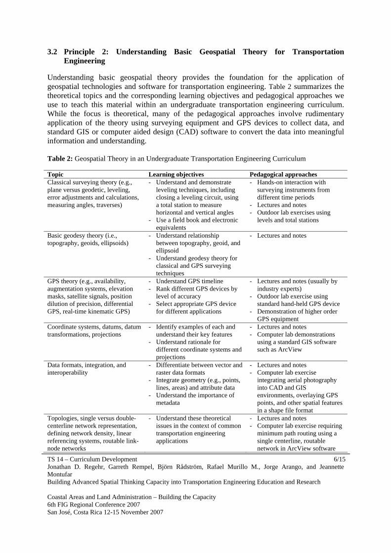
3.2 Principle 2: Understanding Basic Geospatial Theory for Transportation Engineering
Understanding basic geospatial theory provides the foundation for the application of geospatial technologies and software for transportation engineering. Table 2 summarizes the theoretical topics and the corresponding learning objectives and pedagogical approaches we use to teach this material within an undergraduate transportation engineering curriculum. While the focus is theoretical, many of the pedagogical approaches involve rudimentary application of the theory using surveying equipment and GPS devices to collect data, and standard GIS or computer aided design (CAD) software to convert the data into meaningful information and understanding. Table 2: Geospatial Theory in an Undergraduate Transportation Engineering Curriculum Topic Learning objectives Pedagogical approaches Classical surveying theory (e.g., plane versus geodetic, leveling, error adjustments and calculations, measuring angles, traverses)
- Understand and demonstrate leveling techniques, including closing a leveling circuit, using a total station to measure horizontal and vertical angles
- Use a field book and electronic equivalents
- Hands-on interaction with surveying instruments from different time periods
- Lectures and notes - Outdoor lab exercises using
levels and total stations
Basic geodesy theory (i.e., topography, geoids, ellipsoids)
- Understand relationship between topography, geoid, and ellipsoid
- Understand geodesy theory for classical and GPS surveying techniques
- Lectures and notes
GPS theory (e.g., availability, augmentation systems, elevation masks, satellite signals, position dilution of precision, differential GPS, real-time kinematic GPS)
- Understand GPS timeline - Rank different GPS devices by
level of accuracy - Select appropriate GPS device
for different applications
- Lectures and notes (usually by industry experts)
- Outdoor lab exercise using standard hand-held GPS device
- Demonstration of higher order GPS equipment
Coordinate systems, datums, datum transformations, projections
- Identify examples of each and understand their key features
- Understand rationale for different coordinate systems and projections
- Lectures and notes - Computer lab demonstrations
using a standard GIS software such as ArcView
Data formats, integration, and interoperability
- Differentiate between vector and raster data formats
- Integrate geometry (e.g., points, lines, areas) and attribute data
- Understand the importance of metadata
- Lectures and notes - Computer lab exercise
integrating aerial photography into CAD and GIS environments, overlaying GPS points, and other spatial features in a shape file format
Topologies, single versus double-centerline network representation, defining network density, linear referencing systems, routable link-node networks
- Understand these theoretical issues in the context of common transportation engineering applications
- Lectures and notes - Computer lab exercise requiring
minimum path routing using a single centerline, routable network in ArcView software
TS 14 – Curriculum Development 7/15 Jonathan D. Regehr, Garreth Rempel, Björn Rådström, Rafael Murillo M., Jorge Arango, and Jeannette Montufar Building Advanced Spatial Thinking Capacity into Transportation Engineering Education and Research Coastal Areas and Land Administration – Building the Capacity 6th FIG Regional Conference 2007 San José, Costa Rica 12-15 November 2007
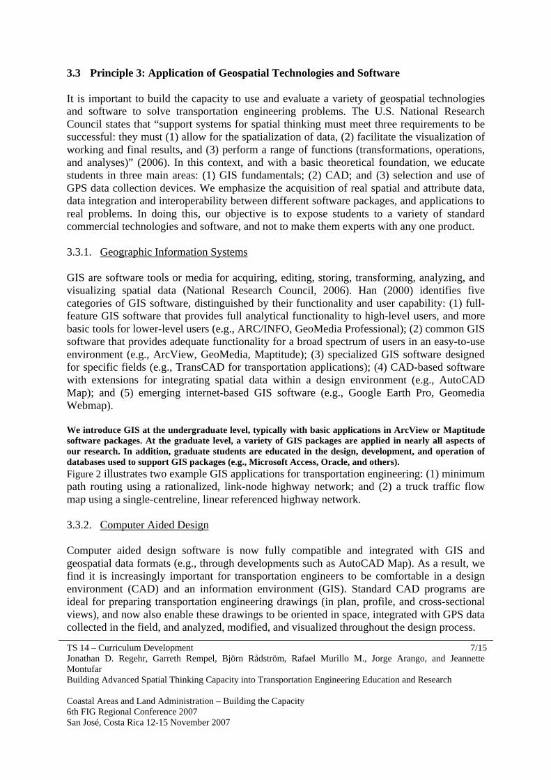
3.3 Principle 3: Application of Geospatial Technologies and Software It is important to build the capacity to use and evaluate a variety of geospatial technologies and software to solve transportation engineering problems. The U.S. National Research Council states that “support systems for spatial thinking must meet three requirements to be successful: they must (1) allow for the spatialization of data, (2) facilitate the visualization of working and final results, and (3) perform a range of functions (transformations, operations, and analyses)” (2006). In this context, and with a basic theoretical foundation, we educate students in three main areas: (1) GIS fundamentals; (2) CAD; and (3) selection and use of GPS data collection devices. We emphasize the acquisition of real spatial and attribute data, data integration and interoperability between different software packages, and applications to real problems. In doing this, our objective is to expose students to a variety of standard commercial technologies and software, and not to make them experts with any one product. 3.3.1. Geographic Information Systems GIS are software tools or media for acquiring, editing, storing, transforming, analyzing, and visualizing spatial data (National Research Council, 2006). Han (2000) identifies five categories of GIS software, distinguished by their functionality and user capability: (1) full-feature GIS software that provides full analytical functionality to high-level users, and more basic tools for lower-level users (e.g., ARC/INFO, GeoMedia Professional); (2) common GIS software that provides adequate functionality for a broad spectrum of users in an easy-to-use environment (e.g., ArcView, GeoMedia, Maptitude); (3) specialized GIS software designed for specific fields (e.g., TransCAD for transportation applications); (4) CAD-based software with extensions for integrating spatial data within a design environment (e.g., AutoCAD Map); and (5) emerging internet-based GIS software (e.g., Google Earth Pro, Geomedia Webmap). We introduce GIS at the undergraduate level, typically with basic applications in ArcView or Maptitude software packages. At the graduate level, a variety of GIS packages are applied in nearly all aspects of our research. In addition, graduate students are educated in the design, development, and operation of databases used to support GIS packages (e.g., Microsoft Access, Oracle, and others). Figure 2 illustrates two example GIS applications for transportation engineering: (1) minimum path routing using a rationalized, link-node highway network; and (2) a truck traffic flow map using a single-centreline, linear referenced highway network. 3.3.2. Computer Aided Design Computer aided design software is now fully compatible and integrated with GIS and geospatial data formats (e.g., through developments such as AutoCAD Map). As a result, we find it is increasingly important for transportation engineers to be comfortable in a design environment (CAD) and an information environment (GIS). Standard CAD programs are ideal for preparing transportation engineering drawings (in plan, profile, and cross-sectional views), and now also enable these drawings to be oriented in space, integrated with GPS data collected in the field, and analyzed, modified, and visualized throughout the design process.

TS 14 – Curriculum Development 8/15 Jonathan D. Regehr, Garreth Rempel, Björn Rådström, Rafael Murillo M., Jorge Arango, and Jeannette Montufar Building Advanced Spatial Thinking Capacity into Transportation Engineering Education and Research Coastal Areas and Land Administration – Building the Capacity 6th FIG Regional Conference 2007 San José, Costa Rica 12-15 November 2007
Figure 2: Example GIS Applications in Transportation Engineering An example of a CAD application for transportation engineering is the use of Land Development Desktop from AutoDesk to develop a detailed topographical model used for road design. This software generates a three-dimensional model of the terrain where the road is to be built, using spatial data coordinates (x, y, z) collected in the field by a GPS device. The designer uses this model to determine the best horizontal and vertical alignment for the road, and calculate material quantities required for construction. Designers use GIS data such as soil type, land use zones, property values, and others to overlay on the proposed road design. The combination of CAD and GIS thus enables the designer to consider a broader range of design controls – including some that may be more important than knowing which particular alignment offers the best road geometry, or which alignment minimizes earth cuts and fills. In addition, this process is increasingly moving into real-time, so that designers are fed information, perform analyses, and make decisions on-the-fly. As illustrated in this example (and shown conceptually in Figure 1), transportation engineers use spatial thinking capacity, supported by CAD and GIS, to translate three-dimensional topographical information into two-dimensional construction drawings depicting plan, profile, and cross-sectional views of the roadway at any location along the alignment. We educate students to use CAD programs, become familiar with their capabilities, and understand the difference between CAD and GIS programs (although the differences are increasingly blurred).
TS 14 – Curriculum Development 9/15 Jonathan D. Regehr, Garreth Rempel, Björn Rådström, Rafael Murillo M., Jorge Arango, and Jeannette Montufar Building Advanced Spatial Thinking Capacity into Transportation Engineering Education and Research Coastal Areas and Land Administration – Building the Capacity 6th FIG Regional Conference 2007 San José, Costa Rica 12-15 November 2007
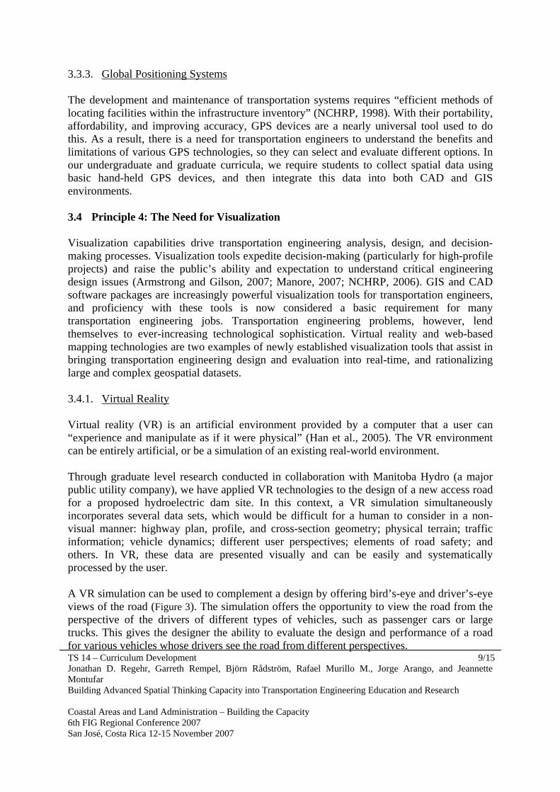
3.3.3. Global Positioning Systems The development and maintenance of transportation systems requires “efficient methods of locating facilities within the infrastructure inventory” (NCHRP, 1998). With their portability, affordability, and improving accuracy, GPS devices are a nearly universal tool used to do this. As a result, there is a need for transportation engineers to understand the benefits and limitations of various GPS technologies, so they can select and evaluate different options. In our undergraduate and graduate curricula, we require students to collect spatial data using basic hand-held GPS devices, and then integrate this data into both CAD and GIS environments. 3.4 Principle 4: The Need for Visualization Visualization capabilities drive transportation engineering analysis, design, and decision-making processes. Visualization tools expedite decision-making (particularly for high-profile projects) and raise the public’s ability and expectation to understand critical engineering design issues (Armstrong and Gilson, 2007; Manore, 2007; NCHRP, 2006). GIS and CAD software packages are increasingly powerful visualization tools for transportation engineers, and proficiency with these tools is now considered a basic requirement for many transportation engineering jobs. Transportation engineering problems, however, lend themselves to ever-increasing technological sophistication. Virtual reality and web-based mapping technologies are two examples of newly established visualization tools that assist in bringing transportation engineering design and evaluation into real-time, and rationalizing large and complex geospatial datasets. 3.4.1. Virtual Reality Virtual reality (VR) is an artificial environment provided by a computer that a user can “experience and manipulate as if it were physical” (Han et al., 2005). The VR environment can be entirely artificial, or be a simulation of an existing real-world environment. Through graduate level research conducted in collaboration with Manitoba Hydro (a major public utility company), we have applied VR technologies to the design of a new access road for a proposed hydroelectric dam site. In this context, a VR simulation simultaneously incorporates several data sets, which would be difficult for a human to consider in a non-visual manner: highway plan, profile, and cross-section geometry; physical terrain; traffic information; vehicle dynamics; different user perspectives; elements of road safety; and others. In VR, these data are presented visually and can be easily and systematically processed by the user. A VR simulation can be used to complement a design by offering bird’s-eye and driver’s-eye views of the road (Figure 3). The simulation offers the opportunity to view the road from the perspective of the drivers of different types of vehicles, such as passenger cars or large trucks. This gives the designer the ability to evaluate the design and performance of a road for various vehicles whose drivers see the road from different perspectives.
TS 14 – Curriculum Development 10/15 Jonathan D. Regehr, Garreth Rempel, Björn Rådström, Rafael Murillo M., Jorge Arango, and Jeannette Montufar Building Advanced Spatial Thinking Capacity into Transportation Engineering Education and Research Coastal Areas and Land Administration – Building the Capacity 6th FIG Regional Conference 2007 San José, Costa Rica 12-15 November 2007
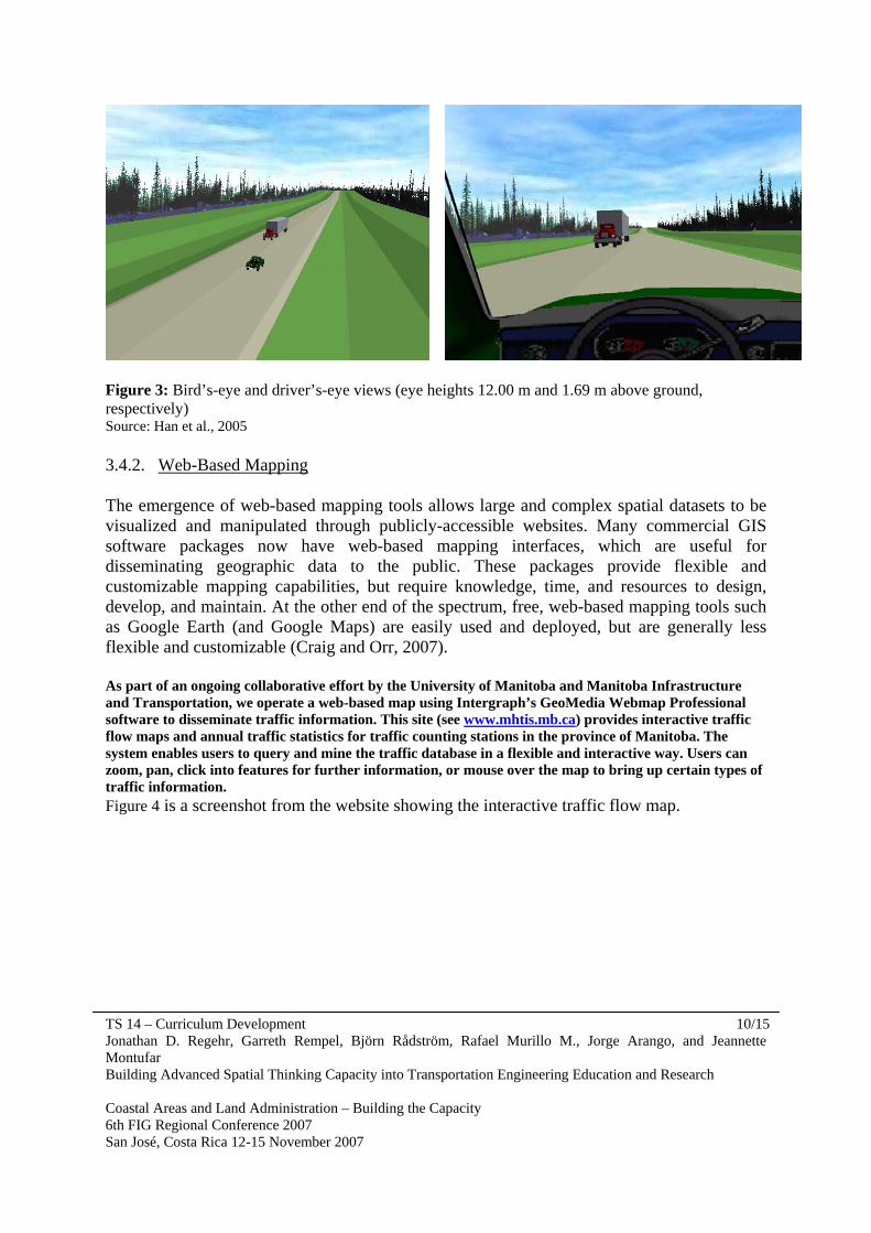
Figure 3: Bird’s-eye and driver’s-eye views (eye heights 12.00 m and 1.69 m above ground, respectively) Source: Han et al., 2005 3.4.2. Web-Based Mapping The emergence of web-based mapping tools allows large and complex spatial datasets to be visualized and manipulated through publicly-accessible websites. Many commercial GIS software packages now have web-based mapping interfaces, which are useful for disseminating geographic data to the public. These packages provide flexible and customizable mapping capabilities, but require knowledge, time, and resources to design, develop, and maintain. At the other end of the spectrum, free, web-based mapping tools such as Google Earth (and Google Maps) are easily used and deployed, but are generally less flexible and customizable (Craig and Orr, 2007). As part of an ongoing collaborative effort by the University of Manitoba and Manitoba Infrastructure and Transportation, we operate a web-based map using Intergraph’s GeoMedia Webmap Professional software to disseminate traffic information. This site (see www.mhtis.mb.ca) provides interactive traffic flow maps and annual traffic statistics for traffic counting stations in the province of Manitoba. The system enables users to query and mine the traffic database in a flexible and interactive way. Users can zoom, pan, click into features for further information, or mouse over the map to bring up certain types of traffic information. Figure 4 is a screenshot from the website showing the interactive traffic flow map.

TS 14 – Curriculum Development 11/15 Jonathan D. Regehr, Garreth Rempel, Björn Rådström, Rafael Murillo M., Jorge Arango, and Jeannette Montufar Building Advanced Spatial Thinking Capacity into Transportation Engineering Education and Research Coastal Areas and Land Administration – Building the Capacity 6th FIG Regional Conference 2007 San José, Costa Rica 12-15 November 2007
Figure 4: Web-Based, Interactive Traffic Flow Map Google Earth is a web-based, three-dimensional map of the world which features satellite and aerial photography of the entire earth’s surface. The program enables users to zoom, pan, tilt, and rotate the earth. Google Earth is a component of a broader initiative to construct a “geoweb”, which links information to its geographic location through user-defined “mash-ups”. The geoweb’s ability to spatialize information removes the “placelessness” that characterizes information on the Internet, but maintains user accessibility (The Economist, 2007).
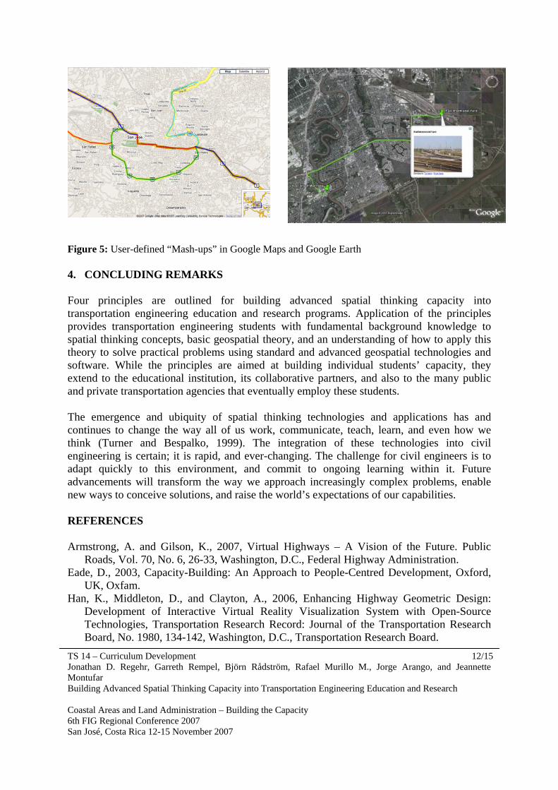
Figure 5 illustrates two examples of Google “mash-ups”: (1) a selection of roads in San José, Costa Rica using Google Maps; and (2) a Google Earth application showing the route between two locations in Winnipeg, Canada, and a photo of the destination. These “mash-ups” can be shared between users by emailing the Google Maps link or attaching a Google Earth KML file (the protocol which describes map metadata) to an email. KML files can incorporate photos, descriptions of geographic features, and links to proprietary GIS data. Since Google controls and houses the geographic data, only the map metadata needs to be sent, and any user with an Internet connection can view the maps.
TS 14 – Curriculum Development 12/15 Jonathan D. Regehr, Garreth Rempel, Björn Rådström, Rafael Murillo M., Jorge Arango, and Jeannette Montufar Building Advanced Spatial Thinking Capacity into Transportation Engineering Education and Research Coastal Areas and Land Administration – Building the Capacity 6th FIG Regional Conference 2007 San José, Costa Rica 12-15 November 2007
Figure 5: User-defined “Mash-ups” in Google Maps and Google Earth 4. CONCLUDING REMARKS Four principles are outlined for building advanced spatial thinking capacity into transportation engineering education and research programs. Application of the principles provides transportation engineering students with fundamental background knowledge to spatial thinking concepts, basic geospatial theory, and an understanding of how to apply this theory to solve practical problems using standard and advanced geospatial technologies and software. While the principles are aimed at building individual students’ capacity, they extend to the educational institution, its collaborative partners, and also to the many public and private transportation agencies that eventually employ these students. The emergence and ubiquity of spatial thinking technologies and applications has and continues to change the way all of us work, communicate, teach, learn, and even how we think (Turner and Bespalko, 1999). The integration of these technologies into civil engineering is certain; it is rapid, and ever-changing. The challenge for civil engineers is to adapt quickly to this environment, and commit to ongoing learning within it. Future advancements will transform the way we approach increasingly complex problems, enable new ways to conceive solutions, and raise the world’s expectations of our capabilities. REFERENCES Armstrong, A. and Gilson, K., 2007, Virtual Highways – A Vision of the Future. Public
Roads, Vol. 70, No. 6, 26-33, Washington, D.C., Federal Highway Administration. Eade, D., 2003, Capacity-Building: An Approach to People-Centred Development, Oxford,
UK, Oxfam. Han, K., Middleton, D., and Clayton, A., 2006, Enhancing Highway Geometric Design:
Development of Interactive Virtual Reality Visualization System with Open-Source Technologies, Transportation Research Record: Journal of the Transportation Research Board, No. 1980, 134-142, Washington, D.C., Transportation Research Board.

TS 14 – Curriculum Development 13/15 Jonathan D. Regehr, Garreth Rempel, Björn Rådström, Rafael Murillo M., Jorge Arango, and Jeannette Montufar Building Advanced Spatial Thinking Capacity into Transportation Engineering Education and Research Coastal Areas and Land Administration – Building the Capacity 6th FIG Regional Conference 2007 San José, Costa Rica 12-15 November 2007
Han, K., Middleton, D., Muzyczka, W.J., Minty, S., Clayton, A., 2005, Developing Virtual Reality Visualizations to Support Highway Geometric Design, Presented at the 3rd International Symposium on Highway Geometric Design, Chicago, Illinois, June.
Han, K., 2000, Development of an Interoperable Geographic Information System Platform for Transportation Applications, Master of Science Thesis, Department of Civil Engineering, University of Manitoba, Winnipeg, MB.
Manore, M., 2007, It’s About Decisions: Improving Transportation Project Development with Visualization Technologies, TR News, January-February, No. 248, 21-24, Washington, D.C., Transportation Research Board.
National Cooperative Highway Research Program (NCHRP), 2006, Visualization for Project Development, Synthesis 361, Washington, D.C., Transportation Research Board.
National Cooperative Highway Research Program (NCHRP), 1998, Applications of GPS for Surveying and Other Positioning Needs in Departments of Transportation, Synthesis 258, Washington, D.C., Transportation Research Board.
National Research Council, 2006, Learning to Think Spatially, Washington, D.C., The National Academies Press.
Casper, C. and Orr, F., 2007, MPO Use of Google Earth as a Visualization Tool to Aid Public Involvement and Integration of NEPA with Transportation Planning, Proceedings of the Transportation Research Board 86th Annual Meeting, Washington, D.C.
The Economist Homepage, 2007, The World on Your Desktop, http://www.economist.com/printedition/displaystory.cfm?story_id=9719045, Last accessed September 28, 2007.
Turner, A.K. and Bespalko, S.J., 1999, Spatial Data Technologies, TR News, November-December, No. 205, 15-18, Washington, D.C., Transportation Research Board.
Wolf, P.R. and Brinker, R.C., 1994, Elementary Surveying, 9th ed., New York, NY, HarperCollins College Publishers.
BIOGRAPHICAL NOTES Jonathan D. Regehr, B.Sc. (CE), EIT, is a doctoral student in civil engineering at the University of Manitoba, with a focus on transportation. He has research experience in the areas of trucking, freight transportation, and transportation regulation. He has worked as the Manager of the Manitoba Highway Traffic Information System (MHTIS), and has held positions with the City of Winnipeg and Montufar & Associates. He has published papers in proceedings of the Transportation Research Board (TRB), the Canadian Institute of Transportation Engineers (CITE), and the Canadian Transportation Research Forum. Jonathan has held scholarships from the Natural Sciences and Engineering Research Council (NSERC) of Canada, the Transportation Association of Canada (TAC), and CITE.

TS 14 – Curriculum Development 14/15 Jonathan D. Regehr, Garreth Rempel, Björn Rådström, Rafael Murillo M., Jorge Arango, and Jeannette Montufar Building Advanced Spatial Thinking Capacity into Transportation Engineering Education and Research Coastal Areas and Land Administration – Building the Capacity 6th FIG Regional Conference 2007 San José, Costa Rica 12-15 November 2007
Garreth Rempel, B.Sc. (CE), EIT, is a Master of Science student in civil engineering at the University of Manitoba, with a focus on transportation. His main research interest is intermodal freight transportation. Garreth has received several academic scholarships from CITE, TAC, and NSERC. He has worked in various civil engineering environments through his participation in the co-op program at the University of Manitoba, and through employment with the University of Manitoba Transport Information Group (UMTIG), Indian and Northern Affairs of Canada, SEG Engineering, Manitoba Infrastructure and Transportation, and Montufar and Associates. Björn Rådström, B.Sc. (CE), EIT, is Master of Science student in transportation engineering at the University of Manitoba, where he has managed MHTIS for the past year. He has worked for several engineering consultants, both in Canada and the UK. His area of research interest is public transportation, and he has recently taken up a position as a Transit System Planner with Winnipeg Transit. Björn has published papers in the proceedings of CITE and has been awarded scholarships by the Canadian Urban Transit Association, CITE, TAC, and the Association of Professional Engineers and Geoscientists of Manitoba. Rafael Murillo M., Ph.D., is an Associate Professor at the Department of Civil Engineering, University of Costa Rica. Mr. Murillo did his graduate studies at IHE-Delft (M.Sc.) and the University of Manitoba (Ph.D.). His main area of interest is water resources where he has been applying remote sensing techniques and GIS on hydrological studies for over 10 years. Mr. Murillo also has extensive experience as a consultant on planning and designing hydropower facilities. Jorge Arango, B.Sc. (CE), is a Master of Science student in civil engineering at the University of Manitoba. He is currently the Manager of MHTIS. His research focuses on road safety dealing with older pedestrians and pedestrians with impairments. Jorge has published papers in the proceedings of the Transportation Research Board (TRB) and in the Transportation Research Record. He is a member of professional organizations such as CITE, TRB, and the Canadian Association of Road Safety Professionals (CARSP). Jorge complements his engineering background with undergraduate studies in Fine Arts. Jeannette Montufar, Ph.D., P.Eng., is an Associate Professor in civil engineering at the University of Manitoba, as well as a private consultant. She earned her Ph.D. degree in civil engineering at the University of Manitoba. Her area of expertise is in freight transportation and road safety. Dr. Montufar has extensive work experience in Canada, the United States, and Mexico regarding commercial vehicle operations and road safety. She has authored or co-authored papers dealing with the application of GIS for truck safety analysis, intelligent transportation systems, truck transportation, commodity flow analysis, transportation policy, road safety, traffic engineering, and traffic information for exposure analysis. She is an active member in TRB, CITE, and CARSP.

TS 14 – Curriculum Development 15/15 Jonathan D. Regehr, Garreth Rempel, Björn Rådström, Rafael Murillo M., Jorge Arango, and Jeannette Montufar Building Advanced Spatial Thinking Capacity into Transportation Engineering Education and Research Coastal Areas and Land Administration – Building the Capacity 6th FIG Regional Conference 2007 San José, Costa Rica 12-15 November 2007
CONTACTS Jonathan D. Regehr, B.Sc. (CE), EIT Ph.D. Student Department of Civil Engineering University of Manitoba Rm. E1-327 EITC 15 Gillson St. Winnipeg, MB R3T 5V6 CANADA Tel. + 1.204.474.7112 Fax + 1.204. 474.7549 Email: [email protected]
Garreth Rempel, B.Sc. (CE), EIT M.Sc. Student Department of Civil Engineering University of Manitoba Rm. E1-327 EITC 15 Gillson St. Winnipeg, MB R3T 5V6 CANADA Tel. + 1.204.474.7112 Fax + 1.204. 474.7549 Email: [email protected]
Björn Rådström, B.Sc. (CE), EIT Transit System Planner Winnipeg Transit 421 Osborne Street Winnipeg, Manitoba R3L 2A2 CANADA Tel. +1.204.986.5743 Fax. +1.204.986.6863 Email: [email protected]
Rafael Murillo M., Ph.D. Associate Professor Department of Civil Engineering University of Costa Rica P.O. Box 208 – 2060 San José COSTA RICA Tel: + 506.207.5510 Fax: + 506.207.5813 Email: [email protected]
Jorge Arango, B.Sc. (CE) M.Sc. Student Department of Civil Engineering University of Manitoba Rm. E1-327 EITC 15 Gillson St. Winnipeg, Manitoba R3T 5V6 CANADA Tel. + 1.204.474.7367 Fax + 1.204. 474.7549 Email: [email protected]
Jeannette Montufar, Ph.D., P.Eng. Associate Professor Department of Civil Engineering University of Manitoba Rm. E1-328 EITC 15 Gillson St. Winnipeg, MB R3T 5V6 CANADA Tel. + 1.204.474.6799 Fax + 1.204. 474.7513 Email: [email protected]