building and planning regulations under israeli colonial
TRANSCRIPT
Full Terms & Conditions of access and use can be found athttps://www.tandfonline.com/action/journalInformation?journalCode=rppe20
Planning Perspectives
ISSN: 0266-5433 (Print) 1466-4518 (Online) Journal homepage: https://www.tandfonline.com/loi/rppe20
Building and planning regulations under Israelicolonial power: a critical study from Palestine
Salem Thawaba
To cite this article: Salem Thawaba (2019) Building and planning regulations under Israelicolonial power: a critical study from Palestine, Planning Perspectives, 34:1, 133-146, DOI:10.1080/02665433.2018.1543611
To link to this article: https://doi.org/10.1080/02665433.2018.1543611
Published online: 13 Nov 2018.
Submit your article to this journal
Article views: 241
View related articles
View Crossmark data
Citing articles: 2 View citing articles

IPHS SECTION
Building and planning regulations under Israeli colonial power: acritical study from PalestineSalem Thawaba
Master Program of Urban Planning and Landscape Architecture, Birzeit University, Ramallah, Palestine
ABSTRACTColonial regimes used urban planning regulations as a tool to control anddominate other people and natural resources. Since the beginning of thepast century, Palestine represented a good example of where urban planningregulations played a major role in urban transformation and development.The Israeli regime has been using old regional plans that were prepared bythe British Mandate, and issued many others to achieve its aim ofestablishing settlements and dominating the West Bank. Consequently, thisstudy explores how urban planning regulations can become a tool forcontrolling and dominating people and natural resources. This studyinvestigated how these tools were used by controlling authority during thepast century.
KEYWORDSColonial planning; Palestine;Israel; West Bank; urbanplanning
Introduction
Urban planning regulations have played a major role in the shaping and monitoring of urban devel-opment throughout history. Colonial powers have used these regulations to formulate and dominatethe socio-economic structures and the morphology of occupied regions. European colonialism, forexample, was interested in developing the living conditions and the socio-economic aspects of theirown communities regardless the native peoples’ needs.1 During the French colonial epoch in Mada-gascar and Guinea, regulations regarding building material played a major role in segregation.2 Themaster plan of Mtwaram in Tanzania is a profound example of segregation. The plan divided thetown into three different zones with three different morphologies. Home, in his article about the Brit-ish colonial cities considered land as a major player ‘land was central to colonial projects, as it hasbeen to Zionism’.3 He added that, ‘European colonizers expropriated land for their benefit, formu-lating a hierarchy of social and spatial controls to justify and maintain their hegemony over indigen-ous populations’.4 Njoh’s article about colonial Africa mentions that urban planning achieved thetwin objectives of domination and socio-political control in colonial regions.5 To legitimize controland dominancy, colonial powers have used planning regulations to support their actions. Goodfellowand Home made it clear that urban planning regulations – such as the form of land use regulations,zoning ordinances and building codes – were used extensively by colonists in relation to the devel-opment of colonized territories, where these regulations generally have the power of law.6 Therelationship between planning and control is fundamental in contexts where urban planning andzoning can be used as a means to serve political ambitions, and to change the landscape accordingly.7
IPHSSection
The
InternationalPlanning
History
Society(IP
HS)
isthe
interdisciplinarynetw
orkfor
planninghistorians
worldw
ide.This
sectionofthe
journalaimsto
raiseaw
arenessofcurrentw
orkin
thefield
throughcontributions
ofup
to4,000
words
onresearch-in-progress,historiography,education,events
andother
topicsof
interestto
Societymem
bers.www.planninghistory.org
PLANNING PERSPECTIVES2019, VOL. 34, NO. 1, 133–146https://doi.org/10.1080/02665433.2018.1543611
© 2018 Informa UK Limited, trading as Taylor & Francis Group
CONTACT Salem Thawaba [email protected]

Colonial regimes often transformed existing land tenure systems via modern land reforms whichsaw the colonial state became the sole custodian of land. By doing so the colonial state was able tosanction land-related actions. Colonial authorities used this privilege to use outright gifts of land toconsolidate colonial powers of control.8 In recent history Israeli planning authorities have used var-ious means to confiscate lands in order to establish colonies and to control Palestinian urban growthas well as to segregate indigenous communities in the area on which this study focuses, the WestBank (W.B.).
During the early years of the twentieth century, the region witnessed visible landscape transform-ation because of population growth resulting from Jewish immigration into Palestine.9 Tartakower,described Palestine in 1949 as ‘a flourishing country… due mainly to the Jewish work of coloniza-tion’. 10 Said added that planners worked in Palestine to establish an ‘irreversible conquest of Pales-tine land and society’.11 While Home stated the process of ‘irreversible conquest’ had been facilitatedby land law and regulations inherited from the British Mandate.12
In 1948 Israel was declared on 78% of Palestine. Of the remaining 22% of the country the WestBank was under Jordanian rule, the Gaza strip controlled by the Egyptians, and the holy city of Jer-usalem was divided in two parts. In 1967 Israel occupied the remaining area (W.B. and Gaza). Thenin 1993 the Oslo Peace Accords were signed between the Palestinian Liberation Organization (PLO)and the Israeli Government in the hope of ending the occupation on theW.B. and Gaza, and as a steptowards establishing a Palestinian state. As a result of the peace accords, the W.B. land was dividedinto three zones: A, B, and C. Zone A was fully controlled by Palestinians (18%), zone B was underPalestinian civil control and Israeli security control (22%), and zone C was fully controlled by Israelioccupation (60%) (Figure 1).
Throughout this research I have explored urban planning regulations and land policy from differ-ent resources and different eras: British Mandate plans, Israeli plans for the West Bank, and masterplans which were prepared or supervised by Israeli planners and officers.
Colonial planning and practice in the West Bank
This section explains how colonial powers (i.e. Israel) absorbed the historical planning culture inher-ited from previous regimes and integrated it into its planning system in order to control and manageboth people and land in the W.B..
In 1922 Jewish owned land or territory that was under immediate control constituted 2.96% ofPalestine. In 1946 this figure reached 6.02%, and recently it has totalled more than 80%.13 The confl-ict has always been about land and resources as described by Weizman in his book Hollow Land.14
This can be interpreted as a literal translation of the strategy of the erstwhile Israeli Prime Minister,Golda Meir: ‘The frontier is where Jews live, not where there is a line on the map’.15 Ultimately, allstate lands were transferred to the Israeli occupying power for their own aims of control anddominancy.
In 1948 the British troops evacuated Palestine and the state of ‘Israel’ was declared on May 14th ofthe same year. In 1950 Israel issued the ‘Absentee Property Law’ to transfer Arab homes, lands, andbusinesses to the Custodian of Absentee Property. The absentee here is any person who left/expelledfrom his village inside ‘Israel’. Consequently, most of the Palestinian residencies (not the demolishedones) were settled by new Jewish immigrants.16
In 1967, the W.B was captured by the Israeli occupation forces as a result of the Six-Day War. Atthat time 70% of the land in the W.B was classified as Mewat or Meri according to the Ottoman codeclassifications. Israeli planning authorities used modern techniques in surveying and aerial
134 IPHS SECTION

photography to allocate uncultivated hill-tops in order to transfer their ‘legal ownership’ to stateproperty.17 Hundreds of thousands of dunnums (one dunnum = 1000 m2) in the W.B. wereclassified as state lands, and were subsequently declared by the Israeli authorities as military ‘closedareas’ or ‘natural reserves’.
Figure 1. West Bank Oslo classifications A, B and C.
PLANNING PERSPECTIVES 135

Israel then amended the Jordanian Planning Law #79 and transferred all responsibility for plan-ning to their military’s Supreme Planning Committee. According to Benvenisti, by 1976 Israelmanged to settle 3,176 people in the W.B., then the number escalated to reach 67,000 by 1987,and reached 383,916 in the W.B. and 205,220 in East Jerusalem by the end of 2014.18 Since 1967regional plans have been prepared by the occupying authorities in order to colonize the W.B.;one hundred and twenty-seven Israeli settlements were established there (not including East Jerusa-lem and Hebron city), as well as one hundred ‘settlement outposts’ located through the W.B. fifteenIsraeli settlements built in East Jerusalem on lands annexed after 1967.
According to Gordon, Israel established a permit regime which was considered the beginning ofthe infrastructure of control.19 ‘The permit regime managed to transform these basic rights into pri-vileges that could be taken away without the revocation being considered a violation’.20 Israel hasused different methods to seize land: (i) by declaring land to be absentee property, (ii) by declaringland to be the property of a hostile state or agent, (iii) by confiscating land for public needs, (iv) bydeclaring land to be part of nature reserves, (v) by requisitioning land for military needs, (vi) bydeclaring land to be state property, and/or (vii) by helping Jewish citizens to purchase land onthe free market.21
In 1971 the Israeli Authority in the W.B. issued the Military Order (MO) #418 cancelling the dis-trict commission that dealt with planning on the district level and transferred its mandate to a mili-tary commander.22 During the 1980s Israeli planners prepared a regional plan for a road system(bypass roads) in order to link settlements with each other, and to ease accessibility to the coastalmajor Israeli cities. During this time planning started on a trans W.B. road to facilitate rapid travelfrom the coast in the west and to the Jordan valley in the east.23 The Israeli Planning & Building Lawof 1965 facilitated land acquisition for highways that bypass Palestinian villages.
Palestinians are not allowed to construct or build any establishment in Area C without obtain-ing a permit from the ICA Office which is managed by Israeli military officers. In addition, the ICAhas approved hardly any master plans for Palestinian communities in Area C and simultaneouslyany construction outside the blue line (village boundary) is under threat of demolishment. As aresult 1,638 Palestinian structures were demolished by Israeli bulldozers in Area C between2006 and 2012.24 According to the report prepared by the UN-HABITAT Commission in Pales-tine, 99 master plans for villages in Area C were submitted to the ICA, yet only three wereapproved.25
Yiftachel described Israeli planning polices as a major player in promoting Israeli national ideo-logical goals such as dispersing population to the peripheries and endorsing the ‘Judaization’ ofnational space.26 Weizman added that these policies are applied and enforced physically in theW.B., where Israeli settlements (colonies) are established to control more lands around Palestinianmajor urban centres, turning these urban centres into enclaves.27
Israel’s Planning Authority had been denying building permits for Palestinians under the excuseof contradicting the regional plans based on outdated British Mandate plans, zoning, and land own-ership title deeds. The occupying power used law amendments to acquire land, and impose restric-tions on Palestinian development. Shehadeh explained that from 1967 to 1971 roughly 400 MOswere issued covering security, state land and Jerusalem.28 Israeli Planning Commissions allocateopen spaces and parks on maps in order to delineate and confine Palestinian built up areas andto establish Israeli settlements (colonies) (i. e. East Jerusalem). The most profound example involvedtransferring the Abo Ghnaim Natural Reserve near Bethlehem, to a huge Israeli settlement (colony),Har Homa (Figure 2).29
136 IPHS SECTION

Use of regulations and plans
In 1971 the Israeli occupying authorities stopped using the Jordanian Planning Law, and amend-ments and military orders were introduced instead. According to Benvenisti, in 1970 the occupyingauthorities issued Order #393 ‘authorizing the military commander to forbid, halt, or set conditionsfor construction’.30 Later the occupying authorities issued the MO # 418 so that Israeli staff officialswere appointed to run physical planning related issues. Israeli officials were authorized to amend,revoke, or place conditions on any license. Later in the mid-1970s physical planning was decentra-lized, more authority was given to Jewish settlement planning councils in theW.B., and more restric-tions were placed on physical planning by and for Palestinians.
Israeli Occupation Planning mechanisms depended heavily on the obsolete regional planningschemes of the British Mandate. In the 1940s the British authority prepared or approved regionaloutline plans for Palestine, the most important of which were RJ5 and S15 (Figure 3).31 Theseplans classified the region into four land-use zones: (i) developmental zones within built-up areasand village boundaries, (ii) agricultural zones around villages and urban areas, (iii) nature reserves,and (iv) state lands.32 Building permits were required for the first two zones, while building was pre-vented in the second two, and any building outside of village boundaries was risked being demol-ished in keeping with ‘planning regulations’.
On the regional level, RJ5 and S15 still survive as live statuary documents to justify and legitimizeplanning decisions. Khamaisi described the goal of these plans on the ground as:
giving the central regime (colonial or occupation) an effective instrument and mechanism for imple-menting policies and achieving aims likely to contradict the interests of the native people33
Israeli Civil Administration (ICA) still uses them to ban any development in Area C. The impact ofthese regional plans on the Palestinian fabric was clear: Palestinian villages were marked as separatecircles, vast areas were undeveloped because they were marked as natural reserves and state lands
Figure 2. Top – Abo Ghnaim natural reserve; Bottom – Har Homa Jewsih settlement.49
PLANNING PERSPECTIVES 137

which were later granted to Israeli Settlement councils. Later after 1967, most of the Israeli settle-ments and bypass highways were established in these zones.
On the regional level, Yigal Allon submitted his plan as a guideline for deployment of Jewishsettlements in the W.B. in 1967.34 The plan stated that: defensible boarders require a chain of Jewishsettlements in the Jordan Valley and theW.B. heights (Figure 4). Allon proposed a 20 kilometre widebuffer zone to be annexed by Israel in the Jordan valley and around Jerusalem, leaving two cantonsfor Palestinians, one in the northern W.B. and the other in the southern part.
Another plan that played a major role in changing facts on the ground and transforming theregion was the Drobless Plan. The plan States that: ‘there is to be not a shadow of doubt regardingour intention to remain in Judea and Samari’.35 Again the proclaimed aim was security, where theplan proposed a chain of Jewish settlements along the heights of the W.B. and in the Jordan Valley asa security barrier (Figure 5). It shows a massive spread of Jewish settlements all over the W.B. creat-ing new blocs, enclaving the Palestinian towns and villages and preventing any contiguous Palesti-nian urban development.36
On the local level, for example, in 1918 WilliamMcLean proposed a plan (Figure 6) for Jerusalemwith a buffer zone around the old city where development was prohibited and limited in the easternside of the city and construction allowed under special permission.37 That plan included develop-mental zones on both the northern and western sides of the city where Jewish settlements werenewly constructed.38 According to Roberts, the plan established a regime of spatial separation byproposing a green belt and two different planning fabrics: a modern one for the western part anda preserved and controlled one for the eastern.39
Figure 3. (a) Mandate District Plan of Samaria – S-15.50 (b) Mandate District Plan RJ5 – S15 (Benvenisti & Khayat).51
138 IPHS SECTION

Since the British Mandate on Palestine, the successive plans proposed for Jerusalem have seen thefocus of development on the western side, and minimal improvements to the eastern side. Physicalplanning and accompanying regulations have been used by planners to develop Jerusalem as thecapital of Israel.40
…A Jewish state has no magic without Jerusalem. Ben-Gurion41
Figure 4. Allon Plan (Benvenisti & Khayat).
PLANNING PERSPECTIVES 139

Drafted in 1968, the master plan of greater Jerusalem aimed to maintain Jerusalem (western side,eastern side, and the Old City) as ‘a unified capital for Israel’. In order to achieve this goal twelveJewish ‘neighbourhoods’ were established in the eastern part on the Palestinian side. These envel-oped and bisected the Palestinian villages.42
Figure 5. Drobless Plan (Benvenisti & Khayat).
140 IPHS SECTION

In Jerusalem 64,867 housing units were built for the Jews (88%) within the municipal boundarybetween 1967 and 1995, while only 8,890 houses were constructed for Palestinians (12%).43 More-over in 1995 38,500 housing units were built in Jewish settlements (colonies) on land which had beenexpropriated from Palestinians. Moreover, these plots were assigned as being of ‘public use’ on themaster plan.44 The Israeli municipality of Jerusalem zoned 60%–70% of the Palestinian neighbour-hoods (e.g. Jabal Mukaber) as open landscape, and set the building ratio to 25%–37.5% with 1–2story buildings, while in an adjacent Jewish colony (Armon HaNatziv) the building ratio is 120%with 4–5 story buildings.45 In Jerusalem Israeli authorities used modern urban planning policiesto maintain a Jewish majority in the city by (i) restricting urban growth, (ii) confining Palestinianlocalities, and (iii) constructing more Jewish colonies on confiscated Palestinian lands.
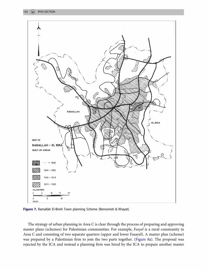
In late 1980s the Israeli Civil Administration (ICA) prepared ‘spatial outline plans’ for dozens ofPalestinian villages and towns.46 These plans were created to define growth boundaries or bluelines.47 The aim of these plans was to encircle Palestinian villages and towns (dotted line as a bound-ary [Figure 7], limiting their expansion and destroying their contiguity and direct accessibility.
ICA officials aimed to demarcate boundaries which later resulted in the demolishment of Pales-tinian houses beyond it. These plans played and still play a major role in shaping urban and ruraldevelopment which ultimately delineated Palestinian villages and towns from expansion in areasof Israeli interest.
Figure 6. McLean plan for Jerusalem (http://www.kings.cam.ac.uk/archive-centre/archive-month/october-2010.html).
PLANNING PERSPECTIVES 141
The strategy of urban planning in Area C is clear through the process of preparing and approvingmaster plans (schemes) for Palestinian communities. For example, Fasyel is a rural community inArea C and consisting of two separate quarters (upper and lower Fasayel). A master plan (scheme)was prepared by a Palestinian firm to join the two parts together. (Figure 8a). The proposal wasrejected by the ICA and instead a planning firm was hired by the ICA to prepare another master
Figure 7. Ramallah El-Bireh Town planning Scheme (Benvenisti & Khayat).
142 IPHS SECTION

plan under its supervision. The later firm came up with a proposal keeping the two quarters a part(Figure 8b).
This example illustrated the ICA planning agenda, where the officials preferred to keep the twoquarters separated and fragmented, whilst simultaneously keeping the Palestinian houses in betweenunder the threat of demolishment. Figure 8 shows that the area of Fasayel is bounded by two hugeIsraeli colonies: one to the north and one to the south.
ICA staff use all possible means to generate, reproduce, and exploit gaps within legal frameworksin order to transform laws into tools of control against the rights of the Palestinian inhabitants.48
Further complicating the planning process, Palestinian planners are obliged to apply for permitsin order to reach the ICA office which is located in the settlement of Beit Eil near Ramallah.
Conclusion
Planning as a discipline provides the tools to translate development and prosperity strategies intophysical plans and mechanisms. Within the context of successive colonial authorities, plannershave been using different means to achieve government goals of control, expansion, domination,and resource exploitation. Plans and regulations have been modified to suit colonial powers.
The West Bank is not an exception, nor a rare case. In addition to planning regulations, the colo-nial powers in this case used military orders when there was a gap in planning regulations.
The Israeli colonial regime uses physical planning, regulations and military orders to preventurban development and to delineate Palestinian villages and towns. The cases discussed in this
Figure 8. (a) Fasayel – Palestinian scheme.52 (b) Fasayel – ICA scheme.53
PLANNING PERSPECTIVES 143

study show that the Israeli planning authority works on different scales (regional, district and local)to prevent any future development and to keep Palestinian towns and villages segregated in order tomaintain control and dominance of both people and land. Israel has managed to move more thanthree quarters of a million Jewish settlers into the W.B. to live in more than one hundred coloniesdistributed all over theW.B. These colonies are connected by a modern road network which bypassesPalestinian villages and towns.
The spatial changes that Israel has created on the map of theWest Bank prevent the establishmentof an efficient planning system for Palestinians, and consequently prevent a viable and contiguousstate for Palestinians in the occupied region.
Notes
1. Kay, “South African City Planning in a Post Apartheid Era.”2. Ambe, Planning Power: Town Planning and Social Control in Colonial Africa.3. Home in his book about British Colonial Cities.4. Njoh, Planning Power.5. Ibid.6. Goodfellow in his article about planning and development regulations, where Africa was a case study
and Home in his book about British Colonial Cities.7. Kay, “South African City Planning in a Post Apartheid Era.”8. See 3.9. Gabbay, A Political Study of the Arab-Jewish Conflict, Bulletin of the School of Oriental and African
Studies.10. Ibid., 229.11. Edward Said in his book, The end of the peace process.12. Home, “Colonial and Postcolonial Land Law in Israel/Palestine.” In this article Home discusses the
whole process of regulations and plans issued during the British Mandate.13. Pappe, A history of Modern Palestine.14. Weizman, Hollow Land.15. Prime Minister Golda Meir, Sept. 1972, quoted in Aronson, Creating Facts: Israel, Palestinians and the
West Bank (Washington, D.C.: Institute for Palestine Studies, (1987), 14.16. Tamari, Jerusalem 1948.17. NRC, Land and Property Law in Area C.18. Benvenisti, The West Bank and Gaza Atlas, B’Tselem, The Israeli Information Center for human rights
in the occupied territories and Bimkom - Planners for Planning Rights – English. The prohibited zonereport.
19. Gordon, in his book ‘Israel’s Occupation’ and permit regime.20. Ibid.21. Khamaisi, “Management Transformations of Statutory Planning Systems in the Jerusalem.”22. See (11).23. See 12.24. Stein, Israel’s Policy in Area C, the West Bank.25. IAG, Spatial Planning in West Bank.26. Yiftachel, Land and Identity Politics in Israel/Palestine.27. See 12.28. Shehadeh, The Law of the Land.29. http://wp.poica.org/1997/03/the-har-homa-settlement-30. See 22.31. Plan RJ/5 for the Mandatory Jerusalem district, See Crookston, Echoes of Empire.32. Benvenisti, A Survey of Israel’s Policies.33. See 27.34. See 22.
144 IPHS SECTION

35. Judea and Samaria is the West Bank.36. See 12.37. Gitler, in his article about Jerusalem City plans during the British Mandate.38. Roberst in his article about dividing Jerusalem and British urban planning.39. Ibid.40. Home, Of Planting and Planning and Hyman, Ph.D dissertation about British planners in Palestine.41. According to Encyclopedia Britannica: the first Israeli prime minister and Karsh, Israel’s transition from
Community to State.42. Ibid.43. See (24).44. See (6).45. Coon, Town Planning Under Military Occupation.46. See 30.47. See 31.48. See 31.49. See 14.50. Crookston, British Mandate planning. Mandate Plan S-15 (1947).51. See 22.52. Zeid and Thawaba an article about counter planning under colonial regime.53. Ibid.
Acknowledgments
I would like to thank Dr. Tom Paradise, Yafa Thawaba, Danielle Beeth for their enormous help.
Disclosure statement
No potential conflict of interest was reported by the author.
Notes on contributor
Salem Thawaba got BSC in Architectural Engineering from Birzeit University in 1994, worked as a planner atthe Ministry of Planning and International cooperation for five years, and got MA in Regional planning andurbanism from Oslo School of Architecture (Oslo, Norway) in 1998 with a thesis ‘Landscape Capacity forAbsorbing Urban Development in Tulkarem’. Then he joined the University of Arkansas, USA to obtainPhD in Environmental Dynamics with a dissertation entitled ‘Integrating Perception Analysis and GeographicInformation System (GIS) Technology in Urban Planning, City Growth and Modeling’. Recently he startedteaching in the department of Architectural Engineering as an associate professor. He is interested in urbanplanning, mainly settlement growth patterns and GIS application in urban issues.
Bibliography
B’Tselem. “The Israeli Information Center for Human Rights and Occupied Territories.” http://www.btselem.org/settlements/statistics.
Benvenisti, M. The West Bank Data Project: A Survey of Israel’s Policies. Washington, DC: American EnterpriseInstitute for Public Research, 1986.
Benvenisti, M., and Shlomo Khayat. The West Bank and Gaza Atlas. Jerusalem: The Jerusalem Post, 1988.Bimkom. “The Prohibited Zone.” 2008. http://bimkom.org/eng/wpcontent/uploads/ProhibitedZoneAbstract.
pdf - Retrieved 2016.Coon, A. Town Planning Under Military Occupation. Aldershot: Datmouth Publishing Company Limited,
1992.
PLANNING PERSPECTIVES 145

Crookston, M. “Echoes of Empire: British Mandate Planning in Palestine and its Influence in the West BankToday.” Planning Perspectives 32 (2017): 87–98. doi:10.1080/02665433.2016.1213183.
Gabbay, Rony E. A Political Study of the Arab-Jewish Conflict: The Arab Refugee Problem (A Case Study).Geneve: Librarie E. Droz, 1959.
Gitler, I. “‘Marrying Modern Progress with Treasured Antiquity’: Jerusalem City Plans During the BritishMandate, 1917–1948.” TDSR 15, no. 1 (2003): 39–58.
Goodfellow, T. “Planning and Development Regulation Amid Rapid Urban Growth: Explaining DivergentTrajectories in Africa.” Geoforum; Journal of Physical, Human, and Regional Geosciences 48 (2013): 83–93.
Gordon, N. Israel’s Occupation. Berkeley Los Angeles London: University of California Press, 2008.Home, R. “An ‘Irreversible Conquest’? Colonial and Postcolonial Land Law in Israel/Palestine.” Social and
Legal Studies 12, no. 3 (2003): 291–310.Home, R. Of Planting and Planning: The Making of British Colonial Cities. Oxford: Alexandrine Press, 1997.Hyman, B. “British Planners in Palestine.” Unpublished Ph.D. dissertation, London school of Economics and
Political science, 1994.IAG. Spatial Planning in the Israeli Occupied West Bank of the Palestinian Territory: Report of an
International Advisory Group, UN Habitat oPt, Ramallah, 2015.Karsh, E. Israel’s Transition from Community to State. London and New York: Routledge, 2000.Kay, D. “South African City Planning in a Post Apartheid Era.” 2007. http://www.lulu.com/shop/david-kay/
south-african-city-planning-in-a-post-apartheid-era/ebook/product-2134012.html.Khamaisi, R. Institutionalized Planning in Palestine. London: University Of Haifa, 1997.Njoh, A. “Urban Planning as a Tool of Power and Social Control in Colonial Africa.” Planning Perspectives 24,
no. 3 (2009): 301–317.Njoh, Ambe J. Planning Power: Town Planning and Social Control in Colonial Africa. London: University
College, 2007.Pappe, I. A History of Modern Palestine. Cambridge: Cambridge University Press, 2004.Roberts, N. “Dividing Jerusalem British Urban Planning in the Holy City.” Journal of Palestine Studies 42, no. 4
(2013): 7–26.Said, E. The End of the Peace Process. London: Granta, 2002.Shehadeh, Raja. The Law of the Land: Settlements and Land Issues Under Israeli Military Occupation
(Jerusalem: Palestinian Academic Society for the Study of International Affairs, (1993).Stein, Y. ed. Acting the Landlord: Israel’s Policy in Area C, the West Bank. Jerusalem: B’Tselem, June 2013.Tamari, S. Jerusalem 1948: The Arab Neighbourhoods and Their Fate in the War. Jerusalem: Institute of
Jerusalem Studies, 2002.Weizman, E. Hollow Land: Israeli’s Architecture of Occupation. London: Verso, 2007.Yiftachel, O. Ethnocracy: Land and Identity Politics in Israel/Palestine. Philadelphia, PA: University of
Pennsylvania Press, 2006.Zeid, M., and S. Thawaba. “Planning Under a Colonial Regime in Palestine: Counter Planning/Decolonizing
the West Bank.” Land Use Policy 71 (2018): 11–23.
146 IPHS SECTION