bula welcome - fig
TRANSCRIPT

FIG/IAG/UN-GGIM-AP/ICG/GSI/JFS Technical Seminar Reference Frame in Practice Kobe, Japan
29-30 July 2017
Page 1
FIG/IAG/UN-GGIM-AP/ICG/GSI/JFS Technical Seminar Reference Frame in Practice Kobe, Japan
29-30 July 2017
Page 1
BULA WELCOME

FIG/IAG/UN-GGIM-AP/ICG/GSI/JFS Technical Seminar Reference Frame in Practice Kobe, Japan
29-30 July 2017
Page 2
Reference Frame in Practice Kobe, Japan, 29-30 July 2017
FIG/IAG/UN-GGIM-AP/ICG/GSI/JFS Technical Seminar
Sponsors:
FIJI GEODETIC NETWORK Asakaia Tabuabisataki
Principal Surveyor
Ministry of Lands and Mineral Resources
Fiji

FIG/IAG/UN-GGIM-AP/ICG/GSI/JFS Technical Seminar Reference Frame in Practice Kobe, Japan
29-30 July 2017
Page 3
FIG/IAG/UN-GGIM-AP/ICG/GSI/JFS Technical Seminar Reference Frame in Practice Kobe, Japan
29-30 July 2017
Page 3
Where is Fiji?

FIG/IAG/UN-GGIM-AP/ICG/GSI/JFS Technical Seminar Reference Frame in Practice Kobe, Japan
29-30 July 2017
Page 4
FIG/IAG/UN-GGIM-AP/ICG/GSI/JFS Technical Seminar Reference Frame in Practice Kobe, Japan
29-30 July 2017
Page 4
LAND STATISTICS
•Lat 17° 45’ S, Long 175° 00’ E
•Population – 858,038
•Land Area – 18,274 sq km (300+ islands) • iTaukei land – 16,081 sq km (88%) •Freehold – 1,462 sq km (8%) •State land – 731 sq km (4%)

FIG/IAG/UN-GGIM-AP/ICG/GSI/JFS Technical Seminar Reference Frame in Practice Kobe, Japan
29-30 July 2017
Page 5
FIG/IAG/UN-GGIM-AP/ICG/GSI/JFS Technical Seminar Reference Frame in Practice Kobe, Japan
29-30 July 2017
Page 5
From the whole to the part…
The current positioning system In Fiji is based on the reference
Ellipsoid WGS 72 - Projection Transverse Mercator, referred to as The Fiji Geodetic Datum 1986 and
The Mean Sea Level as the Elevation Datum.
FIG/IAG/UN-GGIM-AP/ICG/GSI/JFS Technical Seminar Reference Frame in Practice Kobe, Japan
29-30 July 2017
Page 6
FIG/IAG/UN-GGIM-AP/ICG/GSI/JFS Technical Seminar Reference Frame in Practice Kobe, Japan
29-30 July 2017
Page 6
In 1978, the New Zealand Government undertook a review of survey and mapping activities in Fiji and recommended for the establishment of a Datum for Fiji and in 1983, New Zealand established a local reference datum for Fiji called the Fiji Geodetic Datum 1986 (FGD86) which is base on the World Geodetic Systems 1972 (WGS72).
Among the many recommendations in their report is to enhancing and updating the existing control networks and the establishment of a datum capable of not only, meeting existing requirements but also those of any future land information system.
FIJI GEODETIC DATUM

FIG/IAG/UN-GGIM-AP/ICG/GSI/JFS Technical Seminar Reference Frame in Practice Kobe, Japan
29-30 July 2017
Page 7
FIG/IAG/UN-GGIM-AP/ICG/GSI/JFS Technical Seminar Reference Frame in Practice Kobe, Japan
29-30 July 2017
Page 7
THE DEFINITION AND ADJUSTMENT OF THE FIJI GEODETIC DATUM -1986 J. Hannah and J. Maseyk Department of Survey and Land Information, Wellington, New Zealand

FIG/IAG/UN-GGIM-AP/ICG/GSI/JFS Technical Seminar Reference Frame in Practice Kobe, Japan
29-30 July 2017
Page 8
FIG/IAG/UN-GGIM-AP/ICG/GSI/JFS Technical Seminar Reference Frame in Practice Kobe, Japan
29-30 July 2017
Page 8
THE DEFINITION AND ADJUSTMENT OF THE FIJI GEODETIC DATUM -1986 J. Hannah and J. Maseyk Department of Survey and Land Information, Wellington, New Zealand

FIG/IAG/UN-GGIM-AP/ICG/GSI/JFS Technical Seminar Reference Frame in Practice Kobe, Japan
29-30 July 2017
Page 9
FIJI MAP GRID
• Fiji Islands
• Geodetic Datum
• GRID
• ~ Fiji Group ~

FIG/IAG/UN-GGIM-AP/ICG/GSI/JFS Technical Seminar Reference Frame in Practice Kobe, Japan
29-30 July 2017
Page 10
FIG/IAG/UN-GGIM-AP/ICG/GSI/JFS Technical Seminar Reference Frame in Practice Kobe, Japan
29-30 July 2017
Page 10
Conclusive indicators necessitating CHANGE
• Fiji Geodetic Datum 1986 is outdated compare to international standard.
• Inability to relate the actual sea level to landforms in real-time
• Inability to monitor relative tectonic plate movement using ground based controls
• The high costs related to the establishment of lower order ground control using conventional methods
• The availability of space based navigation and positioning systems with it’s compatible required resources at manageable costs (Positional Infrastructure - PI)
• Has poor accuracy with a significant difference of over 20 meters.

FIG/IAG/UN-GGIM-AP/ICG/GSI/JFS Technical Seminar Reference Frame in Practice Kobe, Japan
29-30 July 2017
Page 11
FIG/IAG/UN-GGIM-AP/ICG/GSI/JFS Technical Seminar Reference Frame in Practice Kobe, Japan
29-30 July 2017
Page 11
The Proposed Geodetic Datum Change
• There has never been a better time for Fiji to effect the inevitable geodetic datum change from the current to the space based positioning system using the reference ellipsoid under the International Terrestrial Reference Frame (ITRF)
• If facilitated, the proposed change will ensure that internationally compatible systems will govern our positioning control framework in terms of the positioning infrastructure (PI) required
Recent advances in satellite positioning technology and its widespread societal adoption in both developing and developed countries, reinforces the need for Fiji to adopt an International Recognized Geodetic Datum.
This will ensure Fiji’s compatibility across various geographic information systems at national regional and global level.

FIG/IAG/UN-GGIM-AP/ICG/GSI/JFS Technical Seminar Reference Frame in Practice Kobe, Japan
29-30 July 2017
Page 12
FIG/IAG/UN-GGIM-AP/ICG/GSI/JFS Technical Seminar Reference Frame in Practice Kobe, Japan
29-30 July 2017
Page 12
• Fiji’s move to a recognized international standard would
enable our full commitment to address issues such as :
• Sea level rise and climate change monitoring;
• Natural hazard and disaster management;
• Sustainable management and development of earth resources;
• Safer air, land and sea navigation;
• Spatial data interoperability; and
• Land management
Con’t

FIG/IAG/UN-GGIM-AP/ICG/GSI/JFS Technical Seminar Reference Frame in Practice Kobe, Japan
29-30 July 2017
Page 13
FIG/IAG/UN-GGIM-AP/ICG/GSI/JFS Technical Seminar Reference Frame in Practice Kobe, Japan
29-30 July 2017
Page 13
Location based service - GPS in vehicles

FIG/IAG/UN-GGIM-AP/ICG/GSI/JFS Technical Seminar Reference Frame in Practice Kobe, Japan
29-30 July 2017
Page 14
FIG/IAG/UN-GGIM-AP/ICG/GSI/JFS Technical Seminar Reference Frame in Practice Kobe, Japan
29-30 July 2017
Page 14
Location based service - GPS in vehicles…cont’d
Hideaway Resort Tagaqe

FIG/IAG/UN-GGIM-AP/ICG/GSI/JFS Technical Seminar Reference Frame in Practice Kobe, Japan
29-30 July 2017
Page 15
FIG/IAG/UN-GGIM-AP/ICG/GSI/JFS Technical Seminar Reference Frame in Practice Kobe, Japan
29-30 July 2017
Page 15
COMMITMENT
• United Nations General Assembly: 11th March 2015 Resolution 69/266 – A global geodetic reference frame for
sustainable development; in its 80th plenary meeting held 26th February 2015
• Cabinet Paper - CP(15) 169 29th August 2015
• Cabinet Decision 207 – Modernising Fiji’s Geodetic Datum; 29th August 2015

FIG/IAG/UN-GGIM-AP/ICG/GSI/JFS Technical Seminar Reference Frame in Practice Kobe, Japan
29-30 July 2017
Page 16
FIG/IAG/UN-GGIM-AP/ICG/GSI/JFS Technical Seminar Reference Frame in Practice Kobe, Japan
29-30 July 2017
Page 16
FEASIBLITY STUDY - Completed
• Site must be secure
• Does not have interference with the GPS/GNSS frequencies and not close to any telecommunication mast – 3600 sky clearance
• Sites should access 24/7 power supply and have back up power supply (e.g main power – FEA and Solar with battery back up)
• Have internet connection for data transmission to the Server
• Accessible by authorized personnel
ACHIEVEMENT

FIG/IAG/UN-GGIM-AP/ICG/GSI/JFS Technical Seminar Reference Frame in Practice Kobe, Japan
29-30 July 2017
Page 17
FIG/IAG/UN-GGIM-AP/ICG/GSI/JFS Technical Seminar Reference Frame in Practice Kobe, Japan
29-30 July 2017
Page 17
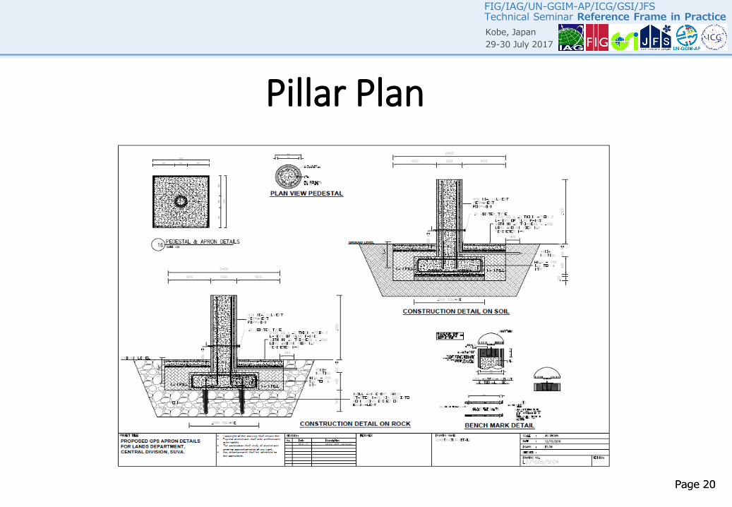
Continuous Operating Reference Stations - CORS
• Structural Drawings – Huts and Pillars
- completed and examined
- Bill Of Quantities (BOQ)
- Procurement of building materials

FIG/IAG/UN-GGIM-AP/ICG/GSI/JFS Technical Seminar Reference Frame in Practice Kobe, Japan
29-30 July 2017
Page 18
FIG/IAG/UN-GGIM-AP/ICG/GSI/JFS Technical Seminar Reference Frame in Practice Kobe, Japan
29-30 July 2017
Page 18
Fence Plan

FIG/IAG/UN-GGIM-AP/ICG/GSI/JFS Technical Seminar Reference Frame in Practice Kobe, Japan
29-30 July 2017
Page 19
FIG/IAG/UN-GGIM-AP/ICG/GSI/JFS Technical Seminar Reference Frame in Practice Kobe, Japan
29-30 July 2017
Page 19
Shelter/Hut for the CORS Plan
FIG/IAG/UN-GGIM-AP/ICG/GSI/JFS Technical Seminar Reference Frame in Practice Kobe, Japan
29-30 July 2017
Page 20
FIG/IAG/UN-GGIM-AP/ICG/GSI/JFS Technical Seminar Reference Frame in Practice Kobe, Japan
29-30 July 2017
Page 20
Pillar Plan

FIG/IAG/UN-GGIM-AP/ICG/GSI/JFS Technical Seminar Reference Frame in Practice Kobe, Japan
29-30 July 2017
Page 21
FIG/IAG/UN-GGIM-AP/ICG/GSI/JFS Technical Seminar Reference Frame in Practice Kobe, Japan
29-30 July 2017
Page 21
Fiji Islands GPS Survey Control Network Station
Rotuma
Cikobia
NaqelelevuUdu Pt
Vanua Balavu
Kia
Labasa
BuaYasawa
Rakiraki Koro
Gau
Lakeba
Ovalau
Suva
Vatulele
Nabukalevu Ogea
Vatoa
Tuvana-i-colo
Ono-i-lau
Tuvana-i-ra
Ceva-i-ra
Matuku
ManaLautoka
Sail Rock
Taveuni

FIG/IAG/UN-GGIM-AP/ICG/GSI/JFS Technical Seminar Reference Frame in Practice Kobe, Japan
29-30 July 2017
Page 22
FIG/IAG/UN-GGIM-AP/ICG/GSI/JFS Technical Seminar Reference Frame in Practice Kobe, Japan
29-30 July 2017
Page 22
THANK YOU