bulahdelah upgrading the pacific environmental impact ... · environmental impact statement...
TRANSCRIPT
Bulahdelah Upgrading the Pacific Highway Environmental Impact Statement Technical Paper 3 Need and Route Evaluation
November 2004
Roads and Traffic
Authority
Parsons Brinckerhoff Australia Pty Limited ACN 078 004 798 and Parsons Brinckerhoff International (Australia) Pty Limited ACN 006 475 056 trading as Parsons Brinckerhoff ABN 84 797 323 433
PPK House 9 Blaxland Road Rhodes NSW 2138 Locked Bag 248 Rhodes NSW 2138 Australia Telephone +61 2 9743 0333 Facsimile +61 2 9736 1568 Email [email protected] ABN 84 797 323 433 NCSI Certified Quality System ISO 9001
c
58L320A.083
3 - Need and Route Evaluation Final.do

Upgrade of the Pacific Highway at Bulahdelah Technical Paper 3
Author: David Fingland
Reviewer: Mark Keogh
Approved by: Mark Keogh
Signed: ..................................................................................................................
Date: 1 November 2004

Contents Technical Paper 3
Contents
Page Number
1. Introduction 1-1 1.1 Overview 1-1 1.2 Clarification of Government Departments 1-2
2. Context, Need and Objectives 2-1 2.1 Planning Context 2-1
2.1.1 The Sydney—Brisbane Corridor 2-1 2.1.2 Hunter and Mid North Coast Regions 2-6 2.1.3 Great Lakes Local Government Area 2-8
2.2 Transport Context. 2-8 2.2.1 Transport Network 2-8 2.2.2 Existing Traffic Volumes 2-10 2.2.3 Future Traffic Volumes 2-12
2.3 Need for the Bulahdelah Upgrade 2-14 2.3.1 Regional Socio-Economic Development 2-14 2.3.2 Travel Demand and Road Safety 2-14 2.3.3 Ongoing Environmental and Social Impacts 2-16 2.3.4 Implications for Ecologically Sustainable Development 2-17
2.4 Objectives to Address Identified Needs 2-17 2.5 Consequences of No Action 2-18
2.5.1 Regional, State and National Issues 2-18 2.5.2 Traffic 2-18 2.5.3 Local Environmental and Social Issues 2-19
3. Investigations to Support Route Evaluation 3-1 3.1 Approach 3-1 3.2 Socioeconomic Investigations 3-6
3.2.1 Heritage 3-6 3.2.2 Land Use and Property 3-6
58L320A.083 3 - Need and Route Evaluation Final.doc PARSONS BRINCKERHOFF Page i
Upgrade of the Pacific Highway at Bulahdelah Technical Paper 3
3.2.3 The Economy and Employment 3-7 3.2.4 Noise 3-7 3.2.5 Community Values 3-8
3.3 Biophysical Investigations 3-8 3.3.1 Biological 3-8 3.3.2 Water, Hydrology and Hydraulics 3-8 3.3.3 Geotechnical 3-9
3.4 Engineering Investigations 3-9 3.4.1 Public Utilities and Services 3-9 3.4.2 Project Costs, Constructability and Design 3-10
4. Route Identification, Evaluation and Assessment 4-1 4.1 Corridor Options Considered 4-1 4.2 Evaluation Process 4-1 4.3 Evaluation Criteria 4-2 4.4 Options Evaluation 4-7
4.4.1 Overview 4-7 4.4.2 Stage One Assessment 4-8 4.4.3 Stage Two Assessment 4-14 4.4.4 Overview of Performance 4-20
4.5 Route Selection 4-21 4.5.1 Approach 4-21 4.5.2 Outcomes 4-21 4.5.3 Review of Through–Town Options 4-26
5. Environmental Impact Assessment and Refinement of the Preferred Route 5-1
Page ii Roads and Traffic Authority 58L320A.083 3 - Need and Route Evaluation Final.doc

Contents Technical Paper 3
List of Tables Table 2.1: Objectives of the Pacific Highway Upgrading Program 2-3 Table 2.2 Descriptions of Levels of Service 2-15 Table 4.1: Stage One Evaluation Criteria 4-2 Table 4.2: Stage Two Assessment Criteria and Measures/Indicators of Performance 4-3 Table 4.3: Value Management Workshop Selection Criteria and Weightings 4-7 Table 4.4: Broad Assessment of Western Corridor Options 4-10 Table 4.5: Broad Assessment of Through-town Corridor Options 4-11 Table 4.6: Broad Assessment of Near Eastern Corridor Options 4-12 Table 4.7: Broad Assessment of Far Eastern Corridor Options 4-13 Table 4.8: Shortlist Options Performance: Efficiency of Travel Safety and Accessibility 4-16 Table 4.9: Shortlist Options Performance: Environmental Quality and Sustainability 4-17 Table 4.10: Shortlist Options Performance: Socioeconomic and Financial 4-18 Table 4.11: Shortlist Options Performance: Design and Engineering 4-19 Table 4.12: Summary of Comparative Assessment of Short-listed Options 4-22 Table 4.13: Summary of Outcomes from Review of Option C 4-27
List of Figures Chapter 1 Introduction Figure 1.1 The Proposal Chapter 2 Context, Need and Objectives Figure 2.1 Regional and Local Government Context Figure 2.2 Daily Two-way Traffic Volumes on Pacific Highway at Karuah River Bridge Figure 2.3 Historical and Projected Traffic Growth on Pacific Highway (south of Bulahdelah) Chapter 3 Investigations to Support Route Evaluation Figure 3.1 Route Selection Process Figure 3.2 Study Area for Route Evaluation and Selection Figure 3.3 Socioeconomic Investigations Figure 3.4 Biophysical Investigations Chapter 4 Route Identification, Evaluation and Assessment Figure 4.1 Stage One Route Options Figure 4.2 Stage Two Route Options
58L320A.083 3 - Need and Route Evaluation Final.doc PARSONS BRINCKERHOFF Page iii

Introduction Technical Paper 3
1. Introduction
1.1 Overview
The Roads and Traffic Authority (RTA) proposes to upgrade the Pacific Highway at Bulahdelah. The technical paper forms part of an environmental impact statement (EIS) that defines the proposal and examines its impacts. The Environmental Impact Statement comprises a main volume and 16 technical papers, which are listed below:
Technical Paper 1 Community and Stakeholder Involvement
Technical Paper 2 Statutory Planning
Technical Paper 3 Need and Route Evaluation
Technical Paper 4 The Proposal
Technical Paper 5 Environmental Management Framework
Technical Paper 6 Traffic and Transport
Technical Paper 7 Ecological Assessment and Species Impact Statement
Technical Paper 8 Water
Technical Paper 9 Hazard and Risk
Technical Paper 10 Energy, Waste and Demand on Resources
Technical Paper 11 Topography, Geology and Soils
Technical Paper 12 Visual
Technical Paper 13 Social and Economic
Technical Paper 14 Noise and Vibration
Technical Paper 15 Air
Technical Paper 16 Heritage
The preferred route of the Pacific Highway at Bulahdelah consists of approximately 8.5 kilometres of dual carriageway that would connect the proposed Karuah to Bulahdelah upgrade to the south to the completed Bulahdelah to Coolongolook upgrade to the north.
58L320A.083 3 - Need and Route Evaluation Final.doc PARSONS BRINCKERHOFF Page 1-1
Upgrade of the Pacific Highway at Bulahdelah Technical Paper 3
The preferred route, shown in Figure 1.1, passing generally to the east of Bulahdelah, was determined following consideration of a number of options in consultation with the local community and a range of other stakeholders. Connections to the existing highway would be via grade-separated interchanges to the south of Bulahdelah and at Lee Street at the northern end of the township.
The details of the proposal are provided in Technical Paper 4 — The Proposal.
The technical paper demonstrates the need for the proposal in the context of the national, State and regional road network and the government’s transport planning objectives and strategies. It also describes the route evaluation and selection process, leading to the ministerial announcement of the preferred route.
1.2 Clarification of Government Departments
NSW Department of Primary Industries commenced on 1 July 2004 as the amalgamation of:
NSW Fisheries;
State Forests of NSW;
NSW Agriculture; and
Mineral Resources.
The 16 technical papers supporting the Environment Impact Statement were drafted before this amalgamation occurred. All references to these government departments in the technical papers signify the NSW Department of Primary Industries.
Page 1-2 Roads and Traffic Authority 58L320A.083 3 - Need and Route Evaluation Final.doc
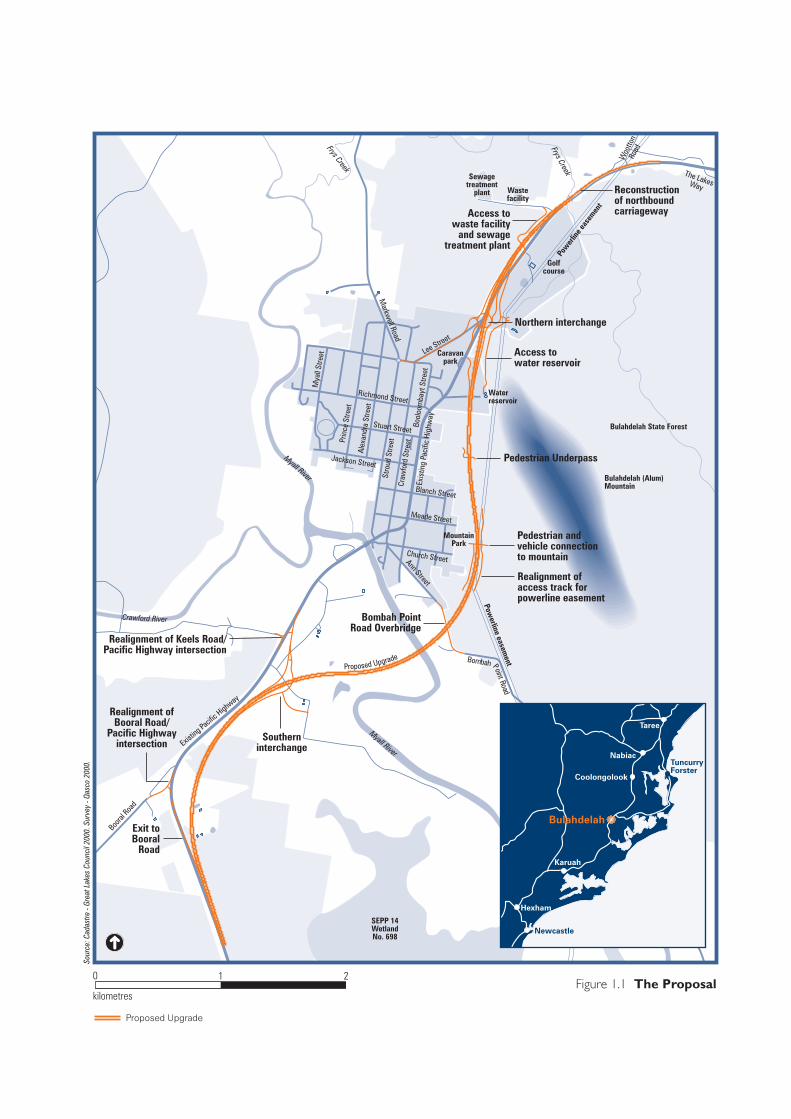
Figure 1.1 The Proposal
Proposed Upgrade
0 2
kilometres
1
Sour
ce: C
adas
tre -
Grea
t Lak
es C
ounc
il 20
00. S
urve
y - Q
asco
200
0.
Golfcourse
Sewagetreatment
plant Wastefacility
Woo
tton
RoadFrys Creek
Waterreservoir
Lee Street
Richmond Street
Stuart Street
Stro
ud S
treet
Craw
ford
Stre
etEx
istin
g Pa
cific
Hig
hway
Markw
ell Road
Caravanpark
Prin
ce S
treet
Alex
andr
a St
reet
Mya
ll St
reet
Bool
oom
bayt
Stre
et
Blanch Street
Meade Street
Church Street
MountainPark
Ann Street
Myall River
Powerline easem
ent
Myall River
Jackson Street
Booral
Road
Existin
g Pacifi
c Highw
ay
Bulahdelah State Forest
Crawford River
Proposed Upgrade
The LakesWay
Frys Creek
Bulahdelah (Alum)Mountain
SEPP 14WetlandNo. 698
Newcastle
Taree
Karuah
Hexham
Coolongolook
Nabiac
Bulahdelah
TuncurryForster
Reconstructionof northboundcarriagewayAccess to
waste facilityand sewage
treatment plant
Northern interchange
Access towater reservoir
Pedestrian Underpass
Pedestrian andvehicle connectionto mountain
Bombah PointRoad Overbridge
Southerninterchange
Realignment ofBooral Road/
Pacific Highwayintersection
Exit toBooral
Road
Pow
erlin
e eas
emen
t
Bombah Point Road
Realignment of Keels Road/Pacific Highway intersection
Realignment ofaccess track forpowerline easement


Need and Objectives Technical Paper 3
2. Context, Need and Objectives
Sections 2.1 and 2.2 describe the planning and transport context for the proposed Upgrade. Section 2.3 discusses the need for the proposal in relation to the planning and transport context. Section 2.4 and 2.5 discuss the objectives of the project to address the identified needs and the consequences of no action.
2.1 Planning Context
2.1.1 The Sydney—Brisbane Corridor
The east coast of Australia between Sydney and Brisbane is one of the fastest growing regions of Australia. Improving the rail and road transport links between Sydney and Brisbane has been a priority for Commonwealth, NSW and Queensland Governments for some time. Substantial public and private investment in transport infrastructure aims to improve the efficiency, reliability and safety of both freight and passenger travel between major urban areas and other centres of economic activity in the corridor.
Transport and land use planning of the regions between Sydney and Brisbane are controlled by the NSW and Queensland Governments and various local governments. Key State and regional strategic planning documents that identify the need for the development of transport infrastructure within the corridor include:
NSW Hunter Regional Environmental Plan (Department of Planning 1989);
NSW North Coast Regional Environmental Plan (Department of Planning 1988);
North Coast Urban Development Strategy (Department of Planning 1995);
South-east Queensland Regional Framework for Growth Management (Queensland Government 1998);
Integrated Regional Transport Plan for South-east Queensland (Queensland Transport 1997);
Action for Transport 2010 — An Integrated Transport Plan for NSW (Department of Transport 1998);
Transport 2007 — An Action Plan for South East Queensland (Queensland Transport 2001); and
Upgrading the Pacific Highway: Ten Year Pacific Highway Reconstruction Program Discussion Paper (RTA 1997).
These planning investigations and strategies identify the need to improve transport infrastructure to address the following common issues:
58L320A.083 3 - Need and Route Evaluation Final.doc PARSONS BRINCKERHOFF Page 2-1

Upgrade of the Pacific Highway at Bulahdelah Technical Paper 3
the increasing demand for urban development, especially in the relatively narrow coastal strip;
current constraints on transport infrastructure and the related need to improve accessibility and transport, both within the individual regions and between the regions; and
the need to improve the efficiency, integration and productivity of the freight sector.
Planning policies that are particularly important to the proposed Upgrade are:
Hunter Regional Environmental Plan;
Pacific Highway Upgrading Program; and
Action for Transport 2010.
Hunter Regional Environmental Plan 1989
The Hunter Regional Environmental Plan 1989 (Department of Planning) applies to an area including the Great Lakes Local Government Area, and is intended to act as a guiding framework for development within the entire Hunter Region. The plan identifies a series of objectives and policies for preparing local government plans and for controlling development. The transport related objectives of the proposed Upgrade are to:
ensure that traffic management techniques optimise the use of the existing road system;
ensure that new or upgraded roads and railways are constructed to meet identified demands, including the provision of bicycle facilities, and that their impact on the natural environment is minimised; and
maintain an appropriate acoustical environment in line with the criteria established by the Department of Environment and Conservation (formerly Environment Protection Authority).
As discussed in Technical Paper 2 — Statutory Planning, the Hunter Regional Environmental Plan 1989 was considered in the development of the proposal, but has no effect on the permissibility of the proposal.
Pacific Highway Upgrading Program
The New South Wales and Commonwealth Governments announced a joint commitment in August 1996 to a 10 year program to upgrade the Pacific Highway between Hexham and the Queensland border. The Pacific Highway Upgrading Program (Roads and Traffic Authority 1997) provides a commitment of $2.2 billion to improve the capacity and safety of the existing Pacific Highway. Ultimately this would provide a dual carriageway standard highway between the Sydney and Brisbane metropolitan areas. The objectives of the Pacific Highway Upgrading Program and the associated strategies are set out in Table 2.1.
Page 2-2 Roads and Traffic Authority 58L320A.083 3 - Need and Route Evaluation Final.doc

Need and Objectives Technical Paper 3
The sections of Pacific Highway around Karuah and from Karuah to the southern edge of Bulahdelah are planned to be constructed in stages over the next 5 years. The Bulahdelah section will be the critical final link of dual carriageway to be completed between Hexham and Coopernook. The completion of this upgrade will eliminate the major constriction to traffic movement on the highway at Bulahdelah.
Table 2.1: Objectives of the Pacific Highway Upgrading Program
Objective Draft Strategies
Significantly reduced road accidents and injuries
reduce uncontrolled access to the route;
increase length of dual carriageway;
improve alignment and eliminate narrow bridges;
provide overtaking lanes at five kilometre intervals, where not dual carriageway;
develop an attractive network of rest areas and service centres;
improve ride qualities of the route to agreed standard; and
design in accordance with Road Environment Safety Guidelines.
Reduced travel times reduce uncontrolled access to the route;
reduce overall length of route;
increase length of dual carriageway;
provide overtaking lanes at five kilometre intervals where no dual carriageway exists;
provide town bypass;
reduce grades;
improve ride qualities of the route to an agreed standard;
improve alignment and eliminate narrow bridges; and
implement road user delay strategy (in development).
Reduced freight transport costs
achieve ‘reduced travel time’ objective;
achieve ‘significantly reduced road accidents and injuries’ objective;
provide new works to meet or exceed B-double standards;
identify and address impediments to efficient freight transport; and
optimise flood immunity of the route (implement flooding strategy).
58L320A.083 3 - Need and Route Evaluation Final.doc PARSONS BRINCKERHOFF Page 2-3

Upgrade of the Pacific Highway at Bulahdelah Technical Paper 3
Objective Draft Strategies
A community satisfied with physical development of the route
involve the community in development of the program (for example, through the ten-year Discussion Paper);
implement community involvement plans for each project;
deliver agreed program (or better) within timeframe and cost limits provided;
develop and implement Internet site;
provide for cyclists and pedestrians as required; and
program some easily constructed works for early implementation.
A route that supports economic development
improve the inter-regional function of the corridor;
encourage complementary land use and public transport developments;
develop an agreed process to resolve impediments to cross-border connectivity and contribute to regional development; and
optimise access to tourism and export markets.
Reconstruction of the route managed in accordance with ecologically sustainable development principles
assess and address cumulative impacts;
adopt best environmental practice in projects;
incorporate environmentally sensitive design standards; and
apply RTA Guidelines for managing environmental issues (biodiversity, noise impacts, water quality, acid sulphate soils).
Maximum effectiveness of expenditure
implement Maintenance Investment Strategy (in development);
use existing road where other objectives are not compromised;
promote innovation, and trial various delivery methods;
fit within existing road reserve;
critically challenge existing design standards;
focus on customer needs; and
maximise competitive tendering processes.
Source: Roads and Traffic Authority 1997.
Action for Transport 2010 — An Integrated Transport Plan for NSW
Action for Transport 2010 — An Integrated Transport Plan for NSW (Department of Transport 1998) provides a long-term vision for meeting the State’s transport needs, with detailed proposals for each region, including the Hunter and the Central Coast. This action plan commits the State government to completing the dual carriageways between Hexham and the Queensland border. Actions relevant to the proposed Upgrade are:
Page 2-4 Roads and Traffic Authority 58L320A.083 3 - Need and Route Evaluation Final.doc

Need and Objectives Technical Paper 3
meeting the needs of a growing and changing population through, among other planning principles, packaging urban development and transport investment in identified corridors and ensuring integrated transport and land use planning and decision making;
safeguarding the environment by maintaining high standards in environmental management, imposing tighter environmental requirements on contractors and protecting flora, fauna and water quality;
improving access for rural communities by upgrading State roads that provide access to services, regional centres and local communities. and recognising the importance of tourism;
making freight transport more efficient and cheaper, thus reducing costs to businesses;
keeping the network in good order through maintaining road quality;
giving the community value for money when investing in transport infrastructure; and
preventing accidents and saving lives by providing the safest possible road traffic environment for all road users.
Population Growth
The 2001 census revealed that the coastal regions between Sydney and Brisbane had a population of approximately 1.2 million. The Sydney–Brisbane corridor plus Greater Sydney Metropolitan population (including Illawarra, Lake Macquarie and Newcastle) of 4.8 million, and the Brisbane, Gold Coast population of two million represent approximately 40 percent of the total Australian population (Australian Bureau of Statistics 2002(a)).
In the five years 1996 to 2001, Australia’s population grew at an average of 1.2 percent per year. Brisbane’s growth rate of 1.7 percent per year was second only to Darwin’s among the capital cities of Australia. In these five years the largest growth outside the capital cities has occurred in coastal areas, especially in south-east Queensland. The Gold Coast–Tweed statistical district grew by 3.8 percent, being the area of largest growth outside the major cities. Rapid population growth was also recorded in other coastal areas between 1996 and 2001, with Port Macquarie recording 3.1 percent growth and Coffs Harbour 1.8 percent (Australian Bureau of Statistics 2003).
The corridor between Sydney and Brisbane is expected to experience significant population growth over the next 20 years and a corresponding increase in economic activity.
58L320A.083 3 - Need and Route Evaluation Final.doc PARSONS BRINCKERHOFF Page 2-5
Upgrade of the Pacific Highway at Bulahdelah Technical Paper 3
2.1.2 Hunter and Mid North Coast Regions
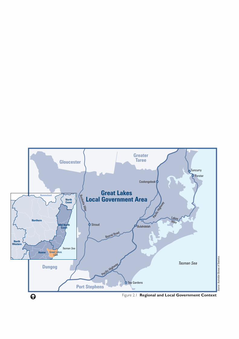
Bulahdelah is at the north-eastern edge of the Hunter region, close to the Mid North Coast region (see Figure 2.1). The Hunter and Mid North Coast regions have a growing and changing economy and population. The patterns of growth and change within these regions are quite different.
The Hunter is traditionally known for its industrial base, particularly manufacturing. It has an increasingly diversified economy, with industries including agriculture, mining, electricity generation, defence, tourism, manufacturing, aluminium and steel production. Most employment is in the service industry.
The Mid North Coast runs from Wallis Lake in the south to the Richmond Range in the north. The major centres include Taree, Port Macquarie, Kempsey, Coffs Harbour and Grafton. The traditional economic base for this region has been dairy farming, beef cattle production and forestry. Related processing and value adding industries are growing. Tourism also continues to make a major contribution to the economy.
Bulahdelah, while being in the Hunter, is more characteristic of the Mid North Coast, having links to tourism and related service industries.
The population of the Australian Bureau of Statistics Hunter sub-region in 2001 was 563,586, a 4.3 percent growth since 1996. The total population for the Hunter at the 1996 Census was 540,491, with a population growth of 5.2 percent since the 1991 Census (Australian Bureau of Statistics 2002(a)).
The population of the Mid North Coast in 2001 was 275,274, which represents an increase of 4.7 percent over the population in 1996. The total population at the 1996 Census was 262,985, with a population growth of 9.2 percent since the 1991 Census (Australian Bureau of Statistics 2002(a)).
Principal sources of employment within both regions are retail and wholesale trade, health and community services, manufacturing, property, business and financial services and construction. Employment growth is expected to be dominated by demand from accommodation, cafes and restaurants, and wholesale and retail trade. Industries recording declining employment demand are manufacturing, mining, logging, dairying, and utilities.
The growth and changes in the regional economy and population drive the need for quality road networks for tourists and increased freight movement between the North Coast and its markets.
Page 2-6 Roads and Traffic Authority 58L320A.083 3 - Need and Route Evaluation Final.doc
Pacif
ic Hi
ghway
LakesWay
Booral Road
Pacific Highway
Bucketts Way
Tasman Sea
Queensland
Northern
Hunter
NorthWestern
Great LakesLGA
Mid NorthCoast
NorthCoast
58L320A(TP3)/05.07.04
Figure 2.1 Regional and Local Government Context
Tea Gardens
Bulahdelah
Coolongolook
Forster
Tuncurry
Stroud
Great LakesLocal Government Area
GloucesterGreaterTaree
Dungog
Port Stephens
Tasman Sea
Sour
ce: A
ustra
lian
Bure
au o
f Sta
tistic
s.
Upgrade of the Pacific Highway at Bulahdelah Technical Paper 3
2.1.3 Great Lakes Local Government Area
The Great Lakes Local Government Area extends from Port Stephens in the south to Hallidays Point in the north, and to the Great Dividing Range in the west, as shown in Figure 2.1. It comprises coastal and forested rural hinterland, and Forster is its largest town. A third of the Local Government Area is made up of national parks and State Forests. Due to attractive natural features such as the coast, lakes and rivers, the Great Lakes area and surrounds are a major recreational destination.
A significant proportion (31.5 percent) of the population is aged over 60 years. The State average is 17 percent. Unemployment is high, and a large proportion of people live in small centres with limited access to health and community services. Bulahdelah shares the characteristics of an ageing population, lack of services and high unemployment.
Although Bulahdelah is not identified as an area for potential urban expansion in The Hunter Coastal Urban Settlement Strategy 1994 (Department of Planning 1994), the plan identifies the whole Great Lakes Local Government Area as having the capacity for an additional 26,000 residents.
The population of the Great Lakes Local Government Area was 28,609 in 1996 and 31,384 in 2001 (Great Lakes Council 2003). This represents an annual growth rate of 1.9 percent. Australia’s overall annual growth rate was 1.2 percent, with New South Wales having an annual population growth rate of 0.8 percent (Australian Bureau of Statistics 2002(b)).
The Pacific Highway is the major arterial route through the Great Lakes Local Government Area. It is important to the local community for accessing and receiving goods and services, as well as for supporting the local economy. The proposed Upgrade at Bulahdelah is the last section within the Great Lakes to be upgraded.
2.2 Transport Context.
2.2.1 Transport Network
The Pacific Highway is the primary arterial road through Bulahdelah. It is a route of strategic national significance serving intrastate and interstate users, and is the main road transport corridor along the coast of NSW, linking Sydney with Brisbane. As it passes through the Bulahdelah area, the highway provides regional and local links to the following regional locations:
Gloucester via Stroud Street and Markwell Road;
Forster via The Lakes Way; and
Stroud via Booral Road and The Bucketts Way.
Page 2-8 Roads and Traffic Authority 58L320A.083 3 - Need and Route Evaluation Final.doc
Need and Objectives Technical Paper 3
As the importance of the Pacific Highway as a primary arterial route increases, the conflicts associated with its role as a local and regional road will also increase.
Measures have been introduced to manage the arising safety issues from this conflict. A central New Jersey barrier physically blocks cross-highway movement at the Meade Street intersection with the Pacific Highway. There are two signalised pedestrian crossings on the Pacific Highway, one to the south of Blanch Street and the other to the north of Stuart Street. None of the road intersections is controlled by traffic signals.
Pedestrian Network
There is no defined continuous network of footpaths in the town and there are very few footpaths in road reserves. Pedestrians tend to use the local roads.
Footpath connections lead from the pedestrian signals on the Pacific Highway to both schools. The St Joseph's Catholic School connection is short and leads to the residential area to the west. The connection to Bulahdelah Central School leads to a mid-block footpath between Harold Street in the east and the Pacific Highway. On the western side it connects to Meade Street and to the shopping centre via Blanch Street. There is also a footpath connecting the Tourist Information Centre, the library and School of Arts.
The Bulahdelah State Forest Reserve has a number of bushland recreational walking tracks leading to and from Bulahdelah Mountain Park. However, there are no footpaths connecting the park to Bulahdelah.
Public Transport
Buses are the primary mode of public transport in Bulahdelah. Two local bus companies operate in the Bulahdelah area: the Bulahdelah Bus Company (trading as Great Lakes Coaches) and Ede’s Bus Service.
Regional return services provided by the Bulahdelah Bus Company are:
Taree–Newcastle;
Forster–Sydney;
Bulahdelah–Newcastle; and
Bulahdelah–Taree.
The Bulahdelah Bus Company provides school charter services for St Joseph’s Catholic School, Bulahdelah Central School and the Bulahdelah Pre-school. School services comprise nine buses that operate to the north, south and west to destinations including Raymond Terrace, Stroud, Karuah, Hawks Nest, Markwell, Coolongolook, Pacific Palms and Taree. The depot is in Stroud.
The company also transports school children to other venues within Bulahdelah, including the Bulahdelah Golf Club, the swimming pool, the showground, and the
58L320A.083 3 - Need and Route Evaluation Final.doc PARSONS BRINCKERHOFF Page 2-9

Upgrade of the Pacific Highway at Bulahdelah Technical Paper 3
tennis courts. Buses also carry school students to other localities, including Pacific Palms, Seal Rocks and Hawks Nest, for school sports and recreational activities.
The main bus stops in Bulahdelah are at the post office, the hospital and Bulahdelah Mountain Caravan Park.
Ede’s Bus Service operates one school bus and some charter services into and out of Bulahdelah from its Wootton depot.
Interstate coaches operate up and down the Pacific Highway and use the highway service station/roadhouse facilities in Bulahdelah.
2.2.2 Existing Traffic Volumes
Traffic and transport investigations and conclusions are discussed in Technical Paper 6 — Traffic and Transport.
In 2002 the Pacific Highway carried approximately 14,400 vehicles per day south of Bulahdelah. Traffic in the centre of Bulahdelah (over 15,000 per day) is only slightly higher than traffic to the north or south of Bulahdelah, indicating the relatively small contribution of local trips to total traffic.
Although the performance of intersections within Bulahdelah results in acceptable delays during weekday non-holiday periods, at peak weekend and holiday periods the delays to local cross-traffic increase considerably.
Daily traffic data from 1998 to July 2003 were obtained from the RTA's permanent traffic counter on the Pacific Highway at the Karuah River bridge (approximately 44 kilometres south of Bulahdelah), as shown in Figure 2.2. The average growth rate in two-way traffic over this period was 4.25 percent per annum.
Heavy vehicles comprised 19–21 percent of all vehicles during weekday non-holiday periods (6.00 am to 10.00 pm). The proportion of heavy vehicles increases to 58 percent of all vehicles during the night (10.00 pm to 6.00 am). The number of heavy vehicles on a typical weekday is two to two-and-a-half times higher than during the weekend. On average, heavy vehicles comprise 17 percent of total traffic passing through Bulahdelah at this time.
Page 2-10 Roads and Traffic Authority 58L320A.083 3 - Need and Route Evaluation Final.doc
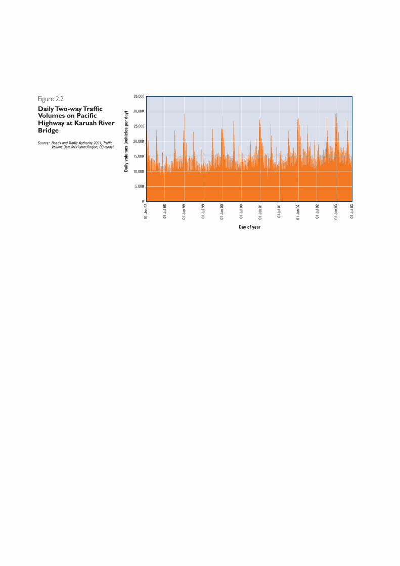
Figure 2.2
Daily Two-way TrafficVolumes on PacificHighway at Karuah RiverBridge
58L320A (TP3)/25.06.04
35,000
30,000
25,000
20,000
15,000
10,000
5,000
Dai
ly v
olum
es (v
ehic
les
per d
ay)
0
01 J
an 9
8
01 J
ul 9
8
01 J
an 9
9
01 J
ul 9
9
01 J
an 0
0
01 J
ul 0
0
01 J
an 0
1
01J
ul 0
1
01 J
an 0
2
01 J
ul 0
2
01 J
an 0
3
01 J
ul 0
3
Day of year
Source: Roads and Traffic Authority 2001, TrafficVolume Data for Hunter Region, PB model.
Upgrade of the Pacific Highway at Bulahdelah Technical Paper 3
Traffic on the Pacific Highway has grown in recent years due to natural growth in the demand for travel, improvements on the Pacific Highway, and population growth in the region and along the eastern seaboard. There has also been a shift in freight transport movements from the New England Highway corridor to the Pacific Highway corridor.
Logging trucks haul timber from the forest areas around Bulahdelah to local sawmills in the area, mainly using Markwell Road and Booral Road. These and other trucks are required to use defined routes on town roads because of load restrictions and to minimise impacts on residents and local traffic. However, the presence of heavy vehicles in residential areas continues to cause problems within the local community.
There is a trucking company operating about 10 trucks out of a business located in Lee Street. Trucks also need access to the waste facility.
2.2.3 Future Traffic Volumes
Historical and projected future daily traffic volumes on the Pacific Highway south of Bulahdelah are shown in Figure 2.3. Average daily traffic volumes are expected to increase from approximately 10,700 in 2000 to 15,400 in 2008 and almost 24,100 in 2028. The basis for this estimated increase relates to increased traffic demands between Sydney and Brisbane, rapid population growth in coastal areas of NSW, the attractiveness of the Great Lakes region as a tourist destination and the cumulative effect of improvements to the Pacific Highway. Bulahdelah is expected to have limited population growth over the next 20 years and is expected to contribute little to the projected demand for travel on the Pacific Highway under current land-use planning strategies.
Between May 2001 and May 2003, a period that included the opening of the Yelgun to Chinderah Bypass in northern NSW, daily heavy vehicle traffic recorded at Nabiac increased by approximately 17 percent. Over the same period, the total traffic volume increased by approximately 28 percent. As a consequence, there was a decline of 1.6 percent in the proportion of heavy vehicles in the total traffic volume. This implies that light vehicle traffic will have a greater influence on total traffic volume than heavy vehicles on the Pacific Highway.
Further traffic analysis reveals that total traffic will increase by 4 percent per annum, while heavy vehicle traffic will increase by 2 percent per annum.
The level of increase or decrease in local truck movements would depend largely on the level of activity in the primary industries in the area. Great Lakes Council has advised that the existing waste facility north of Bulahdelah will be retained as a transfer station with all truck movements being from and to the north.
Page 2-12 Roads and Traffic Authority 58L320A.083 3 - Need and Route Evaluation Final.doc
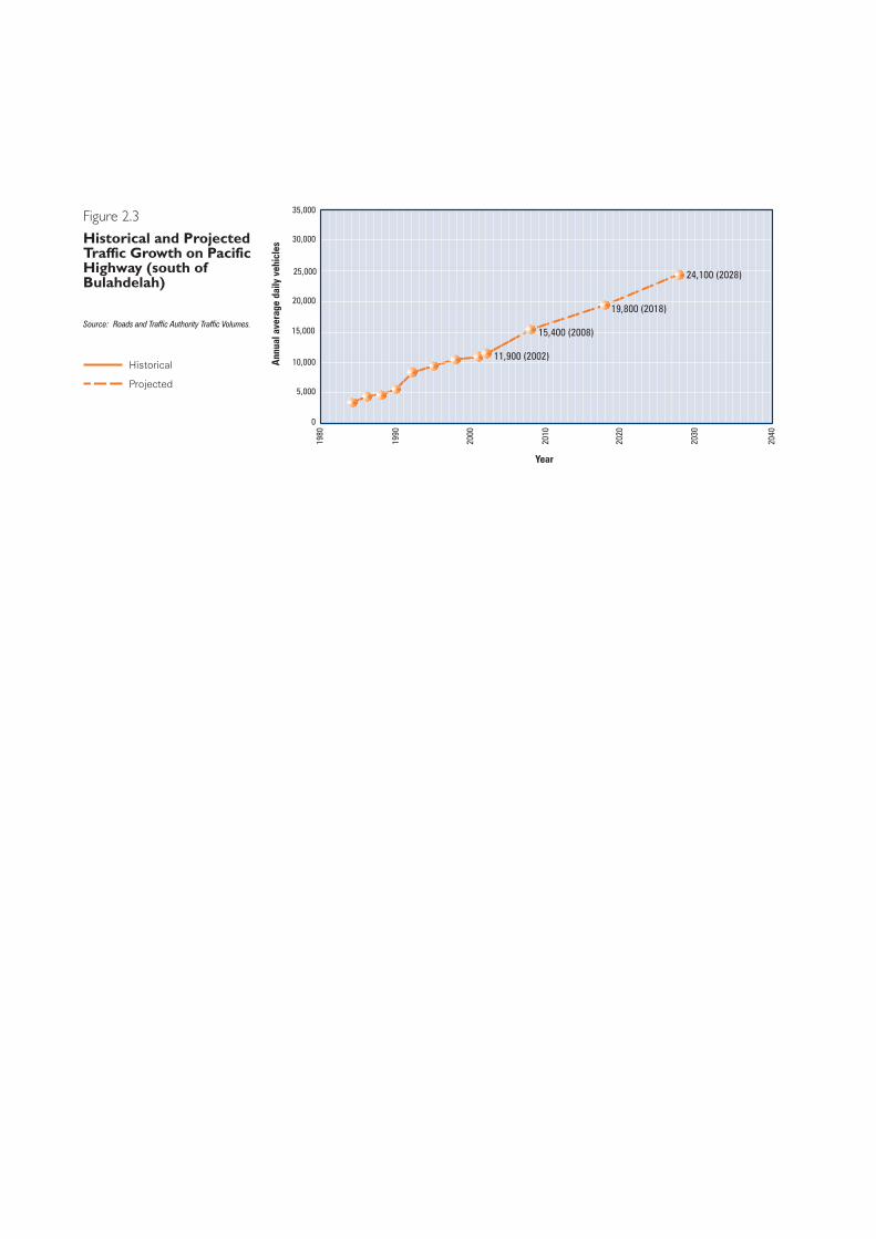
24,100 (2028)
19,800 (2018)
15,400 (2008)
11,900 (2002)
Figure 2.3
Historical and ProjectedTraffic Growth on PacificHighway (south ofBulahdelah)
58L320A.083 (TP3)/28.06.04/R1
Historical
Projected
35,000
30,000
25,000
20,000
15,000
10,000Ann
ual a
vera
ge d
aily
veh
icle
s
1980
5,000
0
1990
2000
2010
2020
2030
2040
Year
Source: Roads and Traffic Authority Traffic Volumes.
Upgrade of the Pacific Highway at Bulahdelah Technical Paper 3
2.3 Need for the Bulahdelah Upgrade
2.3.1 Regional Socio-Economic Development
The demands of a residential population expanding at a rate of 1.9 percent per annum and the increasing importance of the eastern seaboard as a tourism and recreational destination require improvements to road transport infrastructure to maintain community linkages, support urban and regional development and meet community expectations for safe and efficient travel.
Levels of social and economic development are closely linked with population growth and investment. There is a strong connection between land use and transport infrastructure in terms of regional economic development. A high standard of road network linking regional areas and centres of growth provides more efficient access to markets and sources of goods and services. The objectives of the Pacific Highway Upgrading Program, shown in Table 2.1, include those which support regional socio-economic development.
As transport is a major component of the costs of production, road improvements have a direct and positive impact on local, regional and national economies. Therefore, as a vital link in the State’s road network, the proposed Upgrade is expected to make a significant contribution to regional growth and the regional economy.
2.3.2 Travel Demand and Road Safety
The upgrading of the Pacific Highway to dual carriageway to the north and south of Bulahdelah will result in improvements in overall transport efficiency and traffic safety, in addition to meeting travel demand. However, with the number of vehicles using the Pacific Highway at Bulahdelah forecast to double by 2028 (refer Section 2.2.3), there is a need to keep improving the highway through the Bulahdelah area.
Long traffic delays currently occur at Karuah during peak holiday periods and to a lesser extent at Bulahdelah. This is a result of reduced lane capacity (one lane in each direction), 60 kilometres per hour speed limit and pedestrian activated traffic signals in both towns. With the completion of the upgrade of the Pacific Highway at Karuah in 2004, the Karuah to Bulahdelah and Bulahdelah urban sections of the highway would become increasingly congested for traffic in both directions.
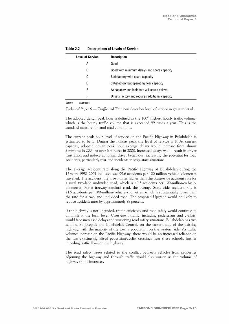
‘Level of service’ is a measurement of a road’s capacity to meet traffic demands, and is used for determining the number of lanes to be provided in the road network. In general, there are six levels of service, from A to F (see Table 2.2). Level of service A represents the best operating condition, and level of service F the worst. Existing and future levels of service for the Pacific Highway in Bulahdelah have been assessed according to guidelines in Roadway Capacity (Austroads 1988).
Page 2-14 Roads and Traffic Authority 58L320A.083 3 - Need and Route Evaluation Final.doc
Need and Objectives Technical Paper 3
Table 2.2 Descriptions of Levels of Service
Level of Service Description
A Good
B Good with minimum delays and spare capacity
C Satisfactory with spare capacity
D Satisfactory but operating near capacity
E At capacity and incidents will cause delays
F Unsatisfactory and requires additional capacity
Source: Austroads.
Technical Paper 6 — Traffic and Transport describes level of service in greater detail.
The adopted design peak hour is defined as the 100th highest hourly traffic volume, which is the hourly traffic volume that is exceeded 99 times a year. This is the standard measure for rural road conditions.
The current peak hour level of service on the Pacific Highway in Bulahdelah is estimated to be E. During the holiday peak the level of service is F. At current capacity, adopted design peak hour average delays would increase from almost 3 minutes in 2004 to over 6 minutes in 2008. Increased delays would result in driver frustration and induce abnormal driver behaviour, increasing the potential for road accidents, particularly rear-end incidents in stop–start situations.
The average accident rate along the Pacific Highway at Bulahdelah during the 12 years 1990–2001 inclusive was 99.6 accidents per 100-million-vehicle-kilometres travelled. The accident rate is two times higher than the State-wide accident rate for a rural two-lane undivided road, which is 49.3 accidents per 100-million-vehicle-kilometres. For a freeway-standard road, the average State-wide accident rate is 21.9 accidents per 100-million-vehicle-kilometres, which is substantially lower than the rate for a two-lane undivided road. The proposed Upgrade would be likely to reduce accident rates by approximately 78 percent.
If the highway is not upgraded, traffic efficiency and road safety would continue to diminish at the local level. Cross-town traffic, including pedestrians and cyclists, would face increased delays and worsening road safety situations. Bulahdelah has two schools, St Joseph’s and Bulahdelah Central, on the eastern side of the existing highway, with the majority of the town’s population on the western side. As traffic volumes increase on the Pacific Highway, there would be an increased reliance on the two existing signalised pedestrian/cyclist crossings near these schools, further impeding traffic flows on the highway.
The road safety issues related to the conflict between vehicles from properties adjoining the highway and through traffic would also worsen as the volume of highway traffic increases.
58L320A.083 3 - Need and Route Evaluation Final.doc PARSONS BRINCKERHOFF Page 2-15

Upgrade of the Pacific Highway at Bulahdelah Technical Paper 3
Regionally, it would be desirable for motorists to have a continuous and uniform standard of arterial road, allowing safe and efficient traffic movement. High quality road conditions reduce driver fatigue and frustration, and contribute to a reduction in accidents, especially those leading to fatalities.
As the upgrading of the sections of the highway to the south of Bulahdelah are finalised, the completion of the proposed Upgrade is even more important from a regional, state and national perspective. This section of the highway would then form a critical link between the Bulahdelah to Coolongolook freeway to the north and the dual carriageway from Hexham in the south. The completion of this total length of dual carriageway highway would improve road safety and the level of service for all road users.
2.3.3 Ongoing Environmental and Social Impacts
Traffic growth on the Pacific Highway is discussed in Technical Paper 6 — Traffic and Transport. Traffic projections along the Pacific Highway indicate an annual growth rate of 4.3 percent between 1999 and 2006 and 2.45 percent between 2006 and 2021. The Pacific Highway in Bulahdelah has relatively high levels of heavy vehicles, being approximately 17 percent of total traffic and is predicted to rise to approximately 19 percent.
Increasing traffic volumes through Bulahdelah would result in:
increased risks to the safety of pedestrians and cyclists as the conflict between the role of the Pacific Highway as a local road and regional highway worsens;
increased risk of accidents (and the impacts of those accidents) associated with the transport of hazardous materials. The risk assessment discussed in Technical Paper 9 — Hazard and Risk concludes that without the proposal, the hazardous materials accident rate on the existing highway would be expected to increase from one accident every 12.7 years to one accident every 6.3 years between 2002 and 2028;
maintenance of current traffic noise levels above accepted criteria (Environment Protection Authority 1999) for approximately 112 properties, including two schools and a church. Monitoring in 2000 showed that in locations near the highway, the traffic noise exceeded criteria by up to 5 decibels during the day and 8 decibels at night;
an increase in vehicle emissions, particularly during peak holiday periods when delays cause stop–start vehicle movements;
undesirable visual impacts associated with increasing movement of heavy vehicles and other traffic within the town; and
constraints on social interaction and movement of residents across town because of the physical barrier created by the highway and its traffic.
Page 2-16 Roads and Traffic Authority 58L320A.083 3 - Need and Route Evaluation Final.doc

Need and Objectives Technical Paper 3
2.3.4 Implications for Ecologically Sustainable Development
The need to upgrade the Pacific Highway at Bulahdelah can be considered in relation to the principles of ecologically sustainable development:
the precautionary principle: The analysis in Section 2.4 indicates that the proposed Upgrade is needed for strategic, operational and environmental reasons. It is a prudent approach to resolving the issues underlying the need for the project, in a way which minimises impacts on the human, built and natural environment.
intergenerational equity: A carefully planned and judiciously located highway around Bulahdelah would provide a more efficient and safer road network which would accommodate travel demand over the next 20–30 years. Aside from providing a safer road for this and future generations in the broader and local community, the proposed Upgrade offers the opportunity for potential urban improvement through new and diverse economic initiatives which would sustain the town in the longer term.
conservation of biological diversity and ecological integrity: The road transport sector is a major user of fossil fuels which are non-renewable and contribute to the greenhouse effect and climate change. The Upgrade of the Pacific Highway at Bulahdelah would improve transport and fuel efficiency in the local area. However, it would also contribute as part of the Pacific Highway Upgrade to a lesser competitive advantage for more fuel efficient rail transport in the Sydney–Brisbane corridor. Judicious locating of the highway and inclusion of mitigation and management measures would avoid or minimise impacts on sensitive terrestrial and aquatic ecological environments at the local level.
the improved valuation and pricing of environmental issues: Consideration of environmental issues in the early stages of project planning has helped achieve improved valuation and pricing of environmental resources by ensuring that these issues are incorporated into strategic planning and consideration of route options and concept design.
2.4 Objectives to Address Identified Needs
Objectives for the Upgrade of the Pacific Highway at Bulahdelah have been developed to guide the project’s development and address the needs identified in Section 2.3. These objectives have been developed from the Pacific Highway Upgrading Program objectives (Table 2.1). The project objectives were developed by the project team, following consultation with the community. They form the basis of a range of assessment criteria and performance measures to address identified needs and are outlined in Table 4.1 and 4.2. The project objectives are:
improve efficiency of travel, safety and accessibility;
improve environmental quality outcomes;
achieve environmental sustainability outcomes;
58L320A.083 3 - Need and Route Evaluation Final.doc PARSONS BRINCKERHOFF Page 2-17
Upgrade of the Pacific Highway at Bulahdelah Technical Paper 3
achieve acceptable socioeconomic and financial outcomes; and
achieve acceptable design, engineering and constructability outcomes.
Chapter 8 of the Main Volume of the EIS provides a justification of the proposed Upgrade by examining how the project objectives are met by the proposal.
2.5 Consequences of No Action
2.5.1 Regional, State and National Issues
If no action were taken to upgrade the highway at Bulahdelah the objectives of the Upgrading the Pacific Highway Program would be compromised, reducing the socio-economic advantages of the whole. The greatest impacts would be felt at the regional, State and national level. An efficient and safe intrastate and interstate transport network is essential for Australia’s national, State and regional economic growth.
The absence of viable, efficient alternative land transport modes or roads in the region make it imperative to construct the proposed Upgrade.
2.5.2 Traffic
If the proposed Upgrade does not proceed, traffic delays currently only occurring at peak holiday periods would begin to occur at other travel times. Delays in Bulahdelah would also be exacerbated by the upgrade of the highway at Karuah and between Karuah and Bulahdelah to the south which would focus the delays and congestion on Bulahdelah.
Based on historical and projected traffic volumes, the indicative peak hour average delays would increase from almost 3 minutes in 2004, to 6 minutes in 2008, and to an unacceptable 40 minutes by 2028.
With the proposed Upgrade, average peak hour delays would be 6 seconds per vehicle in 2008 and 37 seconds per vehicle in 2028.
Implications for the Pacific Highway at Bulahdelah without the proposed Upgrade would be:
Increased delays through and on either side of Bulahdelah — traffic volumes now experienced during peak holiday periods would become daily occurrences and at holiday times the road system would be subject to extended delays. This could cause local, regional and interstate traffic to move to other routes. Freight traffic could suffer productivity and commercial losses that might be passed on to consumers in commodity price rises. Overall regional and national economic performance would suffer from delays and increased travel costs.
The mobility of people in the regional and local communities would be severely reduced, particularly where there are no viable alternative transport modes or
Page 2-18 Roads and Traffic Authority 58L320A.083 3 - Need and Route Evaluation Final.doc
Need and Objectives Technical Paper 3
roads in the region — those mostly affected would be residents and commuters in the Taree, Great Lakes and Port Stephens areas.
The road safety of all road users — motorists, cyclists and pedestrians — would be compromised as more risks are taken to avoid congested areas.
2.5.3 Local Environmental and Social Issues
If the proposed Upgrade does not proceed, the environmental and social implications would be:
increases in the high levels of traffic noise at locations adjacent to the highway, including St Joseph’s Catholic School/Church and Bulahdelah Central School;
increases in the level of vibration from trucks at night experienced by residents and visitors in motels close to the highway;
deterioration of air quality experienced by residents, and pupils and teachers at St Joseph’s Catholic School/Church and Bulahdelah Central School;
a lessening of the social interaction between residents of the eastern and western parts of town as the highway increasingly becomes a physical and social barrier;
an increase in the severance effects of the highway on mobility from the eastern and western part of town, especially in relation to the two schools;
an increase in the visual intrusion of traffic within the town as discussed in Technical Paper 12 — Visual; and
increased hazards and risks of major traffic accidents, potentially involving hazardous goods, near residential and community use areas.
58L320A.083 3 - Need and Route Evaluation Final.doc PARSONS BRINCKERHOFF Page 2-19

Investigations to Support Route Evaluation Technical Paper 3
3. Investigations to Support Route Evaluation
3.1 Approach
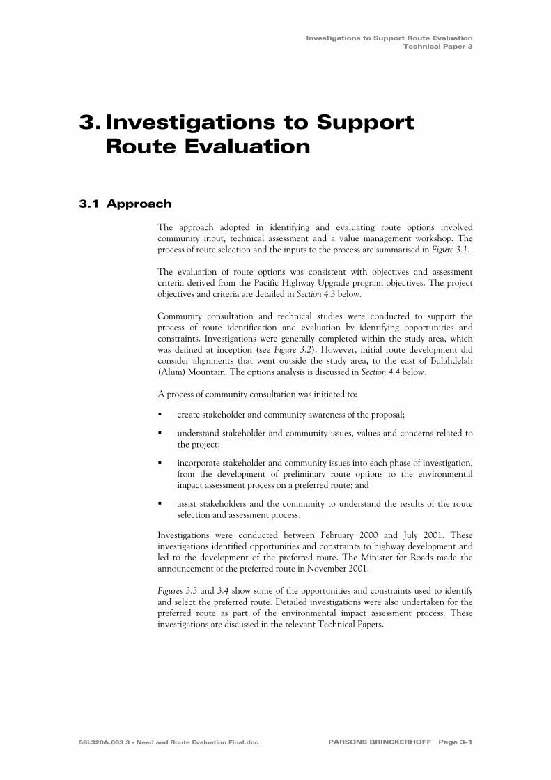
The approach adopted in identifying and evaluating route options involved community input, technical assessment and a value management workshop. The process of route selection and the inputs to the process are summarised in Figure 3.1.
The evaluation of route options was consistent with objectives and assessment criteria derived from the Pacific Highway Upgrade program objectives. The project objectives and criteria are detailed in Section 4.3 below.
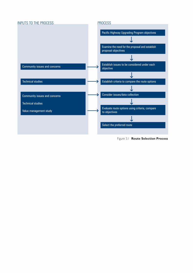
Community consultation and technical studies were conducted to support the process of route identification and evaluation by identifying opportunities and constraints. Investigations were generally completed within the study area, which was defined at inception (see Figure 3.2). However, initial route development did consider alignments that went outside the study area, to the east of Bulahdelah (Alum) Mountain. The options analysis is discussed in Section 4.4 below.
A process of community consultation was initiated to:
create stakeholder and community awareness of the proposal;
understand stakeholder and community issues, values and concerns related to the project;
incorporate stakeholder and community issues into each phase of investigation, from the development of preliminary route options to the environmental impact assessment process on a preferred route; and
assist stakeholders and the community to understand the results of the route selection and assessment process.
Investigations were conducted between February 2000 and July 2001. These investigations identified opportunities and constraints to highway development and led to the development of the preferred route. The Minister for Roads made the announcement of the preferred route in November 2001.
Figures 3.3 and 3.4 show some of the opportunities and constraints used to identify and select the preferred route. Detailed investigations were also undertaken for the preferred route as part of the environmental impact assessment process. These investigations are discussed in the relevant Technical Papers.
58L320A.083 3 - Need and Route Evaluation Final.doc PARSONS BRINCKERHOFF Page 3-1
58L320A (TP3)/25.06.04/R1
Figure 3.1 Route Selection Process
Establish issues to be considered under eachobjective
Establish criteria to compare the route options
PROCESS
Consider issues/data collection
Evaluate route options using criteria, compareto objectives
Select the preferred route
Community issues and concerns
Technical studies
INPUTS TO THE PROCESS
Community issues and concerns
Technical studies
Value management study
Pacific Highway Upgrading Program objectives
Examine the need for the proposal and establishproposal objectives
Sour
ce: C
adas
tre -
Grea
t Lak
es C
ounc
il. S
urve
y - Q
asco
200
2.
0 2
kilometres
1
Golfcourse
Sewagetreatment
plant Wastefacility
Wootton
Road
Frys Creek
Pow
erlin
e eas
emen
t
Waterreservoir
Lee Street
Richmond Street
Stuart Street
Stro
ud S
treet
Craw
ford
Stre
etEx
istin
g Pa
cific
Hig
hway
Markw
ell RoadCaravan
park
Prin
ce S
treet
Alex
andr
a St
reet
Mya
ll St
reet
Blanch Street
Meade Street
Church Street
MountainPark
Ann Street
Bombah PointRoad
Myall River
Powerline easem
ent
Jackson Street
Booral
Road
Existin
g Pacifi
c Highw
ay
Bulahdelah State Forest
Crawfor
d Rive
r
The LakesWay
Frys Creek
Bulahdelah (Alum)Mountain
Myall River
58L320A(TP3)/21.07.04
Figure 3.2 Study Area for Route Evaluation and Selection

State forest
Class 5
Class 4
Class 3
Figure 3.3 Socioeconomic Investigations
58L320A.083 (TP3)/21.07.04/R1
Forestry
Agriculture
Hobby farm
Community/publicutility
Recreation
Rural residential
Commercial
Swamp/floodplain
Vacant - rural/crownland
Existing Land Uses – Rural
Myall River
Crawfo
rd R
iver
Markw
ell Road
Boor
al Ro
ad
Sewagetreatment
plantWastefacility
Golfcourse
Frys
Paci
fic H
ighw
ay
Myall
Road
Paci
fic H
ighw
ay
Paci
fic H
ighw
ay
Paci
fic H
ighw
ay
Markwell Road
Creek
Stro
ud R
oad
Ann StreetM
yall R
iver
Woo
tton
Roa
d
Bool
oom
bayt
Str
eet
The LakesWay
Crawford River
Markwell Road
Pacific H
ighway
Paci
fic H
ighw
ay
Stro
ud R
oad
Ann Street
Mya
ll Rive
r
Mya
ll Rive
r
Bool
oom
bayt
Str
eet
Commercial
Industrial
Community
Tourist
Openspace/recreation
Publicutility/depot
Residential
Vacant - urban
Existing Land Uses – Urban
Myall River
Cra
wfo
rd R
iver
Markw
ell Road
Boor
al Ro
ad
Sewagetreatment
plantWastefacility
Golfcourse
Frys
Paci
fic H
ighw
ay
Myall
Road
Paci
fic H
ighw
ayMarkwell Road
Creek
Stro
ud R
oad
Ann Street
Woo
tton
Roa
d
Bool
oom
bayt
Str
eet
The LakesWay
Agricultural Land Suitability
High
Moderate
Low
Classified as National HeritageSignificance - Register ofNational Estate
Intent to List on HeritageRegister of National Estate(Great Lakes Council, 2000)
Archaeological Sensitivity
Myall River
Cra
wfo
rd R
iver
Markw
ell Road
Boor
al Ro
ad
Sewagetreatment
plantWastefacility
Golfcourse
Frys
Paci
fic H
ighw
ay
Myall
Road
Paci
fic H
ighw
ay
Markwell Road
Creek
Stro
ud R
oad
Stro
ud R
oad
Stro
ud R
oad
Ann Street
Ann Street
Ann Street
Woo
tton
Roa
d
TheTheThe LakesLakesLakesWayWayWay
Mya
ll Rive
r
Bool
oom
bayt
Str
eet
Bool
oom
bayt
Str
eet
Bool
oom
bayt
Str
eet
Indigenous and Non-Indigenous Heritage
Old Court House(registered site)
Cenotaph(potential relic)
Cemetery(registered site)
BulahdelahAlum Mountain

Myall R
iver
Cra
wfo
rd
River
Markw
ell Road
Boor
al Ro
ad
Sewagetreatment
plantWastefacility
Golfcourse
Frys
Paci
fic H
ighw
ay
Myall
Road
Paci
fic H
ighw
ay
Markwell Road
Creek
Stro
ud R
oad
Ann Street
Woo
tton
Roa
d
Bool
oom
bayt
Str
eet
Mya
llRive
r
The LakesWay
Suspected groundwater resource area
100-year flood area
Fault line
Myall Syncline
Figure 3.4 Biophysical Investigations
58L320A (TP3)/25.06.04/R1
Biological Constraints
Myall River
Cra
wfo
rd R
iver
Markw
ell Road
Boor
al Ro
ad
Wastefacility
Golfcourse
Frys
Paci
fic H
ighw
ay
Myall
Road
Paci
fic H
ighw
ay
Markwell Road
Creek
Stro
ud R
oad
Stro
ud R
oad
Stro
ud R
oad
Ann Street
Ann Street
Ann Street
Woo
tton
Roa
d
The LakesWay
Mya
ll Rive
r
Bool
oom
bayt
Str
eet
Bool
oom
bayt
Str
eet
Bool
oom
bayt
Str
eet
SewageSewageSewagetreatmenttreatmenttreatment
plantplantplant
High
Medium high
Medium
Low medium
Low
Threatened fauna
Threatened flora
Fauna corridors
Water Constraints
High - bottom sediments
High - less than 1m
High - between 1 and 3m
High - greater than 3m
Low - within 1 and 3m
Low - greater than 3m
Low - at or near groundsurface
No known occurrence
Myall River
Cra
wfo
rd R
iver
Markw
ell Road
Boor
al Ro
ad
Sewagetreatment
plantWastefacility
Golfcourse
Frys
Paci
fic H
ighw
ay
Myall
Road
Paci
fic H
ighw
ayMarkwell Road
Creek
Stro
ud R
oad
Ann Street
Woo
tton
Roa
dMyall R
iver
Bool
oom
bayt
Str
eet
The LakesWay
Acid Sulfate SoilsTerrain and Geotechnical Constraints
Myall River
Cra
wfo
rd
River
Markw
ell Road
Boor
al Ro
ad
Sewagetreatment
plantWastefacility
Golfcourse
Frys
Paci
fic H
ighw
ay
Myall
Road
Pacif
ic H
ighw
ay
Markwell Road
Creek
Stro
ud R
oad
Stro
ud R
oad
Stro
ud R
oad
Ann Street
Ann Street
Ann Street
Woo
tton
Roa
d
Bool
oom
bayt
Str
eet
Bool
oom
bayt
Str
eet
Bool
oom
bayt
Str
eet
Mya
llRive
r
80
60
strike and dip of strata
TheTheThe LakesLakesLakesWayWayWay
Alluvial plains
Hill crests and ridges(igneous)
Slopes (sedimentary)
Wetlands
Backswamps andbackplains
Fault line
Myall syncline

Upgrade of the Pacific Highway at Bulahdelah Technical Paper 3
3.2 Socioeconomic Investigations
3.2.1 Heritage
Heritage investigations included an assessment of both the Indigenous and non-Indigenous heritage of the study area. Technical Paper 16 — Heritage provides a detailed account of these initial findings.
The assessment of Indigenous heritage sites within the study area did not identify any known sites that would impede the proposal by the requirement for permanent, in situ conservation. However, there are areas where it is considered that there is a high likelihood of the existence and discovery of Indigenous sites or places. These locations are generally on floodplains of major rivers of the Myall River, as they merge with the coastal plain.
There are three non-Indigenous heritage items listed on local, regional, State or National Heritage Registers. They are:
the former Bulahdelah Courthouse, which is listed on the Register of the National Estate, and in the Hunter Regional Environmental Plan 1989 and the Great Lakes Local Environmental Plan 1996;
the Bulahdelah General Cemetery which is listed as a heritage item within the Hunter Regional Environmental Plan 1989 and the Great Lakes Local Environmental Plan 1996; and
the Bulahdelah (Alum) Mountain and former alunite mine which is listed on the Register of the National Estate, and in the Hunter Regional Environmental Plan 1989 and the Great Lakes Local Environmental Plan 1996. Although no part of the Bulahdelah (Alum) Mountain within the study area is identified as having national heritage significance, there is an intention to list part of the Mountain immediately to the east of the study area on the heritage Register of the National Estate.
The Cenotaph/War Memorial on Meade Street has also been identified as a potential relic, although it is not listed on any heritage register.
3.2.2 Land Use and Property
The main land uses within the study area include forestry, agriculture, rural residential and urban, along with other smaller activities. Land uses were identified to guide the development of route options and to help avoid sensitive land uses.
Page 3-6 Roads and Traffic Authority 58L320A.083 3 - Need and Route Evaluation Final.doc
Investigations to Support Route Evaluation Technical Paper 3
Agricultural land use across the Myall River floodplain comprises beef cattle grazing, as well as dairying, aquaculture, poultry farming, hay-making and growing fresh produce. Much of the floodplain is Class 3 Agricultural Land in the Great Lakes Council mapping of agricultural land suitability for the study area. Class 3 is defined generally as land suitable for grazing, pasture improvement and occasional cultivation for cash or forage cropping. Classes 4 and 5 are increasingly viewed as unsuitable for agriculture. Agricultural suitability classes are indicative of land forms and productivity, but do not indicate any constraints to the development of route options within the study area.
3.2.3 The Economy and Employment
Timber logging and milling have traditionally been a major contributor to the economy and employment of Bulahdelah. However, this industry has diminished in recent decades. Bulahdelah is an important service centre for the surrounding area, providing schools, government and other essential services, including health, police and emergency services. Bulahdelah also has a strong tourism, travel and transport focus, being a significant service provider to the existing Pacific Highway.
It is important to maintain links with the transport and service function of Bulahdelah. These important criteria were considered in the route development, evaluation and selection process.
Economic and employment issues are discussed in Technical Paper 13 — Social and Economic.
3.2.4 Noise
Noise is an important consideration when developing route options. To provide base information on noise levels, existing noise levels were monitored. The social and economic impact of road-related noise was considered when developing and comparing route alternatives. Technical Paper 14 — Noise and Vibration provides details of the noise assessment, with a particular emphasis on the proposal.
A total of 475 residences were identified across the study area. At the route selection stage, noise was calculated for every residence or group of residences along the route. The number of houses where noise would exceed the desired levels and the total noise impact for all houses were calculated for each route option to assist in the selection of the preferred route.
58L320A.083 3 - Need and Route Evaluation Final.doc PARSONS BRINCKERHOFF Page 3-7

Upgrade of the Pacific Highway at Bulahdelah Technical Paper 3
3.2.5 Community Values
A range of community values shaped the development of route options. These values were incorporated into the process largely through consultation with the local community and other stakeholders. Technical Paper 1 — Community and Stakeholder Involvement outlines the consultation process and outcomes. In addition, there was a technical assessment of visual and landscape sensitivity within the study area. There is an opportunity to improve linkages between the eastern and western parts of Bulahdelah by removing the highway traffic and related structures. This also provides an opportunity to enhance the urban environment for the local community and the travelling public. Technical Paper 4 — The Proposal and Technical Paper 12 — Visual provides a description of the urban design and landscape elements of the proposed Upgrade and the current visual amenity, as well as the visual amenity that would result from the proposal.
3.3 Biophysical Investigations
3.3.1 Biological
Surveys of the study area were conducted to identify any biological constraints that may guide route evaluation and selection. Through aerial photograph interpretation and field inspection, habitat within the study area was assessed and the conservation value identified. In addition, threatened flora and fauna were targeted and records of previous sightings within the study area compiled. Fauna corridors were also identified.
The key findings are:
nine threatened species are found or have been recorded within the study area;
21 threatened species are found within 10 kilometres of the study area;
a wetland that is protected under the State Environmental Planning Policy (SEPP) No. 14 — Coastal Wetlands, exists within and downstream of the study area; and
regionally significant vegetation communities are present within the study area.
Technical Paper 7 — Ecological Assessment and Species Impact Statement provides a detailed description of the biological environment and the impacts that would result from the proposal, and defines mitigation measures to reduce any impacts.
3.3.2 Water, Hydrology and Hydraulics
Investigations were conducted into the existing water quality, in-town drainage and Myall River flooding. Findings that identified opportunities and constraints to the development and assessment of route options are:
the Myall and Crawford River flood area covers a proportion of the study area;
Page 3-8 Roads and Traffic Authority 58L320A.083 3 - Need and Route Evaluation Final.doc

Investigations to Support Route Evaluation Technical Paper 3
elevated levels of nitrogen and phosphorus already exist within the Myall and Crawford River systems;
groundwater resources may be present through a portion of the study area;
western route options could impact on the town water supply catchment, although effective measures are available to ameliorate any adverse impacts; and
during large rainfall events, town drainage problems create local flooding as water flows from Bulahdelah (Alum) Mountain.
Technical Paper 8 — Water describes the present water related features of the environment at Bulahdelah, the effects of the proposed Upgrade and measures to protect the environment.
3.3.3 Geotechnical
Geotechnical investigations are discussed in detail in Technical Paper 11 — Topography, Geology and Soils. In summary, the geological opportunities and constraints to route development are:
presence of fault lines to the north and west of the study area; and
undifferentiated quaternary alluvium, which may indicate soft soils.
Generally, the constraints that may present themselves in relation to geology can be ameliorated during the design and construction stage.
The main terrain and geotechnical constraints to route development are the hill crests and ridgelines associated with Bulahdelah (Alum) Mountain and the backswamps and backplains of the floodplains.
The floodplains of the Myall and Crawford Rivers present the highest risk of encountering acid sulphate soils. Engineering design and construction methods generally mitigate any risks associated with acid sulphate soils.
3.4 Engineering Investigations
3.4.1 Public Utilities and Services
It is important in route evaluation and selection that the impacts on existing and future infrastructure are minimised wherever possible. In infrastructure for public utilities and services that would need to be relocated include:
Telstra communications and fibre optic cable;
Country Energy low voltage (11 kilovolt) cable;
TransGrid 132kilovolt cable; and
58L320A.083 3 - Need and Route Evaluation Final.doc PARSONS BRINCKERHOFF Page 3-9

Upgrade of the Pacific Highway at Bulahdelah Technical Paper 3
MidCoast Water water main, waste pipeline, control cable and sewer rising main.
3.4.2 Project Costs, Constructability and Design
Estimates of project costs were based on preliminary concept designs prepared to assist in the comparison of options. The development of concept designs also allowed for a more informed assessment of constructability of an upgraded highway within selected route corridors.
Page 3-10 Roads and Traffic Authority 58L320A.083 3 - Need and Route Evaluation Final.doc
Route Identification, Evaluation and Assessment Technical Paper 3
4. Route Identification, Evaluation and Assessment
4.1 Corridor Options Considered
The evaluation focused on route options in the vicinity of Bulahdelah rather than on broader non-structural options, such as public transport or demand management. While it is acknowledged that non-structural options may have a role in providing transport solutions for the coastal corridor between Hexham and Tweed Heads, it is recognised that the Pacific Highway is the primary element of transport infrastructure in this corridor. Consequently the project team concluded that the provision of the proposed Upgrade of the Pacific Highway at Bulahdelah best achieved improvements in efficiency and safety of local and arterial transport in this corridor.
4.2 Evaluation Process
The route evaluation process had a high level of community and stakeholder involvement. It commenced with a State and local government agency workshop in March 2000 to provide a broad industry and government overview in identifying possible routes.
Existing aerial photography and mapping were used in the early stages to develop a range of possible route options, using broad selection criteria. Physical constraints such as mountainous terrain, rivers, flood prone areas and other existing infrastructure were identified in this study. These constraints were considered when developing the route options. Options outside the study area were also considered.
A digital terrain model and more detailed aerial photography enabled a closer investigation of feasible route options. A workshop with the newly formed community focus group considered 14 route options in the first phase assessment.
Preliminary investigations provided a major input into the development and selection of route options. Evaluation of the initial route options was undertaken by the project team in consultation with the Community Focus Group using a set of agreed selection criteria. Five options were selected, including various interchange and access configurations. These routes were placed on public display in August 2000. A newsletter was distributed during the public display of route options seeking community comment on the route options..
58L320A.083 3 - Need and Route Evaluation Final.doc PARSONS BRINCKERHOFF Page 4-1

Upgrade of the Pacific Highway at Bulahdelah Technical Paper 3
Community comments from the surveys, meetings ,displays and other project inputs were summarised for a value management workshop, which was held on 29 and 30 August 2000. This was a structured process designed to allow stakeholder input into the consideration and assessment of the five route options. The workshop attendees represented a broad range of people from within the community, government departments, Great Lakes Council, the Karuah Aboriginal Land Council and industry groups. They undertook a systematic analysis of the route options and other possible options. Route selection criteria and performance measures were then determined and an option recommended for further consideration and refinement by the project team.
Input was also contributed by community members and groups, including residents who were opposed to the value management workshop outcomes.
Additional community comment on route options was provided at a community information night organised by members of the Community Focus Group and Bulahdelah residents. The project team considered all the issues raised and inputs made from the route development and evaluation process when selecting the preferred route. The Minister for Roads announced the preferred route in November 2001.
4.3 Evaluation Criteria
Pacific Highway program and project objectives were used as the basis for determining selection criteria and performance measures used during each phase of the route selection process. Criteria and issues determined for the first stage route assessment are shown in Table 4.1. These were used to compare feasible route options in four broad corridors: western, through town, near eastern and far eastern.
Table 4.1: Stage One Evaluation Criteria
Criteria Issues Considered
Efficiency of Travel Safety and Accessibility Road Safety Road Capacity Accessibility
Environmental Quality and Sustainability Biological Heritage Noise Visual
Socioeconomic and Financial Property Severance Businesses Community Aspirations
Design and Engineering Topography/Geometry Geotechnical Flooding/Water Quality Costs
Page 4-2 Roads and Traffic Authority 58L320A.083 3 - Need and Route Evaluation Final.doc
Route Identification, Evaluation and Assessment Technical Paper 3
The second-stage selection criteria and performance measures/indicators were developed in consultation with the Community Focus Group. These were used to compare the five route options put forward after the first stage of evaluation. These five options were displayed for public comment and all comments received, including those from the relevant agencies and authorities, provided input into the development of evaluation criteria and the assessment of route options.
Table 4.2 summarises the objectives, selection criteria and performance measures/indicators adopted in the second stage and final assessment.
Table 4.2: Stage Two Assessment Criteria and Measures/Indicators of Performance
Efficiency of Travel, Safety and Accessibility
Objectives: to improve the reliability, efficiency and safety of travel on the Pacific Highway; and
to maintain or improve accessibility within Bulahdelah and surrounding areas.
Criteria: Extent to which the route option:
reduces travel times on the Pacific Highway;
improves the reliability of trips on the Pacific Highway;
improves road safety;
maintains or improves access to Bulahdelah township;
maintains or improves access to properties;
minimises vehicle operating costs;
improves pedestrian and cyclist facilities;
improves local traffic circulation, including of school buses; and
improves traffic efficiency during construction.
58L320A.083 3 - Need and Route Evaluation Final.doc PARSONS BRINCKERHOFF Page 4-3

Upgrade of the Pacific Highway at Bulahdelah Technical Paper 3
Efficiency of Travel, Safety and Accessibility
Measures/Indicators: How can travel, safety and accessibility performance be measured?
travel time on new section of highway;
capacity and level of service on new section of highway in 2006 and 2026;
opportunities for efficient and direct connections to Bulahdelah;
property accesses impacted;
road user delay costs over construction life;
estimated vehicle operating costs;
safety rating;
pedestrian and cyclist impacts;
effects on traffic circulation; and
effects on school buses.
Environmental Quality and Sustainability
Objectives: to improve the environmental quality of Bulahdelah, especially areas adjacent to the Pacific Highway;
to create opportunities for improved urban design and town integration;
to identify and enhance potential and beneficial environmental effects; and
to manage potential adverse environmental effects.
Criteria: Extent to which the route option:
improves the scenic (natural and built) quality of Bulahdelah;
improves the impacts of traffic related noise on sensitive receivers;
conserves biological diversity and ecological integrity;
conserves areas of potential cultural and archaeological significance;
improves air quality in Bulahdelah;
provides opportunities to enhance public space in Bulahdelah; and
minimises impacts on existing and potential water supply sources.
Page 4-4 Roads and Traffic Authority 58L320A.083 3 - Need and Route Evaluation Final.doc

Route Identification, Evaluation and Assessment Technical Paper 3
Environmental Quality and Sustainability
Measures/Indicators: How can environmental quality and sustainability be measured?
area of road through visually sensitive areas;
noise sensitive properties affected by above-desirable-maximum levels;
area of habitats of high/moderate conservation value affected;
area of potentially high/moderate archaeological sensitivity affected;
number of sensitive air quality receivers (e.g. hospital, school) within 150 metres of road carriageway;
length of road in water supply catchment;
length of road in potential groundwater supply area;
public space removed; and
public space opportunity created.
Socioeconomic and Financial
Objective: to achieve acceptable socioeconomic and financial outcomes.
Criteria: Extent to which the route option:
minimises impacts on agricultural opportunities and existing agricultural businesses;
minimises the severance of the town residential/community uses by the highway;
produces economic benefits that outweigh costs of construction;
minimises road construction costs;
minimises property acquisition and displacement impacts;
enhances business opportunities in the township; and
minimises impacts on existing community services.
58L320A.083 3 - Need and Route Evaluation Final.doc PARSONS BRINCKERHOFF Page 4-5
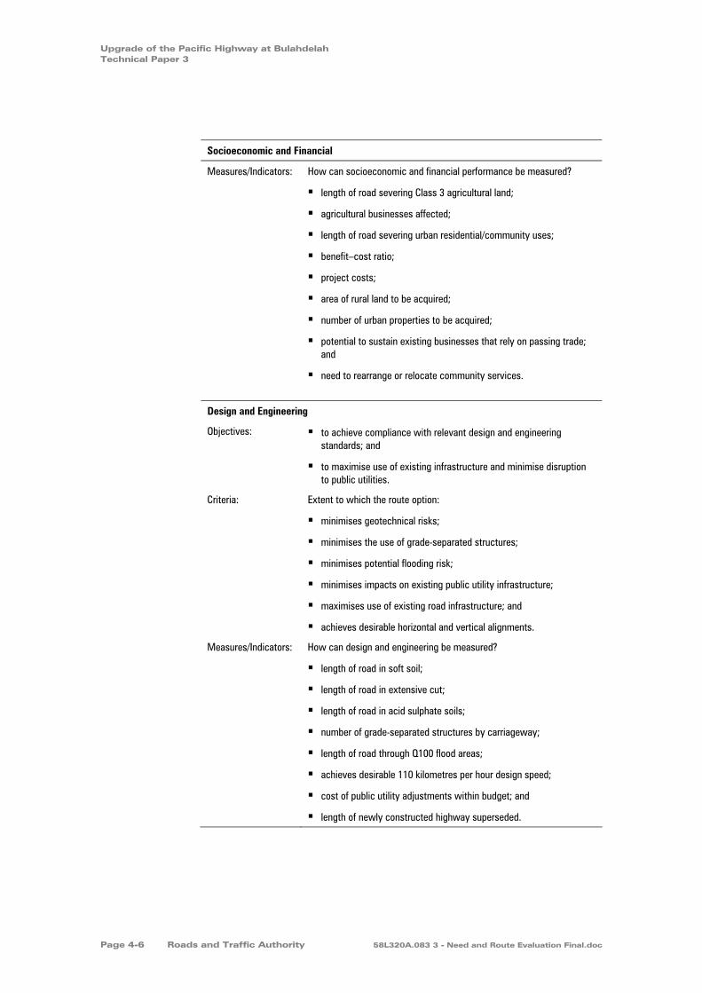
Upgrade of the Pacific Highway at Bulahdelah Technical Paper 3
Socioeconomic and Financial
Measures/Indicators: How can socioeconomic and financial performance be measured?
length of road severing Class 3 agricultural land;
agricultural businesses affected;
length of road severing urban residential/community uses;
benefit–cost ratio;
project costs;
area of rural land to be acquired;
number of urban properties to be acquired;
potential to sustain existing businesses that rely on passing trade; and
need to rearrange or relocate community services.
Design and Engineering
Objectives: to achieve compliance with relevant design and engineering standards; and
to maximise use of existing infrastructure and minimise disruption to public utilities.
Criteria: Extent to which the route option:
minimises geotechnical risks;
minimises the use of grade-separated structures;
minimises potential flooding risk;
minimises impacts on existing public utility infrastructure;
maximises use of existing road infrastructure; and
achieves desirable horizontal and vertical alignments.
Measures/Indicators: How can design and engineering be measured?
length of road in soft soil;
length of road in extensive cut;
length of road in acid sulphate soils;
number of grade-separated structures by carriageway;
length of road through Q100 flood areas;
achieves desirable 110 kilometres per hour design speed;
cost of public utility adjustments within budget; and
length of newly constructed highway superseded.
Page 4-6 Roads and Traffic Authority 58L320A.083 3 - Need and Route Evaluation Final.doc
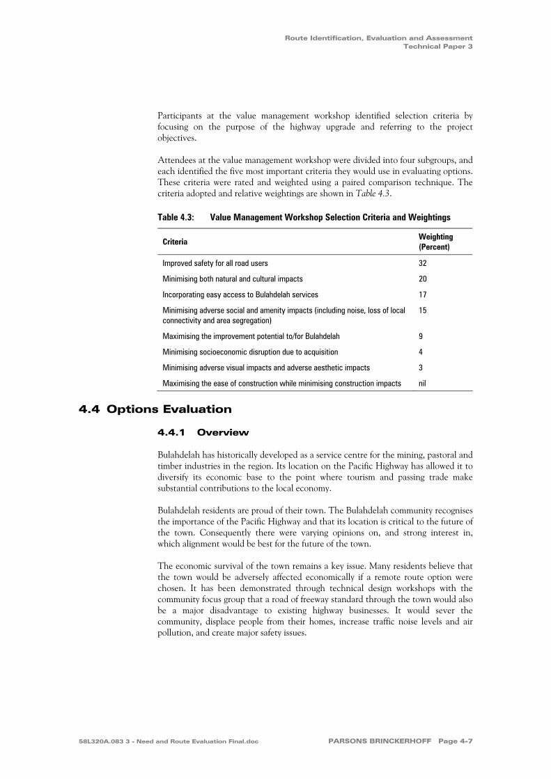
Route Identification, Evaluation and Assessment Technical Paper 3
Participants at the value management workshop identified selection criteria by focusing on the purpose of the highway upgrade and referring to the project objectives.
Attendees at the value management workshop were divided into four subgroups, and each identified the five most important criteria they would use in evaluating options. These criteria were rated and weighted using a paired comparison technique. The criteria adopted and relative weightings are shown in Table 4.3.
Table 4.3: Value Management Workshop Selection Criteria and Weightings
Criteria Weighting (Percent)
Improved safety for all road users 32
Minimising both natural and cultural impacts 20
Incorporating easy access to Bulahdelah services 17
Minimising adverse social and amenity impacts (including noise, loss of local connectivity and area segregation)
15
Maximising the improvement potential to/for Bulahdelah 9
Minimising socioeconomic disruption due to acquisition 4
Minimising adverse visual impacts and adverse aesthetic impacts 3
Maximising the ease of construction while minimising construction impacts nil
4.4 Options Evaluation
4.4.1 Overview
Bulahdelah has historically developed as a service centre for the mining, pastoral and timber industries in the region. Its location on the Pacific Highway has allowed it to diversify its economic base to the point where tourism and passing trade make substantial contributions to the local economy.
Bulahdelah residents are proud of their town. The Bulahdelah community recognises the importance of the Pacific Highway and that its location is critical to the future of the town. Consequently there were varying opinions on, and strong interest in, which alignment would be best for the future of the town.
The economic survival of the town remains a key issue. Many residents believe that the town would be adversely affected economically if a remote route option were chosen. It has been demonstrated through technical design workshops with the community focus group that a road of freeway standard through the town would also be a major disadvantage to existing highway businesses. It would sever the community, displace people from their homes, increase traffic noise levels and air pollution, and create major safety issues.
58L320A.083 3 - Need and Route Evaluation Final.doc PARSONS BRINCKERHOFF Page 4-7

Upgrade of the Pacific Highway at Bulahdelah Technical Paper 3
A town bypass with good Pacific Highway access connections, coupled with the town being promoted as a service town may contribute to the long term economic viability of the town. Effective urban design, which enhances urban amenity, would improve the quality of life for Bulahdelah residents and improve connectivity within the town for all transport modes. It would create an attractive place for travellers and tourists to stop and for residents to live the lifestyle expected in a small country town.
More strategic opportunities may evolve with a bypass if the relevant authorities and the community seek new economic opportunities that take advantage of Bulahdelah's location at the gateway to the Myall Lakes area. Bulahdelah itself has many natural attractions and unique flora and fauna. It also has a rich heritage that has not been fully utilised as a tourism drawcard.
The proposed Upgrade could also open up opportunities for road users. The highway has a high volume of freight truck movements. Opportunities exist to provide attractive, functional and efficient truck stopover facilities. With appropriate promotion and demonstration of superior service, Bulahdelah could increase travellers’ use of the town as a service centre.
4.4.2 Stage One Assessment
Fourteen options were presented to the Community Focus Group in May 2000. The options assessed are shown in Figure 4.1 in four broad corridors of interest. The project team agreed that a maximum of five options would be selected for further assessment. Each option within each corridor was assessed to identify the best option for that corridor. For example, four options in the western corridor were assessed against each other. The options selected for each corridor were then compared against each other.
Five through-town options were considered. Option 9 was a combination of Options 5 and 6, where the northbound and southbound carriageways were split between Options 5 and 6 respectively. There was strong preference for through-town options. Two options were selected, Options 5 and 6.
Page 4-8 Roads and Traffic Authority 58L320A.083 3 - Need and Route Evaluation Final.doc

Sour
ce: C
adas
tre -
Grea
t Lak
es C
ounc
il. S
urve
y - Q
asco
200
2.
0 2
kilometres
1
Western corridor
Through town corridor
Near eastern coridor
Far eastern corridor
Figure 4.1 Stage One Route Options
Note: Option 9 is a combination of Options 5 and 6,where the northbound and southbound routes
were split in the northeast of town.
Optio
n 14
Option
6
(and O
ption
9)
Optio
n 5
(and
Opt
ion
9)Optio
n 8
Option 1
Option 13
Option 12Option 11
Option 10
Optio
n 7
Option 3
Option 2
Option
4
Golfcourse
Sewagetreatment
plant Wastefacility
Woo
tton
RoadFrys Creek
Pow
erlin
e eas
emen
t
Waterreservoir
Lee Street
Richmond Street
StuartStreet
Stro
ud S
treet
Craw
ford
Stre
etEx
istin
g Pa
cific
Hig
hway
Markw
ell Road
Caravanpark
Prin
ce S
treet
Alex
andr
a St
reet
Mya
ll St
reet
Bool
oom
bayt
Stre
et
Blanch Street
Meade Street
Church Street
MountainPark
Ann Street
Bombah PointRoad
Myall River
Powerline easem
ent
Myall River
Jackson Street
Booral
Road
Existi
ng Pa
cific H
ighway
Bulahdelah State Forest
Craw
ford R
iver
The LakesWay
Frys Creek
Bulahdelah (Alum)Mountain
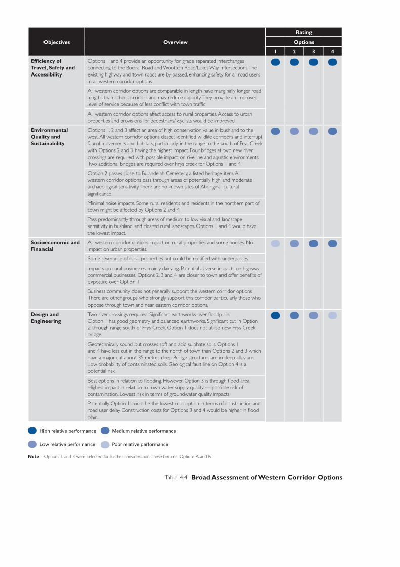
Objectives Overview
Rating
Options
1 2 3 4
Effi ciency of Travel, Safety and Accessibility
Options 1 and 4 provide an opportunity for grade separated interchanges connecting to the Booral Road and Wootton Road/Lakes Way intersections. The existing highway and town roads are by-passed, enhancing safety for all road users in all western corridor options.
All western corridor options are comparable in length have marginally longer road lengths than other corridors and may reduce capacity. They provide an improved level of service because of less confl ict with town traffi c.
All western corridor options affect access to rural properties. Access to urban properties and provisions for pedestrians/ cyclists would be improved.
Environmental Quality and Sustainability
Options 1, 2 and 3 affect an area of high conservation value in bushland to the west. All western corridor options dissect identifi ed wildlife corridors and interrupt faunal movements and habitats, particularly in the range to the south of Frys Creek with Options 2 and 3 having the highest impact. Four bridges at two new river crossings are required with possible impact on riverine and aquatic environments.Two additional bridges are required over Frys creek for Options 1 and 4.
Option 2 passes close to Bulahdelah Cemetery, a listed heritage item. All western corridor options pass through areas of potentially high and moderate archaeological sensitivity. There are no known sites of Aboriginal cultural signifi cance.
Minimal noise impacts. Some rural residents and residents in the northern part of town might be affected by Options 2 and 4.
Pass predominantly through areas of medium to low visual and landscape sensitivity in bushland and cleared rural landscapes. Options 1 and 4 would have the lowest impact.
Socioeconomic and Financial
All western corridor options impact on rural properties and some houses. No impact on urban properties.
Some severance of rural properties but could be rectifi ed with underpasses.
Impacts on rural businesses, mainly dairying. Potential adverse impacts on highway commercial businesses. Options 2, 3 and 4 are closer to town and offer benefi ts of exposure over Option 1.
Business community does not generally support the western corridor options. There are other groups who strongly support this corridor, particularly those who oppose through town and near eastern corridor options.
Design and Engineering
Two river crossings required. Signifi cant earthworks over fl oodplain. Option 1 has good geometry and balanced earthworks. Signifi cant cut in Option 2 through range south of Frys Creek. Option 1 does not utilise new Frys Creek bridge.
Geotechnically sound but crosses soft and acid sulphate soils. Options 1 and 4 have less cut in the range to the north of town than Options 2 and 3 which have a major cut about 35 metres deep. Bridge structures are in deep alluvium. Low probability of contaminated soils. Geological fault line on Option 4 is a potential risk.
Best options in relation to fl ooding. However, Option 3 is through fl ood area. Highest impact in relation to town water supply quality — possible risk of contamination. Lowest risk in terms of groundwater quality impacts.
Potentially Option 1 could be the lowest cost option in terms of construction and road user delay. Construction costs for Options 3 and 4 would be higher in fl ood plain.
High relative performance Medium relative performance
Low relative performance Poor relative performance
Note: Options 1 and 3 were selected for further consideration. These became Options A and B.
Table 4.4 Broad Assessment of Western Corridor Options
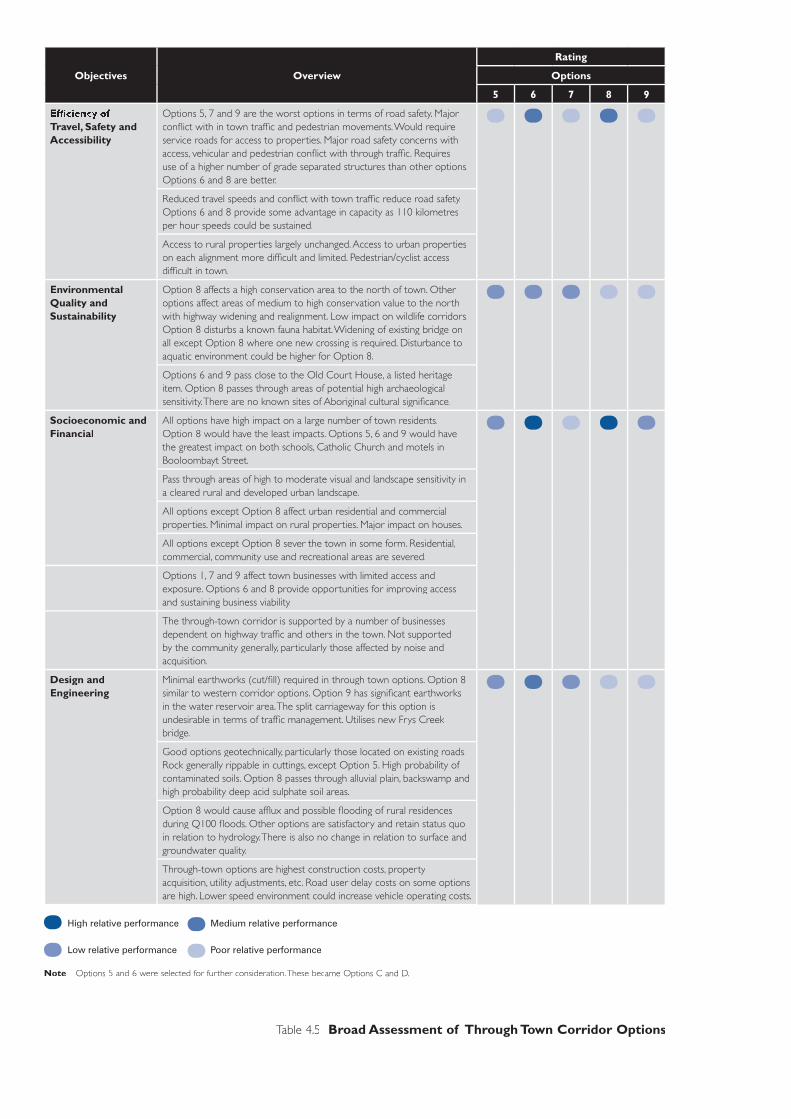
Objectives Overview
Rating
Options
5 6 7 8 9
Effi ciency of Travel, Safety and Accessibility
Options 5, 7 and 9 are the worst options in terms of road safety. Major confl ict with in town traffi c and pedestrian movements. Would require service roads for access to properties. Major road safety concerns with access, vehicular and pedestrian confl ict with through traffi c. Requires use of a higher number of grade separated structures than other options. Options 6 and 8 are better.
Reduced travel speeds and confl ict with town traffi c reduce road safety. Options 6 and 8 provide some advantage in capacity as 110 kilometres per hour speeds could be sustained.
Access to rural properties largely unchanged. Access to urban properties on each alignment more diffi cult and limited. Pedestrian/cyclist access diffi cult in town.
Environmental Quality and Sustainability
Option 8 affects a high conservation area to the north of town. Other options affect areas of medium to high conservation value to the north with highway widening and realignment. Low impact on wildlife corridors. Option 8 disturbs a known fauna habitat. Widening of existing bridge on all except Option 8 where one new crossing is required. Disturbance to aquatic environment could be higher for Option 8.
Options 6 and 9 pass close to the Old Court House, a listed heritage item. Option 8 passes through areas of potential high archaeological sensitivity. There are no known sites of Aboriginal cultural signifi cance.
Socioeconomic and Financial
All options have high impact on a large number of town residents. Option 8 would have the least impacts. Options 5, 6 and 9 would have the greatest impact on both schools, Catholic Church and motels in Booloombayt Street.
Pass through areas of high to moderate visual and landscape sensitivity in a cleared rural and developed urban landscape.
All options except Option 8 affect urban residential and commercial properties. Minimal impact on rural properties. Major impact on houses.
All options except Option 8 sever the town in some form. Residential, commercial, community use and recreational areas are severed.
Options 1, 7 and 9 affect town businesses with limited access and exposure. Options 6 and 8 provide opportunities for improving access and sustaining business viability.
The through-town corridor is supported by a number of businesses dependent on highway traffi c and others in the town. Not supported by the community generally, particularly those affected by noise and acquisition.
Design and Engineering
Minimal earthworks (cut/fi ll) required in through town options. Option 8 similar to western corridor options. Option 9 has signifi cant earthworks in the water reservoir area. The split carriageway for this option is undesirable in terms of traffi c management. Utilises new Frys Creek bridge.
Good options geotechnically, particularly those located on existing roads. Rock generally rippable in cuttings, except Option 5. High probability of contaminated soils. Option 8 passes through alluvial plain, backswamp and high probability deep acid sulphate soil areas.
Option 8 would cause affl ux and possible fl ooding of rural residences during Q100 fl oods. Other options are satisfactory and retain status quo in relation to hydrology. There is also no change in relation to surface and groundwater quality.
Through-town options are highest construction costs, property acquisition, utility adjustments, etc. Road user delay costs on some options are high. Lower speed environment could increase vehicle operating costs.
High relative performance Medium relative performance
Low relative performance Poor relative performance
Note: Options 5 and 6 were selected for further consideration. These became Options C and D.
Table 4.5 Broad Assessment of Through Town Corridor Options

Objectives Overview
Rating
Options
10 11 12
Effi ciency of Travel, Safety and Accessibility
Similar benefi ts to western corridor options. However, at grade intersections at Booral Road and Wootton Road/The Lakes Way intersections may result in vehicle confl ict as traffi c volumes increase.
Shorter lengths and minimal confl ict with town roads increase capacity over western corridor options.
Access to affected rural properties would be diffi cult with Options 10 and 11. Access to urban properties would be improved. Access to Bulahdelah (Alum) Mountain would be limited to grade separated structure. Pedestrian/cyclist areas would be improved except to Bulahdelah (Alum) Mountain.
Environmental Quality and Sustainability
Impact on areas of high to medium conservation value. The vegetation at the base of Bulahdelah (Alum) Mountain has already been dissected by the power easement, which interrupts faunal movements. Some threatened plant species occur in the area. One river crossing required. Options 10 and 11 affect some wetlands to the south of the Myall River. Option 12 is close to the SEPP 14 Wetland south of Myall River.
Pass through areas of potential high to medium archaeological sensitivity. Further investigation required into signifi cance of Bulahdelah (Alum) Mountain. At this stage there are no known sites of Aboriginal cultural signifi cance.
Impact on residents in the eastern part of town and some rural residents. Possible noise impacts on schools.
Pass through areas of moderate to low visual and landscape sensitivity. The area is bushland and cleared rural landscape. Part of the bushland is Forestry Reserve.
Socioeconomic and Financial
Impacts on some rural properties and Forestry Reserve. Minimal impact on urban residential properties. Some houses to the south may be affected by Options 10and 11.
Severs the town from Bulahdelah (Alum) Mountain. Some rural properties are severed.
Considered close enough to town to provide exposure and attract motorists to use town facilities to sustain businesses dependent on highway traffi c. Option 10 the best in terms of town exposure. Some rural businesses affected.
Supported by the majority of business owners in town and rural businesses to the west of town. Seen as the best solution to the economic survival of Bulahdelah. Strong opposition by groups in support of maintaining Bulahdelah (Alum) Mountain connections with the town.
Design and Engineering
Less earthworks in fl oodplain than western corridor options. Signifi cant cut north of the Myall River bridge and through the range to the north. Cuts through the base of Bulahdelah (Alum) Mountain. Maintains new Frys Creek bridge.
Geotechnically sound but all three options cross soft and acid sulphate soils. Signifi cant cut (21 metres) north of river crossing in non-rippable material for Options 10 and 11. Majority of cut is rippable. Boulders on Bulahdelah (Alum) Mountain a potential risk. Low probability of contaminated soils. May be some acid generating rock, but likely to be low environmental risk.
Hydrologically not as good as upstream options. No impact on surface water quality, downstream of water supply weir. Impacts on possible groundwater reserves. Possible impacts on surface water runoff from Bulahdelah (Alum) Mountain.
Lower construction costs depending on level of access to service the town — may require some interchanges. Lower road user delay costs than through-town corridor options but may be higher than western corridor options. Low vehicle operating costs.
High relative performance Medium relative performance
Low relative performance Poor relative performance
Note: Option 10 was selected for further consideration. This became Option E.
Table 4.6 Broad Assessment of Near Eastern Corridor Options
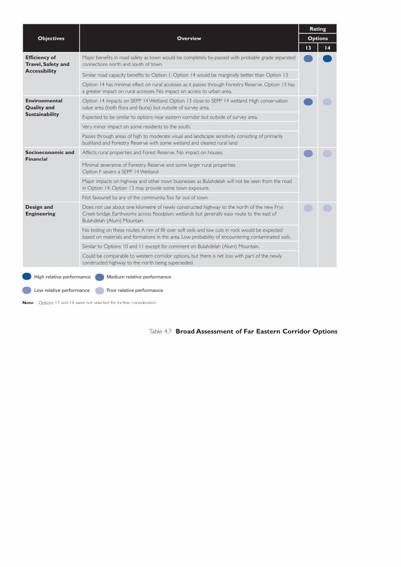
Objectives Overview
Rating
Options
13 14
Effi ciency of Travel, Safety and Accessibility
Major benefi ts in road safety as town would be completely by-passed with probable grade separated connections north and south of town.
Similar road capacity benefi ts to Option 1. Option 14 would be marginally better than Option 13.
Option 14 has minimal effect on rural accesses as it passes through Forestry Reserve. Option 13 has a greater impact on rural accesses. No impact on access to urban area.
Environmental Quality and Sustainability
Option 14 impacts on SEPP 14 Wetland. Option 13 close to SEPP 14 wetland. High conservation value area (both fl ora and fauna) but outside of survey area.
Expected to be similar to options near eastern corridor but outside of survey area.
Very minor impact on some residents to the south.
Passes through areas of high to moderate visual and landscape sensitivity consisting of primarily bushland and Forestry Reserve with some wetland and cleared rural land.
Socioeconomic and Financial
Affects rural properties and Forest Reserve. No impact on houses.
Minimal severance of Forestry Reserve and some larger rural properties. Option F severs a SEPP 14 Wetland.
Major impacts on highway and other town businesses as Bulahdelah will not be seen from the road in Option 14. Option 13 may provide some town exposure.
Not favoured by any of the community. Too far out of town.
Design and Engineering
Does not use about one kilometre of newly constructed highway to the north of the new Frys Creek bridge. Earthworks across fl oodplain, wetlands but generally easy route to the east of Bulahdelah (Alum) Mountain.
No testing on these routes. A rim of fi ll over soft soils and low cuts in rock would be expected based on materials and formations in the area. Low probability of encountering contaminated soils.
Similar to Options 10 and 11 except for comment on Bulahdelah (Alum) Mountain.
Could be comparable to western corridor options, but there is net loss with part of the newly constructed highway to the north being superseded.
High relative performance Medium relative performance
Low relative performance Poor relative performance
Note: Options 13 and 14 were not selected for further consideration.
Table 4.7 Broad Assessment of Far Eastern Corridor Options

Upgrade of the Pacific Highway at Bulahdelah Technical Paper 3
The two options in the far eastern corridor to the east of Bulahdelah (Alum) Mountain were eliminated, largely because of their distance from town and the lack of town exposure, especially Option 14. Option 13 was longer and therefore higher in cost. Option 14 would have affected a wetland protected under SEPP No. 14 — Coastal Wetlands. Both of these options would have also affected a major optical fibre cable, would have passed through areas of environmental sensitivity east of Bulahdelah (Alum) Mountain and made redundant a section of the Bulahdelah to Coolongolook freeway.
The topography of Bulahdelah (Alum) Mountain limited route location opportunities to the east of town. Option 10 was selected from three possible options in the near eastern corridor because it had fewer impacts on SEPP No. 14 — Coastal Wetlands and other wetlands, allowed for a closer, more convenient connection with Bulahdelah at the southern approach and had engineering advantages by limiting construction across the Myall River floodplain.
Two options were selected from four presented to the west of town. Option 1 was considered to be the best of these, with Option 3 also being taken forward for further assessment. Option 1 allowed for easy connections with existing and proposed highway upgrades to the north and south respectively, and provided an opportunity for grade-separated intersections to the north and south of town. Option 3 was selected on the basis that it offered motorists the best opportunity to see the town when approaching from the south and provided an alternative alignment to Option 1 at the northern end.
4.4.3 Stage Two Assessment
To simplify the identification of the route options for the public display and further assessment by all involved, the routes were named from west to east as Options A, B, C, D and E. The Community Focus Group assessed each of the route options in August 2000 to provide the study team with the issues they considered important to this proposal. These route options are shown in Figure 4.2. Tables 4.8 to 4.11 summarise the assessment of the five short listed options.
Page 4-14 Roads and Traffic Authority 58L320A.083 3 - Need and Route Evaluation Final.doc
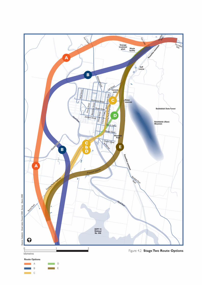
58L320A (TP3)/27.07.04
0 2
kilometres
1
A
B
C
Route Options
D
E
Figure 4.2 Stage Two Route Options
Sour
ce: C
adas
tre -
Grea
t Lak
es C
ounc
il 20
00. S
urve
y - Q
asco
200
0.
C
D
C
D
C
D
C
D
B
B
C
D
C
D
C
D
B
B
A
A
EC&D
SEPP 14WetlandNo. 698
Golfcourse
Sewagetreatment
plant Wastefacility
Woo
tton
RoadFrys Creek
Pow
erlin
e eas
emen
t
Waterreservoir
Lee Street
Richmond Street
Stuart Street
Stro
ud S
treet
Craw
ford
Stre
etEx
istin
g Pa
cific
Hig
hway
Markw
ell Road
Caravanpark
Prin
ce S
treet
Alex
andr
a St
reet
Mya
ll St
reet
Bool
oom
bayt
Stre
et
Blanch Street
Meade Street
Church Street
MountainPark
Ann Street
Bombah PointRoad
Myall River
Powerline easem
ent
Myall River
Jackson Street
Booral
Road
Existin
g Pacifi
c Highw
ay
Bulahdelah State Forest
Crawfor
d Rive
r
Crawfor
d Rive
r
Crawfor
d Rive
r
Proposed Upgrade
The LakesWay
Frys Creek
Bulahdelah (Alum)Mountain

Cri
teri
aM
easu
reO
ptio
n A
Opt
ion
BO
ptio
n C
Opt
ion
DO
ptio
n E
Bes
t Pe
rfo
rmer
Qua
ntit
ativ
e M
easu
res
Red
uces
tra
vel t
imes
on
Pac
ific
Hig
hway
Trav
el t
imes
(m
inut
es)
5.4
5.2
4.9
4.4
4.7
Impr
oves
rel
iabi
lity
of t
rips
on
Paci
fic
Hig
hway
Leve
l of s
ervi
ce 2
006
BB
CB
B
Leve
l of s
ervi
ce 2
026
DD
ED
D
Mai
ntai
ns o
r im
prov
es
acce
ss t
o Bu
lahd
elah
to
wns
hip
Opp
ortu
nitie
s fo
r di
rect
co
nnec
tions
to
Bula
hdel
ah2
32
23
Mai
ntai
ns o
r im
prov
es
acce
ss t
o pr
oper
ties
Prop
erty
acc
esse
s im
pact
ed4
424
104
Min
imis
es im
pact
s on
tra
ffic
effic
ienc
y du
ring
con
stru
ctio
n
Roa
d us
er d
elay
cos
ts o
ver
cons
truc
tion
life
($m
illio
n)0.
390.
586.
315.
090.
65
Min
imis
es v
ehic
le
oper
atin
g co
sts
Estim
ated
veh
icle
ope
ratin
g co
sts
savi
ngs
($m
illio
n pe
r an
num
)
6.6
4.4
19.0
8.7
6.8
E
Qua
litat
ive
Indi
cato
rs
Impr
oves
roa
d sa
fety
Safe
ty r
atin
g (fr
om A
udit)
Elim
inat
es m
ajor
at
grad
e in
ters
ectio
ns.
Goo
d ho
rizo
ntal
and
ve
rtic
al g
eom
etry
. D
esig
n sp
eed
of
110
kilo
met
res
per
hour
ret
aine
d.
Mor
e ho
rizo
ntal
cu
rves
tha
n A
. Som
e gr
ade
inte
rsec
tions
re
tain
ed. D
esig
n sp
eed
of 1
10
kilo
met
res
per
hour
re
tain
ed.
Des
ign
spee
d re
duce
d to
80
kilo
met
res
per
hour
ret
aine
d. S
ome
at g
rade
inte
rsec
tions
re
tain
ed.
Des
ign
spee
d of
110
ki
lom
etre
s pe
r ho
ur
reta
ined
. Som
e at
gr
ade
inte
rsec
tions
re
tain
ed.
Som
e at
gra
de
inte
rsec
tions
ret
aine
d.
Des
ign
spee
d of
110
ki
lom
etre
s pe
r ho
ur
reta
ined
.
Impr
oves
ped
estr
ian
and
cycl
ist
faci
litie
sPe
dest
rian
and
cyc
list
impa
cts
Free
dom
of
mov
emen
t in
tow
n.Fr
eedo
m o
f m
ovem
ent
in t
own.
Res
tric
ted
mov
emen
t in
tow
n.R
estr
icte
d m
ovem
ent
in t
own.
Pote
ntia
lly li
mits
m
ovem
ents
to
Bula
hdel
ah (
Alu
m)
Mou
ntai
n.
Impr
oves
loca
l tra
ffic
circ
ulat
ion
Traf
fic c
ircu
latio
n im
pact
s
Aw
ay fr
om t
own
road
s.A
way
from
tow
n ro
ads.
Con
flict
s w
ith t
own
road
s.C
onfli
cts
with
tow
n ro
ads.
Aw
ay fr
om t
own
road
s bu
t af
fect
s ac
cess
to
Bula
hdel
ah
(Alu
m)
Mou
ntai
n.
Impr
oves
loca
l tra
ffic
circ
ulat
ion
Scho
ol b
us im
pact
s
No
impe
dim
ents
to
mov
emen
ts –
maj
or
impr
ovem
ents
.
Mor
e ho
rizo
ntal
cu
rves
tha
n A
. Som
e gr
ade
inte
rsec
tions
re
tain
ed.
Seve
rely
lim
its
mov
emen
ts. S
ome
re-
rout
ing
requ
ired
.
Less
impa
cts
than
C
but
som
e re
-rou
ting
requ
ired
.
No
impe
dim
ents
to
mov
emen
ts –
acc
ess
impr
oved
.
A
Bes
t O
vera
ll O
ptio
nE
Qua
litat
ive
Ind
icat
ors
H
igh
M
ediu
m
Lo
w
Po
or
Tabl
e 4.
8
Sho
rtlis
t O
ptio
ns
Perf
orm
ance
: E
ffic
ienc
y o
f
Tra
vel,
Saf
ety
and
Acc
essi
bilit
y
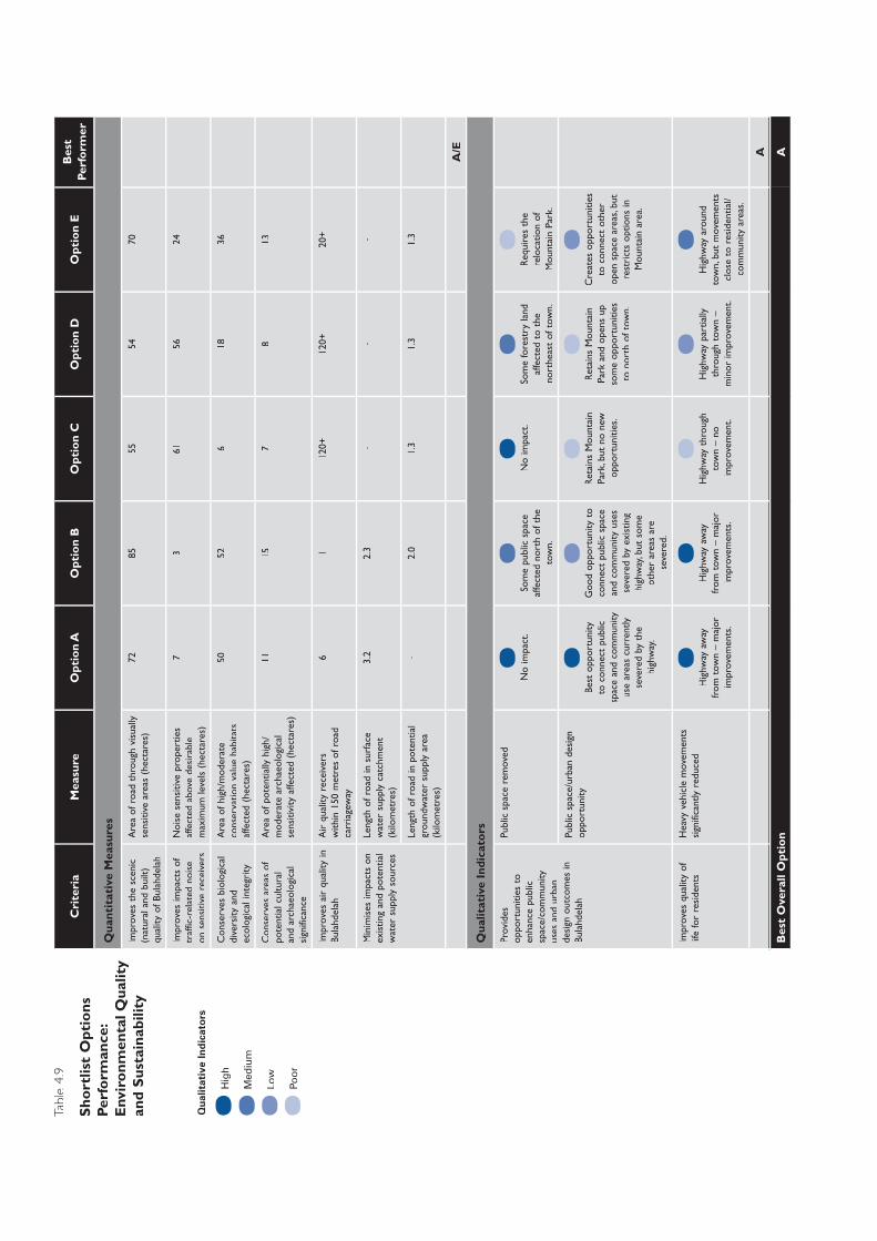
Cri
teri
aM
easu
reO
ptio
n A
Opt
ion
BO
ptio
n C
Opt
ion
DO
ptio
n E
Bes
t Pe
rfo
rmer
Qua
ntit
ativ
e M
easu
res
Impr
oves
the
sce
nic
(nat
ural
and
bui
lt)
qual
ity o
f Bul
ahde
lah
Are
a of
roa
d th
roug
h vi
sual
ly
sens
itive
are
as (
hect
ares
)72
8555
5470
Impr
oves
impa
cts
of
traf
fic-r
elat
ed n
oise
on
sen
sitiv
e re
ceiv
ers
Noi
se s
ensi
tive
prop
ertie
s af
fect
ed a
bove
des
irab
le
max
imum
leve
ls (
hect
ares
)
73
6156
24
Con
serv
es b
iolo
gica
l di
vers
ity a
nd
ecol
ogic
al in
tegr
ity
Are
a of
hig
h/m
oder
ate
cons
erva
tion
valu
e ha
bita
ts
affe
cted
(he
ctar
es)
5052
618
36
Con
serv
es a
reas
of
pote
ntia
l cul
tura
l an
d ar
chae
olog
ical
si
gnifi
canc
e
Are
a of
pot
entia
lly h
igh/
mod
erat
e ar
chae
olog
ical
se
nsiti
vity
affe
cted
(he
ctar
es)
1115
78
13
Impr
oves
air
qua
lity
in
Bula
hdel
ahA
ir q
ualit
y re
ceiv
ers
with
in 1
50 m
etre
s of
roa
d ca
rria
gew
ay
61
120+
120+
20+
Min
imis
es im
pact
s on
ex
istin
g an
d po
tent
ial
wat
er s
uppl
y so
urce
s
Leng
th o
f roa
d in
sur
face
w
ater
sup
ply
catc
hmen
t (k
ilom
etre
s)
3.2
2.3
--
-
Leng
th o
f roa
d in
pot
entia
l gr
ound
wat
er s
uppl
y ar
ea
(kilo
met
res)
-2.
01.
31.
31.
3
A/E
Qua
litat
ive
Indi
cato
rs
Prov
ides
op
port
uniti
es t
o en
hanc
e pu
blic
sp
ace/
com
mun
ity
uses
and
urb
an
desi
gn o
utco
mes
in
Bula
hdel
ah
Publ
ic s
pace
rem
oved
No
impa
ct.
Som
e pu
blic
spa
ce
affe
cted
nor
th o
f the
to
wn.
No
impa
ct.
Som
e fo
rest
ry la
nd
affe
cted
to
the
nort
heas
t of
tow
n.
Req
uire
s th
e re
loca
tion
of
Mou
ntai
n Pa
rk.
Publ
ic s
pace
/urb
an d
esig
n op
port
unity
Best
opp
ortu
nity
to
con
nect
pub
lic
spac
e an
d co
mm
unity
us
e ar
eas
curr
ently
se
vere
d by
the
hi
ghw
ay.
Goo
d op
port
unity
to
conn
ect
publ
ic s
pace
an
d co
mm
unity
use
s se
vere
d by
exi
stin
g hi
ghw
ay, b
ut s
ome
othe
r ar
eas
are
seve
red.
Ret
ains
Mou
ntai
n Pa
rk, b
ut n
o ne
w
oppo
rtun
ities
.
Ret
ains
Mou
ntai
n Pa
rk a
nd o
pens
up
som
e op
port
uniti
es
to n
orth
of t
own.
Cre
ates
opp
ortu
nitie
s to
con
nect
oth
er
open
spa
ce a
reas
, but
re
stri
cts
optio
ns in
M
ount
ain
area
.
Impr
oves
qua
lity
of
life
for
resi
dent
sH
eavy
veh
icle
mov
emen
ts
sign
ifica
ntly
red
uced
Hig
hway
aw
ay
from
tow
n –
maj
or
impr
ovem
ents
.
Hig
hway
aw
ay
from
tow
n –
maj
or
impr
ovem
ents
.
Hig
hway
thr
ough
to
wn
– no
im
prov
emen
t.
Hig
hway
par
tially
th
roug
h to
wn
– m
inor
impr
ovem
ent.
Hig
hway
aro
und
tow
n, b
ut m
ovem
ents
cl
ose
to r
esid
entia
l/co
mm
unity
are
as.
A
Bes
t O
vera
ll O
ptio
nA
Qua
litat
ive
Ind
icat
ors
H
igh
M
ediu
m
Lo
w
Po
or
Tabl
e 4.
9
Sho
rtlis
t O
ptio
ns
Perf
orm
ance
: E
nvir
onm
enta
l Qua
lity
and
Sus
tain
abili
ty
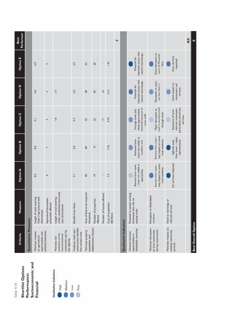
Cri
teri
aM
easu
reO
ptio
n A
Opt
ion
BO
ptio
n C
Opt
ion
DO
ptio
n E
Bes
t Pe
rfo
rmer
Qua
ntit
ativ
e M
easu
res
Min
imis
es im
pact
s on
agr
icul
tura
l op
port
uniti
es a
nd
exis
ting
busi
ness
es
Leng
th o
f roa
d se
veri
ng
Cla
ss 3
agr
icul
tura
l lan
d (k
ilom
etre
s)
8.5
8.0
5.1
6.0
6.9
Agr
icul
tura
l bus
ines
ses
pote
ntia
lly a
ffect
ed4
72
35
Min
imis
es t
he
seve
ranc
e of
the
to
wn/
resi
dent
ial
com
mun
ity u
ses
by
the
high
way
Leng
th o
f roa
d se
veri
ng
urba
n re
side
ntia
l/com
mun
ity
uses
(ki
lom
etre
s)
--
1.8
1.5
-
Prod
uces
roa
d us
er/
cons
truc
tion
bene
fits
that
exc
eed
cost
s
Bene
fit-C
ost
Rat
io2.
12.
02.
32.
42.
5
Min
imis
es p
rope
rty
acqu
isiti
on a
nd
disp
lace
men
t im
pact
s
Are
a of
land
to
be a
cqui
red
(hec
tare
s)85
8432
3863
Num
ber
of p
rope
rtie
s af
fect
ed19
1955
4520
Num
ber
of h
ouse
s af
fect
ed1
-17
141
Cos
t of
acq
uisi
tion
($m
illio
n)2.
52.
369.
356.
311.
47
E
Qua
litat
ive
Indi
cato
rs
Enha
nces
bus
ines
s op
port
uniti
es in
Bu
lahd
elah
tow
nshi
p
Pote
ntia
l to
sust
ain
exis
ting
busi
ness
es t
hat
rely
on
pass
ing
trad
eR
emot
e fr
om t
own
– to
wn
not
visi
ble
at
appr
oach
es.
Rem
oved
from
to
wn,
but
vis
ible
at
sout
hern
end
.
Thr
ough
tow
n, b
ut
visu
al o
ppor
tuni
ties
rest
rict
ed b
ecau
se o
f no
ise
wal
ls.
Pote
ntia
l for
im
prov
ed a
cces
s w
ith
cent
ral i
nter
chan
ge.
Pote
ntia
l for
im
prov
ed a
cces
s w
ith
cent
ral i
nter
chan
ge.
Min
imis
es d
isru
ptio
n to
loca
l com
mun
ity
duri
ng c
onst
ruct
ion
Dis
rupt
ion
to B
ulah
dela
h re
side
nts
Rem
ote
from
tow
n –
may
impa
ct o
n so
me
rura
l res
iden
ts.
Rem
ote
from
tow
n –
may
impa
ct o
n so
me
rura
l res
iden
ts.
Maj
or d
isru
ptio
n as
ro
ad is
rec
onst
ruct
ed
thro
ugh
tow
n.
Dis
rupt
ion
in t
own,
bu
t le
ss t
han
C.
Som
e di
srup
tion
to
user
s of
Mou
ntai
n Pa
rk.
Min
imis
es im
pact
s on
ex
istin
g co
mm
unity
se
rvic
es
Nee
d to
rea
rran
ge o
r re
loca
te s
ervi
ces
No
serv
ices
impa
cted
.H
ighw
ay a
way
fr
om t
own
– m
ajor
im
prov
emen
ts.
Seve
ranc
e of
tow
n re
stri
cts
mov
emen
t, pa
rtic
ular
ly s
choo
l bus
se
rvic
es.
Som
e im
pact
on
mov
emen
t an
d se
rvic
es.
Som
e se
rvic
es
impa
cted
.
B/E
Bes
t O
vera
ll O
ptio
nE
Qua
litat
ive
Ind
icat
ors
H
igh
M
ediu
m
Lo
w
Po
or
Tabl
e 4.
10
Sho
rtlis
t O
ptio
ns
Perf
orm
ance
: S
oci
oec
ono
mic
and
F
inan
cial
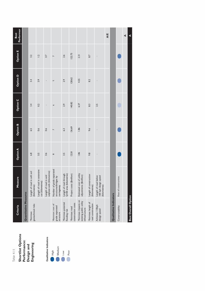
Cri
teri
aM
easu
reO
ptio
n A
Opt
ion
BO
ptio
n C
Opt
ion
DO
ptio
n E
Bes
t Pe
rfo
rmer
Qua
ntit
ativ
e M
easu
res
Min
imis
es
geot
echn
ical
ris
ksLe
ngth
of r
oad
in s
oft
soil
(kilo
met
res)
6.8
6.5
3.4
3.4
3.2
Leng
th o
f roa
d in
ext
ensi
ve
cut
(kilo
met
res)
0.5
0.6
0.2
0.9
1.2
Leng
th o
f roa
d in
aci
d
sulp
hate
soi
ls (
kilo
met
res)
0.6
0.6
--
0.7
Min
imis
es u
ses
of
grad
e se
para
ted
stru
ctur
e
Num
ber
of g
rade
sep
arat
ed
stru
ctur
es/b
ridg
es b
y ca
rria
gew
ay
87
65
7
Min
imis
es p
oten
tial
flood
ing
risk
Leng
th o
f roa
d th
roug
h Q
100
area
(ki
lom
etre
s)3.
56.
32.
92.
92.
6
Min
imis
es r
oad
cons
truc
tion
cost
sPr
ojec
t co
sts
($m
illio
n)12
2.8
136.
6914
0.82
128.
6212
2.75
Min
imis
es im
pact
s on
ex
istin
g pu
blic
util
ity
infr
astr
uctu
re
Estim
ated
cos
t of
util
ity
adju
stm
ents
($m
illio
n)1.
861.
866.
374.
552.
31
Min
imis
es le
ngth
of
road
con
stru
ctio
nLe
ngth
of c
onst
ruct
ion
(kilo
met
res)
9.8
9.6
8.3
8.2
8.7
Ach
ieve
s 11
0kph
de
sign
spe
edLe
ngth
of r
oad
belo
w
100
kph
desi
gn s
peed
(k
ilom
etre
s)
--
2.5
--
A/E
Qua
litat
ive
Indi
cato
rs
Con
stru
ctab
ility
Ease
of c
onst
ruct
ion
A
Bes
t O
vera
ll O
ptio
nA
Qua
litat
ive
Ind
icat
ors
H
igh
M
ediu
m
Lo
w
Po
or
Tabl
e 4.
11
Sho
rtlis
t O
ptio
ns
Perf
orm
ance
: D
esig
n an
d E
ngin
eeri
ng

Upgrade of the Pacific Highway at Bulahdelah Technical Paper 3
4.4.4 Overview of Performance
Efficiency of Travel, Safety and Accessibility
In quantitative terms Option E performed best against program/project objectives, followed by Option A which, because of its extra length, increases vehicle operating costs, reducing the efficiency of travel. Options A and B performed the best in qualitative terms because of significant improvements in connectivity and movement within the town. Option A has highway user safety benefits over Option E.
Option E is considered to be the best overall performer in terms of efficiency of travel, safety and accessibility outcomes.
Environmental Quality and Sustainability
At the time of the assessment, in quantitative terms there was very little difference between Options A and E as the best performers. In comparing the two, Option A potentially had a greater impact on the natural environment, particularly in relation to ecological habitats. Option E had a greater impact on the built environment, in relation to noise-sensitive properties. In qualitative terms Option A was the best performer as it had major benefits in terms of the human and built environment.
The best overall performer in relation to environmental quality and sustainability outcomes was Option A.
Socioeconomic and Financial
The socioeconomic and financial performance of a route option was considered to be a very important criterion, recognising that the town’s economy relies heavily on the contribution from passing trade. The proximity and visibility of the town from the highway were seen as very important contributors to the maintenance of the town’s highway-based economy, although it was recognised that the importance of proximity and visibility as performance measures was largely intuitive and no guarantee of economic security.
Option E performed best in quantitative and qualitative terms. Option B had similar qualitative benefits to Option E in terms of town visibility and access to attract highway motorists to use the town businesses and facilities.
There was strong community support for Option E, which was considered to be the best overall performer in terms of socioeconomic and financial outcomes.
Design and Engineering
Options A and E were considered to be the best performers in quantitative terms. Both have similar construction costs and benefits/disadvantages in relation to geotechnical issues.
Page 4-20 Roads and Traffic Authority 58L320A.083 3 - Need and Route Evaluation Final.doc
Route Identification, Evaluation and Assessment Technical Paper 3
A qualitative measure of constructability was included which considered potential difficulties in constructing under traffic and in restricted areas, closeness to residential areas and accessibility. Option A was the best performer in qualitative terms.
Option A was considered to be the best overall performer in terms of design and engineering outcomes.
4.5 Route Selection
4.5.1 Approach
This section discusses the process and issues taken into account in considering all feasible route options. The evaluation criteria adopted in selecting a preferred route are also described.
As with all studies of this nature, there is a limit to the quantitative analysis that can be part of the assessment process. There are limits to the availability of data, current knowledge and scientific assessment techniques. Despite these limits, this study attempts to assess the environmental, transport and engineering implications of each option in an objective manner. The outcomes have been expressed both quantitatively and qualitatively where appropriate.
The method used to compare the options involved identifying significant issues, reviewing investigations into those issues and selecting relevant assessment criteria, and comparing the performance of each option against the selected criteria.
Submissions made by the Bulahdelah community and other stakeholders helped determine the issues most appropriate for comparison of the options. Against this background, and on the basis of the studies undertaken, assessment criteria were developed to examine the performance of each option.
Although the performance of each option has been compared against the performance of all other options, the number of ‘best performances’ added together do not make up a single ‘best performance overall’, as some issues and criteria are perceived to be more or less important than others. For example, some people may value a reduction in noise impacts as more important than conserving biological diversity. Others may have a different opinion.
The conclusions drawn seek to identify the advantages and disadvantages of proceeding with each option, while avoiding the necessity of making value judgements on the relative importance of key selection criteria.
4.5.2 Outcomes
Table 4.12 is a comparative summary of the short listed options derived from Tables 4.8 to 4.11, in which each option is measured against various criteria.
58L320A.083 3 - Need and Route Evaluation Final.doc PARSONS BRINCKERHOFF Page 4-21
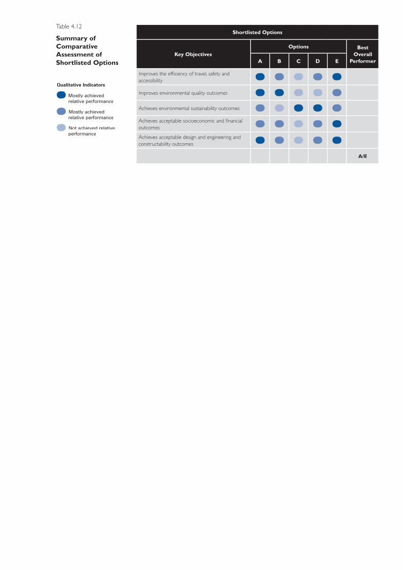
Shortlisted Options
Key ObjectivesOptions Best
Overall PerformerA B C D E
Improves the effi ciency of travel, safety and accessibility
Improves environmental quality outcomes
Achieves environmental sustainability outcomes
Achieves acceptable socioeconomic and fi nancial outcomes
Achieves acceptable design and engineering and constructability outcomes
A/E
Qualitative Indicators
Mostly achieved relative performance
Mostly achieved relative performance
Not achieved relative performance
Table 4.12
Summary of Comparative Assessment of Shortlisted Options
Route Identification, Evaluation and Assessment Technical Paper 3
Options B, C and D did not perform well against the selection criteria and were discounted from further consideration. The main reasons for the poor performance of Options B, C and D are:
Option B would:
► pass through significant areas of high to moderate biological conservation value and known fauna corridors;
► require fill embankments through visually sensitive floodplain areas and involve a major cutting to the north of town;
► require the construction of a bridge over a suspected geological fault line;
► sever potential public open space to the north of town (a possible future national park);
► have the lowest road user benefit–cost ratio;
► have the longest length of road in the Q100-flood-affected area; and
► possibly impact on areas of Aboriginal cultural significance.
Option C would:
► require a reduced design speed of 80 kilometres per hour;
► not achieve the required target level of service;
► restrict general traffic, school bus, pedestrian and cyclist movements across the town;
► sever the town into two parts, to the east and west of the highway (segregating the Bulahdelah Central and St. Joseph’s Schools from the western part of town);
► impact on the existing urban fabric and visual environment of the town and limit the potential for future town improvements;
► require significant property acquisition and displace residents adjacent to the highway;
► result in major disruption to highway/town traffic, residents, businesses and public utilities during construction;
► have high noise and air quality impacts on sensitive receivers, particularly the Bulahdelah Central School and St. Joseph’s Catholic School;
► restrict access to commercial and residential properties along the highway; and
► have the highest capital project cost.
Option D would:
► restrict general traffic, school bus, pedestrian and cyclist movements across the town;
► sever the town into two parts, to the east and west of the highway (segregating the Bulahdelah Central School from the western part of town);
► impact on the existing urban fabric and visual environment of the town and limit the potential for future town improvements;
58L320A.083 3 - Need and Route Evaluation Final.doc PARSONS BRINCKERHOFF Page 4-23
Upgrade of the Pacific Highway at Bulahdelah Technical Paper 3
► require significant property acquisition and displacement of residents;
► result in disruption to highway/town traffic, residents, businesses and public utilities during construction;
► have high noise impacts and air quality impacts on sensitive receivers, particularly Bulahdelah Central School; and
► restrict access to residential and commercial properties in town.
Options A and E were similar in that both performed well in satisfying the key objectives and selection criteria. The selection of the preferred option was subject to input from the community and other stakeholders. Outcomes included:
the value management study, which included participation from a wide range of community and other stakeholders, recommended that Option E be taken forward as the preferred route option, with some modifications that were subsequently adopted;
Great Lakes Council formally endorsed Option E as its preferred route; and
Karuah Local Aboriginal Land Council and Worrimi Nation Elders formally endorsed Option E as their preferred town bypass route.
On the strength of quantitative and qualitative assessment against program and project objectives, Option E was endorsed as the preferred option and subsequently announced by the Minister for Roads in November 2001.
In summary, the identified advantages of Option E over Option A are that Option E:
is closer to town, providing enhanced opportunities to attract passing trade and visitors, and supporting the concept of Bulahdelah as a highway service town;
provides opportunities to improve town drainage;
provides opportunities for a whole-of-town focus and urban design enhancement;
is shorter, which has construction program benefits and reduced impact on the natural environment;
incorporates the new road infrastructure to the north;
has a higher road user benefit–cost ratio;
has fewer impacts on potential sites of Aboriginal cultural significance;
has fewer impacts on prime agricultural land and rural enterprises; and
minimises potential environmental impacts on local drinking water catchment.
Page 4-24 Roads and Traffic Authority 58L320A.083 3 - Need and Route Evaluation Final.doc
Route Identification, Evaluation and Assessment Technical Paper 3
Several disadvantages of Option E over Option A were also identified, but it was considered that these disadvantages could be remedied through appropriate design, environmental safeguards and environmental management. The disadvantages of Option E over Option A and the environmental safeguards and design features that were subsequently incorporated into the concept design, which are discussed in Technical Paper 4 — The Proposal, to address those disadvantages include:
Access to Bulahdelah (Alum) Mountain for vehicles and pedestrians may be impeded. A pedestrian and vehicle underpass adjacent to Stuart Street and a pedestrian and vehicle bridge at Mountain Park have been provided to allow easy and safe access to Bulahdelah (Alum) Mountain.
At-grade intersections would remain at Booral and Wootton Roads, which may create safety concerns. A northbound slip lane would be provided onto Booral Road, with all other movements diverted to the southern interchange. Wootton Road intersection would be an at-grade intersection designed to comply with 110 kilometres per hour design criteria.
There may be direct effects on the heritage values of the old Alunite mine site complex. The alignment of the proposed Upgrade has been adjusted to avoid and minimise direct impacts on heritage features in the area of the old Alunite mine. Additional design features and environmental safeguards and measures have been incorporated to enhance the heritage precinct, including improvements to the Mountain Park and specific design elements included in the pedestrian and vehicle bridge at this location.
There may be impacts on services and public utilities. The proposed Upgrade would have impacts on the TransGrid powerline, the water reservoirs and sewage treatment plant. The concept design has included adjustments to these public utilities, in consultation with TransGrid, MidCoast Water and Great Lakes Council.
There are potential impacts on public open space and recreation areas. The main impact on public open space and recreation areas would occur near Mountain Park. The proposed Upgrade has been located to largely avoid the Mountain Park area. The concept design has included several measures to improve Mountain Park and adjacent areas and facilities and to create opportunities for public access to open space at Bulahdelah (Alum) Mountain.
Community consultation and environmental impact assessment continued following the announcement of Option E as the preferred route in November 2001.
58L320A.083 3 - Need and Route Evaluation Final.doc PARSONS BRINCKERHOFF Page 4-25
Upgrade of the Pacific Highway at Bulahdelah Technical Paper 3
4.5.3 Review of Through–Town Options
Some residents and business owners of Bulahdelah expressed opposition to Option E following its announcement as the preferred route by the Minister for Roads in November 2001 (refer Technical Paper 1 — Community and Stakeholder Involvement). It was felt that a through–town option could be developed that would satisfy the transport related objectives of the proposal and also overcome potential adverse impacts on Bulahdelah’s service industries. In response, the RTA commissioned an independent technical review of the merits of Option C. This review was conducted between early to mid 2002.
The independent review investigated workable modifications to Option C and assessed these designs against engineering, socioeconomic, environmental, construction criteria.
Option C Modifications
The Option C concept originally considered had the following design features:
80 kilometres per hour design speed (compared with 110 kilometres per hour for other options and 100 kilometres per hour on adjacent highway sections);
two carriageways each of two lanes;
median width to accommodate construction of two additional lanes in the future;
existing Myall River bridge retained and new duplicate bridge required for southbound traffic;
two additional brides to carry local traffic over the highway;
noise barriers along both sides of the highway for its full length through Bulahdelah;
access to the highway from Bulahdelah using two grade separated half-junctions to the north and south; and
local western service road, outside of noise barrier, with direct connections to the junctions, also provides access to motels and service stations.
Two sub–options were developed and considered. The first modified the cross section of Option C to reduce the width of the corridor. The second eliminated grade separation of cross streets. The highway would therefore have a restricted speed limit of 60 kilometres per hour.
Technical Review
The technical review assessed the following aspects of the through-town options:
design and engineering — challenges such as geotechnical conditions, hydrology and drainage and impacts on property;
Page 4-26 Roads and Traffic Authority 58L320A.083 3 - Need and Route Evaluation Final.doc
Route Identification, Evaluation and Assessment Technical Paper 3
socioeconomic — enhancing business opportunities, minimising disruption to the community and access to community facilities and services;
environmental — impacts to the level of noise and vibration, air quality and urban design (particularly conserving the items of cultural significance);
construction — the construction sequence and the impact on local and regional traffic flow, and
costs — an estimation of the project costs for each through–town alternative.
The technical review concluded that the through–town option would concentrate traffic at four points along the route. All traffic, including pedestrians and cyclists, would converge on roads leading to the bridges. This would have significant noise, road safety, severance and connectivity impacts on the local community.
A one–way service road on the western side would be provided for access to properties and businesses. This would not attract visitors to Bulahdelah because southbound traffic is required to enter the town via Lee Street, creating inconvenience through additional travel distance and time. A large proportion of the community would be separated from facilities such as schools, emergency services, Bulahdelah (Alum) Mountain and the road to Myall Lakes due to the wide highway footprint.
Noise and vibration modelling concluded that noise levels at 112 properties would exceed the Department of Environment and Conservation night–time guidelines of 12 dBA and daytime guidelines of 11 dBA. Even with a 6 metre high noise barrier, the Department of Environment and Conservation criteria could not be met at the Catholic School and Church.
The technical review confirmed the original estimated cost for Option C.
Conclusions
The benefits and concerns identified by the technical review of through–town options is summarised in Table 4.13.
Table 4.13: Summary of Outcomes from Review of Option C
Benefits Concerns
Widening from two lanes to four lanes increases road capacity.
Improved Level of Service when compared to existing highway.
Removal of at-grade crossings and turns improved road safety on the highway and intersecting streets.
Service road provides access to the properties on the west side of the
Level of Service C provided for only ten years (2018) with two lanes in each direction. Level of Service D provided until 2028 with two lanes.
Other EIS options provide a speed of 110 kilometres per hour, whereas Option C only provides a speed of 80 kilometres per hour.
Design features (e.g. grades on bridge approach ramps and pedestrian crossings) are at the limit of acceptable engineering standards and
58L320A.083 3 - Need and Route Evaluation Final.doc PARSONS BRINCKERHOFF Page 4-27
Upgrade of the Pacific Highway at Bulahdelah Technical Paper 3
Benefits Concerns
highway.
At grade pedestrian crossings replaced by bridged crossings.
disability requirements.
Noise barriers would create a tunnel effect, which is unattractive for motorists and prevents access to existing service stations and motels.
Severance affects within Bulahdelah would be worsened by a wide highway footprint and accentuated by the noise barrier.
Emergency services access to Bulahdelah and highway constrained.
Northbound and southbound traffic passing through Bulahdelah must negotiate a series of turns and changes in grades, thus restricting traffic flow.
Only one exit ramp in each direction, no direct access into Stroud Street shopping centre.
Significant construction nuisance and delays from traffic, dust, noise and passing trade.
The conclusions from this independent technical review were:
The negative impacts of through–town options considered in the route evaluation process were probably underestimated.
Option C could not be practically modified to mitigate the negative impacts to an acceptable level.
Any through–town route would have significant adverse impacts on Bulahdelah.
From these conclusions, the Minister for Roads reaffirmed Option E as the preferred route for the proposed Upgrade.
Page 4-28 Roads and Traffic Authority 58L320A.083 3 - Need and Route Evaluation Final.doc
Environmental Impact Assessment and Refinement of the Preferred Route Technical Paper 3
5. Environmental Impact Assessment and Refinement of the Preferred Route
Between the announcement of Option E as the preferred route in November 2001 and the exhibition of the Environmental Impact Statement in 2004, detailed ground and cadastral surveys, field investigations and community consultation were undertaken to provide the basis for the environmental impact assessment and the concept design development. The refinements to the preferred route and design development are discussed in detail in Technical Paper 4 — The Proposal.
Affected property owners were consulted, together with the community focus group and Great Lakes Council. This consultation resulted in some changes to the preferred route, particularly the alignment, interchange configuration and access to the town.
Other issues taken into account were the need to minimise the road footprint on the lower mountain slopes to reduce impacts on native vegetation, on the old alunite mine complex heritage site and on Mountain Park.
Modifications to the design were developed using input from the community and other stakeholders, study team engineers, planners, urban designers, scientists and the RTA. Community input was received through the community focus group, discussions with landowners, discussions with the Aboriginal Liaison Group, discussions with the broader community through the 1800 information line, meetings with the Bulahdelah Chamber of Commerce and Tourism, and correspondence to the study team. A public meeting was held in December 2001, and community focus group meetings held in December 2001, February 2002 and April 2002 to discuss design development. Government agency and local government input was received during a planning focus meeting held in March 2002. An urban design workshop attended by the RTA and technical specialists also provided input to the design. This workshop was held in April 2002.
Design refinements were displayed at various locations for public comment in August and September 2002, following the broad distribution of a project newsletter. Further input to the refinement process by the community was provided through a community bus tour of the route, a community focus group meeting and public comment via a staffed display, display exit surveys, 1800 line and written responses.
Following this input, the project team consulted further with affected property owners and Great Lakes Council. The information provided by the ongoing field studies and discussions with the relevant authorities enabled the project team to refine the design further for a value engineering review.
58L320A.083 3 - Need and Route Evaluation Final.doc PARSONS BRINCKERHOFF Page 5-1

References Technical Paper 3
References Austroads 1998 Guide to Traffic Engineering Practice, Part 2 Roadway Capacity, Sydney.
Australian Bureau of Statistics 2002(a) 2001 Census Basic Community Profile and Snapshot, 19 November 2002, Canberra.
Australian Bureau of Statistics 2002(b) Regional Population Growth, Australia and New Zealand, 1991 to 2001 (Cat. No. 3218.0) Canberra.
Department of Planning 1994 The Hunter Coastal Urban Settlement Strategy, NSW Department of Planning, Sydney.
Department of Planning 1989 Hunter Regional Environmental Plan 1989: Summary and Plan, NSW Department of Planning, Sydney.
Department of Transport 1998 Action For Transport 2010: An Integrated Transport Plan for NSW, NSW Department of Transport, Sydney.
Environment Protection Authority 1999 Environmental Criteria for Road Traffic Noise, Chatswood.
Great Lakes Council 2003 Great Lakes Population: 2001 Census Summary Information, Great Lakes Council, Forster.
Parolin, B. and Garner, B. 1996 Evaluation of the Economic Impacts of Bypass Roads on Country Towns, Report prepared for the New South Wales Roads and Traffic Authority, R & D Project, Sydney.
PPK Environment and Infrastructure 2001 Bulahdelah Upgrade of the Pacific Highway: Project Development and Preferred Route Option Report, Report to the Roads and Traffic Authority, Newcastle.
PPK Environment and Infrastructure 2001 Pacific Highway, Bulahdelah Upgrade — Route Options Non-indigenous Heritage Report, Report to the Roads and Traffic Authority, Newcastle.
Roads and Traffic Authority 1997 Upgrading the Pacific Highway: Ten Year Pacific Highway Reconstruction Program, Discussion Paper, New South Wales Roads and Traffic Authority, Sydney.
58L320A.083 3 - Need and Route Evaluation Final.doc PARSONS BRINCKERHOFF Page R-1