bulletin - theia-landespace-dev / ird) pleiades days feedback the 2014 pleiades days, jointly...
TRANSCRIPT

1
BULLETIN
Issue No. 2 - July 2014
THEIA Land Data Centre
Geosud/Theia direct reception platform
Equipex Geosud, backed by the State-Region Project Contract additional funding of the same name and in close collaboration with Theia, is setting up a direct satellite reception platform serving French institutional communities that use space imagery. The direct reception antenna is under construction and will be delivered at the end of 2014. Installed at the Remote Sensing Centre in Montpellier, it will allow potential reception from optical sensors and Earth observation radar that will be used for the expected applications in an acquisition circle from the Atlantic to Russia, and from Iceland to the south of Algeria.
The first satellite reception terminal, planned for the start of 2015, will enable the acquisition of space resolution optical data which are complementary to those of the Pleiades and Sentinel-2 missions, and will have the capacity to meet the requirements expressed by the Theia stakeholders in terms of on-demand programming in the reception circle and of annual coverage of the French territory. The system will enable the acquisition of data within the framework of international scientific partnerships, inside the reception circle and also potentially outside the circle in regions and territories in the South.
Jean-François Faure (Espace-Dev / IRD)
Pleiades Days Feedback
The 2014 Pleiades Days, jointly organized by CNES and Airbus Defence and Space, took place in Toulouse on 1, 2 and 3 April 2014.
The results of 130 studies conducted during the Pleiades User Thematic
News
Since the first bulletin last De-cember, a number of strategic dossiers have made headway. All Theia stakeholders are rallying to make progress with the construc-tion of the centre.
We have had the opening of the SPOT archive (SPOT World Heri-tage programme), the Theia propo-sal of a Copernicus Land Surface Collaborative Ground Segment, the provision of Landsat-8 data about France, the drafting of a strategic vision for creating an institutional high-resolution space optical ima-ging branch, the nomination of as-sociated publishers for the various Land Surface themes of the Theia website, and the official launch of the Scientific Expertise Centres (thematic SEC’s and regional SEC’s).
Read about them all in this issue.
Nicolas Baghdadi Marc Leroy
A word from the Scientific and Technical Directors
CoNteNts
News 1
Theia Products 3
National Strategy 7
User feedback 8
National systems 9
Scientific issues 10
Geosud satellite reception station (antenna) - Artist’s impression
Theia Scientific Expertise Centre
On 5 February, the first meeting of the Theia Scientific Expertise Centres (SEC) took place at the Remote Sensing Centre in Montpellier. This meeting was the perfect setting in which to discuss the SEC’s missions and objectives. SEC’s are laboratories or groups of laboratories conducting research work and developing innovative methods for satellite data concerning «land surface» issues. There are two categories of SEC:
○ Thematic SEC’s: SEC’s focused on added-value products, possibly with services associated with this product. These are mono or multi-
team SEC’s, spread over one or more regions. e.g.: Land use SEC, Albedo SEC, etc.
○ Regional SEC’s: SEC’s whose main mission is to unite and lead users (scientists and public stakeholders) at regional level, and to participate in community training efforts, particularly concerning added-value products developed by the products SEC’s. Regional SEC’s should interact well with the products SEC’s. The regional SEC will manage and coordinate the activities conducted on the workshop site(s).
A number of SEC’s have been formalized with a description of the contribution of the teams at Theia, a list of actions and an associated roadmap. The first Theia SEC seminar is planned for 16-17 September at CESBIO in Toulouse.
Nicolas Baghdadi(Tetis / Irstea)

Geosud and radar imaging
Equipex GEOSUD has entered into discussions with radar image providers, Airbus for TerraSAR and Telespazio for Cosmo-SkyMed, to facilitate access to radar imaging for the Land Surface community. This arrangement is already allowing the scientific community and users access to new-generation radar images (very high spatial resolution and frequent temporal acquisition) at negotiated prices (less than €1000 per image). Equipex encourages teams to finance a part of the images, with the remainder being covered by Equipex GEOSUD. However, some projects, for lack of resources dedicated to the purchasing of radar images, were 100% financed by Equipex. Equipex GEOSUD has made widespread announcements about this initiative, and has circulated a call for projects at national level to promote radar imaging. Seven projects have been submitted and accepted (agriculture, natural risks, water, forests). The call for tenders is still open !
Nicolas Baghdadi (Tetis / Irstea)
GLAS/ICESat LiDAR data on France
The LiDAR data acquired by the GLAS (Geoscience Laser Altimeter System) sensor over mainland France have been pre-processed for direct use by the scientific community and public stakeholders. GLAS was installed on board ICESat (Ice, Cloud, and Land Elevation Satellite) and operated between 2003 and 2009. The GLAS data footprints have a near-circular shape approximately 70 m in diameter and spaced approximately 170 m between each footprint along the ICESat track. Each waveform (wavelength in near infrared at 1064 nm) is made up of 544 or 1000 points sampled in time every ns, i.e. 15 cm of vertical resolution.
In total, 451087 waveforms were acquired over mainland France. Successive filters were applied to the original GLAS data to eliminate defective data, contaminated by clouds or other atmospheric artefacts. Finally, only 34.2% of initial data were kept (approximately 370107 data points). The GLAS database made available contains a vector shapefile with the geographical location of the LiDAR measurements (in WGS84 latitude and
Commissioning (RTU), the last phase of the ORFEO Pleiades Preparatory Programme, were presented (64 oral communications, 64 posters).
The RTU lasted 2 years, with 60 institutional entities involved (scientific and operational) and 650 Pleiades images (~166 000 km2) acquired on 171 sites.
More than 400 people took part in this event. The initial feedback received has been very positive in terms of quality of presentations about the potential of Pleiades for thematic/methodological applications, but also about system performance (responsiveness, agility, etc.) The Pleiades 3D capabilities are particularly popular, with numerous application spinoffs in various thematic domains. (See the article about Pleiades on p.5)
Claire Tinel (Cnes)
Coverage of the entire GLAS/ICE at dataset over France
ALOS-2 satellite (artist’s impression) ©JAXA
Copernicus workshop
Theia participated in the Copernicus workshop organised by CNES (Hervé Jeanjean) and MEDDE, the French Ministry of Ecology, Sustainable Development and Energy (Dominique Marbouty), about the ESA «Collaborative Ground Segments» involving representatives from all the geosphere communities, on 18 November 2014 at CNES in Paris. The Theia Centre contributed to preparing the summary of the national community’s requirements (scientists, public stakeholders, from mainland France and the French overseas territories) for data from the Sentinel satellites (1, 2 and 3), on the Earth’s land surfaces, and was also involved in presenting the summary during the national Copernicus workshop about ESA collaborative ground segments.
At this workshop, the Theia centre proposed a Land Surface collaborative ground segment focused on the information chain, in connection with scientists and public stakeholders (France and countries in the south). It is a national infrastructure for research into the environment and territories and its applications to management and public policy.
Nicolas Baghdadi (Tetis / Irstea)
resolution than its older sibling ALOS-1, but leaves out the optical component. As for ALOS-1, a precise programming plan using different modes (SCANSAR, full or partial polarimetry, Spotlight, interferometric, etc.) over predetermined zones (coverage sometimes global, sometimes targeted), sets out the milestones in the life of the satellite, this time by cycles of 14 days. At the first meeting of the PIs in Japan in September 2013, CNES defended 2 super sites likely to depart from this programming plan for better monitoring: they are 2 agricultural sites from the Kalideos database, one in the Midi-Pyrénées (monitoring of various plots of the Observatory) and the other in Réunion (monitoring of sugar cane and prairies). We can expect the first data for these projects at the end of 2014.
Philippe Durand (Cnes)
longitude), the date of the acquisitions, the waveforms in ASCII and jpeg formats, and certain parameters extracted from each waveform: www.equipex-geosud.fr/web/guest/donnees-lidar-satellitaire
Nicolas Baghdadi (Tetis / Irstea)
ALOS-2 news
The official launch date known at present is 24 May 2014. The satellite ALOS-2 carries an L-band SAR with higher
2

theia ProduCts
The «SPOT World Heritage» programme
With the transition to a new generation of high-resolution optical satellites, the two main players in the SPOT programme have decided to open up access to the old archive. CNES, which developed the satellites SPOT 1 to SPOT 5, and Airbus Defence and Space (formerly Spot Image) which operates them, announced a partnership agreement concerning the SPOT World Heritage (SWH) programme, at the ministerial meeting of the Group on Earth Observations in Geneva on 17 January.
Over the past 27 years, the SPOT satellites have acquired more than thirty million images, which together constitute a scientific reference base which is priceless in the analysis of the how our planet is changing. The SWH programme aims to enable processing and pooling for all of the scenes considered to be the most important. Anyone wishing to access images from the SPOT archive may hence request their production, while covering the costs. These images will then be placed into a common pool: the «SPOT World Heritage Archive».
To start the programme off, only images with decametre resolutions acquired more than 5 years ago are concerned. Eventually, the programme may be extended to all of the data acquired by the SPOT satellites. A first batch of 100,000
images, currently in production, will start up a single database of orthorectified data, to be hosted at CNES by Theia Land Data Centre infrastructures. Access to the SWH database will be free of charge through the Theia portal (www.theia-land.fr) and authorized for all registered users for non-commercial use. The first products should be accessible in September 2014.
In addition to the non-commercial use that may be made of the products by the national community, the announcement of the programme at the Global Earth Observations meeting reflects the partners’ desire to establish a real «global heritage», taking into account the various uses of the imaging across the world. By asking for the requirements and resources of GEO and its member states, the resulting SWH archive should respond to the expectations of the institutional international community.
Steven Hosford (Cnes)
First Theia Landsat data available
Landsat satellites have been providing data with 30-metre resolution for the past 30 years. These data have been regularly acquired over 30 years across all terrestrial surfaces with a frequency of 16 days across the United States, often a little less elsewhere. Although the frequency and resolution are not as good as Sentinel-2, the Landsat 4, 5, 7 and 8 satellites are the ideal tool for preparing the use of Sentinel-2 data over extensive territories, while Spot 4’s Take 5 experiment above all allows us to familiarise ourselves with the 5-day frequency, on some sites.
We are delighted to announce that 4 years of Landsat 5, 7 and 8 data over France have been orthorectified and corrected for atmospheric effects and are now available on the Theia portal. These data have been processed to Level 2A, and are hence provided in surface reflectance after atmospheric correction, and include cloud screening. The data are original because this is the first time Landsat 8 data corrected for atmospheric effects over large territories have been made available, and the Landsat 5 data over France cannot be downloaded anywhere else.
Also now available are Landsat 5 and 7 data acquired from 2009 to 2011, as well as Landsat 8 data from 2013, and this is just the beginning; processing of Landsat 8 data is about to kick off as and when they arrive. Limited production of data outside the national territory for the needs of the scientific community could also be envisaged.
The publication of these data and the atmospheric correction and cloud screen processing that were carried out are the result of years of work, at CESBIO and CNES, with the support of our subcontractors. We would also like to extend our deepest thanks to NASA, USGS and ESA, who make the orthorectified data available without restrictions, which allows us to do the same at the Theia centre after the addition of our processing. The data are hence available for all users and for any use. Use them as much as you wish, but do tell us what you are doing with them, as feedback will be very useful to us in improving the service, before the arrival of Sentinel-2, the launch of which is planned in one year.
To find out more : www.cesbio.ups-tlse.fr/multitemp/?page_id=3487
Olivier Hagolle (Cesbio / Cnes)
Landsat 8 data control interface on the Theia portal
Spot-5
33

Sentinel-2 atmospheric corrections and monthly composites
To prepare for using Sentinel-2 data in the future, at the Theia Muscate Management and Data Processing Centre (CGTD), CESBIO is developing prototypes of processing chains for generating level 2 products (atmospheric corrections) and level 3 products (temporal composites).
These prototypes principally allow (i) development of scientific algorithms and drawing up of the corresponding specifications; (ii) validation of the industrial development of the operational chains that will be implemented at CGTD; (iii) current production of the time series at CGTD, pending use of the operational chains there.
A number of data types are required to prepare processing chains in the case of sensors which are not yet in operation, like Sentinel-2. Input data are required which are representative of future products in terms of both format and future scenes observed (as the algorithms have to operate on the greatest possible variety of landscapes).
As input to the prototype, simulated data are required that comply with the formats of the future products which will be processed. However, as these products are simulated, they are not necessarily realistic from a radiometric viewpoint.
Products with characteristics similar to Sentinel-2 To construct scientific algorithms taking best advantage of the different spectral bands that Sentinel-2 will have, we hence essentially use products from other sensors, already in service, which have certain characteristic similar to those of Sentinel-2. The main input data currently used come from different Landsat (5, 7 and now 8) sensors, and more recently from the Spot 4 Take 5 experiment, conducted in the first half of 2013.
The essential common characteristics between these sensors is that they all acquire images under constant observation angles, which minimizes the directional effects between two acquisition dates, and allows a number of «multitemporal» algorithms (which consist in comparing reflectances acquired on successive dates) to be devised.
The other important characteristics are similar spatial resolutions (from 10 to 30 m), revisit times that are more or less comparable (5 to 16 days, as the case may be), as well as the presence for each sensor of spectral bands similar to some of Sentinel-2’s bands.
The similarity between the spectral bands is necessary to test the algorithms that will be applied to Sentinel-2 on the images from one or more of these sensors.
Multi-sensor prototypes for level 2 Once the algorithms have been selected and described in the specification documents, the prototype is used to generate test datasets which will be used to validate the industrial development of the operational chains. These test sets include the input data, the processing parameters and the expected output data, algorithm by algorithm. As soon as the results between the chain and the prototype are close, validation work consists in determining the origin of the differences observed.
The differences may (i) result from errors in the implementation of the specifications (industrial side and/or prototype side) or from other types of errors which have to be corrected, sometimes iteratively; (ii) be residual and of no consequence («machine» specifications, different software libraries) and hence allow the implementation of the algorithm to be considered valid.
Depending on the algorithms tested, it is therefore necessary to use images from one sensor or another to generate the datasets.
The prototype of the atmospheric corrections chain is hence, in essence, multi-sensor, like its operational aspect; the spectral bands available cause the activation or non-activation, depending on the sensors, of certain algorithms. For example, it is the same CESBIO prototype that allowed the Spot 4-Take 5 level 2 products to be generated, and which is currently being used for Landsat processing over France (2013 for Landsat 8, 2009-2011 for Landsat 5 and Landsat 7).
Level 3 under development In parallel with this level 2 chain prototype, CESBIO is developing, with the same purposes (development of algorithms, validation, production of data), a prototype to generate temporal composites (level 3) of surface reflectances.
The composite algorithm which has been adopted, among the different ones that have been tested, consists in carrying out a weighted average of the reflectances of the level 2 images acquired during the composite period, with the weighting depending on multiple factors, such as the distance to the clouds, the optical thickness, the proximity of each date to the central date of the composite, to mention only the principal factors. Work on defining the quality criteria has been conducted in order to choose the optimum processing parameters, which have been applied to all of the Spot 4-Take 5 data. Work is in progress on the consideration of directional effects, to be able to use, within the same composite, images acquired under different viewing angles. Lastly, a revision of the prototype is envisaged to minimise the volume of level 2 data required simultaneously on the disks, by generating intermediate composites, updated as input data are available.
Mireille Huc et Mohamed Kadiri (Cesbio / CNRS)
Level 3A: Monthly composites of surface reflectances of Spot 4 (Take 5) light pixels
Orthorectified data
Level 1C Level 2A Level 3A a) Level 1C: reflectances at the top of the atmosphere b) Level 2A: surface reflectances after atmospheric corrections (clouds and shadows are circled (in green and black respectively)) c) Level 3A: monthly composite (weighted average) of surface reflectances of non-cloudy / non-shadow pixels (the residual clouds and shadows are circled (in green and black respectively)
4
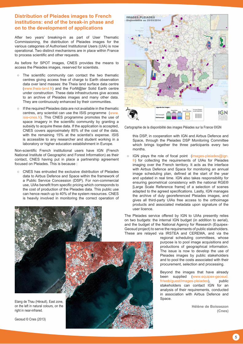
Distribution of Pleiades images to French institutions: end of the break-in phase and on to the development of applications
After two years’ breaking-in as part of User Thematic Commissioning, the distribution of Pleiades images for the various categories of Authorised Institutional Users (UIA) is now operational. Two distinct mechanisms are in place within France to process scientific and other requests.
As before for SPOT images, CNES provides the means to access the Pleiades images, reserved for scientists.
○ The scientific community can contact the two thematic centres giving access free of charge to Earth observation data over land masses: the Theia land surface data centre (www.theia-land.fr) and the ForM@ter Solid Earth centre under construction. These data infrastructures give access to an archive of Pleiades images and many other data. They are continuously enhanced by their communities.
○ If the required Pleiades data are not available in the thematic centres, any scientist can use the ISIS programme (www.isis-cnes.fr). This CNES programme promotes the use of space imagery in the scientific community by granting a subsidy to acquire these data. If the application is accepted, CNES covers approximately 85% of the cost of the data, with the remaining 15% at the scientist’s expense. ISIS is accessible to any researcher and student working in a laboratory or higher education establishment in Europe.
Non-scientific French institutional users have IGN (French National Institute of Geographic and Forest Information) as their contact, CNES having put in place a partnership agreement focused on Pleiades. This is because :
○ CNES has entrusted the exclusive distribution of Pleiades data to Airbus Defence and Space within the framework of a Public Service Concession (DSP). For non-commercial use, UIAs benefit from specific pricing which corresponds to the cost of production of the Pleiades data. This public use can hence reach up to 40% of the system resources. CNES is heavily involved in monitoring the correct operation of
this DSP, in cooperation with IGN and Airbus Defence and Space, through the Pleiades DSP Monitoring Committee which brings together the three participants every two months.
○ IGN plays the role of focal point ([email protected]) for collecting the requirements of UIAs for Pleiades imaging over the French territory. It acts as the interface with Airbus Defence and Space for monitoring an annual image scheduling plan, defined at the start of the year and updated in real time. IGN also takes responsibility for ensuring geometrical consistency with the national RGE® [Large Scale Reference frame] of a selection of scenes adapted to the agreed specifications. Lastly, IGN manages the archive of duly georeferenced Pleiades images, and gives all third-party UIAs free access to the orthoimage products and associated metadata upon signature of the user licence.
The Pleiades service offered by IGN to UIAs presently relies on two budgets: the internal IGN budget (in addition to aerial), and the budget of the National Agency for Research (Equipex-Geosud project) to serve the requirements of public stakeholders. These are relayed via IRSTEA and CEREMA, and via the
regional scheduling committees, whose purpose is to pool image acquisitions and productions of geographical information. The issue is now to develop the use of Pleiades images by public stakeholders and to pool the costs associated with their procurement, selection and processing.
Beyond the images that have already been supplied (www.equipex-geosud.fr/web/guest/images-pleiades), public stakeholders can contact IGN for an analysis of their requirements, conducted in association with Airbus Defence and Space.
Hélène de Boissezon (Cnes)
Cartographie de la disponibilité des images Pléiades sur la France ©IGN
Etang de Thau (Hérault), East zone, on the left in natural colours, on the right in near-infrared.
Geosud © Cnes (2013)
5

Comparison of Pleiades-LiDAR DSM in an agricultural context (Languedoc-Roussillon)
As part of the Pleiades RTU, a Pleiades Digital Surface Model (DSM) was built up from a pair of images dating from 6 January 2013 acquired over the Peyne river basin in Hérault.
This DSM was built using the MicMac stereophotogrammetry suite by IGN, without regularization, then resampled at 1 m. The altitude values were then compared with those of a DSM with the same mesh, acquired by an airborne LiDAR (Toposys system) in 2001 on a sub-section of the Peyne river basin (5.5 km²) (Fig 1-a).
For this comparison to make sense in a context of significant landscape dynamics, a mask was first used on the basin’s permanent structures (roads, paths, etc), as well as an altitude reset (elimination of bias related to the differences in references). On this basis, robust statistics on the deviation between Pleiades and LiDAR altitudes were established, in order to minimize the effect of residual outliers related above all to the difference in dates of the DSMs.
This means that, out of a population of 87,000 meshes, the median absolute deviation observed between the Pleiades and LiDAR altitudes is 35 cm, 90% of deviations are within the interval [-142cm, +110cm] and 50% of deviations are within the interval [-17cm, +42cm]. The observed distribution of deviations is not a standard Gaussian distribution (lighter tails), requiring the use of robust statistics (Fig 1-b).
After a Mantel test on an empirical semivariogram, a clear and significant spatial structure of this deviation was observed, following a spherical model with a range of 11.4 m (Fig 1-c). The distribution of the field of deviations is hence a generalized multi-Gaussian type random distribution, with spatial correlation. This characteristic mainly has effects on the way in which these deviation statistics must be spatially integrated. However, a more textured rendering appears on the Pleiades DSM (Fig 1-a).
This observation should however be qualified given the difference in dates and seasons between the two acquisitions and the intentional non-regularisation of the Pléiades DSM produced. This being said, the elevation precision and the resolution of the Pleiades DSMs already seem of great use for characterising agricultural landscapes and extracting objects and characteristics of the landscape (hedges, banks, gradient of plots, etc.) (Fig. 1-b).
Jean-Stéphane Bailly (Lisah / AgroParisTech), Nesrine Chehata (Lisah / Université Bordeaux 3)
Fig 1. (c) Variograms of field of deviations: empirical (points), modelled (red line) and Mantel test confidence interval (broken lines).
Fig 1. (a) 2 zooms on the LiDAR and Pleiades 1 m DSMs on the Peyne river basin
Fig 1. (b) Topographic transect of 2 DSMs with presence of terraces and histogram of Pleiades DSM - Lidar DSM deviations
LiDAR DSM
LiDAR DSM
Pleiades DSM
Pleiades DSM
6

NatioNal strategy
The ESA Collaborative Ground Segment
The European Space Agency (ESA) is setting up a system of Collaborative Ground Segments, the aim of which is to best distribute the enormous volumes of Sentinel data to the Member States of the European Union. Sentinel-1 (radar imager) has already been launched, the Sentinel-2 (high-resolution optical imager) and Sentinel-3 (low-resolution optical imager) satellites will be launched next year. These three types of satellite are of interest to the national community working on the monitoring and analysis of land surfaces. The Collaborative Ground Segments are projects formulated by the user community within each of the Member States, coordinated by a national point of contact. The description of these projects allows ESA and the Member States to dimension distribution architecture that is sufficient to cover the needs of these projects.
For France, the institution in charge of structuring the Collaborative Ground Segments national request is CNES, which launched a call for proposals in autumn 2013 for Collaborative Ground Segments among the national community potentially interested by the Sentinel data. The Theia Land Data Centre responded, with the objective of coordinating the statement of requirements for land surface observation Sentinel data for all of the national institutional stakeholders.
One project, three sectionsA Theia Collaborative Ground Segment project was therefore developed. It includes three sections: (1) production of Sentinel-2 images corrected for atmospheric effects and of monthly composites without clouds; (2) production of added-value products from the three Sentinels; (3) actions to support the user community.
Sentinel-2 data processing will be at level 2A (atmospheric corrections) and 3A (monthly composites) over a surface sized to be 10 times that of France, thanks to an operational tool called Muscate, set up by CNES, with the support of CESBIO, as part of Theia. The prototype of Muscate is described in this bulletin by Mireille Huc and Mahamed Kadiri. Muscate is designed to offer users ready-to-use products, from time series of images covering extensive territories. Sentinel-2 will be at the heart of the Muscate production, but already a prototype version of Muscate has started to produce the Landsat data acquired over France since 2009, the data from the Spot 4 Take 5 experiment, and the first images from the Spot World Heritage programme (see the article by Steven Hosford on p.3).
The second contribution by the Theia Collaborative Ground Segment will be the supply of added-value products over different regions of the world, in both the North and South, responding to major scientific and societal issues (environment, agriculture, climate risks, biodiversity, etc.) These added-value products coincide with those developed by the Theia Scientific Expertise Centres being built up and described in more detail in the article by Nicolas Baghdadi in this bulletin. Examples of these products are land use, change detection, plant biophysical variables, albedo, river and lake heights, etc.
The third contribution will cover user support, currently being designed. This will include actions for coordinating user networks, initiatives for identifying requirements, pooling methods, and training.
Marc Leroy (Cnes) Nicolas Baghdadi (Tetis / Irstea)
Multitemporal detection of aerosols
Various training catalogues
PEPS: the platform for access to the Theia Collaborative Ground Segment
The Theia Collaborative Ground Segment will be linked and connected to the PEPS national platform for dissemination of Sentinel data. The purpose of the PEPS platform, currently being designed at CNES, is to create a national mirror site for Sentinel data, dissemination of data to the national user community, and facilitate access to data processing tools. Theia will be a major user of PEPS, as its requirements concern at least 10 times the surface of France for Sentinel-2 data, probably the same coverage for Sentinel-1 data, and global coverage of Sentinel-3 data.
Map of vegetation cover density and risk of nitrate leaching (Deux-Sèvres, autumn 2012)
7

user feedbaCk
Monitoring rice with COSMO - SkyMed
This study, jointly conducted by CESBIO and Telespazio France, forms part of the Asia-RiCE (Asia-Rice Crop Estimation) project piloted by Shin-ichi Sobue (JAXA). Asia-RiCE is a component of GEOGLAM (Global Agricultural Geo-monitoring Initiative) resulting from the 2011 G20 Summit. Its objective is to test methods using SAR, particularly in X-band, to detect rice and estimate production. The GEOSUD plan enabled us to obtain 10 images from the COSMO-SkyMed constellation in PingPong mode (HH and VV polarizations) acquired throughout the third rice season in the Mekong Delta in Vietnam (mid-August until the end of November 2013). The quality of the data and their speed of delivery, the day after their acquisition, allowed us, in particular, to produce maps of paddy fields very early in the season and to precisely estimate the sowing dates, and they point towards future operational applications.
Alexandre Bouvet (Cesbio)
Satellite data: essential fuel for
the CNRS communities
When the first SPOT satellite offered its images to the Earth sciences community, it revolutionised the way we observed the Earth. Active faults, coastlines and mountain ranges, were finally seen at a scale that allowed the geodynamics at work, and plate tectonics in particular, to be observed. In addition to the direct observation of processes that were already known, this new method of observation led to new questions and new models, particularly about associations between internal geodynamics and dynamics of the Earth’s surface, or paradigms directing associations of space and time scales.
The major societal issues tackled by the scientific communities for Environmental sciences in the French National Centre for Scientific Research (CNRS), and in particular the National Institute for Earth Sciences and Astronomy (INSU) and the Institute of Ecology and Environment (InEE), are anchored in particular in our understanding of the processes that prevail over natural risks, natural resources of water, land, biodiversity, and the dynamics of life, which are all associated processes preferentially expressed at the continental surfaces and interfaces. Imagery of these surfaces, which are the most accessible observable of the zone critical for life, is hence a key element in the scientific approach in fields as diverse as coastline dynamics, the effect of the climate and humans in the short or long term on biodiversity, soil erosion or the water dynamics of major rivers. The progress of the environmental sciences, and hence our ability to help society to face these environmental challenges, will owe much to the provision of imagery of the Earth’s surface in high spatial and temporal resolution, with a multispectral approach allowing the dynamics of life and non-life to be distinguished, to understand the complex dynamics of land surfaces.
Nicolas Arnaud (Osu-Oreme / CNRS)
Services for institutions
To achieve economical management of agricultural, natural and forest areas, the regulatory environment requires institutional services responsible for land management to have increasingly detailed knowledge of land use and changes in land use.
Earth observation by satellite is entering a new phase of maturity, both in terms of satellite performance and in terms of access to data and processing tools. Various studies demonstrate that automatic processing on satellite images responds to a first level of planners’ needs, as they are capable of providing detailed, homogenous and updatable information for limited cost.
CEREMA is taking an interest in this approach through various exploratory studies whose objective is to simply characterise land use using automatic processing methods for satellite images and exogenous databases. The purpose of these layers is to assist the various services, while integrating consistently into the general context.
Didier Treinsoutrot (Cerema)
Estimated rice sowing dates on a study site in Vietnam from COSMO-SkyMed for the Autumn-Winter 2013 season
Band X mapping of soil states by TerraSar-X
Kalideos data
Following the Multispectral Crop Monitoring experiment which took place in 2010, the CESBIO team continued its Optical/Radar comparative analyses over long periods using the optical Kalideos (Formosat 2) products and the TerraSAR-X radar series acquired every 11 days in 2013, together with terrain measurements.
Thanks to a method of angular normalisation of Radar amplitude (developed because of its high sensitivity to the angle of incidence), this first phase of experimentation demonstrates in particular the possibility of estimating plant height from Radar backscatter. The results (www.cesbio.ups-tlse.fr/fr/mcm.html) are comparable with the LAIs obtained from optical imaging, on condition that consideration is taken of two marked phases of the vegetation’s behaviour, depending on whether the plant is in development or senescence phase.
While the effect of the contribution by the ground (roughness, spacing of seedlings) disperses measurements as the ground is partially bare, the methodology being developed is promising and the measurements made with radar images in X-, C- and L-bands make the method compatible with the future missions: Sentinel-1 and Radarsat-2.
Arnaud Sellé (Cnes), Frédéric Baup (Cesbio / Univ TLS III)
8

NatioNal systems
Creation in Alsace of a partnership for rapid production of territorial information downstream of European Sentinel satellites
A2S: The Alsace Aval Sentinelle (Alsace Downstream Sentinel) programme Alsace Aval Sentinelle largely relies on the launch of the constellation of Sentinel Earth observation satellites, which started in April 2014 as part of the European Copernicus programme. Like many people, we are sure that the use of this data represents both a technological and scientific challenge, and certain economic potential.
A2S is the Alsace region’s response to this challenge, founded on the joint development of a pluridisciplinary regional research centre on «massive image data», and the implementation of an added-value production centre using the remote sensing data, particularly those supplied by the Sentinel constellation.
The A2S programme is a regional initiative conducted by SERTIT (the Regional Service for Image Processing and Remote Sensing) within the University of Strasbourg. It is integrated into a national and European data and services infrastructure, for which Theia is an essential coordination point.
A technical approach: responsivenessThe technical approach of the programme is responsiveness, involving building tools for the systematic and synchronous use of massive flows of images of the Earth.
The generic product concept on which A²S is founded is the systematic localised detection, with a high temporal frequency, of natural and anthropogenic changes occurring on the surface of the Earth. The specifications shared by all of the products (geo information) are as follows: i) the raw material is made up of the satellite observations (images) from the radar and optical Sentinel satellite platforms; ii) the information is produced and published quickly: at least as quickly as the image data is acquired; iii) the zone covered by the production is the national territory, and chosen territories, eventually all the land masses; iv) the geometrical granularity is that of the image acquisition (decametric).
The purpose of A2S is to supply existing decision support systems, or those to be built, with fresh geographical information, in order to help them to: i) manage unpredictable events such as natural and technological disasters; ii) monitor changes to the environment such as the condition of wet zones, the condition of soils, of natural vegetation, and also to monitor agricultural production, urban land use, the condition of forests; iii) monitor in order to alert and protect: major infrastructures, terrain in movement, epidemiological risks. Generally speaking, to detect all slow, rapid, abrupt and/or cyclical changes affecting the territories.
A partnership approachThe development of this programme is built on the basis of the existing experiment in Strasbourg, in the fields of rapid mapping, image processing, remote sensing, nature topics and humanities and engineering sciences, particularly within the teams of the Regional Service for Image Processing and Remote Sensing (SERTIT), of the Engineering, computing and imaging sciences laboratory (ICUBE, UMR 7357), of the Image, town, environment laboratory (LIVE, UMR 7362), of the National School of Water and Environmental Engineering of Strasbourg (ENGEES), of the School and Observatory for Earth Sciences (EOST) and of the Télécom Physique Strasbourg (TPS) school.
The A2S project is partnership-based: its resources in Strasbourg are complemented by the national capacities such as those present within Theia, and also international partnerships, in the forefront of which are those with our German neighbours.
An ambition: to contribute to the development of an economic branch
The objective of the programme is to contribute to building, within a national and European framework, an innovative economic branch, by founding the necessary investment on a public-private partnership approach, to cover the space between research and the merchant sector.
To do so, the A2S programme is implementing 7 complementary and coordinated projects, all of which will eventually constitute an economic development centre established in Alsace.
Situation of the programmeThe A2S programme’s partnership is being established: the laboratories of the University of Strasbourg, the local authorities and the potential regional users have already come together. This partnership is open: contact has also been made with a number of national partners.
The programme’s «sponsor site» is the University of Strasbourg, resources are already provided by the partner research teams, by the University of Strasbourg excellence initiative (IdEX) called «Beyond borders» (Par-delà les frontières). Specific A2S resources are requested within the framework of CPER, the global financing plan for the 2015-2020 period is being drawn up with the partners.
The legal status of the programme, its operation and the organisation of its different projects are being discussed within the steering committee with the various partners and backers, to lead to its launch in autumn 2014.
Bernard Allenbach (Sertit / Université de Strasbourg)Detection of changes, 2 examples with Pleiades images
99

sCieNtifiC issues
Radar altimetry for hydrology
Inland waters have a major impact on life on Earth and domestic needs. They also play an important role in climate variability. Almost 73% of global water demand is supplied by surface water (rivers, lakes and artificial reservoirs) and 19% by groundwater. Within the context of climate change and its impacts on water resources, it is therefore very important, particularly from a societal viewpoint, to estimate the changes that may affect the inland water cycle.
However, ground networks for monitoring the level of lakes and rivers are currently highly disparate depending on the regions of the globe. In many places, either because they are not very accessible, or because the countries in which these lakes and rivers are located are in a difficult economic situation which no longer allows them to maintain existing resources, or which no longer have reliable and sustainable measurement networks, access to this information is non-existent.
HydroWEB: remote sensing for studying water levelsFor a number of years, remote sensing space technologies have been used to study variations in water masses in major river basins with timescales from a few months to several decades. The advantages of satellite systems are well-known :
○ Almost global coverage.
○ Good characterisation of instruments and good spatial and temporal uniformity of datasets.
○ Good archiving of past data.
○ Fairly good guarantee (related to the primary missions of these systems) of continuity of measurements and durability of data, whatever the technical changes to the systems that will provide them in the future.
With the HydroWEB service (www.legos.obs-mip.fr/en/soa/hydrologie/hydroweb), since 2003 LEGOS has developed a database of variations in water levels in the world’s lakes and rivers, from satellite altimetry, endeavouring to cover the major basins (rivers of South America, Asia, Africa, Eurasia, the North American Great Lakes, the lakes of the Andes, of central Asia and the African Great Lakes) as far as possible. 230 lakes and more than 1300 «virtual stations» (points of intersection between a satellite track and a river) on major rivers are monitored, and are available in HydroWEB, which is now the vector for distribution of hydrological products produced by LEGOS.
Products validated with in situ dataThe quality of the products delivered is guaranteed by numerous comparisons with in situ water level data (for example on certain large lakes or certain rivers). As part of a collaboration with SHI (State Institute of Hydrology) of St Petersburg in Russia, we were able to acquire a great deal of in situ data about Russia which allow us to validate our lake and reservoir products in particular. A similar comparison was recently made on some twenty lakes in Chile and Argentina, for which we could obtain a great deal of in situ data. The precision varies from 2-3 cm RMS for large lakes, to tens of centimetres for smaller lakes. Initial estimates yet to be published demonstrate that with the SARAL satellite, this precision is greatly improved. River data, meanwhile, has been used in various projects, including a project with an Indian laboratory which also allowed these data about the Ganges and Brahmaputra to be used and validated.
Moreover, a workgroup was formed at the start of 2013 with a view to making the processing chains for rivers and lakes fully automatic, particularly for Jason-2 and AltiKa. In 2015 this should result in the implementation of an operational service for
the lakes and rivers already present in HydroWEB.
This HydroWEB operational service will be hosted on the Theia Land Data Centre and will be operated by an industrial company with CNES and LEGOS as support.
Jean-François Crétaux (Legos / Cnes)
Comparison of a time series on a large lake (Ladoga, Russia) with in situ data
HydroWEB users
At present, the service has just over 200 registered users, mainly laboratories from across the globe, predominantly Asian and European.
Change in numbers of registered users since March 2012
10

Directional signatures database
Reflectance is the radiance reflected by a surface in a given direction compared with the incident luminous flux. It is a parameter that depends on the solar and observation directions. Surfaces covered with water have highly anisotropic reflectance, with a maximum that is highly marked in the specular direction, and values close to zero in the backscatter direction. Land surfaces, on the other hand, have more isotropic reflectance, but with a strong maximum in the backscatter direction (lighting direction and observation direction coincide).
Measurement from space of reflectances enables, for example, the presence of vegetation to be quantified, and changes to be monitored. However, the directional effects interfere with a quantitative interpretation of temporal variations. The instruments that allow almost daily observation of the Earth, such as VGT or MODIS, require high and variable observation angles. The reflectance variations related to changes of observation geometry are often greater than those related to a change in the surfaces. It is hence necessary, for quantitative interpretation of the measurements, and to detect minor modifications, to measure and correct the directional effects.
POLDER, the only instrument to measure BRDFThe POLDER instrument on board the PARASOL microsatellite, which has just finished its mission after 8 years’ service, measures the directional effects of surface reflectances. The instrument’s field of view not only extends perpendicular to the track, but also along the track. During the satellite pass, a point on the ground is thus observed successively from 16 different directions. Moreover, observations acquired during a certain period can be combined, which allows all of the potentially accessible directions (i.e. viewing angles between the nadir and approximately 60°) to be covered. POLDER remains the only instrument that measures the directional variations in reflectances (called BRDF: Bi-directional Reflectance Distribution Functions). We have hence decided to extract from the acquired measurements a database of measured signatures representative of the variability encountered on Earth.
Naturally, we have looked for measurements of the best possible quality. This quality is affected by the presence of clouds or aerosols. Moreover, spatial heterogeneity also tends to add noise
to the measurement. In addition, we try to have sites for which a large number of measurements have been acquired and which cover all of the directions. Lastly, we want to sample all of the main surface types (snow, desert, deciduous forest, coniferous forest, savanna, crops, etc.) and the different latitude bands. We have therefore defined a quality criterion and extracted the best targets available for the different surface types.
For each target selected, we have extracted the measurements acquired by the POLDER instrument and corrected atmospheric effects (gas absorption and diffusion by molecules and aerosols). The measurements are grouped by period of one month, a period during which changes of surfaces generally remain limited, which allows the variations to be interpreted as essentially related to the directional effects.
In order to facilitate analysis of this database, we have also developed a viewing tool. This tool enables targets to be selected according to various criteria (surface types, vegetation index, period), the measurements to be viewed, and the measurements to be compared to the predictions of various models developed by the scientific community.
This BRDF database, along with the associated viewing tool, are the most frequently-downloaded products on the site of the POSTEL thematic centre. This shows the interest that the scientific community has in this information.
François-Marie Bréon (LSCE / CEA)
The figure opposite is one of the graphs generated by the BRDF analysis software. It shows, for 3 of the 8 POLDER channels (the 3 lines on the graph), the measured reflectance on the left, the difference from the modelling in the centre, and a scatter plot between measured and modelled values on the right. This is a site where the agreement is particularly good. The ranges of variations in reflectances and the model-measurement differences vary between the channels and are given below each graph.
Each graph shows the measurements following the observation direction. A nadir view is represented at the centre, the circles indicate viewing angles at 20, 40 and 60°. The specular direction (forward) is on the left, while backscatter is on the right.
The PARASOL satellite carrying the POLDER instrument Credits: CNES/Ill. D. Decors.
11

Estimate of height and forest biomass on Eucalyptus plantations in Brazil using LiDAR ICESat/GLAS data
LiDAR waveforms acquired by the GLAS (Geoscience Laser Altimeter System) satellite sensor were used to estimate the dominant height of trees and the forest biomass of plantations of Eucalyptus in a study zone in Brazil (centred on Long. : 47°31’-47°38’O and Lat. : 21°29’ -21°39’S). GLAS provided data between 2003 and 2009. Its footprints have a near-circular shape approximately 70 m in diameter and spaced approximately 170 m between each footprint.
The site is mainly covered by industrial plantations of fast-growing Eucalyptus managed by «International Paper do Brasil», mainly located on flat terrain. The tree density is approximately 1300 trees/ha (low mortality, below 7%) following a logging cycle of 6 to 7 years. The annual productivity of the plantations depends on the growth stage, the characteristics of the soil and the use of fertilisers (approximately 40 m3/ha/year). At the time of logging, the volume of wood of the trunks is approximately 250-300 m3/ha and the typical height of the plantation is then 20 to 30 m.
A model based on metrics calculated from GLAS waveforms was used to estimate the dominant height of the plots (Hdom):
Hdom (m) = 0.9445 Wext - 0.5669 Lead ext - 0.9616 Trailext + 3.2179 (R2=0.92)
Wext, Leadext, Trailext (in m) are waveform attributes: “Waveform extent”, “Leading edge extent”, and “Trailing edge extent”, respectively (Figure 1a). For uneven terrain, it is necessary to incorporate into this relationship local metrics resulting from a digital terrain model.
A power type model was then estimated between dominant height and wood biomass at the scale of the plot:
B (Mg/ha)=0.1083Hdom (R²=0.85)
The comparison between the variables estimated from GLAS data and the terrain measurements shows a precision of approximately 1.89 m on the estimate of the dominant height (Figure 1b), and approximately 16.1 Mg/ha (relative error of approximately 25.2% of the average biomass) on the estimate of the biomass (Figure 1c). With a biomass estimate error of less than 50 t/ha, these results show that the precision recommended by UN-REDD (the United Nations Programme on Reducing Emissions from Deforestation and forest Degradation) is at least achievable with space LiDAR data in a favourable case: with gently-sloping terrain and over uniform cover (plantations).
Nicolas Baghdadi (Tetis / Irstea), Guerric le Maire (Eco&Sols / Cirad),
Jean Stéphane Bailly (Lisah / AgroParisTech), Yann Nouvellon (USP / Cirad)
Theia bulletin
Publication directors : Nicolas Baghdadi (Irstea) - Marc Leroy (Cnes)Design - production : Sophie Al Ayoubi (Theia)Contributors to this issue : Bernard Allenbach (Univ. Strasbourg), Nicolas Arnaud (CNRS), Jean-Stéphane Bailly (AgroParisTech), Frédéric Baup (Univ. Toulouse III), Alexandre Bouvet (Cesbio), François-Marie Bréon (CEA), Nasrine Chehata (Univ. Bordeaux IV), Jean-François Crétaux (Cnes), Hélène De Boissezon (Cnes), Phi-lippe Durand (Cnes), Jean-François Faure (IRD), Olivier Hagolle (Cnes), Steven Hosford (Cnes), Mireille Huc (Cnes), Mohamed Kadiri (Cesbio), Guerric Le Maire (Cirad), Yann Nouvellon (Cirad), Arnaud Selle (Cnes), Claire Tinel (Cnes), Didier Treinsoutrot (Cerema)
(b) Comparison between heights estimated from GLAS and heights measured
Eucalyptus plantation in Brazil: experimental rain exclusion system put in place by the University of Sao Paulo and CIRAD. (© J.P. Laclau/Cirad)
(a) GLAS waveform on a plot of Eucalyptus and the main associated metrics (1 ns = 15 cm),
(c) Comparison between estimated biomasses and measured biomasses.
2.1387
12