bundesamt für landestopographie office fédéral de topographie ufficio federale di topografia...
TRANSCRIPT

Bundesamt für LandestopographieOffice fédéral de topographieUfficio federale di topografiaUffizi federal da topografia
EUREF’04: National Report of Switzerland
D. SchneiderE. BrockmannW. GurtnerA. SchlatterB. VogelA. WigetU. Wild

2 - 5 JUNE 04
EUREF'04 Bratislava
Folie 2
Permanent GPS network (AGNES)• High performance: Average of data availability: > 99 %
• Contribution to ECGN: Collocation of various geodetic observations (see paper by E. Brockmann)
Fundamental station Zimmerwald
• Replacement of receivers (Trimble 4000SSI → 4700) resulted in signifi- cantly improved performance of RTK positioning (faster data output)• New station software (GPS-Base Vers. 2.10)
2 - 5 JUNE 04
EUREF'04 Bratislava
Folie 3
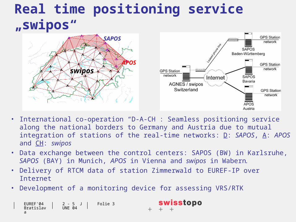
Real time positioning service „swipos“
• International co-operation “D-A-CH”: Seamless positioning service along the national borders to Germany and Austria due to mutual integration of stations of the real-time networks: D: SAPOS, A: APOS and CH: swipos
• Data exchange between the control centers: SAPOS (BW) in Karlsruhe, SAPOS (BAY) in Munich, APOS in Vienna and swipos in Wabern.
• Delivery of RTCM data of station Zimmerwald to EUREF-IP over Internet• Development of a monitoring device for assessing VRS/RTK
swiposAPOS
SAPOS

2 - 5 JUNE 04
EUREF'04 Bratislava
Folie 4
Analysis of permanent GPS networks
• Networks:
EUREF subnetwork 20 -> 25 (1 AGNES) daily observations 21 days
AGNES+ subnet EUREF
65 -> 72 (29 AGNES) daily observations 21 days
AGNES+ subnet EUREF
63 -> 72 (29 AGNES) hourly observations
0.5 hours
• GPS Meteorology: European collaboration within research projects COST-716 and TOUGH

2 - 5 JUNE 04
EUREF'04 Bratislava
Folie 5
National Reference Frames• Determination of all AGNES
stations in the official reference frames (LV95, LV03 and LHN95)
ANDE
ARDE
BOUR
DAVO
EPFL
ETHZ
FALE
FHBB FRIC
GENE
HOHT
HUTT
JUJO
KREU
LOMO
LUZE
MART
NEUC
PAYE
PFAN
SAANSAME
SANB
SARG
SCHA
STAB
STCX
STGA
UZNA
ZIMM
Dossenbach
Farnsburg
Froburg
Gaiss
Gislifluh
Irchel
Küssaburg
Lauberg
Niedergebissbach Benken
Salen
Möhlin
Kaisten
Leuggern
Baldingen DinhardFrauenfeld
OttenbergRomanshorn
Gempenfluh
Herznach
BözbergBirrfeld
Oberglatt
Hohentannen St.Margrethen
Movelier
Montsevelier Belchenfluh
Erlinsbach Bellikon
Birmensdorf
DübendorfPfäffikon ZH Gähwil Schlatt
Muriaux
MoutierWiliberg
Dürrenäsch
Schwarzenbach LU
Sarmenstorf Obfelden
Kilchberg
Kappel
KrummenauEschen
Grenchen Aeschi
HuttwilGettnau Rain Menzingen
Wädenswil
VorderthalMurg
Sutz
HindelbankRuswil
Luzern
Udligenswil
Colombier
Mühleberg
Mänziwilegg
Lüderenalp
Escholzmatt
Schüpfheim Emmeten
Linthal Elm
Wichtrach
Schallenberg
SörenbergGiswil
Gurnigel
Wyler
Sustenpass
Wassen
Amsteg
Disentis
Boltigen Tellenburg
Wimmis
Männlichen
Lalden
Bellinzona
Stabio
Avers
Monteggio
Nufenenpass
OlivoneSamedan
Sta Maria (Calanca)
Sur
Bondo
Schwyz Samnaun
Brione
Schiers
Sils im Domleschg
Brusio
Fafleralp
Grimentz
Verbier
Val d'Illiez Ovronnaz
Montana
Chamblon
Villarsel-le-Gibloux
Château d'Oex
Wiechs
Wutöschingen
Hohentwiel
Siblingen
Chrischona
Hütten
LaufenburgBuchberg Stammheim
Dettighofen
Metzerlen Sissacherfluh Lägern Brütten
Schauenberg
Nollen GoldachPfänder
Fahy
Les Rangiers
Vogelberg
Wartburg
Lenzburg
Hönggerberg
Oberhelfenschwil
Montlingen
Reconvilier Riedholz
PfannenstielBachtel Schwägalp
Chasseral
Langenthal
Knutwil Sins
Einsiedeln
Gaster
La Chaux-de-FondsSeedorf
LuegMenzberg
Oberarth
Glarus
Sargans
Travers
Vully
SignauAlpnach
Col des Etroits
Forel
FribourgZimmerwald
Engelberg
Altdorf Klausenpass
Bonaduz Davos Ramosch
GuggisbergThun
RinggenbergBrienz
Brigels
Filisur Zernez
Le Lieu La Sarraz Moudon
La Tour-de-Trême
Oberalp
ZervreilaseeAndeer
Sta. Maria
Essertines
EchandensSavigny
Saanen
Grimsel S.Gottardo
DalpeLa Givrine Chailly Engstligenalp Fieschertal
BiascaMesocco
MalojaBerninapass
Bossy St-TriphonJeizinen
Simplon Crodo d'Ossola
Bignasco
Piton
Sion
Ascona
CòlicoMartigny
Les HaudèresSaas Fee
Sonvico
Bourg-St-Pierre Zermatt M.Generoso
Jungfraujoch
LECHFLDK
KOPS
KRBG
LIND
FREI
RAVE
SIGMSCHWGPS-Camp. CHTRF2004
and NEOTEK2004
CHTRF2004.1
CHTRF2004.2
CHTRF2004.3
CHTRF2004.4
CHTRF2004.5
CHTRF2004.7
NEOTEK2004
CHTRF2004.6
• Continued re-measurement of levelling lines which are part of the National Vertical Network (LHN95)
• Re-observation of the GPS re- ference network LV95 in 2004 (total: 208 stations, 60 control points of monitoring network)

2 - 5 JUNE 04
EUREF'04 Bratislava
Folie 6
Current projects National Vertical Network LHN95: Software „HTRANS“ for the transfor-mation of heights
between the old (LN02) and the new vertical reference frames (LHN95). Differences: -60 to +20 cm
Swiss-4D: Kinematic analysis of repeated (levelling) or permanent (GPS) observation data for the investigation of crustal deformation, and tests with differential interferometric SAR for monitoring land subsidence and to validate the results with precise levelling
Control Point Data Service: Making available all control point data via the Internet
GIS National Border:Establishment of a GIS for the documentation of data pertaining to the national border