bushfire management plan · po box 84 stoneville wa 6081 bushfire safety consulting mbl: 0429 949...
TRANSCRIPT

9501
9500
603
603
55
55
70
69
67
68
66
65
64
63
62
61
1
904
377
338
331
335
330
337
336
329
339
328
334
340
332
333
341
342
327
343
349
344
348
345
346
347
283
298
284
299
282
297
285
296
286
287
281
295
288
294
289
300
290
293
280
291
292
265
266
277
278
276
275
267
279
274
268
273
272
269
271
270
163
162
161
160
159
149
158
157
150
151
156
152
153
155
154
148
147
146
144
145
137
138
143
139
142
140
141
135
134
133
132
131130
124
125
126
127
128
129
9476
9766
215
217
214
218
213
212
219
211
165
166
164
210
167
168
169
170
171106
105104
103
123
87
88
86
85
102
101
225
224
226
223
222
227
221
84
81
228
83
82
229
230
237
249
248
238
247
239
240
241
244
245
246
242
243
309
308
310
307
312
313
314
306
315
305304
303
301
302
264
263
262
359
358
261
360
260
357
259
361
258
362
257
363
256
253
255
254
252
251
250
352
325
322
323
324
ST.
AVENUE
ANDREW
S
TOREOPANGO
DR
IVE
602
10
0m
ZO
NE
SU
RR
OU
ND
ING
SIT
E
AERIAL PHOTO
PO BOX 84 STONEVILLE WA 6081
BUSHFIRE SAFETY CONSULTING
Mbl: 0429 949 262www.bushfiresafety.net
Safety C O N S U L T I N G
Bushfire
SOURCE:
PHOTOGRAPHY FROM LANDGATE
SUBJECT LAND......
Lots 602 & 603 TOREOPANGO AVENUEYANCHEP
City of Wanneroo
SCALE 1:5000 @ A3
DATE: MARCH 2016
Base mapping supplied by Chappell Lambert Everett
NORTH
0 50 100 150 250m200
Yanchep Activity Centre Structure Plan
Lot 602 & 603 Toreopango Avenue, Yanchep City of Wanneroo
May 26, 2016 Prepared for: CLE Town Planning & Design Version 2.0
Bushfire Management Plan

Bushfire Management Plan – Yanchep Activity Centre Structure Plan
Page i
© 2016 Bushfire Safety Consulting Pty Ltd.
Document Information
Prepared for CLE Town Planning + Design
Project Name Yanchep Activity Centre Structure Plan
Owners Yanchep Beach JV
Document Control
Proposed Subdivision - Lot 9039 Marmion Avenue, Alkimos– Bushfire Management Plan V1
VERSION DATE PURPOSE PREPARED REVIEWED SUBMITTED TO CLIENT
V1 23/05/2016 Client Review K Strahan R Carboon Electronic
V2 31/05/2016 Submission R Carboon Electronic
Front cover photo: Aerial photograph of development site
Bushfire Safety Consulting Pty Ltd PO Box 84 STONEVILLE WA 6081
Tel: 0429 949 262
Email: [email protected]
Web: www.bushfiresafety.net
Disclaimer:
This report has been prepared in good faith and is derived from sources believed to be reliable and accurate at the time of publication. Nevertheless, this publication is distributed on the terms and understanding that the author is not responsible for results of any actions taken based on information in this publication or for any error in or omission from this publication.
Bushfire Management Plan – Yanchep Activity Centre Structure Plan
Page ii
EXECUTIVE SUMMARY
This Bushfire Management Plan (BMP) has been prepared to support the draft Yanchep City Centre Activity Centres Structure Plan (Appendix B).
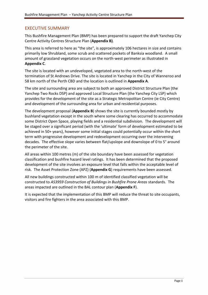
This area is referred to here as “the site”, is approximately 106 hectares in size and contains primarily low Shrubland, some scrub and scattered pockets of Banksia woodland. A small amount of grassland vegetation occurs on the north-west perimeter as illustrated in Appendix C.
The site is located with an undeveloped, vegetated area to the north-west of the termination of St Andrews Drive. The site is located in Yanchep in the City of Wanneroo and 58 km north of the Perth CBD and the location is outlined in Appendix A.
The site and surrounding area are subject to both an approved District Structure Plan (the Yanchep Two Rocks DSP) and approved Local Structure Plan (the Yanchep City LSP) which provides for the development of the site as a Strategic Metropolitan Centre (ie City Centre) and development of the surrounding area for urban and residential purposes.
The development proposal (Appendix B) shows the site is currently bounded mostly by bushland vegetation except in the south where some clearing has occurred to accommodate some District Open Space, playing fields and a residential subdivision. The development will be staged over a significant period (with the ‘ultimate’ form of development estimated to be achieved in 50+ years), however some initial stages could potentially occur within the short term with progressive development and redevelopment occurring over the intervening decades. The effective slope varies between flat/upslope and downslope of 0 to 5° around the perimeter of the site.
All areas within 100 metres (m) of the site boundary have been assessed for vegetation classification and bushfire hazard level ratings. It has been determined that the proposed development of the site involves an exposure level that falls within the acceptable level of risk. The Asset Protection Zone (APZ) (Appendix G) requirements have been assessed.
All new buildings constructed within 100 m of identified classified vegetation will be constructed to AS3959 Construction of Buildings in Bushfire Prone Areas standards. The areas impacted are outlined in the BAL contour plan (Appendix F).
It is expected that the implementation of this BMP will reduce the threat to site occupants, visitors and fire fighters in the area associated with this BMP.

Bushfire Management Plan – Yanchep Activity Centre Structure Plan
Page i
TABLE OF CONTENTS 1 INTRODUCTION ............................................................................................................................................. 1
1.1 Purpose of Plan ...................................................................................................................................... 1 1.2 Background ............................................................................................................................................ 1 1.3 Accreditation ......................................................................................................................................... 1
1.3.1 The Development Proposal........................................................................................................... 2 1.3.2 PLANNING CONTEXT (STATUTURY AND POLICY FRAMEWORK) ................................................... 2
2 OBJECTIVES .................................................................................................................................................... 4 3 DESCRIPTION OF SUBJECT AREA .................................................................................................................... 5
3.1 General .................................................................................................................................................. 5 3.2 Climate and Fire Weather ...................................................................................................................... 5
4 BUSHFIRE ASSESSMENT ................................................................................................................................. 7 4.1 Bushfire Hazard Assessment ................................................................................................................. 8
4.1.1 Vegetation Type and Structure ..................................................................................................... 8 4.1.2 Slope ............................................................................................................................................. 9 4.1.3 Bushfire Hazard Assessment – Existing Site Conditions................................................................ 9 4.1.4 BAL Contour Map – Post Development Conditions .................................................................... 10
4.2 FIRE MITIGATION STRATEGIES ............................................................................................................. 10 4.2.1 Element 1: Location of the Development ................................................................................... 11 4.2.2 Element 2: Siting of the Development ........................................................................................ 11 4.2.3 Element 3: Vehicular Access ....................................................................................................... 14 4.2.4 Element 4: Water ........................................................................................................................ 15
5 Bushfire Risk Management Measures ......................................................................................................... 15 5.1.1 Public Education and Community Awareness ............................................................................ 16 5.1.2 Fire Safer Areas ........................................................................................................................... 17
5.2 Assessment of Fire Management Strategies ....................................................................................... 17 5.3 Implementing the Bushfire Management Plan ................................................................................... 18
5.3.1 Developer’s Responsibilities ....................................................................................................... 18 5.3.2 Property Owner Responsibilities ................................................................................................ 18 5.3.3 City of Wanneroo’s Responsibilities ........................................................................................... 18 5.3.4 Water Corporation’s Responsibilities ......................................................................................... 19
6 CONCLUSIONS ............................................................................................................................................. 19 7 REFERENCES ................................................................................................................................................ 20 8 GLOSSARY .................................................................................................................................................... 22
TABLE OF TABLES
Table 1: Asset Protection Zone ............................................................................................................................. 12 Table 2: Indicative BAL assessment for proposed interface areas of the development ....................................... 13
TABLE OF FIGURES
Figure 1: Mean maximum recorded temperatures between 1991 and 2016 and mean rainfall (1961-2016) for Swanbourne Meteorology Station .......................................................................................................................... 6 Figure 2: Rose of wind direction and wind speed in km/hr for December, January and February between 1993 and 2010 at the Swanbourne Bureau of Meteorology Station………………………………………………………………………… 7 Figure 3: The five fuel layers in a forest environment that could be associated with fire behaviour .................... 8 Figure 4: Low Shrubland dominates much of the site ............................................................................................ 9 Figure 5: Large areas of scrub especially in the west of the site ............................................................................. 9 Figure 6: Banksia woodland areas scattered throughout the site. ......................................................................... 9

Bushfire Management Plan – Yanchep Activity Centre Structure Plan
Page ii
TABLE OF APPENDICES
Appendix A: Study Site Location Appendix B: Activity Centre Structure Plan Appendix C: AS3959 Vegetation Classification Appendix D: Topography and Effective Slope Appendix E: Bushfire Hazard Level Rating Appendix F: BAL Contour Plan Appendix G: APZ Plan Appendix H: Vehicular Access Appendix I: Bushfire Management Plan Checklist

Bushfire Management Plan – Yanchep Activity Centre Structure Plan
1
1 INTRODUCTION
1.1 Purpose of Plan
This Bushfire Management Plan (BMP) has been prepared to support the approval of a draft Yanchep City Centre Activity Centres Structure Plan in an area shown in Appendix B and referred to here as ‘the site’. Given that the timeframe for the ultimate development of the site is estimated to be 20-50 years or more this BMP responds to the conditions as they are now.
1.2 Background
The site is approximately 106 hectares in area and is located north of Yanchep Beach Road and east of Marmion Avenue 58 kilometres north of the Perth CBD.
Retention of remnant vegetation within the City Centre area is not proposed and open space areas will be landscaped and managed as urban parks. Extensive earth working of the site to achieve relatively flat grades is will be necessary to achieve the urban density and form sought. A maximum 15 metre width strip of land extending around the perimeter of the site adjacent to areas of classified vegetation will act as a temporary Asset Protection Zone (APZ) until such time as the adjacent hazard is removed.
1.3 Accreditation
This BMP has been prepared by Bushfire Safety Consulting. Bushfire Safety Consulting is owned and operated by Rohan Carboon and Ken Strahan. Rohan and Ken have provided all technical input and review for this bushfire assessment.
Rohan has undergraduate degrees in Environmental Management and postgraduate qualifications in Bushfire Protection and has been providing bushfire risk and hazard assessment and mitigation advice to the urban planning and development industry for more than 7 years. He first worked professionally in community bushfire safety education in 1999 and has been involved in land management including bushfire suppression since 1993.
Ken Strahan has twenty years experience in emergency management research for a number of major emergency management organisations including the Victorian Country Fire Authority, the Office of the Emergency Services Commissioner (Victoria), Country Fire Service (SA) Office of Premier and Cabinet (NSW) and a large number of local councils. His work was cited extensively by the Black Saturday Bushfire Royal Commission. He is currently completing a PHD thesis researching community responses during bushfire events including the Perth Hills bushfire in 2014.
Bushfire Safety Consulting is a Corporate Bronze Member of the Fire Protection Association of Australia. Rohan and Ken are both in the process of obtaining BPAD Level 1 BAL Assessor

Bushfire Management Plan – Yanchep Activity Centre Structure Plan
2
and BPAD Level 2 accreditation under the Fire Protection Association of Australia’s new accreditation scheme. Rohan will also apply for Level 3 accreditation in 2016.
1.3.1 The Development Proposal
This Bushfire Management Plan (BMP) has been prepared to support the approval of a draft Yanchep City Centre Activity Centres Structure Plan.
The proposed Activity Centre Structure Plan is outlined in Appendix B indicates how the site is proposed to be developed. The site is approximately 106 hectares (ha) in size incorporating proposed, commercial and residential development. The site and surrounding area are subject to both the Yanchep Two Rocks District Structure Plan and the Yanchep City Local Structure Plan which provide for development of the site as a Strategic Metropolitan Centre (City Centre) and development of the surrounding area for urban and residential purposes. The City Centre will not be developed in isolation and is expected to be predominately cleared of surrounding vegetation by the time the development actually occurs. Land surrounding the site will be developed into residential, service industrial, mixed use and business consistent with the Yanchep City Local Structure Plan. Extensive areas on the southern and the lower end of the south and south-west boundary have been cleared to accommodate District Open Space and playing fields. Land cleared south east of the boundary is for a residential development.
The site will be serviced by scheme water and will have extensive public road access.
1.3.2 PLANNING CONTEXT (STATUTURY AND POLICY FRAMEWORK)
The following key legislation, policies and guidelines are relevant to the preparation of BMPs.
1.3.2.1 1.3.2.1 Fire and Emergency Services Act 1998
Areas within Western Australia have now been designated as bushfire prone by the Fire and Emergency Services (FES) Commissioner, through the release of the Map of Bush Fire Prone Areas (OBRM 2015). The Fire and Emergency Services Act 1998 (FES Act) enables the statutory delineation of Bushfire Prone Areas, which are areas within 100 m of classified bushfire prone vegetation or 50 m from grassland. In turn, Bushfire Prone Areas enable the implementation of the regulations and guidelines outlined below.
1.3.2.2 Bush Fires Act 1954
The Bush Fires Act 1954 sets out provisions to reduce the dangers resulting from bushfires; prevent, control and extinguish bushfires; and for other purposes. The Act addresses various matters including prohibited burning times, enabling Local Government to require landowners and/or occupiers to plough or clear fire breaks, to control and extinguish bushfires and establish and maintain Bush Fire Brigades.
Accordingly, the City of Wanneroo publishes an annual Fire Regulations Notice that can be downloaded from:

Bushfire Management Plan – Yanchep Activity Centre Structure Plan
3
http://www.wanneroo.wa.gov.au/info/20035/community_health_and_safety/195/firebreaks
1.3.2.3 Planning and Development (Local Planning Scheme amendment) Regulations 2015
The Planning and Development (local planning Scheme amendment) Regulations 2015 (WAPC 2015a) (the Regulations) include deemed provisions which reference the FES Commissioner’s power to designate bushfire prone areas, and provide a mechanism to apply State Planning Policy 3.7 Planning in Bushfire Prone Areas (WAPC 2015) and the assessment requirements through planning and development decisions.
1.3.2.4 Building Regulations
All building work in Western Australia is required to comply with the Building Code of Australia (BCA). The Building Regulations recognise that properties that are located within a designated bushfire prone areas may require additional assessment for bushfire risk and for construction of dwellings to be in accordance with the Australian Standard (AS) 3959-2009 construction of buildings in bushfire prone areas (Standards Australia 2009)
1.3.2.5 State Planning Policy (SPP) 3.7: Planning in Bushfire Prone Areas
SPP 3.7 provides the overarching policy for bushfire planning throughout the State. The policy refers to the relevant guidelines and standards that must be addressed in land use planning decisions and the design of proposed developments in areas identified as bushfire prone.
Policy measure 6.2 in SPP 3.7 applies to subdivision applications within designated bushfire prone areas relating to land that has a Bushfire Hazard Level above low and/or where a BAL rating above BAL-LOW applies, are to comply with the policy measures.
A subdivision development application in an area to which policy measure 6.2a) applies that has or will on completion have BAL-12.5-BAL-29 rating may be considered for approval where it can be undertaken in accordance with policy measures 6.3, 6.4 or 6.5.
Policy measure 6.4 outlines the information to accompany a subdivision application including the preparation of a Bushfire Management Plan.
1.3.2.6 State Bushfire Prone Map
The Office of Bushfire Risk Management (OBRM) has established a single data standard for mapping bushfire–prone areas that has been adopted by all State and Local Government Areas. A bushfire-prone area is an area defined as an area that is subject to, or likely to be subject to, bushfire attack.
This declaration is being undertaken for the purposes of initiating application of AS3959-2009 Construction of Buildings in Bushfire Prone Areas (Standards Australia 2009 as amended), and State Planning Policy 3.7:Planning for Bushfire Risk Management. The entire site is declared ‘bushfire prone’ under this process.

Bushfire Management Plan – Yanchep Activity Centre Structure Plan
4
1.3.2.7 Guidelines for Planning in Bushfire Prone Areas (2015)
The Department of Planning have recently released the Guidelines for Planning in Bushfire Prone Areas (2015). The requirements of this document are accommodated within this BMP.
The Guidelines for Planning in Bushfire Prone Areas (2015) is intended to inform and guide decision makers, referral authorities and proponents to achieve acceptable bushfire protection outcomes, including expectations at the different stages of planning.
The Guidelines for Planning in Bushfire Prone Areas (2015) provides an update on Planning for Bush Fire Protection Guidelines - Edition 2 (WAPC et al, 2010) to ensure necessary bushfire management measures are incorporated into proposed development.
1.3.2.8 AS3959-2009: Construction of buildings in bushfire-prone areas (Standards Australia 2009, as amended) and the Building Code of Australia (BCA)
These documents set out the construction requirements for buildings in bushfire-prone areas. AS 3959-2009 has six categories of Bushfire Attack Level, namely BAL-LOW, BAL-12.5, BAL19, BAL-29, BAL-40 and BAL-FZ. These categories are based on heat flux exposure thresholds. The method for determining the BAL involves a site assessment of vegetation, setback distances and local topography. The assumed Fire Danger Index (FDI) for Western Australia is 80. The BAL identifies the appropriate construction standard that applies as a minimum standard in AS 3959-2009.
2 OBJECTIVES
The objective of this BMP is to address bushfire management issues within the area of the draft Yanchep City Centre Activity Centres Structure Plan. If there is a bushfire within or near the site, implementing this BMP will reduce the threat to guests, residents, property, the environment and emergency response personnel.
The BMP objectives are to:
Achieve consistency with objectives and policy measures of SPP3.7, the Planning for Bushfire Risk Management Guidelines and local planning scheme provisions;
Understand and document the extent of bushfire risk for the site;
Prepare bushfire risk management measures for bushfire management of the site, with due regard to people, property, infrastructure and the environment;
Nominate individuals and organisations responsible for fire management and associated works within the plan area; and
Define an assessment procedure which will evaluate the effectiveness and impact of proposed bushfire risk management measures and strategies.
Achievable and measurable goals of this plan include ensuring:
Development is located in an area where the bushfire hazard assessment classification is or will be moderate or low, and the risk can be managed;

Bushfire Management Plan – Yanchep Activity Centre Structure Plan
5
The siting and design of the development and land use (including paths and landscaping) is appropriate to the level of risk that applies to the site and minimises the bushfire risk to people, property and infrastructure;
The internal layout, design and construction of public and private vehicular access in the development allows emergency and other vehicles to move through it easily and safely at all times;
The development is provided with a permanent and secure water supply that is sufficient for fire-fighting purposes.
This BMP sets out the roles and responsibilities of the developer, future owners of the site and the City of Wanneroo. It is important that the measures and procedures outlined in this BMP are adopted across the various stages of the land use planning and approvals processes.
It is expected that at subdivision or development application stages in the future, amendment to this Bushfire Management Plan may be required to deal with site specific issues in the context of surrounding bushfire hazard.
3 DESCRIPTION OF SUBJECT AREA
3.1 General
The site is almost fully vegetated primarily by shrubland, some scrub and scattered areas of Banksia woodland. Some grassland occurs on the north-west boundary. Extensive areas on the southern and the lower end of the south and south-west boundary have been cleared to accommodate some District Open Space and playing fields.
The site is bounded to the south-east by housing and residential lots.
The effective slope on the boundary of the site (that is the slope that will affect the behaviour of an approaching bushfire) varies between flat and upslope, and 0 to 5°downslope.
The site will be serviced extensively by public roads and mains water.
Community bushfire safety is a shared responsibility between state and local governments, fire agencies, communities and individuals. The planning and building controls outlined in this BMP, when implemented, will reduce the risk to people and property within the site. How future managers of the site interpret the risk, prepare and maintain the property and buildings and what decisions and actions they take (i.e. evacuate early or relocate to a safer place) will greatly influence the consequences of any bushfire.
3.2 Climate and Fire Weather
The behaviour of bushfires is significantly affected by weather conditions and they burn more aggressively when high temperatures combine with low humidity and strong winds. The fire risk is greatest from summer through autumn when the moisture content in

Bushfire Management Plan – Yanchep Activity Centre Structure Plan
6
vegetation is low. Summer and autumn days with high temperatures, low humidity and strong winds are particularly conducive to the spread of fire.
Research indicates that virtually all house losses occur during severe, extreme or catastrophic conditions (i.e. when the Fire Danger Index is over 50) (Blanchi et al., 2010).
The Bureau of Meteorology website1 states that extreme fire weather conditions in the Perth region typically occur with strong easterlies or north easterly winds associated with a strong high to the south of the state and a trough offshore. Easterly winds represent about 60 per cent of extreme fire weather days (events) compared to less than 5 per cent associated with southerly winds. About 15 per cent of Perth events occurred in a westerly flow following the passage of a trough.
Very dangerous fire weather conditions often follow a sequence of hot days and easterly winds that culminate when the trough deepens near the coast and moves inland. Winds can change from easterly to northerly and then to westerly during this sequence of climatic events.
Data from the Gingin Aero Club Bureau of Meteorology station (19 km east of the study site) indicate the area experiences warm dry summers and cool wet winters (Figure 1), and is classified as a Mediterranean climate. Mean maximum temperatures vary from 33 degrees Celsius in February to 18 degrees Celsius in July.
The site is 4 kilometres from the coast and is significantly influenced by land and sea breezes. These are created by the daily heating and cooling of the land surface next to the ocean. The sea breeze occurs when the air over the land heats up and becomes more buoyant and rises, denser moist air over the ocean then flows inland. Sea breezes can strengthen prevailing wind, reduce it or even reverse it, depending on the strength and direction of the two airstreams (Cheney and Sullivan 2008).
Figure 1: Mean maximum recorded temperatures and mean rainfall for Gingin Aero club between 1996 and 2010
Data from the Bureau of Meteorology weather station at Gingin indicates that the predominant winds in the summer months at 3pm near the study site are south-westerly (Figure 2). Wind strength, direction and frequency of the south-west wind are clearly
1 www.bom.gov.au/weather/wa/sevwx/perth/bushfires.shtml

Bushfire Management Plan – Yanchep Activity Centre Structure Plan
7
dominant and occur 70-80 per cent of the time. Winds from the west and south-east occur approximately less than 10% of the time.
Figure 2: Rose of wind direction and wind speed in km/hr for December, January and February between 1996 and 2010 at Gingin Aero Club Bureau of Meteorology Station
4 BUSHFIRE ASSESSMENT
Bushfires are common in the City of Wanneroo and local brigades respond to numerous bushfires in the district annually.
Given that bushfires are common in the City of Wanneroo this BMP plays a critical role in ensuring that the development of the land appropriately mitigates the risk from bushfire.
Interpreting – wind speed vs. direction plot
Wind roses summarize the occurrence of winds at a location, showing their strength, direction and frequency. The percentage of calm conditions is represented by the size of the centre circle - the bigger the circle, the higher is the frequency of calm conditions. Each branch of the rose represents wind coming from that direction, with north to the top of the diagram. Eight directions are used. The branches are divided into segments of different thickness and colour, which represent wind speed ranges in that direction. Speed ranges of 10 km/h are used. The length of each segment within a branch is proportional to the frequency of winds blowing within corresponding range of speeds from that direction (BOM, 2010).

Bushfire Management Plan – Yanchep Activity Centre Structure Plan
8
4.1 Bushfire Hazard Assessment
The methodology used to assess bushfire hazard is outlined in the Guidelines for Planning in Bushfire Prone Areas (2015.) Assessing bushfire hazards at the site specific level takes into account the predominant class of vegetation on the site and surrounding area for a minimum of 100 m, as shown in Appendix C. Fuel layers in a typical forest environment can be broken-down into five segments as illustrated in Figure 3 below. These defined fuel layers are used in the following descriptions regarding vegetation types, fuel structure and bushfire hazard levels.
Source: Gould et al. (2007)
Figure 3: The five fuel layers in a forest environment that could be associated with fire behaviour
4.1.1 Vegetation Type and Structure
The north-east portion of the site and around most of the perimeter the dominant vegetation class is shrubland. The height of the shrubland varies from less than 50cm up to 2m in height. The coastal shrubland contains lower fuel loads on the sand ridges and higher fuel loads in the dune swales. A degraded area of shrubland and grassland occurs in an east-west line through the middle of the site. Scrub vegetation occurs where coastal heath exceeds 2 metres in height and also in areas dominated by low banksia trees. Low banksia trees less than 6 metres in height have continuous vertical fuel layers from ground level to the canopy and thus will create a wind driven fire behaviour rather than fuel driven fire behaviour.
Low woodland occurs in areas where the banksia overstorey trees exceed 6 metre s in height and there is clear separation between the elevated shrubland fuels and overstorey canopy. These areas do not have continuous elevated fuel structure as the intermediate fuel layer is missing (Figures 4, 5 and 6).
On the north-west perimeter of the site an area of grassland predominates.
Much of the southern and lower western perimeter of the site is bounded by non-vegetated areas which comply with exclusion clause 2.2.3.2(e) in Australian Standard AS3959-2009 which complies with low threat vegetation.

Bushfire Management Plan – Yanchep Activity Centre Structure Plan
9
Figure 4: Low Shrubland dominates much of the site.
Figure 5: Large areas of scrub especially in the west of the site
Figure 6: Banksia woodland areas scattered throughout the site.
.
4.1.2 Slope
The topography is undulating around the whole perimeter of the site consistent with old sand dune systems on the Swan Coastal Plain. Effective slope (that is the slope that affects the behaviour of an approaching bushfire) consistently varies between a downslope of 0-5°and flat or upslope, right around the full perimeter of the site (Appendix D).
4.1.3 Bushfire Hazard Assessment – Existing Site Conditions
The vegetation class map (Appendix C) outlines the existing vegetation classifications on and around the study site including the surrounding 100 m assessment area as identified in AS 3959:2009. Descriptions of the vegetation types, structure and fuel layers are outlined in Section 4.1.
The bushfire hazard assessment levels were determined using Appendix 2 of the Guidelines for Planning in Bushfire Prone Areas (2015).

Bushfire Management Plan – Yanchep Activity Centre Structure Plan
10
All areas that are excluded by virtue of Clause 2.2.3.2 (e) – non-vegetated areas have a low bushfire hazard rating due to the low fuel loads.
Areas of extreme bushfire hazard exist where scrub and woodland vegetation occur and moderate hazard exists in all areas of shrubland and grassland including an additional 100 metres surrounding all areas of moderate and extreme hazard.
A small area of low hazard occurs in the south west of the site.
Existing hazards surrounding the site are shown in Appendix E.
4.1.4 BAL Contour Map – Post Development Conditions
A BAL contour plan has been prepared (Appendix F) which shows how predicted levels of radiant heat impact the perimeter of the site once it is fully developed.
The post development BAL Contour Plan shows that the site can accommodate development with a temporary perimeter Asset Protection Zone (APZ) until such time as the adjacent bushfire hazard is removed.
An APZ (Appendix G) can be incorporated into the perimeter of the site and development will not be exposed to BAL-40 or BAL-FZ. The majority of the area is estimated to be developed in stages in the longer term (ie. 20-50 years), however some initial stages might feasibly occur within the short term (5 years). It is expected that surrounding areas will also be developed during this time period and the long term hazard is likely to be reduced or removed entirely surrounding the entire site and BAL ratings may never eventuate in reality. They are however identified as the exact timing and type of surrounding development is not clear at this sV3tage.
All structures within the site are within acceptable exposure limits (i.e. BAL-12.5, BAL-19 and BAL-29). The APZ occupies the zone of BAL-40 and BAL-FZ to ensure no buildings will be exposed to these extreme limits (see section 4.2.2.1.).
4.2 FIRE MITIGATION STRATEGIES
This report adopts an acceptable solution of control for each bushfire protection criteria. This approach is consistent with Appendix 4 of the Guidelines for Planning in Bushfire Prone Areas (2015). The management issues are:
Location of the development
Siting and Design of Development
Vehicular access.
Water.
Acceptable solutions are proposed for all of the bushfire protection criteria and each illustrates a means of satisfactorily meeting the corresponding performance criteria.
Land use planning bushfire risk mitigation strategies are comprehensively detailed in the following sections by providing responses to the performance criteria that fulfil the intent of

Bushfire Management Plan – Yanchep Activity Centre Structure Plan
11
the bushfire hazard management issues outlined in the Guidelines for Planning in Bushfire Prone Areas (2015). The compliance checklist is attached as Appendix I.
4.2.1 Element 1: Location of the Development
4.2.1.1 Intent
To ensure that development applications are located in areas with the least possible risk of bushfire to facilitate the protection of people, property and infrastructure.
4.2.1.2 Acceptable Solution
The development is located in an area that will, on completion of the development be subject to a BAL rating of BAL-29 or lower.
4.2.2 Element 2: Siting of the Development
Intent
To ensure that the siting and design of development minimises the level of bushfire impact.
4.2.2.1 Acceptable Solution A2.1: Asset Protection Zone (APZ)
One of the most important fire protection measures influencing the safety of people and property is to create an Asset Protection Zone (APZ) to protect any building constructed within the site. The APZ is a low fuel area immediately surrounding a building. Non-flammable features such as irrigated landscapes, mown and slashed grasslands, gardens, driveways and roads can form parts of an APZ.
Recent research into land management and house losses during the ‘Black Saturday’ Victorian bushfires concluded that the action of private landholders who managed fuel loads close to their houses was the single most important factor in determining house survival when compared with other land management practices, such as broad scale fuel reduction burning remote from residential areas (Gibbons et al., 2012).
The creation of the APZ areas will ensure the predicted radiant heat flux exposure levels remains at or below BAL-29 for any development within the site.
Managing vegetation in the APZ has two main purposes:
To reduce direct flame contact and radiant heat from igniting a building during the passage of a fire front.
To reduce ember attack and provide a safer space for people to defend (if required) before, during and after a fire front passes.
The site contains areas exposed to a maximum of BAL-29 due to the establishment of an APZ occupying all areas of potential higher radiant heat flux exposures. The APZ provides sufficient space for the site to be exposed to BAL-29 or less. The APZ is contained entirely around and within the perimeter of the site and is a maximum of 15 metres in width where it is immediately adjacent to scrub with a downslope of 0-5 degrees. .

Bushfire Management Plan – Yanchep Activity Centre Structure Plan
12
The APZ occupies the zone between classified vegetation (i.e. bushfire hazard) and the perimeter of the site. (Appendix G) The width of the APZ will vary according to the type of vegetation and the topography of the area of the site. On the north-west perimeter an area of grassland will require an APZ of at least 8 metres while on the east, shrubland will require a width of at least 10 metres and scrub at the south, an APZ with of at least 13 metres.
The APZ will meet the following requirements (Table 1).
Table 1: Asset Protection Zone requirements
Width: 15 metres maximum measured around the perimeter of the site including the landscaped section of POS at the south-east end of the site. The width varies depending on the adjacent threat (determined by effective slope and vegetation class), but BAL-29 is never exceeded.
Location: Within the boundaries of the site
Fine Fuel load: Reduced to and maintained at two tonnes per hectare
Trees (crowns): Are a minimum distances of ten metres apart. A small group of trees within close proximity to one another may be treated as one crown provided the combined crowns do not exceed the area of a large or mature crown size for that species
Tall shrubs or trees:
No tall shrubs or trees located within two metres of a building
Overhanging trees crowns:
No tree crowns overhang the building
Fences: Fences within the APZ are constructed using non-combustible materials (e.g. iron, brick, limestone, metal post and wire)
Sheds: Sheds within the APZ should not contain flammable materials
4.2.2.2 Building Siting and Predicted Bushfire Attack Levels
AS 3959:2009 Construction of buildings in bushfire prone areas has six categories of Bushfire Attack Level, namely BAL-LOW, BAL-12.5, BAL-19, BAL-29, BAL-40 and BAL-FZ. These categories are based on heat flux exposure thresholds.
4.2.2.3 Methodology and Assumptions
The following indicative BAL assessment has been undertaken to demonstrate that buildings constructed on the site will fall within acceptable levels of risk. This indicative BAL assessment was undertaken by assessing the permanent classified vegetation and effective slope. The criteria to determine the BAL is outlined as follows:
Designated FDI: 80
Flame Temperature: 1090
Slope: Flat/ Upslope and downslope 0-5°
Vegetation Class: Shrubland, Scrub and grassland
Setback distances: Shown in Table 2 below

Bushfire Management Plan – Yanchep Activity Centre Structure Plan
13
4.2.2.4 BAL Outcome
The following indicative BAL assessment was determined for the site.
The BAL assessment was undertaken on the post development site conditions because this reflects what the site will be exposed to once the Asset Protection Zone is established.
Table 2 shows the BAL assessment outcomes for the development interface.
Table 2: Indicative BAL assessment for proposed interface areas of the development
Direction from proposed site
Vegetation Class Setback Distance Effective Slope (°) BAL Rating
North Class C Shrubland 10-<15 metres Downslope 0-5° BAL-29
Class G Grassland 12-<17 metres Flat/Upslope BAL-19
East Class C Shrubland 10-<15 metres Downslope 0-5° BAL-29
Class C Shrubland 13-<19 metres Flat/Upslope BAL-19
South Class D Scrub 13-<19 metres Flat/Upslope BAL-29
Class C Shrubland 10-<15 metres Downslope 0-5° BAL-29
West Class C Shrubland 10-<15 metres Downslope 0-5° BAL-29
Note: See Appendix F for the BAL Contour Plan.
The site has an exposure level of BAL-29 or less.
An assessment of BAL-29 means there is an increased risk of ember attack and impact by burning debris with the likelihood of exposure to an increased level of radiant heat (AS 3959:2009). The risk is considered to be high. It is expected that the construction elements will be exposed to a heat flux not greater than 29 kW/m2. In this case, the recommended construction sections in the Australian Standard are 3 and 7.
An assessment of BAL-19 means the risk is considered to be moderate. It is expected that the construction elements will be exposed to a radiant heat flux not greater than 19 kW/m2. There is a risk of ember attack and burning debris ignited by wind borne embers and a likelihood of exposure to radiant heat (AS 3959:2009). The recommended construction sections in the Australian Standard are 3 and 6.
An assessment of BAL-12.5 means the risk is considered to be low. It is expected that the construction elements will be exposed to a radiant heat flux not greater than 12.5 kW/m2. There is a risk of ember attack and burning debris ignited by wind borne embers and a likelihood of exposure to radiant heat (AS 3959:2009). The recommended construction sections in Australian Standard are 3 and 5.
Any new structures constructed within 100 m of classified vegetation will require consideration of the need for increased construction requirements to address AS3959 ‘Construction of Buildings in Bushfire Prone Areas’.

Bushfire Management Plan – Yanchep Activity Centre Structure Plan
14
4.2.2.5 Acceptable Solution A2.2: Hazard Separation Zone (HSZ)
A HSZ is not required because an adequate APZ is established around the site and the BAL rating for all future buildings does not exceed BAL-29.
4.2.3 Element 3: Vehicular Access
Intent
To ensure that the vehicular access serving a subdivision or development is available and safe during a bushfire event.
Background
The site is currently not provided vehicular access except at the lower south-east corner where St Andrews Drive currently terminates. However once development commences the site will be accessible from St Andrews Drive and Toreopango Avenue. The Vehicular Access Plan (see Appendix H) shows road intersections with the existing public road network.
4.2.3.1 Acceptable Solution A3.1: Two Access Routes
The development will contain interconnected internal roads consistent with a major town centre. More detailed planning in the future will contain two access options to separate destinations on the existing adjacent public road network.
4.2.3.2 Acceptable Solution A3.2: Public Road
All future public roads will comply with minimum public road standards:
Minimum trafficable surface (m) 6
Horizontal clearance (m) 6
Vertical clearance (m) 4.5
Maximum grade < 50 metres 1 in 10
Minimum weight capacity (t) 15
Maximum crossfall 1 in 33
Curves minimum inner radius (m) 8.5
4.2.3.4 Acceptable Solution A3.3: Cul-de-sac / Dead End Road
If cul-de-sacs or temporary cul-de-sacs are required in the development they will achieve the following standards:
Minimum trafficable surface (m) 6
Horizontal clearance (m) 6
Vertical clearance (m) 4.5
Maximum grade < 50 metres 1 in 10
Minimum weight capacity (t) 15
Maximum crossfall 1 in 33

Bushfire Management Plan – Yanchep Activity Centre Structure Plan
15
Curves minimum inner radius (m) 8.5
Maximum length 200 metres
Turn-around area A 17.5 metre diameter head is provided at the end of road
4.2.3.5 4.2.3.3 Acceptable Solution A3.2: Battle Axe
No battle axe access way is proposed in this development.
4.2.3.6 Acceptable Solution A3.5: Private Driveway longer than 50 metres
No private driveway longer than 50 metres is proposed in this development.
4.2.3.7 Acceptable Solution A3.6: Emergency Access Way
No emergency access way is proposed in this development.
4.2.3.8 Acceptable Solution A3.7: Fire Service Access Route
No fire service access route is proposed in this development
4.2.3.9 Acceptable Solution A3.8: Firebreak width
Compliance with the City of Wanneroo Firebreak Notice is required at all times.
4.2.4 Element 4: Water
4.2.4.1 Intent
To ensure that water is available to the subdivision to enable people, property and infrastructure to be defended from bushfire.
4.2.4.2 Acceptable Solution A4.1: Reticulated Water
Fire services require ready access to an adequate water supply during fire emergencies.
The will be serviced with a reticulated water supply and scheme water and fire hydrants that will meet the specifications of Water Corporation Design Standard DS 63 and DFES requirements.
The Water Corporation is responsible for all hydrant repairs.
5 Bushfire Risk Management Measures
The risk management process described in AS/NZS ISO 31000:2009 Risk management – Principles and guidelines is a systematic method for identifying, analysing, evaluating and treating emergency risks.
Bushfire risk is determined by assessing:
Bushfire hazard (i.e. vegetation).
Threat level (i.e. proximity of the hazard to assets and people).
Vulnerability of the asset.

Bushfire Management Plan – Yanchep Activity Centre Structure Plan
16
Consequence rating (i.e. a rating for the potential outcome once the ‘incident’ has occurred).
Likelihood rating (i.e. the chance of an event).
It is beyond the scope of this report to detail a comprehensive bushfire risk assessment according to AS/NZS ISO 31000:2009; however, a comprehensive bushfire hazard assessment is outlined in Section 4.1. The threat level has been assessed for all proposed new buildings in previous sections by determining the Bushfire Attack Levels (BALs) for all new structures in the development.
The vulnerability of assets such as buildings is impacted by several factors. Some relate to the way a bushfire behaves at a site, others to the design and construction materials in the building and siting of surrounding elements. Infrastructure, utilities and human behaviour are also factors. Leonard (2009) identified the following factors:
Terrain (slope).
Vegetation (overall fuel load, steady state litter load, bark fuels, etc.).
Weather (temperature, relative humidity and wind speed).
Distance of building from unmanaged vegetation.
Individual elements surrounding the building that are either a shield or an additional fuel source.
Proximity to surrounding infrastructure.
Building design and maintenance.
Human behaviour (ability to be present and capacity to fight the fire).
Access to the building and how that influences human behaviour.
Water supply for active and/or passive defence.
Power supply.
It is likely that buildings are lost because of their vulnerability to the mechanisms of bushfire attack. Buildings constructed to AS 3959:2009 Construction of buildings in bushfire-prone areas (Standards Australia 2009) are more likely to survive a bushfire than buildings that do not conform to construction standards; however, building survival is not guaranteed.
The vulnerability of people is determined by several factors, including age, fitness levels, gender, level of preparation, evacuation triggers and number of occupants who can actively defend a property.
Vulnerability, consequence and likelihood ratings are all determined using a risk assessment matrix which is beyond the scope of this report.
5.1.1 Public Education and Community Awareness
Community bushfire safety is a shared responsibility between individuals, the community, government and fire agencies. DFES has an extensive Community Bushfire Education Program including a range of publications, a website and Bushfire Ready Groups. Prepare. Act. Survive. (DFES, 2012) provides excellent advice on preparing for and surviving the bushfire season. Other downloadable brochures are available from http://www.dfes.wa.gov.au/safetyinformation/fire/bushfire/pages/publications.aspx.

Bushfire Management Plan – Yanchep Activity Centre Structure Plan
17
The City of Wanneroo provides bushfire safety advice to residents available from their website www.wanneroo.wa.gov.au. It also provides details on how to become a volunteer at the local volunteer Bush Fire Brigades. Professional, qualified consultants also offer bushfire safety advice and relevant services to residents and businesses in bushfire prone areas.
5.1.2 Fire Safer Areas
There are no designated Community Fire Refuges in the City of Wanneroo, however, at the time of an emergency, the relevant authorities can select an evacuation centre and DFES, the City of Wanneroo and Police will provide this information to site managers and people accommodated on the site.
A predetermined centre cannot be nominated, because there are no purpose-built structures (such as bunkers) designed to withstand the impacts of a bushfire.
This means that the location of an evacuation centre is not determined until the position of the fire and the characteristics of a specific event are considered by authorities. There would be nothing more dangerous than sending residents to a centre which is in the direct path of a fire.
The safest place to be during a bushfire is away from it. Where to go is an important element when people are relocating during a time of emergency (NSW Rural Fire Service, 2004). The preferred option for residents is to designate a destination that is not in a bushfire-prone area and will be safe to travel to before a bushfire attack.
Those who find themselves threatened by a bushfire need options (VBRC, 2009). This may be because their plan to leave is no longer possible, because they cannot reach a place away from the fire front, or their plan to defend their property fails.
The concept of a ‘Neighbourhood Safer Place’ and ‘Neighbourhood Safer Precincts’ has arisen from recommendations by the Victorian Bushfire Royal Commission into the Black Saturday bushfires.
5.2 Assessment of Fire Management Strategies
The bushfire hazard that could threaten this development site in its current condition occurs predominantly to the west, north and east of the site in shrubland vegetation.
This vegetation is likely to be temporary as land surrounding the site will be developed into residential, service industrial, mixed use and business consistent with the Yanchep City Local Structure Plan. Extensive areas on the southern boundary have been cleared to accommodate District Open Space and playing fields.
Landscaping of all internal POS areas will ensure there is no long term bushfire hazard within the site in the vicinity of internal residential lots. The inclusion of a perimeter APZ on all bushfire threat interface areas will ensure construction standards mitigate the threat to acceptable levels.
The fire management strategies include acceptable access arrangements, water for fire-fighting and home defence and the dwelling construction standards being acceptable for the predicted radiant heat levels exposed at the site.

Bushfire Management Plan – Yanchep Activity Centre Structure Plan
18
5.3 Implementing the Bushfire Management Plan
5.3.1 Developer’s Responsibilities
To maintain a reduced level of risk from bushfire, the developer’s responsibilities are to:
Comply with the City of Wanneroo Fire Control Notice as published.
Update this Bushfire Management Plan at subdivision or development application stage if the site remains within a Bushfire Prone Area.
Establish a minimum 15 metre perimeter Asset Protection Zone (APZ) around the boundary of the site adjacent to areas of classified vegetation only if required during future development stages.
Construct public roads and other vehicular access to standards outlined in this document.
Install fire hydrants to standards outlined in this document.
Review BMP prior to subdivision and/or development if this occurs after 2021
5.3.2 Property/Land Owner Responsibilities
The owners of the site, as created by the future development approval process, are to maintain a reduced level of risk from bushfire, and will be responsible for undertaking, complying and implementing measures to protect their own assets (and people under their care) from the threat and risk of bushfire. Site owners will be responsible for:
Ensuring the site complies with the City of Wanneroo Fire Control Notice as published.
Maintain areas of APZ to minimum standards to minimise the exposure of buildings and people to bushfire attack if the development interface is adjacent to bushfire hazard.
Ensuring construction of buildings complies with AS 3959:2009. If buildings are subject to additional construction in the future, such as renovations,
AS 3959:2009 compliance is required.
5.3.3 City of Wanneroo’s Responsibilities
The responsibility for compliance with the law rests with the individual property owner and occupiers, and the following conditions are not intended to unnecessarily transfer some of the responsibilities to the Shire of Wanneroo.
The City of Wanneroo shall be responsible for:
Providing fire prevention and preparedness advice to landowners upon request.
Monitoring bush fuel loads in road reserve sites and liaising with relevant stakeholders to maintain fuel loads at safe levels.
Maintaining public roads to appropriate standards and ensuring compliance with the City of Wanneroo’s Firebreak Notices.
Ensure review of BMP every 5 years.

Bushfire Management Plan – Yanchep Activity Centre Structure Plan
19
5.3.4 Water Corporation’s Responsibilities
The Water Corporation is responsible for the repair of water hydrants, as needed.
6 CONCLUSIONS
This Plan provides acceptable solutions and responses to the bushfire protection criteria that fulfil the intent of the bushfire hazard management issues outlined in the Guidelines for Planning in Bushfire Prone Areas (2015). However, community bushfire safety is a shared responsibility between governments, fire agencies, communities and individuals.
The site is proposed to be developed in stages over a long period (50+ years for ultimate development form) and is currently located in a bushfire prone area (i.e. within 100 m of classified vegetation). Some initial stages might be developed within the short term with subsequent stages occurring over the medium to longer term. At the time of subdivision or development application, this Bushfire Management Plan will be reviewed and updated.
A future BMP will outline in detail how the development will have the risk mitigated via compliance with current guidelines and Australian Standards. The current Activity Centre Structure Plan is exposed to an acceptable level of risk. BAL-29 is not exceeded and an APZ is incorporated into the site perimeter adjacent to bushfire hazard. Vehicular access complies with performance criteria and reticulated water supply and hydrants acceptable.

Bushfire Management Plan – Yanchep Activity Centre Structure Plan
20
7 REFERENCES
Blanchi R, Lucas C, Leonard J and Finkele K. (2010). Meteorological conditions and wildfire -related house loss in Australia. CSIRO Publishing, Melbourne.
Bureau of Meteorology (BOM). (2014). www.bom.gov.au/weather/wa/sevwx/perth/bushfires.shtml
Cheney P and Sullivan P. (2008). Grassfires. Fuel, Weather and Fire Behaviour. 2nd edition CSIRO Publishing.
Department of Fire and Emergency Services (DFES). (2011). Plant Guide within the Building Protection Zone for the Swan Coastal Plain of Western Australia. http://www.dfes.wa.gov.au/safetyinformation/fire/bushfire/BushfireProtectionPlanningPublications/FESA%20Plant%20Guide-BP%20Zone-Final-w.pdf
DFES. (2012). PREPARE. ACT. SURVIVE. http://www.dfes.wa.gov.au/safetyinformation/fire/bushfire/BushfireManualsandGuides/DFES_Bushfire-Prepare_Act_Survive_Booklet.pdf
DFES. (2013). Submission of Documents to DFES for Assessment. DFES BEB Guideline No: GL-07 http://www.dfes.wa.gov.au/regulationandcompliance/buildingplanassessment/Guidelines/GL-07-SubmissionOfDocumentsToDFESForAssessment.pdf.
Gibbons P, van Bommel L, Gill AM, Cary GJ, Driscoll DA, Bradstock RA, Knight E, Moritz MA, Stephens SL and Lindenmayer DB. (2012). Land Management Practices Associated with House Loss in Wildfires. PLoS ONE 7(1): e29212. doi:10.1371/journal.pone.0029212.
Gould JS, McCaw WL, Cheeney NP, Ellis PF, Knight IK, and Sullivan AL. (2007) Project Vesta - Fire in Dry Eucalypt Forest: Fuel Structure, fuel dynamics and fire behaviour. Ensis-CSIRO, Canberra ACT, and Department of Environment and Conservation, Perth WA.
Government of Western Australia (2014) Bushfire Prone Area Mapping Standard. Western Australia http://www.dfes.wa.gov.au/regulationandcompliance/obrm/Documents/BPA_Mapping_Standard.pdf
Leonard J. (2009). Report to the 2009 Victorian Royal Commission Building Performance in Bushfires. CSIRO Sustainable Ecosystems.
NSW Rural Fire Service. (2004). Bushfire Evacuation Plans (see: www.rfs.nsw.gov.au).
Standards Australia. (2009). AS 3959:2009 Construction of buildings in bushfire-prone areas.
Standards Australia. (2009). AS/NZS ISO 31000:2009 Risk management – Principles and guidelines.
Victorian Bushfires Royal Commission (VBRC). (2009). Interim Report. Government Printer for the State of Victoria.

Bushfire Management Plan – Yanchep Activity Centre Structure Plan
21
Western Australian Planning Commission (WAPC), FESA and Department of Planning and Infrastructure. (2010). Planning for Bush Fire Protection - Edition 2. Western Australian Planning Commission, Perth.
Western Australian Planning Commission (WAPC), FESA and Department of Planning and Infrastructure. (2014). DRAFT Planning for Bushfire Risk Management Guidelines (2014).
Walker J. (1981). Fuel dynamics in Australian vegetation. Pages 101-127 in Gill AM, Groves RH and Noble IR, editors. Fire and the Australian biota. Australian Academy of Science, Canberra, Australia.

Bushfire Management Plan – Yanchep Activity Centre Structure Plan
22
8 GLOSSARY
AS Australian Standard
APZ Asset Protection Zone
BAL Bushfire Attack Level
BMP Bushfire Management Plan
BCA Building Code of Australia
BOM Bureau of Meteorology
DFES Department of Fire and Emergency Services (was FESA)
FESA Fire and Emergency Services (now DFES)
HSZ Hazard Separation Zone
TPS Town Planning Scheme
VBRC Victorian Bushfires Royal Commission
WAPC Western Australian Planning Commission

Bushfire Management Plan – Yanchep Activity Centre Structure Plan
23
This page has been left blank intentionally.

Bushfire Management Plan – Yanchep Activity Centre Structure Plan
24
APPENDICES
Appendix A: Study Site Location Appendix B: Activity Centre Structure Plan Appendix C: AS3959 Vegetation Classification Appendix D: Topography and Effective Slope Appendix E: Bushfire Hazard Level Rating Appendix F: BAL Contour Plan Appendix G: APZ Plan Appendix H: Vehicular Access Appendix I: Bushfire Management Plan Checklist

AVENUETOREOPANGO
ROAD
BEACHYANCHEP
APPENDIX A:
PO BOX 84 STONEVILLE WA 6081
BUSHFIRE SAFETY CONSULTING
Mbl: 0429 949 262
SCALE 1:15 000 @ A4
DATE: MARCH 2016Base mapping supplied by Nearmap & Google Maps
NORTH
www.bushfiresafety.net
Safety C O N S U L T I N G
Bushfire SITE LOCATION PLAN
LEGEND:
SUBJECT LAND.........
100 2000 300m
LOTS 602 & 603 TOREOPANGO AVENUEYANCHEP
City of Wanneroo
TW
OR
OC
KS
RO
AD
YANCHEP
MA
RM
ION
AV
EN
UE
SITE LOCATION
ST A
ND
RE
WS
DRIVE

400m
C
ATC
HM
ENT
T
O
RA
IL
STA
TIO
N
400m CATCHMENT TO LIGHT
RAIL S
TOP
400m CATCHMENT TO LIGHT
RAIL S
TOP
9501
9500
603
603
55
55
70
69
67
68
66
65
64
63
62
61
1
904
377
338
331
335
330
337
336
329
339
328
334
340
332
333
341
342
327
343
349
344
348
345
346
347
283
298
284
299
282
297
285
296
286
287
281
295
288
294
289
300
290
293
280
291
292
265
266
277
278
276
275
267
279
274
268
273
272
269
271
270
163
162
161
160
159
149
158
157
150
151
156
152
153
155
154
148
147
146
144
145
137
138
143
139
142
140
141
135
134
133
132
131130
124
125
126
127
128
129
9476
9766
215
217
214
218
213
212
219
211
165
166
164
210
167
168
169
170
171106
105104
103
123
87
88
86
85
102
101
225
224
226
223
222
227
221
84
81
228
83
82
229
230
237
249
248
238
247
239
240
241
244
245
246
242
243
309
308
310
307
312
313
314
306
315
305304
303
301
302
264
263
262
359
358
261
360
260
357
259
361
258
362
257
363
256
253
255
254
252
251
250
352
325
322
323
324
ST.
AVENUE
AN
DREW
S
TOREOPANGO
DR
IVE
PS.
*
602
10
0m
ZO
NE
SU
RR
OU
ND
ING
SIT
E
APPENDIX B
PO BOX 84 STONEVILLE WA 6081
BUSHFIRE SAFETY CONSULTING
Mbl: 0429 949 262www.bushfiresafety.net
Safety C O N S U L T I N G
Bushfire
SOURCE:
PHOTOGRAPHY FROM NEARMAP
SUBJECT LAND......
Lots 602 & 603 TOREOPANGO AVENUEYANCHEP
City of Wanneroo
SCALE 1:5000 @ A3
DATE: MAY 2016
Base mapping supplied by Chappell Lambert Everett
NORTH
0 50 100 150 250m200
ACTIVITY CENTRE STRUCTURE PLAN

9501
9500
603
603
55
55
70
69
67
68
66
65
64
63
62
61
1
904
377
338
331
335
330
337
336
329
339
328
334
340
332
333
341
342
327
343
349
344
348
345
346
347
283
298
284
299
282
297
285
296
286
287
281
295
288
294
289
300
290
293
280
291
292
265
266
277
278
276
275
267
279
274
268
273
272
269
271
270
163
162
161
160
159
149
158
157
150
151
156
152
153
155
154
148
147
146
144
145
137
138
143
139
142
140
141
135
134
133
132
131130
124
125
126
127
128
129
9476
9766
215
217
214
218
213
212
219
211
165
166
164
210
167
168
169
170
171106
105104
103
123
87
88
86
85
102
101
225
224
226
223
222
227
221
84
81
228
83
82
229
230
237
249
248
238
247
239
240
241
244
245
246
242
243
309
308
310
307
312
313
314
306
315
305304
303
301
302
264
263
262
359
358
261
360
260
357
259
361
258
362
257
363
256
253
255
254
252
251
250
352
325
322
323
324
ST.
AVENUE
AN
DREW
S
TOREOPANGO
DR
IVE
602
10
0m
ZO
NE
SU
RR
OU
ND
ING
SIT
E
APPENDIX C
PO BOX 84 STONEVILLE WA 6081
BUSHFIRE SAFETY CONSULTING
Mbl: 0429 949 262www.bushfiresafety.net
Safety C O N S U L T I N G
Bushfire
Lots 602 & 603 TOREOPANGO AVENUEYANCHEP
City of Wanneroo
SCALE 1:5000 @ A3
DATE: MAY 2016
Base mapping supplied by Chappell Lambert Everett
NORTH
0 50 100 150 250m200
VEGETATION CLASSIFICATION W - CLASS B WOODLAND
SH - CLASS C SHRUBLAND
SC - CLASS D SCRUB
G - CLASS G GRASSLAND
Ex(e) - EXCLUSION CLAUSE 2.2.3.2(e)
Ex 2.2.3.2 (e)Ex 2.2.3.2 (e)
Ex 2.2.3.2 (e)Ex 2.2.3.2 (e)
Ex 2.2.3.2 (e)
Ex 2.2.3.2 (e)
Ex 2.2.3.2 (e)Ex 2.2.3.2 (e)
Ex 2.2.3.2 (e)Ex 2.2.3.2 (e)
SCSC
SHSH
SHSH
SCSC
SHSH
SHSH
SCSC
SHSH
SHSH
SHSH
SHSH
SHSH
SHSH
SHSH
SHSH
SCSC
WW
WW
SCSC
SCSC
WW
GG
GG GG
GG
SHSH SHSHSHSH
SHSH
SHSH
SCSC

30
30
30
30
30
30
30
30
31
31
31
31
31
31
31
31
26
26
26
26
32
35
35
44 44
37
37
37
37
37
37
37
37
37
37
37
37
37
37
37
37
37
37
37
45
46
39
39
39
39
39
39
39
39
39
39
39
39
39
39
39
39
25
25
25
25
34
34
34
34
34
34
34
34
34
3434
34
34
34
34
34
34
34
34
36
36
36
36
36
36
36
36
36
36
36
36
36
36
36
36
23
43
43
38
38
38
38
38
38
38
38
38
38 38
3838
38
38
38
38
38
38
38
38
38
38
3041
41
41
41
33
33
33
33
33
33
33
33
33
33
33
33
33
33
33
33
33 33
33
33
33
33
27
27
27
27
27
35
35
35
35
35
35
35
35
35
35
35
35
35
35
35
35
29
29
29
29
29
29
29
29
29
32
32
32
32
32
32
32
32
32
32
32
32
32
32
32
32
32
32
32
32
40
40
40
40
40
40
40
40
40
30
28
28
28
28
28
28
44
31
31
24
24
24
42
42
42
29
29
25
25
25
25
25
25
25
25
25
25
25
31
31
31
31
31
31
31
31
31
31
31
31
31
31
31
31
35
35
35
35
35
35
35
35
3535
35
35
35
35
35
35
22
22
27
27
27
27
27
27
27
27
27
27
30
30
30
30
30
30
30
30
30
30
30
30
30
30
30
30
30
30
30
32
31
31
31
31
31
31
31
31
31
31
31
31
31
31
37
37 37
37
37
3737
37
37
37
37
37
37
37
37
37
37
37
37
37
37
37
37
37
37
37
37
37
37
37
37
35
35
35
35
35
21
37
37
37
37
37
37
37
37
41
41
41
41
41
41
41
41
41
41
41
41
35
48
48
48
27 2
7
45
45
45
45
45
45
45
31
31
31
31
31
31
31
31
31
31
31
31
31
31
31
31
31
31
31
31
31
31
31
31
31
31
31
31
31
31
37
37
37
37
37
37
34
34
34
34
34
34
34
29
29
29
29
29
29
29
29
29
29
29
29
29
39
39
39
39
39
39
39
39
39
39
39
39
39
39
39
39
39
39
39
39
39
39
39
34
34
34
34
34
34
34
34
34 34
3429
29
29
29
29
29
29
29
29
29
29
29
29
29
29
29
29
29
29
29
29
29
29
29
29
29
29
29
29
29
29
29
29
29
29
29
29
29
29
29
29
29
29
48
48
48
39
39
39
46
46
46
46
46
46
46
46
46
46
46
46
46
46
46
46
27
27
27
27
27
27
27
27
27
27
27
27
27
27
27
27
30
3030
30
30
30
30
30
30
30
30
30
30
30
30
30
30
30
30
30
30
30
30
30
30
30
30
30
30
30
30
30
30
30
30
30
30
30
30
30
30
30
30
30
30
30
30
3030
30
30
30
30
30
30
30
30
30
30
30
30
30
30
30
30
30
30
30
30
23
23
23
45
45
45
45
45
45
45
45
45
45
45
45
45
45
45
45
45
45
32
32
32
32
32
32
32
32
32
32
32
32
32
32
32
32
32
3232
32
32
32
32
32
32
32
32
32
32
32
32
32
32
32
32
32
32
3232
32
32
32
32
32
32
32
32
32
32
32
32
32
32
32
32
32
32
32
32
32
32
32
32
32
32
32
32
32
32
32
32
32
32
32
32
32
32
32
32
32
32
32
32
32
32
32
32
32
32
32
32
32
32
32
32
3232
32
32
3232
32
32
32
32
32
32
32
32
32
32
32
32
32
32
31
31
31
31
31
31
31
31
31
31
31
31
31
31
31
31
31
31
31
31
31
31
31
31
31
31
31
31
31
31
31
31
31
31
32
32
32
32
32
32
32
32
32
32
32
32
32
31
31
31
31
31
31
31
31
31
31
31
31
31
31
31
31
37
28
28
28
28
28
28
28
28
28
28
28
28
28
28
28
40
40
40
40
40
40
40
40
40
40
40
40
40
40
40
40
40
37
37
37
37
37
37
37
37
37
37
37
37
37
37
37
37
37
37
37
37
37
37
37
37
37
37
37
37
37
37
37
37
37
37
37
37
37
37
37
37
37
37
37
37
37
37
37
37
37
37
37
37
37
37
37
37
37
37
37 3737
37
37
37
37
37
37
37
37
37
37
37
37
3737
37
37
37
37
37
37
37
37
37
37
37
37
37
37
43
39
39
39
39
39
39
39
39
39
39
39
39
39
39
39
39
39
39
39
39
39
39
39
39
39
39
39
39
39
3939
39
39
39
39
39
39
39
39
39
39
39
39
3939
39
39
39
39
39
39
39
39
39
39
39
39
39
39
39
3939
39
39
39
39
39
39
39
39
39
39
39
39
39
41
41
41
41
41
41
41
41
41
41
41
41
41
41
41
41
41
41
41
41
41
41
41
41
41
41
41
41
41
41
41
41
41 4141
41
41
41
41
41
41 41
41
41
41
41
34
3434
34
34
34
34
34
34
34
34
34
34
34
34
34
34
34 34
34
34
34
3434
34
34
34
34
34
34
34
34
34
34
34
34
34
34
34
34
34
34
34
34
34
34
3434
34
34
34
34
34
34
34
34
34
34
34
34
34
34
34
34
34
34
34
34
34
34
34
34
34
34
34
34
34
34
3434
34
34
34
34
34
34
34
34
34
34
34
3434
34
34
34
34
34
34
34
34
34
34
34
34
34
34
34
34
34
34 34 34
34
34
34
34
34
34
34
34
34
34
34
34
34
34
34
34
34
42
42
42
42
42
42
42
42
42
42
42
42
42
42
42
42
42
42
42
42
42
42
42
42
42
42
42
42
42
42
42
42
42
42
42
42
42
42
42
42
42
42
42
24
24
24
24
24
24
24
24
35
35
35
35
35 35
35
35
35
35
35
35
35
35
35
35
35
35
35
35
35
35
35
35
35
35
35
35
35
35
35
35
35
35
35
35
35
35
35
35
35
35
35
35
35
35
35
35
35
35
35
35
35
35
35
35
35
35
35
35
35
35
35
35
35
35
35
35
3535
35
35
35
35
35
35
35 35
35
3535
35
35
35
35
35
35
35
35
35
35
35
35
35
35
35
3535
35
3535
35
35
35
35
35
35
35
35
35
35
35
35
35
35
35
35
35
35
35
35
35
35
35
35
35
35
35
35
35
36
36
3636
38
38
38
38
38
36
36
36
36
36
36
36
36
3636
36
36
36
36
36
36
363636
36
36
36
36
36
36
36
36
36
36
36
36
36
36
36
36
36
36
36
36
36
36
36
36
36
36
36
36
36
36
36
36
36
36
36
36
36 36
36
36
36
36
36
36
36
36
36
36
36
36
36
36
36
36 36
36
36
36
36
36
36
36
36
36
36
36
36
36
36
36
36
36
36
36
36
36
36
36
3636
36
36
36
36
36
36
36
36
36
36
3636
36
36
36
36
36
36
36
36
36
36
36
36
36
36
36
36
36
36
36
36
36
36
36
36
36
36
36
43
4343
43
43
43
43
43
43
43
43
43
43
43
43
43
43
43
43
43
43
43
43
43
43
43
43
43
43
43
43
43
28
28
28
28
28
28
28
28
28
28
28
28
28
28
28
28
28
28
28
28
28
28
28
28
28
28
47
47
47
47
47
47
47
47
47
47
44
44
44
44
44
44
44
44
44
44
44
44
44
44
44
44
44
44
44
44
44
44
44
44
44
44
44
44
44
44
44
33
33
33
3333
33
33
33
33
33
33
33
33
33
33
33
33
33
33
33
33
33
33
33
33
33
33
33
33
33
33
33
33
33
33
33
33
33
33
33
33
33
33
33
33
33
33
33
3333
33
33
33
33
33
33
33
33
33
33
33
33
33
33
33
33
33
33
33
33
33
33
33
3333
33
33
33
33
33
33
33
33
33
33
33
33
33
33
33
33
33
33
33
33
33
33
33
33
33
33
33
33
33
33
33
33
33
33
33
33
33
33
33
33
33
33
33
33
33
33
33
33
33
33
33
33
33
33
33
33
33
33
33
33
33
33
33
33
33
33
33
33
33
33
33 33
33
33
40
40 40
40
40
38
38
38
38
3838
38
38
38
38
3838
38
38
38
38
38
38
38
38
38
38
38
38
38
38
38
40
40
40
40
40
40
40
40
40
40
40
40
40
40
40
40
40
40
40
40
40
40
40
4040
40
40
40
40
40
40
40
40
40
40
40
40
40
40
40
40
40
40
40
40
40
40
40
40
40
40
40
40
40
40
40
38
38
38
38
38
38
38
38
38
38
38
38
38
38
38
38
38
38
38
38
38
38
38
38
38
38
38
38
38
38
38
38
38
38
38
38
38
38
38
38
38
38
38
38
38
38
38
38
38
38
38
38
38
38
38
38
38
38
38
38
38
38
38
38
38
38
38
38
38
38
38
38
38
38
38
38
38
38
38
38
38
38
38
38
38
38
26
26
26
26
26
26
26
26
26
26
26
26
26
26
26
26
26
26
26
24
49
9501
9500
603
603
55
55
70
69
67
68
66
65
64
63
62
61
502
1
904
377
338
331
335
330
337
336
329
339
328
334
340
332
333
341
342
327
343
349
344
348
345
346
347
283
298
284
299
282
297
285
296
286
287
281
295
288
294
289
300
290
293
280
291
292
265
266
277
278
276
275
267
279
274
268
273
272
269
271
270
163
162
161
160
159
149
158
157
150
151
156
152
153
155
154
148
147
146
144
145
137
138
143
139
142
140
141
135
134
133
132
131130
124
125
126
127
128
129
9476
9766
215
216
217
214
218
213
212
219
211
165
166
164
210
167
168
209
169
170
171
172107
106
105104
122
103
123
87
89
88
86
85
100
102
101
225
224
226
223
222
227
221
84
81
228
83
82
229
230
237
249
248
238
247
239
240
241
244
245
246
242
243
309
308
310
307
312
313
314
306
315
305304
303
301
302
264
263
262
359
358
261
360
260
357
259
361
258
362
257
363
256
253
255
254
252
251
250
352
325
322
323
324
ST .
AVENUE
AN
DR
EW
S
TOREOPANGO
DR
IVE
602
10
0m
ZO
NE
SU
RR
OU
ND
ING
SIT
E
APPENDIX D
PO BOX 84 STONEVILLE WA 6081
BUSHFIRE SAFETY CONSULTING
Mbl: 0429 949 262www.bushfiresafety.net
Safety C O N S U L T I N G
Bushfire
SOURCE:
PHOTOGRAPHY FROM NEARMAP
SUBJECT LAND......
Lots 602 & 603 TOREOPANGO AVENUEYANCHEP
City of Wanneroo
SCALE 1:5000 @ A3
DATE: MAY 2016
Base mapping supplied by Chappell Lambert Everett
NORTH
0 50 100 150 250m200
TOPOGRAPHY & EFFECTIVE SLOPE
Down0-5
Down0-5
Down0-5
Down0-5
Down0-5
Down0-5
Down0-5
Flat /Up
Flat /Up
Down0-5
Flat /Up
Flat /Up
Flat /Up
Flat /Up
Flat /Up
Flat /Up
Flat /Up
Flat /Up
Flat /Up

9501
9500
603
603
55
55
70
69
67
68
66
65
64
63
62
61
1
904
377
338
331
335
330
337
336
329
339
328
334
340
332
333
341
342
327
343
349
344
348
345
346
347
283
298
284
299
282
297
285
296
286
287
281
295
288
294
289
300
290
293
280
291
292
265
266
277
278
276
275
267
279
274
268
273
272
269
271
270
163
162
161
160
159
149
158
157
150
151
156
152
153
155
154
148
147
146
144
145
137
138
143
139
142
140
141
135
134
133
132
131130
124
125
126
127
128
129
9476
9766
215
217
214
218
213
212
219
211
165
166
164
210
167
168
169
170
171106
105104
103
123
87
88
86
85
102
101
225
224
226
223
222
227
221
84
81
228
83
82
229
230
237
249
248
238
247
239
240
241
244
245
246
242
243
309
308
310
307
312
313
314
306
315
305304
303
301
302
264
263
262
359
358
261
360
260
357
259
361
258
362
257
363
256
253
255
254
252
251
250
352
325
322
323
324
ST.
AVENUE
AN
DREW
S
TOREOPANGO
DR
IVE
602
APPENDIX E
PO BOX 84 STONEVILLE WA 6081
BUSHFIRE SAFETY CONSULTING
Mbl: 0429 949 262www.bushfiresafety.net
Safety C O N S U L T I N G
Bushfire
Lots 602 & 603 TOREOPANGO AVENUEYANCHEP
City of Wanneroo
SCALE 1:5000 @ A3
DATE: MAY 2016
Base mapping supplied by Chappell Lambert Everett
NORTH
0 50 100 150 250m200
BUSHFIRE HAZARD LEVELSUBJECT LAND.......................
SOURCE OF PHOTOGRAPHY: NEARMAP
EXTREME.................................
MODERATE..............................
LOW..........................................
10
0m
ZO
NE
SU
RR
OU
ND
ING
SIT
E

9501
9500
603
603
55
55
70
69
67
68
66
65
64
63
62
61
1
904
377
338
331
335
330
337
336
329
339
328
334
340
332
333
341
342
327
343
349
344
348
345
346
347
283
298
284
299
282
297
285
296
286
287
281
295
288
294
289
300
290
293
280
291
292
265
266
277
278
276
275
267
279
274
268
273
272
269
271
270
163
162
161
160
159
149
158
157
150
151
156
152
153
155
154
148
147
146
144
145
137
138
143
139
142
140
141
135
134
133
132
131130
124
125
126
127
128
129
9476
9766
215
217
214
218
213
212
219
211
165
166
164
210
167
168
169
170
171106
105104
103
123
87
88
86
85
102
101
225
224
226
223
222
227
221
84
81
228
83
82
229
230
237
249
248
238
247
239
240
241
244
245
246
242
243
309
308
310
307
312
313
314
306
315
305304
303
301
302
264
263
262
359
358
261
360
260
357
259
361
258
362
257
363
256
253
255
254
252
251
250
352
325
322
323
324
ST.
AVENUE
AN
DREW
S
TOREOPANGO
DR
IVE
602
10
0m
ZO
NE
SU
RR
OU
ND
ING
SIT
E
APPENDIX F
PO BOX 84 STONEVILLE WA 6081
BUSHFIRE SAFETY CONSULTING
Mbl: 0429 949 262www.bushfiresafety.net
Safety C O N S U L T I N G
Bushfire
Lots 602 & 603 TOREOPANGO AVENUEYANCHEP
City of Wanneroo
SCALE 1:5000 @ A3
DATE: MAY 2016
Base mapping supplied by Chappell Lambert Everett
NORTH
0 50 100 150 250m200
BAL CONTOUR PLAN
BAL 12.5
BAL FLAME ZONE
BAL 40
BAL 29
BAL 19
BAL LOW

9501
9500
603
603
55
55
70
69
67
68
66
65
64
63
62
61
1
904
377
338
331
335
330
337
336
329
339
328
334
340
332
333
341
342
327
343
349
344
348
345
346
347
283
298
284
299
282
297
285
296
286
287
281
295
288
294
289
300
290
293
280
291
292
265
266
277
278
276
275
267
279
274
268
273
272
269
271
270
163
162
161
160
159
149
158
157
150
151
156
152
153
155
154
148
147
146
144
145
137
138
143
139
142
140
141
135
134
133
132
131130
124
125
126
127
128
129
9476
9766
215
217
214
218
213
212
219
211
165
166
164
210
167
168
169
170
171106
105104
103
123
87
88
86
85
102
101
225
224
226
223
222
227
221
84
81
228
83
82
229
230
237
249
248
238
247
239
240
241
244
245
246
242
243
309
308
310
307
312
313
314
306
315
305304
303
301
302
264
263
262
359
358
261
360
260
357
259
361
258
362
257
363
256
253
255
254
252
251
250
352
325
322
323
324
ST.
AVENUE
AN
DREW
S
TOREOPANGO
DR
IVE
602
10
0m
ZO
NE
SU
RR
OU
ND
ING
SIT
E
APPENDIX G
PO BOX 84 STONEVILLE WA 6081
BUSHFIRE SAFETY CONSULTING
Mbl: 0429 949 262www.bushfiresafety.net
Safety C O N S U L T I N G
Bushfire
SOURCE:
PHOTOGRAPHY FROM NEARMAP
Lots 602 & 603 TOREOPANGO AVENUEYANCHEP
City of Wanneroo
SCALE 1:5000 @ A3
DATE: MAY 2016
Base mapping supplied by Chappell Lambert Everett
NORTH
0 50 100 150 250m200
APZ PLAN SUBJECT LAND.......................
ASSETT PROTECTION ZONE

400m
C
ATC
HM
ENT
T
O
RA
IL
STA
TIO
N
400m CATCHMENT TO LIGHT
RAIL S
TOP
400m CATCHMENT TO LIGHT
RAIL S
TOP
9501
9500
603
603
55
55
70
69
67
68
66
65
64
63
62
61
1
904
377
338
331
335
330
337
336
329
339
328
334
340
332
333
341
342
327
343
349
344
348
345
346
347
283
298
284
299
282
297
285
296
286
287
281
295
288
294
289
300
290
293
280
291
292
265
266
277
278
276
275
267
279
274
268
273
272
269
271
270
163
162
161
160
159
149
158
157
150
151
156
152
153
155
154
148
147
146
144
145
137
138
143
139
142
140
141
135
134
133
132
131130
124
125
126
127
128
129
9476
9766
215
217
214
218
213
212
219
211
165
166
164
210
167
168
169
170
171106
105104
103
123
87
88
86
85
102
101
225
224
226
223
222
227
221
84
81
228
83
82
229
230
237
249
248
238
247
239
240
241
244
245
246
242
243
309
308
310
307
312
313
314
306
315
305304
303
301
302
264
263
262
359
358
261
360
260
357
259
361
258
362
257
363
256
253
255
254
252
251
250
352
325
322
323
324
ST.
AVENUE
AN
DREW
S
TOREOPANGO
DR
IVE
PS.
*
602
10
0m
ZO
NE
SU
RR
OU
ND
ING
SIT
E
APPENDIX H
PO BOX 84 STONEVILLE WA 6081
BUSHFIRE SAFETY CONSULTING
Mbl: 0429 949 262www.bushfiresafety.net
Safety C O N S U L T I N G
Bushfire
SOURCE:
PHOTOGRAPHY FROM NEARMAP
SUBJECT LAND......
Lots 602 & 603 TOREOPANGO AVENUEYANCHEP
City of Wanneroo
SCALE 1:5000 @ A3
DATE: MAY 2016
Base mapping supplied by Chappell Lambert Everett
NORTH
0 50 100 150 250m200
VEHICULAR ACCESS

Bushfire Management Plan – Yanchep Activity Centre Structure Plan
8.1.1.1 Appendix I: Bushfire Management Plan Checklist
Criteria Response
1 Background Information Details on skills, expertise, qualifications and accreditation provided.
2. Spatial Consideration of Bushfire Threat Aerial photography and maps are provided outlining spatial distribution of vegetation and bushfire hazard on the site and within 100 metres of the site boundary
3. Proposal Compliance The proposal to undertake the development meets the objectives of SPP 3.7
3.1 Location of Development
Does the proposal comply with the performance criteria by applying acceptable solution A1.1?
Yes. The development is located in an area that will on completion be subject to a BAL rating of BAL-29 or lower for the entire site.
3.2: Siting of Development
Does the proposal comply with the performance criteria by applying acceptable solution A2.1?
Yes. An APZ is accommodated within the development site that provides sufficient setback from bushfire fuels to ensure all future dwellings be subject to a BAL rating of BAL-29 or lower
Does the proposal comply with the performance criteria by applying acceptable solution A2.2?
Yes. A HSZ is not required because the entire site is contained within an APZ. The BAL rating for all future structures do not exceed BAL-29.
3.3: Vehicular Access
Does the proposal comply with the performance criteria by applying acceptable solution A3.1?
Yes, two access ways are provided on public roads for all lots and will for future subdivision or development applications
Does the proposal comply with the performance criteria by applying acceptable solution A3.2?
Yes
Does the proposal comply with the performance criteria by applying acceptable solution A3.3?
Yes, if required, temporary cul-de-sac heads will be established
Does the proposal comply with the performance criteria by applying acceptable solution A3.4?
Not applicable
Does the proposal comply with the performance criteria by applying acceptable solution A3.5?
Not applicable.
Does the proposal comply with the performance criteria by applying acceptable solution A3.6?
Not applicable.
Does the proposal comply with the performance criteria by applying acceptable solution A3.7?
Not applicable.
Does the proposal comply with the performance criteria by applying acceptable solution A3.8?
Yes, compliance with fire control notice can be achieved
Does the proposal comply with the performance criteria by applying acceptable solution A3.9?
Not applicable.

Bushfire Management Plan – Yanchep Activity Centre Structure Plan
Criteria Response
4: Water
Does the proposal comply with the performance criteria by applying acceptable solution A4.1?
Yes
Does the proposal comply with the performance criteria by applying acceptable solution A4.2?
Not applicable
Does the proposal comply with the performance criteria by applying acceptable solution A4.3?
Not applicable
Applicant Declaration
We declare that the information provided is true and correct to the best of our knowledge.
Signature: Signature:
Name: Rohan Carboon Name: Ken Strahan
Date: 31/05/2016 Date: 31/05/2016