bw shipping managers pte. ltd., change from raster … · bw shipping managers is a leading ......
TRANSCRIPT

A NEWSLETTER FROM THE PROVIDER OF NAUTICAL INFORMATION FOR SAFE NAVIGATION
Autumn 2006
BW Shipping Managers is a leading operator in the tanker industry, with an established reputation for quality in ship management. For three consecutive years, in 2003, 2004 and 2005, it was named the Tanker Operator of the Year by Lloyd’s List Maritime Asia. Over the course of its long operating history, BW Shipping Managers and its predecessor,
World-Wide Shipping, have been operating ships for more than 50 years.
The company has decided to go for C-MAP vector charts as they believe them to be more suitable for modern navigation on ECDIS and ECS systems. “There are a number of benefi ts with vector charts over the raster versions, which make them our preferred option,”
says Paul Jones, General Manager Marine, at BW Shipping Managers.
“They provide seamless worldwide coverage with no
need for manual selection of individual charts, they can be interrogated by the users where feature details are required and there are a number of alert options available which we don’t have on the raster equivalent. In addition, with the SENC format being supported by C-MAP, it has given us the opportunity to combine the C-MAP Professional charts, with ENC’s were they are available,” concludes Mr. Jones.
Capt. Paul Jones, General Manager, Marine, and Manager of Sales Dept. at C-MAP Norway Børge Hetland (left), are both pleased that BW Shipping Management change from raster to vector charts.
Børge Hetland, Manager of the C-MAP Norway Sales Department, is a passionate golf player with a will to fi ght for every victory. He has taken this attitude with him into the sales department at C-MAP Norway, where he has launched the slogan; «A new contract, a new victory». In cooperation with Haw Wong at Mari-Sys (the C-MAP representative in Singapore) an agreement has been reached with BW Shipping Managers Pte. Ltd., to change their fl eet from Raster, to C-MAP Vector Charts. This is as good as “hole in one” says Mr. Hetland.
BW Shipping Managers Pte. Ltd., change from Raster to Vector Charts
UPDATE
C-MAP technology adopted by the industrySince the mid 1990’s C-MAP Norway
has been continually developing and improving its chart kernel (known as our Software Development Kits) to allow System Manufacturers to imple-ment support for C-MAP charts and add advanced functionality to their applications. There are currently 97 System Manufac-turers around the World using our kernel of which 25 are major ECDIS manufacturers, 48 ECS and the rest spread between tracking, military and other types of applications.
Probably the most signifi cant development of the last few years is the introduction of the C-MAP ENC database and support for it in the SDK. This database contains the entire coverage of available offi cial Hydrographic ENC’s
from around the world and is distributed in C-MAP’s System ENC format (SENC) known as CM-93. This distribution concept is approved by the IHO and has now been widely accepted by the Maritime industry because of its ease of use and associated updating service by Internet and email. This product, together with a type approved ECDIS and backup, really does give mariners the chance to go paperless.
For more information on developing chart applications with C-MAP technology please contact Paul Elgar at C-MAP Norway ([email protected])Product Support Manager Paul Elgar at C-MAP Norway states that the majority of ECDIS and ECS manaufacturers have implemented the C-MAP technology

«Last month two Indian fl ag ships belonging to two different companies acquired C-MAP Charts for their Electronic Charts System (ECS). It seems that Indian shipowners have caught on to the advantages of having integrated bridge systems. I hope this trend picks up and many more Indian registered vessels will soon join the club», reports Raj Chakravorty, Managing Director of C-MAP India.
There is nothing better than having a big screen ECS on the bridge on which the Master can watch his vessel progressing smoothly towards its destination. The Master gets the full picture at a glance and is ready to take on any challenge the situation might throw up. What if he notices at a crucial time that his ship is wrongly located on the chart? Suppose he is navigating in the centre of the channel and his ship is positioned on one side - quite off track. What should he do? Should he take his attention away from safe navigation and try to re-fi x the vessel? Or should he ignore the ECS and go back to manual fi xing/eyeball navigation? This article is for those deck offi cers who are responsible for safely taking their ships from one point to another.
ECS has many advantages over paper charts. OOWs (Offi cers on Watch) who get used to such features as automatic chart correction, easy chart management and voyage planning, do not want to go back to paper charts. Bowditch’s American
Practical Navigator states about “ECDIS and the Integrated Bridge” that “watch offi cers have three main duties - Navigation, Collision Avoidance and Ship Management. The integrated bridge is designed to reduce the time spent on
navigation”. ECS not only results in better time management it also reduces human stress and improves safety.
Very often the navigational offi cer of the watch is asked this question by the Master when he comes to the bridge. The OOW would stride towards the chart table and point at the last fi x. With the ECS available the Master will now enter the bridge and at a glance at the ECS screen, would assess the navigational situation quickly and get on to more pressing tasks.
Right? ....Wrong! It is potentially dangerous to
accept the ship’s position from the ECS
C-MAP was a pioneer in the commercialisation of digital nautical charts. Based on system functionality, C-MAP has promoted the advantages of vector charts, increased safety of navigation and improved vessel regularity result in a cost effective service for vessel owners.
The penetration of vector cartography is high in certain segments. In the cruise fl eet safety is a critical factor and the virtually all vessels are fi tted with ECDIS and ECS systems. In the container industry effective vessel operation is essential in maintaining a competitive edge. C-MAP has a large number of customers in these and other market segments.
National Hydrographic Offi ces are the source of all nautical charts. End users need better coverage of accurate up to date digital charts. The production of Electronic Navigational Chart data – ENC - is a costly, time consuming process and many Hydrographic Offi ces do not have the fi nances or resources to fulfi l their commitment to produce ENCs.
Cooperation with Hydrographic Offi ces is a corner stone of C-MAP’s strategy. We have worked with a number of HO’s in the production of ENCs, we have incorporated their data in our ENC service which we actively promote to end users. We believe cooperation is the way forward. It enables partners to focus on their fi elds of responsibility and expertise. The result is increased ENC coverage distributed in a user friendly, cost effective service.
Captn’s Corner IS THAT MY SHIP DISPLAYED ON THE SCREEN?
Where are we ?
Tor A.SvanesPresident & CEA
C-MAP Norway AS
Offi cer on watch on the Motor Tanker T.C.Gleisnet, Andromeda Shipping
2

without cross-checking it independently by other means. A prudent Master should plot a position using radar, compass bearings, transits or any other method. He should compare the position obtained to that displayed on the ECS. He should have a look outside and assess the situation; only when he is satisfi ed should he accept the ECS information as such. It is like checking the Radar and ARPA accuracy in good weather so you can rely on them when visibility is poor.
What can go wrong? What are the potential errors in displayed data? What about errors of Interpretation? Bridge watch keepers should have an in-depth knowledge of the limitations of the equipment and detection of misrepresentation of information for safe use of ECS.
Positional accuracy are affected by sensors’ errors, projection and datum errors or confusion in reference systems. In this article I will talk about a few things which affects positional errors on an ECS which is not yet commonly known by the OOWs.
Most of us are aware of the errors of the GPS system. This forms part of the training syllabi for a deck offi cer. The errors are summarised in the table below. The individual values are not constant, but subject to variances.
Ionospheric effects:± 5 meterShifts in the satellite orbits:± 2.5 meterClock errors of the satellite clocks:± 2 meterMultipath effect:± 1 meterTropospheric effects:h± 0.5 meterCalculation - and rounding errors:± 1 meter
The SA, which used to induce deliberate errors has been switched off since May 2000.
Altogether this sums up to an error of ± 15 meters. What we need to understand is that the known errors of GPS listed above are not the only thing which can cause problems. There are some lesser known factors which can signifi cantly add to the errors above. These are elaborated below.
The ECS has a provision to cater for the actual location of the GPS antenna on a ship. Ideally the GPS antenna should be located vertically on top of the conning position in the Bridge. Many times it is not,
hbecause the ship’s masts or other fi xtures interferes with the signal reception. If the antenna is located laterally or transversely away from the conning position its X and Y offset should be entered in the ECS settings. In big ships these are signifi cant factors. In addition there is a provision to enter the vessel’s dimensions. Both these settings are supposed to be entered when the ECS is being installed. However, it is very easy for someone to change them - knowingly or unwittingly, thereby signifi cantly moving the ship away from its correct location. Once in a while, preferably when taking over a watch or whenever in doubt OOWs should check these settings. The settings and offsets should be prominently recorded on the bridge.
The navigator should realise that even when the antenna location and the ship’s dimensions are accurately defi ned,
the ship’s bow would be traversing signifi cantly away from the position displayed on the screen. This problem can be overcome to some extent if the option of displaying the ship’s outline on the ECS is chosen.
The GPS position is affected by the ship’s motion. Typically a marine GPS unit updates its position every second. Very rarely does a shipowner invests in a substantially more expensive GPS which has dual frequency and/or fast update rates. In a seaway a vessel moving at a speed of 20 knots would travel more than 10 meters in 1 second. The faster the vessel’s speed and slower the equipment update rate the more degradation in its positional accuracy. Masters should obtain the update rate from the GPS technical data sheet.
Positional accuracy are expressed in probability terms - Sigma1 (90%) or Sigma2 (95%). It means that for Sigma2 accuracy 95% of the time the displayed position will be within a radius of 15 metres of its estimated location. But for 5% time it could be signifi cantly away. Since the ECS displays instantaneous fi xes be careful during those 5% times when the position is signifi cantly in error.
ECS gives an alarm when a chart is being viewed on a larger scale than what it has been designed for. This is called an Overscale Alarm. A term which was never taught in the class for navigating with paper charts. Hence when this alarm comes many deck offi cers simply acknowledge it without understanding the full implication and continue to use the chart in dangerous scales. The fact that a paper chart cannot be manipulated in terms of scales makes it inherently safe to use. Electronic charts can have their scales changed at will and therefore subject to dangerous usage.
For example a 100 metre wreck will have a 5 mm long symbol on the chart. On a scale of 1:300,000 it is occupying a 1.5 km box-space on the ground. The 100 metre long wreck could be located anywhere within the 1.5 kms box and it doesn’t matter. When you zoom in to say 1:20,000 the chart is magnifi ed and the wreck is now displayed in a 100 metre box. This is because the size of symbol remains unchanged. Since the hydrographic survey itself was conducted for the smaller scale, by overscaling we have not improved the accuracy. On the contrary the wreck may now be incorrectly positioned.
Navigating on ECSs tempts the navigator to take lesser clearances from dangers; on overscaled charts the vessel may not be suffi ciently clear from dangers even if it seems so on the screen.
With the availability of an accurate GPS/DGPS the navigator must take into consideration the limitations of the chart itself. Even though the chart is in electronic form its data could be based on an old hydrographic survey. Which means that an inferior method than the present age GPS was used for surveying the area. Many mariners presume that just because the chart is in electronic form the latest technology was used to prepare it.
In some ECS you can correct own ship’s position by referencing it to a stationary object which has been positively identifi ed on the chart. For example, say you have a rock or an islet in the vicinity which is painting on the radar. Acquire the target on the ARPA and compare it with the charted object. Adjust own vessel’s position such that the ARPA target coincides with its charted position. Some people call it Echo-referencing.
Watching your ship progressing on the electronic chart gives a comfortable feeling. However, a prudent navigator should not allow this feeling of comfort to lull them into a false sense of safety. He should accept the ship’s position only after critical evaluation. He should not take risks which is considered navigationally imprudent.
Managing Director Raj Chakravorty.
Errors of the GPS
Location of the GPS antenna
Overscale or Zooming in Excessively
3

New Managing Director in C-MAP Hellas conducts his fi rst Posidonia Exhibition
Situated in the maritime electronics hall, C-MAP Hellas was happy to experience that a lot of visitors took interest in C-MAP products and services. When the show closed on Friday the 9th, Mr. Psychas could close the booth with a substantial list of visitors, and confi dence that C-MAP is increasing its success in the Hellenic market.
When C-MAP Hellas was established in 1999, the fi rst managing director Mr. John Zografos started from scratch. Being an ex navigator in the Hellenic Navy, he had the perfect experience to start and expand the company, due to
his market knowledge and his contacts within the maritime environment. He led the company until the spring of this year when he unfortunately died after a short illness. His personality and good humour was always a positive element for C-MAP’s international staff and he will be remembered as a loyal and respected colleague.
John Psychas is taking over a company that is well established and with the experience gained by working closely together with Mr Zografos, it is obvious that the Hellenic market will be in good hands.
John Psychas has been working at C-MAP Hellas as Technical Manager since 2001, being responsible for after sales support and service to the Hellenic customers. He was promoted to Managing Director this spring and one of his fi rst responsibilities was to manage the C-MAP stand at the Posidonia exhibition between the 6 -9 June 2006.
Star Cruises, the third largest cruise line in the world, is a global cruise brand with a combined fl eet of 22 ships in service including 2 to be delivered in 2007. It has over 35,000 lower berths, cruising to destinations and islands in Asia-Pacifi c, North and South America, Hawai’i, Caribbean, Alaska, Europe, Mediterranean, Bermuda and the
Antarctica under the Star Cruises, Norwegian Cruise Line, NCL America, Orient Lines and Cruise Ferries brands.
Star Cruises is represented in more than 20 locations world-wide with offi ces in Australia, China, Germany, Hong Kong, India, Indonesia, Japan, Korea, Malaysia, New Zealand, Norway, Philippines, Singapore, Sweden, Taiwan, Thailand, United Arab Emirates, United Kingdom and the United States of America.
While the Superstar Virgo, one of Star Cruises cruise liners was in Port Kelang in Malaysia, the vessel was visited by Mr. J.C. Lim, managing director of C-MAP Malaysia and Mr. Børge Hetland, manager of the sales dept. at C-MAP Norway. “Speaking with our customers,
the end users, is really something that I like,” says Mr. Hetland. “The feedback from those using our charts and services daily is important for us to continuously improve and extend our business concepts. It is also important to get confi rmation that the market appreciates C-MAP products and services. To learn once again that vector charts really are what the mariners prefer, and to hear statements such as the one from Captain Jan Blomquist. He claims that ECDIS is the best navigation tool since radar and the increased safety utilised when integrated with other sensors is a real advantage for a cruise vessel”.
Star Cruises is a global cruise brand with a combined fl eet of 22 ships and is represented in more than 20 locations world-wide. The shipping company has been using the C-MAP chart service since 1998 and will add the service to the two new builds to be delivered next year.
4
Star Cruises, a C-MAP customer for more than 8 years
Captain Jan Blomquist of «Superstar Virgo» is very pleased with vector charts from C-MAP Norway.

IMO TO INSTALL C-MAP GEOGRAPHIC INFORMATION SYSTEM
You can depend on the lifeboat crew, – they depend on C-MAP
C-MAP Norway, the world’s major supplier of electronic charts offering the largest coverage of offi cial ENC, has for some time been a major sponsor for the Norwegian Society for Sea Rescue. By supporting electronic charts for the entire fl eet, C-MAP Norway not only contributes to increase safety at sea, but also gets useful feedback from the navigators that allow us to improve and develop the C-MAP service.
“As crewmembers on Norwegian rescue boats we have learnt to value C-MAP. The user friendliness is a real benefi t when our crews are changed on a regular basis. The vector charts are informative and easy to read and give a full view of the situation. As we often
approach narrow waters where other seafarers experience trouble, it is good to know that we rely on quality charts to avoid running aground. Another advantage is the possibility to easily download updates directly over the high speed Internet connection. Having access to the latest updated charts is a necessity for offering a safe service and it is really something that the rescue team recognize as a valuable asset.”
C-MAP Norway ASP.O.Box, N-4379 Egersund, Norway
www.c-map.no
5
Skipper Robert JakobsenNSSR Norway
The International Maritime Organisation has a centralised Marine Rescue and Search Coordination Centre at their headquarters in London. In addition to the main co-ordination centre, there are various regional Marine Rescue and Search Co-ordination centres located in strategic areas around the world.
In March 2006, the IMO placed an order with C-MAP Norway for the installation of a Nautical Information system to be installed at an IMO Pilot Project in East Africa. The systems are based on the electronic chart information system previously supplied by C-MAP Norway and installed at IMO Headquarters in London. This system is a client server Geographic Information System based on
the C-MAP OceanView program and CM-93 Edition 3 cartographic technology. The system was designed to meet specifi c IMO requirements including the display of Search and Rescue Plan information and IMO GMDSS Master Plans. The system will also include the display of updated weather information supplied
by C-MAP Marine Forecast AS. An important function of the
OceanView system is the ability to import information from external sources and make this information available to member states and international organisations such as the International Hydrographic Offi ce, maritime administrations, statutory
bodies and specifi cally other MRSC offi ces. A common reference background in the form of an identical database in the various MRSC centres ensures consistency of the information reported back to IMO Headquarters.
The installation in East Africa is pilot project, which includes network applications of the Geographic Information System installed at IMO Headquarters, as well as the regional MRSC centres in Mombassa in Kenya, the Seychelles and Tanzania. C-MAP will in addition to installation and commissioning of the systems, train operational personnel.
C-MAP considers it a privilege to once again work with the IMO in the interests of enhancing Safety of Navigation at Sea and believe that it is a confi rmation of the high quality of the company’s products and services.
Head of Business Development at C-MAP Norway Hilton Cowie reports cooperation with IMO
This article describes a research project of the fi rst automatic voyage planning system that may be considered as one of the major innovations in the ECDIS technology since the adoption of the IMO Assembly Resolution A.817 (19).
By Sergei S.Gubernatorov, Managing Director C-MAP Russia
Effective voyage planning
6
In 1995 the IMO adopted the performance standard for ECDIS. The expected result of its introduction, as underlined by IMO, is the reduction of workload for the mariners and, as a consequence, increased safety of navigation. Indeed, ECDIS performs much of the routine work, such as the plotting the vessel’s position on the chart, manual route planning and automatic route monitoring. It also improves the quality of the navigator’s work thanks to the automatic generation of alarms when approaching charted hazards and deviations from the planned route. However, voyage planning still requires a lot of manual work due to the absence of specialized data- and knowledge bases.
Theoretically, the task of route optimization can be defi ned as the minimization of the criterion function (the integral voyage cost for a commercial vessel or the time to approach the target for tasks such as SAR operations). The parameters to be optimized - waypoints along the route and the speed, can vary within certain limits termed as absolute and conditional limits in the technical cybernetic.
The Absolute limits include self-sustaining period and the ship’s class insuffi cient for the intended voyage, the absence of detailed charts, limiting depths, restricted areas, vertical and horizontal clearance of the bridges, the size of the locks, traffi c lanes of the opposite orientation, etc.
When these limitations are calculated the own ship’s safety zone, which depends upon the dimensions and dynamics of the ship, the accuracy of the ship’s absolute position, the status of hydrographic survey of the navigating area (probability of appearance of non-charted obstructions), the absolute accuracy of
the navigational charts, allowance for the unplanned (not controlled) alteration of the ship’s movement, must be considered. We intentionally underline the terms “absolute position” and “ absolute accuracy of charts” to highlight the importance of this factor for the modern GNSS navigation.
Conditional limits include fi shing zones, areas with high pirate activity, territorial and inland waters requiring a preliminary agreement for entry /passage of foreign vessels, inconsistency of the GMDSS equipment onboard with the actual coverage of GMDSS stations, the absence of an agreement (coordination) regarding the route with SAR centers (mandatory requirement for the large passenger ships according to chapter 5 SOLAS), necessity of ice-breaker assistance to pass a route segment covered by ice, the improbability of receiving timely help from passing vessels and SAR centers in case of emergency, etc.
The main factors affecting the selection of the route and its schedule, with the consideration of the limitations listed above, are: the route distance, the direction and strength of the currents, seasonal winds, meteorological forecast, tides, the cost of channel’s passage, the statistical estimations of speed limitations in narrow waters and in the areas of heavy traffi c considering the variations of day/night conditions and meteorological visibility, necessity of using the shore based aids to navigation and/or radar to check the GPS etc.
The development of an automated
system, which allows the solution to the tasks described effectively and reliably, requires complete databases and an effi cient system for their updating.
Considering the global nature of shipping only those databases that provide global coverage are of a real value.
A special production line is developed and set up to process databases information and synchronize its updates together with the updating of C-MAP electronic charts. The kernel database is the multi layered planar graph that connects approximately 5000 ports worldwide. Ahlgorithms allow quick calculation of the route that would best match applied criteria taking into account
ship’s parameters, information from s u p p l e m e n t a r y databases and rules for passing of traffi c separation schemes. The navigator can specify particular “feeder” waypoints or channels to pass through, and also create a number of alternative routes
by disabling certain navigation areas.Calculation of a route of any complexity
between any numbers of ports worldwide takes only seconds (2-5 sec). Unlike the tables of distances between ports and recommended routes, the calculation of the route based on the planar graph is highly accurate which enables the mariner to calculate the exact time, fuel consumption including storm reserve and the cost of the voyage with the accuracy that can be only achieved based on the time consuming navigational route planning.
“Voyage Planning still requires a lot of manual work due to the absence of specialized data- and
knowledge bases”
Conclusion.1. Positive result of the project demonstrated that automated voyage planning is possible and very effective.
2. Apart from the ECDIS technology, potential applications can include global transport logistics, planning and harmonizing of paper charts and ENC production to better match the shipping needs etc. This database, called “C-Routes”, allows generation of various reports such as calculation and graphic presentation of, say, the routes between all medium harbors within an area or worldwide, or the only routes suitable for particular type of vessels and the list of charts intersected by the routes.
3. Compilation of necessary databases for voyage planning and keeping them up-to-dated requires fi rst of all the representive global electronic charts coverage. In order to provide quick and reliable calculations of the routes, the chart database should form seamless coverage, and the charts from different Hydrographic offi ces should be harmonized with each other in terms of provided information. It still happens that recommended routes, dredged areas and even the IMO adopted traffi c separation schemas are presented differently on different charts, covering the same area.
4. One of the well-known problems is the absence of information about the reliability of navigational charts – the probability of presence of uncharted obstructions and the accuracy of charts. National Hydrographic Offi ces and the IHO could make the vital contribution in the improvement of safety of navigation by providing the global electronic catalogue of all paper and electronic charts with the references to source data and indication of their accuracy/ survey class. In particular, these data are necessary for calculation of the ship’s safety zone, and, in wider view - such database would be the base for many other developments worldwide. For sure, this is one of typical applications where industry could effectively cooperate with IHO and Hydrographic offi ces.
7
The Mediterranean fl agship M/V COSTA CONCORDIA relies upon C-MAP data
Costa Crociere S.p.A.’s newly launched vessel M/V COSTA CONCORDIA, the largest cruising ship of C.C. fl eet, is equipped with latest STN Atlas Integrated Bridge System. Costa Crociere have chosen the C-MAP vector chart database to guarantee the full effi ciency of the bridge systems, increasing safety of navigation and improving situation awareness for the bridge offi cers.
Route planning onboard has also been enhanced by using the C-MAP OceanView software. OceanView has caters for such things as route management, global ports database, voyage reporting, automatic and manual voyage planning, tidal information and updating via Internet/email. There is also the possibility to overlay Weather forecast and sea state data (such data
is produced from the numerical models at the European Center of Medium Range Weather Forecasting). Weather information consists of parameters such as precipitation, pressure, wind, waves/swell, wind induced waves and temperature. In addition tropical storms can be downloaded and displayed on top of C-MAP chart database.
M/V COSTA CONCORDIA is the seventh ship from Costa Crociere S.p.A. to subscribe to the C-MAP service, confi rming full confi dence from C.C. Safety Management staff in C-MAP’s cartographic data and services.
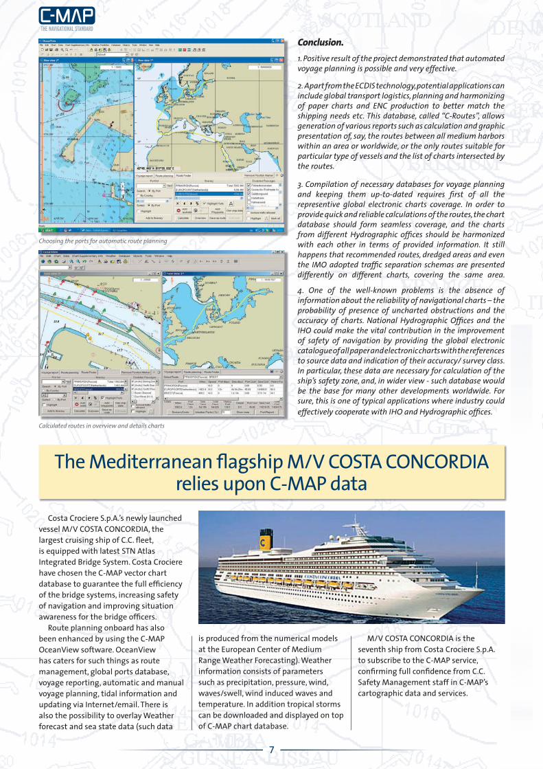
Calculated routes in overview and details charts
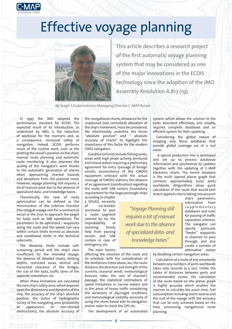
Choosing the ports for automatic route planning

C-MAP Norway ASP.O.Box 212N-4379 EgersundNORWAY
About C-MAP C-MAP develops and markets a global Nautical Information service specifi cally designed to meet the needs of merchant marine vessels operating worldwide. C-MAP distributes the industry’s most complete portfolio of offi cial Electronic Nautical Chart (ENC), branded C-MAP ENC, Offi cial. In addition, C-MAP provides the world’s largest commercially vector chart database, branded C-MAP ProfessionalPlus. Both databases are backed up by online updating, called the Real Time Updating Service. C-MAP offers in extention weather information, route planning and other navigational services all included in the Nautical Indformation Service. The majority of ECDIS, ECS, Vessel Traffi c Control and Fleet Management Systems read and display C-MAP digital chart and information data.
C-MAP UPDATE The UPDATE Newsletter is published by C-MAP Norway AS. For further contact:
Willy ZeilerMarketing Manager
C-MAP NORWAY ASP.O.Box 212, N-4379 Egersund
NORWAYTlf.: +47 51 46 47 00Fax: +47 51 46 47 01
China Ocean Shipping Group Company or, COSCO as it’s normally called for short, is dedicated to the commitment of a safer, faster and more reliable service. After more than 40 years of development, the group owns and operates 600 modern merchant ships with a total carrying capacity of up to 35 million DWT. Earlier this year C-MAP Norway signed a contract with COSCO to join forces where the company will be testing a total navigational information package being developed by C-MAP Norway.
COSCO has ranked fi rst in the international bulk shipping sector for years and is also being listed as one of the Top 10 container line operators in the world. Ships and containers with the conspicuous “COSCO” logo are shuttling between 1,300 ports in more than 160 countries and regions, and handle 180 million tons of cargo per year. COSCO has a variety of ship categories including container vessels, dry bulk carriers, oil tankers, general cargo ships, heavy-lift carriers and specialized vessels. This, together with tonnage supply in various size ranges, makes it possible for COSCO to deal with complicated problems in the course of international shipments. The active involvement of COSCO in international trades guarantees a healthy and sustainable operation of global supply chain networks. COSCO helps to carry out the transfer of valuable commodities in a high-quality and economical way.
C-MAP Norway is a leading player within the electronic chart industry and as e-navigation is expanding and being adopted by mariners, the need for an extended service is evident. Being at the forefront of the industry allows C-MAP Norway to be able to offer a complete range of products and services necessary for safe navigation at sea. The One Stop Shop concept offering a total navigational package from a single supplier, coordinated and streamlined, is the central part of the Nautical Information Service (NIS) project, which is currently under development by C-MAP Norway.
“To achieve our visions, we need to liaise with the market and the industry to get valuable user feedback in order to be able to develop products and services suitable for the market. It is therefore gratifying that C-MAP Norway has reached an agreement with the COSCO group to partnership in the development of the NIS project” says C-MAP Norway President and CEO, Tor A. Svanes. “It confi rms that C-MAP Norway is on track and proves our position as a leader in the navigational industry”.
OCEANVIEW SYSTEM FOR GREAT EASTERN
Great Eastern Shipping is a premier shipping company in India. It owns a fl eet of Bulk Carriers, Oil Tankers, Offshore Support vessels and other auxiliary vessels. Recently their management has acquired the Oceanview system with worldwide coverage of vector charts. Capt. Venkatesh Kailash, GM(Ops) expressed satisfaction with the performance of the system. He said that in an emergency the Oceanview system met a crucial requirement of providing accurate charts of the area. The charts are always kept updated through C-MAP’s Real Time Updating system. We hope in such a situation the company’s reaction time will not only be faster but will also improve on account of the features available with Oceanview’s GIS.
Vicepresident Ma Guichuan in COSCO Group and Tor A. Svanes, President and CEO of C-MAP Norway at COSCO headquarter in Beijing
COSCO vessels test new navigation service from C-MAP