by henry simmons - · pdf fileby henry simmons the exploration of tectonic scars on dry ......
TRANSCRIPT
by Henry Simmons
The exploration of tectonic scars on dry land is revealing the sideways thrysting of older rock over latter-day sediments and a new notion of how mountains came to be.
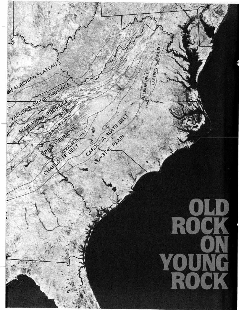
Tectonic scars. Geological belts in the southern Appalachian Mountains span the ill-defined boundary that once marked the shore of the North American continent.
The startling, rapid-fire advances in scientific u n d e r s t a n d i n g of the earth 's complex crustal processes
owe as much to the development of powerful investigative techniques for looking deep into the earth's crust as they do to the emergence in the last decade of p rofound new concepts like seafloor spreading and plate tectonics. Nowhere has this interaction of technique and theory been more productive than in the study of the southern Appalachians, a region that has confounded and vexed geologists since the late nineteenth century.
Geologists seem finally to be cracking the m y s t e r y of h o w the A p p a l a c h i a n s were formed. In the process they are illuminating many other outstanding problems in the workings of tectonic processes at con t inen ta l marg ins . T h e work has important implications not only for unders t and ing of the specific processes tha t have shaped many other regions of the earth but also for unraveling the record of plate movements now preserved only in present and former continental margins.
Since the 1890s, field geologists of the U.S. Geological Survey have repor ted evidence from widely separated areas in the southern and mid-Appalachians indicating large-scale horizontal thrust ing of crystalline rock over sedimentary s t ructures . Similar evidence of great lateral thrust movements was found in the Alps, in the Rocky M o u n t a i n s , and in o the r thrust belts. But how important a role did this play in continental tectonics? Until the 1950s, the view prevailed that while horizontal processes indeed occurred, the more important processes were v e r t i c a l -mounta in chains, plains, and valleys could all be broadly understood as the result of uplif t , subs idence , erosion, depos i t ion , and the like. Uplift was not well understood, but it was presumed to have something to do with forces operating deep within the earth.
In the 1950s and 1960s, however— decades of great ferment in g e o l o g y -horizontal rather than vertical movement came to be seen as the primary driver in geodynamic processes. First came the concept of seafloor spreading and then its e labora t ion into the theory of p la te tectonics . Accord ing to the seafloor-spreading concept, new oceanic crust is manufactured at divergent margins (the mid-ocean ridges), and it is consumed at the convergent margins (the deep-ocean trenches), where one great plate subducts or plunges beneath another. These margins delineate some 20 great lithospheric plates
that make up the earth's crust and float restlessly on the hot, viscous upper mantle of the earth. The plates are only a few tens of ki lometers thick beneath ocean basins, but they are much thicker, perhaps one hundred kilometers or more, beneath the less dense cont inenta l land masses. One important implication of this model is that ocean basins continually open and close as the plates move. Another implication is that whereas the generally denser oceanic basalts subduct beneath continental margins, lighter sediments and other materials tend to accrete onto continental margins during plate collisions. (See "Ocean Margins, the Scars of Creation," Mosaic, Volume 12, Number 2.) Oceanographers soon gathered decisive evidence confirming the new model at spreading zones like the Atlantic's mid-ocean rift, where new crust is continually forming. This was a tremendous advance—perhaps the mos t important achieved so far in twentieth-century geology.
Oceanic crust makes up 70 percent of the earth's surface. Unfortunately, on the scale of geologic time the ocean crust is evanescent. The earth is 4.6 billion years old, and the oldest known continental rock is about 3.8 billion years of age. But because it is cont inua l ly being created and destroyed, oceanic crust can carry a record of only the last 200 million years of geological h is tory , which is about 4 or 5 percent of the total span.
The geological record in oceanic crust can be tracked back that far, to about the time the Atlantic opened to separate the Eastern from the Wes te rn Hemisphere . The very oldest extant oceanic crust was spawned at the Mid-Atlantic Ridge some 200 million years ago. The crust that contains that record today is lodged against passive continental margins, beneath many kilometers of sediments. According to tectonic theory, it is ripe to begin active sub-duction. Even if deeply buried crust were accessible to ocean-floor drilling, however, it would remain mute as to events of more than two hundred million years ago. The bulk of the record of geological and tectonic h is tory , therefore, resides in the continental blocks. But the interpretation of plate interaction with the continental land masses is far more complicated than it is for oceanic crust.
Wilson et al.
Most in te rpre ta t ions of cont inenta l tectonic processes take as their starting point wha t is called the Wilson cycle, named for J. Tuzo Wilson, who proposed
MOSAIC March/April 1983 25
that a number of peculiar continental units in eastern and western North America are the consequence of the opening and closing of ocean basins. During this process, according to the hypo thes i s , i t inerant blocks, or terranes, that originated elsewhere—island arcs, microcontinents, and possibly huge continental land masses like Europe, Africa, and South A m e r i c a -became attached to the proto-North American block along suture zones. It was not clear what forms a suture zone might take,
Simmons is a science writer based in
Washington.
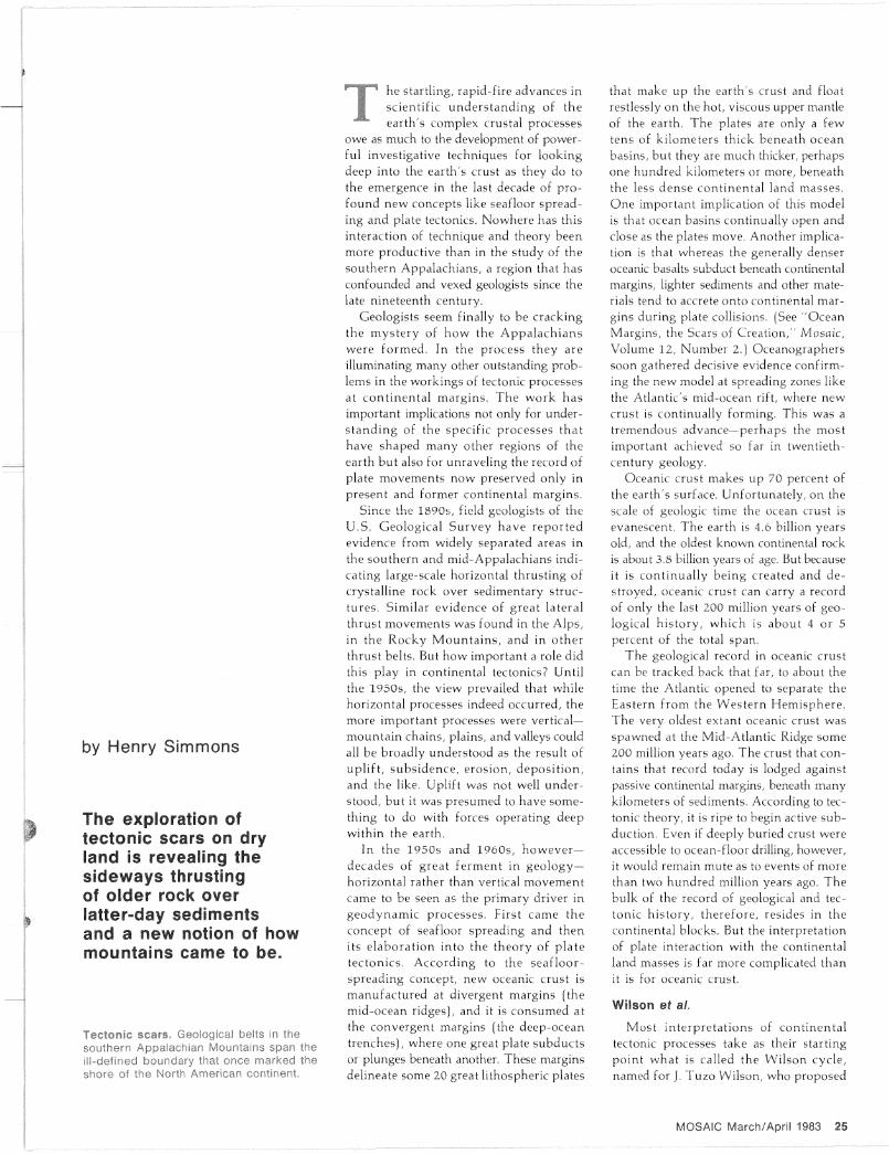
Up ciose, An enlarged section of a folding sequence shows an overlying thrust sheet (color) that dragged layers of sedimentary rock along with it, This section represents a "window" in the idealized sequence (right) of the kind of folding and overthrusting that might have led to the formation of the southern Appalachian Mountains.
but linear mountain chains like the Appalachians seemed the likeliest.
Paleomagnetic studies have shown that this W i l s o n i a n form of accretion does indeed occur in western North America. Wrangellia, Stikinia, Alexander, and several o ther i t inerant terranes have been
identified as having formed at very different latitudes from those of the continental rocks in which they are embedded today. (See "Before P a n g e a / ' Mosaic, Volume 12, Number 2.) There is also paleomagnetic evidence that the same process occur red in coastal N e w England and Canada . There , a 600-mi l l ion-year-o ld continental fragment called Avalon has been discovered that bears a greater affinity to rocks on the eastern side of the Atlantic than to the North American formations with which it lodges today.
Unfortunately, paleomagnetic techniques are of limited usefulness in regions like
26 MOSAIC March/April 1983

the Appalachians, where most of the rocks are highly metamorphosed. Appalachian rocks have been subjected to great heat and pressure during several compressive episodes since their first crystallization. As a result/ their original paleomagnetic signature has been destroyed. With a very few exceptions, it is not possible to determine the latitude at which they first crystallized.
One of the first to propose horizontal thrusting in the western Appalachians was George Washington Stose of the Geological Survey. In 1893, he found that carbonate rocks exposed in a window called Cade's Cove in eastern Tennessee were younger than the overlying Precambrian crystalline rock, and that the contact between the two was a thrust fault. In other words, the overlying, older rock was not rooted, but was loose and had somehow been thrust over the younger rock. By the 1920s, Stose and his wife, Anna Jonas Stose, showed that a similar phenomenon had occurred at the Grandfather Mountain window on the eastern side of the Blue Ridge. There, the hard crystalline rock had been eroded away to expose the folded and compressed younger sediments beneath. i
The extent of the horizontal movement was first suggested by Samuel Root, then with the Pennsylvania Geological Survey, in reports published in 1970 and 1973. Root suggested that the basement rocks beneath the Blue Ridge were loose and and that they had moved westward some 80 kilometers. In other words, the overlying, westward-thrusting crystalline rock had fractured, folded, and dragged the underlying, younger slabs to the west.
As is the case with so many controversies in science, data were needed, to constrain the proposed models. Lacking data, geologists had to fall back on intuition and their understanding of physical processes.
An Appalachian profile
In the quest for data, a technique had to be found for looking deep into the jumbled Appalachians—a way to probe for subsurface structure that might weave sketchy surface observations into a coherent whole. The problem was solved in a spectacular way over the past several years by a technique drawn from exploratory geophysics. Called common-depth-point-reflection seismic profiling and originally developed to search for petroleum, the so-called Vibroseis technique employs sound waves from many directions to map subsurface structure. Techniques of X-ray
Seismic-reflection profiling
A se.smxc-reflect.on profiling crew m ^ ^ S s c a p e ^ ^ n e end as a long scrawny caterpillar, mching its way acrc*^ t h u m p e r s t h a t drive o the p'rocessron are several truck-mounted^Vib g e o p h o n e s , h
some energy into the earth N i ^ ^ s h a k e S , the rear geophon* fore or aft from the vibrators After « A » J » w h l l e the thumpers are brought forward and re-implanted for the
m 0 v e forward another 10 or 20 ™ t e « r e f l e c t l o n s from ™***™™ The geophones gather the faint seism* r ^ Q£ ^ 0
rocks to be recorded for later ^alysrs F r ^ J n a l s a sophisticated pro k a r a t e echoes of the bat-like chirping r e n t e d * h d gram executed on a powerful computer^ can rej ^ profile many fsolate the ones that return from real ^ wres ^ ^ u n d e r g r o u n d kilometers deep can be assembled pro-ding layering along a two-dimensional profile m dustry
Seismic exploration was pioneered by the P V l b r o se is , a pro
1 9 2 0 T f . r s t w'lth dynamite blasts i r L ^ ^ L s proved a strong rival pnetary technique of the Continental O 1 « J l t a more acceptebkm to the shot-hole technique partly a t l e a £ ^ exploration were dev oped densely populated areas [Both approaches to « * « ^ s t t u c tures)
l a / y " p r o b i n g deep ^ 7 ^ ^ 3 k c t « * ^ T X ^ c o S The subsurface depth probed by se sm c g ^ each secon
a function of the two-way travel time o f * * * « P Q l l company r ^ equtvalent to an average of three kJotnete«^ P ^ Unr.t for dnHmg j e search deeper than 12 to 15 kilometer* the ^ ^ g G e o log nology Seismic surveys in crystalline rock t.y ^ d e p t h s 0 a bout Survey and the Virginia Poly tech mc ns utute se ^ Qj 0 kilometers The Cocorp profiles w ^ U» ^ ^ s u f f n t o re. seconds attempt to reach depths o 6 0 » o f seismic wave abrup Y the Mohorovicic discontinuity There the p ^ ^ ^ thought th*
) u m p s from about ^ ^ K ^ ^ w h e r e it makes o n t ^ ^ discontinuity marks the b a s e ^ t h e ^ . i t has spotted * ^ the denser upper mantle The eocc> P o f t h e southern APP several of its surveys including the trave _ ^ ~
MOSAIC March/Apnl 1983 27
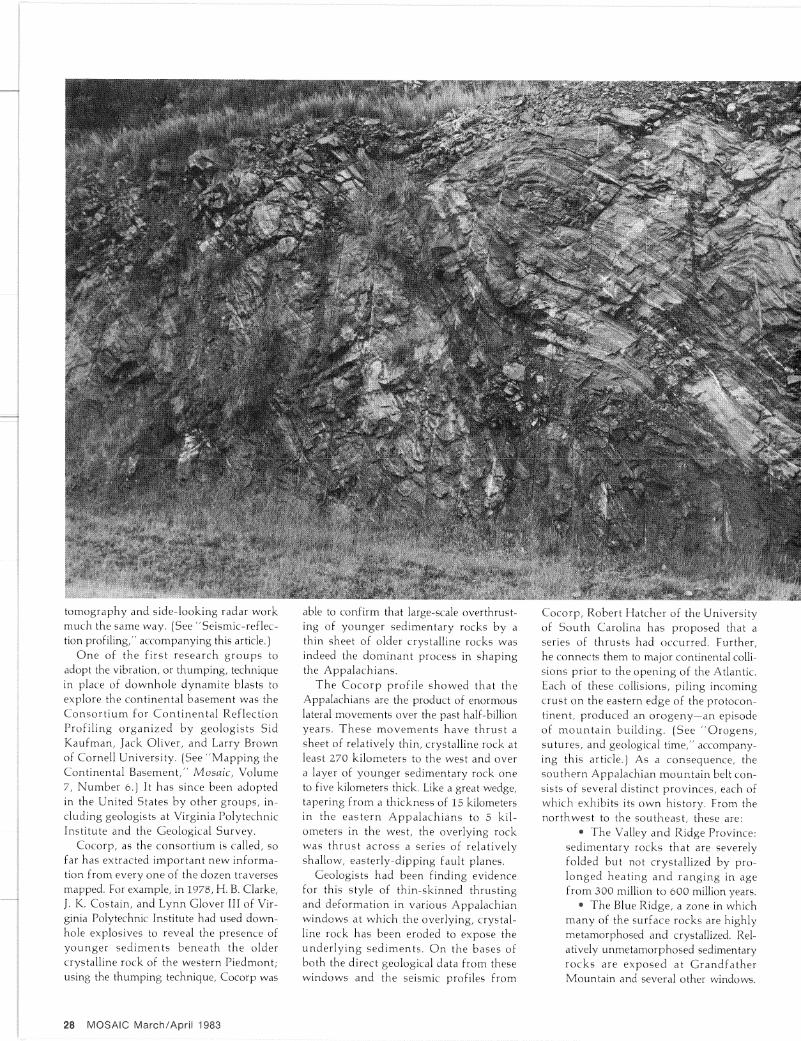
• ible to confirm that large-scale overthrust-ing of younger sedimentary rocks by a thin sheet of older crystalline rocks was indeed the dominant process in shaping the Appalachians.
The C o c o r p profile showed that the Appalachians are the product of enormous lateral movements over the past half-billion years. These m o v e m e n t s have th rus t a sheet of relatively thin, crystalline rock at least 270 kilometers to the west and over a layer of younger sedimentary rock one to five kilometers thick. Like a great wedge, tapering from a thickness of 15 kilometers in the eas te rn Appa lach i ans to 5 kilometers in the west, the overlying rock was th rus t across a series of relatively shallow, easterly-dipping fault planes.
Geologists had been finding evidence for this style of thin-skinned thrusting and deformation in various Appalachian windows at which the overlying, crystalline rock has been eroded to expose the unde r ly ing sed iments . O n the bases of both the direct geological data from these windows and the seismic profiles from
Cocorp, Robert Hatcher of the University of South Carolina has proposed that a series of thrusts had occurred. Further, he connects them to major continental collisions prior to the opening of the Atlantic. Each of these collisions, piling incoming crust on the eastern edge of the protocon-tinent, produced an orogeny—an episode of m o u n t a i n bui ld ing . (See " O r o g e n s , sutures, and geological time," accompanying this article.) As a consequence, the southern Appalachian moun ta in belt consists of several distinct provinces, each of which exhibits its own history. From the nor thwest to the southeast , these are:
• The Valley and Ridge Province: sedimentary rocks that are severely folded but not crystallized by prolonged heat ing a n d r ang ing in age from 300 million to 600 million years.
• The Blue Ridge, a zone in which many of the surface rocks are highly metamorphosed and crystallized. Relatively unmetamorphosed sedimentary rocks are exposed at Grandfa ther Mountain and several other windows.
28 MOSAIC March/April 1983
tomography and side-looking radar work much the same way. (See "Seismic-reflection profiling/' accompanying this article.)
O n e of the first research g r o u p s to adopt the vibration, or thumping, technique in place of downhole dynamite blasts to explore the continental basement was the C o n s o r t i u m for Con t inen t a l Reflection Profiling organized by geologists Sid Kaufman, Jack Oliver, and Larry Brown of Cornell University. (See "Mapp ing the Continental Basement," Mosaic, Volume 7, Number 6.) It has since been adopted in the United States by other groups, including geologists at Virginia Polytechnic Institute and the Geological Survey.
Cocorp, as the consort ium is called, so far has extracted important new information from every one of the dozen traverses mapped. For example, in 1978, H. B. Clarke, J. K. Costain, and Lynn Glover III of Virginia Polytechnic Institute had used down-hole explosives to reveal the presence of younger sed iments benea th the older crystalline rock of the western Piedmont; using the thumping technique, Cocorp was
• The Brevard Zone. There has been much controversy about the nature of this linear feature, which extends some five hundred kilometers, from Alabama to Virginia. Some geologists have proposed that it represents an ancient transform fault, like the great San Andreas fault that bisects California, and that strike-slip movement along it was s ideways ra ther than overthrust ing. Others have held it to represent the tectonic suture where North Africa became welded to North America, about 260 million years ago.
• The Piedmont, consisting of several subzones: the Inner Piedmont— highly metamorphosed sedimentary rocks with some local volcanic intrusions like the Stone Mounta in and Elberton granites; the narrow Kings Mounta in belt, which seems to be the remnant of the closure of an ocean
bas in ; the Char lo t te Belt of metam o r p h o s e d sed imen ta ry rocks ; the Carolina Slate Belt of metamorphosed volcanics that appear to be the remnant of an island arc or a volcanically active continental margin; the coastal plain, containing sediments less than 200 million years old overlying a thick eastern wedge of the kind of crystalline rock that had been found thrust to the surface in the exposed Appalachians to the west.
T h e C o c o r p traverse—an almost unbroken, 500-kilometer line from Tennessee almost to Savannah , Georgia—profiled all or part of every province from the Valley and Ridge to the Carolina Slate Belt. The most prominent subsurface feature, found when the traverse began, was a series of southeasterly dipping reflectors of seismic signals. These extended from the Valley and Ridge to the Inner Piedmont, where
their depth increased nor thwes t to southeast from four kilometers to ten.
A Geological Survey team, Leonard and Ani ta Har r i s , Wallace de Wi t t Jr., and Kenneth C. Bayer, conducted two Vibroseis traverses across the southern Appalachians, well to the northeast of the Cocorp line, and to modest depths. " T h e y [Cocorp] were looking very deep, so they might see all the way down to the Moho [the divis ion between the ea r t h ' s crus t and mantle]," Leonard Harris explained in mid-1982, shortly before his death. "But that meant they had to lose some near-surface data. W e wanted to look In more detail at the upper part of the sedimentary layers beneath the metamorphics , so we could deve lop a regional s t r a t i g r a p h y . " The Geological Survey work not only confirmed the westward thrusting of a relatively thin crystalline sheet over the sedimentary layers but also showed that the westward displacement has folded and overlapped the under lying layers. Fur thermore , In data still being analyzed from a line along highway 1-64 extending from Staunton, Virginia, to the Chickahominy Swamp just east of Richmond, " w e see the same sedimentary rocks beneath the Blue Ridge, and wi th in the P i e d m o n t we see great subsurface megathrust systems extending eastward more than 150 kilometers," says the Geological Survey 's Wallace de Witt.
Another group, Costain, Glover, and Cabit Coruk of Virginia Polytech, ran a Vibroseis profile a b o u t 130 ki lometers south of the Survey profile, from Bates-ville on the geological crest of the Blue Ridge to the western edge of the Piedmont. It also it showed thin-skinned thrusting of c rys ta l l ine rock in a nor thwes te r ly direction over sedimentary rocks.
A model
South Carolina's Rober t Hatcher and the Cocorp group propose a scenario for the formation of the Appalachians that seems to account for the geological and tectonic evidence. Their model begins in the late Precambrian era, about 800 million years ago, when a vast rifting occurred in a megacontinent—a rift that may have split Laurentia (Eurasia) as well as Gondwana-land from the North American block. The rifting produced not on ly large, separating continents , but at least one large continental fragment as well, the Blue Ridge/ Inner P iedmont uni t . As ocean basins opened among these fragments and continents, the metamorphosed volcanic and sedimentary rocks that are found today in the Blue Ridge were deposited. They
MOSAIC March/April 1983 29
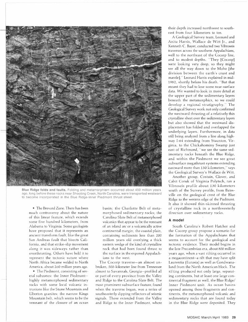
Blye Ridge folds and faults. Folding and mefamorphism occurred about 450 million years ago, long before these rocks near Shooting Creek, North Carolina, were transported westward to become incorporated in the Blue Ridge-Inner Piedmont thrust sheet.
were laid down in the ocean basin spreading between p r o t o - N o r t h America and the offshore unit destined to return as the Blue Ridge/Piedmont province of what are now the Appalachians.
The Blue R i d g e / I n n e r P iedmont is thought to have been a part of the Nor th American segment that broke away and later rejoined the continent. The Carolina Slate Belt to the southeast of it, however, appears to be an accreted terrane similar to Wrangellia, Stikinia, and others in the western United States. " T h e slate belt is now thought to be part of a separate micro-continent, Avalon, that formed 600 to 700 million years ago," Hatcher says. Pieces of Avalon may also be found in Rhode Island, Massachusetts , New Brunswick, Newfoundland, Wales, Brittany, northwest Africa, and Spain.
The tectonic processes that erected the Appalachians suggest a series of collisions with island arcs and continental fragments
rather than a single gigantic impact with another large continental block. These collisions occurred at intervals roughly 100 million years apart. After each collision, a long period of quiescence ensued, and erosion wore down the mountain chains. Sediments accumulated to great thicknesses in shallow seas east and west of the mountain ranges; those in the east provided new material to be heaped back on proto-North America in the next collision.
According to the Cocorp model, vol-canism began some 700 to 740 mil l ion years ago in the island arc that contained today ' s Carol ina Slate Belt. To Glover , this indicates the subduct ion of an oceanic plate. About 500 million years ago, the shal low basin s epa ra t ing p r o t o - N o r t h America from the Blue Ridge/Piedmont fragment began to close, and subduct ion began beneath its western side. Hatcher and the Cornell g roup suggest that this eas tward-dipping subduct ion preserved
the sediments found beneath the overlying crystalline rock in today's Appalachians . A w e s t w a r d - d i p p i n g s u b d u c t i o n zone would have des t royed the sed imen ta ry rocks through volcanism.
T h e n , be tween 450 and 500 mill ion years ago, part of the Blue Ridge/Piedmont fragment overrode the eastern margin of proto-North America, In wha t Is called the Taconic orogeny. The fragment pushed the sediments of its western margin onto the protocontinent. Thin-skinned thrusting of the crystalline rock of the Blue Ridge/ Piedmont fragment also began at this time as it pushed westward up and over the sedimentary rocks of the protocont inent ' s eastern margin.
The second pulse of Appalachian mountain building, called the Acadian, occurred about 370 million years ago. Mounta ins were thrown up then by the closing of the ocean separa t ing the Blue R idge / Inner Piedmont margin of eastern Nor th
Orogens, sutures, and geological time
Central to the idea of plate tectonics is that, over time, continents accrete new land mass at their margins. This process has been verified by identifying a number of apparently itinerant terranes lodged in western North America. For the past 100 million years at least, since the mid-Cretaceous, the Pacific plate has been sides wiping the North American block. Near-intact terranes have slid onto the continent. Al though banged and dented, once-migrant terranes display both paleontological and paleomagnetic evidence that they formed at far different latitudes and times from the rocks in which they are embedded. Definite contacts, or sutures, can be identified in the West between the older parts of the Nor th American craton and the newcomers.
Eastern North America, too, has accumulated terranes. Instead of sliding into the North American block along linear transform faults, however, the itinerants that arrived from the east seem to have engaged in a series of head-on collisions. The Appalachians are one result. Crustal subduct ion and volcanism heat the incoming island arcs and continental fragments so intensely that much of the new rock is heavily metamorphosed and recrystallized. The original paleomagnetic signature of the latitude of its formation has been overprinted by this recrystallization, so its latitude of formation cannot readily be determined. Similarly, any fossil record it might have contained has been erased by metamorphism.
Nevertheless, three collisions that took place during some three hundred million years or more in the Paleozoic era have been identified. Each collision produced a pulse of mountain building. No trace of the first two pulses is visible in the topography of the Appalachians; the mountains have been so worn down by erosion that only their sedimentary remnants are detectable. The remnants of the third pulse still dominate the eastern topography. They are but feeble
reminders, however, of the more-than-alpine s ta ture the mountains must have had when arriving terranes crashed into the Nor th American block.
In order of arrival, the accreted terranes are the Taconic (480 to 440 million years ago), the Acadian (370 million years ago), and the Alleghenian (260 million years ago). Both the Taconic and the Alleghenian appear to be associated with virtually contemporaneous orogenies in the British Isles and Scandinavia and in western Europe.
Because these terranes , newcomers to eas te rn N o r t h America, tended to collide head-on, the orogenies they produced show extensive thrust faulting, in which the immigrant material has moved up-plane along shallow east- or southeast-clipping thrust faults. Geologists believe that the last of these orogenies, the Alleghenian, marks the collision and welding together of the Nor th American block into the megacon-tinent Laurentia (today's Eurasian block) and Gondwanaland (now South America, Africa, Australia, India, and Antarctica).
Presumably, a great suture should still mark the seam of this vast weld. The Brevard Zone, delineating the Blue Ridge and Inner Piedmont, had been thought to be this su ture , but proof comes hard. Seismic-reflection traverses have shown this to be a complex fault zone that cannot be traced nor thward from southern Virginia. Other sharply d ipping zones farther to the southeast have been proposed to contain the suture, also wi thout confirmation from seismic echoes.
Perhaps, considering the violent tectonic events that formed the mountains , the suture would be different from those found in western North America. Perhaps it is diffused within the triply overprinted crystalline rock of the overlying thrust sheet of the Appalachians, or within the folded and overlapping layers of sediments beneath the thrust sheet. Only a start has been made in unraveling these sticky quest ions .
30 MOSAIC March/Apr i l 1983
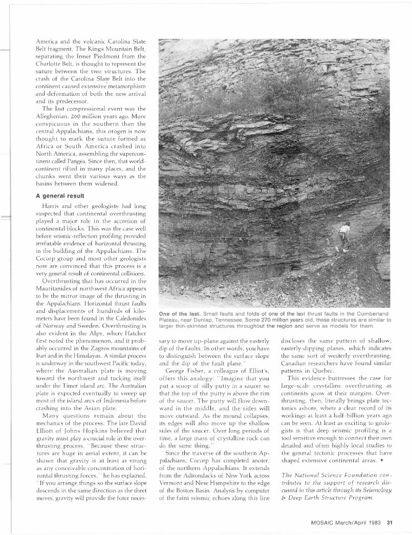
One of the last. Small faults and folds of one of the last thrust faults in the Cumberland Plateau, near Dunlap, Tennessee, Some 270 million years old, these structures are similar to larger thin-skinned structures throughout the region and serve as models for them.
America and the volcanic Carolina Slate Belt fragment. The Kings Mounta in Belt, separating the Inner Piedmont from the Charlotte Belt, is though t to represent the suture between the two structures. The crash of the Carolina Slate Belt into the continent caused extensive metamorphism and deformation of bo th the new arrival and its predecessor.
The last compressional event was the Alleghenian, 260 million years ago. More consp icuous in the s o u t h e r n than the central Appalachians, this orogen is now though t to mark the s u t u r e formed as Africa or Sou th Amer ica crashed into North America, assembling the supercon-tinent called Pangea. Since then, that world-continent rifted in m a n y places, and the chunks went their various ways as the basins between them widened.
A general result
Harris and other geologists had long suspected that continental overthrust ing played a major role in the accretion of continental blocks. This was the case well before seismic-reflection profiling provided irrefutable evidence of horizontal thrusting in the building of the Appalachians. The Cocorp group and most other geologists now are convinced that this process is a very general result of continental collisions.
Overthrust ing that has occurred in the Mauritanides of nor thwest Africa appears to be the mirror image of the thrusting in the Appalachians. Horizontal thrust faults and displacements of hundreds of kilometers have been found in the Caledonides of Norway and Sweden. Over thrus t ing is also evident in the Alps, where Hatcher first noted the phenomenon , and it probably occurred in the Zagros mountains of Iran and in the Himalayas. A similar process is underway in the southwest Pacific today, where the Aus t r a l i an plate is mov ing toward the northwest and tucking itself under the Timor island arc. The Australian plate is expected eventually to sweep up most of the island arcs of Indonesia before crashing into the Asian plate.
M a n y ques t ions r ema in about the mechanics of the process. The late David Elliott of Johns H o p k i n s believed that gravity must play a crucial role in the overthrusting process. "Because these structures are huge in aerial extent, it can be shown that gravity is at least as strong as any conceivable concentrat ion of horizontal thrusting fo rces / ' he has explained. "If you arrange things so the surface slope descends in the same direction as the sheet moves, gravity will provide the force neces
sary to move up-p lane against the easterly dip of the faults. In other words, you have to distinguish between the surface slope and the dip of the fault p l ane / '
George Fisher, a colleague of Elliot's, offers th is ana logy : " Imag ine that you put a scoop of silly put ty in a saucer so that the top of the put ty Is above the rim of the saucer. T h e put ty will flow downward in the midd le , and the sides will move outward. As the mound collapses, its edges will also move up the shallow sides of the saucer. Over long periods of time, a large mass of crystalline rock can do the same th ing . "
Since the traverse of the southern A p palachians, Cocorp has completed anoter, of the northern Appalachians. It extends from the Adlrondacks of New York across Vermont and N e w Hampshire to the edge of the Boston Basin. Analysis by computer of the faint seismic echoes along this line
discloses the same p a t t e r n of shal low, easterly-dipping planes, which indicates the same sort of westerly over thrust ing. Canadian researchers have found similar patterns in Quebec.
This evidence buttresses the case for large-scale crystalline over thrus t ing as continents grow at their margins . Overthrusting, then, literally br ings plate tectonics ashore, where a clear record of its workings at least a half-billion years ago can be seen. At least as exciting to geologists Is that deep seismic profiling is a tool sensitive enough to connect their own detailed and often highly local studies to the general tectonic processes that have shaped extensive continental areas. •
The National Science Foundation contributes to the support of research discussed in this article through its Seismology & Deep Earth Structure Program.
MOSAIC March/April 1983 31