by jeffrey w. bader
TRANSCRIPT

Assembling Laurentia
Precambrian Compressional Tectonics in North Dakota and Surrounding Areas
By
Jeffrey W. Bader
GEOLOGIC INVESTIGATION NO. 251 NORTH DAKOTA GEOLOGICAL SURVEY Edward C. Murphy, State Geologist Lynn D. Helms, Director Dept. of Mineral Resources 2021

i
Table of Contents
INTRODUCTION ............................................................................................................................................. 1
TRIAXIAL COMPRESSION ............................................................................................................................... 1
GEOLOGIC SETTING ....................................................................................................................................... 1
Precambrian Plate Tectonics......................................................................................................................... 2
Deformational Events (D1–D4) ..................................................................................................................... 2
The Wyoming Province and Laurentia .......................................................................................................... 6
DISSCUSSION ................................................................................................................................................. 8
REFERENCES ................................................................................................................................................ 10
Figures
Figure 1A. Triaxial test apparatus. ............................................................................................................... 2
Figure 1B. Triaxial deformation stress states schematic ............................................................................. 2
Figure 2. Proposed convergent deformation system at ~3.0 billion years ago ........................................ 3
Figure 3. Plate tectonic setting of Trans-Hudson orogen .......................................................................... 4
Figure 4. Schematic of possible Wilson Cycle. .......................................................................................... 5
Figure 5. Proposed convergent deformation system at ~1.8 billion years ago ........................................ 6
Figure 6. Tectonic map of western Dakotas uplift .................................................................................... 7
Figure 7. Proposed convergent deformation system at ~1.76 billion years ago ...................................... 8
Figure 8. Laurentia and convergent deformation zone ............................................................................ 9
Cover Photo: What Earth may have looked like in the Archean at 3.8 billion years ago (bing.com)

1
INTRODUCTION
As citizens of North Dakota, each day we leave our homes and venture outside into the prairie flatlands of
the Northern Great Plains. We generally don’t consider that we are situated in the middle of a major rock
mass of planet Earth: the continent of North America. It is important to know that this geographic
arrangement was not always so. In fact, it is difficult to comprehend that western North Dakota was once
the edge of the continent approximately 2 billion years ago. The state was then located along an open ocean
that eventually closed and the edge of the state was then dominated by Everest-like mountains (Mueller et
al., 2005; Bader, 2019a). Indeed, the fundamental geologic process behind our surroundings, plate
tectonics, is generally not part of our daily musing, especially for those of us riding along in the middle of
tectonic plates. However, as geologists, the tectonic history related to growth of the North American
continent is critical in understanding the geology of our state, and more specifically, the evolution of the
Williston Basin and generation of geologic resources such as petroleum. Integral to this understanding are
the rocks that form the foundation or “basement” below which we stand. In North Dakota, these are three
rock masses: one orogenic deformation zone (Trans-Hudson Province), and two major cratons (Superior
and Wyoming Provinces) (Bader, 2019a). The Superior Province underlies the eastern portion of North
Dakota, with the western side dominated by Trans-Hudson rocks. The Wyoming Province barely extends
into southwestern North Dakota. However, because the continent initially grew from the southwest, the
origin and evolution of the Wyoming Province is integral to understanding the specifics of the Precambrian
history of North Dakota, and in general, how the North American craton of Laurentia formed.
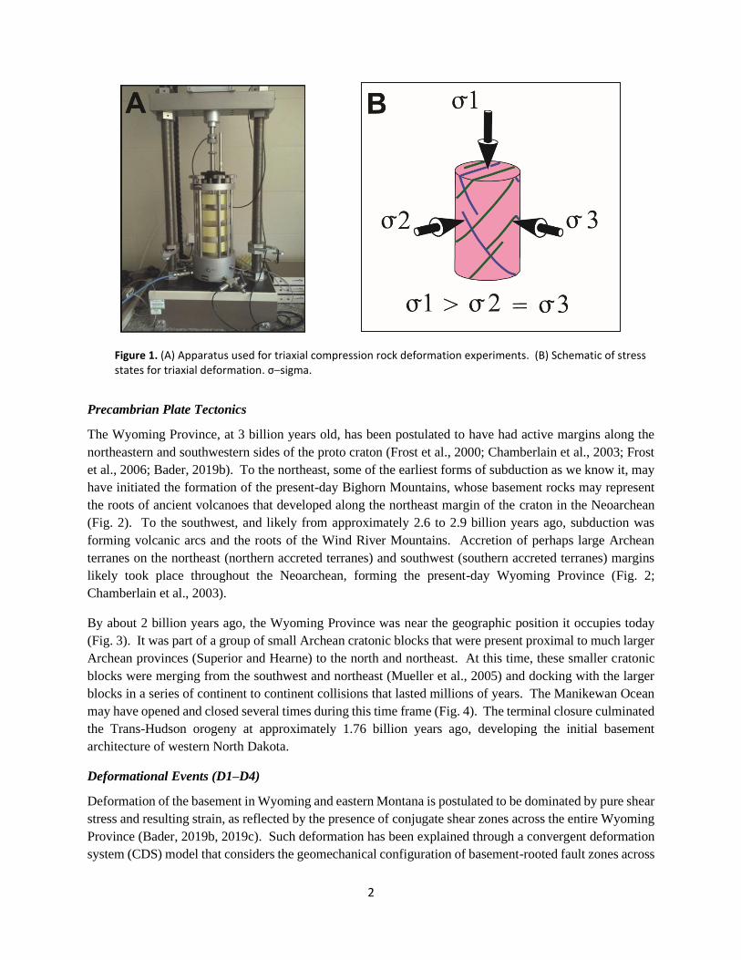
TRIAXIAL COMPRESSION
For continental masses to grow, crustal material must accrete to the continental margins through convergent
events at accretionary or collisional boundaries (subduction zones). Compressional forces at these
convergent boundaries are dominant and significant (Sylvester, 1988). Testing of such compression on
rocks is generally performed through triaxial compression tests that mimic rock behavior on Earth (Fig.
1A), generally with a small core of homogenous rock. The force exerted in this test is pure shear, that is,
non-rotational stress, with the principal horizontal stress (PHS) being dominant and parallel to the surface
of Earth. Rocks break in a predictable manner (conjugate shear fractures) as shown on Figure 1B, with
nominal variations in fracture angles generally related to rock type and heterogeneities. These tests have
been applied to larger rock masses to better understand stress/strain relationships that may affect our planet.
But, at what scales do the tri-axial tests apply? Recent studies of the Rocky Mountains of Wyoming and
Montana suggest that such testing may be applied at continental-scale levels (Bader, 2019b, 2019c) and
thus may be applicable to basement rocks of North Dakota.
GEOLOGIC SETTING
The origins of the Wyoming Province extend to beyond 3 billion years ago (Archean), when proto
continents initially formed on Earth (Corrigan et al., 2009; Bader, 2019a). At this time, the craton was a
thin sliver of rock that was located a great distance from its present-day position (Fig. 2), along with other
proto continents spread across the globe, separated by dominantly vast oceans and oceanic crust of early
Earth.
2
Figure 1. (A) Apparatus used for triaxial compression rock deformation experiments. (B) Schematic of stress states for triaxial deformation. σ–sigma.
Precambrian Plate Tectonics
The Wyoming Province, at 3 billion years old, has been postulated to have had active margins along the
northeastern and southwestern sides of the proto craton (Frost et al., 2000; Chamberlain et al., 2003; Frost
et al., 2006; Bader, 2019b). To the northeast, some of the earliest forms of subduction as we know it, may
have initiated the formation of the present-day Bighorn Mountains, whose basement rocks may represent
the roots of ancient volcanoes that developed along the northeast margin of the craton in the Neoarchean
(Fig. 2). To the southwest, and likely from approximately 2.6 to 2.9 billion years ago, subduction was
forming volcanic arcs and the roots of the Wind River Mountains. Accretion of perhaps large Archean
terranes on the northeast (northern accreted terranes) and southwest (southern accreted terranes) margins
likely took place throughout the Neoarchean, forming the present-day Wyoming Province (Fig. 2;
Chamberlain et al., 2003).
By about 2 billion years ago, the Wyoming Province was near the geographic position it occupies today
(Fig. 3). It was part of a group of small Archean cratonic blocks that were present proximal to much larger
Archean provinces (Superior and Hearne) to the north and northeast. At this time, these smaller cratonic
blocks were merging from the southwest and northeast (Mueller et al., 2005) and docking with the larger
blocks in a series of continent to continent collisions that lasted millions of years. The Manikewan Ocean
may have opened and closed several times during this time frame (Fig. 4). The terminal closure culminated
the Trans-Hudson orogeny at approximately 1.76 billion years ago, developing the initial basement
architecture of western North Dakota.
Deformational Events (D1–D4)
Deformation of the basement in Wyoming and eastern Montana is postulated to be dominated by pure shear
stress and resulting strain, as reflected by the presence of conjugate shear zones across the entire Wyoming
Province (Bader, 2019b, 2019c). Such deformation has been explained through a convergent deformation
system (CDS) model that considers the geomechanical configuration of basement-rooted fault zones across

3
Figure 2. Proposed convergent deformation system at ~3.0 billion years ago. PHS–principal horizontal stress, σ–sigma.
the craton, as well as the temporal constraints for Precambrian tectonism in both the Neoarchean and Paleo-
proterozoic. These events, as described here, are defined as D1 (oldest)–D4 (youngest).
The D1 event corresponds to convergence from the northeast along the northeastern margin of the proto-
Wyoming Province at approximately 3.0 billion years ago (Fig. 2). Subduction at this active margin likely
developed volcanic arcs oriented parallel to the continental margin, and deep-seated shear zones across
north-central Wyoming oriented north-northwest. In addition, conjugate shears likely developed in-board
of the continental margin, as reflected by basement-rooted fault zones that were last active during the
Laramide orogeny from approximately 80 to 40 million years ago, and possibly during post-Laramide
tectonism (Bader, 2019b, 2019c). Similarly, the D2 event resulted in conjugate shears along the southern
craton margin later in the Neoarchean. The northern accreted terranes (NAT) and southern accreted terranes
(SAT) were likely assembled during the 3.0-2.5 billion-year time frame.

4
Figure 3. Plate tectonic setting of the Trans-Hudson orogen showing major lithotectonic elements. Dashed line–Williston Basin, sawtooth line–ocean trench with sawteeth on upper plate, red triangles–volcanic island arc chain, black arrows–convergence direction. Modified from Mueller et al. (2005).
The D3 event corresponds to initial Trans Hudson orogenesis as the Manikewan Ocean began to close at
approximately 1.8 billion years ago (Figs. 4 and 5; Mueller et al., 2005; Whitmeyer and Karlstrom, 2007;
Corrigan et al., 2009; Bader, 2019c, 2021). Evidence for a significant landmass, likely a large
Paleoproterozoic island arc system, is apparent on isostatic gravity maps of the western Dakotas and eastern
Montana (Bader, 2020a). Initial docking of this terrane as well as docking of the Grouse Creek block from
the southwest is postulated to have fractured the NAT and SAT, as well as reactivating sinistral conjugate
shears within the core of the Wyoming Province. Reactivated Laramide basement-rooted shear zones of
eastern Montana and Wyoming provide indirect evidence for this event (Bader, 2019b, 2019c).

5
Figure 4. Schematic of possible Wilson cycle for Wyoming Province, Superior Province, and Trans-Hudson orogen. From Bader (2019a).

6
Figure 5. Proposed convergent deformation system at ~1.8 billion years ago. PHS–principal horizontal stress, σ–sigma.
Finally, the D4 event represents final closing of the Manikewan Ocean and terminal collision at the end of
Trans-Hudson orogenesis at approximately 1.76 billion years ago. Structures observed on the tectonic map
of the Western Dakotas uplift (Fig. 6; Bader, 2020b) reflect this event. At that time and post-D3,
convergence was more east-west directed, with north-south sutures likely reflecting convergence events
across the orogen as the Manikewan ocean opened/closed. The juvenile crust of the Trans-Hudson orogen
was also likely fractured into conjugate shear zones striking northwest and southeast during the terminal
docking event (Fig. 7; Anderson, 2011; Bader, 2020b). Again, such fracturing is consistent with a PHS
directed from the east, as is indicated by the orientation of the western Superior Province boundary.
The Wyoming Province and Laurentia
The basement core of North America is the Canadian shield. It developed in the Archean from 4.0–2.5
billion years ago (Fig. 8; Whitmeyer and Karlstrom, 2007). Trans-Hudson orogenesis included plate
collisions of large Archean continents, such as the Superior Province, along with smaller Archean
continental fragments such as the Wyoming Province, among others, as described above. The resulting

7
Figure 6. Tectonic map of Western Dakotas uplift and surrounding areas. From Bader (2020b).
collisional belt was similar in scale to the modern Himalayas (Bader, 2019a), with a significant convergent
deformation zone (CDZ) developed across Idaho, Utah, Wyoming, Montana, South and North Dakota, at
the southwest edge of Laurentia. Such collisional orogenesis may be considered triaxial compression on a
continental scale, beginning in the Neoarchean and continuing through Trans-Hudson orogenesis.

8
Figure 7. Proposed convergent deformation system at ~1.76 billion years ago. PHS–principal horizontal stress, σ–
sigma.
DISCUSSION
Finally, what does all this have to do with North Dakota? Firstly, the Wyoming Province is considered
basement rock present in the state of North Dakota, regardless of the “Wyoming” name. Secondly, because
Laurentia grew from southwest to northeast, evolution of the Wyoming Province is integral to development
of basement rock in western North Dakota. Lastly, commonalities between tectonic events in the Archean
and Proterozoic in Wyoming and Montana give insight into structures observed in basement rocks of North
Dakota. Such Precambrian structures formed in basement rocks can be reactivated millions of years later
under stress that is conducive to such movement. This stress can deform the sedimentary rocks that overlie
basement rocks forming traps for petroleum accumulation. Therefore, even though the Wyoming Province
barely underlies North Dakota, its tectonic history as part of a Precambrian convergent deformation system
undergoing pure-shear compression has had long-lasting effects on our state continuing to the present day.

9
Figure 8. Laurentia and Convergent Deformation Zone. Areas in gray are Canadian Shield. Large blue arrows–general direction of principal horizontal stress in the Neoarchean and Paleoproterozoic. σ–sigma, CDZ–convergent deformation zone, GCB–Grouse Creek block, MHB–Medicine Hat block, THO–Trans-Hudson orogen. Modified from Whitmeyer and Karlstrom (2007).

10
REFERENCES
Anderson, F.J., 2011, Structural relationships between surface lineaments and basement faulting in the
northeastern Williston Basin, in Robinson, J., Gaswirth, S., and LeFever, J.A., eds., The Bakken-Three
Forks petroleum system in the Williston Basin: Rocky Mountain Association of Geologists Guidebook,
p. 376-392.
Bader, J.W., 2019a, An ancient Everest – Precambrian basement terranes of the Williston Basin: North
Dakota Department of Mineral Resources Geo News, v. 46, no. 1, p. 30–34.
Bader, J.W., 2019b, Structural inheritance and the role of basement anisotropies in the Laramide structural
and tectonic evolution of the North American Cordilleran foreland, Wyoming: Lithosphere, v. 11, no.
1, p. 129–148.
Bader, J.W., 2019c, Structural inheritance for the Laramide, Central Montana Uplift – A wrench-fault
tectonic model related to Proterozoic orogenesis in the foreland of the North American Cordillera:
Northwest Geology, v. 46, p. 21–39.
Bader, J.W., 2020a, Wrench fault tectonics: North Dakota Department of Mineral Resources Geo News, v.
47, no. 1, p. 20–24.
Bader, J.W., 2020b, Tectonic map of the western Dakotas uplift and environs: North Dakota Department
of Mineral Resources Geologic Investigation 227.
Bader, J.W., 2021, Does the Owl Creek fault zone of north-central Wyoming extend to the Black Hills of
South Dakota: Implications for basement architecture of the Wyoming Province: The Mountain
Geologist, v. 58, no. 1, p. 27-37.
Chamberlain, K.R., Frost, C.D., and Frost, B.R., 2003, Early Archean to Mesoproterozoic evolution of the
Wyoming Province – Archean origins to modern lithospheric architecture: Canadian Journal of Earth
Sciences, v. 40, no. 10, p. 1357–1374.
Corrigan, D., Pehrsson, S., Wodicka, N., Kemp, E., 2009, The Palaeoproterozoic Trans-Hudson orogen –
A Prototype of modern accretionary processes: Geological of London Special Publications 2009, v.
327, p. 457–479.
Frost, B.R., Chamberlain, K.R., Swapp, S., Frost, C.D., and Hulsebosch, T.P., 2000, Late Archean structural
and metamorphic history of the Wind River Range – Evidence for a long-lived active margin on the
Archean Wyoming Province: Geological Society of America Bulletin, v. 112, no. 4, p. 564–5782.
Frost, C.D., Frost, B.R., Kirkwood, R., and Chamberlain, K.R., 2006, The tonalite-trondhjemite-
granodiorite (TTG) to granodiorite-granite (GG) transition in the Late Archean plutonic rocks of the
central Wyoming Province: Canadian Journal of Earth Sciences, v. 43, no. 10, p. 1419–1444.
Mueller, P.A., Burger, H.R., Wooden, J.L., Brady, J.B., Cheney, J.T., Harms, T.A., Heatherington, A.L.,
and Mogk, D.W., 2005, Paleoproterozoic metamorphism in the northern Wyoming Province –
Implications for the assembly of Laurentia: Journal of Geology, v. 113, no. 2, p. 169–179.
Sylvester, A.G., 1988, Strike-slip faults: Geological Society of America Bulletin, v. 100, no. 11, p. 1666–
1703.
Whitmeyer, S.J. and Karlstrom, K.E., 2007, Tectonic model for the Proterozoic growth of North America:
Geosphere, v. 3, no. 4, p. 220–259.