by john h. mossler and v.w. chandler

1
m lr m lr Op e w w e j j sl sl j sl sl j sl Op j Os Op sc sc cross section C–C' A A' m lr e Unconsolidated Quaternary sediment Phf Phf Pcv Pcv ? 1200 1000 600 800 400 200 0 -800 -1000 -1400 -600 -1200 -1600 -200 -400 -1800 -2000 -2200 -2400 Elevation (in feet,0 = sea level) lr m m e e e m w w w sc sc lr sl Op Kd Op j sl sl lr j j Op Op cross section C–C' 1200 1000 600 800 400 200 0 -800 -1000 -1400 -600 -1200 -1600 -200 -400 -1800 -2000 -2200 -2400 Elevation (in feet,0 = sea level) B B' Unconsolidated Quaternary sediment Unconsolidated Quaternary sediment sc sc sc m m e e sl lr e w j j sl w lr C C' cross section A–A' cross section B–B' ? 1200 1000 600 800 400 200 0 -800 -1000 -1400 -600 -1200 -1600 -200 -400 -1800 -2000 -2200 -2400 Elevation (in feet,0 = sea level) Pcv Phf Phf Phf Phf Phf Pcv Pcv Mt. Simon Sandstone approximately 160-210 thousands Jordan Sandstone St. Peter Sandstone 2 St. Lawrence Formation Lone Rock Formation Wonewoc Sandstone Eau Claire Formation Upper Cambrian (501-488 m.y.) MESOPROTEROZOIC (1200-900 M.Y. AGO) 80-100 40-50 120-140 45-70 65-75 j Op sl Os G G G G G G G G G G G G G G G G G G G G Prairie du Chien Group Undivided Lower (488-478 m.y.) Middle (458 m.y.) PALEOZOIC 130-160 G G G Birkmose Member Reno and Tomah Members lr w e m Phf Chert Oolites Glauconite Algal domes; stromatolites Fossils (not used in dolostone units) Worm bored Pebbles (gravel in unconsolidated units) Flat-pebble conglomerate Cross-bedded (festoon) Cross-bedded (planar to tangential) Ripple cross-laminations Dolomitic Calcareous Contact marks a major erosional surface Facies change Siltstone Shale Dolostone Sandstone Sandy dolostone Very fine- to fine-grained Medium- to coarse-grained Shaly Fine- to medium-grained Era System-Series 1 Group, Formation, Member Map symbol Lithology Lithostratigraphic unit Composite natural gamma log API-G units 0 100 Increasing count Thickness (in feet) Lithology Key G sc 35 MESOZOIC OR PALEOZOIC (age unknown) Ordovician MESO- ZOIC Cretaceous (95 m.y.) Kd PMu Dakota Formation Unnamed 150-200 15-80 1 Numerical ages from Cooper and Sadler (2004), Ogg and others (2004), and Shergold and Cooper (2004). 2 Maximum thicknesses where overlain by the succeeding bedrock unit in the stratigraphic column except for the St. Peter Sandstone and Dakota Formation, which are everywhere overlain by Quaternary glacial deposits. A range of values is given for all bedrock units because their thicknesses vary across the county. Middle Cambrian (504-501 m.y.) SIBLEY COUNTY HENNEPIN COUNTY HENNEPIN COUNTY MCLEOD COUNTY MCLEOD COUNTY SCOTT COUNTY SCOTT COUNTY T. 117 N. R. 24 W. R. 23 W. T. 116 N. T. 115 N. T. 114 N. R. 24 W. R. 25 W. T. 114 N. R. 26 W. T. 115 N. T. 116 N. T. 117 N. R. 26 W. R. 25 W. 44°45' N. 93°45' W. 93°45' W. 94°00' W. 94°00' W. 44°45' N. 1 6 31 36 1 6 31 36 6 1 6 2 31 36 1 6 31 36 6 1 13 30 6 18 31 1 6 36 31 36 1 36 31 6 31 6 31 36 31 1 6 36 1 1 6 1 6 HOLLYWOOD WATERTOWN CAMDEN WACONIA YOUNG AMERICA BENTON HANCOCK LAKETOWN DAHLGREN SAN FRANCISCO Lake Oak Mud Lake Swede Lake Buck Lake Waconia Lake Hydes Lake Rice Lake Eagle Lake Rutz Lake Lippert Lake Campbell Lake Tiger Lake Brand Lake Barnes Lake Myers Lake Young America Lake Maria Lake Winkler Lake Benton Lake Parley Lake Lunsten Lake Lake Pierson Lake Reitz Lake Riley Lake Rice Lake Stone Lake Miller Lake Gaystock Lake Aue Lake Chaska Lake Lake Lucy Long Lake Lundquist Lake Scott Lake Kelly Lake Berliner Lake Wassermann Lake Hazeltine Lake Susan Lake Lake Goose Lake Auburn Zumbra Stieger Lake Lake Lake Lake Ann Lake Lotus Bavaria Minnewashta Lake Burandt Lake Lake Schutz Minnetonka Lake Virginia Sunny Lake Carl Krey Lake Turbid Lake Mi n n e s o t a Bluff F or k River River South Crow Ditch Creek Ditch No. 4 Joint No. 1 Creek Bevens Bevens Chaska Creek Creek Assumption Creek Silver Ditch No. 6 Judicial Joint Waconia Watertown Mayer New Germany Hamburg Norwood Young America Cologne Victoria Chanhassen Chaska Carver Carver Creek Carver Creek Creek Benton 212 212 7 7 25 25 5 5 284 101 41 25 5 SIBLEY COUNTY WRIGHT COUNTY WRIGHT COUNTY 280 260 240 220 300 320 300 300 300 300 300 300 300 300 300 300 300 320 300 280 300 300 280 300 300 300 300 300 300 300 280 300 300 300 280 220 300 280 280 300 300 300 300 300 300 300 300 300 300 300 300 300 300 300 280 320 300 300 300 300 300 300 280 280 300 300 300 300 300 300 300 300 300 300 300 300 300 300 300 300 300 280 300 260 300 300 300 300 300 300 300 300 300 260 300 280 300 300 300 280 320 300 320 280 300 300 260 300 300 300 300 300 280 300 300 280 300 300 300 300 300 280 300 300 300 300 280 300 300 300 300 300 300 300 300 260 300 300 300 280 280 280 300 300 320 300 280 300 300 300 280 300 300 300 300 300 300 260 500 475 475 525 550 575 425 375 350 325 400 650 300 600 625 750 775 675 725 700 650 650 450 650 775 725 425 650 650 625 500 575 350 475 550 600 450 450 700 625 550 700 575 550 575 650 475 600 625 525 575 525 450 425 500 425 400 600 575 525 500 400 600 375 400 625 550 550 450 425 600 550 650 575 425 600 525 600 750 450 550 F M F F A C C' A' B B' sl lr lr j lr j j j lr lr PMu j lr sl Op lr w j Op e Op j sl j m w sl e sl w j lr sl sl lr lr j w w Op e j lr w sl j j sl e j sl Op j Kd lr m Op Op lr sl sl Op j j Op sl w j Op lr e sl j Os lr w lr sl Op sl sl Kd Op sl Os Op sl sl Kd lr Op e Op Op j w Kd Os Op e w sl w sc sl sl sc Kd sl sl e sl w Os m Os Kd lr sc j j sl sl w U D UD UD U D U D U D U D U D U D U D U D U D U D U D U D U D U D Prepared and Published with the Support of THE CARVER COUNTY BOARD OF COMMISSIONERS AND THE MINNESOTA DEPARTMENT OF NATURAL RESOURCES, DIVISION OF WATERS BEDROCK GEOLOGY By John H. Mossler and V.W. Chandler 2009 Digital base modified from the Minnesota Department of Transportation BaseMap data; digital base annotation by the Minnesota Geological Survey. Elevation contours were derived from the U.S. Geological Survey 30-meter Digital Elevation Model (DEM) by the Minnesota Geological Survey. Universal Transverse Mercator Projection, grid zone 15 1983 North American Datum COUNTY ATLAS SERIES ATLAS C-21, PART A Plate 2—Bedrock Geology GEOLOGIC ATLAS OF CARVER COUNTY, MINNESOTA ©2009 by the State of Minnesota, Department of Natural Resources, and the Regents of the University of Minnesota The University of Minnesota is an equal opportunity educator and employer MINNESOTA GEOLOGICAL SURVEY Harvey Thorleifson, Director GIS compilation by R.S. Lively Edited by Lori Robinson CONTOUR INTERVAL 20 METERS 1 0 1 2 3 4 5 MILES 8 KILOMETERS SCALE 1:100 000 1 0 1 2 3 4 5 6 7 LOCATION DIAGRAM Every reasonable effort has been made to ensure the accuracy of the factual data on which this map interpretation is based; however, the Minnesota Geological Survey does not warrant or guarantee that there are no errors. Users may wish to verify critical information; sources include both the references listed here and information on file at the offices of the Minnesota Geological Survey in St. Paul. In addition, effort has been made to ensure that the interpretation conforms to sound geologic and cartographic principles. No claim is made that the interpretation shown is rigorously correct, however, and it should not be used to guide engineering-scale decisions without site-specific verification. INTRODUCTION The bedrock geology map portrays the distribution, structure, and kinds of uppermost bedrock units that are exposed at the land surface or lie directly beneath unconsolidated deposits of Quaternary age. It shows how the bedrock would appear if it were viewed from above and all the overlying unconsolidated materials were stripped away. The bedrock geologic cross sections add a third dimension and show how bedrock layers would appear if exposed in deep trenches cut to depths of hundreds of feet below the land surface. Some of the layers are very thin compared to their areal extent, and it is necessary to use a vertical dimension ten times horizontal distance to show these units. The uppermost bedrock across Carver County consists mainly of Paleozoic rocks, with minor Mesozoic and Mesoproterozoic rocks. Few bedrock outcrops occur in the county because of the thick cover of Pleistocene glacial deposits and Holocene alluvium, therefore bedrock geology must be generalized from available water well and geophysical data. The geology of the Paleozoic and Mesozoic rocks is largely based on descriptions from water well drillers' logs, geologist's descriptions of water well cuttings, down-hole geophysical logs, engineering borings records, and previous bedrock mapping (Runkel, 1993). Relatively few water wells penetrate Precambrian bedrock in Carver County and geologic interpretations, such as those illustrated on the cross sections, rely primarily on aeromagnetic and gravity data (Chandler, 2009). These data are particularly useful for mapping Precambrian rocks in the region, which are associated with strong contrasts in density and magnetization (Chandler and others, 2008). The Data-Base Map (Plate 1) shows the distribution of data used for constructing this map. For site-specific studies in Carver County, it is best to consult current data at the Minnesota Geological Survey, because acquisition of subsurface data is a continuing process and new data may have become available after publication of this map. The uppermost bedrock across Carver County is mostly sedimentary rock units of Paleozoic age that are characterized by relatively thin (less than 200 feet [61 meters]) but widespread layers dominated by sandstone, shale, or dolostone (Fig. 1). Individual layers are designated as formations or groups (Fig. 1), such as the Mt. Simon Sandstone or Prairie du Chien Group. The oldest Paleozoic formations (Cambrian) are dominated by siliciclastic sedimentary rock—sandstone, siltstone, and shale; carbonate rock occurs only as relatively thin layers in the lower parts of the Lone Rock Formation and in the St. Lawrence Formation. Younger Paleozoic bedrock of Ordovician age, in contrast, is dominated by carbonate rock, such as the dolostone of the Prairie du Chien Group, locally capped by thin, eroded patches of St. Peter Sandstone. The Paleozoic bedrock formations were deposited as sediment in shallow seas that covered the region from about 504 to 458 million years ago. Deposition occurred in the Hollandale embayment: a shallow shelf that extended north from what is now central Iowa, into southeastern and south-central Minnesota from deeper marine waters that covered most of central North America during the early and middle parts of the Paleozoic era. As older layers of sediment were buried by succeeding layers, they gradually consolidated and lithified into rock: limestone, dolostone, siltstone, shale, and sandstone. Paleozoic bedrock units younger than the St. Peter Sandstone found farther south and east in Minnesota and neighboring states likely were deposited in Carver County; however, during the long intervals when the region was dry land, these rocks were eroded from the area. There is a sequence of sandstone and claystone of uncertain, possibly Mesozoic age, in northwestern Carver County that unconformably overlies the Upper Cambrian rock and in turn is unconformably overlain in places by a thin layer of sandstone of Cretaceous age. The Cretaceous sandstone was deposited on an alluvial plain that bordered a shallow epicontinental sea that covered much of the western interior of North America during the Late Cretaceous period. Both these units have limited distribution in the county. Paleozoic bedrock lies on a thick sequence of Mesoproterozoic rocks of the Keweenawan Supergroup that was deposited in the Midcontinent rift. The rift formed during a thermo-tectonic event 900 to 1,200 million years ago that involved extension of the earth's crust in the area, with concurrent faulting, mafic volcanism, plutonism, and later deposition of a thick sequence of sediments (Chandler and others, 1989; Hinze and others, 1997). The rocks of the rift in Carver County include rocks of the Chengwatana Volcanic Group, mainly basalt, red to brown shale, siltstone, and arkosic to lithic sandstone of the Solor Church and Fond du Lac Formations, and quartzose sandstone of the Hinckley Sandstone. Faulting and broad folding locally disrupted the layering and distribution of Paleozoic rocks in Carver County. A large horst (a large, relatively uplifted crustal block that is bounded by faults along its long sides) crosses the center of the county. East of the horst structure, contours drawn on the tops of Paleozoic formations indicate that the strata are dipping gently to the east (less than 2°), toward the Twin Cities metropolitan area, as part of the southwestern margin of a shallow structural depression named the Twin Cities basin. West of the horst, the strata are dipping gently toward the southeast. The subcrop distribution in eastern and western Carver County reflects this pattern: the youngest Paleozoic rocks are in the easternmost and southwest parts of the county. This structural grain is also depicted by the structure contours on the top of the Wonewoc Sandstone, which have their lowest values in the eastern and southwestern parts of the county. The unnamed unit of Paleozoic or Mesozoic age and the Cretaceous Dakota Formation do not have distributions that correspond to the structural grain, which may indicate most of the folding and faulting predates their deposition. Their distribution was most likely influenced by the erosional surfaces developed on Paleozoic bedrock upon which they were deposited. The distribution of Paleozoic formations is also affected by deep, buried valleys eroded into older formations and by faults, especially by those that bound the horst in the central part of the county. These faults have displacements that range from a few tens of feet to over 300 feet (91 meters), sufficient to juxtapose two different formations at the fault contacts. Blocks of bedrock dropped down alongside faults in southwestern Carver County preserve outlying layers of Paleozoic rocks of relatively young age such as the Prairie du Chien Group at Young America. Along the uplifted blocks on the medial horst in southern Carver County, bedrock as old as the Mesoproterozoic era subcrops directly beneath unconsolidated Quaternary deposits. Faulting and folding in the Paleozoic rocks are most likely due to reactivation of faults associated with the Midcontinent Rift System, although the details of this relationship are somewhat obscure because of the limitations of the geophysical data (Chandler, 2009). DESCRIPTION OF MAP UNITS PHANEROZOIC ROCKS Nomenclature has been revised for some of the Paleozoic formations of Minnesota (Mossler, 2008) and some formation names that were formerly used at the Minnesota Geological Survey have been replaced by names that are widely accepted elsewhere in the Midwest. For example, in this report rocks formerly referred to as the Franconia Formation are now referred to as the Lone Rock Formation, and the sandstone interval referred to as the Ironton-Galesville Sandstone is now named the Wonewoc Sandstone. More detailed discussion of these changes is given in Mossler (2008). Kd Dakota Formation (Late Cretaceous)—Sandstone, fine- to coarse- grained, poorly consolidated, light gray to brown and orange, quartzose. Grains are subangular to subround; unit contains granules and pebbles of vein quartz near the base. Generally friable, with minor iron oxide cement. Some light gray claystone and siltstone are interbedded with the sandstone. At the few areas in Carver County where the Dakota Formation is present, it is from 15 to 80 feet (5 to 24 meters) thick and disconformably overlies the unnamed formation described below (unit PMu), dolostone of the Prairie du Chien Group, or Cambrian sandstone. The Dakota Formation contains carbonized wood (charcoal). A thin saprolite is present at its base. The saprolite is kaolinitic light gray clay that contains minor quartz grains and grades down into unweathered rock. PMu Unnamed claystone, siltstone, and sandstone (Paleozoic or Mesozoic)Pale red-brown to pale olive claystone, pale olive to yellowish-gray to moderate red-brown siltstone, and interbedded yellow-gray to pale olive to pale red, very fine- to medium-grained sandstone. Contains blebs, concretions, and intergranular fillings of carbonate. There is faint horizontal lamination or layering in some beds, other beds are very uniform and massive, and some look convoluted by soft sediment deformation. Existing sampling indicated the unit is unfossiliferous. This formation is present in northwestern Carver County, where it is up to 200 feet (61 meters) thick. It unconformably overlies Late Cambrian formations, but the hiatus represented by this unconformity is unknown. Os St. Peter Sandstone (Middle Ordovician)—Fine- to coarse-grained, light gray to yellowish-gray quartz sandstone that has a maximum eroded thickness of about 35 feet (11 meters). Some sandstone is weathered and stained brown by iron oxide. Locally includes beds of variegated siltstone. The St. Peter Sandstone has a patchy distribution on the map and is present largely as thin (10 to 15 foot [3 to 4.6 meter]) erosional remnants on top of Prairie Du Chien Group dolostone in eastern Carver County. Its basal contact with Prairie du Chien Group dolostone is an unconformity. Op Prairie du Chien Group, undivided (Lower Ordovician)—Finely crystalline dolostone and fine- to medium-grained sandstone that subcrops as small erosional remnants on the relatively flat, buried plateaus between the major buried bedrock valleys in Carver County. The Prairie du Chien Group is thickest at Chanhassen, where it is 130 to 160 feet (40 to 49 meters) thick. Elsewhere it commonly is only 10 to 25 feet (3 to 8 meters) thick. The thin remnants commonly are weathered and stained dark brown with iron and manganese oxide. They may be rubbly or "rotten" and contain cavities filled with clay or "soapstone." Dolostone is dense to finely to coarsely crystalline; some contains intraclasts or coated grains of well-rounded quartz. The Prairie du Chien Group dolostone has thin, interbedded, fine- to medium-grained sandstone layers that are locally cemented with dolomite. Oolitic chert and dolostone with oomoldic porosity is present locally, particularly in the lower 45 to 50 feet (14 to 15 meters) at Chanhassen. The lowermost 10 to 20 feet (3 to 6 meters) contains substantial quartz sandstone in some areas, cemented with dolomite and siltstone. The Prairie du Chien Group unconformably overlies the Jordan Sandstone. _j Jordan Sandstone (Upper Cambrian)—Dominantly white, light gray, and tan sandstone that includes coarsening-upward sequences consisting of two interlayered facies. These are medium- to coarse-grained, well-rounded, generally friable quartzose sandstone; and very fine-grained, feldspathic sandstone with shale and siltstone lenses. The Jordan Sandstone is 80 to 100 feet (24 to 30 meters) thick where uneroded. The fine-grained facies is best developed in the basal 25 to 30 feet (8 to 9 meters) of the formation. The contact between the Jordan Sandstone and underlying sandstone and siltstone of the St. Lawrence Formation is transitional. The Jordan Sandstone commonly has dark brown iron and manganese oxide staining and cement where it is the uppermost bedrock formation. _sl St. Lawrence Formation (Upper Cambrian)—Dominantly tan, white, or light gray, very fine-grained sandstone and siltstone in the upper part of the formation. Light gray to green shale and light gray, finely crystalline dolostone occur in the lower part of the formation. Glauconite content increases toward the base of the formation. The contact between the St. Lawrence Formation and underlying Lone Rock Formation is transitional, and rock types characteristic of both formations may be interbedded across the contact. The formation is generally 40 to 50 feet (12 to 15 meters) thick in Carver County. It is widely distributed across flat subcrop areas in the county, which may be the result of its resistant, high dolomite content. _lr Lone Rock Formation (Upper Cambrian)—Principally gray-yellow- green to yellowish-green to light olive-gray, very fine- to fine- grained, silty, feldspathic, and glauconitic sandstone that has poor to moderate cementation. Interbedded grayish-green shale partings are common. Thin to medium beds of pink-orange to dark red dolostone are most abundant in the lower one quarter to one third of the formation. The basal one-quarter of the formation is more glauconitic. The basal contact is sharp and well defined on borehole geophysical logs; however, water well cuttings samples indicate that the basal Lone Rock Formation contains interbedded medium- to coarse-grained quartzose sandstone typical of the underlying Wonewoc Sandstone. The Lone Rock Formation is 118 to 150 feet (36 to 48 meters) thick. It subcrops throughout Carver County mostly along buried bedrock valleys and adjacent to them on the flat buried plateaus. _w Wonewoc Sandstone (Upper Cambrian)—Light gray to yellowish- gray, fine- to coarse-grained, moderately to well-rounded, friable, quartzose sandstone. Minor siltstone and green shale is interbedded locally. Minor amounts of glauconite occur in the upper part of the sandstone. Inarticulate brachiopod valves occur throughout the formation, but mostly at the top and near the basal contact. The sandstone coarsens upwards and the basal part is mostly very fine- to fine-grained. A regional unconformity is present in this formation; however, it is not practical to subdivide the formation into two separate units on the basis of subsurface data. The Wonewoc Sandstone is 45 to over 70 feet (14 to 21 meters) thick. It subcrops along the deeper buried valleys in Carver County. The basal contact with the Eau Claire Formation is gradational. _e Eau Claire Formation (Upper and Middle Cambrian) —Light gray, very fine-grained, feldspathic sandstone and siltstone with interbedded grayish-green shale. The sandstone is cemented with carbonate. Some beds are slightly glauconitic and inarticulate brachiopod valves are present throughout the formation. Sandstone beds are stained dark reddish-brown to light to moderate brown by iron oxide near the basal contact with the Mt. Simon Sandstone. Brassy oolites are present at some locations at the basal contact. The Eau Claire Formation is 65 to 75 feet (20 to 23 meters) thick. It subcrops in the deeper parts of buried bedrock valleys. _m Mt. Simon Sandstone (Middle Cambrian) —Sandstone; fine- to medium-grained in the upper part of the formation, medium- to coarse-grained in the lower part; unit is yellowish-gray to light gray; quartzose. Locally conglomeratic at its base with pebbles of vein quartz. Generally very friable and poorly cemented. The formation contains thin beds of grayish-green shale and pale olive, shaly siltstone interbedded with the sandstone. The Mt. Simon Sandstone is 160 to 210 feet (49 to 64 meters) thick. It subcrops along buried valleys in southern and north-central Carver County. It overlies Mesoproterozoic sedimentary rocks unconformably. MESOPROTEROZOIC ROCKS Phf Hinckley Sandstone and Fond du Lac Formation (shown only on cross sections)—The Hinckley Sandstone is salmon-colored, very fine- to medium-grained, quartzose sandstone that is variably cemented with quartz. It is moderate to well sorted. Red-brown shale and siltstone are present in the lower part of the formation. The Fond du Lac Formation is moderate reddish-orange to moderate yellow- brown feldspathic sandstone, siltstone, and shale. Its sandstone is poorly sorted with grains that tend to be subrounded to angular (Morey, 1977; Boerboom, 2001). The combined thicknesses of the Fond du Lac Formation and Hinckley Sandstone are thousands of feet; however, the Hinckley Sandstone is only a small fraction of that thickness. The Hinckley Sandstone is also a discontinuous unit. More than 100 feet (30 meters) of Hinckley Sandstone was penetrated in a test hole at New Germany, but it is missing in well cuttings from wells that penetrated Mesoproterozoic rocks at Young America. It may only be present in the northwestern corner of the county. <sc Solor Church Formation—The Solor Church Formation is interbedded sandstone, siltstone, and shale that is generally moderate red or pale reddish-brown (sandstone and siltstone) to dark reddish- brown (mudstone) in color, although dark to light greenish-gray beds occur at depth (Morey, 1977). It is generally a poorly to moderately sorted sandstone with grains that are angular to subrounded. The rock is mineralogically immature with appreciable amounts of feldspar grains and volcanic rock fragments (Morey, 1977). It may be carbonate-rich, especially in its upper part. The Solor Church Formation is thousands of feet thick, similar to the Fond du Lac Formation; however, its thickness is extremely variable because of the faulting of the Mesoproterozoic rocks. A test well drilled at Cologne penetrated only 20 feet (6 meters) of Solor Church Formation rock beneath the Mt. Simon Sandstone before entering Mesoproterozoic basalt. Pcv Chengwatana Volcanic Group (shown only on cross sections)—Volcanic rock, mainly basalt flows. The rock is gray to brown in color and fine- to medium-grained. The distribution of this unit is mainly inferred from modeling of gravity and magnetic data because it was encountered in only one well at Cologne. REFERENCES Boerboom, T.J., 2001, Bedrock geologic map and sections, pl. 2 of Boerboom, T.J., project manager, Geologic atlas of Pine County, Minnesota: Minnesota Geological Survey County Atlas C-13, 7 pls., scale 1:100,000. Chandler, V.W., 2009, Gravity and magnetic studies in Carver County and adjacent areas, southeastern Minnesota: Minnesota Geological Survey Open-File Report OFR 09-3, 34 p. Chandler, V.W., Jirsa, M.A., and Boerboom, T.J., 2008, A gravity and magnetic investigation of east-central Minnesota: Insights into the structure and evolution of the Paleoproterozoic Penokean orogen: Minnesota Geological Survey Report of Investigations 66, 33 p. Chandler, V.W., McSwiggen, P.L., Morey, G.B., Hinze, W.J., and Anderson, R.R., 1989, Interpretation of seismic reflection, gravity, and magnetic data across Middle Proterozoic Mid-Continent Rift System, northwestern Wisconsin, eastern Minnesota, and central Iowa: American Association of Petroleum Geologists Bulletin, v. 73, p. 261-275. Cooper, R.A., and Sadler, P.M., 2004, The Ordovician period, in Gradstein, F.M., Ogg, A.G., and Smith, A.G., A geologic time scale: Cambridge University Press, p. 165-187. Hinze, W.J., Allen, D.J., Braile, L.W., and Mariano, J., 1997, The Midcontinent Rift System: A major Proterozoic continental rift, in Ojakangas, R.W., Dickas, A.B., and Green J.C., eds., Middle Proterozoic to Cambrian rifting, central North America: Geological Society of America Special Paper 312, p. 7-35. Morey, G.B., 1977, Revised Keweenawan subsurface stratigraphy, southeastern Minnesota: Minnesota Geological Survey Report of Investigations 16, 67 p. Mossler, J.H., 2008, Paleozoic stratigraphic nomenclature for Minnesota: Minnesota Geological Survey Report of Investigations 65, 84 p., 1 pl. Ogg, J.G., Agterberg, F.P., and Gradstein, F.M., 2004, The Cretaceous period, in Gradstein, F.M., Ogg, A.G., and Smith, A.G., A geologic time scale: Cambridge University Press, p. 344-383. Runkel, A.C., 1993, Bedrock geologic map of Carver County, Minnesota: Minnesota Geological Survey Open-File Map 93-4, scale 1:100,000. Runkel, A.C., and Mossler, J.H., 2006, Bedrock geology, pl. 2 of Setterholm, D.R., project manager, Geologic atlas of Scott County, Minnesota: Minnesota Geological Survey County Atlas C-17, scale 1:100,000. Shergold, J.H., and Cooper, R.A., 2004, The Cambrian period, in Gradstein, F.M., Ogg, A.G., and Smith, A.G., A geologic time scale: Cambridge University Press, p. 147-164. MAP SYMBOLS Geologic contact—Approximately located. Location of geologic cross section. Line of equal elevation of the top of the Wonewoc SandstoneContour interval is 25 feet (8 meters). The contours show the manner in which bedrock layers are tilted and faulted in Carver County. Fault —Faults in Paleozoic rocks are interpreted to be dip-slip. Letters indicate relative vertical displacement: U, up; D, down. The faults are concealed by Quaternary sediments and recent alluvium and are inferred from subsurface geologic data supplemented by aeromagnetic and gravity data (Chandler, 2009). Contrasts in magnetic intensity on the aeromagnetic map are inferred to be largely the expression of faults in the underlying Mesoproterozoic volcanic and sedimentary rocks. Offsets of Paleozoic strata indicate that some of these faults were rejuvenated during post-Mesoproterozoic time. Fold—Axial trace of syncline, anticline. All folds have shallowly dipping limbs, arrows indicate the direction of plunge. No arrow implies that plunge direction is uncertain. Cross sections —The contact between glacial deposits and bedrock is based on the Bedrock Topography map (Plate 5). Contacts for Paleozoic bedrock units are based on drillers' logs, water well cuttings, and geophysical logs. Contacts for Mesoproterozoic rocks are based principally on two-dimensional modeling of gravity and magnetic data along profiles (Chandler, 2009) and sparse data from well records, water well cuttings, and geophysical logs. Dips of contacts and faults in the Mesoproterozoic rocks are inferred from two- dimensional modeling of gravity and magnetic data. Due to vertical exaggeration (10x), features that appear to dip steeply actually dip at moderate angles, generally 35° to 50°. Faulting (heavy lines, dashed where highly inferred) is based on drillhole data in the Paleozoic rocks, and on gravity and magnetic modeling in the Mesoproterozoic rocks (Chandler, 2009). In some cases, faults in the Paleozoic rocks can be directly correlated with faults that are interpreted in the Mesoproterozoic rocks. In other cases, the relationship between Paleozoic and Mesoproterozoic faults is not clear, perhaps reflecting the relatively lower resolution of the geophysical models. Figure 1. Stratigraphic column depicting the lithology, thickness, and vertical succession of bedrock units shown on the map. Adapted from Runkel and Mossler (2006). Pcv m e w sl j Kd PMu MESOPROTEROZOIC PALEOZOIC and/or MESOZOIC MESOZOIC Late Cretaceous Late Cambrian PALEOZOIC CORRELATION OF MAP UNITS unconformity unconformity unconformity unconformity unconformity unconformity unconformity lr Phf sc Os Early Ordovician Middle Ordovician unconformity unconformity Op Middle Cambrian 600 F M A A'

Upload: others

Post on 25-Feb-2022

3 views

Category:

Documents


0 download

TRANSCRIPT

mlr

m

lr Op

e ww

ej

jsl sl

j

slsl

jsl Opj OsOp

sc

sc

cross section C–C'A A'

m

lr

e

Unconsolidated Quaternary sediment

Phf

Phf

Pcv

Pcv

?

1200

1000

600

800

400

200

0

-800

-1000

-1400

-600

-1200

-1600

-200

-400

-1800

-2000

-2200

-2400

Elev

atio

n (in

feet

,0 =

sea

leve

l)

lr

m

me

e

em

w

w

w

sc

sc

lrsl

OpKd Opj

sl

sl

lr

j j

Op Op

cross section C–C'1200

1000

600

800

400

200

0

-800

-1000

-1400

-600

-1200

-1600

-200

-400

-1800

-2000

-2200

-2400

Elev

atio

n (in

feet

,0 =

sea

leve

l)

B B'

Unconsolidated Quaternary sediment

Unconsolidated Quaternary sediment

sc

sc

sc

mm

ee

sl

lre w

jjsl

wlr

C C'cross section A–A' cross section B–B'

?

1200

1000

600

800

400

200

0

-800

-1000

-1400

-600

-1200

-1600

-200

-400

-1800

-2000

-2200

-2400

Elev

atio

n (in

feet

,0 =

sea

leve

l)

Pcv

Phf Phf

Phf

Phf

Phf

Pcv

Pcv

Mt. SimonSandstone

appr

oxim

atel

y 16

0-21

0th

ousa

nds

JordanSandstone

St. Peter Sandstone2

St. LawrenceFormation

Lone

Roc

k Fo

rmat

ion

WonewocSandstone

Eau ClaireFormation

Upp

er C

ambr

ian

(501

-488

m.y.

)

MESOPROTEROZOIC(1200-900 M.Y. AGO)

80-1

0040

-50

120-

140

45-7

065

-75

j

Op

sl

Os

GG

GG

G

G

G

G

G

GG

G

GG

GG G

G

GG

Prai

rie d

u C

hien

Gro

up

Und

ivid

ed

Low

er (

488-

478

m.y.

)M

iddl

e(4

58 m

.y.)

PALE

OZO

IC

130-

160

G

G

G

BirkmoseMember

Renoand

TomahMembers lr

w

e

m

Phf

Chert

Oolites

Glauconite

Algal domes; stromatolites

Fossils (not used in dolostone units)

Worm bored

Pebbles (gravel in unconsolidated units)

Flat-pebble conglomerate

Cross-bedded (festoon)

Cross-bedded (planar to tangential)

Ripple cross-laminations

Dolomitic

Calcareous

Contact marks a major erosional surface

Facies change

Siltstone

Shale

Dolostone

Sandstone

Sandy dolostone

Very fine- to fine-grained

Medium- to coarse-grained

Shaly

Fine- to medium-grained

Era

Syst

em-S

erie

s1

Group,Formation,

Member Map

sym

bol

Lithology

Lithostratigraphicunit

Composite natural gamma log

API-G units0 100Increasing count

Thic

knes

s (in

feet

)

Lithology Key

G

sc

35

MES

OZO

IC O

R P

ALEO

ZOIC

(age

unk

now

n)

Ord

ovic

ian

MESO-ZOIC

Cretaceous(95 m.y.) Kd

PMu

DakotaFormation

Unnamed

150-

200

15-8

0

1Numerical ages from Cooper and Sadler (2004), Ogg and others (2004), and Shergold and Cooper (2004). 2Maximum thicknesses where overlain by the succeeding bedrock unit in the stratigraphic column except for the St. Peter Sandstone and Dakota Formation, which are everywhere overlain by Quaternary glacial deposits. A range of values is given for all bedrock units because their thicknesses vary across the county.

Mid

dle

Cam

bria

n (5

04-5

01 m

.y.)

SIBL

EY C

OU

NTY

HEN

NEP

IN C

OU

NTY

HEN

NEP

IN C

OU

NTY

MC

LEO

D C

OU

NTY

MC

LEO

D C

OU

NTY

SCOTT COUNTY

SCOTT COUNTY

T. 117 N.

R. 24 W. R. 23 W.

T. 116 N.

T. 115 N.

T. 114 N.

R. 24 W.

R. 25 W.

T. 114 N.

R. 26 W.

T. 115 N.

T. 116 N.

T. 117 N.

R. 26 W. R. 25 W.

44°45' N.

93°45' W.

93°45' W.

94°00' W.

94°00' W.

44°45' N.

16

31 36

16

31 36

6 1 62

3136

1 6

3136

61

13

30

6

18

31

16

363136

1

3631

6

31

6

31 36 31

1 6

36

1

1616

HOLLYWOOD WATERTOWN

CAMDEN WACONIA

YOUNGAMERICA

BENTON

HANCOCK

LAKETOWN

DAHLGREN

SAN FRANCISCO

LakeOak

Mud Lake

SwedeLake

BuckLake

Waconia

Lake

HydesLake

Rice Lake

EagleLake

RutzLake

LippertLake

CampbellLake

TigerLake

BrandLake

BarnesLake Myers

Lake

YoungAmerica

Lake

MariaLake

WinklerLake

BentonLake

ParleyLake

LunstenLake

Lake

PiersonLake

ReitzLake

RileyLake

RiceLake

StoneLake

MillerLake

GaystockLake

AueLake

ChaskaLake

LakeLucy

LongLake

LundquistLake

ScottLake

KellyLake

Berliner Lake

WassermannLake

HazeltineLake

SusanLake

LakeGoose

LakeAuburn

Zumbra

StiegerLake

LakeLake

LakeAnn

Lake

Lotus

Bavaria

Minnewashta

LakeBurandt

Lake

Lake

Schutz

MinnetonkaLake

VirginiaSunny

Lake

Carl KreyLakeTurbid

Lake

Minnes

ota

Bluff

Fork

River

Rive

r

South

Crow

Ditch

Creek

DitchNo. 4

Joint

No. 1

Creek

Bevens

Bevens

Chaska

Creek

Creek

Assumption

CreekSilver

DitchNo. 6

Judicial

Joint

Waconia

Watertown

Mayer

NewGermany

Hamburg

Norwood

YoungAmerica

Cologne

Victoria

Chanhassen

Chaska

Carver

Carver

Creek

Carver

Creek

Creek

Benton212

212

7 7

25

25

5

5

284 101

41

25

5

SIBLEY COUNTY

WRIGHT COUNTYWRIGHT COUNTY

280

260

240

220

300

320

300

300

300

300

300

300

300

300

300

300

300

320

300

280

300

300

280

300

300

300

300

300

300

300

280

300

300

300

280

220

300

280

280

300

300

300

300

300

300

300

300

300

300

300

300

300

300

300

280

320

300

300

300

300

300

300

280

280

300

300

300

300

300

300

300

300

300

300

300 30

0

300

300

300

300

300

280

300

260

300

300

300

300

300

300

300

300

300

260

300

280

300

300

300

280

320

300

320

280

300

300

260

300

300

300

300

300

280

300

300

280

300

300

300

300

300

280

300

300

300

300

280

300

300

300

300

300

300

300

300

260

300

300

300

280

280

280

300

300

320

300

280

300

300

300

280

300

300

300

300

300

300

260

500

475

475

525

550

575

425

375

350

325

400

650

300

600

625

750

775

675

725

700

650

650

450

650

775

725

425

650

650

625

500

575

350

475

550

600

450

450 700

625

550

700575

550

575

650

475

600

625

525

575

525

450

425

500

425

400

600

575

525

500

400

600

375

400

625

550

550

450

425

600

550

650

575

425

600

525

600

750

450

550

F

M

F

F

A

C

C'

A'

B B'sl

lr

lr

j

lr

j

j

j

lr

lr

PMu

jlr

sl

Op

lr

w

j

Op

e

Op

j

sl

j

m

w

sl

e

sl

w

j

lr

sl

sl

lr

lr

j

w

w

Op

e

j

lr

w

sl

j

j

sl

e

j

sl

Op

j

Kd

lr

m

Op

Op

lr

sl

sl

Op

j

j

Opsl

w

j

Op

lr

e

sl

j

Os

lr

w

lr

sl

Op

sl

sl

Kd

Op

sl

Os

Op

sl

sl

Kd

lr

Op

e

Op

Op

j

w

Kd

Os

Op

e

w

sl

w

sc

sl

sl

sc

Kd

sl

sl

e

sl

w

Os

m

Os

Kd

lr

sc

j

jsl

sl

w

U D

U D

U D

UD

UD

UD

UD

U D

UD

UD

UD

UD

UD

U D

UD

U D

UD

Prepared and Published with the Support of

THE CARVER COUNTY BOARD OF COMMISSIONERS AND THE MINNESOTA DEPARTMENT OF NATURAL RESOURCES, DIVISION OF WATERS

BEDROCK GEOLOGY

By

John H. Mossler and V.W. Chandler

2009

Digital base modified from the Minnesota Department of Transportation BaseMap data; digital base annotation by the Minnesota Geological Survey.

Elevation contours were derived from the U.S. Geological Survey 30-meter Digital Elevation Model (DEM) by the Minnesota Geological Survey.

Universal Transverse Mercator Projection, grid zone 151983 North American Datum

COUNTY ATLAS SERIESATLAS C-21, PART A

Plate 2—Bedrock Geology

GEOLOGIC ATLAS OF CARVER COUNTY, MINNESOTA©2009 by the State of Minnesota, Department of Natural Resources, and the Regents of the University of Minnesota

The University of Minnesota is an equal opportunity educator and employer

MINNESOTA GEOLOGICAL SURVEYHarvey Thorleifson, Director

GIS compilation by R.S. LivelyEdited by Lori Robinson

coNToUR INTERvAL 20 METERS

1 0 1 2 3 4 5 MILES

8 KILOMETERS

SCALE 1:100 000

1 0 1 2 3 4 5 6 7

LOCATION DIAGRAM

Every reasonable effort has been made to ensure the accuracy of the factual data on which this map interpretation is based; however, the Minnesota Geological Survey does not warrant or guarantee that there are no errors. Users may wish to verify critical information; sources include both the references listed here and information on file at the offices of the Minnesota Geological Survey in St. Paul. In addition, effort has been made to ensure that the interpretation conforms to sound geologic and cartographic principles. No claim is made that the interpretation shown is rigorously correct, however, and it should not be used to guide engineering-scale decisions without site-specific verification.

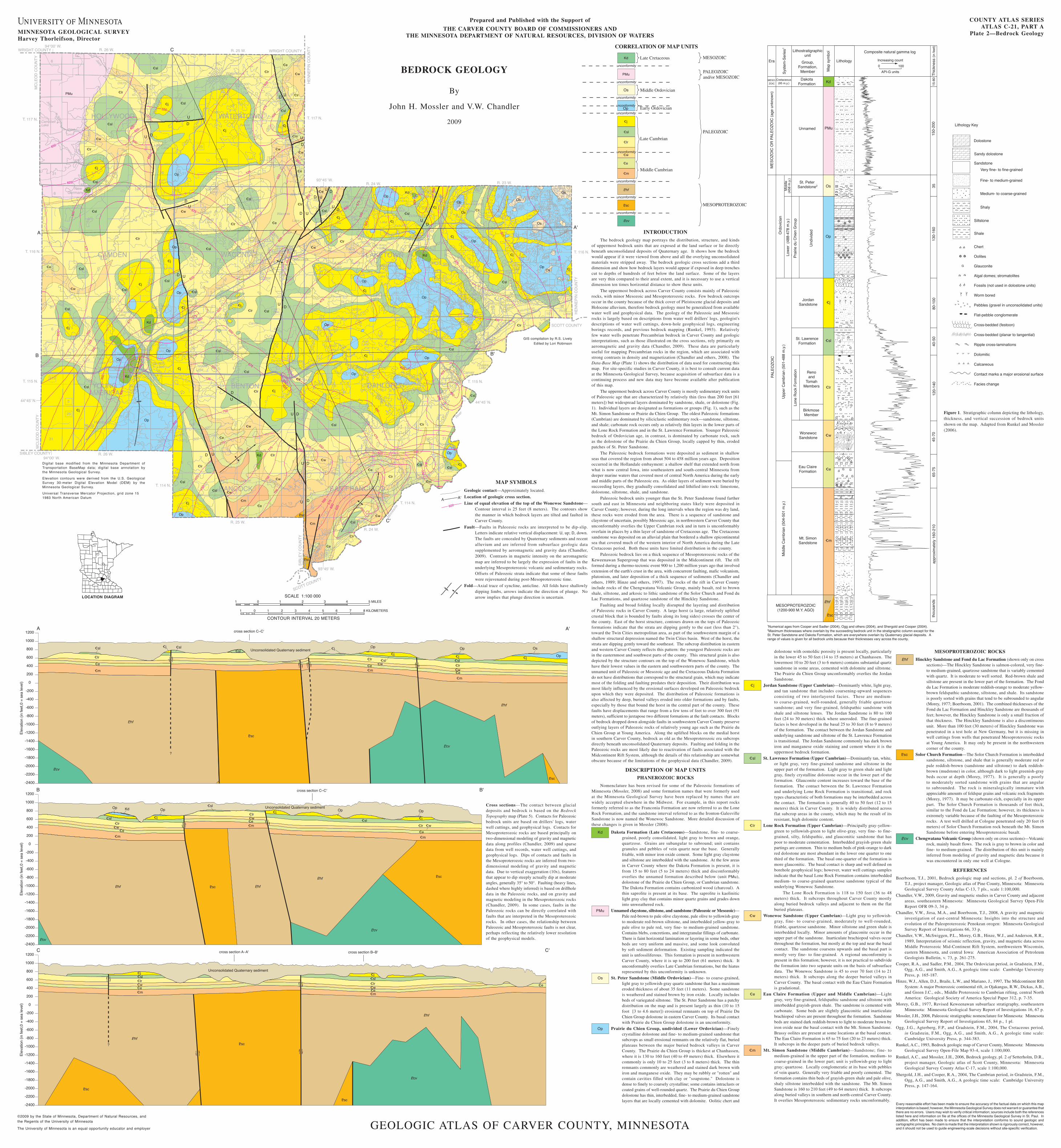
INTRODUCTIONThe bedrock geology map portrays the distribution, structure, and kinds

of uppermost bedrock units that are exposed at the land surface or lie directly beneath unconsolidated deposits of Quaternary age. It shows how the bedrock would appear if it were viewed from above and all the overlying unconsolidated materials were stripped away. The bedrock geologic cross sections add a third dimension and show how bedrock layers would appear if exposed in deep trenches cut to depths of hundreds of feet below the land surface. Some of the layers are very thin compared to their areal extent, and it is necessary to use a vertical dimension ten times horizontal distance to show these units.

The uppermost bedrock across Carver County consists mainly of Paleozoic rocks, with minor Mesozoic and Mesoproterozoic rocks. Few bedrock outcrops occur in the county because of the thick cover of Pleistocene glacial deposits and Holocene alluvium, therefore bedrock geology must be generalized from available water well and geophysical data. The geology of the Paleozoic and Mesozoic rocks is largely based on descriptions from water well drillers' logs, geologist's descriptions of water well cuttings, down-hole geophysical logs, engineering borings records, and previous bedrock mapping (Runkel, 1993). Relatively few water wells penetrate Precambrian bedrock in Carver County and geologic interpretations, such as those illustrated on the cross sections, rely primarily on aeromagnetic and gravity data (Chandler, 2009). These data are particularly useful for mapping Precambrian rocks in the region, which are associated with strong contrasts in density and magnetization (Chandler and others, 2008). The Data-Base Map (Plate 1) shows the distribution of data used for constructing this map. For site-specific studies in Carver County, it is best to consult current data at the Minnesota Geological Survey, because acquisition of subsurface data is a continuing process and new data may have become available after publication of this map.

The uppermost bedrock across Carver County is mostly sedimentary rock units of Paleozoic age that are characterized by relatively thin (less than 200 feet [61 meters]) but widespread layers dominated by sandstone, shale, or dolostone (Fig. 1). Individual layers are designated as formations or groups (Fig. 1), such as the Mt. Simon Sandstone or Prairie du Chien Group. The oldest Paleozoic formations (Cambrian) are dominated by siliciclastic sedimentary rock—sandstone, siltstone, and shale; carbonate rock occurs only as relatively thin layers in the lower parts of the Lone Rock Formation and in the St. Lawrence Formation. Younger Paleozoic bedrock of Ordovician age, in contrast, is dominated by carbonate rock, such as the dolostone of the Prairie du Chien Group, locally capped by thin, eroded patches of St. Peter Sandstone.

The Paleozoic bedrock formations were deposited as sediment in shallow seas that covered the region from about 504 to 458 million years ago. Deposition occurred in the Hollandale embayment: a shallow shelf that extended north from what is now central Iowa, into southeastern and south-central Minnesota from deeper marine waters that covered most of central North America during the early and middle parts of the Paleozoic era. As older layers of sediment were buried by succeeding layers, they gradually consolidated and lithified into rock: limestone, dolostone, siltstone, shale, and sandstone.

Paleozoic bedrock units younger than the St. Peter Sandstone found farther south and east in Minnesota and neighboring states likely were deposited in Carver County; however, during the long intervals when the region was dry land, these rocks were eroded from the area. There is a sequence of sandstone and claystone of uncertain, possibly Mesozoic age, in northwestern Carver County that unconformably overlies the Upper Cambrian rock and in turn is unconformably overlain in places by a thin layer of sandstone of Cretaceous age. The Cretaceous sandstone was deposited on an alluvial plain that bordered a shallow epicontinental sea that covered much of the western interior of North America during the Late Cretaceous period. Both these units have limited distribution in the county.

Paleozoic bedrock lies on a thick sequence of Mesoproterozoic rocks of the Keweenawan Supergroup that was deposited in the Midcontinent rift. The rift formed during a thermo-tectonic event 900 to 1,200 million years ago that involved extension of the earth's crust in the area, with concurrent faulting, mafic volcanism, plutonism, and later deposition of a thick sequence of sediments (Chandler and others, 1989; Hinze and others, 1997). The rocks of the rift in Carver County include rocks of the Chengwatana Volcanic Group, mainly basalt, red to brown shale, siltstone, and arkosic to lithic sandstone of the Solor Church and Fond du Lac Formations, and quartzose sandstone of the Hinckley Sandstone.

Faulting and broad folding locally disrupted the layering and distribution of Paleozoic rocks in Carver County. A large horst (a large, relatively uplifted crustal block that is bounded by faults along its long sides) crosses the center of the county. East of the horst structure, contours drawn on the tops of Paleozoic formations indicate that the strata are dipping gently to the east (less than 2°), toward the Twin Cities metropolitan area, as part of the southwestern margin of a shallow structural depression named the Twin Cities basin. West of the horst, the strata are dipping gently toward the southeast. The subcrop distribution in eastern and western Carver County reflects this pattern: the youngest Paleozoic rocks are in the easternmost and southwest parts of the county. This structural grain is also depicted by the structure contours on the top of the Wonewoc Sandstone, which have their lowest values in the eastern and southwestern parts of the county. The unnamed unit of Paleozoic or Mesozoic age and the Cretaceous Dakota Formation do not have distributions that correspond to the structural grain, which may indicate most of the folding and faulting predates their deposition. Their distribution was most likely influenced by the erosional surfaces developed on Paleozoic bedrock upon which they were deposited. The distribution of Paleozoic formations is also affected by deep, buried valleys eroded into older formations and by faults, especially by those that bound the horst in the central part of the county. These faults have displacements that range from a few tens of feet to over 300 feet (91 meters), sufficient to juxtapose two different formations at the fault contacts. Blocks of bedrock dropped down alongside faults in southwestern Carver County preserve outlying layers of Paleozoic rocks of relatively young age such as the Prairie du Chien Group at Young America. Along the uplifted blocks on the medial horst in southern Carver County, bedrock as old as the Mesoproterozoic era subcrops directly beneath unconsolidated Quaternary deposits. Faulting and folding in the Paleozoic rocks are most likely due to reactivation of faults associated with the Midcontinent Rift System, although the details of this relationship are somewhat obscure because of the limitations of the geophysical data (Chandler, 2009).

DESCRIPTION OF MAP UNITSPHANEROZOIC ROCKS

Nomenclature has been revised for some of the Paleozoic formations of Minnesota (Mossler, 2008) and some formation names that were formerly used at the Minnesota Geological Survey have been replaced by names that are widely accepted elsewhere in the Midwest. For example, in this report rocks formerly referred to as the Franconia Formation are now referred to as the Lone Rock Formation, and the sandstone interval referred to as the Ironton-Galesville Sandstone is now named the Wonewoc Sandstone. More detailed discussion of these changes is given in Mossler (2008).

Kd Dakota Formation (Late Cretaceous)—Sandstone, fine- to coarse-grained, poorly consolidated, light gray to brown and orange, quartzose. Grains are subangular to subround; unit contains granules and pebbles of vein quartz near the base. Generally friable, with minor iron oxide cement. Some light gray claystone and siltstone are interbedded with the sandstone. At the few areas in Carver County where the Dakota Formation is present, it is from 15 to 80 feet (5 to 24 meters) thick and disconformably overlies the unnamed formation described below (unit PMu), dolostone of the Prairie du Chien Group, or Cambrian sandstone. The Dakota Formation contains carbonized wood (charcoal). A thin saprolite is present at its base. The saprolite is kaolinitic light gray clay that contains minor quartz grains and grades down into unweathered rock.

PMu Unnamed claystone, siltstone, and sandstone (Paleozoic or Mesozoic)— Pale red-brown to pale olive claystone, pale olive to yellowish-gray to moderate red-brown siltstone, and interbedded yellow-gray to pale olive to pale red, very fine- to medium-grained sandstone. Contains blebs, concretions, and intergranular fillings of carbonate. There is faint horizontal lamination or layering in some beds, other beds are very uniform and massive, and some look convoluted by soft sediment deformation. Existing sampling indicated the unit is unfossiliferous. This formation is present in northwestern Carver County, where it is up to 200 feet (61 meters) thick. It unconformably overlies Late Cambrian formations, but the hiatus represented by this unconformity is unknown.

os St. Peter Sandstone (Middle Ordovician)—Fine- to coarse-grained, light gray to yellowish-gray quartz sandstone that has a maximum eroded thickness of about 35 feet (11 meters). Some sandstone is weathered and stained brown by iron oxide. Locally includes beds of variegated siltstone. The St. Peter Sandstone has a patchy distribution on the map and is present largely as thin (10 to 15 foot [3 to 4.6 meter]) erosional remnants on top of Prairie Du Chien Group dolostone in eastern Carver County. Its basal contact with Prairie du Chien Group dolostone is an unconformity.

op Prairie du Chien Group, undivided (Lower Ordovician)—Finely crystalline dolostone and fine- to medium-grained sandstone that subcrops as small erosional remnants on the relatively flat, buried plateaus between the major buried bedrock valleys in Carver County. The Prairie du Chien Group is thickest at Chanhassen, where it is 130 to 160 feet (40 to 49 meters) thick. Elsewhere it commonly is only 10 to 25 feet (3 to 8 meters) thick. The thin remnants commonly are weathered and stained dark brown with iron and manganese oxide. They may be rubbly or "rotten" and contain cavities filled with clay or "soapstone." Dolostone is dense to finely to coarsely crystalline; some contains intraclasts or coated grains of well-rounded quartz. The Prairie du Chien Group dolostone has thin, interbedded, fine- to medium-grained sandstone layers that are locally cemented with dolomite. Oolitic chert and

dolostone with oomoldic porosity is present locally, particularly in the lower 45 to 50 feet (14 to 15 meters) at Chanhassen. The lowermost 10 to 20 feet (3 to 6 meters) contains substantial quartz sandstone in some areas, cemented with dolomite and siltstone. The Prairie du Chien Group unconformably overlies the Jordan Sandstone.

_j Jordan Sandstone (Upper Cambrian)—Dominantly white, light gray, and tan sandstone that includes coarsening-upward sequences consisting of two interlayered facies. These are medium- to coarse-grained, well-rounded, generally friable quartzose sandstone; and very fine-grained, feldspathic sandstone with shale and siltstone lenses. The Jordan Sandstone is 80 to 100 feet (24 to 30 meters) thick where uneroded. The fine-grained facies is best developed in the basal 25 to 30 feet (8 to 9 meters) of the formation. The contact between the Jordan Sandstone and underlying sandstone and siltstone of the St. Lawrence Formation is transitional. The Jordan Sandstone commonly has dark brown iron and manganese oxide staining and cement where it is the uppermost bedrock formation.

_sl St. Lawrence Formation (Upper Cambrian)—Dominantly tan, white, or light gray, very fine-grained sandstone and siltstone in the upper part of the formation. Light gray to green shale and light gray, finely crystalline dolostone occur in the lower part of the formation. Glauconite content increases toward the base of the formation. The contact between the St. Lawrence Formation and underlying Lone Rock Formation is transitional, and rock types characteristic of both formations may be interbedded across the contact. The formation is generally 40 to 50 feet (12 to 15 meters) thick in Carver County. It is widely distributed across flat subcrop areas in the county, which may be the result of its resistant, high dolomite content.

_lr Lone Rock Formation (Upper Cambrian)—Principally gray-yellow-green to yellowish-green to light olive-gray, very fine- to fine-grained, silty, feldspathic, and glauconitic sandstone that has poor to moderate cementation. Interbedded grayish-green shale partings are common. Thin to medium beds of pink-orange to dark red dolostone are most abundant in the lower one quarter to one third of the formation. The basal one-quarter of the formation is more glauconitic. The basal contact is sharp and well defined on borehole geophysical logs; however, water well cuttings samples indicate that the basal Lone Rock Formation contains interbedded medium- to coarse-grained quartzose sandstone typical of the underlying Wonewoc Sandstone.

The Lone Rock Formation is 118 to 150 feet (36 to 48 meters) thick. It subcrops throughout Carver County mostly along buried bedrock valleys and adjacent to them on the flat buried plateaus.

_w Wonewoc Sandstone (Upper Cambrian)—Light gray to yellowish-gray, fine- to coarse-grained, moderately to well-rounded, friable, quartzose sandstone. Minor siltstone and green shale is interbedded locally. Minor amounts of glauconite occur in the upper part of the sandstone. Inarticulate brachiopod valves occur throughout the formation, but mostly at the top and near the basal contact. The sandstone coarsens upwards and the basal part is mostly very fine- to fine-grained. A regional unconformity is present in this formation; however, it is not practical to subdivide the formation into two separate units on the basis of subsurface data. The Wonewoc Sandstone is 45 to over 70 feet (14 to 21 meters) thick. It subcrops along the deeper buried valleys in Carver County. The basal contact with the Eau Claire Formation is gradational.

_e Eau Claire Formation (Upper and Middle Cambrian)—Light gray, very fine-grained, feldspathic sandstone and siltstone with interbedded grayish-green shale. The sandstone is cemented with carbonate. Some beds are slightly glauconitic and inarticulate brachiopod valves are present throughout the formation. Sandstone beds are stained dark reddish-brown to light to moderate brown by iron oxide near the basal contact with the Mt. Simon Sandstone. Brassy oolites are present at some locations at the basal contact. The Eau Claire Formation is 65 to 75 feet (20 to 23 meters) thick. It subcrops in the deeper parts of buried bedrock valleys.

_m Mt. Simon Sandstone (Middle Cambrian)—Sandstone; fine- to medium-grained in the upper part of the formation, medium- to coarse-grained in the lower part; unit is yellowish-gray to light gray; quartzose. Locally conglomeratic at its base with pebbles of vein quartz. Generally very friable and poorly cemented. The formation contains thin beds of grayish-green shale and pale olive, shaly siltstone interbedded with the sandstone. The Mt. Simon Sandstone is 160 to 210 feet (49 to 64 meters) thick. It subcrops along buried valleys in southern and north-central Carver County. It overlies Mesoproterozoic sedimentary rocks unconformably.

MESOPROTEROZOIC ROCKS

Phf Hinckley Sandstone and Fond du Lac Formation (shown only on cross sections)—The Hinckley Sandstone is salmon-colored, very fine- to medium-grained, quartzose sandstone that is variably cemented with quartz. It is moderate to well sorted. Red-brown shale and siltstone are present in the lower part of the formation. The Fond du Lac Formation is moderate reddish-orange to moderate yellow-brown feldspathic sandstone, siltstone, and shale. Its sandstone is poorly sorted with grains that tend to be subrounded to angular (Morey, 1977; Boerboom, 2001). The combined thicknesses of the Fond du Lac Formation and Hinckley Sandstone are thousands of feet; however, the Hinckley Sandstone is only a small fraction of that thickness. The Hinckley Sandstone is also a discontinuous unit. More than 100 feet (30 meters) of Hinckley Sandstone was penetrated in a test hole at New Germany, but it is missing in well cuttings from wells that penetrated Mesoproterozoic rocks at Young America. It may only be present in the northwestern corner of the county.

<sc Solor Church Formation—The Solor Church Formation is interbedded sandstone, siltstone, and shale that is generally moderate red or pale reddish-brown (sandstone and siltstone) to dark reddish-brown (mudstone) in color, although dark to light greenish-gray beds occur at depth (Morey, 1977). It is generally a poorly to moderately sorted sandstone with grains that are angular to subrounded. The rock is mineralogically immature with appreciable amounts of feldspar grains and volcanic rock fragments (Morey, 1977). It may be carbonate-rich, especially in its upper part. The Solor Church Formation is thousands of feet thick, similar to the Fond du Lac Formation; however, its thickness is extremely variable because of the faulting of the Mesoproterozoic rocks. A test well drilled at Cologne penetrated only 20 feet (6 meters) of Solor Church Formation rock beneath the Mt. Simon Sandstone before entering Mesoproterozoic basalt.

Pcv Chengwatana Volcanic Group (shown only on cross sections)—Volcanic rock, mainly basalt flows. The rock is gray to brown in color and fine- to medium-grained. The distribution of this unit is mainly inferred from modeling of gravity and magnetic data because it was encountered in only one well at Cologne.

REFERENCES

Boerboom, T.J., 2001, Bedrock geologic map and sections, pl. 2 of Boerboom, T.J., project manager, Geologic atlas of Pine County, Minnesota: Minnesota Geological Survey County Atlas C-13, 7 pls., scale 1:100,000.

Chandler, V.W., 2009, Gravity and magnetic studies in Carver County and adjacent areas, southeastern Minnesota: Minnesota Geological Survey Open-File Report OFR 09-3, 34 p.

Chandler, V.W., Jirsa, M.A., and Boerboom, T.J., 2008, A gravity and magnetic investigation of east-central Minnesota: Insights into the structure and evolution of the Paleoproterozoic Penokean orogen: Minnesota Geological Survey Report of Investigations 66, 33 p.

Chandler, V.W., McSwiggen, P.L., Morey, G.B., Hinze, W.J., and Anderson, R.R., 1989, Interpretation of seismic reflection, gravity, and magnetic data across Middle Proterozoic Mid-Continent Rift System, northwestern Wisconsin, eastern Minnesota, and central Iowa: American Association of Petroleum Geologists Bulletin, v. 73, p. 261-275.

Cooper, R.A., and Sadler, P.M., 2004, The Ordovician period, in Gradstein, F.M., Ogg, A.G., and Smith, A.G., A geologic time scale: Cambridge University Press, p. 165-187.

Hinze, W.J., Allen, D.J., Braile, L.W., and Mariano, J., 1997, The Midcontinent Rift System: A major Proterozoic continental rift, in Ojakangas, R.W., Dickas, A.B., and Green J.C., eds., Middle Proterozoic to Cambrian rifting, central North America: Geological Society of America Special Paper 312, p. 7-35.

Morey, G.B., 1977, Revised Keweenawan subsurface stratigraphy, southeastern Minnesota: Minnesota Geological Survey Report of Investigations 16, 67 p.

Mossler, J.H., 2008, Paleozoic stratigraphic nomenclature for Minnesota: Minnesota Geological Survey Report of Investigations 65, 84 p., 1 pl.

Ogg, J.G., Agterberg, F.P., and Gradstein, F.M., 2004, The Cretaceous period, in Gradstein, F.M., Ogg, A.G., and Smith, A.G., A geologic time scale: Cambridge University Press, p. 344-383.

Runkel, A.C., 1993, Bedrock geologic map of Carver County, Minnesota: Minnesota Geological Survey Open-File Map 93-4, scale 1:100,000.

Runkel, A.C., and Mossler, J.H., 2006, Bedrock geology, pl. 2 of Setterholm, D.R., project manager, Geologic atlas of Scott County, Minnesota: Minnesota Geological Survey County Atlas C-17, scale 1:100,000.

Shergold, J.H., and Cooper, R.A., 2004, The Cambrian period, in Gradstein, F.M., Ogg, A.G., and Smith, A.G., A geologic time scale: Cambridge University Press, p. 147-164.

MAP SYMBOLS

Geologic contact—Approximately located.

Location of geologic cross section.

Line of equal elevation of the top of the Wonewoc Sandstone—Contour interval is 25 feet (8 meters). The contours show the manner in which bedrock layers are tilted and faulted in Carver County.

Fault—Faults in Paleozoic rocks are interpreted to be dip-slip. Letters indicate relative vertical displacement: U, up; D, down. The faults are concealed by Quaternary sediments and recent alluvium and are inferred from subsurface geologic data supplemented by aeromagnetic and gravity data (Chandler, 2009). Contrasts in magnetic intensity on the aeromagnetic map are inferred to be largely the expression of faults in the underlying Mesoproterozoic volcanic and sedimentary rocks. Offsets of Paleozoic strata indicate that some of these faults were rejuvenated during post-Mesoproterozoic time.

Fold—Axial trace of syncline, anticline. All folds have shallowly dipping limbs, arrows indicate the direction of plunge. No arrow implies that plunge direction is uncertain.

Cross sections—The contact between glacial deposits and bedrock is based on the Bedrock Topography map (Plate 5). Contacts for Paleozoic bedrock units are based on drillers' logs, water well cuttings, and geophysical logs. Contacts for Mesoproterozoic rocks are based principally on two-dimensional modeling of gravity and magnetic data along profiles (Chandler, 2009) and sparse data from well records, water well cuttings, and geophysical logs. Dips of contacts and faults in the Mesoproterozoic rocks are inferred from two-dimensional modeling of gravity and magnetic data. Due to vertical exaggeration (10x), features that appear to dip steeply actually dip at moderate angles, generally 35° to 50°. Faulting (heavy lines, dashed where highly inferred) is based on drillhole data in the Paleozoic rocks, and on gravity and magnetic modeling in the Mesoproterozoic rocks (Chandler, 2009). In some cases, faults in the Paleozoic rocks can be directly correlated with faults that are interpreted in the Mesoproterozoic rocks. In other cases, the relationship between Paleozoic and Mesoproterozoic faults is not clear, perhaps reflecting the relatively lower resolution of the geophysical models.

Figure 1. Stratigraphic column depicting the lithology, thickness, and vertical succession of bedrock units shown on the map. Adapted from Runkel and Mossler (2006).

Pcv

m

e

w

sl

j

Kd

PMu

MESOPROTEROZOIC

PALEOZOIC and/or MESOZOIC

MESOZOICLate Cretaceous

Late Cambrian

PALEOZOIC

CORRELATION OF MAP UNITS

unconformity

unconformity

unconformity

unconformity

unconformity

unconformity

unconformity

lr

Phf

sc

Os

Early Ordovician

Middle Ordovician

unconformity

unconformityOp

Middle Cambrian

600

F

M

A A'