c centre for geodesy and geodynamics, nasrda, toro, bauchi state the nigerian national network of...
TRANSCRIPT
• • C CENTRE FOR GEODESY AND GEODYNAMICS, NASRDA , TORO, BAUCHI STATE
THE NIGERIAN NATIONAL NETWORK OF SEISMOLOGICAL STATIONS
(NNNSS)BY
OLOGUN, C.O., KADIRI, U. A. & YAKUBU, T.A.CENTRE FOR GEODESY AND GEODYNAMICS (CGG),
NATIONAL SPACE RESEARCH AND DEVOLOPMENT AGENCY,FEDERAL MINISTRY OF SCIENCE AND TECHNOLOGY,
TORO, BAUCHI STATE, NIGERIA
A PAPER PRESENTED AT THE
IRIS workshop “Managing Waveform Data andRelated Metadata from Seismic Networks”
Helwan, Cairo, Egypt.
8TH – 17TH NOVEMBER 2009

• • C CENTRE FOR GEODESY AND GEODYNAMICS, NASRDA , TORO, BAUCHI STATE
OUTLINE1. GENERAL OVERVIEW OF THE GEOLOGY OF NIGERIA BASEMENT COMPLEX
2. THE FRACTURE SYSTEMS IN NIGERIA AND ITS RELATIONSHIP TO THE MID-ATLANTIC RIDGE 3. EARTH TREMOR OCCURRENCES IN NIGERIA 4. ACTION TAKEN SO FAR BY THE NIGERIAN GOVERNMENT - NTCEP - NNNSS - CGG 5. INSTRUMENTATION/ANALYSIS SOFTWARE 6. THE 9/11 EVENT 7. CONCLUSION
• • C CENTRE FOR GEODESY AND GEODYNAMICS, NASRDA , TORO, BAUCHI STATE
GEOLOGY OF THE NIGERIA BASEMENT COMPLEX
Nigeria’s geologic terrain can be broadly divided into two: crystalline basement complex and the sedimentary basins. The Precambrian basement complex is located within latitudes 7°N and 12°N and longitudes 3°E and 10°E. It forms a large part of the Pan-African mobile belt which lies between the West African Craton to the West and Congo Craton to the Southeast.

• • C CENTRE FOR GEODESY AND GEODYNAMICS, NASRDA , TORO, BAUCHI STATE
The region has been affected greatly by deformation and/ or thermal reactivation during the Pan-African event without extensive sedimentation.Odeyemi (1981) classified the basement complex rocks into three major groups, namely:
(i) a suite of rocks comprising of migmatites and gneiss;
(ii) metasedimentary successions (schist belts) which distinctly exist within the migmatites and gneisses;
(iii) a suite of intrusive syntectonic to late tectonic granitoids (Older Granites) associated with
pegmatites and aplites.
• • C CENTRE FOR GEODESY AND GEODYNAMICS, NASRDA , TORO, BAUCHI STATE
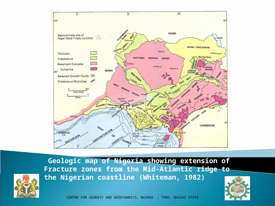
Geologic map of Nigeria showing extension of Fracture zones from the Mid-Atlantic ridge to the Nigerian coastline (Whiteman, 1982)
• • C CENTRE FOR GEODESY AND GEODYNAMICS, NASRDA , TORO, BAUCHI STATE
EARTH TREMORS IN NIGERIA
Nigeria, like other parts of West Africa, lies on the eastern flank of the Atlantic Ocean and unlike the Pacific Ocean margins which are characterized by subduction tectonics and occurrence of devastating earthquakes, the Atlantic margins are generally believed to be quiet and free of diastrophic activities.However, in recent times, earth tremors have been reported in some parts of Nigeria.
• • C CENTRE FOR GEODESY AND GEODYNAMICS, NASRDA , TORO, BAUCHI STATE
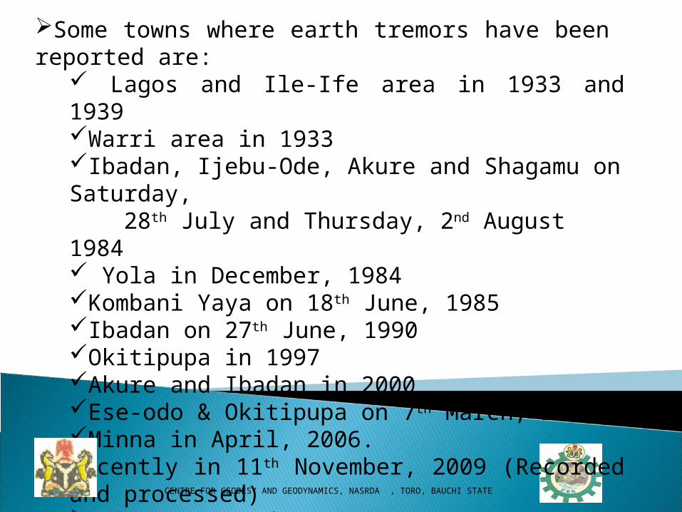
Some towns where earth tremors have been reported are: Lagos and Ile-Ife area in 1933 and 1939Warri area in 1933Ibadan, Ijebu-Ode, Akure and Shagamu on Saturday, 28th July and Thursday, 2nd August 1984 Yola in December, 1984Kombani Yaya on 18th June, 1985 Ibadan on 27th June, 1990Okitipupa in 1997Akure and Ibadan in 2000Ese-odo & Okitipupa on 7th March, 2000Minna in April, 2006.Recently in 11th November, 2009 (Recorded and processed)Only 4 of these events were instrumentally recorded

• • C CENTRE FOR GEODESY AND GEODYNAMICS, NASRDA , TORO, BAUCHI STATE
ACTION TAKEN SO FAR BY THE NIGERIAN GOVERNMENT
SETTING UP OF THE NTCEP
ESTABLISHMENT OF NNNSS
ESTABLISHMENT OF CGG
• • C CENTRE FOR GEODESY AND GEODYNAMICS, NASRDA , TORO, BAUCHI STATE
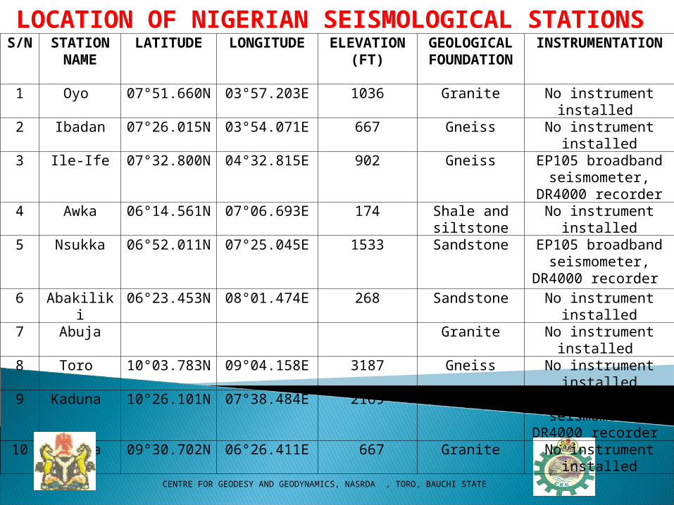
S/N STATION NAME
LATITUDE LONGITUDE ELEVATION (FT)
GEOLOGICAL
FOUNDATION
INSTRUMENTATION
1 Oyo 07°51.660N 03°57.203E 1036 Granite No instrument installed
2 Ibadan 07°26.015N 03°54.071E 667 Gneiss No instrument installed3 Ile-Ife 07°32.800N 04°32.815E 902 Gneiss EP105 broadband
seismometer, DR4000 recorder
4 Awka 06°14.561N 07°06.693E 174 Shale and siltstone
No instrument installed
5 Nsukka 06°52.011N 07°25.045E 1533 Sandstone EP105 broadband seismometer, DR4000
recorder
6 Abakiliki 06°23.453N 08°01.474E 268 Sandstone No instrument installed7 Abuja Granite No instrument installed 8 Toro 10°03.783N 09°04.158E 3187 Gneiss No instrument installed9 Kaduna 10°26.101N 07°38.484E 2169 Granite EP105 broadband
seismometer, DR4000 recorder
10 Minna 09°30.702N 06°26.411E 667 Granite No instrument installed
LOCATION OF NIGERIAN SEISMOLOGICAL STATIONS
• • C CENTRE FOR GEODESY AND GEODYNAMICS, NASRDA , TORO, BAUCHI STATE
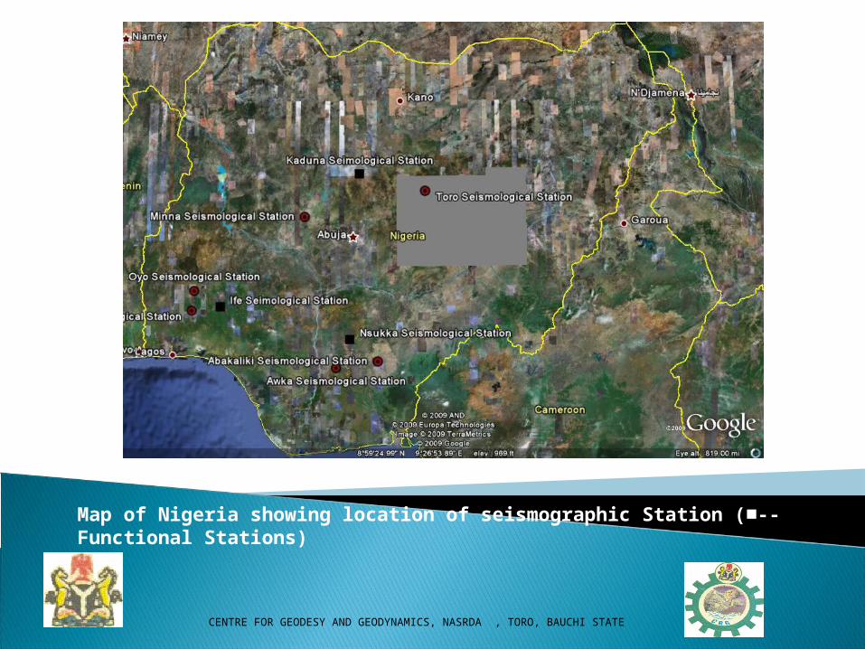
Map of Nigeria showing location of seismographic Station (■-- Functional Stations)

• • C CENTRE FOR GEODESY AND GEODYNAMICS, NASRDA , TORO, BAUCHI STATE
A Typical CGG Station
• • C CENTRE FOR GEODESY AND GEODYNAMICS, NASRDA , TORO, BAUCHI STATE
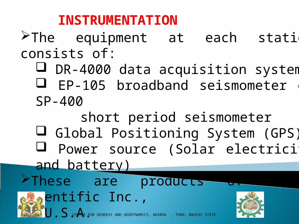
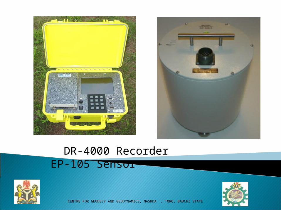
The equipment at each station consists of: DR-4000 data acquisition system EP-105 broadband seismometer or SP-400
short period seismometer Global Positioning System (GPS) Power source (Solar electricity and battery)
These are products of Eentec Scientific Inc., U.S.A.
INSTRUMENTATION
• • C CENTRE FOR GEODESY AND GEODYNAMICS, NASRDA , TORO, BAUCHI STATE
DR-4000 Recorder EP-105 Sensor
• • C CENTRE FOR GEODESY AND GEODYNAMICS, NASRDA , TORO, BAUCHI STATE
DATA ANALYSIS SOFTWARE
The SEISAN Seismic analysis software is a complete set of programs for analyzing earthquakes from analog and digital data.

• • C CENTRE FOR GEODESY AND GEODYNAMICS, NASRDA , TORO, BAUCHI STATE
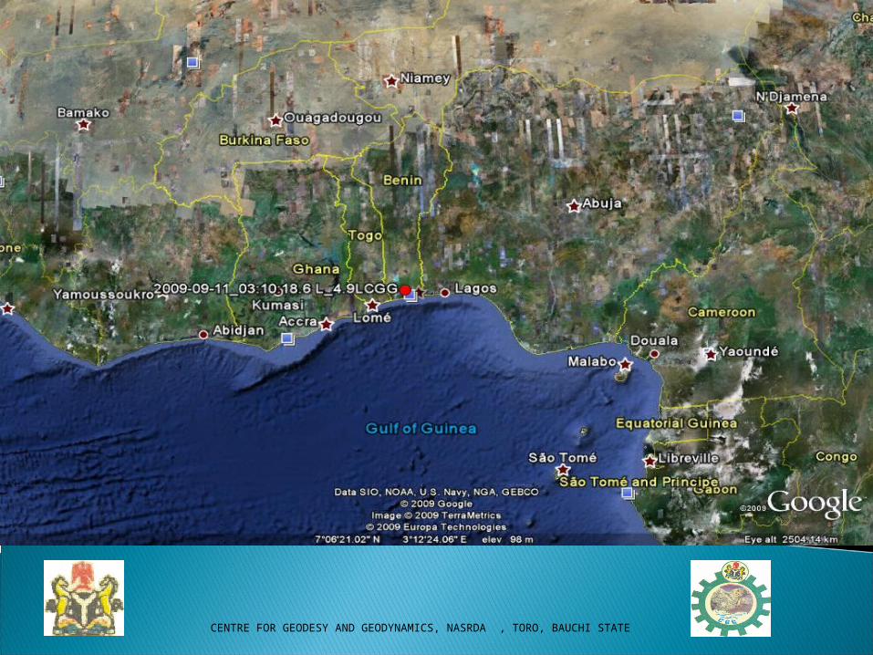
PRELIMINARY RESULT OF 11TH SEPTEMBER 2009 EARTHQUAKE
DATE OF OCCURRENCE: 11 SEPTEMBER, 2009ORIGIN TIME: 04:10:18.6 FOCAL DEPTH: FIXED TO 10 KMLOCAL MAGNITUDE: 4.8MOMENT MAGNITUDE: 4.0EPICENTRAL DISTANCE: 129 KM WEST OF LAGOSRMS: 0.4

• • C CENTRE FOR GEODESY AND GEODYNAMICS, NASRDA , TORO, BAUCHI STATE
LOCATION PARAMETERSSTAT SP IPHASW HRMM SE AMPLIT PERI AIN TRES DIS IFE BZ EP 310 58.96 51 0.6910 276 IFE BZ ES 311 26.89 51 -0.3110 276 IFE BZ AML 311 32.04 17078.2 0.26 276 NSU BZ EP 311 34.81 51 -0.6310 573 NSU BZ ES 312 31.82 51 0.3210 573 NSU BZ AML 313 27.30 2450.3 0.49 573 KAD BZ EP 311 55.14 51 -0.0510 731 KAD BZ ES 313 5.64 51 -0.0310 731 KAD BZ AML 313 45.44 1501.8 0.35 731 KEYSTAT: Station AMPLIT: Amplitude SP: Instrument type, Component PERI: PeriodIPHASW: Phase ID AIN: Angle of incidenceHR: Hour TRES: Travel time residualMM: Minute DIS: Epicentral distanceSE: Second
• • C CENTRE FOR GEODESY AND GEODYNAMICS, NASRDA , TORO, BAUCHI STATE

• • C CENTRE FOR GEODESY AND GEODYNAMICS, NASRDA , TORO, BAUCHI STATE
CONCLUSIONCONCLUSION Nigeria is not located within the major seismic belt of the world Minor earthquakes and/or earth tremors had occurred in different parts of the country. Presently, 4 stations are functional. Efforts are being made to install equipment in 7 additional stations and network all the stations for effective data acquisition and proper monitoring of seismic activities in the country.
• • C CENTRE FOR GEODESY AND GEODYNAMICS, NASRDA , TORO, BAUCHI STATE
THANK YOU