c d a p council development assessment … 3530448009 15.07.2014 sa qlty home impvmts r & j...
TRANSCRIPT

C D A P
A G E N D A
Meeting to be held on
Wednesday, 20 August 2014 at 7.00 pm
at
Council Administration Centre 115 Ellen Street, Port Pirie
for Dr Andrew Johnson Chief Executive Officer
14/8/14
MEMBERS: Trevor White (Presiding Member)
Fiona Barr, Debbie Devlin, Ian Miller, Joe Paparella, John Rohde and Chad King
COUNCIL
DEVELOPMENT ASSESSMENT
PANEL
DEVELOPMENT ASSESSMENT PANEL
AGENDA
1.0 PRESENT:
Also in attendance: Gallery:
2.0 APOLOGIES: Nil
3.0 CONFIRMATION OF MINUTES:
MOVED SECONDED That the minutes of the Council Development Assessment Panel Meeting held on
16 July 2014, be received and confirmed.
4.0 DECLARATION OF INTEREST: Nil
5.0 MONTHLY DEVELOPMENT NOTIFICATIONS:
MOVED SECONDED That Development Notifications issued for July 2014 be received.
6.0 CATEGORY 3 HEARING(S): Nil
7.0 REQUESTS TO BE HEARD BY THE PANEL: 7.1 354/106/14 AC Build
- Tony Introna, AC Build
8.0 REPORT – DIRECTOR, DEVELOPMENT & REGULATION:
MOVED SECONDED That the action report be received.
9.0 REPORTS:
MOVED SECONDED That reports be received in accordance with meeting procedures and pursuant to
Section 56A(12)(b) of the Development Act 1993, with the Panel ordering that all
persons present, with the exception of the Chief Executive Officer, Director,
Development & Regulation, Planning Officers and Minutes Officer, be excluded
from the meeting during so much of a meeting that consists of its discussion or
determination of applications before the Panel for decision.

9.0 REPORTS:
9.1 Category 1 Development: 9.1.1 354/123/14 A Wickham 9.1.2 354/D006/14 JHI Developers Pty Ltd
9.2 Category 2 Development:
9.2.1 354/106/14 AC Build 9.3 Category 3 Development:
9.3.1 354/045/14 Port Pirie Regional Council 9.3.2 354/162/14 T Murdoch MOVED SECONDED That pursuant to Section 56A(12)(b) of the Development Act 1993, the Panel now
orders that the public be permitted to be in attendance at this meeting.
10.0 OTHER BUSINESS:
10.1 Development Applications - Minor Development Considerations
10.1.1 Minor Development - Process
11.0 NEXT MEETING: 7pm Wednesday, 17 September 2014
12.0 CLOSE:

MONTHLY DECISION NOTIFICATIONS – JULY 2014
DA NO. VG NO. RECEIVED APPLICANT OWNER CLASS M2 VALUE DEVELOPMENT LOCATION APPROVED
354/009/14 3531720406 29.01.2014 T & J FRANKLIN T & J FRANKLIN 1A & 10A 410 & 288 $350,000 NEW DWELLING & SHED (STORAGE OF VEHICLES & EQUIPMENT) LOT 3 MAGOR RD 30.07.14
354/060A/14 3541277508 13.06.2014 DISTINCTIVE HOMES P/L D MCPHERSON & L FIDDAMAN 1A & 10A 221.92 & 0.9 $218,689 VARIATION TO 354/060/14 TO AMEND APPROVED PLANS 845 ABATTOIRS RD 17.07.14
354/067/14 3529343840 24.03.2014 G HADGES G HADGES 10A 40 $4,500 SHED 50 PORT DAVIS RD 26.07.14
354/071/14 3525025255 26.03.2014 PPRC PPRC 10B N/A $20,000 REMOVE TOWN CLOCK & INSTALL ELECTRONIC DISPLAY SIGN 115 ELLEN ST 18.07.14
354/079/14 3527883050 01.04.2014 MC MUDGE MC MUDGE 10A 96 $13,500 VERANDAH (SIDE & REAR) 7 LEONARD AVE 09.07.14
354/081/14 3528616587 03.04.2014 DISTINCTIVE HOMES P/L B & M DIETMAN 1A & 10A 212.39 & 74.92 $239,000 NEW DWELLING 53 PETERSON CCT 17.07.14
354/106/12 3525006054 08.05.2012 NYRSTAR PORT PIRIE P/L NYRSTAR PORT PIRIE P/L 8 N/A $50,000 TELLURIUM DIOXIDE RECOVERY - STAGE 1 PILOT PLANT LOT 50 ELLEN ST 17.07.14
354/107/14 3532213908 05.05.2014 SA QLTY HOME IMPRVMTS DJ TAYLOR 10A 143.4 $15,695 VERANDAH AND SHED LOT 36 HARRIS RD 17.07.14
354/108/14 3528441000 05.05.2014 MR HANLON MR HANLON 1A & 10A 155 $150,000 SINGLE STOREY REAR EXTENSION & INTERNAL ALTERATION 5 HEYWOOD AVE 18.07.14
354/124/14 3528362003 27.05.2014 PJ HILL DJ HILL 10A 49 $3,500 VERANDAH 24 HALLIDAY ST 02.07.14
354/132/14 3501165106
& 3501165501
03.06.2014 ERICSSON AUSTRALIA BM ROBINSON 10A & 10B 80 $150,000 TELECOM FACILITY - 40M TOWER, EQPMT UNITS & ASSOC ANTENNAS
HD CRYSTAL BROOK 30.07.14
354/136/14 3529057000 27.06.2014 A & J FINN A & J FINN 10B N/A $9,200 INSTALL SOLAR PANELS TO FLAT ROOF AT REAR 428 THE TCE 21.07.14
354/138/14 3527627508 10.06.2014 A LESKE RG DAVEY 10A 40.85 $4,000 VERANDAH 3 DONOVAN ST 22.07.14
354/140/14 3500256604 11.06.2014 B RUNKEL B RUNKEL 10A 184 $33,000 SHED & VERANDAH 278 GOYDER H/WAY 17.07.14
354/141/14 3541101000 16.06.2014 W DEVINE & S RICHARDS W DEVINE & S RICHARDS 10A 90 $8,928 DEMOLISH SHED & REPLACE 318 SCENIC DRV 03.07.14
354/144/14 353411425* 19.06.2014 M GADALETA M GADALETA 10A 200 $23,751 SHED LOT 27 AERODROME RD 21.07.14
354/149/14 3500692510 23.06.2014 R PERRY BF PERRY 10A 107 $46,823 SHED 100 GOULTER RD 22.07.14
354/151/14 3529898811 25.06.2014 AS JOHANNING AS JOHANNING 10A 135 $13,500 SHED 3 HOLZE CRT 30.07.14
354/153/14 3527683008 26.06.2014 SA QLTY HOME IMPVMTS MWJ TOBIN 10A 39.2 $11,825 VERANDAH 277 SENATE RD 02.07.14
354/155/14 3532228501 04.07.2014 RS HENSEL RS HENSEL 10A 94.89 $8,550 SHED 6 WARREN ST 30.07.14
354/159/14 3530298055 08.07.2014 SA QLTY HOME IMPVMTS S PUDDY 10A 57.96 $107,000 CARPORT & VERANDAH 7 PATTERSON ST 17.07.14
354/160/14 3529777008 09.07.2014 A LESKE C GREIG 10A 29.28 $4,999 NEW SHED 7 FERME ST 21.07.14
354/161/14 3531670007 09.07.2014 SA QLTY HOME IMPVMTS RJ PARKER 10A 19.76 $4,285 VERANDAH 35 HORNER ST 21.07.14
354/164/14 3531704000 11.07.2014 A LESKE PM BARRETT-MOY 10A 31.2 $2,900 ATTACHED CARPORT 43 THREE CHAIN RD 22.07.14
354/166/14 3500363602 14.07.2014 DB PAGE DB PAGE 10A 56.42 $7,000 SHED 43 MUSGRAVE ST 23.07.14
354/167/14 3529370005 11.07.2014 A LESKE DJ LLOYD 10A 26.52 $4,100 OUTBUILDING 193 KINGSTON RD 23.07.14
354/168/14 3529761508 11.07.2014 A LESKE JA MEYERS 10A 37.21 $4,000 GARAGE 8 EAGLE CRT 22.07.14
354/169/14 3530448009 15.07.2014 SA QLTY HOME IMPVMTS R & J ROBERTS 10A 43.19 $11,085 VERANDAH 7 DEGENHARDT ST 21.07.14
354/170/14 352892300* 18.07.2014 SA QLTY HOME IMPVMTS MC MCDONALD 10A 31.26 $5,620 DEMOLISH VERANDAH & REPLACE 363 SENATE RD 22.07.14
354/184/13 3529685509 03.07.2013 MID NTH CHRISTIAN COLL MID NTH CHRISTIAN COLLE 9B & 10A 158.66 & 12.72 $426,000 TWO CLASS ROOMS & STAFF AMENITIES 43 PORT DAVIS RD 18.07.14
$1,951,450 DWELLINGS (3)
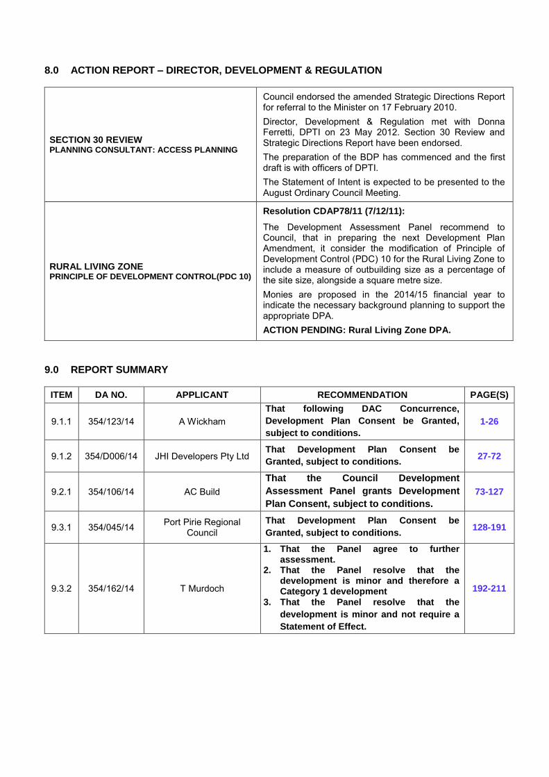
8.0 ACTION REPORT – DIRECTOR, DEVELOPMENT & REGULATION
SECTION 30 REVIEW PLANNING CONSULTANT: ACCESS PLANNING
Council endorsed the amended Strategic Directions Report for referral to the Minister on 17 February 2010. Director, Development & Regulation met with Donna Ferretti, DPTI on 23 May 2012. Section 30 Review and Strategic Directions Report have been endorsed. The preparation of the BDP has commenced and the first draft is with officers of DPTI. The Statement of Intent is expected to be presented to the August Ordinary Council Meeting.
RURAL LIVING ZONE PRINCIPLE OF DEVELOPMENT CONTROL(PDC 10)
Resolution CDAP78/11 (7/12/11):
The Development Assessment Panel recommend to Council, that in preparing the next Development Plan Amendment, it consider the modification of Principle of Development Control (PDC) 10 for the Rural Living Zone to include a measure of outbuilding size as a percentage of the site size, alongside a square metre size. Monies are proposed in the 2014/15 financial year to indicate the necessary background planning to support the appropriate DPA. ACTION PENDING: Rural Living Zone DPA.
9.0 REPORT SUMMARY
ITEM DA NO. APPLICANT RECOMMENDATION PAGE(S)
9.1.1 354/123/14 A Wickham That following DAC Concurrence,
Development Plan Consent be Granted,
subject to conditions.
1-26
9.1.2 354/D006/14 JHI Developers Pty Ltd That Development Plan Consent be
Granted, subject to conditions. 27-72
9.2.1 354/106/14 AC Build That the Council Development
Assessment Panel grants Development
Plan Consent, subject to conditions.
73-127
9.3.1 354/045/14 Port Pirie Regional Council
That Development Plan Consent be
Granted, subject to conditions. 128-191
9.3.2 354/162/14 T Murdoch
1. That the Panel agree to further assessment.
2. That the Panel resolve that the development is minor and therefore a Category 1 development
3. That the Panel resolve that the
development is minor and not require a
Statement of Effect.
192-211

9.0 REPORTS: 9.1 DEVELOPMENT APPLICATIONS – CATEGORY 1 9.1.1 A WICKHAM - 354/123/14
APPLICATION NO. 354/123/14 APPLICANT Alan Wickham DEVELOPMENT PROPOSAL Dwelling and Shed LODGEMENT DATE 22 May 2014 LOCATION Allotment 171, Hundred of Napperby ZONE Rural Living (Policy Area 2) NATURE OF DEVELOPMENT Non-Complying PUBLIC NOTIFICATION Category 1 ASSESSING OFFICER Adina Teaha
REFERRALS Internal: Infrastructure Department Environmental Health Officer
DEVELOPMENT PLAN VERSION 10 January 2013
COUNCIL WIDE PROVISIONS
Objectives (Obj) 8, 9, 18, 21, 22, 29, 30 and 74.
Principles of Development Control (PDC) 15, 54, 70, 77, 75, 76, 102, 104, 107, 108, 111, 112, 113, 114, 308, 309 and 310.
ZONE PROVISIONS Objectives (Obj) 1, 2 and 3.
Principles of Development Control (PDC) 1, 2, 7, 9, 10 and 15.
POLICY AREA PROVISIONS Objectives (Obj) 1
Principles of Development Control (PDC) 1
RECOMMENDATION Following DAC concurrence, Development Plan Consent be granted, subject to conditions.
PLANNING HISTORY:
A review of Council records indicates that the application site has been the subject of a recent Development Application 354/014/14 for a shed. This application was withdrawn by the applicant on 12 March 2014 to enable the applicant to prepare plans for a house and resubmit the application for a dwelling house and shed.
The application was the subject of a previous report to the Panel, on 16 July 2014, where permission was sought for the further assessment of the application. At that meeting the Panel resolved:
A: That the Development Assessment Panel, pursuant to the provisions of the Development Act 1993; agree to a further assessment of Development Application 354/123/14, by A Wickham, for the erection of a dwelling and shed at Lot 171, Hundred of Napperby.
B: That the Development Assessment Panel, having considered Development Application 354/123/14, for the erection of a dwelling and shed, pursuant to Schedule 9 Part 1 of the Development Regulations 2008 determine the application to be a minor development and Category 1 for the purpose of Public Notification.
C: That the Panel, pursuant to Regulation 17(6) of the Development Regulations 2008, resolve that the application is of a minor nature and not require a statement of effect.
1

9.0 REPORTS: 9.1.1 A WICKHAM - 354/123/14 (Continued)
Port Pirie Regional Council Agenda – Development Assessment Panel 20/08/14
PLANNING HISTORY (Cont’d):
This report represents the further assessment of the application. During the assessment of the application, the applicant has made a minor amendment to the location of the shed from 3 metres to 10 metres from the northern boundary. The proposal also includes the establishment vegetation between the shed and the boundary. These two changes by the applicant have been made to further decrease visibility of the shed to neighbouring allotments.
SITE AND LOCALITY:
Legal Description
The subject land is described as Allotment 171, Filed Plan 216511, Certificate of Title Volume 5886 Folio 504 in the area named Napperby, Hundred of Napperby.
Physical Description and Land Use
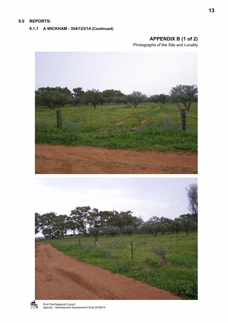
The application site is a single regularly shaped parcel of land located off Gulf View Road, Napperby. The site has an area of 4.05 hectares and has dimensions of 256.69 metres x 157.11 metres. The site is sparsely vegetated and gently slopes from the north west to the south west with part of the Napperby Creek catchment area running centrally through the site. No development presently exists on the site and the boundaries of the site are identified by post-and-wire fencing.
The site has no direct road frontage and access to the site is provided from Olive Grove Road to the south and Gulf View Road to the north via easements across adjacent land. Olive Grove Road is an unconstructed road, whilst Gulf View Road is a formed but unsealed road. The access is similarly unconstructed.
The locality containing the site is characterised by large Rural Living allotments, with areas ranging from approximately 2 hectares to over 4 hectares. Adjacent allotments are either vacant or developed with dwellings and associated outbuildings.
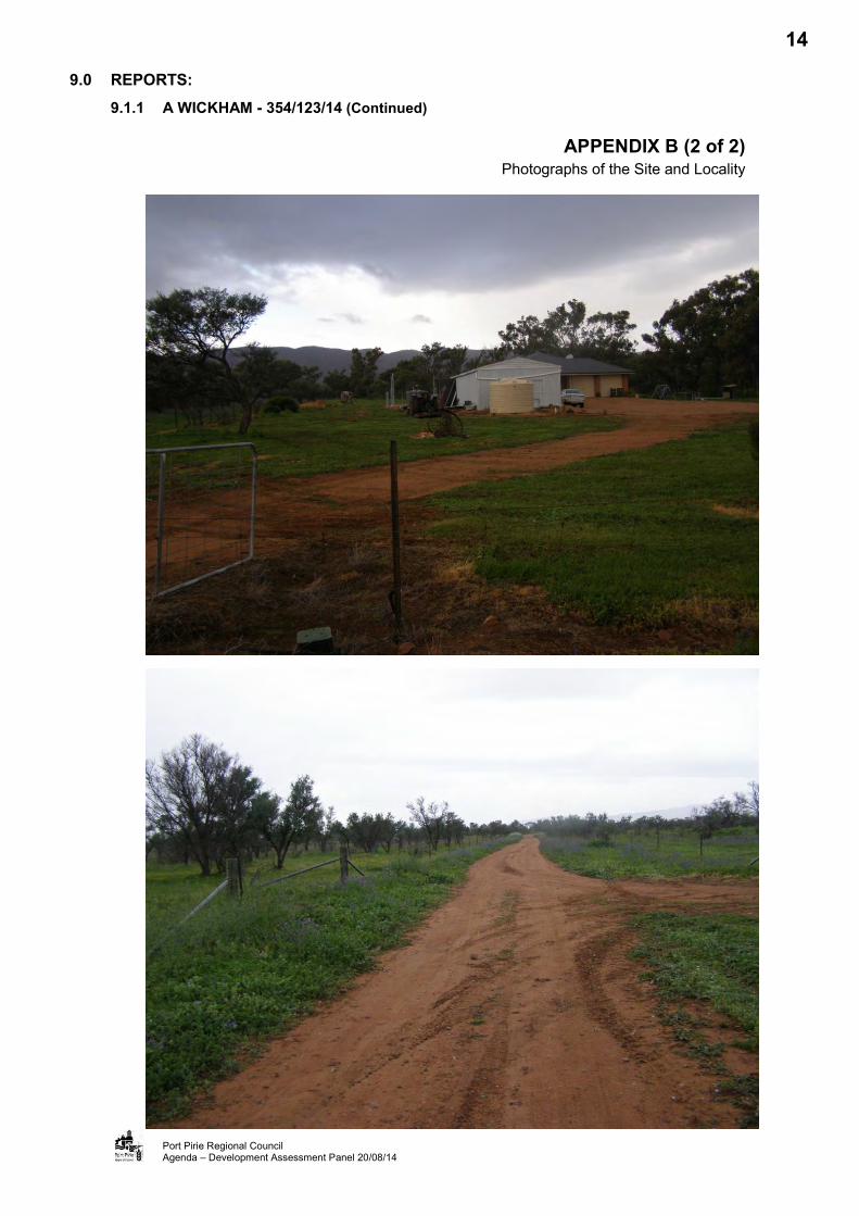
To the north, land has been developed for the purpose of a dwelling house and two sheds. One of the sheds is 37 square metres in area with a wall height of 3 metres and the other has an area of 55.81 square metres and a wall height of 3 metres. This dwelling has a floor area of 147 square metres and an overall height of 4.2 metres.
To the northeast, land fronting Gulf View Road has been developed with a storage shed with an area of 216 square metres and a wall height of 4.2 metres.
To the east, the adjoining allotment has been developed with a dwelling house and shed. The dwelling has an area of 259 square metres and total height of 5.9 metres. The shed has an area of 90 square metres with a wall height of 3 metres and overall height of 3.8 metres.
To the south is a vacant block owned by the applicant, however the next allotment to the south includes a dwelling and shed. The dwelling has an area of 310 square metres and overall height of 6.1 metres. The shed has an area of 54 square metres with a wall height of 2.4 metres.
To the west, the adjacent allotment has been developed with a storage shed with a floor area of approximately 162 square metres and a height of 3.6 metres.
Refer Appendix A (Aerial Photographical Map of the Site and Locality); and
Appendix B (Photographs of the Site and Locality)
2

9.0 REPORTS: 9.1.1 A WICKHAM - 354/123/14 (Continued)
Port Pirie Regional Council Agenda – Development Assessment Panel 20/08/14
SITE AND LOCALITY (Cont’d):
Zoning
The application site is identified in the Rural Living Zone, Map PtPi/18, and within Policy Area 2, Map PtPi/45 of the Port Pirie (RC) Development Plan (Consolidated 10 January 2013). The land has been identified within this zone since 1997. An amendment incorporated into the development plan on 28 June 2007 identified outbuildings with an area in excess of 135 square metres and wall height in excess of 3.6 metres as being Non-Complying developments.
Refer to Appendix C (Zone Map)
NATURE OF PROPOSED DEVELOPMENT:
The application is for the development of the site for a dwelling and ancillary shed. The dwelling would be a single storey dwelling erected in the north east corner of the site and setback 30 metres from the northern and eastern boundary. The dwelling would be a single storey four bedroom dwelling with a verandah to the sides and rear. The total roofed area of the dwelling would be 573.9 square metres and the dwelling would be constructed of masonry walls with a colorbond roof. The dwelling would have a wall height of 2.8 metres above ground and an overall height of 4.1 metres above ground.
The outbuilding would be located centrally adjacent to and setback 10 metres from the northern boundary. The outbuilding would be constructed of colorbond materials and would have a floor area of 288 square metres with a wall height of 5 metres and an overall height of 6.1 metres. The outbuilding would have a mezzanine floor and would be used for the storage of machinery and vehicles.
Stormwater would be collected from the roofs of the buildings and directed to five 22,500 litre stormwater tanks. Gums and brush are to be planted to the north and east of the proposed outbuilding.
Refer to Appendix D (Application Documentation)
REFERRALS:
Internal
Councils Infrastructure Department – no objection.
Environmental Health Officer - no objection to the proposal, subject to the provision of an onsite wastewater system.
External
The application is required to be referred to the Development Assessment Commission (DAC), should the Panel resolve to support the application. The DAC will need to concur with the decision of the Panel, prior to a Decision Notification being issued.
NON-COMPLYING DEVELOPMENT:
The proposed shed is identified in the Port Pirie (RC) Development Plan (Rural Living Zone Principle 16) as a Non-Complying development as the proposed domestic outbuilding has a floor area in excess of 135 square metres and a wall height in excess of 3.6 metres. Whilst the proposed dwelling is identified as a development to be assessed on its merit, as both the shed and dwelling are part of the one application, the application has been assessed as a Non-Complying development application.
3

9.0 REPORTS: 9.1.1 A WICKHAM - 354/123/14 (Continued)
Port Pirie Regional Council Agenda – Development Assessment Panel 20/08/14
NON-COMPLYING DEVELOPMENT (Cont’d):
As previously mentioned, the Panel determined in its July meeting that the development is a Category 1 development, according to Schedule 9 Part 1 of the Development Regulations 2008. Further, the “Statement of Effect” is not required pursuant to Regulation 17(6) of the Development Regulations 2008.
ASSESSMENT:
The application is for the development of a dwelling and a shed. The proposed shed is identified as a non-complying development, listed under PDC 16 of the Rural Living Zone in the Council Development Plan. The categorisation and public notification are discussed later in the report.
The Act requires the Council, as the Relevant Authority, to consider the application for Development Plan Consent against the provisions of the Development Plan. An assessment of the proposed development against the relevant Council Wide and Rural Living Zone Provisions is set out below.
Council Wide Provisions
Form of Development
Obj. 8: Orderly and economic development.
Obj.9: A proper distribution and separation of living, working and recreational activities by the allocation of suitable areas of land for those purposes.
PDC 15: No development should be located within 50 metres of: (a) a watercourse identified as a blue line on a current series 1:50 000 SA Government
topographic map; or (b) any river, stream, creek or channel in which water is contained or flows
permanently, intermittently or occasionally.
The site is located within the Rural Living Zone, Policy Area 2. This zone supports the development of residential dwellings with ancillary rural living activities. It is considered that the type of development proposed would reinforce the Rural Living Zone provisions. Furthermore, the proposal is unlikely to affect the predominant existing or future character of the locality, in terms of use. The development is considered orderly and economic.
The size and configuration of the site allows both the dwelling and shed to be greater than 50 metres from the watercourse. The watercourse can be can be identified on the series 1:50,000 SA Government topographic map as a blue line. The dwelling wall is located, as per the minimum requirement, 52 metres from the watercourse, with the shed setback 63 metres. The siting of the development from the watercourse is considered appropriate.
Movement of People and Goods
Obj.18: Development that: (a) provides safe and efficient movement for all motorised and non-motorised transport
modes; (b) ensures access for vehicles including emergency services, public infrastructure
maintenance and commercial vehicles; (c) provides off street parking; (d) is appropriately located so that it supports and makes best use of existing transport
facilities and networks.
4
9.0 REPORTS: 9.1.1 A WICKHAM - 354/123/14 (Continued)
Port Pirie Regional Council Agenda – Development Assessment Panel 20/08/14
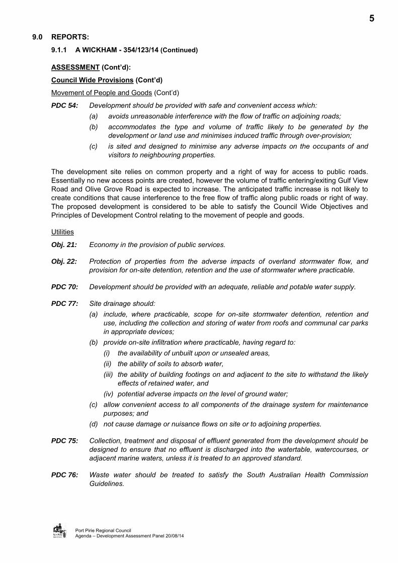
ASSESSMENT (Cont’d):
Council Wide Provisions (Cont’d)
Movement of People and Goods (Cont’d)
PDC 54: Development should be provided with safe and convenient access which: (a) avoids unreasonable interference with the flow of traffic on adjoining roads; (b) accommodates the type and volume of traffic likely to be generated by the
development or land use and minimises induced traffic through over-provision; (c) is sited and designed to minimise any adverse impacts on the occupants of and
visitors to neighbouring properties.
The development site relies on common property and a right of way for access to public roads. Essentially no new access points are created, however the volume of traffic entering/exiting Gulf View Road and Olive Grove Road is expected to increase. The anticipated traffic increase is not likely to create conditions that cause interference to the free flow of traffic along public roads or right of way. The proposed development is considered to be able to satisfy the Council Wide Objectives and Principles of Development Control relating to the movement of people and goods.
Utilities
Obj. 21: Economy in the provision of public services.
Obj. 22: Protection of properties from the adverse impacts of overland stormwater flow, and provision for on-site detention, retention and the use of stormwater where practicable.
PDC 70: Development should be provided with an adequate, reliable and potable water supply.
PDC 77: Site drainage should: (a) include, where practicable, scope for on-site stormwater detention, retention and
use, including the collection and storing of water from roofs and communal car parks in appropriate devices;
(b) provide on-site infiltration where practicable, having regard to: (i) the availability of unbuilt upon or unsealed areas, (ii) the ability of soils to absorb water, (iii) the ability of building footings on and adjacent to the site to withstand the likely
effects of retained water, and (iv) potential adverse impacts on the level of ground water;
(c) allow convenient access to all components of the drainage system for maintenance purposes; and
(d) not cause damage or nuisance flows on site or to adjoining properties.
PDC 75: Collection, treatment and disposal of effluent generated from the development should be designed to ensure that no effluent is discharged into the watertable, watercourses, or adjacent marine waters, unless it is treated to an approved standard.
PDC 76: Waste water should be treated to satisfy the South Australian Health Commission Guidelines.
5

9.0 REPORTS: 9.1.1 A WICKHAM - 354/123/14 (Continued)
Port Pirie Regional Council Agenda – Development Assessment Panel 20/08/14
ASSESSMENT (Cont’d):
Council Wide Provisions (Cont’d)
Utilities (Cont’d)
The development can be serviced with water and power and should not impact on the services provided to existing development within the area. The development would provide five 22,500 litre water tanks to collect stormwater from the roofed areas. The proposed development is considered to be able to satisfy the Council Wide Objectives and Principles of Development Control relating to stormwater and connection to public services.
As mentioned previously, a watercourse runs through the site. The site should allow both the development and the associated wastewater systems to be greater than 50 metres from the watercourse and installed in accordance with South Australian Health Commission Guidelines. Furthermore, a wastewater application for the dwelling has not been submitted to the Council, however based on the information available on the development and wastewater system the Environmental Health Officer has no objections to the proposal.
Residential Development
Obj. 29: Safe, convenient and pleasant living environments.
Obj. 30: Encourage a full range of dwelling types, dwelling design and development techniques.
PDC 102: Garages and carports should have a roof form and pitch, building materials and detailing that complement the associated dwelling.
PDC 104: Domestic Outbuildings should be ancillary to an existing dwelling or dwelling under construction on the site and have external walls comprised of either new masonry, compressed fibre cement, pre-treated timber or pre-coloured or pre-painted metal and is of a low light-reflective nature of muted, natural colours.
PDC 107: Dwellings should be set back from allotment or site boundaries to: (a) contribute to the desired character of the area, (b) provide adequate visual privacy by separating habitable rooms from pedestrian and
vehicle movement.
PDC 108: Dwelling setbacks from side and rear boundaries should be progressively increased as the height of the building increases to: (a) minimise the visual impact of buildings from adjoining properties,
(b) minimise the overshadowing of adjoining properties.
PDC 111: Private open space should be provided for each dwelling and should be designed and located: (a) to be accessed directly from the internal living areas of the dwelling, (b) generally at ground level to the side or rear of a dwelling and screened for privacy, (c) to take advantage of natural features of the site, (d) to minimise overlooking from adjacent buildings, (e) to achieve separation from bedroom windows on adjoining sites,
(f) to have a northerly aspect to provide for comfortable year-round use, (g) to not be significantly shaded during winter by the associated dwelling or adjacent
development, (h) to be shaded in summer.
6

9.0 REPORTS: 9.1.1 A WICKHAM - 354/123/14 (Continued)
Port Pirie Regional Council Agenda – Development Assessment Panel 20/08/14
ASSESSMENT (Cont’d):
Council Wide Provisions (Cont’d)
Residential Development (Cont’d)
PDC 112: Dwellings should have associated private open space of sufficient area and shape to be functional, taking into consideration the likely needs of the occupant(s), the location of the dwelling, and the dimension and gradient of the site.
PDC 113: Dwellings should be provided with at least 60 square metres metres of useable private open space which: (a) has no dimension less than 4.0 metres; and (b) does not incorporate driveways, rubbish bin storage, sites for rainwater tanks and
other utility areas, parking areas, communal open space in residential flat buildings and group dwellings or a domestic outbuilding.
PDC 114: Site coverage should be limited to ensure sufficient space is provided for: (a) pedestrian and vehicle access and vehicle parking; (b) domestic storage; (c) outdoor clothes drying; (d) rainwater tank; (e) private open space and landscaping; (f) front, side and rear boundary setbacks that contribute to the desired character of the
area; and (g) convenient storage of household garbage and recycling receptacles.
The form, style, siting and materials of construction of the proposed development are considered complementary to each other and the locality. The proposed outbuilding incorporates factory pre-painted materials of a non-reflective nature. The Development Plan encourages factory pre-painted metal with non-reflective material. The combination of these aspects will assist to disguise the outbuilding to adjoining properties and help the building complement the proposed dwelling, and existing and future character of buildings in the locality.
The proposed development has been designed to include an adequate provision of landscaping and open space for rural living activities. The private open space is appropriately located where direct access can be gained from the dwelling. The orientation and design of the development allow any existing or future dwellings constructed on adjoining properties to maximize the use of available natural light.
It is considered that the above features are expected to contribute to a safe, convenient and pleasant living environment.
Appearance of Land and Buildings
Obj. 74: The amenity of localities not impaired by the appearance of land, buildings and objects.
PDC 308: The appearance of land, buildings, and objects should not impair the amenity of the locality in which they are situated.
7

9.0 REPORTS: 9.1.1 A WICKHAM - 354/123/14 (Continued)
Port Pirie Regional Council Agenda – Development Assessment Panel 20/08/14
ASSESSMENT (Cont’d):
Council Wide Provisions (Cont’d)
Appearance of Land and Buildings (Cont’d)
PDC 309: Building development should be located and designed in respect of its: (a) height; (b) size; (c) colour; (d) form; (e) siting; (f) architectural style; and (g) materials of construction, to harmonize with conditions desired as indicated by the objectives or principles of development control for the zone, in which it is situated or otherwise, the predominant character of other buildings in the locality.
PDC 310: Buildings and other structures should be of a high standard of design with particular emphasis on the external appearance and siting of buildings so as to blend with, preserve and enhance the character and amenity of the locality.
The prevailing form of development in the area is dwellings and outbuildings on large allotments. The predominant wall height of the outbuildings in the area is in the order of 3.6 metres and the area of sheds range from 54 square metres to 216 square metres. The shed wall height is considerably higher than the wall height of the proposed dwelling and any other sheds within the immediate locality. The overall height of the shed would be 2 metres greater than that of the proposed dwelling; however given the location of the shed and the size of the site, this would not have a significant visual impact.
The development would be sited on an area of 4.05 hectares. The floor area of the dwelling and outbuilding on the site totalling 861.90 square metres, equates to only 2.12 percent of the site area. Though greater than the neighbouring sheds in terms of size, the outbuilding covers only 0.71 percent of the site area and is less than half the size of the proposed dwelling. The locality does have outbuildings exceeding the zone requirements of 135 square metres. The proposal is not expected to result in an overdevelopment of the site, and is not considered to dominate the site or adversely affect the character of the location.
At the same time, it is also important to consider that the site does not face a public road and is surrounded by mature vegetated lands; these two factors aid in limiting the visibility of the proposed structures from the adjoining properties of the locality. The development also includes planting gums and brush to the north and east of the shed to further reduce visibility from the neighbouring land. The nearest dwelling to the shed is approximately 150 metres to the east. It is considered unlikely that the height and size of the shed would have a significant visual impact when viewed externally from the site.
Apart from the size and wall height of the outbuilding being inconsistent with the required size of 135 square metres and having a wall height of 3.6 metres, within the Zone, the proposed development for the dwelling and shed is would not be a significant variance with the desired character of the area, including appearance, colours and materials used, scale and siting.
ASSESSMENT (Cont’d):
8
9.0 REPORTS: 9.1.1 A WICKHAM - 354/123/14 (Continued)
Port Pirie Regional Council Agenda – Development Assessment Panel 20/08/14
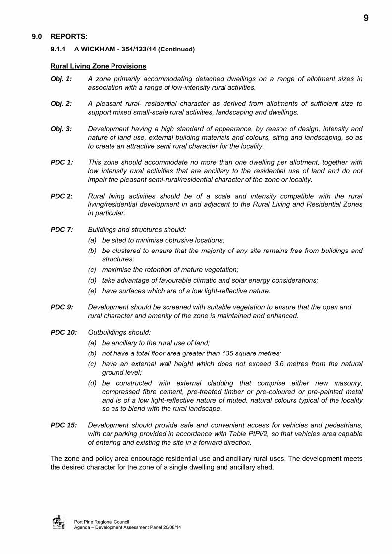
Rural Living Zone Provisions
Obj. 1: A zone primarily accommodating detached dwellings on a range of allotment sizes in association with a range of low-intensity rural activities.
Obj. 2: A pleasant rural- residential character as derived from allotments of sufficient size to support mixed small-scale rural activities, landscaping and dwellings.
Obj. 3: Development having a high standard of appearance, by reason of design, intensity and nature of land use, external building materials and colours, siting and landscaping, so as to create an attractive semi rural character for the locality.
PDC 1: This zone should accommodate no more than one dwelling per allotment, together with low intensity rural activities that are ancillary to the residential use of land and do not impair the pleasant semi-rural/residential character of the zone or locality.
PDC 2: Rural living activities should be of a scale and intensity compatible with the rural living/residential development in and adjacent to the Rural Living and Residential Zones in particular.
PDC 7: Buildings and structures should: (a) be sited to minimise obtrusive locations; (b) be clustered to ensure that the majority of any site remains free from buildings and
structures; (c) maximise the retention of mature vegetation; (d) take advantage of favourable climatic and solar energy considerations; (e) have surfaces which are of a low light-reflective nature.
PDC 9: Development should be screened with suitable vegetation to ensure that the open and rural character and amenity of the zone is maintained and enhanced.
PDC 10: Outbuildings should: (a) be ancillary to the rural use of land; (b) not have a total floor area greater than 135 square metres; (c) have an external wall height which does not exceed 3.6 metres from the natural
ground level; (d) be constructed with external cladding that comprise either new masonry,
compressed fibre cement, pre-treated timber or pre-coloured or pre-painted metal and is of a low light-reflective nature of muted, natural colours typical of the locality so as to blend with the rural landscape.
PDC 15: Development should provide safe and convenient access for vehicles and pedestrians, with car parking provided in accordance with Table PtPi/2, so that vehicles area capable of entering and existing the site in a forward direction.
The zone and policy area encourage residential use and ancillary rural uses. The development meets the desired character for the zone of a single dwelling and ancillary shed.
9

9.0 REPORTS: 9.1.1 A WICKHAM - 354/123/14 (Continued)
Port Pirie Regional Council Agenda – Development Assessment Panel 20/08/14
ASSESSMENT (Cont’d):
Rural Living Zone Provisions (Cont’d)
The buildings constructed on land in the zone should be unobtrusive, constructed in close proximity to other buildings (clustered), constructed from undamaged, low-light reflective material and screened by suitable vegetation. Ancillary outbuildings in particular should not have a floor area greater than 135 square metres, must not be more than 3.6 metres high and must be constructed using pre-painted metals of a low light-reflective nature.
The materials of construction are of low light reflective materials and considered to be of good quality. The outbuilding has a floor area and height which is above the amount specified for an outbuilding in the Rural Living Zone. As such, the outbuilding is considered large and its appearance bulky. However, it is considered that the scale of the proposed outbuilding is reasonable, given the location of the site relative to the surrounding area and in the context of the size of the site. Additionally, the planned planting adjacent to the proposed shed, and existing mature vegetation around the site and within the Napperby Creek watercourse also provide additional screening of the development from the adjoining properties and public roads.
The site would provide sufficient space to facilitate safe and convenient movement of vehicles. The dwelling makes provision for two personal motor vehicles to be garaged under the same roof of the dwelling and as such it meets the requirements set under Table PtPi/2 of the Development Plan which requests a parking space under roof.
Rural Living Zone Policy Area (PA) 2
Obj. 1: A policy area for rural living on existing allotments with provision for low intensity animal keeping.
PDC 1: Development should primarily be detached dwellings with ancillary rural living activities.
The proposed development is considered to be consistent with the relevant Policy Area provisions of the Development Plan.
PUBLIC NOTIFICATION:
The Panel would recall that, at its July 2014 meeting, it determined that the proposed development was minor in nature. Consequently, the development was identified as a Category 1 development, not requiring Public Notification, and a Statement of Effect was not required to be submitted.
CONCLUSION:
The development is identified as a non-complying development as the outbuilding exceeds the maximum floor area and wall height requirements for the area. The proposed development, being a dwelling home and outbuilding, has a floor area of 2.12 per cent of the site area. The site can readily accommodate the development without adverse visual impact, given the location of the site relative to the surrounding area and in the context of the size of the site
The proposed development is unlikely to affect the character of the locality; being similar in overall height, form, architectural style, materials of construction, and scale to existing structures in the area.
It is considered that the proposal has merit and warrants Development Plan Consent subject to reasonable and relevant conditions.
10
9.0 REPORTS: 9.1.1 A WICKHAM - 354/123/14 (Continued)
Port Pirie Regional Council Agenda – Development Assessment Panel 20/08/14
RECOMMENDATION:
A: That the Development Assessment Panel, having considered Development Application 354/123/14, for the erection of a dwelling and shed, determine that the proposal is not seriously at variance with the Port Pirie (RC) Development Plan.
B: That the Development Assessment Panel, pursuant to the provisions of the Development Act 1993, and subject to the concurrence of the Development Assessment Commission; delegate authority to the Director, Development & Regulation to grant Development Plan Consent for Development Application 354/123/14, for the erection of a dwelling and shed at Lot 171, Hundred of Napperby, subject to the following conditions:
1. Development is to take place in accordance with the supporting documentation and plans, except as modified by any conditions attached to this Decision Notification.
2. The construction of the drainage system and the position and manner of discharge of a stormwater drain must not:- a) Result in the entry of water into a building; or b) Affect the stability of a building; or c) Create any unhealthy or dangerous condition on the site or within the building;
or d) Flow or discharge onto land of an adjoining owner; and not flow across
footpaths or public ways.
3. The dwelling approved herein is to have all services (ie septic system, water, electricity, etc.) connected and servicing the dwelling prior to occupation.
4. The shed shall only be used for domestic purposes associated with the use of the dwelling erected on the land and is not to be used for human habitation or commercial or industrial activities without the prior written consent of Council.
5. The landscaping, as approved, shall be established upon the land within three (3) months of the completion of construction of the shed.
C: That the Development Assessment Panel resolve to attach the following notes to the Development Plan Consent:
1. Reason for Council’s Decision The above conditions were imposed upon the Development Plan Consent notice
pursuant to Section 42 of the Development Act 1993 (as amended).
2. That the development hereby approved must be: a) Substantially commenced within twelve (12) months from the date of the
decision of this Consent or Approval, otherwise this Consent or Approval will lapse at the expiration of twelve (12) months from this date (unless Council extends this period), and a new development application shall be required;
b) Substantially or fully completed within three (3) years from the date of the decision of this Approval, otherwise this Approval will lapse at the expiration of three (3) years from this date (unless Council extends this period), and a new development application shall be required; and
c) Any request for an extension of time must be lodged with the Council prior to the above mentioned periods.
d) Where an approval is given, any consent which was necessary for that approval will not lapse unless or until the approval lapses.
11

9.0 REPORTS: 9.1.1 A WICKHAM - 354/123/14 (Continued)
Port Pirie Regional Council Agenda – Development Assessment Panel 20/08/14
APPENDIX A Aerial Photographical Map of the Site and Locality
Imagery copyright AEROmetrex Pty Ltd. 2013
Disclaimer This map is a representation of the information currently held by Port Pirie Regional Council. While every effort has been made to ensure the accuracy of the product, Council accepts no responsibility for any errors or omissions. Any feedback on omissions or errors would be appreciated.
12
9.0 REPORTS: 9.1.1 A WICKHAM - 354/123/14 (Continued)
Port Pirie Regional Council Agenda – Development Assessment Panel 20/08/14
APPENDIX B (1 of 2) Photographs of the Site and Locality
13
9.0 REPORTS: 9.1.1 A WICKHAM - 354/123/14 (Continued)
Port Pirie Regional Council Agenda – Development Assessment Panel 20/08/14
APPENDIX B (2 of 2) Photographs of the Site and Locality
14

9.0 REPORTS: 9.1.1 A WICKHAM - 354/123/14 (Continued)
Port Pirie Regional Council Agenda – Development Assessment Panel 20/08/14
APPENDIX C Zone Map
15

9.0 REPORTS: 9.1.1 A WICKHAM - 354/123/14 (Continued)
Port Pirie Regional Council Agenda – Development Assessment Panel 20/08/14
APPENDIX D Application Documentation
16

9.0 REPORTS: 9.1 DEVELOPMENT APPLICATIONS - CATEGORY 1 9.1.2 JHI DEVELOPERS PTY LTD - 354/D006/14
APPLICATION NO. 354/D006/14
APPLICANT JHI Developers Pty Ltd
DEVELOPMENT PROPOSAL Land Division (34 Allotments created from 2 allotments)
LODGEMENT DATE 4 June 2014
LOCATION Port Davis Road, Risdon Park South (Opposite Mid North Christian College)
ZONE Residential Zone / General Farming Zone
NATURE OF DEVELOPMENT Merit
PUBLIC NOTIFICATION Category 1
REPRESENTATIONS Nil
ASSESSING OFFICER Patrick Clifton
REFERRALS
External Development Assessment Commission, SA Water; Department of Education and Child Development; Renewal SA (Affordable Housing); Environment Protection Authority and Department for Planning, Transport and Infrastructure. Internal Infrastructure Department
DEVELOPMENT PLAN VERSION 10 January 2013
COUNCIL WIDE PROVISIONS
Objectives (Obj) 8, 9, 14, 16, 17, 18, 19, 20, 21, 22, 25, 26, 27, 28, 29 and 30
Principles of Development Control (PDC)
9, 10, 12, 18, 19, 20, 22, 29, 30, 33, 36, 40, 53, 54, 70, 72, 73, 74, 75, 77, 78, 79, 88, 89, 90, 91 and 92
RESIDENTIAL ZONE PROVISIONS
Objectives (Obj) 1
Principles of Development Control (PDC) 16 and 18
GENERAL FARMING ZONE PROVISIONS
Objectives (Obj) 1 and 3 Principles of Development Control (PDC) 13
RECOMMENDATION That Development Plan Consent be granted, subject to conditions.
PLANNING HISTORY:
A review of Councils recent planning files indicates that the land has been the subject of two recent applications and approvals for Land Division. These are set out below:
354/D004/06, Land Division (creating 32 allotments from 1 existing allotment), Mr Malcolm Johnson, approved subject to conditions. This approval represented the initial stage of division for this land; and
354/D030/08, Land Division (creating 45 allotments from 2 existing allotments), Mr Malcolm Johnson, approved subject to conditions. This approval was on the same land as that the subject of the present application and represented the second stage of this division.
27

9.0 REPORTS: 9.1.2 JHI DEVELOPERS PTY LTD - 354/D006/14 (Continued)
Port Pirie Regional Council Agenda – Development Assessment Panel 20/08/14
SITE AND LOCALITY:
Legal Description
The subject land is described as Allotment 43, Deposited Plan 79645, Certificate of Title Volume 6026 Folio 355, as Allotment 906, Deposited Plan 79645, Certificate of Title Volume 6026 Folio 356; and, as Allotment 9, Filed Plan 101381, Certificate of Title Volume 5114 Folio 285 in the area named Risdon Park, Hundred of Pirie. The property is more commonly known as Lot 906 Port Davis Road, Port Pirie.
Physical Description and Land Use
The subject land is irregular in shape, contains an area of 90.81 hectares and is accessed from Kingston Road to the North and Port Davis Road to the East. The land represents the parent parcel of a previous land division with recently created residential allotments located to the north east of the subject land.
The land is vacant with the exception of an old farm house fronting Port Davis Road, which would be demolished to provide for the Division. The land is also predominantly flat with the exception of an area located approximately centrally on the site and which extends from the eastern boundary to the western boundary and is used for the purpose of a quarry under an existing mining licence. The land is covered in saltbush and native grasses with introduced weed species evident.
The locality containing the site is best described as an emerging residential area. To the north east and east, the site adjoins a relatively new residential estate. To the east is an educational establishment (The Mid North Christian College) and, on the opposite side of Port Davis Road, vacant land that is proposed to be developed for residential purposes. Immediately adjacent the southern portion of the site and fronting Port Davis Road is a former quarry and Landscape Supplies Business (Heidrichs Landscape Supplies) and a recreational shooting range (Paintball Skirmish Port Pirie). To the South and West land is general farming land predominantly used for grazing purposes.
Refer to Appendix A (Aerial Photographical Map of the Site and Locality); and
Appendix B (Images of the Site and Locality)
Zoning
The subject land is identified partly within the Residential Zone and partly within the General Farming Zone, as defined on Map PtPi/9 and PtPi/23 of the Port Pirie (RC) Development Plan (Consolidated 10 January 2013). That part of the site proposed to be divided for residential allotments is located within the Residential Zone, whilst the proposed reserve area is identified within the General Farming Zone.
Refer to Appendix C (Zone Maps PtPi/9 and PtPi/23)
NATURE OF PROPOSED DEVELOPMENT:
The application proposes the division of land to create 35 allotments from an existing 2 allotments. 33 of the allotments would be residential allotments, one allotment would be a reserve of 27.19 hectares and one allotment would be the balance of the land.
Appendix D (Application Documentation)
28

9.0 REPORTS: 9.1.2 JHI DEVELOPERS PTY LTD - 354/D006/14 (Continued)
Port Pirie Regional Council Agenda – Development Assessment Panel 20/08/14
NATURE OF PROPOSED DEVELOPMENT (Cont’d):
The residential allotments would be located in the north east of the subject land and would be accessed from Port Davis Road. They would contain areas ranging from 510sqm to 869sqm and would have frontages of 15 to 25 metres. As part of the division, two new road reserves would be created, one directly from Port Davis Road and the other an extension of the existing Radford Drive South, connecting to the new road reserve. Both the road reserves would have a width of 15 metres. The residential allotments would be stage two of the recent division to the north east of the subject land, which was created in accordance with Development Approval 354/D0043/06.
The proposed reserve would be located in the South of the subject land and would have a northern boundary consistent with the boundary of the adjoining land containing the landscaping supplies business and the paintball business. The reserve is intended to form part of the Councils South West Drainage Scheme, which is a strategic infrastructure proposal to provide for the drainage of the urban expansion area to the South West of the City. As part of this drainage strategy an easement will be created across the adjoining land to the east connecting the reserve to Port Davis Road and the proposed residential land further to the east and across the adjoining land to the west connecting the reserve to the ultimate drainage outfall to the north. Attached at Appendix E is a plan of the proposed easement. Council have adopted the South West Drainage Scheme as a strategic infrastructure proposal and it is to form a material consideration in the assessment of development applications.
Appendix E (Proposed South West Drainage Scheme Easement)
REFERRALS:
External
Development Assessment Commission
In addition to the requirements of SA Water below, the Development Assessment Commission have requested that the following requirements be included in any development approval granted:
A final plan complying with the requirements for plans, as set out in the Manual of Survey Practice Volume 1 (Plan Presentation and Guidelines) issued by the Registrar General to be lodged with the Development Assessment Commission for Land Division Certificate purposes.
South Australian (SA) Water Corporation
The SA Water Corporation has advised that the applicant will be required to satisfy the following requirements:
The financial requirements of SA Water shall be met for the provision of water supply and sewerage services;
The augmentation requirements of SA Water shall be met;
The necessary easements shall be vested to SA Water; and The 150DN main in Port Davis Rd needs to be extended to interconnect to the 100DN main in
Lawrie Rd to service this development.
Department for Education and Child Care Development
No Comment
29

9.0 REPORTS: 9.1.2 JHI DEVELOPERS PTY LTD - 354/D006/14 (Continued)
Port Pirie Regional Council Agenda – Development Assessment Panel 20/08/14
REFERRALS (Cont’d):
External (Cont’d)
Renewal SA (Affordable Housing)
No Comment
The Department of Planning, Transport and Infrastructure (DPTI)
No Comment
Environment Protection Authority
No Comment
Internal
The application was referred to the Council’s Infrastructure Department; who have no objections to the proposed development subject to the following, as per the Councils adopted policy: Appropriate engineering design and certification for all construction works;
The submission of a Construction Management Plan and Dust Management Plan;
Appropriate security for all works; The submission of an appropriate Traffic Management Plan;
Provision of street lighting and footpaths; The provision of a Stormwater Drainage Management Plan and the appropriate construction of
drainage infrastructure; and
Provision of street trees.
ASSESSMENT:
The proposal has been considered on merit, pursuant to Section 35(5) of the Development Act 1993 and has been identified as a Category 1 development in accordance with Schedule 9 Part 1(5) of the Development Regulations 2008.
The Act requires the Council, as the Relevant Authority, to consider the application for Development Plan Consent against the provisions of the Development Plan. An assessment of the proposed development against Council Wide and specific Zone provisions is set out below.
Council Wide Provisions
Form of Development
Obj. 8: Orderly and economic development.
Obj. 9: A proper distribution and separation of living, working and recreational activities by the allocation of suitable areas of land for those purposes.
PDC 9: Development should be orderly and economic.
30

9.0 REPORTS: 9.1.2 JHI DEVELOPERS PTY LTD - 354/D006/14 (Continued)
Port Pirie Regional Council Agenda – Development Assessment Panel 20/08/14
ASSESSMENT (Cont’d):
Council Wide Provisions (Cont’d)
Form of Development (Cont’d)
PDC 10: Development including land division, urban holiday settlement, tourist development other urban development should be: (a) supportive of compact rather than linear development; (b) contiguous with any existing built-up areas; (c) developed in a staged and orderly manner which facilitates the economic provision of
services and infrastructure; and (d) able to be serviced with a reticulated domestic quality mains water supply and a
common effluent drainage scheme.
PDC 12: Development should only take place: (a) on land which is protected from flooding by higher land, tidal levee banks and
stormwater drainage where the actual probability of water reaching to within 0.25 metres of floor levels is less than 1 percent, taking into account protection measures, and an increase of 0.3 metres in mean sea level and in the height of extreme tides above the levels, respectively, existing on the 1 January 1991;
(b) involving the erection of a building on land which is not protected from flooding by higher land, tidal levee banks and stormwater drainage where the site level of that building is not less than 3.15 metres above Australian Height Datum and any floor level of that building is not less than 3.40 metres above Australian Height Datum; or
(c) involving the erection of a building over the Port Pirie River or the sea or so close to the water's edge as to preclude the construction of tidal protection works, where any floor level of that building is not less than 4.30 metres above Australian Height Datum or can be designed to be raised to that level if necessary.
The proposed division is within the existing Residential Zone and would form a continuation of the existing residential development located to the north east of the development site. The development represents a contiguous compact development and allows for the orderly extension of infrastructure such as roads, sewer, gas, power and water thus achieving economy in the provision of public services.
The application site is located in an area affected by the recently adopted South West Drainage Scheme. The South West Drainage Scheme provides a strategy for the management of storm water in the locality to protect existing and future residential development. The proposed land division and drainage proposals are considered to be in accordance with this strategy and the allocation of the reserve is in accordance with the Councils strategic intent for the provision of drainage infrastructure in the locality.
The proposed division is considered to be orderly and economic and the land is able to accommodate the intended development.
31
9.0 REPORTS: 9.1.2 JHI DEVELOPERS PTY LTD - 354/D006/14 (Continued)
Port Pirie Regional Council Agenda – Development Assessment Panel 20/08/14
ASSESSMENT (Cont’d):
Council Wide Provisions (Cont’d)
Interface Between Land Uses
Obj. 14: Development located and designed to prevent adverse impact and conflict between land uses.
PDC 18: Development should not detrimentally affect the amenity of the locality or cause nuisance by: (a) the emission of effluent, odour, smoke, fumes, dust or other airborne pollutants; (b) excessive noise; (c) vibration; (d) electrical interference; (e) light spill; (f) glare; or (g) hours of operation
PDC 19: New development should be designed and sited to minimise its impact on existing and potential future land uses considered appropriate in the locality.
PDC 20: Development should be designed, constructed and sited to minimise negative impacts of noise and to avoid unreasonable interference.
PDC 22: Residential development adjacent to non-residential zones and land uses should be designed and sited to protect residents from any adverse impacts of non-residential activities.
The proposal is for land division to create residential allotments in the Residential Zone. The development of the created allotments for residential purposes would compliment the existing development in the locality and is not anticipated to have an adverse impact on the amenity of the area. Furthermore, any development of the allotments created would be subject to a future development application, and detailed consideration in respect of the impact of that development would be provided at that time. The proposed land division would not adversely affect the amenity of the area.
Land Division
Obj. 16: Land in appropriate localities divided into allotments in an orderly and economic manner.
PDC 29: Land should not be divided: (a) in a manner which would prevent the satisfactory future division of the land, or any
part thereof; (b) if the proposed use, or the establishment of the proposed use, is likely to lead to
undue erosion of the land or land in the vicinity thereof; (c) unless wastes produced by the proposed use of the land, or any use permitted by
the principles of development control, can be managed so as to prevent pollution of a public water supply or any surface of underground water resources;
32

9.0 REPORTS: 9.1.2 JHI DEVELOPERS PTY LTD - 354/D006/14 (Continued)
Port Pirie Regional Council Agenda – Development Assessment Panel 20/08/14
ASSESSMENT (Cont’d):
Council Wide Provisions (Cont’d)
Land Division (Cont’d)
(d) if the size, shape and location of, and the slope and nature of the land contained in, each allotment resulting from the division is unsuitable for the purpose for which the allotment is to be used;
(e) if any part of the land is likely to be inundated by tidal or floodwaters and the proposed allotments are to be used for a purpose which would be detrimentally affected when the land is inundated;
(f) where community facilities or public utilities are lacking or inadequate; (g) where the proposed use of the land is the same as the proposed use of other
existing allotments in the vicinity, and a substantial number of the existing allotments have not been used for that purpose; or
(h) if it would cause an infringement of any provisions of the Building Act or any by-law or regulation made thereunder.
PDC 30: When land is divided:
(a) each allotment shall be designed to maximise solar access; (b) any reserves or easements necessary for the provision of public utility services
should be provided; (c) stormwater should be capable of being drained safely and efficiently from each
proposed allotment and disposed of from the land in a satisfactory manner; (d) a water supply sufficient for the purpose for which the allotment is to be used should
be made available to each allotment; (e) provision should be made for the disposal of waste waters, sewage and other
effluents from each allotment without risk to health; (f) roads or thoroughfares should be provided where necessary for safe and convenient
communication with adjoining land and neighbouring localities; (g) each allotment resulting from the division should have safe and convenient access to
the carriageway of an existing or proposed road or thoroughfare and to documented bicycle and pedestrian routes;
(h) for urban purposes, provision should be made for suitable land to be set aside for usable local open space; and
(i) where the land borders a river, lake or creek, the land immediately adjoining the river, lake or creek should become public open space, with a public road fronting the open space.
The proposal is for the division of land to create residential allotments within the Residential Zone. The development would form a logical extension to the existing residential area to the north east and would create allotments suitable for their intended purpose.
The land would be suitably drained and each allotment provided with appropriate services to enable development. All of the residential allotments would be accessed off a proposed new road, which is considered to be of an acceptable width to accommodate the road infrastructure and the anticipated traffic generated.
33

9.0 REPORTS: 9.1.2 JHI DEVELOPERS PTY LTD - 354/D006/14 (Continued)
Port Pirie Regional Council Agenda – Development Assessment Panel 20/08/14
ASSESSMENT (Cont’d):
Council Wide Provisions (Cont’d)
Land Division (Cont’d)
An area of 27.19 hectares of the parent parcel is to be provided as reserve. The Development Regulations 2008 require the provision of 12.5% of the area the subject of the residential division, 2.03 hectares, to be provided as open space. This equates to an area of 2,537.5sqm, which is significantly less than the 27.19 hectares provided. However, it is intended that this reserve contribution would be provided for future stages of division in accordance with section 50(11) of the Development Act 1993. Even if the whole 90.81 hectares were divided at a future stage the proposed 27.19 hectares would equate to 29.9% reserve contribution. The reserve would also be used as part of strategic infrastructure to drain the South West of the City. On this basis it is considered that the requirement for open space provision has been satisfied.
The proposed division is considered to be consistent with these provisions of the Development Plan.
Movement of People and Goods
Obj. 17: A comprehensive, integrated, affordable and efficient air, rail, sea, road, cycle and pedestrian system that will: (a) provide equitable access to a range of public and private transport services for all
people; (b) ensure a high level of safety; (c) effectively support the economic development of the State; (d) have minimal negative environmental and social impacts; and, (e) maintain options for the introduction of suitable new transport technologies.
Obj. 18: Development that: (a) provides safe and efficient movement for all motorised and non-motorised transport
modes; (b) ensures access for vehicles including emergency services, public infrastructure
maintenance and commercial vehicles; (c) provides off street parking; and, (d) is appropriately located so that it supports and makes best use of existing transport
facilities and networks.
Obj. 19: A road hierarchy that promotes safe and efficient transport in an integrated manner throughout the State
Obj. 20: Provision of safe, pleasant, accessible, integrated and permeable pedestrian and cycling networks.
PDC 33: Land uses should be arranged to support the efficient provision of sustainable transport networks and encourage their use.
PDC 36: Roads should be sited and be designed to blend with the landscape and by in sympathy with the Terrain.
PDC 40: Development should provide safe and convenient access for all anticipated modes of transport including cycling, walking, public and community transport, and motor vehicles.
34

9.0 REPORTS: 9.1.2 JHI DEVELOPERS PTY LTD - 354/D006/14 (Continued)
Port Pirie Regional Council Agenda – Development Assessment Panel 20/08/14
ASSESSMENT (Cont’d):
Council Wide Provisions (Cont’d)
Movement of People and Goods (Cont’d)
PDC 53: Development should have direct access from an all weather public road.
PDC 54: Development should be provided with safe and convenient access which: (a) avoids unreasonable interference with the flow of traffic on adjoining roads; (b) accommodates the type and volume of traffic likely to be generated by the
development or land use and minimises induced traffic through over-provision; and (c) is sited and designed to minimise any adverse impacts on the occupants of and
visitors to neighbouring properties.
The proposed land division would create 33 residential allotments that would be accessed from a 15 metre wide road reserve constructed off Port Davis Road. Port Davis Road is a higher order road with a reserve width of 20 metres and is capable of accommodating 3000+ vehicles per day. The internal roads of 15 metres in width are capable of accommodating 500 vehicles per day. The proposed land division is considered to complement the road hierarchy in the locality and would not adversely affect the free flow of the traffic in the network. Furthermore, the development was reviewed by the Department of Planning, Transport and Infrastructure and Council’s Infrastructure Department. No objections were raised to the development.
Utilities
Obj. 21: Economy in the provision of public services.
Obj. 22: Protection of properties from the adverse impacts of overland stormwater flow, and provision for on-site detention, retention and the use of stormwater where practicable.
PDC 70: Development should be provided with an adequate, reliable and potable water supply.
PDC 72: Development should provide power and telephone services to be placed underground in visually prominent areas.
PDC 73: Development should be provided with essential services and cause no health or pollution risk.
PDC 74: Development should not be undertaken unless effluent and other wastes can be effectively disposed of on-site without risk to public health or damage to the environment.
PDC 75: Collection, treatment and disposal of effluent generated from the development should be designed to ensure that no effluent is discharged into the watertable, watercourses, or adjacent marine waters, unless it is treated to an approved standard.
PDC 77: Site drainage should: (a) include, where practicable, scope for on-site stormwater detention, retention and use,
including the collection and storing of water from roofs and communal car parks in appropriate devices;
35
9.0 REPORTS: 9.1.2 JHI DEVELOPERS PTY LTD - 354/D006/14 (Continued)
Port Pirie Regional Council Agenda – Development Assessment Panel 20/08/14
ASSESSMENT (Cont’d):
Council Wide Provisions (Cont’d)
Utilities (Cont’d)
(b) provide on-site infiltration where practicable, having regard to: (i) the availability of unbuilt upon or unsealed areas, (ii) the ability of soils to absorb water, (iii) the ability of building footings on and adjacent to the site to withstand the likely
effects of retained water, and (iv) potential adverse impacts on the level of ground water;
(c) allow convenient access to all components of the drainage system for maintenance purposes; and
(d) not cause damage or nuisance flows on site or to adjoining properties.
PDC 78: Where site conditions do not permit either on-site stormwater retention or detention, site drainage should be directed into the street drainage network of the minor system.
PDC 79: Urban stormwater collection should be designed where practicable, to harvest and use water for irrigation purposes, ensuring that pollutants are not discharged into the water table, watercourses, or adjacent marine waters.
The applicant has advised that all allotments established as part of this land division will be connected to all appropriate utilities. Any approval should be conditioned accordingly. In respect of stormwater drainage, the application site is located in an area covered by a broader drainage strategy, the South West Drainage Scheme. The Scheme provides a strategy for the drainage of all of the residentially zoned land to the South West of the City, including the application site. The proposed land division is in accordance with this strategy and the proposed reserve would form part of this strategic drainage infrastructure.
Site Contamination
Obj. 25: Identification of land and associated surface water, sediments and groundwater that is contaminated.
Obj. 26: Remediation of the adverse impacts (including land contamination) of existing or past activities, and cleaning up of such land where a risk of harm to human health or the environment exists.
Obj. 27: Sites made suitable for their intended use to ensure a safe and healthy living and working environment.
PDC 88: Development, including land division, should not occur on contaminated land or on potentially contaminated land unless: (a) remediation of the site is undertaken to a standard that makes it suitable and safe for
the proposed use; or (b) the site will be maintained in a condition or the development will be undertaken in a
manner that will not pose a threat to the health and safety of the environment or to occupiers of the site or land in the locality.
36

9.0 REPORTS: 9.1.2 JHI DEVELOPERS PTY LTD - 354/D006/14 (Continued)
Port Pirie Regional Council Agenda – Development Assessment Panel 20/08/14
ASSESSMENT (Cont’d):
Council Wide Provisions (Cont’d)
Site Contamination (Cont’d)
PDC 89: A land use history and condition of site report should be undertaken on any site that is likely to have been contaminated through industrial, commercial, agricultural, site filling or other potentially contaminating activities.
PDC 90: In order to prevent harm to human health or the environment, development should not be undertaken on contaminated land or on potentially contaminated land unless: (a) the land is remediated to a level that makes it suitable and safe for the proposed use;
or, (b) the land will be maintained in a condition or the development will be undertaken in a
manner that will not pose a threat to the health and safety of the environment or occupiers of the land or land in the locality.
The land has previously been used for the grazing of animals and is not known to have been used for any notifiable activity for the purpose of land contamination. It is not considered that the land is likely to be contaminated or that remediation works would be required.
Residential Development
Obj. 28: Compact urban areas within the City of Port Pirie, and townships of Crystal Brook, Redhill, Koolunga and Napperby.
Obj. 29: Safe, convenient and pleasant living environments.
Obj. 30: Encourage a full range of dwelling types, dwelling design and development techniques.
PDC 91: Residential allotments and sites should have the appropriate orientation, area, configuration and dimensions for: (a) the siting and construction of a dwelling and ancillary outbuildings;
(b) the provision of landscaping and private open space;
(c) convenient and safe vehicle access and parking; and,
(d) passive energy design.
PDC 92: Allotments or sites with an area of 450 square metres or greater should incorporate an area for a dwelling of at least 10 metres by 15 metres and is set back from the boundaries in accordance with applicable zone policies to contribute to the desired character for the area.
The application site is contiguous with existing residential development and would create allotments with sizes varying from 510 square metres through to 869 square metres. The proposed allotments are considered of appropriate size, shape and orientation to allow for a dwelling and associated outbuildings, landscaping, private open space and safe vehicle access/parking. The allotment’s orientation allows for a variety of building designs to take advantage of passive energy designs.
37

9.0 REPORTS: 9.1.2 JHI DEVELOPERS PTY LTD - 354/D006/14 (Continued)
Port Pirie Regional Council Agenda – Development Assessment Panel 20/08/14
ASSESSMENT (Cont’d):
Residential Zone Provisions
Obj 1: A zone primarily accommodating detached dwellings located on sites of varying size with medium density residential development and community facilities in suitable area adjacent to retail and community facilities.
PDC 16: Any site accommodating a detached dwelling should be at least 450 a square metres in area, any site accommodating a semi-detached dwelling should be at least 400 square metres in area, and any site accommodating a row dwelling, group dwelling or residential flat building should be at least 300 square metres in area.
PDC 18: A site should have a frontage to a constructed public road and a depth of not less than the following:
Type of Dwelling Frontage The Width of Site The Depth of Site Detached Dwelling 15.0 metres 15.0 metres 25.0 metres Semi-Detached Dwelling 10.0 metres 10.0 metres 25.0 metres Row Dwelling 10.0 metres 10.0 metres 25.0 metres
The proposed land division would create residential allotments with minimum dimensions of 15.94 metres x 32.02 metres and a minimum size of 510 sqm. Each allotment would also be provided with access from a constructed road. The proposed land division is able to satisfy the relevant Residential Zone provisions of the Port Pirie (RC) Development Plan.
General Farming Zone Provisions
Obj 1: The long term continuation of primary production, including value adding to primary production.
Obj 3: Allotments of a size and configuration that promote the efficient use of land for primary production.
PDC13 Land division into allotments of less than 40 hectares in area should only be undertaken where: (a) the division will rationalise existing boundaries so as to improve the agricultural
efficiency and productivity of the property, provided that there is no increase in the number of allotments and the proposed use of the new allotments is consistent with the purpose of the zone.
The proposed land division would create an allotment in the General Farming zone of 27.19 hectares, which is less than the 40 hectares provided for in the Development Plan. The proposed allotment is to be provided to Council as a reserve to be used as part of strategic drainage infrastructure and is to contain an open drain that would link to drainage easements to the east and west to allow the drainage of stormwater from residential zoned land to the gulf.
38

9.0 REPORTS: 9.1.2 JHI DEVELOPERS PTY LTD - 354/D006/14 (Continued)
Port Pirie Regional Council Agenda – Development Assessment Panel 20/08/14
ASSESSMENT (Cont’d):
General Farming Zone Provisions
It would form part of the South West Drainage Scheme which was adopted by Council at its meeting 24 October 2012 as the approach for the drainage and management of storm water in the south west of the city. The provision of this land as part of the South West Drainage Scheme was approved by Council at its Ordinary Meeting 23 April 2014.
Notwithstanding the non-compliance with the provisions of the General Framing zone, the creation of the reserve and the associated drainage infrastructure is in accordance with Council Wide Utilities Objective 22 identified above and is considered acceptable and appropriate. CONCLUSION:
The proposed development would create 33 residential allotments in a Residential Zone adjacent to an existing residential area and a reserve in the General Farming Zone to be used, in part, for strategic drainage infrastructure. The residential allotments would be of a variety of sizes, suited to residential development and offer a choice of configuration to suit individual needs and a variety of building designs. The reserve is in accordance with the Councils Strategy for drainage infrastructure provision in the South West of the City and is suitable for the proposed use.
The proposal is able to satisfy the relevant provisions of the Port Pirie (RC) Development Plan and the allotments created would be suitable for their intended purpose. The proposal is recommended for approval subject to reasonable and relevant conditions.
39

9.0 REPORTS: 9.1.2 JHI DEVELOPERS PTY LTD - 354/D006/14 (Continued)
Port Pirie Regional Council Agenda – Development Assessment Panel 20/08/14
RECOMMENDATION:
A: That the Council Development Assessment Panel, having considered Development Application 354/D006/14, resolve that the proposed development is not seriously at variance with the Port Pirie (RC) Development Plan.
B: The Development Assessment Panel, having considered the application for consent to undertake a division of land into 34 allotments, and pursuant to the provisions of the Development Act 1993; hereby Grant Development Plan Consent to Development Application 354/D006/14 to undertake the division of land at Port Davis Road, Risdon Park South (Opposite Mid North Christian College), subject to the following conditions and notes:
PLANNING CONDITIONS:
1. Development is to take place in accordance with the supporting documentation and Plan Ref: JK76P12.2/PIR-57/DAJ prepared by Mosel Steed relating to Development Application Number 354/D006/14 for Land Division except as modified by any conditions attached to this Decision Notification.
2. Prior to the commencement of works a Construction Management Plan shall be submitted to Council for approval. The construction management plan shall identify all on-site management practices and shall be approved prior to the commencement of works.
3. Prior to the commencement of works a Dust Control Plan shall be submitted to Council for approval. The plan may include, but is not limited to, cleanup, sweeping, sprinkling, compacting, enclosure, chemical or asphalt sealing and the use of wind screens. In the most adverse climatic conditions operations shall cease if necessary to reduce nuisance and to avoid undesirable environmental impacts. The Dust Management Plan shall be approved prior to the commencement of works.
LAND DIVISION CONDITIONS:
4. Roads, kerbing, footpaths, site works, drainage etc shall be designed by a chartered engineer in accordance with the design criteria as detailed in Schedule 1 annexed hereto and shall be approved by Council in writing prior to the commencement of any site works. Plans are to be submitted to Council in hard copy and electronic format.
5. The construction of all civil works is to be supervised by a civil engineer with suitable experience. At the completion of works, the engineer shall provide the Council a certificate declaring that the works have been carried out in a satisfactory manner that meets all the requirements of the approved plans and specifications.
6. The engineering design and all specifications for all site construction works including any required roads, kerbing, footpaths, site works, drainage etc. is to be approved by Council in writing prior to the commencement of any site works.
40

9.0 REPORTS: 9.1.2 JHI DEVELOPERS PTY LTD - 354/D006/14 (Continued)
Port Pirie Regional Council Agenda – Development Assessment Panel 20/08/14
B (Cont’d):
7. Port Davis Road at the site frontage is to be provided with mountable kerb and gutter with a paved footpath adjacent the kerb. The footpath provided as a result of these works is to be consistent with the footpath width of that area of Port Davis Road to the north of the site.
8. A Traffic Management Plan including appropriate signage, line marking, street name blade locations, location and type of traffic control devices in accordance with AS 1742 shall be submitted and approved by Council prior to the commencement of works.
Stormwater Requirements:
9. The applicant shall provide a detailed Stormwater Drainage Management Scheme to the reasonable satisfaction of the Port Pirie Regional Council. The Stormwater Drainage Scheme is to be prepared by a Professional Civil Engineer with suitable experience. The Stormwater Drainage Management Scheme is to incorporate: a) A detailed assessment of the catchment area. b) Details of how the stormwater disposal will tie in with the South West Drainage
Scheme, if appropriate. c) Disposal of stormwater from the site in an effective manner. d) Control litter and pollution from the site. e) Measures to maintain the rate of run off from the site at levels no greater than
those that existed prior to development. f) Control erosion and sedimentation during construction. g) Measures to encourage on site water harvesting.
10. All such works detailed within the Storm water Drainage Management Plan shall be completed in accordance to the satisfaction of Council. Approval of the aforementioned plans must be obtained from Council in writing prior to the commencement of any construction.
11. As constructed plans for all stormwater works shall be provided at the conclusion of works. The plans are to be certified by a Consulting Engineer that the works have been carried out in accordance with the approved plans and specifications and shall be forwarded to Council upon practical completion.
12. All infrastructure assets constructed should be included in “As Constructed Drawings” and where possible referenced to the digital cadastral database (DCDB). Council requires all asset information to be submitted in electronic format post construction for easy transference to Council’s Asset Design As Constructed (ADAC) Register. Developers are directed to contact Council’s Infrastructure Department (08 8633 9666) for details of the electronic format specification currently being used.
41

9.0 REPORTS: 9.1.2 JHI DEVELOPERS PTY LTD - 354/D006/14 (Continued)
Port Pirie Regional Council Agenda – Development Assessment Panel 20/08/14
B (Cont’d):
13. As soon as practical after the completion of construction and before the issue of a certificate of practical completion by Council, the Developer shall supply: • An electronic copy of the "As-Constructed" drawings for all works in AutoCAD
(.dwg) format. This is to include any variations to the For Construction plans, including survey results. The drawing must reference the following coordinate system, unless otherwise specified: - Australia Geocentric Datum 1994 (AGD 94) - Map Grid Australia Zone 54 (MGA 54)
• A schedule of the infrastructure that will become the property of Council in tabular Excel format to the satisfaction of Council;
• copies of all compaction tests (and re-tests) for all trenches in roads (one test per layer for each backfill material for each 30 metres of trenching)
• CCTV Footage of internal inspection of all stormwater pipe networks in WIN-CAN format.
• Certification by a professional civil engineer that the works were carried out in accordance with the approved plans and specifications.
• Copies of NATA Certified compaction test results, as follows: - Roads - Four tests per thousand square metres in each layer, with
locations randomly generated, (the Council may specify the location from time to time).
- Trenches in Roads - One test per each layer for each material every 30 metres of trenching. One test per trench for each service trench to each property.
14. The stormwater drainage system shall be designed to carry a 1 in 100 year ARI storm event and in accordance with the Stormwater Design Criteria as detailed in Schedule 2 attached hereto.
15. Easements shall be provided over all drains in any allotments not being a road or reserve. Unless indicated otherwise, such easements shall be four (4) metres wide where the easement contains more than one drain and three (3) metres wide when the easement contains only a single drain.
Landscaping Requirements:
16. Street trees shall be provided in front of all new allotments at a rate of one tree per allotment and shall be positioned centrally to the frontage of the new allotments created.
17. The species, size and location of the street trees shall be submitted to Council for approval prior to the commencement of works. Trees shall nave a minimum height of 2 metres at the time of planting, be double staked with 50mm hardwood stakes installed parallel to the road and loose tied and planted in a 1 metre diameter mulched bowl to facilitate watering and water retention.
42

9.0 REPORTS: 9.1.2 JHI DEVELOPERS PTY LTD - 354/D006/14 (Continued)
Port Pirie Regional Council Agenda – Development Assessment Panel 20/08/14
B (Cont’d):
GENERAL REQUIREMENTS:
18. Street names are to be determined by the Council in accordance with its Street naming policy.
19. The Developer must seek from SA Water a written guarantee of supply of water complementing this development.
20. The Developer shall make arrangements with SA Power Networks for the provision of an adequate electricity supply to each allotment with due consideration given to likely peak demands.
21. All public utilities (water supply, electricity, gas and Telstra services) shall be provided underground.
22. Street lighting will be provided throughout the subdivision. The following minimum lighting “categories” (ASNZS 1158.3.1 – 1999) will apply:- Roads & Intersections P5
23. The streetlights and poles shall be of a type approved by the Port Pirie Regional Council. They shall also be of an SA Power Networks “standard” type or approved for SA Power Networks SLUOS tariff, so that the authority will assume full responsibility for the maintenance/replacement of lamps and poles.
24. Street lights are to be located 1.5m behind the kerb.
25. All engineering designs shall be to AHD.
26. All construction work shall be guaranteed for the period of 12 months from the date of practical completion. A bank guarantee whose value represents 5% of the total contract price shall be lodged with Council prior to practical completion. The Bank guarantee shall be held by Council for the full 12 months guarantee period and shall only be released when Council is satisfied that there are no defect items outstanding.
27. Site development machinery should not be operated outside the hours of 7am to 6pm daily.
REASON:
To ensure compliance with the requirements of the Development Plan, The Development Act 1993 and the Development Regulations 2008.
NOTES:
1. The applicant is reminded to contact Council when all the Council’s conditions and requirements have been complied with and accordingly, the Development Assessment Commission will then be notified that the Council has no objections to the issue of the Certificate of Approval.
2. The applicant is advised to contact the individual service providers regarding the location of street lighting and electricity supply.
43

9.0 REPORTS: 9.1.2 JHI DEVELOPERS PTY LTD - 354/D006/14 (Continued)
Port Pirie Regional Council Agenda – Development Assessment Panel 20/08/14
B (Cont’d):
3. The applicant is reminded of its general environmental duty, as required by Section 25 of the Environment Protection Act, to take all reasonable and practical measures to ensure that the activities on the whole site, including during construction, do not pollute the environment in a way which causes or may cause environmental harm.
4. The applicant should be aware that the approval of the Native Vegetation Council is required for the clearance of vegetation for house sites and for infrastructure prior to clearance occurring. There will also be a requirement for any clearance that occurs to be offset by a significant environmental benefit.
DAC REQUIREMENTS:
1. The financial and augmentation requirements of the SA Water Corporation shall be met for the provision of water supply and sewerage services (SA Water 90086/14)
The necessary easements shall be granted to the SA Water Corporation free of cost.
2. A final plan complying with the requirements for plans as set out in the Manual of Survey Practice Volume 1 (Plan Presentation and Guidelines) issued by the Registrar General to be lodged with the Development Assessment Commission for Land Division Certificate purposes.
DAC NOTES:
1. SA Water Corporation further advise that the 150DN main in Port Davis Road needs to be extended to interconnect to the 100DN main in Lawrie Road to service this development.
44
9.0 REPORTS: 9.1.2 JHI DEVELOPERS PTY LTD - 354/D006/14 (Continued)
Port Pirie Regional Council Agenda – Development Assessment Panel 20/08/14
SCHEDULE 1 – ROAD CONSTRUCTION DETAIL
1. Reserve Widths
The following minimum road reserve widths shall apply:- • Residential Streets – 15m
2. Road Widths
Streets will have the following minimum width:- • Residential streets (face to face of kerb) – 7.0m • Cul-de-sac ends (circular) – 10.5m radius
3. Minimum Stopping Sight Distance Adopt the minimum for 50 km/hr design speed.
4. Longitudinal Grades The following are to be adopted: Preferred minimum 0.4% Absolute minimum 0.25% Maximum 12%
5. Road Seal - 2 Coat Bitumenous Seal with 14mm/7mm Aggregate Application
6. Pavement Construction
The following minimum standards will apply:-
Sub-Base • To comply with Transport SA Standard Specification PM21 • To be compacted to 95% dry density ratio (AS 1289.5.2.1) • Minimum soaked CBR at the above compaction to be 40 • Minimum thickness of 100mm • Level tolerance on completed course –20mm, +10mm.
Base • To comply with Transport SA Standard Specification PM32 • To be compacted to 98% dry density ratio (AS 1289.5.2.1) • Minimum soaked CBR at above compaction to be 80 • Minimum thickness of 100mm • Level tolerance on completed course –10mm, +10mm
Total Pavement Thickness • To be determined from the current Austroads Pavement Design Manual, adopting a
traffic level of 104 ESA, and using a design subgrade CBR determined from testing of actual materials encountered in the exposed subgrade when compacted to 95% dry density ratio (AS 1289.5.1.1).
• To be no less than 200mm (excl. bituminous thickness).
45

9.0 REPORTS: 9.1.2 JHI DEVELOPERS PTY LTD - 354/D006/14 (Continued)
Port Pirie Regional Council Agenda – Development Assessment Panel 20/08/14
SCHEDULE 1 – ROAD CONSTRUCTION DETAIL (Cont’d)
Subgrade Preparation
The street subgrades are to be formed, compacted and trimmed so that:- • A dry density ratio of 95% (AS 1289.5.1.1) is attained • A firm, uniform surface is achieved • The tolerance on levels is –25mm, +0.
7. Pavement Crossfall
To be 3% minimum in general. Flatter crossfalls may be approved by the Port Pirie Regional Council at cul-de-sac ends, car parks, roundabouts, etc where no practical alternative exists.
8. Cul-de-sac Ends
The layout of cul-de-sac ends shall be to the complete satisfaction of Council, and shall be adequate to accommodate the operation of Council’s refuse collection truck with a side mounted robotic arm, without the need for multi-step manoeuvres, or for the driver to leave the cab.
9. Footpaths Paved footpaths of 1500mm wide (minimum) shall be provided to both sides of all
local roads and collector roads. Pavers shall be sulphate resistant concrete 60mm CSR terracotta “unipave”, unless otherwise approved by Council.
above footpaths shall be laid on a minimum 50mm sand base over a minimum of 100mm compacted base course.
The footpaths shall be constructed with a minimum crossfall of 2% and a maximum crossfall of 5% They shall also be constructed at such levels to ensure water is not ponded over the path under any circumstances.
Tactile indicators shall be set into kerb ramps in accordance with AS 1428.4.
10. Water tables and kerbing Both edges of all streets will be protected by the provision of an extruded kerb and
gutter of cross-section approved by the Port Pirie Regional Council. Generally, the kerb and gutter is to have a mountable type profile approved by the
Port Pirie Regional Council. Pram ramps complete with tactile ground surface indicators complying with the
requirements of AS 1428 – 1993 Clause 5.8 shall be constructed wherever a footpath intersects a kerb line, and at, and opposite street corners.
Pram ramps and vehicle access crossings shall be of reinforced concrete construction, at least 100mm thick, with F82 mesh centrally placed.
Spoon drains shall be constructed with a top profile approved by the Port Pirie Regional Council. They shall have a minimum thickness of 150mm, and shall be reinforced with F82 mesh centrally placed.
All concrete used in pram ramps, vehicle access crossings and spoon drains will be Grade 32 MPa /20mm. Concrete in extruded kerb and gutter and median kerbing shall have a minimum 28 day strength of 32MPa.
46

9.0 REPORTS: 9.1.2 JHI DEVELOPERS PTY LTD - 354/D006/14 (Continued)
Port Pirie Regional Council Agenda – Development Assessment Panel 20/08/14
SCHEDULE 1 – ROAD CONSTRUCTION DETAIL (Cont’d)
Where properties drain to the street, one galvanised steel kerb adaptor shall be provided per allotment. Such adaptor shall be cast into the kerb, the location of which shall be within approximately one metre of the property boundary. Where footpaths are provided, a galvanised box channel with a skid resistant top shall be installed to cater for a 100mm PVC pipe under the footpath adjacent each kerb adaptor.. The installation shall provide for a minimum crossfall of 1% to the kerb.
47

9.0 REPORTS: 9.1.2 JHI DEVELOPERS PTY LTD - 354/D006/14 (Continued)
Port Pirie Regional Council Agenda – Development Assessment Panel 20/08/14
SCHEDULE 2 – STORMWATER DRAINAGE DESIGN CRITERIA
1. Stormwater Drainage - Underground drainage entry pits, traps, etc shall be designed on the following basis:- • Using Bureau of Meteorology published rainfall IFD data for the region • Adopting an ARI = 5 years • Using a method approved by the Port Pirie Regional Council for the calculation of
the various sub-catchment times of concentration, e.g. ARRB Special Report No. 34 J. Argue “Stormwater Drainage Design in Small Urban Catchments”
• A minimum pipe size of 450mm dia. • Minimum pipe gradient of 0.4%, unless otherwise approved by Council.
2. All drainage pipes and pits shall be located within road reserves, drainage reserves and drainage easements.
3. Only reinforced concrete pipes or box culverts may be used, unless an alternative is specifically approved by the Port Pirie Regional Council.
4. All stormwater entry pits and junction boxes shall be constructed of reinforced concrete, complying with AS 3600 – 1994.
5. Side entry pits, as nominated by the Port Pirie Regional Council, shall incorporate a silt trap of minimum depth 150mm below the invert of the outlet pipe.
6. Where pre-cast side entry pits and manholes are proposed they shall be installed in accordance with the manufacturers directions and specifications.
7. All drainage outfalls shall be appropriately protected to the satisfaction of the Port Pirie Regional Council, against scouring resulting from the action of storm waters.
8. The whole development shall be designed so that no inundation of private land occurs as a result of a critical ARI = 100 years flood event. Surplus flows unable to be handled by the underground drainage system will be adequately catered for by one or more of the following means:- (i) via swale drains or overland flow (through “public” lands only) (ii) via the installation of ARI = 100 years pipes in lieu of ARI = 5 years (iii) temporary detention within road and drainage reserves.
9. Swale drains shall be constructed with the minimum dimensions of a 6m base with side slopes between 5 horizontal:1 vertical to 8 horizontal:1 vertical to facilitate maintenance slashing. The longitudinal gradients shall be no steeper than that consistent with the avoidance of scouring, Details of these provisions shall be subject to the specific approval of the Port Pirie Regional Council.
10. Drainage reserves shall provide a minimum 3 metre wide access along both sides of the drain for maintenance and emergency vehicles, and is not to be planted with trees or shrubs.
48

9.0 REPORTS: 9.1.2 JHI DEVELOPERS PTY LTD - 354/D006/14 (Continued)
Port Pirie Regional Council Agenda – Development Assessment Panel 20/08/14
SCHEDULE 2 – STORMWATER DRAINAGE DESIGN CRITERIA (Cont’d)
11. For drainage outfalls serving the catchment, a settling pond /detention basin may be required in addition to the normal silt and litter traps.
12. Pipe outlets into natural water courses and open channels shall incorporate works designed to provide protection from flows within the receiving waters, from overland flows into the receiving waters, and from local scouring and undermining of the outlet structure, and include measures to dissipate the outflow velocity.
49

9.0 REPORTS: 9.1.2 JHI DEVELOPERS PTY LTD - 354/D006/14 (Continued)
Port Pirie Regional Council Agenda – Development Assessment Panel 20/08/14
APPENDIX A Aerial Photographical Map of the Site and Locality
Imagery copyright AEROmetrex Pty Ltd. 2011
Disclaimer This map is a representation of the information currently held by Port Pirie Regional Council. While every effort has been made to ensure the accuracy of the product, Council accepts no responsibility for any errors or omissions. Any feedback on omissions or errors would be appreciated.
50

9.0 REPORTS: 9.1.2 JHI DEVELOPERS PTY LTD - 354/D006/14 (Continued)
Port Pirie Regional Council Agenda – Development Assessment Panel 20/08/14
APPENDIX B (1 of 4) Photographs of the Site and Locality
51

9.0 REPORTS: 9.1.2 JHI DEVELOPERS PTY LTD - 354/D006/14 (Continued)
Port Pirie Regional Council Agenda – Development Assessment Panel 20/08/14
APPENDIX B (2 of 4) Photographs of the Site and Locality
52

9.0 REPORTS: 9.1.2 JHI DEVELOPERS PTY LTD - 354/D006/14 (Continued)
Port Pirie Regional Council Agenda – Development Assessment Panel 20/08/14
APPENDIX B (3 of 4) Photographs of the Site and Locality
53

9.0 REPORTS: 9.1.2 JHI DEVELOPERS PTY LTD - 354/D006/14 (Continued)
Port Pirie Regional Council Agenda – Development Assessment Panel 20/08/14
APPENDIX B (4 of 4) Photographs of the Site and Locality
54
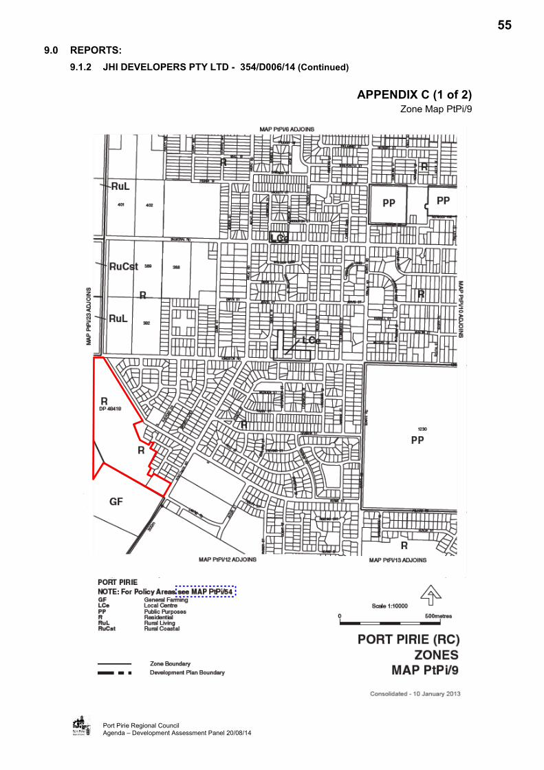
9.0 REPORTS: 9.1.2 JHI DEVELOPERS PTY LTD - 354/D006/14 (Continued)
Port Pirie Regional Council Agenda – Development Assessment Panel 20/08/14
APPENDIX C (1 of 2) Zone Map PtPi/9
55

9.0 REPORTS: 9.1.2 JHI DEVELOPERS PTY LTD - 354/D006/14 (Continued)
Port Pirie Regional Council Agenda – Development Assessment Panel 20/08/14
APPENDIX C (2 of 2) Zone Map PtPi/23
56

9.0 REPORTS:
9.1.2 JHI DEVELOPERS PTY LTD - 354/D006/14 (Continued)
Port Pirie Regional Council Agenda – Development Assessment Panel 20/08/14
APPENDIX D Application Documentation
57

9.0 REPORTS:
9.1.2 JHI DEVELOPERS PTY LTD - 354/D006/14 (Continued)
Port Pirie Regional Council Agenda – Development Assessment Panel 20/08/14
APPENDIX E Proposed South West Drainage Easement
Reserve
72

9.0 REPORTS: 9.2 DEVELOPMENT APPLICATION - CATEGORY 2 9.2.1 AC BUILD - 354/106/14
APPLICATION NO. 354/106/14
APPLICANT Milne Architects
OWNERS AC Build
DEVELOPMENT PROPOSAL New Motel Units (Refitting Existing Office Building)
LODGEMENT DATE 1 May 2014
LOCATION 99 Ellen St, Alexander Street, Port Pirie
ZONES Regional Centre Zone; and Industry Zone
POLICY AREAS Port Pirie Historic Conservation Policy Area 21; and Ports Policy Area 23
NATURE OF DEVELOPMENT Merit
PUBLIC NOTIFICATION Category 2
REPRESENTATIONS One (1)
ASSESSING OFFICER Patrick Clifton
REFERRALS Internal: Infrastructure Department Environmental Health Officer
DEVELOPMENT PLAN VERSION 10 January 2013
COUNCIL WIDE PROVISIONS
Objectives (Obj) 1, 4, 5, 7, 8, 11, 14, 18, 45, 46, 63, 76
Principles of Development Control (PDC)
5, 9, 18, 19, 20, 25, 33, 40, 45, 53, 54, 59, 61, 62, 64, 66, 67, 69, 156, 158, 286, 291, 318, 323
REGIONAL CENTRE ZONE PROVISIONS
Objectives (Obj) 1, 2, 8, 11, 13 Principles of Development Control (PDC) 16, 17, 19, 20
PORT PIRIE HISTORIC CONSERVATION POLICY AREA 21 PROVISIONS
Objectives (Obj) 1, 2, 3
Principles of Development Control (PDC) 1
INDUSTRY ZONE PROVISIONS Objectives (Obj) 2, 7 Principles of Development Control (PDC)
6
PORTS POLICY AREA 23 PROVISIONS
Objectives (Obj) 1 2 Principles of Development Control (PDC) 1, 4, 7
RECOMMENDATION That the Council Development Assessment Panel grants Development Plan Consent, subject to conditions.
BACKGROUND:
The Panel will recall that, at its July meeting, it considered a report on this application. At that meeting the Panel resolved:
“That the Panel resolve to defer consideration of the application and request the applicant to provide a report in respect of Car Parking Management, including provision for disabled cars and buses, and a Traffic Impact Assessment.”
73

9.0 REPORTS: 9.2.1 AC BUILD - 354/106/14
Port Pirie Regional Council Agenda – Development Assessment Panel 20/08/14
BACKGROUND (Cont’d):
A copy of the report to the Panels July meeting is attached at Appendix A.
Appendix A – Report to Development Assessment Panel 16 July 2014
Following the Panel resolution, the applicant engaged the services of Phil Weaver & Associates, Consultant Traffic Engineers, to consider the car parking and traffic implications of the proposed development. A copy of the further submission from Phil Weaver & Associates is attached at Appendix B.
Appendix B – Phil Weaver & Associates Submission.
This report provides a review of this latest submission and a revised recommendation to the Panel. It does not repeat much of the content of the previous report nor the detailed assessment. This report focuses on the traffic and car parking impacts of the development only.
TRAFFIC AND PARKING ASSESSMENT:
In considering the parking related aspects of the proposed development the traffic engineer considered the following:
The proposed development and the anticipated car parking demand; The existing lawful use of the building and the anticipated car parking demand; The options for improving vehicular parking and facilities on the site; and The availability of on-street and public car parking spaces in the area containing the site.
The assessment concluded that the proposed development would generate a theoretical maximum demand for car parking of 19 spaces. However, this is based on 100% occupancy of the motel, which is unlikely and that the general demand by visitors is more likely to be 16 spaces, based on 85% occupancy.
The existing lawful use of the development for offices, given the Development Plan requirements, would generate a demand for 46 car parking spaces, based on a building of 1145sqm. The area differs from that of the previous report and appears to be based on land area rather than building floor space. The building has a floor space of 928 sqm and therefore a Development Plan car parking requirement of 37 car parking spaces for offices.
The engineers reviewed the proposed plans and identified an alternative car parking arrangement that provides 10 off-street car parking spaces that satisfy the Australian Standards, including one disabled, and two loading areas. This is attached in Appendix B. The revised plan suggests that the proposed development would result in a short fall of 9 spaces, whilst the existing lawful use with existing car parking provision would result in a short fall of 31 car parking spaces.
In assessing the impact of the proposed shortfall on the car parking in the area the engineers undertook a survey of car parking availability in the area. The surveys were undertaken at hourly intervals on Wednesday, Friday and Saturday between 3pm and 5pm, 3pm and 8pm and 6pm and 8pm, respectively. The survey indicated that there were ample car parking spaces available to accommodate the shortfall. On Wednesday the least number of car parking spaces available were 44, Friday 41 and Saturday 63.
74

9.0 REPORTS: 9.2.1 AC BUILD - 354/106/14
Port Pirie Regional Council Agenda – Development Assessment Panel 20/08/14
TRAFFIC AND PARKING ASSESSMENT (Cont’d):
The engineers reports concludes that the proposed land use would significantly reduce the existing shortfall of car parking associated with the current land use and that there are adequate public car parking spaces available in the vicinity of the site to accommodate the shortfall.
CONCLUSION:
The proposal for the development of land located at 99 Ellen Street, Alexander Street and Alexander Lane for the purpose of a Motel comprising 19 units, is able to satisfy the relevant provisions of the Development Plan with the exception of on site car parking provisions.
However; having regard to the existing use of the premises, and the availability of public car parking spaces a dispensation of this requirement is considered warranted in this instance.
The proposed re-use of an existing vacant building, bringing it back into active use is considered sustainable development that would add to the viability and vitality of the Port Pirie CBD. The application is therefore recommended for approval subject to reasonable and relevant conditions.
75

9.0 REPORTS: 9.2.1 AC BUILD - 354/106/14
Port Pirie Regional Council Agenda – Development Assessment Panel 20/08/14
RECOMMENDATION:
A: That the Development Assessment Panel, having considered Development Application 354/106/14 for New Motel Units (Refitting Existing Office, determine that the proposal is not seriously at variance with the Port Pirie (RC) Development Plan.
B: That the Development Assessment Panel, in accordance with the Development Act 1993, grant Development Plan Consent to Development Application 354/106/14 by Milne Architects, for a New Motel Units (Refitting Existing Office) on land at 99 Ellen Street, Port Pirie and land at Lot 404, Deposited Plan 75081, CT 6091/861, and Lot 140, CT 5453/891, subject to the following conditions:
1. Development is to take place in accordance with the supporting documentations and plans, except as modified by any conditions attached to this Decision Notification;
2. The car parking area shall be line marked, drained and surfaced in accordance with the relevant Australian Standards within 3 months of Development Approval;
3. The car parking area shall be maintained for Motel use at all times;
4. Appropriate security lighting shall be provided to clearly identify the site car parking and to Provide a secure path between the car parking area and the entrance to the Motel prior to commencement of use;
5. Appropriate noise attenuation shall be provided to ensure that the internal noise environment complies with the relevant Australian Standards and the relevant provisions of the current Environmental Protection (Noise) Policy. Details of the noise attenuation shall be submitted and approved in association with any application for Building Rules Consent.
6. The fit out, design and construction of the food preparation and service areas shall comply with the Australia/New Zealand Food Authority (AN2FA) Standards 3.2.3 prior to the commencement of use.
C: That the Development Assessment Panel resolves to attach the following notes to the Development Plan Consent:
1. That the development hereby approved must be: a) Substantially commenced within twelve (12) months from the date of the
decision of this Consent or Approval, otherwise this Consent or Approval will lapse at the expiration of twelve (12) months from this date (unless Council extends this period), and a new development application shall be required;
b) Substantially or fully completed within three (3) years from the date of the decision of this Approval, otherwise this Approval will lapse at the expiration of three (3) years from this date (unless Council extends this period), and a new development application shall be required; and
c) Any request for an extension of time must be lodged with the Council prior to the above mentioned periods.
d) Where an approval is given, any consent which was necessary for that approval will not lapse unless or until the approval lapses.
2. Reasons for Council’s Decision: The above conditions were imposed upon the Development Plan Consent notice pursuant to Section 42 of the Development Act 1993 (as amended).
76

9.0 REPORTS: 9.2.1 AC BUILD - 354/106/14
Port Pirie Regional Council Agenda – Development Assessment Panel 20/08/14
APPENDIX A Report to Development Assessment Panel 16 July 2014
77
9.0 REPORTS: 9.2 DEVELOPMENT APPLICATION - CATEGORY 2 9.2.1 AC BUILD - 354/106/14
APPLICATION NO. 354/106/14
APPLICANT Milne Architects
OWNERS AC Build
DEVELOPMENT PROPOSAL New Motel Units (Refitting Existing Office Building)
LODGEMENT DATE 1 May 2014
LOCATION 99 Ellen St, Alexander Street, Port Pirie
ZONES Regional Centre Zone; and Industry Zone
POLICY AREAS Port Pirie Historic Conservation Policy Area 21; and Ports Policy Area 23
NATURE OF DEVELOPMENT Merit
PUBLIC NOTIFICATION Category 2
REPRESENTATIONS One (1)
ASSESSING OFFICER Kuol Baak
REFERRALS Internal: Infrastructure Department Environmental Health Officer
DEVELOPMENT PLAN VERSION 10 January 2013
COUNCIL WIDE PROVISIONS
Objectives (Obj) 1, 4, 5, 7, 8, 11, 14, 18, 45, 46, 63, 76
Principles of Development Control (PDC)
5, 9, 18, 19, 20, 25, 33, 40, 45, 53, 54, 59, 61, 62, 64, 66, 67, 69, 156, 158, 286, 291, 318, 323
REGIONAL CENTRE ZONE PROVISIONS
Objectives (Obj) 1, 2, 8, 11, 13 Principles of Development Control (PDC) 16, 17, 19, 20
PORT PIRIE HISTORIC CONSERVATION POLICY AREA 21 PROVISIONS
Objectives (Obj) 1, 2, 3
Principles of Development Control (PDC) 1
INDUSTRY ZONE PROVISIONS Objectives (Obj) 2, 7 Principles of Development Control (PDC)
6
PORTS POLICY AREA 23 PROVISIONS
Objectives (Obj) 1 2 Principles of Development Control (PDC) 1, 4, 7
RECOMMENDATION That the Council Development Assessment Panel grants Development Plan Consent, subject to conditions.
PLANNING HISTORY:
A review of Council records indicates that Allotment 404 Alexander Lane (Behind 97 Ellen Street), which is part of the subject site has not previously been the subject of a Development Application. However, Allotment 140 at 99 Ellen St which is the main part of the subject site has been the subject of another Development Application set out below:
Development Application 354/234/03 (lodged 10 July 2003) for External Doors & Refurbishment to an Existing Office. This application was granted Full Approval without conditions.
78
9.0 REPORTS: 9.2.1 AC BUILD - 354/106/14
Port Pirie Regional Council Agenda – Development Assessment Panel 16/07/14
SITE AND LOCALITY:
Legal Description
The subject site is on two different Certificates of Titles which are the lands described as: Allotment 140 Town of Port Pirie, Hundred of Pirie, in the Certificate of Title Volume 5453 Folio
891; subject to the easement over the land marked B (TG 11117997); and commonly known as 99 Ellen Street, Port Pirie; and
Allotment 404, Deposited Plan 75081, in the area named Port Pirie, Out of Hundreds (Burra) and Out of Hundreds (Whyalla) and Hundreds of Pirie and Telowie, in the Certificate of Title Volume 6019 Folio 861; and commonly known as Alexander Lane (Behind 97 Ellen Street), Port Pirie.
Physical Description and Land Use
The site the subject of the application has an area of 1420sqm and frontage to Ellen Street, Alexander Street and Alexander Lane of 25.15m, 41.56m and 49.3m, respectively. The land has been developed with two buildings and has historically been used for office purposes.
Allotment 140 contains an area of 1145sqm with a frontage to Ellen Street, Alexander Street and Alexander Lane of 25.15m, 41.56m and 25.15, respectively. This land has been developed with a single storey office building and has been built to all road frontages. A setback of 2m is provided to the northern side boundary.
Allotment 404 contains an area of 275sqm and has frontage to Alexander Lane of 23.8m. This land has been developed with a complex 6 single storey garages, which are understood to have been used in association with the office development.
The site is located within the Port Pirie CBD and the locality is characterised by a mix of commercial, leisure, retail and industrial uses. To the north, the site adjoins the former Port Pirie Library, which is presently vacant. Further to the north are offices and a number of Heritage Listed buildings. To the east the site adjoins the railway line and Port facilities whilst to the south is the Port Pirie Regional Council Administration building. To the west, on the opposite side of Ellen Street, is the Port Pirie CBD comprising a Hotel (the Portside), offices, shops and personal services (hairdressers).
Refer to Appendix A (Aerial Photograph) and Appendix B (Images of the Site)
Zoning
The site falls within two separate zones and policy areas, Allotment 140, containing the existing office building, is identified within the Regional Centre Zone and Port Pirie Historic Conservation Area 21. Allotment 404, containing the existing garages, is identified in the Industry Zone and Ports Policy Area 23.
These zones and policy areas are all shown on Maps PtPi/7 & PtPi/37 of the Port Pirie (RC) Development Plan (Consolidated 10 January 2013).
Refer to Appendix C (Zone Map PtPi/7), Appendix D (Policy Area Map PtPi/37) and Appendix E ( Regional Centre Concept Plan Fig RCe 1/1)
NATURE OF PROPOSED DEVELOPMENT:
It is proposed to develop the application site for the purpose of a motel comprising 19 New Motel Units.
79

9.0 REPORTS: 9.2.1 AC BUILD - 354/106/14
Port Pirie Regional Council Agenda – Development Assessment Panel 16/07/14
NATURE OF PROPOSED DEVELOPMENT (Cont’d):
The motel would be contained within the existing building, which would be refurbished to accommodate the proposed use. In addition, the existing garages on Alexander Lane would be demolished to provide 10 car parking spaces. Three of the proposed car parking spaces would be tandem car parking spaces, which suggests that only 7 car parking spaces would comply with the relevant standards. These would be accessed from Alexander Lane.
Access to the proposed motel would be provided directly from Ellen Street to a reception and Breakfast Room/Lounge. Beyond the reception, two corridors would provide access to 19 motel rooms, each with own ensuite. Two of the rooms would be located centrally within the building and would rely on borrowed light from skylights above.
As part of the development, the external appearance would be changed to replace a door with a window, block existing doors and enlarge windows. Fenestration would also be enhanced and landscaping altered.
Servicing of the proposed Motel would be undertaken from the rear and a landing is provided on site to secure the linen.
Refer to Appendix F (Application Documentation)
REFERRALS:
Internal
Council’s Infrastructure Department – No objection.
Environmental Health Officer – No objections subject to compliance with food premises standards.
ASSESSMENT:
The proposal is identified as a merit development in the Regional Centre and Industry Zones of the Port Pirie (RC) Development Plan. The Development Act 1993 (the Act) requires the Council, as the Relevant Authority, to consider the application for Development Plan Consent against the provisions of the Development Plan. An assessment of the proposed development against the relevant Council Wide and Regional Centre and Industry Zones Provisions is set out below.
Council Wide (CW) Provisions
Economic Development
Obj. 1: To identify and provide economic development opportunities based on existing resources or opportunities.
The proposed New Motel Units (Refitting Existing Office Building) involves the redevelopment of an existing vacant building in the centre of the Central Business District (CBD) and is considered to be a sustainable use of an underused resource. The new tourist accommodation within the CBD is a desired land use and would enhance the economic activity in form of revenue from accommodation and ancillary expenses made by tourists while in the area. The proposed development is considered consistent with the Economic Development Objections.
80

9.0 REPORTS: 9.2.1 AC BUILD - 354/106/14
Port Pirie Regional Council Agenda – Development Assessment Panel 16/07/14
ASSESSMENT (Cont’d):
Council Wide (CW) Provisions (Cont’d)
Community Development
Obj. 4: To create employment opportunities for the local population, particularly for post school aged persons.
Obj. 5: To improve income levels through economic development.
The proposed development would economically support the viability of the CBD and the Council area as a whole. The new motel at the centre of the Port Pirie CBD is expected to increase the vitality and viability of the area and provides an opportunity to improve economic activity in the CBD. For these reasons, the new motel is considered to be consistent with abovementioned council wide objectives.
Ecologically Sustainable Development
Obj. 7: To ensure development and revitalisation is consistent with the principles of ecologically sustainable development.
PDC5: The achievement of a land use pattern throughout the Council which helps reduce per capita energy demands and greenhouse gas emissions by the development of an urban form and design that: (a) reduces the need to travel and reduces trip length; (b) reduces private motor vehicle dependency by favouring alternative transit modes; (c) promotes development that is designed for energy efficient use; and (d) promotes the use of lower greenhouse gas emission energy sources and renewable
energy sources in new development.
The proposal provides sustainable development in that it is the redevelopment of an existing vacant building, bringing it back into active use. Furthermore, the location of the proposed motel in the CBD would reduce private car travel to central destinations and the reuse of the existing building decreases greenhouse emissions associated with demolition and new build. The proposed development is consistent with Ecologically Sustainable Development Principles.
Form of Development
Obj. 8: Orderly and economic development.
Obj. 11: To maintain existing townships as the primary areas of urban development, with development outside townships being in either designated development zones or on a limited and controlled basis.
PDC 9: Development should be orderly and economic.
The proposal is for the reuse of an existing office building in the CBD of Port Pirie that has been lawfully established. A motel is a use consistent with the operation of a Regional Centre and the development of a motel in the urban area, making use of an existing building, is considered both orderly and economic.
81

9.0 REPORTS: 9.2.1 AC BUILD - 354/106/14
Port Pirie Regional Council Agenda – Development Assessment Panel 16/07/14
ASSESSMENT (Cont’d):
Council Wide (CW) Provisions (Cont’d)
Interface Between Land Uses
Obj. 14: Development located and designed to prevent adverse impact and conflict between land uses.
PDC 18: Development should not detrimentally affect the amenity of the locality or cause nuisance by: (g) hours of operation
PDC 19: New development should be designed and sited to minimise its impact on existing and potential future land uses considered appropriate in the locality.
PDC 20: Development should be designed, constructed and sited to minimise negative impacts of noise and to avoid unreasonable interference.
PDC 25: Development should be consistent with the relevant provisions of the following: (a) AS 2107 Acoustics - Recommended Design Sound Levels and Reverberation Times
for Building Interiors. (b) AS 3671 Acoustics - Road Traffic Noise Intrusion, Building Siting and Construction; (c) Development should be consistent with the relevant provisions in the current
Environment Protection (Noise) Policy.
The proposed motel is adjacent and adjoining a number of existing commercial, office and industrial uses and is considered consistent with the existing and envisaged development for the area.
The proposed motel would not involve any heavy machinery or manufacturing; and would therefore not generate noise that would exceed that generated by the existing uses or traffic in the locality. However; the proposed motel would be a potentially sensitive use in respect of noise from adjacent activity. It is therefore considered appropriate that any Development Plan Consent be conditioned to ensure that the proposal satisfies the relevant Australian Standards and Environmental Noise Policy to ensure a satisfactory amenity is provided.
Movement of People and Goods
Obj. 18: Development that: (a) provides safe and efficient movement for all motorised and non-motorised transport
modes (b) ensures access for vehicles including emergency services, public infrastructure
maintenance and commercial vehicles (c) provides off street parking
(d) is appropriately located so that it supports and makes best use of existing transport facilities and networks.
PDC 33: Land uses should be arranged to support the efficient provision of sustainable transport networks and encourage their use.
PDC 40: Development should provide safe and convenient access for all anticipated modes of transport including cycling, walking, public and community transport, and motor vehicles.
82

9.0 REPORTS: 9.2.1 AC BUILD - 354/106/14
Port Pirie Regional Council Agenda – Development Assessment Panel 16/07/14
ASSESSMENT (Cont’d):
Council Wide (CW) Provisions (Cont’d)
Movement of People and Goods (Cont’d)
PDC 45: Development should make sufficient provision on site for the loading, unloading and turning of all traffic likely to be generated.
PDC 53: Development should have direct access from an all weather public road.
PDC 54: Development should be provided with safe and convenient access which: (a) avoids unreasonable interference with the flow of traffic on adjoining roads; (b) accommodates the type and volume of traffic likely to be generated by the
development or land use and minimises induced traffic through over-provision; (c) is sited and designed to minimise any adverse impacts on the occupants of and
visitors to neighbouring properties.
PDC 59: Development should be sited and designed to provide convenient access for people with a disability.
PDC 61: Development should provide off-street vehicle parking and specifically marked disabled car parking places to meet anticipated demand in accordance with Table PtPi/2 Car Parking Requirements unless the following conditions are met: (a) an agreement is reached between the Council and the applicant for a reduced
number of parking spaces; (b) a financial contribution is paid into the Council Car Parking Fund specified by the
Council, in accordance with the gazetted rate per car park.
PDC 62: Development should be consistent with Australian Standard AS 2890 Parking facilities.
PDC 64: Vehicle parking areas should be designed to reduce opportunities for crime by: (a) maximising the potential for passive surveillance by ensuring they can be overlooked
from nearby buildings and roads; (b) incorporating walls and landscaping that do not obscure vehicles or provide potential
hiding places; (c) being appropriately lit; (d) having clearly visible walkways.
PDC 66: Parking areas that are likely to be used during non daylight hours should provide floodlit entrance and exit points and site lighting directed and shaded in a manner that will not cause nuisance to adjacent properties or users of the car park.
PDC 67: Parking areas should be sealed or paved in order to minimise dust and mud nuisance.
PDC 69: Parking areas should be line-marked to indicate parking bays, movement aisles and direction of traffic flow.
83

9.0 REPORTS: 9.2.1 AC BUILD - 354/106/14
Port Pirie Regional Council Agenda – Development Assessment Panel 16/07/14
ASSESSMENT (Cont’d):
Council Wide (CW) Provisions (Cont’d)
Movement of People and Goods (Cont’d)
The application site is located on the corner of Ellen Street and Alexander Street; and both streets are constructed all weather roads. Vehicular access to the main site car parking area would be via Alexander Lane (which has an existing two-way driveway) to the rear of the building – and accessed directly from Alexander Street.
The parking area and the lane is of sufficient size to enable all vehicles to enter and leave in a forward gear; and Ellen Street and Alexander Street are capable of accommodating the traffic that would be generated by the proposed motel.
The Development Plan requires a Motel development to provide car parking at the rate of one space per room. At 19 rooms, the proposal is therefore expected to provide 19 car parking spaces. However; the proposed development provides 7 car parking spaces, 10 if the tandem spaces are accepted.
Dispensation of the car parking spaces has been requested in this instance on the basis of the existing, lawful use of the site and the availability of car parking spaces in the vicinity.
The building presently has a lawful use for the purpose of an office. In accordance with the Development Plan requirements, an office is required to provide on-site car parking at the rate of 1 space per 25sqm. With a floor area of 928sqm, the existing use is required to provide 37 car parking spaces. Only 6 spaces have been provided leaving a shortfall of 31 car parking spaces or 19 more than the proposed Motel. On this basis, the proposed development would generate a significantly lesser demand than the existing use and would have a lesser impact on car parking availability in the locality.
The area containing the site is characterised by office and retail uses, in particular the Council Chambers on the opposite side of Alexander Street. The Regional Development Australia offices to the north of the site and the retail uses on the opposite side of Ellen Street. All of these uses have peak car parking demand periods during the day with limited car parking demand in the evening. Conversely, the proposed motel would have a peak car parking demand period during the evening, when tourists stay at the motel. Public car parking spaces are available on Ellen Street, to the rear of the Council Chambers, adjacent Flinders View Park and to the rear of the development site. These spaces are underutilised during the evening peak period of the proposed motel.
On the basis of the existing lawful use of the building and the availability of car parking spaces in the vicinity of the site, it is considered appropriate to dispense with the car parking requirements in this instance and accept that proposed.
In terms of car parking design, it is considered appropriate that any approval granted should be conditioned to require security lighting, car park surfacing and line marking.
Tourism Development
Obj. 45: Tourism development that contributes to local communities by adding vitality to neighbouring townships, regions and settlements.
84

9.0 REPORTS: 9.2.1 AC BUILD - 354/106/14
Port Pirie Regional Council Agenda – Development Assessment Panel 16/07/14
ASSESSMENT (Cont’d):
Council Wide (CW) Provisions (Cont’d)
Tourism Development (Cont’d)
Obj. 46: Increased opportunities for visitors to stay overnight.
PDC 156: Tourism development should, where appropriate, add to the range of services and accommodation types available in an area.
PDC 158: Major tourism developments should generally be located within designated areas and existing townships, towns or cities.
Converting an existing office building in a Regional Centre, which has been vacant for an extended period, into a tourist accommodation is an environmentally sustainable tourism development envisaged by the Council’s Development Plan. The proposed tourism development is expected to contribute to the CBD and community by adding vitality to the CBD and the region as a whole. The proposed motel would enhance opportunities for visitors to stay overnight within the Port Pirie area and would add to the range of services and accommodation types available in the council area. The proposal is considered consistent with the Tourism objectives of the Development Plan.
Environmental
Obj. 63: The conservation and maintenance of the distinctive architectural and historic character of areas identified as Historic Conservation Policy Areas.
PDC 286: Development affecting a heritage place or area should only alter or adapt that place where the heritage value of that place or area is retained or enhanced.
PDC 291: Development of land adjacent to a Heritage Place should be compatible with the heritage value of the heritage place and neither dominate nor compete with the built form character of the Heritage Place in matters including design, siting, scale, form and detail.
As the proposed motel would be in an existing building, it is not expected that the proposal would undermine the Conservation and Heritage values of the Historic Conservation Area. As such, it is considered the proposal would retain or have no negative impact on the heritage value of area.
Crime Prevention
Obj. 76: A safe, secure, crime resistant environment where land uses are integrated and designed to facilitate community surveillance.
PDC 318: Development, including car park facilities should incorporate signage and lighting that indicate the entrances and pathways to, from and within sites.
PDC 323: Development should avoid pedestrian entrapment spots and movement predictors (eg routes or paths that are predictable or unchangeable and offer no choice to pedestrians).
The proposed motel development would provide for new lighting and amended landscaping. In addition the increased activity would improve natural surveillance in the area. Subject to appropriate lighting to the rear car parking area, it is considered that the proposal would enhance the environment and reduce potential for crime.
85

9.0 REPORTS: 9.2.1 AC BUILD - 354/106/14
Port Pirie Regional Council Agenda – Development Assessment Panel 16/07/14
ASSESSMENT (Cont’d):
Regional Centre Zone Provisions
Obj. 1: A zone accommodating a full range of retail facilities, offices, consulting rooms, cultural, community, public administration, entertainment, educational, religious and residential facilities to serve the community within the surrounding region and visitors.
Obj. 2: That portion of the zone east of Ellen Street shown on Concept Plan Figure RCe1/1 as the Community Area developed for cultural, community, tourist and public administration purposes.
Refer to Appendix E (Regional Centre Concept Plan Fig RCe 1/1)
Obj. 8: Buildings should provide an active frontage at street level to take advantage of pedestrian activity.
Obj. 11: Co-ordinated use of off-street parking areas by neighbouring occupiers of land to ensure the efficient use of such areas.
Obj. 13: A high level of pedestrian amenity and safety.
PDC 16: Car parking spaces and areas should be clearly defined.
PDC 17: Development should provide safe and convenient access for vehicles and should be designed and located in such a way as to minimise traffic hazards, and queuing on public roads, including vehicles being able to enter and exit sites in a forward direction.
PDC 19: Building entrances should be clearly apparent from the street.
PDC 20: Service bays and loading docks should be located away from public areas.
The Regional Centre Zone is envisaged to accommodate a full range of retail facilities, offices, consulting rooms, cultural, community, public administration, entertainment, educational, religious and residential facilities to serve the community within the surrounding region and visitors. The new motel would provide short term residential accommodation for the visitors within the CBD in a location proposed to be developed for such purposes.
The proposed development would retain the existing building and enhance the façade to Ellen Street, including improved accessibility from Ellen Street. The proposed door on the Ellen Street frontage would provide an active frontage at street level to take advantage of pedestrian activity and improve CBD vitality and viability.
Clearly identified and accessible car parking spaces would be located to the rear of the premises and accessed from Alexander Lane. Access to these spaces would also be shared with adjacent properties.
The proposed development is considered consistent with the Regional Centre Zone provisions.
Port Pirie Historic Conservation Policy Area 21 Provisions
Obj. 1: An area of historic importance where the heritage value is conserved and reinforced.
86

9.0 REPORTS: 9.2.1 AC BUILD - 354/106/14
Port Pirie Regional Council Agenda – Development Assessment Panel 16/07/14
ASSESSMENT (Cont’d):
Port Pirie Historic Conservation Policy Area 21 Provisions (Cont’d)
Obj. 2: An area where a distinctive historical character is created and enhanced by the interaction between built form, spaces, plantings and general street pattern of the area.
Obj. 3: An area which continues to function as an integral part of the Port Pirie Regional Centre.
PDC 1: Development should ensure that any building, building elements and other features that contribute to the heritage value of the area are retained.
The proposed development would be accommodated within the existing building with limited external alteration. The proposed development would not adversely affect the special characteristics of the Heritage Policy Area.
Industry Zone Provisions
Obj. 2: A high standard of development which promotes good design, with high visual amenity to improve the character and appearance of the area, particularly along Zone interfaces and public roads.
Obj. 7: The establishment and maintenance of a visual and acoustic buffer between development and zone interfaces.
PDC 6: Development should provide safe and convenient access for vehicles and pedestrians, with car parking provided in accordance with Table PtPi/2, so that vehicles are capable of entering and exiting the site in a forward direction.
The only aspect of the development that would be in the Industry Zone is the car parking area, which already exists. On this basis, the proposed motel would not have an impact on the existing design, visual amenity or function of the area.
Ports Policy Area 23 Provisions
Obj. 1: An industrial policy area comprising land for the long-term growth of the port and accommodating industrial activities dependant on a port-side location and/or access to freight handling and movement infrastructure.
Obj. 2: The selective use of land in a manner commensurate with the strategic and economic significance of the policy area for the state with regard to the handling of export and import commodities.
PDC 1 Development undertaken in the Port Area should be, primarily, activities dependant on a portside location.
PDC 4 Development should not be undertaken unless it is consistent with the desired character for the policy area.
PDC 7 Development should not unreasonably impact on the Regional Centre Zone or on the adjacent recreational/open space area located on Berth 3 through noise, traffic, fumes, dust, vibration, or any other harmful or nuisance-creating land use.
87

9.0 REPORTS: 9.2.1 AC BUILD - 354/106/14
Port Pirie Regional Council Agenda – Development Assessment Panel 16/07/14
ASSESSMENT (Cont’d):
Ports Policy Area 23 Provisions (Cont’d)
The main objective of the Ports Policy Area 23 is to protect land for the long-term growth of the port and to accommodate industrial activities dependant on a port-side location and/or access to freight handling and movement infrastructure. The car parking area already exists and the proposed motel would not alter the present setting. As such, the proposed motel along with the required car parking would not conflict with the relevant provisions of the Ports Policy Area 23.
Refer to Appendix G (Statement of Representation)
PUBLIC NOTIFICATION:
The proposed development is a Category 2 development in accordance with s38(2)(c) of the Act. The application was placed on Public Notification between 19 May 2014 and 30 May 2014. There was one representation received during the notification period. The representation raises objections to the proposed development on the basis of inadequate car parking provisions. It is suggested that this could be overcome by the developer providing additional car parking.
A copy of the representation was provided to the applicant who has declined to comment on the basis that the objection has been addressed in the supporting statement submitted with the application.
Comment
The on site car parking provision has been addressed earlier in this report and on the basis of the existing lawful use of the premises and the availability of public car parking in the area it is considered that dispensation be provided in this instance.
CONCLUSION:
The proposal for the development of land located at 99 Ellen Street, Alexander Street and Alexander Lane for the purpose of a Motel, comprising 19 units, is able to satisfy the relevant provisions of the Development Plan with the exception of on site car parking provisions.
However; having regard to the existing use of the premises, and the availability of public car parking spaces as dispensation of this requirement is considered warranted in this instance.
The proposed re-use of an existing vacant building, bringing it back into active use is considered sustainable development that would add to the viability and vitality of the Port Pirie CBD. The application is therefore recommended for approval subject to reasonable and relevant conditions.
88
9.0 REPORTS: 9.2.1 AC BUILD - 354/106/14
Port Pirie Regional Council Agenda – Development Assessment Panel 16/07/14
RECOMMENDATION:
A: That the Development Assessment Panel, having considered Development Application 354/106/14 for New Motel Units (Refitting Existing Office, determine that the proposal is not seriously at variance with the Port Pirie (RC) Development Plan.
B: That the Development Assessment Panel, in accordance with the Development Act 1993, grant Development Plan Consent to Development Application 354/106/14 by Milne Architects, for a New Motel Units (Refitting Existing Office) on land at 99 Ellen Street, Port Pirie and land at Lot 404, Deposited Plan 75081, CT 6091/861, and Lot 140, CT 5453/891, subject to the following conditions:
1. Development is to take place in accordance with the supporting documentations and plans, except as modified by any conditions attached to this Decision Notification;
2. The car parking area shall be line marked, drained and surfaced in accordance with the relevant Australian Standards within 3 months of Development Approval;
3. The car parking area shall be maintained for Motel use at all times;
4. Appropriate security lighting shall be provided to clearly identify the site car parking and to Provide a secure path between the car parking area and the entrance to the Motel prior to commencement of use;
5. Appropriate noise attenuation shall be provided to ensure that the internal noise environment complies with the relevant Australian Standards and the relevant provisions of the current Environmental Protection (Noise) Policy. Details of the noise attenuation shall be submitted and approved in association with any application for Building Rules Consent.
6. The fit out, design and construction of the food preparation and service areas shall comply with the Australia/New Zealand Food Authority (AN2FA) Standards 3.2.3 prior to the commencement of use.
C: That the Development Assessment Panel resolves to attach the following notes to the Development Plan Consent:
1. That the development hereby approved must be:
a) Substantially commenced within twelve (12) months from the date of the decision of this Consent or Approval, otherwise this Consent or Approval will lapse at the expiration of twelve (12) months from this date (unless Council extends this period), and a new development application shall be required;
b) Substantially or fully completed within three (3) years from the date of the decision of this Approval, otherwise this Approval will lapse at the expiration of three (3) years from this date (unless Council extends this period), and a new development application shall be required; and
c) Any request for an extension of time must be lodged with the Council prior to the above mentioned periods.
d) Where an approval is given, any consent which was necessary for that approval will not lapse unless or until the approval lapses.
2. Reasons for Council’s Decision:
The above conditions were imposed upon the Development Plan Consent notice pursuant to Section 42 of the Development Act 1993 (as amended).
89

9.0 REPORTS: 9.2.1 AC BUILD - 354/106/14
Port Pirie Regional Council Agenda – Development Assessment Panel 16/07/14
APPENDIX A Aerial Photographical Map of the Site and Locality
Imagery copyright AEROmetrex Pty Ltd. 2013
Disclaimer This map is a representation of the information currently held by Port Pirie Regional Council. While every effort has been made to ensure the accuracy of the product, Council accepts no responsibility for any errors or omissions. Any feedback on omissions or errors would be appreciated.
90

9.0 REPORTS: 9.2.1 AC BUILD - 354/106/14
Port Pirie Regional Council Agenda – Development Assessment Panel 16/07/14
APPENDIX B (1 of 6) Photographs of the Site
Looking east directly at the subject Office Building proposed to be converted to a Motel
Looking west at Portside Tavern located directly opposite the subject site
91

9.0 REPORTS: 9.2.1 AC BUILD - 354/106/14
Port Pirie Regional Council Agenda – Development Assessment Panel 16/07/14
APPENDIX B (2 of 6) Photographs of the Site
Looking north standing in front of the subject Office Building proposed to be converted to a Motel
Looking south standing in front of the subject Office Building proposed to be converted to a Motel
92

9.0 REPORTS: 9.2.1 AC BUILD - 354/106/14
Port Pirie Regional Council Agenda – Development Assessment Panel 16/07/14
APPENDIX B (3 of 6) Photographs of the Site
Looking east along the secondary frontage of the subject Office Building on Alexander St
Looking west along the secondary frontage of the subject Office Building on Alexander St
93

9.0 REPORTS: 9.2.1 AC BUILD - 354/106/14
Port Pirie Regional Council Agenda – Development Assessment Panel 16/07/14
APPENDIX B (4 of 6) Photographs of the Site
Looking north along the rear frontage of the subject Office Building on Alexander Lane
Looking south along the rear frontage of the subject Office Building on Alexander Lane
94

9.0 REPORTS: 9.2.1 AC BUILD - 354/106/14
Port Pirie Regional Council Agenda – Development Assessment Panel 16/07/14
APPENDIX B (5 of 6) Photographs of the Site
Looking west directly at the rear frontage of the subject Office Building on Alexander Lane
Looking west directly at the existing subject undercover carports on Alexander Lane
95

9.0 REPORTS: 9.2.1 AC BUILD - 354/106/14
Port Pirie Regional Council Agenda – Development Assessment Panel 16/07/14
APPENDIX B (6 of 6) Photographs of the Site
Looking north past the existing carports towards rear of Australia Post Office on Alexander Lane
Looking north past the rear of the existing carports towards the Post Office on Alexander Lane
96

9.0 REPORTS: 9.2.1 AC BUILD - 354/106/14
Port Pirie Regional Council Agenda – Development Assessment Panel 16/07/14
APPENDIX C Zone Map PtPi/7
97
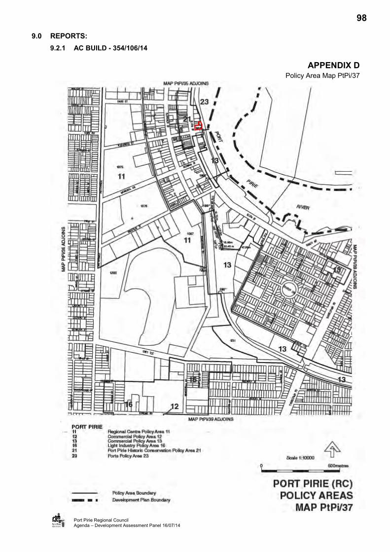
9.0 REPORTS: 9.2.1 AC BUILD - 354/106/14
Port Pirie Regional Council Agenda – Development Assessment Panel 16/07/14
APPENDIX D Policy Area Map PtPi/37
98
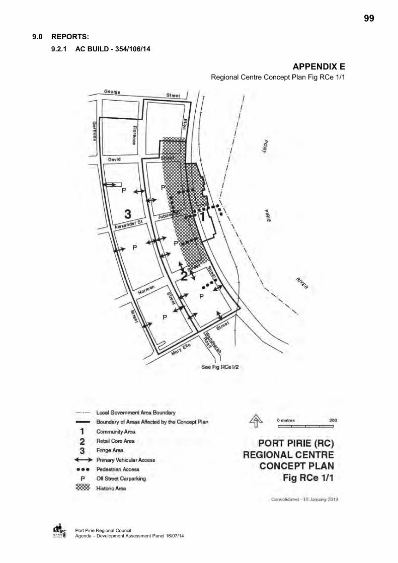
9.0 REPORTS: 9.2.1 AC BUILD - 354/106/14
Port Pirie Regional Council Agenda – Development Assessment Panel 16/07/14
APPENDIX E Regional Centre Concept Plan Fig RCe 1/1
99

9.0 REPORTS: 9.2.1 AC BUILD - 354/106/14
Port Pirie Regional Council Agenda – Development Assessment Panel 16/07/14
APPENDIX F Application Documentation
100

9.0 REPORTS: 9.2.1 AC BUILD - 354/106/14
Port Pirie Regional Council Agenda – Development Assessment Panel 20/08/14
APPENDIX B Phil Weaver & Associates submission
117

File: 115-14 31 July 2014 Mr Ken Milne Milne Architects Level 1/124 Franklin Street ADELAIDE SA 5000 Dear Mr Milne, PROPOSED MOTEL DEVELOPMENT - 99 ELLEN STREET, PORT PIRIE (DA 354/106/14) - PARKING ASSESSMENT I refer to our recent discussions relating to a proposed change of use of the existing building on the above site from an office use to a motel. As requested I have undertaken the following review of the parking related aspects of the subject development. EXISTING SITUATION The subject site is located on the north eastern corner of the intersection of Ellen Street and Alexander Street, Port Pirie. The subject site is situated over two allotments which form an L-shaped parcel of land, comprising:-
Allotment 140 to the south with an area of 1145m², which accommodates a single storey building, and
Allotment 404 to the north east with an area of 275m², which accommodates 6 garages
associated with the above building. The subject site is bounded by three roads, namely:-
Ellen Street to the west, with a frontage of approximately 25m, Alexander Street to the south, with a frontage of approximately 40m, and
Alexander Lane to the east, with a frontage of approximately 50m.
118

2
The subject building is currently vacant, but was most recently approved as an office. Ellen Street, adjacent to the site, provides two traffic lanes separated by a central median. A pedestrian crossing is located on Ellen Street directly adjacent to the subject building. Ellen Street generally provides angled parking on each side of the road, along the sections of Ellen Street immediately to the north and south of Alexander Street. Parking is limited in the area to a duration of two hours between 9.00am and 4.00pm Monday to Friday but is otherwise unrestricted within the area in front of the Port Pirie Library (7 spaces) and the area in front of the Post Office (2 spaces). A disabled parking bay is provided in Ellen Street, located directly in front of the subject building. Alexander Street has a kerb to kerb width of approximately 6m and links Ellen Street with Alexander Lane. A No Stopping Anytime restriction applies along both sides of this roadway. The intersection of Alexander Street with Ellen Street provides left and right turn entry into Alexander Street and left turn exit only onto Ellen Street. Alexander Lane, adjacent to the subject site, varies in width but mostly has a kerb to kerb width of approximately 6m. Alexander Lane provides access to the 6 garages at the rear of the subject site. The main Adelaide to Port Pirie railway line extends along the eastern side of Alexander Lane including the area directly opposite the subject site. On-street parallel parking spaces are provided on the eastern side of Alexander Lane, approximately 70m south of the subject site. PROPOSED DEVELOPMENT I note that the proposed development is identified on a series on plans prepared by your office including a Site Plan (Drawing No. 13.022.WD.10.01 T-F). The proposed development will include:-
Demolition of the existing garages on the site,
Refurbishment of the existing building to provide :-
19 motel rooms, A breakfast / lounge room for use by motel guests,
Two offices,
A reception area, and
A laundry room,
Provision of up to ten 90 degree parking spaces to replace the existing garages off Alexander
Lane,
119

3
An opportunity to provide three parallel parking spaces, located along the eastern side of the
existing building, and
A loading bay at the rear of the building off Alexander Lane.
The design of the at-grade car parking spaces will provide:-
car parking spaces of at least 2.5m in width, and
car parking spaces of 5.4m in length.
As such, I consider that the design of the on-site car parking areas would conform to the requirements of the relevant off-street car parking standards (AS/NZS 2890.1:2004) for parking associated with a motel use. COUNCIL COMMENTS In an email dated 17th July 2014, Council requested additional information and, in particular a response to the following parking related aspects. In summary these aspects included:-
“That the Panel resolve to defer consideration of the application and request the applicant to provide a report in respect of Car Parking Management, including provision of disabled cars and buses and a Traffic Impact Assessment.
I recommend that you speak to a traffic consultant who can prepare a standard report setting out the traffic generation for a motel as compared to an office, including peak demand times etc. I think you also need to provide a response as to how the car parking will be managed, where will people park, how will the unloading of vehicles be managed and how disabled visitors will be catered for. I note that there is no car parking space provided for these users”.
The above issues are assessed in detail below. However, in summary it should be noted that:-
A dedicated loading area will be provided within the car parking area at the rear of the site,
A bin storage area will also be provided at the rear of the site,
Parking for the disabled is also provided at the rear of the site, with the design of this space including an adjacent shared area as per the requirements of the relevant off-street parking standards, and
A review of the road network has indicated that it would be possible to access the rear of the site by small to medium rigid body busses. Given the small size of this development this is considered to be appropriate. A turning path diagram of such a vehicle is provided as Appendix A.
120
4
It is also noted that there are existing bus stops on the western side of Ellen Street to the immediate south of the intersection with Alexander Street which could potentially be used by large buses if required, with convenient pedestrian access provided to and from the proposed motel via the signalised pedestrian crossing located on the southern side of this intersection.
PARKING ASSESSMENT Table PtPi/2 - Car Parking Requirements within the Port Pirie Development Plan identifies car parking provisions as follows:-
Motel - 1 space per room or residential unit plus 1 space per 10m² of total floor area of restaurant (if provided).
On the above basis the proposed development would require 19 parking spaces based upon my understanding that the breakfast / lounge area will be available to guests. The previously approved use as an office required 46 parking spaces based upon 1145m² @ one car space / 25m² = 45.8 spaces. Conversely, there would be a significant reduction in the car parking requirement associated with the proposed use of the subject building compared to that of the existing office use in that :-
The proposed use would generate a requirement for 19 spaces less the provision of 8 spaces on site, resulting in a shortfall of 11 spaces, and
The existing development generates a requirement for 46 spaces less the 6 spaces provided
within the garages, resulting in a shortfall of 40 spaces. However, in order to address the potential to accommodate the shortfall in car parking associated with the proposed change of land use, parking surveys have been conducted within the vicinity of the subject premises (refer to Appendix B). The surveys were conducted in the following areas:-
The eastern side of Ellen Street to the north of the site, up to the Post Office, which includes:-
Two spaces in front of the Post Office (Area A), Seven car parking spaces in front of the Public Library (Area B),
The existing disability car parking space in front of the building (Area C),
The area at the rear of the subject building on Alexander Lane, providing 3 spaces (Area D),
Two on-street spaces located on the southern side of Alexander Street (Area E),
The eastern side of Ellen Street to the south of Alexander Street comprising of two areas, namely :-
The area in front of the Council offices which has a total of 21 spaces (Area F),
121

5
The area in front of the shops further to the south which has a total of 16 spaces (Area G),
and
The area at the rear of the Council offices which provides a total of 17 spaces (Area H). The surveys were undertaken at hourly intervals over the following periods:-
Between 3.00pm and 5.00pm on Wednesday 23rd July 2014, Between 3.00pm and 8.00pm on Friday 25th July 2014, and
Between 6.00pm and 8.00pm on Saturday 26th July 2014.
Full details of the results of the surveys are attached as an appendix to this report (refer to Appendix C). Analysis of the survey results has identified that there were significant levels of vacant spaces during each of the survey periods which could be used by the patrons of the proposed motel. More particularly, the results of the surveys have identified that on a Friday evening after 6.00pm there were at least 10 spaces available in the on-street areas of Ellen Street (north of Alexander Street), the two spaces located off Alexander Street were also vacant and there was also parking at the rear of the building i.e. a total of 15 parking spaces were potentially available in the immediate locality of the subject site. This level of available parking would address the theoretical shortfall of the subject development. There were also 53 vacant spaces available in the on-street areas of Ellen Street to the south of Alexander Street. Similarly, on the Saturday evening it was identified that there was an opportunity to accommodate up to 11 cars in the area immediately adjacent to the subject development. Notwithstanding that, the above assessment indicates that there would be ample parking in close proximity to the subject development (even on a Friday or Saturday evening), there would be infrequent occasions when the subject motel will generate a demand for 19 spaces as this assumes that motel would be fully occupied. In reality, peak occupancy levels would usually be at most 85%, corresponding to a demand for approximately 16 spaces (0.85 of 19 units). Based on the provision of 10 spaces on the subject land this would equate to a shortfall of typically at most 6 spaces. The parking demand associated with the proposed motel during daytime periods on a weekday would be significantly lower and the surveys conducted on the Wednesday would indicate that there would also be an opportunity for guests to park close to the motel in evening periods when booking in. SUMMARY AND CONCLUSIONS In summary, I consider that the proposed development would generate a theoretical requirement for 19 spaces (albeit this will infrequently occur) and will provide a total of 10 spaces on site. On this basis, there would be a shortfall of at most 9 spaces associated with the proposed land use. Conversely, the existing office use has a requirement for 46 spaces with an on-site car parking provision of only 6 spaces. Hence, there is a far greater shortfall (40 spaces) associated with the current use.
122
6
Notwithstanding, the proposed land use would significantly reduce the existing shortfall of car parking associated with the current land use, the surveys of car parking in the locality have identified that there are substantial levels of parking spaces available. These spaces are conveniently located and are unrestricted outside of the periods between 9.00am and 4.00pm Monday to Friday. Hence, there is an opportunity for patrons to use these spaces in periods of peak parking demand associated with the motel. Consequently, it is considered that the parking shortfall can be conveniently accommodated in close proximity to the subject development. Council has requested further information in respect to the proposed operation of the subject development, and is considered that each of these aspects has now been appropriately addressed by the above assessment. Yours sincerely
Phil Weaver Phil Weaver and Associates Pty Ltd Enc
123

125

Appendix C: Parking Survey for Proposed Motel Development - 99 Ellen Street, Port Pirie - Car park capacity and number of spaces occupied
TIME AREA A AREA B AREA C AREA D AREA E AREA F AREA G AREA H TOTAL Approximate Capacity 2 spaces 7 spaces 1 space 3 spaces 2 spaces 21 spaces 16 spaces 17 spaces
Spaces occupied
Spaces available
Spaces occupied
Spaces available
Spaces occupied
Spaces available
Spaces occupied
Spaces available
Spaces occupied
Spaces available
Spaces occupied
Spaces available
Spaces occupied
Spaces available
Spaces occupied
Spaces available
Spaces occupied
Spaces available
Wednesday 23rd July 2014
3.00pm 2 0 2 5 0 1 0 3 0 2 2 19 2 14 12 5 20 49 4.00pm 2 0 2 5 0 1 0 3 0 2 1 20 6 10 14 3 25 44 5.00pm 0 2 3 4 0 1 0 3 0 2 0 21 6 10 7 10 16 53 Friday 25th July 2014 3.00pm 0 2 1 6 0 1 0 3 0 2 3 18 7 9 12 5 23 46 4.00pm 2 0 1 6 0 1 0 3 0 2 6 15 6 10 13 4 28 41 5.00pm 2 0 1 6 0 1 0 3 0 2 2 19 6 10 4 13 15 54 6.00pm 0 2 2 5 0 1 0 3 0 2 0 21 1 15 0 17 3 66 7.00pm 1 1 3 4 0 1 0 3 0 2 1 20 0 16 0 17 5 64 8.00pm 2 0 3 4 0 1 0 3 0 2 0 21 0 16 0 17 5 64 Saturday 26th July 2014
6.00pm 0 2 4 3 0 1 0 3 0 2 0 21 0 16 0 17 4 65 7.00pm 0 2 3 4 0 1 0 3 0 2 0 21 0 16 0 17 3 66 8.00pm 2 0 2 5 0 1 0 3 0 2 0 21 0 16 0 17 4 65
126
9.0 REPORTS: 9.3 DEVELOPMENT APPLICATIONS - CATEGORY 3 9.3.1 PORT PIRIE REGIONAL COUNCIL - 354/045/14
APPLICATION NO. 354/045/14
APPLICANT Port Pirie Regional Council
DEVELOPMENT PROPOSAL Solomontown boat ramp upgrade: replacement of existing pontoon and installation of additional pontoon.
LODGEMENT DATE 20 February 2014
LOCATION Lot 1143 Main Road, Solomontown
ZONE Waterfront (Solomontown)
POLICY AREA N/A
NATURE OF DEVELOPMENT Merit
PUBLIC NOTIFICATION Category 3
ASSESSING OFFICER Kuol Baak
REFERRALS Internal: Infrastructure Department External: Coast Protection Board and Environment
Protection Authority (EPA) DEVELOPMENT PLAN VERSION 10 January 2013
COUNCIL WIDE PROVISIONS
Objectives (Obj) 1, 2, 3, 4 7, 8, 11, 14, 18, 21, 34, 39, 74, 75, 100, 101, and 102.
Principles of Development Control (PDC) 5, 9, 12, 18, 19, 23, 33, 37, 40, 44, 45, 53, 54, 57, 61, 63, 308.
ZONE PROVISIONS Objectives (Obj) 1, 2,
Principles of Development Control (PDC) 1, 3, 7 and 10.
POLICY AREA PROVISIONS N/A
RECOMMENDATION That Development Plan Consent be Granted, subject to conditions.
PLANNING HISTORY:
A review of Council records indicates the site has not previously been the subject of any recent development applications.
SITE AND LOCALITY:
Legal Description
The subject land is described as part Allotment 10, Deposited Plan 49206, Certificate of Title Volume 6031 Folio 739 in the area named Solomontown, Hundred of Pirie. The property is more commonly known as Lot 1143 Main Road, Solomontown.
128
9.0 REPORTS: 9.3.1 PORT PIRIE REGIONAL COUNCIL - 354/045/14
Port Pirie Regional Council Agenda – Development Assessment Panel 20/08/14
SITE AND LOCALITY (Cont’d):
Physical Description and Land Use
The application site has an approximate area of 1.51 hectares and a frontage to Main Road of 229.14 metres. Vehicular access to the site is directly off Main Road via a two-way driveway at the centre of the site frontage and via a two-way vehicular access from John Pirie Bridge Road to the east of the site. Pedestrian access is also available from the western boundary along the waterfront and adjacent Fisherman’s Wharf. The application site contains a two lane boat ramp and 60 car parking spaces.
The existing boat ramp is located on the northern boundary and consists of two lanes on either sides of a floating pontoon. The two lanes are constructed of concrete to a certain extent into the water to enable vehicular access. The ramp is accessed from the car park area via a two-way access. Limited vehicular manoeuvring space is provided with the only turning space provided within the access to the lanes or to the west on an unsealed area of foreshore.
Other than the Port Pirie River to the north, development adjoining and adjacent to the site is predominately recreational or commercial in nature. To the east, and further east across John Pirie Bridge Road, is the Amateur Anglers’ Club premises, Skate Park, Solomontown Beach Plaza, a former drive-through bottle-shop (now derelict and vacant) and the Solomontown Beach Recreation Precinct. To the south on the other side of Main Road are various business establishments including offices for building companies, motor vehicle retail outlet, personal service premises (salon and chiropractor services) and other shops. To the west and south-west are a rowing club, yacht club, fish wholesale/retail outlet and grains bulk handling facilities (silos).
Refer to Appendix A (Aerial Photographical Map of the Site and Locality) and
Appendix B (Images of the Site)
Zoning
The subject site and land immediately adjacent to the east is identified in the Waterfront (Solomontown) Zone. Land immediately adjacent the site to the west is identified in the Commercial (Bulk Handling) Zone and the land to the south is identified in the Neighbourhood Centre and Regional Centre Zones. The zoning of the area is shown on Map PtPi/7 of the Port Pirie (RC) Development Plan (Consolidated 10 January 2013).
Refer to Appendix C (Zone Map)
NATURE OF PROPOSED DEVELOPMENT:
The Port Pirie Regional Council seeks Development Plan Consent for the upgrade to the existing Solomontown Boat Ramp (the proposal). The proposal includes excavation and clearance of the area to the eastern side of the existing boat ramp for placement of concrete ramp widening and concrete hardstand widening; and demolition of the existing flat pedestrian ramp and pontoons.
The upgraded boat ramp would consist of three lanes so that up to three boats can be launched or retrieved at any one time. The upgraded boat ramp would comprise of an extended concrete hardstand; and two new floating pontoons with guide piles.
Each floating pontoon would be anchored to four guide piles and would be fitted with three sets of stainless steel hand rails measuring 3 metres long and 0.9 metres high. The eastern pontoon would have a solar light fitted to the most landward guide pile. Each of the pontoons would be 48 metres long and fixed to an anchoring point on the land.
129

9.0 REPORTS: 9.3.1 PORT PIRIE REGIONAL COUNCIL - 354/045/14
Port Pirie Regional Council Agenda – Development Assessment Panel 20/08/14
NATURE OF PROPOSED DEVELOPMENT (Cont’d):
The upgraded boat ramp would be serviced by the existing 60 car parking spaces and the existing vehicular access. Notwithstanding the additional lane, no new car parking spaces are proposed and no reduction of the existing car parking spaces is proposed.
Refer to Appendix D (Application Documentation)
REFERRALS:
Internal
Infrastructure Department – No objection.
External
Pursuant to Section 37 of the Development Act 1993 (the Act), the application was referred to the Coast Protection Board and the Environment Protection Authority (EPA). The Panel is required to follow any direction received; and have regard to any advice received.
The Coast Protection Board have no objections to the proposed development. However, the Coast Protection Board made a disclaimer and recommended it to be attached as a note, without reference to the Board, to any approval granted. A full copy of the response is attached at Appendix E.
Appendix E – Response – Coast Protection Board
The Environment Protection Authority also have no objections to the proposed development but gave direction that any approval granted be subject to several conditions and notes including a condition on monitoring and contingency plan being prepared and submitted to the reasonable satisfaction of the EPA and implemented prior to the commencement of works. Also included in the direction are a number of notes relating to the general environmental duty, as required by Section 25 of the Environment Protection Act; and a reminder that construction activities with adverse noise impacts must comply with relevant provisions of the Environment Protection (Noise) Policy 2007.
It is considered appropriate that these conditions and notes be attached as part of any approval granted. A full copy of the EPA response is attached at Appendix F.
Appendix F – Response – Environment Protection Authority
ASSESSMENT:
The proposal is identified as a merit development in the Waterfront (Solomontown) Zone of the Port Pirie (RC) Development Plan. The Development Act 1993 (the Act) requires the Council, as the Relevant Authority, to consider the application for Development Plan Consent against the provisions of the Development Plan. An assessment of the proposed development against the relevant Council Wide and Waterfront (Solomontown) Zone Provisions is set out below.
Council Wide (CW) Provisions
Economic Development
Obj. 1: To identify and provide economic development opportunities based on existing resources or opportunities.
130
9.0 REPORTS: 9.3.1 PORT PIRIE REGIONAL COUNCIL - 354/045/14
Port Pirie Regional Council Agenda – Development Assessment Panel 20/08/14
ASSESSMENT (Cont’d):
Council Wide (CW) Provisions (Cont’d)
Economic Development (Cont’d)
The proposal represents the replacement of an existing infrastructure which is used by leisure boaters and commercial fishermen with an upgraded similar infrastructure. The proposal would enhance economic activity in the area in the form of improved facilities for commercial fishermen. It would also allow the existing base infrastructure to service a greater number of recreational fishermen. Given these reasons, the proposal is considered to be able to improve the economic and recreational opportunities for the community members and the general public. Form of Development
Obj 8: Orderly and economic development.
PDC 9: Development should be orderly and economic.
The proposal is for the replacement of an existing boat ramp that has been lawfully established, with an improved boat ramp and launching facilities. The proposal would not alter the use of the infrastructure (including the existing car parks) so as to cause adverse impact in terms of noise or any other nuisance in the locality.
Furthermore, the location of a boat ramp in an area identified for waterfront recreational activities and which is established for this purpose is considered to be an economic use of resources.
Interface Between Land Uses
Obj. 14: Development located and designed to prevent adverse impact and conflict between land uses.
PDC 19: New development should be designed and sited to minimise its impact on existing and potential future land uses considered appropriate in the locality.
The proposal has an interface with a number of existing recreational and commercial uses. Furthermore, the site is located on Main Road, Solomontown, which is a higher order road carrying large volumes of traffic.
The use does not involve any heavy machinery or manufacturing and does not generate noise that would exceed that generated by the existing uses or traffic in the locality. There are no sensitive receptors (dwellings) located within the immediate locality of the site. In any event, the use would not create any greater adverse impact on any sensitive uses than the existing commercial or boating activities.
The proposed development of an upgrade to the boat ramp is consistent with the planned development for the area and is considered appropriate in the locality. On this basis, it is concluded that the proposal is consistent with the Development Plan provisions that regulate the interface between land uses within the council area.
131
9.0 REPORTS: 9.3.1 PORT PIRIE REGIONAL COUNCIL - 354/045/14
Port Pirie Regional Council Agenda – Development Assessment Panel 20/08/14
ASSESSMENT (Cont’d):
Council Wide (CW) Provisions (Cont’d)
Movement of People and Goods
Obj. 18: Development that: (a) provides safe and efficient movement for all motorised and non-motorised transport
modes (b) ensures access for vehicles including emergency services, public infrastructure
maintenance and commercial vehicles (c) provides off street parking (d) is appropriately located so that it supports and makes best use of existing transport
facilities and networks.
PDC 40: Development should provide safe and convenient access for all anticipated modes of transport including cycling, walking, public and community transport, and motor vehicles.
PDC 45: Development should make sufficient provision on site for the loading, unloading and turning of all traffic likely to be generated.
The application site is located on Main Road, which is a higher order road capable of carrying large volumes of traffic. Vehicle access to the site would be via the two existing two-way driveways to the car parking area and pedestrian access would be directly from the street.
The car parking area is of a sufficient size to enable all vehicles to enter and leave in a forward gear; and Main Road is capable of accommodating any additional traffic generated by the improved boat launching facilities.
The proposal is considered to be in accordance with the Development Plan provisions relating to the movement of people and goods.
Access
PDC 53: Development should have direct access from an all weather public road.
PDC 54: Development should be provided with safe and convenient access which: (a) avoids unreasonable interference with the flow of traffic on adjoining roads; (b) accommodates the type and volume of traffic likely to be generated by the
development or land use and minimises induced traffic through over-provision; (c) is sited and designed to minimise any adverse impacts on the occupants of and
visitors to neighbouring properties.
PDC 57: Development with access from arterial roads or roads as shown on Structure Plan should be sited to avoid the need for vehicles to reverse on to the road.
Main Road is a constructed tarmac public road which would accommodate the type and volume of traffic likely to be generated by the proposed development. The existing boat ramp is accessed directly off Main Road and this would not change. The upgraded boat ramp is not expected to generate substantially greater traffic than the current levels of the associated traffic flows. Furthermore, the existing access off Main Road and the 60 car parking spaces would continue to provide adequate manoeuvring area and car parking. The vehicles are able to enter and exit in a forward gear.
132

9.0 REPORTS: 9.3.1 PORT PIRIE REGIONAL COUNCIL - 354/045/14
Port Pirie Regional Council Agenda – Development Assessment Panel 20/08/14
ASSESSMENT (Cont’d):
Council Wide (CW) Provisions (Cont’d)
Access (Cont’d)
The development can accommodate the traffic likely to be generated by the use of the upgraded boat ramp. The vehicles accessing the site will not adversely affect the free flow of traffic in the road network or access to neighbouring properties.
Appearance of Land and Buildings
Obj. 74: The amenity of localities not impaired by the appearance of land, buildings and objects.
Obj. 75: A high standard of design in respect of the appearance of development.
PDC 308: The appearance of land, buildings, and objects should not impair the amenity of the locality in which they are situated.
Presently, the amenity of locality is not impaired by the appearance of the boat ramp. Given the submitted plans, it is expected that the upgrading of the boat ramp would bring a high standard of design in respect of the appearance of development. As such, it is considered that the proposal would not impair the amenity of the locality in which it is situated.
Coastal Development:
Obj. 77: Sustain or enhance the natural coastal environment in South Australia.
Obj. 78: Preserve and manage the environmentally important features of coastal areas, including mangroves, wetlands, dune areas, stands of native vegetation, wildlife habitats and estuarine areas.
Obj. 83: Protect the coast and adjacent marine ecosystems from inappropriate development.
Obj. 86: Protect the coast from development that will adversely affect the marine and onshore coastal environment whether by pollution, erosion, damage or depletion of physical or biological resources, interference with natural coastal processes or any other means.
Obj. 87: Development which does not interfere with environmentally important features of coastal areas, including mangroves, wetlands, dune areas, stands of native vegetation, seagrass, wildlife habitats and estuarine areas.
Obj. 88: Development which does not detract from or reduce the value of sites of ecological, economic, heritage, cultural, scientific, environmental or educational importance.
Obj. 90: Development which maintains or enhances public access to coastal areas in keeping with objectives for protection of the environment, heritage and amenity by provision of: (a) planned, appropriate easy to use public access to and along beaches; (b) coastal reserves and lookouts; (c) convenient and safe public boating facilities at selected locations; (d) convenient vehicular access to points near beaches and selected points of interest;
and (e) adequate car parking.
133
9.0 REPORTS: 9.3.1 PORT PIRIE REGIONAL COUNCIL - 354/045/14
Port Pirie Regional Council Agenda – Development Assessment Panel 20/08/14
ASSESSMENT (Cont’d):
Coastal Development (Cont’d)
Obj. 94: The protection of the physical and economic resources of the coast from inappropriate development.
PDC 324: Development, including flood, erosion and wave protection measures, should not adversely affect the ecology of coastal areas, the seabed or coastal waters by pollution, significant loss of habitat, interference with coastal processes or any other means.
PDC 325: Development should not be located in delicate or environmentally sensitive coastal features such as sand dunes, wetlands or important remnants of native vegetation.
PDC 326: Development should not, nor be likely in the future to, adversely affect the ecology and stability of environmentally sensitive coastal features.
PDC 327: Development should not be undertaken where it will create or aggravate coastal erosion, or where it will require coast protection works which cause or aggravate coastal erosion.
PDC 334: Development should not preclude the natural geomorphological and ecological adjustment to changing climate, sea level or other conditions. For example landward migration of coastal wetlands should not be prevented by embankments. Development should be designed to allow for new areas to be colonised by mangroves and wetland species and for removal of existing embankments where practical.
PDC 332: Development should not cause deleterious effects on the quality or hydrology of groundwater.
PDC 344: Development, including marinas, should be located and designed to allow public access along the waterfront, to beaches, and to coastal reserves, except where public safety reasons preclude.
PDC 349: Development should not compromise the structural integrity of any sea wall or levee bank adjacent to the coast or a river foreshore, or compromise its capacity to protect against coastal flooding and erosion.
PDC 350: Development, including earthworks associated with development, should not do any of the following: (a) impede the effectiveness of the levee on the subject land or other surrounding land; (b) increase the potential hazard risk to public safety of persons during a flood event; (c) aggravate the potential for erosion or siltation or lead to the destruction of vegetation
during a flood; (d) cause any adverse effect on the levee function; (e) increase the risk of flooding of other land.
It is considered that the proposal would not adversely affect the ecology and stability of environmentally sensitive coastal features. The proposal represents the replacement and minor extension of an existing boat ramp.
134
9.0 REPORTS: 9.3.1 PORT PIRIE REGIONAL COUNCIL - 354/045/14
Port Pirie Regional Council Agenda – Development Assessment Panel 20/08/14
ASSESSMENT (Cont’d):
Coastal Development (Cont’d)
The proposal has been assessed by the Coast Protection Board who have considered the impact of the proposal on the coastal environment and processes as reflected in the above relevant provisions of the Development Plan. The Board have raised no objection to the proposal.
The boat ramp proposed for upgrading will continue to be used for public access to the water.
It is not considered that the works associated with this development would neither impede the effectiveness of the levee wall or increase the potential hazard risk to public safety of persons during a flood event.
Waterfront (Solomontown) Zone Provisions
Obj. 1: Accommodation of community and tourist beach and beachside recreation facilities and associated shelters, change rooms and kiosk, open spaces for passive and active recreation with landscaped park lands and a usual focus on the base of the Pier.
Obj. 2: That portion of the zone shown on Fig W(S)/1 as the Waterfront Area redeveloped to provide public car parking areas, a boat ramp, boat storage, clubrooms and related recreational facilities and waterfront commercial services and a kiosk.
Appendix G – Concept Plan Fig W(S)/1
PDC 3: Development should reinforce recreational boating, aquatic activities and functions associated with the Port Pirie River.
The proposal seeks to reinforce and continue the recreational boating, aquatic activities and functions associated with the Port Pirie River. One of the core objectives of the zone is to accommodate community and beachside recreational facilities which include the existing boat ramp. This land use is intended to provide public car parking areas, a boat ramp, clubrooms and related recreational facilities. A two-lane boat ramp exists and it is proposed to be upgraded to three-lane boat ramp.
The proposal is considered to be in accordance with the relevant provisions of the Waterfront (Solomontown) Zone.
PUBLIC NOTIFICATION:
The proposed development has been identified as a Category 3 development in accordance with s 38(2)(c) of the Act. The application was placed on public notification between 9 December 2013 and 3 January 2014. There were no representations received during the notification period.
CONCLUSION:
The application is for the replacement and upgrade of the existing Solomontown a boat ramp, including excavation and demolition of the existing pontoons. The proposal has been identified as a merit development under the Act. The proposal is able to satisfy the broader Objectives and Principles of Development Control of the Development Plan. The proposed development is considered to be consistent with the provisions of the Waterfront (Solomontown) Zone.
It is considered that the proposal has merit and should be granted Development Plan Consent, subject to reasonable and relevant conditions.
135

9.0 REPORTS: 9.3.1 PORT PIRIE REGIONAL COUNCIL - 354/045/14
Port Pirie Regional Council Agenda – Development Assessment Panel 20/08/14
RECOMMENDATION:
A: That the Development Assessment Panel, having considered Development Application 354/045/14, by the Port Pirie Regional Council, for the Solomontown Boat Ramp Upgrade: Replacement of existing pontoon and installation of additional pontoon of an existing pontoon and an installation of an additional pontoon at Lot 1143 Main Road, Solomontown, determine that the proposal is not seriously at variance with the Port Pirie (RC) Development Plan.
B: That the Development Assessment Panel, in accordance with the Development Act 1993, grant Development Plan Consent to Development Application 354/045/14, subject to the following conditions:
1. Development is to take place in accordance with the supporting documentations and plans, except as modified by any conditions attached to this Decision Notification;
2. The car park and servicing area shall be maintained for boat ramp use at all times;
Environment Protection Authority Conditions
3. The monitoring and contingency plan must be prepared and submitted to the reasonable satisfaction of the EPA and implemented prior to the commencement of works. The monitoring and contingency plan must include, but not be limited to:
a) Monitoring each day of dredging and for at least three days prior to dredging and for at least three days after the coffer dam is removed with a procedure to increase the monitoring frequency and/or locations and cease work if monitoring approaches the WQEPP criteria;
b) Clearly stated HOLD criteria and ALARM criteria with corresponding management responses to those criteria to ensure the WQEPP is not exceeded outside the construction site. All reasonable and practicable measures must be used to contain the turbidity plume to less than 20m from the work area during piling and construction of both ramps and pontoons:
i) Turbidity must have a HOLD criteria at 8 NTU and ALARM at 10 NTU;
ii) pH must have a HOLD criteria at 7.5 and ALARM at 7;
iii) Dissolved oxygen must have a HOLD criteria at 6 mg/L and ALARM at 5mg/L; and
iv) Relevant total and soluble metals (Cd, Mn, Pb & Zn) criteria are contained in the WQEP;
c) Monitoring of turbidity, pH and dissolved oxygen to ensure compliance with the WQEPP must occur each day before work commences and at noon. The compliance point for this monitoring is no less than three locations 20 meters from the coffer dam or construction location (if coffer dam is not used);
d) If HOLD criteria are exceeded then further mitigation methods are necessary prior to work continuing. If ALARM criteria are exceeded then work must stop until conditions improve below the HOLD criteria;
136

9.0 REPORTS: 9.3.1 PORT PIRIE REGIONAL COUNCIL - 354/045/14
Port Pirie Regional Council Agenda – Development Assessment Panel 20/08/14
B (Cont’d):
e) Monitoring of total and soluble metals must be undertaken no less than twice during the dredge activity, once at the commencement of dredging (no less than three hours after dredging starts) and once during the period of the dredging.
Samples must be analysed at a NATA accredited lab. When taking all samples, measurements of turbidity, pH and dissolved oxygen must be taken to match a metal sample to those parameters.
Samples for the metal assessment must be taken in duplicate (ie two samples) as follows:
i) one location (ie two samples) within the coffer dam;
ii) no less than three locations (ie six samples) 20m outside the coffer dam;
iii) three locations (ie six samples) from the work location outside the coffer dam; and
iv) six locations (ie 12 samples) randomly sampled at approximately 100m from the work site to allow comparison with background levels.
Results of the metals testing must be submitted to reasonable satisfaction of the EPA within one month of receiving the results;
4. Should there be any dredge spoil from the site when upgrading the existing ramp/pylons and pontoons (ie outside of the coffer dam) the dredge spoil must not be allowed to re-enter the marine environment and must be treated as if it is of the same level of contamination as the tested soil;
5. Any water draining from the spoil once it is dredged from the site must only be returned to the Port Pirie River within a coffer dam or other control device such as buffer tanks for settling and Geobags (or similar) to remove suspended solids;
6. The dredge operator must have in place a spill retention kit and contingency plan to manage any spills of fuel and lubricants in the event of a leak or other similar mishap with machinery to minimise potential impact on the marine environment;
C: That the Development Assessment Panel resolves to attach the following notes to the Development Plan Consent:
1. No additional access to the site is approved as part of this approval;
2. Based upon current knowledge and information the development and development site is at some risk of coastal erosion and inundation due to extreme tides notwithstanding any approval herein or may be at future risk. Neither erosion nor the effect of sea level change on this can be predicted with certainty. Also, mean sea level may rise by more than the 0.3 metres assumed in assessing this application;
3. That the development hereby approved must be:
a) Substantially commenced within twelve (12) months from the date of the decision of this Consent or Approval, otherwise this Consent or Approval will lapse at the expiration of twelve (12) months from this date (unless Council extends this period), and a new development application shall be required;
137

9.0 REPORTS: 9.3.1 PORT PIRIE REGIONAL COUNCIL - 354/045/14
Port Pirie Regional Council Agenda – Development Assessment Panel 20/08/14
C (Cont’d):
b) Substantially or fully completed within three (3) years from the date of the decision of this Approval, otherwise this Approval will lapse at the expiration of three (3) years from this date (unless Council extends this period), and a new development application shall be required;
c) Any request for an extension of time must be lodged with the Council prior to the above mentioned periods; and
d) Where an approval is given, any consent which was necessary for that approval will not lapse unless or until the approval lapses;
4. Reasons for Council’s Decision:
The above conditions were imposed upon the Development Plan Consent notice pursuant to Section 42 of the Development Act 1993 (as amended);
Environment Protection Authority Notes:
5. The applicant is reminded of its general environmental duty, as required by Section 25 of the Environment Protection Act, to take all reasonable and practicable measures to ensure that the activities on the whole site, including during construction, do not pollute the environment in a way which causes or may cause environmental harm;
6. Any dredging must be carried out by an EPA licensed contractor. An environmental authorisation in the form of a licence is required for the operation of this development. The applicant is required to contact the Environment Protection Authority before acting on this approval to ascertain licensing requirements;
7. The applicant is reminded that construction activities with adverse noise impacts and must comply with relevant provisions of the Environment Protection (Noise)
Policy 2007;
8. The applicant is reminded that all plant and equipment should be in good mechanical condition with silencers fitted where appropriate). Noisy equipment should be located as far away as practical from residences to assist in achieving compliance with the Environment Protection (Noise) Policy 2007; and
9. The applicant is reminded that due care should be taken to prevent or minimise adverse impacts and to appropriately manage storm water runoff during construction and for the long term. Guidance can be found in the EPA's Stormwater
Pollution Prevention Code of Practice for the Building and Construction Industry and the EPA Handbook for Pollution Avoidance on Commercial and Residential
Building Sites.
138

9.0 REPORTS: 9.3.1 PORT PIRIE REGIONAL COUNCIL - 354/045/14
Port Pirie Regional Council Agenda – Development Assessment Panel 20/08/14
APPENDIX A Aerial Photographical Map of the Site and Locality
Imagery copyright AEROmetrex Pty Ltd. 2013
Disclaimer This map is a representation of the information currently held by Port Pirie Regional Council. While every effort has been made to ensure the accuracy of the product, Council accepts no responsibility for any errors or omissions. Any feedback on omissions or errors would be appreciated.
139
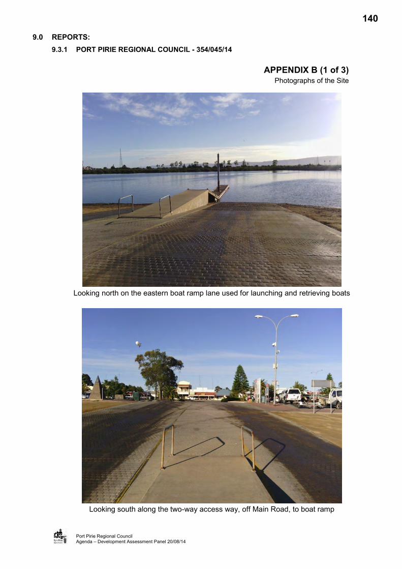
9.0 REPORTS: 9.3.1 PORT PIRIE REGIONAL COUNCIL - 354/045/14
Port Pirie Regional Council Agenda – Development Assessment Panel 20/08/14
APPENDIX B (1 of 3) Photographs of the Site
Looking north on the eastern boat ramp lane used for launching and retrieving boats
Looking south along the two-way access way, off Main Road, to boat ramp
140

9.0 REPORTS: 9.3.1 PORT PIRIE REGIONAL COUNCIL - 354/045/14
Port Pirie Regional Council Agenda – Development Assessment Panel 20/08/14
APPENDIX B (2 of 3) Photographs of the Site
Manoeuvring area to the western side of the boat ramp access way
Additional lane would encroach the existing manoeuvring area to the eastern side of boat ramp
141

9.0 REPORTS: 9.3.1 PORT PIRIE REGIONAL COUNCIL - 354/045/14
Port Pirie Regional Council Agenda – Development Assessment Panel 20/08/14
APPENDIX B (3 of 3) Photographs of the Site
Car parking spaces on the western side of the boat ramp car park area
Car parking spaces on the eastern side of the boat ramp car park area
142
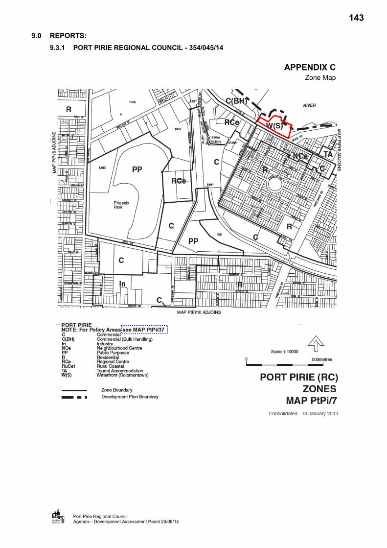
9.0 REPORTS: 9.3.1 PORT PIRIE REGIONAL COUNCIL - 354/045/14
Port Pirie Regional Council Agenda – Development Assessment Panel 20/08/14
APPENDIX C Zone Map
143

9.0 REPORTS:
9.3.1 PORT PIRIE REGIONAL COUNCIL - 354/045/14
Port Pirie Regional Council Agenda – Development Assessment Panel 20/08/14
APPENDIX D Application Documentation
144

9.0 REPORTS:
9.3.1 PORT PIRIE REGIONAL COUNCIL - 354/045/14
Port Pirie Regional Council Agenda – Development Assessment Panel 20/08/14
APPENDIX E Response - Coast Protection Board
178

Ref: CPB/031/14 5 May 2014
Patrick Clifton Port Pirie Regional Council PO Box 45 Port Pirie 5540
BY EMAIL
Government of South Australia
Coast Protection Board
Level 1 ANR House 1 Richmond Rd Keswick SA 5035
GPO Box 1047 Adelaide SA 5001 Australia DX138
Contact Officer: Peter Allen
Ph: (08)8124 4906 Fax: (08) 8124 4920
e-mail: [email protected]
www.environment.sa.gov.au
Dear Patrick
Development Application No 354/045/14 Applicant Port Pirie Regional Council Description Boat ramp upgrade Location Solomontown Council Port Pirie Regional Council
I refer to the above mentioned development application forwarded to the Coast Protection Board (the Board) in accordance with Section 37 of the Development Act 1993. The planning authority is required to have regard to this response prior to making a decision on the proposal.
In accord with part 43 of the Development Regulations, a copy of the decision notification must be forwarded to the Board at the above address.
The following response is provided under delegated authority for the Board in compliance with its policies. Those policies are contained in the Board's Policy Document which is located on the following internet web site:
http://www.environment.sa.gov.au/coasts/pdfs/cpb_policy_document_2002.pdf
Proposal
Minor upgrade of boat ramp.
Coast Protection Board Response
The Coast Protection Board advises that it has no objections to the proposed development.
Disclaimer
The Board attaches the following disclaimer to the above advice;
Based upon current knowledge and information the development and development site is at some risk of coastal erosion and inundation due to extreme tides notwithstanding any recommendations or advice herein, or may be at future risk. Neither erosion nor the effect of sea level change on this can be predicted with certainty. Also, mean sea level may rise by more than the 0.3 metres assumed in assessing this application.
179

9.0 REPORTS:
9.3.1 PORT PIRIE REGIONAL COUNCIL - 354/045/14
Port Pirie Regional Council Agenda – Development Assessment Panel 20/08/14
APPENDIX F Response - Environment Protection Authority
180

J Environment Protection Authority GPO Box 2607 Adelaide SA 5001
250 Victoria Square Adelaide SA www.epa.sa.gov.au T (08) 8204 2000 F (08) 8204 2020
Country areas 1800 623 445 South Australia
EPA Reference: 33285
11 July 2014
Mr Kuol Baak
Port Pirie Regional Council 115 Ellen Street PORT PIRIE SA 5540
Dear Mr Baak
DIRECTION - Act iv i t ies of Major Environmental Significance
Development Application No. 354/045/14
Applicant Port Pirie Regional Council
Location A10 DP 49206 Hundred OH (Burra), 1143 Main Road, Solomonfown SA 5540
Act iv i ty of Environmental Significance Schedule 8 Item 11; Schedule 22 Part A Activities, Item 22-7(4)
Proposal Solomontown Boat Ramp Upgrade
Decision Notif ication A copy of the decision notification must be forwarded to: Client Services Officer Environment Protection Authority GPO Box 2607 ADELAIDE SA 5001
I refer to the above development application forwarded to the Environment Protection Authority (EPA) in accordance wi th Section 37 of the Development Act 1993. The proposed development involves an activity of major environmental significance as described above.
The following response is provided in accordance with Section 37(4)(b)(ii) of the Development Act 1993 and Schedule 8 Item 11 of the Development Regulations 2008.
In determining this response the EPA had regard to and sought to further the objects of the Environment Protection Act 1993, and also had regard to:
the General Environmental Duty, as defined in Part 4, Section 25 (1) of the Act; and relevant Environment Protection Policies made under Part 5 of the Act.
Printed on 100% recycled paper using vegetable-based inks
181
Please direct all queries relating to the contents of this correspondence to Melissa Chrystal on telephone (08) 8204 1318 or facsimile (08) 8124 4673 or email [email protected].
THE PROPOSAL
This proposal is for the upgrade of the Solomontown Boat Ramp to create a three lane boat ramp. It includes demolition involving the removal of the existing pontoons, removal of the existing f lat pedestrian ramp, and clearance and excavation for the placement of an additional concrete ramp.
The Development Application has been referred to the EPA for comment as i t includes a Schedule 22 activity of major environmental significance, being dredging during construction works. Of specific interest to the EPA is the excavation and offsite disposal of approximately 50 m of soil and sediment classified as Low Level Contaminated Soil (LLCS).
SITE DESCRIPTION
The site of the proposed development is located at and adjoining Allotment 10, DP 49206, also known as 1143 Main Road, Solomontown.
The location of the work is situated in the shallow water adjacent the boat launching ramp, and opposite Parks Street in Solomontown.
The Port Pirie Council Development Plan identifies the site as being located within the Waterfront (Solomontown) Zone. Nearby land uses include industry and bulk handling /shipping, retail and commercial, and residential. The closest dwelling is located within 200 metres of the existing boat ramp.
The site has not been inspected but has been viewed using manning information available to the EPA, including recent aerial imagery and existing knowledge of the site and locality.
CONSIDERATION
Advice in this letter includes consideration of the location with respect to existing land uses and is aimed at protecting the environment and avoiding potential adverse impacts upon the locality. Such advice does not take into account zoning or future development.
The 'Discussion Relating to Direction' and the 'Direction' sections of the following response are provided in accordance with section 37(4)(b)(ii) of the Development Act 1993 and Schedule 8 Item 11 of the Development Regulations 2008.
The 'Other Comments' section of this response is provided to assist the relevant authority to undertake an environmental assessment of those parts of the application outside the scope of the activity of environmental significance that triggered a referral to the EPA.
In assessing the proposed development, the EPA considered the plans and specifications supplied in the application including the following documents:
Six sheets of plans drawing Number 13468-0, Revision C prepared by Magryn Engineering Consultants and dated January 2014
Page 2 of 10
182

One sheet of plans t i t led Site Storage ft Site Fencing, undated One sheet of plans t i t led Coffer dam plan, undated
• Chemical Assessment of Sediment report prepared by Golder Associates, dated 17 April 2014, Reference No. 147663019-001-L-RevO
• Proposal to Provide a Dredging and Sediment Environment Management Plan for the Solomontown Boat Ramp Upgrade Earthworks report prepared by Golder Associates, dated 21 May 2014, Proposal No. P47663089-001-L-RevO, and
• Environmental ft Site Management Plan report prepared by Orion Project Services Pty Ltd, dated 28 May 2014, Revision A.
ENVIRONMENTAL ISSUES
DISCUSSION RELATING TO DIRECTION
Water Quality
The proposed Solomontown boat ramp upgrade is intending to remove the existing pylon and floating pontoons and replace wi th new pylons and pontoons, as wel l as laying an additional ramp with pylons and pontoons. This would involve dredging and excavation and would impact on the turbidity of surrounding waters and other water quality issues including possibly dissolved oxygen and pH levels. High levels of turbidity reduce the amount of light available to benthic marine communities, low dissolved oxygen can harm aquatic organisms and low pH can mobilise metals in the sediments as wel l as harming aquatic organisms. The works must be undertaken appropriately to ensure protection of the environment.
The applicant has provided a Chemical Assessment of Sediment report (Golder Associates, dated 17 April 2014) which indicates that the sediment is characterised as Low Level Contaminated Soil (LLCS). If LLCS is resuspended i t has the potential to harm benthic marine communities. In addition high levels of turbidity l imit available light to benthic marine communities, increasing stress. Therefore generation of turbidity of LLCS has the potential to significantly impact on local biota.
A monitoring and contingency plan must be developed and implemented to address actions required in the circumstance that turbidity, pH or dissolved oxygen are outside of the Environment Protection (Water Quality) Policy 2003 (WQEPP) and to ensure the risk from liberation of metals to biota is minimised. The monitoring and contingency plan must be prepared and submitted to the reasonable satisfaction of the EPA and implemented prior to the commencement of works. The monitoring and contingency plan must include, but not be l imited to:
a. Monitoring each day of dredging and for at least three days prior to dredging and for at least three days after the coffer dam is removed with a procedure to increase the monitoring frequency and/or locations and cease work if monitoring approaches the WQEPP criteria.
b. Clearly stated HOLD criteria and ALARM criteria with corresponding management responses to those criteria to ensure the WQEPP is not exceeded outside the construction site. All reasonable and practicable measures must be used to contain the turbidity plume to less than 20m from the work area during piling and construction of both ramps and pontoons.
Page 3 of 10
183

i. Turbidity must have a HOLD criteria at 8 NTU and ALARM at 10 NTU i i . pH must have a HOLD criteria at 7.5 and ALARM at 7 i i i . Dissolved oxygen must have a HOLD criteria at 6 mg/L and ALARM at 5mg/L iv. Relevant total and soluble metals (Cd, Mn, Pb 6t Zn) criteria are contained
in the WQEPP. c. Monitoring of turbidity, pH and dissolved oxygen to ensure compliance wi th the
WQEPP must occur each day before work commences and at noon. The compliance point for this monitoring is no less than 5 locations 20 meters from the coffer dam or construction location (if coffer dam is not used).
d. If HOLD criteria are exceeded then further mitigation methods are necessary prior to work continuing. If ALARM criteria are exceeded then work must stop unt i l conditions improve below the HOLD criteria.
e. Monitoring of total and soluble metals must be undertaken no less than twice during the dredge activity, once at the commencement of dredging (no less than three hours after dredging starts) and once during the period of the dredging. Samples must be analysed at a NATA accredited lab. When taking all samples, measurements of turbidity, pH and dissolved oxygen must be taken to match a metal sample to those parameters.
Samples for the metal assessment must be taken in duplicate (ie two samples) as fol lows:
i. one location (ie two samples) within the coffer dam i i . no less than three locations (ie six samples) 20m outside the coffer dam i i i . three locations (ie six samples) from the work location outside the coffer dam, and iv. six locations (ie 12 samples) randomly sampled at approximately 100m from the
work site to allow comparison wi th background levels.
Results of metals testing must be submitted to the reasonable satisfaction of the EPA within one month of receiving results.
Should there be any dredge spoil from the site when upgrading the existing ramp/pylons and pontoons (ie outside of the coffer dam) the dredge spoil must not be allowed to re-enter the marine environment and must be treated as if i t is of the same level of contamination as the tested soil.
The applicant has proposed to undertake the majority of works behind a sandbag coffer dam and the sandbag wall is to be lined with a geotextile fabric. Construction impacts contained behind the coffer dam should result in minimal impact on the external environment. Provided the coffer dam is in place prior to any works and remains in place for a suitable period of t ime after the works finish to allow settling of sediment, the impacts are contained. This method is acceptable to the EPA and is capable of containing excessive impacts.
It is noted that the removal of existing pontoons on the western side of the boat ramp are outside of the proposed coffer dam. The extent of works at this location is relatively minor. The monitoring and contingency plan described above includes monitoring and testing outside of the coffer dam area and as such would have the effect of minimising adverse environmental impacts arising from this component of the proposal.
Page 4 of 10
184

Any extracted sediment would need to be transported and disposed of appropriately by licensed waste transporters and to a licensed waste depot capable of accepting this waste. The proposed sand bag coffer dam to be used for the construction of the additional ramp must be disposed of as if i t is of the same level of contamination as the spoil that is being removed. The sediment w i l l be considered LLCS and a waste transport licence wi l l be required for the transport. The sediment and sandbags must be disposed of to a landfill licensed to accept LLCS.
Any water draining from the spoil once i t is dredged from the site should only be returned to the Port Pirie River within a coffer dam or other control device such as buffer tanks for settling and Geobags to remove suspended solids.
A licence wi l l be required to undertake the prescribed activity of environmental significance of dredging.
The dredge operator should have in place a spill retention kit and contingency plan to manage any spills of fuel and lubricants in the event of a leak or other similar mishap with machinery to minimise potential impact on the marine environment.
While this proposal is relatively small in scale and contaminated sediments are involved, the adoption of environmental impacts can be appropriately contained and minimised subject to the conditions directed below.
Air Quality
Environmental impacts must be monitored in accordance with the dredging operator's conditions of licence. It can be expected that some odour may be experienced at nearby residences for short periods resulting from prevailing wind conditions in the vicinity of the dredging site.
Conditions of the dredging licence are likely to require the operator to monitor any environmental impacts including odour and dust and to minimise such impacts where possible. Provided these conditions are adhered to by the contractor, the EPA considers that there would not be any unacceptable air quality impacts.
A note to bring dredging licence conditions to the attention of the applicant is included below.
Noise
Impacts on residents
Measurements based on aerial photography suggests that the nearest residential development would be approximately 200 metres from the construction site. Based on similar operations and the separation distances to the nearest noise sensitive receivers, the noise impact of plant/equipment involved in the dredging operation may cause some nuisance.
The dredge operator must ensure all plant is to be kept in good mechanical condition, and appropriate silencers are deployed on machinery and equipment at all times. As a requirement of EPA licence, the dredge operator is normally required to monitor and minimise noise impacts and to comply wi th the requirements of general environmental duty, as contained in
Page 5 of 10
185
Section 25 of the Environment Protection Act 1993.
In addition, the Environment Protection (Noise) Policy 2007 requires that any construction activities resulting in noise with an adverse impact on amenity must only occur between 7.00 a.m. and 7.00 p.m. Monday to Saturday. Given the nature of the development and the proximity to residential development any activities which are proposed to occur outside of these timings would require consideration by the EPA. In addition, all reasonable and practicable measures must be taken to minimise noise resulting from the activity and to minimise its impact wherever possible.
A note to bring this to the attention of the applicant is included below.
OTHER COMMENTS
The following comments are provided to assist the planning authority to undertake an environmental assessment of those parts of the application that do not directly relate to the activity which triggered the EPA referral. Further information has not been sought by the EPA in relation to these comments and no conditions are directed in relation to these matters.
Noise
Impacts on marine mammals
The proposed Port Pirie boat ramp upgrade is intending to build an additional boat launch facil i ty as wel l as upgrade the existing floating pontoons which would be supported by pylons to allow the platforms to move wi th the t ide. The piling of these pylons can cause hearing injury to marine mammals. Marine mammals live in an environment in which vision is not the primary sense, relying heavily on sound for communication (mother/calf cohesion, group cohesion, individual recognition and danger avoidance). Piling produces noise levels that are among the highest recorded for construction activities and as such has the potential to impact on the health of marine mammals.
In order to minimise noise impacts on marine mammals, i t is recommended an underwater noise management plan be developed and include, but not be l imited to, the following:
1. Safety Zones to be used in the management and mitigation procedures for piling activities to include 'observation' and 'shut down' zones. An 'observation zone' is a zone where the movement of marine mammals should be monitored to determine whether they are approaching or entering the shut-down zone. For piling activit ies, the 'observation zone' should be 300 metres, and 100 metres for Vibro-driving activities. A 'shut down zone' is the zone where piling activities must be stopped as soon as reasonability practical if a marine mammal is sighted within or entering the zone. For piling activit ies, the 'shut down zone' should be 100 metres, and 10 metres for Vibro-driving activities.
2. Avoid conducting piling activities during times when marine mammals are likely to be breeding, calving, feeding, or resting in biologically important habitats located within the potential noise impact footprint.
3. Use low noise piling methods, such as vibro-driving, instead of impact piling methods where possible.
Page 6 of 10
186

4. Ensure that sufficient trained crew members are available and have proven experience in marine mammal observation, distance estimation and reporting.
5. Pre-start procedure - The presence of marine mammals should be visually monitored by a suitably trained crew member of at least 30 minutes before the commencement of the 'soft start ' procedures.
6. 'Soft start ' procedure - If marine mammals have not been sighted within and are not likely to enter the 'shut down zone' during the pre-start procedure, the 'soft start' procedure can commence in which the piling activity is gradually increased over a 10 minute period. The 'soft start ' procedure should also be used after a break in piling lasting more than 30 minutes.
7. Normal operation - If marine mammals have not been sighted within and are not likely to enter the 'shut down zone' during the 'soft start ' procedure, piling may start at ful l impact energy. Trained crew should continuously undertake visual observations during piling activities and shut down periods. After long breaks in piling activity or when visual observations ceased or were hampered by poor visibility, the pre-start procedure should be used. Night-time or low visibility operations may proceed provided that no more than three shut-downs occurred during the preceding 24 hours.
8. If a marine mammal is sighted within the 'observation zone' the operator of the piling rig should be placed on stand-by to shut-down the piling rig. If a marine mammal is sighted within or about to enter the shut-down zone, the piling activity should be stopped immediately.
Council is requested to consider that the preparation and implementation of an underwater management plan be included as a condition of development consent.
Construction activit ies
During the construction activities at the site, the provisions of the Environment Protection (Water Quality) Policy 2003 must be observed. All reasonable and practicable measures must be taken to minimise the potential for pollution, including containing al l wastes generated on site. In particular, all solid wastes and other rubbish must be contained in a suitable bin or removed daily from the site. Wash water from cleaning (e.g. concrete mixing) must be contained on site and not allowed to enter any water resources (e.g. the stormwater system or the marine environment). Further guidance may be sought from the EPA's Stormwater Pollution Prevention Code of Practice for the Building and Construction Industry and the EPA Handbook for Pollution Avoidance on Commercial and Residential Building Sites.
A note to bring this to the attention of the applicant is included below.
CONCLUSION
Consideration has been given to the volume of material proposed to be dredged and disposed of and the potential water quality impacts within the nominated construction area. Whilst the EPA has some concerns, the level of risk in this case can be mitigated to an acceptable level.
Page 7 of 10
187

Potential does exist for environmental harm to occur as result of the proposed activit ies, however such risk would be addressed through the directed conditions of development consent and the environmental authorisation (ie licence) under the Environment Protection Act 1993. The dredging licence is also likely be subject to conditions that would address relevant environmental and operational issues.
DIRECTION
The planning authority is directed to attach the following conditions to any approval:
1. The monitoring and contingency plan must be prepared and submitted to the reasonable satisfaction of the EPA and implemented prior to the commencement of works. The monitoring and contingency plan must include, but not be l imited to :
a. Monitoring each day of dredging and for at least three days prior to dredging and for at least three days after the coffer dam is removed wi th a procedure to increase the monitoring frequency and/or locations and cease work if monitoring approaches the WQEPP criteria.
b. Clearly stated HOLD criteria and ALARM criteria with corresponding management responses to those criteria to ensure the WQEPP is not exceeded outside the construction site. All reasonable and practicable measures must be used to contain the turbidity plume to less than 20m from the work area during piling and construction of both ramps and pontoons.
i. Turbidity must have a HOLD criteria at 8 NTU and ALARM at 10 NTU
i i . pH must have a HOLD criteria at 7.5 and ALARM at 7
i i i . Dissolved oxygen must have a HOLD criteria at 6 mg/L and ALARM at 5mg/L.
iv. Relevant total and soluble metals (Cd, Mn, Pb ft Zn) criteria are contained in the WQEP
c. Monitoring of turbidity, pH and dissolved oxygen to ensure compliance wi th the WQEPP must occur each day before work commences and at noon. The compliance point for this monitoring is no less than three locations 20 meters from the coffer dam or construction location (if coffer dam is not used)
d. If HOLD criteria are exceeded then further mitigation methods are necessary prior to work continuing. If ALARM criteria are exceeded then work must stop unti l conditions improve below the HOLD criteria.
e. Monitoring of total and soluble metals must be undertaken no less than twice during the dredge activity, once at the commencement of dredging (no less than three hours after dredging starts) and once during the period of the dredging.
Page 8 of 10
188
Samples must be analysed at a NATA accredited lab. When taking all samples, measurements of turbidity, pH and dissolved oxygen must be taken to match a metal sample to those parameters.
Samples for the metal assessment must be taken in duplicate (ie two samples) as follows:
i . one location (ie two samples) within the coffer dam
i i . no less than three locations (ie six samples) 20m outside the coffer dam
i i i . three locations (ie six samples) from the work location outside the coffer dam, and
iv. six locations (ie 12 samples) randomly sampled at approximately 100m from the work site to allow comparison wi th background levels. Results of the metals testing must be submitted to reasonable satisfaction of the EPA within one month of receiving the results.
2. Should there be any dredge spoil from the site when upgrading the existing ramp/pylons and pontoons (ie outside of the coffer dam) the dredge spoil must not be allowed to re-enter the marine environment and must be treated as if i t is of the same level of contamination as the tested soil.
3. Any water draining from the spoil once it is dredged from the site must only be returned to the Port Pirie River within a coffer dam or other control device such as buffer tanks for settl ing and Geobags (or similar) to remove suspended solids.
4. The dredge operator must have in place a spill retention kit and contingency plan to manage any spills of fuel and lubricants in the event of a leak or other similar mishap wi th machinery to minimise potential impact on the marine environment.
The fol lowing notes provide important informat ion for the benef i t of the applicant and are requested to be included in any approval:
The applicant is reminded of its general environmental duty, as required by Section 25 of the Environment Protection Act, to take all reasonable and practicable measures to ensure that the activities on the whole site, including during construction, do not pollute the environment in a way which causes or may cause environmental harm.
• Any dredging must be carried out by an EPA licensed contractor. An environmental authorisation in the form of a licence is required for the operation of this development. The applicant is required to contact the Environment Protection Authority before acting on this approval to ascertain licensing requirements. The applicant is reminded that construction activities with adverse noise impacts and must comply wi th relevant provisions of the Environment Protection (Noise)
Page 9 of 10
189

Policy 2007. The applicant is reminded that all plant and equipment should be in good mechanical condition with silencers f i t ted where appropriate). Noisy equipment should be located as far away as practical from residences to assist in achieving compliance with the Environment Protection (Noise) Policy 2007. The applicant is reminded that due care should be taken to prevent or minimise adverse impacts and to appropriately manage storm water runoff during construction and for the long term. Guidance can be found in the EPA's Stormwater Pollution Prevention Code of Practice for the Building and Construction Industry and the EPA Handbook for Pollution Avoidance on Commercial and Residential Building Sites. Any information sheets, guidelines documents, codes of practice, technical bulletins etc. that are referenced in this response can be accessed on the following web site: http://www.epa.sa.gov.au
Yours faithful ly
Hayley Riggs Delegate ENVIRONMENT PROTECTION AUTHORITY
Page 10 of 10
190

9.0 REPORTS:
9.3.1 PORT PIRIE REGIONAL COUNCIL - 354/045/14
Port Pirie Regional Council Agenda – Development Assessment Panel 20/08/14
APPENDIX G Concept Plan Fig W(S)/1
191
9.0 REPORTS: 9.3 DEVELOPMENT APPLICATIONS – CATEGORY 3 9.3.2 T MURDOCH - 354/162/14
APPLICATION NO. 354/162/14 APPLICANT Troy Murdoch DEVELOPMENT PROPOSAL Shed LODGEMENT DATE 9 July 2014 LOCATION 445 Scenic Drive North, Nelshaby ZONE Rural Living (Policy Area 4) NATURE OF DEVELOPMENT Non-Complying PUBLIC NOTIFICATION Category 3 ASSESSING OFFICER Kuol Baak
REFERRALS Internal: Infrastructure Department Environmental Health Officer
DEVELOPMENT PLAN VERSION 10 January 2013
COUNCIL WIDE PROVISIONS Objectives (Obj) 8, 9, 18, 21, 22, 29, 30, 74,
75
Principles of Development Control (PDC) 15, 54, 70, 77, 75, 76, 102, 104, 107, 108, 111, 112, 113, 114, 308, 309, 310
ZONE PROVISIONS Objectives (Obj) 1, 2, 3
Principles of Development Control (PDC) 1, 2, 7, 9, 10, 15
POLICY AREA PROVISIONS Objectives (Obj) 1
Principles of Development Control (PDC) 1
RECOMMENDATION
1. That the Panel agree to further assessment. 2. That the Panel resolve that the development is minor
and therefore a Category 1 development 3. That the Panel resolve that the development is minor
and not require a Statement of Effect.
PLANNING HISTORY:
A review of Council records indicates that the application site has been the subject of a recent Development Application 354/066/14 for a single storey detached dwelling. This application was granted Full Approval on 1 May 2014 with 10 conditions and 16 notes.
SITE AND LOCALITY:
Legal Description
The subject land is described as Allotment 16, Deposited Plan 88593, Certificate of Title Volume 6091 Folio 296 in the area named Nelshaby, Hundred of Napperby.
Physical Description and Land Use
The application site is a single regularly shaped parcel of land located at 445 Scenic Drive North, Nelshaby on the corner of Scenic Drive and an unnamed road reserve to the north. The site has an area of 1.898 hectares and has dimensions of 146.37m by 362.39m. The site is sparsely vegetated and gently slopes away from the Flinders Ranges (east to west). An approved single-storey detached dwelling is presently under construction on the site and the boundaries of the site are identified by post-and-wire fencing.
192

9.0 REPORTS: 9.3.0 T MURDOCH - 354/162/14 (Continued)
Port Pirie Regional Council Agenda – Development Assessment Panel 20/08/14
SITE AND LOCALITY (Cont’d):
Physical Description and Land Use (Cont’d)
The site has a direct road frontage and access at 445 Scenic Drive North, Nelshaby. Scenic Drive North Road at this section is sealed but the driveway to the site is unconstructed. The unnamed road to the north is an unconstructed road.
The locality containing the site is characterised by large Rural Living and General Farming allotments, with areas ranging from approximately 0.8 hectares to over 9 hectares in the Rural Living area and allotments of more than 160 hectares in the General Farming area. Adjacent allotments are either vacant or developed with dwellings and associated outbuildings.
To the north, land has been developed for the purpose of a dwelling house and two sheds. The smaller shed is 70sqm in size with a wall height of 2.1 metres. The big shed is 90sqm in size with a wall height of 2.8 metres. The dwelling associated with these shed has a floor area of 425sqm.
To the east, land fronting and directly across Scenic Drive North is used for primary production and has been developed with a dwelling and farm buildings. The dwelling has an area of 275sqm. The farm building is 111.41sqm in size with a wall height of 3.6 metres.
To the south, the adjoining allotment has been developed with a dwelling house and two sheds. The smaller shed is 70sqm in size with a wall height of 2.8 metres. The big shed is 135sqm in size with a wall height of 3 metres. The dwelling has an area of 217sqm.
Adjoining to the west is a vacant allotment owned by a person other than the applicant.
Refer Appendix A (Aerial Photographical Map of the Site and Locality), and Appendix B (Photographs of the Site and Locality)
Zoning
The application site is identified in the Rural Living Zone, Map PtPi/17, and within Policy Area 4, Map PtPi/44, of the Port Pirie (RC) Development Plan (Consolidated 10 January 2013). The land has been identified within this zone since 1997. An amendment incorporated into the development plan on 28 June 2007 identified outbuildings with an area in excess of 135 square metres and wall height in excess of 3.6 metres as being Non-Complying developments.
Refer to Appendix C (Zone Map PtPi/17)
NATURE OF PROPOSED DEVELOPMENT:
The application is for the development of a shed on the site where a single-storey detached dwelling is approved and currently under construction.
The outbuilding would be setback 57 metres from the Scenic Drive road frontage; 10 metres from the associated dwelling; and 50 metres from the nearest dwelling on the adjoining allotment to the south. The outbuilding would not be accessed from the secondary road frontage located to the north of the subject site. The outbuilding would be constructed of colorbond materials and would have a floor area of 219 sqm with a wall height of 3.6 metres. The outbuilding would be used for the storage of vehicles and other domestic personal effects.
Refer to Appendix D (Application Documentation)
193
9.0 REPORTS: 9.3.0 T MURDOCH - 354/162/14 (Continued)
Port Pirie Regional Council Agenda – Development Assessment Panel 20/08/14
REFERRALS:
Internal
Councils Infrastructure Department - no objection.
Environmental Health Officer - no objection as the shed would not encroach on the waste system.
External
The application is required to be referred to the Development Assessment Commission (DAC), should the Panel resolve to support the application. The DAC will need to concur with the decision of the Panel, prior to a Decision Notification being issued.
NON-COMPLYING DEVELOPMENT:
The proposed shed is identified in the Port Pirie (RC) Development Plan (Rural Living Zone Principle of Development Control 16) as a Non-Complying development because the proposed domestic outbuilding has a floor area in excess of 135 square metres. On this basis, the application has been assessed as a Non-Complying development application.
Regulation 17 of the Development Regulations 2008 provides specific requirements for the processing of a Non-Complying application:
“Where a person applies for consent in respect of a Development Plan for a non-complying development, the applicant must provide a brief statement in support of the application.”
“A relevant authority may, after receipt of an application which relates to a kind of development that is described as a non-complying development under the relevant Development Plan— (a) refuse the application pursuant to section 39(4)(d) of the Act, and notify the applicant accordingly;
or (b) resolve to proceed with an assessment of the application.”
If the Panel resolves to assess the application, a “Statement of Effect” is required pursuant to Regulation 17(5) of the Development Regulations 2008, which states that a Statement of Effect must include: (a) a description of the nature of the development and the nature of its locality; and (b) a statement as to the provisions of the Development Plan which are relevant to the assessment
of the proposed development; and (c) an assessment of the extent to which the proposed development complies with the provisions of
the Development Plan; and (d) an assessment of the expected social, economic and environmental effects of the development
on its locality; and (e) any other information specified by the relevant authority when it resolves to proceed with an
assessment of the application (being information which the relevant authority reasonably requires in the circumstances of the particular case), and may include such other information or material as the applicant thinks fit.
194

9.0 REPORTS: 9.3.0 T MURDOCH - 354/162/14 (Continued)
Port Pirie Regional Council Agenda – Development Assessment Panel 20/08/14
NON-COMPLYING DEVELOPMENT (Cont’d):
The “Statement of Effect” is not required if the Panel determines that the development is consistent with Regulation 17(6) of the Development Regulations 2008. Regulation 17(6) states that a Statement of Effect is not required if the development consists of the alteration of a building; or the construction of a new building which is ancillary to the existing development and facilitates the better enjoyment of that development; and the Panel considers the proposed development is of a minor nature.
Schedule 9 Part 1 (17) of the Development Regulations 2008 provides guidance on determining whether a development is minor. For the purpose of determining whether a development should be considered to be of a minor nature only, the Council may consider the following factors:
the size of the site of the development; the location of the development within that site; and,
the manner in which the development relates to the locality of the site.
If the Panel resolves to proceed with the assessment of the application, the merits of the proposal are then considered. If the application is subsequently approved by the Panel, DAC concurrence must be sought prior to any Decision Notification being issued.
The purpose of this report is to seek the Panels determination in respect of the further assessment of the application, the category of application for the purpose of Public Notification and the requirements for a Statement of Effect.
ASSESSMENT:
For a Non-Complying development to be considered minor and therefore Category 1 and not requiring a Statement of Effect it is considered appropriate, having regard to the regulations, the following assessment criteria should apply: The development should be ancillary to an existing lawfully established or approved development
and use on the site; The development should facilitate the better enjoyment of the purpose for which the existing
building and site is being used; The development should be minor in the context of size having regard to the size of the site on
which it is to be located and the existing or proposed development on the site; The development should not be readily visible from any vantage points external to the site; The development should comply with the setback provisions of the Development Plan; and The Development should be consistent with the prevailing form of development in the area.
An assessment against these criteria is set out below:
Ancillary
The proposed outbuilding would be ancillary to an approved dwelling currently under construction on the same allotment and would facilitate better enjoyment of the site and dwelling.
Facilitating Better Enjoyment of Land Use
The proposed shed is able to complement the dwelling and facilitate better enjoyment of land use as the outbuilding would be used for the storage of vehicles and other domestic personal effects.
195

9.0 REPORTS: 9.3.0 T MURDOCH - 354/162/14 (Continued)
Port Pirie Regional Council Agenda – Development Assessment Panel 20/08/14
ASSESSMENT (Cont’d):
Minor in Context
The proposed outbuilding would be setback 57 metres from the Scenic Drive road frontage and constructed on a site with an area of 1.898 hectares. The 219sqm shed would be 1.15% of site coverage. In terms of area, it would also be 205.51sqm less than the size of the house. Though the wall height of the shed would be 3.6 metres, the principal dwelling would still be higher at 6 metres. All these dimensions suggest the principal dwelling would be dominant; and given the size and location of the shed, it would be minor in the context of existing and proposed development on the site.
Visibility
The proposed shed would be setback 57 metres from the Scenic Drive road frontage; more than 10 metres from the associated dwelling; and about 50 metres from the nearest dwelling on the adjoining allotment. Given these separation distances and vegetation along Scenic Drive, it is unlikely that the proposed shed would have an adverse visual impact when viewed externally from the site.
Setback Provisions
The proposed shed is able to satisfy the relevant setbacks of the Development plan in respect of road frontages and side and rear boundaries.
Prevailing Form of Development
The prevailing form of development in the area is dwellings and outbuildings on large allotments; and the predominant wall height of the outbuildings in the area is 3 metres. The proposed shed height would be 3.6 metres in accordance with the Rural Living Zone Principle of Development Control 10.
Notwithstanding, the sizes of the sheds in the area range from 70sqm to 135sqm and the proposed shed is 219sqm in size. While this is not in accordance with the Rural Living Zone Principle of Development Control 10, the overall appearance would be softened by being setback 57 metres from Scenic Drive North road frontage and screened by the existing street trees. It is considered its size of 219sqm would not detract from the prevailing form of development, especially given its siting and setbacks from the road and other buildings in the vicinity; and being constructed with non-reflective external materials.
CONCLUSION
Given the size of the site the subject of the application and the nature of development in the locality, it is considered appropriate that the Panel agree to the further assessment of the proposed development. It is also considered appropriate that, having regard to the guidance provided in the Development Regulations 2008, that the Panel resolve that the development is minor and therefore a Category 1 development for the purpose of Public Notification and not requiring a Statement of Effect.
196
9.0 REPORTS: 9.3.0 T MURDOCH - 354/162/14 (Continued)
Port Pirie Regional Council Agenda – Development Assessment Panel 20/08/14
RECOMMENDATION:
A: That the Development Assessment Panel, pursuant to the provisions of the Development Act 1993; agree to a further assessment of Development Application 354/162/14, by T Murdoch, for the erection of a shed at 445 Scenic Drive North, Nelshaby.
B: That the Development Assessment Panel, having considered Development Application 354/162/14, for the erection of a shed, pursuant to Schedule 9 Part 1 of the Development Regulations 2008, determine the application to be a minor development and a Category 1 development for the purpose of Public Notification.
C: That the Panel, pursuant to Regulation 17(6) of the Development Regulations 2008, resolve that the application is of a minor nature and not require a Statement of Effect.
197

9.0 REPORTS: 9.3.0 T MURDOCH - 354/162/14 (Continued)
Port Pirie Regional Council Agenda – Development Assessment Panel 20/08/14
APPENDIX A Aerial Photographical Map of the Site and Locality
Imagery copyright AEROmetrex Pty Ltd. 2013
Disclaimer This map is a representation of the information currently held by Port Pirie Regional Council. While every effort has been made to ensure the accuracy of the product, Council accepts no responsibility for any errors or omissions. Any feedback on omissions or errors would be appreciated.
198

9.0 REPORTS: 9.3.0 T MURDOCH - 354/162/14 (Continued)
Port Pirie Regional Council Agenda – Development Assessment Panel 20/08/14
APPENDIX B (1 of 2) Photographs of the Site and Locality
Looking west at the subject site with a dwelling under construction
Looking east directly from the subject site at the adjacent allotment
199

9.0 REPORTS: 9.3.0 T MURDOCH - 354/162/14 (Continued)
Port Pirie Regional Council Agenda – Development Assessment Panel 20/08/14
APPENDIX B (2 of 2) Photographs of the Site and Locality
Looking south past the subject site to view adjoining and adjacent allotments
Looking north past the subject site to view adjoining and adjacent allotments
200

9.0 REPORTS:
9.3.0 T MURDOCH - 354/162/14 (Continued)
Port Pirie Regional Council Agenda – Development Assessment Panel 20/08/14
APPENDIX C Zone Map PtPt/17
201

9.0 REPORTS: 9.3.0 T MURDOCH - 354/162/14 (Continued)
Port Pirie Regional Council Agenda – Development Assessment Panel 20/08/14
APPENDIX D Application Documentation
202
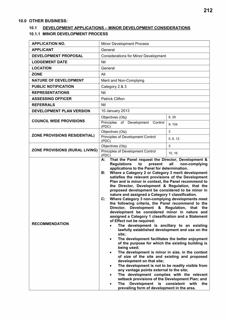
10.0 OTHER BUSINESS: 10.1 DEVELOPMENT APPLICATIONS – MINOR DEVELOPMENT CONSIDERATIONS 10.1.1 MINOR DEVELOPMENT PROCESS
APPLICATION NO. Minor Development Process APPLICANT General DEVELOPMENT PROPOSAL Considerations for Minor Development LODGEMENT DATE Nil LOCATION General ZONE All NATURE OF DEVELOPMENT Merit and Non-Complying PUBLIC NOTIFICATION Category 2 & 3 REPRESENTATIONS Nil ASSESSING OFFICER Patrick Clifton REFERRALS Nil DEVELOPMENT PLAN VERSION 10 January 2013
COUNCIL WIDE PROVISIONS Objectives (Obj) 8, 29
Principles of Development Control (PDC) 9, 104
ZONE PROVISIONS RESIDENTIAL) Objectives (Obj) 3
Principles of Development Control (PDC) 5, 6, 12
ZONE PROVISIONS (RURAL LIVING) Objectives (Obj) 3
Principles of Development Control (PDC) 10, 16
RECOMMENDATION
A: That the Panel request the Director, Development & Regulations to present all non-complying applications to the Panel for determination.
B: Where a Category 2 or Category 3 merit development satisfies the relevant provisions of the Development Plan and is minor in context, the Panel recommend to the Director, Development & Regulation, that the proposed development be considered to be minor in nature and assigned a Category 1 classification.
C: Where Category 3 non-complying developments meet the following criteria, the Panel recommend to the Director, Development & Regulation, that the development be considered minor in nature and assigned a Category 1 classification and a Statement of Effect not be required: The development is ancillary to an existing
lawfully established development and use on the site;
The development facilitates the better enjoyment of the purpose for which the existing building is being used;
The development is minor in size, in the context of size of the site and existing and proposed development on that site;
The development is not to be readily visible from any vantage points external to the site;
The development complies with the relevant setback provisions of the Development Plan; and
The Development is consistent with the prevailing form of development in the area.
212

10.0 OTHER BUSINESS: 10.1.1 MINOR DEVELOPMENT PROCESS (Continued)
Port Pirie Regional Council Agenda – Development Assessment Panel 20/8/14
BACKGROUND
The Panel will recall that at its meeting 16 July 2014 it considered a report that set out a process whereby developments could be considered minor in nature and not subject to category 2 or 3 public notification or, in the case of non-complying development, a Statement of Effect. At that meeting the Panel made the following resolution;
“That the Panel defer the determination of the report pending recept of legal advice regarding the Panels ability to determine developments to be minor on nature and the impact of this on Categorisation and the requirement for a Statement of Effect.”
A copy of the previous report to Council is attached at Appendix A.
Appendix A – Report to Council Development Assessment Panel, Meeting Held 16 July 2014
As per the resolution, legal advice was sought on the legal position of these considerations from Norman Waterhouse Lawyers. The response from Norman Waterhouse is attached at Appendix B.
Appendix B – Norman Waterhouse, Legal Advice.
This report relates solely to the legal advice and the changes to any recommendation as a result of that advice. It does not repeat the content of the previous report.
LEGAL ADVICE Norman Waterhouse Lawyers were requested to provide advice on the following:
Is development able to be considered minor in nature and therefore a Category 1 Development?
Does the determination of minor in nature differ in terms of development that would otherwise be considered Category 2 or 3 developments were it not considered to be minor?
What is the impact of the minor in nature determination on the requirement for a Statement of Effect in respect of Non-complying development?
Is there any legal risk in the process set out in the report and if so what is the extent of that risk and can it be eliminated or reduced?
Any other comments that are considered appropriate?
A copy of the previous report to the panel was provided to assist with the provision of the advice.
In summary, the advice had provided the following responses:
1. Development is able to be considered minor in nature and a Category 1 development. However, the legal advice further states that this is at the discretion of the Council delegate and that the Panel should not dictate to staff how to approach categorisation. This has resulted in some minor changes to the recommendations, whereby they have been amended to be recommendations from the Panel to Council Officers;
2. There is no difference of approach in terms of a minor determination between developments that would otherwise be Category 2 and 3 developments, should they not be considered minor;
3. Should development be considered minor for the purpose of categorisation, it is considered appropriate that the requirement for a Statement of Effect be waived as the tests set out in Regulation 17(6) are substantially identical to that for categorisation; and
213

10.0 OTHER BUSINESS: 10.1.1 MINOR DEVELOPMENT PROCESS (Continued)
Port Pirie Regional Council Agenda – Development Assessment Panel 20/8/14
LEGAL ADVICE (Cont’d)
4. There is a risk of challenge from a person who believes that they should have had the ability to have a say or right of appeal, in respect of Category 3 developments. However, if the recommendations are treated as a guideline to increase consistency of decision making, the risk is considered negligible.
CONCLUSION: It is considered appropriate that the Panel determine non-complying applications, regardless of Category and the Director, Development & Regulation should be requested to present these applications to the Panel for determination.
In respect of Category 2 or Category 3 merit developments identified in the Development Regulations 2008, where the proposal is able to satisfy the relevant provisions of the Development Plan and is minor in context, the proposed development could be considered to be minor in nature and assigned a Category 1 classification rather than Category 2 or 3.
In respect of Category 3 non-complying developments identified in the Development Regulations 2008, where the following criteria can be satisfied the development could be considered minor in nature and assigned a Category 1 classification:
The development should be ancillary to an existing lawfully established development and use on the site;
The development should facilitate the better enjoyment of the purpose for which the existing building is being used;
The development is minor in size, in the context of size of the site and existing and proposed development on that site.
The development should not be readily visible from any vantage points external to the site; The development should comply with the relevant setback provisions of the Development
Plan; and The Development should be consistent with the prevailing form of development in the area.
214

10.0 OTHER BUSINESS: 10.1.1 MINOR DEVELOPMENT PROCESS (Continued)
Port Pirie Regional Council Agenda – Development Assessment Panel 20/8/14
RECOMMENDATION: A: That the Panel request the Director, Development & Regulations to present all
non-complying applications to the Panel for determination.
B: Where a Category 2 or Category 3 merit development satisfies the relevant provisions of the Development Plan and is minor in context, the Panel recommend to the Director, Development & Regulation, that the proposed development be determined to be minor in nature and assigned a Category 1 classification.
C: Where Category 3 non-complying developments meet the following criteria the Panel recommend to the Director, Development & Regulation, that the development should be considered minor in nature and assigned a Category 1 classification and a Statement of Effect not be required: The development is ancillary to an existing lawfully established development and
use on the site; The development facilitates the better enjoyment of the purpose for which the
existing building is being used; The development is minor in size, in the context of size of the site and existing and
proposed development on that site; The development is not to be readily visible from any vantage points external to the
site; The development complies with the relevant setback provisions of the Development
Plan; and The Development is consistent with the prevailing form of development in the area.
215

10.0 OTHER BUSINESS: 10.1.1 MINOR DEVELOPMENT PROCESS (Continued)
Port Pirie Regional Council Agenda – Development Assessment Panel 20/8/14
APPENDIX A Report to Council Development Assessment Panel, Meeting Held 16 July 2014
216

10.0 OTHER BUSINESS: 10.1 DEVELOPMENT APPLICATIONS – MINOR DEVELOPMENT CONSIDERATIONS 10.1.1 MINOR DEVELOPMENT PROCESS
APPLICATION NO. Minor Development Process APPLICANT General DEVELOPMENT PROPOSAL Considerations for Minor Development LODGEMENT DATE Nil LOCATION General ZONE All NATURE OF DEVELOPMENT Merit PUBLIC NOTIFICATION Category 2 & 3 REPRESENTATIONS Nil ASSESSING OFFICER Patrick Clifton REFERRALS Nil
DEVELOPMENT PLAN VERSION 10 January 2013
COUNCIL WIDE PROVISIONS Objectives (Obj) 8, 29
Principles of Development Control (PDC) 9, 104
ZONE PROVISIONS (RESIDENTIAL)
Objectives (Obj) 3
Principles of Development Control (PDC) 5, 6, 12
ZONE PROVISIONS (RURAL LIVING)
Objectives (Obj) 3
Principles of Development Control (PDC) 10, 16
RECOMMENDATION
A: That the Panel request the Director, Development & Regulations to present all non-complying applications to the Panel for determination.
B: Where a Category 2 development satisfies the relevant provisions of the Development Plan, The Panel recommend to the Director, Development & Regulation, that the proposed development be determined to be minor in nature and assigned a Category 1 classification.
C: Where Category 3 developments meet the following criteria the development should be considered minor in nature and assigned a Category 1 classification and a Statement of Effect not be required: The development is ancillary to an existing
lawfully established development and use on the site.
The development facilitates the better enjoyment of the purpose for which the existing building is being used.
The development is minor in the context of size having regard to the size of the site on which it is to be located and the existing or proposed development on the site.
The development is not to be readily visible from any vantage points external to the site.
The development complies with the relevant setback provisions of the Development Plan.
The Development is consistent with the prevailing form of development in the area.
217
10.0 OTHER BUSINESS: 10.1.1 MINOR DEVELOPMENT PROCESS (Continued)
Port Pirie Regional Council Agenda – Development Assessment Panel 16/7/14
BACKGROUND
The Panel will recall that at its meeting 21 May 2014 it resolved:
“That the Director, Development & Regulation, present a report to the panel regarding the proposed process for deciding non-complying development applications.”
It is understood that this resolution related to the process of Categorisation and Public Notification, specifically when a development could be considered minor for the purpose of a Statement of Effect and Public Notification. It has arisen generally due to recent considerations of applications for domestic outbuildings in the Rural Living zone that exceed the 135 sqm maximum size. However, the determination on this matter could have implications for development in other zones, particularly in respect of public notification.
CATEGORISATION AND PUBLIC NOTIFICATION
Development Act 1993
Section 38 of the Development Act 1993 relates to the Categorisation of development and the requirements for Public Notification.
S 38 (1) identifies 4 categories of development for the purposes of this section— a) Category 1 development; and ab) Category 2A development; and b) Category 2 development; and c) Category 3 development.
S38 (2) states that the Development Regulations 2008 or the Development Plan identify when a development is a Category 1 or 2 development. Where it is not identified as either Category 1 or 2 then the development is a Category 3 development.
In respect of Category 1 development the Council must not, on its own initiative, seek the views of the owners or occupiers of adjacent or other land in relation to the granting or refusal of development plan consent; and
In respect of Category 2A or 2 developments, notice of the application must be given, in accordance with the regulations, to— a) an owner or occupier of each piece of adjacent land; and b) any other person of a prescribed class.
In respect of Category 3 development, notice of the application must be given, in accordance with the regulations, to— a) the persons identified for a Category 2 or 2A application; and b) any other owner or occupier of land which, according to the determination of the Council, would
be directly affected to a significant degree by the development if it were to proceed; and c) the public generally.
Where notice of an application for consent in respect of a Category 2 or Category 3 development has been given, any person who desires to do so may, in accordance with the regulations, make representations in writing to the Council in relation to the granting or refusal of consent.
The Council must forward to the applicant a copy of the representations made and allow the applicant an opportunity to respond, in writing, to those representations.
218

10.0 OTHER BUSINESS: 10.1.1 MINOR DEVELOPMENT PROCESS (Continued)
Port Pirie Regional Council Agenda – Development Assessment Panel 16/7/14
CATEGORISATION AND PUBLIC NOTIFICATION (Cont’d)
Development Act 1993 (Cont’d)
In the case of a Category 2 development, the Council may, in its absolute discretion, allow a person who made a representation to appear personally or by representative before it to be heard in support of the representation. In the case of a Category 3 development, the Council must allow a person who made a representation and who, as part of that representation, indicated an interest in appearing before the authority, a reasonable opportunity to appear personally or by representative, to be heard in support of the representation.
If a person appears before the Council, the Council must also allow the applicant a reasonable opportunity, on request, to appear personally or by representative before it in order to respond to any relevant matter.
Where representations have been made under this section, the Council must give to each person who made a representation notice of its decision on the application and of the date of the decision and, in the case of a Category 3 development, of the person's appeal rights under this Act; and, in the case of a Category 3 development, give notice to the Court.
Development Regulations 2008
Schedule 9 of The Development Regulations 2008 assigns public notification categories to various developments.
Schedule 9 Part 1 (1) of the Regulations identifies Category 1 development and states that any development classified as a complying development under these regulations or the relevant Development Plan, or which would be a complying development if it were to meet the conditions associated with the classification where the failure to meet those conditions is, in the opinion of Council, of a minor nature only.
Schedule 9 Part 1 (2) of the Regulations further deals with minor development and states that except where the development is classified as non-complying under the relevant Development Plan, Category 1 development can include any development which comprises, amongst other matters, a kind of development which, in the opinion of the Council, is of a minor nature only and will not unreasonably impact on the owners or occupiers of land in the locality of the site of the development.
In respect of non-complying development, Schedule 9 Part 1 (3) identifies Category 1 Development as including any development classified as non-complying under the relevant Development Plan which comprises the alteration of, or addition to, a building which, in the opinion of the Council, is of a minor nature only; or the construction of a building to be used as ancillary to or in association with an existing building and which will facilitate the better enjoyment of the purpose for which the existing building is being used, and which constitutes, in the opinion of the Council, development of a minor nature only.
Schedule 9 Part 1 (17) provides guidance on determining whether a development is minor. For the purpose of determining whether a development should be considered to be of a minor nature only, the Council may consider the following factors: the size of the site of the development, the location of the development within that site, and, the manner in which the development relates to the locality of the site.
219

10.0 OTHER BUSINESS: 10.1.1 MINOR DEVELOPMENT PROCESS (Continued)
Port Pirie Regional Council Agenda – Development Assessment Panel 16/7/14
NON-COMPLYNG DEVELOPMENT PROCESS
Development Act 1993
S 35 (3) of the Development Act 1993 states that a development that is of a kind described as a non-complying development under the relevant Development Plan must not be granted a development plan consent unless, inter alia, the Development Assessment Commission; concurs in the granting of the consent.
In respect of a non-complying development S39 (2) requires the Council to request an applicant to provide a statement of effect in accordance with the Regulations.
Development Regulations 2008
Regulation 17 of the Development Regulations relates to the provision of information for a non-complying development. If a person applies for consent in respect of a Development Plan for a non-complying development, the applicant must provide a brief statement in support of the application. Sub regulation 4 states that if a Council resolves to proceed with an assessment of the application, the Council must obtain from the applicant, a statement of effect which must include the following:
a description of the nature of the development and the nature of its locality and a statement as to the provisions of the Development Plan which are relevant to the assessment of the proposed development;
an assessment of the extent to which the proposed development complies with the provisions of the Development Plan; and
an assessment of the expected social, economic and environmental effects of the development on its locality.
However, sub regulation 6 states that a statement of effect is not required if the proposed development consists (wholly or substantially) of the alteration of a building; or the construction of a new building which is to be used in a manner which is ancillary to, or in association with, the use of an existing building and which would facilitate the better enjoyment of the existing use of the existing building and the Council considers that the proposed development is of a minor nature.
SUMMARY
Given the provisions of the Act and Regulations, notwithstanding the specific provisions of the Act and Regulations identifying a development as a Category 2 or 3 development, the Council are able to determine that an application is a minor development and therefore Category 1 for the purpose of Public Notification. In the case of a Category 3 development, where the Council determine that the development is ancillary to an existing development on the site, where the principle has previously been approved, and where the development is minor a statement of effect is also not required.
For the purpose of determining whether the development is minor in nature, Council are required to have regard to: the size of the site of the development, the location of the development within that site, and, the manner in which the development relates to the locality of the site.
220
10.0 OTHER BUSINESS: 10.1.1 MINOR DEVELOPMENT PROCESS (Continued)
Port Pirie Regional Council Agenda – Development Assessment Panel 16/7/14
APPLICATION
Category 2 Developments
Typically the consideration of minor in respect of Category 2 developments would relate to the construction of car ports, garages, sheds, pergolas, verandahs, swimming pools, spa pools or other outbuildings. These developments fall into a Category 2 development where they do not satisfy the criteria for a Category 1 development and where the following applies: they have a setback to the front boundary less than the principle dwelling; they are closer than 900mm to the side boundary in respect of solid walls and 600mm where
there is no wall; they exceed 1 story in height or are greater than 3 metres in height above ground; they have a floor level greater than 600mm above or below ground; they have a floor area in excess of 54sqm; or they have a wall length of greater than 9 metres.
In respect of these developments, the Development Plan provides the following relevant assessment criteria: Domestic outbuildings should be no closer to a road that the building to which it relates; Domestic outbuilding in the residential zone should be setback from side and rear boundaries by
600mm if the wall height is 2.4m, 1000mm if the wall height is 2.7m and 1200mm if the wall height is 3m or greater;
The combined floor area of outbuildings in the residential zone should not exceed 72sqm or 10% of the site area, which ever is the greater;
Domestic outbuildings in the residential zone should be setback no less than 4m from a rear boundary that is adjacent a public road; and
Outbuildings in the Rural Living Zone should not have a floor area greater than 135sqm or a wall height greater than 3.6m.
For the purpose of considering whether a Category 2 development should be considered minor and therefore a Category 1 development, it is considered that the Development Plan offers reasonable guidance. Where a Category 2 development is able to satisfy the provisions of the Development Plan, it is considered acceptable that the development be considered minor and therefore Category 1 for the purpose of public notification.
Category 3 and Non-Complying Developments
Typically, the minor consideration would relate to developments that are identified as non-complying developments in the development plan and are Category 3 developments as a result. If the development is considered minor for the purpose of public notification, it follows that the development application is also not required to be supported by a Statement of Effect.
221
10.0 OTHER BUSINESS: 10.1.1 MINOR DEVELOPMENT PROCESS (Continued)
Port Pirie Regional Council Agenda – Development Assessment Panel 16/7/14
APPLICATION (Cont’d)
Category 3 and Non-Complying Developments (Cont’d)
For a Category 3 development to be considered minor the following should apply, having regard to the regulations: The development should be ancillary to an existing lawfully established development and use on
the site; The development should facilitate the better enjoyment of the purpose for which the existing
building and site is being used; The development should be minor in the context of size having regard to the size of the site on
which it is to be located and the existing or proposed development on the site; The development should not be readily visible from any vantage points external to the site; The development should comply with the relevant setback provisions of the Development Plan;
and The Development should be consistent with the prevailing form of development in the area.
PROCESS
The Delegated Authority provided to the Panel by the Council provides for the panel to decide the following applications: A development application relating to a Category 2 development where representations have
been made; A development application relating to a Category 3 development; An application for a non-complying development which is also a Category 2 or 3 development; A development application relating to a state or local heritage place where the proposed
development is not minor in nature; A development application relating to the demolition of a heritage asset where approval is
recommended; A development application for land division resulting in 4 or more allotments; A development application by Council where the minister has declined to be the relevant
authority; and Any development application referred to the Panel by the Director, Development & Regulations.
In accordance with the delegations, it is not necessary for the Panel to be presented with reports relating to non-complying developments that have been considered to be minor in nature and therefore Category 1 applications. However, it is considered appropriate that these applications be referred to the Panel for determination by the Director, Development & Regulation as per the final clause above.
In such instances, the determination to continue with the assessment following receipt of the application should be made, in accordance with the delegations, by the Director, Development & Regulation prior to the report being presented to the Panel. This avoids unnecessary delays and, as a Statement of Effect would not be required, is principally an administrative process.
222

10.0 OTHER BUSINESS: 10.1.1 MINOR DEVELOPMENT PROCESS (Continued)
Port Pirie Regional Council Agenda – Development Assessment Panel 16/7/14
CONCLUSION: It is considered appropriate that the Panel continue to determine non-complying applications, regardless of Category and the Director, Development & Regulations should be requested to present these applications to the Panel for determination.
In respect of Category 2 developments identified in the Development Regulations 2008, where the proposal so able to satisfy the relevant provisions of the Development Plan, the proposed development should be determined to be minor in nature and assigned a Category 1 classification.
In respect of Category 3 applications identified in the Development Regulations 2008, where the following criteria can be satisfied the development should be considered minor in nature and assigned a Category 1 classification:
The development should be ancillary to an existing lawfully established development and use on the site;
The development should facilitate the better enjoyment of the purpose for which the existing building is being used;
The development should be minor in the context of size having regard to the size of the site on which it is to be located and the existing or proposed development on the site;
The development should not be readily visible from any vantage points external to the site; The development should comply with the relevant setback provisions of the Development Plan;
and The Development should be consistent with the prevailing form of development in the area.
223
10.0 OTHER BUSINESS: 10.1.1 MINOR DEVELOPMENT PROCESS (Continued)
Port Pirie Regional Council Agenda – Development Assessment Panel 16/7/14
RECOMMENDATION: A: That the Panel request the Director, Development & Regulations to present all non-
complying applications to the Panel for determination, regardless of categorisation. B: Where a Category 2 development satisfies the relevant provisions of the Development
Plan, the Panel recommend to the Director, Development & Regulation, that the proposed development should be determined to be minor in nature and assigned a Category 1 classification.
C: Where Category 3 developments meet the following criteria the development should be
considered minor in nature and assigned a Category 1 classification and a Statement of Effect not required: The development is ancillary to an existing lawfully established development and
use on the site; The development facilitates the better enjoyment of the purpose for which the
existing building is being used; The development is minor in the context of size having regard to the size of the site
on which it is to be located and the existing or proposed development on the site; The development is not to be readily visible from any vantage points external to the
site; The development complies with the relevant setback provisions of the Development
Plan; and The Development is consistent with the prevailing form of development in the area.
224

10.0 OTHER BUSINESS: 10.1.1 MINOR DEVELOPMENT PROCESS (Continued)
Port Pirie Regional Council Agenda – Development Assessment Panel 20/8/14
APPENDIX B Norman Waterhouse, Legal Advice
225
Level 15, 45 Pirie Street Adelaide SA 5000 GPO Box 639 Adelaide SA 5001 T 08 8210 1200 F 08 8210 1234 www.normans.com.au
By Email: <[email protected]> Ref: DXB\M00281622F03324632.DOCX 12 August 2014 Mr P Clifton Manager Environmental Services Port Pirie Regional Council 115 Ellen Street PORT PIRIE SA 5540
Dear Patrick Minor Development Categorisation I refer to your letter of 24 July 2014. I do not repeat the background set out therein. My advice follows. Introduction I note that the CDAP cannot dictate to staff how to approach categorisation decisions and minor determinations. That would undoubtedly be an unlawful fetter upon the discretion of staff delegates. However I not see any particular difficulty with the CDAP making recommendations as to guidelines for staff, so long as staff do treat such as guidelines. The Recommendations – a Risk
As I understand it, recommendations are proposed which are intended to guide Council staff in making categorisation decisions and “minor” determinations, and consequently, whether there is a requirement for a statement of effect for certain non-complying developments. The recommendations can be no more than a “helpful guide”. They cannot be applied inflexibly and without consideration of whether a particular matter should be treated in a different way for some reason: Surinakova v Minister for Immigration, Local Government and Ethnic Affairs (1991) 33 FCR 87; Khan v Minister for Immigration and Ethnic Affairs (unreported, Fed Ct, Gummow J Dec 1987). Blind application of the recommendations would be a basis upon which to have a categorisation decision or minor determination set aside, with the consequence that any consent granted in reliance upon that decision would probably also be quashed (invalidated and set aside). While I think that an applicant challenge would be exceptionally rare (application of the recommendations is likely to lead to approvals in shorter timeframes), there is the possibility of challenges by persons who believe that they should have been able to have a say (Category 2) or right of appeal (Category 3). If the recommendations are treated as a guideline (and improved in some respects, which you and I have discussed) then I think that the recommendations could be used as a guideline to increase consistency of decision-making. In such circumstances I would see little or no risk.
226

- 2 -
12 August 2014
DXB\M00281622F03324632.DOCX
The Recommendations – Improvements I make the following brief observations:
Part B should deal with all merit development, whether Category 2 or 3;
Part C should deal with all non-complying development, whether Category 2 or 3;
Part B should include a “minor in context” component in addition to the guideline that development satisfies the relevant provisions of the development plan. Satisfaction of the development plan might well mean that no unreasonable impacts will arise (one limb of the minor development test) but is quite inconclusive of whether the development is minor in context (the other limb);
Part C should, like parts A and B be worded in the form of a recommendation; and
One of the dot points of Part C might be re-worded for easier comprehension to read “the development is minor in size, in the context of the size of the site and existing and proposed development on that site”.
Minor Development Generally The issue of “minor development” arises when, under Section 38 of the Development Act 1993, a development is assigned a public notice category by Regulation 32 of, and Schedule 9 to, the Development Regulations 2008.1 The various clauses of Schedule 9 are generally objective: either a development falls within a clause, or it does not. However, certain clauses depend upon the formation of an opinion. If the opinion is formed, that clause applies; if the opinion is not formed the clause does not apply. Relevant to the present advice, Clause 2(1)(g) provides that development is Category 1 where the relevant authority (i.e. a Council delegate) forms both of these two opinions:
the development is of a minor nature only; and
the development will not unreasonably impact on the owners or occupiers of land in the locality of the site of the development.
It is crucially important that the delegate forms both opinions, not just one of them: Jaric v City of Charles Sturt [2009] SAERDC 33. Clause 3(b)2 provides that non-complying development is Category 1 where:
the development comprises the construction of a building to be used as ancillary to or in association with an existing building; and
the development will facilitate the better enjoyment of the purpose for which the existing building is being used; and
the development constitutes, in the opinion of the relevant authority, development of a minor nature only.
1 Unlike some development plans, Port Pirie does not include its own minor development categorisation scheme. 2 Clause 3(a) and 3(c) provide different tests which would not apply to the construction of new domestic and rural outbuildings.
227

- 3 -
12 August 2014
DXB\M00281622F03324632.DOCX
I note that only the third dot point for Clause 3(b) is cast in terms of an opinion, however, reasonable minds may also differ about the second dot point. That is also a de-facto opinion to be formed by the delegate. It is a legal requirement that all opinions be formed reasonably, and upon relevant material (including the application documents, the development plan, and the location and locality of the development, and with regard to Clause 17 of Schedule 9). Provided that is done, there is a reasonably broad discretion for the delegate as to what may be considered minor. That said, historically the Supreme Court has taken a relatively conservative approach to what might be “of a minor nature only”. That phrase is intended to signify development which is of little moment or importance: McKay v Alexandrina Council [2003] SASC 167. In Verdouw v City of Unley (2001) 113 LGERA 26 the Full Court held that an “unusually large” carport in a residential context, “was so large, and its obvious effect on the appellant's use and enjoyment of her land was so significant, that no reasonable planning authority could reasonably conclude that the development was of a minor nature only”. In Colmer v Alexandrina Council (2009) 260 LSJS 398 the Supreme Court held that a garage and studio associated with a detached dwelling in a residential area could not be described as development of a minor nature only. In Bade v Rural City of Murray Bridge (2008) 101 SASR 302 the Full Court held that it was difficult to see how any planning authority could possibly classify a non-complying upper level extension to a single storey boatshed to convert it into a river shack in a river shack area as being of a minor nature only. My own view is that the Supreme Court has historically taken an unduly narrow view, and I would not place excessive weight upon the prior decisions noted above. A number of them seem to involve the Court engaging in a hypothetical exercise of identifying what it would have thought, rather than actually reviewing a well-reasoned delegate’s decision. The ERD Court has traditionally been rather more accepting of delegate opinions: see, for example Gaetjens v The Corporation of the City of Unley [2014] SAERDC 26. I also note that the Supreme Court is yet to consider the second limb of the minor test, namely, the absence of unreasonable impact. A Delegate’s Discretion It is beyond doubt that a Council delegate may form the necessary opinions for a development to be Category 1, provided that the decision is lawfully made. Some developments are so obviously minor that to not form the relevant opinions would be perverse. Some developments are so obviously non-minor (i.e. have obvious impacts) that the necessary opinions cannot be lawfully formed. The difficulty is the grey area in between. There is no easy code for ensuring identification of the limits of the grey area, but it seems to me that the proposed recommendations go a good way toward identifying many of the relevant factors to be considered, and thus to give any decision a defensible basis, whatever the eventual decision is. A determination of “minor nature only” is always context-dependent. A large chicken shed, say, 1 ha in covered area, might well be of a minor nature only if it is, say, the tenth such building on a site where nine already exist and the additional shed has no obvious additional impact. Equally, a small verandah addition of 0.5 sq m might not be minor if it has some real impact (perhaps shading the only window of a small apartment for many hours per day).
228

- 4 -
12 August 2014
DXB\M00281622F03324632.DOCX
In the case of domestic and rural sheds, there has been a long history in South Australia of treating such buildings as minor, generally in the circumstances envisaged by the recommendations. From my general experience, most such treatments would have been correct, or at least defensible. It is abundantly clear that, just because a development might fail to meet other criteria for Category 1 development (or criteria for exempt development), this does not preclude it being minor development and therefore Category 1: Verdouw’s case (supra) and Gaetjens’ case (supra) and Clause 17 of Schedule 9. Category 2 or 3 You ask:
Does the determination of minor in nature differ in terms of development that would otherwise be considered Category 2 or 3 development were it not considered to be minor?
No. There is no difference of approach. I would, however, suggest that the second part of the test (whether there will be no unreasonably impact upon occupiers in the locality) be given close scrutiny in such circumstances. If the development is Category 1 important rights will be denied – of course, that is what Clause 2(1)(g) anticipates – and so the delegate should be quite confident in their assessment that there will be no unreasonable impacts. Non-Complying Development – Statement of Effect You ask:
What is the impact of the minor in nature determination on the requirement for a Statement of Effect in respect of Non-Complying development?
As is identified in your report, the tests for minor non-complying development (Clause 3(b) – new buildings) and the circumstances in which a statement of effect is not required (Regulation 17(6)(b)) are substantially identical.3 That being the case, I cannot envisage a scenario where a delegate forms the opinion that the relevant non-complying development is of a minor nature only (for categorisation purposes) but does not form that opinion for the purposes of the statement of effect. Put another way, if the delegate determines that a non-complying development is Category 1 pursuant to Clause 3(b) it follows automatically that a statement of effect is not required.4 I also note that the Council (by its delegate) may waive the requirement for a statement of effect for any non-complying development should it so wish: Section 39(4)(b). Given the scheme of the regulations, however, I expect that (outside the application of Regulation 17(6)) that would occur only in exceptional or unusual circumstances. 3 There are minor differences in wording, but I think that they are not consequential. There are material differences as between the other parts of the two provisions – i.e. Clause 3(a) embraces the “addition to” a building but Regulation 17(6)(a) does not; and Clause 3(c) concerns certain land divisions with no qualifications about being minor in nature, but Regulation 17(6)(c) requires that the opinion as to minor nature be formed. 4 It likely also follows automatically in the case of non-complying development which meets Clause 3(a), but one must be more careful in relation to Clause 3(c).
229

- 5 -
12 August 2014
DXB\M00281622F03324632.DOCX
Conclusion I trust that the foregoing assists. Yours faithfully Norman Waterhouse David Billington Partner Direct Line: (08) 8210 1263 or 0438 077 728 e-mail: [email protected]
230